|
Reflections 2008
Series 20
December 12
NW U.S. III: Oregon Territory
| | Oregon Territory We now need to interrupt the drive up the coast to speak about this area lying north of California. It is the area to which the northern route across the United States ended—and still ends. But why here? Why didn’t Lewis and Clark go to Los Angeles? Why didn’t the Oregon Trail yield to its California Trail branch and go to San Francisco? I think we know some of those answers already, and we also know you have to look at a map of the era. | | | | There were on the west coast two established parties and two interested parties. Keep that in mind, and you’ll understand the whole story.
| | | | To one established party, the one in the south, I’ll give the double name Spain/Mexico, since over time the controlling powers changed. Their territory extended north to EXACTLY where the northern border of California remains today, hence the significance of that border to our story. Let’s place an imaginary goalpost on that line.
| | | | To the other established party, the one in the north, I’ll give the double name Russia/Alaska. This territory extended south to EXACTLY where the southernmost point of the Alaska state line is today (with British Columbia). We’ll put another imaginary goalpost on that line.
| | | | So two powers had international borders that correspond today to the northern border of California and the southern border of Alaska. With all that space in between.
| | | | You cannot doubt that the Russians were interested in moving south, because they did move south! Alta (Upper) California was weakly defended, since it was so far from the center of Mexico, and so, if the Russians entered California itself and built Fort Ross and named the Russian River, and even got those burials on top of Русский Холм in San Francisco, you’d better imagine that they were interested in the territory in between as well. | | | | You may doubt that the Spanish were interested in moving north. After all, if they could hardly defend California, why look further north? But they did, and you can see it in place names. Spanish place names in Washington State? You bet, because the Spanish explored there. The strait separating Washington from Victoria and all of Vancouver Island in Canada is the Juan de Fuca Strait. It leads to the San Juan Islands that the US got when the border was drawn. And the city on the Washington side of Juan de Fuca Strait, opposite Victoria, is Port Angeles. That name remains half-Spanish. It had to have been Puerto (de los) Ángeles, and was never completely translated to Port (of the) Angels, hence the hybrid name Port Angeles.
| | | | So we have two established parties on either side of those goalposts. The large territory in between those California and Alaska goalposts, variously claimed here and there, was called by the British the Columbia District and by the US the Oregon Country. (This led to the part of it that went to the US to be called the Oregon Territory, and part of that became the state of Oregon.) Get used to it: Oregon, as it was understood at the time, reaching from California all the way to Alaska, corresponding to today’s Oregon, Washington, and British Columbia. Of course, I’m only talking about the coast. In the interior, the Oregon Territory reached the mountains, and included all or part of today’s Idaho, Montana, and others. Still, I’ll mainly be discussing the Pacific coast here. | | | | [Note the parallel that, just as the present-day State of Oregon is only part of the vast Oregon Territory (and at its south end, at that), the present-day State of Louisiana is only part of the vast Louisiana Purchase (and at ITS south end as well.)]
| | | | Sitting in the East are two interested parties. One is Britain/Canada, and one is the United States. Both are interested in claiming all of the Oregon Country/Columbia District. It’s interesting to speculate what might have happened. | | | | If Britain/Canada had gotten the whole Oregon Country, leaving the US as an entity only in the East, upon leaving California northwards today, you’d enter Canada immediately and have a long way to Alaska, in other words, there’d be a lot more of Canada interrupting the two parts of the US in North America. | | | | Many in the US sorely wanted all of the Oregon Country as well. If I mention that that southern border of Alaska is at 54° 40’, you may remember the US political slogan “Fifty-four Forty or Fight!” Getting all of the Oregon Territory up to Alaska was what that was all about, limiting Canada to being just an entity in the East. If that had indeed happened, once the US also acquired Alaska and California, today the entire Pacific coast from San Diego to Nome would be in the US. Ironically, that longer distance once again extends between Mexico and Russia. | | | | But neither of those scenarios took place. Instead, a treaty was signed in 1846 dividing the Oregon Country between Britain/Canada and the US, resulting in not only the longest straight-line international boundary in the world, but also the longest undefended border of any shape. This border is discussed in 2005/6, including where that straight-line border cuts off Point Roberts, Washington (the last time I physically entered that state) from its logical urban center of Vancouver, then zig-zags around Vancouver Island. | | | | Thus, on the coast, the Oregon Country/Columbia District became British Columbia in Canada, with the US side the Oregon Territory, eventually divided between Washington, and Oregon (and inland states).
| | | | The Oregon Country had two potential maritime centers. The northern one had the Fraser River (near today’s Vancouver) flowing into the Georgia Strait separating Vancouver Island from the mainland, connecting to the Juan de Fuca Strait. This all went to Canada. The southern end of that area was Puget Sound (where Seattle is today), connecting out to sea via the Juan de Fuca Strait as well.
| | | | The southern maritime center of the Oregon Country was the Columbia River, and it was here that so much history took place: Lewis and Clark, the Astor fur traders, the Oregon Trail.
| | | | We need to discuss the geography of the Columbia River region specifically. If you have some vague picture of the Columbia forming the border today between Oregon and Washington, you’re right. There’s a land border between the states at their eastern end running about 1/3 of the distance, but then the Columbia comes down out of Washington and forms the border the rest of the way to the Pacific, at about where Astoria is. | | | | But perhaps surprisingly, the Pacific coast itself, while the destination for Lewis and Clark and the Astor fur traders, was not the destination of the Oregon Trail. About ¼ of the way inland from the Pacific, the Willamette River (wi.LAM.it) enters from the south. This is the center of population today. The Willamette Valley is a major agricultural center, and from the south, includes the cities of Eugene, the capital of Salem, and Portland. The goal of the Oregon Trail was Oregon City, today a suburb of Portland, so it wasn’t literally the Pacific that these later settlers were looking for; many were headed for this inland valley—and elsewhere in the area.
| | | | [In the summer of 1988, Beverly and I took the Coast Starlight from San Francisco to Portland (OK, Emeryville to Portland) for a Columbia River Cruise on the “Colonial Explorer”. We were surprised that it started by going south down the Willamette for an hour or so (possibly to Oregon City, but at the time, that wasn’t significant to me). Once on the Columbia, we saw in the distance Mt St Helens, that had exploded eight years earlier, and Mt Hood. We continued up the Snake River into Idaho, where we took a jet boat up the rapids in Hell’s Canyon. Returning, we were delayed at the locks passing Bonneville Dam, so when we went quickly beyond Portland to Astoria to see Lewis and Clark’s Fort Clatsop, we were rushed, and I remember little. It was time for a return, which was, pleasantly, very fruitful.] | | | | But, again, the geography. Westward, the north (Washington) shore of the Columbia approaching the Pacific is quite straight, and ends in a promontory known as Cape Disappointment, named when a ship exploring for the mouth of the Columbia felt they hadn’t found it. | | | | But the south (Oregon) shore has some interesting irregularities. Near the end of the river, there is first the site of Astoria. But then there is a bay that runs from the river behind Astoria to the south, making Astoria’s location a peninsula pointing downstream. At the south end of this bay is where Lewis and Clark set up Fort Clatsop. Finally, the bay ends and the south side of the river consists essentially of a peninsula reaching up to close off the end of the Columbia.
| | | | LEWIS AND CLARK We learn that Lewis and Clark were sent by Thomas Jefferson to explore the newly acquired Louisiana Purchase of 1803, since France didn’t fully know what it was selling, nor the US what it was buying. That’s true. But why didn’t they go and explore its southern end? Well, there was more to it than that. From previous exploring, it was well known that rivers flowed west on the Pacific coast, most notably the Columbia, which meant that there had to be at least a division of watersheds, if not an outright continental divide. So while indeed exploring the (upper) Louisiana Purchase, they were also to see how close of a water connection they could find to the Pacific (read: Oregon Territory). In other words, how possible was it to connect the Mississippi basin (via the Missouri River) with the Columbia basin? This is the basis for the route to the Pacific through the northern US.
| | | | [Note: Lewis and Clark were NOT the first non-Native Americans to cross North America north of Mexico, they were the second (although the first to do so on US territory). The first was a Canadian expedition led by Sir Alexander Mackenzie, which reached the Pacific coast of North America on 30 June 1793, over a decade earlier than Lewis and Clark. He reached it at what is now Bella Coola BC, at a point between northern Vancouver Island and what is now the Alaskan border. This crossing of North America was Mackenzie’s second one of interest. Four years earlier, in 1789, he had gone west, but turned north at the Continental Divide when local natives told him rivers in the area flowed northwest, since he was interested in finding the Northwest Passage. On 10 July 1789 he discovered the Mackenzie River, and followed it to its end, becoming the first non-native to reach the western Arctic Ocean. His reaching TWO oceans and discovering a major river has its own deep significance.]
| | | | Lewis and Clark had to start on US territory, since Louisiana hadn’t been transferred yet, so they spent the winter of 1803-1804 at a Camp Dubois near what is today Hartford, Illinois, on the east side of the Mississippi, just across from where the Missouri enters it from the west. The transfer from Spain to France happened on 9 March 1804, and the transfer from France to the US took place the very next day, on 10 March 1804 (talk about flipping real estate), and then the expedition could proceed. It returned to this same camp on 23 September 1806.
| | | | [Just 15 mi / 24 km south of this departure point, but on the west bank of the Mississippi, that is, on the Louisiana Purchase side, is Saint Louis, Missouri, where the spectacular Gateway Arch by Eero Saarinen was erected in 1963-5 as part of the Jefferson National Expansion Memorial to commemorate the expansion of the US, or, as I’ve been calling it, routes west. The arch is 630 ft / 192 m across at the base, and exactly the same distance high, making it the tallest monument in the US. Each arm has a unique interior tram to bring visitors to the top for a spectacular view.]
| | | | The 33-member expedition of 1804-1806 was called the Corps of Discovery, and their route was well documented, largely through Clark’s diaries. They sometimes separated, then rejoined, so the route was more complicated than just the connecting of the two rivers, but for our purposes, let’s leave it at that.
| | | | In what is now North Dakota, one of their number, a fur trapper named Toussaint Charbonneau married the Native American woman Sacagawea. (Her name has many variations. Clark in his diaries spelled it differently almost every time he referred to her. I learned it with –ja- in the center, but this is the spelling and pronunciation most commonly accepted by authorities today.) Her inclusion has great historical significance within the exploration party. Charbonneau could interpret some Indian languages, and she could work with others. Most significantly, it is believed that no attacks were made by local Native Americans on the party because it was recognized that any party traveling with a mother and child was not a warring party. It is believed that many eyes secretly watched the Corps of Discovery travel past, but they were not disturbed.
| | | | Their route is well documented today, and certainly at their destination at the mouth of the Columbia. They first arrived in the area on the north (today, the Washington) shore of the river. Immediately to the east of the Astoria bridge on that side is a tiny wayside park where they suffered a long, severe storm, and were sure that was going to be the end, so near the goal. The feeling you get there now is the significance of that cramped location on the water’s edge below the hills, yet today it’s just a place to pull off the road to read the historical sign.
| | | | But they survived, and moved a tiny distance downstream, still on the north shore, to a spot just west of the Astoria bridge today. The bridge and river at that point are 4.5 mi / 7.2 km wide, with treacherous currents, and they had a big decision to make.
| | | | It was felt that the hilly north shore was not the point to set up camp. Perhaps the flatter south shore would provide hunting for elk or deer for food, also buckskins to make new clothes. They also needed easy access to the sea to boil seawater to make salt to preserve meats for the journey back. (On that first day as I drove to the Astoria hotel, I passed historic signs about salt and L&C that I didn’t understand, but found out only later what was meant. I tell you, EVERYTHING about L&C is documented.)
| | | | The big decision at this spot known as Station Camp whether to stay or move to the south shore (which they eventually did) was a significant one in American history. It was unusual in that it could have been a military decision by the leaders, yet it was instead, contrary to standard military protocol, put to a “tally”, essentially a vote, of the expedition’s participants. But the historic significance went beyond that, since one participant was Clark’s enslaved African named York, and another was Sacagawea. It was a period long before (1) blacks, (2) Native Americans, or (3) women voted in the United States, yet York, a black, and Sacagawea, a Native American woman, were included in the “tally”. I found extra significance in this in that I learned this information from the roadside sign, right where it had happened, and also on the very day before Barack Obama was elected President of the United States.
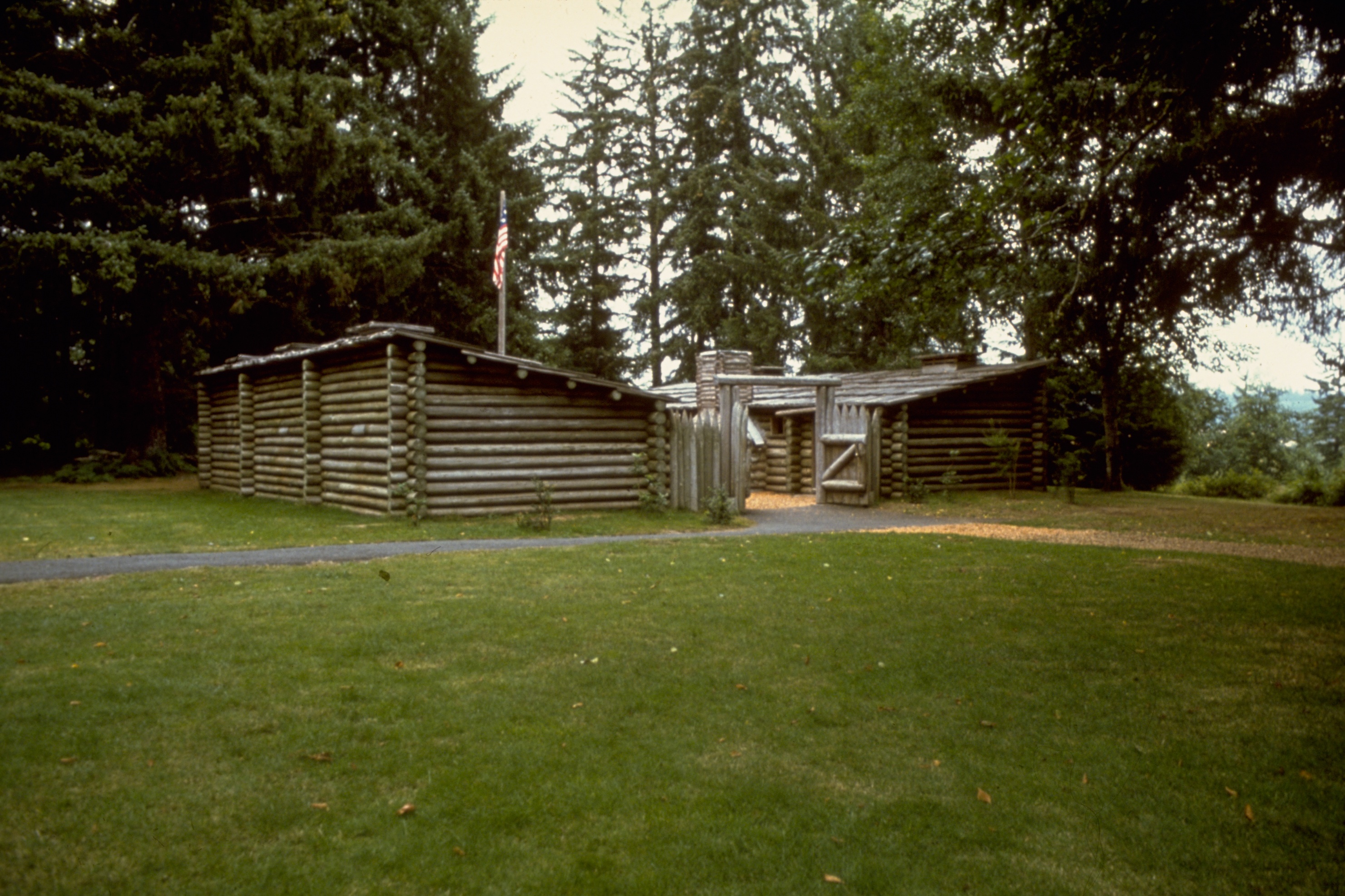
| | | | So they crossed the river, as well as that large bay on the south side, and established Fort Clatsop, named after the local tribe. The river to its side is today known as the Lewis & Clark River. Fort Clatsop is, not surprisingly, a National Historic Site. We had visited the replica of the fort fleetingly in 1988, and now I wanted to inspect it more at leisure. It is known roughly where the original fort was, although no precise foundations have been found to build the replica. Then, while there, I found out that the replica we had seen, built in the 1950’s, burned to the ground in 2006, so what I was about to see was a newer replica still of Fort Clatsop. | | | | It was a few steps in the drizzle to see the replica of Fort Clatsop, but one should not be surprised about precipitation in the Pacific Northwest (read: Oregon Territory), which I had in Oregon, Washington, and Victoria, British Columbia. It is so typical, that these figures stand out: of the 106 days the Corps of Discovery was at Fort Clatsop, 7 December 1805 to 23 March 1806, just 12 days were sunny and on nothing less than 94 they had rain, so it is historically accurate to visit the Fort Clatsop area in the drizzle. | | | | A fort? Hardly. It was made all of logs, and was enclosed for protection, but it had the footprint perhaps of the tiniest of log-cabin motels. Picture the number 111. The left-hand 1 represents three tiny rooms in a row for the men. The right-hand 1 represents four rooms in a row for storage, a day room, the officer’s room, and the family room for the Charbonneaus. The middle 1 is the central courtyard, enclosed at both ends. The upper gate went to a spring, and the lower gate was the entrance. Both roofs tilted to the center courtyard, presumably to collect rainwater (which would not have been too hard). It’s surprising that something of such significance could have been so small.
| | | | At one point, I’m not sure just when, they did reach Cape Disappointment on the north shore physically overlooking the juncture of the Columbia and the Pacific, which was the furthest point west the Corps of Discovery reached.
| | | | While in the Astoria area I visited the L&C locations mentioned (except the salt manufacturing site on the way in), plus going out to the state park at the end of the south shore juncture of the Columbia and the Pacific.
| | | | ASTOR FUR TRADERS Subsequently, John Jacob Astor financed an overland expedition from Saint Louis to the Oregon Territory to establish a fur-trading operation. The Astor expedition of 1810-1812 discovered a natural crossing of the continental divide in what is now southwestern Wyoming. South Pass is 7550 ft / 2301 m and later became the route of the Oregon Trail (including the California Trail and Mormon Trail). The expedition arrived at the Columbia in April 1811, five years after Lewis & Clark left in the winter of 1806. They founded Fort Astoria on that peninsula where Astoria is today, just upstream from that bay on the south shore where Fort Clatsop had been, making Astoria the oldest US settlement west of the Rockies. However, fur trading didn’t last forever. Later Astoria became a fishing center, especially for salmon, and a large salmon-packing operation developed, which today is also gone. Astoria’s population is today about 10,000, with Portland on the Willamette becoming instead the regional larger city. | | | | A digression is worthwhile at this point about John Jacob Astor. Do not include him in the time period of Carnegie, Rockefeller, Vanderbilt and others, since he was a full century earlier (1763-1848). He was born Johann Jakob Astor in Walldorf, Germany, near Heidelberg. He came to the US in 1784, after the Revolutionary War. He was the first US millionaire, making his money in two areas, one after the other. First was his fur trading operations on the Great Lakes, Canada, and in the Oregon Territory. Second was his investments in New York City real estate. At the time of his death he was the wealthiest person in the United States. He left $20 million, which today would be $115 billion. | | | | As well as he was doing in his fur and other ventures, in the 1830’s he withdrew from them, since he foresaw that the next big boom would be in the buildup of New York City, and he bought Manhattan real estate as the city expanded northward on Manhattan island. He probably would have bought it all, if he had been able to. Rather than buying and selling, he would buy, then lease the land to builders, retaining title to the land, a practice that has remained frequent in New York, where Trinity Church owns much of the land south of Greenwich Village and Columbia University owns the land under Rockefeller Center. | | | | He was a philanthropist, and supported Audubon and Poe. He built the Astor Library, which eventually combined with two other libraries to become the New York Public Library. At the end of the 19C, a branch of his family moved to Britain, achieved prominence and joined the peerage, the name Lady Astor perhaps being familiar. In 2007. the much-loved philanthropist Brooke Astor died in New York at 105. Her husband, Vincent Astor had been heir to the fortune, which she distributed generously through the Astor Foundation. (One of her death notices in the New York Times quoted five lines from “Young at Heart”, the first two of which are: “And if you should survive to 105, / Look at all you’ll derive out of being alive.”) | | | | Obviously, the city of Astoria in Oregon is named for him, as are other places named Astor or Astoria. Combined with his birthplace of Walldorf, the Waldorf-Astoria Hotel in New York is named for him, with the notable spelling change.
| | | | Just over the Queensboro Bridge in New York from Manhattan is Astoria, Queens. This is Archie Bunker’s neighborhood, and also the home of Kaufman Astoria Studios, where many films and TV shows are made. When Astor was doing his investing in Manhattan, over the river in Queens, what was then Hallet’s Cove, dating from 1659, changed its name to Astoria in an attempt to flatter him and attract a $2000 investment from him. He did invest $500. It should not be surprising that Astor never visited far-away Astoria, Oregon. But he never even crossed the East River to Astoria, Queens, to see how his $500 was doing, but still, the name Astoria stuck.
| | | | There is an Astor Place in Manhattan, coming east off Broadway at an angle in the area of the low numbers, such as 8th Street. When the first subway line was built in Manhattan in 1904, a stop was put at Astor Place, and the decorative tiles of the period on the station walls to this day show pictures of beavers to commemorate Astor’s fur trading interests.
| | | | Astor Place was once an entertainment center and included the Astor Place Opera House, whose demise is of interest. It wasn’t opera that was the problem, it was theater. We are aware how today soccer fans can riot in stadiums. In the day of the Astor Place Opera House, there were two Shakespearean actors, one British, one American, who had avid fans. In 1849 there was a notable riot between these fans on Astor Place, which then developed to a more serious class war, eventually causing the closing of the opera house.
| | | | It is also of interest why Astor Place is at an angle. Long, narrow Manhattan is not really aligned north-south, but its avenues run more like from one o’clock position to seven o’clock, with the perpendicular cross streets running from ten to four. However, Astor Place precedes the Manhattan street plan grid, when a local landowner decided to subdivide his property and laid out the street due east-west, so comparing cross streets to Astor Place shows the degree of “tilt” of the Manhattan street plan grid.
| | | | And finally, I find it pleasing to know that the sister city of Astoria, Oregon, is Walldorf, Germany.
| | | | OREGON TRAIL When settlers started coming west overland in numbers in the early 1840’s, it was to this region between the “goalposts” of California and Alaska that they traveled, on the Oregon Trail. Be aware that the Oregon Trail is not named after the State of Oregon, which was merely a later subdivision of the region. It was named after the Oregon Territory that was its goal. Settlers might just as well have been headed for what became the state of Washington, or, who knows, what became British Columbia, not even to mention the inland states on the way. It is better to understand the term “Oregon Trail” as implying “Pacific Northwest Trail”.
| | | | Oregon City was the hub of this huge territory stretching form California to Alaska, and was the end of the Oregon Trail. Again, pondering the original meaning of “Oregon”, the name should imply “Oregon (Territory) City”. In 1844, Oregon City became the first incorporated city west of the Rockies. But in time, it lost its importance, and is today a tiny, southeastern suburb of Portland. Let me describe this geography this way.
| | | | If, from Astoria, almost at the mouth of the river, you drive upstream two hours, you come to Portland on the Willamette, with only its northern suburbs reaching up to the Columbia. You then take interstates to get to its southeastern corner, and Oregon City, also on the Willamette, where the Trail ended, so it’s clear that there was less interest in the seacoast itself then in the fertile Willamette Valley this distance inland. There is a museum on the outskirts of Oregon City where the settlers actually arrived. The town itself is very pleasant and has an atmosphere of another era. | | | |
| |
|
|
|

