|
Reflections 2011
Series 2
January 31
Time Perception - Ratzer Map - New York Place Names Awry
| | Time Perception I remember being very impressed by the 1983 film Betrayal by Harold Pinter, based on his play (Pinter won the Nobel Prize for Literature in 2005). The distinguishing feature of Betrayal is that its nine scenes are told in reverse chronology. Scene One deals with a couple breaking up in 1977. Subsequent scenes continue backward until Scene Nine shows the couple first meeting in 1968. It’s a striking technique and works very impressively. Knowing the “end” of the story of the relationship gives insight to all the other scenes. | | | | There is a similar technique, not by Pinter, in the 1967 film Two For the Road with Audrey Hepburn and Albert Finney. The film also deals with a deteriorating relationship over twelve years between a couple who regularly drives on holiday from the UK to the south of France. Each scene deals with a road trip in a different year, but the scenes are neither in forward nor reverse chronology, but in an apparent random chronology. Middle trips are shuffled together with the last trip and the first trip. Still, the story of the deterioration of the relationship comes through very clearly, in spite of, and probably because of, the chaotic sequencing of events in time.
| | | | From this we learn that, although we live our lives linearly, and usually expect to see/hear/read stories linearly (other than via flashbacks, another interesting technique) it isn’t necessary. And this brings us to how we learn history. You might first learn a considerable amount about the Russian Revolution, then Peter the Great, then Stalin, then the founding of the Orthodox Church. This out of sequencing hurts nary a whit, and might strengthen one’s perception of the “story” of history.
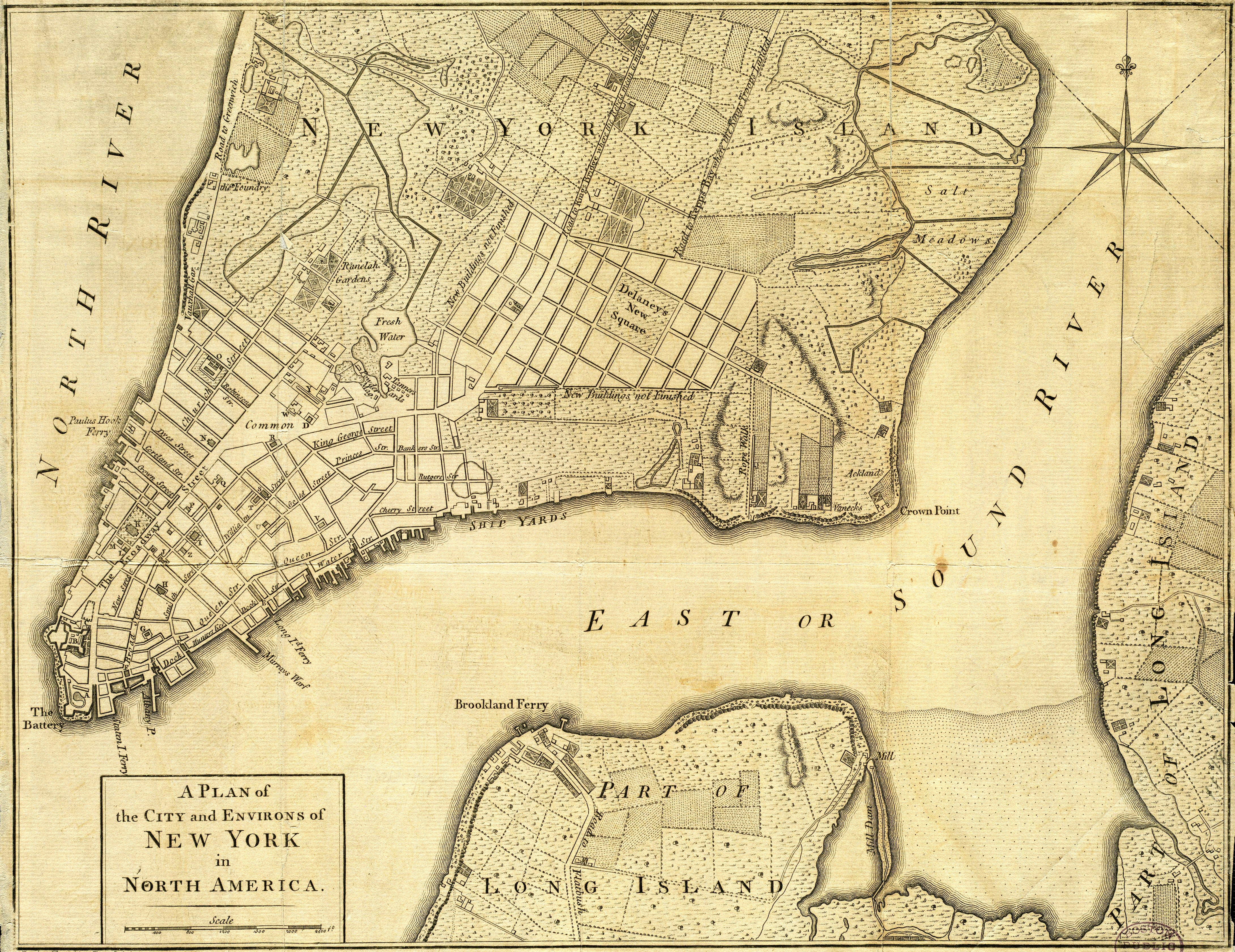
| | | | Ratzer Map We’ve been discussing New York city in this same sort of chaotic sequencing: first New Amsterdam and the 1660 Castello Plan (2009/24; 2010/1), then primeval waterways millennia ago (2010/28), followed by a modern satellite image (2011/1), and then in the same posting, NYC maps of 1906 and 1910.
| | | | To this back-and-forth I was then planning to jump backwards again to 1776 to a delightful little map I’d found online. When we look at this we can compare the growth from the 1660 Castello Plan of about a century earlier, and also compare subsequent growth with the 1906/1910 maps of a century and 1/3 later. We will still do this, but I have to first point out some exciting information from the front page of the Times. It deals with a newly discovered copy of a map, and ties directly into our discussion. However, the Times quite logically reported it Pinteresquely, starting with the recent discovery and working back to the 1770’s. For simplification, I’ll repeat the story in chronological order. | | | | The article just appeared on the front page (!!!) of the New York Times on 16 January 2011, although I will concede it was, as they say, “below the fold”. Putting the events in order, I’ll say that I now learn that Bernard Ratzer was working in America as a surveyor and draftsman, although he was actually a British army officer, a Lieutenant (the British had taken over New Amsterdam/New York from the Dutch in 1664). He is apparently referred to as the “DaVinci of New York cartography”, of such quality and detail were his maps of New York City. The earlier edition of his most famous New York map is dated 1770, a copy of which is the one that was newly discovered. The almost identical later edition, which is more common, is dated 1776, and is the one we’ll see online.
| | | | Until this month, it was believed that there were only three copies of the more valuable earlier edition of 1770. One had been presented to George III as a gesture of the publishers, and is today located in the British Library in London, where it is displayed occasionally. The other two, also displayed only occasionally, are located at the New-York Historical Society in Manhattan and were gifts by its founder in 1810, which means that the newly discovered fourth copy at the Brooklyn Historical Society is the first one discovered in 200 years, and has been described as finding “a needle in a haystack”. It had arrived by delivery truck last May at the BHS from its storage facility in Connecticut. It was rolled up among other yellowed maps and had never been catalogued. It was in such disastrous shape that, when unfurled, the linen the map had been mounted on began to tear and disintegrate. To allow it to be rolled up for storage, the map had originally been cut in long strips that were now so brittle they broke when touched. But the name Ratzer was visible, and caused a stir, and restoration became an immediate priority, and it was in time transformed from untouchable to fully restored and mounted behind glass. | | | | The BHS contacted a paper conservationist living in Park Slope, Brooklyn, who came right over. It was too brittle to move to his office right away, so he made a makeshift plastic tent at the BHS and installed a humidifier. The paper softened and he was able to move it. He washed the map for four days in an alkaline bath to remove acid and grime and then removed the paper from the linen. He aligned the pieces using a strong magnifying glass and tweezers, and let it dry. | | | | The final step was the most amazing. Although the restoration was well on its way, there were still cracks and spaces visible where the white interior of the paper was visible, spider web-like, through the browned surface of the map. The restorer then visited an antiquarian book store and acquired several old, but valueless volumes dating from the period in question. These books were printed on cloth paper, like the map, and not wood pulp. He then baked these books in his kitchen stove (!!!) and then boiled them in water (!!!). This resulted in an “antiquarian stew” that he then painted on the white lines, making them match the aged color of the rest of the map. Finally, he framed the restored map behind plexiglass. Before and after pictures in the Times are astounding: before looks like a deteriorating window shade and after looks like the distinguished map that it is.
| | | | Let’s look at it, keeping in mind this image is not of the newly restored one, or even one from the earlier 1770 edition. This is the 1776 Plan of New York (click to enlarge).
| | | | The most noticeable is that the southern tip of Manhattan at the Battery (named for an early battery of guns to protect the harbor) actually points very distinctly southwest. We have in the past discussed the extent to which considerable landfill extended the shoreline from the slender V that it was originally to today’s fat U. Estimate 3-4 streets added on both sides of the V added over the centuries, plus on the west side as of two decades ago, Battery Park City extending two streets further into the river. Where I live today is approximately where the N of North River is. That brings us to the older name of the Hudson--but only off Manhattan’s shore, not upstate--as the North River to distinguish it in the days of New Netherland from the South (Delaware) River. The term North River extended commonly through the mid-20C as long as the piers were still there, referred to as the North River Piers. This designation of the Hudson is today used primarily by steamship aficionados--not including me--and few others.
| | | | Startling however is the designation of an alternate name of the East River as the Sound River. Even though it does lead to Long Island Sound, I never heard that name before. Note how in general the map includes a detailed topography of the shoreline, piers, and streets, as well as surrounding farmland. Let’s look at some details.
| | | | At a much smaller Battery Park than today, B indicates the still-standing Fort Amsterdam at the foot of Broadway. It was replaced by the Custom House, which is today the Smithsonian’s Museum of the American Indian. In front of it C indicates Bowling Green, still a park today, shown here from the steps of the former Custom House looking up Broadway. Note that Broadway is here called The Broadway Street. Walk up Broadway a couple of blocks to K, which is Trinity Church, shown here looking up Wall Street. The side street to its south, where the church’s rectory was located is Rector Street. King’s College was founded here in Trinity Church’s schoolyard in 1754, which later moved uptown several times under the name of Columbia University. Rector Street is here little more than a block long. Today it’s four blocks long, plus two more to cross Battery Park City to where I live. This 1776 map is really quite accurate, as long as you don’t walk into the river because of shoreline changes. It’s clear from this and the Castello Plan that Broadway here is definitely a street on the west side, while today, it’s very close to being centrally located.
| | | | Facing Trinity Church to the east is--what else, but: Wall Street, running down to the East River. At this point it was still residential, and didn’t become a financial center until much later. Therefore, Ratzer didn’t even think it was important enough to note its name. (This is similar to Times Square not being important enough to be noted on the 1910 map [2011/1].) New Street and Broad Street are still there, and between them on Wall Street is the New York Stock Exchange. Smith Street and William Street are now all William Street. Queen Street is now Pearl Street, as another article in the Times on 23 January 2011 pointed out in regard to the renaming of streets with royal designations in 1794, after the Revolution. In that regard, this 1776 Ratzer map is a last hurrah.
| | | | On the map, walk back to Broadway and continue north to Crown Street, another royal naming casualty. Although it ran river to river under that name, most of it is now Liberty Street (!!!) to where it merges with Maiden Lane, whose name then continues to the East River. Back on the west side, note the streets above Crown (Liberty). Cortland Street is now spelled Cortlandt and Dyes Street is now spelled Dey Street. The next (unnamed) street is today Fulton Street. Now imagine Church Street, here ending at Fulton, cutting right through down to Trinity Church. Now: the west side of the (completed) Church Street between Crown (Liberty) and Fulton is the inland side of Ground Zero, at the 20C’s World Trade Center. Two subway stations named Cortlandt Street were destroyed in Nine Eleven (only one direction in one of them is now operative). | | | | Remember that the shore line was extended 3-4 blocks so that the west side of the World Trade Center was on dry land, and not at the river. But two things are very important here to our topic. We will see that Paulus Hook (2010/29) in Jersey City has been the historic entrance to Manhattan from the west. You can see that even in 1776 there was a ferry connecting the two. In addition, in the early 20C the Hudson Tubes (now PATH), a sort of interstate subway, was built to connect many Jersey sites--but significantly, via Paulus Hook--through a tunnel ending under what became the World Trade Center, right where this historic ferry had been. This station was also destroyed in Nine Eleven but was promptly rebuilt (see 2004/3 “Visiting Ground Zero”).
| | | | Continuing along the Hudson we come to New York’s Vauxhall Gardens of the 1760’s, a country-tavern pleasure gardens modeled after London’s Vauxhall Gardens. The route continues as the Road to Greenwich, which is today’s Greenwich Street, located two blocks in from the Hudson. Greenwich Village, today a Manhattan neighborhood, was an early settlement in the country well north of the then built-up part of New York.
| | | | Travel back to the Battery for a visit to the east side of the 1776 city. I was surprised to note that that there is a Staten Island Ferry located exactly where the modern one is, right to the east of Battery Park. You can tell that the East River frontage was the “face” of the city, where most of the ships docked. Water Street is now followed by Front Street, then South Street, and this area is the location of the (South Street) Seaport Museum I’ve often referred to.
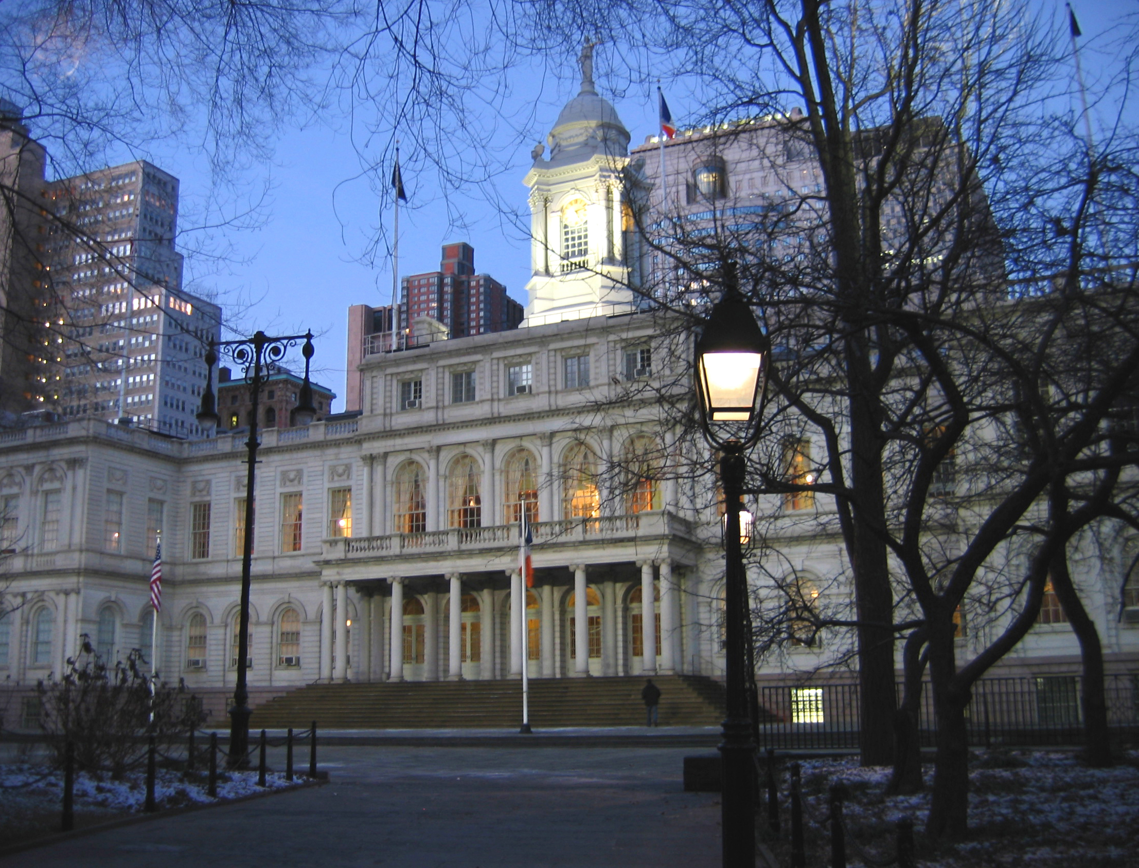
| | | | Another vital connection of great importance is the ferry, here called the Long Island Ferry across the East River. It seems to be at the end of the Crown (Liberty)/Maiden Lane route from the Paulus Hook Ferry, which would allow for through travel. In later times, this ferry became the famous Fulton Ferry to Brooklyn and was about two blocks north (where the word “Water” is), at the end of what became Fulton Street, which also was river to river. Note that Fulton Street (New York) aligns better with the Brooklyn side, which here, curiously, is called Brookland. Brooklyn is here just referred to as part of Long Island, and we don’t see the built-up village further south. Although the very historic street you see on the Brooklyn side is referred to as the Road to Flatbush (in the southern part of Brooklyn), it is today Old Fulton Street and went to Jamaica and beyond, an important point we’ll expand on later. Brooklyn Heights is on the river south of the ferry and west of this road. Picture the Brooklyn Bridge of about a century later than this map (1883) immediately to the north of both Brooklyn’s Fulton Street and New York’s Fulton Street directly across the river. The Brooklyn Bridge in Manhattan obliterated most of Cherry Street, which is where George Washington had had his home (3 Cherry Street) as President, essentially the first executive mansion. The landscape becomes rural en route to Crown Point, which the Dutch had called Corlaer’s Hook and is now spelled Corlear’s Hook (2010/29). | | | | Finally, let’s look at the center of town. Broadway ends not far beyond the Common. Later on it became a very long road, running up the Hudson Valley to Albany, usually maintaining its name along the way. The Common is now City Hall Park. City Hall, seen here from the Park, was built between 1802 and 1812 on the north side of the Common. The other road leading up from the Common is Park Row, which becomes the Bowery. Right behind here is the Collect Pond (here called “Fresh Water”). It served many uses, but an omen of its downfall is apparent on this map. Note the leather tanners nearby. Eventually the pond became so polluted that it was filled in, and is today’s Foley Square, location of many courthouses.
| | | | An additional advantage of the 1776 Ratzer map is that there are several signs of impending war. We’ve already noted the postwar change in royal place names, and now the wealthy Delancey family comes to mind. Today’s Lower East Side has a well-known Delancey Street, which is probably the only thing they’re remembered for now. They had a huge estate, and seeing the spread of the city toward it, they were planning on subdividing their property into city blocks. However, the Delanceys were staunch Tories, and after the Revolution, as Loyalists they were exiled, and their estate confiscated by New York State. It’s curious to see what is essentially a huge, planned real estate development as early as this, marked “New Buildings not Finished”, but 1776 was a fateful year. Actually, there is a bit of a Delancey legacy, in that the state did maintain their planned street layout, that became the Lower East Side, with the exception of the large square (with the name misspelled), which was never built.
| | | | Absolutely priceless are the designations of the two routes north along the length of the island. Kip’s Bay was a bay on the East River in today’s 20’s and 30’s that succumbed to landfill. The King’s Bridge was built in 1693 at the northernmost tip of Manhattan over the Harlem River to the Bronx (then Westchester) to carry the Boston Post Road, and the Bronx neighborhood of Kingsbridge immediately on the Bronx side beyond 230th Street is named after it. But with war looming, the Road to Kings Bridge is here marked where the Rebels mean to make a Stand and the Road to Kip’s Bay (here spelled Kepps Bay) is marked where the Kings Troops Landed. What amazing notations. In our Pinter mode, we know what is going to happen, since we’re already aware of the later chapter. | | | | The Road to Kings Bridge coming up from today’s Park Row became the Bowery (2004/2), about which we’ll have much more to say later in our discussion of “trails, sails, rails”. | | | | New York Place Names Awry Other cities might have local, perhaps unusual usage for referring to places in the region, but I’m unaware of anywhere that has the variety that the New York region has. This selection of references just seem to have gone awry, and visitors should be aware of some noteworthy naming in New York-speak. | | | | JERSEY We’ve already discussed the fact (2009/24) that New Jersey is the only state with a two-word name that is also known by only the second word, Jersey. (Both “Dakota” and “Carolina” are historical names that refer today to more than one state.) It is probable that “Jersey” is used more frequently than “New Jersey”, certainly in conversation. I refer to the Steinberg map (2011/1) that simply refers to “Jersey” without anyone thinking the island in the English Channel is being referred to. We’ve said that the coastal area is always called simply the Jersey Shore, and that the Jersey Turnpike includes the word “New” only on official signs. Also note that the city facing New York named after New Jersey is called Jersey City, not *New Jersey City.
| | | | THE Who would imagine that the definite article could be an issue, but it is, although just a minor one. We note two locations that use “the” in their name, the Bowery and the Bronx, but there are logical, historical explanations for both.
| | | | The Bowery When we first discussed the history (2004/2) of that fabulous street whose reputation was originally very high, the best address in town for the location of country estates, then very low, virtually being synonymous with “the worst” in humanity, and now gentrifying into a street of museums and luxury condominiums, we discussed the Dutch origin of the name. Essentially, the name was De Bouwerij, which means “The Farm” since it went to the country area of farms and estates, notably including that of Peter Stuyvesant. The “Road/Lane to The Farm” was eventually shortened to “The Farm (The Bowery)”, which is why the article is still used today in both speech and writing. It is only left out in addresses, such as 123 Bowery. There is today a Bowery Lane Theater, named after the full name of the original lane.
| | | | The Bronx In 1639, Jonas Bronck sailed up the East River and settled on a piece of land he’d bought from the Native Americans across the Harlem River from Harlem in what is today’s Bronx, corresponding to the area below 150th Street. The story I had always heard--which is now highly suspect--was that visitors would talk about visiting the Broncks, accounting for the use of the article. In actuality, his farm was known as Bronck’s Land, or just Bronck’s. His land abutted the north-south river in the center of today’s Bronx, which was then referred to as Bronck’s River, respelled as today’s Bronx River. But he died four years later in 1643 and his land was sold off, so there is NO direct connection between Bronck and the 1898 establishment of the Borough of the Bronx during consolidation. Yet there is an indirect connection, since it turns out that the Bronx is named after the Bronx River. So how do we account for the article with this explanation? I can only speculate that it’s because the river was called the Bronx, just as we say the Hudson or the Nile. Could that be it? Could rowing on the Bronx (River) have resulted in visiting the Bronx (Borough)? As with the Bowery, the article is left out only in addresses, such as “Bronx, NY”. Also, in the case of Bronx County, the article is never used.
| | | | TAKING THE TRAIN There is no doubt that travel broadens one, and not only about other places, but, in contrast, about your own location. Travel in this way helps one to “know thyself”. I remember on an early visit to Minnesota to visit Beverly’s relatives I commented that I “took the train to work”, to which I was asked “Why don’t you take the subway?” I had to explain that it was the subway I was talking about.
| | | | This question caused me to analyze this aspect of New York-speak. “Subway” is not commonly used in daily conversation. Talking about public transportation, one most frequently talks about taking either “the bus” or “the train”, which is the usual reference to the subway. An alternative to these two in everyday speech is taking “the railroad”. Of course “train” can refer to either the subway or the railroad, but it’s most frequently used to refer to the subway. Since there are today three railroad connections into Manhattan, instead of saying you take “the railroad” you can also be specific such as “take Metro North”, “take the LIRR”, or “take NJ Transit”. [It remains significant, and will be discussed as such, that the three rail connections come from Hudson West (NJ), Hudson East-Mprong (the north), and Hudson East B-Q-LI (Long Island).] | | | | UPSTATE As with many states with anything resembling a north-south division, locations in New York State are referred to as being upstate or downstate. (“Upstate” is more frequent, but “downstate” is occasionally used, such as the Downstate Medical Center in NYC.)
| | | | Most people would consider a reasonable division between upstate and downstate as falling somewhere in the mid-Hudson Valley--Poughkeepsie, perhaps. No one living in Westchester, which borders the Bronx, considers themselves as anywhere near Upstate. Yet when we lived in Westchester, we found there was a tendency in Long Islanders to refer to anything immediately beyond the City Line in the north Bronx as being Upstate. When asked how we enjoyed living Upstate when we lived in Westchester, I had visions of people picturing us sitting under Niagara Falls. Eventually, we just resignedly accepted the designation. | | | | DOWNTOWN-MIDTOWN-UPTOWN Americans call the oldest part of a city “downtown”, as in “Downtown Brooklyn”. The “down” DOES NOT indicate any direction, south or otherwise, and Downtown Brooklyn happens to be in the northwest corner of the borough.
| | | | [European downtowns are referred to in various ways: GE Altstadt (Old City); FR Centre Ville (City Center); IT Centro Storico (Historic Center). British usage usually refers to the City, certainly in London, but also elsewhere. German also borrows this word as “die City” for more contemporary use, as in Germany’s high-speed train the ICE or Inter-City Express. Americans probably slightly misunderstand this usage as meaning inter-urban, while it most accurately means inter-downtown.]
| | | | Given the long, slender shape of the island, Manhattan uses Downtown, Midtown, and Uptown, and this usage is very unique. I know of nowhere else that uses the term Midtown; Uptown is used occasionally elsewhere in a manner I do not understand. But the terms in Manhattan are unique, because two of them are not only locations, but are also DIRECTIONAL. Given the slender shape of the island, Downtown has the meaning of South/Southbound and Uptown means North/Northbound. When taking the train, on a subway platform you will know which direction the trains will be going in by noting which is the Uptown or Downtown platform. If you were Uptown and took the Downtown train, you may be only going to Midtown; the term only means you are headed south.
| | | | Suppose you are giving driving directions: drive five blocks Uptown, make two right turns, then go back Downtown one block. The two terms simply replace “north” and “south”. This is unique and does not work this way in other cities.
| | | | THREE NEW YORKS This is most unusual. Everyone knows of two New Yorks, New York State and New York City. (Unlike Oklahoma City or Jersey City, “City”--or “State”--is not part of the name, but just added when necessary for clarity.) But in reality, the total is really three, since on the city level there are still two New Yorks. One is five boroughs large, and the other--surprise--is one borough large: Manhattan.
| | | | The 1898 consolidation was extremely successful, since five-borough New York is considered to be New York City. But in another sense it would appear that no change had taken place. We mentioned earlier the mail designation Bronx NY. Similarly, there is Queens NY, Brooklyn NY, and Staten Island NY. Only Manhattan uses the postal designation New York NY. A new resident in one of the four so-called “outer boroughs” who uses the post office designation New York NY will get his mail misdirected to Manhattan. In other words, even on the city level, the term New York means two things. A Queens resident could still say he lives in New York, as long as it’s clear he isn’t referring to Manhattan. Context makes the difference in an otherwise confusing situation. Inbound railroad trains are said to be going to New York, with the clear meaning of Manhattan. If a LIRR train is going to Brooklyn--which is in the city--it’s marked “Brooklyn”, or nowadays Atlantic Terminal, the new name for the Downtown Brooklyn station. For further clarity, trains going to “New York” are instead marked “Penn Station”. Sometimes the term “Greater New York” is used to refer to the five boroughs, but this, too, is confusing, since the same term could refer to the entire metropolitan area including parts of New Jersey and Connecticut and adjacent New York State areas. | | | | THE CITY Still under this same rubric of multiple New Yorks, the word “city” has two designations. In writing a differentiation COULD be made by capitalization: City versus city. That is not always done, and in speech, such a distinction is moot.
| | | | If you live in the Bronx, you live in the city, and still, you may take the train to the City, since you work in Manhattan. Context really tells the difference in this confusing situation. You could live in Jersey or within the city in Brooklyn, and still take a train to the City to see a Broadway show.
| | | | Furthermore, since both New York (Manhattan) and Brooklyn were twin cities before consolidation, using “the City” for just Manhattan doesn’t really make sense, since it theoretically could also refer to Brooklyn--but it doesn’t. Also, New York (Manhattan) before consolidation spilled over into the Bronx (then Westchester). Shouldn’t “the City” refer to this oversized area? Well, it doesn’t, it just refers to Manhattan proper.
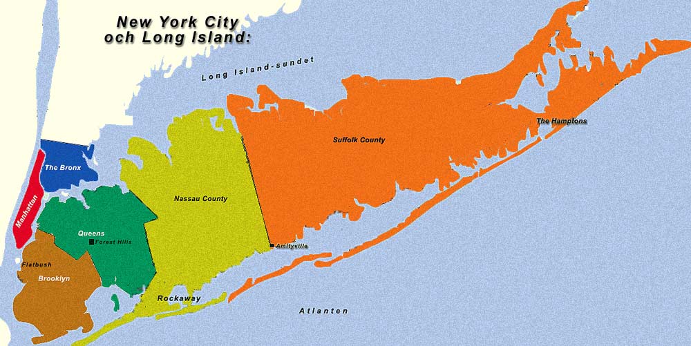
| | | | LONG ISLAND If the 1898 consolidation might seem in a way rejected by New Yorkers (in any sense) still referring to Manhattan itself as New York, this is more than made up for by what happened to poor Long Island. To outsiders the dissection of geographic Long Island might seem like off-the-wall nonsense that couldn’t really be so, but to New Yorkers (in any sense) it’s just business as usual.
| | | | A friend, who had visited New York (Manhattan) on occasion but still had to get out his atlas to follow the descriptions of 2011/1 and other recent postings, recently asked me: “Where is Long Island?” I was taken aback for a second, and then fully understood his confusion. He’s absolutely right. Where on earth IS Long Island?
| | | | I’ve avoided using this Swedish map before because, aside from the fact that it leaves out Staten Island, it has a pair of serious errors. The Rockaway Peninsula is in Queens, and should be green, not yellow, and the western half of Jones Beach Island is in Nassau, and should be yellow, not orange. Otherwise, this map shows what we need to discuss.
| | | | We are looking at geographic Long Island, which has four counties. NO ONE in the New York area EVER refers any refers to the four-county area as Long Island. This sad fact is only attributable to the 1898 consolidation of New York City. When Adriaen Block circumnavigated Long Island it was of course the entire area. When the Ratzer map shows Brooklyn and otherwise indicates “Part of Long Island”, that was a true picture. But since 1898, Brooklyn and Queens, the western third of geographic Long Island, have been considered something of a special entity--and are often grouped together as such--and have been “removed” in local minds from Long Island. Warning: don’t ever suggest that Brooklyn or Queens is on Long Island to locals, because they’ll look at you as though you’d said Chicago--or Timbuktu--is on Long Island. It’s anathema.
| | | | In local minds, Long Island, or “the Island”, consists of just those two areas OUTSIDE New York City limits, Nassau and Suffolk Counties. This is the correct answer today to the question “Where is Long Island”, as off-the-wall as it may seem. I suppose we have to say that “Long Island” is not an island at all, but a huge peninsula emanating from the Queens end of the entity known as Brooklyn-and-Queens. Under this contemporary definition, you cannot get in a boat and circumnavigate “Long Island”, since you’d bump into that pesky land border between Queens and Nassau. This “shrinkage” of Long Island leaves anomalies: | | | | The Long Island Expressway Driving from Midtown Manhattan through the Queens-Midtown Tunnel one emerges on the Long Island Expressway, which runs to Riverhead, at the beginning of the split between the East End forks. But it being Queens, the name Long Island Expressway perhaps seems odd to locals, and only makes sense once one crosses into Nassau.
| | | | The Long Island Rail Road The Long Island Rail Road (idiosyncratically never written as “Railroad”) also emerges from Manhattan into Queens, while another line leaves Brooklyn, both lines merging at the LIRR rail hub at Jamaica. Yet it is only once the several lines emerging from Jamaica cross into Nassau County that people feel the railroad’s name makes sense.
| | | | Long Island City In 1870 the independent city of Long Island City was formed in the westernmost part of Queens, on the East River facing Manhattan. It lost its separate identity in the 1898 consolidation, and is today simply a Queens neighborhood. Yet no one questions why Long Island City is in Queens and “not on Long Island”.
| | | | Long Island University Long Island University (LIU) was founded in 1926 in Downtown Brooklyn, where one of its main campuses remains. No one in Brooklyn today seems to question why Long Island University should be in Brooklyn and “not on Long Island”. (The other campuses are.)
| | | | [It is noteworthy that no one had a problem as late as 1926, 28 years after the 1898 consolidation, with confirming that Brooklyn was indeed on Long Island and that one could name a campus as such. Also remember the Ratzer map’s reference, south of the ferry, to the “Road to Flatbush”, which is today’s Flatbush Avenue. LIU is on Flatbush Avenue at Dekalb Avenue, just steps from Brooklyn Tech on Dekalb Avenue.]
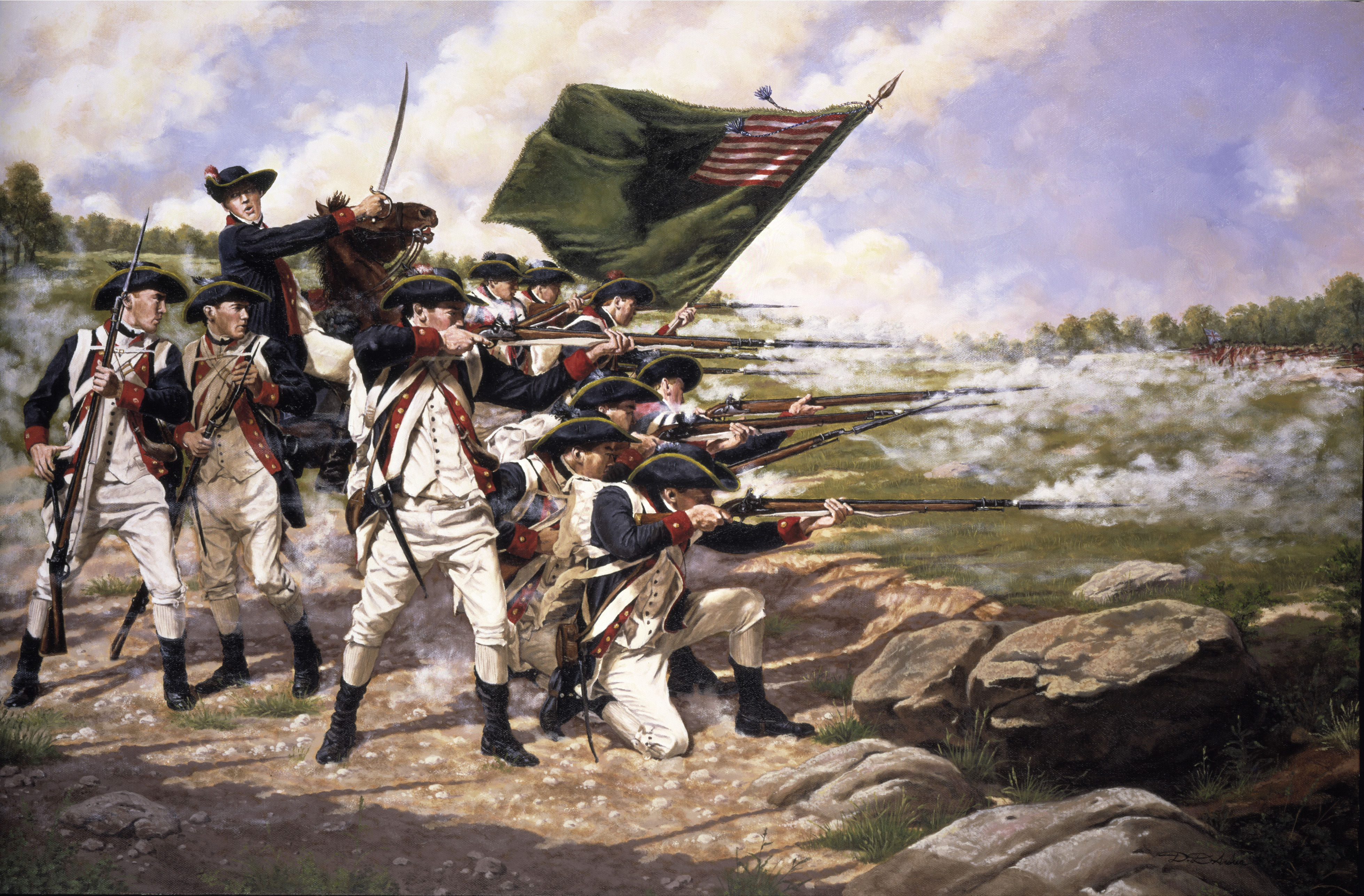
| | | | The Battle of Long Island The Battle of Long Island is the Revolutionary War battle fought in Brooklyn on 27 August 1776. It is exciting that the 1776 Ratzer map was already making references to the war (it had started in 1775), but the map was making military comments about the center and north of Manhattan, not Brooklyn. The Ratzer map also confirmed that Brooklyn was “Part of Long Island”,
| | | | It was the first major battle of the war after the Declaration of Independence the month before (54 days earlier), and therefore the first battle in which an army of the United States ever engaged. It was also the largest battle of the entire conflict (10,000 Americans, 20,000 British and Hessians) and at the time, the largest conflict ever fought in North America. | | | | Washington, coming from winning the siege of Boston, was trying to defend New York, where he had the bulk of his forces, and set up headquarters on Broadway on 13 April. On 6 July, news arrived that Congress had voted for independence, and on Tuesday, 9 July at 6:00 PM, Washington had several brigades march onto the Commons of the City (see Ratzer map) to hear the Declaration of Independence read aloud. At the end of the reading, a famous event occurred. A mob ran down Broadway to Bowling Green where, with ropes and bars, they tore down the gilded lead statue of King George III on his horse, which was dragged to Connecticut and melted down into musket balls. We’ve also seen statues come down in the 20C.
| | | | Washington then moved some troops to Brooklyn. The British later landed in Staten Island and blocked the Narrows, after which they attacked American forces in Brooklyn, who fled north to Brooklyn Heights. The British were ready for a siege, but in the night of 29-30 August, Washington secretly evacuated all his troops in Brooklyn Heights in utter quiet by the ferry to Manhattan without loss of material or life. This was depicted on a 1951 US postage stamp commemorating the 175th anniversary of the event. [This appears to be a smaller version of the evacuation of troops from Dunkirk in 1944, although there, material had to be left behind.] The British on 15 September landed at Kip’s Bay and occupied New York. Since the Ratzer map indicates this landing, it was published after that date. Washington and the Continental Army moved north to Harlem Heights, but then had to abandon New York. All in all, the Battle of Long Island was a decisive British victory, and New York was British throughout the war. | | | | But now to our main point amidst all this history: although Brooklyn was at the time just a small village east of Brooklyn Heights (see battle map above), and while the most accurate name remains the Battle of Long Island, should that name confuse (“Brooklyn isn’t on Long Island!!!”), it can also be called the Battle of Brooklyn, or even the Battle of Brooklyn Heights.
| | | | The Long Island Historical Society In 1863 the Long Island Historical Society, a museum, library, and educational institution, was founded on a quiet, leafy street in Brooklyn Heights, which is particularly significant, given the above Battle history. Where else but in Brooklyn, the Queen City of Long Island and its commercial and cultural center, should such an institution be? Its landmark building, on the National Register of Historic Places, is in Queen Anne style and was completed in 1881. But in time, the Long Island Historical Society yielded to public ignorance (“Why is the Long Island Historical Society in Brooklyn? Brooklyn isn’t on Long Island!!!”) and it renamed itself the Brooklyn Historical Society, a name that is now literally in stone above its doorway. If you cant beat ‘em, join ‘em.
| | | | And thus we come full circle, since it was the Brooklyn Historical Society that just discovered the new copy of the Ratzer map.
| | | |
| |
|
|
|

