|
Reflections 2021
Series 1
January 8
Constantinople-cum-İstanbul
| | Turkey-in-Europe We didn't get to use our Political Map too much in the previous posting, but it can be helpful now. Look it over again, then move down towards Turkey:
https://www.mapsland.com/maps/europe/balkans/large-detailed-political-map-of-the-balkan-states.jpg
We will have little to say about Turkey as a whole, since our focus won't be on the entire country. We'll be concentrating primarily on Istanbul (along with the rest of Turkey-in-Europe) and the Turkish Straits, and will only minimally mention Anatolia (Turkey-in-Asia) as a further extension of that.
| | | | | | But a word or two never goes amiss. Anatolia is a huge peninsula, the westernmost protrusion of Asia. The name derives from a Greek word referring to the sunrise and meaning "the East", since Anatolia lies east of Greece. The name is consistent in most languages. The male given name Anatol, rare in English, has the same derivation, and so means "sunrise". It's a little more common in French, as Anatole—the poet Anatole France comes to mind—and it quite a bit more common in Russian and Ukrainian as Анато́лий / Anatóliy—you may know the Russian chess grandmaster Anatoly Karpov.
But the first recorded name the Greeks used for the peninsula was Ἀσία / a.SI.a, which might have also referred to the sunrise. As over time, the name Asia broadened in scope to encompass areas MUCH further east, so in Late Antiquity, the Greeks started to refer to Anatolia as Μικρὰ Ἀσία / Mikra Asía, literally "Micro-Asia". This, in the Latin version "Asia Minor", also entered English, and was similar in languages derived from Latin: FR: Asie Mineure; SP: Asia Menor. But in Germanic and Slavic languages, the local word for "small" is usually used instead: GE: Kleinasien; DU: Klein-Azië; SW: Mindre Asien; RU: Ма́лая А́зия / Málaya Áziya.
|
| | | | But let's get back to the European side. Actually, I always wondered why, after losing so much of southeast Europe, Turkey still includes European territory to this day, and I'm coming to believe more and more that it's primarily not a question of land, but a question of water: it's so that the Turkish Straits remain within one country. And of course, to hold on to Constantinople.
Turkey-in-Europe is a remnant of a geographical and historical region with boundaries based on the Roman Province of Thrace (sometimes called Thracia) shown here in yellow-and-blue (Map by Infestor). As we've seen, Greece had a strong influence in this entire region, and so it turns out that Thrace was, in Greek mythology, a sorceress who supposedly lived in this area. To be accurate, the name was, in the original, Θράκη / Thráki. But let's step back and get a more complete view of what had been Thrace and its region, but showing modern borders (Map by Пакко). To tell the whole story, Thrace comprises southeastern Bulgaria (North Thrace), northeastern Greece (West Thrace), and the European part of Turkey (East Thrace). Thus, Turkey-in-Europe is technically East Thrace, but if the context is clear, it can be referred to simply as Thrace.
You'll recall that, when we were talking about the horse-drawn carriages carrying passengers early on on the Belgrade/Sofia route, we mentioned in passing that the city of Edirne (é.DIR.na) is completely in Turkey. Click to find it on the Political Map. There had been an earlier settlement, but the Emperor Hadrian refounded the city, naming it after himself as Hadrianopolis. In locally important Greek, it was Ἁδριανούπολις / Hadrianoúpolis.
| | | | | | H SOUND I refer back to our discussion of Rhode Island, where we talked about the Greek letter rho, as well as initial H in Greek words (2029/14, Ctrl-F: H Sound). We said it appeared as a "breathing" mark above the first vowel, looking like a left-hand single quote. Check that out in Ἁδριανούπολις, where the breathing accounts for the H. These breathings disappeared, and are no longer written in Greek, so the modern Greek name is Αδριανούπολη / Adrianoúpoli. (It also lost the final S, but that's no surprise: compare Tripolis becoming Tripoli, Neapolis becoming Napoli.)
Thus, based on Greek, the English name became an H-less Adrianople, even tho it was named after Hadrian (for the ending, compare Constantinople). Tho harder to see, the Ottoman name Edirne also derives from the Greek name. The name Adrianople was used in the West until the reforms of Ataturk in the late 1920s, when the Turkish form Edirne became mandatory.
I dwell on this to show that initial H has always been a very fleeting sound. In English, initial H thrives when stressed. If it isn't supported by being stressed, as in HIS.to.ry becoming his.TO.ri.cal, it's often dropped, as in "an (h)istorical novel". But let's return to the Greek influence. There are a number of names starting in H where it can disappear to form a variant:
Hadrian / Adrian are variants of the same name, so are Helen / El(l)en; Hester / Est(h)er; Hanna(h) / Anna.
Not connected to Greek, but similar in nature, is the fact that German Helga developed in Russian to Olga. In addition, while a person might be a hindu, and the language is hindi, the country is an H-less India, not *Hindia.
|
| | | | Waterways: The Black Sea We need to discuss the Turkish Straits, but I find you cannot discuss them without mentioning the Black Sea as well, since the Straits are the outlet of that sea to the world oceans. Let's start by seeing how much water we're talking about.
https://i.redd.it/h0hdiaj56ju41.png
This, in German, shows the Black Sea (Schwarzes Meer) Drainage Basin. We already know about the size of the Danube (Donau), but can now see that the Dniester (Dnister), Dnieper (Dnepr) and Don, among others, also empty into it, resulting in a massive inflow of water. I've gotten curious how something so large seems so aloof from other waterways, and assumed there must be a geologic answer, and now I've found it.
We have to go back to that word endorheic (stress the "RHE" syllable), referring to a body of water with inflow, but no outflow of note to the oceans, so it loses water only by evaporation. We first came across the concept in China's Qinghai Lake (2014/9) and also talked about the Dead Sea and Death Valley. We found after that that Lake Titicaca is also endorheic (2017/9). Moving to our present area now, we find that the adjacent Caspian Sea (Map by Redgeographics) is endorheic as well, despite the huge Volga flowing into it. Now let's move to the left (west) to the Black Sea (Map by NormanEinstein). Scientific theory has it that during the last glaciation, and for some time after, the Black Sea was landlocked, and therefore was also endorheic. With that thought in mind, the Turkish Straits leading via the Aegean to the Mediterranean become even more interesting.
Worldwide water levels have varied significantly over geological time. At the height of the last ice age, sea levels were more than 100 m (330 ft) lower than they are now, so that today's Turkish Straits were a land barrier to water exchange. But in the aftermath of the last glacial period, water levels in the Black Sea and the Aegean Sea rose independently until they were high enough to exchange water. Just when that might have happened remains subject to debate, but one thought is that the Black Sea filled first, with excess freshwater flowing thru the Straits and reaching the Aegean and Mediterranean.
But how the water flows today in the Straits is counterintuitive, since it's bidirectional! And that's not due to tides--it's simultaneously bidirectional! It's all based on the fact that the Mediterranean is saline, and the Black Sea is fresh water, with a large volume of it. Inflow from the Mediterranean, with its higher salinity and density, occurs below, while freshwater outflow from the Black Sea, being lighter, occurs near the surface in the Straits. Since the inflow is only about 70% of the outflow, there's a positive water balance out from the Black Sea. The two flows occur simultaneously, one above the other, and do not mix.
I was also quite surprised by the name. Popular supposition assumes it's called the Black Sea from the dark color of the water, but there's a very interesting cultural explanation that has been proposed, involving "color symbolism". It holds that red refers to the south, and black refers to the north (Also, white is west and green or light blue is east.) Could it be that the bright sun is often in southern skies, leaving northern skies darker? In any case, that would mean that, from the point of view of the Greeks, the Black Sea was the Northern Sea and the Red Sea south of the Mediterranean between Africa and Arabia was the Southern Sea (Map by Eric Gaba [Sting]).
| | | | | | There are two other seas with "colorful" names, and they have nothing to do with this theory. It's believed that the White Sea in northern Russia might be named because of its frequent ice cover, or the whitish color of the water reflecting the northern sky. The Yellow Sea between China and Korea could be called that either because of the fine sand grains from the Gobi Desert sand storms turn the surface a golden yellow, or that silt from the Yellow River might do something similar, since that river gets ITS name from its silt it carries. |
| | | | Waterways: The Turkish Straits Separating Thrace and Anatolia are the Turkish Straits. After looking more into the Black Sea's geology, we now see more clearly that the Straits don't just separate land, they act as a sort of river, joining seas. This simplified picture of the Turkish Straits (Map by Interiot) sets the stage: Red indicates the Bosporus Strait and yellow the Dardanelles Strait. In Turkish, they're named after cities on them: The Bosporus is the İstanbul Boğazı (consider the ğ "silent"--more later) and the Dardanelles is the Çanakkale Boğazı (Ç = CH as in "chair"). Since boğazı is Turkish for "throat", it describes the same sort of constriction that lets it also be used to means "strait". Because these two straits function as a sort of pseudo-river, it's particularly odd to have another body of water between them, the Sea of Marmara.
https://thumbs.dreamstime.com/z/road-map-marmara-sea-istanbul-vector-85511289.jpg
This map, however, shows a lot more. Look at the Bosporus to find the first bone of contention, where it's called the Bosphorus, a version I think is, thankfully, rarer in English, and which I dislike. Here's the issue: is it Bosporus with a P or Bosphorus with an F (spelled PH)--don’t get entangled in spelling quirks: it's a P or an F. To understand this difference in this Greek-influenced part of the world, we go back to Ancient Greek, where the name was: Βόσπορος / Bósporos—you don't have to remember too much of the Greek alphabet to find pi (π) in the middle of the word. Dictionaries also seem to prefer the P version, but the F(PH) version occurs as a variant in medieval Latin (as Bosfor[us]), and in medieval Greek sometimes as Βόσφορος / Bósforos, showing the letter phi (φ). Now there's nothing wrong with this version, but English can use both, and P is preferred. Otherwise the F is perfectly normal in Latinate and Slavic languages, such as the French form Bosphore, Romanian & Polish Bosfor, Catalan Bòsfor, Russian & Ukranian Босфор / Bosfor, tho an O is added in Italian Bosforo, and Spanish & Portuguese Bósforo. But all the Germanic languages are like English, including German, Dutch, Danish, and Norwegian. So is Swedish Bosporen, tho it adds the article "the" as the suffix –en.
Tho I've only seen (and crossed) the south end of the Bosporus in Istanbul, I find that it's a mere 30 km (19 mi) long, with a maximum width of 3.7 km 2.3 mi) at the northern entrance and a minimum width of 0.75 km (0.47 mi) just south of its midpoint.
For some reason, since I learned about these waterways in the 6th grade, I've always been fascinated by the Sea of Marmara and how it interrupts the two straits. Only now am I surprised to find that it gets its name, quite logically, from the largest island within it, Marmara Island (see map). A further surprise is that it all comes down to marble. Marmara island is rich in marble, and it remains the island's primary export. It was used extensively in the Hagia Sophia and in other buildings around the Mediterranean, including in the Roman Forum. The Pergamon Altar in Berlin's Pergamon Museum is made from marble from Marmara Island. Who knew?
But we need to look more deeply into the word "marble", since it varies wildly—and crazily--between languages. And so we go back to the best source for this region, the Greek word μάρμαρο / MAR.ma.ro and inspect the second –MAR-, which has the consonant sequence M-R.
German Marmor and Dutch marmer remain the closest, keeping M-R and just changing the vowel.
Spanish mármol changed the vowel, but also changed M-R to M-L.
French marbre replaced that M with another lip-sound, B, and lost the vowel entirely, thereby changing M-R to BR.
English marble followed French, but went further, by also changing the R to an L: M-R went via BR to BL.
Russian мрамор / mramor took a totally different route. It, uniquely, left the last syllable alone, and instead flipped the first MAR- to MRA-.
But that wild spree with the noun rarely affected the name of the Sea: GE: Marmarameer; FR: Mer de Marmara; SP: Mar de Mármara; DU: Zee van Marmara. But note RU: Мраморное море / Mramornoye morye.
I find that the Dardanelles has a pretty name. The word is singular, as you see, but comes from a plural form. In Ottoman times there was a castle on each side of the strait and the two were known together as the Dardanelles, and so hence the plural form. They're gone. They were probably named after Dardanus, an ancient city on the Asian shore. It's gone. That city apparently took its name from the mythical son of Zeus and Electra, Dardanus, who's also not around anymore. Just the Dardanelles. The name is easily recognizable in other languages. In French it's exactly the same, otherwise: GE & DU: Dardanellen; SP: Dardanelos; Ru: Дарданеллы / Dardanelly. The Dardanelles is 61 km (38 mi) long, making it twice the length of the Bosporus. Its maximum width 6.5 km (4 mi) and its minimum width is 1.2 km (0.75 mi)—both figures are also approaching double those of the Bosporus.
On our map find, in the Dardanelles, the city of Gelibolu. That's the Turkish version of Gallipoli, the horrific WWI battlefield site, so very particularly important to Australians and New Zealanders. For its name, I refer you once again, to Greek and to the word "calligraphy" ("beautiful writing"), whereby κάλλος / kallos is "beauty". Thus Καλλίπολις / Kallípolis, is "Beautiful City". Gallipoli is the Italian form of the Greek name.
We can now zero in on the Istanbul area, but let's take it slowly. I've always been convinced one learns about a city best from past to present, not vice versa. I also think the recent past splits the time difference best, and so we come to this:
https://upload.wikimedia.org/wikipedia/commons/d/d3/12_-_Konstantinopel%3B_Scheda-Karte_europ_T%C3%BCrkei.jpg
It's an Austro-Hungarian map in German of Konstantinopel, dated 1860-1870. We now get to see that interesting Historic Peninsula which has housed Byzantium, Constantinople, and now Istanbul, but we'll get to that, since we're still talking about waterways. The peninsula of course borders on its east the southern end of the Bosporus, and that allows it to also border to its south the Sea of Marmara, with actually a longer coastline. But our point of interest is what's to its north, a very famous waterway called the Golden Horn. This older map is the only one I've seen that shows why the Golden Horn is there, since it shows its source rivers, the Alibeyköy and the Kağıthane. Just before the city, the two rivers merge to become one, but this entire merger ends up as a drowned estuary of the Bosporus, an inlet called the Golden Horn. And it's the location of the Golden Horn that makes the historic city into a peninsula, thereby defining it.
It's an unusual name. It was called a horn because of its shape, and it was "golden" perhaps because of the wealth brought on ships that docked here toward the end of the peninsula—or because of the sunlight shining on it. The name is consistent in various languages: GE: Goldenes Horn; DU: Gouden Hoorn; FR: Corne d'Or; SP: Cuerno de Oro; IT: Corno d'Oro; RU: Золотой Рог / Zolotóy Rog (зóлото / zóloto = gold). But the Turkish name is different, and is possibly the only word I learned in Turkish when I was there. The Golden Horn in Turkish, however, is the Haliç (ha.LICH, rhymes with "leech"). The Turkish name simply means "estuary", which really makes a lot of sense. Add it to your vocabulary, as I'll be using it.
| | | | Outlying Areas It's worthwhile to talk about a couple of locations of importance, since their early forms are so well shown on this map. Located on the northern shore of the Golden Horn opposite the Historic Peninsula is/was Galata (ga.LA.ta) which became the historic name of the Karaköy neighborhood once place names were Turkified in the 1920s. The district is connected to the Historic Peninsula by several bridges, most notably the Galata Bridge. This is indicated on the map as the Neue Brücke, but calling it the New Bridge is almost a joke, since there have been five bridges at that location from Classic times to the present day.
The medieval citadel of Galata was a colony of the Republic of Genoa between 1273 and 1453. We first noted that the Genoese came this far east with the founding of Giurgiu on the Danube in Romania in the last posting. The famous Galata Tower was built by the Genoese in 1348 at the northernmost and highest point of the citadel. It's number 5 on this map, if you can find it near the top of the gray area.
North of the citadel walls of Galata you'll find Pera, an appropriate name, since Πέρα in Greek means "beyond", and this area was beyond the walls of Galata. The name Pera was maintained during the Middle Ages and, in western languages, into the early 20C. But today, not only is Pera called by its more Turkish name Beyoğlu (BÉ.yo.lu), it now encompasses the former Galata plus areas well north of both. And so pretty much all of the north shore of the Haliç, in other words, modern Istanbul, is referred to as Beyoğlu.
Finally, not only was there early growth across the Haliç from the Historic Peninsula in Galata, the same thing happened across the Bosporus in what used to be called Scutari (spelled in German Skutari on the map). It was again a Greek name, Σκουτάριον / Skoutárion, which became in Italian Scutari, the name used in English and other languages. (Could that have been the Genoese influence again? Just a guess.) But it's now called Üsküdar (üs.KÜ.dar). Can you tell it's a variation of the very same name? Picture it without the first vowel and it'll be clearer that it's just another version of Scutari.
| | | | The Historic Peninsula Now we'll move in from the outlying areas and take a look at the Historic Peninsula. On an earlier map like this you can see the city walls of Constantinople, protecting the historic center from land attack. While we won't be doing any great discussion of sights, we can point out three major ones that are both famous and that are in the most historic of locations—at the end of the peninsula. We'll discuss them later.
The large set of buildings in that green park area comprise the Topkapı Sarayı or Topkapi Palace, also known as the Seraglio (se.RAL.yo). It's today a museum, but was once the residence of the Sultans. At the northern end of the park is the culmination of the peninsula, the famous Seraglio Point, shown on the map in German as the Spitze des Serai. To the southwest of the park is one of the most famous buildings in the world, the Hagia Sophia at number 5, and further still is the famous Blue Mosque at number 7.
| | | | | | I only just discovered something on this map of interest, altho by now it has to be hugely out of date. Click at the extreme lower right to find a color code for ethnic areas for "Mohammedans", Christians, and "Hebrews". The green symbols show the same division of cemeteries. |
| | | | Here's a puzzler for you. This map is dated 1860-1870. Just thirteen years after that, Nagelmackers would be bringing his Orient Express to town in 1883. Of course, passengers first came by steamer out of Varna, which arrived from the Black Sea down the Bosporus to Constantinople. Picture that on this map. Where might they have docked? I believe it was on the south side of the Haliç between Seraglio Point and the Galata Bridge, where anchor symbols on this map show docking facilities, which is also where the rail station would eventually be built. | | | | Byzantium Three names come readily to mind for the city we're studying, and the first was Byzantium. It was first named in Classical antiquity in Greek—of course--as Βυζάντιον / Byzántion, and we use the Latin version of that. Only in Late Antiquity was it renamed Constantinople. Byzantium had been colonized by the Greeks in 657 BCE, and remained primarily Greek-speaking until its conquest by the Ottoman Empire in 1453 CE.
From what we know of the region, it should not surprise that Byzantiium (Map by Thomas Ihle) was located right at the tip of the Historic Peninsula, at Seraglio Point and its adjacent hilled area, which retained its importance as the city changed later. This simple map also indicates how Constantine expanded it—including Galata—and how it was later expanded further to the walls we saw.
| | | | | | It strikes me that the adjective "Byzantine" today is used in two references: (1) It describes an ornate artistic and architectural style that developed in the Byzantine Empire and spread especially to Italy and Russia. The art is generally rich and stylized (as in religious icons) and the architecture typified by many-domed, highly decorated churches. Simply put, the "onion domes" of Russian churches are described as being of a Byzantine style. (2) The word also means "excessively complicated", such as when talking about "Byzantine insurance regulations" or a "Byzantine tax code". This is apparently based on the bureaucracy of the Byzantine Empire. |
| | | | Constantinople It was in 324 CE that the ancient city of Byzantium was made the new capital of the Roman Empire by Emperor Constantine the Great, who named it after himself (what else?). Its basic name was Greek, Κωνσταντινούπολις / Konstantinoúpolis, with the Latin version as Cōnstantīnopolis. The suffix, consisting of a "connecting O" plus –polis for "city" reduced thusly: -opolis became: IT & GK: –opoli; SP & POR: -opla; RU: -opol'; GE & DU: -opel; FR & EN: -ople.
The Turkish version is Kostantiniye. Tho the Turks are NOT Arabs, they used to use the Arabic alphabet, and that was the version by which the city came to be known in the Islamic world. It really is a simple variant of Constantinople, with an Arabic ending meaning "place of" instead of Greek polis for "city".
This is a more detailed topographical map of Constantinople during the Byzantine Period (Map by Cplakidas), but summarizing features that were there over various times within it. The Hagia Sophia is already here—this was a Greek city--and the Byzantine walls are indicated. Galata has its own walls, and the Galata Tower is shown as part of them. It's also interesting that, facing Galata were neighborhoods in the 11C-12C housing people from Venice, Amalfi, Pisa, and Genoa.
| | | | | | We said in 2020/9 that, regarding the rebuilding of Saint Nick's at the WTC, Calatrava's plans were influenced by the Byzantine 4C . . . Chora Church . . . converted into the Kariye Mosque in the 16C . . . . The location of that building is shown at the top of this map, on the inner side of the northern end of the old city wall. |
| | | | After the fall of Rome, which stretched from 396 to 476 CE, Constantinople became the only capital of the Roman Empire (330–395), then the Byzantine Empire (395–1204 & 1261–1453), the Latin Empire Crusader state known (1204–1261), and the Ottoman Empire (1453–1923), the latter being from the Turkish Conquest to the establishment of the Turkish Republic, after Constantinople was occupied by allied troops after WWI. From the mid-5C to the early 13C, Constantinople was the largest and wealthiest city in Europe and a center of culture and education. It was so famous and so well-known that colloquially the local Greeks just referred to as ἡ Πόλις / i Pólis ("the City"). This is the same as when people living in metropolitan NYC talk about going into "the City" when referring to Manhattan. This colloquial name was the basis for the later formation of the name Istanbul (see below). | | | | Seraglio Point It would seem obvious that, not only is the Historic Peninsula the core of what's interesting in this city, it's the promontory at its eastern tip with the three monuments mentioned that's the most special. Again, it's Seraglio Point, called in Turkish the Sarayburnu. And sure enough, there have been various settlements on the Sarayburnu over the millennia, the oldest being Neolithic from c 6600 BCE. Let's look at the two parts of that name.
I find that the word burnu (also burun) actually means "nose". We've seen "nose" in English used to describe promontories such as Anthony's Nose in the Hudson, and the Devil's Nose in Ecuador. The word therefore also means "promontory" or "cape".
The Persian word for a palace was sara'i, which became in Turkish saray. It was used to describe this palace of the sultans, but it also meant "harem". In French it was pronounced exactly the same, but came to be spelled serail (we'll see in a later posting more French words in -rail that rhyme with "rye"). Mozart used the word when he wrote the opera Die Entführung aus dem Serail / the Abduction from the Seraglio, but in German the word is pronounced ze.RAIL (rhymes with "rile"). The Italian version was modified to seraglio (se.RAL.yo), which is what English borrowed as of the 1580s. Hence, a reasonable translation of Serayburnu is Seraglio Point or Seraglio Cape.
And here it is. This is a panoramic view (Photo by Gryffindor), stitched together from eight pictures, of the Sarayburnu looking westward from the Bosporus. On the left is the Sea of Marmara, then (click, and follow the minarets) come the Blue Mosque, the Hagia Sophia, and Topkapı Palace. On the right, across the Golden Horn (not itself really visible), is the Galata Tower. So let's move closer. Here we're looking across the Golden Horn / Haliç to Galata, the neighborhood now renamed Karaköy (Photo by Lapost). And let's get closer still. Here's the Galata Tower (Photo © A.Savin, WikiCommons), built in 1348 at the northern apex of the Genoese citadel.
https://upload.wikimedia.org/wikipedia/commons/5/5e/Istanbul2010.jpg
We'll get to my 1965 (55 ½ years ago!!!) visit later, but I have two more pictures to show. The above view is how I remember our visit. It's an aerial view from Beyoğlu (Pera) looking south. Galata and the Galata tower are in the foreground, then the latest of the five bridges called the Galata Bridge crosses the Golden Horn / Haliç to the Historic Peninsula and Sea of Marmara beyond. To the left (east) of the bridge is the wharf where fish sandwiches called balik ekmek are sold that we'll talk about later. In the distance, from left to right, are the Topkapi Palace, Hagia Sophia, and Blue Mosque. I have fond memories of this area, and note particularly the low-lying level of buildings in these historic areas.
Now I know there have been huge changes since we were there. I understand there was a rapid increase of Istanbul's population in the 1970s and the city expanded. Where there were no fixed crossings of the Bosporus at the time, there are now three bridges and two tunnels. There was no subway, and now there is an extensive one, and intercity rail traffic has also exploded. These are all wonderful improvements, and we'll be discussing them on a later posting.
But then I've been looking at some pictures like this contemporary panorama looking north from the Sea of Marmara and am shocked (Photo by Ben Morlok). Every city has a right to modernize, but I find it hard to believe that so much Manhattanization (and I used that term pejoratively) has hit Istanbul. And this picture was taken in 2012, so it may be worse now. Fortunately, it seems to have primarily hit Beyoğlu, and not the Historic Peninsula, or even Galata. Click to inspect from the left the Blue Mosque, the Hagia Sophia, and Topkapi Palace, but consider the backdrop they have! At the time, we stayed at a hotel on the Historic Peninsula, and I would do it again. If I wanted Manhattan, I wouldn't leave home. But then, that's progress.
| | | | Names of Constantinople/Istanbul While Byzantium was an entirely different name, the names Constantinople and Istanbul ran parallel to each other for centuries until Istanbul was adopted as the official name in 1924, and it's time to talk about that. (Here's a tidbit about stress: while English says IS.tan.bul, Turkish says is.TAN.bul, but you can promptly forget that.)
As we said earlier, based on its importance, size, and wealth, despite the official Greek version of the name, colloquially, Greeks have always called it simply "the City", which is apparently still in use in Modern Greek, and appears as η Πόλη / i Poli (that final S in "polis" was apparently lost early on, again note: Tripoli, Napoli).
That phrase is the basis for another very common phrase that means "in the City", which is εις την Πόλιν, which does spell "is tin Pólin" (I assume both Ns are case endings). But the adjacent consonant pair –NP- assimilates to –MB-, so it's pronounced (is.tim.BO.lin), which was reinterpreted as a single word. Even tho the official Turkish name for Constantinople is Kostantiniye, this colloquial phrase in Greek took on a similar Turkish form in the 16C as Istanbul.
Do note that, despite the spelling with –NB-, casual pronunciation, at least in English, does assimilate that to –MB- as "Istambul". And then English has the alternate older version with –MB- in Stamboul as well, notably in Graham Greene's well-known novel taking place on the Orient Express, "Stamboul Train". And that older English form also lacks the initial I, but such forms are attested to from early on in the Middle Ages. And thus, while the southern Slavic languages use the standard form with I, those in the north—Russian, Ukrainian, Belarusian, Polish--do not have the I up front: Russian & Ukrainian Стамбул / Stambul, Polish Stambuł.
Dutch uses Istanboel, using its standard OE spelling for the U-sound, as English also does in "shoe". Portuguese accepts as gospel the assimilation of the –NB- to –MB-: Istambul. Spanish does that as well, but starts the word uniquely with an E: Estambul.
| | | | | | Spanish has developed in such a way that consonant clusters with S no longer appear at the beginning of words. Thus SP-, ST-, SC- all have all developed an E- up front, making them ESP-, EST-, or ESC-. While English has "Spain, student, school", Spanish has España, estudiante, escuela. When English "stress" was borrowed by Spanish, it appeared as estrés. Given this environment, it's not at all surprising that Spanish is more comfortable with an E in Estambul.
Tho English never developed a native tendency for this, it has numerous twin examples of it, and I'm sure that most of them were borrowed from French, which once went thru a similar E-phase as Spanish still does: state/estate, squire/esquire, spy/espy, stop/estop (legal term), strange/estrange; special(ly)/especial(ly). An additional oddity with the last pair involves "mixed twins": the adjective "special" and the adverb "especially" pair together as the more common terms, while "specially" and "especial" are rarer.
While Turkish and Spanish are in no way related languages, Turkish has traditionally done something very similar. But instead of an E, it's used an I (more rarely, a Ü). Thus, when Turkish borrowed English "steamboat", it appeared as istimbot. When it borrowed station from French, it appeared as istasyon (it has to be from French, since it uses SY as French does, while English uses SH).
The third city in Turkey after Istanbul and Ankara can be found on our Political Map south of Istanbul, in Anatolia, and on the Aegean. It had been named in Greek as Σμύρνη / Smírni; the English and German version is Smyrna (Spanish, of course, is Esmirna, French, Smyrne), all of which lasted until names were required to take their Turkish form. But like Spanish, Turkish added an initial vowel, and the result, after some further changes, is the city of İzmir.
But as we'll review shortly, a rounded version of I is Ü (no matter if the letter looks like a U), and sometimes Ü was used in place of I. That happened with Scutari as it became Üsküdar.
But I've read that at least in Turkish, this I-phenomenon is no longer productive. For instance, not the English word "sport", where the T is pronounced, but the French word sport (SPOR) entered Turkish as ispor, but as of the late 20C, it's one of the words that have changed back, to spor.
|
| | | | Based on the huge prestige, importance, and wealth of the city, it developed additional different names in some languages, which are too interesting to ignore.
TSAR(I)GRAD The Slavic languages, plus Latinate Romanian, had a historic way, now archaic, of referring to Constantinople: Tsargrad, or Tsarigrad. You'll recognize the suffix as used in Volgograd and Leningrad, which corresponds to a suffix like –ville, so Tsargrad was basically "Tsarville" or "Emperor City". Here's a selection of versions:
● Russian Царьгра́д (tsar'.GRAD)
● The South Slavic languages, using whichever alphabet, had a connecting I: Tsarigrad or Цариград,/i>
● Others used a C for TS: Slovak: Carihrad, Czech: Cařihrad, Polish: Carogród
● Latinate Romanian, whose alphabet uses Ț for TS, (remember Constanța!) used Țarigrad.
However, the name is now entirely archaic and no longer used in any of these languages. But there are always remnants of archaic words in languages. Bulgaria is physically closest to Turkey and to Istanbul, and in its capital, Sofia, the major boulevard, which happens to lead southeast in the direction of Istanbul, is still called Цариградско шосе / Tsarigradsko shosé, or Tsarigrad Chaussée (Road).
MIKLAGARD In 2012/12 we discussed the Vikings' eastward expansion into Russia, and even to the Black Sea, a direction we usually don't picture Vikings traveling in. We said at the time, discussing the local name for the Norse, Varangians: Also of importance were the Varangian trade routes (Map by Briangotts). . . . In purple is the Dniepr trade route, known far better by the long name "trade route from the Varangians to the Greeks". . . This route connected Scandinavia, via the Dniepr River, to the Byzantine Empire, particularly Constantinople . . .
As we've said, Constantinople was at the time, a Greek city. The Vikings used the Old Norse name Miklagarðr (ð=TH in "this"), from mikill (big) and garðr (wall, stronghold). This later became Miklagard, which I'd like to think meant "Great Citadel". While the Scandinavian languages on the mainland of Europe, Swedish, Danish, Norwegian, do use "Istanbul" today, two Scandinavian island languages hold on to traces of the old name. Faroese still uses Miklagarður, and Icelandic can use Mikligarður, tho Istanbúl is generally used. The past is always with us.
| | | | Atatürk's Reforms I've known since high school that, when Atatürk established the Turkish Republic (Türkiye Cumhuriyeti) in 1923 after WWI (those two shots in Sarajevo caused SO many changes!) he updated a great deal, but only now do I understand in more detail what he did. Almost any single reform he accomplished can be considered revolutionary. He was known for the first 53 years of his life as Mustafa Kemal, but in 1934, the Turkish Parliament granted him the unique surname Atatürk, so for the last four years of his life he was Mustafa Atatürk. I find that ata means "forefather, progenitor, father", so the name is usually translated as Father of the Turks, tho it's good to understand the full, cultural meaning of ata. I have no intention of summarizing the dizzying number of changes Atatürk brought to Turkey but they were political, legal, religious, cultural, social, and economic policy changes meant to make Turkey a secular, modern state. Below are some highlights.
POLITICAL: The capital was moved from Istanbul, with its political connections to the past, to centrally-located Ankara in 1923. A new constitution was passed, adopting European laws. The administration was secularized and modernized. The Ottoman Empire had been an Islamic state in which the head of the state, the Sultan, also held the position of Caliph, or spiritual leader. In 1922 the Sultanate was abolished and the Sultan left the country, allowing the nationalist government to be the sole governing entity, allowing it to be officially neutral in matters of religion, supporting neither the religious nor the irreligious.
INSIGNIA: Religious insignia had extended to every social function, where clothing, especially headgear, identified status, rank, profession. This was abolished, including turbans, fezes, and military bonnets. In the illustration in Sarajevo, the fez lying on the ground presaged the Ottoman decline by a decade.
WOMEN'S RIGHTS: Women's rights were expanded exponentially. Women won the right to vote, coeducation was furthered, there were equal rights of inheritance, polygamy was abolished.
SURNAMES: The Ottomans did not use surnames. The Surname Law was adopted in 1934, which required all citizens of Turkey to adopt the use of hereditary, fixed, surnames. That seems to be when they gave him the name Atatürk. However, much of the population, particularly in the cities, as well as Turkey's Christian and Jewish citizens, already had surnames.
TIME & MEASUREMENTS: (1) Several conflicting calendars had been in use in Turkey, causing confusion. They were banned in favor of the Western calendar.
(2) Clocks used to be adjusted regularly according to the sunset, and so, fixed-time Western clocks were adopted. In addition, review what we said in 2010/7 about so-called Eastern Arabic numerals as opposed to the Western Arabic numerals we're familiar with. In that posting, we used as an illustration of both of these this telephone keypad, and yes, that dot next to the 0 is also a zero (Illustration by Astriolok). We also said that, when in 1928, Turkey dropped the Arabic alphabet . . . , they dropped Eastern Arabic numerals as well in favor of Western Arabic numerals to align themselves more with the West.
(3) Numerous old weights and measures were abolished in favor of the metric system.
ALPHABET: For centuries, tho Turks are not Arabs, the Ottomans had used a modified Arabic alphabet, which was poorly suited for Turkish, since Semitic alphabets only represented consonants and not vowels, and Turkish grammar was particularly rich in vowel changes to change meaning. Arabic script was inadequate in representing Turkish phonemes (sounds), since there were some that could be expressed only by using four different Arabic letters, and others could not be expressed at all. A language commission was responsible for adapting the Latin alphabet for Turkish and it was designed to go right to the source and to reflect the actual sounds of spoken Turkish, rather than simply transcribing the old Ottoman script into a new form. The result was the current 29-letter Turkish alphabet, with seven modified letters to suit modern Turkish pronunciation, since the Latin alphabet had been tailor-made for the Classical Latin language and had no single letters for later sounds such as sh or ch.
The alphabet law was passed on 1 November 1928. Within a month, starting 1 December 1928, newspapers, magazines, movie subtitles, advertisements, and signs had to be in the new alphabet. Just a month after that, as of 1 January 1929, books had to be printed in the new alphabet, and its use was compulsory in all public communications as well the internal communications of banks and political or social organizations. These are two simple readers in a museum showing Arabic alphabet-based Ottoman Turkish and Latin alphabet-based modern Turkish from the 1920s and 1930s (Photo by Kafkasmurat). The old script was much harder to learn, and helped keep Turkish literacy very low.
The Language Commission proposed a five-year transition period, but Atatürk saw this as far too long and reduced it to three months. He himself traveled around Turkey helping to introduce and popularize the new alphabet as is shown here in 1928.
LITERACY: While the Ottomans had made only primary education mandatory, a 1928 directive made it mandatory that every Turkish citizen between the ages of 16 and 30 join their local Public Education Center. An abysmal literacy rate of about 10% was thus raised to over 90%, also aided by campaigns of the Ministry of Education, and Atatürk's personal participation. Turkish literacy is now over 96%.
PURGING FOREIGN WORDS: Any single one of these reforms would have been epochal, but the list goes on, to agricultural reform and more. This was certainly caused by a nationalist streak in Atatürk to improve the country, but to an extent, it went too far.
He tried to purge Turkish of foreign words, and was also against non-Turkish city names. This was when, wanting to draw a line between the old order and the new, in 1923 he formally changed the name of Constantinople to Istanbul to match what it was already called by the Turkish people. Smyrna became İzmir, Adrianople became Edirne, Scutari became Üsküdar. It's probably also when Galata was totally changed to Karaköy. But there are also stories of Kurdish villages in the east being forced to make their names sound Turkish. I've heard that some of these latter changes have been reversed.
But internationally, dropping the ancient name of Constantinople was rarely recognized, and the Turks wanted to be taken seriously. So, in 1930, to force the issue, Turkey passed a new postal law which forbade the postal service from delivering letters addressed to Constantinople. This worked, and the name shifted internationally as well, with the several variations cited. However, given local history, Greece might still have an issue with that. I have the feeling some Greeks say "Istanbul" with clenched teeth.
| | | | Novelty Songs Most songs about cities praise them. "Autumn in New York" and "April in Paris" come to mind. But the only popular songs I know of that come to mind about Constantinople/Istanbul are novelty songs. While I'm not a follower of popular music, I'm certain novelty songs as a genre are long gone. They may have been silly, but they were fun.
When I was 13, in 1953, there was a wildly popular novelty song about the name change you-know-where. When she heard it, my mother promptly spoke up and told me about a song about Constantinople that SHE remembered as a child (since determined at age 11), and on several occasions, she sang to me the easily remembered first line, which has also remained with me. I never heard the song elsewhere until doing this current research, and have found that it was popular in 1928—when my mother would have been 11—and was originally recorded by Paul Whiteman & His Orchestra, who was arguably the most popular recording artist of that decade.
https://imgc.allpostersimages.com/img/print/u-g-F743HI0.jpg?w=550&h=550&p=0
The name of the song is NOT "Constantinople". The name is C-O-N-S-T-A-N-T-I-N-O-P-L-E, that is, the name spelled out (as above on the sheet music), since it tells of a teacher trying to teach spelling by using this long, "difficult" word to do so. Silly, I know, but it's a cute song sung in a fun and catchy manner. Here's a YouTube video (3:03) of Paul Whiteman & His Orchestra playing C-O-N-S-T-A-N-T-I-N-O-P-L-E. Also enjoyable are the shots of the city in 1928. It opens with the Blue Mosque (which, unusually, has 6 minarets, not 4), and has several views of Galata Bridge. I would have to speculate that Atatürk's changes in the news could have been an impetus for this song, but that's a guess.
I've read that the other song, Istanbul (Not Constantinople), humorously referring to the official renaming of the city, came out in 1953 because that was the 500th anniversary of the Ottomans taking over Constantinople in 1453. Perhaps, but the name wasn't changed way back then, only three or so decades before the song came out, so that has to be taken with a grain of salt. It's also said that it was influenced by the song Whiteman made famous earlier, which is quite possible. This newer song was originally recorded by the Canadian vocal quartet The Four Lads, peaked at #10 on the Billboard charts, and became their first gold record.
I'm going to present two YouTube versions of this song. This first one (2:18) has the advantage of being performed by the original group, The Four Lads. But I find the tune and lyrics to be even catchier here than to the earlier song, so I'm adding the following recording (2:28) by the Trevor Horn Orchestra made for inclusion in the Julia Roberts 2003 film (set in 1953) "Mona Lisa Smile". The advantage here is that it includes the full set of lyrics.
| | | | The Turkish Alphabet At the beginning of 2009/30, we first discussed the changing of writing systems in Turkish, Vietnamese, and Mongolian. In the case of Turkish, it was the change from Arabic script to Latin script organized by Atatürk in 1928. It was decided to change to the Latin alphabet, which would bring Turkish alongside all the languages of Western Europe, which is understandable. But it's worth commenting that the Greek alphabet was in the next country, and many Greeks were still in Turkey, using that alphabet. But politically, given the animus between the two ethnicities, that would have been impossible—but also, the Greek alphabet is limited to just that one language. Also bordering is Bulgaria, with the Cyrillic alphabet, but that's based on Greek, and would only open up some, not even all, of the Slavic countries in Eastern Europe anyway. So Latin it was. | | | | | | As an academic exercise, look again at our Political Map and click on Turkey-in-Europe (East Thrace). There's an "alphabetic tripoint" right near Edirne. The Latin alphabet is now in Edirne, Cyrillic across the border in Bulgaria, and the Greek alphabet across the border in Greece.
For the sake of completeness, we should point out one other place where these three alphabets come together. Move west along the Greek border. Macedonian also uses Cyrillic, and Albanian uses the Latin alphabet, so the only other "alphabetic tripoint" with these three alphabets is where Greece, North Macedonia, and Albania come together. That's in the middle of that lake, so three different alphabets appear on the three lakeshores.
|
| | | | I could just present the very easy Turkish version of the Latin alphabet, but it's more interesting to speculate why they went in the directions they did. The Latin alphabet was custom-made for the Latin language, and very few letters have been added to it for later needs, notably J and W. But most modern languages have sounds (phones) not reflected by single letters, so digraphs are used. In English, that includes SH, CH, TH (for two different phones), NG, and more. But French uses CH for English SH and German uses SCH, a trigraph. English also uses a trigraph for CH, TCH (as in "watch"). Odder still, is where German uses a tetragraph to represent one phone, specifically TSCH for the CH sound in "Deutsch" (There's even an extremely rare variation of TSCH appearing as a pentagraph in German, TZSCH, still pronounced CH; the only common word it appears in is the name Nietzsche.) Some languages have developed special letters, such as Czech using Š for SH and Č for CH. Other languages develop letters for unique sounds, like Ö and Ü.
History has also been hard on some letters of the Latin alphabet in given languages, where, depending on context, C could either be a K or S (can; city) and G could either be a G or J (go, gin). Most modern languages have suffered from these developments, and so the International Phonetic Alphabet was established in the late 19C to bring science to this jumble. Simply, in an ideal linguistic world, one letter is used for one phone, and one phone is represented by one letter, so what you see is what you say, and what you say is what you write. The technical term for this describes a language having a close sound-symbol relationship. The lay term for this, which linguists abhor, but which I'll use for better comprehension, is calling a language "phonetic".
The Turkish scholars wanted none of this obfuscation. You'll recall above that one Turkish sound had had to use four Arabic letters, and they didn't want that. That's exactly the same thing as German using TSCH for the single sound that Czech writes with one letter, Č. But the Turkish scholars had a great advantage. They weren't working historically, but were custom building a version alphabet for the spoken Turkish of the early 20C, just as the original Latin alphabet had been custom-built for Classical Latin.
But over the centuries, some Latin letters had become totally useless, and should be headed to the trash pile, especially if you're starting a new alphabet for a language. Most obviously are X, Q, and C, which are just duplicates covering what other letters already do.
X is a waste of time, as it merely stands in for KS in "extra", GZ in "exam", or Z in Xavier, causing some people to mispronounce this last word with an extra syllable, as Egzavier. Why can't Xerox be Zeroks? Norwegian spells "extra" as ekstra. Bravo. Russian uses KS in its version of Alexander and even initially, as in Xenia.
Q is a waste of time, as it just stands in for K. And it always forces the use of a U behind it to represent W. Only jocularly in ads is "quick" spelled "kwik", showing how Q is unnecessary. And CK is another digraph, just representing K again! (All double letters are mere duplications of their single form: MM, NN, PP, and so on.
C is a waste of time, as it just stands in for K (can) or S (city).
(But there's a caveat. Sometimes you have to retrieve items you've thrown in the trash pile, and find you may want to polish them up and recycle them elsewhere. See below.)
| | | | The 29 Letters So let's look at the 29 letters the Turkish scholars came up with for the Turkish alphabet (Chart by Jelican9). You can be sure they used no digraphs, trigraphs, or worse. One letter to a phone (sound), and that was it. Let's look at them in groups.
All the letters not discussed separately here are exactly what you expect, including the familiar vowels, but do realize they have their "continental values". Use Spanish as a guide, with this phrase: tu amigo Pedro (tu is "your"). It has every one of the familiar Turkish vowels, and is a good guide.
Also easy are the letters G g & J j. G g never varies and is as in English "go". J j can represent various sounds in different languages (ja, José, Jack), but the scholars chose its value in French, ZH, as in déjà [vu]).
We then come to those "newer" sounds that Latin never had, as in English SH and CH. English, goes the digraph route and uses H to point out that SH and CH aren't simple S or C. Czech uses its háček, that "flying bird" accent mark, to do the same with its Š and Č. The Turks decided to go with a cedilla, that little hook used in Portuguese, Catalan, and French (façade), but NOT to use it in the same way. Instead Ç ç, is used for CH and Ş ş is used similarly for SH. In a Turkish restaurant, it may list skewered meat as the more international-looking "shish kebab", but it also may write it the more local şiş kebap, where şiş means "skewer". If you want tea, ask for çay (rhymes with "aye").
| | | | | | A cedilla is a mark attached to the bottom of a letter. It looks like an inverted sickle, but is often simplified to a mere hook. It appears as Çç (C-cedilla) (Illustration by 1234qwer1234qwer4) in French, Portuguese, and Catalan to represent an S sound (français, praça, plaça).
The Ç ç (C-cedilla) is also used for a Č (CH) sound in some languages, including Albanian, which is where Turkish borrowed it from.
The Ş ş (S-cedilla) is used for an Š (SH) in some languages (Illustration by Hellooo), and Turkish borrowed it from Romanian. We saw it earlier in the name of the Transylvanian city I mentioned stopping in, Brașov. It's also part of the Romanian version of Bucharest, București.
For the sake of completeness, since we've seen it before, we should also mention here Ţ ţ (T-cedilla), which Romanian uses for TS. We've seen it in the city of Constanța (kon.STAN.tsa); "elegance" is eleganţă; "Tuesday" is marţi.
(I take note for the record that technically in Romanian, S-cedilla and T-cedilla are considered to be S-comma and T-comma and the commas are not attached to the letters. Perhaps, but then tomayto, tomahto.)
|
| | | | We've already been using the name Haliç (ha.LICH, rhymes with "leech", as we said), and I want to introduce another Istanbul location of importance now. You may have already come across the Turkish word, "pasha". It's the honorary title given in the Ottoman political and military system, something like a knighthood. As you can imagine, in Turkish it's spelled paşa. Now, there was a minister named Haydar (first syllable rhymes with "hi") who was made a Pasha, and a neighborhood on the Asian side of Istanbul was named for him, Haydarpaşa. But for our purposes, it's the Haydarpaşa Rail Station we'll be discussing (as will Agatha Christie), which historically was the main station on the Anatolian side, and was the busiest in Turkey, complementing the one in the Historic District on the European side (see below). So use the locations Haliç and Haydarpaşa as your key words for these two letters. | | | | The Tittle No, that doesn't say "title", it says "tittle". Maybe if you're a fan of crossword puzzles you've come across the word "tittle", which has to be one of the least useful words you can come across. A tittle is the dot that appears above a lower-case i or j. Most of us call it—quite cleverly—a dot. So forget the technical term until you're planning to be a contestant on Jeopardy.
As I see it, the scholars had a sound unique to Turkish and came up with an unusual way to find a letter for it. They took the letter I and made it do double duty. They gave it two forms, one that ALWAYS had the dot, er, tittle, and one that NEVER had it, with this result (Illustration by Tasnu Arakun). The result looks odd to the non-Turkish eye, since we're not used to seeing a capital I with a dot, nor a lower-case i without one. (Lower-case j in Turkish does have its tittle.) This is how it works.
The dotted I (İ i) is the familiar one, that appears in the Spanish word amigo. That's the reason why Haliç rhymes with "leech"—it's dotted, so it's THAT sort of an I. As you'll see in the heading to this posting, İstanbul has one of these, meaning in Turkish, the first syllable rhymes with "east". (We can avoid that, of course, just as we avoid Turkish stressing the second syllable as i.STAN.bul). It's the same with both vowels in İzmir, meaning in Turkish at least, the first syllable rhymes with "ease".
The dotless I (I ı) is the unusual one. I hope I have it down properly, but it's described as "back unrounded", so say the U in "rule", where your tongue is pulled back and lips rounded. Now say it WITHOUT rounded lips. I believe this vowel can also be achieved via the consonant L, which also has the tongue pulled back. Try saying "til", but don't fully achieve the L, and I think the I will be pretty close to being "back unrounded". The word for "year" is yıl, which should make the ı pretty easy. The word for "railroad station", obviously copied from French gare (GAR), is gar, but in use, it apparently appears grammatically as garı. Try saying it using an "unachieved L" as a crutch. We now know how to pronounce Haydarpaşa garı when we need it. (We can also point out that the Orient Express ran from the Gare de l'Est to the Sirkeci garı, in other words, from one gare to another gar[ı].)
If "back unrounded" is rare, the opposite, two "front rounded" vowels appear in a number of familiar languages, tho not in English, which had had one in Old English, but it died out.
One of them is Ö ö, appearing as Ö in Swedish över (over) and in German Öl (oil). It also appears as the diphthong EU in French peur (fear), and also in Dutch neus (nose). The scholars avoided the diphthong of course and chose the spelling Ö for Turkish. As it turns out, there was a Swedish interpreter present at the deliberations, and he was the one who suggested Swedish Ö, so even though German has the same letter, Swedish gets the credit for having chosen Ö.
The other one is Ü ü, appearing as Ü in German über (over), and as U in French unique, and also in Dutch uniek, both meaning "unique". It appears as Y in Swedish dyn (dune) and in Old English cyning (KÜ.ning, king). They chose the German spelling Ü for Turkish.
| | | | | | Y would have conflicted with the consonant Y in Turkish--not a problem in Swedish, which uses J (ja). U would have conflicted with the vowel U in Turkish--not a problem in French, where U as in "rule" is always spelled OU (tout "all") nor in Dutch, where it's spelled OE (soep "soup"). |
| | | | Tho we've worked in the past on how to pronounce these front-rounded vowels, here's another go at it. Contrary to what you may think, neither has anything whatsoever to do with O or U. | | | | | | Ü is a front-rounded I. Ö is a front rounded E.
Kiss your hand and freeze your lips in the rounded position you get.
Holding it, say "ski", and you'll get a nonsense word, "skü", but you've got your Ü. (It's a rounded I!)
Say [ca]fe with your lips in that rounded position and you'll get nonsense: [ca]fö, but you've got your Ö. (Ö is a rounded E as in cafe!)
A very well-known area of central Istanbul, on the south side of Galata Bridge, is called Eminönü (e.MI.nö.nü). It's perfect for practice, since it has all four possibilities. First mispronounce it as e.MI.ne.ni. Then say it again, with no rounding in the first half, but rounding in the second, and you'll be saying Eminönü. Keep kissing your hand if it helps! Now work on Karaköy and Üsküdar (üs.KÜ.dar).
|
| | | | From the Trash Pile Let's pop back to Chinese for a moment. The authors of pinyin (2013/21), the Latin-alphabet-based script used to show the pronunciation of Mandarin Chinese, picked a number of disused letters off the trash pile and "frankensteined" them into new "bodies", so non-Chinese speakers trying for a semblance of decent pronunciation have to learn them specially. I'll just cite two of many, X (recycled for a special kind of SH) and Q (recycled for a special kind of CH). As examples, Westerners have to know to pronounce X'ian on a map approximately as shi.AN and the Qing dynasty approximately as the CHING dynasty. It's part of the burden imposed by recycling and thereby frankensteining discarded letters off the trash pile.
Fortunately, the Turkish scholars took only one useless letter from the trash pile. Turkish has a J sound as in Jack, but the letter J was already committed to be used for the French J as in déjà [vu], so what to do? They dug around in the trash and chose the discarded C (!) to represent the J-sound. It strikes the eye as odd, but Chinese pinyin has done similar things, and more of them. But I have a trick to remember that Turkish C represents J, and that's Stephen King's 1981 horror novel about a rabid Saint Bernard, Cujo, which has both a C and a J in it. It's a device to remember that in Turkish, when you see a C, think Cujo, and say a J.
We can now introduce one of the most important words relating to the Orient Express, the name of the rail station in the Historic Peninsula where the train arrived, not far from the Galata Bridge. It's the Sirkeci garı, whence Agatha Christie's Orient Express departed that dark night. I had to determine that the name is stressed on the first syllable, so, remembering Cujo, it's SIR.ke.ji. As for both Is, remember "amigo".
| | | | | | Modern timetables and signboards assume a traveler has some knowledge of local names internationally. A train from Vienna to Venice will be listed as going from Wien to Venezia. This is certainly true in my 1986 Cook's, but the reprint of the 1939 Cook's shows names were still being presented in a more parochial style, usually leaning toward guiding the eye of the English speaker. So you'll see Munich and not München, Geneva and not Genève. But sometimes it just got funky. Karlsruhe was Carlsruhe, Niš was Nisch, Tsaribrod was Tzaribrod (now Dimitrovgrad, Bulgaria), and Sirkeci was Sirkedji. |
| | | | So in sum, the two traditional historic stations Constantinople/Istanbul are the Sirkeci garı on the European side and the Haydarpaşa garı on the Asian side. Christie mentions both. | | | | | | I'd like to tell again this personal story that's pertinent. For a year in 1962-1963, right after we got married, I worked as a professional translator for American Express at its old office at 65 Broadway, a half-block south of Trinity Church on Lower Broadway. I still walk by the building once in a while. A certain Mr Boroni sat at the desk next to mine and did Spanish, while I did German and French. But there was a lot more French coming in, so I ended up learning quite a bit of French business terminology. Some letters had some meat to them, but so many were hardly more than Veuillez trouver ci-inclus . . . ("Please find enclosed . . . ").
The point is that, so many of this French correspondence came from Turkey, and particularly from the Osmanlı Bankası (I now know how to write those final vowels correctly). The letterhead was bilingual in French, so I saw that this was the Banque Ottomane, so it was here that I first learned on the fly the difference between Otto- and Os-. Present research shows that it's an old bank, founded in 1856 and located in Galata (Karaköy), which makes sense, since that is the traditional business area. But the letterhead address included that it was in the Türkiye Cumhuriyeti, which I understood because it also said République de Turquie. The Turkish name stayed with me over the years, since these letters came in every few days, and I always felt I knew what I was saying. Only in recent years do I realize that most of what I was pronouncing was perfectly correct—but not the beginning. For "Cum-" I was saying "koom-", while I later found out it's "joom-". Live and learn.
|
| | | | Here's a self-test, putting three of the Turkish letters into the English words "gin, shin, chin)". A guy had had too much cin and kicked another guy in the şin, who then punched the first guy in the çin. | | | | The Seeming Anomaly We've praised how well the scholars did on building the close sound-symbol relationship between the Turkish alphabet and contemporary Turkish sounds, but one letter remains that seems a little awkward. It's written as a G with a breve (rhymes with "grieve") above it, Ğ ğ, a breve looking like the lower part of a circle. I've found somewhat conflicting explanations, but the Ğ, which appears only AFTER A VOWEL, seems to be used as follows:
If it's after one of the front vowels, either unrounded E, İ, or their rounded twins Ö, Ü, (and that's the dotted İ), Ğ represents a Y, as in eğri("curve"), which sounds like "eyri", and iğne ("needle"), which sounds like "iyne".
If it's after one of the other four vowels, A, I, O, U, (and that's the dotless I) Ğ LENGTHENS that vowel, but is itself "silent"(!). I'm told that kağnı ("paper") sounds like "kaanı" and that dimağ ("mind") sounds like "dimaa".
| | | | | | Having a letter like Ğ in an alphabet just to assist other letters might seem odd, but consider the following.
English uses an H to lengthen the vowels in "ah, bah, eh, oh". German can use H to lengthen any vowel whatsoever: ihn, Ohr, Uhr, geh!, fahr!, führ!, Böhmen. But this is slightly different, since H also has its normal use; it doesn't exist in the alphabet solely for lengthening.
But some versions of Cyrillic, notably Russian, has two letters that are part of the alphabet that have NO corresponding sound at all. They are, like Turkish Ğ, hardly more than punctuation marks. The Russian letter called the soft sign (ь) is used to show that the previous consonant is different—it's palatalized. Thus T is different from Tь. Russian also still has a letter called the hard sign (ъ). It was largely eliminated in the spelling reform after the Revolution, but still has to be used occasionally within a word to show that the consonant is NOT palatalized: Tъ. This would seem even more to be like just punctuation. Yet both are letters of the alphabet.
|
| | | | The above explanation of Ğ seems reasonable, but only if you're going deeply into learning Turkish. I feel that non-speakers can safely consider Ğ to always be "silent", such as where we've already come across it above in the name of the new part of Istanbul, Beyoğlu (BÉ.yo.lu). You will also see it with some frequency in the papers in the name of the current strongman running Turkey (about whom I have nothing good to say), Erdoğan. It would seem that it would be pronounced ER.do.an, and apparently it is, in Turkish. But English sometimes has intrusive sounds--a T can appear in "dance" (DANS or DANTS) making it rhyme with "pants". English also can have an intrusive W between vowels as in "go [w] away", and that apparently can happen in the English pronunciation of ER.do[w]an.
The success of the Turkish alphabet is reflected in the development of similar Turkic Latin alphabets in the other Turkic languages across Central Asia (Map by Mirza Farahani).
| | | | The Orient Express Route We are gradually adding more and more to the narrative about the Orient Express--and about Agatha Christie, as well. Now that we've discussed some fundamentals about Constantinople/Istanbul and the Turkish language, let's answer our above question about where Turkish officials positioned the rail route and put the terminal station in Constantinople in anticipation of long-distance rail connections to western Europe.
In the Crimean War (1853-1856), Russia lost to an alliance that included the Ottoman Empire, Britain, and France, and since then, the Ottomans were interested in making attempts to connect Constantinople with their allies in the West for military, political, and commercial reasons. Their first impetus was to connect Constantinople with Vienna--Viyana in Turkish. When I first read about this, I wondered how they came to pick Vienna first, since other cities lay closer. They the obvious struck me: southeastern Europe at that time had only two countries, the Ottoman and Austro-Hungarian Empires, so this was a desire to connect the two imperial capitals, at least for starters.
This now explains why, when routes south from Vienna were extended, there was already infrastructure close to Istanbul ready to be connected to belonging to the Turkish railroad that was eventually called in French the Chemins de fer Orientaux, or Eastern Railroad, usually translated as Oriental Railroad.
| | | | | | The Turkish name was much more descriptive, the İstanbul-Viyana Demiryolu, a name that's very specific. I'm also pleased to find that demir is "iron", and yolu is "way", so once again, Turkish uses the word "iron" to describe a railroad, just as most languages do: Eisenbahn, chemin de fer, ferrocarril, ferrovia, and so on. |
| | | | The Oriental was chartered in 1870. The original planned route was based on politics and was changed because of politics. For that, we need to see again this map from earlier showing the status in 1888 (Map by Alphathon & Pechristener):
https://upload.wikimedia.org/wikipedia/commons/a/aa/Chemins_de_fer_Orientaux%2C_1888_%282%29.png
The project foresaw a route via Edirne and Plovdiv that avoided Belgrade (ironic, given the final route) and swung around into Bosnia via Sarajevo (!) and ended in Dobriljin on the Sava River, which was the Austro-Hungarian border. There it would meet up with the Südbahn (Southern Railway), an Austrian line that already had domestic routes and its own station in Vienna, the Südbahnhof.
| | | | | | A quick contemporary update: Vienna today has several stations, and most of my rail experience in Vienna involved the Westbahnhof, which served the major long-distance routes. I only recently found out that the Südbahnhof has been totally rebuilt and positioned better so it could be converted into Vienna's first Hauptbahnhof (Central Station), which happened in 2015. Now the Westbahnhof has only commuter rail. This is reminiscent of Berlin having converted the former Lehrter Bahnhof in 2006 into ITS first Hauptbahnhof, which I have used (2006/2). |
| | | | The planned route avoided Belgrade because both participants wanted to skirt Serbia, which was semi-independent. Austria-Hungary also was in favor of the route via Sarajevo to increase its influence over Bosnia. | | | | | | We said in the last posting: As of 1878, Austria-Hungary occupied Bosnia as the Ottomans left, and in 1908, just six years before the Sarajevo event, had annexed it. We had a photo of locals in fezes reading about the annexation, so you can already tell that "Sarajevo 1914" is on the horizon. |
| | | | Operation on this line was to be given to the Südbahn, but negotiations failed, and so Turkey had the Oriental run it. Then came more trouble. Financial problems hit, and after Bosnia, other regions continued breaking away from the Ottomans as their empire continued to disintegrate. And just then, Serbia arranged in 1881 to build its railway on ITS territory from Belgrade to Niš, parallel to and disregarding the Constantinople–Vienna railway. With all these woes, the connection to the Südbahn was dropped from consideration, and in 1883 a new agreement changed the main line from its planned Bosnian route via Sarajevo to the Belgrade route thru Serbia, then Budapest. The full Constantinople–Vienna main line was opened in 1888, and the Orient Express, operated by Wagons-Lits, started its first run from Paris to İstanbul in 1889. The only part of the final route that Oriental built totally on its own was from Belovo (which at first had that horse-carriage connection to Serbia) to Istanbul. After political changes, Oriental only operated in the Turkish territory of Eastern Thrace until the company was absorbed in 1937 by Turkish State Railways.
And so the Ottoman effort to build rail infrastructure to the northwest to Vienna slowly crumbled, as did their empire, and instead other players such as Austria and Serbia laid rail to the southeast toward Istanbul to join Oriental's section from Belovo to Constantinople. But at least the connection was made.
| | | | Infrastructure in Constantinople Neither rails nor highways are necessarily built from one end to the other. They're usually built in sections, which are then connected. The Oriental's section from Belovo to Constantinople was the major one of three that it had been working on. Some of how this was done close to Constantinople is clear, while other points are less so. The first construction near the city started in 1870, well before the first OE trip in 1883, so we see that the infrastructure always came first, built by local entities, then Wagons-Lits took advantage of it when it was ready.
https://www.imtilak.net/uploads/posts/image_1542270303_Tv1mm83rcBLW2bV0ZG5PiJpYQu4UqjmNWVvWhEpq.png
On the above map, the Historic Peninsula of Istanbul is almost hidden under the name, but you'll see that Halkalı is located to the west, next to that very large lagoon of the Sea of Marmara called Lake Küçükçekmece. This places Halkalı 28 km (17 mi) west of what later became Sirkeci station. Remember the name Halkalı, as it will become more important later.
The information I have is that the construction of the first 15 km (9.3 mi) of the route between (somewhere in suburban) İstanbul and Halkalı began on 4 June 1870 and was completed on 4 January 1871. This is where the data becomes vague, since I find no clarity about where in suburban Istanbul this first section started, as it reached west to Halkalı.
We can use as a guide this modern satellite view of metropolitan Istanbul (Photo by © Sémhur / Wikimedia Commons / CC-BY-SA-3.0, or Free Art License), which shows in red a present commuter rail line that runs from Halkalı in the west (unnamed) on the historic rail route to the Historic Peninsula. I have to estimate that construction started at a point maybe a third of the way to town from Halkalı. In any case, since this location was too far away from the center of Constantinople, an extension of the line to Sirkeci was demanded.
https://upload.wikimedia.org/wikipedia/commons/thumb/d/d7/Ottoman_Istanbul_-_ru.svg/2000px-Ottoman_Istanbul_-_ru.svg.png
Now that we're in the Historic Peninsula, we'll use this period map (Map by Kaidor). It's in Russian, but no matter. We already know what the waterways are called, anyway. We can see Üsküdar has grown some, as has Beyoğlu (click), still called here Pera (Пера). We see that at the upper right, it says this map shows СТАМБУЛ, but we already know the Russian name is STAMBUL. Right below that it says that it's "at the time of the Ottoman Empire", so we can assume it's the last years of the 19C. But given the rail infrastructure already built--tracks and stations—it would be in the last decade, after 1890.
Follow the rail route coming in from the lower left. The goal was Eminönü, the main business district of the Historic Peninsula, located at the south end of Galata Bridge--the Sirkeci neighborhood abuts Eminönü to the east. You can estimate that the first proposed option for the extended line was a route from the Marmara shoreline diagonally across the central Historic Peninsula down to the shore of the Golden Horn/Haliç, which would have been quite disruptive. This was then decided by the Ottoman Sultan Abdülaziz, who permitted the route to run on the periphery of the Historic Peninsula, in the shape of a hook. As the map shows, it ran along the shoreline of the Sea of Marmara then turned north, below the major monuments above and bordering the walls of Topkapı Palace’s lower garden. It then turned west at Seraglio Point and started up the Haliç to Sirkeci, abutting Eminönü, written on the map as Эминёню, awkwardly transposed into Cyrillic as Eminyonyu. The extension of the line was completed on 21 July 1872. In 1873, a temporary terminus station in Sirkeci was built. The construction of a new replacement for the terminal building began in 1888 and Sirkeci garı was opened by the Oriental Railway in November 1890, when it began serving as the eastern terminus of the Orient Express.
But of course, OE passengers had already been arriving by water from Varna for seven years. It was on 4 October 1883 that the first trip of the Orient Express departed Paris from the Gare de l'Est, accompanied by Mozart’s Turkish March as farewell music. This is the trip that used the original route via Bucharest, then the Giurgiu/Ruse ferry, connecting to Varna for a steamship entry into Constantinople from the north. But it did also end in the Sirkeci neighborhood, and near the temporary rail station. Finally, in 1890, passengers arrived by train into the new station.
| | | | Turkish March Mozart composed his Piano Sonata No. 11 in c1783 with three movements, the last of which is marked Alla turca or "in Turkish style". But this third movement is often heard on its own and is one of Mozart's best-known piano pieces. It's popularly called the "Rondo alla Turca" or "Turkish March". (A rondo, from French rondeau, is a musical style where the repeated theme--think "round" like going around--is contrasted with alternating themes.) The piece imitates the sound of Turkish military marching bands, whose music was much in vogue in the late 1700s. I understand that this piece remains very popular in Turkey and is often played at official events.
Mozart's opera Die Entführung aus dem Serail, mentioned earlier, also had an Alla turca influence. Here's the Turkish March played on YouTube (4:02).
| | | | | | In Turkish, it's called the Türk Marşı. If we remove the ending from the last word, the result is marş, the actual word. From what language would you assume it's been borrowed? The two top candidates would be English and French.
Well, it can't be English, since "march" would involve Turkish using the letter Ç. (The same goes for Spanish marcha and Italian marcia.) So it must be taken from French marche, the pronunciation Turkish is imitating by spelling the word marş. (German Marsch could have been a contender, but that was borrowed from French, too.)
|
| | | | Sirkeci garı You can see on the Russian map how the route runs down below the Blue Mosque (8), the Hagia Sophia (3), and Topkapi Palace (1), on to Sirkeci Station (16), located about a block inland from the Haliç at a point not far from the Galata Bridge. Nearby Eminönü (200 meters/yards away) has ferries going everywhere.
http://sirkecirestaurants.com/wp-content/uploads/2012/03/sirkeci_restaurant_map.jpg
This more detailed map shows the station, which faces north, toward the Haliç, as being a five minute walk to the ferries, and quite close to the bridge. Tho Beverly and I visited Eminönü, we were unaware of the historic rail station, and never visited it.
https://d2rdhxfof4qmbb.cloudfront.net/wp-content/uploads/20180628204742/Istanbul-Sirkeci-Train-Station.jpg
This is the best view I could find online of the front façade of Sirkeci garı, its historic 1890 main façade facing north across a park to the Haliç and its ferries. The architect was a German who designed here one of the most famous examples of European Orientalism, but behind it is a newer version of the station. The restaurant in the terminal became popular, and a meeting point for writers and journalists, as well as tourists. It's today called the Orient Express Restaurant, shown here in 2014 (Photo by shankar s.). Here is an interior view in 2006 (Photo by Themightyquill).
| | | | Haydarpaşa garı Back on the Russian map, look across the Bosporus to the other side, and you'll find Haydarpaşa Station / Haydarpaşa garı (67) right on the water, tho not named. Tho referred to as stations, both Sirkeci and Haydarpaşa, being last stops, are terminals, but we'll stick to common usage. We'd said that an advantage of Constantinople over Athens as a destination was that Athens was essentially a dead end, while Constantinople had the possibility of expanding rail onwards into the Middle East, and Haydarpaşa is the prime example of that possibility. (Remember it's named after a Pasha, so say it correctly.) Just think of the possibilities. Just as Dover was connected by ferry to Calais across the English Channel to connect rail lines, so did Sirkeci and Haydarpaşa have steady ferry service connecting them, for rail service into Anatolia and beyond.
Actually, Turkey developed Haydarpaşa Station well before Sirkeci, supposedly since service to and from the interior of the country was more of a priority at first than external service to the West. Haydarpaşa opened in 1872, but for freight only, and was placed directly on the water, just where the Bosporus meets the Sea of Marmara, for easy transfer of freight between trains and ships. It saw its first regular passenger service in 1890, the very year the updated Sirkeci opened, so the relationship was apparent from the start. Until recently, Haydarpaşa was a major intercity, regional and commuter rail hub as well as the busiest railway station in Turkey.
This is Haydarpaşa garı (1909), bordering the Bosporus, as it looked in 2010. Note the distinctive roof, somewhat Mansard-looking (Photo by A.Cihan CÖMERTEL). But a fire destroyed that roof later in 2010 and hasn't been replaced, so this 2014 view from the water looks like this (Photo by Far-gh). On the back side of the building are the platforms for intercity trains. This 2012 picture shows that the roof is already gone (Photo by Btian Paul Dorsam).
In the beginning at least, Wagons-Lits continued to be involved. In 1927, Wagons-Lits started a daily, all-sleeper (8 sleepers, 1 diner) premier train service from Haydarpaşa to Ankara, the Turkish capital in central Anatolia, very logically named the Anatolian Express. They continued to operate it from 1927 to 1950, when Turkish State Railways took over the operation the train.
In 1938, the Eastern Express entered service from Haydarpaşa via Ankara due east across northern Anatolia to the Turkish city of Kars, close to the eastern border, a distance of 1,994 km (1,239 mi). It was the first overnight service east of Ankara. However, today, a high-speed rail route covers the first part (we've heard that story before, when the TGV took over the OE Paris/Strasbourg), so the Eastern Express now runs only from Ankara to Kars for 1,310 km (814 mi).
But the completion of the Baghdad Railway to Baghdad and beyond enabled the famous Taurus Express to enter service in 1940 from Haydarpaşa to Baghdad, a distance of 2,566 km (1,594 mi). The fascinating story of the Baghdad Railway and Taurus Express will be discussed in the next posting, once we finish discussing Istanbul.
| | | | Our Visit As mentioned in the previous posting about the two visits Beverly and I made to southeast Europe, the second one was during our dual sabbaticals of 1971-1972, when in September-October 1971 we drove in a large clockwise loop out of Vienna after completing our studies and short residence there. From Austria via Hungary we visited, Romania, Bulgaria and Yugoslavia. After the breakup of Yugoslavia, I was able to determine that we'd visited Serbia, Montenegro, Bosnia/Herzogovina, Croatia, and Slovenia. The closest we would have gotten to Istanbul (and the furthest from Vienna) was in Varna and driving along the Bulgarian Black Sea coast.
We didn't go any further because we'd already been in Istanbul (and Athens) six years earlier, in August 1965, when we did that huge, summer-long tour of the Mediterranean by air, sea, and some train. We did far more local air travel than usual on that trip, which accounts for the fact that we made air connections from Athens to Istanbul to Beirut. Also, the extent of that trip explains our relatively short time in Istanbul, flying in quite late on August 12th, visiting on the 13th and 14th, but again flying out quite late on that last day. That gave us two full days, Friday and Saturday, and we used them to the fullest. Other than some minor sights, I remember quite well what the diary confirms that we did and saw.
http://www.orangesmile.com/common/img_city_maps/istanbul-map-5.jpg
http://imagizer.imageshack.com/a/img834/374/3t1ac.jpg
These are two very good maps of the area. The "orange" map gives the better overview of sights, and the "green" map shows a wider area, and in more detail. On the orange map, re-orient yourself as to the Historic Peninsula and city walls in the west, the Haliç, Galata Bridge and Eminönü, Sirkeci (which we didn't know to visit), Topkapi, the Hagia Sophia, and Blue Mosque (all in a row), Galata Tower and Beyoğlu, and across the Bosporus, Haydarpaşa (which we also didn't see) and Üsküdar. Then move to the green map, click, and do the same, but more in detail. From now on, we'll just be using this detailed "green" map.
We stayed at the Hotel Teras on Yeniçeriler Caddesi. I now realize that the name means "Terrace". I vaguely remember enjoying it, but only know it was on the Historic Peninsula. The hotel no longer seems to exist, but Google Maps points out that Yeniçeriler "Avenue" is just south of the Grand Bazaar on the green map, so we were very nicely located. (Disregard the subway lines, as they weren't there 55 years ago.) I don't usually mention hotel rates, but this is interesting. These were the years when Arthur Frommer's "Europe on $5 a Day" was our "bible" for hotels and restaurants, and we used it all the time. We noted in the diary that our rate at the very comfortable Hotel Teras was the Turkish lira (TL) equivalent of $4.05 per person per day. And that was with breakfast included! It was indeed another time.
| | | | | | During our year's sabbatical, we were in Genoa in early November 1971 to board the freighter we took home mid-year for the winter. We "discovered" pasta al pesto, loved it, and got our recommendation listed in "Europe on $5 a Day" for two Genoa restaurants serving it that we'd found. |
| | | | Friday On our first day in Istanbul, Friday the 13th, we started with the Hippodrome, shown on the map near the Blue Mosque. We wrote that we saw the "Hippodrome with obelisks", but I remember nothing about it. But then we visited the three main sights, one after another.
The Blue Mosque is officially called the Sultan Ahmed Mosque and is a functioning mosque, while also attracting large numbers of visitors (Photo by Javier Giménez). It incorporates many Byzantine elements of the adjoining Hagia Sophia with traditional Islamic architecture and is considered to be the last great mosque of the classical period. It was constructed between 1609 and 1616, with five main domes (click), eight secondary domes, and, unusually, six minarets, four as always at each corner of the mosque, but two additional ones at the end of the courtyard on the right.
• The lower stories are illuminated by about 200 stained glass windows with intricate designs to admit natural light.
• The upper area of the interior is decorated with more than 20,000 handmade and hand-painted glazed blue ceramic tiles in about 60 different tulip patterns. The tiles were made in İznik, southeast of Istanbul, whose pottery center thrived roughly from the late 1400s thru the end of the 1600s. The Blue Mosque was the last important building to be decorated with tiles from İznik, with the tilework completed in 1616.
| | | | | | In our travel diary, I see that Beverly and I decided she'd write this, among other comments: We went into the Sultan Ahmed (Blue) Mosque in time for the Friday noon service. We carried our shoes. Pigeons were flying around inside. The women sat apart. |
| | | | This is the dazzling interior of the Blue Mosque--do click to see all that detail (Photo by Benh LIEU SONG). These are two İznik ceramic tiles c1560 in the Art Institute of Chicago, painted in blue, turquoise, red, green, and black, under a transparent glaze. | | | | | | The color turquoise is named after the gemstone of the same name. It was mined historically in Persia (Iran), and was brought to Europe commercially via Turkey. By the 15C it was described in French as the pierre turquoise, or Turkish stone, then shortened to just turquoise for both the gemstone and color. As of the 1680s, the same word entered English with both meanings, but with the pronunciation change that the OI was not pronounced WA, but anglicized to OI.
If this type of error in misnaming because of commerce sounds familiar, it should. Do remember our discussion of the traditional straw hat made in Ecuador that reached North America and Europe commercially via the Panama Canal and is therefore known generally as a Panama hat (2015/15, Ctrl-F: Panama hat).
There is additional geographic confusion about a certain bird, which begs the question: What is a turkey called in Turkey?
English—and English alone—calls this bird a turkey because it seems that guinea fowl, native to Africa, were brought to Europe by Turkish merchants via Constantinople, and so the birds, in English, were mistakenly named after Turkey (but not in any other language). The larger American bird, which originated in Mexico, was further mistakenly identified by colonists as the same bird, and so the name was transferred across the Atlantic.
But the geographic confusion doesn't end there. The French name of the bird is dinde, which developed c1600. It's short for poulet d'Inde, or "India chicken", literally "chicken from India", possibly based on the ongoing misconception at that time that the New World was Asia ("India"). Since Turkish, as we've seen, likes to borrow words from French, dinde probably influenced the Turkish word for turkey, hindi, literally "Indian". (Remember our above discussion of the fleeting H between "Hindi" and "India".)
|
| | | | Directly adjoining the Blue Mosque is one of the most famous and culturally significant buildings in the world, the Hagia Sophia (HA.ghi.a so.FI.a) (Photo by Arild Vågen). After a fire destroyed the original building, the Hagia Sophia ("Holy Wisdom") was built in 537 CE as the cathedral of the imperial capital of Constantinople. It remained the world's largest cathedral for nearly a thousand years, until Seville Cathedral was completed in 1520. That also made it the largest church in the eastern Roman (Byzantine) Empire and in the Eastern Orthodox Church, except for the period from 1204 to 1261, when it became the city's Roman Catholic cathedral. In 1453, after the fall of Constantinople to the Ottoman Empire, it was converted into a mosque, and four minarets were added. In Turkish, it's called the Ayasofya. Christian features were removed and Islamic features added. In 1935 the secular Turkish Republic under Atatürk transformed it into a museum. It was Turkey's most visited tourist attraction in 2015 and 2019. However, in July 2020, the right-wing Turkish strongman Erdoğan revoked its museum charter and monument status and had it re-opened as a mosque, to great domestic and international condemnation: from the Turkish opposition, UNESCO, the World Council of Churches, and many other cultural and political leaders.
The Hagia Sophia is considered the epitome of Byzantine architecture. It became the model for Orthodox churches, and, as one of the ironic oddities of history, its architectural style was also copied by Ottoman mosques, including the neighboring Blue Mosque. We'll mention here three notable architectural features.
The Hagia Sophia was among the first buildings to employ a fully ◊pendentive dome. I can describe it this way. Picture trying to put the proverbial round peg into the square hole. They don't match up. A pendentive takes care of that. It's a constructional device allowing a circular dome to be placed over a square room. A pendentive is a triangular segment of a sphere (Illustration by Arend041). In the illustration, four pendentives (marked "a") allow a round dome to rest on a square base. The pendentives are wide and circular at the top, then taper to points at the bottom. They thus receive the weight of the dome and concentrate it at the four corners to be passed on to the piers beneath. The first experimentation with pendentives began in Rome in the 2C-3C CE, but full development of the form came with the Hagia Sophia.
This is the Hagia Sophia interior, where the rounded triangular shape at the very top is a pendentive supporting the main dome (Photo by Radomil). Note the height of the building, and also the distinctive colored stone panels in the walls, and especially (click) the colored columns with intricate capitals.
The colored building stone that is reminiscent of marble but isn't marble is ◊ophite (Photo by Lysippos). It's a dark, dull-green stone, white-mottled or white-veined, with a serpentine surface resembling broken rock, and is used as marble is used. It's been popular since ancient times for columns and as a decorative facing stone, particularly by builders in the Byzantine Empire and by the Ottomans after them. It's common in Istanbul's monuments, including the Hagia Sophia.
This is a detail of ophite and marble columns in the Hagia Sophia sporting distinctive, intricately carved Byzantine ◊basket capitals (Photo by Mark Ahsmann). Notice (click) the scroll-like parts of two of them, better seen in this basket capital (click) on an ophite column between ophite panels on the walls (Photo by Clay Gilliland). A basket capital is typically Byzantine and combines the classic Ionic (double scroll) and Corinthian (upswept, inverted cone) styles. It gets its name from the wavy, delicate floral patterns that give the capital the look of a basket.
To illustrate the interior of the Hagia Sophia, we'll use this vertical panorama, which is helpful, but does skew the image, so that we're looking up into the dome (click) while looking straight ahead as well (Photo by Christophe Meneboeuf).
●That's the main dome we're seeing at the top, with two of its pendentives. Its center has a Quranic verse.
●Below that is the hemisphere of the eastern main semidome, of the same diameter, also with two of its pendentives.
●The left circular medallion says "Muhammad", the right one says "Allah".
●Between the medallions, the smaller semidome shelters the original apse of the church, and has within it a Madonna and Child mosaic. This is probably one of the art works that will be curtained over, since human images are not allowed in mosques.
●At the bottom of what had been the apse is the mihrab, the niche that indicates the direction of Mecca for all to face. Here is a closeup of the mihrab pointing towards Mecca, located in the apse where the church's altar used to be (Photo by Radomil). One thing it illustrates is Turkish as it used to look when written in the Arabic alphabet. So do those two medallions.
https://upload.wikimedia.org/wikipedia/commons/0/06/Topkap%C4%B1_-_01.jpg
Of the three major monuments in the row, the third one, Topkapı Palace Museum is/was of least interest to me. Above is a view of its sprawl, looking roughly south from about the Galata Bridge. Construction began in 1459. In the 15C-16C it served as the main residence and administrative headquarters of the Ottoman sultans. After the 17C, Topkapı (notice the dotless ı) gradually lost its importance, since the sultans of that period preferred to spend more time in their new palaces along the Bosporus. It was nice enough to visit, and had nice views over the Bosporus, but there are palaces and sprawling estates like that everywhere. But we had a particular interest. Perhaps you're aware of it.
https://pics.filmaffinity.com/Topkapi-640971481-large.jpg
In September 1964, just eleven months before our Istanbul visit, the film Topkapi had come out, everyone had been talking about it, and we'd seen it. Without the film (whose title wasn't concerned about the dotless ı) I'd never have heard of the palace. Note the five actors in the above ad, and the director. It was an exciting film about a fictitious jewel robbery in the Topkapı Palace Museum, where an emerald-encrusted dagger was to be stolen, but then replaced by a replica to slow down detection of the robbery. What made this robbery different is that the floor of the room where it was kept had pressure-sensitive sensors in it, so walking across it would be detected. Thus the robbers hire two acrobats to enter the room from the roof, with one lowering the other down on ropes (rapelling, or abseiling) the other down to the exhibit case to do the theft. The above poster shows this.
I've just checked, and the dagger in question really exists (Photo by Hajotthu). It belonged to the 18C Sultan Mahmud I. The sheath is 35 cm (13.8 in) long, made primarily of gold, set with jewels. The handle has three large emeralds, and the top has a built-in watch. I'm told the dagger became world famous because of the film, which I can well imagine. I do not clearly remember seeing it when we were at Topkapı, and the diary doesn't speak to it, but I'm sure we must have sought it out at the time.
| | | | Friday Evening Knowing our second and final day would be busy, we chose the evening of the first day for a quick visit to Beyoğlu to see a bit of the newer city. There was no specific place we really wanted to go, but I believe we went to Taksim Square, knowing that it's considered the heart of modern Istanbul and a major tourist and leisure district famous for its restaurants, shops, and hotels. In its center is the Republic Monument commemorating the foundation of the Republic in 1923. On the green map of Istanbul, follow metro lines from Galata Bridge converging at the picture of the monument (the square is not named).
But this short excursion was much more interesting for the means to get there than for the end goal. If we were doing this today, we've have happily taken the Istanbul metro, but it didn't exist then. A taxi was always a possibility, but not only do I have a general aversion to taxis, on arriving the night before, we took a taxi to our hotel and were severely overcharged. We were on a budget on this very long trip, and, not having been in the country for an hour and being unfamiliar with the Turkish Lira (TL), we were charged considerably more than we should have been. That's the type of experience that's led to my taxi aversion over the years. But as I said, the solution we had was much more interesting than taking any old taxi, or even than seeing Taksim Square. We "went native" and took a dolmuş (DOL.mush).
We had learned from Frommer's "$5 a Day" that, in Turkey, a dolmuş (DOL.mush) is a share taxi that runs a set route in town. They depart from the terminal only when a sufficient number of passengers has boarded. Sometimes they pick up and drop off passengers at designated stops, sometimes passengers may board anywhere along the route. In fact, if it has empty seats, it may slow to a crawl in the hopes of picking up a few more riders. These are some Turkish dolmuş (Photo by Petr Vykoukal).
| | | | | | Do not think that share taxis, which are a cross between a taxi and a bus, are something exotic, found only abroad. I know they exist in NYC, particularly in what is known as "transit deserts" that are underserved by subways, such as in sections of Brooklyn and Queens. A van runs along a major street, picking up passengers, often working class, charging a dollar, and usually ending at a subway hub. |
| | | | I so clearly remember the ride experience going and coming, but little else. I'd guess we found a local terminal and probably went to a terminal at Taksim Square, making it a little easier. But you get in, pay a flat (low) fee to the driver, and off you go. I remember it was filled to the brim, and everyone else was Turkish, mostly men. We didn't know the route, which made it a little scarier—it's also good that we weren't looking for an intermediate stop, which is why I suspect we went between terminals. We had to have crossed Galata Bridge, but I don't remember that. And I remember the evening ride better than I remember Taksim Square, shown here in the 1960s, just when we were there, with the Republic Monument in the center (Photo by SALTOnline). | | | | | | A happy food connection just struck me. I read that dolmuş is actually a jocular name, since it literally means "filled, stuffed". But the word dolma is used in southeast Europe and the Mideast to describe a number of stuffed vegetables, such as stuffed cabbage and stuffed vine leaves, also stuffed peppers or stuffed tomatoes, and all this comes from the Turkish verb dolmak "to fill". So you really are stuffed in when riding in a dolmuş! |
| | | | That's all I saw in Beyoğlu, but there are two hotels there appropriate to our discussion that I was nowhere near being aware of at the time. We've talked about railroad builders such as Flagler and Plant also building hotels on their rail routes. Well, while Wagons-Lits was not a railroad, in 1892, it built the Pera Palace Hotel (Photo by qwesy qwesy) to host passengers arriving or departing on the Orient Express. You'll recognize Pera as the older name of Beyoğlu. It was where Agatha Christie stayed on her trips to and thru Istanbul. It's still in operation, and the hotel maintains Christie's room as a memorial to her. Guests today can stay in that room, 411, known as the "Agatha Christie Room" (Photo by SteveHopson). The hotel claims she wrote her 1934 mystery, Murder on the Orient Express (M/OE), there. On our green map, trace the road north from the Atatürk Bridge. As you pass Tepebaşi on the left, turn to the right side of Refik Saydam for the Pera Palace (not named).
But she never put the Pera Palace in her novels. Instead, in two mysteries involving the Orient Express, one more famous than the other, she mentioned the Tokatlıyan Hotel, the 1897 luxury hotel shown on this postcard. Google Maps says it's a nine-minute walk northeast of the Pera Palace. On the green map, from the Pera Palace, move NE one stop on the purple metro route—it's in the area of Sahne Street. When we later discuss M/OE, we'll find Hercule Poirot arriving at the Tokatlıyan near the beginning of the story, looking forward to a pleasant stay.
| | | | Saturday There's always pressure trying to enjoy a day when you know you have to be ready to leave that evening, but Saturday the 14th really worked out quite well. What we did early in the day was standard sightseeing, but the late afternoon was particularly memorable. For the morning, I'll quote what we decided Beverly would write in the diary: Today we went through the covered bazaar, to the Istanbul University, up in the Beyazit Fire Tower to get a view of the city, to the Mosque of Süleyman the Magnificent . . . [On the green map, in the center of the Historic Peninsula and moving north, you'll find the Grand Bazaar, University, Fire Tower, and Mosque. I remember little of this.] . . . and to the Galata Bridge, where we saw men frying fish in their boats and selling portions with bread on the spot. This is where things got interesting and memorable. We went to the Galata Bridge in the Eminönü neighborhood to take a ferry to complete our afternoon, but first we got fascinated with men with grills in their boats. Only now do I know in detail what they were doing, and what it's called. | | | | Balık ekmek This is another magnificent overview looking south of the present iteration of the Galata Bridge (Photo by Vikiçizer). In the distance is the Sea of Marmara, and on the horizon, from the left, are the Hagia Sophia and Blue Mosque. If you look downward from the right minaret of Hagia Sophia and click, I do believe we're looking at the green domed roof of Sirkeci Station. But we're here to see the Eminönü waterfront, where all those ferries are, and Galata Bridge. We learn now that one iconic image of Istanbul are the rows of fishermen fishing off the bridge on each side, here with the Hagia Sophia in the background (Photo by Jwslubbock). I understand that it's an everyday activity, and a large number of the people were fishing to make a living, or at least to serve dinner to their families. But what about those fishermen grilling in their tiny boats?
These two next pictures were taken in 1976, which is now "back in the old days", just eleven years after we were there. Here at the Eminönü wharf, just as we'd seen it, are two men frying fish in a tiny rowboat, somewhat precariously (note the newspapers on the right). In a wider shot, we see a third man on the quay perhaps adding the bread and wrapping the sandwich in newspaper (or perhaps butcher paper, or foil), somewhat reminiscent of how fish & chips are often served in the UK (Both Photos by Jpbazard). We enjoyed watching this street scene, but did not partake.
I now learn the name of what we saw, balık ekmek (ba.LIK ek.MEK), and that it's a common street food item in Turkish cuisine. The story is that, for maybe a century, fishermen would bring their catch from the Bosporus and the Sea of Marmara to Eminönü and the Galata Bridge for sale. Then some got the idea of putting grills and fryers right in their boats and grilling fish fillets (typically, mackerel), then stuffing them in a small half-loaf of Turkish bread and selling them directly to those on the waterfront, cutting out any middleman. Thus was born the balık ekmek or "fish bread", in other words, a fish sandwich.
Now comes the bad news, but followed by good news. In time, Turkey wanted to modernize, and felt that such old-fashioned, romantic, but perhaps unsanitary practices should be discouraged. Yet the practice didn't disappear, it just updated. Today, as I understand it, the iconic practice continues in two ways, one on land, and one floating (see below). But now they add to the sandwich a scoop of salata / salad: lettuce, tomatoes, and onions, and call it a balık ekmek salata (Photo by Archeologo).
Let's take a look. This shows, quite to my surprise, that, below the traffic level, there's a restaurant level on Galata Bridge, with a string of these sit-down restaurants, one after the other (Photo by Derzsi Elekes Andor). Click on the lower left to see that they still have an open kitchen to do the grilling, but under more modern circumstances. This seems all well and good, but the charm seems lost. If you want charm, you apparently go a few steps away to the quay near the ferry docks, where gaudy barges tied to the quay sell the same thing. I've seen some pictures of barges with both kitchens and restaurant seating, but others like this one seem to me to be the most traditional of the possibilities, with the vessel used only for food preparation, and all sales taking place on the quay. This is just like those guys in the rowboat, but on a much grander scale (Both Photos by Omer Unlu).
| | | | Bosporus Ferry to Üsküdar We'd walked over to Eminönü, not for a sandwich, but to take a ferry ride. Partly it was to relax on a boat, more it was to physically cross the Bosporus, but mostly it was to cross from Europe to Asia and back, and to set foot on the Asian side—and in Anatolia. The green map shows the numerous ferry routes across the Bosporus. You can see the ferry departure area from the Eminönü-Üsküdar Port, and can follow its ENE route to the Üsküdar-Eminönü Port. The ferry crossing would have looked something like this (Photo by Ilya Plekhanov). | | | | | | English speakers would refer to the vessel as a ferry, and only rarely talk about a ferryboat. Yet it's the English word "ferryboat" that Turkish borrowed, and it appears in Turkish as feribot. |
| | | | There were no fixed crossings whatsoever of the Bosporus when we were there, while now there are three bridges and two tunnels, as mentioned. The Bosporus Bridge (for road traffic) didn't exist yet, as it was built starting five years later, between 1970 and 1973. However, I was aware in those subsequent years of that first bridge being built. Anyway, since it's shown here, it tells us that we're looking north, and that this ferry is crossing over to the Asian side, possibly to Üsküdar, which that might even be on the hillside on the right. This is the Üsküdar waterfront in 2007 (Photo by QuartierLatin1968). We only spent a short time in Üsküdar—it was for the thrill of crossing the Bosporus to Asia and back that we did it. This "intercontinental" round trip by boat in 1965 was followed by the one-way crossing by rail from Asia to Europe after Yekaterinburg 40 years later, in 2005, as discussed recently in 2020/7. | | | |
| |
|
|
|


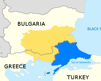
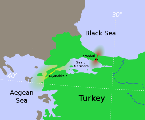
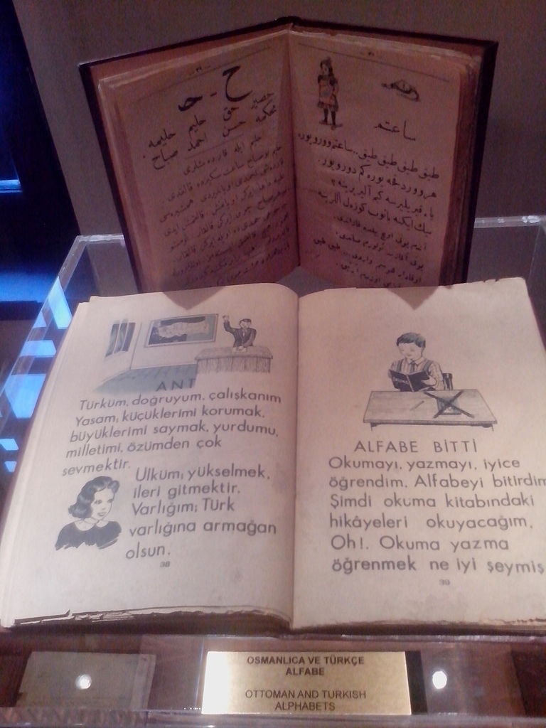
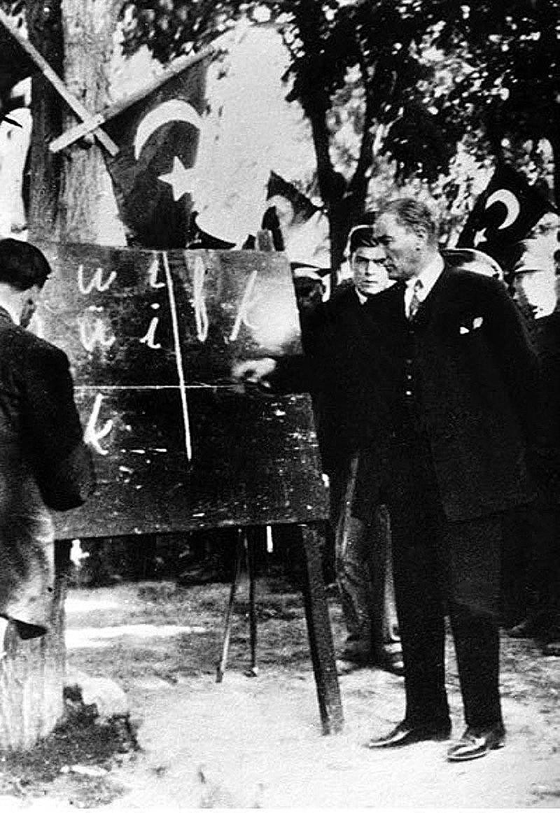
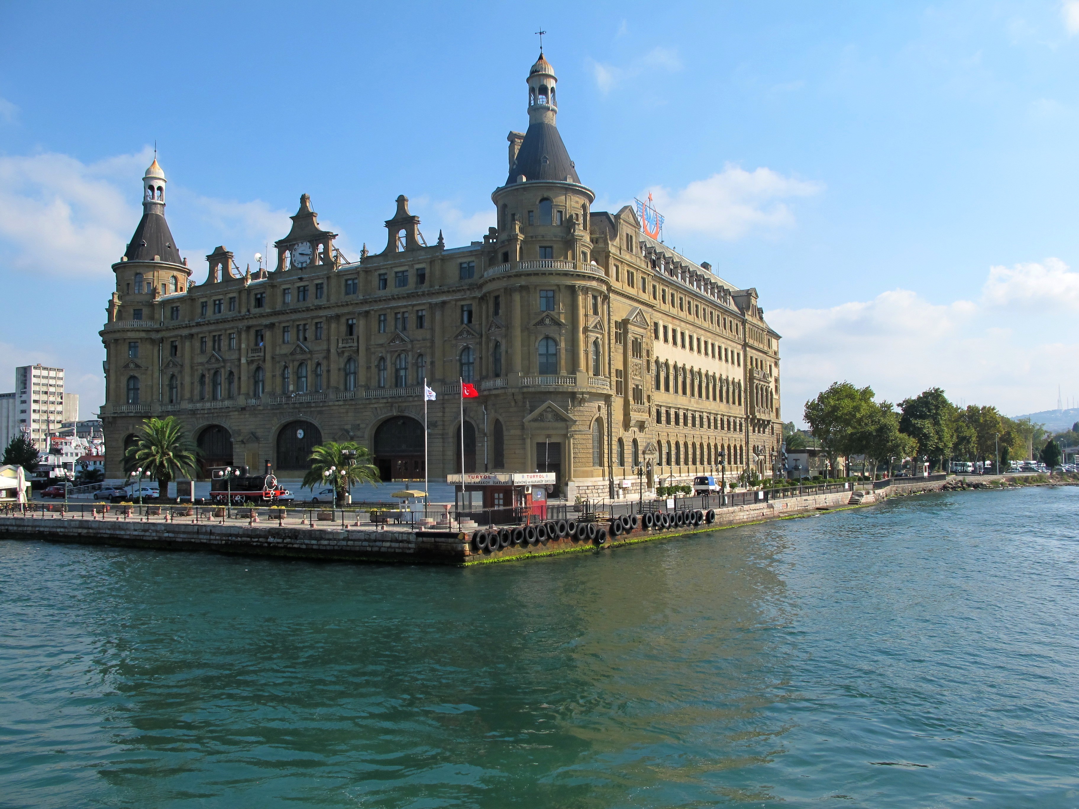
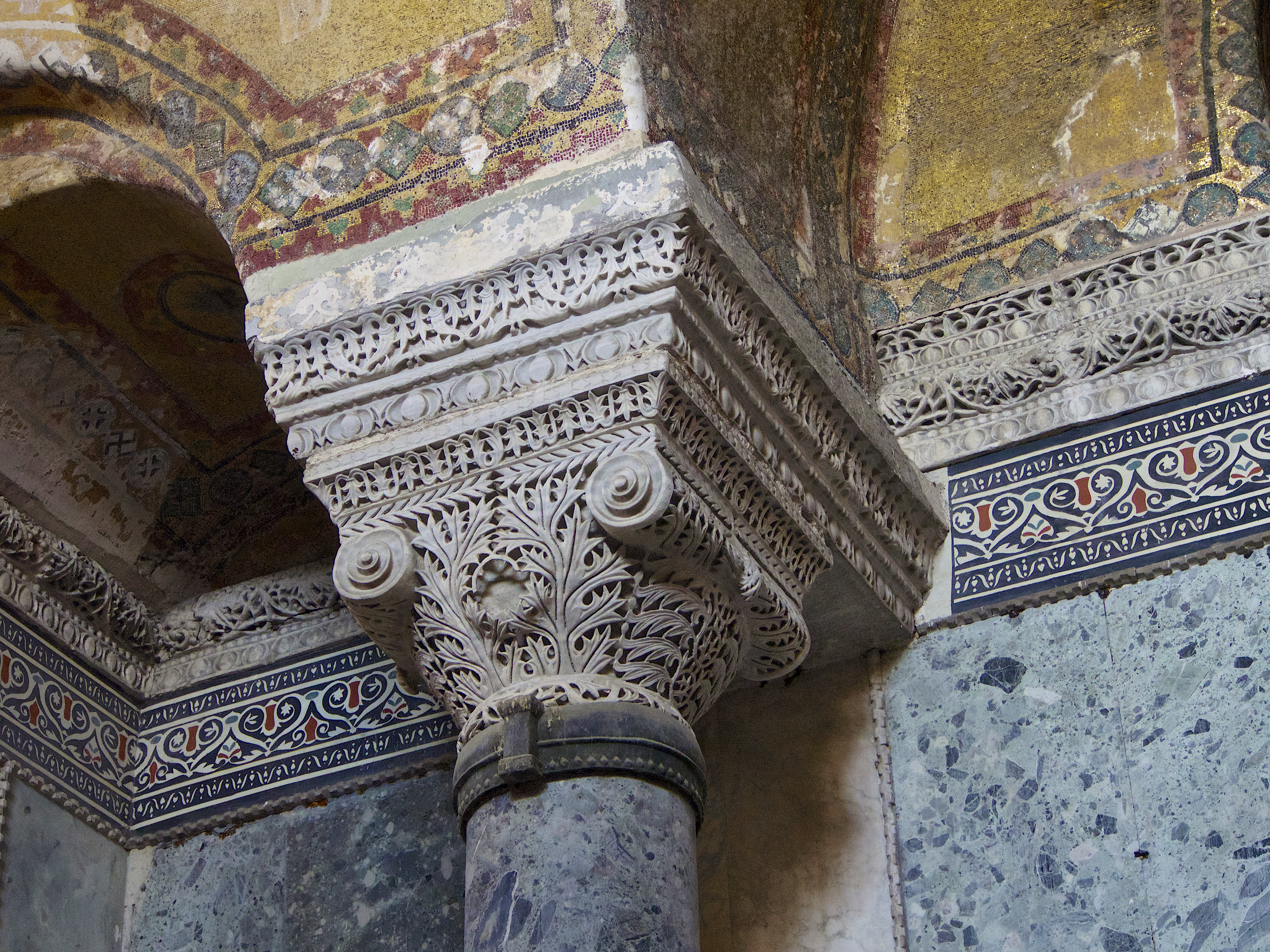
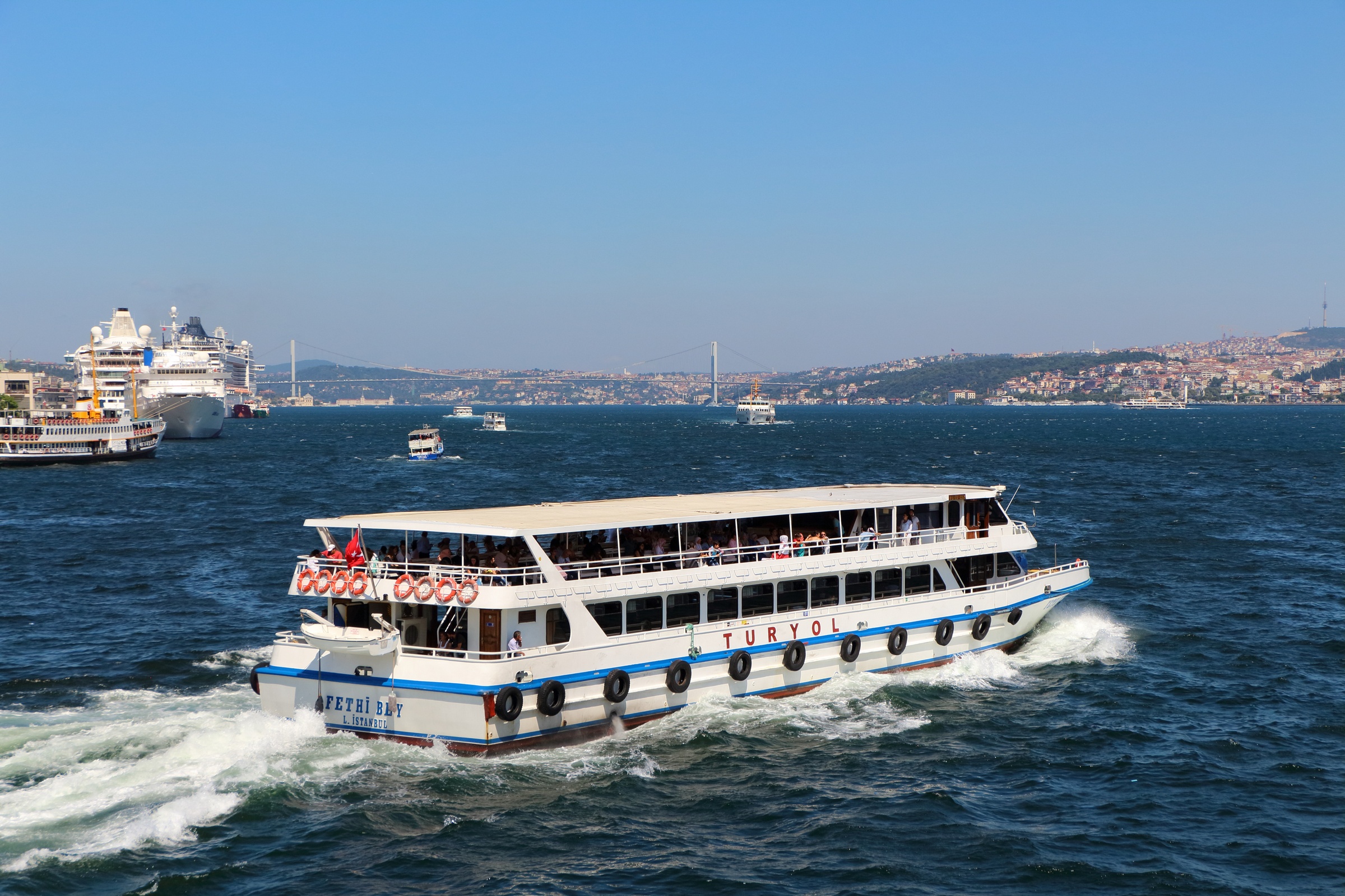