|
Reflections 2022
Series 1
January 21
2008 Swiss Rail Visit II: Zermatt/Matterhorn – Sankt Moritz/Davos
| | In the last posting, the description of the 2008 Swiss rail trip covered Luzern/Rigi/Pilatus, Meiringen/Holmes, and Interlaken/Jungfrau. We'll continue from there with the next part of the trip.
https://www.mystsnet.com/wp-content/uploads/2018/07/Grand-Train-Tour-of-Switzerland-Map-2017.jpg
| | | | Golden Pass Route Back on our route map, follow the orange route from Zürich to Luzern, then the Golden Pass Route, in gold, which actually involves three trains on three railroads, for the simple reason that the middle railroad is standard gauge while the other two are narrow. We took the Brünigbahn from Luzern to Meiringen (not shown, but in that zig to the east), then on to Interlaken. As a major hub, it's no problem that there's a break of gauge, and is easy to change to the next Golden Pass line, which is standard gauge, even for those not stopping in Interlaken. This next train will now be taking us from Interlaken to Zweisimmen on the mid-section of the Golden Pass route. We're leaving Interlaken on July 23rd. | | | | BLS The standard-gauge section of the Golden Pass Route is part of the BLS, the second-largest standard-gauge company after the SBB (federal railroads), as was just explained in 2021/10. In the next posting we'll discuss how this stretch of BLS from Interlaken to Zweisimmen came about and how the smallish town of Zweisimmen—apparently pleasant enough, but no real rail hub--became the dividing line between this segment of the BLS and the MOB that we've discussed before. | | | | | | It was the change at Zweisimmen that got me back to reviewing this whole subject. I should have caught on earlier to how the name came about, but its logical derivation recently came to me, and I checked and I was right. It's the old "one plus one is two". Here's a map of Zweisimmen (in gold) and adjoining communities (Map by Tschubby). The longish blue river in the center coming up from the south is the Grosse (Great) Simme (two syllables), and the Kleine (Small) Simme joins it at—where else?—Zweisimmen, using the Germanic N plural (as in English "oxen, children"). We just saw exactly the same thing out of Interlaken where the Weisse (White) Lütschine joined the Schwarze (Black) Lütschine at Zweilütschinen. |
| | | | MOB We last mentioned the MOB—with English speakers giggling at its acronym--in 2021/8 (qv), when we compared the gauge-changing system it's developing to that of the Talgo system. We'll give additional details on the MOB when we discuss its history and its gauge changing system in the next posting. For now we'll remind that MOB is the (Compagnie du Chemin de fer) Montreux-Oberland bernois, starting up in the mountains (the Oberland bernois) and going down to Lac Léman (Lake Geneva) at Montreux.
http://www.rail-info.ch/MOB/pics/map.gif
It has only one main line that runs 62.4 km (38.8 mi) from Zweisimmen to Montreux, which is the only section of importance to us. However, for full disclosure, there is a side branch, requiring changing trains, leading up into the hills to Lenk that adds 12.9 km (8.0 mi) to the totality of trackage. We'll come back to this map after we talk about the unique seating I was able to get.
For specialty viewing, to this day, some trains carry a so-called observation car at their end. It's usually also a lounge car, and sometimes the car would be rounded at the end, with windows all around. In South Africa, I remember being in the observation car of the Blue Train as we approached Cape Town. In Canada, leaving Halifax, the Ocean had an observation car in the rear. In Ecuador, the last car of the Tren Crucero had an enclosed lounge up front, then an open, roofed deck at the very end. But most trains rely on your watching the scenery from your seat. Still, many trains in Switzerland have extra large windows at the seats, sometimes going so high as to wrap a bit around the roof. But can you imagine a train like the MOB Golden Pass train allowing you sit at the very front of the first car, with a spectacular view of where you're headed?
| | | | | | The only time I was ever at the very front of a moving train was fun, but quite a different experience, more of a fun stunt. It was on the Golden Eagle on a quiet stretch of track near Lake Baikal, where passengers were allowed to climb on the side and front of the diesel engine, then the train moved slowly ahead for a few minutes. See 2020/7 "Locomotive Ride!". |
| | | | Still, that was a stunt for fun, but I'm talking about sitting in a comfortable seat on the MOB Golden Pass connection at the very front of the first car with the best view possible. I knew these seats existed, and I had to use my wits and determination to get one. When making my original plans at home, I knew from the MOB website that these seats existed, but when I worked with Rail Europe ordering my Swiss Pass and reservations, they said they couldn't reserve these special seats, and I'd have to do that once in Switzerland. I hate doing that, since I like all my ducks in a row with no last-minute worries, and there are only eight of these special seats on the train. Now Rail Europe is great for bookings, but I knew I had to outwit them to get what I wanted, so I turned to the MOB website, where for 15 Swiss Francs by credit card, then and now about US$15-16, I could order exactly the spectacular seat I wanted and have it settled before leaving for Africa and Switzerland.
This is what the MOB Golden Pass route train looks like (Photo by ZachT). While you can see the large windows along the length of the train, it's of course the front of the first car that give the spectacular forward view. MOB calls it Grande Vue Seating, an accurate name. (They also refer to it as VIP seating, which I think is inappropriate. There were no VIPs sitting up front, only those who paid the special supplement.) If you wonder where the train driver (US: "engineer") sits, he's above in what I like to refer to as the "attic", with his own window and windshield wiper. But down below, eight of us had the driver's view--unavailable on other trains—and thru larger windows.
https://i.pinimg.com/736x/4c/f4/eb/4cf4eb0ad97e5804eabd3dec7876f5b5.jpg
For this posting, I've found the train layout (click) to present. The Grande Vue seating covers the two front rows, totaling eight seats, with the second row raised à la stadium seating. The aisle separates each row to 1+3, and, since I made the reservation so long in advance, I was able to hand-pick the single seat in the front row! The boxy area behind us is the access area for the train driver to reach his spot.
https://live.staticflickr.com/8612/16213877587_5a3eb57252_b.jpg
http://switzerlandbyrail.com/trains/scenic/images/golden_pass_front_view_sbr.jpg
The first link shows a close-up of the train front. You can see that the train driver has side views as well, and the two closest white headrests are of "my" single seat, and of the single behind me raised a bit higher. The second link—pardon the tiny size—shows my view EXACTLY. The guy on the left has "my" seat, and he's watching Switzerland unfold before his very eyes. This is the most spectacular seating I've ever had on a train, but I think it's perfectly obvious that such seating would only work on a self-propelling EMU (or MU) train, and would be impossible if the train were pulled by a locomotive.
| | | | | | But truth be told, there was more to it than just MOB. I have no notes saying so, just a very clear memory. My Grande Vue seating reservation covered the trip from Interlaken, plus the change in Zweisimmen, to Montreux. That means they were twin trains, the BLS standard-gauge train, then the MOB narrow-gauge train, but otherwise alike. I know this because when we got to Zweisimmen, as far as I could tell, everyone crossed over to the SAME SEAT in the MOB train that they'd had out of Interlaken on the BLS train. I have to assume that MOB works in tandem here with BLS, just as it does with the gauge-changing system we'll discuss later. |
| | | | Look again at the MOB route map. The MOB ride only takes about 1h15 (it's 3h00 from Interlaken to Montreux), but is very scenic and very rural. After a while, we stopped in the famous resort town of Gstaad, which is nicely situated, but of which we had only a quick view. It's a major ski resort and is popular with high society and the international jet set. I'm surprised to find its population is even larger than Interlaken's. | | | | | | I wanted to discuss the pronunciation of the name Gstaad, but that led into finding out the origin of the name first. After extensive digging, I found it. The German word for "[river]bank" today is Ufer. It has largely supplanted (except in the odd place name, especially in Austria) the archaic word Gestade, pronounced more or less ga.ShTA.da.
Gstaad is on the Saane River—note on the route map that the next town on the MOB is called Saanen—and apparently Gestaad started as a settlement on the river, called (in modern German) Am Gestade, or "On the Riverbank". Over time, that name was reduced to Gstaad, with a long AH, so technically it means "Riverbank". Note that it's very common in Alemannic dialects such as Bavarian and Swiss for the prefix GE- to lose its vowel (cf: Gmünd).
So now we come to how the name is pronounced (you'll soon spot my prejudice). It all depends on how authentic you wish to be. Many English speakers will butcher it to ga.ShTAHD, re-inserting that long-lost vowel. Others will butcher it worse, making it ga.STAHD, omitting the Sh sound. So be it. But for greatest accuracy, say KShTAHT. Don't be shocked: Keep it one syllable. Preserve the Sh. But also realize that certain German consonants go voiceless, particularly at the end of a word, so that und is pronounced UNT, with D devoicing to T. And curiously, before a voiceless Sh, the G also devoices, to a K.
So there you have the local pronunciation, plus the reasons why it happens. Make your decision.
|
| | | | On the MOB route map, note how the names change from German to French as we cross the language border, also the cantonal border, from Bern to Vaud (say "VO"). On 2008/15, I said that the last 15 minutes of the ride was the best part, which is why I wanted to do it in this direction. We reached the point where the highlands dropped away down to Montreux on Lac Léman / Lake of Geneva, and the view was spectacular. . . . On the right (west) you could not see as far as Geneva, or even Lausanne, but both ahead and to the left (east) you saw from the center to the east end of this large lake. You saw . . . much of the Swiss (north) shore, with Montreux at your feet. You could clearly see on your left where the Rhône entered the lake from the Rhône Valley (it flows out on the other end at Geneva, then into France), and on the opposite (south) side, as you looked left to right, the Swiss shore became the French shore and you were looking into the next country. The train zigzagged left and right through vineyards, making suburban stops on its way down to Montreux. What a beautiful descent.
The route map shows, after Les Avants, the hairpin turns made as we descended back and forth to Montreux thru vineyards bursting with grapes for making Swiss wine. This view is meant to show the area and its atmosphere (Photo by Kabelleger). This is NOT the MOB Golden Pass train which came down directly above Montreux, it's a standard-gauge train some distance to the west. But it gives an idea of an EMU/MU train wending its way among the vineyards, just as the roadway below does. The view is the same, east along Lake Geneva (Lac Léman), and the three projections into the lake are Vevey, La Tour-de-Peilz, and finally Montreux. The MOB descends similarly further east, right above Montreux. Note the mountain peak in the upper center of the picture, partially blocked by clouds (it's a mountain, so what else?). It's the Rochers-de-Naye, which we'll discuss in a moment. But there's a cloudless peak to the left, the Dent de Jaman. You may recall our discussing in 2021/3 that the French Swiss like calling a peak a dent, or tooth, and this one does look like one.
https://snowcomparison.com/images/trailmaps/montreuxrochers-de-naye.jpg
This map will now put it all together. Disregard all the winter snow and ski lifts, since we're looking for the underlying geography of the area. The previous photo was taken from a point off this map to the left, but you see here how it was looking over toward Vevey, La Tour-de-Peilz, and Montreux. Note the black dashed lines connecting them, which is the standard-gauge route we'll be changing to in Montreux in order to leave the area to the east, passing the Château de Chillon. Earlier this year, in 2021/3 (qv), we discussed going by (standard-gauge) rail right here along the north shore of Lake Geneva, stopping in Lausanne and Montreux, then discussing the Château de Chillon extensively.
Now look at the center-right top to find Gstaad, and you can trace (click) the MOB route down to Les Avants (don't let the snow distract you—it's July!). As the black-dashed route descends, you can make out the switchbacks (the first is obscured by the white road) down to Montreux.
Finally, take a look at how the mountain called the Rochers-de-Naye ("Naye Rocks") hovers over Montreux. Starting at the right-hand restaurant in yellow, trace the set of tracks that circle around thru tunnels, then cut over to (thru!) the Dent de Jaman, then down to the 19C resort village of Glion with its own funicular, then makes at least one switchback before arriving at Montreux.
| | | | Montreux Area There's a break-of-gauge in Montreux, as the meter-gauge MOB descending from the mountains meets the standard-gauge main line coming in from the west along the lake shore and heading for the Simplon Tunnel to Italy. But as usual, the train change was simple, just following signs to another platform for a connection that arrived promptly (this is Switzerland!). Thus I would have had no more to say about the Montreux station.
But in 2021/8, we found in the Pyrenees two stations which accommodated three gauges. In Hendaye, Spanish broad gauge met French standard at the station, and a Basque narrow-gauge train had an adjoining building. Even more blatantly, a station I'd never heard of before, Latour-de-Carol/Entveig had Spanish broad, French standard, as well as the meter-gauge Little Yellow Train all joining at the station. But that source also stated there was a third station in Europe, in Montreux (perhaps others elsewhere) that accommodated three gauges. How could that be? There's no broad gauge anywhere in or near Switzerland. So this meant a little more investigation into Montreux station, and it was at this point that I first learned of a mountain I've never been to or seen, the Rochers-de-Naye, and of the narrow-gauge train that reached it, the Montreux-Glion-Rochers-de-Naye (MGN) rack railway. So this is what I've just learned, and I find how this line was built to be interesting.
It all starts with that town of Glion we saw on the map up in the hills above Montreux. An indication of its popularity as a 19C resort was that in 1883, a funicular connected it down to Territet, another suburb of Montreux that was one stop further east on the main line. Then in 1892, Glion was chosen as the lower station of the new rail line up to Rochers-de-Naye, as we saw on the map. This railway was narrow-gauge, but not meter gauge, just 800 mm (2 ft 7.5 in). We've seen this gauge twice, on the Pilatusbahn up that mountain and on the Wengernalpbahn connecting Grindelwald, Kleine Scheidegg, and Lauterbrunnen. Like those, because of the steepness, this was a rack railway, and was also steam operated. But in 1909, another rack railroad connected Glion directly with Montreux, this one electric, but maintaining the 800 mm gauge, thus bringing this super-narrow gauge into the station, making it a three-gauge station. Glion now was the terminus of two rail lines and a funicular with a cross-platform interchange between the three, tho electric and steam locomotives had to be changed in Glion for thru service. Finally, in 1938, the Rochers-de-Naye line was also electrified and the cars were all exchanged for EMUs to ease thru service. But it wasn't until 1987 that the two companies were merged to form the Montreux-Glion-Rochers-de-Naye Railroad (MGN). In 1992, it also took over operation of the funicular. Here's the route of the MGN:
https://rogerfarnworth.files.wordpress.com/2018/04/rden1.png?w=768&h=266
Leaving Montreux it makes one sharp hairpin curve to reach Glion (at the next bend, not named), before winding its way for 10.36 km (6.44 mi) to the mountaintop at a maximum grade of 22%. Note the curve it takes to finally reach the summit. The blue icons below Glion are the funicular. This is an MGN train (click) on the steep approach to the Rochers-de-Naye, in the background (Photo by Simon LEPÊTRE).
| | | | | | I translated Rochers-de-Naye above as Naye Rocks, and it's probably best left at that. But one does get curious and so I went digging in French sources. Just what does "Naye" mean? One explanation had to do with wet, marshy land, which cannot refer to the summit of a mountain. On the other hand, noue has a number of meanings, but one refers to where two sloping sides of a roof come together to form a "roof junction", also called "roof valley". These are stone roof tiles coming together to form a noue (Photo by James Allan). So how could noue become Naye? Well, it's really only a vowel change, from NU to NÉ. And perhaps—to speculate--early people noted that rocks on the summit came together like a roof. Compare this roof to the previous picture showing several crevasses coming down from the summit. But then how to translate Rochers-de-Naye, if that should be the accurate origin of the name? Roof Rocks? Rooftop Rocks? It's all too awkward, and best left at Naye Rocks. (But it's nice to know.) |
| | | | This is the summit station at 1,968 m (6,457 ft) (Photo by Whgler). Click to inspect the view to the north, and also that final curve we saw on the map involving an unusual last-minute tunnel. From here it's apparently only a short walk to reach the summit at 2,042 m (6,699 ft). The summit view to the south spectacularly encompasses Lake Geneva and Montreux (Photo by Sophie Photographie). | | | | | | During the Holidays, the MGN adds something special. On Wednesdays to Sundays from late November to Christmas Eve, parents can take their kids to the Maison du Père Noël aux Rochers-de-Naye, or the Father Christmas (Santa Claus) House at the Rochers-de-Naye. The train ticket includes the round-trip from Montreux, entrance to Santa's House, a certificate from Santa, and a gift bag of goodies and sweets.
https://cdn.unitycms.io/image/ocroped/1200,1200,1000,1000,0,0/i4wiIypDD8k/2-OvcDEyaJ48VfcJLGUCFX.jpg
https://mob.ch/app/uploads/2019/02/p-naye-noel.003.jpg
https://i1.wp.com/www.swissromande.ch/wp-content/uploads/2019/11/m3.jpg?fit=800%2C488&ssl=1
The MGN trains seem to have a special holiday livery, shown in the first link. The other two links show that you can apparently visit Père Noël in a larger alpine-looking room or at his desk, next to a prominent globe.
|
| | | | Montreux Station Montreux railway station opened in 1861 when a standard-gauge, main-line railroad came thru town on its way to the Simplon area. This line is now owned by Swiss Federal Railroads, SBB-CFF-FFS. Forty years later, in 1901, the MOB started building its meter-gauge line from here up into the mountains (to be discussed later), and the station became a two-gauge station, which is not uncommon. But then in 1909, the MGN connection arrived from Glion, making Montreux a three-gauge station, the only in Switzerland and only one of three in Europe. But again, it isn't as one might think. In the two stations in the Pyrenees, the gauges are broad, standard, and narrow (meter). Goldilocks would compare them to Papa Bear, Mama Bear, and Baby Bear. But in Montreux, there's no Papa Bear in sight. Instead we have standard, narrow (meter), and extra narrow (800 mm), in other words, Mama Bear, Baby Bear, and Infant Bear. It's just a different array. When buying shirts, you expect your choices to be large, medium, and small. You don't expect to find only medium, small, and extra small. But three gauges are indeed three gauges.
https://ontheworldmap.com/switzerland/city/montreux/montreux-tourist-map.jpg
Let's take a quick look at Montreux, and then its station.
| | | | | | An aside: I'd thought that the name Montreux would have had something to do with a mountain, but I now find it derives, after many Medieval variations, from Latin monasterium / "monastery", via the diminutive monasteriolum, "small monastery", a term that also includes the lands belonging to it. |
| | | | We see the standard gauge (1,435 mm [4 ft 8.5 in]), Federal Railways main line come barreling in from the west and stopping on the south side of the Gare CFF / Federal Railways Station (click). Some local trains might then stop at Territet to connect to the funicular to Glion, but most would continue east toward the Simplon Tunnel, as we will. Then, back on the left, trace the MOB (1,000 mm [3 ft 3.375 in]) coming east down from the hills and making its last switchback to arrive at the north side of the station facing west. Finally, go to Glion (not named) at the top of the funicular and follow the MGN (800 mm [2 ft 7.5 in]) thru its switchback as it also arrives at the north side of the station, tangling a bit with the MOB tracks. Apparently narrow-gauge tracks are close enough in width that they "tangle" well--the difference is only 200 mm (7.9 in), or, in an outstretched hand, roughly thumbtip to pinkytip.
http://www.mappery.com/maps/Montreux-City-Map.jpg
And finally we zoom right in on the station, and see its location near Vieux (Old) Montreux. Review the routes of the three arrivals, but then click on the station for the most detail. It's clearer here that the standard-gauge federal lines wield the most weight here, with the two narrow-gauge routes huddling together behind the main building after each ended up arriving via a tunnel (dashes).
This is a standard-gauge main line federal train on the south side of the station (Photo by Remontees). The MOB part of the station can be seen on the left. This view looks east, as the train is headed in the direction of the Simplon Tunnel, the direction we'll be going in. Don't be disoriented. Remember we spoke in Paris that British engineers first set up French railways, and so they run on the left, tho the Métro runs on the right. Similarly, in Switzerland, trains run on the left, tho trams, like other street traffic, run on the right. Go figure.
Here's a view of the station complex looking down to the west (Photo by Rafał Klisowski). We again see a standard-gauge train on the south side of the station, but then a tangle of tracks on the north side, which is mostly the two narrow gauges, but apparently also some standard-gauge access. We have a view of an MGL train behind the station (Photo by Jan Oosterhuis). Note the itsy-bitsy 800 mm tracks (click) and the geared rack between them. This train is sitting on a siding, with the running line on its left that actually connects into the tunnel. The line on the right also connecting to the tunnel belongs to the MOB. You can see that, tho also narrow gauge (1000 mm), it's wider than the MGL tracks. Looking again toward the tunnels, it's claimed that this picture shows all three rail types, tho I find it hard to discern between them (Photo by Paebi). But you see what I mean when I say that at least the two narrow gauges "tangle well". This last picture says it's the view from the MOB driver's cabin arriving out of the tunnel, making it the reverse view of the last picture (Photo by Hansueli Krapf). It shows at least the two narrow-gauge tracks crossing each other.
| | | | Montreux to Zermatt Refer back to our route map at the beginning of the posting to confirm that, while some of the connections in color are named as being special for visitors (Golden Pass Route), others, such as Zürich-Luzern are just regular rail connections. That's the case of our next routing from Montreux via Visp to Zermatt, which takes 2h30, with the break-of-gauge change at Visp. You also see on the map the Gornergrat and Matterhorn areas for our side trip. The section from Montreux to Visp is standard gauge, then going up into the mountains again is the narrow-gauge MGB (Matterhorn-Gotthard Bahn), which we'll discuss when we leave Zermatt. Actually, a break-of-gauge should be expected, since the main line is logically connected with mountain railways along its route, the MOB coming down from Zweisimmen and the MGB going up to Zermatt.
https://www.powderhounds.com/site/DefaultSite/filesystem/images/Europe/Switzerland/Zermatt/zermattrailmap.jpg
| | | | Valais/Wallis This map gives us some good detail showing our entrance to the canton of Valais/Wallis. After leaving the east end of Lake Geneva at the Château de Chillon (not named here), we're in the Rhône Valley, which makes a sharp turn at Martigny as Vaud/Waadt (VO/VAHT) becomes Valais/Wallis. The French-speaking part of the canton calls it Valais (va.LÉ), while the German-speaking part calls it Wallis (VA.lis).
While the main line train continues to Brig and then into the Simplon Tunnel to Italy, you can see where we connect at Visp. I noted in 2008/15: It was a mixed adhesion and rack railway, and as we went up along the Vispa river, you could hear the cog engaging, then disengaging. From Visp to Zermatt and the Matterhorn, you go rather directly south. I'll add that out of Visp, on the way to Zermatt (and tomorrow's connection to the Gornergrat), there's a stop at Täsch (TESH), which is interesting. Zermatt is very concerned about air pollution ruining its air and view of the Matterhorn, and so no automobiles are allowed in town, where electric shuttles and scooters are used instead. Car drivers have to park in Täsch, then take a shuttle—I don't know if it's a local shuttle or the train (which is, of course, electric) into Zermatt.
But first a bit more about the Rhône Valley and the language border. On the last map, very roughly, the language border runs between French-majority Sierre and German-majority Leuk. Here's a map of the canton showing town borders (Map by Tschubby), and the language border division between French-majority Sierre et al to the west and German-majority Leuk et al to the east is much more obvious. This puts Visp, Brig, and Zermatt in the German-speaking part of Wallis. (Visp and Zermatt are not named here, but are at opposite ends of the Vispa.) We have one more map, of the river valley leading into Lake Geneva, thence to France (Map by Romano1246). Check that, in the French area, you do hear Rhône (ROHN), but in the German area, it's Rhone—but not what you think, since in German, Rhone rhymes with "Mona".
And one last point in the valley: as we've said before, Visp is pronounced FIShP. In Walliserdeutsch (the local German dialect), the spelling is more straightforward, as Fischp. It's the Vispa flowing down to Visp that apparently gives the town its name, but then the story gets more interesting. Remembering that a Bach is a brook, earlier forms of the brook's name—going backward--appeared as "Vispach, Vispbach", to a straightforward "Fischbach" ("Fishbrook"). What an unusual string of changes—a sensible name for both brook and town being altered again and again to achieve unrecognizability, so that Fisch gets a grossly altered spelling and Bach reduces to a B, then to a P. While the stream/brook, Vispa, retains the A of Bach at its end, the town of Visp does not. So strange.
https://www.powderhounds.com/site/DefaultSite/filesystem/images/Europe/Switzerland/Zermatt/villagemap.jpg
| | | | 4) ZERMATT So we arrive in Zermatt (Z=TS) for two nights, to allow for a day trip tomorrow to the Matterhorn. Do remember that this day, 23 July, started in Interlaken, and we went via Zweisimmen and Montreux to arrive in Zermatt. Don't be confused by the above map, since it's turned on its side to go along with the river valley. North (downstream) is on the left, and the valley rises going south, to the right. On the lower left, note (click) where our train arrives after passing Täsch, the upvalley limit for cars. We again see the Vispa (FISh.pa) determining the shape of the valley and town. Our train pulls right into the MGB station, which is conveniently adjacent to the Gornergratbahn (GGB) station. Actually, my recollection is that the buildings are connected, confirmed on Google Maps. Tho he MGB and GGB are both meter-gauge rack railways and there is a connection, there's no thru service, because there's little need for one. Most people going beyond to see the Matterhorn would stop to stay in Zermatt, like we're doing. Therefore, the few going to hotels beyond would have to change here.
I have very nice memories of the hotel I had booked—near the stations, of course—but the name today is slightly different, so I just checked. Hotel Tenne had opened in 1965, built from the typical dark wood of five dismantled local barns. (I didn't know that detail until now, but I did enjoy the rustic Swiss look.) In 1984, new owners remodeled and expanded the hotel. Some rooms were kept in their rustic alpine look with a lot of wood, while others were decorated in Art Nouveau style. It was then called the Schlosshotel Tenne, which was the name I knew it by during my 2008 visit, and I do remember a lot of dark wood with a rustic alpine look. In 2011, newer new owners renovated and expanded it, and renamed it Schlosshotel Zermatt, its present name (Schloss = castle). It's located inside the backwards L created by the two stations, and should be #52 on our map, literally one minute's walk from either station. You can see below the original wooden section I remember so well, and also see how Zermatt is in a valley. I wrote: I had a balcony with mountain view (but not towards the Matterhorn), and the lobby was cozy. . . There were surrounding gardens, and everything one would expect in a rural Swiss town. Except, of course we were within Zermatt.
https://www.mountvacationmedia.com/a/2555/w/22/o
Before we go for a walk in Zermatt, let's talk again about the name. We first came across the word Matte (two syllables) at that park in Interlaken. I'll rearrange slightly what I said then in 2021/3: A Matte is a mat, but in the Alps it describes the flatness of an Alpine meadow. "Zermatt" is derived from zur Matte "at the meadow". The Tal (valley, dale) that Zermatt is located in is the Mattertal, and, further upvalley, the "horn" at the head of the Mattertal is the Matterhorn. Tho really untranslatable, we could say that the Matterhorn could be "Meadow Peak". But given our present town map, look it over to see how often the word comes up in neighborhood names, often in the plural, Matten. I count five on this map.
Since it's barely mid-afternoon, we have time for our stroll thru town. I wrote: Leaving the front of the Tenne I could already see the distinctive top of the Matterhorn peering over the tops of roofs, and those intermittent views continued all the way through town down the main street. We walk between the stations and find ourselves on Bahnhofstrasse, which we follow into the town center, including an area at a museum and church (at red 5&7). I have in my notes that, just as you can see the Jungfrau from Interlaken, I walked to the end of town to get the ideal view upvalley of the Matterhorn as seen from Zermatt (Photo by Andrew Bossi).
I've reviewed comments I made in 2008/15, where I was very bothered by the commercialism I found while walking thru Zermatt—not near the hotel, which, despite being near the stations, was in a charming, quiet area, but in the town center, where it was sell, sell, sell to the (many) tourists. I also wrote I was upset about having to dodge all the electric vehicles. But in retrospect, I've mellowed, and have happier memories as time has gone by. I wrote: It was, not counting stops, about a half-hour’s walk through town until the countryside started appearing, and the Matterhorn, which had been peeking out tantalizingly between and over buildings, was visible in full view. I sat down in a pleasant area on the banks of the Vispa and just stared. Once again, as at the Jungfrau, there was that "diamond" view: low foothills on either side formed a dark V-neck to surround that so very distinctive peak. . . . I sat and relaxed on the side of the Vispa . . . and stared in the late afternoon light until all senses were saturated, then walked back to the north side of Zermatt to the Tenne. However this time, instead of walking back along the . . . [commercialized] Bahnhofstrasse on the west side of the narrow, long town, since I was already at the point where that street joined the river road, I walked back on that more pleasant route, Bachstrasse ("Brook Street") along the Vispa. My feeling as to the commercial district was "so near and yet so far". On the other side of the Vispa were pleasant homes and some . . . nice small hotels . . . , with the occasional footbridge across to them, and the rapid flow of the river was hypnotic. I find it amazing how these Alpine rivers I walked along (the Reuss in Luzern, the Aare bei Meiringen, the Vispa in Zermatt) move so quickly, like rapids, and how steely-gray-brown their color is. . . . I heartily recommend Zermatt for all the gentle, laid-back-in-the-mountain positive things outside of that touristy core.
| | | | The Alphorn I also wrote that on my march southward there was a pleasant interlude. Signs indicated that all summer long there were special events as part of a folk festival, and that two alphorn players were scheduled here and there around town that week, and in a more pleasant open area on Bahnhofstrasse in front of a church [noted above], there they were. I've found on YouTube this short video of two alphorn players in Zermatt (0:47). Do notice all the tourists that surely were the basis for presenting such a touristic activity, but it was the only time I ever heard a live performance on the alphorn. One might expect such a large instrument to have a deep, bass sound, but I find its plaintive music to be more in the baritone range.
The name is German, and English being Germanic, the name and both parts of the name correspond exactly to English words. On the other hand, the French call it the cor des Alpes and the Italians the corno delle Alpi. It consists of a long, straight, conical wooden natural horn-shape (natural=without valves) with an upturned bell and a wooden cup-shaped mouthpiece. The alphorn is carved from a solid piece of softwood, generally spruce but sometimes pine. Earlier, a tree would be sought out that was bent at the base, but today, the bell is pieced together. Traditionally the alphorn was always made in one single piece, or two parts at most. Today it may be made of three, to more easily transport it. They were once used for mountain-to-mountain communication, but are today musical instruments.
Since an alphorn is of natural construction, its length also defines the basic tone or tuning. It's available in lengths between 2.45 m (8.04 ft) and 4.05 m (13.29 ft). In Switzerland, the length has been set at 3.47 m (11.38 ft), which corresponds to F#. Because of its length, the alphorn has a built-in stand supporting the bell. If you wonder how to transport such a long instrument if it hasn't been made in pieces, over the shoulder works, (click) especially while steadying it by its tiny stand (Photo by High Contrast). This picture was taken in Passau, Germany—note the Lederhosen—indicating that the range of use of the alphorn widely extends beyond the Alps themselves.
The well-known "Ranz des Vaches" is a traditional melody often heard on the alphorn. The song describes the time of bringing the cows to the high country at milk-making time. As we know, Rossini included it in his opera (and overture) William Tell. Finally, let's listen to an alphorn sextet--including a woman--playing right at the rail station (2:38).
| | | | Fondue We've talked about the Swiss food specialties of Rösti, Zürcher Geschnetzeltes, and Bündnerfleisch, and we really need to add fondue to that list, even tho many already know what the several kinds of fondue are.
https://www.alpenwild.com/alpenwild-wp-content/uploads/2014/10/Fondue.jpg
Fondue is a Swiss melted-cheese dish served in a communal fondue pot over a portable stove heated with a candle or spirit lamp, such as Sterno, and eaten by dipping bread into the cheese using long-stemmed forks. It was promoted as a Swiss national dish by the Swiss Cheese Union (Schweizerische Käseunion) in the 1930s, and was popularized in North America in the 1960s. However, the word fondue was first attested to in French in 1735 and in English in 1878, tho those earliest dishes were quite different, involving both cheese and eggs. Only as of 1875 did the modern version come to light. Cheese fondue consists of a blend of cheeses, wine, and seasoning, although there are many variations. Traditionally—and this is how Beverly and I made it at home--the fondue pot is rubbed with a cut garlic clove, white wine is added and heated with cornstarch, and then grated cheese—one or more varieties--is added and gently stirred until melted, although in practice all the ingredients can be combined and heated together all at once.
While crouton-sized pieces of bread are fundamental to any cheese fondue, small or cut-up vegetables also work very well with cheese. In this service I also see olives, tomatoes, cornichons, pearl onions, and endive. I've also had cherry tomatoes, sliced radishes, cut-up potatoes, and mushrooms—the list can go on (Photo by EquatorialSky at English Wikipedia). In addition, other than the classic fondue as described above, the cheese itself can be flavored. Look at this fondue menu showing a variety of cheese fondues (Photo by Arnaud 25). I'll just mention some of them, fondue with herbs, shallots, nuts, cumin, wild garlic, different kinds of mushrooms, ham—and beer. The one I thoroughly enjoyed in Zermatt (below) was made with onion and bacon.
In the mid-20C, the term "fondue" was willfully expanded to two other dishes in which foods are dipped into a communal pot of liquid kept hot in a fondue pot. This development happened in New York and was done by the same man, Swiss restaurateur Konrad Egli of the former Chalet Suisse restaurant. He was encouraged to promote the Swiss chocolate brand Toblerone, and in 1966, he first served the dessert fondue au chocolat / chocolate fondue, where the pot holds a melted chocolate mixture of either dark or milk chocolate (Photo by FASTILY). For dipping there are marshmallows (the best!), several kinds of pastry, and fruits—the picture shows sliced bananas and sections of mandarin oranges. Also used are grapes, strawberries, other berries, and more. However, I had chocolate fondue only once, and it was good, but it's very rich, like eating one candy bar after another, so this is the only one of the three types of fondue that's OK, but that I'm not a strong fan of.
But even earlier, in 1956, Egli had introduced another dish, a meat fondue that he'd invented, which he called fondue bourguignonne, / Burgundy fondue, often simplified to "beef fondue", which featured strips of beef on long forks cooked in oil in the fondue pot. Why he chose this name is unclear, since traditionally, Burgundy (Bourgogne) never even bordered Switzerland (Map by Solsticedhiver). Now I like this dish as much as I like cheese fondue, and Beverly and I in the past prepared this one at home as well for guests, but I never fully understood before that only cheese fondue has a Swiss tradition behind it, while the other two are modern New York inventions. And furthermore, since the word is derived from the French verb fondre "to melt", it doesn't really make sense to call fondue bourguignonne a fondue. But so be it—it's good.
So here's a service of fondue bourguignonne (Photo by Deni Williams). Often (not always) a variety of meats is offered for each person, not only beef, but chicken and pork as well. The meat is raw, and is cooked when placed into the pot, which usually contains hot oil, but broth can also be used. Various dipping sauces are provided on the side, and can include Dijon mustard, aïoli, truffle sauce, curry, horseradish sauce, any kind of steak sauce, and more.
| | | | | | As a language point, we have here a retronym. Retronyms occur when an item is changed with an updated version, so then the original item needs further clarification in the form of a retronym. Some examples: the image of a "guitar" adds to it an "electric guitar", so the language goes back ("retro") and develops the alternative of the original name as "acoustic guitar", a retronym. Clock; digital clock; retronym: analog clock. Phone; mobile/cell phone; retronym: landline. An excellent example was the Great War, which was then followed by World War II, at which point the "World War I" retronym was back-formed. Anyway, in this case, since the mid-19C, we've had the term "fondue". The mid 20C gave us the two other fondues, so we develop the retronym "cheese fondue" for clarification, even tho it seems redundant and repetitious. |
| | | | So how does this fit in with Zermatt? I've had fondues many times in restaurants, and almost always, they only serve it for two or more people. The only time I'd had cheese fondue in Switzerland was once with Beverly in Geneva. But I was delighted to find a place in Zermatt that accommodated the solo traveler seeking the dish. I remember enjoying it, but never noted the name. I only had it in my notes that it was between the station and the hotel. But Google Maps helped me find it. Consult the Zermatt map again, where the hotel is at #52. Closer to the station, and right in my "neighborhood", is #157, and that's the place.
https://images.toubiz.de/image/big2/40666_01.jpg
https://images.toubiz.de/image/big2/40666_05.jpg
Both the exterior and interior views present a traditional image, which added to the enjoyment. Google Maps happily spells the name Ross-Stall (where, in Stall, S=Sh). But as you see, they spell it, more confusingly, Rosstall. I just checked their online menu, which has a large variety of choices, but I'm looking just for the fondues. They have two kinds of Fleischfondue / meat fondue, and sure enough each one is for a minimum of two people. But under Käsefondue / cheese fondue, no such reference is made, so a solo diner has a choice of four varieties, Natur / Classic, or with tomatoes, or truffles, or with breaded cutlets (!). My diary notes remind me that I had the Classic cheese fondue, but it did include onion and bacon.
| | | | | | In New York, I've sought out fondue. Recently I went to a wine bar in Manhattan's West Village with friend Alejandro. Our fondue was made of Gruyère and Vacherin, which I later found out is also called moitié-moitié / "half and half", but can also be called simply Fondue Suisse. It's also possible to use Emmental, Appenzeller, and others. But it being primarily a wine bar, the fondue was just snack size. I've also found a place in Hudson Square, aka West Soho, which serves fondue—for two or more—in an interesting fashion, that looks worth trying. They have a two-course prix fixe with cheese fondue as the appetizer, then meat fondue as the main course (the better choice to my mind), as well as a three-course prix fixe which adds chocolate fondue for dessert. It's on my to-do list. |
| | | | 1981 I need to inject an aside here as it affects Switzerland. Beverly and I had been to Switzerland a number of times, including just visiting Geneva once as part of a visit to France. I remember being briefly in Bern once on another trip. But I've found details of an additional very enjoyable trip to several countries in Central Europe whose highlights I remember clearly, but some details of which are now lost to memory—unless the diary reminds me of them. The trip was 40 years ago, in 1981, the year after we got our doctorates in the summer of 1980.
https://www.ezilon.com/maps/images/europe/political-map-of-Switzerlan.gif
As that trip affects Switzerland, we went to Zürich, Luzern, the Rigi, and the Vierwaldstättersee, and when I returned in 2008, while I didn't strongly remember details, I vaguely felt I'd been to those places before. In 2021/9 I referred back to Stein am Rhein (click), remembering the boat ride on the Rhein, but few details. I now see we took the boat from Schaffhausen, got off in Stein am Rhein and walked around the town (which I do not remember doing), then took the train back to Schaffhausen. Einsiedeln is near Schwyz. We apparently took the train there in 1981, but it's a blank. When talking about Interlaken, I've said I'd never been to Thun, but we went there in 1981 and walked around the town. The same goes for Solothurn and Fribourg, tho I've thought for some time that the only French-speaking city in Switzerland I'd been to was Geneva. With a lot of travel, including repeat visits, some memories get lost. There are other forgotten 1981 visits, which I'll mention as we come to those places later in our narrative.
| | | | Gornergratbahn It's now 24 July, our excursion day out of Zermatt, the day to go up to the Gornergrat to see the Matterhorn up close, plus the Monte Rosa, and more. A Grat is a "ridge" (and this one is quite rocky), so to get to the Gorner Ridge we'll take the Gornergratbahn (GGB). We've worked it out that our hotel is across the street from both stations to make for easy travel. Note that tracks do connect the two stations, since both the MGB and GGB are owned by the same company and have common management, but there's no thru service. As with the railways at the Jungfrau, there's a fee, but discounted along with the Swiss Card. Our train crosses the Vispa and ascends the valley southbound with sweeping views back at Zermatt along the way. This is the route of the GGB (Map by Philipp Gross). It shows in Zermatt (click) the connecting track with the MGB, the five intermediate stops it makes at some resorts, and later some tunnels. As protection against heavy snows, the Riffelbordgalerie is a roofed-over, but open-sided, gallery covering the tracks. The GGB, which opened in 1898, is a rack railway for its entire 9 km (5.6 mi) route and climbs almost 1,500 m (4,900 ft).
https://a.storyblok.com/f/53624/4096x1260/feda9fd930/sbt_4096x1260.png
This gorgeous view (click) shows the GGB moving up the valley. It's early in the trip since the view shows the Matterhorn as seen from Zermatt, featuring both its dark north face and iconic, well-lit, east face that's facing more our direction. We will turn left for the Gornergrat, from which the east face is seen close-up. One almost wonders if, seeing the cows on the alpine meadows, one might hear the Ranz des Vaches as performed in the William Tell overture.
https://mychaletfinder.com/resorts/zermatt/piste-maps/zermatt-summer-skiing-piste-map.jpeg
This is a sketch (click) of the upper valley as it leads to the Gornergrat. It shows Täsch, the limit cars can go, and the black lines left and right are cable cars and gondolas, leading to hiking trails (in color) and ski opportunities. You'll note that the hardy can walk up to the Gornergrat. But the winding black line in the center is the route of the Gornergratbahn. It passes the tree line and shows the stops at Riffelalp and Riffelberg. It's striking how well the Gornergrat itself happens to be placed, with a hugely wide view of so many mountains. Above it we see all the glaciers coming down from the heights, notably the Gornergletscher right below the Gornergrat. But now let's pay attention to all the mountains along the skyline. You'll notice how many names include "Horn", which is so common in the German-speaking area of the Alps.
But concentrate your attention on the central Monte Rosa area, which has the highest mountains and which dominate the area, actually more so than the Matterhorn, famous as it is. It becomes obvious here that the Matterhorn is in the extended Monte Rosa area and is not as tall as some of the dominant ones we're looking at. Start with Monte Rosa, which has several peaks, the famous Dufourspitze being the highest one. Several of these peaks are higher than the Matterhorn (compare all readings, in meters). The Liskamm has two peaks, both higher than the Matterhorn. Then we have the "twins", Castor and Pollux, the Breithorn ("Broad Peak"), and the Klein (Little) Matterhorn. Tho the Matterhorn is considered part of this grouping, it stands quite isolated from the others.
https://www.acprail.com/images/stories/Gornergrat-map.jpg
This other sketch concentrates on the GGB and includes additional information. It shows the Gornergrat from a different angle, and indicates that north is behind us, so Italy is to the south straight ahead, right over the Monte Rosa, and not too far to the west (right) is France. The Gornergrat is the southernmost point of the contiguous German-speaking area in all of Europe, including South Tyrol/Alto Adige in Italy.
But take a look at the yellow and gray circles, which pinpoint our arrival. First is the GGB station, at 3,090 m (10,138 ft); then some 100 meters/yards beyond that is the Kulm Hotel, a bit higher at 3,120 m (10,240 ft); and beyond that is the actual summit and best viewing area of the Gornergrat, even higher at 3,135 m (10,285 ft). To these numbers, we should add some statistics.
The Gornergratbahn is the highest open-air railway in Europe. The Jungfraubahn is the highest overall, but is mostly in a tunnel. The Gornergrat station is the highest open-air station in Europe, which makes a great difference as to sights that can be seen. However, overall it's the third, after the Jungfraujoch and Eismeer stations, but both of them are in a tunnel. The Eigerwand station is fourth. After that comes—see the last map--the Rotenboden (fifth) and Riffelberg (sixth) stations, but these are then the second and third highest open-air stations respectively.
| | | | The Gornergrat Our arrival at the summit looks like this, with the darker brown building on the right being the station, and with the hotel-observatory beyond (Photo by Johnw). It's indeed a rocky ridge, and the tracks are quite steep. Here's the train in the station (Photo by Nnn at jp Wikipedia). As the maps have shown, the Gornergrat is beyond the Matterhorn, so we largely pass it en route, and the view from here (click) is a backward one, showing primarily the iconic, bent east face. Here's another, higher view, looking down from the hotel toward the station, with the Matterhorn on the right and the Klein Matterhorn on the far left, and with a number of glaciers below (Photo by Cable1). Off the picture to the left would be the Monte Rosa and others. The Gornergrat offers a view of more than 20 "Four Thousanders", mountains with peaks at least 4,000 m (13,123 ft) high. From a point further back still, which I believe is the larger viewing terrace at the summit, since there are walkers going up the path to it, we see the Gornergrat Kulm Hotel, with some nuisance clouds on the Matterhorn (Photo by Ximonic). It's actually a hotel, restaurant, and observatory. (Remember from the Rigi Kulm is "summit"—think of "culmination".) Originally built in 1896, two years before the railroad arrived, the building was replaced by the current larger version between 1897 and 1907. Because of the clean air and good light in the area, in 1996, a dome was built on each of the two towers, each accommodating an astronomical observatory and each with a telescope. At 3,120 m (10,240 ft), it's the highest hotel in Switzerland. I wrote: From the terraces around the hotel you have a 365° panorama, and the day was spot-on perfect. The July temperature of 8°C/42°F was quite comfortable in the sun.
As spotted on several photos, straight down below the Gornergrat was the Gornergletscher, a valley glacier that is the second largest in Switzerland after the Aletschgletscher one sees from the Jungfrau. The Gorner is 14 km (8.7 mi) long and 1 to 1.5 km (0.6 to 0.9 mi) wide, comes down from the Monte Rosa massif on the left, and has several glaciers joining it like fingers as it runs left-to-right down towards the Matterhorn. I suppose those "fingers" are like tributaries to a river.
| | | | Monte Rosa From the terrace we have a dead-on view of the mountain massifs to the south, as we see in this panoramic view above the glaciers (Photo by Tobi 87). The massif of the Monte Rosa ("Pink Mountain") is on the left. Its Dufourspitze--Spitze (ShPIT.sa) =peak--is the dark knob right of center (click), and, despite the five nearly equally high subsidiary summits, at 4,634 m (15,203 ft), it makes the Monte Rosa the highest mountain in Switzerland and second highest mountain in the Alps, after Mont Blanc in the French Alps, which is the highest peak in the Alps and in western Europe (outside the Caucasus), reaching 4,804 m (15,774 ft). The massif to the right of Monte Rosa is the Liskamm with its two peaks, the two smaller peaks are Castor and Pollux, and the next massif is the Breithorn. Barely visible on the very far right is again the Klein Matterhorn.
While we may like to think that all mountaintops simply come to a point of some sort, like the Matterhorn, the Monte Rosa massif is actually more typical, and it has about ten peaks higher than 4,000 m, and they are all named. The highest one was originally called, quite logically, Höchste Spitze / Highest Peak, but in 1863, the Swiss government decided to rename it after Guillaume-Henri Dufour, a Swiss engineer, topographer, army general, and co-founder of the Red Cross. The peak just 80 m (260 ft) east of the Dufourspitze—and only 2 meters/yards lower—had been called the Ostspitze / East Peak, but in 2014, it was renamed the Dunantspitze, for Henry Dunant, the main founder of the Red Cross. Two pictures will give an idea. This is Monte Rosa looking east from the Liskamm (Photo by Francofranco56). We see four of its peaks—the large, black one on the left is the Dufourspitze—and again, all the others also have names. Finally, this picture really demonstrates the splitting of hairs (Photo by marco167 on Camptocamp). Click to see the climbers going toward the crest, as you try to discern these peaks: on the ridge, the Dufourspitze (4634 m) is just right of center. The next high spot to the left of center is the Dunantspitze (4632 m); further left, to the left of the cloud, is the Grenzgipfel (4618m); and way to the left, on the next snow-covered ridge, is the Zumsteinspitze (4563m).
I wrote, in addition: While I was in Zermatt I’d heard that the young Winston Churchill had climbed the Dufourspitze of Monte Rosa, but I was somewhat incredulous. I checked later online—he did so in 1894.
The Italian name Monte Rosa is used in English and German, but in French, it's Mont Rose. (Tho Italy's on the other side, the Dufourspitze is wholly located in Switzerland). The name of the mountain appears to be based on folk etymology. It originally was named using a local dialect word for "glacier", and was known on maps as late as 1740 as Monte Bosa. Perhaps that stopped making sense to people, who thought they were hearing Monte Rosa, where rosa is Italian for "pink", as is French rose, and Monte Bosa has been Monte Rosa ever since. But here's a surprise. The original German name for the mountain was the Gornerhorn (!), where gorner in local Walliser German means "big". That word remains today in the Gornergrat and the Gornergletscher below it, but today German uses the Italian name for the mountain itself.
| | | | Mont Blanc I really must add this aside at this point. Once, when driving in France, Beverly and I stopped in Chamonix (sha.mo.NI) to take the cable car up to the Aiguille du Midi facing Mont Blanc (Monte Bianco in Italian—it's at the border). It was foggy in town, but we were already there, so we took the cable car up anyway in the hope the fog would lift. It most certainly did not. We froze up top for a while, then gave up and went back down to Chamonix. I believe the weather was so discouraging that we never left the cable car station building, since nothing was visible anyway. So have I been to Mont Blanc to see it across from its famous viewpoint? Yes, I have. Did I see anything? Barely my frigid hand in front of my face, and that not too well.
https://snowcomparison.com/images/trailmaps/aiguille-du-midi-chamonix.jpg
It would seem worth researching at this point what I missed about Monte Rosa's slightly larger sister. This wintry view for skiers (tho it was summer for us) looks east toward Switzerland. Chamonix is in the valley and the two-part, 20-minute téléphérique / cable car (black line) leaves from town to the right (south). The first cable car leaves Chamonix at 1,037 m (3,402 ft) to Plan de l'Aiguille at 2,317 m (7,602 ft), where you change to the second cable car that swoops up directly, without any intermediate support pillars, to the upper station at Aiguille du Midi at 3,777 m (12,392 ft), facing Mont Blanc.
| | | | | | To pronounce Aiguille say "eggy", but stress the last syllable: eg.GY, and you'll be quite close. It literally means "needle", but can also designate "hand [of a clock]", or "spire". We've seen in the past that midi (mi.DI), structured similarly to "mid-day", can indicate "noon", but geographically, it more frequently is another word for "south". I've come across sloppy translations into English online for Aiguille du Midi, none of which are as follows. I would go with South Peak. But because it points so sharply upward (see below) maybe South Needle or South Spire would work. And I wouldn't be surprised if the intended imagery is a [clock] hand pointing at noon. Take your pick. |
| | | | Now look at this aerial view of the Aiguille du Midi and be duly impressed, after seeing so many rounded mountain crests, by how sharply pointed upward (Photo by Michel CAPLAIN). We're again looking east toward Switzerland, so Mont Blanc is off the picture to the right, and we instead see the next mountain east, the Point Walker summit of the Grandes Jorasses. The Aiguille du Midi has three sections. On the left is the North Spire, with the cable car station. It's my recollection that we never left this building, since the dense fog (and cold) made walking around senseless. There is then a footbridge to the Central Spire, where an elevator inside the rock brings visitors 42 m (138 ft) to the top terrace at 3842 m (12,605 ft). I'm told, that on a clear day, looking east, it's possible to see the Matterhorn and the Monte Rosa in Switzerland (HA!). This spire houses, other than the terrace, the highest elevated radio tower in Europe broadcasting FM and television. I'm told visitors should bring protection from very bright sunlight—that wasn't our problem—and that even in summer, temperatures in the open viewing areas can fall to −10°C (14°F). It wasn't that cold, but still pretty bad. But—I'm told—looking south, Mont Blanc seems quite close, tho it's 1,000 m (3,300 ft) higher (Photo by Nicolas Sanchez, edit by Digon3).
To get a feeling of distance to Monte Rosa, I offer this view, looking roughly east from the Mont Blanc area (Photo by Ceky). Starting at Mont Blanc itself, Mont Maudit and Mont Blanc du Tacul are relatively close, as is the Pointe Walker summit of the Grandes Jorasses. But then, sure enough in the distance in Switzerland, is Monte Rosa (Mont Rose). I measured on Google Maps, and it's about 80 km (50 mi) away. But remember: tho I was there, yet saw none of this other than Chamonix.
One last point: as we've seen, Mont Blanc itself and everything around it is actually part of a mountain range within the Alps, the Mont Blanc Massif (Map by Pechristener). You can see that it's mostly in France, but that its south-central area (abutting Mont Blanc/Monte Bianco) is in Italy, and its northeastern area lies in Switzerland. Counting Four Thousanders, the massif contains eleven major independent summits, each over 4,000 m (13,123 ft) in height, as well as numerous subsidiary points also above this height. Click to find many other of these points called "Aiguille", and also find Mont Dolent, lying at the tripoint between three countries, tho in actuality, the real tripoint lies less than 100 meters/yards northwest of its summit.
| | | | Matterhorn Back to Switzerland, and now we turn from Monte Rosa et al to the Matterhorn, behind us (Photo by Ximonic). It may not be the tallest, but by far it's the most distinctive. Of course, Disney World in Florida has its fake, scaled-down Matterhorn. It's a nice hommage, but really looks absolutely nothing like it, so that I even refuse to copy a picture of it here.
The Matterhorn in French is called the Cervin, and in Italian, the Cervino (C=Ch), and of course, therein lies a tale. The Latin name was Mons Silvanus, where silva means "forest" (think "sylvan"). "Silvanus" eventually evolved into Selvin, then Servin. But the final change is once again the doing of a do-gooder without full information, who thought the name was related to the words for "deer", French cerf and Italian cervo, and he was influential in altering the name, changing S to C, so it became (Mont) Cervin and (Monte) Cervino, respectively. Given that it reaches above the tree line, neither "forest" nor "deer" makes too much sense, anyway.
Its unique and very distinctive shape forms a large, near-symmetrical pyramid. But not quite. It's not a square pyramid, but a rectangular pyramid, since the north and south faces are wider than the east and west faces. The Matterhorn's four steep faces nearly face the four compass points. The south face is in Italy, with the other three in Switzerland. Our photo shows the mountain as seen from Zermatt, with two faces. That's the north face on the right, but it's the iconic east face on the left that faces the Gornergrat and resembles a beckoning finger. In addition, since the north and south faces are the only ones that meet at that crest, the east and west faces do not meet at all. For that reason, the Matterhorn has two distinct summits, situated at either end of a 100-m (330 ft)-long exposed rocky crest which forms part of the Italian/Swiss border. Look at that crest. It's 4,477 m (14,688 ft) on the right, and 4,478 m (14,692 ft) on the left, this left one being considered the definitive height of the Matterhorn. This government map is revealing (Map by the Federal Office of Topography swisstopo). Italy is to the south, Switzerland and the Matterhorn Glacier to the north. Click to see how the Matterhorn crest forms the international border, with the dual altitudes marked with Xs.
One way of measuring it puts the Matterhorn as the sixth highest in the Alps and Europe outside of the Caucasus, but another shows it as being twelfth. Just counting peaks that can be seen from the Gornergrat, taller are the Monte Rosa/Dufourspitze, three more peaks in the Monte Rosa massif and both peaks of the Lysskamm.
But the big question here is: where's the massif? It's been pointed out that some huge primeval forces, possibly going back 200 million years ago to the supercontinent pangea discussed in 2013/17 (Map by Fama Clamosa), must have broken huge chunks off of what was a massif as large and round as the Monte Rosa, leaving just this relatively slender peak--think of Michelangelo chipping away at a chunk of carrara marble until he ended up with the David. But the mystery then remains that there is no debris below to indicate what might have happened to the huge, cut-away areas of rock. Also, the sharp features of the Matterhorn would seem to indicate sudden breakage rather than gradual erosion of the lost material. Thus the distinctive beauty of the Matterhorn remains a mystery.
I've taken this YouTube video (0:27) from the old 2008/15 posting. It shows the perfect weather I had, but is more of a winter view, although I did see quite a bit of summer snow at that altitude. Here's the 360° view from the Gornergrat.
0:01 – Monte Rosa, encircled with glaciers. The black knob right of center is the Dufourspitze.
0:08 - More peaks, the Breithorn and Klein Matterhorn among them, with more glaciers flowing down like fingers to the Gornergletscher in the valley.
0:14 – The Matterhorn in the distance at the end of the valley.
0:19 – The stone Gornergratbahn station.
0:25 – The Kulm Hotel with the observatory towers. The highest terrace for views is behind it. The clip ends with the view of Monte Rosa again.
| | | | Glacier Express It was now 25 July, and the whole day was dedicated to the longest single train ride of the trip—or in Switzerland--on the Glacier Express connecting Zermatt in western Switzerland with Sankt Moritz in eastern Switzerland, where I also wanted to visit Davos. To my chagrin, I now note that, during the 1981 trip, Beverly and I did this same connection, which also means this 2008 trip 27 years later was not my first time in Zermatt, either. Since I remember none of this earlier connection in this part of Switzerland, all I can suggest is this: when you have a tape recording and then record the same material over it, the old gets subsumed by the new. In any case, the 2008 trip remains clearly with me, and in addition, I have the diary notes and postings to support it. I even wrote on 2008/16 that, regarding the earlier trip, I remember just bits and pieces, so doing it again was worthwhile. However between 2008 and now, even those bits and pieces went astray, so this outstanding 2008 trip remained in my memory as being the first time to these southern areas.
Refer back to the route map at the top of the posting to follow the light blue route we're taking. While the Golden Pass route covered three railroads of varying gauge, and thus three trains, the Glacier Express, tho it covers two railroads, both are meter gauge, and this particular train runs over both with no changing involved, taking 7h45. Both are rack railroads, but the rack is engaged only periodically for steep areas.
The Glacier Express has Panoramawagen / panoramic cars with large, ceiling-high windows, and covers 291 km (181 mi) of the two railroads thru 91 tunnels and over 291 bridges. There is an at-your-seat hot meal service that can be purchased, and a running multilingual commentary. (I've now read that there was once a dining car, but there were far too many passengers that could be accommodated that way.) It's not an express in the sense of being a high-speed train, but rather that it omits stops made by local trains and is also a lengthy, one-seat ride. For that reason, it's jocularly known--and advertised--as the slowest express train in the world.
I was surprised to recently learn that my year of 2008 saw a record number of Glacier Express passengers, 260,000. That sort of popularity will explain the fact that there's not just one Glacier Express most of the time. In the winter, it does run just once daily Zermatt/St Moritz, but in the spring, that increases to twice daily. In high season the service is also twice daily, but added are a Zermatt/Chur train and also a Brig/Sankt Moritz train. All these trains run of course in both directions. In 1985, an additional connection to and from Davos was created--it's not clear to and from where (Map by Borvan53). But economic conditions in 2013 caused the Davos train to be discontinued. However, today there's a convenient change in Filisur for Davos (which we'll do later).
| | | | | | This map is dated 2018, yet it still shows some sort of a Davos connection. On the map, Viège is the French name for Visp; Brigue is the French spelling of Brig; *Zermat is a misprint. |
| | | | Matterhorn-Gotthard-Bahn We first mentioned the Matterhorn-Gotthard-Bahn (MGB) and Rhätische Bahn (RhB) in 2021/10 as being the longest narrow-gauge railways in Switzerland—and the Glacier Express is owned 50/50 by both and so it runs on both—all of the MGB and much of the RhB--making it a long ride. The formation of the MGB from two smaller railroads was quite simple (Map by Arbalete). One ran from Zermatt to Brig and the other from Brig to Disentis/Mustér, so they were combined in 2003 to form the MGB, whose network is now 144 km (89.5 mi) long.
Originally, the route of the Glacier Express came close to the Rhone Glacier, giving the train its name. But in 1981, the route was altered so that the train went thru a new tunnel (dashed line on MGB map) allowing year-round operation, but disconnecting the train from its namesake glacier. Next, note where Andermatt is, but then refer back to the overall route map of this trip. There you'll see something they wouldn't announce, but you'd only realize if you checked out just where you were. Perpendicular to this train's route run the routes thru the Gotthard massif, the road and both rail tunnels. In other words, we're at the crossroads of this trip—the center of that infinity symbol--and in a few days' time, we'll be taking the dark blue route crossing this light blue route. And since we started in the Matterhorn area and are now near the end of the MGB's route in the Gotthard area, we can understand why it's called the MGB.
| | | | Disentis/Mustér The MGB map then shows we arrive at Disentis/Mustér in Graubünden, the end of the MGB ownership of the tracks and the start of the RhB's tracks. This is the station—click to see the sign on the right saying so, which also mentions the RhB; so does the local train on the left (Photo by JoachimKohlerBremen). Under the clock, another sign also says so, but you have to be aware of the local culture to get it. The red area says "Viafier re[tica]", which is Romansh for Rhätische Bahn. Regarding that cultural shift, we can say that as of 2000, most of the population of the town, 75.3%, spoke Romansh, with German a distant second at 20.4%. The official language is Romansh, and the local laws are only in Romansh, but most Romansh speakers speak Swiss German as a second language and German as a third, so the numbers have to be taken with a grain of salt. This is reminiscent of Wales, where both Welsh and English are official languages, yet so many Welsh speakers also speak English that the numbers are skewed. The situation of Catalan in Spain is similar, as is that of Basque in Spain and France.
But the bicultural aspect of the city explains the double name. Above the town and the station is the Disentis Monastery, founded c720, which is the origin of the two names for the town (Photo by Wobwobismyname). The German name Disentis was first mentioned in 765 as Desertina, supposedly from the Latin word used to describe the deserted valley of those early years. In 1127, the name of the building appeared as monasterium Dissertinensis. On the other hand, the Romansh name Mustér is derived from the word for monastery. Since 1963, the name has officially been Disentis/Mustér. I had to check by searching for an audio file, and Mustér is pronounced mu.ShTÉ. This dual naming happens elsewhere. In Spain, what had been San Sebastián is now officially called Donostia-San Sebastián, with the Basque name first.
| | | | Rhätische Bahn The Rhätische Bahn (RhB) is translated into English as the Rhaetian Railway, but I prefer to stay with the original German name. It also serves Romansh and Italian areas, and so, as we've already noted, in Romansh it's the Viafier Retica and in Italian the Ferrovia Retica. We've said in the past that, in most languages other than English, a railroad is called some version of an "iron road", such as German Eisenbahn or French chemin de fer. That's also seen in the Italian ferrovia ("ferrous way"), and Romansh follows suit with viafier, being the same thing in reverse order.
The RhB dates from 1888, and starting in 1896, it expanded considerably. Some of its lines, such as the famous Bernina Bahn, sound like separate railways, but are not. It's the longest meter-gauge railway in Switzerland and the largest private railway, with a total length of 384 km (238.6 mi). This is the route map of the Rhätische Bahn (Map by sansculotte@despammed.com). We'll be referring back to it, so I'll also give the direct link to the same map:
https://upload.wikimedia.org/wikipedia/commons/7/76/KARTE_rhb.png
There are two oddities about the RhB. First, it's the ONLY railroad in Switzerland's largest canton, Graubünden, with two minor exceptions: the short bit of the MGB we just rode on from the Oberalp Pass to Disentis/Mustér, and a line (not shown) of the standard-gauge Federal Railways from Chur north to Sargans in the canton of Sankt Gallen. Beyond that, the RhB exists ONLY within Graubünden, with the minor exception of where it tip-toes into Italy for the shortest of distances in Tirano in the former Swiss area of the Veltlin.
The first line was established in 1888 to connect Landquart and the 19C health spa of Davos (see map), making this the oldest line in the system. Tho standard-gauge had been planned, the tight terrain required narrow gauge, which was then used for that line and for the whole system. Typically, that first line was named the Landquart-Davos-Bahn, but in 1895, the current name was adopted. Two years later, the people of Graubünden decided in a referendum, that the RhB would come under state ownership. These changes allowed for further construction of more lines to reach all parts of Graubünden, and expansion continued until 1922 in collaboration with the federal and cantonal governments. The RhB network by itself contains 84 tunnels and 383 bridges. It's totally an adhesion railway with no rack sections, tho the maximum gradient is 7% on the Bernina Bahn and 4.5% on the Landquart-Davos Line.
| | | | Rhein/Rhine As we move into this area of Graubünden, we'll be, perhaps to the surprise of some, in the area of the headwaters of the Rhine. Let's look quickly at the entire Rhein/Rhine (and tributaries) to gain our bearings (Map by Ulamm). Moving upstream from the North Sea (click), we have the Delta Rhine (red) in the Netherlands; then the Lower Rhine (orange) in Germany, the Middle Rhine (yellow), probably the most famous area (I've sailed on it); the Upper Rhine (green), where I lived near the river in Mainz—it later forms the border with France. After the sharp bend at Basel is the High Rhine in blue (I've talked about sailing here along the river between Switzerland and Germany), which flows out of the Bodensee (Lake Constance). But flowing into the Bodensee is the Alpine Rhine (purple), in Switzerland, but forming the border with Austria and Liechtenstein. But at the bottom, look at the two tributaries. This is a detail of the Alpine Rhine, where you see its entire watershed (Map by Tentotwo). Click to trace it as it flows into the Bodensee, bordering Austria, then Liechtenstein, and you'll then come to Chur. Here we see more of those two early tributaries that start the Rhine, the Vorderrhein and the Hinterrhein. I disdain the standard translation into English, Anterior Rhine and Posterior Rhine, which tells English speakers little to nothing. Calling them the Front Rhine and Back Rhine might sound a little awkward, but is more helpful. Note that the Vorderrhein / Front Rhine comes out of Disentis/Mustér and comes past Ilanz, Chur, and Landquart. Then note how the Hinterrhein / Back Rhine comes up from the south to join it. Now from Davos, trace the Landwasser flowing into the Albula, and it flowing into the Hinterrhein, and you'll see how all of the following ties together.
Leaving Disentis/Mustér, I wrote: The route then goes along the Vorderrhein . . ., which is soon joined by the Hinterrhein . . . and we arrive in Chur, the capital of Graubünden. . . . At Chur the train turns south, but the Rhine goes north . . . Before arriving in Chur, the Rhine forms the Rhine Gorge in the area of Ilanz (see map), with cliffs several hundred meters/yards high. Some towns there are not accessible by road, only by trains. This is the Glacier Express in the Rhine Gorge (Photo by Champer). Click to inspect the panoramic windows and UNESCO sign, where Welterbe is "World Heritage", tho that area is still coming up.
Chur is the capital of Graubünden. The first record of the name in the 3C CE appeared as Curia. A curia was a Roman political subdivision, or its assembly place. Today, in Italian, Chur is Coira, in Romansh Cuira, in French Coire. Chur in standard German sounds like KUR (as in Coor['s beer]); also think of Interlaken's Kursaal. But in Swiss German, K has developed to Kh, so that Kind /child (KINT) would sound like KhINT. Thus the local pronunciation of Chur is KhUR.
| | | | | | I wrote: And just a few kilometers north of Chur is Maienfeld, the home of Heidi. Johanna Spyri (ShPI.ri) spent some childhood summers in the area around Chur, and she chose Maienfeld as the setting for her 1880 book "Heidis Lehr- und Wanderjahre". The full title means "Heidi’s Learning and Wandering Years", but is usually just shortened to "Heidi". It has become a world classic, and Heidi joins William Tell and Sherlock Holmes in the list of fictional characters relating to Switzerland. It seems to me that so many non-German-speaking people are named Heidi, and it surely is attributable to the book. Most of those people, though, are not aware that Heidi is a diminutive form based on the end of the rather rare, and less attractive, name Adelheid. I understand that tourists come from around the world to Maienfeld, located just south of Liechtenstein, but I’ve never been there. |
| | | | Albulabahn After Thusis (TH=T) we're on the Albulabahn, noted for its natural beauty and engineering wonders. Do understand that lines of the RhB are often referred to as tho they were separate railways, which they are not: the Albulabahn and Berninabahn are today just lines of the Rhätische Bahn. The Albulabahn forms part of the core network of the RhB, linking Thusis and Filisur with St Moritz (see map). With its 55 bridges and 39 tunnels, the line is one of the most spectacular narrow gauge railways in the world. In 2008, the Albula Railway and the Bernina Railway (Sankt Moritz to Tirano) were jointly recorded in the list of UNESCO World Heritage Sites.
Check the RhB map to confirm that the train runs along the Albula stream, which flows into the Hinterrhein. You'll also note that almost all of the RhB lines run along river valleys in this rugged terrain. Construction began in 1898, it opened in 1903, and finally reached Sankt Moritz in 1904 to complete its length of 62 km (38 mi). It's single-track and meter-gauge and officially runs uphill between Thusis on the Hinterrhein at 697 m (2,287 ft) via Filisur at 1,080 m (3,540 ft) to the spa resort of Sankt Moritz at 1,774 m (5,820 ft) (Map by Peter Christener). You see also where the Landwasser stream from Davos joins the Albula just before Filisur as well as the rail branch running up to several stops within Davos. Note the famous Landwasserviadukt just before that, then the incredibly twisted route between Bergün and Preda, followed by the Albulatunnel.
Finally, at the end, note that after the tunnel, we've left the Rhine watershed as we the turn west up the valley of the Inn River (downstream it flows to the Danube and Black Sea) for an arrival, after Samedan, in Sankt Moritz, which functions like a terminus, but was originally meant for thru service (more in the next posting). You can also see where the Berninabahn is then accessed either from Sankt Moritz (as we'll do) or by bypassing it and going directly from the north via Samedan. All of the above will be discussed below.
| | | | Landwasserviadukt We'll start with the first notable location we reach, the Landwasserviadukt over the stream of the same name. A viaduct is of course a bridge, but while a bridge might be open for multiple uses, a viaduct is purpose-built. Its model is the old Roman aqueduct, literally a "water-conductor", and so in the mid-19C, based on Latin via for "road", the word "viaduct" came about, ("road-conductor"), either for roads or railroads.
The Landwasserviadukt--here in an upstream view toward Davos--is a single-track, six-arched, curved limestone railway viaduct, built between 1901 and 1902 (Photo by Kabelleger / David Gubler). Click to see the Glacier Express on the viaduct, and note its panoramic windows. The viaduct has at least three notable features: the approaching tracks are on a shoulder, a cliff's edge as they reach the abutment of the viaduct; the viaduct itself is curved (!) as it crosses the abyss; and its other abutment connects directly to the 216 m-(709 ft)-long Landwassertunnel, perfectly engineered to form a unit with the viaduct. A particularly striking feature of the viaduct itself is the obvious curve, as seen here from a local train; the curve has a radius of 100 m (328 ft) (Photo by Friedrich-Karl Mohr). The length of the viaduct is 142 m (466 ft) and its height, seen here above the Landwasser stream, is 65 m (213 ft) (Photo by JoachimKohlerBremen). The six arches, 20 m (66 ft) wide, rest on five formidable pillars. The viaduct ensemble was a challenging feat of its time.
We have a great YouTube video (2:49) of a train crossing the Landwasserviadukt area. At 0:30 it first crosses the Schmittentobel Viaduct, which is formidable in its own right, then at 0:50 it goes thru the short Zalaint Tunnel. That leads to the Landwasserviadukt and –tunnel. It's amazing how it just disappears into the Felswand / rock face. At 2:03, the view is from the upstream side of the viaduct, showing another train exiting the tunnel. Popping suddenly out of the Felswand, it resembles toothpaste suddenly and unexpectedly being squeezed out of a tube. At 2:30, notice the people in the valley who have come to see the viaduct.
Our train then promptly reaches Filisur (Map by Peter Christener). We'll be back here tomorrow to take the connection up to Davos, so remember what it looks like here. But on we go on the winding route we saw before, starting right away with the Greifenstein spiral, which is partly exposed but largely in a tunnel, the second longest tunnel of the route, after the Albulatunnel coming up.
Then before long, we reach that very sinuous Bergün/Preda stretch that we saw earlier. We are going up the valley, and the purpose of the tunnels and spirals is, as I wrote, to gain altitude up to Sankt Moritz and the Bernina Pass beyond it. I remember being high on the mountain and looking at the tracks way down in the valley where we had just been. (Obviously, in the other direction, the purpose is to lose altitude rapidly.) Over a distance of 5 km (3 mi) as the crow flies, there's a difference in altitude of over 400 m (1,412 ft). If the RhB had been at least a partial rack railway, things would be different, but as an adhesion railway, only a gradual increase in grade was possible, so the line was lengthened by 12 km (7.5 mi) by means of switchbacks, spiral tunnels, and curved tunnels, plus numerous bridges crossing back and forth over the Albula Valley. Here's a slope diagram of the Albulabahn, showing the rise in the valley in meters, and the distance covered in kilometers. You'll note that the two highest areas are between Bergün and Preda, followed by the Albulatunnel (Diagram by Markus Schweiß).
Here's a detailed map of the Bergün/Preda stretch of the Albulabahn (Map by Peter Christener). Along with more viaducts, we go up two huge switchbacks, partly in tunnels. But the further we go, the more complex it is. The many viaducts criss-crossing the Albula River have to be numbered, I to IV. Before the first pair of these is the Rugnux spiral and viaduct, mostly in a tunnel, but between the second pair of viaducts, comes a most complex configuration. We first go thru the Toua spiral, then cross the river to a switchback, which runs not in a tunnel, but in the Malieragalerie, again a roofed-over, but open-sided, gallery covering the tracks against snow. Then back across the river, we pass thru the Zuondra spiral. Both of these are largely in tunnels, but rather amazingly, the Zuondra spirals ABOVE the Toua.
We have a "backwards" picture of a local train (like we'll do tomorrow) coming downvalley, towards us. It shows the lower Toua spiral portal with the Albulaviadukt III in the background (Photo by Markus Schweiß). The train has crossed the bridge and entered the upper Toua spiral portal, and here it's coming out the lower portal. As we enter, we'll do the reverse.
We also have a YouTube video of this steep stretch between Bergün and Preda The video is rather long at 7:55, but you can skim it. Stop it at the beginning to check out the map, segments of which are later repeated as needed. At 2:43, don't miss the Rugnux viaduct and spiral. It looks like a clown act, with an appearing and disappearing train going downvalley. Right after that, at 3:23, a train repeats "live" at the Toua spiral what we just saw in the above photo. You'll find other maneuvers.
When we roll into Preda, we can already see the portal of the Albulatunnel (Photo by Hans G. Oberlack); it opened in 1903 and has a length of 5.9 km (3.7 mi). With its maximum elevation of 1,820 m (5,970 ft), it is amongst the highest tunnels in the Alps, but also of interest is that it has above it a mountain overlay of up to 950 m (3,120 ft).
| | | | 5) SANKT MORITZ Both Sankt Moritz and Davos are smallish resort towns that offer a lot to vacationers and sports enthusiasts. For instance, Sankt Moritz hosted the 1928 Winter Olympics, and did so again in 1948, and has hosted many other sports events in addition. But for a traveler seeking history and geography along with charm, there's little to see beyond strolling around town and absorbing some alpine atmosphere. I went to both (and, to my surprise, it was the second time) mainly because of the World Heritage Sites of the RhB. Usually a train is a means to an end. In this case, the train itself was the end, and visiting the two towns secondary. But did I ever get a turnaround! I was just planning on strolling in Sankt Moritz the next morning and running up to Davos in the afternoon for the same. But talk about serendipity: I ended up with an unexpectedly fabulous "Mountain Morning" and "Train-Tag Afternoon". | | | | "Maurice" There's a lot to say about this name, both (1) by itself in English and (2) in reference to this town. The name in that form came to English from French "Maurice" (mo.RIS, rhymes with "police"), and entered English in that pronunciation. However there's a tendency in English speakers, particularly British English speakers, to avoid end-stress and resort to Germanic initial stress. An example is the French word "garage". In North American English it retains the French end stress and ZH: ga.RAZH, altho it can also be partially anglicized with ZH becoming J: ga.RAJ. But British English has gone further moving the stress to the beginning, where standardly, "garage" is GA.rij, rhyming with "marriage". Similarly, in British English, the stress shifted and mo.RIS became MO.ris. But oddly, a respelling also occurred as Morris, and so today, all forms of English have the two variations, Maurice and Morris, where the only real difference is stress. I have a feeling many people are unaware that those are two versions of the same name. | | | | | | Let's get a bit poetic-literary. You'll remember that an iamb goes da-DUM, while a trochee goes DA-dum. In both examples, British usage has converted an iamb (mo.RIS) to a trochee (MO.ris); also (ga.RAJ) to (GA.raj). |
| | | | Now as for the town, it was named after Saint Maurice, tho possibly starting from the Latin version Mauritius. That's most obvious in the Italian version, San Maurizio (Z=TS). But oddly, neither English nor French use "Saint Maurice" for the town, but instead, rely on the German version of the name (not Sankt; French uses its Saint and English usually fudges it to come out something like "San"). But what about "Moritz"? Similar to Italian, German uses TZ to spell TS, but where does the stress go? If we can determine what German does, that would guide how English might want to follow. I always said MO.rits, but to my consternation on the old posting, I had read that mo.RITS is also possible. In German, is the name a trochee, as I believe, or an iamb? So this time I dug deeper.
Let's start with daily usage. I'm convinced that there, MO.rits is the norm, and I take that from a strong cultural reference, Wilhelm Busch. He wrote and illustrated a story in verse, published in 1865, about two boys, Max und Moritz, and the pranks they pulled, and it's become a classic in all the German-speaking countries, with all kids—and adults, who also read it in childhood—recognizing any reference to the boys. The work can be considered a forerunner of the comic strip, but told in rhymed couplets! Actually, Max und Moritz were the basis for the long-running American comic strip the Katzenjammer Kids.
Wilhelm Busch himself drew a portrait of Max und Moritz for the title page of his book. All his illustrations are simple line drawings, but this picture has been colorized for additional interest. Max's hair is thick, while Moritz has his characteristic curls, especially the one on top. They are solid cultural icons across the German-speaking countries. They even appeared on this 1958 German stamp commemorating fifty years since the death of Busch in 1908. The top curl again identifies Moritz. One more charming example. This is a statue of Max und Moritz--with his curl—in the town where Busch spent his final years (Photo by Axel Hindemith). One figure is pointing to the Wilhelm-Busch-Haus, where he died, and the other to the cemetery with his grave.
Ok, we've established that the two characters, one named Moritz, are fundamental to German culture. Now I'll go a step further to say that Busch wrote his entire book in trochaic tetrameter, that is, four trochees per line: DA.dum, DA.dum, DA.dum, DA.dum. Here is a couplet in German, and a different couplet in an English translation of the work, both mentioning the boys:
| | | | | | Wie zum Beispiel hier von diesen,
welche Max und Moritz hießen
| For example, take these stories
Of two youths, named Max and Moritz
|
| | | | Moritz appears consistently as a trochee, MO.rits. So now, how is the town pronounced in German? I finally dug up the answer. First, local Swiss German "Bündnerdeutsch" says (sa.mo.RITS), end stressed, but not really a guide. Speakers of standard Swiss German do say (sangkt.mo.RITS), reflecting the historic pronunciation going back to Latin. But the majority of Germans on the other hand use the pronunciation (sangkt.MO.rits). This is what I'd thought, that the town name should be consistent with the proper name. With all due respect for local usage, it's what I use when local usage is out of sync with common usage, and find it a proper guide of how English speakers should call the town. But some think otherwise, so go ahead and take your pick.
But wait! This is also a Romansh-speaking town, where it's called San Murezzan. I found an audio file online and now know that that's pronounced (san.mu.RÉT.san). Fun to know, but not a guide for outside usage.
https://i.pinimg.com/originals/10/42/86/1042862761fa9f54003e9a14d283612d.jpg
Talking about Romansh, we need this Sankt Moritz area map next for one thing, but keep it the whole time that we're in Sankt Moritz for a lot more. For now, just scan the horizon and check out how many peaks use the Romansh word piz, most notably the Piz Nair, considered the Hausberg ("house mountain", or local iconic mountain) of Sankt Moritz. Use of this word for "peak" completes the triumvirate of special Swiss words for mountain peaks. The regular French word is pic--we've discussed the Pic du Midi du Bigorre (Bigorre South Peak), but the French Swiss also like to use dent / tooth, as with the Dent Blanche ("White Tooth"). German uses Spitze, as in Germany's Zugspitze ("Peak of the Avalanche Tracks"), or the Dufourspitze of Monte Rosa, but the German Swiss also use Horn / horn, as with the Schreckhorn ("Terror Peak"). While the Italian word for "peak" is picco, the local Lombard dialect adjacent to Switzerland in the Veltlin/Sondrio joins with Romansh in using piz. I find I've always mispronounced it, but again I found an audio file online, so I can now state that piz sounds like "Pete's", or if you prefer, like "piz[za]".
I never knew at the time what the name of the mountain meant, but this time I checked, and nair, which rhymes with "fair", means "black", so the Piz Nair is the Black Peak. Of course, once you know, you suddenly see parallels with French noir and even more so, with Italian nero, which, without the O, even rhymes with nair.
| | | | | | As I first mentioned in the old posting, you may know of the sunscreen named Piz Buin (bu.IN, rhymes with "marine"). It's named after a mountain in the Alps on the border between Switzerland and Austria, whose name can be translated as Ox Peak. (I didn't know that earlier, and guessed that Buin might be someone's name.) But again, hindsight brings clarification: parallels to Romansh buin / "ox" in other Latinate languages are Italian bue and Spanish . The story is this: in 1946, an Austrian chemist who'd gotten sunburned on Piz Buin mountain, concocted and introduced the sunscreen he called Gletscher Crème (Glacier Cream). It later became the basis for the Piz Buin company, named for that mountain. |
| | | | Arrival For the moment, we can continue to use the area map to see again where the RhB arrives at the Sankt Moritz station, near the lake. We can see again as with an earlier map that the route comes in from Samedan on the right, but then there is another connection, either from town or directly from Samedan, to access the Berninabahn at the bottom. We'll discuss in the next posting why the Sankt Moritz station was designed as a thru station, but serves as a terminus instead for the Samedan and Bernina lines.
This is a view looking west of Sankt Moritz station (Photo by Bahnfrend). I doubt that's Piz Nair, since I believe that the foothills (see area map) block the view of Piz Nair from town. But do note right adjacent how convenient the La Margna Hotel is that I'd booked, with its signature pitched roof, right across the street—but up the hillside. It's a Grande Dame of a building, dating from 1907. I wrote in the earlier posting that I was happy with the hotel I’d found right across from the station, the La Margna, that had just celebrated its centennial last year, 1907-2007. . . . I was given a high room, one of only a handful that had terraces, and I enjoyed sitting outside, looking beyond the station to the snow-covered mountains across the lake, simply called Lej da San Murrezan (lej sounds like “lay”). I also strolled around the lakeside promenade, which was quite attractive. I suppose this picture shows the terraces near the top, where my notes said I enjoyed sitting and looking at the view, but I really don't remember that bit. The hotel is now being renovated by the luxury Grace Hotel chain as the Grace St Moritz, which I'm glad to see on their website also lists the hotel as the Grace La Margna St. Moritz, with a remnant of the original name. The renovation is supposed to be complete by the end of 2022.
Tho I didn't know it at the time, I now find that Sankt Moritz station, at 1,775 m (5,823 ft), is the highest town station in Europe, as opposed to being in a remote area. Both the Jungfraujoch and Gornergrat stations are higher, but are not in urban areas. Actually, when we take the Berninabahn over the Bernina Pass, the station there is higher as well, but also remote.
https://storytelling.blick.ch/infografik/2017/wm_stmoritz_map/img/04_bahnhof.jpg
https://www.reportair.ch/770x520_archiv_neu/k90-7970-s1--Der_Bahnhof_St.Moritz_.8.GR.9...jpg
I don't care for winter pictures when I want to show a summer trip, but this first aerial view is quite good. At the lower left is the frozen lake, then the rail yards, then the station building with its distinctive tower, facing away from us. We then see the La Margna hotel, located in a hairpin curve of Via Serlas. When you enter crossing from the station, you enter the back of the hotel, and the lower lobby, then have to go up to the main lobby at the main entrance facing north. Yet both are on Via Serlas. Now look at the second aerial view in summer weather. You can see how a lakeside stroll would be pleasant, but also how the hotel lies in the hairpin curve located on higher ground than the station.
The next day was July 26, which to my surprise, didn't turn out to be a stroll in two towns as planned, but instead ended up as a "Mountain Morning" and "Train-Tag Afternoon". You've seen on other mountain maps, as well as on this current area maps, that cable cars, either gondolas or chairlifts, are a dime a dozen. If you were to try to ride every one, even discounted or free with the Swiss Pass, it would be incredibly repetitious and would seemingly take forever. I'd had my gondola and chair lift coming down from Mount Pilatus, and that was quite satisfactory. But an odd thing happened when I'd checked in to the hotel yesterday. I don't know if it was a seasonal thing, or if all hotels did it or not, but I found that at least at that time, Sankt Moritz hotels apparently [had] a deal where residents can sign out a plastic card that gets them free entry to many . . . cable cars in the region. It was just too prophetic. They were handing this to me on a silver platter. Rather than only walking around, I decided I'd use the card, and of course, it HAD to be the trip up to the top of Piz Nair.
https://swisskarte.ch/en/city/st-moritz/map-of-st-moritz.jpg
Now let's use this town map in conjunction with the area map. Click to see just the upper part, north of the lake. Find the station and hotel (not named, but at the blue bed symbol) and follow the steep Via Serlas with me as we hike uphill into town. As you see, Romansh uses via, like Italian does. While we're walking across town, take note of this panorama of the area (Photo by Niki Gango). To the far right of the sail boats you can see (click) a red train in the station, and behind it, the signature peaked roof of the hotel. I'm not sure which piz shown from this angle, if any, is Piz Nair. On our town map, we see that the main road makes another turn, and ends in a small square, with an open book as a library symbol on one side. This is the San Moritz library, located in the formidable former school building that dominates the Plazza da Scoula, the circular area at the end of the road in the center of town (Photo by MadGeographer). I don't think it takes too much imagination to see that the Romansh name Plazza da Scoula is "School Square". It's also easy to see the parallel to other Latinate languages, where the name would be in IT: Piazza della Scuola; PO: Praça da Escola; SP: Plaza de la Escuela; FR: Place de l'École. And to go Germanic, German Schulplatz is also easily recognizable. But the street signs are in Romansh and say Plazza da Scoula.
| | | | To Piz Nair I don't think I knew until getting there just how the cable car trip to Piz Nair would work out. It involved a series of firsts for me. (1) It turns out that there was a funicular connection to the cable car. I've never, ever taken a funicular ride to get to a cable car before or since. Talk about break of mode! | | | | | | Do not confuse this with the Pilatus trip. There, you either took the Pilatusbahn up and down, or took the gondola/chair lift up and down on the other side. One did not depend on the other. I just happened to go up one way and down the other. But here, the only way from town to the gondola to the mountain was, quite uniquely, the funicular connection. |
| | | | It gets better. (2) There were actually two funiculars in tandem. I've never before or since taken a funicular to get to another funicular! While that wasn't a break of mode, it was a break of gauge, because the two funiculars had different gauges! So with the gondola, this was a three-seat trip! (Not literally, since you stand in the gondola.) (3) Every funicular I've ever ridden on had a route that was straight as an arrow as it went uphill. Think Montmartre, Québec, two in Pittsburgh, Johnstown, Chattanooga. But here, not one but both funiculars had very distinctive curved routes! I'd never seen such a thing! And twice, one after the other! (4) Funiculars are always outdoors. The one very notable exception to that was in NYC at the 34th Street-Hudson Yards station (2017/8) where two "inclined elevators" (= funiculars) were entirely underground. But here, the first funicular started out underground, then emerged to the outdoors! And in a curve no less! Only in Switzerland. What a memorable ride.
I knew nothing at the time about this ride, so just now I've been doing research on them. Trying it in English is minimally helpful, since, as I've always said, if you want deep info, check the local language, even if you need Google translate to help you with it. Thus I got MUCH more info from German Wikipedia than from English Wikipedia, plus other websites in German.
The lower funicular goes as far as Chantarella Hill, and is thus the Chantarellabahn. The upper goes to the foothill called Corvigilia, and is the Corvigliabahn. The (lower) Chantarellabahn opened in 1913 as a private company. Its purpose was to connect a hotel with the local ski area. When the (upper) Corvigiliabahn was built in 1928, the northern end of the Chantarellabahn was extended a bit further north and to the side to a new transfer station between the two. This new "extension" was the first funicular in Switzerland that led directly into a skiing area. Both funiculars are owned today by the city of Sankt Moritz. As a continuation, in 1955 the gondola cable car to Piz Nair was built.
| | | | | | Do ponder the various ways to travel by powered cable in unpowered vehicles. In a gondola or chairlift you hang from a cable. In a funicular, your car is dragged up or down a hill on tracks. And it's easy to forget in this regard the unpowered San Francisco cable cars, which work like funiculars, being pulled by a cable while on tracks, but in that case, the cable cars run in the street, and the cable is hidden under the street and accessed by a mechanism under the car. This sort of cable car is equally good on the hills for which San Francisco is known, but also works there on straightaways. It also used to be much more popular in other cities, including those without hills, like Manhattan and Chicago. I know of an area on lower Broadway up to Union Square that used to have this kind of cable car, but all that is now gone. |
| | | | I've gathered the following statistics that apply to the lower (first) then the upper funicular in Sankt Moritz:
Length: 436 m (1,430 ft) versus 1,616 m (5,302 ft); the lower is only 30% of the length of the upper.
Rise: 160 m (520 ft) versus 480 m (1,570 ft); the lower rises 33% of the rise of the upper.
Ride time: 2 min versus 6.5 min.
Passengers per car: 100 versus 200.
Gauge: 1200 mm (3.94 ft), which is beyond meter gauge at 1000 mm—consider it a "fat" narrow gauge, versus 1,440 mm, which is 5 mm (or 3/16 in) beyond standard gauge, something I don't quite understand. However, another source reports it as being 1600 mm = Irish gauge. In any case, there's a break of gauge between the funiculars.
https://www.funimag.com/suisse/Saint-Moritz02.gif
On this map, the three red dots are the ends of the two funiculars. On both the city map and this one, note the unusual sharp left turn between the two. Immediately you notice the unusual curves each one takes. Now on the town map, let's walk uphill from the Plazza da Scuola to the lower station. Obvious is the short tunnel, bend in the route, and transfer station up at Chantarella. As with all funiculars, we see here that the entry platform is stepped to match the oblique car, but it's also interesting to see the tunnel, with the "light at the end of the tunnel" in the distance (Photo by MOs810).
https://www.funimag.com/suisse/Saint-Moritz02.jpg
I also like this picture showing the tunnel exit, and curve in the route. Now move to the area map with the mountains, and you'll see the distance from Chantarella hill up to the Corviglia foothill, which the upper funicular accesses on its sinuous route thru open fields (Photo by MOs810). Beyond that you see the transfer station there to the gondola up to Piz Nair. Note how the gondola route is above a distinctive ridge, and arrives near the peak from the east, with the viewing terrace to the south. This is all quite accurate, much of which is confirmed by this wintry picture of the area (Photo by Murdockcrc). Click to inspect the lake and town, with the red train at the station. Dead center in the picture you might be able to see the sharp left turn between the two funiculars, with the upper one then clearly winding to the very visible Corviglia, which is already well above the tree line. To the left is the sharp ridge leading up to Piz Nair, where the gondola accesses the lower of the two summits, the one on the left.
Again we have a winter picture to illustrate a summer visit, but this view of the gondola leaving the lower station at Corviglia is just right (Photo by Roland Zumbühl). You see how boxy a gondola can be, and how it gets attached to the cable.
https://www.cumbicao.com.br/wp-content/uploads/2014/11/Post-205-030-1024x682.jpg
https://www.myswissalps.com/docs/systemlibrariesprovider/rail/cable_car_piz_nair_inside8e464983d6a06af692eaff000057114d.jpg?sfvrsn=a3e62338_0
This first link shows it approaching the upper station, and also that long narrow ridge we saw earlier. That MIGHT be half of Sankt Moritz and its lake in the distance, but generally, it's not really visible from the top because of the foothills. The second link shows the interior of a gondola. It's a bit hard to believe that it can hold up to 100 standees, but it's not always full, as can be seen. I wrote that, in the gondola, there's an eerie silence and the feeling of hanging from a clothesline, plus a creepy jostling when the gondola’s cable passes over a tower, [then] you reach the station at the top of Piz Nair. While down in town at 1,822 m (5,978 ft) it’s 19°C (66°F), up here at 3,056 m (10,026 ft) it’s down to 10°C (50°F). Although this day was a bit cloudy, the view south was really very nice. Thus, the total difference in altitude, town to mountain, is 1,234 m (4,048 ft). I will add that, suspended in mid-air, I felt perfectly comfortable, except for each time the attachment to the cable would go, with the cable, over the wheels on one of the several towers. That clickety-clack each time was a bit unnerving.
And here we arrive at the barren summit of Piz Nair (Photo by Tiia Monto). Well, sort of. As you can see, the upper station unloads roughly 30 m (100 ft) below the actual summit. Click to see again that we arrive on the east side, but the viewing platform is on the south side.
https://d3e1m60ptf1oym.cloudfront.net/6046d5c0-9ec1-11e3-a50a-b96e574df930/Piz-Nair-Mountain-Corviglia-Saint-St.-Moritz-Summer-007_xlarge.jpg
This is the somewhat precarious-looking south viewing area, and this is the view you get (Photo by Johnw). This best view is to the southwest, not southeast to Sankt Moritz, which is partially blocked.
Now this is the point where I have to explain something. While on the gondola, hanging above the nothingness, I was perfectly at ease. But once I set foot at the upper station, I felt very leery, wary, and vulnerable of the precarious location. When I've been to the tops of other mountains, such as the Rigi or Pilatus, there were broad expanses at the top, with hotels and plenty of open space. Now look carefully at the top of Piz Nair in this view from the south (Photo by Tiia Monto). The upper station building is an aerie, an eagle's nest on the edge of a cliff. Click for a closer look. I know perfectly well that it's on solid ground, but it even looks like those heavy cables might want to pull the building over the edge. I didn't know at the time that you could walk that short distance to the actual summit, but even if I had, I never would have considered it, since it looks even more unsecure than where the building is. On the top of Piz Nair I felt as precarious as a ballerina pirouetting on top of a flagpole.
https://swissfamilyfun.com/wp-content/uploads/2021/06/piz-nair-peak-wander-768x480.jpg
Here's the view to the south. Doesn't it look like the building is ready to go over the edge? In sum, I highly enjoyed the round trip to Piz Nair, and the view once I got there, but I was wary and uneasy about being up there, and after I got a sufficient view, I got on the next gondola going back. Oddly, it felt better to be hanging from a cable than to be standing on solid, but precarious-looking ground up top. Thus I'll say that this is another case where the means to get there was more enjoyable than the actual destination. And so it was then gondola, upper funicular, lower funicular, and a walk to the station across from the hotel.
| | | | Davos The name Davos, which to me doesn't look particularly German, is pronounced da.VOS (rhymes with "dose [of medicine]"). In Romansh, it's Tavau (ta.VAU, rhymes with "vow"). The best thinking is that the name describes an arithmetic fraction, perhaps derived from Latin *octāvātum / [one] eighth. Such a division might have been for governmental or economic reasons. The name was first noted locally in 1213 in the form Tavaus, which explains the Romansh name Tavau. I can only speculate that the T got voiced to a D, making Tavaus into Davos.
At 1560 m (5118 ft), Davos is the highest city in Switzerland. Again, note the phrasing when talking about altitudes, especially in Switzerland, since there are villages that are higher, but we're talking about urban areas. It's a winter resort, and in addition to skiing, Davos is perhaps best known today for hosting the World Economic Forum—often referred to simply as "Davos"—an annual meeting of global political and corporate leaders. In the 19C, because of its microclimate in its high valley, Davos became a health resort for patients with lung disease, and started being popular with the British during the Belle Époque, between 1871 and 1914. Robert Louis Stevenson, who suffered from tuberculosis, wintered in Davos in 1880, where he completed writing "Treasure Island". The peaceful atmosphere of Davos and of a local sanatorium are what impressed Thomas Mann when he spent time here in 1911; the sanatorium was the inspiration for the Berghof Sanatorium in his 1924 novel Der Zauberberg / "The Magic Mountain", which won the Nobel Prize for Literature in 1929. Arthur Conan Doyle wrote an article here in 1899, not about Sherlock Holmes, but about skiing.
The borders of Davos are very large, covering almost the entire Landwasser valley that it's located in, so it's divided into six Fraktionsgemeinden / Fractional Communities (Map by Tiob). Starting from downvalley near Filisur, those smaller ones are Davos-Wiesen, Davos-Monstein, Davis-Glaris, and Davos-Frauenkirch, based on suburban village names. If we look back once again at the map of the Albulabahn (Map by Peter Christener), we'll see the stops for these four on the shuttle up to the main part of Davos. The main part consists of areas around the stations called Davos-Platz (Davos "Locality") at the south side of town, and Davos Dorf (Davos Village) at its north side. These two areas form the urban center of population, economic activity, and administration. We said earlier that the oldest RhB route (1890) is the one from Landquart to Davos (Map by Steffen M. in der Wikipedia auf Deutsch), which was surely based on Davos's importance as a health spa at the time. "Davos" in that sense, is Davos-Platz, which has to be considered the main Davos station because two lines terminate there, the one from Landquart and the shuttle line from Filisur. But not shown on this last map is the stop made in Davos-Dorf, just before reaching Davos-Platz. These two stations are the basis for the "Train-Tag Afternoon" adventure.
So we're up to the afternoon of the 26th, after coming down from Piz Nair. I had very precise RhB schedules, so I knew exactly what I was doing. Here's a stylized RhB route map for local services (Map by NJ Giggie). You can review how we got here, and how we'll get to Tirano tomorrow, but check out our route for a quick visit to Davos. From Sankt Moritz there's hourly service, taking either 1h17 or 1h27 from St Moritz to Davos-(Platz). But it's a two-seat ride, starting on the gold route, with the change we saw at Filisur, where two minutes are allowed to walk across the platform to the connecting shuttle, the yellow route (built 1909), for its 20-minute part of the trip. But you also see that Davos-(Platz) is the terminus for the purple route from Landquart--also with hourly service--whose Davos-Dorf station isn't shown here, either.
http://switzerlandisyours.com/images/rg.maps.davos.gif
This first of two Davos maps (see at the bottom where north is) is more basic, but shows both stations well. Here's the plan. I'd arrive at Davos-Platz in the south and stroll leisurely thru town, since there isn't much beyond pleasant atmosphere that I was interested in seeing. Higher on the hill is the street called Promenade (four syllables), which is what I'd use, but also note the street further downhill, Talstrasse (Valley Road). The walk along Promenade was about 3 km (1.8 mi), a nice urban stroll. I wrote: As the name implies, it’s a well-planned, level road, and after a commercial section, one passes pastel façades and some parkland, where I sat looking down toward the lower town and tracks paralleling the Promenade. Knowing the train schedules well, I would then arrive in the north at Davos-Dorf station, where I would (quite cleverly) catch the train back to Davos-Platz to continue back to the hotel, using the RhB in town as tho it were some sort of local streetcar. Thus, the two-seat outbound trip would become a three-seat trip back to Sankt Moritz.
https://skimap.org/data/1009/2052/1579740331jpg_render.jpg
Now let's use this map, which is, as the link says, a ski map of Davos, but which shows a livelier town. Click to see Bahnhof Davos-Platz at #5; Bahnhof Davos-Dorf is at #33. As the numbers show, it's an uphill rise of 20 meters/yards between the two parts of town. The train tracks follow the Landwasser stream, flowing towards us. The two main roads are in yellow, and I strolled northward, just looking around, to where the two meet, right before the upper station. I was completing my walk, and find that I wrote at the time that I was getting close to the station in Davos-Dorf. A half block away I saw a crossing gate go down on a side street, so I could tell the train had just pulled into the station ahead. I began to run, and fortunately it was a small station, all at street level. From the street I dashed past the station house, across the single platform, and into the first door on the train, just as it closed behind me. I'd made it, but by a hair's breadth. I was still catching my breath during the four minutes or so the train went between the two town stations. At Davos-Platz the shuttle was waiting—of course! I made my onward connection back down to Filisur, where, as ever, two other trains had just pulled in for connections in either direction.
So my Graubünden story is largely one of Swiss precision, in this case, on the RhB, where getting there made the destination secondary. That was true on the Albulabahn as opposed to central Sankt Moritz. That was true on the two funiculars and gondola as opposed to actually being on Piz Nair. And that was true on the "Train-Tag" adventure in Davos as opposed to just seeing Davos. I loved this part of the Swiss trip as much as any other, but one might be surprised at these reasons.
On the earlier posting, I summed it up by saying that it was just . . . fun to see Swiss coordination at work again [in] Filisur. Trains arrive once an hour at Filisur all day long, and at the same time. The train from Chur in the north, Sankt Moritz in the south, and the shuttle train from Davos in the east all pull in within a minute or two of each other. Depending on the direction you’re coming from or going to, your connection to the Davos shuttle is either across the platform or through the underpass. It all works like (Swiss) clockwork.
We shall complete the 2008 Swiss trip to Lugano and Zürich in the next posting, and finally get to discuss Zweisimmen and MOB's developing of its proprietary gauge changing system.
| | | |
| |
|
|
|


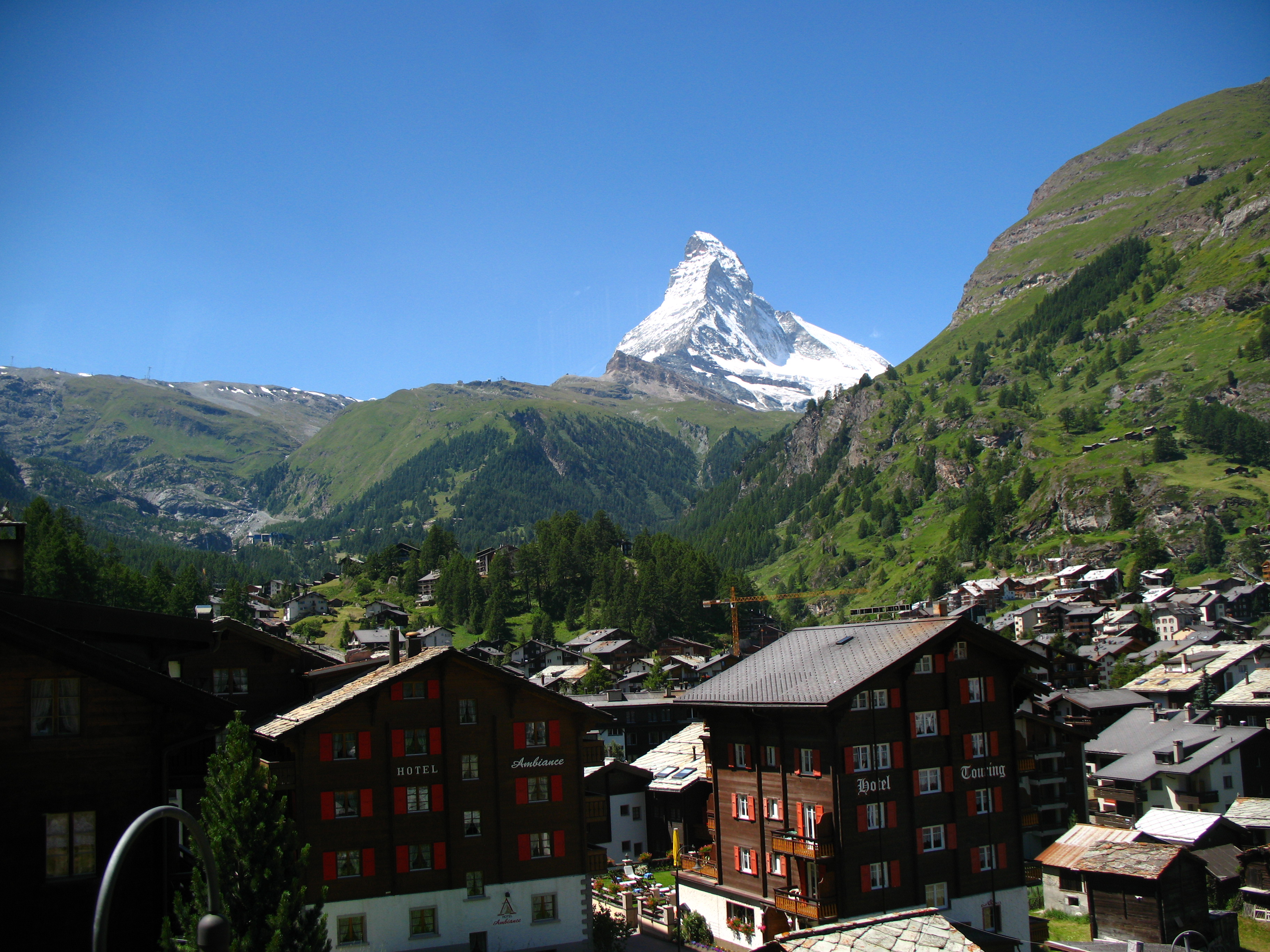
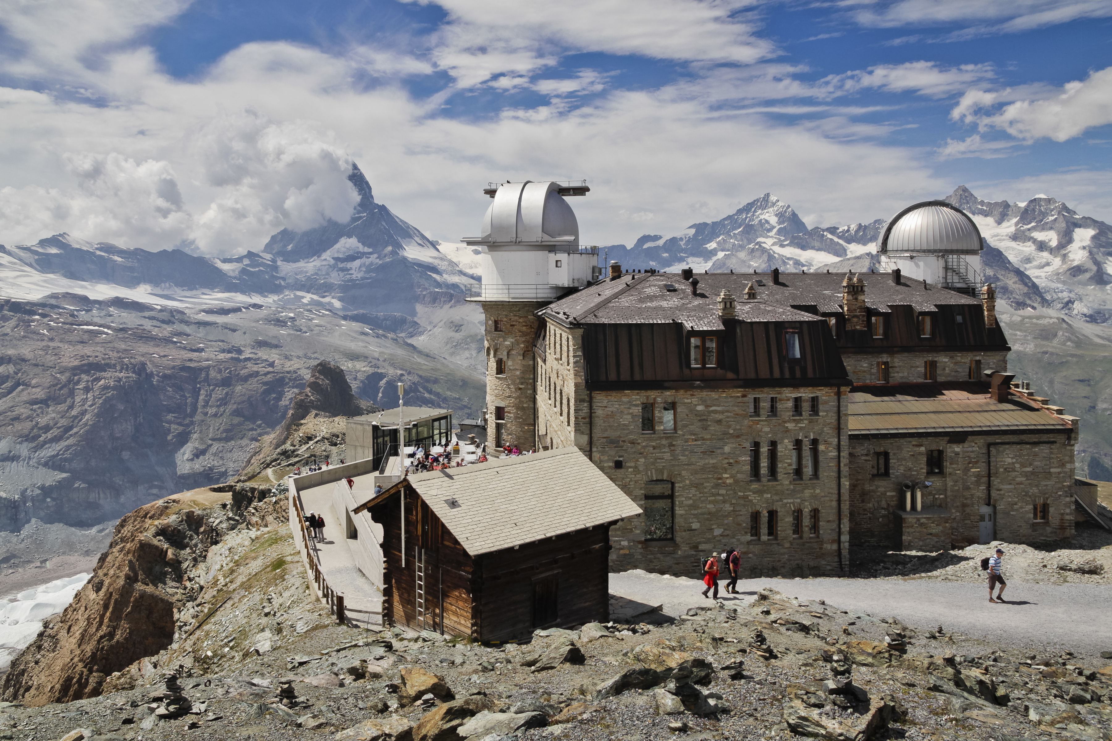
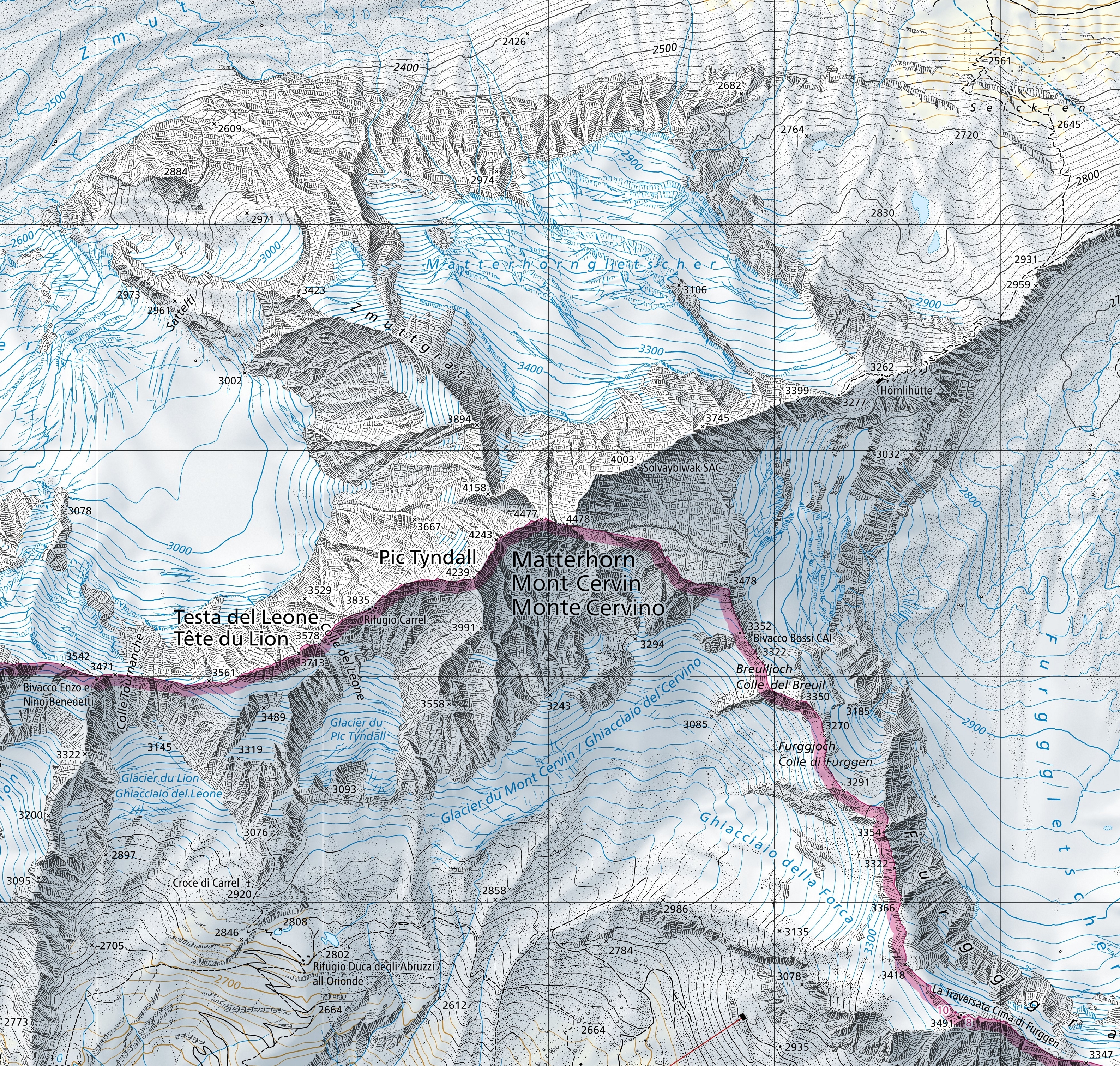
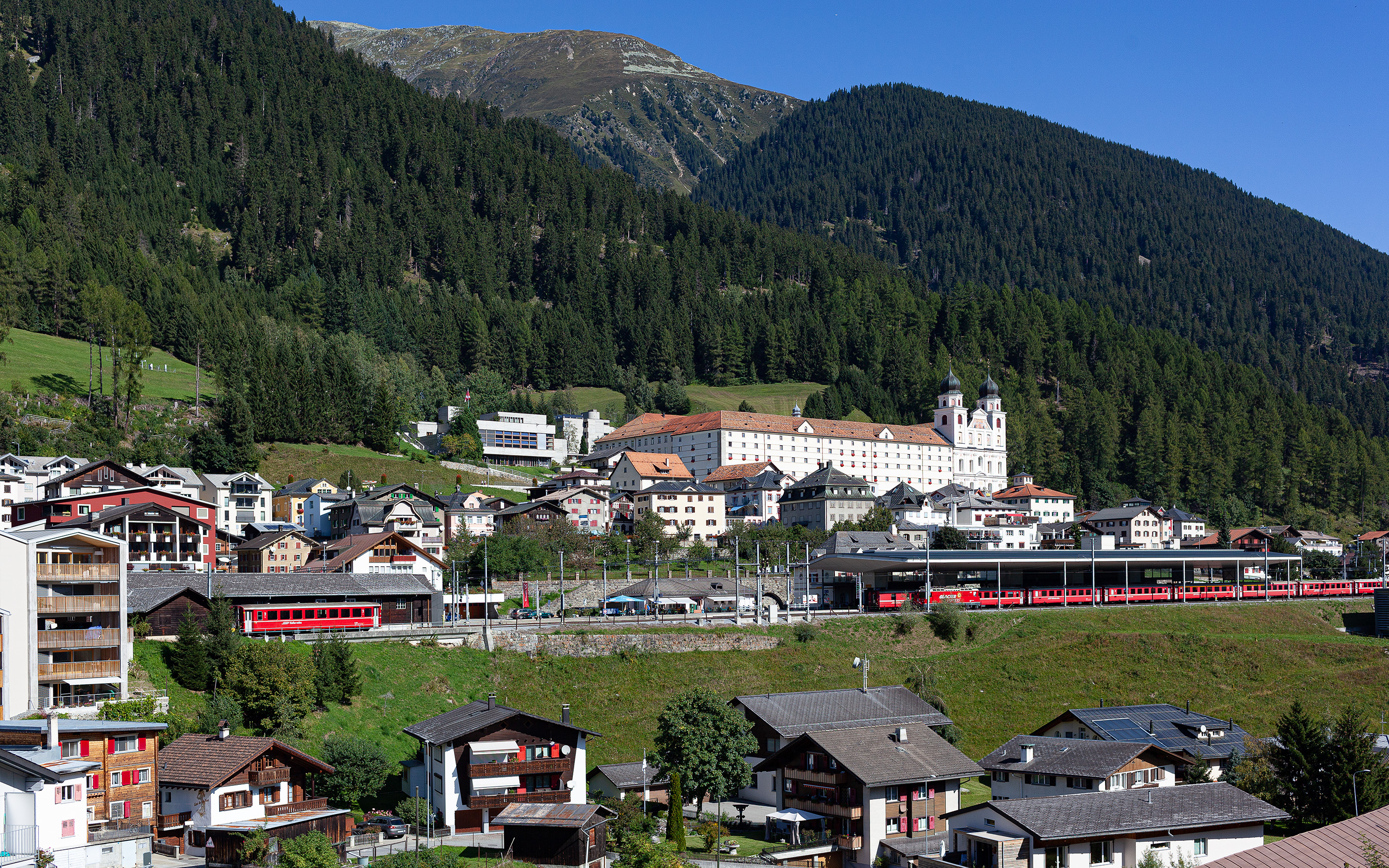
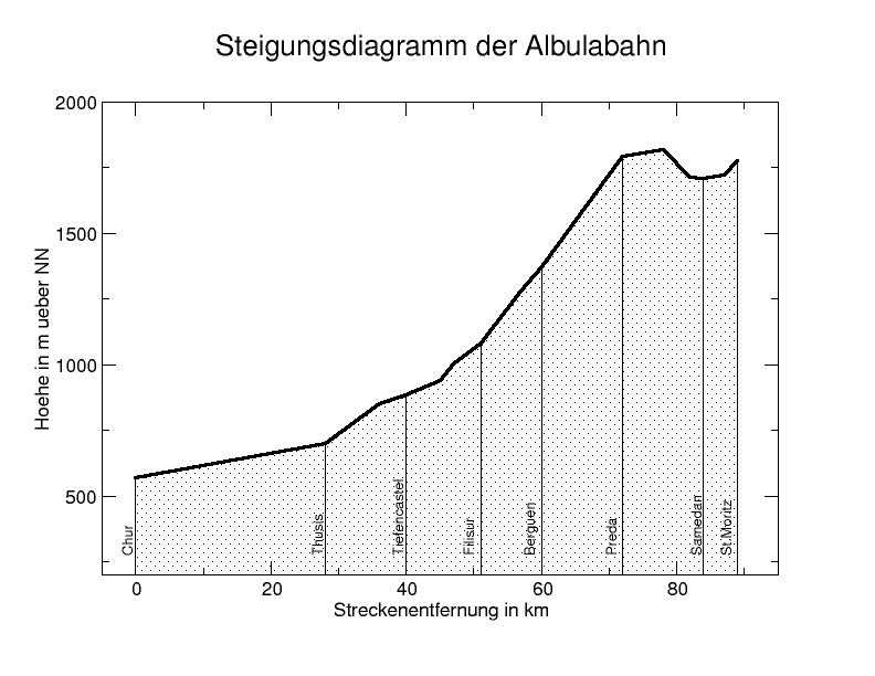
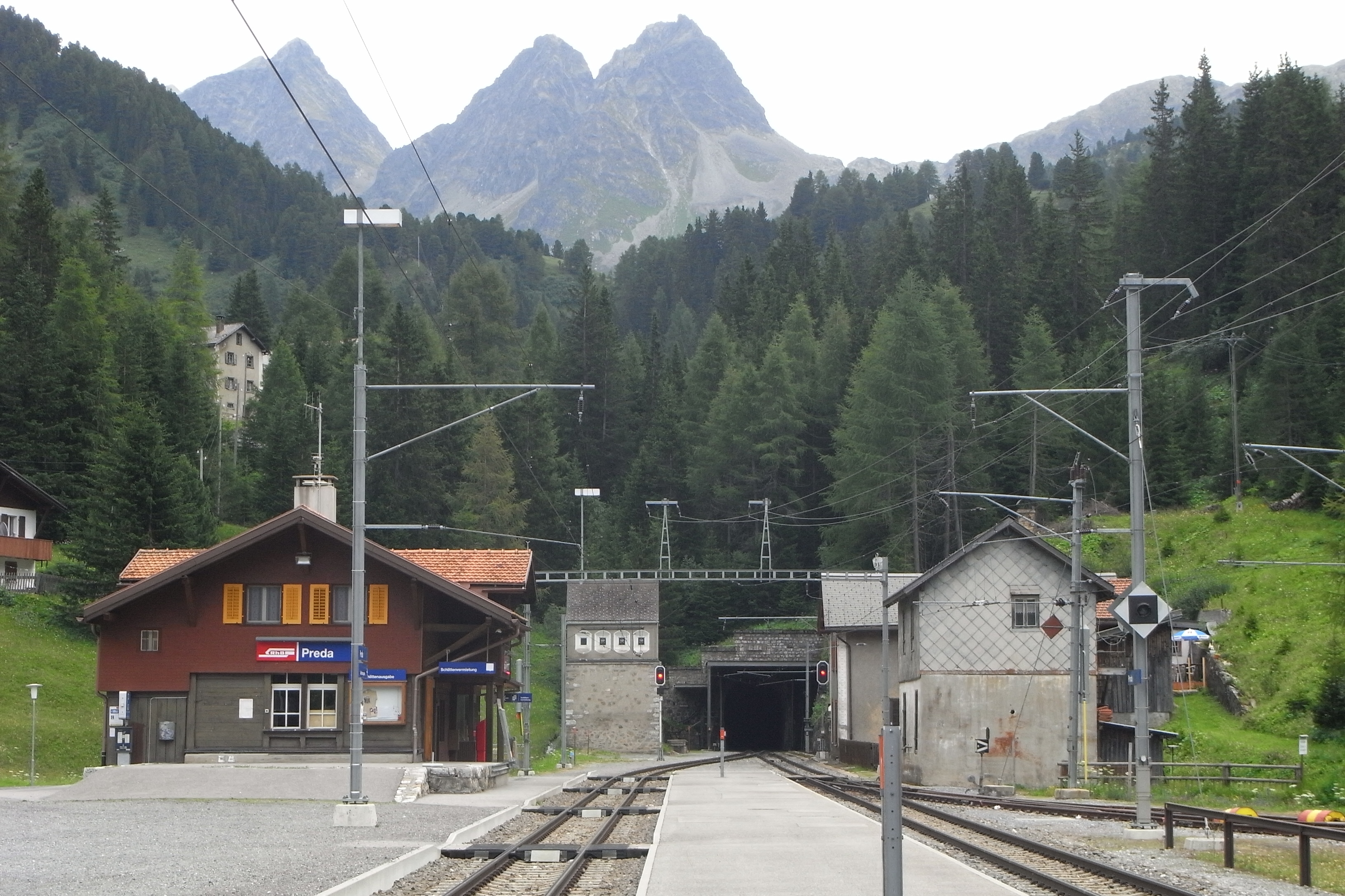
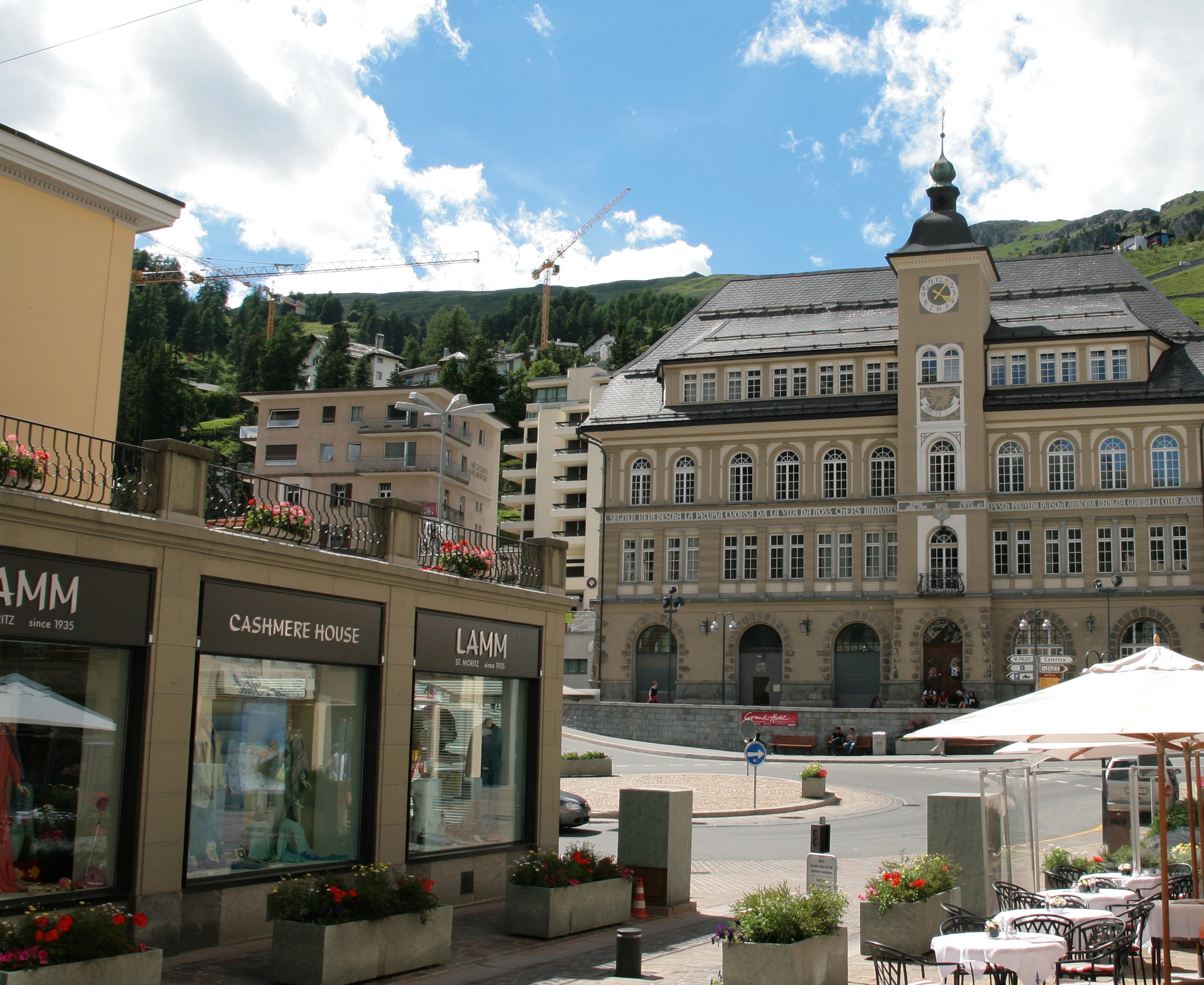
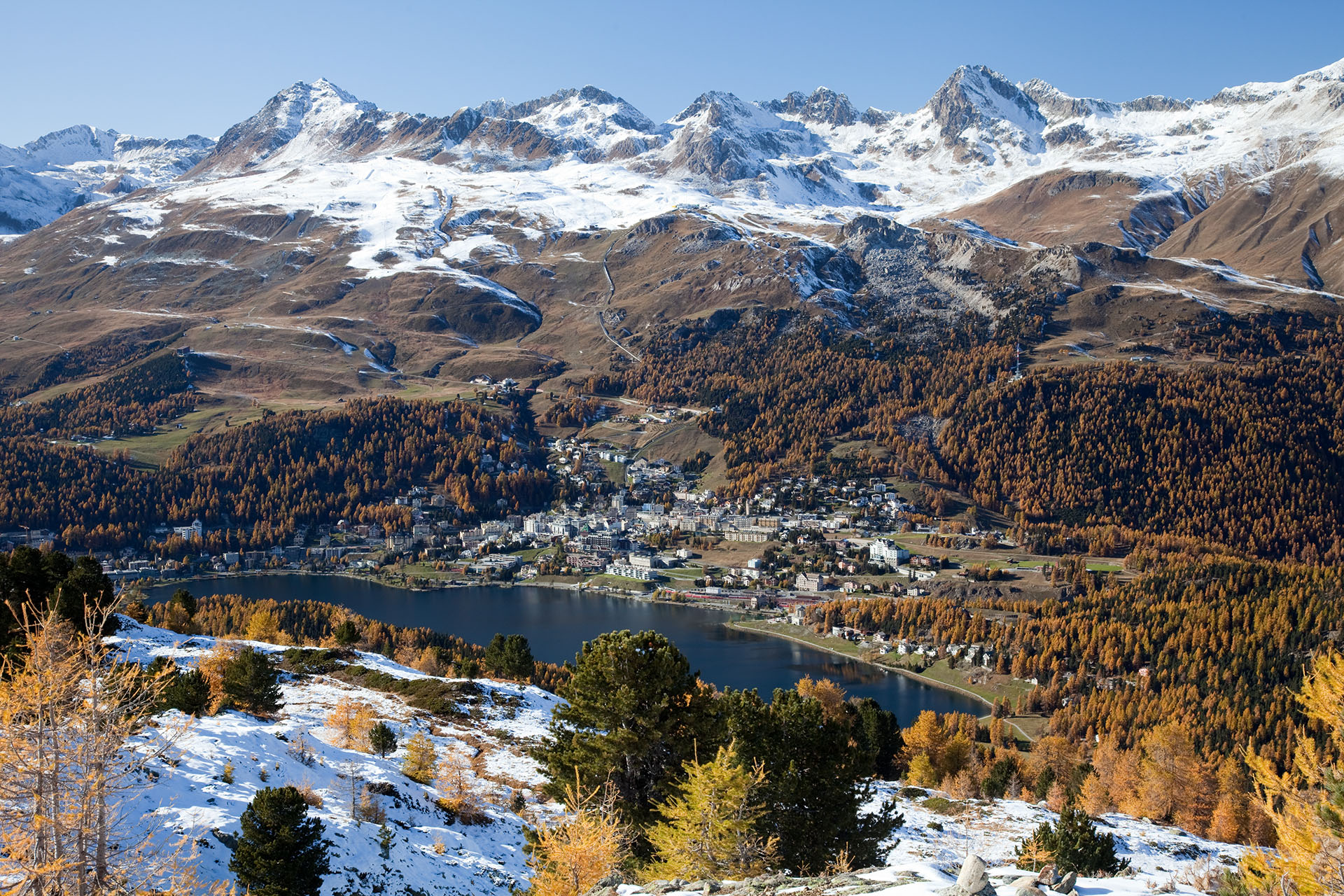