|
Reflections 2023
Series 1
January 30
Street Cable Cars Worldwide II: US Domestic II: Brooklyn Heights -
Lower East River – Battle of Long Island – Washington Escapes – BQE Crisis
| | We've moved from San Francisco's cable cars to worldwide systems to several systems in the US, and we now move to cable cars in NYC. Of course, it's the same old story—cable car lines became electrified streetcar lines to join many others that were always electric, then everything got swept away by the automobile culture. We'll talk about Brooklyn first, specifically, Brooklyn Heights. In the next posting we'll talk about cable cars on the Brooklyn Bridge, and then those that existed in Manhattan.
I do promise there is indeed a cable car involved here, a charming one I would have loved taking, on Montague Street, that connected to the former Wall Street Ferry. But then the story grew—to telling about Brooklyn Heights, and Brooklyn. Then the Battle of Long Island took place in the area, with Washington managing to escape overnight with his army to Manhattan. And with all this history, we have to see what the Brooklyn-Queens Expressway did to Brooklyn Heights (tho it also gave it its Promenade), and how it continues today to be a major problem.
| | | | Brooklyn Let's take a first look at Brooklyn by looking at its neighborhoods—keep this map for later (Map by Peter Fitzgerald).
https://upload.wikimedia.org/wikipedia/commons/f/f2/Brooklyn_neighborhoods_map.png
Those from the NYC area will recognize many names, others will have heard of fewer of them. I'll comment only on several. All should realize that Brooklyn started along the East River facing Manhattan, where you see older, smaller neighborhoods. When Prospect Park was first laid out, it was on the edge of town. Brooklyn eventually spread in several directions to take over all of what had been very rural Kings County, to the point where it's all urbanized today. Kings County (Brooklyn) is the most populous county in NY State and the most populous borough in NYC. New York County (Manhattan) has only about 2/3 of Brooklyn's population.
| | | | | | In Eastern Brooklyn, find East New York, which is presently the name of a very good police procedural TV program. I consider myself to be from East New York, tho I was born in adjacent Brownsville. As I child, I shortly lived with my family at two locations in Brownsville, then at two in East New York, and finally at one in adjacent Cypress Hills, usually considered part of ENY, before moving to Hollis, in Queens. I went to a specialized high school, Brooklyn Tech, in Fort Greene, near downtown and took els and subways to school daily from ENY and later on from Hollis, supplemented by two buses.
The yellow street on the north side of ENY is Atlantic Avenue, the historic main route of the Long Island Rail-Road, which we'll mention later. Trace it west to the East River, where the LIRR originally started, on its way east via Jamaica in Queens to Boston. (!) The road just north of it is Fulton Street. We'll speak later about when Fulton Street started at the Hudson, crossed Manhattan, where traffic continued on the Fulton Ferry, then on Brooklyn's Fulton Street well out into Long Island.
You may want to ponder this:
You can take the boy out of Brooklyn, but . . .
|
| | | | Click on the East River. We'll be talking about Brooklyn Heights, Manhattan's "first suburb", nestled in neatly between Atlantic Avenue on the south and Fulton Street to the north. We'll also make reference to adjacent Downtown Brooklyn. | | | | Brooklyn Rail I've found sources saying there were several cable car lines in Brooklyn among the trolley car lines, but there's next to no information about them. Let this next map of Brooklyn transit routes c1930 suffice to give a hint to Brooklyn rail, since some of them might have been cable car routes early on:
http://www.brooklynrail.net/images/historic_maps/Brooklyn-trolley-map-BMT-19.JPG
This being about 1930, there are elevated rail lines, which, for our purposes, we should disregard—dashed green lines belong to Manhattan's IRT and solid green lines belong to Brooklyn's own BMT. Also skip the red dashes showing BMT bus lines. We're interested in the majority of solid red lines which were trolley/tram/streetcar routes.
Look at the East River—the first red crossing to the south is the Brooklyn Bridge and a BMT trolley line crosses it to Manhattan (the same goes for the Williamsburg Bridge further upstream). By this date the Montague Street cable car line at the south end of Brooklyn Heights (see below) no longer existed.
| | | | | | I've found sources saying there were several cable car lines in Brooklyn among the trolley car lines, but there's next to no information about them. Let this next map of Brooklyn transit routes c1930 suffice to give a hint to Brooklyn rail, since some of them might have been cable car routes early on:
http://www.brooklynrail.net/images/historic_maps/Brooklyn-trolley-map-BMT-19.JPG
This being about 1930, there are elevated rail lines, which, for our purposes, we should disregard—dashed green lines belong to Manhattan's IRT and solid green lines belong to Brooklyn's own BMT. Also skip the red dashes showing BMT bus lines. We're interested in the majority of solid red lines which were trolley/tram/streetcar routes.
Look at the East River—the first red crossing to the south is the Brooklyn Bridge and a BMT trolley line crosses it to Manhattan (the same goes for the Williamsburg Bridge further upstream). By this date the Montague Street cable car line at the south end of Brooklyn Heights (see below) no longer existed.
|
| | | | Trolley Dodgers We're not talking cable cars yet, but there's more to say about trolley cars in Brooklyn. In 1892, Brooklyn began the switch from rail horse cars (and cable cars?) to electric trolleys, which were a lot faster. As the use of trolleys spread, there were trolley accidents with pedestrians until the public could get used to them.
https://i.pinimg.com/736x/b0/3b/44/b03b44508fb065d3e6edf34dba937f5e--city-streets-dodgers.jpg
As this cartoon implies, as of 1895, the situation gave rise to the point where Brooklynites were referred to as "trolley dodgers". This became so well-known a nickname at the time that the local baseball team also became known as the Brooklyn Trolley Dodgers, which would have been a perfectly logical name to everyone then.
https://thetrolleydodger.files.wordpress.com/2016/01/1915-the-brooklyn-trolley-dodgers.jpg
This is a newspaper excerpt from 1915 showing the name as used at the time. The name was later shortened to simply the Brooklyn Dodgers—or even just the Dodgers--tho surely for a while, the image of dodging trolleys remained in the public mind. Once the team was ignominiously brought to California in 1957, the name Los Angeles Dodgers didn't make any real sense any more.
| | | | | | There's apparently some confusion—I remember hearing this in the past—that it was only baseball fans that were called trolley dodgers, those fans who were trying to reach the ballpark by scrambling over trolley tracks, but this is not true. The fad at the turn of the 20C was to call ALL Brooklynites trolley dodgers.
Pre-Ebbets Field, in the 1890s, the Dodgers played at a ball field called Eastern Park, probably named that because it was well to the east of built-up Brooklyn, in Brownsville. Their time there included 1895, when the term was first used. However, Eastern Park was not bordered by trolley lines at all. This made it hard to reach, which is the reason it eventually failed and closed. The Dodgers moved to Ebbets Field n 1913.
On the trolley map, find the intersection toward the right in Brownsville (not named) of Sutter and Van Sinderen Avenues. Eastern Park lay in the four city blocks to the northwest of that intersection, where we see there are no trolley lines. Ebbets Field, on the neighborhood map, was to the east of Prospect Park, in southwestern Crown Heights (tho often described as being in Flatbush).
|
| | | | Brooklyn Heights We'll explore this topic as we've done with some topics in the past—first looking to see the marvel that Brooklyn Heights is today, and only then going back to find out how it got that way. It's at that latter point where we'll find where the cable car was. Keep this excellent "main map" handy while we discuss this topic.
https://i.pinimg.com/originals/ed/47/b0/ed47b0cd75ed5ce99055dbba9834866b.jpg
Brooklyn Heights is located on a plateau on a high bluff that rises sharply from the river's edge and gradually recedes on the landward side. Since that bluff defines the area—it's called "heights", after all—let's start there. Over time, the shoreline has changed. It used to be docks and shipping, and is now being converted to parkland—still under construction as the gray piers indicate. It's now Brooklyn Bridge Park and covers the piers and land at the foot of the bluff. The park starts at Atlantic Avenue and runs along Furman Street, which runs the length of Brooklyn Heights, tho part is hidden in this map. The park then continues under the Brooklyn and Manhattan Bridges, and ends at Jay Street in Vinegar Hill.
| | | | | | Those unfamiliar with the area will be startled by the unusual name DUMBO. It's a charming, historic neighborhood that grew from the original Fulton Ferry landing. It was revived by a real estate developer in the late 20C, and has become quite trendy and upscale. It's just a shame he chose such a cutesy name, since it's meant to stand for Down Under the Manhattan Bridge Overpass. "Overpass" makes no sense, and the area is below both bridges, the Brooklyn Bridge being far more famous. If the developer wanted to point out that two bridges hovered above the place, why not pick something like "Undertown"? But no, it's DUMBO, all caps. The next neighborhood east, Vinegar Hill, has a much earthier, more historic-sounding name. |
| | | | The plateau level of Brooklyn Heights falls between Atlantic Avenue on the south (click) and (Old) Fulton Street on the north. From the bluff it extends to Cadman Plaza West, where Downtown Brooklyn starts. Thus, Brooklyn Heights is very narrow and not particularly long.
The best reading I can get for the elevation of Brooklyn Heights is 27 m (89 ft). What would that be, 9-10 stories above sea level, maybe 7-8 stories above Furman Street at the shore level?
| | | | | | Brooklyn's historic Fulton Street, starting at the historic ferry landing that was the gateway to Brooklyn and Long Island, has been disrespected, and cut into bits. The first part of Fulton Street is now called Old Fulton Street; the next part is now called Cadman Plaza West. In the Civic Center area, what had been Brooklyn's City Hall until the 1898 merger with New York is now Borough Hall; Fulton Street had passed by here, but that segment is now a pedestrian esplanade on its east side. The next shopping segment is now called Fulton Mall. Only after that does Fulton Street retain its original complete name as it crosses Brooklyn to the east and runs beyond (see below). |
| | | | We won't go into many details about Brooklyn Heights' attractions beyond saying that it's been a prominent area of Brooklyn since 1834. It's noted for its low-rise architecture and its many brownstone row houses, most of them built prior to the Civil War. It also has an abundance of notable churches. As a quick illustration of the atmosphere of the neighborhood, on the lower end of the main map, find Grace Court, which runs for one longish block near the river. This is a row of charming brownstone townhouses on Grace Court (Photo by Rickbern).
Brooklyn Heights was named a National Historic Landmark and a NYC Landmark in 1965 and was added to the National Register of Historic Places in 1966. The Brooklyn Heights Historic District, the oldest one in NYC, is below:
https://thumbs.cityrealty.com/assets/smart/1004x/webp/7/7c/7cdcbe8165117295a62d23c61c37e8aa88b9ee88
You'll see it extends from Old Fulton to Atlantic, and above Furman. Much of the east side and the entire northwestern corner of Brooklyn Heights became to desecrated to include will be described shortly.
There are numerous famous people connected with the neighborhood. In recent decades, Truman Capote, Matthew Broderick, Matt Damon, Norman Mailer, Arthur Miller, Marilyn Monroe, Mary Tyler Moore, and dozens more celebrities have lived there. "Bill W.", the AA pseudonym of William Wilson, who co-founded Alcoholics Anonymous on 10 June 1935, did so in a town house at 182 Clinton Street (at State).
Historically, John Roebling and his son Washington Roebling, designers of the Brooklyn Bridge, lived there, and Abolitionist Henry Ward Beecher had his church there. Walt Whitman did not live there—he lived at 99 Ryerson Street in Clinton Hill, near the Navy Yard (see neighborhood map). However, in 1855, the Rome Brothers Print Shop put out the first edition of Whitman's fabled Leaves of Grass; the shop was located at the southwest corner of 98 Cranberry Street at Fulton, and Whitman himself helped set some of the type (the intersection was plowed under with construction around the Plaza). The main map shows Walt Whitman Park nearby. We might also add that one poem in Leaves of Grass is called "Crossing Brooklyn Ferry", which describes the Fulton Ferry trip across the East River from Manhattan to Brooklyn.
On our main map, find Montague Street (say MON.ta.gyu; last syllable rhymes with "argue")--it's already in boldface because of its importance. At four blocks in length, it would seem to be the longest east-west street in Brooklyn Heights. However, I'm going to describe its length as 4+1 blocks long, and the reason for that will shortly become both important and apparent.
http://www.bkmag.com/wp-content/uploads/2014/07/Montague_map.jpg
I usually can't abide kitschy tourist sketches, but this is a fun one and will help us to introduce Montague Street, from where it starts at Court Street near Borough (ex-City) Hall, to the park bench near the river. Not only will our discussion center on Montague Street, we'll find that that's where the cable car once ran.
| | | | Breukelen Now let's plunge back into the past. Before European settlement, NYC was the domain of the Lenape Native Americans, an Algonquian people, also called Lenni Lenape or Delaware Indians. We first pointed this out in 2018/2, where this map was included (Map by Nikater). In their time, the Brooklyn Heights promontory was called Ihpetonga, meaning, quite accurately, "the high sandy bank". But as we know, in 1624 the Dutch founded New Netherlands, centered in Lower Manhattan, and in 1664 they surrendered their colony to the British. But now let's cross the Lower East River from what became New York County (Manhattan) to what became Kings County.
https://i.pinimg.com/736x/01/12/3c/01123c5d51ee69b0bcde3b0bbad26322--the-western-red-hook.jpg
The subdivisions of counties in the US are often towns (= townships), and between the Dutch and English, Kings County became 6 townships, as explained below the map. (New Lots in Flatbush later became part of East New York.) You may recognize a lot of place names as still existing today. But do note that right from the beginning, two townships were clustered along the Lower East River opposite Lower Manhattan, while the others lay more remotely to the southeast. Brooklyn (Breukelen) had one of these prime maritime locations—note large Wallabout Bay--as did Bushwick.
Bushwick was later subdivided, developing the independent City of Williamsburg(h), which was later taken over by the City of Brooklyn, and all of it was taken over after that by the City of New York [Manhattan]).
| | | | | | Breukelen was established here in 1646, and the name first appeared in print in 1663. Say BRÖ.kə.lə (the schwa [ə] is as in əmong; some speakers do pronounce the final N in Dutch words). Compare the rhythm of saying BRÖ.kə.lə with saying "camera" KA.mə.rə
The original Breukelen in the Netherlands was first mentioned in a charter in 953 in the form Broecklede. A broeck (rhymes with "kook") was a peat bog, and a lede was a stream in such a peat bog, so the original Netherlands town would translate as a Peat-Bog Stream. But in America, Breukelen was anglicized to Brooklyn.
https://www.weather-forecast.com/locationmaps/Breukelen.8.gif
This map of the Netherlands shows Breukelen northwest of Utrecht on the way to Amsterdam. We saw the township of Nieuw Utrecht on the Brooklyn Map, and we know about Nieuw Amsterdam in Manhattan, so we're really at home here. Dutch actor Rutger Hauer was born in Breukelen. I would love to say I've visited Breukelen, so I will. Sort of. On an express train in the Netherlands, I passed thru Breukelen, a local station, and I saw a view similar to below, so that will have to be a sufficient visit for me.
http://wonenbuiten.amsterdam/wp-content/uploads/2016/03/9.jpg
|
| | | | But Brooklyn had the best location vis-à-vis the Lower Manhattan settlement and, thanks to Brooklyn Heights and its prominent landowners getting the Fulton Ferry started (more later), it received a charter as a village from the state of New York in 1816, as the map shows. Brooklyn Village would have then been the seat of Brooklyn Township. But it was all squeezed up against the Lower East River. | | | | Lower East River As we speak of this southeast bank of the Lower East River growing in urban importance, I find it worthwhile to point something out that it took me years to realize.
Anyone interested in history will have learned that New York (Manhattan) was settled in its southern tip by the Dutch, and from there grew ever northward. And that's true. But I need to modify that, just slightly, and to do so, we have to go back to the Castello Plan of New Amsterdam in 1660, discussed in detail in 2009/24 (qv). Now, realizing that it's tipped to the side, with north on the right, take another look at the magnificent Castello Plan. We see on the north side (right) the wall containing Wall Street. Crossing it is the major road that eventually became Broadway, starting at Bowling Green on the left. We see the canal that once cut up Broad Street, explaining its width. But note something else. New Amsterdam "faced" the East River.
There were bluffs on the Hudson River, still visible today at the back of Trinity Church. There may have been some sailing activity there, as well as at the Battery on the left. But without a doubt, everything faced the East River. That's where the South Street Seaport, a museum area today, developed. That's where the Broad Street Canal led to, and where the few streets, including Wall Street, led to. To this day, Wall Street dead-ends at Broadway, but comes right down to the East River. Thus we should modify our original concept: Manhattan grew from the south, yes, but more accurately, from the southeast, since the colony faced the East River.
https://www.nycgo.com/utilities/maps/static-map.php?lat=40.7060855&lng=-73.9968643&style=feature:poi|visibility:on&size=700x700&key=AIzaSyDkSQUrbnLkcBi92Bz1sKKqG9wEe0NWif8&zoom=14
Now if we put together the fact that the City of New York (Manhattan) grew from the northwest shore of the Lower East River with the fact that the developing City of Brooklyn grew from the southeast shore of the same, we find that the Lower East River is the actual cradle of the City of Greater New York. While an early important connection was the Brooklyn Ferry-cum-Fulton Ferry, its replacement by the Brooklyn Bridge formed the first fixed connection between the two. I now consider the metaphor for the pair together to be a dumbbell, that is, two masses joined by a fixed connection (Photo by Tiia Monto). Keep that image in mind as we continue to show how Brooklyn developed.
| | | | The Brooklyn Shore Let's start with a very pastoral scene across the Lower East River This is an early view of New York (Manhattan) from Brooklyn Heights. You can see New York is busy with maritime activity. It's unclear if this view is from below the Heights or partway up the slope. I doubt that it's from the top.
https://cdn.vox-cdn.com/thumbor/xHA-g3EJan9a0KBgZhAEFMS2NoA=/0x0:800x390/1820x1213/filters:focal(336x131:464x259)/cdn.vox-cdn.com/uploads/chorus_image/image/63678488/bkheights1852color.0.1489190402.0.jpg
Do not let yourself get confused by some jumping back and forth in time, as we're now for the moment in the mid-19C and are looking at Brooklyn Heights c1852, then we'll go back earlier. But this is the only view I've found that shows one special thing. We expect to see the charming houses up top. We expect that on the waterfront, warehouses would have developed to accommodate the shipping on the Brooklyn side of the river. But this is the only view I could find showing the original look of the sloping bluffs that define the Heights. Keep those graceful slopes in mind, because unfortunately, they most definitely do not look like that today.
| | | | 1776 We've talked about the Dutch here in the 1600s and will concentrate below on the 1800s, but it's really worthwhile to pause here for an stop in the 1700s, specifically in the year 1776 at the start of the American Revolution, when the Battle of Long Island was fought. Whether you know this story or not, you should find it fits in quite well with our discussion here, and its story came down to ONE day and, two days later, ONE night. But here's a spoiler alert: the Americans lost—it was a complete rout—and New York City and its area were British thru the entire period of the Revolution. But the story takes a positive turn, without which, Charles III might still have been King of the Province of New York—and more--to this day.
We will not talk about the American Revolution in detail. I've done that in the past, and even discussed the Battle of Long Island in 2011/2. To simplify things, I can start by quoting from that posting: The Battle of Long Island is the Revolutionary War battle fought in [what is now] Brooklyn on 27 August 1776. . . . It was the first major battle of the war after the Declaration of Independence the month before (54 days earlier), and therefore the first battle in which an army of the United States ever engaged. It was also the largest battle of the entire conflict . . . and at the time, the largest conflict ever fought in North America.
Washington, coming from winning the siege of Boston [April '75 – May '76], was trying to defend New York, where he had the bulk of his forces, and set up headquarters on Broadway on 13 April. On 6 July, news arrived that Congress had voted for independence, and on Tuesday, 9 July at 6:00 PM, Washington had several brigades [listen to] the Declaration of Independence read aloud. . . .
To continue, study this map of the Battle of Long Island (Map by Oneam):
https://upload.wikimedia.org/wikipedia/commons/thumb/c/ce/Battle_of_Long_Island%2C_1776.svg/768px-Battle_of_Long_Island%2C_1776.svg.png
In July, the British, under General William Howe, landed in rural Staten Island (as depicted here in Harper's Magazine in the 1876 Centennial), with additional reinforcements arriving over the next six weeks, bringing their total force to 32,000 troops. In 1776, New York (Lower Manhattan) had an estimated population of 25,000 (the second largest, after Philadelphia's 40,000), meaning that more British troops were landing in Staten Island than there was in the entire population of New York (Lower Manhattan) at the time. Washington, suspecting the city itself would be the first target, had the bulk of his forces there, more than 20,000 trained soldiers. (If the Royal Navy is included, the total number of combatants in the Battle of Long Island came to over 40,000, making it, at the time, by far the largest battle ever fought in North America.)
But in case New York wouldn't be attacked directly by sea but over land instead, Washington decided to protect his left flank, which was the land route from Staten Island to Manhattan, namely the east shore of New York Harbor which was the western edge of Long Island. Therefore, he stationed about one-third of his Manhattan troops across the river, some 6,500 troops. Later he reinforced those men to almost 9,000.
| | | | | | There are at least two names for this important battle, but it's easy to be misled. Look at the battle map. The Village of Brooklyn (on Brooklyn Heights) wouldn't even exist for another four decades. The only thing called Brooklyn at the time of the battle was the town[ship] of Brooklyn (see earlier map). As the battle map shows, "Brooklyn" is a tiny entity up by the East River, and the fighting took place in what was totally rural Kings County, all part of Long Island. For that reason, I feel that the Battle of Long Island is the best name.
However, to modern under-informed ears, calling it the Battle of Long Island brings to mind images of areas leading out to Montauk Point, which is totally misleading—this was a battle pointed at Manhattan. The further complication for modern ears is the fact that Brooklyn expanded to totally fill out all of Kings County, so that the battlefield ends up located within TODAY'S Brooklyn. Thus it's also called the Battle of Brooklyn. But at the time, it didn't take place IN Brooklyn, only NEAR what was then Brooklyn. So of the two names, I find the first more accurate, tho it always requires an explanation.
|
| | | | For (re-)orientation, look again at this map of Brooklyn neighborhoods (Map by Peter Fitzgerald). In the south find Gravesend, then Flatlands. In the center find Flatbush, and on its right border (click), trace Flatbush Avenue (not named), today the central artery of Brooklyn, northward. It is the straightened-out version of the historic Flatbush Road. At Prospect Park, it separates the park from the Brooklyn Botanic Garden (not named), then continues north thru circular Grand Army Plaza and into downtown. Flatbush Avenue Extension then crosses the Manhattan Bridge. Remember this route.
Find Gowanus, connecting to Gowanus Creek, now called the Gowanus Canal. North of the park, notice how the names of three neighborhoods indicate a hilly ridge: Park Slope (formerly Gowanus Heights), Prospect Heights, Crown Heights. This ridge is important.
Also find Bushwick, and Bedford-Stuyvesant ("Bed-Stuy"), which combines the old Village of Bedford with what was Stuyvesant Heights, another name indicating the ridge. Having reviewed these modern locations, move back to 1776 and the Battle.
| | | | The One-Day Battle The story of the battle is very short. The Battle proper took place on one day, August 27. After a pause of two days, another historic event secretly took place on the night of the 29th. I've seen the battle described as running from the 27th to the 29th, but that's misleading. Think: one day; long pause; a one-night event.
High ground, as ever, was all-important. In Brooklyn, that describes not only Brooklyn Heights but also the ridge (see map) that we've discussed in the past. If the memory is vague, check out again 2010/26 and scroll down to "Two Moraines", describing the two ridges that cut across from Brooklyn across Long Island, each forming one of the eastern "forks". Here in Brooklyn, we see its military significance.
This is the Harbor Hill Moraine, formed 13,000 to 12,000 years ago during the Wisconsin glaciation. You saw where it still runs, north of Prospect Park, strikingly so at the entrance to the Brooklyn Botanical Garden, then further east forming Highland Park, Cypress Hills, and beyond. But in Brooklyn it had a historical name I'd never heard before, the Heights of Guan. It seems that unusual word is an old variation of Gowanus, so this ridge was seen as an extension of Gowanus Heights (Park Slope). The hills vary from 30-46 m (100-150 ft). The southern slope has a relative steep drop (stairs down into the botanical garden), but the northern slope is more gradual—similar to Brooklyn Heights. Everything to the south is the flat, glacial outwash plain.
As our battle map shows, Washington (blue markers) located some of his troops in Brooklyn Heights, but his main defenses were on a line along the Heights of Guan. On August 22, the British sailed from Staten Island and landed on the shores of Gravesend Bay, outside the Narrows, at Gravesend. For landing, they would have used flatboats like these (tho this picture depicts a later Rhode Island landing). Along with British Redcoats, two other boats show blue-coated Hessian mercenaries.
They established their troops in an east-west line (red markers) passing thru Flatbush, and after five days of waiting, they attacked the American defenses.
The British goal was Brooklyn Heights, which is why it's so appropriate that we discuss this battle in this posting. About 6,500 men manned the main American positions while the rest were placed forward to block the three approach roads up to the Heights. Howe divided his men into three assault columns, one for each road. But he surprised the Americans by a flanking maneuver. Note that the two other generals had 5,000 troops each, but How himself took 10,000 and swung way to the east via Flatlands to New Lots (the southern part of East New York), looped around the rear thru Bedford, and attacked the flank of the Americans. That would have been along what was then Ferry Road, and is today Fulton Street. Meanwhile, the central column went north via Flatbush Road, the forerunner of today's Flatbush Avenue. Surprised and outnumbered, the Americans panicked, and fled to the main defense line in Brooklyn Heights, resulting in 20% losses due to casualties and capture. Several regiments fought desperate rearguard actions but were overwhelmed.
For further edification of this one day, we have this quaint, period British military map (click). It shows clearly the "Position of the British Army" running east-west thru Flatbush, and that the flanking move involved the "March of the Army in One Column" via Flatland[s], [The] New Lots, and Bedford. You see the position of "The Americans" in "The Heights" and how the "Flight of the Americans" took place along Flatbush Road (Avenue), cutting thru the ridge and leading to a place spelled "Brookland". Its gateway ferry was also sometimes spelled the Brookland Ferry.
| | | | Battle Pass Let's take a momentary respite to inspect the route of that retreat, and where it is in today's Brooklyn. Our main battle map shows that that route was being defended by American (New Hampshire) General John Sullivan and being attacked by Hessian General Leopold Philip von Heister (also known, oddly, as "de Heister"). At the ridge, Flatbush Road crossed thru what was then called Flatbush Pass, but is now called Battle Pass, where there was a skirmish, as the Americans attempted to block the road from the advancing Hessians by cutting down a tree now known as the Dongan Oak. The Hessians had 5,000 troops and the Americans had 1,300. The skirmish was over by late morning, and Sullivan was captured. The Hessians also killed a number of Americans in a devastating bayonet charge.
http://www.mappery.com/maps/Prospect-Park-Map-2.jpg
This is a modern map of Brooklyn's Prospect Park, designed by Olmstead and Vaux. Click on the dark semicircular Prospect Park Zoo building near where the straightened Flatbush Avenue separates the park from the Brooklyn Botanical Garden. Nearby is Battle Pass as shown in this 1792 print, with tree stumps still visible. Battle Pass runs for about 45 m (150 ft) along the car-free East Drive in the park, which is the former winding Flatbush Road, now in the park. Along it is the small Dongan Oak Monument (Photo by Jim.henderson), which commemorates the tree felled and used as a barricade by the American defenders against the northward invasion. Preservation of this battlefield site was one of the reasons given for the creation of Prospect Park in the 1860s.
| | | | | | Many of the American dead from this skirmish were buried at the Flatbush Dutch Reformed Church, on Flatbush Avenue, just south of the Park, tho for years after the battle, remains occasionally continued to be discovered in the area.
General Sullivan was released in a prisoner exchange four months later in time to rejoin Washington before the Battle of Trenton, the famous victory that took place on Christmas night, right after crossing the Delaware. In Trenton, Sullivan's division secured an important bridge that prevented escape and ensured that about two-thirds of the Hessians were captured.
|
| | | | The Two-Day Pause All that action happened on the 27th. After that, Howe ordered all his troops to halt the attack and pause for two days, the 28th and 29th, in front of the American fortifications (see battle map). He did this despite the protests of many officers who believed that they should push right on to Brooklyn Heights and finish the job. But Howe had decided against a direct frontal assault on the entrenched American positions, and chose instead to dig in for a siege. He believed the Americans were essentially trapped, since his troops blocked escape by land and the Royal Navy was in control of the East River. As the day went on, the British began to dig trenches, slowly coming closer to the American defenses. By doing this, the British would not have to cross over open ground to assault the American defenses as they had done in Boston the year before. On the afternoon of that first day of the pause, it began to rain and Washington had his cannons bombard the British well into the night.
Let's now move to this map showing more detail of downtown. We see again the Heister/Sullivan route, and Howe's flanking route. But now let's concentrate on where they're heading. Blue markers show Washington's troops in Brooklyn Heights, and a black line shows another line of defense to protect the Heights. This line crosses the Flatbush Road/Avenue route an includes Fort Box and Fort Putnam. I wanted to find out where those two forts had been, and to my surprise, one of them turned out to be in a location very familiar to me.
https://mapcollections.brooklynhistory.org/wp-content/uploads/sites/8/2020/02/bhs_ba003982577_a-2048x1321.jpg
I've been wanting to use this "Downtown map", and this is a good place to put it. We see the Heights, Montague Street, the Civic Center. But now let's pop back almost 2 ½ centuries to see the military confrontation. We know that the disrespected Fulton Street now has several names, including Cadman Plaza West. We see where Flatbush Avenue comes up from the south and crosses it, and Flatbush-to-Fulton is presumably the route the retreating troops took behind their line of defense. But where were those forts?
Back on our neighborhood map, locate the adjacent Boerum Hill and Fort Greene neighborhoods, which are right between the two areas we've been discussing. Fort Box was also called Fort Boerum, which today would be in the Boerum Hill neighborhood (a hill!). On the above Downtown map, the fort would have been down in Boerum Hill (click) where Pacific and Bond Streets intersect, just below the bottom of the map in those purple boxes.
But Fort Putnam, to my surprise, later became Fort Greene Park with its Monument, on the mid-right of the map, the center of the Fort Greene neighborhood. Mentally connect these two forts across the Flatbush/Fulton intersection and you'll find the American line of defense during those two days in 1776, defending Brooklyn Heights. But then look across DeKalb Avenue from the park and you'll find my high school, Brooklyn Tech! In my years there, tho I was well aware of the monument, I never pictured the school as lying on a line between two armies, even if had just been for two days.
https://live.staticflickr.com/2145/2479308492_b74cde6bd9_b.jpg
This is a view looking northeast past Brooklyn Technical High School. Across DeKalb Avenue is Fort Greene Park, also designed by Olmstead and Vaux, like Prospect Park. You see its altitude is sufficient to make it a good defensive site for a fort. The main distinctive feature of the park is the Prison Ship Martyrs' Monument.
| | | | | | During the Revolutionary War, the British used sixteen prison ships to house American prisoners in nearby Wallabout Bay and across New York harbor under terrible conditions, which resulted in some 11,500 American prisoners dying from disease and malnutrition. More Americans, from every state, died on British prison ships at this time than in all the battles of the Revolutionary War combined. The dead were dumped overboard or disposed of in other horrific ways. The remains of a small fraction of the prisoners were located and removed to a crypt at the monument site in 1873, and a granite Doric column 45 m (149 ft) tall, designed by Stanford White of McKim, Mead, and White was unveiled in 1908 over the crypt. |
| | | | The Overnight During the first day of the pause, the 28th, there was little actual fighting beyond Washington continuing to bombard the British line in the rain into the night. But he also sent a letter (How? By a courier on horseback north on the Brooklyn shore? I can only guess.) instructing General William Heath, who was at Kingsbridge, which is due north of northernmost Manhattan in what is today the Bronx, to send every flat-bottomed boat and sloop without delay. We can presume that the flat-bottomed boats were like those the Brits and Hessians had landed in at Gravesend. On the second day of the pause, the 29th, Washington met with his generals at 4:00 PM in a mansion on Brooklyn Heights (more later). They agreed unanimously that further retreat to Manhattan was their best option, and Washington had orders disseminated by the evening. Some regiments would make up the rear guard, holding the line until the rest of the army had withdrawn. | | | | | | Far more famous, and much larger in scale, was the evacuation over a century and a half later of over 338,000 allied troops at Dunkirk over nine days in 1940, tho all matériel was lost. While the much smaller evacuation at Brooklyn Heights was similar in nature, the matériel was brought out with the troops. |
| | | | Nature assisted Washington. While the warships of the Royal Navy ostensibly had control of the East River (which was forefront in Howe's mind), that rainstorm they'd been having in fact drove the British warships down into New York harbor. This is an original sketch by an English officer on board of one of the ships while at anchor in New York Harbor, right after the Battle of Long Island and presumably right before the evacuation across the East River. The sky seems to indicate bad weather, and those hills look like Staten Island to me.
The troops were told to gather up equipment and ammunition to prepare for a night attack. By 9:00 PM, the sick and wounded began to be moved to the Brooklyn Ferry in preparation for evacuation. At 11:00 PM, troops from Massachusetts, who were sailors and fishermen, began to evacuate the troops. As more were evacuated, more were ordered to gradually withdraw from the lines and march to the ferry landing. This would presumably be both up Fulton Street and down from the northern side of Brooklyn Heights. Quiet prevailed, since wagon wheels were muffled and the men were forbidden to even talk. The silence must have been quite eerie. As troops evacuated, the rear guard continued to tend the troops' campfires to deceive the British to think the troops were still in place. Artillery and supplies were all being evacuated with the troops across the river at this time, but it was taking longer than Washington had anticipated, and it was soon dawn. And so nature helped Washington again. A fog settled in and concealed the evacuation from the British. As the last boat was leaving for Manhattan, the last person to board it was George Washington. It was a successful escape that helped repair low American morale.
| | | | | | Given the date, the only illustrations available are artists' renditions made years later, and they uniformly are made to look quite heroic. This is Washington leading the evacuation at the landing of Brooklyn Ferry, later called Fulton Ferry, and here he is supervising the removal of artillery as well. Finally, a 1951 USPS commemorative stamp depicted the 175th anniversary of Washington saving his army at Brooklyn, once again depicting Brooklyn Landing. |
| | | | By 7:00 AM on the 30th, that last boat with Washington landed in Manhattan. All 9,000 troops had been evacuated with no loss of life. By then, British patrols began to notice the lack of activity and so began to search the area, and were stunned to find that Washington and his army had disappeared. Later that day, the British troops occupied the American fortifications, Brooklyn Heights, and the historic ferry landing, the gateway to—and from--Brooklyn.
Presumably Washington then set up shop back on Broadway, but he knew New York's days as an American city were numbered for the time being. Howe waited for just over two weeks, until September 15, to invade Manhattan. Just like the original invasion hadn't attacked the city proper by water, but had landed in Gravesend, neither was this a frontal attack. Instead, Howe sailed up the East River to what is today Midtown Manhattan and landed his force at Kips Bay (also spelled Kip's Bay).
| | | | | | While old maps are often geographically inaccurate, they are fascinating for showing the mindset of the time. This undated map (west at the top) shows the lower East River apparently at some point after the war ended in 1783. From Gowanus Creek to Wallabout Bay we see (click) the American line of forts. They are protecting historic Fulton Street, here labeled as the Old Jamaica Road to Ferry, then Old Ferry Street, leading right up to the dock. To the left of the dock, between lands belonging to Hicks and to Remsen, is Brooklyn Heights.
While the later Fulton ferry crossed straight across the East River to Fulton Street in Manhattan, we see that the older Brooklyn Ferry crossed diagonally to reach the more populated area of Wall Street, leading up to Broadway. This 1746 view shows the ferry house at the foot of Wall Street, where the evacuation landed.
Look at Wallabout Bay, where both sides are labeled "Prisoners' Graves". Those would be just some of the Americans who died on the British prisoner ships in the bay and harbor, who are commemorated by the monument in Fort Greene Park.
Now move up the coast to what was then called Bushwick Creek, and is now Bushwick Inlet in Williamsburg, located approximately across from 14th Street in Manhattan. You see the point marked "Place where the British embarked" on the north side of the creek in an area called Green Point, now the Greenpoint neighborhood in Brooklyn. Follow the "Track of the Flat Boats crossing to Kips Bay", and you'll see where in today's Midtown Manhattan the British invaded—about 34th Street--in the follow-up pursuit of Washington and his army.
We now move to another historical map, one I've taken from my earlier posting on the area (qv) 2011/18 "Kips Bay". Again, it's a British map, this one dated 1781. I'll update my comments from that posting: All the shorelines are rather distorted from reality . . . but start at the misshapen New York at the tip of [what was called] "York Island"; note Greenwich (Greenwich Village); Crown Point (Corlear’s Hook); Inclenberg (Murray Hill); Kepps Bay (Kips Bay); Bloomingdale (to which Bloomingdale Road, today an extension of Broadway, led); Haerlem (Modern Dutch Haarlem, but in NY, Harlem), along with the Harlem Heights*; the King’s Bridge with the Kingsbridge area [where Washington had sent for boats]; Spiking Devil (Spuyten[de] Duyvil, actually “Spouting Devil”). On the Long Island side, note how Brooklyn [has] the indication of the "rebel lines 1776" of five years earlier; the town of Bedford with the Road to Jamaica [Fulton Street]; [Bushwick Creek;'] Newton (Newtown) Creek [here misidentified as the creek they sailed from] . . . and, further up, the turbulent meeting of waters Hell Gate (second word missing on map) . . .
*A further clarification about hilly northern Manhattan as shown on this map. The southern part of it is Harlem Heights, better known today as Morningside Heights. The northern part beyond 155th Street is Washington Heights, named for Fort Washington, built to defend the area by continental Army troops on the highest natural point in Manhattan. But two months after Kips Bay, on 16 November 1776 Howe seized the fort, using a force of approximately 8,000 men, mostly Hessians commanded by Lt Gen Wilhelm von Knyphausen. While this assault is now known as the Battle of Fort Washington, following the British-Hessian victory, the fort was renamed Fort Knyphausen, which is the name shown on this map, further indicating the British origin of the map.
|
| | | | I have discovered a long mislabeled watercolor that depicts the British landing at Kips Bay on 15 September 1776. It shows (click) naval forces in the East River about to make a landing at rebel entrenchments along the shore at Kips Bay. The ships bombarding rebel positions are from the left, the Rose, Carysfort, Roebuck, Phoenix, and Orpheus. In the foreground are troops in flatboats having sailed from unseen transports on the Long Island side behind us, who are waiting to pass thru to land on the shore. | | | | | | https://storage.googleapis.com/raremaps/img/xlarge/48187.jpg
This 1864 map is a fabulous find that shows the Kip family farm located on its bay, with a list of family members' lots and how they planned on laying out a village, including streets named after some family members. It ends at the Eastern Post Road, which we've discussed in the past—it was the extension of the Bowery and became Boston Post Road further north. Superimposed on this are the actual streets of today. You can see that building 1st Avenue must have involved filling in part of the bay, as did building Bellevue Hospital.
Focus on the central "Kip's Bay Street", which neatly coincides with today's 34th Street, a major crosstown route. Off the top of the map, after Lexington Avenue, would next come Park, then 5th Avenue. To mentally link 1776 with today, the Empire State Building is at 34th & 5th.
Today's East River ferry route connects, among other stops, Fulton Ferry in Brooklyn with East 34th Street in Manhattan (actually located at 35th Street). A future posting will describe that ride.
|
| | | | The heavy advance fire caused the inexperienced militia guarding the landing area to flee, allowing the British to land unopposed, making the landing a total British success. British maneuvers following the landing very nearly cut off the escape route of some Continental Army forces stationed further south on the island. It forced the Continental Army to withdraw to Harlem Heights (Morningside Heights), ceding control of New York City at the lower tip of the island, which the British quickly occupied.
Although American troops delivered an unexpected check to the British at Harlem Heights in mid-September, Howe defeated Washington in battle again at White Plains and then again at Fort Washington. Because of these defeats, Washington and the army retreated across New Jersey and into Pennsylvania. On September 21, a fire of uncertain origin destroyed a quarter of New York City.
All in all, I wish people, and New Yorkers in particular, were far more aware of both the overnight evacuation at Brooklyn Landing and of the fact that Kips Bay is the only place the island of Manhattan was ever invaded by an enemy force.
https://i.pinimg.com/736x/c4/90/cf/c490cf431ccc7d21c4b484482f0a3f0f--new-york-maps-le-village.jpg
| | | | Village of Brooklyn So here we're back earlier, in 1816, when the Village of Brooklyn was formed within the township, and here it is (north is lower left). Let's start at the waterfront, where the warehouses developed at the piers. This map is one of the few that indicate where the bluffs were that defined the Heights, but it seems that Furman Street down by the docks might have had to have been partially cut thru some irregular bluffs. Otherwise, Columbia Street (now Columbia Heights) was and is the first street up above.
With both the ferry and village established, landowners began to subdivide their farms into lots, which were advertised as suitable for a "country retreat" for Manhattanites, leading to a building boom that resulted in Brooklyn Heights becoming the "first commuter suburb" since it was easier and faster to get to (Lower) Manhattan by ferry than it was to commute from upper Manhattan by ground transportation.
On the left, we see where the Fulton Ferry eventually got its landing at the start of Brooklyn's Fulton Street, which runs around the Heights and off east to the top of the map. This is before its early parts were chopped up as Old Fulton Street, Cadman Plaza West, and Fulton Mall.
HICKS/MIDDAGH: But let's look at some major landowners, the ones who established the village status. To the left (north) we see properties of the Hicks and Middagh (MID.daw) families. Brothers John Middagh Hicks and Jacob Middagh Hicks, whose family had lived in the area for some time, began developing family land on the northern end of the Heights. The Hicks brothers were building to attract middle-class tradesmen and artisans already living in Brooklyn, and established relatively small lots. Among street names, we see a Hicks Street, and crossing it, a Middagh Street.
The three "fruit streets" of Brooklyn Heights, Cranberry, Orange, and Pineapple Streets, are well-known and iconic, and are located in the Hicks/Middagh area. There is a legend, even promulgated by a sign from NYC Parks, that a Middagh family member took issue with streets being "pompously" named after families, so she changed street signs to those of fruit names in the middle of the night, and those changes eventually caught on. However that is dubious, and it's more likely that the Hicks brothers, whose business was selling exotic fruits, "went botanical" and named the fruit streets as such in the 1820s to draw attention to their real estate venture. This also extended to their two "tree streets", Poplar and Willow Streets.
| | | | | | I’m sure you'll recall the 1987 film Moonstruck, with a great cast, including Cher and Nicholas Cage. While interiors were filmed in Toronto, exteriors were filmed in the Brooklyn Heights area. The exterior of the family home was the building at 19 Cranberry Street, below, so typical of Brooklyn Heights:
https://www.trulia.com/pictures/thumbs_5/zillowstatic/fp/215ec13b445683f7acac841785fbfdf9-full.jpg
|
| | | | To show that the fruit streets are iconic and a real "concept", look at our main map for a triangular sliver of land at Orange Street and Columbia Heights, just north of the Promenade. This parklet is called the Fruit Street Sitting Area:
http://2.bp.blogspot.com/_k3hMgO439Qc/S9ZOleE8vUI/AAAAAAAAAmw/bsRKWEGtNsQ/s1600/4-fruit+street+sitting+area.JPG
Another value of this picture is that you can judge the height of Brooklyn Heights, since the brick building is down on Furman Street next to Brooklyn Bridge Park. The Promenade proper starts just steps to the left of here.
PIERREPONT: Return to our village map. On the right (southern) side, we see large properties owned by the pivotal landowner, Hezekiah Pierrepont; also properties of Joris Remsen and Tumis Joralemon (jo.RA.le.mon). While the latter two were from old families in the region, Pierrepont was from a well-established family in New Haven CT. He married into a wealthy New York family in 1802, and c1804, he opened a gin distillery along the waterfront (see map). But the distillery failed, and Pierrepont went into real estate speculation. He bought up farms near the property he already had and planned on subdividing it. While the village map doesn't seem to show how he planned to subdivide his land, the historic district map shows how that happened. But unlike the Hickses trying to attract the middle class, many already living locally in Brooklyn, he had his eye on a wealthier clientele. He wanted to attract Wall Street merchants and bankers who were living in New York (Manhattan). You can see on the village map how the Hickses' developmental plans were adopted north of Clark Street, and Pierrepont's, south of it.
| | | | | | Hezekiah Pierrepont was related to Wall Street financier J. Pierpont Morgan. However, Hezekiah restored the original French spelling of the family name. With a little knowledge of French, close inspection will show the name is the equivalent of "Stonebridge".
It's another of numerous examples within English of the Norman Invasion of 1066, and of the Normans assuming control of the Anglo-Saxon culture in Britain. The name comes from one of several hamlets in Normandy called Pierrepont. There's one each in the départements of Seine-Maritime and Calvados, and Manche has both a Saint-Nicolas-de-Pierrepont and a Saint-Sauveur-de-Pierrepont. So the name would have traveled from Normandy to England, then via emigration to the US.
|
| | | | On the village map, note that there is also a Pierrepont, Remsen, and Joralemon Street. While Remsen is short, the main map shows it runs full-length today. Next to Remsen is another short street, Constable (Pierrepont's wife was Anna Constable), but it was renamed Montague, after a British relative, Lady Montagu (no E). As we know, it was also made full-length, and was to become the main street of Brooklyn Heights. | | | | | | Deeper digging found that the relative was Lady Mary Wortley Montagu, née Pierrepont, who'd died over a half-century earlier. She was an English aristocrat, writer, and poet who'd been born in the tiny hamlet of Holme Pierrepont 8 km (5 mi) southeast of Nottingham, where the Pierrepont family had lived since 1280. It was originally known as Holme, but later added the family name as well. With any knowledge of French, see if you can split the name in half and might see what Montagu translates as. It's the same story as the Pierrepont name: Normandy to England, then used in the US. The first Montagu was said to have been a follower of William the Conqueror who was granted lands in England. He was named after a place in Normandy called Montagu. Have you figured it out? French mont is "mount, hill"; you might see that Old French agu resembles Modern French aigu, which is "sharp, pointed". It also means "acute" and is related to that word, since an acute angle is sharp and pointed. You might say Montagu is something like "Pointed Peak" or "Sharpmount".
However, I'm sure that French-based spellings such as "argue" (with a pronounced U and "silent" E) or even "colleague" and "fatigue" (with both a "silent" U and E) had the effect of adding an E, making the most common spelling today Montague. My gut feeling is that the spelling –gue was felt to be more eye-pleasing and "normal" than –gu.
And then there was Shakespeare's guy, Romeo Montague, who had an affair with Juliet Capulet. I understand that didn't work out well.
NB: In French, his name is spelled Roméo Montaigu, which indicates (1) an awareness that the spelling of the Old French word agu is dated and (2) that there's absolutely no need for that final "silent" E.
|
| | | | Pierrepont was a major investor and influencer in Brooklyn Heights, and he and other landowners were the ones that got from New York State the charter that founded Brooklyn Village in 1816, and he financially backed Robert Fulton's steam ferry two years earlier, in 1814. The Fulton Ferry was the game-changer, not only for Brooklyn Village/Brooklyn Heights, but for all of Brooklyn and beyond. | | | | Fulton Ferry Boats and sailing ferries had crossed the East River between New York (Manhattan) and Brooklyn since 1642. This is a view of the Ferry House in Brooklyn at the foot of Fulton Street in 1746—both sides were as sparsely populated as the Manhattan side appears here. However, crossings were unpredictable, since the East River, like all of New York Harbor, is highly tidal, with strong currents. Sailing ferries could be swept upstream or downstream, and were also dependant on the wind—or lack of it—to cross. Pierrepont financially backed Robert Fulton's New York and Brooklyn Steam Ferry Boat Company to secure a 25-year lease on running the ferry, and the first trip of the steamboat Nassau was in May 1814. The crossing took 12 minutes. This was the point when Brooklyn Heights became known as "America's First Suburb", since it revolutionized travel across the East River. Residents could easily commute to Manhattan, and the rest of Brooklyn and Long Island also benefitted. As mentioned earlier, the Fulton Ferry joined Fulton Street in Manhattan and Fulton Street in Brooklyn, which continued eastward to Long Island as a country road.
More on the two Fulton Streets, names that didn't exist until the Fulton Ferry was established in 1814, showing the perceived importance of the Fulton Ferry as THE link across the river. (Picture that dumbbell—the connecting bar was at first the Fulton Ferry, later replaced by the fixed link next to it, the Brooklyn Bridge).
Let's first trace the Manhattan side. Starting at the Hudson, there had been a Partition Street, which changed its name to Fair Street after it crossed Broadway. In 1816, two years after ferry service started, both parts of this street were renamed Fulton Street. This was both to honor Robert Fulton for having invented the steamship in 1809, and for indicating the cross-Manhattan route to the Fulton Ferry landing.
This is an 1845 view across the East River to Brooklyn from above the Fulton Ferry landing. Click in the lower center to see the entrance to the ferry building, with period horse-drawn carriages and wagons. A steam ferry has just left, and another is mid-route. Slightly diagonally left, another ferry waits on the Brooklyn side, and traffic can be seen already leaving up Brooklyn's Fulton Street. The Brooklyn side is still called "Fulton Ferry [Landing]", as you can see on our main map. Some seven decades hence, the Brooklyn Bridge will be built immediately to the left of these two landings, replacing the ferry with a fixed link, so that would be what is now called DUMBO to the left of the Brooklyn landing. To the right is Brooklyn Heights, and looking carefully, you can still see some of the open slopes coming down the hill to the warehouses on Furman Street. Do realize how petite these areas still were at that time. Click to see how rural the horizon in Brooklyn is. Correspondingly, New York's built-up area didn't reach very far uptown either—hardly to 14th Street.
Consider the Fulton Ferry connecting the two Fulton Streets as forming one long continuous travel link further onto Long Island. The history of Brooklyn's Fulton Street is this: it had been a Native American path from the East River thru the Jamaica Pass (the glacial ridge in East New York, today near Broadway Junction) and onto the Hempstead Plains. Then for a century before Fulton, it was called Ferry Road following the same route—remember even before steam, there were (some rather unreliable) sail ferries across the river. Now there was a Fulton Street from the Hudson, via the ferry, out to Long Island. Only in the early 20C was the beginning of Brooklyn's Fulton Street broken up into little pieces.
https://i.pinimg.com/originals/b5/24/d4/b524d4904bff9ca056ab9d1c22c8e6f5.jpg
Use this 1829 map to visualize a very lengthy Fulton Street. Click to first see how little of Manhattan was populated, and how Brooklyn Village was miniscule. Picture Fulton Street (not shown) crossing New York (Lower Manhattan) to where the Fulton Ferry would be, then follow Fulton Street thru Bedford (now Bedford-Stuyvesant in Brooklyn), then thru New Lots ("newly" settled from Flatbush, now part of East New York), thru Jamaica, now in Queens, then on to Hempstead, on the Hempstead Plains, now in Nassau County.
Back to the ferry. This next view of the Fulton Ferry is dated between 1895 and 1910, and shows the ferry Farragut leaving Fulton Street Brooklyn on the right headed westbound for Fulton Street Manhattan. This shows the ferry survived quite a while—until 1924—despite the competition of the bridge, completed in 1883.
This is a modern view of Brooklyn's Fulton Ferry landing, part of the small Fulton Ferry Historic District, on the National Register of Historic Places (Photo by Laslovarga). The east tower of the Brooklyn Bridge defines the shoreline. Click to see next to it the windows of the pricey, glitzy River Café, built on a pier, and on the far right is a cultural icon, Bargemusic, a classical music venue located on a converted coffee barge. Behind them are commercial buildings dating from 1830 to 1895. Rising on the right are some industrial buildings on the flank of Brooklyn Heights. The Fulton Ferry proper has been gone since 1924, but as of 2006, other ferry service has returned. However, it isn't cross-river, but runs along the river. Presently, NYC Ferry's East River route now includes this as one of its stops. I'll describe it further in a future posting, when I took it on a round trip from Wall Street to here, and then further up the East River.
| | | | Wall Street Ferry The Fulton Ferry wasn't the only one to cross to the Brooklyn Heights area, tho it ran the longest, a full eleven decades from 1814 to 1924, even surviving the opening of the adjacent Brooklyn Bridge in 1883. While it served the northern end of Brooklyn Heights, by mid-19C another ferry was planned to serve a point close to its southern end. This was the Wall Street Ferry, which ran from 1853 to 1912.
https://cdn.supadupa.me/shop/14281/images/1073133/il_fullxfull.450728409_lexf_grande.jpg?1375659921
This is an 1893 map, when the Wall Street Ferry was just four decades old. Just south of the Brooklyn Bridge is the Fulton Ferry, and the Wall Street ferry is just south of that. It had the advantage of serving the business hub of Wall Street directly, making it super-convenient for bankers and brokers. There was another ferry shown on the map, that left the Battery (an area still called South Ferry today—it's where the Staten Island ferry leaves from) and connected to Atlantic Avenue, at the southern end of Brooklyn Heights, a Brooklyn location that was called South Ferry as well at the time, tho that no longer is the case. This whole connection is reviewed below.
| | | | Montague Street Thus the Wall Street ferry had its Brooklyn terminus not at the southern end of Brooklyn Heights, but perhaps 2/3 of the way toward it, at the foot of—what else?—Montague Street. But wait. How could that be? Montague Street is one of the many streets on top of the Heights.
When we first mentioned Montague, we said it was not four blocks, as it appears on our main map, but 4+1 blocks long. Now take a second look on that parkland on the western end of Montague, which accounts for that no-longer-existing fifth block. So let's go back to the Village of Brooklyn map and see what happened. Compare this map with the modern, main map during this discussion.
We'd seen that it was originally named after his wife, Anna Constable Pierrepont, then changed to Montague, and was only two blocks long, running from Clinton to Henry to Hicks. We'll have to interpolate what happened after that. On the old map, on the eastern end, you see that all streets—note Pierrepont--ran to the original Fulton Street, the main "highway" of the area back in the day. But that is just where the Civic Center developed, and that short segment of Fulton Street is now a pedestrian path thru the grounds of Borough Hall. While one cannot say if Montague ever intersected with Fulton, the redevelopment of that area would indicate that Montague effectively ended at the block before. Tho the map doesn't show it, that street had been called George Street, but in 1835, it was renamed Court Street, which is very odd, since there were no courthouses nearby. On the new, main map, you see that Montague still effectively ends at Court Street, tho I always feel it's an abrupt intersection, and the rightful end of Montague has been cut off.
On the western end, note that Willow Street never reached Montague, and the new map shows it doesn't reappear for several blocks, and only then as Willow Place. Why? Also check out Columbia Street (now Columbia Heights). In 1816, it was at least laid out as a thru street, but the new map shows it, too, has an irregular connection with Montague, and then it disappears also, appearing as Columbia Place? What's all this about? What's so strange about the western end of Montague Street? Well, let's not forget that this area is called Brooklyn Heights.
On the old map, do realize that many streets are shown ideally, in a planned stage, and not in reality. Most obvious is that all streets up top are shown as crossing Furman Street down below, which is impossible. Let's see what streets do reach the water. Fulton Street, certainly, but that has always lain at the northern foot of the Heights. On the far right, it shows District Street, now Atlantic Avenue, as reaching the water. We know that starting 18 years after this map, in 1834, the LIRR had trains rising up Atlantic Avenue's slope with difficulty. Other than that—look at the cliffs—I believe that the only street in Brooklyn Heights that had natural access to the river level is Joralemon Street, and modern maps show it still does to this day. So how did the Wall Street Ferry service Brooklyn Heights via Montague Street?
| | | | | | Before we answer that, I've just made a discovery that has surprised me. On the Village map, we can see that Constable/Montague Street lies exactly in the center of the Pierrepont property between Pierrepont and Remsen Streets. It doesn't go further west because there are some buildings shown closer to the cliffs, along Columbia Street, altho in greatest likelihood, that street did not go thru early on and appeared only on maps.
I've now found out that those former buildings constituted the Pierrepont mansion, called Four Chimneys. There is little available about his life there, but it had beautiful views across the East River, and—I really like this—there was a series of stone steps that led down the slope to the shore, where Pierrepont kept a small boat in which he was accustomed to row himself each day across the East River to New York (Manhattan)!
Remember, he was the one who was interested in attracting Wall Street bankers and brokers to the property he was subdividing, so one would think he must have been thrilled at the appearance of the Wall Street Ferry in 1853. But that came too late, since he had died in 1838.
The discovery I've made is this. It's a standard joke in the US to say that "George Washington slept here", but in the case of the Pierrepont Mansion Four Chimneys, it's true. Washington and his generals used the building during that two-day pause in the fighting. Firstly, he used its prominent position as a signal station. Signals were sent between the mansion's roof in Brooklyn Heights and a location across the East River in New York concerning the movements of troops. But it was in this mansion that Washington and his generals held that council that decided to retreat from Long Island and Brooklyn to Manhattan.
It's well-known that, a half-century after the Revolutionary War, the French war hero the Marquis de Lafayette was invited to tour the US for a year, actually 13 months, from August 1824 to September 1825. He was called the National Guest, and his tour was one of the greatest public events of the 19C, when he visited all 24 states of the Union, visited Washington's tomb at Mount Vernon, John Adams in Massachusetts, and Thomas Jefferson in Virginia. People were overjoyed to see him, and towns and streets were named after him. He started his extensive tour in New York (Manhattan), and at the end of his tour, he visited Brooklyn as well. When he did so, he stayed at the mansion of Hezekiah Pierrepont in Brooklyn Heights.
His purpose was to lay the cornerstone of a library on 4 July 1825, which later evolved into the Brooklyn Museum. Present at the dedication was noted Brooklyn resident and poet Walt Whitman, tho only six years old at the time. Lafayette helped some kids get into better viewpoints, and he briefly picked up Walt Whitman. Whitman fondly remembered for the rest of his life being carried in Lafayette's arms.
Lafayette Street in Lower Manhattan runs N-S parallel to Broadway and about a block east of it. Lafayette Avenue in Brooklyn runs E-W near Fulton Street, about a block south of my high school.
|
| | | | The Sloping Cut I don't know when it happened, nor do I have many details about it, but at some point in the mid-19C a sloping cut was made in the face of the cliff to bring Montague Street down to the water, so that, unlike all those other streets, it really did end up extending down to Furman Street and reaching the docks. As shipping at the piers increased, so did the need for movement between up top and down below. It's logical to assume that the cut started at a point west of Hicks Street (see both maps), which is why Willow never went thru. As for Columbia, that's even more unusual.
https://forgotten-ny.com/wp-content/gallery/streetscenes_furman_08/penny_bridge.jpg
This is one of the few bits of information I've been able to dig up. This charming picture is undated, but has to be mid-19C. We are down below, somewhere near the docks and Furman Street. The rider is on the lower, extended part of Montague Street, headed uphill into Brooklyn Heights. To do that, he has to cross under the Penny Bridge, with its arched tunnel below. Penny Bridge carried pedestrians and vehicles on the equivalent of Columbia Street (now Columbia Heights) over Montague. Apparently at one time, the bridge did have a penny toll, but I know nothing more about that. Now let's turn around 180° and get this view:
http://www.boweryboyshistory.com/wp-content/uploads/2019/09/M3Y43711-768x495.jpg
The caption is self-explanatory. The ferry didn't begin operations until 1853, so this 1850 picture tells us that the ferry house had to be built first.
https://www.boweryboyshistory.com/wp-content/uploads/2019/09/montague_view_NYC.jpg
And now another charming drawing, this time looking down from the Heights, still very woodsy. That has to be a very early view of Furman Street below, running left-right. I have no idea why the sloping cut appears to be elevated. New York (Manhattan) is across the way, and a steam ferry is approaching the terminus surrounded by more traditional tall ships.
When dealing with this period of time, as we noted in San Francisco, drawings are the most common illustrations to be found. But as we also saw in SF, photography was gaining ground:
http://1.bp.blogspot.com/_6YjsreT1Ru0/S_miNIQNcbI/AAAAAAAAB1s/ZAomH9NPcns/s400/bkheights31.jpg
This is a period photo of the Montague Street terminus of the Wall Street Ferry before anything more was added to it (big hint). Manhattan is in the background. In addition to the period ships docked there, we can also see a black smokestack on a white steam ferry at the pier. A horse-drawn carriage either is meeting or has just dropped off a passenger here at the westernmost end of Montague Street.
But viewing the village map again, obviously, extending Montague street down this new sloping cut would have involved demolishing Four Chimneys and its grounds, so Pierrepont, Washington, Lafayette—poof! Gone with the wind.
The first Wall Street Ferry left the new Montague Street terminal in June of 1853, and it was an immediate success, with full boats taking commuters to Wall Street jobs and back. The ferry was so successful—and crowded--that there was even talk of opening a second terminal up at Fulton Street.
There was also some griping that the company was gouging Brooklynites, since it cost two cents to sail from Brooklyn but only one cent to sail from Manhattan. Perhaps they felt they had a point, but the issue is nonsense. No local resident goes one way. Even today, many toll bridges charge double one way and not at all the other way, effectively charging for a round trip all at once. Thus on the ferry, locals taking a round trip were paying 1 ½ cents each way. It would have been a tempest in a teacup. However, to today's eyes, the penny fare is notable. So is the fact that the Penny Bridge charged the same thing.
The Wall Street Ferry was an immediate boon to businesses on the relatively short Montague Street. In just a few years, hotels were built for both transients and permanent residents, and freestanding wooden houses were being replaced by large brownstone row mansions just steps away from the road down to the ferry.
| | | | A Cable Car! In 1883, the Brooklyn Bridge opened, offering cross-river competition to both the Fulton Ferry and Wall Street Ferry. But both ferries continued to thrive at this time. And to make sure that continued, it was decided to improve the Wall Street route. While that sloping cut is what made river-to-Heights access possible, that fifth block of Montague Street was steep, and had always been the hardest part of the commute. A rail connection on Montague Street would be the answer.
At first, the promoters considered using conduit cars, those electric cars that didn't use overhead cables but rather a power line in a slot between the tracks. But the limited power of early electric cars led to the planners' decision to use a cable car system. And there was also that "up-down" assistance factor we talked about in San Francisco, and it was said that "The steep grade near the Wall Street ferry, together with the fact that cars coming down the grade, retaining grip on the cable, assist in pulling cars up the grade, make it desirable . . . to continue the operation of this line as a cable road, rather than to substitute electric traction." So in 1884, the city aldermen voted to build a cable car that ran down the (short) length of Montague Street, which could haul people and small goods down to, and up from, the ferry terminal. The cable car line opened in 1891, almost four decades after the ferry opened in 1853.
The only asset, at least in its early years, of the Brooklyn Heights Railroad was its short Montague Street Line, a fact that by itself already seems pleasantly quaint. It was standard gauge and double track and ran all five (4+1) blocks of Montague, from within steps of the ferry terminal to Court Street, facing the Civic Center and the then Brooklyn City Hall (now Brooklyn Borough Hall). The length of the route was a mere 0.79 km (0.49 mi). The ride took 3.5 to 4 minutes, including stops, and cars ran every 2.5 minutes during rush hours, less at other times. The cable ran at 9.7 km/h (6 mph).
The line functioned symbiotically with the ferry, making it a charming rail 'n' sail hybrid operation between Wall Street and the Brooklyn Civic Center. When it opened, the fare had not been set, but the company had hoped to have a single fare cover the ferry and cable line, making it a true hybrid. I don't know if that was successful or not. The whole concept of its petite nature and location in historic Brooklyn Heights makes me wish I'd been able to ride it. It's been described as the most successful street-running cable line in the East.
The short line had eight cars, and the company claimed at the time that they were the most expensive streetcars ever built. The cars seated 44-50 passengers each, were nicely upholstered, and finished inside in polished oak. Outside, the trim was mahogany, with a black-and-gold livery. As usual, each car had a conductor and a gripman, and the gripman had a compartment at each end, for each direction.
https://media.gettyimages.com/photos/montague-street-wall-street-ferry-terminal-brooklyn-new-york-new-york-picture-id486626883?s=612x612
http://www.cable-car-guy.com/images/wall_st_ferry_nytrib_18970718.jpg
We just had a picture of the slope going down to the ferry when the slope was nothing more than a street. Compare that with the first link above showing tracks and a cable slot, with a cable car down at the ferry house. The second link shows cable cars running up and down the slope of that last block of Montague Street.
https://i.pinimg.com/originals/3b/f2/3e/3bf23edefb83b3fbb168c825e0a6e374.jpg
Other than that, pictures are hard to come by. The only one I have of the cable cars on the upper part of Montague Street is the above sepia postcard, whose actual purpose is to show a building site. At least we can tell that Gertrude was having a lovely time there. But I do have the two following gems from down near the ferry:
https://i.ebayimg.com/images/g/9UsAAOSwvvhfRlzS/s-l300.jpg
https://brooklyneagle.com/wp-content/uploads/2017/11/cable-cars.jpg
The first one, unfortunately rather small, is a 1905 colored postcard looking uphill at the arch on Montague Street. The arch either is, or is in the location of, the Penny Bridge. A cable car is coming toward us and another is receding into the background.
I LOVE the second one, since it shows the essence of this cable car-ferry hybrid and its importance to Brooklyn Heights. As the link says, the drawing is from the Brooklyn Eagle, which was the leading Brooklyn newspaper back in the day. In the foreground is the distinguished clientele on its way to Wall Street, dressed as you might expect for the time. A cable car is waiting to bring ferry arrivals uphill, and another car is on its way downhill—remember the 2.5-minute headway. This drawing captures the essence of the whole operation.
There was a problem establishing the system that was solved in a way we've seen before. Real estate on Montague was and is expensive. While tracks and cables go on city streets, where does one build the powerhouse? But remember the modern situation in San Francisco. The California Street line is several blocks south of the powerhouse, so the cable to it dead-heads those several blocks down to it before turning onto it and actually being used by cars.
A similar remote location was used in Brooklyn Heights. On our main map, find the intersection three blocks south of Montague, of Hicks and State Streets. This cheaper real estate was the location of the powerhouse. Thus the cables dead-headed up Hicks, which itself had no cable car service, despite having cables under the street, and then turned onto Montague. And "cables", plural, is the accurate term, because there were two separate cables giving service. At Montague, one cable made a complete loop of the south track only. That means it continued to dead-head down to the ferry and only after it turned was it used to tow cars up to Court Street, where it turned again, and dead-headed back to Hicks to State. The other cable passed under this one at Montague to work similarly for the north track. I wondered about the reason for this duplication, and the only reason I can guess at is this: perhaps it was to avoid coasting. We've said that, where cables cross, the car using the lower one has to coast to pass over the upper one. I don't know if that was the reason, but it's a thought.
The line was very successful, tho Sunday and holiday service stopped in 1898, indicating the commuter nature of the line. Then in 1909, the inevitable happened; the line was converted from cable to electricity. Presumably electric cars had been developed that were powerful enough to climb the slope. The cars had heavy single-trucks/bogies, which were suitable for conversion, so they continued to be used.
But then came disaster—the Wall Street Ferry stopped running in 1912. It had lasted as long as it had because the Wall Streeters on Brooklyn Heights liked the relatively uncrowded ferry much more than the busy el trains across the Brooklyn Bridge (more later). Also, the ferry left them almost at their office doors. But then, since the purpose of the cable line was to connect to the ferry, it suddenly lost its reason for being—few people on the short street would need to go down to the dock area now—and the four level blocks up top were otherwise quite walkable. Still, the Montague Street Line soldiered on another dozen years, until 1924 (the same year the Fulton Ferry ceased operation). Then poof! it was gone, and nothing replaced it, not even a bus line, since the street was so short.
So what killed the Fulton Ferry (in its original form), the Wall Street Ferry with its symbiotic Montague Street Line, and the el trains across the Brooklyn Bridge? Actually, it was a positive move, an improvement in technology—the subways. Five minutes on the subway was better than twelve on the ferry alone, but the difference was "seats" and connectability. The ferry plus what had been the cable car line was a two-seat ride, plus more "seats" extending one's ride on either end, while the subway is a one-seat ride, even from, say, Times Square via Downtown Brooklyn to Coney Island. Also with a subway running under Montague Street with a station there, no bus is necessary. [Look for an entire section on the subway development in Brooklyn Heights below—it's how I go to Brooklyn Heights myself.]
The Brooklyn Heights Railroad had grown beyond its single asset on Montague Street and was acquired by various companies and ended up as a part of the Brooklyn Rapid Transit Company (BRT), which in 1923 became the BMT (Brooklyn-Manhattan Transit).
| | | | Early 20C Brooklyn Heights We need a spoiler alert here. Woe came to Brooklyn Heights in the postwar mid-20C, tho, incredibly, with a blessing that attempted to mitigate the woe. Therefore, it would behoove us to take a last look at the area before that time period. While we still will be referring to our main map later, for the moment let's review this next prewar map of Brooklyn Heights in the year 1933:
https://mapcollections.brooklynhistory.org/wp-content/uploads/sites/8/2020/02/bhs_ba003982014_a-scaled.jpg
At the bottom (click), first note #3, described on the right as "Here was the Wall Street Ferry", and #8, "Here was the Fulton Ferry". Sic transit. (Pun intended.) In between the two are indications of four of the five tunnels carrying the subway lines that replaced the ferries: from right to left, in 1908, 1920, 1919, and in that very year, 1933. Three years later, in 1936, the fifth tunnel would cross to Brooklyn just beyond the Manhattan Bridge, then down Jay Street.
Next to the Brooklyn Bridge at this date is the disused Fulton landing, but which today is the small Fulton Ferry Historic District, on the National Register of Historic Places. Fulton Street has not yet been disrespected by cutting it into smaller sections—the first few blocks today are officially "Old Fulton Street". But as a preview of the mid-century woe to come, we can say that encroachment will take place. Compare this map with the main one, and also with the Brooklyn Heights Historic District map earlier, and you'll see that Doughty and Vine Streets, the river side of Poplar and Middagh, and the north end of Columbia Heights, are not in the historic district because of modern encroachments to the historic area.
Follow Fulton Street around the bend. Between it and Washington Street had been the large Sands Street Station, shown here in 1936 (Brooklyn Heights is on the left). It was a huge hub for elevated trains that formerly served both the Brooklyn Bridge and Fulton Ferry (more next time).
As a harbinger of the woe to come mid-century, in 1935, just two years after this map, that whole area was condemned and "reclaimed" for the park called Cadman Plaza (see main map). While parks are good things, surely more changes were made than were ideally necessary. We already said that historic Fulton Street lost its name at this point to become Cadman Plaza West, and part of Washington Street became Cadman Plaza East.
We explained earlier how Walt Whitman was so associated with Brooklyn and the Heights, and the main map does show Walt Whitman Park nearby. Now find #7, the site of the Rome Brothers Print Shop, which in 1855 put out the first edition of Whitman's fabled Leaves of Grass. (One poem in Leaves of Grass is called "Crossing Brooklyn Ferry", which describes the Fulton Ferry trip across the East River from Manhattan to Brooklyn.)
The red-brick, three-story shop was located at the southwest corner of (98) Cranberry Street at Fulton, and Whitman himself helped set some of the type. Even after the shop was gone, the building was associated with Whitman. In 1931, two years before this map, Whitman's 102nd birthday was celebrated by erecting a bronze tablet on the building interpreting four of his poems.
The intersection, including at least one block of the iconic Cranberry Street, was plowed under with construction around the Plaza. The building was also demolished, in 1964, as part of the "Cadman Plaza Redevelopment" plan, despite outcries by many locals, plus literary luminaries Carl Sandburg, Robert Frost, Marianne Moore, Archibald MacLeish, and Arthur Miller.
| | | | | | Arthur Miller was also a resident of Brooklyn Heights, which is where he wrote his four tragedies: All My Sons, Death of a Salesman, The Crucible, A View from the Bridge. He lived at five locations in the Heights, and a plaque has been affixed to the first one, at 62 Montague Street, just steps east of where the Penny Bridge once was, and near the location of the Pierrepont mansion. |
| | | | If you again check the map of the historic district, you'll note that the eastern border avoids Cadman Plaza like the plague. From Fulton, it runs down Hicks to Clark, then continues to zig-zag its way down to Atlantic Avenue, well away from the park and from Court Street. This strip, plus that northwestern corner, were sacrificed in the mid-20C.
https://cdn.urar.org/i/teUT2sFmQ2uL5nqTaq4nfW9wfAcuTvtukXZSY8G5xdpC.jpg
Back to Montague Street. The above downhill view, which seems to be dated (19)44, shows the tracks still there under the archway after the cable car/streetcar disappeared, leading down to a lonely waterfront, with the ferry house gone. When the above-mentioned big change came mid-century, the cut and archway were destroyed, in 1946 (more later). The street had been 4+1 blocks before the cut was made; for years it was five blocks long; and today it's back to being 4+1, and you might as well forget about that one block down below.
#2 on the map marks the site of the Pierrepont House and the arch is still referred to as the Penny Bridge in 1933. But the cross street above (near?) the arch never became part of Columbia Heights. To this day that short strip has been called Montague Terrace to the south and Pierrepont Place to the north, which is how Montague accesses today's Promenade. Otherwise, Montague now ends at this intersection.
http://www.hmdb.org/Photos1/105/Photo105964.jpg
https://forgotten-ny.com/wp-content/gallery/downtown_brooklyn_14/37-tablet.jpg
However, a park-like pedestrian path with benches leads a bit further, as the first (rather dark) link shows, leading to the area seen in the second link, which is not the Promenade, but still has great views. The stone marks the location of Four Chimneys, Pierrepont's mansion that was George Washington’s headquarters during the Battle of Brooklyn and where the evacuation decision was made.
| | | | Robert Moses We've seen the harbinger of unpleasant things to come. Now comes The Woe. But our story has a most unusual factor. Along with the desecration of The Woe came The Blessing, the thing that perhaps even doubled the desirability of Brooklyn Heights. How could there have been such a yin, a dark side, and yang, a bright side? We have to look into a very powerful man and his projects. And even if you have heard of Robert Moses, you still might not be fully aware of his power.
Robert Moses was an urban planning public official in the first half of the 20C. Tho he had never been elected to any public office, he became one of the most powerful individuals in the history of NY City and State governments in his four-decade career. He held numerous positions, and at time held up to 12 titles at once. He was the New York Secretary of State, Chair of the Long Island State Park Commission, the NYC Parks Commissioner, and more, none of which is an elected position. He became skilled in writing laws and working his way thru governmental bureaucracy. In doing so, his projects transformed the NYC area. As LI Park Commissioner, he oversaw the building of Jones Beach State Park, the most visited public beach in the United States. As head of the Triborough Bridge Authority, he had near-complete control of all bridges and tunnels in NYC, and their tolls. From the 1930s to the 1960s he built the Triborough, Throgs Neck, Bronx-Whitestone, Verrazzano-Narrows, Henry Hudson, and Marine Parkway Bridges, and the Brooklyn-Battery Tunnel. He was involved in building Shea Stadium, Lincoln Center, the UN Headquarters and the 1964 NY World's Fair.
He built the NY Parkway system on Long Island and elsewhere, the Cross-Bronx Expressway, the Staten Island Expressway—and the Brooklyn-Queens Expressway, called the BQE (more below). But many New Yorkers began to turn against his grandiose projects, such as building a Lower Manhattan Expressway cutting thru Greenwich Village and SoHo, and a Mid-Manhattan Expressway, and they never happened. This is a 1964 Parks Department map (he was Commissioner!) boasting numerous Robert Moses projects, including several highways that went unbuilt (the Bushwick Expressway) or were only partially completed, shown by most—not all—of the dotted lines. Still he was responsible for building 1,009 km (627 mi) of expressways.
Moses's reputation took a big hit when Robert Caro wrote a Pulitzer Prize-winning biography in 1974 called The Power Broker, which cast Moses in a negative light and cast doubt on the benefits of many of Moses's projects, saying he acted as a bully, disregarded public input, disfavored public transit in favor of cars, and had a lack of sensitivity in how the Cross-Bronx Expressway and others sliced thru neighborhoods, displacing hundreds of thousands of people and destroying traditional neighborhoods. It was claimed that his projects contributed to the ruin of the South Bronx and the amusement parks of Coney Island, and also helped cause the Dodgers and Giants to decamp to California. It was claimed that the proposed expansion of the NYC subway over decades was hindered because he built expressways more or less replacing where the subway lines would have gone, showing his bias for cars over public transportation. When he built the Verrazzano-Narrows Bridge for vehicles, he made sure it wouldn't be strong enough to carry subway trains from Brooklyn to Staten Island as well—that's how anti-public transport he was.
Tho Moses is long gone, his name came up again recently in London and New York. The award-winning Sir David Hare wrote a play about Moses in 2022 called Straight Line Crazy, and title that says much. Ralph Fiennes plays Moses (Ralph rhymes with "safe", Fiennes rhymes with "fines") with the London production opening in March and the NY one running Off-Broadway from October to December 2022, shortly before this posting.
Apparently Hare tries to show how Moses used a mix of charm and an intimidating presence to manipulate people and events in his favor. Variety said that "Fiennes is all boldly convincing, controlled threat, his monomania teetering on the edge of malevolence", which also says a lot about Robert Moses.
| | | | The BQE On the Moses map, trace the BQE, which by itself, runs from the LaGuardia Airport area (not named) south toward the Verrazzano-Narrows Bridge. However, it later became part of I-278, which continues north to the Bronx and south over the bridge to Staten Island and New Jersey—so it's a really major route. The BQE ostensibly was meant to follow the route of the East River, but in actuality, it's mostly inland from it. Its construction, under Moses, sliced thru many residential neighborhoods in Queens and Brooklyn, sometimes in open cuts, sometimes elevated. But look at Lower Manhattan and at the two unnamed bridges leading to Brooklyn. You recognize where this is, and know that that means trouble. Here's a more detailed map.
https://i.pinimg.com/736x/68/10/97/681097f6d8c4b5a676ed0b47990ba767--brooklyn-heights-image.jpg
Damage was done to neighborhoods north and south of here, but our issue is specifically the Brooklyn Heights/Downtown Brooklyn area. Coming down from the Williamsburg Bridge, the BQE runs elevated above a street, then has its downtown exit at Tillary Street (see detailed map). It then has exits to access the Manhattan Bridge, the Brooklyn Bridge, and Cadman Plaza. The next exit is at Atlantic Avenue (shown on main map), after which it continues south to connect with the Brooklyn-Battery Tunnel and then the Verrazzano-Narrows Bridge.
| | | | | | We have a good example of where Moses disrupted a viable neighborhood. There had been a traditional working-class neighborhood called by the archaic name South Brooklyn, but once Moses plowed his highway thru it, he cut Red Hook off from the rest. Look again at our neighborhood map (Map by Peter Fitzgerald). Red Hook is now on one side of the highway and Carroll Gardens is on the other, and there's no longer a mention of the name South Brooklyn. |
| | | | Now lean more on the main map for the following, because we artfully talked about the exits, and not about the route as it affects the Heights.
We'll first describe the ways Moses wanted to rape Brooklyn Heights, putting cars before history. After the Brooklyn Bridge connection, Moses wanted to have the BQE run straight down Hicks Street (!!!), the length of the center of the Heights, destroying the neighborhood. He also thought it would be better for the brownstones to be replaced by apartment buildings. (Another route he suggested, as I understand it, would have connected Hicks, Atlantic Avenue, Court, and Tillary Streets, cutting across downtown.) However, the Brooklyn Heights Association was able to fight these proposed routes, since the Heights had more political power than working-class Red Hook. For those that don't know yet what his solution was, I really don't think you'd ever guess.
As we've looked at historic sketches and maps of the Heights, we kept on emphasizing the charm of the hillside, going down to the shore, the hillside that defines the Heights. Moses's solution was to desecrate the slope and run his highway vertically (!) along it, around the western perimeter of the Heights. His initial plan was to have a two-level roadway running along the bluff, with the upper level cutting thru the private gardens of local residents. In other words, where the Promenade is today would have been one direction of traffic, blocking views from the homes of residents, with the other below. This is when the community fought back.
The Brooklyn Heights Association told Moses they would give the city free use of their land in exchange for a third level above the highway. This top level would be a barrier that separated their homes from the noise and emissions of the BQE. It would also create a space for them to rebuild their gardens. Moses did accept this suggestion. Thus, the southbound lanes ran on a bottom tier below, near Furman Street, and the northbound lanes ran in a tier above that. Then he added a third tier, on which he built the Brooklyn Heights Promenade, the thing that, as mentioned, has perhaps doubled the pleasure that the Heights has to offer to the resident and to the visitor.
https://9670f26306f0aa722eb1-bf8a0720b767c6949515361a19a9737f.ssl.cf2.rackcdn.com/uploads/website_attachment/attachment/107/triple2.jpg
Because of the three levels, the structure that was built is called the triple cantilever. You'll recall that a cantilever is a projection supported on only one end, like some shelves are. As the drawing shows, Furman Street remained as is, then above that, and set inward (the whole structure follows the contour of the hillside) are the southbound lanes of the BQE, above that, the northbound lanes, and above that, Moses's "gift" for ruining the hillside, the Promenade. One has to admit that it's clever engineering, but isn't this wedding cake misplaced?
https://cdn1.vox-cdn.com/thumbor/4GkGXEfSZbkabCH_dBQ_tAUD-AQ=/1000x0/filters:no_upscale()/cdn0.vox-cdn.com/uploads/chorus_asset/file/4620469/BKpromenadeconstruction.0.jpg
https://www.nydailynews.com/resizer/SdFYDHkjx-YfMPd7BppN6qw8C3Y=/1400x0/top/arc-anglerfish-arc2-prod-tronc.s3.amazonaws.com/public/PDMWS7ZHZWEA6W54NMA32CUTP4.jpg
The BQE was a postwar entity, built in sections between 1944 and 1948. The first link shows its construction alongside the Heights in 1948, and the highway and Promenade were opened in 1954. The second shows how it looks today. In both, you see Furman Street, then the three levels, including the Promenade up top. If the roadways appear much too narrow and also seem to be deteriorating, well, we'll get to that. We also have a distance view. This rather dark picture shows Brooklyn Heights as it's seen today across the East River (Photo by Joe Mabel). Disregard the construction area for Brooklyn Bridge Park down below at the shore level and click to see where the BQE has been positioned with one direction of traffic above the other, surmounted by the Promenade. If you recall various earlier more pastoral sketches of the view from Manhattan, compare those to this highway view.
https://brooklyneagle.com/wp-content/uploads/2018/12/BQE-Furman-Don-Evans-b-1024x681.jpg
https://forgotten-ny.com/wp-content/uploads/2015/08/montague.jpg
With the Brooklyn and Manhattan Bridges in the background, the triple cantilever runs toward us in this aerial view. If you compare this view with the main map, you'll see that the Promenade ends at Remsen Street, one block south of Montague. On the picture, click on that curve at Remsen, and Montague (which does not connect to the Promenade) would be roughly at that lighter area one block before that. While it's true that, even after the cable car stopped running, the sloped cut continued to run down to the shoreline, you can see that this whole phase of Heights history was obliterated when the BQE came thru: the slope, Penny Bridge, and anything else historic that had survived to that point.
Now look at the second link—an ugly picture. The camera's back is to the former ferry. We're looking down that one single isolated low-level block of Montague, now ending at Furman at the corner. The BQE—and Promenade—then come smashing across our view. That upper level four-block main section of Montague would be behind those trees.
https://thumbs.cityrealty.com/assets/smart/1004x/webp/7/7c/7cdcbe8165117295a62d23c61c37e8aa88b9ee88
| | | | Additional Losses We mentioned earlier there were at least two additional historic parts of the Heights that were lost because of Moses, since the historic district was only formed to protect the Heights two decades after this postwar adventure. So if we once again look at the SAME map we saw earlier, more things will make sense.
First, Moses, as Parks Commissioner, was responsible for replacing that Sands Street elevated station complex with Cadman Plaza Park, which was completed in 1940. But that included building high-rise and low-rise housing on Cadman Plaza West (ex-Fulton Street), all the way up to Henry Street.
http://cdn.brooklynheightsblog.com/wp-content/uploads/Cadman-Plz-plan-map-1942.jpg
This 1942 map shows the housing along what was then still called Fulton Street. This construction is what obliterated the print shop associated with Walt Whitman, and explains why the historic district ends at Henry Street, bending at Clark Street, and zigzagging all the way south. None of the historic district today borders on the original Fulton Street except for a miniscule section at its northernmost point. The easternmost blocks of streets from the Heights were obliterated, including the fruit streets. The historic district map shows that the last block of Pineapple Street is now reduced to being Pineapple Walk.
That was Moses's prewar blow to the area, with the BQE coming postwar. The historic district map reminds us that the Heights traditionally went right up to Fulton Ferry Landing. But that map, and the main map, show how the BQE, in making a sharp turn, sliced off Doughty and Vine Streets and the ends of Hicks and Columbia Heights, making this the second loss of historic turf due to Moses. As the BQE took away the neighborhood's northwest corner, it destroyed whole rows of brownstones.
https://nypost.com/wp-content/uploads/sites/2/2018/09/180920-bqe-wealthy-residents.jpg?quality=90&strip=all&w=1236&h=820&crop=1
https://i.pinimg.com/originals/0e/78/30/0e7830583b9003b9befe87412e7f1ade.jpg
https://cdn.vox-cdn.com/thumbor/zirb4tGVAQD4DGvVKE9ygHeJaNc=/0x0:5459x3290/1200x800/filters:focal(2294x1209:3166x2081)/cdn.vox-cdn.com/uploads/chorus_image/image/63339077/GettyImages_1017143778.0.jpg
The first link looks south to the Verrazzano-Narrows Bridge far in the distance. We see Furman, two levels of crowded traffic with no breakdown lane, then the Promenade. Let's now follow the northbound traffic on the upper lane as the whole structure begins to turn left, leaving the Promenade.
The middle link shows the turning traffic as it goes underneath Columbia Heights (click to read the small green sign). The exit sign points to Cadman Plaza West (ex-Fulton Street).
The third link is an aerial view of the same thing, but more expansive, as the BQE noisily slices off that corner of the Heights.
| | | | The Promenade I don't think it's an exaggeration to say that the Promenade doubled the attractiveness of Brooklyn Heights. Almost every time I've gone there, alone or with friends, for dinner or on an errand, I've managed to spend a few minutes enjoying the view from the Promenade. One curiosity is the fact that before the Promenade was opened to the public, the residential buildings along it had the view to themselves. If that reminds you of beachfront houses that keep the beaches to themselves unless governmental action is taken opening the beaches to the public. I think that's a fair parallel.
Check our main map. The Promenade runs between Orange and Remsen Streets, each of which is also an entrance. There are also entrances at Pineapple, Clark, and Pierrepont Streets. The connection from Montague Street involves a right turn on short Pierrepont Place, to connect up to the Pierrepont Street entrance. Symbolically, it's proper that the Montague and Pierrepont names should be thus associated.
This is a view looking south along the Promenade, standing at a shaded street entrance and looking past townhouses fronting the Promenade, to New York harbor in the distance (Photo by Joe Mabel). Now let's see the reverse. This is a view looking north along the Promenade (Photo by Acroterion). Looking down at the parked cars on Furman Street gives an idea of the height of Brooklyn Heights. Click to locate from left to right: Lower Manhattan's Financial District (FiDi); ongoing construction on piers and other parkland west of Furman Street below as part of the future Brooklyn Bridge Park; the iconic neo-gothic Brooklyn Bridge with the Empire State Building beyond on 34th Street, seemingly above its middle; a bit of the Manhattan Bridge roadway showing underneath; a tiny view of the pointed Chrysler Building on 42nd Street; houses fronting the Promenade.
Now for the pièce de résistance. A photographer stitched together five images to form this panorama of the Lower Manhattan skyline (Photo by Dtabb73).
In the center, locate the whitish, multi-roofed building. The "canyon" to its left (click) is Wall Street, whence the old ferry used to leave for Montague Street.
At shore level, left to right: (Statue of Liberty not shown, just off to the left); Bayonne Bridge; towered red roof on Ellis Island; the orange Staten Island ferry at its South Ferry terminal; the elevated FDR Drive above South Street; the NY Waterway ferry at its Wall Street pier; a tall ship at the South Street Seaport museum area (low-level buildings from here on in—this was NYC's maritime district for centuries).
At skyline level in the center: 40 Wall Street (picture below) is the spire hiding behind the green building; One World Trade Center; the white terra-cotta "wedding-cake" building with the green pyramid on top is the Woolworth Building (picture below); the white massive semi-circular building on the far right with the gold statue on top of its tower is the Municipal Building (Photo by Tony Hisgett), which faces City Hall (not visible).
| | | | | | The NY Waterway ferry shown goes from Wall Street up the East River. Its first stop is at the historic Fulton Ferry Landing, where, well before Fulton got there, Washington and his troops had escaped from the British. It makes several stops on the way to 34th Street in Kips Bay, near where the British later landed to invade Manhattan. |
| | | | But most of the times I'm in Brooklyn Heights it's to go out to dinner, so afterward, the Promenade beckons, with nighttime views like this (Photo by Kumar Appaiah). The bright white-red tower toward the left (click) is a much better view of 40 Wall Street, once the tallest building in the world, but only for two months, April-May 1930 (Photo by ChrisRuvolo). Missing here is One World Trade Center, which didn't open until 2015, and the picture was taken in 2010. The next bright building is a better view of the Woolworth Building, tallest in the world from 1913 to 1930 (Photo by Norbert Nagel). Next comes the illuminated Municipal Building mentioned above; the Brooklyn Bridge; the Empire State Building on 34th Street in green and red, tallest in the world from 1931 to 1970; the Manhattan Bridge, and hiding at its beginning is the tiny white tower of the Chrysler Building on 42nd Street.
You have to admit that the Brooklyn Heights Promenade has a magnificent view, day or night.
| | | | The Modern Crisis But there's a fly in the ointment. You've heard of gifts that "keep on giving". Robert Moses's BQE in Brooklyn Heights is the rape that keeps on raping. If you are unaware of the current history, you might have difficulty believing the crisis that's been going on recently.
We've seen in pictures that the BQE is antiquated. It was built a couple of decades before modern highway design was instituted, and so is narrow, winding, and has no shoulders for emergencies. I've driven it under Brooklyn Heights, and the experience is not pleasant. One shouldn't plan on enjoying the view, even peripherally. In addition, we've seen that the roadway looks shabby and deteriorated, which it is. The roadway is supported by steel rebars inside concrete, which is corroding due to wet road salt seeping down thru the cracks, then freezing and thawing, and so the roadway is crumbling. In addition, the BQE was built for moderately heavy traffic from passenger vehicles, but now also accommodates overweight trucks that it was never designed to carry. The highway now has to bear the weight of about 150,000 vehicles a day, both cars and trucks. The roadway is often more like a parking lot than a well-functioning artery.
In October 2021, the roadway was reduced from three to two lanes in each direction as it passed under the Heights, in an attempt to extend its life and to upgrade to modern standards for lane width and shoulders. It's believed this could prolong its life by 20 years. If nothing is done, by 2026, weight restrictions would have to be implemented, sending trucks to local streets, and by 2036, the Heights section of the road would have to be closed. In addition, the Promenade has suffered as well from the same problems, and is due to undergo renovations.
| | | | Cures Worse than the Disease Late in 2018, the NYS Department of Transportation, whose commissioner has called the BQE situation "the most challenging project not only in New York City, but arguably in the United States right now", proposed rebuilding this 2.4 km (1.5 mi) section of the BQE below the Heights. Two proposals were offered, one worse than the other. All the following figures would be higher now with the passage of time.
HORRIBLE: Replace the Promenade (!!!) for six years with a six-lane highway while the two roadways below were upgraded all at once, widening lanes and adding shoulders. This would take six (!) years and cost $3.3 to $3.6 billion (more now).
WORSE: Replace the Promenade (!!!) for two years, while repairing the two roadways below one at a time. This would take eight (!!) years and cost more, $3.4 to $4 billion (more now).
As for the Promenade, the public should always fear something being taken away with promises, then never getting it back after all.
| | | | Alternatives There have been other ideas and suggestions. One was routing the BQE over Brooklyn Bridge Park. But why ruin a park?
There is also support for tearing down the BQE in the Heights, with articles in New York magazine and the Wall Street Journal. These articles noted how the removal of highways in other cities improved local neighborhoods and led to economic development. And I have personal experience of two of those cases. In San Francisco, I've seen how the removal of the Embarcadero Freeway has improved the city and its waterfront on the Bay, and in Portland OR, I've sat on the lawn of Waterfront Park looking down at the Willamette River, a park that had been the site of the Harbor Drive freeway, which was the first major highway in the US to be intentionally removed and not replaced. So there is precedent.
For years, building a tunnel had been proposed, and finally, six tunnel configurations were studied. In the end, in February 2020, the NYC Department of Transportation found that a 4.8 km (3 mi) tunnel under Downtown Brooklyn connecting Williamsburg and Gowanus would be feasible. Tho it would cost $11 billion, it would be financed by tolls:
https://brooklyneagle.com/wp-content/uploads/2019/04/BQE-tunnel-map-Roy-Sloane.jpg
It would be a straight-line connection, cutting off the loop toward the Heights, and would carry thru traffic, avoiding both Downtown and the Heights. Now I like this solution, except for the fact that it suggests keeping the cut-off loop open, which could be remedied as below:
NORTH: A feeder spur could be kept up to the Manhattan and Brooklyn Bridge exits, and possibly to the Cadman Plaza West exit. Beyond that, under the Heights (which has no exits anyway) the BQE should be demolished.
SOUTH: What it says about the Gowanus Expressway to the south is moot, since that serves the Brooklyn-Battery Tunnel. The stretch of the BQE north of that only serves the Atlantic Avenue exit locally. If that exit is important, a stub road could end there, otherwise, that section could be removed along with the section under the Heights.
https://cdn.vox-cdn.com/thumbor/SCNQO0DOj4COk3f2x7OH8h1hl4I=/0x0:1937x1111/1200x800/filters:focal(815x402:1123x710)/cdn.vox-cdn.com/uploads/chorus_image/image/63273939/Tri_Line_proposal.0.jpg
This is an interesting alternative, looking south. Its prime purpose is putting the BQE in a tunnel under Brooklyn Bridge Park, which seemingly would work, and would also maintain that loop, but without bothering the Heights. But the parkland suggestion would work either here, or with the above solution.
The Promenade up top would be restored. It's unclear whether this would remain isolated, just for the Heights, or be connected to the park below.
Below that, a second Promenade would be made from the former northbound lanes. This would have spiral staircases connecting it to an extended Brooklyn Bridge Park, which would then encompass the former southbound lanes. Furman Street would be eliminated to enhance the connection. Again, this could work with or without that new highway below. But these are all dreams. Little to nothing is happening now.
| | | | Subways Across the "Cradle" We said that tho New York started at the southern tip of Manhattan, from the Dutch days on, it "faced", not the Hudson, but the Lower East River (which is why the South Street Seaport Museum is there) and the opposite shore that developed into Brooklyn,. As we've said, this makes the Lower East River the "cradle" of the modern city. At Fulton Landing, there was the Brooklyn Ferry, replaced by the Fulton Ferry, replaced by the Brooklyn Bridge to join the two shores together. But the cross-river ferries are gone, and all rail across the Brooklyn Bridge (see next posting) is also gone, leaving no public transportation whatsoever between the two sides. What killed the ferries? And how do people who are happily carless access both sides? By subway, of course. And we already pointed out on the 1933 map above where the five tunnels were.
https://printablemapaz.com/wp-content/uploads/2019/07/nyc-subway-manhattan-in-2019-scenic-route-to-where-ive-been-manhattan-subway-map-printable.gif
https://images.squarespace-cdn.com/content/558b04a7e4b050b2d0e0fc04/1441137321206-TW0A8YQBK7EYIULNWIPK/subway.jpg?content-type=image%2Fjpeg
Note the standard subway map in the first link. Many are familiar with the layout of the subways in Manhattan, many lines conforming to the north-south avenues that run much of the length of this north-south island.
In the north (not shown) these lines run into the Bronx; in Midtown branches run east into Queens; and further south they run into Brooklyn. Standard stuff.
But only when I recently discovered the "trunk" map on the second link did something strike me. This map concentrates the same information, and all of a sudden what pops out to the eye? Those lines on the avenues are now much more obviously trunk lines, and its clearer that there are precisely five of them, east to west: LEXINGTON AVENUE (green), BROADWAY (yellow), 6th AVENUE (orange), 7th AVENUE (red), 8th AVENUE (blue). More about the names and routes follows.
1) Uptown and the Bronx are served by only four of the five trunk lines: green, orange, blue, red. The yellow trunk line does not go that far north (because the BMT never made it to the Bronx).
2) Queens is served by only one trunk line, the yellow (BMT) Broadway line, plus individual routes taking off from the others and turning east, two orange (F & M) and one blue (E). The green and red trunk lines don't serve Queens at all.
| | | | | | There are two single-route east-west lines, the magenta #7 under 42nd Street to Queens, and the gray L line under 14th Street to northern Brooklyn. Further south, we see that one route of the orange trunk line, the M train, turns east to serve the Williamsburg neighborhood of northern Brooklyn. Joining it are the J and Z trains of the quirky brown line that emanates from the financial district. |
| | | | 3) But now we're back in our area of study, Downtown Brooklyn and Brooklyn Heights. Remember that the City of New York (Manhattan) joined the former City of Brooklyn (across the "cradle") in 1898 to form the present Greater NY. We're going to see that ALL FIVE trunk lines in Manhattan also cross the "cradle" area to serve this region. On this map, it will be from the orange F train (tho it doesn't look like it) down to the green 4 & 5. But now it's best we also use the other linked map of this pair, the more traditional one which might be clearer showing the crossing of the Lower East River from the F to the 4 & 5. Click on it and compare it to the below very good larger map of Downtown Brooklyn, and see how each Manhattan trunk line, over time, was extended to Downtown Brooklyn using five dedicated tunnels (and one bridge) to cross the Lower East River. It's probably best you flip thru all three maps, comparing them. Note that we'll follow the lines to Downtown, but all routes were later extended much further.
http://barclayscenter.s3.amazonaws.com/img/2-subway-2012_08_20-1200x900.gif
• LEXINGTON AVENUE LINE (4 & 5): On the trunk map you saw it running under Lafayette (!) Street and Park Avenue, but north of Grand Central, it's under Lexington Avenue, and this gives it its name. It was the first subway in NYC, built in 1904 by the old Interborough Rapid Transit Company (IRT) based in Manhattan, running north from Brooklyn Bridge (plus the loop to City Hall Station). It was extended under Lower Broadway (stations at Fulton, Wall, Bowling Green) in 1905. It then crossed under the EAST RIVER via the Joralemon Street Tunnel (on the National Register of Historic Places) in 1908. From the tunnel onward, the IRT called it the EASTERN PARKWAY LINE. In any case it brought the 4 & 5 trains to the Borough Hall Station (oddly, not named), the lower black dot of what is now a triple station. Thus, just a decade after municipal consolidation in 1898 (fully discussed in 2011/1), the two City Halls were joined by rail. However, to my mind, this station has always been oriented toward the Civic Center, and less so for Brooklyn Heights. The route then continued to Atlantic Avenue near what was then called the Flatbush Avenue LIRR station (which the Barclays Center today abuts), then onward under Eastern Parkway.
• SEVENTH AVENUE LINE (2 & 3): In Manhattan, the IRT added to its East Side Line (LEX) by developing a West Side Line on Seventh Avenue. It split this line at Chambers Street, with the local #1 train staying in Manhattan (near me) and the express lines cutting east to stations at Park Place, Fulton, Wall, then crossing under the EAST RIVER via the Clark Street Tunnel in 1919 to bring the 2 & 3 trains to the Clark Street Station (at Henry), right in the center of Brooklyn Heights, and thence to Borough Hall (the middle black dot). It then also continued, with stops, down Flatbush Avenue to the LIRR terminal bring all four IRT routes to the LIRR. All four then continued down Eastern Parkway (with a branch to Brooklyn College). The Eastern Parkway Line was the full extent of the IRT's foray into Brooklyn.
| | | | | | I've used the Clark Street Station, tho it's not my main route. Note for later reference that both the tunnel and first station are named after the street they're under. |
| | | | • BROADWAY LINE (R): This was a line built by the former Brooklyn-Manhattan Transit Corporation (BMT, ex-BRT). I suspect that people who know the names IRT and BMT might not realize that, after municipal consolidation in 1898, the IRT was a New York company "invading" Brooklyn—see above—and the BMT was a Brooklyn company "invading" Manhattan. Thus the only Manhattan trunk line of the BMT was the Broadway Line, making it the BMT's only foray into Manhattan. Construction started in 1917 and included the stretch from 14th to Canal Streets; in January 1918 it was extended north to Times Square and south to Rector Street (my stop), and by September, further south to the station now called Whitehall Street/South Ferry at the "bottom" of Manhattan. Finally, it crossed under the EAST RIVER via the Montague Street Tunnel (!) in 1920 to bring what is now the R line to Brooklyn. It stopped at the Court Street Station (the top of the three black dots) right in Brooklyn Heights, then continued to DeKalb Avenue to connect with other BMT routes. | | | | | | I use the Court Street Station for Brooklyn Heights, as it's two stops from Rector and well-located in the Heights. Since it's under Montague Street and so close to the tunnel, it's located way underground, with rounded tube-like walls; one goes to the west side of the platform below Clinton and Montague to take an elevator up to street level (Photo by Billie Grace Ward).
I must say I have a naming issue with the station. While Clark Street Station above is named after its tunnel and the street above it, this station, right out of the Montague Street Tunnel and under Montague Street, is named after another street which is at best a half-block further east (see main map). While the R subway is essentially the replacement for the Montague Street cable car (and ferry), I think not naming the station Montague disrespects the street's position in history. But then look what they've done to Fulton Street.
https://images.squarespace-cdn.com/content/v1/55ababf2e4b064e8b6004ad2/1528171442199-ZZ47P70GP9DT3I1X39TR/ke17ZwdGBToddI8pDm48kFQQgP34qnCpeHaeAOzTt7pZw-zPPgdn4jUwVcJE1ZvWQUxwkmyExglNqGp0IvTJZamWLI2zvYWH8K3-s_4yszcp2ryTI0HqTOaaUohrI8PICHnXC1b9smDvYLPdL-DS7U1pkhCtl83kemXd5r3C5ngKMshLAGzx4R3EDFOm1kBS/25+Court+Street+Borough+Hall.jpg
Pardon this huge link, but it does show how the two Borough Hall Stations and the Court Street Station were connected in 1948. Excuse the fact that, while the sketch is excellent, it's askew from the streets, perhaps to make them visible. But the 4 & 5 platforms are under Joralemon Street (having just come out of the Joralemon Street Tunnel); the R platforms are under Montague (at Clinton!, with the elevator), and the 2 & 3 platforms are under the bit of Fulton Street that's now a pedestrian path in the park next to Borough Hall. This view facing south towards Borough Hall is a subway entrance that, with a little walking, can access all five lines (Photo by TFSyndicate).
|
| | | | • EIGHTH AVENUE LINE (A & C): In 1932, the city decided it wanted to go into the subway business itself and formed the city-owned Independent Subway System (IND) and built a number of lines. But that lasted for only eight years, because in 1940, the city took over, then merged, all three subway companies, IRT, BMT, IND, into one single system, allowing numerous free transfers that hadn't existed between the companies. | | | | | | For instance, there's an opening with a low staircase in the Times Square station that obviously connected the IRT and BMT routes. Regarding that, take another look at the trunk map to see instances of first come-first serve. When the IRT built the Seventh Avenue Line it got to Times Square first, and decided it wanted to turn there up Broadway. So when the BMT built the Broadway Line, on arriving at Times Square it had no choice but to turn up Seventh Avenue. So Times Square flip-flops two trunk lines. On the other hand, just south of there, the BMT got its Broadway Line there first, and didn't have to waver—it stayed on Broadway. Later, the IND's Sixth Avenue Line also was able to not waver, so Herald Square has NO flip-flop of trunk lines. |
| | | | IRT routes became the numbered lines; BMT routes had been a different size and couldn't intermix, and those became the lettered lines. IND routes had purposely been built to BMT specifications and so are also lettered, so those two sets of routes intermingled so thoroughly that it's hard sometimes to describe which had been which.
Anyway, the first IND route built was the Eighth Avenue Line in 1932, which came south to Chambers Street. It was extended under Fulton Street—including the Fulton Street Station—and under the EAST RIVER thru the Cranberry Street Tunnel in 1933 and carries the A & C trains. It continued under Cranberry Street to the High Street Station (not named) under Cadman Plaza, then to Jay Street.
| | | | | | Cranberry Street once crossed where Cadman Plaza is now, and High Street Station had Cranberry as an alternate name. However, High Street no longer exists either, due to the construction of Cadman Plaza, so take this station's name with a grain of salt. I've never been there. |
| | | | • SIXTH AVENUE LINE (F): This line opened in 1936, as an extension of the Eighth Avenue Line south of West Fourth Street, running eastbound under Houston Street to East Broadway. It then crossed under the EAST RIVER from Rutgers Street in Manhattan via the Rutgers Street Tunnel in 1936 carrying the F train, stopping in the York Street station in what is now DUMBO, then Jay Street. (I've never used York Street to visit DUMBO.) | | | | | | NB: The trunk map shows best how the Broadway Line N & Q trains, and the Sixth Avenue B & D trains all diverge from their main routes and cross over the Manhattan Bridge to Brooklyn instead. The Manhattan and Williamsburg Bridges are the only two remaining ones of several East River bridges that had had subway lines that still allow a spectacular ride from underground, high over water with great views, then underground again. |
| | | | And that's how all five Manhattan trunk lines also service Brooklyn. In closing, it would behoove us to take a further look of the Brooklyn subway map. | | | | Atlantic Terminal We see the Atlantic Terminal of the LIRR (with Barclays Center) as well as the stretch of Atlantic Avenue leading down to the East River. Let's talk about that, since it's shown so clearly.
In 2006/11, entitled "Off to Boston!" (via the LIRR!), we discussed how the LIRR main line originally started in the 1830s at a ferry landing at the foot of Atlantic Avenue bringing passengers from New York (Manhattan). Brooklyn passengers joined them there on a LIRR train headed to Boston. Atlantic Avenue was sloped uphill (it's part of Brooklyn Heights) and in 1844, to mitigate the slope, a tunnel had to be dug under the street from Columbia Street (now Columbia Heights and Columbia Place) to Boerum Place (see main map). But by 1861, the LIRR route was cut back from the waterfront to what is now Atlantic Terminal, and the tunnel was abandoned and sealed. Walt Whitman himself bewailed the closing of the Atlantic Avenue Tunnel. I toured the tunnel during the period it was open to the public, and we all entered thru a manhole and down a ladder at Court Street and Atlantic Avenue. Great fun. But you should be aware that this stretch of Atlantic Avenue has great history.
| | | | | | The LIRR station, located where Atlantic and Flatbush Avenues intersect (see subway map), was originally called in 1852, quite logically, "Brooklyn". In 1877, it was renamed "Flatbush Avenue". After rebuilding it in 2010, it was renamed "Atlantic Terminal". Personally, I think that, rather than flip-flopping with street names, it should have been renamed "Brooklyn" again. But so be it. |
| | | | Back to the Brooklyn subway map. And do remember the Battle of Long Island, from Battle Pass in Prospect Park, with the fighting coming up Flatbush Avenue (roughly) to the fortifications set up between Gowanus and Fort Greene Park, and the deadly British prison ships up in Wallabout Bay, plus Washington's successful overnight evacuation from Brooklyn Ferry.
But the highlight of this map are the subway routes. We can see how five tunnels plus the bridge bring trunk line subways to Downtown Brooklyn. Five routes then spread out south and east, and branch off later to more lines, but the lines in these routes are a mix-and-match of routes, as the map shows. In addition, the light green G train (ex-IND) has nothing to do with Manhattan and, unusually, runs only in Brooklyn and Queens, including passing thru downtown Brooklyn. But look at the mess in the middle.
Shall we call it a "spaghetti junction" in downtown Brooklyn—a tangle-town of routes. I've traveled many subways, and this is quite unique. It's partly because the streets are irregular, and subways were built hither, thither, and yon. I have a good sense of direction, and know my subways, but anytime I need to go to Downtown Brooklyn, I need to check both subway and street maps to see how I should do it. For example, if I need to go to a high school reunion at Brooklyn Tech, follow my route. My R train leaves from Rector Street, stops at the South Ferry/Whitehall Street station, and then POW! I'm at the Court Street Station in Brooklyn Heights. Piece o' cake. But look at the map again. How do I get to DeKalb Avenue? YOU try to follow that strand of spaghetti. (It's just two more stops—the one now called Jay Street/MetroTech, then DeKalb.)
But there is a positive side to having so many lines close to each other: station consolidation. We've already seen that having happened at Court Street/Borough Hall, which is three stations into one. And the next stop on the R consolidates two stations that have been renamed to include a research park located there, and the station is now called Jay Street/MetroTech. But the most spectacular consolidation has to be the triple subway station at the LIRR's Atlantic Terminal.
Our subway map shows that an incredible total of nine lines stop there, all except for two lines built later that had been part of the IND, the F and the A&C. (My guess: there was no room left for latecomers.)
https://images.squarespace-cdn.com/content/v1/55ababf2e4b064e8b6004ad2/1508340225677-QDMTW9Q3EQA1CFIKDWUB/ke17ZwdGBToddI8pDm48kOocpZx0xlvWaMfujuqmZxF7gQa3H78H3Y0txjaiv_0fDoOvxcdMmMKkDsyUqMSsMWxHk725yiiHCCLfrh8O1z5QHyNOqBUUEtDDsRWrJLTmujyyI7Frso6MRdplGTbhDuXZECgQPB9cqfz5W6M2bbtdO48clcURN-OsvwxYNGXR/image-asset.jpeg
The first to arrive were the 2-3-4-5 trains for the one and only IRT line, the Eastern Parkway Line, in 1908, whose stop was called Atlantic Avenue. You can see on the above sketch that its station lies right under Flatbush Avenue, at the intersection with Atlantic. It's also quite large, and to this day, lords it over the other stations it's now joined to.
The BMT Fourth Avenue Line with the R-N-D, lying physically under Fourth Avenue, arrived next, in 1915. You can see that a quirk of the neighborhood is that Pacific Street is a block south of Atlantic Avenue. This station, perhaps to distinguish it, was first called Pacific Street, and later, Atlantic Avenue-Pacific Street. When I've come here, I arrive on the R, take an elevator up to the mezzanine, but then come to the formidable behemoth of the former IRT station. There's a passageway underneath it (showing that the IRT came first), and fortunately, an elevator down, then up on the other side. After a few steps along an IRT platform, you reach the LIRR.
The BMT Brighton Line (B-Q) was last to arrive, in 1920, under a local street, and called its station Atlantic Avenue. I've never been in this part of the complex. I assume that the three stations were consolidated into one when the City took over all the lines in 1940, just as Times Square was. The consolidated station is the busiest subway station in Brooklyn and is ranked 20th overall.
I find it very odd that, unlike at Grand Central and Penn stations, none of these three subway station ever referred to the adjacent LIRR in its name. But then the Barclays Center opened in 2012, also adjacent, and Barclays Bank bought naming rights to the subway station for $200,000 per year for 20 years, so since then, it's been called Atlantic Avenue-Barclays Center (Photo by Tdorante10). Personally, I think the MTA whored itself out for filthy lucre, and lost all railroad dignity, but that nonsense has been going on for sports arenas and other structures for some time.
https://4.bp.blogspot.com/--qQKxGKaHDc/U-qsir0xqmI/AAAAAAAAH1A/CLQoiKpSyMw/s1600/2014-08-08%2B01.34.45.png
I have two reasons to show this last small map. First it may be clearer how the three stations abut Atlantic Terminal (click). While the ex-IRT line is clearly under Flatbush Avenue, we can see how the Fourth Avenue Line peels off of Fulton Street and goes down local street Ashland Place (not named). But we see that the Brighton Line also peels off of Fulton and turns down local Saint Felix Street, which is on the opposite side of Atlantic Terminal, and we see how LIRR trains squeeze out between the subway lines. I never realized that.
The other reason involves the two stations at the top. Find them now on the main subway map, where, for some reason, they're made to stand out, and compare both maps. Now go back to the small map. Lafayette (!) Avenue with its light green G train, comes down to intersect with Fulton Street, with its blue A&C trains. Both lines are ex-IND, which, being latecomers, found this was the closest they could get to Atlantic Terminal. Oddly, the Lafayette line's station is Fulton Street, and the Fulton Line's station is Lafayette Avenue, yet, close together as they are, these two stations were never merged.
When I first started going to Brooklyn Tech, I used the E train on the blue Fulton Street line to Lafayette Avenue (at the time, it carried the A&E lines, with the E being the local, not the C).
Later on, I found it more convenient to take the OTHER END of the E in Jamaica to connect to the green G train (then called the GG) in Long Island City, down to the Fulton Street station. In either case, it was only steps to the school. (Tho its main entrance is at 29 Fort Greene Place, it was more convenient for me to use the opposite entrance on South Elliott Place.)
But over time, if I was extra tired going home, I developed a third, more unusual, rather long route. I'd take the E train from Lafayette Avenue the "wrong way', westbound, thru Downtown, into Manhattan, up Eighth Avenue, into Queens, to its last stop at the time at the end of that route, 179th Street in Jamaica, where I caught a bus home to Hollis. Tho doing this extended my trip, I didn't have to change trains, and I could more easily spread out my homework on my lap and get a lot done. If I got a window seat (BMT/IND trains also have seats perpendicular to the side of the train), I could, in addition, rest my elbow on the window sill, rest my chin in my hand, and sleep a good part (or all) of the way home, getting some sorely needed extra rest. School days, school days.
In the next posting, we'll discuss cable cars on the Brooklyn Bridge, and also three long cable car routes along the avenues of Manhattan.
| | | |
| |
|
|
|


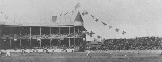
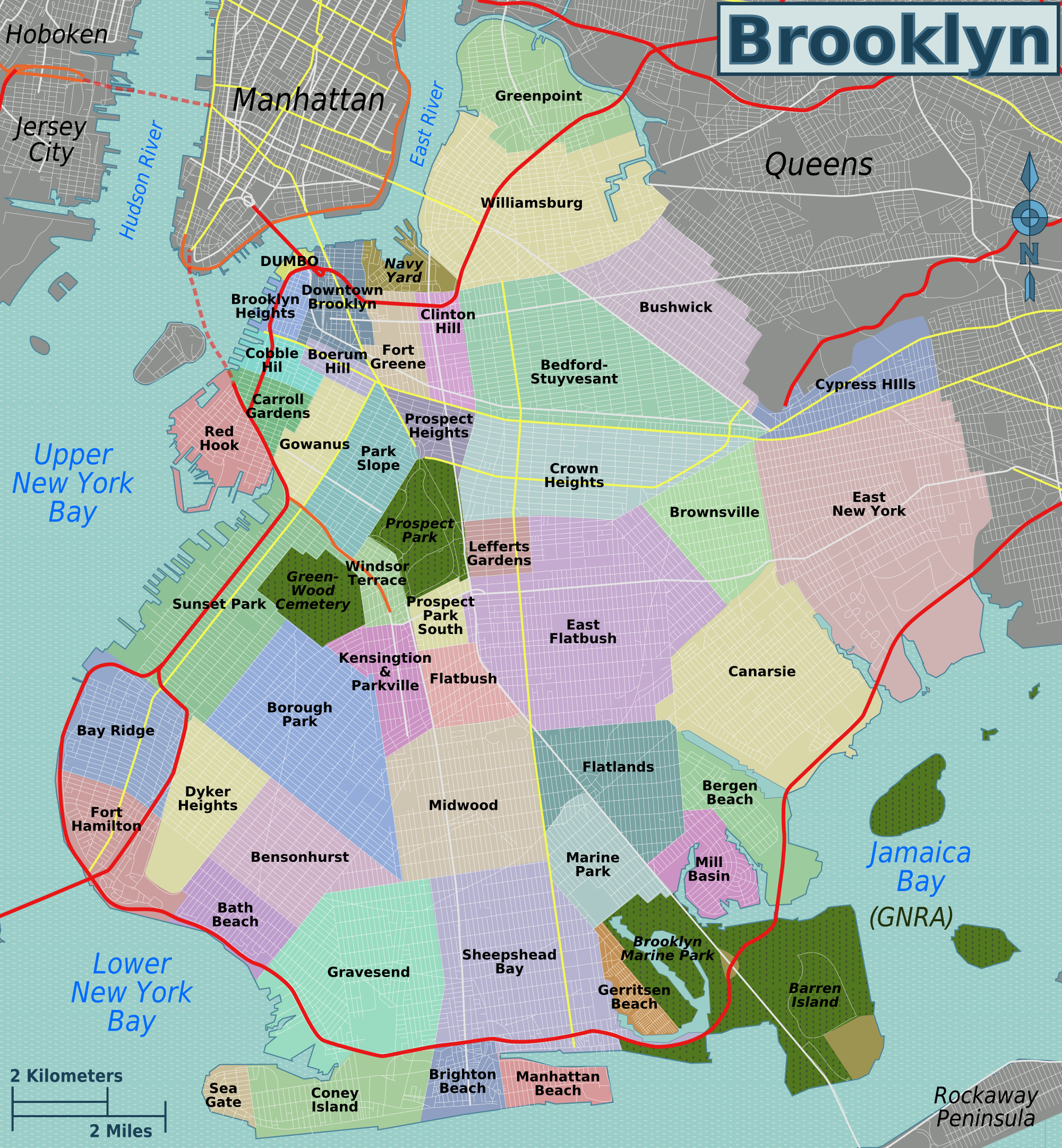
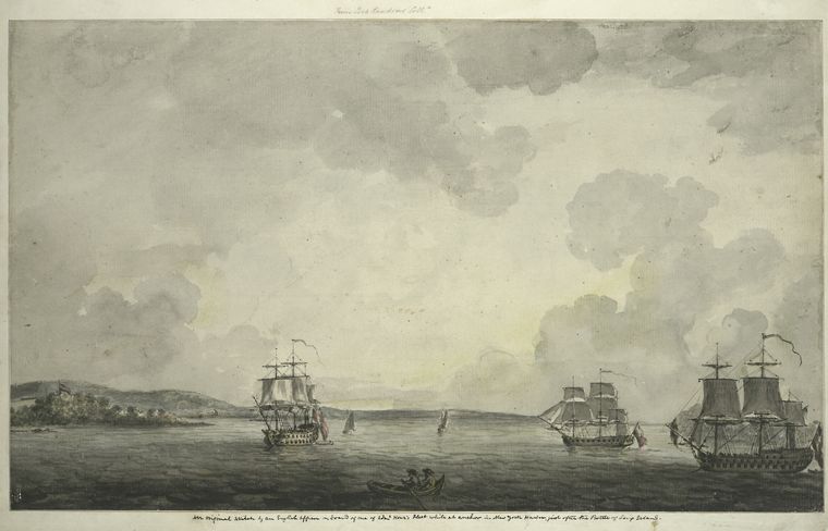
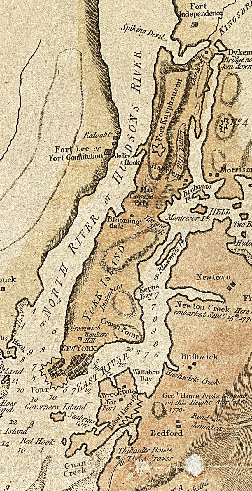