|
Reflections 2025
Series 1
January 1
Hamilton & Burr in Manhattan I: Wall & Lower Broadway – Burr's Richmond Hill & Carriage House
| | Wall & Lower Broadway The reason for what is actually my relatively mild, passing interest in Alexander Hamilton ties in, oddly, with why I live in Lower Manhattan. I suppose it comes down to the iconic intersection of Wall Street and Lower Broadway, which includes Trinity churchyard, as well as Rector Street abutting it (detailed map to follow in a while). | | | | | | An appropriate aside at New Year's: "Lower Broadway", that is, the stretch of Broadway from Bowling Green up to City Hall Park, is a retronym. When the British took over the city from the Dutch, they just called it Broadway, since that was the extent of it. This map of the ticker-tape parade route on Lower Broadway past Trinity Church and Wall Street shows the length of Original Broadway:
https://media.nj.com/yankees_main/photo/yankees-parade-routejpg-5a32bda4573428d4_large.jpg
It was as recently as 1899 that the name was extended far to the north, up already existing paths and roads (Bloomingdale Road, Boulevard, Kingsbridge Road). Thus at the time of the first Times Square Ball Drop in 1907, the adjacent street had been Bloomingdale Road, not Broadway, up until just eight years before. Once the name was extended, a reference to the original Broadway downtown usually had to be via the newer term, the retronym "Lower Broadway".
|
| | | | That intersection also explains why the only two jobs I had before teaching were first on Wall, then Lower Broadway, both walkable from that intersection. Thus it would seem appropriate to tell a bit of my early bio, especially relating to how my earliest schooling left me with a time slot to fill between college and grad school.
As a teenager living in Hollis, Queens, my interest in travel grew, and during my high school and college years, I found myself taking a bus to the subway, then riding into Manhattan to explore. This type of self-guided tour later led to travel to other cities around the world. It started in Midtown and the Times Square entertainment district, including regular visits to Radio City Music Hall. It included finding new neighborhoods, like Chinatown and Greenwich Village, also visiting the major museums and historic houses, Grant's Tomb, the Cloisters, the Empire State Building.
But I've always been interested in origins, and European settlement of Manhattan began in what is now called the Financial District, the area of the island with the longest European settlement. Elsewhere it would be called the Altstadt, vielle ville, città vecchia, gamla stad, but in English we don't often use the term "old town". Yet when I travel today, I also look for a hotel in, or at least near, the historic core of a city, as I find it most meaningful. It's the quintessential HIC LOCUS EST / THIS IS THE PLACE. Everything grew from there. Thus, early on, I found my way to the neighborhood around Wall & Broadway, the original Nieuw Amsterdam.
This included visiting Trinity Church and its churchyard (Photo by Benoît Prieur). This view is north, with the neo-Gothic Trinity Building in the background. The church faces Wall Street (not seen), and Rector Street leads off to the left, at the trees. In the churchyard along Rector Street is Alexander Hamilton's grave, topped by its iconic pyramid (Photo by Gigi alt). I purposely chose this older picture from 2012, since it shows the monument as still being stained, as I remember it from years ago. Since the recent interest in Hamilton because of the musical, it's been spruced up and looks much nicer now, but we'll see that later. Maybe because it was the first historic graveyard I saw as a teen, but I have always deeply associated Hamilton's grave with not only the churchyard, but also with the entire area.
| | | | My Schooling But how the timing worked out for me to seek out two jobs in this neighborhood requires a quick review of my early schooling. It started when we lived in Brooklyn's East New York. After three early grades in a nearby school, the family was surprised when the school selected me to attend enriched "Advanced Reading" classes for the next three grades in another school, a long half-hour's walk way for a little kid. It was a regular school, but had special classes for AR4, AR5, and AR6. I learned a lot there, but especially remember Mrs Rhoda Lindner in AR6. Whenever I mention having learned something in elementary school, most likely it was in her AR6. Coming especially to mind are learning to identify classical music selections and reading Longfellow's "Evangeline" (surely a simplified text). This was the basis for my visiting later in life the Evangeline sites in Nova Scotia and Louisiana.
Moving on to Junior High School, I was again selected to attend special (SP) classes in an otherwise regular JHS. But this new enrichment experience had a time-shifting schedule—the SP classes did three years in two, but not by skipping anything. In all subjects, 7SP covered the 7th grade curriculum plus half of the 8th. We then moved directly to 9SP, where we completed the 8th plus all of the 9th. Thus we were all one year ahead in age compared to our contemporaries, but hadn't skipped any subject matter, the best way to do it.
At the time, students took separate tests for all of NYC's specialized schools, and I was accepted at both I applied for, Stuyvesant in Manhattan and Brooklyn Tech. I had no preference, but a friend from 9SP was going to Tech, so I did, too. Life's little decisions can be consequential.
| | | | | | Tech at the time had a College Prep course with a language requirement, with two languages offered, German and French. My friend had a German-Jewish background, so I again followed him and chose German. At that point, any thoughts of being an engineer (architecture?) flipped on the spot to language study instead, after the very first day of German class with Dr Walter Bernard. What a skilled teacher!
This same friend for years had traveled with his family to Europe both for family and on business. For their trip in the summer of 1957, when we were both 17, he wanted to break away from his parents to travel solo, but they didn't want him to go alone, so he convinced me to join him.
Thus this friend passively influenced me thrice, in choosing Tech, German, and European travel.
|
| | | | But there was a scheduling issue with Tech, which had a rich, and very strict curriculum, with a gazillion required courses. Students coming in from a school that ran to 8th grade had no problem; they took grades 9-10-11-12 at Tech for four years, or eight semesters (as the system worked then). But those of us coming from a Junior High School, even from an enriched 9SP, were at a disadvantage—we'd missed out on all sorts of 9th grade technical courses that Tech required. Thus JHS students had to spend an additional semester at Tech, totaling not the expected six (three years), but seven semesters, throwing one's timeline out of whack. And for that first semester, our group even had a longer day. In addition to the regular eight periods, we had the infamous "ninth and tenth" periods, where we didn't leave school until about 5 PM. Thus our SP group had gained a year, but at Tech I lost a half-year. Nevertheless, I was still a half-year ahead.
Thus, our group graduated from Tech in January 1957. (Alumni have since been consolidated with the June Class as the "Class of 1957".) This situation caused my four years as a German major at Queens College for my BA to also be out of whack, January to January, with QC graduation in January 1961.
| | | | | | When at QC, I was advised by another mentor, Dr Harold Lenz, for further enrichment in spoken German, to attend the six-week summer session of Middlebury College's German School, and I did so as an undergraduate in the summer of 1959. Since I'd started studying Spanish at QC, in 1960 I went to Middlebury's Spanish School. (I taught myself French from books and records. Only years later, during doctoral studies, did Beverly and I audit some French courses at the French School; our doctorates are in German with a French minor.) Two special mentors among several over nine summers at Middlebury are Dr Heinz Vater and Dr Frédéric Hartweg. |
| | | | Graduating from QC, I had my eye on MA studies, a requirement that included the German School session for that summer, 1961 (finally on a graduate basis!), plus the year at Middlebury's program at the Universität Mainz for the academic year 1961-1962. (My plans always covered academic years, not calendar years.) So NOW we can finally get to the Wall Street connection.
Here I was, with five months free, January to June 1961, clearly time to get a job. Did I look in Queens? No. Did I look in Midtown Manhattan? No. My instincts led me right to the Wall Street neighborhood that I'd gotten to know so well.
https://mapsof.net/uploads/static-maps/wall_street_map.png
Wall Street is probably shorter than most people picture. It's only six short blocks on its north side from Broadway to the East River, eight if you count on the south side. The green square is Trinity churchyard with its south side on Rector Place. Hamilton's grave borders it, about halfway down to Trinity Place. The gray area on that block is the Trinity Building, which today I visit regularly for my doctors' offices. I worked at 72 Wall, at Pearl, northwest corner. Hold on to this map for a moment.
I'd found a local temp agency that sent me to a clerking job at Decoppet & Doremus, a small brokerage, defunct since 1975. They promptly hired me permanently, even tho I had told them I was there only to June. They wanted me enough that they started teaching me bookkeeping on company time, which is quite flattering. Under other circumstances, I might have had a career on Wall Street—literally. Needless to say, much of each day's lunch hour was spent further exploring the old streets of the neighborhood.
https://c8.alamy.com/comp/2P9AM5A/74-wall-street-center-former-seamans-bank-for-savings-has-a-monumental-arch-entry-decorated-with-carved-granite-blocks-2P9AM5A.jpg
Looking west at the street corner, 74 Wall (1926) is the yellowish building in the center, directly on Pearl, with the large arched entrance (click). "My" 72 Wall (1925) is the smaller arch to its left. There seems to be some historic connection between the two buildings—they look alike and were built a year apart--but I cannot find it. Both are now residential, since the neighborhood is changing.
That summer at Middlebury, I met Beverly, where we spoke German for six weeks, not hearing how we sounded in English until after that. During the year in Germany, Beverly was accepted—sight unseen!—to teach German and French at Pelham High School in Westchester, right on the Bronx border. I applied to Harvard's German department for a small scholarship, and it was granted. But I later realized that the sum I'd asked for was too small, and moving to Massachusetts would have been too disruptive, given Beverly's upcoming new job. So after we got married in Beverly's Minnesota on our return in 1962, we rented an apartment in the north Bronx near Pelham, where she could commute by bus (we had no car the first two years) and I could take the subway into Manhattan to work. Near Wall & Broadway, of course.
It was probably in the Times want ads that I found a job with American Express as a translator, finally making use of languages. The one other guy already there did Spanish, so I was to do German and French. But there was little German work coming it, it was mostly French (a lot from Turkey!), so I ended up honing my French skills.
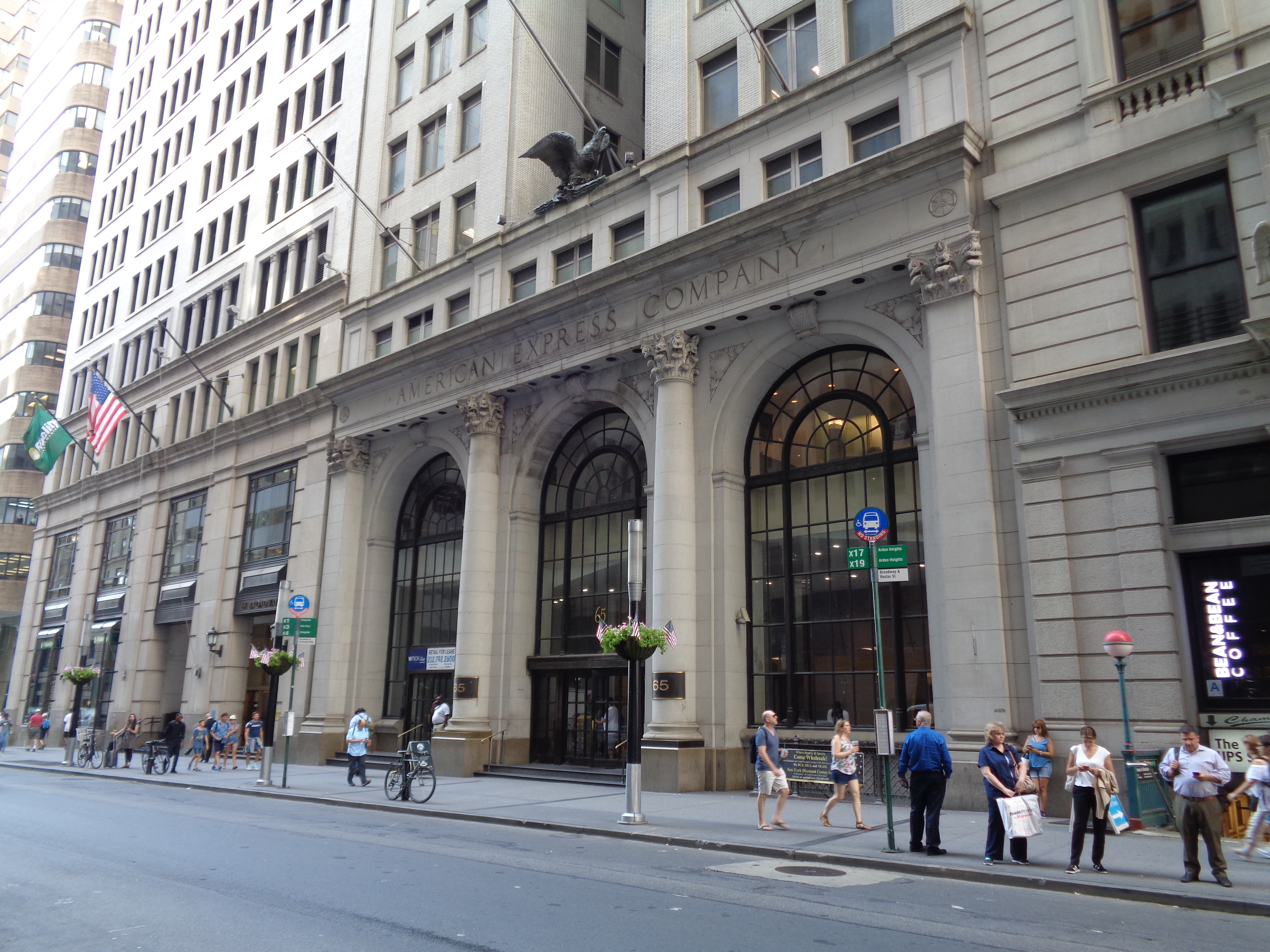
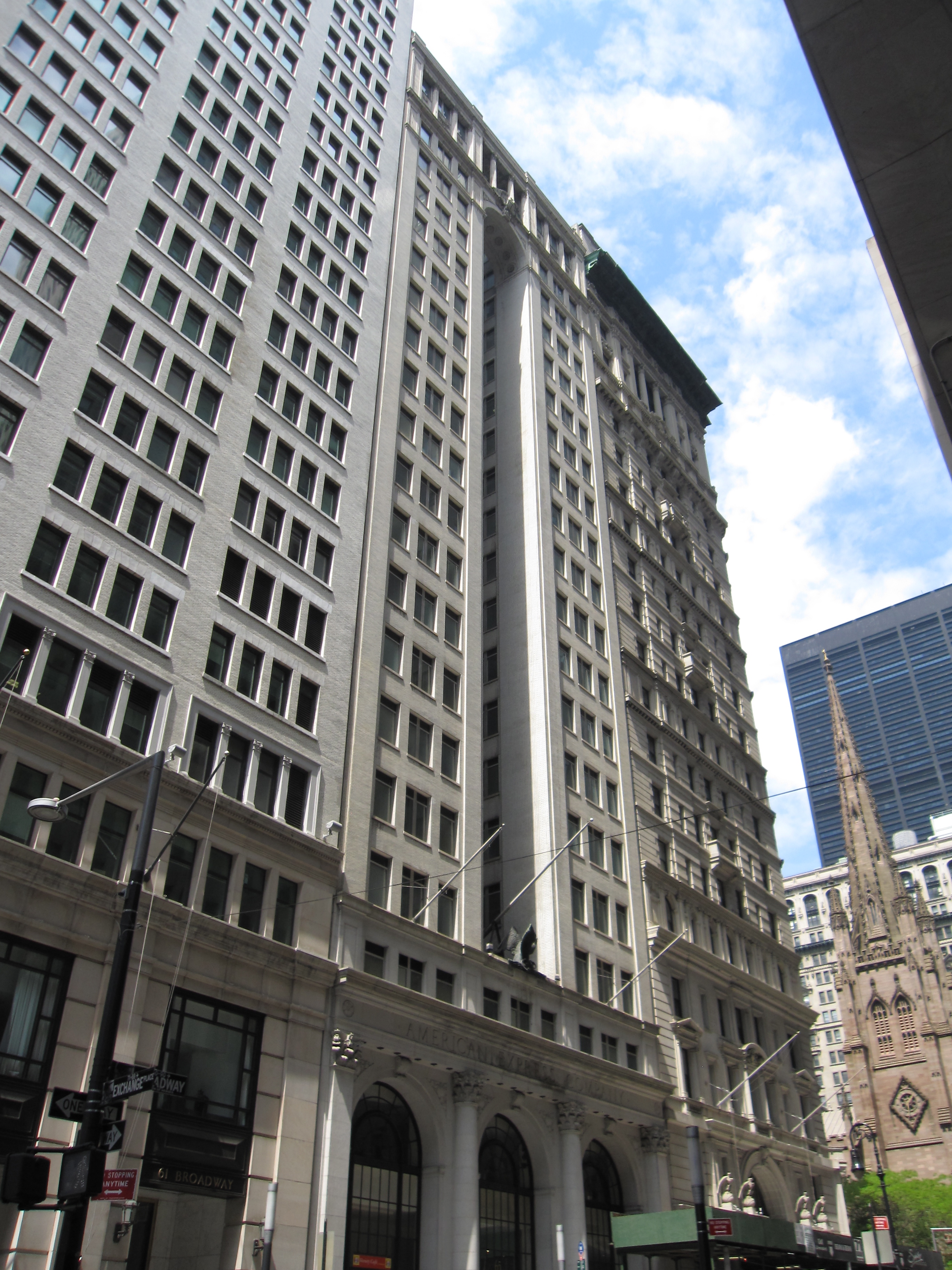
On our map, locate the southwest corner of Broadway and Rector, which is even closer to the churchyard and Hamilton on the northwest corner. I worked at 65 Broadway (built 1916-1917) for the academic year 1962-1963. This is its Neoclassical, triple-arched entry (Photo by Tdorante10). Tho AmEx moved out in 1974 (to nearby Battery Park City!), 65 still bears AmEx's name in stone (click), as well as that large eagle, the insignia of American Express. 65 is an official NYC Landmark. The building on the right, is 71, which is actually the corner building on Rector Street, facing Hamilton. This view is north on Broadway and shows the three arches of 65 (click) with 71 on the corner of Rector. Hamilton and Trinity come next, and beyond that is the Trinity Building in white (Photo by Gryffindor).
https://www.worldeasyguides.com/wp-content/uploads/2015/08/Map-of-Trinity-Church-640x456.jpg
This map shows the churchyard more closely. It shows 71 on the corner, and 65 Broadway is the next building south. Here's also a real-estate map of Trinity Church in 1905, the year the Trinity building was built (click), which is among the first Gothic-inspired skyscrapers. Again, the Hamilton grave is centered on the south side of the churchyard, along Rector.
https://c8.alamy.com/comp/BYB8R9/trinity-church-in-downtown-manhattan-new-york-city-BYB8R9.jpg
This excellent aerial view taken from 71 shows Trinity Church looking down Wall Street, both sides of its graveyard, the Trinity Building, Trinity Place on the left, and Rector Street on the lower right. Click to even see the pyramid top to the Hamilton monument. If you're aware of its existence, it's omnipresent when walking these streets.
After the AmEx year, I decided I wanted more graduate study. I'd had to reject the Harvard offer, but Columbia was right here in Manhattan at 116th Street. And so I was accepted for Linguistics and German for the academic year 1963-1964.
| | | | | | Only years later did I come to realize another connection. Alexander Hamilton attended King's College at Trinity Church (more later) which developed later into Columbia College nearby, then Columbia University uptown at 116th Street. Today, there's even a well-known 1905 building called Hamilton Hall on the Columbia campus, and I may—or may not—have had some German classes there (Photo by Beyond My Ken). |
| | | | However, I got intrigued by Beverly's teaching and the large circle of friends we made at Pelham HS, so for the second semester, I switched from the German department to Columbia's TC, its well-known Teachers College on 120th Street, the oldest and largest graduate school of education in the US. There I fulfilled all my coursework for my NY State teaching license, and started my 28-year career at John Jay High School in Westchester in September 1964.
We moved to a condo in North White Plains, then built our house in Purchase NY (on Beverly Road!). She retired in 1991, and I did in 1992 at age 54. After a couple of years living at our condo in Tampa FL, we finally decided to move back, and this time, into Manhattan, Lower Manhattan of course. We checked out a few places, but ended up in Battery Park City, just as AmEx had done. I've recently described BPC as sterile (except for the Winter Garden) and "too new"—my building dates only from 1980—but it's a short walk past Hamilton to historic Wall & Broadway for various errands.
https://www.maps-of-the-usa.com/maps/usa/new-york/new-york/large-detailed-road-map-of-lower-manhattan-nyc.jpg
Click on South Cove. I'm on the gray block just north of it, on South End Avenue at West Thames Street. You'll find AmEx further north. You see a possible route toward history via Rector Street, but more often, I zigzag, as described in the last posting, via Ward and Edgar Streets, then tiny Exchange Alley, to Broadway, then to Rector and Wall, with Hamilton always in sight.
Of my circle of friends, the only ones who ever lived near me in Lower Manhattan were Joe & Lars, who for a time lived a block south of Wall on Exchange Place at William, walkable to me, but who now live in Williamsburg. Thus, friends visiting me today all come from outside my neighborhood of choice.
| | | | Three Wednesdays I'd always heard of the Hamilton/Burr duel taking place at some vague location in New Jersey. Then, when preparing to take the light rail south of Weehawken in 2021, a bit of online research finally allowed me to figured out exactly where the duel took place, tho there was nothing to see there.
Finally, there were the three Wednesdays. At dinner with friends on Wednesday, November 6, I discussed Hamilton the Musical with friend Dave Irish, who'd liked it, at least to some extent. I'd been wary of it since it opened, since the music was rap, something I do not appreciate. But right after that, I made two decisions. I booked a ticket to the show for two Wednesdays later, the 20th. (Spoiler alert: I didn't care for it. More later.), Then I fully researched another lack in my résumé, Hamilton's home, the Grange, and on the Wednesday in between, the 13th, I finally visited it, up on 141st Street, and visiting that gem of a structure was one of the highlights of the year, and of the whole Hamilton story. In any case, I'd now say my Hamilton credentials are rather complete.
| | | | The Questions We know the Who of our narrative: Aaron Burr, Alexander Hamilton, and some of Hamilton's family.
We know the What: one of the most famous duels in history.
The Why and the How we'll get to later.
This posting and following will deal with the Where, specifically (1) Burr's home Richmond Hill, (2) Hamilton's home The Grange, (3) the Weehawken Dueling Grounds, and (4) Wall Street, where they both had their law offices, including adjacent Trinity Church, where Hamilton was educated and is buried.
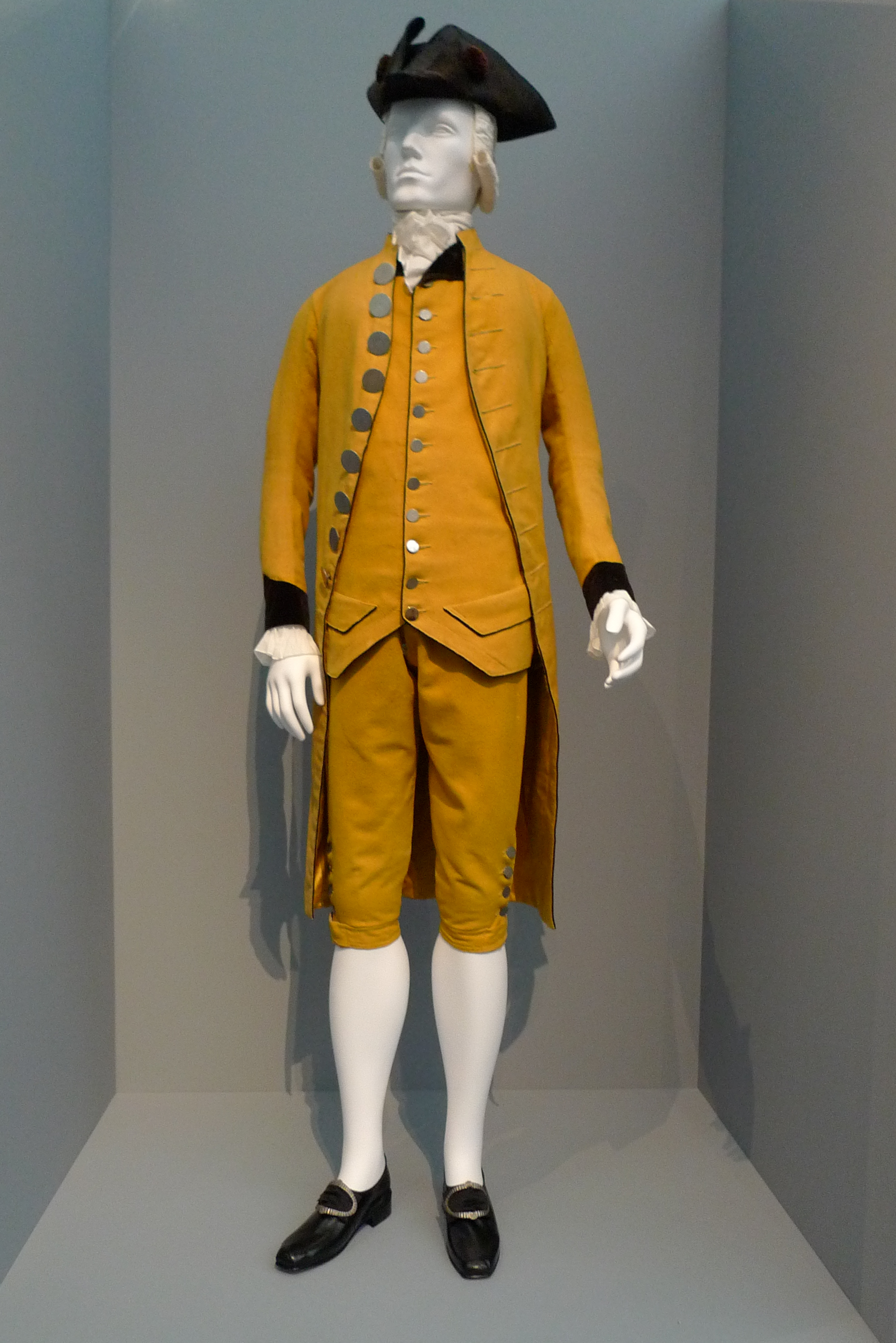
But before we get to the Where, we have to clarify the When. On hearing that the duel took place in 1804, I'm sure most of us will get the wrong impression. We'll envision the 1800s, with Queen Victoria, railroads everywhere, the American Civil War. We have to disabuse ourselves of thinking of the 1800s in this situation. Instead, envision the 1700s, with the colonial era in North America, the American Revolution of 1776, the British occupation of New York, with their evacuation in 1783, the adoption of the Constitution in 1789 establishing the new government, in which both Burr and Hamilton participated. If you keep those dates in mind, the year 1804 becomes a minor overflow of the 1700s. Picture a dueling mentality overflowing into the new century, and men in 1804 still wearing tricorn hats, tails, knee britches, and knee stockings (Photo by Marshall Astor-Food Fetishist). Picture Hamilton and Burr both looking like this and you'll have a better understanding of the When.
As we deal with the When, we won't find maps dealing specifically with the duel year of 1804, but we will find maps for the recent decades leading up to the duel. No matter, since we'll be seeing the New York that our participants lived in up to that event.
| | | | Early Manhattan Bernard Ratzer was a British cartographer best known for his 18C maps of early New York City, so the best place to start with is the iconic 1770 Ratzer map from the collection of the New York Public Library, whose full title is "Plan of the city of New York, in North America: surveyed in the years 1766 and 1767". A few years ago, a new copy was found and restored for the Brooklyn Historical Society, which I went to see. However, this detailed map of just Lower Manhattan is more helpful. Below is a copy of this SAME map if you wish to hold it in a separate window for later reference:
https://upload.wikimedia.org/wikipedia/commons/d/d3/Ratzer_lower_Manhattan_1.jpg
Click to find Wall Street with the original Trinity Church on Broadway; nearby is the ferry to Paulus Hook. Move up to the fork at the Common, now City Hall Park; where 23 & 24 appear is where City Hall would be built between 1803 and 1812. At this point, we're already moving into the suburbs. Just picture City Hall, today way downtown, as being on the edge of the suburbs! "Freſh Water" (now spelled with S replacing the long s [ſ] as "Fresh Water"), was later called Collect Pond, now gone—Foley Square took its place.
There's one more early landmark, also long gone. Where Broadway comes to an end, there are three dark squares. These are the pleasure gardens known as the Ranelagh Gardens--say RAN.ə.lə--misspelled here as *Renelagh. They were built to mimic the famous London pleasure gardens of the same name. They were recreational spaces open day and night that featured landscaped grounds, lights, music, theater, fountains, and grottoes, situated in what was then regarded as a bucolic northern suburb of New York City—note the open fields beyond.
https://mom.girlstalkinsmack.com/image/082012/New%20York%20-%20Civic%20Center%20and%20South%20Street%20Seaport_2.jpg
This is today's view of this "bucolic northern area" of the City. City Hall (6), is at City Hall Park. Government buildings, largely court houses (7-8-9-10) surround Foley Square, the former Pond, where Lafayette and Centre Streets merge. Ranelagh Gardens were located on the west side of Broadway, running to what is now Church Street, between Worth and Duane Streets. They were established in 1765, but operated only into the early 1770s. Still, might Hamilton and Burr visited here? I do not know, but visiting here would have been within what their social circle might do.
Of the two places in Lower Manhattan that Beverly and I checked out before choosing my present place, we actually put money down on an apartment right here on Duane Street, but it never panned out.
Go back to the Ratzer map for one more location. Along the Hudson, find the Road to Greenwich, the original name for the village that is today's neighborhood of Greenwich Village. It runs along the riverbank, but today, to go west from what is now called Greenwich Street, you pass Washington and West Streets, plus the width of Battery Park City on the southern end. That's landfill for you.
As we're headed north on the Road to Greenwich in search of Aaron Burr country, we'll quickly introduce this:
https://journals.sagepub.com/cms/10.1177/1463499613483406/asset/images/large/10.1177_1463499613483406-fig2.jpeg
This map unfortunately presents as rather unkempt. It's a slightly modified version of the original Ratzer map. For instance, it doesn't use the long S, and there are modifications to the cartography. A better version will follow. But move north from Ranleagh Gardens (click) on the Road to Greenwich and you'll see the advantage of this map, also in an exploded version to the left. Just south of a creek using the old name Bestavaer's Rivulet (later Minetta Creek) is the estate of one Abr[aha]m Mortier. All this, in the area that today is called Hudson Square, south of Greenwich Village, but north of Tribeca, will reveal its importance in a moment as including the estate of Aaron Burr.
Once we pass the stream, located very roughly where Houston Street divides neighborhoods today, we come to the area that became Greenwich Village, where everything back in 1766-1767, still early for our period of interest, is in the form of country estates, not yet a village. Note three names: Lady Warren, Oliver Delancy [sic], and W[illia]m Bayard.
For now, here's a preview of Greenwich Village (remember: say Grennich): first, a quote from Joyce Gold's book on my shelf "From Trout Stream to Bohemia", 1988, 1996. (You may imagine that the trout stream she mentions is the creek we just saw.)
During British rule of the city, from 1664 to 1783, Greenwich Village became the home of great estates. The greatest landowner of them all was Sir Peter Warren . . . In 1748 he built his home on the block now bounded by Perry, Charles, Bleecker, and West 4th Streets . . . Warren made the Village fashionable. . . . [He died] in 1752 at age 49. . . . Warren's widow died [in 1771] . . . . This explains Lady Warren's estate.
Now a reminder of what we said in the past that affected the period right after the one we're discussing: In 1822, a yellow fever epidemic in New York encouraged residents to flee to the healthier air of Greenwich, and afterwards many stayed. In 1825, the Commercial Advertiser was writing that "Greenwich is no longer a country village. Such has been the growth of our city that the building of one block more will connect the two places" of Greenwich and New York. By 1850, New York had extended itself entirely around Greenwich such that the two were no longer considered separate. Do keep this in mind as we move from the colonial days to the American Revolution with Rebels and Loyalists thru the duel year of 1804, and into the years of developing land areas that followed.
Let's now talk about the two other estates in Greenwich, both involving well-known New York families, Delancey and Bayard, both of French Huguenot lineage. First look to the east to find the estate of James Delanc[e]y Sr (in the old spelling). Below it is Delancy's Square, which no longer exists—Grand Street and others go right thru. Instead, Delancey Street, two blocks north, is today the major thoroughfare on the Lower East Side. All this is named for James Delancey. But well before the American Revolution, James moved to, and died in, Nova Scotia, so there's no Loyalist issue here. However, later on, his brother Oliver De Lancey in Greenwich was a Loyalist in Revolutionary times, and he left for England and his property was confiscated in 1779. So we now have a greater feeling of the confrontational times we're discussing.
William Bayard Sr was also a Loyalist and left for England, after which, most of his estate was also confiscated. However, the property ended up back in the Bayard family thru marriage. One of his sons was William Bayard Jr, and he was a friend of Alexander Hamilton, who died in his Greenwich Village house the day after the duel. That's the house we see on the map, with this complex history. (Bayard Street in Chinatown is named after Nicholas Bayard, an ancestor of this Bayard, who was a 17C mayor of New York.)
Now let's move to a much better map of the City of New York that gives us a better idea of how things looked. Again, here's a link to the SAME map:
https://upload.wikimedia.org/wikipedia/commons/4/44/Stuyvesant_Farm_from_The_Plan_of_the_City_of_New_York_in_North_America_by_Ratzer_1770.jpg
The coloration should give us a better feel of the lay of the land. The pink urban area of New York ends in countryside. As we find the Morbier (later Burr) property, it seems to be in a rougher terrain, not as developed as the manicured estates north of it in Greenwich, among the green fields.
| | | | | | This map and its inset also shows Peter Stuyvesant's farm, or on the East River, using the archaic Dutch word for farm, anglicized as "bowery", but do not be misled. He lived in the 1600s, so it would have been descendents owning the farm in our period of interest.
The farm was on a side road off a Native American footpath that later became the Boston Post Road. As you can see this section was called Bowery Lane because it also led to Stuyvesant's bowery. In modern times, the word "lane" was dropped, so the street today is called simply the Bowery, with a transfer of meaning of the word. If you don't realize how odd that really is, picture a fictitious street called Library Lane leading to a library, then lose the word "lane", so that people would then say they were driving down "the Library". Language can do odd things.
|
| | | | A bit more on Greenwich. Off Bowery Lane, note Sand Hill Road, which, once it crossed Minetta Brook, led to The Monument Lane. This in turn led to an obelisk simply called The Monument, dedicated to General Wolfe of the Battle of Quebec. The monument was removed prior to August 1773. Its location today would have been on the north side of 14th Street, between 8th and 9th Avenues, which gives us an idea of the location of the Delancey and Bayard estates.
Monument Lane was also called Greenwich Lane, and was renamed Greenwich Avenue in 1843. This explains why today, there is both a Greenwich Street near the Hudson and Greenwich Avenue further inland, both leading north from what was New York to Greenwich [Village].
Looked at historically, the modern concept of Greenwich Village is problematic, with three areas being involved. (1) What became the historic commercial center at the river at Greenwich Street and near the Warren estate is now referred to merely as the West Village.
(2) Inland, east of Minetta Creek and in the area of Greenwich Avenue is where the wealthier, uptown part of Greenwich had developed, including Washington Square. Today THIS is the area referred to as Greenwich Village.
(3) Amazingly, the area east of that, and east of Broadway, is now called the East Village, tho it has no connection whatsoever to Greenwich. Actually, it's pretty similar to what our map shows as the Stuyvesant farm area. I feel most people don't realize this name is to be understood as being East [of the] Village.
Also, the naming is erratic, between using both words in the phrase "Greenwich Village", or just the first, or just the second. Both Greenwich Street and Greenwich Avenue are old enough that they refer to Greenwich by its original one-word name. The word "village" NEVER appears here.
Just the opposite appears in the names West Village and East Village. The word "Greenwich" NEVER appears here either.
Possibly strangest of all, is that the limited area today called Greenwich Village is only sometimes referred to by that two-word name, most often by visitors. Most locals shorten that to just "the Village", totally avoiding a reference to Greenwich, its original name, as in "he lives in the Village". I don't think most people who say these things realize how strange this really is. But now let's cross over south of Minetta Creek and visit Aaron Burr's estate.
| | | | Richmond Hill It's a common name. On a list I've counted 13 Richmond Hills in a number of countries, notably locally, the Richmond Hill neighborhood in Queens. But this bucolic colonial estate is what became Aaron Burr's home in Manhattan, which we first mentioned in 2018/2 when discussing the various Manhattan street grids.
As we saw on the map, it started out with Major Abraham Mortier, local paymaster of the British army, who got a 99-year lease from Trinity Church in 1767 for a parcel of 10.5 hectares (26 acres) of what was called the King's Farm. (You will note how Trinity Church often appears as a landowner, if not a virtual real estate developer.) The bucolic colonial estate and its house had a rich history. During the Revolution, it was used by Washington for his headquarters when he led the defense of New York against the British in 1776. It was later taken over by the occupying British as their headquarters. Then, when New York became the first capital of the US, it became the first official residence of Vice President John Adams and his wife Abigail. They lived there from June 1789 to August 1790, but that December, the capital of the US moved from New York to Philadelphia, and the Adamses moved there as well.
https://avenuemagazine.com/user-content/uploads/2020/01/56_356_66_web-1024x658.jpg
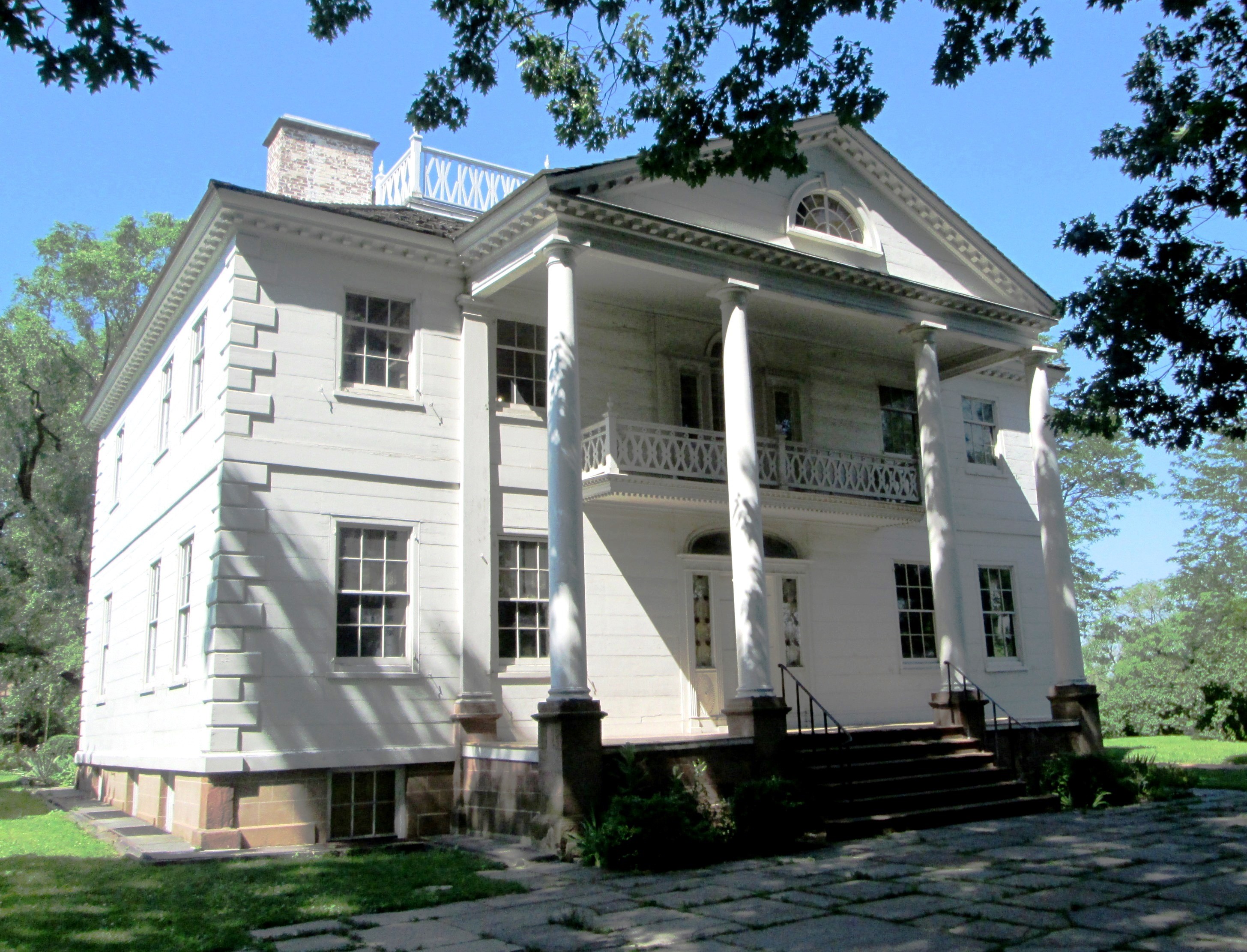
The estate included a widely-praised Georgian mansion dating from 1767 perched on top of a hill. It was five bays wide, with an Ionic portico, and three bays deep, with paired dormers in the attic. It was a frame structure, with carpentered imitation quoins at the corners, raised on a high basement and approached by a flight of steps. Even tho later landfill has caused the site to be further inland, in the 18C, it stood closer to the Hudson River shore. Abigail Adams was delighted with the house and described the estate's rural beauty on its rise with views of the City to the south, Long Island (Brooklyn) to the east, and the Hudson and New Jersey to the west. (The area is far too built-up today to see any of these views.) She wrote:
| | | | | | Upon my left the city opens to view, intercepted here and there by a rising mound and an ancient oak. In front beyond the Hudson, the Jersey shores present the exuberance of a rich, well cultivated soil. In the background is a large flower-garden, enclosed with a hedge and some very handsome trees. Venerable oaks and broken ground covered with wild shrubs surround me, giving a natural beauty to the spot which is truly enchanting. A lovely variety of birds serenade me morning and evening, rejoicing in their liberty and security. |
| | | | In 1794, Aaron Burr purchased Richmond Hill as a country home, tho when he became the third vice president, he lived in Washington while serving his term from 1801 to 1805, yet he continued to own Richmond Hill. He occupied the property with his wife and daughter, tho his wife would die a year after they settled in. Among the many guests at Richmond Hill was Alexander Hamilton, since, despite their political rivalry, the two men shared the same circle of friends and acquaintances.
Nevertheless, on the morning of 11 July 1804, Burr left Richmond Hill and had himself ferried across the Hudson to Weehawken NJ for his fateful duel with Alexander Hamilton, who arrived separately. More later.
| | | | Aaron Burr Actually, he was Aaron Burr Jr. Aaron Burr Sr was a Presbyterian minister and one of the founders of the College of New Jersey, later called Princeton University. Burr Jr was born in Newark NJ and studied at Princeton. He became a politician, businessman, and lawyer. He was a man of complex character who made many friends, but also many powerful enemies. Contemporaries often remained suspicious of Burr's motives to the end of his life, continuing to view him as a questionable character. He was reported by acquaintances to be curiously unmoved by Hamilton's death, expressing no regret for his role in the matter.
He's remembered today for the dueling death of Hamilton, which also ruined Burr's career. If not for that, he might have been remembered for his other accomplishments, to wit:
• Burr founded a bank, the Manhattan Company, in 1799, which merged with the Chase National Bank in 1955 to form the Chase Manhattan Bank (the current JPMorgan Chase & Co).
• He became the third Vice President of the United States of America, with a term running from 1801 to 1805, which means he was a sitting Vice President in the last year of office at the time of the duel in 1804. (Imagine any other VP still in office not only getting involved in a duel, but killing another national leader in that duel.)
• He came very close to becoming President, and his experience in becoming VP in the election of 1800 resulted in the passing afterward of the 12th Amendment to the US Constitution.
| | | | | | The first presidential elections in the US were under the old (original) rules in the US Constitution. In the states, each member of the Electoral College cast two votes, with no distinction between President and Vice-President. The candidate getting the most votes would be President, and the runner-up, Vice-President. But this system would allow the two to be from two different political parties.
Thus in the first two elections, in 1788-9 and in 1792, the immensely popular George Washington was unanimously elected President and John Adams VP.
But Washington refused to run again, and the 1796 election became the first where political parties were involved. Adams won with 71 electoral votes, and Jefferson was very close, becoming VP with 68—but they were from opposing parties! SC Ex-Governor Thomas Pinckney got 59, and NY Senator Aaron Burr got 30. Nine others accounted for the remaining 48 votes.
But 1800 was the year of the real problem. Jefferson and Burr each tied with 73 electoral votes, Adams won 65, and Pinckney won 64. This necessitated a contingent election in the House of Representatives to choose between Jefferson and Burr. Neither was able to win on the first 35 (!) ballots. Hamilton favored Jefferson over Burr, and he convinced several voters to switch their support to Jefferson, giving Jefferson a victory on the 36th ballot. He became President, and Burr, in second place, became VP. The election only added to the animosity between Hamilton and Burr, leading in part to the 1804 duel.
This time, Jefferson and Burr were from the same party. Altho Burr maintained that he supported Jefferson, the President was somewhat at odds with Burr, who was relegated to the sidelines of the administration during his vice presidency and was not selected as Jefferson's running mate in 1804.
This situation caused a constitutional change. Under the 12th Amendment to the Constitution, passed in 1803 and ratified in 1804, each Elector would cast one vote for President and one for VP starting in 1804, but, crucially, one vote would explicitly be to fill the presidency, while the other designated who should become vice president, which is the system that remains today. (The only other election that had to go to the House was in 1824, but for different reasons.)
|
| | | | DUEL AFTERMATH Burr challenging Hamilton a duel was the start of Burr's downfall. Tho dueling was illegal, Burr was never tried and all charges against him were eventually dropped. He was charged with multiple crimes, including murder, in New York and New Jersey, but was never tried in either jurisdiction. One issue was that NJ said, tho Hamilton was shot in NJ, he died in NY. On the other hand, NY argued that, while he died in NY, the shooting happened in NJ!
Nevertheless, his killing of Hamilton ended Burr's political career. Burr fled to South Carolina, where his daughter lived with her family, but soon returned to Philadelphia and then to Washington DC to complete his term as VP. He wasn't renominated for office, but remained Vice President until March 1805. He ran for governor of New York instead. He lost, in what was the most significant margin of loss in the state's history up to that time.
He fled America and his creditors for Europe. Burr lived in self-imposed exile from 1808 to 1812, passing most of this period in London. After returning from Europe, for a while, Burr used the surname Edwards, his mother's maiden name, to avoid creditors.
SECOND MARRIAGE The Burr story ended very interestingly. To fully understand it, you have to know about the Morris-Jumel Mansion in upper Manhattan, which also gives more understanding to the revolutionary times both Burr and Hamilton lived in.
It's an 18C historic house museum in Washington Heights, and the oldest extant house in Manhattan, having been built in 1765 by British military officer Roger Morris and his wife. They only lived there until 1776, since they were Loyalists and fled the US, resulting in the confiscation of their property. Washington used it as his temporary headquarters for one month in late 1776, after which British and Hessian officers occupied the house until the British evacuation of NYC in 1783.
The house then passed thru multiple owners until French wine merchant Stephen Jumel and his wife Eliza bought the house in 1810. Stephen deeded Eliza the mansion and surrounding land in 1825, possibly to prevent his creditors from taking it over. He died in 1832. NYC acquired it as a museum in 1907.
This is what is known today as the Morris-Jumel Mansion (Photo by Beyond My Ken). I've toured it and its neighborhood and it's well worth the visit. We'll mention it again later when we discuss Hamilton. However, for reasons I don't fully understand, the popularity of the Morris-Jumel Mansion, so tangential to Alexander Hamilton himself, increased after the Broadway musical Hamilton opened in 2015. It's estimated that, in 2016, the museum may have seen a 75% increase in visitors because of the musical.
https://morrisjumel.org/wp-content/uploads/page/visit/MJM-Visit-Map.jpg
https://www.hmdb.org/Photos5/576/Photo576550.jpg?41202165100AM
As the first link shows, it's perched above the Harlem River near the 163rd Street-Amsterdam Avenue (= 10th Avenue) subway station served by the C train, and just a block from Broadway. It's on the street called Jumel Terrace (name partially blocked), which in turn is perpendicular to Sylvan Terrace (not named). The second link shows the borders of the Jumel Terrace Historic District, which includes Sylvan Terrace, which was originally the mansion's carriage driveway. The Historic District, notably Sylvan Terrace, consists of 50 residential rowhouses built between 1890 and 1902 as the heirs of Eliza Jumel sold off the land of the former Roger Morris estate (Photo by Beyond My Ken).
Now that we know this background, we can get to the point. In 1833, at age 77, Aaron Burr married Eliza Jumel in the parlor of her mansion. She was by then a wealthy widow, tho she was nineteen years his junior. They lived together briefly in her mansion, but the marriage, and Burr's stay in the house, was short. Eliza got wise to her situation and realized her fortune was dwindling due to Burr's land speculation losses. So after a mere four months of marriage, she separated from him and he moved out. She filed for divorce in 1834, and Burr died on Staten Island in 1836, at the age of 80, the same day the divorce was granted. He's buried in Princeton near his father.
But this story has a twist. The divorce lawyer Eliza Jumel chose was Alexander Hamilton Jr, the Hamilton's third child (of eight) and second son. It seems that what goes around does indeed come around.
| | | | Richmond Hill Redux We need to complete the story of Richmond Hill during these later times. What happened to it? Where exactly was it located? Let's start with an unusual map.
In 1797 the Common Council hired mapmaker Casimir Goerck and fellow city surveyor Joseph François Mangin to make the first official post-Revolution map of the city. Goerck died in the 1798 yellow fever epidemic that chased so many New Yorkers to the Greenwich countryside, and so the resulting map was largely the work of Mangin. The map conveyed Mangin’s ideas about how to organize the city’s disorderly street pattern: he straightened the colonial streets, placed new streets on river landfill, and proposed a patchwork of small, rectilinear grids at varying angles north of the city proper. The Common Council rejected his map, ordering copies destroyed, but despite its rejection, it prompted the city to begin thinking about its street system and stimulated the establishment of the street commission, which eventually led to the Commissioners' Plan of 1811 and its iconic grid of numeric streets north of the original city.
Therefore, when looking at the Goerck-Mangin map of 1807, take it with a grain of salt. Click to read the title: "Plan of the City of New York, with the recent and intended Improvements". That latter phrase is what makes it untrustworthy, since it was trying to tell the future. The idealized block structure and shoreline are no more accurate today than when drawn, since the plan was reimagined on a grander scale than was real. For instance, over on the East River, South Street didn't exist, tho it eventually was built. Also, Goerck and Mangin had a little bit of fun. Look at the east end of South Street where it merges with East Street, which didn't exist then, and never has. Even worse, next to East are Goerck and Mangin streets, which the mapmakers named after themselves! They didn't exist then (they would have been under water), and still don't.
So why do we present this map? Look south of Greenwich on the Hudson, past Minetta Creek in black, to find a green rectangle labeled A. Burr. This is the only map I've ever found that shows the location of Burr's mansion, Richmond Hill. The property stood on a rise—hence its good views--and seems to have blocked what would have been the intersection of Charlton and Varick Streets, with the house lying to its east side. While the streets around the property would soon be cut thru and developed, this map surely shows more development than was factual at the time. Still, it's an indication.
| | | | | | There are a few other things of interest. In Greenwich, note #38, Newgate State Prison, newly built in 1796-7. It was closed and razed in 1829, when the land was sold off to become the Greenwich Market, informally called the Weehawken Market, later closed, with the lots sold off privately. But this included today's Weehawken Street between Christopher and Amos (today's West 10th) Streets on what had been prison property.
Just above Burr's property, note Hammersly Street. In the mid-19C it was renamed West Houston, allowing Houston Street to run river-to-river. It was and still is narrower than the original Houston, which is why it's the only part of Houston today that's one-way.
Canal Street never had a canal on it. One was planned, to connect to the Collect Pond, but never built. This map shows in black a canal (with a side canal) starting at a nonexistent Collect Street, running to a nonexistent Canal Square on the Hudson.
Move down Broadway to #2, Trinity Church, then back up to what is now City Hall Park, near #4, Saint Paul's Chapel. Both are still there, but behind Saint Paul's is a green square on a Robinson Street, with #39, labeled "College". More details will follow, but King's College at Trinity Church moved here to become an early home to Columbia College, now way uptown as Columbia University. This old campus is gone, Robinson Street was cut thru, and is now Park Place.
|
| | | | Burr had bought Richmond Hill in 1794 and spent a lot of money redecorating it and improving the estate. He had Minetta Creek blocked to create an ornamental pond (click), which was called Burr's Pond, and was used for ice skating in the winter.
Burr lived in the mansion for a time and used it as the site of lavish parties. Since Alexander Hamilton and Burr traveled in the same social circles, Hamilton attended some of these events at Richmond Hill, probably more than once. But then it was Burr who, just three years later, in 1797, mapped the property, dividing it into lots and laying out the grid of three streets, which would become Charlton, King, and Vandam Streets. But it wasn't until a decade later, in 1807 and three years after the duel, that Burr filed his plans for driving his three new streets thru the Richmond Hill property. His plan was approved by the City Council, but he was too strapped for cash to carry the plan to fruition, despite the fact that he mortgaged the equivalent of 240 building lots to the Bank of the Manhattan Company, for $38,000. It's possible that part of his downfall was because of general disapproval of the duel.
This bank was the very one he had founded, yet it proved to be part of his financial undoing. His creditors called for the bank to foreclose in favor of the creditors, and they sold the mortgaged estate to John Jacob Astor, the leading land developer of the time, for $32,000, who then resold the building lots for a large profit. Thus, Burr's assets were liquidated. Astor knew a bargain when he saw it, and he was the one who continued to develop what became to be known as the Richmond Hill neighborhood.
| | | | | | See 2008/20, Ctrl-F "John Jacob Astor", especially the second click, to learn his background, and also for Astoria, Oregon, Astoria, Queens, Astor Place in Manhattan, and more. |
| | | | With the grounds heavily cut up and sold, in December 1820, Astor had the mansion set up on logs and rolled down the hill (presumably helped by horse teams) to the newly carved southeast street corner of Varick and Charlton Streets. (I believe this might have been a short move, just to align the house with the new streets.) He opened the house and its gardens as a genteel public resort in 1822. The hill that had afforded Abigail Adams such nice views was then leveled.
After serving as a resort in its new location, it opened in November 1831 as the Richmond Hill Theater, and, as New York theater historians report "the following year it became the Italian Opera House, but finished the year with equestrian shows." It eventually became a roadhouse and was finally razed in 1849. There is no trace of it today at this location. After the mansion was razed, the neighborhood name "Richmond Hill", used south of Greenwich Village, fell into disuse. Today, that name is forgotten and is only used for the unrelated neighborhood in Queens, named either after Richmond, near London, or after Edward Richmond, the architect who designed the neighborhood. (Burr's mansion had gotten the name before he acquired it, from an unknown source.)
But there's a bit of a surprise here. While Astor moved the main building nearby, he decided to do something else with the carriage house and accompanying barn. (Picture a carriage house as similar to an adjacent garage.) Astor moved Burr's carriage house further north, beyond Minetta Creek, well into Greenwich Village to what is today 17 Barrow, between Bleecker and [West] 4th Streets. There it was later re-purposed sequentially as a stable and fire-engine house, a brothel, a silent movie house, a bar, restaurant, bar again, restaurant again. In 1970, the present owners bought it and restored the carriage house, and it today houses the romantic—and very pricey—restaurant called One if by Land, Two if by Sea.
Let's try and update our locations. For review, this is an excerpt from the Ratzer map we saw earlier showing the area c1766. Lying west of The Bowery Lane at the bottom is the Fresh Water (later Collect Pond, now Foley Square) with Ranelagh Gardens nearby, so we're not going out far from the City. Right above the crease, Minetta Creek is labeled by its old name "Bestavaer's Rivulet", modified from its Dutch name, and may be seen exiting into the Hudson on the left. You may be able to discern the hill below the name of Abr[aha]m Mortier Esq", which became Burr's Richmond Hill estate. North of that, again find Lady Warren's estate in what became Greenwich, later Greenwich Village, as well as the Bayard estate where Hamilton died. But again, this map is too old for our period, the turn of the century between the 1790s and 1800s, but we have little choice. So we'll jump way ahead instead.
https://www.old-maps.com/NY/ny_townmaps/nyc/manhattan/nyc_1846_Mitchell_web.jpg
https://upload.wikimedia.org/wikipedia/commons/f/fe/Minetta_Creek.jpg
We show the first map here as a transition to the second one. It's from 1846 and shows the growth of the urban area in blue from the original city grids to the numbered streets added by the 1811 Commissioners' Plan. On the East River, you see that South Street really did eventually appear; Trinity Church #16 still faces Wall Street; City Hall #82 was finally built on the Common, now called City Hall Park; Columbia College #52 now has Park Place to its front, tho behind it, the street is still called Robinson Street; for our purposes, at Varick & Charlton, #119 is the Richmond Hill Theater. But the major point of this map is that, after 1811, the numbered streets have finally been laid out, tho not necessarily inhabited—only the blue area. On the East Side, short 1st Street was added north of Houston, but because Greenwich (Village) preexisted, the numbered streets don't reach the Hudson until 13th, tho 14th remains the first river-to-river grand boulevard. Go back to the Richmond Hill [Theater]. This area was among the first residential neighborhoods developed—by Astor--in NYC beyond the city's colonial boundaries, and remained primarily residential until the 1840s.
The second "green" map shows the same area almost two decades later, in 1865, and at least six decades into the future beyond the 1804 duel, and is very helpful, in spite of the fact that again, it's turned on its side with north on the right. (Tilt you head to the right?)
At least Greenwich (Village) is still relatively virginal, long before 7th Avenue South was sliced right thru its historic center diagonally to connect 7th Avenue to Varick Street in 1917 and before 6th Avenue, which had ended at Carmine Street (as shown) was sliced thru in 1926 to run down to Church & Franklin Streets, four blocks beyond Canal Street, shown at the extreme left of the map. For now, we can disregard those atrocities.
This green map centers on Minetta Creek, here still exposed to the sky. It started in two branches in the teens, then flowed thru what is now Washington Square, before veering west to the Hudson. I referred earlier to a book on my shelf about Greenwich called From Trout Stream to Bohemia. Minetta Creek is the trout stream referred to before Greenwich Village became a center of bohemian life.
You may recall the many places in the Hudson Valley and NYC area using the old Dutch word kill, meaning "stream/creek": Kill Van Kull, Arthur Kill, Peekskill, Fishkill, Catskill, and many more. An even older form is kille, and -tje is a common Dutch diminutive ending. Thus we come to the fact that Minetta Creek was originally known by the Dutch as Bestevaer's Killetje, conforming with local usage. The English made that into Bestevaer's Rivulet, and it's now Minetta Creek.
Minetta Creek's name is thought to have originated from either a Native American term "Manette", meaning "Devil's Water", or, once again, from the Dutch word "Minnetje", meaning "the little one". In any case, Minetta Creek, now largely buried, was one of the largest natural watercourses in Manhattan. During the 1700s, large amounts of wildlife could be seen around the creek (as Abagail Adams noted). In the early 1820s, the New York City common council commissioned a project to divert Minetta Creek into a covered sewer. The creek was filled in by the mid-1800s, although it persisted as an underground stream through the 20C. The southernmost part of the creek's course was on the Richmond Hill estate.
Now on our green map, let's locate some of the things we've been talking about. Find Charlton and Varick, the original site of the mansion, which Astor then moved to the corner. You'll recall that Greenwich Street had been the shore road, and even this map already shows, in brown, that Washington & West Streets are additions.
Now find Bedford and Downing, right on the creek. This was the approximate site of Burr's Pond, at the foot of Richmond Hill. Let's walk up Downing to Minetta Street, which ends in a T-intersection with Minetta Lane (unnamed). Minetta Street was actually build OVER Minetta Creek. This is a modern view of Minetta Street looking south, showing the unusual curve caused by the original creek bed. The intersection in the distance is with the interloper, 6th Avenue, not with Bleecker or Downing as on the older green map. And don't look for Hancock Street today, since it was swallowed up by the extension of 6th Avenue and is now only a memory.
We also have a view of one-block Minetta Lane looking north, to the intersection of Minetta Lane. The small park on the left, also in the first photo, is Minetta Triangle (Both Photos by Kosboot). Thus, at least the name Minetta does survive.
Now let's delve deeper into Greenwich Village by walking up Bleecker, up to Charles and Perry. The block now located between these three streets and 4th Street (now called West 4th) was the site of Lady Warren's estate, which largely influenced the establishment of Greenwich.
Finally, let's backtrack south for four short blocks on Bleecker and turn right on Barrow, toward [West] 4th. Here, on the south side at #17, is the restaurant One if by Land, Two if by Sea, in Burr's former carriage house, so you can judge the distance it was moved across the creek from Charlton and Varick. But do be aware: while 7th Avenue South now cuts an ugly path thru the facing block, with about a quarter of it to the west, and three-quarters to the east, this block has only lost its northwest corner, fortunately excluding the carriage house. Thus the restaurant today lies between 7th Avenue South and West 4th Street.
https://i.pinimg.com/originals/46/13/15/461315b3baa0b148f5a5a7ab9c470704.jpg
On this "modern" map, find the extensions of 6th and 7th. See how 6th now abuts both Minetta Street and Minetta Lane, and how 7th South now slices the once unified block between Grove and Barrow into two triangles. You'll also find no trace of Minetta Creek.
| | | | Burr's Neighborhood Today Where the Richmond Hill neighborhood used to be is now landmarked, but not for the reasons you'd think. Let's look first at Manhattan neighborhoods, whose borders are just approximate and subject to interpretation.
https://images.squarespace-cdn.com/content/v1/57154d604d088e8318875db8/1461873602343-LU4CD544ZJ815G73ZSBM/ke17ZwdGBToddI8pDm48kApoiK_IQqnzqolrl0V3VVEUqsxRUqqbr1mOJYKfIPR7en732yiSnkzwldLtFAPjQGkDzr4PDzyLP6z4QtYj5adCRW4BPu10St3TBAUQYVKct7cdXoSynWm4sXDu0TWEKeIZr6ywbaxMR5ARpykYhriqe96TuQZiwOEBVttbM0yT/Hudson+Square
The area is now called Hudson Square, a relatively new name dating from the 1990s. As you see, Hudson Square includes the entrance to the Holland Tunnel to Jersey. North of it in pink (unnamed) is the original Greenwich, which since the 1950s-1960s has inexplicably been known as the West Village. In light green to the northeast, unnamed, but around Washington Square, once the uptown part of Greenwich, is what is now known as Greenwich Village, or "The Village". Also shown are the East Village (named in 1960), as are SoHo (named in 1962) and TriBeCa (named in 1973).
The relatively new name Hudson Square is actually an unusual transfer from elsewhere. Look in TriBeCa at the green area with a circular drive in it. Since 1927, it's been used, quite humbly, merely for traffic exiting the Holland Tunnel. Before that, starting in 1866, it was the southern terminus of the Hudson River Railroad to which today's High Line Park originally led. But from 1803 to 1866 it was called Hudson Square (later Saint John's Park), and was one of the most exclusive residential neighborhoods in the City, so this is another example of neighborhoods in severe decline. However, in recent decades with all the renaming of neighborhoods in this area, the name was apparently revived and moved from a city square south of Canal Street to an entire neighborhood north of it.
It's generally agreed that Hudson Square borders the Hudson River on the west, and Canal Street on the south. It runs north to Clarkson Street, as shown here, tho some say it ends a block short of that, at Houston Street (HOW.stən). It runs east to 6th Avenue, as shown here, tho some cut it a long block short at Varick Street, today the extension of 7th Avenue.
Now as to the historic district. When streets were run thru the Richmond Hill estate, builders bought the majority of the lots Astor laid out, so that much of the construction in the neighborhood took place in the early and mid-1820s in the Federal style. This is a Federal-style townhouse built c1820 on the north side of Vandam Street (Photo by Beyond My Ken). The "green" map will show that Vandam at the time ended at MacDougal, but when 6th Avenue plowed thru the neighborhood it cut off a slice from the east end of the block. The "modern" map shows that Vandam now ends at 6th.
However, after a major fire, a number of houses had to be replaced in the 1840s. By then, styles had changed, and these were built in the Greek Revival style. Thus the historic district contains the largest concentration of both Federalist and Greek Revival style row houses built during the first half of the 19C.
https://media.villagepreservation.org/wp-content/uploads/2020/05/15044955/charlton_king_vandam.jpg
Part of the Richmond Hill estate is now called the Charlton-King-Vandam Historic District, which includes parts of those three streets between Varick to the west and 6th/MacDougal to the east. Most of it is in Hudson Square, but the eastern extension is in SoHo. In my humble opinion, the name of the historic district should be altered from the awkward triple-street name to "Richmond Hill Historic District". Perhaps this has not been done because there's already a Richmond Hill neighborhood in Queens. On the other hand, Manhattan has a Murray Hill in the East 30s-40s, and no one sees a conflict there with the Murray Hill in Queens.
| | | | Burr's Carriage House I greatly enjoyed visiting Hamilton's mansion, The Grange, in October, and that will be discussed in the next posting, on Hamilton. I've been to the very interesting historic district that used to be Burr's Richmond Hill—I had friend Paul show me where he used to live on King Street. But while the whole neighborhood today breathes Astor's town houses, it shows nothing of Burr. As soon as I found that his carriage house still existed in Greenwich Village, I felt I should visit it to complete my hands-on research.
Under other circumstances, visiting a 1767 carriage house that's now a restaurant would be simple. But the more I read about One if by Land, Two if by Sea (OIBL), I found it would be a formidable experience, being very unique and very, very pricey. I found the following information online:
| | | | | | One if by Land, Two if by Sea, established in 1973, has been recognized for its classic menu, long history, and beautiful decor. It is often cited as the most romantic restaurant in New York City. The decor features candlelit tables, brick fireplaces, a baby grand piano and a private garden. The restaurant operates inside a historic, land-marked carriage house built in 1767.
According to reports, One if by Land, Two if by Sea averages around two engagements per week. More people are said to have announced their engagement here than any other restaurant in Manhattan.
|
| | | | I don't know how much of Burr would be perceptible, but the atmosphere seemed extraordinary. However, there seemed to be warnings: | | | | | | In 2013, Zagat gave it a food rating of 24, with a decor rating of 27, and wrote: "'Prepare to be swept away' by this 'gorgeous' Village American." In 1998, as food critic for The New York Times, Ruth Reichl gave the restaurant a mixed, one star review. She criticized the restaurant's Beef Wellington. In 2005, also as the restaurant critic for the New York Times, Frank Bruni gave the restaurant a negative review, criticizing the food, and concluding it was too reliant on its ambience and reputation. |
| | | | While these reviews are dated, I've always respected Reichl and Bruni, and particularly took note of his last point. There were also other issues: they require a credit card to make a reservation, with a $75 no-show penalty, but I can understand that a high-end restaurant doesn't want to get stiffed. They have a dress code: We appreciate elegance and we politely request that you dress your best for your evening with us, though jackets are not required. They specify they won't accept flip-flops, shorts, or tee-shirts, and I can understand that as well. But while I continued to have reservations, I was also intrigued. Why not treat myself?
Beverly and I used to go out on New Year's Eve, but she's been gone for two decades as of October. Also, my two sisters and I for a number of years would take my widowed mother out on NYE, since it was her wedding anniversary. But other than that, I've usually enjoyed a nice quiet NYE at home.
My decision was to book a solo reservation—I wasn't planning on making any marriage proposals. I first considered the day after New Year's day, but then I thought, why not go early on New Year's Eve, before the party started at 9:00? So after mulling it over for several days, it was only on the very day before NYE, I booked for 6:00 to see how things would go.
Then there's the prices. I always enjoy Rita Rudner's stand-up comedy on YouTube, and remember one routine she does. She tells of a restaurant she went to that's so expensive, they don't even print the prices. They just show people's pictures expressing varying degrees of horror! I wonder if she might have been talking about OIBL.
I wouldn't normally show prices, but this is worthwhile. I found out on the OIBL website that their only à la carte menu was limited (and reasonable), but only available at the bar—but not on holidays. Anyway, I wanted to treat myself.
Valentine's Day would be big at a romantic place. Their website lists their Valentine's Day five-course set menu for $350 plus beverage, tip, and tax.
They show New Year's Eve Party Menu, which includes beverages. There's an open bar and a champagne toast at midnight, plus entertainment, for $350 plus tip and tax. But party seating starts at 9:00, and I'd be in and out before that.
There are two every-day prix fixe menus. I was not attracted to the Chef's Tasting Menu of seven fixed courses (too much!), including items I don't eat and would never order, for $185, with an optional wine pairing for $115. Nonsense.
Finally, there's their every-day Three-Course Prix Fixe, with several good choices for each course. But even this came to a hefty $155, plus beverage, tip, and tax. That would be more than I've ever paid for a dinner just for myself. Still I wanted to give it a go. I'd skip the optional wine pairing at $85.
As usual, the online OpenTable reservation form had a comment box, so I thought it worthwhile to say I was visiting for the Burr connection and was in the midst of writing an online article about Burr. It made me feel good to say that and proved to be a wise move.
I didn't want to be too casual, but also not too dressy, so I opted for a jacket over a sweater, and set off.
https://media.guestofaguest.com/t_article_content/gofg-media/2016/10/1/47733/one_if_by_land__two_if_by_sea.png
This was the view on the south side of Barrow Street on arrival, tho, given the time of year, it was dark. The carriage house-cum-restaurant seemed petite from the street, cuddled between larger buildings, and all brick, the interior as well. Those flower boxes were no longer there; a temporary wintertime entryway protected the front door. This is a better view of the façade, minus the temporary entryway (Photo by Transpoman). Note the name discretely written across the top windows. I think if you didn't know this was a high-end restaurant, you might easily walk past it. It's also easy to see this being an entry for carriages in 1767, and also later a fire house entry.
https://s3-media0.fl.yelpcdn.com/bphoto/OvJgnDkiMfMO2veM-4CwHw/l.jpg
https://i.pinimg.com/originals/73/c8/d0/73c8d0d12b18dd764f41710d4bde9db2.jpg
https://i.pinimg.com/originals/2e/ae/aa/2eaeaa06de01f6e5e9bcfc889b006753.jpg
After the entry came the narrow bar area (first link), with the pianist. It became obvious how, as a carriage house, this led into the larger, more barn-like area in back, which was indeed the much wider and higher main dining room. The second link shows the far end of the bar, leading to the expanded area. (Note the seats to the right and the bent staircase in the distance.) The third link shows those seats, including a roaring fireplace. Now let's enter the main dining room.
https://assets-global.website-files.com/64c4f400e3ffa0d067735d78/6560d275782f31414edc6a74_Emma-Cleary-Photo-and-Video-013_klymes-Web%20Sizing-p-800.jpg
https://resizer.otstatic.com/v2/photos/large/24613449.jpg
https://media-cdn.tripadvisor.com/media/photo-s/1d/03/ae/73/photo5jpg.jpg
The first link shows that bent staircase leading to the mezzanine. I was seated on the banquette in that cozy corner at the bend. Then, not only was the second place setting removed, the chair was taken away as well. I've never seen that happen before. Note tables 2-3-4 on the banquette. The second link shows the balance of the dining room, which continues around the bend to the left of the windows. This far in from the street, the much wider building shows its garden thru all the exposed brickwork. Maybe 20% of the seats were taken when I arrived, and even after a couple of hours, it was not more than 80%. The third link shows the big white, fresh roses and tapered candle on each table. It was charmingly posh.
My M20 bus got me there early, and I was seated at 5:30. One of the several roaring fireplaces was just across the way. When the waitress seated me, she said she understood I was writing an article, so I could tell the word had gotten thru. I again emphasized to her it was on Burr, and not so much the restaurant. However, I wonder now if that's really true, since I actually have quite a bit to say about OIBL.
My waiter, Jordan, came and introduced himself, and I ordered a drink. When he brought the menu, it wasn't just a paper menu, it was a book of several pages. Of course, the more expensive Chef's Prix Fixe was listed first before the Three-Course Prix Fixe—I can't blame them for trying. I told Jordan I knew exactly what I wanted, having checked it out in advance. It's hardly even worth saying that there was no down-market QR code anywhere in evidence.
This was the point that the whole evening took a different turn. Remember those other tables on the banquette. A couple at the third table, noting I was alone, asked if I'd be interested in making it a threesome. I was, and they moved up to the second table next to me. From here on in, the evening became one of constant socialization, so much so that I had to remind myself to keep on eating.
He was Tom, she was Mimi. Believe it or not, they were from Weehawken, and lived steps away from the upper Hamilton monument describing the duel! He said he'd heard I was writing an article (news travels fast!) and joked, asking if I'd try to take the dinner off on taxes as a research project. He felt it appropriate to ask me my age, which was fine by me—I told him I was 85. I told about my trip to (lower) Weehawken and taking the light rail. They were very familiar with the horrendous steps coming down from the upper town. Both work in Manhattan, but had never heard of Weehawken Street in Greenwich village, so I filled them in.
Mimi explained she was Cuban-American (Tom was Polish-American) and that her real name was Mirta, but she didn't use it because people couldn't pronounce it. So I pronounced it for her, with a trilled R, which delighted her. I wondered what Mirta meant. I had a couple of thoughts, but asked Tom to look it up on his phone. It turns out it's borrowed into Spanish from Greek, and corresponds to the flower Myrtle, so now we all had learned something new.
As it turns out, New Year's Eve is Mimi/Mirta's birthday, so I wished her Feliz Cumpleaños, and we joked that she made it as a tax deduction the year she was born, by one day. I mentioned it was also my late Mother's wedding anniversary, and talked about my birthday corresponding to the start of WWII. We had a great time.
But we should get down to the food. For my first course I started with the Lobster Bisque, something I know you can't go wrong with. Below is a generic photo, but OIBL's was very similar.
https://www.tasteofhome.com/wp-content/uploads/2020/03/Lobster-Bisque_EXPS_FT20_250649_F_0206_1-3-696x696.jpg
For my main course, I of course wanted the Beef Wellington, which OIBL is known for. To make sure we're all on the same page: Beef Wellington is of English origin, made out of beef tenderloin coated with pâté and duxelles (a mince of mushrooms, onions, herbs, and black pepper, sautéed in butter and reduced to a paste), then wrapped in pastry and baked. A whole tenderloin may be wrapped and baked, then sliced for serving, or the tenderloin may be sliced into individual portions, and only then wrapped and baked. It's believed that the dish is named for the Duke of Wellington, but it existed before his time. Historians think it possible that, when he became famous, an existing dish was patriotically rebranded in his honor.
I've had the dish a few times in the past, notably (possibly twice) at Rules in London (Photo by Toxophilus), the oldest restaurant in England, founded in 1798 by Thomas Rule. Rules is noted for its Beef Wellington. I'm sure that there it's always served sliced (Photo by Snielsen1112). But as I already knew, OIBL served its version individually, as a round ball, on top of a bit of mashed potatoes, veggies, and some sauce.
https://s3-media0.fl.yelpcdn.com/bphoto/PyGOMIjhFB7YgSvFSjrtaw/348s.jpg
Tho I've had better, it was quite good, and I'm OK with OIBL trying to coast along on its Beef Wellington. It was too much to eat, and I took half home for New Year's Day, where I just now had a second chance to check it out.
https://s3-media0.fl.yelpcdn.com/bphoto/Sa8X19BEUOZnfeFRRbergg/180s.jpg
http://2.bp.blogspot.com/-5mwSxk3sfaE/TomzkpjLuVI/AAAAAAAAA74/LXFNoKEcYGs/s1600/chocolate+souffle+%252812%2529.JPG
For the dessert course, Mimi and I agreed that a soufflé is so special that it shouldn't be missed. I prefer a hazelnut soufflé, but the choice here was chocolate and it was just fine (first link). As you may know, soufflés are usually served with a Crème Anglaise ("English Cream") vanilla sauce, which you pour from an adjacent pitcher (second link).
https://s3-media2.fl.yelpcdn.com/bphoto/Rpx9-_VFoPXpZ6fzg1bg_w/l.jpg
Because it was Mimi's birthday, Jordan brought her a dish as above. I love how they get the single candle to stand on end.
It was a very pleasant evening, despite the very high cost. Upscale restaurants do this because they can get away with it. OIBL is a nice place, but I'm not about to ask friends in the future to join me in financial folly. I doubt I'll ever go again, but if I do, already having experienced the main dining room, I'd try sitting at the bar, where the limited à la carte menu is within financial reason.
My bus didn't seem to be coming, so I grabbed a taxi home. It was still early evening and I relaxed, then went to the laptop to finalize the posting with what had just happened. As always, I watched the Times Square Ball Drop on TV (I'd been there twice in my life), along with watching fireworks to the left of the Statue from my balcony—this is the view on NYE 2017:
https://live.staticflickr.com/4680/39403192882_a4745b0e8e_z.jpg
Down below, unlike at noisy Times Square, the railing of the Esplanade was filled with very silent spectators.
| | | |
| |
|
|
|

