|
Reflections 2026
Series 1
January 12
An Unorthodox View of NYC's Five Boroughs via Maps II
Urban Street Numbering – Jamaica - Hollis
| | Upcoming Consolidation We still have to get Queens into the mix, but at this point, I'd like to present this quad map as a helpful, yet misleading summary.
https://stevemorse.org/census/location2_files/image058.gif
It's good for summarizing consolidation, but is oversimplified. We see how the original NYm became NYwb, then NYbx, all before consolidation. I do not think this is common knowledge among locals. The last map shows consolidation, which, frankly, is also little understood locally. However, for orientation, it shows the Bronx as existing as such throughout. But it was all Westchester county (1), then half NY County and half Westchester (2), then all NY County (3). This was the NYC that joined Brooklyn and the rest. Only as part of the 1898 consolidation (4) did the two parts of the Bronx reunite to become a borough, and Bronx County was not formed until 1914, as the newest county in NY State.
| | | | "Old" Queens As you look at the quad map above, it becomes obvious that NYmbx took up the whole north shore of the East River and Brooklyn took up the lower part of the south shore, which means we only have to see how Queens got pulled into the picture. But it wasn't as easy as you'd think—it would be like a goldfish trying to swallow a whale. I think it's little known how large Queens County originally was, even among locals, whose jaws might drop on seeing this:
https://stevemorse.org/census/location2_files/image028.jpg
We said that in 1683, the Colonial Assembly established the borders of many local New York counties. Suffolk County was set up on eastern LI, and in the west, two royal names were used, Kings County (Brooklyn) was at the far western end, and everything in between was a very large Queens County, similar in size to Suffolk. "Old" Queens County included today's Nassau County and was VERY much larger than Manhattan, the Bronx, and Brooklyn combined! There was no way that that tiny emerging city could swallow Queens County whole.
| | | | | | The map is undated—and ignores Staten Island--but we can tell it shows borders in the 1890s, before consolidation. While I love how it illustrates the Queens County issue, see if you agree with these defects I find: (1) "Brooklyn" should also be labeled "Kings County" to be parallel; (2) "Manhattan" and "The Bronx" should be a single unit and color, and should be labeled "New York County; (3) the heading is wrong--NYC didn't exist yet. After corrections 1 & 2, the heading should be something like "Pre-consolidation downstate counties (minus SI)". But do admire what it shows about Queens County. |
| | | | Queens bordered on the East River, and it was logical to include it. But when the melon is too big, you slice it up, and in this case, you take the nearest quarter of the melon. Compared to the situation in the north Bronx, this was only mildly disruptive, if at all.
https://images.fineartamerica.com/images/artworkimages/mediumlarge/3/1891-historical-map-of-queens-county-new-york-city-toby-mcguire.jpg
https://www.newyorkfamilyhistory.org/sites/default/files/Queens_combined.jpg
The first link shows "old" Queens in 1891 with its six Towns (plus Long Island City, which had been part of Newtown). So the cut should be easy, three in, three out. The second link's map is easier to read. The Towns of Oyster Bay, North Hempstead, and Hempstead (mostly) stayed outside the new city limits, while the Towns of Newtown (with LIC), Flushing, and Jamaica, plus a protruding piece of Hempstead called the Rockaway Peninsula, stayed within the City. (This map is quite accurate. It shows Kings County as such, and the Bronx is not named because it's still part of Westchester.)
We see that the Town of Jamaica, tho it borders only the northeastern part of Jamaica Bay, nevertheless has the bay named after it. The blue inset shows that the islands in Jamaica Bay were always divided between Brooklyn and Queens (Jamaica). Just keep your eye on that dotted line at the eastern end of Rockaway.
https://cdn.vox-cdn.com/thumbor/w_LFIxZNwUgr3esUzuxBWmnpEbU=/0x0:500x375/1200x0/filters:focal(0x0:500x375)/cdn.vox-cdn.com/uploads/chorus_asset/file/4405633/queens-county-1898-thumb.0.png
https://www.newyorkfamilyhistory.org/sites/default/files/Nassau_combined.jpg
I like the first spectacular map because its bright colors make perfectly clear what went where. The second "white" map belongs to the series we've been using and shows the three Towns, minus Rockaway, that were to remain suburban, along with two cities that had been formed from them. What you see became Nassau County in 1899, the year after consolidation, making Nassau the second-youngest county in the state--younger is Bronx County from 1914, and both are the result of consolidation.
Today's Queens County is about 28% of "old" Queens, and Nassau County is 72%. Roughly speaking, today's Queens County is about a quarter of what it once was. I know this history is little known among locals. I have family in Flushing, Queens and in Merrick (Town of Hempstead), Nassau County, and I'm sure they're probably unaware that the two areas were once together as "old" Queens.
| | | | Nassau Nassau County is named after the House of Nassau, a royal Dutch family that became the British royal family through William of Orange, who became King William III of England. Since the entire region had originally been a Dutch colony, the name honored the area's history and the royal family's significance to the colonial era.
What happened to "old" Queens is the opposite of what happened to "old" Westchester. Westchester lost its head, the Town of Westchester, to the Bronx, with the much larger tail becoming today's suburban Westchester County. But Queens kept its head (on the East River) as well as its name, and lost its tail to suburban Nassau.
I'll repeat my issue about disrespecting history. If the Bronx had been named *South Westchester, everyone would be aware of its history. It would have been the same if Nassau had been named *East Queens.
| | | | Borough of Queens Let's start with the name. Brooklyn grew prominent enough within Kings County so that the Borough was called Brooklyn. Apparently no town within Queens was felt prominent enough (or perhaps too many vied for the position) to give its name to the entire borough, so unlike Brooklyn, the Borough of Queens took the name of the county instead. Thus the two county names form an obvious pair, Kings/Queens, but the two borough names do not: Brooklyn/Queens.
Let's take a closer look at the three towns, plus the pilfered Rockaway Peninsula, that make up the borough—follow on the Queens "white" map.
The Town of Newtown was chartered by the Dutch as Middelburgh in 1652 and named after a Dutch city, but was renamed Nieuwe Stad / New Towne in 1665. Long Island City officially separated from the Town of Newtown in 1870--more below. In 1897, one year before consolidation, Newtown was renamed Elmhurst, meaning "grove of elms" due to the prevalence of elm trees.
| | | | | | I'm happy to learn this. I always wondered what happened to Newtown and where Elmhurst suddenly came from, and now I know they're one and the same. This also accounts for the name of Newtown Creek, with no noticeable Newtown any more that it was named after, so different from Jamaica Bay so obviously being named after the former Town of Jamaica.
https://www.newtowncreekalliance.org/wp-content/uploads/2012/10/newtown_watershed.jpg
Newtown Creek is the tributary of the East River that separates Brooklyn's Greenpoint and East Williamsburg on its southwest shore from Queens's Long Island City and Maspeth on its northeast shore—see map. It's heavily industrialized and polluted, but with cleanups planned. Shown is the current WPCP, the Water Pollution Control Plant. But back in the day Newtown became Elmhurst to disassociate itself from the creek.
|
| | | | The Town of Jamaica was founded under English rule around 1680, following its earlier settlement by English colonists in 1655 and a Dutch designation of the area as Rustdorp. The Village of Jamaica was incorporated within the Town of Jamaica in 1814. In Lenape it was called Yameco, a variation of "yamecah", meaning "beaver". The Dutch spelled it with a J, and the English later pronounced it with an English J. The name of the Caribbean Jamaica is unrelated, coming from the Taíno word Xaymaca. My guess is that folk etymology took over here: English speakers heard the unfamiliar Queens name Jameco and thought they must have been hearing the more familiar Caribbean Jamaica, and substituted it—but that's just my supposition.
The Town of Flushing was chartered in 1645 as Vlissingen, named after a city in the Netherlands. The Village of Flushing was incorporated within the Town of Flushing in 1837. The original Vlissingen in the Netherlands was always historically called "Flushing" in English, since even in the 17C, it was important enough for English speakers that it had acquired an anglicized name. Even Samuel Pepys called it Flushing in his diaries. Thus the anglicization of "Vlissingen" into "Flushing" did not occur in Queens, but in Europe well before then.
The City of Long Island City (LIC) was incorporated in 1870 from the Town of Newtown, merging the village of Astoria to the north with a number of hamlets. But embezzlement issues came up in LIC and many dissatisfied residents of Astoria circulated a petition to ask the New York State Legislature to allow it to secede from LIC and reincorporate as the Village of Astoria as earlier. This never happened, but note that there was early dissatisfaction of Astoria with the merge.
Thus there was a total of four incorporated cities that grew along the East River: New York, Brooklyn, Williamsburg, and LIC. Williamsburg had gone to Brooklyn in 1855, then Brooklyn and LIC went to New York in the 1898 consolidation.
The "white map" will show that LIC ran the full length of the western border of Queens on the East River (tho never the northern border). This is LIC in 1896, two years before consolidation. As you see, it went from Newtown Creek north beyond Astoria almost up to Riker's Island. Compare that to this map we've seen before of Queens neighborhoods (Map by Peter Fitzgerald) and you'll see that the current neighborhood of LIC along Newtown Creek is considered to be much smaller than the City of LIC was. Astoria (and Steinway) is now separate, and it's quite a ways to Rikers Island. In addition, Elmhurst seems to have shrunk.
With that map still handy, move to the eastern border with Nassau and find the Queens neighborhood of Floral Park. There's no real problem here, just a curiosity, because across the border in Nassau County we'll find the same name in the Village of Floral Park, incorporated in 1908. What happened here?
In 1874, a seed and bulb business was established in this area. Then the owner bought up land around it, naming local streets after flowers and naming the settlement Floral Park. The local post office took the name, as did the LIRR for its train stop. But why is it in two pieces?
https://graphics8.nytimes.com/images/2013/04/21/realestate/21livinginmap/21livinginmap-popup.png
https://en-academic.com/pictures/enwiki/70/Floral-park-ny-map.gif
The first link again shows the Queens neighborhood of Floral Park. The dotted line shows the city line between Queens and Nassau. Note the numbered avenues and streets, typical for Queens, as well as Little Neck Parkway and the other border streets. There's a short border on Jericho Turnpike, plus a stark diagonal border not along any street but cutting thru many city blocks. It runs from Jericho Turnpike at 257th Street up to Hillside Avenue at 271st Street. I've read that the Queens neighborhood does use the designation North Floral Park, tho I've never heard that myself. Below this Floral Park can be seen the larger Nassau Floral Park with the LIRR station.
The second link moves south and shows the Village of Floral Park in Nassau. You can spot the original flower names: Tulip Avenue is the main business street, and you'll also see streets named Crocus ,Geranium, Violet, Iris. To the north, in Queens, you'll again see numbered streets, Little Neck Parkway, and the stark diagonal border.
It turns out that the situation is based on the fact that the entity known as Floral Park overlapped Town borders in "old" Queens. I've found two, and have to suspect a third. The Village of Floral Park is mainly in the Town of Hempstead, while that triangular section north of Jericho Turnpike is within the Town of North Hempstead. Nowhere have I found anything about the Queens neighborhood, so I have to speculate that it had been part of the Town of Flushing, and when that went to the Borough of Queens, so did this neighborhood.
https://www.old-maps.com/z_bigcomm_img/ny/town/Kings&QueensCos/1859/Flushing_1859_11x17_web.jpg
I show this map of the Town of Flushing in 1856 for two reasons. While today, Queens including this area is totally urbanized, this shows how rural it had been. What today is Downtown Flushing is here an isolated village on Flushing Bay. Much of the rest is quite empty. On the right, in beige, is the Town of North Hempstead, and the area in pink has to be Hempstead. I direct your attention to the southeast border of Flushing. Eighteen years after this map, in 1874, Floral Park was founded overlapping Hempstead and North Hempstead. Tho I find no online proof, I contend that a third part of it has to have also been founded in Flushing, and 24 years later, on consolidation, when the Town of Flushing went to Queens, that little wedge of Floral Park went with it.
| | | | Rockaway We've now accounted for most of the Borough of Queens, and have remaining just the Rockaway Peninsula, the only area that was "surgically" moved between towns. I'm now beginning to think this might be the most interesting area to discuss as to the development of the Borough of Queens, because of its unique separation. Think of it: Queens is the only borough that comes in two major parts. We saw on the "white map" how the peninsula was originally made part of the Town of Hempstead, even tho it reached FAR to the west, south of the Town of Jamaica, and even a bit south of Brooklyn. The dotted line also shows where it was cut away and made part of "new" Queens, tho not physically connected to it. This is quite distinctive. Other than small islands, most boroughs come in one piece, but the Borough of Queens is unique in now appearing in two sections. Discounting bridges, the only way to go between the two parts of Queens by land is to leave the City into Nassau and then come back. That's unique in the Five Boroughs.
The east coast is known for its barrier islands, from Miami Beach to Hilton Head to Fire Island. However, in some cases, the tides that caused their formation attached them to the mainland as peninsulas, such as Sandy Hook and Rockaway.
https://poetsdoublelife.com/wp-content/uploads/2012/11/rockaway-peninsula.jpg
Here we see Jamaica Bay and Kennedy Airport. Hold on to this "overview map". Rockaway is physically isolated by water from the main part of "new" Queens. However, the Marine Parkway Bridge connects it to Brooklyn, and the lengthy Cross Bay Boulevard connects it to mainland Queens across Jamaica Bay. To its right is the former LIRR connection, now part of the subway system (see our usual subway map below, route slightly distorted):
https://maps-nyc.com/img/0/mta-subway-map.jpg
With the current research on the Rockaways--often cited in the plural, because of the several neighborhoods on the peninsula with "Rockaway" in their names--I now see my lifetime view as having been distorted, and I'm in the process of readjusting my mental image. Of the three ways to enter the peninsula, east by land, central by causeway or rail trestle, and west via bridge, I've always only come via the central connection across Jamaica Bay. As a child I was taken by family friends via rail when it was still an LIRR route. Other than that, I've come by car over the causeway, or by subway. As far as I was concerned, I was coming to a place called "Rockaway Beach", which I assumed included the whole peninsula, all the way east to the curiously named Far Rockaway. My opinions have changed—see below.
The Rockaway Peninsula is geologically young, formed by waves and storms pushing sand together over the past 400 years. Initially, it was a collection of marshes and sandbars that eventually formed a substantial peninsula.
https://images.squarespace-cdn.com/content/v1/57154d604d088e8318875db8/293a56f6-5ca2-45ed-bd34-31ecf8c7e5ea/Breezy+Point+-+Queens+-+NYC+-+Neighborhood+Map.png
https://images.squarespace-cdn.com/content/v1/57154d604d088e8318875db8/358739d0-e36a-44bf-9647-56f908304b21/Far+Rockaway+-+Queens+-+NYC+-+Neighborhood+Map.png
Above are the neighborhoods of the Rockaway Peninsula. The first link shows that Breezy Point is so far west that it's adjacent to two Coney Island neighborhoods in Brooklyn, Brighton Beach and Manhattan Beach. It also shows the 1937 Marine Parkway Bridge connecting to mainland Brooklyn. This map runs to Neponsit (in yellow, name partly blocked).
The second link runs from yellow Neponsit via Rockaway Beach to Far Rockaway and Nassau County, with the Broad Channel community in Jamaica Bay connecting the Queens mainland to Rockaway Beach. Keep this "eastern neighborhoods" map for below discussions.
| | | | Father Knickerbocker I've found a delightful political cartoon involving Rockaway and Father Knickerbocker, but nowadays, I'm not sure everyone is aware of this character as traditionally was the case.
It all goes back to the New York author Washington Irving and terminology he created. He was the one who, in 1807, gave NYC the nickname Gotham. Close analysis (got + ham) will show it to be Anglo-Saxon for "Goat Town", using the same suffix as in Pelham and Birmingham.
https://upload.wikimedia.org/wikipedia/en/d/d0/A_History_of_New_York.png
Then two years later, in 1809, Irving published a literary historical parody (above, 1915 edition--click) called A History of New York, but with the lengthy subtitle From the Beginning of the World to the End of the Dutch Dynasty. He invented a Dutch-American character with the pseudo-Dutch name Diedrich Knickerbocker, who supposedly wrote the book. But later editions acknowledged it was a pseudonym for Irving himself, and the book's title was altered to Knickerbocker's History of New York. Beyond that, the fictional character became known as Father Knickerbocker, and became the symbol of New York, particularly of the original New York, Manhattan, whose residents back in the day could be referred to as knickerbockers. Still, I fear he's less known today. Despite the fact that NY's professional basketball team is called the Knicks, I suspect few fans know that—or even care.
| | | | | | Expanding on the name, we have to point out that his 18C knee-length trousers would, starting in the mid 19C, become fashionable as "knickerbockers", later shortened to "knickers", used as men's sportswear for golf and cycling. They were also adopted by women in the early 1890s, and continued to be popular into the 20C, especially as boys wear. This is President Theodore Roosevelt wearing knickerbockers in 1901. This is a boy wearing knickers on a 1922 Saturday Evening Post cover by Norman Rockwell called "Boy with Stereoscope". On a personal note, I remember being about 4-5 years old (roughly 1944-5) and wearing brown corduroy knickers, tho that era was dying out.
Another point: in the US and Canada, women's briefs are called "panties" an obvious diminutive of "pants", which is short for the leg coverings once known as "pantaloons". However, in the UK, and occasionally Australia, New Zealand, and South Africa, women's briefs may be referred to as "knickers", an unusual route that the word has taken from its original NY reference.
|
| | | | In 1938, Kurt Weill (music) and Maxwell Anderson (book & lyrics) wrote the musical Knickerbocker Holiday, set in 17C Dutch New York and loosely based on Washington Irving's 1809 work. Most memorable among the numbers was the September Song, sung by Walter Huston playing Peter Stuyvesant.
Back to the point of Rockaway being taken from the Town of Hempstead to be a detached part of the Borough of Queens. I just love this 1899 political cartoon showing Father Knickerbocker pulling Rockaway into New York City. The date would have been just the year after consolidation.
| | | | Rockaway Beach My experience with Rockaway was always by traveling across Jamaica Bay, by rail or by road, to a place called Rockaway Beach, which I assumed to be the name of the entire peninsula. I now see that, coming down from Broad Channel, the name Rockaway Beach refers only to the neighborhood at the end of the causeway and rail line, not the whole peninsula. It's in turn is named for the beach and boardwalk, the largest urban beach in the US, stretching from Far Rockaway in the east thru Neponsit in the west.
I now learn that there were originally two hamlets, Holland and Hammels, named after their founders. Then Louis Hammel decided in 1878 to give land to the New York, Woodhaven and Rockaway Railroad in order to build a railroad station for the peninsula, as the railroad arrived across the bay, insuring that the village would thrive. In 1897, the two hamlets merged into the Village of Rockaway Beach and it was incorporated, but Hammels remains as a sub-neighborhood here. Rockaway's famous amusement park, Rockaways' Playland, quickly became a major attraction for people around the region. It operated from 1902 to 1987. Obviously it was both the amusement park and local stretch of beach that drew me to assume that this area in the center of the peninsula was all there was to know about Rockaway.
I think I can now generalize about how urban beach areas developed, at least the local ones. First they were hard-to-reach by road overnight resorts, then the railroads came and made it easier. Finally, they became residential, and visitors were mainly day-trippers. We've talked about Coney Island in Brooklyn developing this way. Just checking the subway map again will show the tangle of subways in northern Brooklyn, but then the several subway routes (formerly railroads) that run south to Coney Island and join together there.
I now learn that Rockaway developed the same way, but not as I'd always thought, starting in the middle. On reflection, it's like the uninformed thinking Manhattan was settled starting in the middle, in Midtown, and not with New Amsterdam in Lower Manhattan.
Where was Far Rockaway far from? Wrong. It was not far from the west (Manhattan), but far from the east! In the 19C, the only land route to the Rockaways was from the east, from the Town of Hempstead of which it was a part, so we shouldn't be surprised (but we are) that Far Rockaway was where development started! Far Rockaway got is name in the 19C when "far" was used to distinguish its location as being distant from the center of Hempstead and also from a former village called Near Rockaway, which is known today as East Rockaway. Take a look:
https://oldmapgallery.com/cdn/shop/products/munger_nassau_20county.jpg?v=1621336190
This map of Nassau County is undated, but might be right after partition, which could explain the confused phrase "City of Queens" on the left. Also note Floral Park on the border. But in the center, find downtown Hempstead, which back in the day would have been an isolated village. Southwest of it is East Rockaway, which changed to that name in 1869, after having been named Near Rockaway. Continue down past Hewlett, Woodmere, Cedarhurst, Lawrence, and Inwood (you'll see why later), and then cross into the white area (Queens) and Far Rockaway—not named, but the rail branch does use that name.
Now to be totally sensible, I had to dig deep to find the connection to Hempstead, so I suppose in modern times, my assumption (and everyone else's) that Far Rockaway is called "far" because of its distance from the East River urban areas, tho historically inaccurate, is really quite reasonable.
| | | | | | A comment on AI. It's very helpful, including to my research, but do take it with a grain of salt. When I first asked Google's AI, it told me it was called Far Rockaway because it's the last subway stop. That's ridiculous—the neighborhood is much older than the subway. But in fairness (must I be fair to a non-human?), when I dug deeper, Google's AI did lead me to the Near Rockaway story. Of course, I separately checked the history of East Rockaway to confirm it used to have that name. So use AI, which is very helpful, but watch your step. |
| | | | Now let's follow the growth of the Rockaway Peninsula, from when it was part of the Town of Hempstead to when it became a (significantly) detached part of the Borough of Queens, then up to today. As with Coney Island, remember that beach development starts with hard-to-reach by road overnight resorts, then railroads making it easier, then the area becoming residential, with visitors being merely day-trippers.
The Rockaway peninsula became a popular area for seaside hotels starting in the 1830s. The Marine Pavilion was a luxury hotel in Far Rockaway completed in 1833. The hotel attracted people such as Henry Wadsworth Longfellow, Washington Irving, the Vanderbilts, and other NYC literary figures and socialites. The Pavilion was destroyed by fire in 1864, but with many more hotels already built in its wake, Far Rockaway remained a fashionable resort area.
https://preservationlongisland.org/wp-content/uploads/2025/02/marine-pavilion-1024x654.jpg
Travel was difficult and time-consuming. Visitors from the East River urban centers would typically take an LIRR train to Jamaica and then switch to a horse-drawn carriage or stagecoach—the historic equivalent of a taxi or bus--to complete the journey over rutted roads around the east of Jamaica Bay to Far Rockaway.
The next change in this sort of scenario was of course the railroad. But not the LIRR.
https://th.bing.com/th/id/R.f17737cdd34d182260f8c13a9320517b?rik=zo5xurbOhveJyw&riu=http%3a%2f%2farrts-arrchives.com%2fimages2%2fssrrmap.jpg&ehk=fp5yqy4FFxBdi6uhfzcuk74z8covW%2b57TlHe4w4r8R0%3d&risl=&pid=ImgRaw&r=0
This is the South Side Railroad of Long Island (SSRLI), which opened in 1867. You will notice its two western ends as being in the built-up East River areas of Brooklyn (via ENY!) and Long Island City, thence leading out to LI. But as of Valley Stream, it had a cross route, leading up to Hempstead (now abandoned) and down to Far Rockaway, the first rail connection there, in 1869, built under a subsidiary called the Far Rockaway Branch Railroad. Thus Hempstead also had a direct rail connection to "its" Far Rockaway. The SSRLI was reorganized in 1874 as the Southern Railroad of Long Island, which eventually was acquired by the LIRR and most of it is now roughly the LIRR's Montauk Branch. The Far Rockaway connection stimulated population growth on the Rockaway Peninsula and made it more accessible and popular as a summer resort. Land values increased and businesses in the area grew, and by 1888, when it incorporated, Far Rockaway was a relatively large village. The Rockaway Railway was incorporated in 1871 to continue from Far Rockaway west to Rockaway Point at the far tip of the peninsula, but was merged into the South Side and thus into the LIRR. However, trackage never got further west than Rockaway Park, the western terminus to this day. But the story now seems ideal, with rail service reaching most of Rockaway. What could possibly go wrong?
| | | | NYW&R Someone will always find a better way to do things, sometimes referred to as "building a better mousetrap." Instead of going from the citified areas on the East River all the way around Jamaica Bay to get to Rockaway, why not build a short cut, cutting across the bay using its islands? Thus in 1880, the New York, Woodhaven, and Rockaway railroad (NYW&R) built its Rockaway Beach line to mid-peninsular Hammels in Rockaway Beach. Would you then guess it turned east or west?
It then turned west to serve the areas of the peninsula that were most distant on the old route, to the terminal at Rockaway Park, thus competing with the LIRR west of Hammels, as shown on this 1891 map. Just imagine, going from no rail service to two routes competing against each other on the western Rockaways.
It happened this way. The NYW&R was incorporated in 1877 to build a narrow gauge line from Greenpoint via Woodhaven and across Jamaica Bay on a wooden trestle via Broad Channel to Rockaway Beach (Hammels) in order to cut an hour off of travel times to the Rockaways. The new short-cut route would take just 30 minutes, while the existing route to the Rockaways around the bay would take an hour and a half. The plans were changed the next year to build a standard gauge line from Hunter's Point in LIC rather than Greenpoint, but still maintained an inner-Queens connection. The line opened in 1880, and it had an immediate effect, causing the LIRR to stop running trains the long way around the bay to Rockaway Beach, stopping its trains instead at Far Rockaway. The new railroad had pulled a very clever coup. Again, what could possibly go wrong?
| | | | NY&RB Just seven years later, in 1887, the NYW&R went bankrupt and ended up being sold under foreclosure to the LIRR, which reorganized it as a subsidiary, the New York and Rockaway Beach Railway (NY&RB), which then also began operating trains east to Far Rockaway over this new connection, called the Hammels Wye (see below). Thus the LIRR retained its rail monopoly to the Rockaways.
In addition, by the late 1890s, the Ocean Electric Railway operated trolleys over the LIRR lines, further connecting Far Rockaway to other communities along the peninsula.
The old Far Rockaway Branch in the eastern peninsula was connected that same year, 1887, to the NY&RB at Hammels and the duplicate route was abandoned west of the new connection.
| | | | | | NUMBERING A little aside here to mention numbering. NYC created a new street numbering system for the Rockaway Peninsula in 1912, but it took a decade or more for it to be fully implemented due to local resistance to changing names. The numbered names started with the word "Beach". Renumbering officially began in 1916 starting at the Nassau County line and moving west, but local resistance caused a delay, and the new numbering system wasn't fully adopted until the 1920s. I'm told there really is a Beach 1st Street, but I can't find it. Beach 2nd Street seems to be the first one of note. The highest one I find is Beach 149th Street in Neponsit. |
| | | | Hammels Wye With the new route entering the mid-peninsula, a triangular intersection was formed.
https://thequeenslink.org/wp-content/uploads/2024/04/Screenshot-2020-09-15-171846.png
This map is from a little later, 1942, but shows Rockaway very well (click). First trace the Far Rockaway Branch out of Valley Stream to Far Rockaway and beyond to Rockaway Park, and then the Rockaway Beach Branch out of Woodhaven and across Jamaica Bay. You'll find the rounded triangle where they merge in Hammels, and this is called the Hammels Wye.
The June 1947 weekday schedule shows 68 trains crossing Jamaica Bay north to south, which included 28 trains west to Rockaway Park from Penn Station and 14 from Brooklyn, as opposed to five trains east to Far Rockaway from Penn and one from Brooklyn, an illustration of the imbalance that had developed between the two. But in addition, at the height of service, trains also made a loop via Valley Stream and Far Rockaway, then across Jamaica Bay to rejoin other LIRR lines.
https://th.bing.com/th/id/R.bdc4df05b7f90840150f07b198ba4127?rik=zvj9MZUKvNWO2A&riu=http%3a%2f%2fwww.trainsarefun.com%2flirr%2frockawaybeachbranch%2fMap-Hammel%27s-Wye-c.1924_The-Keystone-Summer99-Keller.jpg&ehk=n9cMidNYLOYHGet1X4Q1gkYZZD4Za6U9Q2HlM4a80WQ%3d&risl=&pid=ImgRaw&r=0
This link shows the Hammels Wye in detail c 1924 (click). At the top is the Jamaica Bay connection to Penn Station and Brooklyn; to the right is the route to Far Rockaway and to the left is the route to Rockaway Park. Curiously, to the south, the trolley line that used the tracks goes down to the ocean. The Wye lies roughly between Beach 80th and Beach 85th Streets. However, this was still at the end of the street numbering period and all streets also show their earlier names.
Particularly notable in the southwest corner of the Wye is Hammels Station at Beach 84th Street, with a covered outdoor waiting room (#4) and a wooden depot (#5). This transfer station between lines, including the trolley, was built in 1886, but is now gone. That's because in 1941-1942, the LIRR rebuilt its Rockaway routes as elevated lines. Hammels was not included and closed in 1941. Today, Broad Channel station up in Jamaica Bay is the only connecting station for Rockaway, meaning a passenger in Rockaway Park wanting to stay on the peninsula has to take what is now a subway train north to Broad Channel, cross the platform, and change to a southbound train that will continue to Far Rockaway.
This is an aerial view of the Hammels Wye in 2019 (Photo by Pi.1415926535). North to Broad Channel is at the upper right. The connecting stretch between the two arms is not in revenue service.
| | | | Cross Bay Boulevard This situation now seems ideal, but we know now that if we ask what could possibly go wrong to upset the apple cart, something will certainly manage to. Refer back to the above "overview map" of Jamaica Bay so we can see the automobile starting to compete with the LIRR. Start by following the wooden trestle taking the rails across Jamaica Bay. The northern islands remain primitive, but to the south is the community of Broad Channel (click), with its rail station, the only one in the Bay and the last stop before the Hammels Wye. To the immediate west of the rail route is Cross Bay Boulevard, covering the same stretch. Now retrieve the "eastern neighborhoods" map (click), and see how these two routes across the Bay essentially make the Broad Channel neighborhood a de facto extension of the Rockaways.
Cross Bay Boulevard dates from a 1899 proposal to build a road across Jamaica Bay aimed at connecting the Jamaica Bay islands, filling in the marshes and leasing properties for homes along the route. The LIRR, whose Rockaway Beach Branch trestles were the only transportation connection across the bay at the time, vigorously opposed the plans in an effort to protect its monopoly. While this first proposal was not successful, construction finally began in 1921 to connect mainland Queens with Broad Channel and the Rockaways, and the route was completed in 1925. (In the western Rockaways, the Marine Parkway Bridge from Brooklyn opened in 1937.)
| | | | | | Momentarily jumping ahead to modern times, consult our subway map again to see that the Broad Channel station serving the A train is one of only two NYC subway stations located on its own island, the other being the Roosevelt Island station in Manhattan, serving the F train.
In addition, the Rockaway Line stretch of 5.6 km (3.5 mi) between the Howard Beach station on the mainland and Broad Channel station is the longest between any two stations in the NYC subway system.
|
| | | | Weiss's I cannot help but go off-topic for a bit to talk about Weiss's. When I was a kid in the late 1940s, say between 5 and 10, we were living in East New York. On a hot summer's night in that pre-airconditioning era, on a number of occasions, my father would get an urge to pile us up in the car (sometimes joined by friends and family) and drive out to Queens, down Cross Bay Boulevard to Broad Channel to get a hot dog, burger, and/or French fries on a warm summer evening.
https://bloximages.chicago2.vip.townnews.com/qchron.com/content/tncms/assets/v3/editorial/a/0a/a0ae08bf-cd58-572c-9a1e-ba2abc51b6de/56e1a530efe98.image.jpg?resize=1026%2C607
I now learn that Meyer Weiss opened his sprawling Art Deco restaurant in Broad Channel in 1935 and remained open 24/7 all year round. In 1949, Weiss added a 200-foot service counter for the outdoor restaurant and seats in the dining room so that it could seat 750 people. For many years, Weiss's was nearly as famous as Nathan’s in Coney Island. However, when he passed away in 1973, the business was closed. The was apparently a well-appointed dining room inside specializing in seafood, chops and steaks, but on a warm summer's night, we enjoyed getting fast food at the service counter inside and then sitting outside at one of sidewalk café-style tables under umbrellas.
I had totally forgotten about a Weiss's specialty until doing this review. One of the fast-food items we would enjoy was chow mein on a hamburger bun. At the counter, we'd watch a scoop of chow mein cover the bottom of a bun, then a layer of crisp noodles cover it before the top of the bun was added. Needless to say this was almost as sloppy as a Sloppy Joe, but was greatly appreciated. I also clearly remember enjoy riding the carousel near Weiss's, a popular spot for families.
| | | | Subway But change comes to everything, including LIRR service to the Rockaways. The LIRR had two routes to the Rockaways. Cars at first could only reach the peninsula by going east around Jamaica Bay, but the Cross Island Parkway from central Queens radically changed that, as did the Marine Parkway Bridge from Brooklyn. By mid-century, the LIRR was financially hurting, and even faced bankruptcy.
But that wasn't the worst of it. The wooden trestle across Jamaica Bay was a high-maintenance structure to begin with, and in addition, it was subject to fires. Between 1942 and 1950 there were around 30 fires on the trestle, and a fire on 7 May 1950 north of Broad Channel cut service on the middle section of the line. With the trestle out of service, the LIRR continued to operate for a time over the original line via the Far Rockaway Branch thru Nassau County to Rockaway Park. But this was the beginning of the end.
The LIRR decided to abandon all rail service to the Rockaways (with one minor exception). However, NYC came to the rescue and in 1958 purchased what the LIRR was abandoning to become a subway route, making it the IND Rockaway Line. In central Queens the route was disconnected from LIRR routes and connected to the pre-existing A train subway route.
| | | | | | I often tend to think in hypotheticals. What if the Rockaways had remained part of the Town of Hempstead and hadn't joined NYC? I question if the City would have come to the Rockaways' aid if the peninsula were still part of Nassau County. |
| | | | Confirm the route again on our subway map. At its southern end in the Rockaways, the line has two branches: the main one travels east to Far Rockaway–Mott Avenue and the alternate one traveling west to Rockaway Park–Beach 116th Street. The A train crosses Jamaica Bay via Broad Channel, then turns east on the Far Rockaway branch. The Rockaway Park Shuttle (in gray) runs between Broad Channel and Rockaway Park. However, five rush hour A trains each day provide one-seat service between Rockaway Park and Manhattan in the peak direction. Tho the Hammels Wye still exists, as said above, no revenue service exists on its south side, so Broad Channel is the only connection for both ends of the peninsula. | | | | Far Rockaway Stations The changeover is easier to understand in central Queens, but what happened in Far Rockaway is more problematic. While this may surprise, essentially the parties broke the rail link, and just left it that way. I do not understand this. Check below to see if you can make any sense about why what was done was done this way.
https://www.nycsubwayguide.com/subway/images/far_rockaway_mott_ave_station.jpg
https://static01.nyt.com/images/2008/01/26/realestate/190-livi-map.jpg
https://citylimits.org/wp-content/uploads/2016/10/rockaway.jpg
The first link shows how today's subway, the A train, ends at the Far Rockaway-Mott Avenue station, which is the eastern terminal of the IND Rockaway Line. It's also the easternmost station of the NYC subway. We said the LIRR didn't completely abandon the Rockaways, and you see the only toehold it still has there, its own Far Rockaway station, just crossing the city line after the Inwood station in Nassau County.
The second link is a Times map (NYT) of Far Rockaway showing more detail. It's understandable that the parties wanted to end run-thru rail capability, but one would think they could have side-by-side transfer capability within the same station, or otherwise next-door stations for easy transfers.
The third link shows the situation most clearly. You can see it's a three-block walk from the subway terminus at Mott Avenue to the LIRR Far Rockaway station, which is not only the terminus of the LIRR Far Rockaway branch, but also the newest station on that branch, dating from the 1958 split in the line. There's also no longer any track connection between the two stations at all. It's a 6-minute walk from the subway to LIRR. To judge distances, from the LIRR it's a 9-10 minute further walk to the city line.
Thus, where it was once possible to get a one-seat ride from western Rockaway the length of the peninsula into Nassau county, with this break it became a two-seat ride plus a walk at least, and for those from furthest away who had to change in Broad Channel, it was now a three-seat ride plus a walk.
| | | | | | There's an amusing follow-up story about Far Rockaway. The LIRR (and Metro-North) offers a reduced-rate CityTicket of $5 ($7 for peak hours) to go between any two stations served within the city limits. But then the Far Rockaway people started grumbling; their station was within the city limits, even tho it was isolated as such. At first, the LIRR felt if they allowed that, it could be misused, but they relented, and now offer a discounted "Far Rockaway Ticket" at the same prices as the CityTicket. It's the first ticket ever created for uses at a specific station. |
| | | | The Five Towns The rail break at the city line at Far Rockaway has had an unusual result on the Nassau County side, where the entire southwestern corner of Nassau has taken on the informal—not at all official—name Five Towns (Map by Rcsprinter123). This map shows all the municipalities in Nassau County. I count nine municipalities in red in the "Five Towns", not a single one of which is actually a legal town. Talk about a misleading name! There are more than five, and none is a town! The entire red area remains part of the Town of Hempstead (from which the entire Rockaway peninsula had been taken), the most populous (legal) town in NY State and the second most populous local administrative division in the state after NYC itself. A total of 22 incorporated villages are completely or partially in the Town of Hempstead (one of which is actually named Hempstead)--remember, Floral Park straddles Hempstead's border with North Hempstead.
The name "Five Towns" dates back to 1931, when individual Community Chest groups in the area banded together to form the "Five Towns Community Chest", consisting of Inwood (second largest), Lawrence, Cedarhurst, Woodmere (largest), and Hewlett. Afterward the "Five Towns" moniker caught on as a designation for the entire area.
https://www.trains.com/wp-content/uploads/2023/07/TRN_LIRR_Far_Rockaway_branch.jpg
We mention this because each of these five "towns" has a consecutive stop on the Far Rockaway Branch of the LIRR (above), just before the route enters Queens for the Far Rockaway station. This branch becoming a dead-end route perhaps gave these municipalities some sense of "end-of-the-line" unity.
I like this photo I found looking east as European visitors contemplate whether to leave Far Rockaway and visit Five Towns (Photo by Jim.henderson). Click to see the green Nassau County sign on the left. I also refer back to our "eastern neighborhoods" map of the Rockaways. When you click on Far Rockaway you'll see in gray some of the Five Towns area. Check to see how many businesses there use that designation.
| | | | LI versus BQ&LI We discussed this in an earlier posting, but it's worth repeating here. NYC (NY5) has two external land borders. There's no quirk with the area north of the Bronx. People simply refer it as Westchester, which is large enough to cover the area in question. But the Queens border with Nassau is entirely a different matter. Ever since 1898, that border has worked as a mental and emotional "Great Wall of China" in deciding just what and where Long Island is.
https://ontheworldmap.com/usa/state/new-york/long-island/map-of-long-island.jpg
Outsiders looking at the above land mass covering four counties today would identify it as Long Island. After all, it's surrounded by water. Locals once did as well, but after the city line appeared between what is now Queens and Nassau counties in 1898, since Kings (Brooklyn) and Queens counties are within NY5, in colloquial speech, the term "Long Island" today refers to just Nassau and Suffolk counties. To the local mind, once Brooklyn and Queens became NYC boroughs, they stopped being "on Long Island". Should you say they're "on LI", you'll be stared at as tho you'd suggested that the Bronx was on LI. To the Five Borough mentality, it just ain't so. That this definition of LI has no water on its west side bothers no one.
It isn't unusual to hear someone say "I live in Queens but work on LI", or "I live in Brooklyn but enjoy going to Jones Beach on LI." I'm sure outsiders find this quite confusing.
| | | | | | Exactly the opposite is a statement like "I live in Queens but work in the City", which is a reference to Manhattan, as tho Queens were not also "in NYC". The phrasing implies Brooklyn and Queens are NOT in the City, while the LI phrasing implies they most definitely are. It's weird. |
| | | | So how would a local describe the above land mass running from the East River to Montauk if it's "not LI?" Hold onto your hat. The only recourse locals have to describe the above map is that is shows "Brooklyn, Queens, and Long Island!" Tho it's not a standard abbreviation, I'll write it as BQ&LI.
This brings to mind a story about when we lived in Hollis, in Queens. We used to get daily doorstep delivery of the local paper, the Long Island Press, printed in Jamaica, also in Queens. As I research its history now, I find that it was first published in 1821 as the Long Island Farmer, and eventually ceased publication in 1977.
As a teenager, I thought it odd that it advertised itself as "serving Brooklyn, Queens, and Long Island" but I now see why. Its name might otherwise imply to some that it didn't include news about Brooklyn and Queens, even tho it was published right in Jamaica.
But there were places that were named at a time when everyone still felt that BQ&LI was all considered LI. Right on the East River is Long Island City, which made perfect sense when it was first named. But today, LIC is "not on LI". In downtown Brooklyn, just up the street from Brooklyn Tech--whose name does sound local--is Long Island University, whose name doesn't seem to make sense.
And then there are the name changes. In 1863, the Long Island Historical Society was founded in Brooklyn Heights, and the name made sense. However, in 1985, it apparently got tired of the confusion, and changed its name to the Brooklyn Historical Society. I am now surprised to see that in 2020, it merged with the Brooklyn Public Library to become the Center for Brooklyn History.
And we know that the biggest battle of the American Revolution took place mostly in Brooklyn and was called the Battle of Long Island, which made perfect sense at the time. But now, to avoid confusion as to where it took place, it's commonly called the Battle of Brooklyn, including by me.
| | | | Referendum & Consolidation I always assumed the five boroughs just came together somehow on their own—maybe others made the same assumption. Not true. While there were advocates in the affected area pro and con in the 1890s, the final decision wasn't made locally, but in the state capital, Albany, way to the north. An interesting point is that the mayors of both Brooklyn and New York were both against consolidation. However, the state did conduct a referendum in 1894 thruout the potentially affected area. But it was non-binding on the state as to the 1898 results, so it could be considered just advisory. It reminds me of today's private political polls about an election, which sometimes come close to being accurate, but often are not.
But the question remains: just which areas were asked to vote? This is an excellent map showing period borders (Map by John M Wolfson). Since many readers would want to refer back to it, here's a link to the SAME map to keep in a separate window:
https://upload.wikimedia.org/wikipedia/commons/thumb/d/db/New_York_City_1897.png/500px-New_York_City_1897.png
Actually, this map is sensibly limited to what eventually ended up inside the Five Boroughs, and not what externally became today's Nassau and Westchester Counties.
It also proves what I've been saying, that NYlm and Brooklyn grew across from each other on the Lower East River, which was the cradle of NY5. Again, we have to exclude remote Staten Island to see just where the four "Home Boroughs" (my phrase) were and are located. It shows that NYmbx included the entire western shore of the East River and that the Harlem River was already an internal one in NYmbx. Brooklyn included the lower east bank of the East River. Thus, the writing was on the wall about the upper east bank--Queens had to be included, tho it was much too big, so the map shows the bits and pieces that became modern Queens. So just be aware that the color coding you see is not today's, but how things were at the time of the non-binding 1894 referendum. The referendum coincided with election day that year, 6 November 1894. One argument for consolidation was that the unconsolidated city would soon be surpassed by Chicago as the most populous city in the US.
Let's start again with Kings County (Brooklyn) in blue. It seems to have voted in 1894 as a unit, tho three towns didn't become part of Brooklyn until that year, which I assume was earlier than election day. However, the last to join, the Town of Flatlands, didn't officially become part of Brooklyn until 1896, yet somehow all of Kings County voted together. Brooklyn had the most to lose—its identity as an independent city, yet the Brooklyn result was yes. But it was a squeaker, by 50.11%, with a majority of only 277 votes. But even if Brooklyn had voted no, the vote was non-binding. Still, to this day, Brooklyn retains a degree of national if not international identity among the Five Boroughs, even among those who don't know it ever was its own city.
Now when you think of NY County (in gold), don't limit yourself to Manhattan (NYm), since, as of way back in 1874, the county also included the West Bronx (NYmwb). It's at this point that our map varies from the statistics. The map shows all the Bronx as being part of NY County (NYmbx) which voted yes by 61.78%. But the East Bronx didn't join NY County until 1895, the year after the referendum, so that number seemingly doesn't include the east Bronx at all, for which I have separate statistics.
The Town of Westchester in the southeast Bronx provided two surprises. It voted NO by 50.04%. But the other surprise is that that happened by only ONE VOTE!--621 to 620. The New York State legislature ultimately disregarded the nonbinding negative vote and annexed it anyway, striving to form the modern-day Bronx.
As we know, the City of Mount Vernon voted a resounding NO by a negative landslide of 64.74%. In addition, Yonkers was in on the vote—I don't have numbers, but it joined Mount Vernon in voting strongly no and both remained independent municipalities. Thus it's all the more surprising that the Town of Pelham voted yes by 62.13%, apparently realizing it would lose all of what became Bronx parkland and City Island, and limiting itself to today's little triangle.
But the yes vote of the Town of Eastchester by 58.99% was not surprising. Remember, with Mount Vernon having been cut away from its middle, it de facto consisted of a northern section encompassing Bronxville and Tuckahoe, which would have been happy to stay in Westchester, and a disconnected southern section including Wakefield which would just as well stay in the Bronx.
When you picture Queens County, you have to picture Old Queens, which included what is now Nassau County. It voted yes by 61.93%, which means that what is now Nassau had a say in the results. Our map only shows the parts of Old Queens that were dissolved to became the Borough of Queens: LIC (pink), Newtown (purple), Flushing (green), Jamaica (yellow), and the Rockaways (red). Note here how the islands in Jamaica Bay are clearly delineated as being either in Brooklyn or in Queens.
These three East River counties became four East River boroughs upon consolidation, once the Bronx broke away from NY County to become its own borough in 1898 and its own county in 1914. I still like to call them the Home Boroughs.
However, it's interesting to note that Richmond County (Staten Island), shown on our map in its former Towns, voted yes by an impressive landslide of 78.61%, which is roughly 4 out of 5 voters. It's obvious that they didn't want to be left out in the cold as the only piece of the southwest corner of NY state that was not in NYC. Whether that was a wise move or not remains to be seen, since Staten Island, as pleasant a place as it is, unfortunately remains the Cinderella Borough.
The final decision was made by the New York state government, which passed the consolidation bill in 1896. The new city charter, which included the five boroughs, was ratified by the state government in 1897, and consolidation officially took effect on 1 January 1898.
| | | | New York Waterways We talk a lot here about rail 'n' sail, and we've seen how rail—the NYC subway—ties together the four boroughs on the East River that I've been calling the "home counties" or "home boroughs", tho a proposed connection to remote Staten Island was never made.
Now it's time to talk about "sail", or the ferries plying all these waterways, since the Five Boroughs encompass a lot of waterways, very few of them actually rivers, most of them many of them actually straits, to say nothing of the two large bays involved, with connections to ocean and sound. Thus it behooves us to review to make sure we're all on the same page, geographically.
https://imgcap.capturetheatlas.com/wp-content/uploads/2022/12/boroughs-of-new-york-city-map.jpg
https://i.pinimg.com/originals/cb/fe/65/cbfe657a873307397e64bd2cb21bd609.jpg
Both these maps are from the last posting. The first one shows the traditional Five Boroughs. Make sure you can picture the real size of Upper New York Bay; compare it again to the subway map, which typically squeezes Staten Island much closer than reality, and also shrinks SI. Also note how the glaciers formed a very wide upper East River between the Bronx and Queens, but then a quite narrow part abutting Manhattan. And as we said earlier, this familiar-type map is also a blatant liar. Since it limits itself to the Five Boroughs, it implies that there's nothing to the south—maybe until you reach Antarctica?
That's why I've called the second map the "honest map". It shows that, south of the Narrows, Lower New York Bay is much larger than Upper. And when one realizes that Raritan Bay (with its sub-area of Sandy Hook Bay) adjoins it, one sees that the true entrance to the harbor is marked by Sandy Hook on the southwest side, and the Rockaways (also Coney Island) on the northeast side. In addition, we see where the East River connects to Long Island Sound beyond Throgs Neck. We suddenly have a lot more water in our neighborhood.
I'll also be reiterating that, while New York is said to be "on the Hudson", in reality it centers on the East River, where I'm calling the four boroughs there facing each other the "home boroughs".
| | | | New York Ferries I find it easiest to separate private NY ferries from public ones. It turns out that all the private ones have interstate service, mostly with New Jersey, but also with Massachusetts. (!!) These are the weekday peak ferry routes of New York Waterway, reduced on weekends:
https://www.visithudson.org/wp-content/uploads/2022/11/C1476_Weekday_Ferry_Route_Map_8.5x11_FINAL.jpg
In addition to two upstate trans-Hudson services, opposite Manhattan are eight NJ ports (click) that connect to Midtown/W39th Street and Brookfield Place/Battery Park City on the West Side, but some also reach around to Pier 11/Wall Street on the East River. I've used Port Imperial/Weehawken, Hoboken Terminal, and Paulus Hook/Jersey City, plus all three Manhattan ports.
There is also a long-distance service shown at the bottom to Belford NJ on Sandy Hook Bay. Not shown, but listed on their website is another service to South Amboy NJ on the Raritan River/Raritan Bay, southwest of Staten Island.
The other interstate service of note is Seastreak, with services to the south, but also to the northeast. Let's go south first:
https://media.seastreak.com/wp-content/uploads/2024/03/27145307/route-map_paulus_hook_v1-scaled.jpg
It does have a Hudson service, but this only serves Belford NJ on Sandy Hook Bay (as above). Much more interesting is the service from the two main East River piers at Pier 11/Wall Street (as earlier) and E 35th Street. They have a service I highly recommend, not only across Upper New York Bay near the SI Ferry service, but Seastreak continues out thru the Narrows and across the huge Lower New York Bay/Raritan Bay complex, ending in Sandy Hook Bay. The ferries are catamarans, and so move swiftly, as tho on skis.
I first used this some years ago, solo, going from Wall Street to Highlands to visit a favorite restaurant. Timing was essential, since leaving in mid-afternoon will get one home after dining before the last ferry in the early evening. Then, in 2024, four friends took me out to dinner for my September 1 birthday. Two left from E 35th, three of us joined at Wall, and we crossed a lot of water, stopping at Highlands, then at Atlantic Highlands, to dine at a shore restaurant walkable from the ferry. There was a gorgeous view of the NY skyline to the north, and it made a delightful day trip.
https://thumbs.dreamstime.com/b/scenic-panorama-views-highlands-new-jersey-309478337.jpg
This picture gives a rough idea of the dynamics of the area. It's taken from above Highlands, showing, in order, Sandy Hook Bay, Sandy Hook, Lower NY Bay, SI-Verrazano Bridge-Brooklyn; then, seemingly floating above Brooklyn, the NYC skyline.
Even more exciting is what Seastreak does to the northeast.
https://image.slidesharecdn.com/seastreakbarker-120829120416-phpapp01/75/Seastreak-19-2048.jpg
I'd been to Martha's Vineyard and Nantucket before, starting in the customary Woods Hole MA ferry, but when I returned in June 2011, it was by Seastreak, and getting there was as much fun as the visit itself. At the time, Seastreak only served the Vineyard, as this map shows, so I stayed there a couple of days, then took a local ferry round trip for a few days in Nantucket. But now Seastreak serves both, and I'd suggest taking a week and doing just that. It leaves either end at midday and arrives early evening. It starts way down in Highlands, but many get on as I did at E35th. It then goes express along the upper East River and you actually get to travel Long Island Sound from end to end, plus a bit of open ocean, then the islands. (They also do a local connection to New Bedford.) Highly recommended.
| | | | | | I like to think I've circumnavigated in bits and pieces LI (ok, BQ&LI). To the west, on the Bays and East River, to the north on the Sound, and on every ocean trip, to the south.
In addition, on the Erie Canal trip, I've come down the Hudson, and years ago, I twice took the Circle Line around Manhattan, so I've sailed the Harlem River as well.
|
| | | | We now come to public ferries, and this is where NYC does a good job taking care of its own, since these services are all intrastate, or better, intracity.
Everyone has heard of the granddaddy of these, the Staten Island Ferry, which operates across Upper New York Bay between Battery Park in Lower Manhattan and Saint George SI (Map by HGrosser/Decumanus). Its route is 8.4 km (5.2 mi) long, takes 25 minutes and runs 24/7.
It was started by a very young Cornelius Vanderbilt, who was from SI, as a sailboat service in 1810 when he was only 16. It grew to a steamboat service in 1817. NYC took it over in 1905. With the construction of bridges and tunnels, the ferry situation had gotten so bad that by 1967, the SI ferry was the only commuter ferry in the entire city. It once took cars, but today is passenger-only, like all the other NYC ferries. Today, it's the busiest ferry route in the US and the world's busiest passenger-only ferry system.
It started out costing five cents. I remember the years it had gone up to 25 cents. But since 1997 it's been fare-free, and, while meant for commuters, it's the biggest, most spectacular bargain for sightseeing visitors in the city (Photo by InSapphoWeTrust). It bears the livery of the City of New York, as seen in the NYC flag, derived from the Dutch days, orange, blue, and white (Flag by Zscout370).
New York City had an extensive ferry network until the 1960s, when almost all ferry services were discontinued, but saw a revival in the 1980s and 1990s. Nowadays the most extensive ferry system in NYC is, like the SI Ferry, also the City's own, called simply the NYC Ferry. It has the largest passenger fleet in the US, with a total of 38 vessels, tho they are smaller in size than the SI ferry (Photo by Praneeth Thalla). 2024 saw record ridership, over 7.4 million passengers, with 2025 already tracking higher. The system has constantly expanded since first launched in 2017. The latest expansion was just recently, on 8 December 2025, and we have the newest map:
https://images.ferry.nyc/wp-content/uploads/2025/12/09132708/2.OptimizedSystemMap-Local.png
We must mention exaggerations. You'll recall on our subway map that the route to the Rockaways is oddly shaped, for the sake of clarity. In this map, the East River wildly exaggerated, perhaps 4-5 times its actual width, again for clarity. As usual, so is Upper New York Bay—SI is much further away from Manhattan and Brooklyn than shown.
That said, the location of these ferries supports my point that the East River (ER) serves NYC as the Thames does London and the Seine Paris. First note (also in the inset), that, to maximize service, there are two separate ER routes, A and B, between the two major ER hubs, 35th and Wall (tho joined on off-hours and weekends). In addition, the Astoria Route and South Brooklyn Route further fill in ER service, and between them, also service both Roosevelt and Governors Islands.
Most spectacular to my mind is what had been until now two separate services, one from Wall Street to Throgs Neck, covering the entire north shore of the ER, plus another service leaving Wall, via Brooklyn, to the Rockaways (with bus shuttle). On this newest of maps, we see that those routes have been joined into a single one, now serving all four of what I'm calling the Home Boroughs.
Happily for SI, the "fifth borough", there has also been a move to make Upper NY Bay a service extension of the ER. Earlier, the two Hudson stops we already know about on the NYC side, W 39th (with bus shuttle) and Battery Park City, had been added to service Saint George. As of this map, that's been extended from Saint George via Brooklyn to Wall Street. This not only gives Staten Islanders more Manhattan (and Brooklyn) stops, but creates a de facto travel circle around the Upper Bay for visitors, which has to be quite spectacular.
I've crossed Manhattan by subway, city bus, car, taxi, and I've walked river-to-river in Lower Manhattan. But most satisfying was the time not too long ago when I visited someone in the hospital, by ferry. I made my way to Wall Street (the free Downtown Shuttle is one option), and went from Wall to E 35 by ferry, steps away from the hospital.
But there's a lot more water in NYC. My personal observation is that, still unserved is northern Queens, including LaGuardia Airport, Flushing, even Whitestone. Could the Astoria line be extended? Unserved is also the Harlem River with Yankee Stadium. Could Riverdale in the west Bronx be reached, either up the Harlem River or up the West Side from W34? Or both?
A proposed route to Coney Island has been postponed indefinitely as of 2022 because of shifting sand problems at a potential dock. Online suggestions were made to reach Co-op City in the East Bronx, in the area of Pelham Bay Park. How about City Island? Also, the South Shore of SI has been suggested. If the private ferries can reach NJ's Sandy Hook Bay and Raritan River, perhaps NY Ferry could reach southern SI. This is all for future thought.
| | | | Urban Street Numbering North America, specifically the US and Western Canada, seems to be close to unique in using numbers for city streets, tho this is also true in some grid-planned cities in Colombia and Argentina. But I think it's safe to say that numbered streets are usually for urban expansion, that is, for new developments of cities, often as part of a new street grid. It's hard to imagine any urban area suddenly replacing all its already named streets with numbers instead. However, if that's what you picture, then you haven't heard the story of Queens.
We again have to look at the urban outlook at and after consolidation. If you're still thinking in terms of Five Boroughs, that's only what it led into. It was really a merger of two rivals across the ER, New York (NYmbx) and Brooklyn. The rest was residual "collateral damage".
The City of New York had grown to include what later became the Bronx, so that's one unit on one side. The City of Brooklyn had filled out Kings County on the other side. Those two have to be considered the founding members of today's city. That left Queens and Staten Island as followers caught up in the action.
The two urban rivals seem to have always been acting out Irving Berlin's song from Annie Get Your Gun "Anything you can do, I can do better."
While NY had Olmstead & Vaux building Central Park, Brooklyn had them building Prospect Park.
NY: Met Museum--Bk: Brooklyn Museum.
NY: Washington Arch on Washington Square--Bk: Soldiers' & Sailors' Arch on Grand Army Plaza.
NY: NY Botanical Garden--Bk: Brooklyn Botanical Garden.
NY: NY Zoological Garden (Bronx Zoo)--Bk: Prospect Park Zoo.
| | | | | | We should note again that the last two locations named "NY" referred only to what we today consider just Manhattan, since the West Bronx was fully integrated to the NYC of the era. I'm sure today most people think of them as referring to the Five Boroughs, which suddenly makes the Brooklyn locations seem redundant. |
| | | | So how does Urban Street numbering fit into this situation? We'll first review what we know about the Manhattan/Bronx numbering system. We explained in 2018/2 about the Commissioners' Plan of 1811, where it was decided that new streets laid out north of Greenwich Village would have a new grid with numbered E-W streets and numbered N-S avenues. This system has held true in the new grid, with very few streets being named (Central Park South) as well as very few avenues (Madison, Lexington, some renamed Upper West Side streets, also Park Avenue). The system ran to the north of the island. But then as we know, NYm became NYmwb for many years, as the system crossed into what became the West Bronx, and later, the East Bronx as well, ending as NYmbx. The numbered streets, tho tend to be somewhat irregular and don't always mesh, since the two parts of the Bronx were added separately, without any apparent preplanning. The only numbered avenue in the Bronx is a continuation of Manhattan's Third Avenue, which is odd, since it has no other numbered avenues as reference points.
As for Brooklyn things are in reverse. While in Manhattan, the original named streets are in the south, with growth going north, in Brooklyn the original named streets are across the north to East New York, with growth going south. Let's look at this map of Brooklyn districts, which include sub-neighborhoods (Map by Peter Fitzgerald). For those who want it in a separate window for further reference, here is a link to the SAME map:
https://upload.wikimedia.org/wikipedia/commons/0/05/Brooklyn_districts_map_draft_1.png
But unlike the Manhattan/Bronx grids, there isn't a single, uniform grid across all of Brooklyn. Instead we find four, one heritage and three expansionist. So before we look at Brooklyn's expansion grids to the south, we have a special issue with Williamsburg. We know that Brooklyn early on subsumed what had been the City of Williamsburg to the north (see map), which already had a street numbering system in place, so let's start there with this heritage numbering system dating back to 1802.
https://ontheworldmap.com/usa/city/new-york-city/williamsburg-tourist-map-max.jpg
On the ER, find Grand Street, which is the dividing line between the Williamsburg areas of Northside and Southside. Northside streets start there, running W-E from N 1st Street to N 15th Street (not named here), while Southside streets run from S 1st Street to S 11th Street (not named here), just before Division Avenue, the historic border between what had been the City of Williamsburg and the City of Brooklyn.
Beyond that, the system seems to have been chaotic. Check to see that the N-S streets today are all named. But they were originally also numbered. Today's Berry Street was originally called 3rd Street, which meant that, under that name, 3rd crossed N 3rd and S 3rd, causing great confusion, hence the renaming c 1885.
Now that we understand the heritage numbers in Williamburg to the north, we can return to the above Brooklyn district map (click) to see how new grids grew where Brooklyn was expanding to the south. This numbering came in the 1860s and 1870s.
https://ontheworldmap.com/usa/city/new-york-city/map-of-park-slope-and-prospect-park.jpg
MAIN GRID: The main and only true numbered grid with both numbered streets and avenues, lies in the western Brooklyn neighborhoods that lie near or along Upper NY Bay. It runs from Park Slope (see above map) to Sunset Park, Bay Ridge and down to Gravesend. The streets, perpendicular to the Bay, start with 1st Street (click) in Park Slope, just below the LIRR station on Atlantic Avenue, and end with 101st Street in Bay Ridge. The avenues run parallel to the Bay and are numbered from 1st Avenue in Sunset Park (just off this map) to 28th Avenue in Gravesend. The other grids are more one-sided.
"WEST"/"EAST" GRID: In southern and eastern Brooklyn there's a separate grid of N-S numbered streets that run east and west from a given starting point, and are thus include "West" and "East" in their names, but no numbered avenues cross them. On the district map, these numbers run from Coney Island to Gravesend and Sheepshead Bay, then across to Canarsie, ending before ENY's named streets.
https://cdn.pacer.cc/route/screenshot/dr5qu_20200225_54.png
https://cdn.shopify.com/s/files/1/0017/0272/3619/products/neighborhood-borders-map-for-sheepshead-bay-19_890x700.jpg?v=1575461735
https://static01.nyt.com/images/2013/10/13/realestate/13living-in-map/13living-in-map-popup.png
The first link shows where the series starts in Coney Island at West 37th Street, with numbers running downward to West 5th Street, these last streets leading north into Gravesend. The second link (click) shows part of Gravesend, where West 1st Street is followed by the oddly named West Street, but then by East 1st Street, with the numbers then running upward into Sheepshead Bay. This continues to Canarsie in the third link, where the series ends at East 108th Street.
(In the rest of Coney Island, streets in Sea Gate and Manhattan Beach are named; Brighton Beach streets run N-S and are uniquely named Brighton 1st Street to Brighton 15th Street.)
"BAY" GRID: On the district map, find the part of Lower NY Bay along Bath Beach and Gravesend.
https://metropolismoving.com/wp-content/uploads/2021/08/gravesend-brooklyn-map-1024x777.jpg
This part of the bay is also referred to as Gravesend Bay, perpendicular to which is a set of "Bay" streets, which run from Bay 7th Street in Bath Beach to Bay 50th in Gravesend (the lowest numbers were apparently replaced by the park). This grid also has no numbered avenues of its own.
LETTER GRID: As it expanded, Brooklyn decided to go alphanumeric, and started naming E-W avenues, generally in south-central Brooklyn, after letters of the alphabet, but again without any specially named cross streets. Avenue A is in northern Canarsie, and run, with some omissions and deliberate name changes, to Avenue Z in Sheepshead Bay, just before Coney Island.
I would suggest another look at our faithful subway map. Click on southern Brooklyn and take note of the numerous subway stops on stations named after numbered streets, after numbered avenues, and after letters in the various grids. You'll find a station near Coney Island at Bay 50th Street, and in Coney Island at West 8th Street. In Canarsie, you'll find East 105th Street. On the B & Q subway line, Avenue H is the stop I used to visit my friend SD in Midwood.
| | | | | | This is a good time to point out that Manhattan has four lettered avenues, Avenue A to Avenue D. But what a world of difference. The Brooklyn lettered avenues are a grid unto themselves, but in Manhattan, they were sort of a last resort. They were created by the Commissioners' Plan of 1811, as one of 16 N-S streets specified as 100 feet (30 m) in width. These included the familiar 1st thru 12th Avenues, and they wanted 1st Avenue to run the length of the east side of Manhattan.
https://images.squarespace-cdn.com/content/v1/57154d604d088e8318875db8/1461019417600-WTQ1ZZMY6D61GW7FKD0N/image-asset.jpeg
But as this map shows, the Lower East Side of the island above E Houston Street bulges eastward into the ER, and they needed names for four more short avenues to be the same size as those numbered avenues. I'm sure they didn't want to name them "Negative First" to "Negative Fourth", so they chose Avenues A-B-C-D instead. Today, this naming has become so distinctive so that the neighborhood is regularly called Alphabet City.
|
| | | | So as the two big cities were merging, let's look at the two "followers caught up in the action". Both Staten Island and Queens were rural, with no numbered street grids. I cannot explain either what did NOT happen to SI as opposed to what did happen to Queens.
Staten Island never had a borough-wide system of numbered streets, and still doesn't, which is another thing that makes it stand out from the other boroughs. It has a tiny group of heritage-numbered streets in the New Dorp neighborhood, specifically 1st thru 10th Streets, tho 5th and 6th Streets are missing and replaced by New Dorp Plaza. I cannot imagine someone today suddenly suggesting that most SI streets should have their names changed to numbers. It seems ludicrous. But that's just what happened to Queens in the early 20C.
| | | | Queens Street Numbering We have two maps that will help us with Queens neighborhoods. First is this map we've seen before showing great detail. Take note of Downtown Flushing and Jamaica, whose downtown is on its west side, as well as Hollis, clearly an adjunct to Jamaica. Note the straight-line route from Hollis back via Jamaica to the Cypress Hills area of East New York, Brooklyn, in gray, just east of Woodhaven. Now move to this more generalized map (Both Maps by Peter Fitzgerald). Especially note that all of northeastern Queens can vaguely be referred to as Flushing, and all of southeastern Queens, including Hollis, as Jamaica. I'll also add a point about the Rockaways, in blue. Broad Channel on the southern end of Cross Bay Boulevard in Jamaica Bay should be included, and it's interesting how Howard Beach on the mainland (not named) IS included.
Now let's look at Queens getting its numbered streets. Before the consolidation of NYC in 1898, Queens was quite rural, made up of some 60 independent municipalities, each with its own small grid of names and possibly numbers. Early on, local authorities decided to change Queens street names to a grid system of numbered streets (N-S) and avenues (E-W). Curiously, the decision was made to do so opposite the pattern used in Manhattan/Bronx and parts of Brooklyn, where streets run E-W, but in Queens they were to run N-S. Avenues in Manhattan run N-S, but in Queens, E-W. The changeover started in 1910 and continued rather gradually thru the 1920s.
What Queens got has been described as a semi-grid system, which is a polite way of saying a hodgepodge.
http://travelsfinders.com/wp-content/uploads/2016/09/new-york-map-queens_2.gif
This is a map of just the northwest part of Queens (click). The first thing is to note the proliferation of named streets, often diagonals, names that were never numbered. But here in Astoria is where the new street numbering began. That little nubby peninsula in the East River that Astoria Boulevard points toward has a 1st Street (not named here) a couple of blocks long, followed by 2nd, 3rd, and 4th, but the first one of any length is 12th Street, and then the street numbers continue eastward.
https://williamhallett.com/wp-content/uploads/2012/05/Astoria2012.jpg
This more detailed map is clearer. We see those numbers as well, but then that Astoria Boulevard swings south, and the peninsula is served by 27th Av (and 28th Av). Now check out the other streets and avenues. But to go back in time, I've found this map of Astoria in 1873 that shows that little peninsula in detail. To my surprise, I find (click) that the street that became 1st Street in the renumbering had been named that all along! But the next ones were Clinton St, Washington St, and Perrot Avenue, so even the street/avenue system was different. To the south, today's Astoria Blvd had been Fulton St (more name duplication) leading into Main Street (now called Main Avenue) and the Horse Car Depot near the Steamboat Landing fed the Horse Car RR going east. North of that, 27th Av was Franklin St, and 28th Orchard St.
We also found a map showing more of Astoria in 1873 (click). It shows Randall's and Ward's Islands before they'd been connected, and Riker's Island well before it got its prisons in 1932. Moving about the map, you'll also find several sets of numbered—and even lettered—streets.
| | | | | | ZORHAN MAMDANI While we're in Astoria, we should talk about NYC's new mayor as of 1/1/26, Zorhan Mamdani, who has lived in Astoria since 2018 and represented it in the state legislature. It's well known that, for security purposes and also not wishing to disturb his neighbors, he's given up his one-bedroom apartment as he moves into the mayor's residence, Gracie Mansion, just across the East River on Manhattan's Upper East Side. His apartment was in a six-story pale brick residential building with 50-52 apartments. It was built in 1929, has the name Princess Martha, and his apartment was about 74 m² (800 ft²) in size, a little smaller than my present condo.
First refer back to our trusty subway map. On the Astoria el (N&W trains), find Broadway, and nearby, find Steinway Street on the R subway. Now let's match that on one more map of Astoria:
https://sites.rootsweb.com/~nyqueen2/Maps/street5.jpg
I wanted this map because it shows transportation. Find Astoria's Broadway, and the two above stations. You'll find that Broadway is equal to 32nd Avenue (But it's complex! This is Queens!) South of 31st Avenue in the older section near the river are squeezed in 31st Road and 31st Drive, then Broadway (= 32nd Av), 33rd Avenue, 33rd Road, then finally 34th Avenue. We'll talk about all that later. But between the stations in what was perhaps a newer area, that complexity wasn't necessary.
We'll also explain the complex Queens house numbers further in a moment, but Mamdani's address was 32-15 35th Street. 35th St is conveniently four blocks from both the el and subway stations and added to what Mamdani felt was a community feeling. The address is further interpreted as being adjacent to 32nd Avenue (Broadway), building #15. You have now been introduced to the Queens numbering system, to be further explained below.
On the other hand, Gracie Mansion (click) has been described as being over 1200 m² (13,000 ft²). It's in a park with no street address, but is on East End Avenue at East 88th Street.
(This avenue name requires more explanation. You'll remember Alphabet City on the Lower East side. Avenue A, B, C, and D run north east of 1st Avenue, and seem to end in the high teens, as Manhattan narrows. However, the island bulges again, and the first two reappear under other names. Avenue A reappears under the name Sutton Place South from 53rd to 57th Streets, as Sutton Place from 57th to 59th, and as York Avenue from 59th to 91st/93rd Street. It appears (unnamed) in the center of the Gracie Mansion map. Avenue B reappears as East End Avenue, but is much shorter, running from 79th to 90th Street in Yorkville. Thus, Mamdani has moved from the numbers of Astoria to the renamed Avenue B in Yorkville.)
|
| | | | In Manhattan, it's possible to stand at the intersection of (East) 1st Street and 1st Avenue, just above Houston Street, since that system of new streets was carefully planned. In Queens, you cannot do something similar, since these numbered routes were sloppy renamings. In Astoria, you won't even find a 1st Avenue, since where that would have fallen is now within the Con Edison industrial area. This region does have a rudimentary 15th and 16th Avenue, but the first actual avenue is 20th Avenue (horribly misnumbered on this map as 220th). The avenues then continue south.
http://travelsfinders.com/wp-content/uploads/2016/09/new-york-map-queens-manhattan_0.gif
If we move a bit east into Flushing, we can find lower avenue numbers. If you look up near the Whitestone Bridge, you'll see a 7th Avenue. Google maps do show a 2nd Avenue near the water, but no 1st. All this illustrates the slapdash system that was used in renaming already existing streets. I wouldn't have wanted that job.
(For future reference, note bottom center the curve of Hollis Avenue in Hollis, which always retained its name.)
Look again at our map of detailed Queens neighborhoods (Map by Peter Fitzgerald). First confirm what we've just seen in Astoria and Whitestone, but then find Glen Oaks on the right. This is where the borough's highest-numbered street is, 271st Street, just a block from the Nassau border.
| | | | | | Just below Glen Oaks is Floral Park, which blends numbers with older street names. See the two Floral Park maps above. The first shows the Queens neighborhood, abutting Glen Oaks, naming 80th, 82nd, and 86th Avenues, and 255th Street. The second shows many more numbers, while the Nassau Floral Park retains its floral names, such as Tulip Avenue. |
| | | | Then find Howard Beach in the south. This is where the highest-numbered avenue in Queens is, 165th Avenue, in Howard Beach, right on the edge of Jamaica Bay. (Remember that the Rockaways were numbered separately in their own system--see above).
I understand the original plan was to let people know where low-numbered and high-numbered streets and avenues were. I have a good geographical sense, yet this directionality always evaded me. Any Queens neighborhood I was in just struck me as a hodgepodge of numbers. Only now am I really learning where "low" and "high" numbers are.
But putting a new number grid on old streets will run across the problem where there are more streets (in a village), especially short ones, than fit the number grid, as the grid appears across the fields, compounded by the fact that there had been about 60 villages, connected by country roads, each village having its own separate system of street names and house numbers. This was gotten around by using words in addition to "street" and "avenue". Thus, if a street should fall between 20th and 21st Streets, it would be called 20th Place; if there were two streets, the second would be 20th Lane. In the case of avenues, it would be Road, Drive, and Court instead. Short curved streets are called "Terraces" or "Crescents".
But this makes the system all the more complex and confusing, including to me years ago. When we lived in East New York, my Aunt Julia and Cousin Gary moved to Saint Albans in Queens on 115th Drive, and I never fully understood that street until now. Current maps show me this sequence in Saint Albans: 115th Avenue, 115th Road, 115th Drive, 116th Avenue, all crossing 194th Street.
DUPLICATION One of the problems of uniting so many communities was duplication of street names which was becoming a serious source of annoyance, particularly to the post office authorities. When the various villages included within the borough of Queens were separate communities, it did not matter particularly whether or not there was a Main Street in Jamaica, and another Main Street in Flushing. By 1911, when these subdivisions were being mapped together into one street system, it was clear that something had to be done about the ten different "Main Streets" (Flushing's Main Street is famously the one that remains to this day) and the 30-odd streets and avenues named after Washington (Washington Avenue in Astoria remained, but later became 36th Avenue—see below).
IMPLEMENTATION Thus the numbering system was not only meant to impose a systemic regularity, it also would avoid the repetition of names. But to do so would eventually involve changing the names of about 75% of all the streets in Queens. (!!)
Most residents were horrified. Some of the more historic streets had names as old as Boston’s Common, or Philadelphia’s Broad Street. So the authorities worked slowly. Streets and house numbers were at first renamed or renumbered on paper only. Then new street signs were put up only where new streets were being laid out between villages, and updated house numbers were assigned to these empty lots.
https://forgotten-ny.com/wp-content/uploads/2011/09/01.HouseNo1.jpg
The old built-up sections of villages were avoided, until they became surrounded with newly built-up areas, containing streets showing the new names at the intersections, and houses numbered in accordance with the new system. Finally, new buildings erected within the older sections were provided with new numbers mixed in with buildings with old house numbers. These gradual changes finally so altered the character of the former villages that the evolution from the old to the new system at last became complete.
The new system was given official recognition in 1915, when the Richmond Hill map was approved. This was followed by the Flushing and Far Rockaway maps in 1916; the Bayside map in 1917; Jamaica and Queens Village in 1919; Rockaway Beach in 1920; Corona and Hollis in 1921 and 1922; Ridgewood, Maspeth and Long Island City in 1925; and Springfield Gardens and the southerly portion of the borough in 1926.
HOUSE NUMBERS Below are two examples of older houses caught in the transition from the old, simple, short house numbers to the longer, more complex new ones, so they showed both.
https://forgotten-ny.com/wp-content/uploads/2005/06/33rdoldnumbers.jpg
https://junipercivic.com/wp-content/uploads/2020/09/attachedaddresses.jpg
Queens house numbers are unique and complex, consisting of three parts. My address in Hollis was 104-15 195th Street, meaning we lived on 195th Street, just south of 104th Avenue, house number 15. Even numbers are on the west side, odd on the east, so we were on the east side. It sounds nice and tidy, right? But while the streets in Hollis were numbered logically in sequence, the avenues were not. The next avenue north of 104th was 100th; to the south, beyond Hollis Avenue, was 109th Avenue. Crazy. Maps to follow.
Note that house numbers are hyphenated. Thus the house numbers on the two above links are properly 32-57, 32-59 (32nd Avenue runs thru Flushing), and 69-01 (69th Avenue runs thru Forest Hills).
DUAL NAMES One might think the issue was settled in the early 20C, but in a number of cases, it was not, as evidenced by subway station names. Subway/el stations in northern Queens have had dual names, originally to ease the transition from old to new, and some still do. This is a sampling and is not necessarily complete. Let's look at two situations that were handled differently.
Look on our subway map at the N & W line in yellow in LIC/Astoria. I remember wondering about these double names when I rode the line.
Beebe Av became 39th Av, but the station was given the dual name 39th Av-Beebe Av.
Washington Av became 36th Av but the station was given the dual name 36 Av-Washington Av.
Grand Av became 30th Av but the station was given the dual name 30 Av-Grand Av.
Since a NYC Transit Authority rule prohibits subway stations from being named after nonexistent streets, in 1998, the Metropolitan Transportation Authority (MTA) removed the old names from station signs and subway maps. As our map shows, the stations are now 39th Av, 36th Av, 30th Av. Issue solved.
Now look at the 7 line in purple.
Rawson, Lowery, and Bliss Streets in the 1930s were renamed respectively 33rd, 40th, and 46th Streets, and again, the subway stations displayed both names as 33rd St–Rawson St, 40th St–Lowery St, and 46th St–Bliss St. Then the MTA dropped the old names. This story is familiar so far.
However, local (troglodyte) residents opposed dropping the old names on the stations and unsuccessfully attempted to persuade the MTA to restore them. The only way to legally do that was for the City Council to pass a law in 2003, actually giving all three streets both the old and new names!! Once that was done, the MTA was free to legally restore the old double names to each station, which the subway map now shows. Unbelievable.
| | | | A Straight Historic Route Tho I knew all the details, I never put together the fact that events in my earliest years, from birth until marriage, all took place more or less in a straight west-east route that had had a long history. Only when researching the present summary has so much personal history become clear to me. It all started with the Hempstead Plains.
https://www.researchgate.net/profile/Patrick-Kennelly/publication/259700382/figure/fig1/AS:297165244125191@1447861123535/The-historical-extent-of-the-Hempstead-Plains-Nassau-County-Long-Island-New-York.png
The Hempstead Plains is a region of central Long Island, in what is now Nassau County. It was once a large open expanse of native grassland that was one of the few natural prairies east of the Allegheny Mountains in Pennsylvania. Today, over 99.9% of the original plains have been developed, with only small remnants preserved.
Native Americans settled around the Hempstead Harbor area as early as 3500 BCE, and the area was heavily used by local tribes, particularly the Merrick, who were part of the Algonquian-speaking peoples. These areas were used for hunting, gathering, and potentially foraging. In addition, the Plains attracted tribes from as far away as the Ohio River and the Great Lakes, coming to trade skins and furs for wampum.
A pre-Columbian trail developed from the East River to the Hempstead Plains. This is now the street known as Jamaica Avenue, also Fulton Street. While I don't particularly care for this map of Brooklyn (Map by Peter Fitzgerald, OpenStreetMap), it does show exactly what I need. Follow Jamaica Avenue, Fulton Street, and also Atlantic Avenue from the East River thru Downtown, Bed-Stuy, and northern East New York (not named here). Then on this Queens map we've seen before (much better, also by Peter Fitzgerald) let Eastern Parkway guide you into ENY (in gray), then into Queens and into Jamaica and Hollis. After the Cross Island Parkway, Jamaica Avenue is known as Jericho Turnpike.
Now let's put this history all together. During the early 19C, the road from the East River thru historic Jamaica Pass (now Broadway Junction) was the Brooklyn Ferry Road. At mid-century this became the Brooklyn and Jamaica Plank Road, with toll booths. Late in the century the portion west of Jamaica Pass became Fulton Street, and the eastern portion, extending into Queens, Jamaica Avenue. (However, in ENY, the street not far south of Jamaica Avenue carrying the el was also named Fulton Street, presumably to carry on the name eastward.) The route was crucial for transportation, with horse car lines laid in 1866 and later electrified. So we go from a pre-Columbian trail to a heavily used turnpike running east. That's the road—how about rail?
Starting in 1832, a number of railroad lines were chartered to connect downtown Brooklyn with Jamaica along Atlantic Avenue, just south of Jamaica/Fulton. After several mergers, these eventually became the LIRR. Thus rail followed road from the East River to Jamaica—and beyond.
So how does my history fit in on this route? I went to Brooklyn Tech in Fort Greene, adjacent to Downtown Brooklyn. The first subway I used to get to school ran under Fulton Street, where I changed at Broadway Junction to the Jamaica el. Near the Junction was Eastern Parkway, with the hospital where I had been born. I lived in three places in East New York, including in the northern part, Cypress Hills, between Jamaica Avenue and Fulton Street, where I took the el to Junior High, a bit further east in Brooklyn, on the Queens border. After ENY, we moved to Hollis, but I used Downtown Jamaica as a bus-to-el transportation hub. So when I started high school, my daily route connected Hollis and Tech, right along this straight historic route, end-to-end.
Thus I now want to talk about Jamaica, then Hollis, but we'll start with this marvelous historic map I found.
https://www.old-maps.com/NY/ny-longisland/LongIsland_1873_CentralRR_web.jpg
It's dated 1873 and its purpose seems to have been to map a certain Central Railroad of Long Island, which was a predecessor of the LIRR. But its value to us is immense, since it shows very clearly what was built up at that point and what was still open farmland.
Click on Manhattan, and you can clearly see the older streets in Lower Manhattan, plus the more orderly numbered streets further north. At this date we see urbanization up to, but not yet including Washington Heights. We're still a year before the 1874 annexation of what is now the West Bronx from what is still lower Westchester County (the East Bronx came in 1895). But do venture to the top of the map to see that Washingtonville (which became Wakefield) and Mount Vernon are already established.
Now look at urbanized Brooklyn, which had already expanded across northern Kings County and swallowed up what had been the three-year-old City of Williamsburg in 1855. It had also reached the Town of New Lots (but didn't annex it until 1866), at the top of which are (barely legible) Brownsville and East New York.
| | | | | | Before we continue, this map shows best that it was the two urbanizations, the City of New York and the City of Brooklyn, that were joined together in 1898. Surrounding areas were just "collateral damage". |
| | | | Now move east of ENY into Queens. Given that all this is today urbanized, it's strange to see so much open farmland, even between ENY and a growing, but isolated, Jamaica. But the roads and railroad routes do reach Jamaica, and go beyond. On this map, Hollis didn't exist yet, but would be developed just east of Jamaica on the rail (and road) line, and before Queens [Village]. | | | | | | There are other things to note. Find Near Rockaway as well as Far Rockaway. When I visit family on the south shore, I go to Merrick, and all those towns are one single urbanization today. But I also see that originally, Merrick P[ost] O[ffice] was a distance away from Merrick Sta[tion]. |
| | | | Jamaica My interest in downtown Jamaica only involves it as a transit hub on my way to school.
http://www.pefagan.com/gen/queens/images/jam_tran.gif
I moved to Hollis in November 1953 at age 14. As I described earlier, I had two routes to Brooklyn Tech. For the first couple of years, I took the Q2 bus to another bus to the 165th Street bus terminal (see map), entering on Merrick Boulevard. I understand it's now moved elsewhere. Coming out onto 165th Street, I walked the one block to the el that used to be on Jamaica Avenue. I understand that block is now a pedestrian mall. Then I took the el above Jamaica Avenue to Broadway Junction in ENY, and the Fulton Street subway to Tech, making it a four-seat ride. (For the last couple of years, I took the Q2 to the F train on Hillside Avenue to the GG train [now G], reducing it to a three-seat commute.)
But look at Jamaica's streets: major streets keeping their old names, and some smaller streets avoiding numbers as well. We see the E-W numbered avenues, but they're not completely sequential. The N-S numbered streets are rather sequential, but coming from home on 195th street to get the el at 165th NEVER gave me the feeling that I'd come 30 blocks in the same way as it would in Manhattan, going 30 blocks from 42nd to 72nd Street.
| | | | | | We need to interrupt here about the el. Take a look at this 1924 map when BMT was still a private company:
https://images.cf.nycsubway.org/images/maps/bmt_1924.gif
(First take a quick look at the Astoria line, where the Beebe, Washington, and Grand Street stations had their original pre-number names. Right below that are the Rawson, Lowery, and Bliss stations—see above).
But now move out to the Jamaica el, which reached 168th Street in 1918. I used the el as is, from there to Broadway Junction, to get to high school in 1953-1954. But service beyond 121st Street ended in 1977 and the el from there to 168th was demolished in the mid-1980s. In its place, the route beyond 121st went underground into a subway, and moved south a block to become in 1988 the Archer Avenue Line alongside the railroad tracks. Confirm this on our modern subway map, where the J-Z brown line stops at Sutphin Blvd at the LIRR station, and ends at the new Jamaica Center station at Parsons Blvd/Archer Av. In addition, the blue E train has also been shunted to these stations.
|
| | | | Now go back to the modern Jamaica street map. You see the two E-J-Z stops on Archer Avenue along the tracks, and a block south of Jamaica Avenue where the el had been. Find 168th Street where the station was. Actually I never saw that street, because the back (west end) of the station was at 165th Street, which is what I always used. (Don't let those numbers fool you: the station was only two blocks long.)
It's time to compare names and numbers. For this we have this map of Jamaica Village in 1873:
https://www.geographicus.com/mm5/graphics/00000001/L/JamaicaVillage2-beers-1873.jpg
Click to see Jamaica Avenue (oddly referred to as Fulton Street). This is well before the el, but an early rail connection (streetcars?) was charmingly called the "East New York & Jamaica Rail Road".
Where the el ended years later at 168th Street was then called Canal (south) & Grand (north) Streets.
165th Street with the Bus Terminal and the west end of the 168th Street station had been Clinton Avenue.
Oddly, Smith Street was never numbered, but instead became Merrick Boulevard.
One block north was Shelton Avenue, now 89th Avenue, but north of that, Hillside Avenue remains.
| | | | Jamaica to Hollis by Rail As a segue on to Hollis, I want to copy from 2025/7 the description of the alternate way I got home to Hollis. It was always fun, and I had the feeling I was "beating the system" in getting home more easily. | | | | | | I might have done this next variation 5-6 times. Coming home after a tiring day—never in the morning rushing to school—on arriving on the el and getting off at 165th Street, I would decide I wanted to skip the two bus rides. Instead, I'd find my way to the underused LIRR Union Hall Street station. (It's not on any map, since it disappeared with all the 1977 changes, but Union Hall Street itself is on the Jamaica map.) I'd ride the short, one-stop distance from Union Hall Street to Hollis. It cost 25 cents and you could pay cash, so I never took time to buy a ticket, but gave the conductor a quarter on the train. It was fun to get off in Hollis, just 3+ blocks from home after a three-seat ride (subway, el, LIRR), for a total rail (non-bus) experience coming home from school. |
| | | | In 1953, NYC bus fare went up from 10 to 15 cents, tho I may have had a reduced student pass. Still, splurging to pay 25 cents for one stop was a luxury, which made that short ride home even sweeter.
The Union Hall Street station opened in 1913 to be closer to downtown Jamaica. Eventually its patronage dropped, since it was only 1 km (0.5 mi) from the main station at Sutphin Boulevard, and so it closed in 1977.
| | | | Hollis I lived in Hollis thru my high school and Queens College years until getting married in August 1962, tho that last year was de facto in Mainz, so practically speaking it was from 1953 to 1961. I learned early on that Hollis, Queens, was named after Hollis, New Hampshire, but I didn't know the full story until now.
I never associated Hollis in the slightest with Jamaica tho it apparently was connected--the area that became Hollis had earlier been called East Jamaica, which I learn only now. Frederick W Dunton was the last supervisor of the Town of Jamaica before it was dissolved in the 1898 Consolidation and he was also the nephew of the president of the LIRR. In 1884, Dunton, with backers, purchased 55 ha (136 acres) of what was then farmland in East Jamaica for development.
I usually picture that early railroads connected pre-existing villages like following the dots, but that wasn't the case with Hollis. The railroad came first, and Hollis was immediately fitted around it.
https://c8.alamy.com/comp/J2WFHF/a-historical-map-from-1873-showing-the-area-of-jamaica-in-queens-new-J2WFHF.jpg
This was the Town of Jamaica in 1873, and within it (click) was the Village of Jamaica in purple. I can manage to read Hillside Avenue within it. For now, skip over the yellow area and concentrate on the green area, which had two names, Inglewood and, oddly, "Queens". In time, the first name dropped way, and the second name was extended to Queens Village, which is still the name. Thus, the yellow area in between is what became Hollis in 1885. North of the rail line you might be able to make out Fulton Street, which is now Jamaica Avenue. South of the rail line, the curved road is what became Hollis Avenue. It's quite unusual to find a rail line and two roads where a town will eventually be, before the town ever appeared.
https://images.squarespace-cdn.com/content/v1/57154d604d088e8318875db8/6287ebe5-f71e-41b9-ac02-1e0684a925b1/Hollis+-+Queens+-+NYC+-+Neighborhood+Map.png?format=1000w
This attractive local neighborhood map does shows Hollis as lying between Jamaica/Jamaica Center and Queens Village. However, there's an error. The southern border of Hollis is Murdock Avenue (see map, click), the equivalent of 114th Avenue. However, this map shows Saint Albans reaching way up to Hollis Avenue. I do not agree.
| | | | | | This NY Times map shows Hollis accurately as extending between Hillside and Murdock Avenues.
https://static01.nyt.com/images/2012/04/15/realestate/15living-map/15living-map-popup.jpg
In addition, it runs from 181st Street to Francis Lewis Boulevard, which is the equivalent of 206th Street. Francis Lewis, a Queens resident who was a signer of the US Declaration of Independence, lived in Whitestone, and the Boulevard runs south from there, thru Hollis, to Laurelton.
|
| | | | Hillside Avenue runs along the bottom of the glacial moraine--as the first map tries to show--so as the name implies, it does abut a hill. Holliswood was developed at the same time as Hollis as a neighboring hilly area. Jamaica Estates is the next neighborhood west on the hillside, where Donald Trump is from (born in Jamaica Hospital), for which I take no responsibility.
I've pointed out the colonial history of the Brooklyn-Queens straight line I lived on and now need to add to it. In the west, Brooklyn Tech is located where major fighting in the 1776 Battle of Brooklyn (or of LI) took place, and across from it in Fort Greene Park is the Prison Ship Martyrs' Monument (Photo by Tessa Bury), which commemorates the more than 11,500 American prisoners of war who died in captivity aboard sixteen British prison ships during that war.
Further east, in East New York, is today's Broadway Junction, the site of Jamaica Pass, where the British swung up from the south and used the pass to outflank Washington's army further east near downtown Brooklyn, winning NYC for the British during the war.
| | | | | | I've also mentioned that where I lived in Wakefield in the Bronx, plus adjacent Mount Vernon, are connected to Washington's retreat up north, and how our condo in North White Plains was near the Miller House, used as Washington's headquarters during the Battle of White Plains. Where I live now in Battery Park City is built on landfill, but steps away on Wall & Broad is where Washington took the oath of office. |
| | | | It would thus seem that Hollis would be without a Revolutionary War connection, but it did have one, tho it was minor, and took place before Hollis actually existed. So what was there before Hollis? The old road based on the native American trail, now Jamaica Avenue, running east to the Hempstead Plains.
In August 1776, on the eve of the Battle of Long Island (or of Brooklyn), General Nathaniel Woodhull and his militia were detailed to drive livestock out of the battle zone in the west to the east to prevent its falling into British hands. Woodhull's troops had driven 1,400 cattle out onto the Hempstead Plains, with 300 more ready to go. But a severe thunderstorm drove the general to take refuge in Carpenter's Inn & Tavern on 27 August 1776, whose location today would be on Jamaica Avenue at 196th Street in Hollis. (It was replaced by housing in 1921.) Woodhull was surrounded by British forces. Relief was not forthcoming, his situation deteriorated, and he was wounded and captured. He was taken in a cattle transport to the Old Stone Church in Jamaica, which the British had converted into a prison. (The Old Stone Church or Meeting House dated from 1699, but was replaced in 1813. It was located on the north side of what is now Jamaica Avenue between 163rd and 164th Streets.)
He was later moved to a brig serving as a prison ship in Wallabout Bay, Brooklyn. He died of his wounds a month later, in September. What a small world: I lived in Hollis, used 165th Street in Jamaica as a transit hub, and the Prison Ship Martyrs' Monument is in Fort Greene Park opposite Brooklyn Tech.
FOUNDING As that old map showed, the area between Jamaica and Queens Village, referred to as East Jamaica, had little population, and consisted of about 20 farms. Things changed in 1885, when Dunton got backers to help him purchase two farms in East Jamaica for development.
Dunton was the nephew of Austin Corbin, the railroad magnate who'd consolidated LI railroads to form the LIRR. He convinced Corbin to extend service east of Jamaica, and a new station, on land donated by Dunton and his backers, was named East Jamaica in May 1885, but was renamed Hollis four months later, in September. (More about the name in a moment.) The line and station were rebuilt in 1915 onto an embankment as part of a grade crossing elimination project, which is how I remember it. This sort of development, along roads or rail lines, is called ribbon development. Dunton laid out streets, built homes, and marketed the district as a retreat for professionals working in Manhattan and Brooklyn—"country living within the city’s reach".
THE NAME Dunton evidently didn't want to keep the name East Jamaica, because he planned on naming his new village Woodhull in honor of the Revolutionary War general who was captured here at what is now Jamaica Avenue and 197th Street. However, he then discovered that there already was a Woodhull NY, upstate west of Corning and Elmira. It remains only a tiny village even today, but I suppose he didn't want the in-state duplication. So he went to Plan B and named the areas Hollis (and Holliswood to the north) after his hometown in New Hampshire.
https://www.bestplaces.net/images/city/9910822_nh_hollis.png
The map shows that tiny Hollis NH abuts the west side of the larger Nashua, and both abut the Massachusetts border, so are not that far from Boston. Hollis dates from 1746 and was named after Thomas Pelham-Holles (with an E), the 1st Duke of Newcastle. However, one Thomas Hollis (with an I) was known regionally as a major benefactor of Harvard College, and being better known, around 1775, his spelling started to appear in the town, and became exclusive for the town at about 1815. Thus, Hollis, Queens, has an I.
| | | | | | HOLLISWOOD This is about Hollis, period. I know very little about Holliswood north of Hillside Avenue, and hardly ever set foot there. I do not know if the two farms Dunton bought for Hollis included Holliswood. I know the hillside I lived south of in Hollis is the Harbor Hill Moraine, left by the glaciers, and is the same hill north of Arlington Avenue in ENY where we went to play in Highland Park. I know that Holliswood is the same width as Hollis, and runs north from Hillside Avenue to the Grand Central Parkway (see above NY Times map of Hollis).
But I do like this tidbit. For himself, Dunton reserved the largest lot of land at the southern edge of Holliswood on Dunton Avenue. There, on the bluffs, he built a large stately mansion called Hollis Hall (!) with views all the way south to the Atlantic Ocean. On this sales map (click) of Holliswood (pencil notation at bottom: 1890), where red indicates sold lots, you see in the big oval, right on Dunton Avenue "Residence of Mr F W Dunton". (For later reference in the next map, note Foothill Avenue.)
Andrew Cuomo grew up in Holliswood, for which I also take no responsibility.
|
| | | | MY HOLLIS The modern street map of Hollis we'll be relying on is this one, showing Hollis both north and south of the railroad:
https://forgotten-ny.com/wp-content/uploads/2023/07/hollis-map.jpg
To connect with the terra incognita of Holliswood, note Foothill Avenue at the top across (unnamed) Hillside Avenue in brown. Beyond Hillside, the main east-west routes thru Hollis are Jamaica and Hollis Avenues.
We need to look at Hollis two ways, how Dunton designed it in 1885 and how the renumbering altered it 36-37 years later, in 1921-1922, as mentioned above. I find it convenient to look at the northern part first. Typical for the renumbering, the east-west avenues are numbered most erratically, so that counting how far apart avenues are is useless.
For purposes of house numbering, Hillside Avenue serves as 88th Avenue, similarly to how we saw Astoria's Broadway and Hollis's Francis Lewis Boulevard functioning. We then see Dunton's Choctaw Av becoming 89th Av (in pieces). Chicopee Av became a broken 90th Av. 91st Av is in two tiny sections, each two blocks long. 92nd Av never made it into Hollis, but there are stunted 93rd and 94th Avenues. There are no avenues between Jamaica Av and the tracks, and the next numbered avenue is 99th, on the south side. Is this a system you can count on? On the other hand, the north-south streets are largely dependably in order so you can count how many streets you've crossed, tho not perfectly. On this map, 187th St is followed by an extra 187th Place; 194th doesn't exist, but 195th if followed by 195th Place; and 200th St is missing. Thus, the system is far from perfect for counting streets as well.
Between Jamaica Av and the tracks, many of Dunton's original names remain, most notably Woodhull Avenue (misprinted here as "Woodhill"). Woodhull Avenue connects two points on Jamaica avenue, at 188th and 197th St, the intersection where he was captured (Photo by CaptJayRuffins).
I've also learned from another old map that Hollis Avenue was originally called Old Country Road, so Dunton would have changed it, since he considered the intersection of it with the quaintly named Farmer's Avenue (now Boulevard) to be the center of Hollis (see map) which explains why Hollis Station is adjacent to it. However, Hollis Avenue now goes thru a broad underpass under the tracks, since the rail line was raised on an embankment. This underpass was the route of my Q2 bus (thence up 188th St), both to Tech and Queens College. Just east of that, on "my" 195th Street, you'll see the small pedestrian tunnel I used in order to get to Jamaica Avenue.
| | | | | | There were no other tunnels as shown here, other than at Francis Lewis Boulevard (=106th St). Note the word "Cross" on this map. I've just learned FLB was called Cross Island Boulevard before it was renamed in the late 1930s to avoid confusion with the new Cross Island Parkway. Thus, this map dates from the late 1930s. |
| | | | I mention the tunnel to point out that "my" Hollis was almost exclusively south of the tracks, but since there was no bank on Hollis Avenue, I opened an account at a bank on Jamaica Av. My rare visits via the tunnel to the bank were my only contact with this northern part of Hollis. As a teenager, I didn't even think it was part of Hollis, but of Jamaica, probably because of the name of Jamaica Avenue.
So let's look at the south side. 104-15 195th Street was on the last block between 104th and Hollis Avenues. Again, we'll start with the avenues, and have already noted that there was a jump from 94th to 99th Avenue along the south side of the tracks. I was amused when I found out that quiet, trackside 99th had been called Atlantic Avenue and was once considered to be an extension of Atlantic Avenue in Brooklyn, including ENY! And then, after 100th, the inconsistency continues, jumping to 104th, then 109th. Off our map, the inconsistency continues, with all "Avenues" alternating with "Roads" at least to the southern border, Murdock, the equivalent of 114th Av. Thus while you might want to believe that, from 109th to 114th (Murdock) there were five blocks to walk, but there are actually ten, with all the "Roads" in between. Crazy. You can see they were trying to get the numbering system to work, no matter what.
You can also see the names Dunton had wanted here before the numbering, Chichester, Beaufort, and Jerome Avenues, with the 104 in my address having been Beaufort. But better news is that the north-south streets were numbered quite uniformly within this part of Hollis, with almost no numbers skipped or added, from in the 190s and low 200s. I now find on the map that the only addition was after 205th Street, where a 205th Place was added before Francis Lewis Boulevard (=206th).
We've seen Hollis today, so it's time to see what Dunton planned, using this 1906 map:
https://c8.alamy.com/comp/2K3Y986/hollis-terrace-addition-no-1-belonging-to-the-participating-realty-co-in-the-4th-ward-borough-of-queens-city-of-new-york-1906-cartographic-maps-lionel-pincus-and-princess-firyal-map-division-2K3Y986.jpg
Let's start with transportation. The LIRR tracks are labeled "3rd rail electric and steam trains", and the original Hollis station house is in black. Jamaica Avenue shows the route of "trolley cars connecting to L [el(evated)] trains to Brooklyn and Manhattan". Hollis Avenue shows something that never happened, a "proposed rapid transit line connecting with 42nd Street tunnels".
| | | | | | This seeming triviality has an extensive background. The tunnels referred to are the pair of tubes known as the Steinway Tunnel between 42nd St in Manhattan and LIC, now used by the Flushing Line's 7 train, in purple on our subway map. The tunnel was originally designed and built as an interurban trolley tunnel (hence the Hollis reference), with a narrow loading gauge and height and stations near the Hunterspoint Avenue and Grand Central railroad stations.
Planning for the tunnel began in 1885 with the intent of connecting the LIRR with the NY Central, but construction did not start until 1892 due to a lack of funds and was often delayed, if not abandoned. It was named for William Steinway, the piano maker and major land owner in Astoria (note the Steinway neighborhood) , who provided the funding to start the initial construction, expecting the connection to be beneficial for Astoria. The route was finalized in the City of New York in 1890 and in the (still independent) City of Long Island City in 1891. Construction was started in 1892, but everything seemed to go wrong. Eventually, the IRT acquired the tunnel to extensively expand its size for subway car use in 1913 and opened it for the Flushing Line in 1915. In LIC, the tunnel portals were between what was then 4th & 5th Streets, but which are now renumbered to 49th & 50th Avenues, connecting to the Hunterspoint Avenue LIRR station (see subway map).
|
| | | | Back to the historic map. To me, the most significant aid this map gives to our understanding is in finding out the original names Dunton gave to the north-south streets before they were all eradicated by numbers. They were not haphazard but carefully grouped, each one reflecting a town in the Hudson Valley, all of which I've since visited! After a short Cornwall St (193rd), which also runs north of the tracks, is Garrison St (194th St), then Catskill St (195th St) where we lived (!) just off Hollis Avenue, on the east side. In our time, there was an apartment building facing Hollis Avenue, and our house was the second property north of it. The side streets continue with Rondout, Fishkill, Irvington, West Point, Nyack (200th St). Another map I've found shows the names continue east with Ulster (?), Peekskill, Yorktown, Tarrytown Streets.
There's a charm in regular names lost in the anal precision of knowing coordinates such as 195th Street at 104th Avenue. It almost seems like an early form of GPS coordinates, and, helpful as those might be, there's no romance in them.
I've also pointed out that traces of local history were wiped out in all the renamings at the time of consolidation. If the Bronx had been named South Westchester, people would understand the history and why Westchester Square is there. If Nassau had been named East Queens, people would know its origin. The borough wouldn't have needed to be named West Queens, since the urban core was there on the East River anyway. Floral Park's flower-named streets were preserved in its major Nassau part, but those in its Queens side are today mostly numbered in the 250s and 260s. And Hollis's Hudson Valley town names are all gone. I find this a general disrespect for history.
My Hollis world from 1953 to 1961, roughly my teenage years, was between home and the commercial section on Hollis Avenue, mostly in two ways. Every Saturday, it was my chore to do the family grocery shopping, and I'd drag the shopping cart behind me for 5-6 blocks to the local supermarket. But more fun was when I quite often went with my mother and two sisters to the movies, 8-9 blocks away, about a ten-minute walk. I misremembered the name of the movie house, but have now checked to see it was the Island Theatre at 203-11 Hollis Avenue (but at the 204th St end of the block). I've now read that it closed, and in 1962, St Matthew's AME Church moved into the building to larger quarters.
Two memories remain with me going on those family trips to the movies in Hollis. The four of us went many times, but sticking in my mind was seeing two films there whose dates I do see fit into that time period. One was the horror film House of Wax with Vincent Price in 1953, and the other was the neo-Western Bad Day at Black Rock in 1955.
But beyond the films, the issue that remains with me is the dishes given away. My mother remembered the "Dish Nights" at the movies from the Depression years of the 1930s, and we enjoyed the Dish Night encore in the 1950s. My research shows it started with the Salem China Company of Salem, Ohio in the 1920s, which had promoted bulk dishware sales to furniture stores and banks to be given away as bonus gifts to a family buying a dining room set or opening a savings account. In the Depression, Salem and others moved on to struggling theater managers to boost movie attendance on slow nights. We enjoyed the revival of this in Hollis, when "each lady" attending on Dish Night—in our case, I think it was Tuesday—got a dish, a cup, a saucer, or whatever each week, to build up an entire matching set over time. I understand that the Smithsonian Institution holds records and examples of Salem China, as does the International Museum of Dinnerware Design in Kingston NY.
| | | | Street Addresses I think it's obvious that I feel, while the Manhattan street numbering was planned for new streets and works quite well, the Queens street renumbering was misguided and rather ham-handed. It does serve some purpose, but ultimately fails. If it was a matter of removing duplicate names like Main or Washington, those names could have been replaced with words instead of numbers.
I've decided to close the Queens and Five Boroughs topics by using my own street addresses over a lifetime, and commenting on them.
BROWNSVILLE In the strictest sense, I have to start with three locations in Brownsville, the neighborhood adjacent to East New York to the west, tho I remember next to nothing. I can say it was developed by Charles S Brown from farmland and meadowland between 1858 and 1865. It was first known as Brown's Village.
https://www.nyc.gov/assets/brooklyncb16/images/content/bkcb16-2nd-map.gif
I've said I was born in the Brooklyn Women's Hospital (1930 to 1966), which I find was at 1395 Eastern Parkway. On the map, it's at Ralph Av, right after the Parkway angles to the northeast. I'm glad to have started out with such a distinguished boulevard, built from 1870 to 1874 by Olmstead & Vaux, who did Central and Prospect Parks. The longer section, from Prospect Park way in the west to Ralph Av, was the world's first parkway and is on the National Register of Historic Places. East of Ralph, it's narrower, and officially called the Eastern Parkway Extension, but I'll take whatever I can get.
The story always was I was taken home from the hospital to an apartment my newlywed parents had on 00? Sterling Place. I was always somehow under the impression that it was way to the west, but that doesn't make sense. Sterling Place starts near Brooklyn Heights, and the map shows its eastern end at ENY Av. My father was from ENY and my mother from Brownsville, and it's much more likely that they were living here at its eastern end—and not that far from the hospital, so my new inclination is that I continued to be a Brownsville baby for that short while at Sterling Place (with an E).
I looked the name up. William Alexander, Lord Stirling (with an I) was an American Major General who commanded a brigade in the Battle of Brooklyn. His rearguard action resulted in his capture, but allowed the main body of Washington's army to escape. He was later returned by prisoner exchange and continued to serve with distinction.
As to the E/I spelling change, I can only attribute it to the fact that the I spelling is unusual, while the E spelling is normal when talking about "sterling silver", so apparently the street name was eventually altered to use an E. This is particularly odd, given what happened between Holles/Hollis, where the I won out instead.
But we promptly moved to an apartment I vaguely remember on 00? Christopher Av. On our map, count in from the ENY border, Junius, Powell, Sackman, and Christopher (unnamed) is next, south of the el on Livonia Av. Tho I was just 1-2 years old there, I do remember the el. I finally decided to look up the name, and found it's the middle name of Charles Christopher Amos, who owned land there. That alone wouldn't be shocking, except for the fact that I know his name. He also owned land in Greenwich Village in Manhattan, and named no fewer than three streets there after himself: Charles St, the famous Christopher St, and also Amos St, which was later changed to West 10th Street. Small world. Thus, all three of my locations in Brownsville have a story.
EAST NEW YORK I've talked about ENY in the past, but will now just dwell on the three addresses I had there. All appear on the Brownsville map. From when I was roughly ages 3-5, we had an apartment at 144 Pennsylvania Avenue, just south of Liberty Av. The quirk of the address is that, since the building apparently covered three even-numbered building lots, the address was also expressed as 144-48, which I've always felt to be overkill. When my twin sisters were born, we moved again, to 481 Jerome Street, which is no longer there. On the map, it's between Barbey and Warwick, south of Sutter Av. I'd guess I was there between ages 6 and 10. I've always known it was named after the wealthy Jerome family, specifically the 19C financier Leonard Jerome, as was the important Jerome Avenue in the Bronx. But he's best remembered thru his daughter, Jennie Jerome, who married Lord Randolph Churchill and was the mother of British Prime Minister Winston Churchill, making him Churchill's grandfather.
We then moved to the Cypress Hills section of ENY, to 85 Arlington Av at Hendrix St. This street was named after Arlington National Cemetery, across from Washington DC, and I always thought it was the prettiest address I ever had, including the relatively low house number. I was just starting my teens here.
HOLLIS This is where I jumped from named streets into the numbers at 104-15 195th St, roughly at ages 13 to 21. It was the first free-standing house my parents owned, and from here I spent my years at Tech and Queens College.
MAINZ-GONSENHEIM Beverly and I spent the academic year 1961-2 in the Mainz suburb of Gonsenheim at Lennebergstraße 20 (ß=ss). I was back to a name and thought this was the second prettiest address I've had, especially since the name had directional significance. It led from the center of Gonsenheim out into the Lennebergwald (Wald=forest), also known as the Gonsenheimer Wald. I just checked, and Lenne is an old Germanic word signifying "mixed forest", one having some trees with leaves and others with needles, and a Berg is a mountain.
WAKEFIELD We got married and moved to Wakefield in the Bronx, at 660 Nereid Avenue the ugliest address I've had because of its unpronounceability and because "no one" knows a nereid is a Greek sea nymph. I didn't either, until I looked it up at the time. Tho the el station's name has flip-flopped between that and 238th Street, the street itself didn't use that number. We also never used the term Wakefield, since standard use in an address was to write Bronx NY (without the "The"). We had a five-year rental lease on the apartment, and then decided we wanted to own.
NORTH WHITE PLAINS When we moved out of the Five Boroughs to our first condo, our address was 204 Woodland Hills, but that isn't what you'd expect—it wasn't a street and wasn't a house number. In the Woodland Hills Condominium, there was a nameless road that serviced the six buildings, so the address was the condo name with our apartment number in building 2. (Modern maps show that it's since been named Woodland Hills Road.)
It's also a place where the address denied where we were living. The condo was on the western hillside above the Bronx River, which was physically located in the far eastern, unincorporated end of the huge Town of Greenburgh, which stretched all the way to the Hudson and included six villages, including Tarrytown and Hastings-on-Hudson (Map by Rcsprinter123). To go to our Greenburgh Public Library involved a long drive west.
I suspect most people don't realize that an address, in the US at least, does include the street one actually lives on, but not the town. The third line is not one's individual address, but the address of the post office that serves that location, which in our case, was across the Bronx River in North White Plains, with the Miller House, Washington's Headquarters. Thus, our address didn't say Greenburgh. We could have written North White Plains, but it was common to just write White Plains, which we did, but still told people it was North White Plains, which had a more countrified feel. We stayed there for about a decade.
PURCHASE While owning a condo was one step up from renting, we then decided we wanted to own a house, and build it as well. (This was the only private house we ever owned, and the second one I ever lived in after my parents' house in Hollis.) We found a one-acre (0.4 ha) lot east of White Plains for sale in Purchase NY (the name refers to a purchase from Native Americans) at 19 Beverly Road. It had a stream down one side leading under a beautiful stone bridge to a lake across the road. The fact that the street had Beverly's name was an added bit of fun. The quirk was that there were no house numbers.
https://www.purchasefd.com/content/district/Image/District%20Map.jpg
This odd map does show Purchase. Find Purchase Street and Anderson Hill Road. Southeast of that intersection is an unnamed gray street with a loop off it, and a lake. That's short stub of a street is Beverly Road and we were on the north side of that lake.
But it bothered me that there were no house numbers on that very short road, so I decided to figure a numbering system out. We had a gathering of neighbors at the house we built to tell them about it, then I went to the post office and registered the numbering system, by which we turned out to be, as the last house on the street, 19. Current maps now show higher numbers to the east of us.
FLORIDA (TAMPA AREA) When we built the house, we thought we'd be there forever, but eventually the travails of home ownership piled up and we wanted a condo again. We owned the Purchase property from 1977 to 1993, right after retirement. But early in 1991, we'd bought a vacation condo in Florida north of Tampa, so there was an overlap where we owned two properties at once. We bought in Manhattan in 1994, and I didn't sell Florida until 2015, so at the end, there was further overlap of ownership there as well. While the overlap times involved having a vacation home to use, that's not the complete story.
The IRS rules are that, when you sell a property at a profit—which we did—you pay tax on the capital gain unless you roll over those funds within two years into a new home. While we had Manhattan in mind, we took advantage of that rule and, unlikely as it may seem, we temporarily abandoned NY State and became legal residents of Florida for those couple of years, including voting and getting Florida vanity license plates for our car. So the following address information involves the full time of owning Florida property, altho we were legal residents there for only about two years in the early 1990s.
When we bought a unit at Paradise Lakes Condominium as a vacation home, we got a small studio apartment, 524, at 2001 Brinson Road, which we had from 1991 to about 1994. But once we saw we were going to be there full time, we got a one-bedroom unit down the third-floor breezeway, 519, and remodeled it thoroughly, owning it from 1994 until 2015. That sounds simple enough. But there's more.
We found we had the same situation as in North White Plains. The condo is located in Pasco County, in Land o' Lakes FL. (Tho there are lakes there, it was named after Land o' Lakes butter from Minnesota, even better known for its lakes.) But our post office was in Lutz (rhymes with "boots") to the south, and physically in an entirely different county, Hillsborough, like Tampa, so the bottom line on of our address was Lutz FL. Again, we had to be sure our homeowners and car insurance were registered in the actual location, not the PO address.
But that still wasn't the end of it. Apparently Pasco County since the 1980s had been redoing street names in order to have addresses clearer for fire, police, and ambulance service, and this changeover was coming to an end in 1993, when Brinson Road had to be renamed. This was just about when we were moving back to NY, so I wasn't all that bothered about the change. But I did get upset when I heard, without my being asked for any input, what the condo association had suggested for a new name: Vista del Sol Circle, with my building number being 2210. Circle sounds nice, even if the road is closer to a triangle in shape. But what upset me were two things. I think naming a street in Spanish in an English-speaking community is pretentious. But worse is the meaning. I know streets are named things like Crestview, when there's no mountain crest in sight, just because the words are deemed pretty, and I believe these Spanish words were just considered pretty, without considering their meaning. Vista del Sol means "Sunview", and viewing the sun, in an eclipse or otherwise, can blind you. If you know what you're really talking about, it's a horrible name. There are lots of words in other languages that might sound pretty, tho some of them might mean things that would change your mind. However, when I gave the reasons for my objecting to the name I was told that I "see things differently than most people". I hope so--I've taken that thought as a great compliment, indicating I have insights, especially in language matters, that others might not have.
MANHATTAN: BATTERY PARK CITY When those two fiscal rollover years were ending, we moved back to NY, Beverly and I found our present condo, 612, in the Regatta at 21 South End Avenue, and I've lived here since March 1994, almost 32 years. That's a record for my living in one place. A rough guess would have Purchase come next at about 16 years, and Hollis after that, at about 8.
Landfill for BPC started in the 1970s, and the new neighborhood was ready in about 1980, which is when the Regatta was built. Normally, I'd be happier with more tradition than that, but the Wall Street area and Lower Broadway are just steps away, and we wanted the river view (and I'm NOT calling it the Vista del Río). You'll recall that I'd been drawn here when I clerked for the half year at a brokerage on Wall Street and later translated for a year at American Express on Lower Broadway.
https://i.pinimg.com/564x/28/14/fd/2814fd16c03076ca5367df3cc73ea4df.jpg
BPC is long and narrow. Click to see its two main streets: North End Avenue in the north end, starting at Stuyvesant HS, and in the south end, South End Avenue, ending in the block between The Regata and the Cove Club. At the bottom is (Historic) Battery Park.
I need to point out the numbering quirk. The Cove Club, on the east or even side of the street, has the logical address 2 South End Avenue. That would indicate that the Regatta, on the west or odd side, could have had the number 1. But the builders apparently decided to avoid that, added 20, and ended with 21 as a house number. Stranger still, the buildings to the north that seem to face South End Av have Rector Place addresses, so the numbers 21 and 2 seem to stand alone and are not helpful in finding other buildings.
I have lived in all four of what I like to call the home boroughs facing the East River. Hollis was the furthest east, tho Queens Village separated it from the city line. Wakefield was the furthest north, not far from the Westchester border. But here, I'm closer to the edge of the city, since BPC faces the city line running down the middle of the Hudson River, with New Jersey beyond.
And there's the triple low-number oddity, 21-20-19. I've lived at 21 South End Av, Lennebergstraße 20, and 19 Beverly Road, the last one of which I made up myself.
| | | |
| |
|
|
|


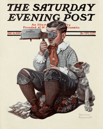
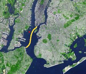
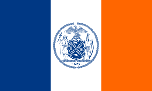
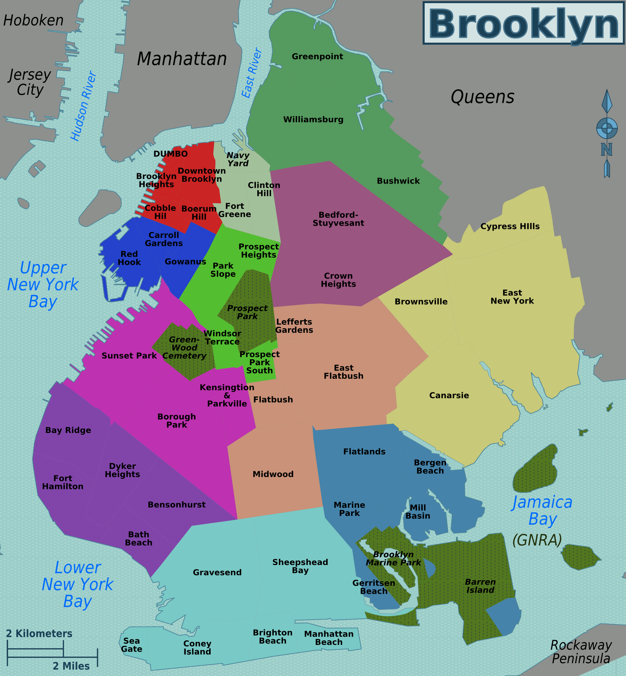
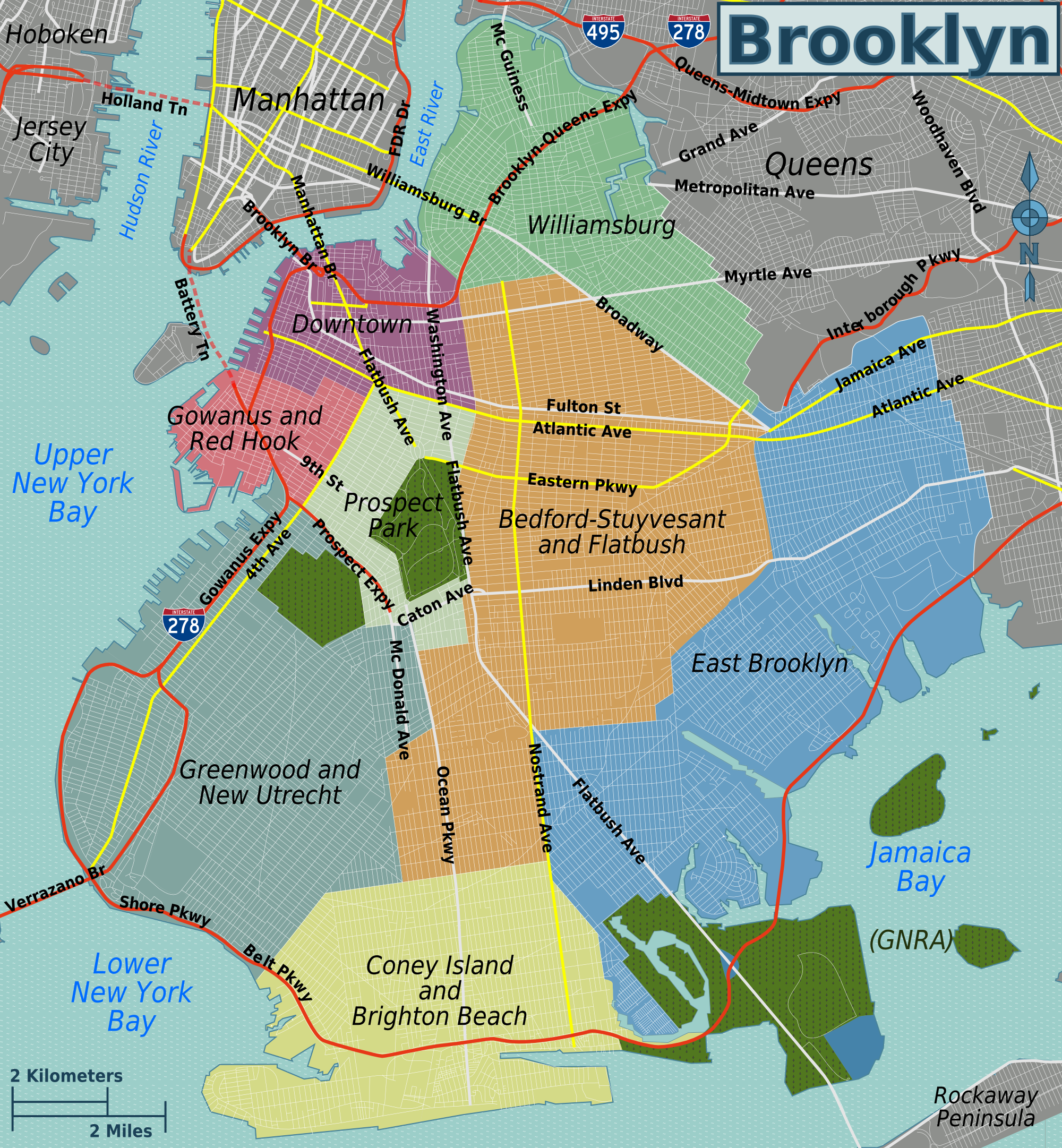
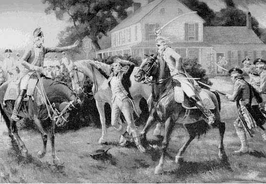
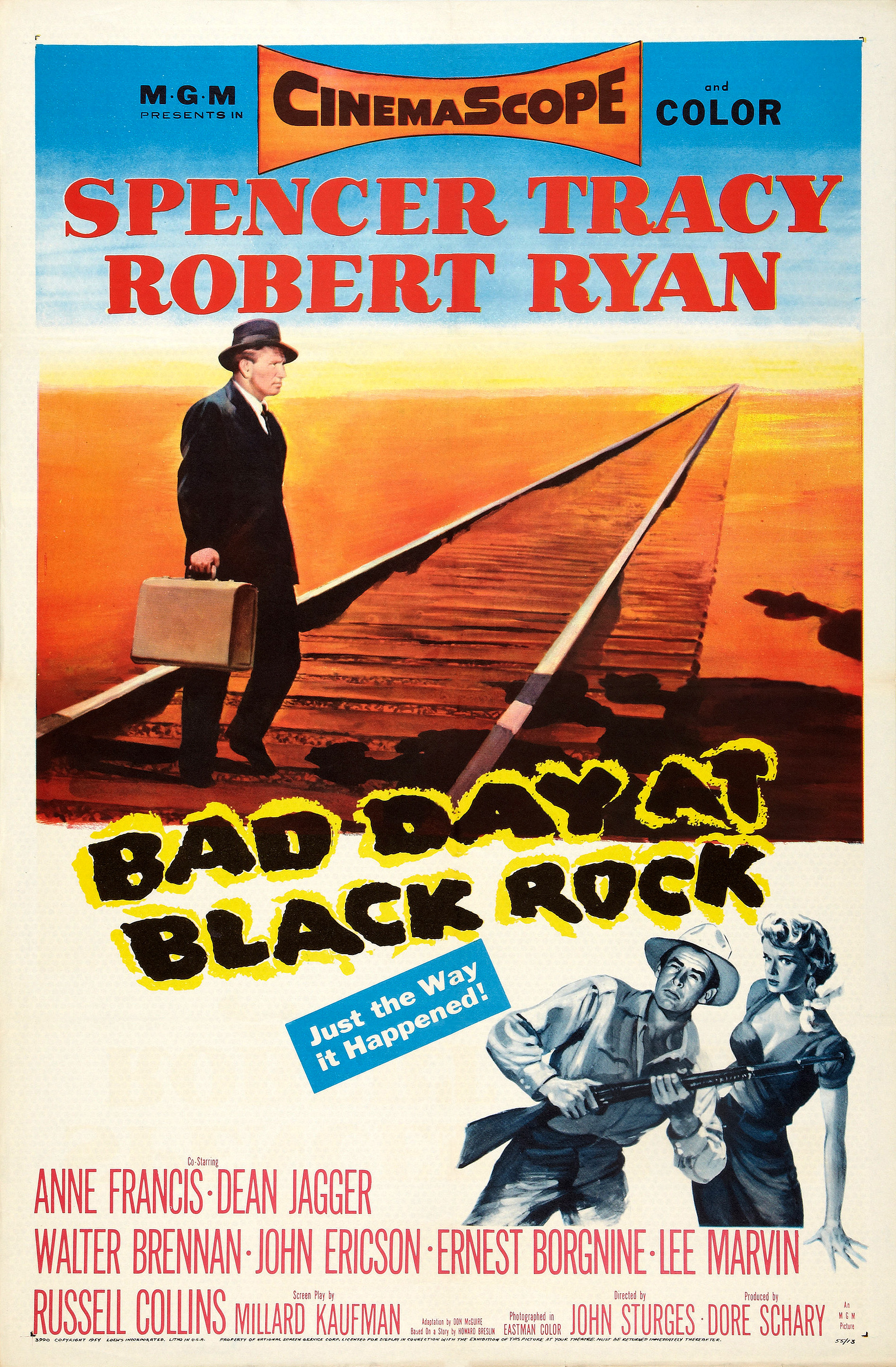