|
Reflections 2017
Series 10
June 28
High-Altitude Sickness - Central Andes II: Peru I: Lima
| | High-Altitude Sickness A rather obvious conclusion I've come to is that high altitude and I are not friends. It's just as well that I've now completed my bucket list of high-altitude places I've wanted to visit. I'll leave it to others to conquer their Everests, figuratively, or even literally. | | | | On my three trips involving high altitude, I dutifully took daily the diamox pills my doctor prescribed. I didn't see how they helped. During both trips to the Central Andes, I also regularly took the folk remedy, coca tea / mate de coca (Photo by Anikó), first discussed in the Ecuador posting, 2015/16. Also just called mate (MA.té), it's an herbal tea simply made with leaves of the coca plant in hot water. We can now add that it's from Quechua kuka mat'i, so we can see how deeply it goes back into the culture. To show how common it is, in Ecuador I was even served it in tea bags (Photo by Franke 1). But anywhere I had it in the Andes, while it was a mild stimulant, so is coffee, and I didn't see any other benefit from it, other than the fun of being part of the culture. | | | | Let's define our parameters. Altitude sickness is caused by exposure to low pressure of oxygen at high altitude. The information I've found reports that it's hard to determine who will be affected, and that exertion aggravates the symptoms. (Great! Let's go sightseeing!) | | | | Typical symptoms I DID NOT have were headache--although I was asked about it a few times, indicating how common that is--stomach illness, dizziness, sleep disturbance.
Typical symptoms I DID have were fatigue and lethargy, general malaise, shortness of breath upon exertion, occasional loss of appetite.
| | | | Specific numbers are as follows:
Minor symptoms (breathlessness) may occur at 1,500 m (5,000 ft).
It can begin to appear at around 2,000 m (6,600 ft).
It commonly occurs (in those prone to it) above 2,400 m (8,000 ft).
| | | | I now believe the key point is "to those prone to it". Many people have little to no trouble. Anyway, we can now be specific. Below are excerpts from my list of Highest Overnight Stays, updated, which will appear in complete form at the end of all the Central Andes postings. | | | | | | Lhasa, Tibet: 3,490 m (11,450 ft) |
| | | | In Tibet in 2014, after leaving the train, which was pressurized with extra oxygen just like a plane, by the time we reached the hotel, I already felt fatigue and malaise, and felt I was wearing concrete shoes, the best imagery I can come up with. It was a two-story hotel around a central courtyard. When I found out my room was across the courtyard, and up a flight of stairs, reaching the room already required some exertion. In 2014/10, on the visit to the Sera Monastery with its wonderful library/print shop, I wrote: Sera was perhaps the most interesting stop for me in Lhasa, yet with my oxygen-deprived lethargy, I had to drag myself out of the van and up the path to walk among its buildings; . . . the path was largely uphill, wouldn't you know.. At the summer palace, we started strolling toward the center of the park. Part of my memory of the time there is me, with the oxygen problem, wanting to sit down every few steps and rarely being able to. And of course, when our group of seven came to those famous "killer steps" to climb up to the Potala Palace: One guy didn't try at all. One guy made it up one somewhat lengthy staircase, then turned back. I'm glad to say that I made it up 1 ½ staircases before I felt I couldn't go another step, and turned back. May [the guide] continued with the other four in the group.
| | | | | | Hacienda La Andaluza, Ecuador: 3,287 m (10,783 ft)
Hacienda La Ciénega, Ecuador: 2,980 m (9,776 ft)
Quito, Ecuador: 2,824 m (9,267 ft)
|
| | | | In Ecuador in 2015, the very next year, it appeared that a traveler seeking new destinations never really yields. In 2015/16 we described the Tren Crucero's ascent from the coastal plain to Quito, which involved the three above high-altitude overnight destinations. Lethargy and malaise did reappear as we got higher. I enjoyed the rose plantation tour, but it was here that I first felt the toll of the altitude . . . I'm always up front in a tour group, but I found I was lagging behind as we walked from greenhouse to greenhouse. After the night at La Ciénega, while on the train: But while I had had a good night's sleep, I still got up feeling even more lethargic than usual . . . I did have some breakfast, but was not particularly hungry. I know it was the altitude finally really getting to me . . .. I was lucky that I really wasn't interested in the planned hike through the woods in a national park, and so I stayed on the train, with the crew. I went to one lounge and slept soundly on a sofa for two solid hours. After some noon tea, I went to the other lounge and slept for another hour and a half. At that point, I did feel better, which means I used the time quite productively, while hiking in the woods would have tired me out even more. Fortunately, taking it easy in Quito worked out quite well, as long as I didn't try walks that were overlong. | | | | | | Cusco, Peru 3,402 m (11,160 ft)
Puno, Peru 3,826 m (12,552 ft)
Posada del Inca, Yumani, Isla del Sol, Bolivia 3,990 m (13,090 ft)
Inca Utama Hotel, Huatajata, Bolivia 3,830 (12,566)
La Paz, Bolivia 3,640 (11,942 ft)
|
| | | | In Peru and Bolivia in 2017, just two years later, I expected it to be déjà vu all over again. Outside Lima, at sea level on the coast, every one of the ten overnights in the above locations were at high altitude. Yumani, on the Isla del Sol, would be my new overnight high-altitude record, surpassing even Lhasa by 14%, and also surpassing nearby La Paz. So what could I expect? Probably more fatigue and lethargy, perhaps some malaise, certainly some shortness of breath upon exertion. Check, check, check. Unfortunately, my appetite stayed with me. | | | | But this time, there was an additional factor. For the previous few months, I'd been experiencing some bouts of shortness of breath, for which I'm seeing a doctor (he thinks it's OK). I wasn't looking forward seeing that symptom coupled with high altitude, but we'd see how it went. Well, let's just say it was slow moving. Fortunately, at this writing some weeks after returning to New York, and being away from that high altitude, an additional plus is that that shortness of breath problem from before the trip seems to have abated, and I've been lately been walking around town with NO pauses to catch my breath. I hope it stays that way. | | | | We first used the following bilingual chart from German Wikipedia in an Ecuador posting. It shows Andes Altitude Levels (Chart by Anita Graser), as well as, in German, what is found at each level (bananas, corn, fruit, wheat, barley, potatoes, cattle, llamas). On the Spanish side, consider tierra to be "region", and we have these regions down below "hot; temperate; cool". But above about 3,100 m (roughly 10,200 ft) the region is helada, which is "cold", perhaps "freezing", and above maybe 4,400 m (roughly 14,400 ft) the region is nevada, which is "snow-covered", and definitely "freezing". All of the five stops beyond Lima that we'll be making on this trip are above that first cutoff. None quite reach that latter cutoff, but some come pretty close. They call the Tibetan Plateau the "Top of the World", but the Andean Plateau/Altiplano isn't far behind.
http://yinyangbob.com/Peru2010/photogallery/Map_3.jpg
| | | | We can also look at it this way. The black dot for Lima is shown on the coastal/desert strip in gold. Lima's altitude starts at sea level. The gold strip would continue into Ecuador, where Guayaquil's altitude also starts at sea level, and then south into Chile's Atacama Desert, which is another matter. | | | | Now look at the area in green, which is Peru's Amazon rainforest, which also extends into Ecuador and Bolivia. While this area covers 60% of Peru, only 5% of its population lives there. Do notice the Urubamba and Ucayali rivers leading out of the highlands to the Amazon. We'll discuss this more fully later. | | | | But it's the brown area we're visiting. It extends into Ecuador to include Quito, and into Bolivia to La Paz, close to Lake Titicaca. You see the black dots for Cusco and Puno (also for Machu Pikchu), and the three Bolivian stops are just as high. Well, let's give it a try. Off to the mountains!
http://www.lib.utexas.edu/maps/americas/peru_physio-2006.jpg
| | | | Peru We've used this map earlier as our "Peru map" since it shows the entire area we're discussing, so keep it aside for reference now. All we'll say now is that Peru is the third largest country in South America by area, after Brazil and Argentina (though only 46% the size of Argentina). The Frommer guide points out that the nights are chilly to cold, especially in the mountains. You'd better believe it! Especially keep in mind that May in the northern hemisphere is spring looking into summer, while in the southern hemisphere it's autumn looking into winter. Northerners, add six months and think November! It was comfortable traveling, but I'm glad I heeded the guide book and brought both sweater and jacket. I remember how outright chilly the evenings in Cusco were, and the heat in the hotel was definitely on. Both restaurants I went to in Cusco had electric heaters going. In the afternoon, the guide kept on adjusting the layers of clothing he was wearing, exchanging some for others in his backpack.
| | | | The Frommer guide likes to list "Bests". Below are the ones they list that we WILL be doing in Peru and Bolivia:
Their Bests of South America: Machu Pikchu, floating on Lake Titicaca, Isla del Sol
(also blue-footed boobies [2015/11], Chilean fjords seen on the Caronia cruise, and Iguassu Falls [bucket list—maybe]).
Their Best Small Towns & Villages include Ollantaytambo & Isla del Sol (where we'll be staying in Yamani, mentioned above).
Their Best Markets include Pisaq.
Their Most Intriguing Historical Sites include Cusco
(also Quito's Old Town [2015/17]).
| | | | I will add here in advance a personal comment as an opinion. Yes, Machu Pikchu should not be missed, but Cusco was for me the somewhat more intriguing historical site of the two. But then I'm an urbanist, and am much more strongly attracted to a thriving historic town as opposed to historic ruins in the mountains. But the Machu Pikchu setting is fabulous. | | | | Lima There are four big cities in the Central Andes countries of Ecuador, Peru, and Bolivia, including the three capitals. Frommer gives Quito and La Paz two stars each (out of three). I disagree. I give Quito, particularly its Centro Histórico three stars easily. I really enjoyed it. La Paz can perhaps get two stars, but when you add those gondola cable cars we mentioned in the last posting, it goes easily up to three as well. Quito gets from me three for the old, La Paz three for the new.
| | | | Frommer gives no stars at all to either Guayaquil or Lima. The only reason I went to Guayaquil was because the Tren Crucero left from there, and, being there anyway, I asked for a tour. I particularly remember the riverfront park and also iguanas running around Iguana Park. I'll give Guayaquil one star. | | | | As for Lima, it apparently isn't what it once was. It was founded by Francisco Pizarro in 1535. In 1746, a powerful earthquake almost completely destroyed it and initiated its decline. In addition, the subsequent tsunami destroyed the port of Callao. There was another earthquake in 1940, and again in 1970. In the 17C, Lima was the richest and most important city in the Americas, reportedly the most beautiful colonial settlement. Today, much of the historic area, including the main Plaza de Armas, has been reconstructed. But Lima's balconies are a main sight to see, so for the Plaza and balconies I'll give Lima one star as well.
http://3.bp.blogspot.com/-OWDAaxJtMtc/TyvLRy8-KAI/AAAAAAAADfk/U2Q3SqEMTzc/s1600/map-of-greater-lima-peru.jpg
| | | | This map (click) shows Greater Lima, and it's a huge city. On the left, you see the port of Callao, where we docked on the Caronia, and right above it, the airport, which is physically located in Callao. The red box marks the historic city center, but first take a look to the south at Miraflores. This is the modern, international quarter with many hotels, where many visitors stay. But I'll remind that there was a similar situation in Quito. There was the beautiful, historic Old City, where I was delighted to stay, and further afield, an international hotel quarter as well. But the Quito one had the nickname "Gringolandia", because of the concentration of tourists that stay there. In Lima, I wanted no part of it, and wanted to stay near, and visit, the historic city center.
http://2.bp.blogspot.com/-tr_8Ta6krm8/TyvLRgwi7aI/AAAAAAAADfY/K5cII_fVrFE/s1600/central-lima-map-peru.jpg
| | | | This related map shows Lima's center. Before you click, find the Rimac River at the top, with the X-shaped grid for the Old City right below it. Now click to see the Plaza de Armas in green, around which it all centers within a few blocks. Now move down past the green of the Plaza San Martín to the green Paseo de la República, with the Palacio de Justicia (Palace of Justice=Court House) opposite the Sheraton Hotel in blue. Thus, the Sheraton Lima was ideally situated in this area, and I could stay there on points, and on the Club Floor to boot, with the Club Lounge that includes breakfast and snacks later on in the day. It was a nice hotel, but I booked it because of the convenience of its downtown location. Hotels I found at later stops on the trip were the real charmers. | | | | Day 1: Flying Months before, I had myself booked the non-stop round-trip between Newark (for New York) and Lima, plus two local flights in Peru and Bolivia. Only shortly before leaving did I check, and found out the non-stop flight was on United, and wondered to myself jokingly if I'd be dragged from my seat. (!!) But I'd gotten many reassuring emails before the flight from United about improvements made, and everything went very well.
| | | | At Newark Airport heading down an endless concourse with my wheeled bag after security, I did something I never did before. A woman driving one of those carts with a few people already aboard stopped me and asked if she could drive me to my gate. I readily climbed aboard, and it was really worthwhile, particularly with the shortness of breath. | | | | It was a day flight lasting 7h55 going, mid-afternoon to mid-evening. On arrival, I was met, and taken to my hotel, the Sheraton Lima, as planned. I had a snack in the Club Lounge just before it closed. I was pleased to note that my room had a view across the park of the Palacio de Justicia. I remember then going down to the lobby stepping out in front of the hotel for the view across the park and for some nice fresh air, before all the activity started the next day.
http://www.productoselparque.com/www/uploaded_files/evc01c.jpg
| | | | But stepping back inside, I noticed the above sign of interest right in the lobby—and I'm known for ALWAYS reading signs. You never know what you'll learn, but this wasn't the usual historical marker. It was in green, the international color indicating safety, and, as you see, it said "ZONA SEGURA EN CASOS DE SISMOS", indicating that the lobby was a "SAFE ZONE IN CASE OF AN EARTHQUAKE". (Full disclosure: it actually says "in cases of earthquakes", but that doesn't ring true in English.) I saw the same sign later in the Cusco hotel, and they were probably in all the others. I mention this since Lima has seen its share of earthquakes, having lost a great deal of visible history, and Lima will probably see more of them in the future. | | | | But I learned some Spanish at the same time. The Spanish word for "earthquake" was, to my knowledge, terremoto, which, now that I look it up, I find is from the Latin words terra & motus, or "earth & movement". But English words such as "seismic, seismology", made the sign understandable, anyway. I now see that both sismo & seísmo are alternate words for this in Spanish, and learn that are these forms are from the Greek word for "earthquake", σεισμός (seis.MOS), from a root meaning "to shake". Live, travel, and learn. | | | | | | What food comes to mind when talking about Lima? Why lima beans, of course! (Photo by Howard F. Schwartz, Colorado State University, Bugwood.org) But perhaps not immediately for English speakers, because of a quirk of English pronunciation.
Lima beans as we know them are of Andean origin, and were first domesticated about 2000 BCE. From colonial days on, the beans were exported from Peru to the rest of the Americas and to Europe, and since the boxes they were in had their place of origin listed as "Lima, Peru", that's how the beans got named. German has Limabohne, French, haricot de Lima, Italian, fagiolo di Lima. Spanish has several names, including haba de Lima.
There are places around the world also named Lima; the largest in the US is Lima, Ohio. Now we come to the pronunciation quirk in English. In all other languages, the bean and the city are pronounced the same, that is, the first syllable of Li[ma] or li[ma] rhymes with "Lee". But in English, that's only true for Lima, Peru. Otherwise, in English that syllable rhymes with "lye" if you're talking about the bean, or Lima, Ohio. This might be why the English speaker is perhaps slow in connecting Lima with lima beans.
The follow-up point would then be, where did Lima get its name? The surprising answer is from the Rimac River! If that's hard to see, let's try to pick apart and explain the chain of events involved.
Some consonants are rare in final position in Spanish and are close to inaudible when pronounced. The pronoun usted is a good example, with the D almost disappearing, which explains the alternate spelling usté. C is another example, and it's not hard to see that it could have been dropped over time in "Rimac", leaving something like a hypothetical *Rima.
The study of historical linguistics also shows that R and L, both produced in the center of the mouth, have historically flip-flopped and replaced each other. An example is the word "marble", the stone. It all started with R at the end of the Latin word marmor and stayed that way in French marbre and Portuguese mármore, each with R at or near the end. But English and Spanish both developed an L in "marble" and mármol. German is the most interesting here, since Old High German had developed marmul with an L like English, but later the original Latin R was deliberately restored in German Marmor, by do-gooders who thought they were doing the "right thing". In any case, it should be obvious now that the hypothetical *Rima could have easily flip-flopped to Lima. Which it did.
|
| | | | Day 2: Lima While I am the most independent of independent travelers, I remain cautious in some places in South America because of street crime. I have stories from the Caronia trip, but the most recent incident I just heard today while preparing this posting. Two people I know visiting the beach in Rio de Janeiro brought drinks, and later woke up in their hotel room, remembering nothing, not even how they got there. What was in the drinks? Your guess is as good as mine—or theirs. | | | | For this trip, I planned and booked my own flights, planned my own hotels and sights to see, telling the tour operator what I wanted, but remained wary about walking the streets on my own. I had been OK when in Santiago de Chile, and walked the streets of charming Puerto Ayora in the Galápagos on my own. But I'd heard stories about Guayaquil, and went with a private guide. I walked the Old City of Quito on my own, but noticed a strong police presence, even including at a supermarket checkout counter. Fortunately, private guides in South America booked through Amazon Adventures are quite reasonable in price. | | | | On this trip I had a guide in Lima, and we came across a police presence as we walked around, in the form of 6-8 officers jogging along behind full-length clear-plastic body shields. In Cusco, the guide and I came across the same sort of thing, but they were instead relaxing behind their shields, not jogging. On that basis of that police presence, on a later day, I went out walking on my own in Cusco, just as I had in Quito, which was a pleasure. You get the drift.
http://mapshop.com/media/maps/samerica/city-map-of-lima-9781553416562inside.jpg
| | | | We'll use this map for Lima (click). It's much clearer, but is tilted—the Trujillo bridge points roughly north. It also has a few minor location errors we can easily correct as we move along. On my Lima day, I knew it wouldn't take too long to see what I wanted, so I left the morning at leisure and had the guide and driver pick me up in the early afternoon. I knew exactly what I wanted to see, including the famous balconies of Lima, and had made sure in advance that they would be included. The driver then drove us past Plaza San Martín and let us off on Ucayali (see map), to see the first of two areas of balconies. I have to say that, unfortunately, even at sea-level Lima, the walking went slowly, with lethargy, shortness of breath, and occasional pauses. | | | | We walked east on Ucayali, and the guide first stopped at something he wanted me to see at the NW corner of Lampa, the Museo del Banco Central de la Reserva del Perú, the Museum of the Central Reserve Bank of Peru (misplaced on our Lima map). There were coin collections on the main floor at what had been teller windows and pre-Columbian artifacts in the basement, including within the huge former vault. But that's not why I mention it. | | | | The guide had indicated that the Old City is not doing well. On the second level above all the shops we were passing, which seemed to be thriving well enough, he said there was one empty apartment after another. Apparently not enough people were interested in living downtown, and the "return to downtown" that's hit so many cities—like where I live in New York—has not taken place here. I hope I can add the word "yet".
http://paseosescolares.pe/wp-content/uploads/2015/11/229.jpg
http://www.divertinajes.com/nueva/images/parrafos/Lima_Museo-BC-Reserva11.jpg
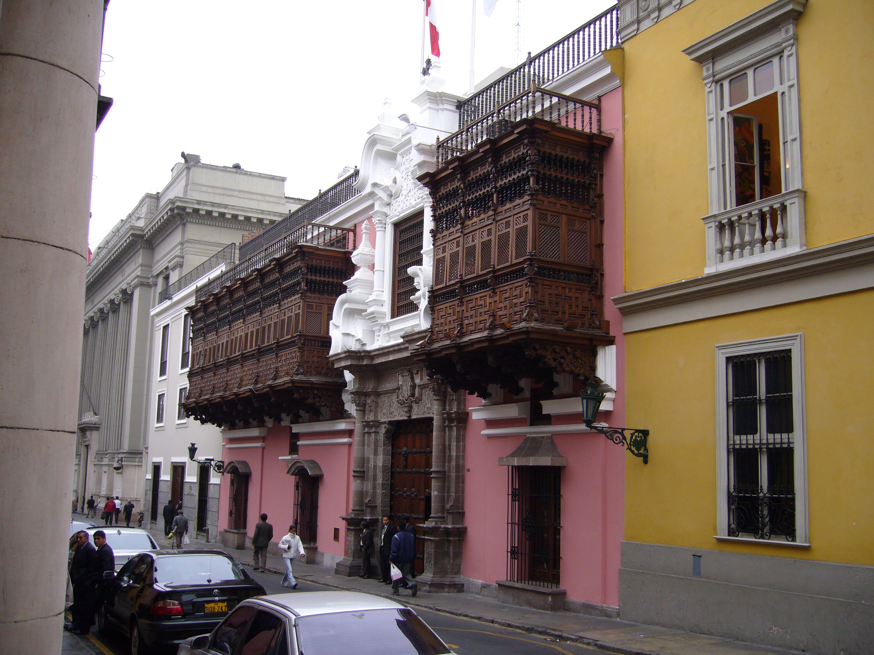
| | | | So it was the bank building itself that intrigued me. It was built in this traditional neighborhood in 1929 by a New York architect in a formal, classical style, as the main office of the Reserve Bank. Note in the first picture the two lanterns, wrought-iron gate, and grilles on the large windows, centered between Corinthian columns. This building could have been on Wall Street. It was after a half-century that the main office was moved in 1979 and the structure made into a museum. Yet it still evokes to me a bygone early 20C period and style of architecture. The second picture shows the wrought-iron former teller windows, where now the numismatic collections are located. | | | | On our Lima map, continue down Ucayali past Lampa to the Palacio Torre Tagle mid-block on the left (also misplaced on the map). The Torre Tagle Palace was one of two destinations I'd insisted on because of its balconies. It's a Spanish Baroque palace dating from the first decades of the 1700s. | | | | The balconies of Lima are a cultural heritage that were first initiated during the Spanish Colonial regime, mostly in the late 17C and 18C, so it's logical that they should be located here in the historic center. I read there are about 1,600 balconies today; the guide says there were once 4,000. The balconies were a big reason, along with the Plaza de Armas, for Lima's Old Town being declared a Unesco World Heritage Site. | | | | Ucayali, like most streets in the historic center, is narrow, and it's hard to step back and get distance to admire the façade, so we'll first pass it by and get the view back, which is probably the best way to see the Palace (Photo by © Manuel González Olaechea y Franco). First be sure to click to inspect the two finely worked balconies in dark wood. They're an adaption of European architecture to a vernacular Peruvian tradition. In a sense, they also could be considered porches. The closed nature of these balconies gives privacy for the residents, while enjoying the view outdoors. | | | | Let's retrace our steps a bit for a better, though off-kilter, look (click) at the Baroque entrance (Photo by Ministerio de Relaciones Exteriores). It's rather unique in being made from stone below, including he carved columns, but plaster above. If we backtrack just a bit more, we can get a better look at the moorish influence in the carving of this woodwork from the Colonial period (Photo by Mikaelashamrock). | | | | If you check the Lima map again, you'll see that behind us all along has been another balconied building of note, the Casa de la Rada (Photo by Ministerio de Relaciones Exteriores), seen here, along with the Church of San Pedro/Saint Peter (see map) across Azangaro, from the balcony level of Palacio Torre Tagle.
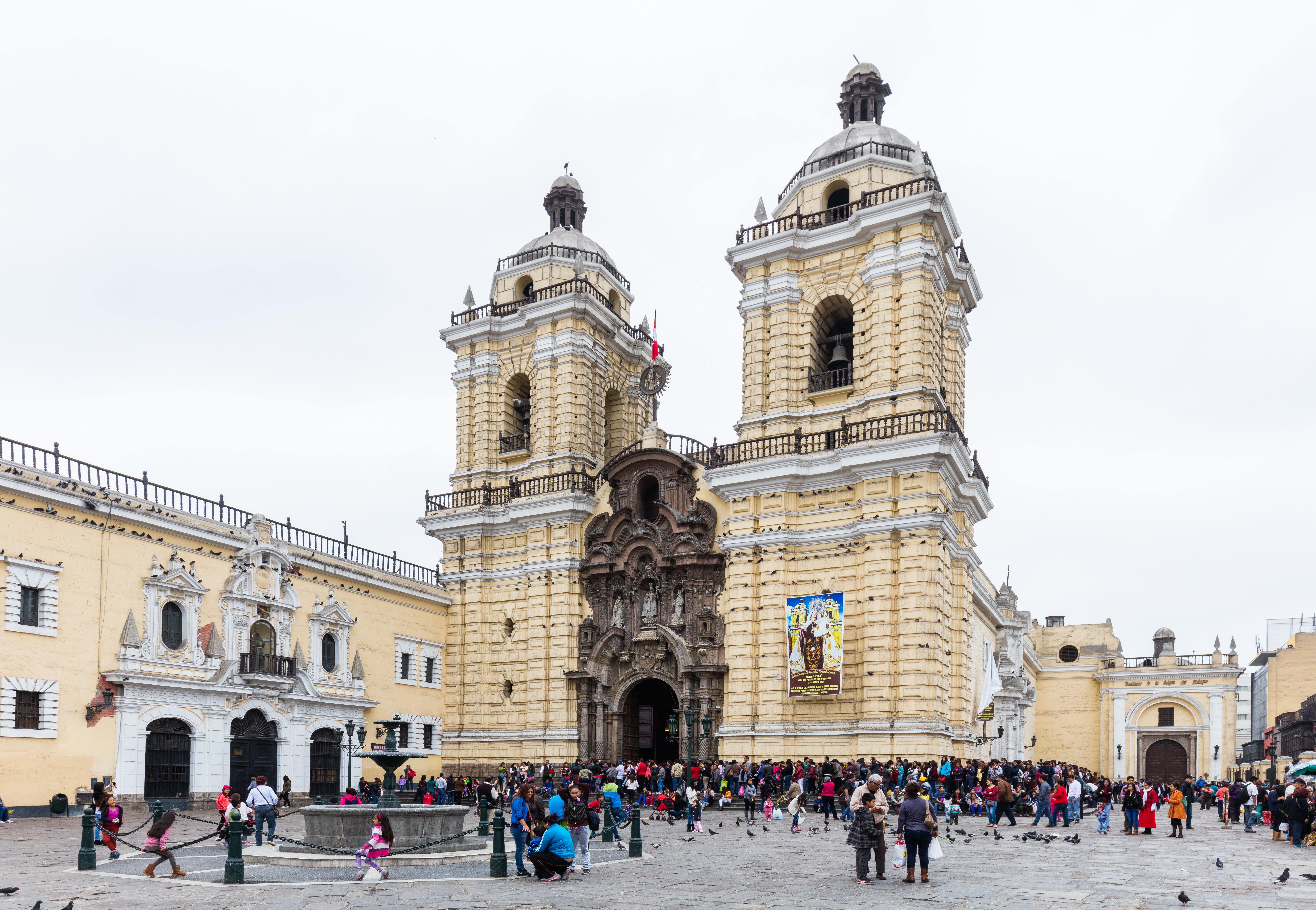
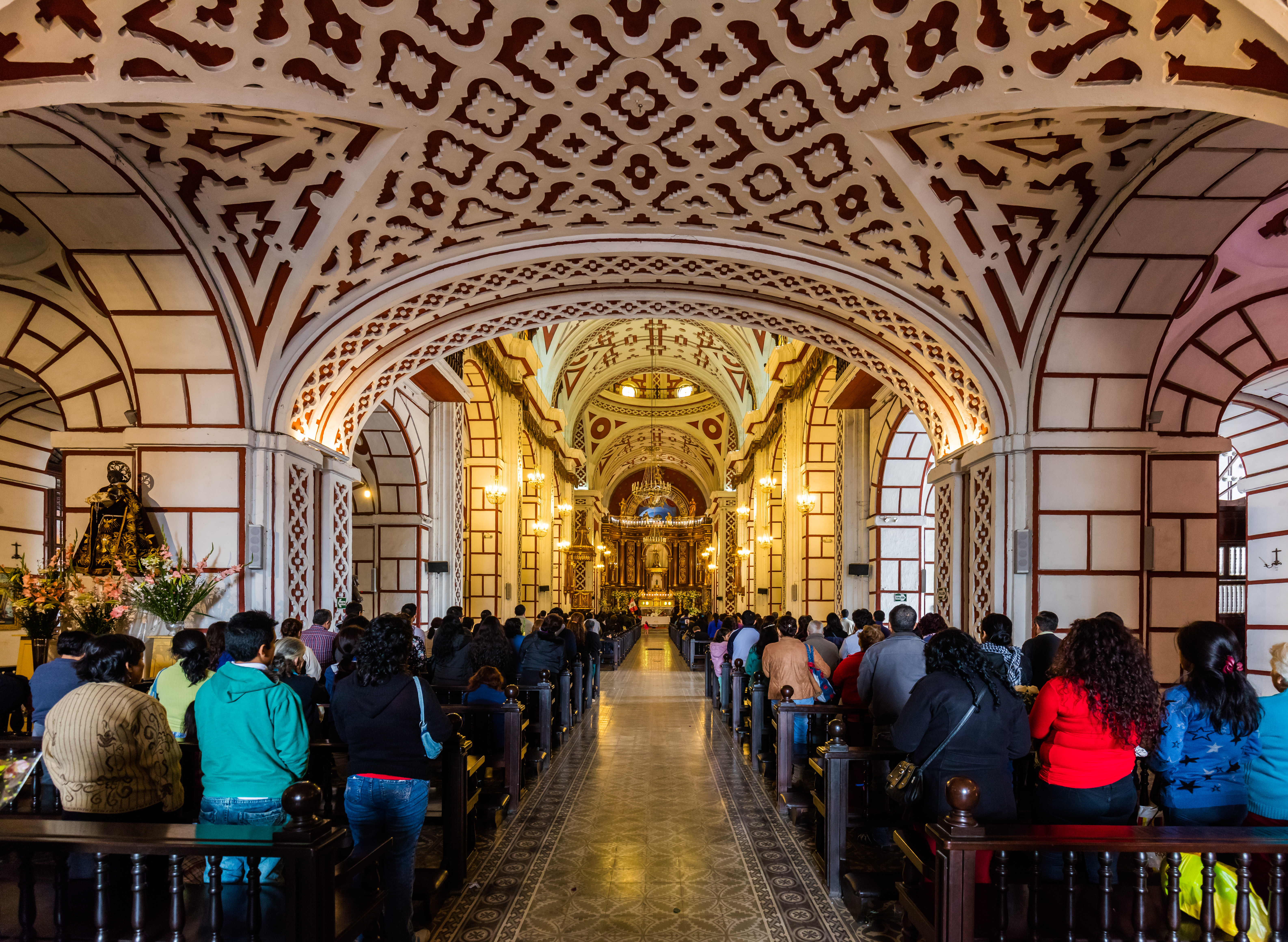
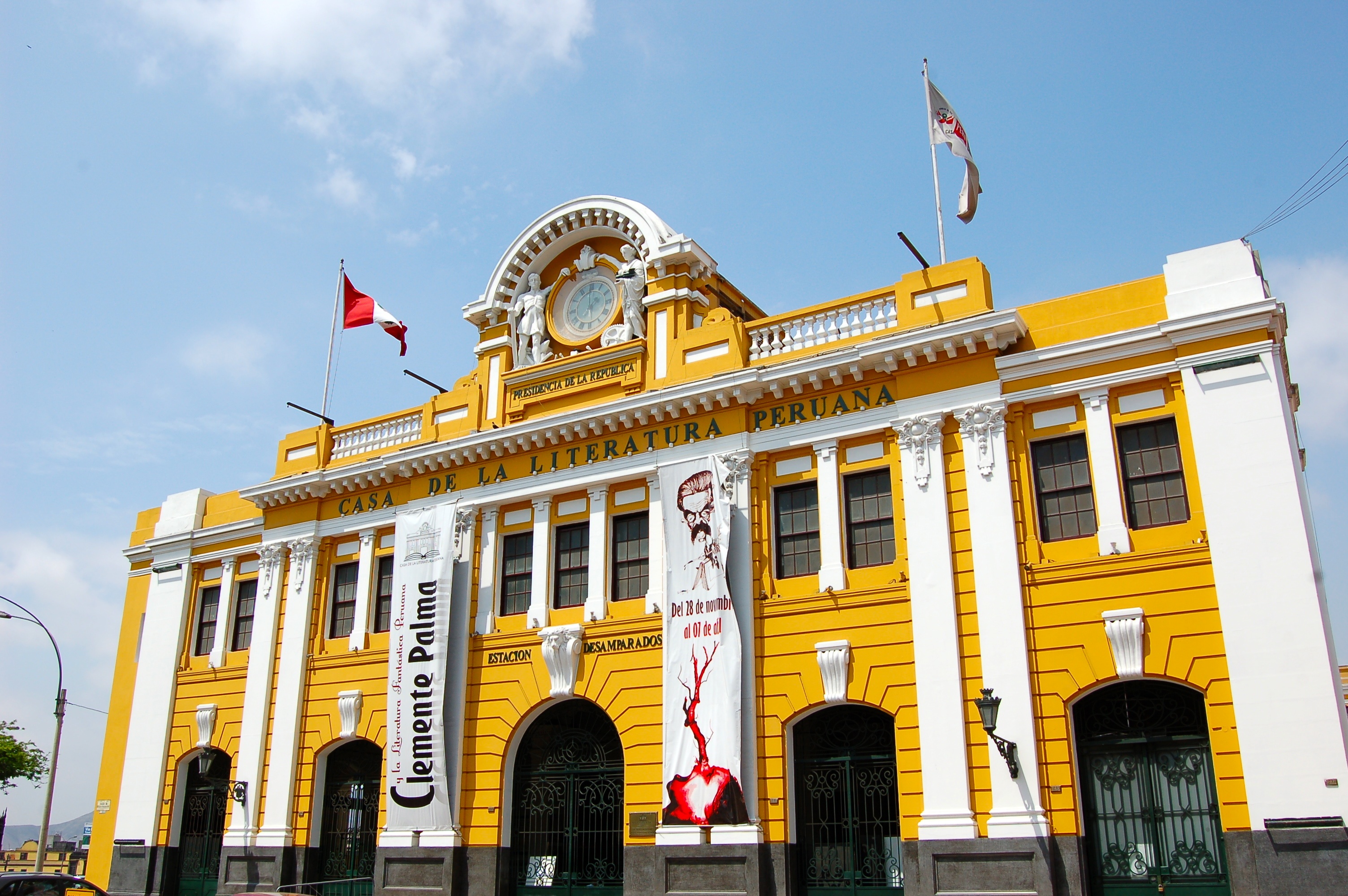
| | | | From Ucayali, a left turn for three blocks gets us closer to the river, and to the Convento de San Francisco, the St Francis Monastery, located on the extensive Plaza de San Francisco (note that the word convento in Spanish denotes either a convent or monastery). The church and monastery were completed in 1774. Though the complex survived several earthquakes intact, including in 1746, it was extensively damaged in the one in 1970. The church is noted for its architecture, it being an excellent example of Spanish High Baroque. Click to inspect the façade, especially the granite carved portal. We also stepped inside to see (click) the striking interior, and also strolled the adjacent cloister (Both photos by Diego Delso, delso.photo, License CC-BY-SA). | | | | It's just another block west down Ancash (named after a region of Peru) and then a right turn towards the river to arrive at another disused monument to the early 20C like the Reserve Bank, the Estación Desamparados / Emparados Station. The Beaux-Arts style, 1911 Station (Photo by Manuel Menal), close to the edge of the Rimac River (see map), is beautifully restored and recycled as the Casa de la Literatura Peruana / House of Peruvian Literature. We stepped inside—this is the ceiling of the main hall (Photo by Jorge Gobbi). | | | | We talked in the last posting about passenger rail in Peru being almost nonexistent today. Let's clarify that with this map of the railways in Peru (Map by jkan997). It's obvious that there never was a true network, since many rail lines were built for freight purposes, largely mining, with little concern for moving passengers between cities. Our previous posting covered the system in the south, much of which we'll be riding on later. Below is a recap. | | | | From Cusco to Aguas Calientes there's a narrow-gauge line at 914 mm (3 ft). Aguas Calientes serves Machu Pikchu, and rail is the only mode of access other than hiking. (The line actually goes beyond, but is unusable.)
From Cusco to Puno (and to Arequipa) is the standard-gauge line we discussed in the last posting at 1435 mm (4 ft 8.5 in). It does not connect with the previous line, and even uses a separate station in Cusco. Passenger service is as described earlier.
| | | | But now move up to Lima (see rail map). Once again, rail started on the coast and ran inland. The first railway in Peru was standard gauge and connected the port of Callao to Lima in 1851. It was extended to La Oroya in 1893 and Huancayo (HU=W!) in 1908. In 1904 the Cerro de Pasco branch joined it at La Oroya. In 1926, the extension to Huancavelica (HU=W) was built, but it was narrow gauge. I understand it's now been converted to standard gauge. But the lines are now only for freight. There is no regular passenger traffic, although special excursions are operated out of Desamparados Station in Lima. This is an excursion train—I did not see this--leaving Lima for Huancayo (Photo by Jorge Gobbi), so this beautiful station still gets some rail use. | | | | | | I've already said that my list of Highest Overnight Stays will be updated and will appear in complete form at the end of all the Central Andes postings. That will also be the case for the list of Highest Railways in the World. However, I have some new information I've just discovered. Look again at the Peru rail map and note the zig-zag loop between Lima and La Oroya. That crosses the highest point on this line, which traditionally has been at the Ticlio mountain pass, located at 4,818 m (15,807 ft), making this the second highest railway in the world after Tibet.
But I've now read that the line no longer goes over the pass, but instead crosses it through a nearby tunnel at a somewhat lower elevation, The Galera Summit Tunnel at 4,783 (15,692 ft). While that seems simple enough, there's a problem. The third highest railroad on the list that I've always consulted and followed is the Río Mulatos/Potosí Line in central Bolivia, whose highest point is at Cóndor Station at 4,786 m (15,702 ft). But it would seem that the Galera Summit Tunnel is now lower than that Cóndor station by a mere 3 m (10 ft), so on this technicality, I'm going to flip the two on my list. Hence, the line out of Lima is now the third highest in the world.
|
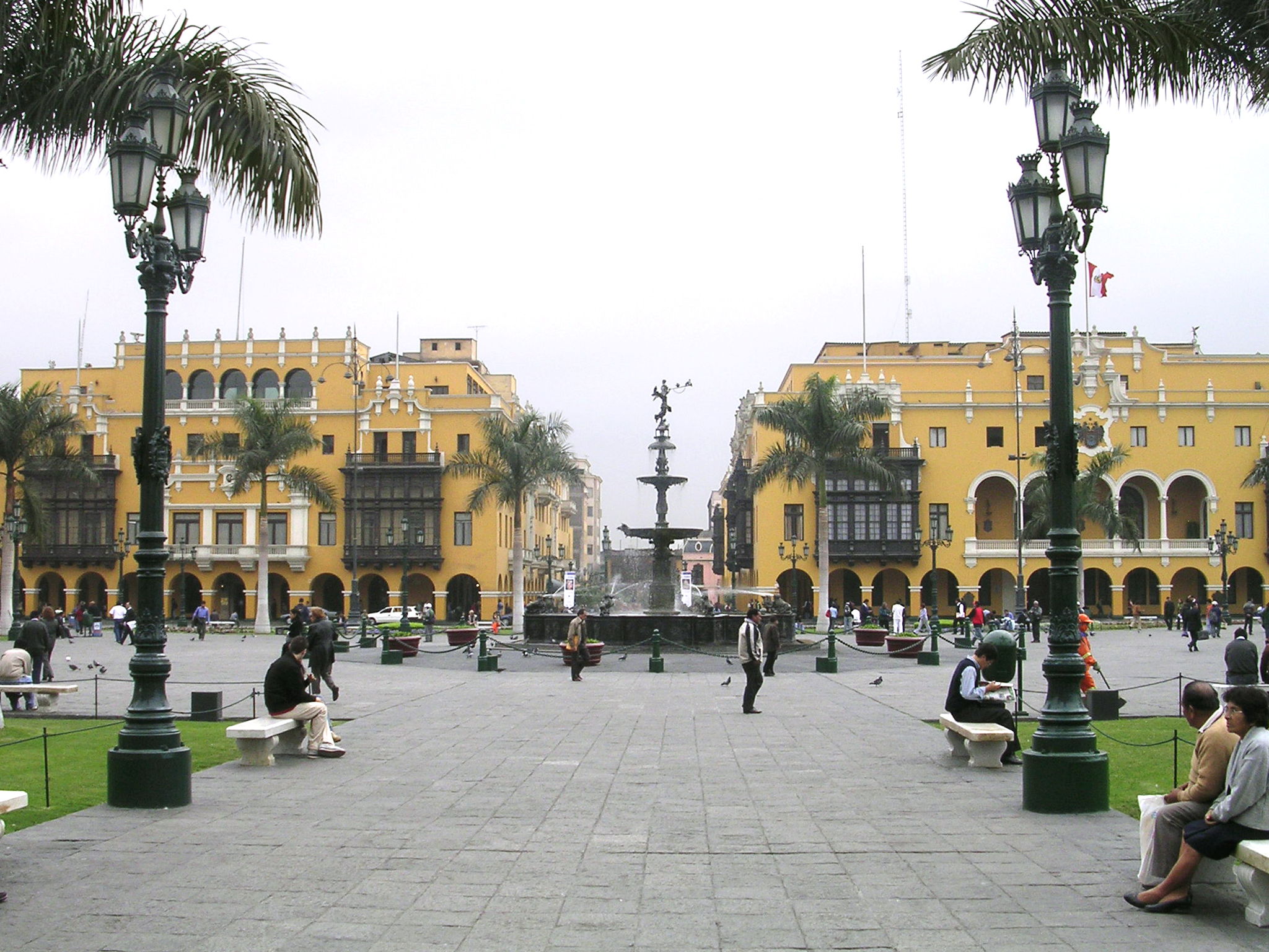
| | | | The map shows it's just a block from the station to the Plaza de Armas, also known as the Plaza Mayor. This latter name just says it's the Main Square, but as to the first name, I'll just refer back to Canada where three cities we stopped in had a Place d'Armes. In 2017/4, we said that Such a square is common in French colonial cities . . . , just as Spanish colonial cities have their Plaza de Armas. The phrase is hard to translate, and "Arms Square" doesn't cut it. But it was where arms were kept for colonial militias to drill with, and the closest translation might be "Parade Ground", but that loses most of the flavor. Today, these areas are always parks. | | | | Established Spanish procedure was that a main square should be established, and growth should follow in a grid pattern based on it. Francisco Pizarro founded Lima on 18 January 1535 and, as the city's first mayor, designated the main square to be here. Locations for specific public buildings around the square were also designated, and the grid spread out from here. | | | | As we walk into the square, we sit down facing away from the cathedral (see map) to relax and look around. The view straight across the square (Photo by Dozenist) can orient us best. I agree with the Fodor book, that it's not the prettiest square, but is distinguished—it is a Unesco World Heritage Site. You cannot miss the typical balconies on the public buildings. Click to inspect the fountain in the center. The first fountain was built in 1578. This bronze fountain is a replacement from 1651, which makes it the oldest surviving element on the square, given that earthquakes destroyed the surrounding buildings, so their replacements are newer. | | | | We'll now get closer to the fountain and turn right for a bit (then come back later, and swing left). That building we just saw part of on the right is the Palacio Municipal / Municipal Building (Photo by Manuel González Olaechea). Click to inspect details, and also note on the right a gray structure. When we turn further right, we come across the Palacio del Gobierno (Photo by Maurice Chédel), literally the Government Palace, used as the Presidential Palace and also known as the House of Pizarro, located where his residence was. The original building was erected in 1535, but there have been numerous changes over the years. The current Neo-Baroque structure was completed in the 1930s. | | | | Now let's turn back to that original view looking out from the cathedral and turn left instead (Photo by Håkan Svensson [Xauxa]). It's good to see the hustle and bustle of activity in the Historic District. Another turn to the next corner gives us a view of the Casa del Oidor (Photo by © Manuel González Olaechea y Franco). While the building seems modest compared to the others, it stands out for two reasons. Dating from the early 18C, it's the oldest building on the square and the only one dating genuinely from the Colonial era. And secondly, that incredible balcony that actually wraps around the corner is quite unique. I looked it up, and an oidor was a type of Colonial judge. The word is from oír, to hear, so he was literally a "hearer", one who hears court cases.
| | | | We finally turn around to see the last side of the square, and to the right is the Cathedral (Photo by Avodrocc). Baroque in style, founded in 1555, and originally built in 1625, it's been heavily damaged by earthquakes and has been rebuilt.
| | | | For the frequent traveler, many similar buildings start to look exactly alike, and one can become "over-cathedraled". Having just walked over from San Francisco, that served as the "church-fix" of the day, and only if a building has something unique to offer need it be toured within. And so, since I'd read that the Lima Cathedral contains the Tomb of Pizarro, I said to the guide I wanted to step inside. | | | | Pizarro was assassinated in the Plaza de Armas in 1541. His remains were brought to the Cathedral after they were discovered in a crypt in 1985. Located in a chapel next to the entrance is the Tomb of Francisco Pizarro (Photo by Manuel González Olaechea y Franco). You can click to read the inscription with his dates, which I won't bother to translate. Around the chapel was a museum exhibit trying to explain how they identified the remains. Still, the guide remained quite dubious and skeptical about it all.
| | | | To the immediate left of the Cathedral was the structure that impressed me the most around the Plaza, the Palacio Arzobispal / Archbishop's Palace (Photo by Alfredobi / Ana Lucia Bianco). The stonework, especially the entrance, is superb (click), but it's once again those wooden balconies (Photo by Marie Thérèse Hébert & Jean Robert Thibault) that give the building its uniqueness. Note this incredible balcony detail (Photo by Alfredobi / Ana Lucia Bianco), particularly the melding of the woodwork and stonework.
| | | | | | You may have noted the word palacio used in Spanish in ways "palace" wouldn't be used in English. It can indeed designate a palace, such as Palacio Torre Tagle and Palacio Arzobispal, but otherwise, it designates any large public building. In this posting we've seen: Palacio de Justicia ("Palace of Justice"=Court House), Palacio Municipal ("Municipal Palace"=Municipal Building), and Palacio del Gobierno ("Government Palace"=Government Building). |
| | | | There was one last balcony stop I wanted, but we could stop there on the way back to the hotel. The guide phoned the driver, who picked us up on the Plaza and drove us down Conde de Superunda (see map) to the T-intersection with Cailloma. That’s important, since the intersection allowed a better distance view of the building. It was the Casa de Osambela / Osambela House, which also goes under the name of Casa de Oquendo, the name used on the map, though misplaced. Move it mentally to the T-intersection so we can see it better. | | | | It's one of the biggest houses built in Lima in Colonial times, and was completed in 1807. As we look at it lengthwise down Superunda (Photo by © Manuel González Olaechea y Franco), we can admire (click) its five balconies that stand out from those on adjacent buildings. But only when we step back at the intersection can we get a better view of the entryway (Photo by comicpie) with its special balcony, called a mirador (from mirar, to watch, look at). It was from here that the first owner of the place, Don Martín de Osambela, used a spyglass to watch the arrival of the galleons in the port of Callao in the distance. This detail shows three different styles of balcony (Photo by Guillermo Arévalo Aucahuasi). | | | | Driving back to the hotel, we passed the Plaza de San Martín (Photo by © Manuel González Olaechea y Franco). It's the other grand square of central Lima, inaugurated in 1921 with stately, handsome gardens, and is connected to the Plaza de Armas by the Jirón de la Union (in yellow). The central monument shows José de San Martín, the liberator of Peru. | | | | The rest of the late afternoon and evening was for relaxing and writing at the hotel, and an included buffet dinner in the Club Lounge. Tomorrow morning we fly to Cusco, our first high-altitude stop of the trip. | | | |
| |
|
|
|

