|
Reflections 2019
Series 10
July 18
Trent-Severn Waterway I: The "Kawartha" Cruise
| | Rationale I'm sure you haven't heard of the Trent-Severn Waterway. I hadn't either, until I rode on the Rideau Canal in 2014 and found that it was simply the other route that same boat traveled on. I figured if I liked the Rideau trip (2014/16, Voyage 51), this would be good, too, and it was. When on board as the only American among a sea of Anglo Canadians, I was asked how I'd heard about the trip. I'll review here what I told them and what I wrote earlier.
| | | | In about 5th or 6th grade, we were learning about the War of 1812. Since not only history, but geography in particular impresses me deeply, I remember her saying that, after that war, Canada built a canal to avoid having Canadian shipping sail along the Saint Lawrence right next to the US along the New York border. Let's reuse this map of NY-ON-QC waterways that we've seen before:
http://boating.ncf.ca/images/chart-canals-north.gif
| | | | Canada built the Rideau Canal from Kingston to Ottawa, at which point shipping could continue down the Ottawa River to Montréal (see map), totally avoiding the NY border in its entirety. In addition, there were shoals in the river that were best to avoid. But eventually, relations with the US improved, the shoals were removed, all shipping returned to the Saint Lawrence, and the Rideau Canal was left to just recreational boating. | | | | | | We can review the waterways we've experienced on this map other than the Rideau (but never the Ottawa connection to Montréal). Start at Albany for the Erie Canal trip (2017/3-8). While riding on the Adirondack to Montréal, we discussed—but did not ride on—the Champlain Canal and its connection via Lake Champlain to the Saint Lawrence. We sailed from Montréal (and Québec) up the Saint Lawrence, across Lake Ontario, along the Oswego and eastern Erie Canals, and down the Hudson to NYC. I have never been on the western Erie Canal. On the current trip, we'll use the Trent-Severn Waterway (more to follow) almost--but not quite--from Georgian Bay, the HUGE arm of Lake Huron, down to Kingston for a revisit to that city.
Take note of the Welland Canal, which we discussed in 2017/2, and of its importance in connecting two Great Lakes. Its existence as a superior route adversely affected both the Erie Canal and the Trent-Severn Waterway. We've not yet visited the Welland, but will cross it as part of our planned Great Lakes trip from Chicago to NYC a year from now, in July 2020. From the Welland, we'll continue back to Oswego and repeat the Oswego-Erie-Hudson route to NYC.
|
| | | | Canadians I've been to Canada many times, and always enjoy it. But since we're going back now, allow me to make some personal observations. There is no doubt in my mind that there are two Canadas. We know how the British suppressed French language and culture in Québec for a long time, and how Québec has made a comeback in recent decades under threat of secession. So while that anglophone versus francophone division was always there, today it's more obvious than ever. I know the federal government is constitutionally mandated to practice "official bilingualism" to maintain unity. Anything at the federal level is bilingual--post office, VIA Rail, government forms, Parks Canada. The Constitution also urges that this "official bilingualism" trickle down to the provincial, municipal, and commercial level—food labels are bilingual, even some labels in NYC of companies wanting to do business in Canada.
| | | | But that's all official. I suspect public perception in Canada might be different, and I know it's different in the US. If I were to say I met some Canadians while in Florida—and I did—you'd automatically assume they were Anglo Canadians, because if they'd been from Québec, I'd have specified that I'd met some French Canadians in Florida. If I were to say that Americans write "harbor" and "meter", while Canadians write "harbour" and "metre" (like the British), you know that that reference to Canadians means Anglo Canadians. Thus I see that the word "Canadians" takes on two meanings on the practical level: one is the unifying meaning encompassing everyone, and the other is the parochial meaning referring just to Anglo Canadians. On an everyday, practical level, that's just the way it is. | | | | On this trip to the area of Ontario you saw on the last map, I saw bilingual signs on VIA Rail (PA announcements were also bilingual) and similar official places. A brochure handed out on the Waterway was bilingual, since it's run federally. Beyond that, French seemed to disappear. This is not a criticism—it's similar in Québec with English. It just shows forced bilingualism is not natural—and remember, I'm very pro-language! | | | | Ontario Waterways Cruises, Inc is monolingual. So are its website and brochures. The announcements on their sole boat, the Kawartha Voyageur, are all monolingual. They apparently do not advertise to French speakers, and their clientele on board, while almost totally Canadian, is anglophone. On this trip there were two women from Montréal traveling together, but both were from the anglophone part of Montréal. I saw no trace of French anywhere along the route, including Kingston, unless it was a federal agency. | | | | I love Québec, and have always said Québec City is one of my favorite cities in North America (along with San Francisco). I also feel very comfortable in Anglo Canada--people joke that it's like "the US Lite"—and that's meant as a high compliment. But I continue to see two worlds. | | | | Ontarians On the Rideau trip I first came across the concept of "Southern Ontario" and mentioned it, along with a map. With this trip, I've gotten a much deeper concept of what it is, and now realize it's the de facto capital of Anglo Canada (Toronto has long been the major city of Anglo Canada.) I also understand how it stands apart from Northern Ontario to an extent I never realized.
| | | | First let's look at Canada as a whole (Map by E Pluribus Anthony). The territories to the north are to a large extent under the purview of the First Nations, the phrase Canadians use where the US uses "Native Americans". Québec remains the "great interrupter" separating Anglo Canada in two. To its east are the Maritimes with Newfoundland and Labrador. Wonderful places, but an Anglo outpost away from the bulk of Anglo Canada, which covers the provinces between Toronto and Vancouver. Now look at the huge size of Ontario—I've learned not to be fooled by that size. | | | | Look at Ontario again here (Map by Vidioman). The area in red is always considered Southern Ontario (actually, southeastern Ontario), though the area in green is sometimes added. We'll consider them together. Northern Ontario (actually, northwestern Ontario) includes a great deal of remote wilderness. I know because I've both driven and taken the train through it. Its 2016 population was about 780,000, with a density of only 0.9 people per sq km or 2 per sq mi. You can see that on the map because of the large size of the subdivisions with it. | | | | On the other hand, Southern Ontario has the big cities, roads and institutions. The population of both red and green areas was 12.8 million with a density of 91.3 per sq km or 236 per sq mi. My calculations show that Northern Ontario has about 6% of the population of Southern Ontario. To my mind, Northern Ontario has a lot more in common with the Prairie Provinces in regard to wide, open spaces. That leaves Southern Ontario to be a tight unit unto itself, which is the feeling I've gotten on my visits there. | | | | Why discuss this now? It will help explain the cultural atmosphere of this trip. Don't expect to hear anything about French Canada, such as having any Québecois as passengers on the boat. Do expect to find virtually everyone on board (but me) not only to be Canadian, but with rare exception, coming from within reasonable driving distance of the Waterway. Again and again, I heard fellow passengers mentioning that they lived nearby to where we were at any given point. I also know why, particularly on the Rideau trip, so many people were repeaters. They just used this boat as a repeat room-and-board vacation spot, similar to how many people regularly revisit a favorite (favourite) resort somewhere. I found Southern Ontario to be a somewhat inbred society, but in a nice way, like one big "small town". So when I call this a Canada trip, take that with a grain of salt. It's not even an Ontario trip. It's a Southern Ontario trip, from the very beginning to the very end.
http://woodyboater.wpengine.netdna-cdn.com/wp-content/uploads/2015/08/canadaCanals.jpg
| | | | Trent-Severn Waterway Just how the Trent-Severn Waterway came about is a story I find just as interesting as why the Rideau Canal came about, and it has more twists and turns, some of which are almost humorous (humourous). [OK, I'll stop doing that—I was just trying to get into my Canadian mode.] Let's start by noting the locations our two canals in red in relation to all the Great Lakes on the above map. Georgian Bay is not named on this map, but it's that HUGE bulge on the east side of Lake Huron, so large that it almost takes on a personality of its own. Whenever we say Georgian Bay, understand we're talking about Lake Huron. You can see that the Trent-Severn connects Georgian Bay with Lake Ontario. You can also see it's a shortcut between them. Actually, if you picture the two canals together, along with the Canadian part of the Saint Lawrence, you can see the imagery, trying to connect the Canadian sides of Lakes Superior and Huron with the Canadian side of Lake Ontario, and the River. It hasn't quite worked out that way—we have the Saint Lawrence Seaway—but you can see the 19C thinking. Also keep in mind how much of this is in the Province of Ontario, and that both canals in their entirety are in—ahem--Southern Ontario.
http://2.bp.blogspot.com/-34ufLwZnsR0/TyBcCXbGpLI/AAAAAAAAAIs/WBex1yM4Tbo/s1600/TSWMap%2B11X17%2BBIL%2Bcopy.jpg
| | | | This map above is from Parks Canada/Parcs Canada, and so you see, is bilingual. Since the Waterway is officially organized on the federal level as a National Historic Site of Canada linear park, operated by Parks Canada, it's name in French does appear here; it's the Voie navigable Trent-Severn. Since voie corresponds to "route, way", I suppose Voie navigable is pretty close to "Waterway". | | | | Click for detail--we're looking at the numerous Kawartha Lakes in Southern Ontario, of which the huge Lake Simcoe stands out. The brown areas are First Nations areas. You see the many towns and villages, but they're small. Largest is Peterborough, with a population of 81k, where we'll start the trip—sort of; Orillia has 31k; Trenton 21k. Most are much smaller. | | | | | | While the yellow numbers go up to 45, there are actually only 44 locks on the system, since there is no lock 29, for reasons I do not know. There are two pairs of flight locks each pair being double, where two locks are in close enough proximity as to be considered a pair. One pair is at Upper Healey Falls, #16-17, and the other is at Ranney Falls, #11-12. The Rideau Canal on the other hand has 35 locks. |
| | | | The green area shows the watershed of the lakes, which includes the two rivers that drain them. In the lower right is the Trent River, which drains the lakes via Rice Lake (see map) past Trenton into the Bay of Quinte, an arm of Lake Ontario. The Trent is only 90 km (56 mi) long. | | | | In the upper left is the Severn River, which drains the lakes via Lake Couchiching, just north of Lake Simcoe, past Port Severn into the Georgian Bay of Lake Huron. The Severn is only 30 km (19 mi) long. And here is a basic reason we're showing the map. The last lock in the system is #45 in Port Severn. We'll never get there. Lock #44 (not a normal lock) is Big Chute, where we'll really start the boat trip. I was concerned when planning the trip that we wouldn't be entering Georgian Bay at all, and not even going to Port Severn. But there's an excellent reason why not, which I only learned about when we got to Big Chute. Stay tuned. | | | | | | I continue to be amazed at the unwieldy name given this canal, which is eminently forgettable (see how quickly after you read this you'll forget the name). Most canals intertwine with adjacent rivers and many cross lakes (the Erie Canal crosses Oneida Lake). This one does all that, yet it was not called a canal, but a "waterway".
Worse still, it's named after the two tiny rivers that drain this large lake region, and not after the region. The Waterway (Canal) is 386 km (240 mi) long (about twice the length of the Rideau Canal at 199 km [124 mi]). The Trent accounts for 23.3% of that distance and the Severn only 7.7%, for a total of 31%, not even a third of the way, leaving a huge 69% of the route lying within the lake area. When I become Emperor, I'll rename it more sensibly the Kawartha Canal.
|
| | | | During the Rideau trip, it was the name of the boat, the Kawartha Voyageur, that got me started looking into this area. I learned that the boat's home base was not on the Rideau, but over in Orillia, in the Kawartha Lakes, so let's start in the lake area. In 1895, a First Nations woman coined the word "Ka-wa-tha" ("Land of Reflections") in the Anishinaabe language in the hope that it would be a convenient advertising label for the region. But it was anglicized by tourism promoters and an R was added (why?), making it Kawartha and claiming it meant "bright waters and happy lands". I hope they were right and didn't make that translation up. | | | | | | Only on this trip did I realize I'd been saying the word wrong, pronouncing the stressed syllable –WAR- to rhyme with "far". I subsequently learned it's actually pronounced like "war" or "wore". Silly me. All in all, Kawartha rhymes with "ortho[dox]". |
| | | | When the boat was built, it was called the Kawartha Voyageur, which makes perfect sense, since it traveled the Kawartha Lakes. Using "voyageur", of French origin, rather than "voyager", seems to reflect on the French exploration of this region, notably Champlain. Thus, its trips to and on the Rideau Canal are "trips away from home". | | | | | | In 1615, Samuel de Champlain was the first European to travel the inland waters from Georgian Bay to the Bay of Quinte, with the Hurons. It was this same route that would later be canalized and become the Trent–Severn Waterway. In 2013/2, we talked about Champlain's exploration of what today is Southern Ontario in a large looping route (pay attention to the lower part of the following map): In 1615 he went up the Ottawa [River] a second time, then went west to Lake Huron and south to Lake Ontario . . . Upstream, Champlain cut over to Lake Nipissing . . . [Use] . . . this map (Map by Kmusser) to see that lake. You can then see how he completed his loop via Lakes Huron and Ontario . . . and back to Québec. You can also see Lake Simcoe, through which the Trent-Severn Waterway passes today. You'll realize that what the map shows as Lake Huron is the Georgian Bay part of that lake. |
| | | | Although the first lock was built in 1833 (at Bobcaygeon) as a commercial venture, the canal was originally surveyed as a military route, and there's only one adjacent country that would have been causing concern. The canal was built from the middle outward, in that original construction connected a number of Kawartha lakes and rivers and opened a large area to steamship navigation. There was some civil unrest that delayed progress, and then the government decided that there were too many locks that would slow down military movement, and so they stopped work. | | | | | | You have to pause and smile at the whole military idea of the 19C. If it were a canal all on one level, maybe it could serve a military purpose, but just picture a military unit wanting to respond to an attack—or flee from one—waiting to go up or down dozens of locks. That's worth at least a smile. |
| | | | So we're up to the point where the canal exists between some of the lakes, but there was no outlet to the outside world! Local business interests responded by working to get a number of new toll roads, plank roads, and eventually railroads to connect to the incomplete canal. During the 1850s and 1860s, many railways were built to connect to the canal at various points, most of which--if not all—are gone now. | | | | Progress in canal building was slow, and was greatly delayed by WWI. The Trent River link to Lake Ontario finally opened in 1918, then the Severn River link to Georgian Bay in early 1920. The first complete transit of the entire waterway was made in July 1920, 87 years after the first lock was built in 1833. But it was too late. | | | | You have to smile again at what was in so many ways a comedy of errors. Not only because of that military issue earlier but because by 1920 (1) Great Lakes steamers had become too big for the canal and (2) enticing railroads into the area turned out to be inviting the fox into the henhouse. Railroads are historically notorious canal-killers, and they took all the business away from the canal. Why should a shipper, or a passenger, use rail to get to the canal, then take a boat, then take rail to continue on the opposite end? That's a three-seat voyage. Rail lines were just connected with each other, avoiding the canal, resulting in a simple one-seat voyage. | | | | When the present-day Welland Canal was opened in 1932, the Trent-Severn Waterway became completely obsolete for commercial purposes, since the Welland was larger and offered a more direct route to the Great Lakes. Since then, the Waterway's scenic, meandering route has been used just for pleasure boats—like the Rideau Canal—and for the Kawartha Voyageur. | | | | As a final historical illustration before we take the trip, let's look at the region through this historical map from 1918, almost exactly a century ago. (Actually, at the time of the trip late last summer, it WAS exactly a century before.) As you see at the top, it was issued by what was then called the Department of Railways & Canals, and we have comments on both. But first note it's all in English, typical for its day. Today, you'd also see French text, as on the Parks Canada map. | | | | CANALS: (1) It's referred to as the Trent Canal, since the Trent River had just been canalized that year. Click to follow the route to the other end, where you'll find the black-and-white dashed line yields to just a white line, indicating, as the inset says, an incomplete section of canal—you'll recall that the Severn River wasn't canalized for another two years, in 1920. (Speculation: if here it's called the Trent, and two years later they finished the Severn, perhaps that's why they named it after these two small rivers, since that construction was fresh on everyone's mind. Just a guess.) Then, as you work your way up to Big Chute, there's another surprise. (2) It shows the canal entering Georgian Bay at Honey Harbour to the west, rather than where it ended up, in Port Severn to the south. That's one of the dangers in printing a map in advance, but it does indicate how plans do change. (3) The Newmarket Canal is also shown, at the south end of Lake Simcoe, just prior to its cancellation. Finally, go to the inset map at the upper right, which shows a larger area. You'll find (4) that another canal had been proposed, but not built, called the Georgian Bay Canal. It would have linked Montréal up along the Ottawa River, past where the Rideau Canal enters, up to Georgian Bay. Interesting. | | | | RAIL: I'll also have a few points to make about the rail network of a century ago, and will repeat this map later. For now, the point is to see how vast a local rail network there was, seemingly serving everywhere! You'll find at least the Grand Trunk Railway (G.T. Ry), Canadian Pacific Railway (C.P. Ry), Canadian National Railway (C.N. Ry) and others, even running way north of the canal. So if you wanted to travel, or ship goods, from, say, Peterborough to Orillia, why would you have used the canal when Canadian National connected them directly via Lindsay? And if you were starting and ending outside this area, why not stay on the train through it, for a one-seat ride? Thus the canal was doomed as a viable commercial venture. | | | | The family company that operates the Kawartha Voyageur does just three tours. Other than the Rideau trip ("Rideau"), they divide the Waterway into two trips, one between Big Chute and Peterborough (the "Kawartha"), described in this posting, and then the Quinte between Peterborough and Kingston, described in the next posting. The Quinte actually consists of three sections, (1) the final third of the Waterway, (2) the Z-shaped route through the Bay of Quinte, and finally, as a time-filler, (3) a run over to the Thousand Islands area before backtracking a bit to Kingston. Any one of these can be done either northbound or southbound, as the boat functions constantly, and busing moves passengers to or from each end of a trip. | | | | When I got thinking about this trip quite a while before it happened, I made two decisions. I wanted to do the two remaining sailings back-to-back, from Big Chute to Peterborough to Kingston, and specifically in that north-to-south direction, since I wanted to end up in Kingston to spend more time there beyond that one afternoon earlier, to soak in the town's atmosphere, but especially to dine again at Chez Piggy. Since there's only one single cabin on the boat—and I wasn't going to pay a single supplement to use a double cabin—I had to check the schedule carefully. I found a double southbound trip would work only twice a year, once in June and once in late-August/early September, so I put in my request for the waitlist. This might have first been about a year or two after my Rideau trip in 2014. Nothing worked out for 2017. I was also told both months were booked in 2018, but I continued on the waitlist. | | | | I have a very fond memory of being in my cozy aerie in the Aéro hotel in Paris in September 2017 and getting an email from Canada saying there'd been a double cancellation on the single cabin a hear hence, for late summer 2018. For this reason, I tend to associate this trip with Paris. I wrote back I'd send the deposit as soon as I got back home from Paris, and it was finally set. | | | | A couple of financial points. While I heard some Canadians grumbling that the prices on this boat go up year after year—another indication that there are repeat travelers among the Southern Ontarians—I found the price to be quite reasonable, so much so that booking two in a row was really not bad at all. In addition, they gave a 2% early-payment discount, and a 3% past-passenger discount. Their reasonable prices, plus discounts, resulted in a total in Canadian dollars that I'd have been glad to pay even if it were in US$. The total for two trips was in line with either single trip on the American Queen or on the Grande Mariner out of Montréal, and considerably lower than other recent boat trips. But I wasn't paying in Canadian dollars. When the rate was converted to US$ I was paying only 80% of that comparatively low total! | | | | | | The company has a peculiar aversion to credit cards. They will only accept them if you have some incidentals you bought on the boat (I didn't). For the down payment, I as usual had to mail in a check in US$, which they deposited in their US$ bank account. But for the balance, we do this little song-and-dance. In the month the balance is due, I email that I'm ready to pay. They check the current conversion rate, and email me the total both in C$ and US$, so I then mail them a personal check in US$. It's just a little ritual we go through, since I seem to be their only US customer nowadays. It's just part of my participation in the parochial world of Southern Ontario—where everyone else is local pays by personal check in C$. |
| | | | Day 1 - T Aug 28 - New York to Toronto This trip was very enjoyable. But do understand that much of it was pretty green scenery and pretty blue lakes and river, with pretty little towns. There was little outstanding like Louisville or Cincinnati on the Ohio River, or like the wonderful excursions to wine tastings, old castles, and abandoned monasteries on the Luciole in Burgundy. What did stand out here quite magnificently were mechanical wonders I've never experienced before anywhere. The only bumps in the road, oddly, came on leaving home. Getting out of NYC was a problem, but then things went very smoothly. | | | | This trip took place the same summer that Amtrak was repairing the Spuyten Duyvil Bridge at the northern tip of Manhattan and also the West Side tunnel. For that reason, while all long-distance trains out of Penn Station going east or west were normal, any train going north up the Hudson Valley was instead shunted to Grand Central, which nowadays normally has no long-distance trains any more. This had affected me early in the summer, on the Ohio River trip, when I had to take the Lakeshore Limited to Chicago out of Grand Central. (Coming home from Pennsylvania was from the west, so we went right to Penn.) | | | | Now in late August, taking the Maple Leaf to Toronto, the issue rose again, but only outbound. Coming home, though also on the Maple Leaf, fell after the end of construction, so we went right to Penn. But there was more about the outbound trip. The Maple Leaf usually leaves Penn very early, at 7:15, which means getting up earlier still (ugh!) and getting to Penn during the rush hour, though only a one-seat subway ride. But now that it was leaving from Grand Central, not only was it a two-seat subway ride, but it was leaving at an eye-weary 6:40 instead! Getting all the way to Grand Central that early would make it a hard morning. | | | | Discussing the matter with Dave Irish, he had a simple solution—make it an all-nighter, and don't go to sleep at all! Though I hadn't done that since college, it seemed a good solution, so after packing, I took a nap for a couple of hours in the early evening, then wrote on the laptop late, as usual, ready to just continue a little longer and leave in the early morning before dawn. Given the early hour, I arranged for the same black-car service I'd used earlier in the summer. | | | | | | I've made it clear in the past that I don't like to take taxis or similar. I have a good sense of direction, and if I'm driving in another city, I check online to see what a good route is, on the basis that, if you want it done right, do it yourself. I remember when I had to take that taxi in Montréal to the Grande Mariner, I'd checked the short route—south a bit on the expressway, exit and turn left under the expressway. The taxi driver, who should have known the city better than I did, exited but was ready to go straight at the traffic light. I had to tell him Ici! À gauche!.
Maybe he should have had GPS, but I don't trust GPS when driving. I think GPS is the greatest thing since sliced bread. It powers Google Maps which I use repeatedly during the day. It powers the bus app on my smartphone, so I know how far away the next bus is. But when driving, common sense should prevail. I remember visiting the Wayside Inn in Massachusetts (2011/22). It was out of the way, so I had to arrive by taxi, which was uneventful. But leaving by taxi to a suburban station to get back to Boston, I'd checked the roads online and saw a couple of possibilities, so I knew where I was going. This taxi driver started up, but was then flummoxed by a parade on the road through town. I started to tell him about the other road, then noticed he began fiddling with a GPS I hadn't noticed. Shouldn't a local driver know local roads? Why would he need GPS for a short ride to a rail station, when I, an out-of-towner, knew the alternate route? I do not trust local drivers using GPS.
|
| | | | Since early in the summer, the train left mid-afternoon, I didn't really need the black-car service, but felt I'd preview it, looking ahead to this early departure later in the summer. That first ride all went very well. This time I arranged for the car from the same company to pick me up at 4:30. (!!) What a weird feeling. Shortly before then, I went down to my building's lobby, eerily quiet. We have an overnight concierge, who was surprised to see me. I was surprised in turn that he had to unlock the front doors, which I never knew before were locked overnight. It was cool and deserted outside as I waited for the car, which did, at least, arrive on time--just. | | | | I'd asked for a cheaper compact car, but they sent an SVU, which I found awkward to climb up into and get my wheeled bag into. When they emailed me later to see if all had gone well, I mentioned that, just because something costs more, does not mean I'd feel it’s an upgrade. I paid for a small car, and wanted just that. Anyway, off we went. | | | | We used this map of Manhattan to show the car trip the other time (Map by Nick Roux). The route involves two simple steps, as the first driver knew. From lower Manhattan (click) next to South Cove, (1) take the shore road (West Street to the FDR Drive on the East River) around the bottom of the island and (2) make a left turn onto 42nd Street to Grand Central (#4). I'd say it's as easy as 1-2-3, except you only need 1 & 2!
| | | | On this trip, the driver started out the same way, with step 1. We went south on West Street, then through the Battery Park Tunnel and up the East River. At 4:30 it was still pitch black, and there was a bit more traffic than I expected, though light, and we moved along quickly. What could possibly go wrong? | | | | We then made our left turn for step 2. But wait. This wasn't 42nd Street! He'd turned left early, at 34th Street (see map). I didn't say anything, since you can also use a zig-zag route. I looked at the Empire State Building ahead (#1 on the map). Sure enough, he turned right (north) on Park Avenue. That would bring us right at the station. It would be a sharp left turn, but doable. | | | | Then the doofus surprised me. He suddenly veered left and started going up a ramp! In no time, we were on the lower roof of Grand Central. Yes, I mean roof! He pulled up to the upper-level taxi-stand entrance to the Grand Hyatt hotel (Photo by Ɱ)—note its sloped glass roof--and turned to me for approval. I was aghast. If I were late in catching a train (down below in the station) I could have missed it. Only when he saw I was objecting did he show me his GPS, saying that's where it told him to go! I couldn't believe it.
https://www.starrandstarr.com/photos/map.gif
| | | | Here's the deal. As all New Yorkers know, Grand Central blocks Park Avenue. For that reason, a viaduct was built starting at 40th Street (see map) to bring traffic up to the lower roof level, which then proceeds around the east side of the building before regaining ground level at 46th Street. A corresponding route for southbound traffic goes around the west side of the lower roof. This is the viaduct crossing 42nd Street (Photo by Beyond My Ken), with Grand Central and its normal street entrance to the left, and the Grand Hyatt (in blue) beyond. If you click under the viaduct, you can see the sloped roof of the taxi stand where the doofus wanted to drop me off. The corresponding sloped roof of the main (lower) 42nd Street entrance to the Hyatt is on the right. | | | | He claimed he'd entered the street address of Grand Central, and that's where the GPS brought him. First, why not enter the name of the station? Anyway, I've since checked, and Grand Central's street address is 89 East 42nd, and the Hyatt's is 109 East 42nd, so I don't see how that story holds water. In frustration, I directed him—I wish I'd been driving!—to make three right turns, on 46th, Lex, and 42nd, to end up in front of Grand Central—and not on its roof! Needless to say, I also commented in that email to the company of the driver's abominable lack of expertise in local geography, and total lack of common sense. | | | | If you think that's the end of it, I'm afraid you'd be wrong. I wasn't yet out of NYC, so there's more to come. Because of the light traffic, we'd gotten to the station quickly, by 4:50. I'd allowed a lot of fat in the schedule, so I could grab some breakfast in the food court. I then entered the building to find it was closed, and wouldn't open until 5:30! Then it came back to me. While Penn is open 24h, since Grand Central no longer has long-distance trains, it closed every night at 2:00 for 3.5 hours. Now that a couple of long-distance trains were temporarily running out of it, made no difference. There were portable metal fences across the entrance lobby with police on the other side, and maybe 20 people waiting to get in. With no place to even sit. And I hadn't eaten. | | | | I stepped outside onto 42nd Street. Surely, in the City that Never Sleeps, there'd be a coffee shop open. Not a one in sight. However there was a street vendor at the curb selling gyros. I love gyros, and regularly get one from a street vendor up my street. It was a little odd for breakfast, but so be it. I took my gyro into the entrance lobby and—standing up—started to dine. It was great, but dripped down my hand and onto my bag. Finally, it was 5:30, the police removed the fences and the crowd rushed in. I cleaned up, and rested in the small waiting room. They finally announced the train, and off I went. What a start to a trip! | | | | I'll repeat the local rail map used last time in 2018/2 (Map by The Port of Authority [sic]). Click to find the black line showing Amtrak's regular Hudson Valley route out of Penn Station along the West Side Tunnel and across the Spuyten Duyvil Bridge (not named) out of Manhattan, with first stops in Yonkers, Croton-Harmon, and Poughkeepsie, and see how it overlaps with the local Hudson Line. Then instead, follow our temporary Maple Leaf route duplicating the Hudson Line out of Grand Central, but skipping everything up to Yonkers. Beyond that, this is the route of the Maple Leaf to Toronto via Albany, Buffalo and Niagara Falls (Map by JKan997). I was able to get some sleep right away and during the day, and had a regular breakfast and snacks later from the café car. The difficult departure from home was over! | | | | Niagara Falls When we've discussed riding the Maple Leaf in the past, we glossed over crossing the international border near Niagara Falls, specifically between the city of Niagara Falls NY and the city of Niagara Falls ON. But it's a spectacular crossing, and worth illustrating. This always involves just one stop, at the country being entered. My notes say we were there at Canadian customs for about a half-hour, between 4:11 and 5:45. But let's take a look at the crossing.
| | | | This is a map of just Niagara Falls NY, but it shows the whole region (Map by LtPowers). Click to see the rail line crossing the Niagara Gorge between the NY rail station, set a bit inland, and the ON rail station, much closer to the gorge. The bridge between them is the Whirlpool (Rapids) Bridge (there's also a disused rail bridge to its south). | | | | | | I've discussed Niagara extensively in the past, and won't reinvent the wheel now, but we can discuss the map and illustrate it a bit. The water is flowing from south to north. Out of Lake Erie (not shown) comes the Niagara River, and the falls in modern times have eaten its way well south from the northern edge of the gorge that it's left behind. The river is split by Goat Island, with the narrow American Falls (#1) on one side, and the much larger Horseshoe Falls (#4) on the other; they're also called the Canadian Falls, as they lie mostly, but not entirely, in Canada. This is an aerial view of both falls (Photo by IDuke). The view is obviously better from the Canadian side. North of the falls is Rainbow Bridge. |
| | | | We'll talk more about the Maple Leaf crossing the Whirlpool Bridge on the way back, but for now we can show this dramatic view (Photo by Ad Meskens). We are looking south back at the Whirlpool Bridge and the NY side. The Falls are further south still, and out of sight. Click to check out the bridge. Road traffic uses the lower level and rail traffic uses the upper—essentially today just the Maple Leaf, back and forth. As spectacular and dramatic as this picture is, I have disappointing news. I've crossed this bridge many times by car, but mostly by train. You see nothing, which is why I haven't discussed it before. Looking out from the train while crossing the bridge I've never seen much of any rapids to speak of, and hardly any water at all—maybe on a good day, some spray above the Falls. Sorry. | | | | But right across the bridge we come to the VIA station at Niagara Falls ON (Photo by JustSomePics). It's so close to the gorge that in this picture, the greenery on the left, the expressway, and the tall building, are all on the NY side. At this point, everyone gets off the train with their luggage, goes inside the otherwise little-used station for the customs inspection, then sits in the waiting room until it's time to reboard, at which an entire VIA crew takes over the train from the Amtrak crew. The train also loses its Amtrak number and gets a VIA one. I find the status of this station interesting. For quite a while, the Maple Leaf has been the only train stopping here. I did notice that a number of buses from Toronto did stop here. But I've since learned more.
https://www.gotransit.com/static_files/gotransit/assets/pdf/TripPlanning/SystemMaps/201901-system-map.pdf.pdf
| | | | Hold on to this map of Toronto's GO Transit, as we'll be using it beyond here. Use the + at the top to enlarge it. First you'll notice that, since this is a government entity, the map is bilingual. It covers both GO Rail and GO Bus service, all operating out of Toronto's Union Station, where we're presently heading. For now, look to the bottom of the map. It shows some dedicated bus service that does reach the Niagara Falls station we're waiting at. But it's the dotted magenta line extending the Lakeshore West route that's of interest. The version of this map I originally had said that Lakeshore West service to Niagara Falls out of Toronto was just "weekend service in summer months". | | | | I found out about a change here from the ESPA Express: News from the Empire State Passengers Association, Winter 2019, the newsletter I also quoted in 2019/3 regarding Amtrak food service. They announced that GO transit began, on 7 January this year, limited weekday commuter service to both Saint Catharines and Niagara Falls ON. It involves one morning southbound and one evening northbound train every weekday, complementing the weekend service in summer months, and, of course, the Maple Leaf. This new version of the GO map corroborates this update. The ESPA article also said that GO Transit has long-term plans for more extensive commuter rail service in the future to Niagara Falls. This will require considerable capital investment and working out a plan to deal with maritime traffic on the Welland Canal which host railway CN currently crosses via a movable bridge. Ships have priority over trains which can result in lengthy delays for rail traffic. See the GO map for where the Welland crosses the rail route, but in any case, this is another example of the gradual return of rail service. | | | | The Maple Leaf then continued to Toronto as a VIA train on the Lakeshore West route, stopping in Saint Catharines, Grimsby, Aldershot, and Oakville on the way. | | | | | | Here's a surprise if you checked the GO map. Amtrak/VIA stops in Grimsby, halfway between Saint Catharines and Hamilton, but GO's Lakeshore West does not! The current station is on Ontario Street, and GO is planning a station in Grimsby by 2021, but the preferred site is at Casablanca Boulevard, presumably close to the present Park & Ride bus top on Casablanca and Queen Elizabeth Way. I wonder how that duplication will be settled. |
| | | | When Amtrak pulls into Toronto's Union Station (Photo by Andrew Dolch), at a scheduled 7:41, its livery contrasts with one of the uniquely-styled, two-level green GO Transit commuter trains. Upstairs is the station's Great Hall (Photo by Raysonho). Click to read the bilingual departure sign. As usual, we go to an ATM and take out C$20—just in case—but will not need most of it, and will use the balance up when paying the last hotel bill. | | | | One nuisance is that I found out I couldn't buy the next morning's train ticket to Peterborough in advance, since it has to be used within a few hours of purchase. What a bother. I left the station on its east side for a walk of a couple of blocks to the Novotel Toronto Centre, where I enjoyed staying twice before, in the autumn of 2011, going to and coming from Churchill. | | | | Day 2 – W Aug 29 - Toronto to Peterborough to Big Chute I know the cruise people expect most of their passengers to arrive by car, for which parking is provided, as they're most likely coming from Southern Ontario. When planning each trip, I've chided them for just giving directions by car and not by rail. Obviously, it's rail I want—I'm not about to rent a car when rail is available—but I must say I do enjoy baffling 'em by coming by rail. It's one of my minor pleasures. Anyway, this morning I finally got to buy my GO Transit ticket to Peterborough, the meeting place for this trip, which is where this gets a little odd, since the train no longer goes to Peterborough. (!) | | | | Look back to the GO Transit map. I must say I admire Toronto's system, since they do the best they can with a rail system that has shrunk in recent decades, as it has elsewhere, and seem to be trying to expand it again. I'd learned in advance online what my route would be, and how this short trip would play out. Find the red Lakeshore East line to Oshawa--VIA continues here well beyond. (I found I'd been stressing the name wrong—Oshawa rhymes with "Joshua"). Now check out the green network of dedicated bus lines that extend inland from here and from earlier stations. Most stop just at Park & Rides (the automobile world strikes again!), but one goes on to Peterborough Bus Terminal (and Trent University). I was a little wary of having to make some bus connection, but the online directions were clear and simple: the bus waits for the train, and apparently serves as an extension of the train, since they're both GO Transit. | | | | The GO Train Lakeshore East ride, with frequent departures, was just under an hour. Leaving Toronto at 11:18, we were in Oshawa at 12:16, a very pleasant ride. This is the GO Train near Guildwood station (Photo by GTD Aquitaine). GO trains operate on their own dedicated trackage, separate from VIA, between the four stations from Pickering and Oshawa. Interestingly, all off-peak and some peak trains connect with the Lakeshore West line, making a lengthy through service.
| | | | At Oshawa station--the tower in the distance (Photo by Anthony Easton)--there were signs to the parking lot at the entrance (Photo by GTD Aquitaine), where the same ticket got me on to GO Bus 88, leaving promptly at 12:24. It was just like changing trains. The bus was better than I expected. It wasn't a city bus. It wasn't a tourist "motor coach". It was more like an airport shuttle, with a large luggage storage rack behind the driver. Functioning as an ersatz train, it wasn't bad.
| | | | Bus 88 made just four Park & Ride stops, the ones listed vertically at the right of the map. I found it odd, a pseudo-train not stopping in towns, but in parking lots, pulling off the highway at each interchange, then pulling up to a parking lot bus shelter. But no one got off at any of the four, and only at one, two people got on. I found it strange. | | | | We pulled into the Peterborough Bus Terminal at 13:34, making it a 1h10 bus ride. About half the passengers got off here, with the remainder apparently students going on to the other Peterborough stop at Trent University ten minutes later. It wasn't the only instance I came across on this trip of public transportation being very useful to college kids. | | | | | | This is one of the times I want to refer back to the 1918 rail map. Click along the lake to find the route connecting Toronto and Oshawa. Oshawa seems to be on the former Canadian National line, but it's a surprise to see two other lines nearby, with such duplication of service! South of it is a Grand Trunk line, and north is a Canadian Pacific line. But our purpose here is to look at the next line north, a Canadian Pacific line that used to leave Toronto and went straight for Peterborough, then on to Ottawa. Since I sought out the tracks and former station in Peterborough, I was interested in future developments. I was delighted to have found an article online, excerpted below, in the Peterborough Examiner dated 21 July 2017.
Train service along an existing VIA Rail line could be improved as part of a proposal to build a dedicated passenger route that would include a stop in Peterborough. The plan, in its early stages, would see the Crown corporation build a new rail route between Toronto and Ottawa as part of a larger line from Windsor to Quebec City. . . . A map of the proposed route shows the new rail line passing through Peterborough, Tweed, Sharbot Lake and Smiths Falls. "One of the options under consideration by VIA Rail includes . . . passenger service from Toronto to Ottawa through Smiths Falls, using existing or discontinued railroad rights of way," [said a] VIA Rail spokeswoman . . . The plan is meant to allow VIA to operate trains on a more frequent basis, solving what the company says is the biggest obstacle to travellers choosing the train. VIA trains currently run on tracks owned by Canadian National Rail, which limits how often the passenger trains can run. . . ."For the existing routes, residents along the Toronto-Kingston-Montreal-Quebec corridor will see improved scheduling and service" . . .
http://storage.thewhig.com/v1/dynamic_resize/sws_path/suns-prod-images/1297974990628_ORIGINAL.jpg?quality=80&size=650x&stmp=1500569189396
This is the map being referred to. The blue line is the present route, the tracks still owned by Canadian National, with Oshawa being served by GO, and Kingston by VIA. We used this route on the last trip, beyond Kingston to Québec City (2013/6). The hope is that a new route would take pressure off this line. The Yellow route is the proposed one "using existing or discontinued railroad rights of way", with stops in Peterborough and Smith's Falls, which is on the Rideau Canal (2014/16) and which is already connected to Ottawa coming from Brockville. I'm also very pleased that the proposed route would once again revive the former station we visited in Trois Rivières (2017/5).
|
| | | | Peterborough Peterborough was just the small town I'd expected from online research. I knew it wasn't far to the hotel the group would be meeting at, which was a total of about five blocks away. I remember when I told them online I'd be coming by train and bus--she might have been slightly taken aback, but I still smile about her trying to coddle me by advising that, if it should be raining, I could always take a taxi. Yeah, sure. I'd probably end up on the roof of the Holiday Inn.
http://www.rense.com/1.imagesG/map1.jpg
| | | | It's a nice little town, concentrated in the pink area above. Just remember, it's the largest town in the Kawartha Lakes region, so everything else will be smaller. The Holiday Inn Peterborough Waterfront is on the water, obviously, just south of the (disused) rail bridge. The bus terminal is on Simcoe (above Charlotte), a half-block west of George. The 11-minute walk involves a half block to George, then south 5 ½ blocks to the hotel. But of course, I'd planned to look at the tracks and station. The tracks are ground-level crossing George, the recycled former CP station is a half-block west near Dalhousie Street (Photo by Robert Taylor). Surprisingly, these tracks and the rail bridge on the map are still used, since the line extends a half-hour east to Havelock where it services a mine north of that town. But the mine traffic is the line's only traffic. It's so ironic that, if the old passenger route were still operational (or if the new one should be started), at Toronto I'd have taken a direct train here, then literally just walked over the tracks across the street to the Holiday Inn. (Before you leave this map, notice not only the canal, but particularly the nearby location of the Peterborough Lift Lock, which is a highlight we'll traverse in due course.) | | | | I knew I was early, since we weren't to meet until 5:45, but I'd just as soon spent time here as anywhere. I ensconced myself and my laptop at the lobby computer station and wrote. Since dinner wouldn't be served on the boat, just the usual welcome snack, I'd checked out a restaurant across the Street here for an early dinner in the late afternoon. I had noticed that Smitty's served cheddar and potato pierogies, 8 deep-fried ones per portion, served with sour cream. The chef-owner came by, and we had a discussion about them. He suggests boiling them first, while separately frying butter, bacon bits, and onions (garlic's OK, too), then adding the pierogies to fry. Nice meal. | | | | You remember that, since most people drive to get to these trips, there's always a bus trip taking them back to the parking lot, which is the back-tracking part I don't like. I arranged this to avoid back-tracking once the trip started. The previous trip had just ended that day up in Big Chute, and those people were bused back to the Holiday Inn parking lot to end their trip. That meant that our group would have a bus trip first—which I do not consider after-the-fact back-tracking—to Big Chute, then go by boat back to Peterborough, then I'd have the second cruise to Kingston. So we met at 5:45, and the bus left at 6:00. This is where I met Sandy, who was the charming hostess on this "Kawartha Cruise". It should be noted that this company uses the term "hostess" instead of the more pretentious "cruise director" heard elsewhere. | | | | A scheduled 2h20 ride became 2h40 as we drove on dark back roads to the northwest. I always like to know where I'm going, but I yielded here and just worked on my laptop while we drove through the dark unknown. It's only now, eleven months later and sitting in New York, that I decided to let Google Maps tell me the route we must have taken, which surprises me. Follow on the Parks map. We would have driven west out of Peterborough on Route 7, then turned north on Route 12 to follow the east side of Lake Simcoe, even passing over the Waterway at a cluster of locks, then around to pass right through Orillia. Later on the trip, when we stopped in Orillia, then sailed on Simcoe, I had no idea we'd been there already! Even more surprising is that Route 12 then goes right through Port Severn—possibly even near that final lock--and over the Waterway again, to say nothing about being at Georgian Bay! But all in the dark. Finally we turned off on a local road and approached Big Chute from the west, a direction I wouldn't have expected. | | | | In any case, I remember the arrival as almost enchanting. We pulled up on this dark road in blackness. You could hardly see the forest to our right, but to our left, right off the road, was the Severn River, here lake-like, and moored at a dock perpendicular to the road was the Kawartha Voyageur, lit up like a Christmas tree in all this darkness. Standing on the dock was the entire crew—including the Captain, Brian—waving to greet our arrival. It was a much nicer arrival than I'd expected. | | | | We boarded easily. I took my wheeled bag, which I consider "carry-on" and the crew emptied the bus of luggage. I knew just where "my" single room was, #7. I unpacked, and at 8:45 went up to the lounge for the orientation that's always given, about meals, how things are done, and so on. This is where snacks were served. It was a pleasant end to a rail+bus+bus arrival day. Below are typical orientation snacks in the starboard side of the dining area, facing forward, though you have to picture darkness outside. Trip photos are posted on the bulletin board in the back.
http://ontariowaterwaycruises.com/wp-content/uploads/2015/09/Robinss-Powerpoint0020.jpg
| | | | Kawartha Voyageur The Kawartha Voyageur (below) is an odd-looking boat.
https://i.ytimg.com/vi/o-94y6nG0Rw/maxresdefault.jpg
Don't look for sleek, curved lines. Not only is it boxy, it looks like an overgrown shoebox. If you've heard of something "only a mother could love", this might apply, but I like it. The company is family-owned and run, and was started by the grandparents on their farm. I heard the boat wasn't built in a shipyard, but on the family farm, which is maybe why it resembles a barn. It's beautifully maintained, and is perfectly accommodated to its job. What you're looking at is cabins below, with the shower area in the back. Above is the lounge up front with the dining area in the middle. In the back is the galley and crew quarters, all very simple. The boat rides relatively high in the water, with a draft of 1.32 m (4' 4" or 52 in).
| | | | When I was on the Luciole in France, I was surprised to find the boat had been cut in two, had a new center added, then reassembled, like a stretch limo. Only on the present trip did I learn that the same thing happened here—but twice! I find it hard to picture this large boat shorter, but there are two sections added in the middle, presumably the whole dining area above and a lot of cabins below, including my single, #7. The stretching doubled the length of the boat. | | | | This is a boat that can do tricks. Notice the prow area, with chairs for viewing the forward view, and, when needed, an awning. Watch this trick, that takes place when a lock is too short:
http://www.boatnerd.com/news/newsthumbsb/images-13-2/7-kawartha_voyageur_08_02_1.jpg
| | | | Following a PA announcement, the awning is raised, chairs are pulled back, and the whole prow bends upward like a pug nose, shortening the boat's length to make it fit in a smaller lock. Obviously, having stretched the boat required this as a possibility. The other trick? On either picture, notice the sun roof aft, on Z-shaped posts, the communications arch upfront, and the pilot house, which has a window area above the white area. Watch this trick:
http://ontariowaterwaycruises.com/wp-content/uploads/2015/09/lowbridge.jpg
| | | | When a bridge is too low ahead, the following happens hydraulically, with the push of a button: (1) the Z-posts become flatter Zs to lower the sun roof; (2) the arched tower leans forward in front of the pilot house, and, most surprisingly, (3) the pilot house, which is also the Captain's cabin with a bed, telescopes down on itself! That window area descends over the white area and a skylight can be opened for the captain to—carefully—pop his head through. I enjoyed teasing Brian that, when that happens, he looks like a Whac-a-Mole!
https://i.ytimg.com/vi/BPsKfFNELzI/maxresdefault.jpg
The deck plan is quite simple:
http://ontariowaterwaycruises.com/wp-content/themes/owc/images/boat_plan-large.png
| | | | The entrance gangways are on either side of the hinged bow. Most of the lower deck consists of passenger cabins. You can see that "my" single, #7, is that way because of the adjacent staircase—there's also an elevator and public WC there. I like the layout of my cabin. With the sink and toilet on the inner side, the bed runs front-to-back under the window, which works nicely for viewing out while lying in bed. The cabin is wood-framed and resembles a rural cabin in the woods. There—thankfully!—is no room service. You make your own bed, and there's no tipping, either. There are four showers aft with wonderful "downpour" showerheads. You pick up a towel at the linen counter, floor mats are already in the shower area. Afterward, you toss both in a bin back in the linen area. | | | | At the top of the stairs, you're right in the lounge. In the mid-section are six dining tables with a bar in the back, followed by the galley and crew quarters. The six tables seat eight each, for a total of 48 seats. Since 45 passengers are accommodated, the three extra seats might be filled at any time by off-duty crew. Things are just THAT informal.
http://ontariowaterwaycruises.com/wp-content/uploads/2015/09/Robinss-Powerpoint0071.jpg
| | | | This is the same starboard side of the dining area we saw in the orientation picture, but now we are with our back to the bulletin board and facing aft.
http://ontariowaterwaycruises.com/wp-content/uploads/2015/09/IMG_1671.jpg
| | | | Once serving starts, there's always a variety of items in the center of the table. A server on each side of the dining area wheels a hot food cart between her three tables. She announces what the meal is, and then serves, often individually, but sometimes she'll pass a platter family style. Later she comes again asking about seconds. | | | | The founding family had been serving farm vacation guests on their farm, so when the boat trips started in 1983, they decided to serve "old-fashioned farm meals" on the boat. It's good and hearty country cooking. I asked for copies of the menu, and found there are two five-day rotations, each lasting one trip. One of the breakfasts on one of them is: Oatmeal Porridge, Oven Omelet, Turkey Sausage, Sliced Tomatoes, Toast, Banana Muffins. | | | | Once a trip they serve peameal bacon, something I'd never heard of the first time, and had to have it explained to me. It's fabulous, and typical of Southern Ontario (!) A quick explanation: just as you grind dry corn to make cornmeal, the Victorians ground dry yellow (split) peas to make peameal. To extend shelf life of Canadian bacon (unsmoked back bacon from a pork loin) they rolled it in peameal. Since the end of WWI, peameal bacon (Photo by Kelapstick) has instead been rolled in the more familiar yellow cornmeal, but the original name has stuck. At the breakfast buffet in the Toronto hotel, I made a beeline for the peameal bacon, and was glad to get it onboard as well. | | | | Though lunches were usually similar to dinner, they could be soup-and-sandwich lunches as well, with a serve-yourself tureen of soup on the table and a serve-yourself plate of half-sandwiches: tomato soup, salmon/egg/corned beef open face, cucumber & cream cheese on pumpernickel, carrots/celery/radishes, apple crisp with ice cream. One dinner was: roast pork/gravy, scalloped potatoes, Harvard beets, spinach salad, pumpkin pie with whipped cream. These meals were typical for general North American country cooking, not just Canadian. (Language note: the common North American word beet, used on both sides of the border, is usually "beetroot" elsewhere in the English-speaking world. This is typical of Anglo Canadian and US vocabulary.) | | | | The company has claimed they got more American passengers before border controls were stiffened, and claims they get others from abroad, which I have yet to see. On these three cruises, all were from Southern Ontario, plus this one American, with these variations: there was one Alberta couple on the "Rideau" cruise. There were two Québec ladies traveling together on the "Kawartha" cruise, but from the Anglo part of Montréal. The "Quinte" cruise had a bit more variety: one couple from British Columbia, and two couples from New Brunswick. The passenger roster listed a couple from Scotland (!), though I never met them. Since the company's advertising doesn't reach to Scotland, I speculate that this Scottish couple might have been guests visiting Canadian relatives, who all traveled together. Shall I call this couple less foreign and more pseudo-Canadians? | | | | Day 3 – Th Aug 30 - Big Chute to Orillia After breakfast this morning began one of the most exciting days of the trip. We were docked, not just near, but right at the Big Chute Marine Railway! The concept is really simple. Think of owners of tropical fish or goldfish. When they want to move fish between tanks they use a mesh fishnet to scoop up the fish:
http://watermarked.cutcaster.com/cutcaster-photo-100770362-Goldfish-in-net.jpg
Lifting the net from the water drains the net immediately, then putting it into the next tank floods the net again, and the fish swims away. Now for the goldfish substitute a boat, and for the fishnet substitute a transporter in the form of a flat-bed railcar with two open sides:
https://mthtrains.com/sites/default/files/product_images/20-98713.jpg
| | | | Now this flat-bed railcar with two open sides is just a model train, but it illustrates the point—now just substitute a boat for the logs (also the real transporter has tiny, itsy-bitsy wheels running on the track). The transporter scoops the boat out of the water and runs a distance over land to then bring it to another level, in the case of where we're standing in Big Chute from the upper level of the Severn River to the lower level below, on the way to the last lock at Port Severn and Georgian Bay. | | | | Follow the "scooping up" of the boat via this illustration (Image by Nick at the English language Wikipedia): (1) The transporter (in red) has come down on its rails so it's under water; (2) The boat sails in to position itself over the transporter. If it's smaller with a relatively flat bottom, it does nothing more. If it's larger, steel cables are positioned under it to form a sling, or cradle. (3) As the transporter moves up its track and the water drains out (like with the fishnet) the smaller boat will just ground itself on its keel on the now dry bed of the transporter, while the bigger boat will find itself hanging in its sling/cradle, just like a child on a swing. (4) The transporter travels its short distance over land and then down the other side. When it again pulls into water on its rails, allowing its bed to flood again, both boats will simple refloat themselves, just like a goldfish swimming away. It's all an amazing sight, all of which we'll now illustrate profusely. Let's start with our location:
http://gpsnauticalcharts.com/static_html/nautical_charts_app/nautical_chart_images/CA2029B_4.jpg
| | | | This is the first of three illustrations, each showing something important, and they go from good to better to best. This one is a map for orientation, though it's hard to see everything. On the land barrier you see the cascade known as the Big Chute, with the Marine Railway to its left. The water flows downhill from the upper right, which is where we are now, the upstream side of the Severn. At the bottom of the cascade is the downstream side of the Severn, flowing on its way to Port Severn and Georgian Bay.
http://www.boatsandplaces.com/wp-content/uploads/2016/05/640x480xAn-aerial-view-of-Big-Chute-along-the-Trent-Severn-Waterway-1024x768.jpg.pagespeed.ic.tZzTtMVF9R.jpg
| | | | Better is this angular aerial view, from the opposite direction. We're now above the Upper Severn looking southwest to the Lower Severn. Coming from the top is the road we arrived on last night, to the longest of the docks you see. The rectangular basin is for the hydroelectric power station with the white roof. You can barely make out the Marine Railway with the tracks of its upper, short side underwater, then descending the hill into the water there. The transporter is parked to the left of the control building. The power station must be drawing off a lot of river water here, since the Big Chute cascade on the left looks a little dry.
https://img.marinas.com/v2/af65d5f15bd53ad7998ef68df4d456a0f49bae8abd22490564213c6ddea32a9d.jpg
| | | | But the very best is this directly-above aerial view I was SO lucky to find. This is even a better orientational view than I got on the ground myself when I was there. As on the last picture, southwest—downhill from the Upper Severn to the Lower Severn—is at the top. On the left, the Big Chute cascade is gushing away, just as it was when we were there, since the power station was offline. Click to enjoy the gushing cascade on this marvelous picture, and check out again the power station with its basin. | | | | Now find that longest dock and zoom in. We were docked on its right side. When we got off the boat after breakfast, we had the shortest of walking tours—that's all you needed, since we were so close! And as a sign of the casual atmosphere on this boat, this one and only walking tour was led by none other than the Captain, Brian. As we walked along the dock to the road, I noticed something that I considered a special link to this whole experience, and you can actually see it in this picture. Near the road end of the dock you can see some old closely-spaced tracks underwater that were right under the boat. Brian explained that that's what's left of the older, much smaller marine railway, which was replaced in 1978 with the new, larger one. We walked up to its former administrative building, and I thought at the time that this nearby area was the only remnant left. Only now when I see this aerial view do I see that ALL the old trackage remains, through the woods and down to the Lower Severn. I still enjoy the fact that we were docked right above the old tracks. | | | | Let's now follow Brian on our walk of just a few steps, first passing the basin, then approaching the administrative building for the modern Marine Railway. We first notice the HUGE difference in the width of the tracks from the old tracks. I don't know how wide apart these are, but compare their width to the size of the cars in the adjacent parking lot. As with any railroad crossing a highway, there's a crossing gate on each side of the road for that lane. You can't see them here, since they're pointing skyward, but look for their shadows. | | | | Now follow these tracks to where they go underwater here on this upper side, then follow them all the way down the slope to the lower level on the other side, and you'll find the transporter in the water at the lower level already having scooped up two small boats and about to bring them up to where we're standing here on the road. While there, we saw small boats transiting in both directions.
https://i.ytimg.com/vi/Mpn1e05gsYg/maxresdefault.jpg
| | | | I've found a series of pictures, all with different boats, that we can use to follow a complete transit. In this first one, the transporter is up here where we are in the Upper Severn, and is partly submerged at an angle, just flooded enough so that the boat can sail right onto it. It won't need a sling, though they're hanging on both sides, in yellow. The transporter starts, and the water drains away.
http://2.bp.blogspot.com/-pUa_aRNLjyA/Tq9sEp_Sn5I/AAAAAAAAA_s/HahM2ofM7y4/s1600/Big%2BChute%2B6%2BWe%2527re%2Boff%2B.jpg
| | | | You couldn't want a better example of a boat suspended from the yellow slings as the transporter rises from the water on its tracks. This is the time for a little language study. I was surprised to read that the Marine Railway is called a Ber roulant in French. I recognized the second word as "rolling" but the first I'd never seen before. Then it struck me: berceau (bér.SO) is a (child's) cradle, and ber (rhymes with "bare") seems to be another, probably earlier, version of that. These names illustrate how two different languages see the same thing differently. The French name sees it as a "rolling cradle" and doesn't refer to the rail aspect. The English name sees it as mini-railroad and the name doesn't refer to the cradle aspect.
https://farm4.staticflickr.com/3161/2881753130_db36c3da8f_z.jpg
| | | | The transporter is out of the water and crosses the road. No slings are apparent on these boats. Here we can see that it's being pulled along on steel cables—in actuality, it's a type of cable railway, such as a funicular or incline, though it has only one "car". While the cables for the others are controlled from the top, the transporter's cables are controlled from the aptly named control building.
https://mpackham.files.wordpress.com/2014/07/img_1085.jpg
This is the view from where we're standing on the road. Notice the white crossing gates, and also those itsy-bitsy little wheels, odd for such a large structure. I see one yellow sling.
| | | | Here the transporter passes the control building before making the steeper descent on the longer side up ahead (Photo by Motorbiker). Click to inspect two things of interest here. (1) You can see four slots where the cables feed into the control building, then out again. (2) And instead of two tracks, there are four, two on each side! A dual track on each side keeps the transporter level, since the front and back wheels are on different tracks at varying heights. Down at the bottom, the transporter points down slightly as it submerges again into the water.
https://mpackham.files.wordpress.com/2014/07/img_1089.jpg
| | | | The steeper descent begins, with a boat in a pair of slings. Over a 4-minute transit time, the change of height of about 18 m (60 ft). Here is a view of the steeper side from down below, before reaching the water (Photo by acansino).
https://i.ytimg.com/vi/QrwsYTwiCvc/maxresdefault.jpg
| | | | When the transporter submerges at the lower level, the boats refloat themselves (picture that goldfish leaving the net), as would any that happened to be in the slings/cradles. | | | | Brian promptly explained what I'd been wondering, why we don't go down to Georgian Bay ourselves: the Kawartha Voyageur is twice as heavy as the transporter can carry. That means that we, or any other mid-size ship—or larger--are locked in, and can never reach Lake Huron as the builders of the Waterway had originally intended. One can only imagine how small the older marine railway used to be. | | | | The Big Chute Marine Railway is of course not a lock, but is numbered as lock 44 as though it were. It's operated by the Canadian federal government, and is the only marine railway of its kind in North America still in use. It's also the only commercially-operated marine railway in the world. Compared to a lock, and certainly to a flight of locks, it's quicker and wastes less water, but is more costly to install and to operate. | | | | We'll close this section with a rather good YouTube video (7:04) of a pleasure boat traversing the Big Chute Marine Railway downhill, the same direction we just illustrated—and it uses slings. Because of its length, you may want to skip ahead now and again, even though some bits are done in time-lapse. The transporter starts moving at 2:53. | | | | After this interesting walk, we're ready to depart up the Severn River, and we shortly come to our first conventional lock at Swift Rapids, #43 on the Parks map. From the beginning, when the Severn was being canalized, while the last lock, #45 at Port Severn, was a conventional one, two marine railways were built upstream, the one at Big Chute, #44, and also one here at Swift Rapids, #43. But in the 1960s, the facility at Swift Rapids was changed to a conventional lock. Well, conventional in one sense, but building on the steep area that had earlier needed a marine railway, the conventional lock had to be big, and ended up being the highest (deepest) lock in the system. We went through a lot of locks on this trip and I particularly remember this one. Usually when you enter a lock to go to a higher level, you see a stone wall on the side that's slightly higher than you are. But when we entered this one I felt like we were down in a deep basement, since the drop here is 14.3 m (47 ft), all of it visible in the walls above us. | | | | But I also remember things went quickly, and I found out why. Instead of a few intakes pumping in water, there were numerous holes below, like in a colander. The chamber filled quickly and we rose quite briskly. Just picture putting an empty colander in a sink and running the water around it—the colander fills immediately because of all the holes. It was the same here.
http://www.gpsnauticalcharts.com/static_html/nautical_charts_app/nautical_chart_images/CA2029A_3.jpg
http://media.boatguidecanada.com/2c723b280e9eda4679125feafc24f64b.jpg
http://3.bp.blogspot.com/_4zln904olus/TG6IZeURuGI/AAAAAAAACoE/YXN_TaTCpO4/s1600/8-19-10+PORTAGE+LOCK+39+THROUGH+SWIFT+RAPIDS+LOCK+43+054.jpg
| | | | The map at the top shows the dam blocking the river, and the lock on its north side. The second picture shows the complex from upstream. Just look at the size of those walls! The third picture shows the approach to the lock before the doors have opened.
https://media-cdn.tripadvisor.com/media/photo-s/0b/a9/60/19/inside-the-lock-by-boat.jpg
https://media-cdn.tripadvisor.com/media/photo-s/0b/a9/5f/a3/lock-doors.jpg
| | | | On entering, look at the height of those walls. And I've never seen such high doors. But of course, all went well. I've found a good YouTube video (5:43) of a boat traversing Swift Rapids lock in the same direction as we did, upstream. I think it's the same boat as earlier. Once again, you may want to skip ahead now and again, despite the time-lapse sections. | | | | | | At this point I want to remind about what I said recently in 2019/6 about our water level problems on the Ohio River and what I'd heard about Canada. I heard in June 2017, over a year earlier, that the lakes and rivers were high, just like the present situation on the Ohio, and that they had to cancel three sailings because the ship couldn't get under a number of bridges. When I actually did sail with them in August 2018, I was well aware of when we went under bridges that had caused the previous problems. |
| | | | Right after lock #42, we're at the source of the Severn River at the exit to Lake Couchiching. As you see, Couchiching is separated from Simcoe only by the land bridge where Orillia is located, and we shortly find ourselves docked on Orillia's downtown waterfront, where we'll spend the afternoon walking around the park and town, and also where we'll spend the night.
http://www.hammockharbour.com/images/AREAMAPhammock.gif
| | | | Orillia As this local map affirms, Orillia (a.RI.li.a) is surrounded by two lakes and affords the only crossing between them for quite a distance. The home office of the cruise company is located here, so I've mailed payment checks here over time. I now notice again that Route 12 crosses directly through here, so we were here unknowingly in the dark the evening of arrival. It being at a land bridge should also indicate that native peoples have lived here for centuries, trading, hunting, and fishing, and archaeological evidence has been found of the Huron and the Iroquois having fished here over 4,000 years ago.
| | | | The town is immensely proud that Champlain visited this area in the summer of 1615, and so there's a statue of him in the waterfront park. He is known to have traveled over Coldwater Road (see "Coldwater" on this map), which obviously had been a native trail. That road was later used by the Hurons, Ojibways, French, and British as a fur-trading route, and then we see that Route 12 does the same thing, confirming that our bus had traveled an historic route. | | | | I've wondered about the unusual name of the town for some time, which doesn't appear to be English, French, or native. Nothing definite is known about the name, but the most commonly accepted explanation is, of all things, that it's Spanish! The Spanish word for "shore" is orilla. Though in Latin America is would be pronounced o.RI.ya), in Spain it would be o.RIL.ya, which would account for both the L spelling and for that extra I in "Orillia". | | | | Day 4 – F Aug 31 - Orillia to Kirkfield The Parks map will show we've completed the few locks on the Severn and that, after Lake Simcoe, a flurry of locks will introduce us more deeply into the Kawartha Lakes area. This satellite image (click) shows Lake Couchiching to the north followed by the gray area indicating Orillia, with its land bridge. Today we leave early and enter huge Lake Simcoe at about the 12:00 position, then cut across its northeast quarter to leave at about the 2:00 position for our first group of locks, #41-37, where we arrive at about noon.
| | | | After that we cross Canal Lake (barely legible on the Parks map but also showing on the Simcoe map), which gets its unusual name because it's a man-made lake, built specifically for the canal. We then come to the first pair of lift locks, the Kirkfield Lift Lock, #36, which together with the later Peterborough Lift Lock constitutes the other engineering wonder on the Waterway, along with the Marine Railway. While lift locks are not conventional locks, they're much more similar to conventional locks than the marine railway is. | | | | Picture again a conventional lock. We saw an extremely deep one at Swift Rapids, but most lock chambers have walls just a little higher than the boat. We'll describe going uphill, as at Swift Rapids, and downhill it works just in reverse. A boat enters the back gates of the chamber, which close. Water pours into the chamber, which raises the boat. When it's high enough, the front gates open and the boat sails out. | | | | Now it's easiest to describe lift locks first, then illustrate them later, so use your imagination for now. A conventional lock chamber is stationary. What would happen if the chamber moved with the boat from level to level? Picture a chamber, not of stone, but of metal on the sides and below, along with the metal gates front and back. A boat enters from the back, as usual. Then the whole chamber, the water in it, and with the boat, rises (or falls) to the new level. Sound impossible? What sort of huge force would be needed to lift (or lower) all that at once? | | | | Well actually, far less than you might imagine, when engineers get smart about it. A conventional lock is often single, taking comers from one direction or another. When there's a lot of traffic, paired (or twinned, or double) locks might be built next to each other. Each one could still take two-way traffic, or they could perhaps be made one-way each, depending on need. The Panama Canal is famous for its paired locks. Both lift locks on the Waterway are twinned. | | | | Now picture a funicular, which also uses twinning. The cars are not lifted as dead weight, but as the big wheel at the top of the incline turns to lower the upper car down the track by its cable, the other end of that cable runs down the tracks to the other car, and pulls the lower car up the hill. | | | | Let's see how we can use that twinning in a lift lock. Within the structure, if one chamber is up and the other down, how can we get the upper chamber on one side to lower itself, and at the same time, push the lower chamber on the opposite side up to the top? It's not that complicated, but to understand how to solve it, we'll need a little physics, and have to consult with Blaise Pascal. | | | | If you've ever had a crack in the bottom of a toothpaste tube, you'll have found that squeezing the tube yielded toothpaste at both ends. While griping about the mess, some consolation might be that you'd just illustrated Pascal's Law, established in 1647-1648. Most simply put, squeezing doesn't just push toothpaste out of the opening at the top as you want, the pressure is applied equally everywhere, including pushing it out the hole in the bottom. Even without the hole, squeezing the tube will still push toothpaste to the bottom end, as well as out the top—applied pressure spreads equally everywhere. | | | | Expressed more formally, Pascal's Law states that pressure applied at any point on an enclosed, incompressible fluid is transmitted undiminished to all points throughout the fluid. Here's a graphic showing pressure on a fluid and illustrating Pascal's Law (Graphic by MikeRun). Pressure applied at F on piston A results in equal pressure everywhere in the liquid (p). It's the basis upon which the science of hydraulics is based.
https://qph.fs.quoracdn.net/main-qimg-d66e3d95ea3405666abbf401d7c6c639
| | | | Everyone has seen a hydraulic lift in a car service shop where pressure applied at one end of a hydraulic system will end up raising the car to service its underbody. But this is more complicated than we need, since it's talking about multiplying a small force to a greater result, so let's back up a bit. We don't need to multiply. All we need for two equal lock chambers is an equal force for one chamber to move the other. | | | | The following gif will best show our equal force (Gif by Fluffy*Cupcake). Try to avoid being hypnotized as you concentrate on the left graphic, which shows just the equality we need. Picture that these are the two lock chambers, and, provided you can get some force to exert pressure to push the left chamber down, the hydraulic system connecting the chambers will push the other chamber up an equal amount. Then later that same pressure can be applied to the second side to raise the first side. Pascal always wins! | | | | | | Since this is such a good illustration, let's not waste the examples of inequality, even though we don't need them. The middle example shows that that same amount of pressure can also raise something larger, here twice the size. The difference is, it'll only raise it half as high, to keep everything in balance. This is what happens in the auto repair shop, so you can imagine how much pressure is needed to raise a car. On the other hand, the third example shows that the same amount of pressure can also raise something smaller on the other side, but it'll raise it through the roof! |
| | | | But the issue remains, how do we put pressure on whichever is the upper chamber? The answer is so simple, you'll laugh. Picture two kids on a see-saw. They've stopped to rest and, being of equal weight, they're in equilibrium in a horizontal position. Now hand one kid his backpack. What happens? With broken equilibrium, he sinks down, raising the other kid on high. | | | | How do you apply this to a lift lock? What can you add to weigh one side down? Well there's plenty of canal water about. With the upper chamber's gates closed, you pump about 30 cm (12 in) of canal water into the upper chamber to give it greater weight and leave the rest to gravity. That chamber sinks, thereby raising the other chamber through the hydraulic system quite quickly. At this point, Pascal does a little jig. | | | | We finally have the chambers moving up and down, but there aren't any boats in them. How will boats affect the equilibrium?
Take two equal bowls, each ¾ filled with water, and float an apple in one. Which bowl is heavier? The one with the apple, of course. Everything else is equal.
Now take two equal bowls that are filled to the brim with water. This time, when you float an apple in one, the excess water overflows the bowl and makes a mess. Which bowl is heavier now?
| | | | I hope you didn't fall into that little trap. They're exactly the same, and if you got it right, now it's Archimedes (2C BCE) who's dancing a little jig. Remember that buoyancy is just like apparent weight loss. Archimedes' Principle states that, when a body is immersed in a liquid, it experiences an apparent loss in weight that is equal to the weight of the liquid displaced by the immersed part of the body. That means that the weight of the spilled water is equal to the weight of the part of the apple that's underwater, for a net weight gain in the bowl of zero. Do this with three apples, and the zero result is the same. Archimedes always wins! | | | | So let's picture an upper-level lift lock chamber with water in it. Its back gate is opened and lets the boat in that's wants to go downhill. As the boat enters, it displaces water equal to its submerged part that escapes back out the gate, so when the gate closes, there's zero weight gain in the chamber. A little water is then pumped in so that gravity works in our favor and pulls the chamber down thereby pushing the other chamber up. If you're instead down below and going uphill, water is added to the other chamber, so this chamber is raised. This will work with no boats, one boat or several boats on one side, one boat or several boats on both sides, or any combination of the above. Thanks to Pascal and Archimedes, lift locks are fun to traverse. | | | | Traversing Kirkfield Lift Lock Though I'd learned generally at the time how lift locks worked, one doesn't understand something complex fully until one explains it to oneself and others, which is why I understand it much better now. Also, I have a much clearer recollection of traversing the Peterborough Lift Lock (downhill) than this one. Maybe it's because at Kirkfield I was still a "lift lock newbie". We were still going uphill here, meaning our approach would have looked like this (Photo by Motorbiker), with us at the lower level. You see how the chambers are part of a structure, with a windowed control tower in the center. Since one chamber is up top here, you can spot (click) its black hydraulic lift below it. The chamber on the left is harder to spot, since it's submerged, but above it, you can see the rectangular gate holding back the water at the upper level. When the chamber meets up with this fixed gate, slots from one enter the other so that they open in unison.
https://i.ytimg.com/vi/rVcv9VhZHGA/maxresdefault.jpg
| | | | This is the same view, but with the chambers reversed. Perhaps most interesting is this following view, where the chambers are in movement (Photo by User: Dataiv). Here you can see what a boat looks like sitting in its "bathtub in motion".
https://farm5.static.flickr.com/4081/4741564313_9ffdc39d9e.jpg
| | | | This is the downward view once the chamber has reached the top. The difference in height is much more immediately apparent than with a conventional lock. Remember that Swift Rapids has the highest lift of all the conventional locks on the system, 14.3 m (47 ft), second only to the hydraulic lift locks at Kirkfield, with a drop of 14.9 m (48.9 ft) and Peterborough, easily the highest of all, at 20 m (65.6 ft). These are impressive numbers, considering that conventional locks have only an average rise of 2.1 m (6.9 ft). To understand the uniqueness of what you're seeing, understand that there are lift locks in China, Russia, Belgium, Germany, France, and the UK, but that these two in Canada are the only ones in the Americas. Kirkfield was completed in 1907, and is Canada's second lift lock, after the larger one in Peterborough (1904; see below). In 1969 Kirkfield was reconstructed, including being electrified and automated to be controlled from a single console. At that time, a two-lane road underpass was built underneath. To further understand that these two chambers are machines operating within a structure and are not located in the ground like conventional locks, here's a side view of that structure with that local road running beneath the locks (Photo by Floydian). The road is two-way, and a pedestrian tunnel is adjacent. Finally, here's the boxy stern of the Kawartha Voyageur entering the Kirkfield Lift Lock, headed toward that upper gate and beyond.
https://3.bp.blogspot.com/-OczihUnMv2k/WWgM4CM6rgI/AAAAAAAADbs/aL8M5fMlbvcyBI8XTlpG10nO7HTsFxkAQCLcBGAs/s1600/Kawartha%2BVoyager%2Bin%2BKirkfield%2BLift%2BLock.JPG
| | | | A bit of language study. Since these are operated federally, the French name appears frequently. I find there are two. It can be called an ascenseur hydraulique, or a hydraulic elevator, which makes sense, or it can be called an écluse-ascenseur, or elevator lock, which makes equal sense. But seeing the names in French has made me understand the names in English better, which I've found is always an advantage of language study. You may think it a minor point, but I see it as fundamental. | | | | As is often the case, both (Anglo) Canada and the US call the device in a building an elevator, as opposed to British (and other) usage, which calls it a lift. I now have to assume that the term "lift lock" is British in origin, even though it's being used in Canada. I'd understood "lift" in "lift lock" as a verb, meaning it's a lock that does lifting. I now see that "lift lock" means "elevator lock", which I find much more sensible. I owe this clearer understanding to discovering the French name.
Right beyond Kirkfield Lift Lock we make our overnight stop at in a tranquil rural setting on the side of the canal.
http://ontariowaterwaycruises.com/wp-content/uploads/2015/09/IMG_3478.jpg
| | | | Day 5 – Sa Sep 1 - Kirkfield to Bobcaygeon The above picture looks aft in the dining area, this time on the port side. It shows the galley down the corridor as well as the service bar for snacks, which is also a drinks bar to purchase alcoholic beverages. Every morning, at the end of breakfast, the Captain stands here, rings that bell, and makes the daily announcements—the Captain onboard here is always visible—you can even go chat him up in the pilot house. This morning, September 1, I happened to be sitting at the close-by table, actually, on that right-hand chair, when Brian started out by announcing my birthday, after which a shipful of Canadians, all the passengers and crew, sang a resounding Happy Birthday to me.
| | | | We now have a satellite view of the rest of the lakes, of which we'll cite just a few. Kirkfield lies between A, the already-mentioned Canal Lake, and B, Mitchell Lake, also man-made and also built along with the lift lock. This area is the summit area of the Waterway and culminates in Balsam Lake, C. While there's no visible change when we cross this H-shaped lake, it's been made clear to us that we're at the highest point of the Waterway between Georgian Bay and Lake Ontario at 256.3 m (841 ft). Therefore, Balsam Lake divides the Trent-Severn watershed. Waters leave westward past Kirkfield and Lake Simcoe to Georgian Bay/Lake Huron and other waters leave eastward to Peterborough and Lake Ontario. | | | | Because of that, Balsam Lake has other distinctions, but read the wordings carefully. (1) It's the highest natural lake reachable from sea level anywhere in the world. (2) It's the highest point specifically in the Great Lakes-Saint Lawrence River drainage basin reachable from sea level.
But it's not the highest in North America. If you follow the recently-discussed Monongohela River upstream (Map by Pfly) south of Pittsburgh and cross into West Virginia, you reach Fairmont WV and the navigable summit of the Monongahela (which connects to the Ohio, then to the Mississippi). At 263 meters (863 ft), it's the highest point in all of North America reachable from sea level.
| | | | I do not know of other height statistics of this kind, save for one other. It involves the Rhine-Main-Danube Canal (RMD). This map shows in black an earlier canal, the Ludwigskanal, which was superseded by the RMD, and shows how the RMD, running from Bamberg to Kehlheim, connects the North Sea via the Rhine (Rhein) and its tributary the Main to the Danube (Donau) down to the Black Sea. This graph (Map & Graph by jailbird) shows the heights between locks, with the Scheitelhaltung (summit level), reachable from sea level, being at an impressive 406 m (1,332 ft). You see how Nuremberg (Nürnberg) is on the canal, and how much higher this part of the Danube is than the Main. The yellow notation marks a European primary division of watersheds. | | | | On the Parks map you can see how we move on to Bobcaygeon and lock 32. Let's also look one last time at our satellite view to see how it appears in a narrowing, almost like a land bridge, as Orillia did, between two lakes, Sturgeon Lake (F) and Pigeon Lake (G). [Since we won't be returning to this map, look ahead now to the relatively large size of Peterborough (2) and Rice Lake (R), where we see the Trent River exiting.] | | | | I had two experiences here that indicated to me I was surrounded by local Southern Ontarians on the boat. When it was announced we'd be arriving in Bobcaygeon—which meant nothing to me--there was a general murmur of recognition. Then when Brian mentioned an apparently well-known ladies' shoe store known for its bargains, there was a much larger rumble of recognition of people who were planning on buying some shoes—and they apparently did, in hoards. Tsk, tsk. | | | | It was the odd name of this charming town that impressed me. Bobcaygeon, which rhymes with "cajun" apparently reflects a name Champlain gave it when he passed thru—here, too—in 1615. He apparently called it beau bocage (bo.bo.KAZH) or "beautiful hedgerow", which was altered over time to Bobcaygeon. Not knowing exactly what a hedgerow is, I looked it up to find it's "a row of bushes, shrubs, or trees surrounding or dividing fields."
http://www.mobilemaplets.com/thumbnails/15817_thumbnail-1024.jpg
| | | | This is really a good map, though the colors tend to confuse. Disregard if you can the green border, which is the town line. Follow the blue lines, which show geography. Bobcaygeon covers the north shore, two small central islands, and one large one, though there's another water passage south of that large island. These islands are what give the impression of a land bridge. Lock #32 (click) is between the large island and the small one north of it, along East Canal Street just west of Main Street. We went through the lock, past Main Street, and docked for the night on the right, right in the center of town, in a park area at about William Street. It was all quite relaxing and cozy. The next day we'd continue into Pigeon Lake. | | | | This is our entry into town from the west (click), coming from Sturgeon Lake in the distance to the lock behind us. It really was this idyllic (Photo by Shaundd). We then reach the lock (Photo by John Vetterli), where we look east past the Main Street swing bridge to the park area on the right where we'll dock for the night. Once on the far side, we look back to the bridge (Photo by R Neil Marshman) from our docking area with the open gray gate of the lock just behind it. The gray stone building near Main Street (click) is the ladies' shoe store. I've since looked them up online—they're Bigley Shoes and Clothing "Since 1911".
http://ontariowaterwaycruises.com/wp-content/uploads/2015/09/Kawartha_Voyageur_Crew1.jpg
| | | | While we were docked here in the late afternoon, the deckhands got off and pressure-washed the boat. They would do this periodically when there was time and space. I've seen Brian, the Captain, helping out, which says a lot. Sometimes they have paint rollers on long poles and touch up the white paint on the boat. Maintenance was excellent. | | | | I was sitting up front in the bow of the boat when picnickers at those benches came up to chat and to ask what the boat and the trip were all about. When I did get off, I didn't stroll beyond this picnic area, but after dinner, we were invited to walk up to the local history and art museum, right at the top of the slope in the picture. The Boyd Heritage Museum is only open to 4:00, but opened specially in the early evening for us. Bobcaygeon was an enjoyable and atmospheric stop. | | | | Day 6 – Su Sep 2 - Bobcaygeon to Lakefield Though the trip was very enjoyable, there was a lot of time just enjoying the scenery, the trees along the lakes and rivers, with little to comment on. This was one of those days, going from Bobcaygeon at #32 to Lakefield at #26. But I did find a pleasant picture of a perfectly normal, quite unremarkable lock in Buckhorn, #31 (Photo by P199). The Canadian flag lends a nice touch. | | | | Day 7 – M Sep 3 - Lakefield to Peterborough (First Part) This is the final day of this first "Kawartha" cruise. Much of the day is as relatively unremarkable as yesterday, until we get to the Peterborough Lift Lock, #21, at the northern edge of town (refer to earlier town map), another high point of the trip.
| | | | The Peterborough Lift Lock is not only the older of the two (1904 vs 1907), it's much larger. Kirkfield's vertical drop is only 75% of Peterborough's—put the other way, Peterborough's is 1/3 higher. It's also less altered, since it didn't undergo the 1969 reconstruction that Kirkfield did. In addition, it uses concrete instead, which is one of its engineering firsts. It was the first lock to be built out of concrete, and at the time was the largest structure ever built in the world with unreinforced concrete. | | | | Traversing Peterborough Lift Lock Because of its construction, Peterborough seen from below resembles a massive castle, even up to its red-roofed control tower (Photo by Big iron). While this view shows the right chamber up, in this picture the left chamber is up, and I remember, that's the one we descended in (Photo by Danauf). The hydraulic lift is particularly visible here. Here are the chambers passing each other in mid-lift. It, too has a road tunnel through its structure, though only one-lane wide, and with a pedestrian walkway apparently being an afterthought (Last Two photos by Ron Crough).
https://media-cdn.tripadvisor.com/media/photo-s/09/58/83/fb/peterborough-lift-lock.jpg
https://i.ytimg.com/vi/brsMKP0yP8I/maxresdefault.jpg
| | | | And what have we here? Though, as I said, we descended on the left, here are two pictures of the Kawartha Voyageur descending on the right. | | | | Right after, we arrived back at the home base directly behind the Holiday Inn at about 2:00. Debarking passengers thereby were just steps away from where they'd parked their cars for most likely a quick drive home. I remember a man about to get off, knowing I was staying on for the next cruise, asking me what upcoming towns the boat would be stopping at. Once again indicating that the other passengers were mostly local, thoroughly knew the area, and would recognize names, while I wasn't, I found I was at a loss. I'd only learned names of places like Bobcaygeon after we visited them, and would have needed to consult a map to check that we'd be coming up to Trenton, Picton, and others. His question was thus another minor indication that I was an outsider—though eager to learn. | | | |
| |
|
|
|


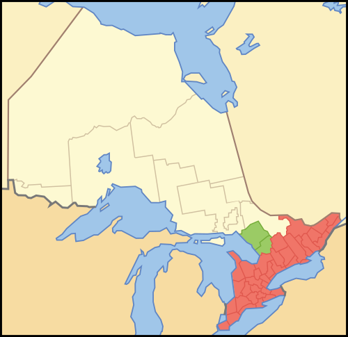
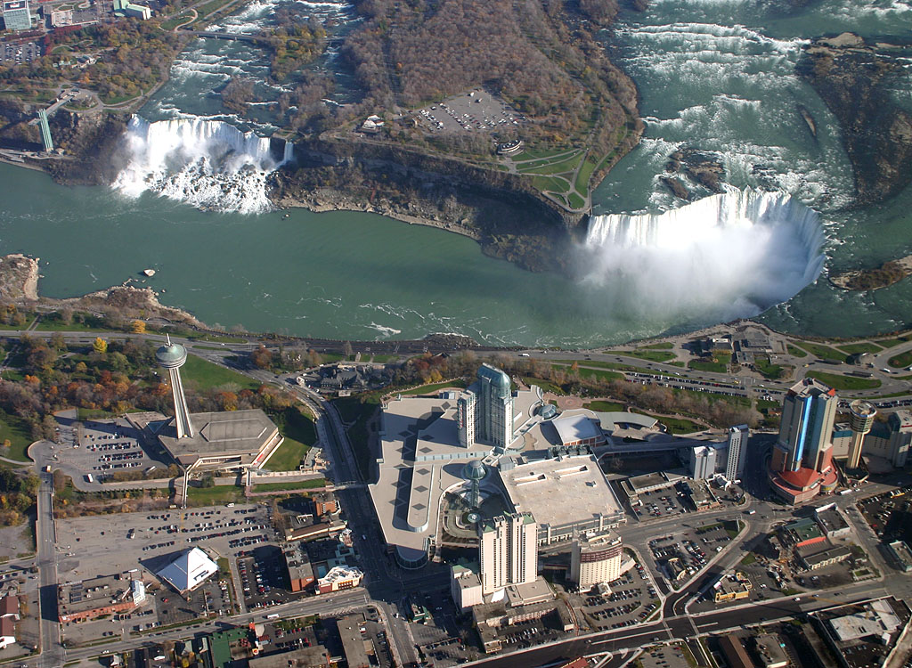
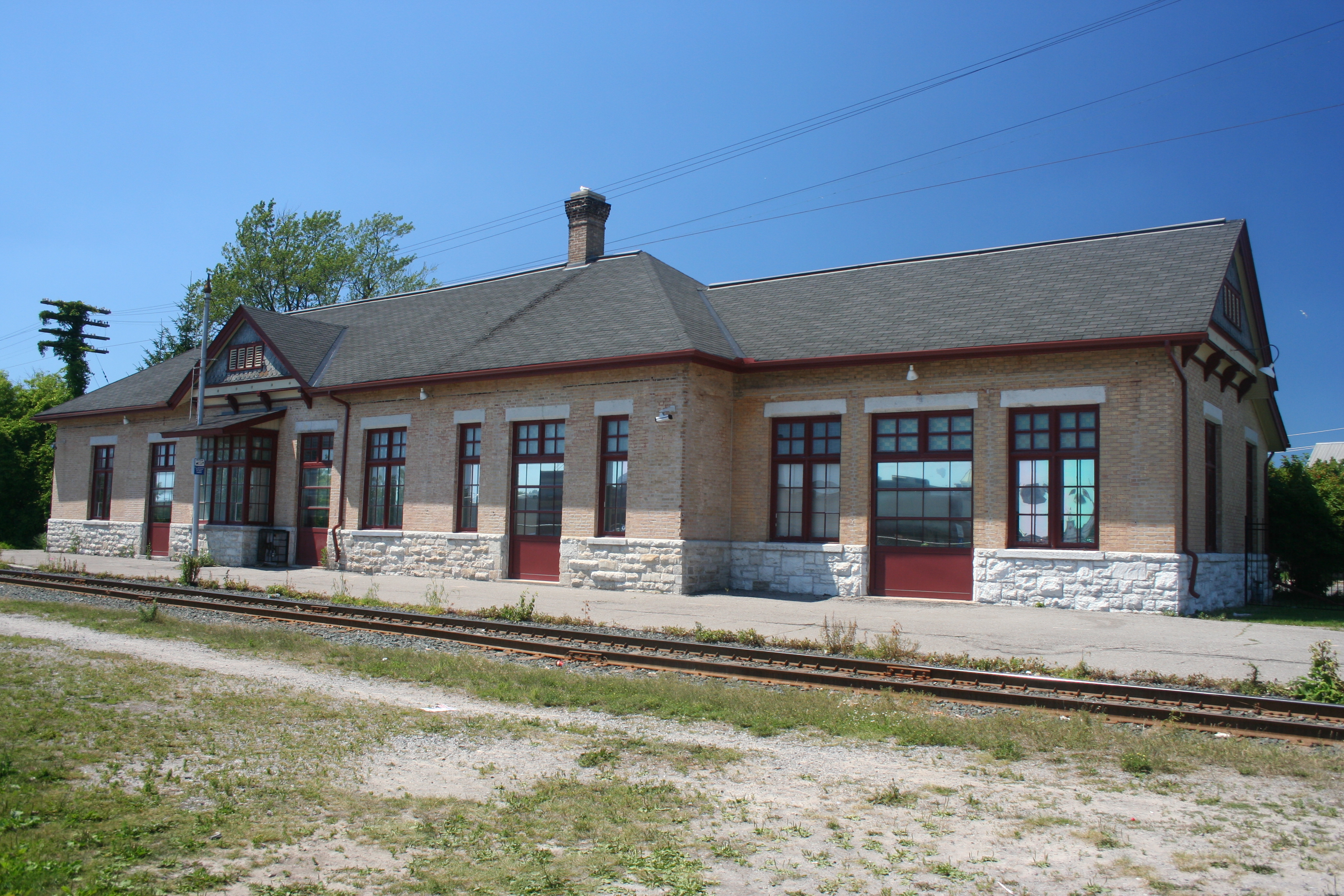
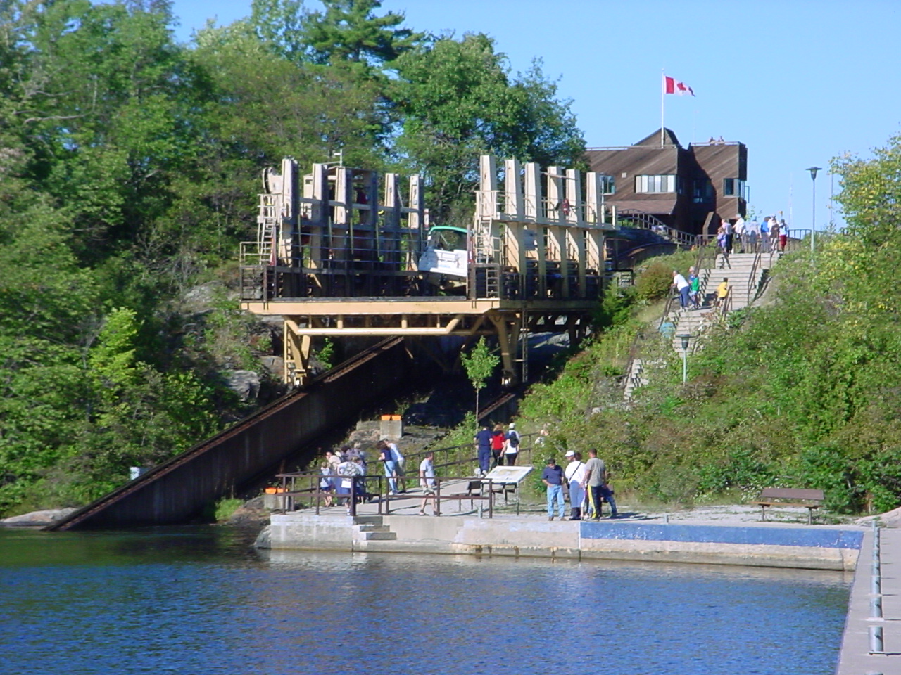
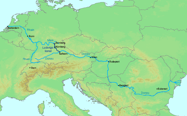
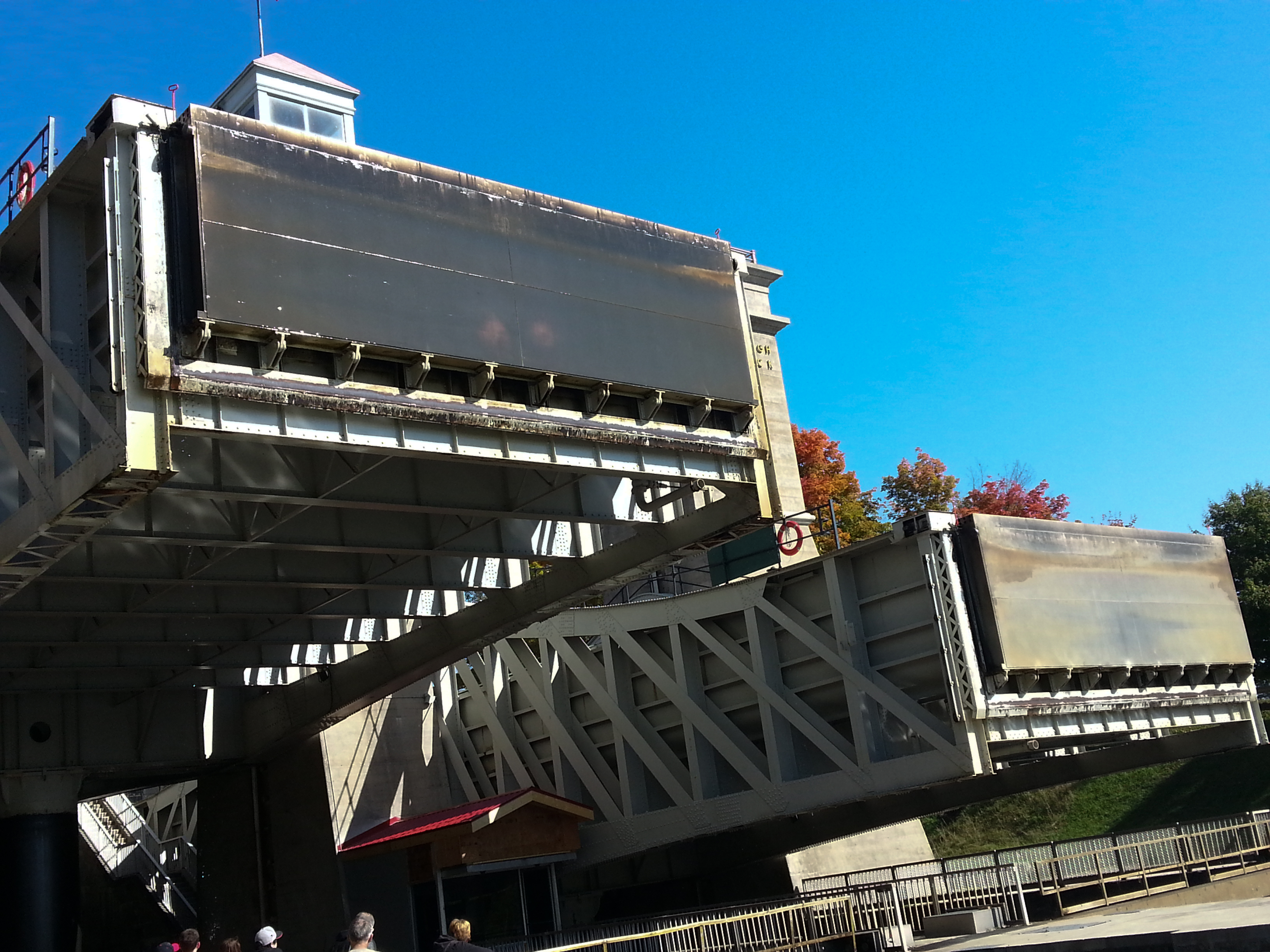