|
Reflections 2021
Series 10
December 4
Swiss Gauges - 2008 Swiss Rail Visit I:
Luzern/Rigi/Pilatus - Meiringen/Holmes - Interlaken/Jungfrau
| | Swiss Gauges We had decided that, in Europe at least, conflicts (disruptive breaks of gauge) mainly arose between broad and standard gauges, notably connecting standard-gauge Europe with Iberian gauge in the west and Russian gauge in the east. We found very little narrow gauge track in Europe. In Spain it was primarily across the north, where it had no conflict with broad gauge and where standard gauge didn't exist. That leaves us with Switzerland, which abounds in narrow gauge routes, since they are more compatible with mountainous terrain where narrow turns are important. | | | | Swiss Standard Gauge We can see gauges easily in this map of the Swiss Rail System (Map by Pechristener, Plutowiki). We'll refer back to this as the "network map". First of all, disregard the few tiny green routes along some borders. They are standard gauge, but that trackage belongs to neighboring countries. | | | | | | We shouldn't forget that we just talked in 2021/6 about the VSOE crossing northern Switzerland during our 2002 trip. It was overnight, but I'm sure the VSOE entered Switzerland at Basel, on one of the green French routes entering Switzerland at the border. Everyone was asleep when we cut over to Zürich, and we must have gone along the shore of the Zürichsee (Lake Zürich—not named). You may want to refer to the Seat61 map in that posting to confirm that the Arlberg route continued to an intersection near the border at Sargans (not named here), where we turned north a short distance to Buchs. Buchs being a terminal station, we reversed direction before crossing (green line) across northern Lichtenstein and into Austria. The entire route we crossed then in Switzerland was of course standard gauge, and it all belonged to the SBB, the Swiss Federal Railways. |
| | | | Our interest lies in the narrow-gauge lines in red, and the further south you look—into the highest Alps—the more red you see. While no note is made as to who owns which ones, they're all privately owned. They come to about a large 25% of all Swiss rail routes. We'll get to them shortly.
The rest of the lines, about 75%, are all standard-gauge. Those in black belong to the Swiss Federal Railroads and those in blue belong to two private Swiss companies, as follows.
1) SBB is the catch-all for Schweizerische Bundesbahnen, a name that also appears as CFF, Chemins de fer fédéraux [suisses], and FFS, Ferrovie federali svizzere. All of that refers to the Swiss Federal Railroads, but this being Switzerland, everything is done in German, French, and Italian (at least). Even in marketing, all three acronyms are used: SBB CFF FFS. The SBB was formed in 1902 when the Federal government took control of the five big Swiss standard-gauge railways, which had been competing against each other rather than improving national service. (I ponder why no narrow-gauge ones were included.) Of the 75% of the lines that are standard gauge, the SBB has 84.5% of the trackage (Map by Pechristener). This map showing just these SBB routes (click) shows to what little extent standard gauge ventures into the high Alps. In the west, we see the route to Italy via the Simplon Tunnel (not named) that we've discussed already, and in the east is the route over the Saint Gotthard Pass (not named), then via Lugano, that we'll discuss later.
2) BLS stands for Bern-Lötschberg-Simplon, which is actually the old name, since in 2006 it went thru its newest merger making it BLS AG (AG=INC). It wasn't founded until 1913, so it escaped being taken over at the time of the 1902 government acquiring of other standard-gauge railroads. Thus it's considered the largest of the Swiss "private" railways. But that's still misleading, since even when known as the BLS AG, the canton of Bern owns 55.8%, the Swiss Confederation owns 21.7%, and some other cantons—plus private individuals--own the remaining 22.5%, so there's far more government ownership than meets the eye. On this map, the blue lines were the original BLS and the red lines were of the company that merged with it in 2006 to form BLS AG (Map by Tobias b köhler). If you follow all the "ex-" notations, you can see what smaller railroads had been merged into each of these earlier. This is an excellent illustration of how railroads grow. We'll repeat this map when we talk more about MOB at Zweisimmen later. Of the 75% of Swiss rails that are standard gauge, BLS is second, but it covers only 11.6% of the trackage.
3) SOB is the Südostbahn (Southeast RR). It's the tiniest of these three and operates a mere 3.9% of the standard-gauge trackage. Private? Not exactly, since it's jointly owned by cantonal and federal governments.
https://www.sob.ch/fileadmin/_processed_/5/3/csm_Liniennetzplan_SOB_2021_WEB_16217606_343d24391e.jpg
Despite its name including a reference to "southeast", this map (click) shows that the SOB operates in northeastern Switzerland, with Sankt Gallen as its hub. It notably runs the Voralpen Express (Pre-Alpine Express) from Sankt Gallen all the way to Luzern, a name that indicates that its region is not exactly in the high Alps. Also of interest is its S4 route in red, a circle route that runs along the Bodensee / Lake Constance, then along the Austrian and Lichtenstein borders (none named on map, but we see Buchs, plus the above-mentioned Sargans). [English speakers giggled in the last posting at the acronym MOB, but the acronym SOB is much funnier.]
| | | | Swiss Narrow Gauge We know that narrow (metric) gauge in Europe runs across northern Spain—where it fits in nicely—and extensively in Switzerland. Our need is to see how well narrow in Switzerland blends in with standard, or if disruptive breaks of gauge as in Zweisimmen are common. We saw on the earlier map that narrow gauge railroads are all over the country, but are concentrated in the more mountainous south, the high Alps. But then we come across an unusual fact about Swiss rail: there is a total of 74 railway companies in Switzerland! With all the merging that's taken place over the last century and a half (in all countries) Switzerland has maintained a (typically) stubborn sense of individuality, continuing to have numerous small narrow-gauge companies. We'll mention just a few now as a sampling to illustrate, but get into it more deeply when we take a rail tour of Switzerland right after that.
In the last posting we mentioned the Rhätische Bahn (RhB) in the east because of its name (Map by NJ Giggie). You'll see later how we'll use it coming in from the east via Disentis to visit Sankt Moritz, then continue on to Tirano in the Veltlin. At 366 km (227 mi), it's the longest narrow-gauge railway in the country. Still, it's not huge, but it is an indication of how piecemeal the situation is. But is that a good or bad thing?
The Matterhorn Gotthard Bahn (MGB) in the west is 144 km (89.5 mi) long (Map by Arbalete). We'll use it to go from Zermatt via Disentis to Sankt Moritz. There's no change at Disentis, since the Glacier Express runs across Switzerland using the MGB in the west and the RhB in the east, which is an indication of how these small-sized, narrow-gauge railroads cooperate.
The Glacier Express is a famous train running on two railroads. The Golden Pass Route is one that runs on three railroads. However, the middle one of the three is standard gauge—so how does that work? We'll see later.
The numerous other narrow gauge railroads, including the MOB, start at about half the length of the MGB and some are tinier than that, but as we see, they cooperate among each other. We'll mention the ones we traveled on in 2008 as we review that rail trip below.
The two most famous Swiss mountains each have narrow-gauge rail access, making each an easy day trip. The Jungfrau is reached out of Interlaken by three narrow-gauge short lines--two of them cog (rack) railroads--so you change twice going and again coming back. But this is Switzerland and these changes are easy and smooth as silk. The Matterhorn is viewed from the Gornergrat (Gorner Ridge), which is reached by the Gornergratbahn, a cog railway out of Zermatt that's only 9 km (5.6 mi) long, a typical length for these narrow-gauge short lines.
This selective summary is given to illustrate the variety of very short private narrow-gauge lines. Most narrow-gauge lines have at least one interchange station with the standard gauge SBB or BLS. The entire Swiss rail system is 100% electrified, with the exception of some small heritage steam lines. The system is also noted for being on time, and for its coordination between its own services and additional integration with the lake steamer and Post Bus systems. All this leads to the fact that, despite the Alps covering about 60% of Switzerland, the Swiss rail network is the most dense in the world (except for tiny countries and city-states). In other words, you can go most anywhere by public transportation, an ability that was lost in many countries in the mid- to late 20C. We'll be seeing how that all works.
| | | | Basis for 2008 Visit Switzerland being in the center of Western Europe, I've been there a number of times, either to see Switzerland or as an extension of a visit to Germany or France. I got to know it well early on—when my friend and I went to Europe in 1957, based on his previous experience with his parents, we made Interlaken the center of our time in Switzerland. But now we're talking specifically about my rail tour of Switzerland's most interesting routes in 2008.
It's rather odd how it came about. In 2008, I set up and executed a seven-week southern Africa & Switzerland trip. That's an odd combination, and I just now had to review just how Switzerland got added, but now I recall. I had been very lucky when, in 2002, the crossing on the QE2 meshed so well with the VSOE trip, with only one overnight in London, but this trip had additional set schedules to mesh together. First, I had long planned the rail trip in southern Africa, where I had to blend the schedules of the Blue Train with Rovos Rail, which I managed to do. In addition, I definitely wanted to come home on the QM2, not out of the usual Southampton, but specifically out of Hamburg, a combination I'd never done before. However, these schedules did not mesh at all. This is how I got it to all work out. For details on the Africa part of the trip, see 2008/9-10-11-12.
On June 20, I flew to Johannesburg to see Pretoria, and took the Blue Train south to Cape Town, which I visited for a few days. I then took the Rovos Rail trip to Dar-es-Salaam, and I'd been very lucky to have been able to coordinate those two train trips, neither of which left all that frequently. But ideal coordination would have been, at the end of the Rovos trip, to fly from Dar to Hamburg and board the QM2 directly, but the ship didn't sail that often from Hamburg, which was the whole point. So I could have flown to Hamburg and then killed a lot of time. But as part of the 2006 Scandinavia trip two years earlier, I had sailed on the Finnmaid (Voyage 38 in 2013/7) from Helsinki to Travemünde, stayed in Hamburg, and revisited Lübeck, Berlin, and Bremen. I love the area, but I didn't need to see it again so soon. So where else could I kill twelve nights between Dar and Hamburg? How about a rail trip thru Switzerland, revisiting old sites and seeing new ones? And that's how Switzerland got sandwiched in between Africa and the QM2 out of Hamburg. Tho I did it to bide my time, it was as stupendous a visit as any other part of that summer.
Coming back from Africa, I flew from Dar to Zürich overnight on 18 July. I then did my carefully planned eleven night rail trip around Switzerland back to Zürich, as described below. The night of my last Swiss day, the 29th, I took the CityNightLine from Zürich to Hamburg; that morning I seamlessly connected to the QM2 and sailed via the English Channel for New York, arriving at the Brooklyn Passenger Ship Terminal on 7 August to complete the seven-week trip.
| | | | | | As I was boarding the QM2 in Hamburg, I met Paul and Marya, also coming back home to the US, and we've been friends ever since. They are also frequent travelers to Europe, particularly Switzerland, but that departure was the only time we were all in Europe at the same time. I can always get Paul to laugh when I paraphrase Bogie in "Casablanca" by saying "We'll always have Hamburg!" |
| | | | You'll find that 2008/13 is an introduction to Switzerland, but now I much prefer the similar one I just wrote in the last posting, 2021/9. Other than that, the original description of my Swiss trip up to taking the overnight train to Hamburg can be found in 2008/14-15-16. But as I review those postings, I find some problems. 2008 was still among the early years when I didn't yet have a source for pictures, nor one for maps. I only could add YouTube videos, some of which whose links no longer work. I can do much better now, and even if you remember reading about the trip in 2008, I much prefer this version, which also has additional information.
The main purpose of this posting is to show how well rail transportation works in Switzerland, and how it couples with lake steamers, Post Buses, even bicycles. But while doing that, I'm going to retell the highlights of what I saw on that trip, but now much better illustrated and mapped out, as tho we were all taking the train trip together. I prefer a lot of what I'm saying now, even as perceived thru the mists of time.
I have to say first, tho, that a number of things made this Swiss trip work exceptionally well, fitting in so very much in only a dozen days.
• I planned it very carefully, deciding where I wanted to visit again, and what new places I wanted to see, including what special rail and other connections fit best. All connections were day trips—Switzerland is a very small country. And the connections work like a Swiss watch.
• I was SO glad I'd planned on repacking. I travel very light, with only a mid-sized roller bag. But I know things that I needed in Africa, and dress-up things I'd need on the ship, were more than I wanted to schlep around Switzerland with me. So I'd packed a collapsed small bag in my roller bag. Arriving from the airport at Zürich's Hauptbahnhof (Main Station) I went to the waiting room and repacked essentials in my small bag, then checked my roller bag for twelve days in the baggage room. It worked perfectly, and made movement so easy.
• I booked seven attractive hotels amazingly close to the rail stations, to save time coming and going.
• I bought the wonderful Swiss Travel Pass that covers ALL transportation (for outsiders). It covers consecutive travel days of varying length. I believe I must have taken the 15-day one to cover my 12 days "wall-to-wall". It gives unlimited coverage of all rail, bus, boat, and urban transport, plus over 500 museums. Some special connections not included are discounted up to half. A few connections required a reservation, which I took care of online before leaving home.
I'll add that, while I have a very clear memory of what happened on that trip, it has been 13 years, and I did find myself reviewing minor, but interesting details in the 2008 travel diary that I'd totally forgotten. Also, to my surprise, I found that there were details in my website postings for that trip that had additional information that hadn't even made it to the diary. I'm now ready to proceed.
| | | | 2008 Swiss Rail Visit I had assembled my dozen days based on research on important rail lines I wanted to take, connecting my destinations. But now I find the below map, that duplicates my route! We'll call it the "route map".
https://www.mystsnet.com/wp-content/uploads/2018/07/Grand-Train-Tour-of-Switzerland-Map-2017.jpg
Well, almost. My route went south from the starting point, Zürich Flughafen (Airport), since I wanted to cross the Swiss Plateau to visit the Alps (again, you'll notice the SW-NE tilt of the Plateau and Alps). I had no reason to take the Voralpen-Express (in red) that runs for 2h15 from Sankt Gallen to Luzern (Voralpen is "pre-alpine", so the name alone says it wasn't the area of interest for this trip). I had been to Schaffhausen (green connection) and along the Bodensee (not named) by car, so ditto. Actually, at the very END of this trip, the overnight train went from Zürich to Schaffhausen and beyond to Hamburg, so I did travel this route, altho in the mid-evening. Thus on this trip, just follow from Zürich to the south. My rail routes formed a counterclockwise circle in the west, followed by a clockwise circle in the east. It was a lazy-8 infinity sign!
| | | | 1) LUZERN It was July 2008 and on the 19th, I flew in from Dar quite early and in very clear weather, saw the Alps below. I usually do surface travel, so I'm sure it was the only time I overflew the Alps and saw them from above. On arrival, I had to validate my Swiss Pass at the rail desk before use, and then used it immediately to come in from the airport to the Hauptbahnhof in Zürich. In the waiting room I repacked, checked the larger bag, and in no time was on my second train of the day (orange on the map) to Luzern (lu.TSERN, rhymes with "cairn", = Lucerne). Both trains so far were standard gauge.
https://i.pinimg.com/originals/70/4c/1b/704c1b3df15a898d213d3d51709c0fa7.jpg
In my mind's eye, what I did in Luzern took a couple of days, but the diary reminds me I'm mistaken. I took suburban side trips to two mountains, in the morning to the Rigi, then in the afternoon to the Pilatus, and revisited the Old Town of Luzern in the early evening. Thus I had planned just one overnight at what my diary tells me is the Waldstätter Hof, just to the left of the station in Zentralstrasse south of Pilatusstrasse. Everything I needed was so close, almost like being in the room!
The route map shows both the Rigi and Pilatus, and the connection to the Rigi was—believe it or not—rail 'n' sail! Across from the station are the Landungsbrücken / Landing Docks for boats on the Vierwaldstättersee. So it wasn't a matter of break-of-gauge, but changing modes.
http://www.martynbane.co.uk/images/alsacelorraine/Rigi/HiResMap.jpg
This view showing the Rigi (G as in "go", otherwise like "Fifi") looks west, back to Luzern. The steamer passes Weggis where a gondola cable car also goes up the mountain and we arrive in Vitznau (rhymes with "[it] fits now"). There we change to the Rigibahn (in red) which takes us up to Rigi Kulm / Rigi Summit (think "culmination") at a maximum grade of 25%. While the whole system is electrified and extremely modern, on special occasions there are two heritage steam engines that are used (Photo by Kabelleger). Still, the steep grade is noticed, as is the view over the Vierwaldstättersee back to Luzern. And the mountain behind the smoke is our next stop, the Pilatus. This is what I mean when I say these two mountains are in the suburbs of Luzern.
The Rigibahn is the oldest mountain railway in Switzerland (1871) and the first in Europe. The oldest in the world is the 1869 Mount Washington Cog Railway in NH (2006/12). Many people vacation on the Rigi at the hotel there, and enjoy watching the sunrise in the distance. Among them were Brahms, Goethe, Victor Hugo, and Mark Twain.
| | | | | | This is the view from Rigi Kulm at dawn across much of Switzerland to the Gotthardmassiv, which we'll cross later by rail (Photo by Stefan K-50678). I was there in the late morning. At dawn I would have still been in the plane from Africa, but seeing a similar view from above. At this point, picture the gentle opening notes of five cellos of Dawn from the William Tell Overture. |
| | | | The name Rigi derives from the Latin (and Italian) word riga, which refers to a line or crease, and some rocks here are striped or layered. The same root appears in "rigatoni" and "penne rigate". In 1875, another mountain railway (in blue) was built on the north side, from Arth (ART), the Arth-Rigibahn. Later, the last section to Arth was removed, and it now terminates in the Arth suburb of Arth-Goldau, at the regular rail station (see Rigi map). Unexpectedly for mountain railways, both cog railways on the Rigi are standard gauge, making them the highest standard gauge railways in Europe (1,752 m [5,748 ft]). So I returned down the north side and took the train back around the Rigi to Luzern, returning by midday. As the route map shows, coming back from the Rigi by rail covers part of the pink route, tho not the special express. See 2008/14 for videos of Rigi travel and views.
https://travelingcanucks.com/wp-content/uploads/2012/12/Gold_Rundfahrt-2011-1_0.jpg
In Luzern I connected easily right at the station to the narrow-gauge Zentralbahn (more about that tomorrow) for the quick trip to Alpnachstad to ascend the Pilatus (pi.LAH.tus). It's also possible by boat, but takes longer. The connection to the Pilatusbahn from my train--or the boat—was adjacent. German uses the full name Pontius Pilatus for the biblical figure instead of Pontius Pilate, and the mountain, which hovers forbiddingly over Luzern, was believed to have been haunted by him, hence the name.
You'll have to read my description of the breathtaking ascent on the Pilatusbahn in 2008/14 to really understand how thrilling it was, but I'll condense it here. It's the steepest cog railway in the world, with an average grade of 35%, but climbing at a maximum grade of an incredible 48%--and remember that 45% is halfway to being vertical. My reaction was that it was a hybrid. Most cog railways use regular rail cars. A funicular, however, uses a stepped car, so that passengers stand on a staircase-like platform to enter the car at various levels. I call the Pilatusbahn a seeming hybrid because it's NOT a funicular pulled by a cable but a regular train, yet its route is so steep that it actually uses stepped cars! (Photo by Maria Feofilova). This is the Alpnachstad station (Photo by Alpöhi). Click to inspect the highly inclined stepped platform behind it. Emotionally, it gave the feeling of climbing almost vertically, like a fly up a wall.
It ascends 4.6 km (2.9 mi) on an extra-narrow gauge. Instead of the usual meter gauge, it was only 80% of that, at 800 mm (2.6 ft). Its 1889 technology is fantastic. We've discussed cog (or rack) railways before, where we saw this animation showing a rack studded with cogs lying between the tracks, and a cogged wheel in the train "climbing" up the rack, but just where needed—racks are not necessarily continuous along a route. But that type of rack wouldn't be sufficient for the extra-steep Pilatusbahn, so an engineer named Locher devised the Locher system, a two-wheel horizontal cog system (Photo by Roland Zumbühl). The rack has two rows of cogs, one on each side, and two horizontal cogwheels grip the rack apparently quite ferociously. The stepped Pilatus Kulm station is shared with the cable car shown on the map. At the top there are two hotels, and three peaks you can walk to, eventually getting close to a 360° view of Luzern, the Rigi, and the lakes and Alps in the distance.
The round-trip ticket could be used to back-track, but why not take the cable cars down? And yes, that's plural, there are two, and they are of two kinds. The upper one is a huge gondola car holding about 40 people standing. At an intermediate station, you get off and cross the platform to a smaller-style car that seats four people each, which brings you to the suburb of Kriens, in the middle of nowhere. But there are instructions to walk about eight minutes to city bus #1 for a 15-minute ride to the Hauptbahnhof—where else in highly coordinated Switzerland? Some might pay for the bus, but my Swiss Pass covered urban transport.
It was late afternoon, but there was time to revisit a couple of special sights in Luzern. On the map, take the short walk across the river, up the appropriately named Löwenstrasse and Denkmalstrasse to the Löwendenkmal / Lion Monument. We've spoken about the Swiss Guards at the Vatican, but they were used elsewhere as well, notably in Paris guarding the royal family at the time of the French Revolution. About 760 Swiss Guards were massacred at the Tuileries Palace in 1792, and about 200 more died in prison afterward. The commemorative monument in the form of a rock relief was carved into a cliff face out of the living rock in 1820-1821, and is one of the most famous monuments in Switzerland (Photo by Andrew Bossi). It's about 10 meters/yards long and six high. The dying lion is portrayed impaled by a spear, still protecting the fleur-de-lis of the French monarchy, next to the Swiss coat of arms (Photo by Andrew Shiva/Wikipedia /CC BY-SA 4.0).
Back in the center of the Altstadt (Old Town), I strolled past historic squares and buildings, and ended up again at the Reuss (ROISS). It can be seen that two historic bridges of note cross it, both wooden and roofed over, and my walk took me in a loop across both. The further one is the Spreuerbrücke (1408), in the middle of which is a tiny chapel (1568). Spreu (ShPROI) is chaff, the husks of cereal grains left after threshing, so a Spreuer would be someone handling chaff. The bridge got its name because it was downstream: it was originally the only bridge in town where it was allowed to dump chaff (and leaves) into the river, where it would float away from town. After a walk along the south bank, I returned via the longer, and more famous, Kapellbrücke / Chapel Bridge, built in 1333 and named after St Peter's Chapel at its north end (see map) (Both bridge photos by Ermell). It's the oldest covered bridge in Europe, tho much had to be replaced after a 1993 fire caused by a cigarette. It’s longer, since it, oddly, crosses the Reuss at a very steep angle. Attached to its center (click) is the octagonal stone Wasserturm / Water Tower, a 12C fortification. The tower predates the bridge by about 30 years, so one wonders if the bridge's odd shape was caused by trying to include the tower in its route. This bridge serves as the symbol of Luzern.
Right off the Kapellbrücke and back on the north bank, I had dinner at an outdoor café. The scene was idyllic. Behind me, in the distance, was the Rigi. The Reuss and the Kapellbrücke were to my left, and seemingly right behind them loomed the Pilatus. In addition, altho it was already twilight, the top of the Pilatus was surrounded by alpenglow, since it was tall enough to catch the remaining rays of the sun that had already set.
I've written about Rösti and Bündnerfleisch. Now I'll talk about my favorite, Zürcher Geschnetzeltes (Photo by Benreis). It's finely minced (cut-up) veal cutlets in a creamy white-wine sauce with mushrooms and onions, Zürich style, served here with Rösti, which is a common pairing. The second word looks more formidable than it is. You know that a (Wiener) Schnitzel is a (breaded veal) cutlet. Change the I to E and you see it in Geschnetzeltes, literally "schnitzled things" or "cut-up things". The name outside of German Switzerland will often appear in French as émincé de veau à la zurichoise. I had this dish for a total of four times during this trip, the last time being, quite evocatively, for dinner in the dining car of the train leaving Zürich for Hamburg.
https://cdn.happyrail.com/uploads/landingpage_block_images/schermafdruk_2016_12_14_20_36_36.png
The next day was the 20th and I was ready to start the Golden Pass Route, shown in gold on the route map as well on the above detail map. It's not one train—oddly, it's three, on three different lines. It goes from Luzern to Interlaken on a narrow gauge route, the Zentralbahn (zb), thence to Zweisimmen on a standard gauge route (part of the BLS—see above) , thence to Montreux on narrow gauge again on the MOB.
So we start in Luzern on the Zentralbahn, the beginning of which duplicates the trip yesterday to the Pilatusbahn. The zb has an odd story. Swiss Federal Railways (SBB) today has only standard-gauge routes, but up until recently, it had one single narrow-gauge route, the Brünigbahn that went over Brünig Pass between Luzern and Interlaken. You may remember I pointed out Brünig Pass in the last posting when we were indicating various mountain passes during the history discussion. The Brünigbahn opened in stages between 1888 and 1916, and was, between 1903 and a very recent 2004, the only narrow gauge line of the Swiss Federal Railways. It wanted to divest itself of the line, which was also a cog railway, so it made a deal with a tiny neighboring company that was also a narrow-gauge cog railway, and as of 2005, the new Zentralbahn had two routes.
http://blog-imgs-75.fc2.com/c/h/i/chizumania/ZentralB.jpg
Click on Luzern, and you can see what we did yesterday afternoon on this line. You see how we took it to Alpnachstad, then the Pilatusbahn to Pilatus Kulm, then the two cable cars to Kriens. But south of that it splits like a wishbone. Disregard the branch on the right, since the Brünigbahn, running for 74 km (46 mi) over the pass to Interlaken, is the main route. Both the main line and the branch use cog railway technology to climb and descend their steepest gradients, although most of both lines uses conventional adhesion. This is a zb Golden Pass train climbing to the Brünig Pass summit on a cog (rack) section of the line on the south side—explained below (Photo by Kabelleger). The summit station in the pass is at Brünig-Hasliberg (Graph by Chivk), and this graph shows altitudes in meters and distances on the Brünig line in kilometers. Then the map shows that there's a sharp switchback over to Meiringen, where the train changes direction. It then continues along the Aare to the north shore of one of Interlaken's two lakes, the Brienzersee, and ends at Interlaken Ost. Interlaken has two stations, Ost and West; Ost is the primary one. However, the Brünigbahn route is the only one we'll interrupt, then continue with the next day, because I'd never been to Meiringen, and was deeply interested.
| | | | | | I have one more bird's-eye view of the Brünigbahn area.
https://i1.wp.com/www.transitmap.net/wp-content/uploads/2012/11/tumblr_md6wlwjuot1r54c4oo1_1280.jpg?fit=1200%2C785&ssl=1
Switzerland loves to issue mountain maps—they have so many mountains, and it does make things clearer. But this is turned around, with north—Luzern--at the bottom. Again we see Alpnachstad-Pilatus-Kriens. The branch line goes to the left and we continue to Brünig-Hasliberg at the summit. My understanding is that the cog and rack isn't needed on the north side, but desperately has to kick in on the south side going to Meiringen, which probably explains the sudden zig-zag. It's a sudden drop on the south side from the summit at 1,008 m (3,307 ft) to Meiringen at 595 m (1,952 ft) on the valley floor, which is a drop of 413 m (1,355 ft). On the above graph, I take that to be a distance of only 5.5 km (3.4 mi). While most of the simple adhesion traction sections of the line have a maximum gradient of only 3%, the gradient at this point reaches 12%, thus the use of the cogwheel track. Then comes the Aare valley to the Brienzersee to Interlaken Ost.
|
| | | | 2) MEIRINGEN I'd never been to Meiringen before (stress the first syllable, which rhymes with "my") and was looking forward to seeing it. Some readers of classic detective fiction might recognize the name, but probably not. It's when I say that, on the edge of Meiringen are the Reichenbachfälle / Reichenbach Falls that the light will turn on for those readers, who will remember that that's where Sherlock Holmes was "killed off" by Arthur Conan Doyle. And Meiringen has reveled in that connection ever since. Check out both rail maps we've just seen, the zb and the bird's eye view, and each mentions the falls. The falls are nice to see, but there are other waterfalls. Only this one has the Holmes connection, which, frankly, tho it's a pleasant town, is the only reason I wanted to visit Meiringen.
The Sherlock Holmes stories written, not by later authors, but by Conan Doyle himself ("the Canon", all of which I've read), come to four novels interspersed with 56 short stories. (It's also a known fact that nowhere in the Canon did Holmes ever say "Elementary, my dear Watson".) But, just like what we mentioned about Agatha Christie's stories, everything in the Canon started out being serialized in magazines. Sherlock Holmes first appeared as a fictional character in "A Study in Scarlet", published in Beeton's Christmas Annual magazine in 1887, as seen in this cover illustration. In 1890, he used Lippencott's magazine for his second serialized novel. Both of these were moderately well received, but not spectacularly. Then in January 1891, the monthly Strand Magazine was founded, just off The Strand in London and named for that street, and Conan Doyle used it consistently for the rest of the Canon, up to its end in 1927. After serialization, the four novels were published in hardcover and the short stories were published in five hardcover collections.
The popularity of the Holmes character really took off domestically and internationally when Conan Doyle shifted to the new Strand magazine for the publication of an early series of twelve short stories for the year running from July 1891 to June 1892, later appearing in book form in 1892 as The Adventures of Sherlock Holmes. Right after that, 12 more stories appeared in the Strand for the year from December 1892 to December 1893, which then appeared in book form in 1894 as The Memoirs of Sherlock Holmes. Note how its cover pays homage to the Strand magazine as the actual source.
The popularity of the character was phenomenal, both domestically and internationally. For instance, the two British fictional Victorians who were so popular that they left a creative and cultural legacy in Japan in the late 19C are Sherlock Holmes and Alice [in Wonderland]. Apparently, Conan Doyle didn't fully realize the popularity of the character he'd created.
The first series of Holmes stories ended in the early 1890s because Conan Doyle had decided he was tired of the character and wanted the stories to end. Therefore, in the last story of that second dozen, called The Final Problem, he killed off Sherlock Holmes. It appeared in this December 1893 issue of The Strand magazine, tho the story was set in 1891, a point significant in this history.
| | | | | | Two comments about covers of The Strand Magazine. Almost all issues I've found online show numerous variations of this eastward view down the Strand, the iconic London street. The famous Savoy Hotel would be to the right of this view. Secondly, the Holmes stories were so important, that most issues had at least a mention of it, and more likely a large inset picture of Holmes or Conan Doyle. |
| | | | In the late 19C, a number of towns in Switzerland were very popular destinations for British vacationers. Meiringen was known for its waterfall, and in that same year of 1893 when he wrote that last story, Conan Doyle took his tubercular wife to Switzerland and they discovered Meiringen, which fired his imagination. He wrote in his diary, which still exists, that he'd have Holmes die at the waterfall. He has Holmes and Watson travel to several locations in Switzerland (as shown on a map in the museum in Meiringen), in pursuit of his archenemy, Professor Moriarty, who was first introduced in this short story. Holmes meets Moriarty on a path up near the top of Reichenbach Falls, they struggle, and both fall into the abyss below to their deaths. (As it turns out, to the death of one of them, anyway.) | | | | | | This illustration, one of the most famous of the series, was, as you can see (click) done by Sidney Paget in 1893, and appeared in the Strand Magazine that December along with The Final Problem. Paget was an illustrator known for his Holmes illustrations, whose services Conan Doyle used as often as possible. Paget illustrated one Holmes novel and 37 Holmes short stories and Paget's influence affected interpretations of Holmes ever since. As the Strand became one of Britain's most famous fiction magazines with the Holmes stories its most popular feature, Paget's illustrations became larger and more elaborate. The deerstalker cap and Inverness cape were never mentioned in the stories, but were an invention of Paget. (Someone else later popularized the curved pipe.) In total, Paget did 356 published drawings for the Sherlock Holmes series. These became iconic, and others felt compelled to imitate the Paget drawings. A complete set of The Strand issues featuring the illustrated Holmes stories is among the rarest and most expensive collector's items. Look again at the above Paget illustration. The original drawing was sold in 2004 at Sotheby's in New York for $220,800. |
| | | | Conan Doyle's own mother, who was an enthusiastic reader of the stories, had tried to stop him in this plan, but to no avail. After the story was published, he wrote in his diary "killed Holmes". He also expressed that "my literary energies should not be directed too much into one channel". He felt he was being distracted from more serious literary efforts and he wrote to his mother "I must save my mind for better things, even if it means I must bury my pocketbook with him". Three years later, he defended his decision by saying "If I had not killed him, he certainly would have killed me".
But the public reaction did hugely surprise him as it was different to anything previously seen for fictional events. Conan Doyle himself received many protest letters, and distressed readers wrote letters to The Strand, which suffered a serious financial setback when 20,000 people cancelled their subscriptions in protest.
Because of the intense public pressure for more Holmes stories, in 1901, ten years after the "death" that was set in 1891, Conan Doyle revived Holmes in the novel The Hound of the Baskervilles. But the device he used was that the novel was a prequel to the Meiringen event, so it made sense. This is a copy of the cover of The Strand magazine of August 1901 where the novel started its serialization before coming out in hardcover. The revival was of sufficient importance that a special broadsheet was used to announce the reappearance.
Then in 1903, twelve years after the abyss, he revived Holmes definitively in the first of 13 stories in the Strand magazine called The Adventure of the Empty House. Holmes just suddenly reappears and explains to a stunned Watson that he'd won the struggle with Moriarty that had sent only Moriarty into the abyss. He said he'd faked his death to fool his enemies, henchmen of Moriarty, and went "to explore the Himalayas" to avoid those enemies. Actually, this flimsy story did fit the quirky Holmes persona, and didn't bother fans in the least. When the 13 stories went to hardcover, the book was appropriately called The Return of Sherlock Holmes. These stories were set in 1894, leaving the period 1891 to 1894 unexplained. Enthusiasts refer to this period as The Great Hiatus. Conan Doyle then continued to write new stories, one more novel and two collections of short stories. The last Holmes story, The Adventure of Shoscombe Old Place" appeared in April 1927. This cover was typical of most, which blaringly showed Holmes with a blurb about the story superimposed on the usual picture of the Strand in London. Conan Doyle died in 1930.
| | | | Visiting Meiringen It's fun to think that in the 19C, people went to Meiringen to see the waterfall, but starting with the early 20C, people went there for the Holmes connection, then secondarily to see the waterfall, because of his connection. And starting with this trip in the 21C, it was my turn to commune with Sherlock Holmes in Meiringen. The Golden Pass/Brünigbahn train from Luzern arrived promptly—it wasn't that far—and I had the day to see what I wanted. Not only was it very enjoyable, but the town was very compact. In 2008 its population was just 4,489, and is only a couple hundred more now. In Luzern I was easily able to see two mountains and the old town in a single day, but it took several trains, a boat, a funicular, two cable cars, and a city bus. In Meiringen, everything was very reachable on that single day entirely on foot.
https://en.snowell.com/rudenz-32-pollux-sport-map-meiringen_500.png
Excuse the tiny map. The Brünigbahn came down from the Brünig Pass (you see the Brünigstrasse) to the Bahnhof (station). As you see, it's not a terminus, but the Brünigbahn uses it as a terminus by changing direction—a new locomotive would be needed--to take the continuing route to Brienz on the Brienzersee and Interlaken. Now how's this for being compact: I merely walked north across the Bahnhofplatz (not named) to my hotel, located at the purple "i", the Hotel Victoria, a name already referring to Britain, especially since the German spelling would be Viktoria. It was a nice hotel in a surprisingly quite modern style, not the usual traditional Swiss style with geraniums in window boxes. And as soon as I got settled in, I walked east, literally across Almendstrasse, to the park-and-playground compound that lies adjacent to the Holmesiana. The entrance to the compound was from the north, from Bahnhofstrasse (see map), where you get this iconic view (Photo by Yesuitus2001). In the background is the deconsecrated, Gothic-style Anglican church (click) that now contains the Sherlock Holmes museum, and in the foreground is a statue of you-know-who. And I know why it was set up at this southern angle—the mountain in the near distance is where the Reichenbach Falls is (not visible here). If you wish, you can have a seat next to Holmes and consult with him. In any case, remember that this typical image you see is the work of both Conan Doyle and Sidney Paget.
This is a detail of the statue showing angular, chiseled features, unveiled in September 1988 (Photo by Juhanson). I would have considered that to be a rather late date, but it turns out the Meiringen statue of Holmes was the first, and therefore oldest in the world. Yet there are multiple statues of him around the world; I saw a list detailing eight of them. And Meiringen just barely made the record books, because the second oldest statue was unveiled the very next month, in October 1988, in Karuizawa, Japan, northwest of Tokyo (see Japanese enthusiasm above). The third was installed in Edinburgh in 1989, the very next year. Finally, in 1999, one was unveiled in London near the fictional detective's address, 221b Baker Street.
https://cdni.rbth.com/rbthmedia/images/web/en-rbth/images/2014-03/extra/SherlochHolmes-941.jpg
And in 2007, the above dual statue was unveiled in Moscow on the Moscow River near the end of Novy Arbat. The figures of Шерлок Холмс и доктор Ватсон / Sherlok Kholmss i Doktor Vatson are based partially on Sidney Paget, and partially on the Russian actors who portrayed them.
The church had been in reality a small chapel. The museum was officially opened in May 1991 by the youngest daughter of Conan Doyle. It's the second Holmes museum after the one that opened in 1990 at 221b Baker Street in London, one of the most famous addresses in the world. On the main level within all those Gothic-style windows, there is all sorts of memorabilia including his pipe, cap, magnifying glass, and a bust. But the highlight is located in the basement level.
https://jungfrauregion.swiss/fileadmin/haslital/see_do/Sherlock_Holmes_Museum_Meiringen_high_bySherlockHolmesMuseum.jpg
It's a complete recreation of Holmes's study and sitting room at 221b Baker Street, as was described by Conan Doyle and illustrated by Paget in the stories. It's overwhelming enough and has so much detail that it takes quite a while to view and appreciate. There is also a rare and very valuable (as described earlier) complete collection of the monthly Strand magazines. However, I don't remember seeing them. Assuming I did, I didn't appreciate their full significance.
Tho some will surely consider it overkill, the compound with the statue and museum has been named, in English, Conan Doyle Place (Photo by RHaworth), with an street sign in the exact style of a City of Westminster street sign, where Baker Street really is. And since London is divided into 32 boroughs, you'll notice that you're standing in the (fictitious) Borough of Meiringen. Arthur Conan Doyle loved Switzerland, and it apparently loved him back, since he was made an honorary citizen of Meiringen.
Just to the east of the museum at #26, the venerable (1880) Park Hotel du Sauvage is at Bahnhofstrasse 30. I was unaware of it at the time and did not stop off there. No matter. I now know its special claim to fame. It boasts of two things. One is that Conan Doyle and his wife stayed there during that fateful visit in 1893. The other is that Conan Doyle, in the abyss short story, gave the hotel the pseudonym Englischer Hof (English Court) and had Holmes and Watson stay there as well before Holmes went off to meet Moriarty.
https://victorianweb.org/authors/doyle/bio5d.jpg
https://victorianweb.org/authors/doyle/bio5i.jpg
The first link shows the Sauvage. The museum can't be seen, but would be to the right. Read the plaque in the hotel on the second link. Do not be confused by the dates. Remember the 1893 story (and Meiringen visit) was set back two years to 1891, the start of the Great Hiatus. Thus Holmes and Watson would have visited the hotel two years before Conan Doyle did!
Return to our map. Follow the route from Bahnhofstrasse down across the Aare to the neighborhood of Willigen—it's about a 15 minute walk. There you might see a sign like this one (Photo by Juhanson). I understand it's possible to follow the same steeply wooded path (supposedly) taken by Holmes and Moriarty, which is what the footpath sign would be referring to. But, as the map shows, it's not far to the Drahtseilbahn Reichenbachfall. Seil is "cable", so a Seilbahn is a funicular. Draht is "wire", so Drahtseil, "wire cable", is an overkill way of redundantly saying the same thing.
The funicular, included on my Swiss Pass, can simply be called the Reichenbachfallbahn (RfB)—this is the lower station (Photo by Roger W Haworth). It was built in 1899 and rebuilt in 1999, nostalgically to the original, traditional design of two wooden cars seating 24 each (Photo by Andrew Bowden). En route to the upper station and the uppermost falls, it does cross the lower Reichenbach Falls. That's because the falls is really a cascade of seven steps, or seven falls, one below the other, for a total drop of 250 m (820 ft). At the top, is the Grand, or Grosser Reichenbachfall, which, at 110 m (360 ft), is by far the tallest segment (Photo by Audrius Meškauskas) and is one of the highest waterfalls in the Alps. Its height covers about 44% of the entire drop.
Near the upper station are three viewing terraces to see the falls. And of course—of course!—on a ledge along one of the pathways to them is the "site" where Holmes and Moriarty struggled, commemorated by a large white star:
https://i.ytimg.com/vi/CxZWspBXqik/maxresdefault.jpg
The star is here blocked by a memorial bouquet. (!) Right near it is this rather large plaque in three languages (Photo by Juhanson).
https://c1.staticflickr.com/9/8156/7649751242_aa386b9c0b_b.jpg
This is the ledge where the star (partly obscured) and plaque are located with part of the falls in the distance. To compare with the story, we'll reproduce here the Sidney Paget sketch.
I have two short YouTube videos. The first (1:45) shows the quaint funicular ride and falls, but not the ledge. The second (1:47) shows the ledge and view. It starts with the ledge, and at 0:15 looks down on Meiringen, which looks just like our map, with the little bridge over the Aare. After that, the rest is repetitive and skippable.
It had been a wonderful day with beautiful weather, and so I didn't expect one final adventure before dinner. Coming off the Seilbahn and recrossing the Aare (see map), I noticed a large sparsely-settled area to my left, including parkland along the river, so I turned immediately left for a pleasant stroll along the Aare, then zig-zagged over to the hotel (at "i"). The blue sky then began to rapidly darken, and I picked up my pace. The sky got quite gray, and I walked faster still. Were those violins and violas playing tremolo?
https://live.staticflickr.com/1369/4732077597_4bff212e4a_b.jpg
I'm showing the (very modern) Hotel Victoria now because of how this final adventure of the day played out. The wind picked up and I started to run, especially in the very last block or so. I remember those steps at the hotel because I bounded up them to the safety of that large porch area. It was just as I had written in the last posting where the first raindrops start[ed] falling slowly, one after the other, in groups of three—plink, PLONK, plunk—plink, PLONK, plunk--first performed by the piccolo, flute, and oboes, then expanded on by the clarinets and bassoons. And then POW!!! the full strength of the storm hits with the entrance of the French horns, trumpets, trombones, and bass drum.
The plink, plonk hit the porch roof as well as the street as the rain came down in sheets, as I stood on the porch chatting in German with others noting the sudden change in weather. The rain was so heavy that you couldn't see the ex-English church just across the street. If I hadn't hurried those last minutes with no doorways to duck into, I would have been thoroughly soaked thru and thru, just as if I'd fallen into the Aare.
But these intense, sudden summer storms don't last long, and in short order the storm abates, and the number of instruments decreases, as well as the overall volume. Then we're back to a final few rain spatters—plink, PLONK, plunk—plink, PLONK, plunk. The section ends with the flute playing alone for a few notes—perhaps a bird appearing—life renewing--as the sun comes out. That's exactly what happened in Meiringen. I'm sure Rossini must have visited Switzerland in order to have been able to reimagine a sudden Alpine summer storm as well as he did for the second section of the William Tell Overture. He wrote it to apply to William Tell country around the Vierwaldstättersee, but, as I saw, it applied to Meiringen just as well.
Talk about Meiringen being a compact visit—as you saw on the hotel picture, the building includes a popular restaurant as well, so I dined in-house to complete the day. And in the morning—it was the 21st--it was a short walk across the street to complete this Brünigbahn section of the Golden Pass Route to Interlaken, which was just over a half-hour away.
| | | | 2) INTERLAKEN Coming to Interlaken was like coming home. During my first trip in 1957, my friend and I spent several days there as a "vacation" in the middle of all the "traveler time" touring (France, Italy, Austria, Switzerland, Britain). I was later back with Beverly at one time, so this was my third time. Its non-German name had made me wonder. It's a variation of Latin inter lacus with a German –n plural. But why does a Swiss city have an almost-Latin name? Let's start with this map of the area--disregard the orange dots (Map by Sandstein). Prehistorically it had been one long lake, but the middle of it silted up to form the area Interlaken is in now, thus dividing it into two lakes. The train from Meiringen had come along the north shore of the Brienzersee thru Brienz (rhymes with "teents[y]") to Interlaken Ost. Our departure later would take us via Interlaken West along the south shore of the Thunersee, not to Thun (rhymes with [car]toon"), since we'd be turning off to Zweisimmen at Spiez (ShPITS, rhymes with "Pete's").
It's obvious that Interlaken is named because of its location between the lakes, but why in that form? Well, after 64 years, I decided to figure it out. The Latin word inter is related to the German word unter and the English word "under", and the German and English words have the same meaning. But when I recently learned that the former canton of Unterwalden could be translated as "among the forests", I realized that inter also can also mean "among" so that Interlaken is best translated as "among the lakes" (which is the same as between the lakes, anyway). But why wasn't it then named using complete German structure as Unterseen (unter+see+(e)n)?
https://www.orangesmile.com/common/img_city_maps/interlaken-map-1.jpg
Before we finish the name origin, let's look at this map of Interlaken (click). Like with other Swiss lakes, they are bulges in rivers, and so the Aare in Meiringen passes thru both, and then thru Interlaken. Follow the rail line from where we got off, at Interlaken Ost, along the Aare to Interlaken West, and beyond. But only now do I note a historic split between two halves of the town.
LEFT BANK (WHITE): About 1133, an Augustinian monastery was built, referred to as inter lacus Madon, which lasted till 1528. It was on the left bank of the Aare (or Aar), and it controlled a toll bridge that generated income. Around the monastery, a village, and as of 1365, a mill, developed and the settlement was called Aarmühle (Aar Mill). But in more recent times, presumably based on the monastery's name, Aarmühle started using the name Interlaken for its post office and train station, leading to that name becoming more well known. The name of the town was officially changed to Interlaken in 1891.
RIGHT BANK (PINK): Around 1239, a town on the right bank developed called, somewhat curiously, Villa Inderlappen. In 1279-1280, there developed near it the village of Unterseen. (This to my great surprise, since I thought I'd invented that form.) In time Unterseen absorbed its older twin on the right bank.
I'm glad I checked out this history, because now I know the metropolitan area the map shows is NOT all Interlaken as I'd always thought, tho it all functions as a unit. Find #49, and you'll see the pink dashed line that delineates the town of Unterseen, and this map of local municipalities (click) clearly divides Interlaken from Unterseen (Map by Tschubby). But what a hoot! Unterseen and Interlaken face each other, basically having the same name, one totally Germanic, one mostly Latinate.
And sure enough, both rail stations are physically on the Interlaken side of the Aare. But why should a town of 5600 have two stations? I now learn that Interlaken West opened first, in 1872, when rail arrived from the west, and the station was simply called "Interlaken". In 1874 it was extended to dead end at the closest point of the Brienzersee to the east, but via an Interlaken Zollhaus (Tollhouse) station in Bönigen (see area map). Then eventually, when rail also arrived from the east, including the Brünigbahn, Zollhaus station became the more important one, and so Interlaken station was renamed Interlaken West, and Interlaken Zollhaus station was renamed Interlaken Ost.
So go back to the town map and let's get off the train together at Interlaken Ost. We walk down Höheweg (High Street), which links both stations, and is the major street of the resort. It's a short distance to the hotel I'd booked, #28, the Hotel St Georges. It's a 1907 period grande dame, well located near the station and near the Kursaal. We're spending two nights here in preparation for a short side trip tomorrow. As for today, since Interlaken is mainly a resort, we can "vacation" today and just loll about town.
For the visitor, the town center is just for relaxing, so after settling in, let's keep on walking another short distance and turn to the right, into the Kurpark. #2 is the Interlaken Kursaal, and as the map shows, the Kurpark features the Kursaal-Brunnen (fountain), with the Kursaal Casino (click) beyond (Photo by Salomé Mulet). You can spy by the writing in front of the fountain the flower clock (Photo by Dietrich Michael Weidmann)—years earlier I'd seen a similar one with Beverly in Geneva and this trip saw one in Zürich.
As early as 1820, early tourists came visiting, and in 1859, the Kursaal opened as an elegant spa. Kur is "cure, therapy"; Saal is "large room, hall", related to "salon"; call a Kursaal a "therapy hall". A laid-back casino was added, and, as far as I can tell, the tail now wags the dog. While the adjacent large hotel to the west, #20-21, advertises itself as a spa, I don't believe the Kursaal itself offers any spa services. Perhaps gambling is an alternate therapy?
I remember our 1957 visit, when my friend and I stepped into the Kursaal (there's a small fee, and, at the time at least, you had to show your passport—no Swiss allowed!). I took Beverly here on our later visit, and I went again on this trip, for old times' sake. I do not gamble—it was just for the atmosphere. It was very laid-back. Do not picture the elegant Monte Carlo, and certainly not the glitzy Las Vegas or Macao. I've seen them all, and this was much simpler, quieter, and calmer. There were a few games around, but what I remember most clearly is the simplified form of roulette called La Boule / The Ball (Photo by Pierre Poquet). It strikes me that the tameness of La Boule matches the laid-back Swiss personality.
In roulette, a high-tech wheel is set in motion, and a ball is spun in the opposite direction. Not here. The "wheel" does not move, so setting the rubber boule in motion is the only movement. The wheel includes the numbers 1-9, each one twice. 5 is yellow, and if it comes up, only the house wins. One can bet on Rouge (red) 2,4,7,9; Noir (black) 1,3,6,8; Pair (even) 2,4,6,8; Impair (odd) 1,3,7,9 [not 5!]; Manque (low) 1,2,3,4; Passe (high) 6,7,8,9. Watch this shortened YouTube video of La Boule, which runs from 0:10 to 0:55. The moving ball is shown nicely at 0:17, the table at 0:37, and the spinning at 0:41.
You'll notice that, tho Interlaken is in German Switzerland, the language of gambling on the Continent is often French. The word croupier is international (less so for the female croupière in the video), and the words on the board and even the name of the game are all in French, which leads to a pleasant memory.
In 1957, I was just out of high school with still a tenuous command of German (until the Middlebury German Summer School some years later). I wouldn't be starting Spanish until later in Queens College, and I wouldn't be teaching myself French until the QC time, either. So I was thrilled, hardly knowing a word of French, that I managed to understand what the croupier was saying when he said Rien ne va plus, literally "nothing goes more", but corresponding to "No more bets". And now on further reflection, I see that that was actually the second phrase I learned in French in Paris—both on this same 1957 trip!--after Avec ou sans filtre. That story was explained in the Epilog to 2004/24. It's odd that my introduction to having a feel for comprehending functional French was via phrases involving smoking and gambling, neither of which I do!
| | | | | | But that was history, and retold just for the memory of it. As I wrote in 2008/15, that laid-back atmosphere has now been replaced by a much gaudier atmosphere--regular roulette, slot machines, poker, the same as you get anywhere. Sic transit gloria mundi. |
| | | | The above is the draw to Interlaken for the vacationer, but what's the really big draw to Interlaken for the serious traveler? Let's cross the street to see. Opposite the Kurpark is the much larger park called the Höhematte ("High Meadow"), a name including a very Swiss word. The normal German word for "meadow" is Wiese, as in the city of Wiesbaden ("Meadow Spa"). But the Swiss also use Matte (two syllables) to mean very specifically an Alpine meadow, such as where you'd hope (if it's rural) to see cows and hear a Ranz des vaches. The word also is part of Zermatt and the Matterhorn, which we'll discuss later. But enter this park, and look south to find the pièce de résistance of Interlaken, the magnificent view of the Jungfrau (Photo by Kenwbar). You can see beyond the Höhematte the opening in the foothills thru which we'll take the train tomorrow on a full-day excursion up into the sky, to the highest rail station in Europe.
https://ontheworldmap.com/switzerland/ski/interlaken/interlaken-summer-map.jpg
| | | | Jungfrau Day Trip If the Swiss are excellent at mechanical things such as railroads and watches, they're also pretty good to distribute illustrated maps (click) such as above, to show you just how the Alps line up and rail lines go between them. First orient yourself, since we're looking south here between the lakes. We'd come from Meiringen thru Brienz to Interlaken and will leave thru Spiez (not Thun) thru that valley on the right to Zweisimmen (barely Zw- is visible). But notice the opening in the foothills south of Interlaken giving partial road access and total rail access to the mountains (rail wins!). | | | | | | I must tell another anecdote from 1957, not only out of nostalgia, but because it adds info on coordinated transportation in Switzerland. In the foothills on the left, find Grindelwald. My friend had been to Interlaken before, so he knew to do this for fun. One morning we took a train from Interlaken Ost and in about three-quarters of an hour, were up in Grindelwald. We looked around for a moment, but then rented bikes from Grindelwald station. While the regular German word for "bicycle" is Fahrrad, in Switzerland it's called a Velo (related to the antiquated English word "velocipede", also to "velocity"), so I learned that early on. We then rode our Velos back to Interlaken, but, as you can imagine, it was a great deal more a matter of exhilaratingly coasting downhill than pedaling. I believe we kept the bikes for the couple of days we were in town then returned them to Interlaken station on leaving.
The anecdote shows why I've had a good feeling about Grindelwald ever since, but also that, long before the current bicycle-renting craze, Switzerland, via its rail stations, had been coordinating rent-here-leave-there bicycle use with rail, lake steamers, Post Buses, and all other forms of transportation.
|
| | | | It was now the 22nd, and time to revisit the Jungfrau on a day trip. I do not remember visiting it with my friend in 1957 (no travel diary back then), but now have reason to believe we did. I know I went with Beverly on an earlier trip, so apparently, this makes the third time up top. The Jungfrau is reached out of Interlaken by three (!) narrow-gauge short lines in succession. Follow this on the map and you'll see how simple it actually is.
The Berner-Oberland-Bahn (BOB) is a regular traction railroad (tho with cog [rack] assistance for steep spots). It's the common narrow-gauge size of meter gauge. It dates from 1890 and has two branches covering the first 24 km (15 mi). From Interlaken the route goes between those first foothills we saw from the park, then splits 10 km (6.2 mi) later in two directions at Zweilütschinen.
| | | | | | The name of the village is prophetic and tells it all—check our map. Coming down from Grindelwald on the left flows the Schwarze (Black) Lütschine and coming down from Lauterbrunnen on the right is the Weisse (White) Lütschine, and the two tributaries meet—where else—at Zweilütschinen ("Two Lütschinen", using the Germanic –N pural). From there, and visible on the map, the Lütschine proper runs to the Brienzersee. |
| | | | Thus at Zweilütschinen, the front of the train goes to Lauterbrunnen and the rear to Grindelwald. You can start out this trip either way. Both times I've done this I started by going to Grindelwald, since I'd had a predilection for it ever since that bike trip in 1957. Both Interlaken and Grindelwald have always had a nostalgic feeling for me of "going home" again. This is a BOB train ascending toward Grindelwald (Photo by Osarius). It's easy to see how we coasted back on our Velos down that sloped road back to Interlaken. This is the station at Grindelwald (Photo by Andrewrabbott). (Wispy) clouds can always be a problem on a mountain trip, but fortunately they eventually dissipated on this trip. Note the simple transfer across this platform to the next train. Click to inspect the rack between its (itsy-bitsy) tracks.
The Wengernalpbahn (WAB), dating from 1893, has a steeper route, and is a cog (rack) railroad running a total of 19 km (12 mi), making it the world's longest cog railway. Follow its route on the map from Grindelwald up to Kleine Scheidegg, and then down again via the Matte / Alpine meadow called Wengernalp (hence the WAB name), then via Wengen to Lauterbrunnen. But as we just saw, while it is narrow gauge, it's not meter gauge. At 800 mm (2.625 ft), it's only 80% of meter gauge, so you see the reason for having to change trains. (The Pilatusbahn was also this size.) If one envisions that breaks-of-gauge involve only standard versus narrow, it might surprise to find a break between two kinds of narrow gauge. This is a WAB train having arrived up at Kleine Scheidegg (Photo by W. Bulach). Note again the racks between the very narrow tracks.
However, it's misleading to say that the WAB runs from Grindelwald to Lauterbrunnen, since the line is operated in two separate sections, each rising up from those towns to terminate in Kleine Scheidegg. Here, most passengers transfer to the Jungfraubahn (JB), anyway, so de facto, Kleine Scheidegg is the terminus for trains arriving from three directions. The reason the WAB has no thru service for passenger trains is because of the steep geography, since for safety's sake, each train's power car always has to be at the downhill end. Therefore, in practice, the WAB simply extends each branch of the BOB up to the central stop at Kleine Scheidegg.
Kleine Scheidegg is a mountain pass at an elevation of 2,061 m (6,762 ft). There are hiking paths up to it, but no vehicles reach Kleine Scheidegg, just trains. It's the highest rail hub in Switzerland and also in Europe, and the third highest rail crossing in Europe. The widest section of the station has about ten parallel tracks. This view looks roughly south at the north side of Kleine Scheidegg WAB station (Photo by Martin Hawlisch). Trains from Grindelwald connect from straight ahead, and the Lauterbrunnen trains connect to the lower right. On the other side of the station is the track for the Jungfraubahn. That's a preexisting hotel in the background; the curved track in the lower left leads to a wye in a tunnel (more on both in a moment).
This is a wonderful panorama of Kleine Scheidegg, now looking north, with the valley going down to Lauterbrunnen on the left (Photo by Markus Jung). Click to find the partially hidden green-and-yellow WAB train descending to Lauterbrunnen, next to a hiking path. But primarily note the red-and-yellow Jungfraubahn train here on its south (near) side of the station. You can see the hotel, and plenty of hikers using all those paths. Now, back on the north side of the station, we see trains sporting both liveries on either side of the station building (Photo by Hapesoft). This shows that it's an easy transfer, as the guy with the backpack demonstrates. That's the famous Nordwand (North Face) of the Eiger behind the roof, and backpack guy will be peering out of the Nordwand from his train in just a few moments.
| | | | | | A momentary aside on the name Kleine Scheidegg, which baffled me years ago. The first word is "little", but the rest was always a mystery to me. Now that I know what it means, perhaps I should have recognized that scheid[en] is to separate, but that Egg always got to me, until I stumbled across its meaning. It's another German Swiss word like Matte or Kulm, but those are still viable words, while Egg is now archaic in daily use to mean "hill", replaced by the standard German Hügel. Egg today remains only in certain set place names, such as Schönegg, Rüschegg, and on the left of our map, Pfingstegg and Handegg. Thus a scheid+egg is a "separating hill", and thus a watershed line. So we have here a "Little Watershed", but the next step gets even more interesting. The water that Kleine Scheidegg divides is the two tributaries of the Lütschine river, both converging at Zweilütschinen further down, so we come the full circle! If you look to the left of our map beyond Grindelwald, you'll also find Gr[osse] (Great) Scheidegg, which divides the Lütschine from the Rychenbach, which is what flows over Reichenbach Falls (on the map) in Meiringen (I cannot account for the Y versus EI spellings.) |
| | | | We also have an aerial view of Kleine Scheidegg (Photo by the Federal Office of Topography swisstopo). The black roof is of the station building. Trains from/to Grindelwald run to the right, and from/to Lauterbrunnen to the lower left. The red train in the station is the JB, whose tracks run to the lower right. The roads you see are for hikers, not cars. Also for hikers are several restaurants and the blue-roofed hotel Bellevue des Alpes on the right, which dates from 1840, and thus is well pre-rail and was quite remote. (I can hardly imagine what the remote hotel thought when it suddenly found it was getting so much rail service.) Running invisibly at a diagonal between hotel and station is the actual Wasserscheide / watershed line (as in Scheidegg). (The Online Etymological Dictionary says that English "watershed" is possibly a loan-translation of German Wasserscheide.)
Shown particularly well here is the wye. The WAB tracks at Kleine Scheidegg include a mostly underground, turning wye track to allow non-passenger trains to be reversed. You can see (click) a train at one white portal, perhaps entering, and the adjacent white portal to exit in the opposite direction. (We've discussed turning wyes more than once, but, just in case, here's an illustration [Sketch by LennartBolks at Dutch Wikipedia].) Here are trains entering and exiting the turning wye tunnel off the main track (Photo by Falk2).
We've looked at Kleine Scheidegg from several directions, but what we haven't seen (other than the hint of the Eiger Nordwand) is the view FROM this rail hub. You just have to turn around and look to the south, and these are the triplets/troika/triumvirate you see (compare with our map). With Kleine Scheidegg in the right foreground (and Grindelwald to the far left--click), we see, left to right, Eiger, Mönch, Jungfrau. The same photographer has prepared a labeled version of this shot, so use this one for reference (Both Photos by: Armin Kübelbeck, CC-BY-SA, Wikimedia Commons). Their heights are shown on our map, and each one, left to right, is higher than the last. They form together a ridge crest of what is known as a massif, yet their separate peaks have long been named.
We'll start with the Eiger, but first be sure to notice on the labeled version the Eigergletscher / Eiger Glacier, closest to Kleine Scheidegg. Yet surely the most distinctive feature of the entire group is the flat face of the Eiger known as its Nordwand (NORT.vont). While Wand is "wall", hence "North Wall" in English it's called the North Face.
| | | | | | We need a quick aside. The Nordwand of the Eiger is one of many mountains having a "north face". There are five others in the Alps alone including the North Face of the Matterhorn. I once assumed that the San Francisco North Face outdoor clothing company was making a reference to the Eiger in its name, but I now find it's a reference to the north face of Half Dome in Yosemite National Park (Photo by DAVID ILIFF-License CC BY-SA 3.0), which also shows a precipitous drop. The clothing company was founded in 1968 to supply climbers, and its logo is a stylized drawing of Half Dome. However, we're dealing here with the North Face of the Eiger. |
| | | | The Nordwand--here in a closeup (Photo by Terra3)--with its drop of nearly 1,800 m (5,900 ft), is easily the most striking feature of the Eiger and is the biggest north face in the Alps. Since 1935, at least 64 (to my mind, suicidal) climbers have died trying to climb it, resulting in a nickname: Nordwand, Mordwand, which involves a pun in German; Mord is "murder(ous)".
There are three possible derivations of the name Eiger, none of them particularly interesting, other than the one that involves the name of an ancient family called Agiger or Aiger that settled at the foot of the mountain. But there's one "folk" derivation that's a lot more fun that I found only in German Wikipedia. The German word for an ogre is Oger, the same as in English, but with a minor spelling change, and its similarity to "Eiger" has been long noticed, especially given the dangerous reputation of the Eigernordwand. Noting the triple nature of the three peaks, the story goes that the ogre (Eiger) wants to get his lustful paws on the maiden (Jungfrau), but is prevented from doing so by the jolly monk (Mönch) in between them. Works for me.
I have little to say about the "guy in the middle", the Mönch, other than it means "monk" and the fact that München (Munich) has the same root. So again I dug into German Wikipedia to find the following clarification of what would seem to be obvious. In earlier times, alpine meadows at the foot of this mountain were used for the summering of geldings (castrated male horses—ouch!). Such a gelding was known locally at the time as a Münch, and the mountain above these meadows was called Münchenberg. In time, the mountain's name itself was shortened to Münch, and eventually became Mönch, to my mind, by folk etymology, once the term Münch became archaic and no longer understood. Also compare this flip-flop of Ü and Ö between Mönch and the city of München.
The Jungfrau, being the tallest, gives its name to the massif. The name, based on "young+woman", corresponds to "maiden, virgin".
| | | | | | It's worth adding here that, parallel to Jung+Frau, the word Junker, used throughout northern Europe, is derived from Jung+Herr. However, this designation was used as an elevated honorific for young men in the nobility. The Dutch version is Jonkheer "young lord, esquire" and is the origin of the name of the city of Yonkers in the Hudson Valley north of NYC, settled by the Dutch. |
| | | | Back to the mountain. Like the other two, its name derives from what was near its foot. Check on our map to be reminded about the Wengernalp below the huge northern side of the Jungfrau that gave its name to the railroad. The land was originally owned by the nuns of Interlaken Monastery, and Wengernalp was once known as the Jungfrauenberg. The designation was then probably modified and transferred to the Jungfrau itself. So now we have references to nuns and monks. And possibly an ogre.
On our trip, tho, we won't be going exactly to the Jungfrau. On the labeled picture, find the Jungfraujoch with the Sphinx Observatory. That's where we're going, and that requires some explanation, which we'll get from this picture of the Jungfraujoch (Photo by Einaz80). To the left is the Mönch and to the right is the Jungfrau. In between the two peaks is a dip. In English, the dip is called a saddle, with the imagery of mounting it sideways to ride a horse. In German, the dip is called a yoke (Joch YOKH), with the imagery of it connecting two oxen (the peaks). It's to this saddle/yoke that we're going. Click to inspect the Sphinx Observatory, part of our destination.
The Jungfraubahn (JB) is then the third railway we use in this uphill direction, and it has by far the most interesting history, not only of the three we're using today, but of any railroad. Railroads climbing mountains to a terminus are spectacular, but not unusual—think of the Pilatusbahn, the two Rigibahnen, Pike's Peak Cog Railway, the Mount Washington Cog Railway and more. But they do it on the outside of the mountain, not on the inside! Only the beginning of the JB, leaving Kleine Scheidegg, is outdoors, then 80% of it is in a tunnel within the massif. Usually, one talks about a "light at the end of the tunnel", but not here. There's no light, because there's no exit. The route within the mountain just terminates underground at the top, just below and not far from, the actual destination. Confirm this on our map. Who would be so audacious as to think of such a plan?
I had a general explanation on the old posting about this, but now I have more information and plenty of pictures, so I prefer most of this discussion, tho I'll quote from the older one.
On our map, find Mürren, beyond Lauterbach. On Sunday, 27 August 1893, a Swiss entrepreneur named Adolf Guyer-Zeller, 57, was hiking with his daughter above Mürren. From there, he had a perfect view of both the troika of peaks on the massif and of the WAB, which was brand new that year, traveling toward the Kulm Station at Kleine Scheidegg.
| | | | | | We first met that other very Swiss word, Kulm "summit", related to "culmination", above on the Rigibahn when the train arrived at Rigi Kulm. Apparently, when the WAB was the only railroad at Kleine Scheidegg, the station was just called the Kulm Station.) |
| | | | At that moment it occurs to him how ideal it would be to have a railroad rising all the way up to the Jungfrau. That night, in room 42 of the Mürren Spa Hotel, he sketches on a sheet of paper the layout of what was to be the JB. But he was very clever about it. While logic would have suggested to start his route below Mürren in Lauterbrunnen, he decided instead to "ride on the tails" of the WAB and save a lot of distance, money, and trouble, by starting his JB at WAB's Kulm Station at Kleine Scheidegg. | | | | | | Another pause to point out the odd fact that the WAB and JB are not physically connected in any way, and this for three very good reasons: 1) they use different rail gauges (the JB is meter gauge, like the BOB, so it's just the WAB in the middle that's smaller); 2) they use different electrification systems, and 3) they use different kinds of rack rails.
That's fact. The following is PURE SPECULATION on my part. Accept it as such, but perhaps you'll see the logic. I presume Guyer-Zeller did not want to split JB profits with the WAB. Using three different systems would pose a "wall" between any cooperation between the railroads, and be a basis for the JB to deny WAB access of its own trains to the Jungfrau, even for a fee. Only JB would go up top. Guyer-Zeller, perhaps contrary to common sense, did build it to meter (1000 mm) gauge, even tho WAB's 800 mm gauge would require a smaller, narrower tunnel, and thus less rock blasting. I state again that this is only my guesswork and not proven fact.
|
| | | | I also find it of great interest that Guyer-Zeller's original plans were to go all the way to the Jungfrau itself, ending with an elevator of 100 meters/yards from the terminal station to the summit. None of this ever happened. I'm delighted to have found these two items online:
https://stories.jungfrauregion.swiss/thumbs/adolf-guyer-zeller/skizzenblatt/skizze_fullwidth-767x431.jpg
https://media.jungfrau.ch/image/upload/f_auto,fl_lossy,q_auto,c_crop,ar_3:4/c_scale,w_715/v1480246260/fileadmin/Stories/Bau-der-Jungfraubahn/Bau-der-Jungfraubahn25.jpg
The first item is the actual sketch he made that night in Mürren. Disregard the chaotic Kritzelei / scribbling at the bottom and concentrate on the sketch, starting at the left center. It's the line leaving Kleine Scheidegg and swinging thru the Eiger and Mönch to the Jungfrau, where he indicates his elevator to the summit. The altitude of Kleine Scheidegg is measured today at 2,061 m (6,762 ft), and you'll find his number of 2069 on the left. But it's the second sketch that's particularly impressive. The half-hidden, title in antiquated German is Guyer-Zeller's Project einer Jungfraubahn: Elevator und Wendeltreppe / Guyer-Zeller's Project of a Jungfraubahn: Elevator and Spiral Staircase. The station shows an old train, a lounge (!) and an double viewing platform outside. At the top is a viewing tower, also with an outside platform. But none of this ever happened.
He received the concession to build the next year, in 1894, and construction began in 1896. By 1898, the JB opened the Eigergletscher Station, outdoors, before the tunnel. But in 1899, Guyer-Zeller died at 59 of a heart attack. His death and financial difficulties slowed and altered progress. As other stations within the mountain (see below) were built, they were scaled down from having restaurants and possibly a hotel to being just a station stop, if even that. Eigerwand station opened in 1903, and Eismeer in 1905. Each intermediate station, higher and higher, became in turn a terminus. But then financial problems and construction problems really hit hard, and management decided not to go all the way to the Jungfrau as planned, but to use the Jungfraujoch station, reached in 1912, as its final terminus, making the length of the JB 9 km (5.6 mi), 80% of which is in the tunnel. Thus the Jungfraujoch station is the highest station in Europe, and is well above the perennial snow line. Oddly, the Kleine Scheidegg station, its starting point, is also the highest hub in Europe. The difference in height is 1,393 m (4,570 ft) and the steepest grade is 25%. Nevertheless, even as it is today, the JB is a major engineering achievement, and does hold the title of the highest railway in Switzerland and in Europe.
| | | | | | To split hairs, the railroad remains misnamed. Historically, railroads were named by their route, or by end points. But the far end of the end points could be risky, since you might never make it all the way. We talked about the Denver & Rio Grande railroad in Colorado. While it did start in Denver (the easy choice), it never made it to the Rio Grande (the risky choice) in southern Arizona. Actually, it never got south of northern Arizona. It's the same with the Jungfraubahn which never made it all the way to the Jungfrau, which proved to be the risky choice. And no one would have wanted to rename it the *Jungfraujochbahn, would they have? I suppose the attitude was "well, it's close enough". |
| | | | As we take the JB from Kleine Scheidegg, let's use this map:
https://upload.wikimedia.org/wikipedia/commons/6/63/Jungfraubahn_Plan_1903.jpg
It dates possibly from 1899 and shows the JB plans, but nevertheless still does a good job of indicating the route, as long as we disregard the things we know didn't actually happen. Click to count the numbered stations from 1 to 12, most of which never existed. Leaving Kleine Scheidegg, I cannot speak for what was planned at #1, but #2 is the Eigergletscher station (Photo by Andrewrabbott) that we saw on our main map at the Eiger Glacier. Note the racks between the rails. Given the yellow hiking directional signs (click) and the restaurant, perhaps it's used by hikers. It dates from 1898 and is today not a normal stop, but is the last open-air station before the tunnel. In that regard, it's the second-highest open-air station in Switzerland. Just south of it is the tunnel portal, shown here in winter under the Eiger (left) and Mönch, with a JB train (click) traveling between it and Kleine Scheidegg (Photo by Kabelleger). This is a closeup of the tunnel portal in summer (Photo by Andrewrabbott). Keep in mind that, exiting the mountain, this is the only "light at the end of the tunnel", since there is no "light" at the upper end, where the line dead-ends within the mountain—tho close to the surface.
#3 on the map is the former Rotstock Station, here spelled Rothstock, which existed only from 1899 to 1903 as a temporary terminus. Today, a door leading outside is all that remains. 1899 was the year Guyer-Zeller died.
There are just two underground intermediate stations that are in any way active, and the first, #4, the Eigerwand station (1903), is a wonder. Assuming you're no more likely to want to climb the Eigerwand than I am, it's the only opportunity to see anything of the Eigerwand up close—but from inside! First tho, this is the Eigernordwand from a distance (Photo by W like wiki), but click on what the red circle is indicating. Here's a closer, detailed, external view (click) of the windows of the Eigerwand station (Photo by Whgler). It gives an idea of how close both the line and station are to the side of the mountain. Tho Guyer-Zeller might have had grand plans for these intermediate stations (restaurants, shops, maybe more), today there's only a platform near the viewing windows (Photo by Hapesoft). It's an unusual feeling of walking around inside a mountain in the first place and then looking out of a window at the world (Photo by 최광모). My guess is that that bright triangle on the left (click) is part of the Thunersee. Here's a view of Grindelwald from the station (Photo by Andrew Bossi). And yes, you can see the Nordwand itself, right outside the window, with Grindelwald below (Photo by Marie-Lan Nguyen). How'd you like to be out there climbing the "Mordwand"? Other than by train, the only access to the station is a door on the sheer face of the Nordwand. This door has on occasion been used to rescue stranded mountain climbers who decided to give up, the most famous incident being during the 1936 Nordwand climbing disaster where five climbers were killed. Be honest—would you rather be inside the station or out there clinging to a rope? (Photo by Franz-alpin).
I've taken some of the most useful quotes from the original 2008/15 posting and will repeat them here, mildly edited. It takes 50 minutes to go up because of two stops it makes, but then just 35 minutes to come back down. . . . To gain altitude, it first turns left (east) under the Eiger. The route turns [right] where you "run out" of Eiger, right at the Eigernordwand, but that’s also where the first stop is. It’s announced that you have five minutes to go see the view, which is a time of panicked pressure, because you leave your things on your seat, run the few steps to the view, and can also stop at the rest rooms, since there are none on the train, and hope you don’t miss the train. But the view, looked at fleetingly, is worth it. There are windows in the rock [originally] built to remove rock during excavation . . . Although I would have some cloud trouble at the top [eventually resolved], the views at this window and the next were clear.
| | | | | | I just read that a change was made in late 2016, when new, faster trains were introduced, and the JB sadly no longer stops at the Nordwand station. I'm not surprised that later advertising apparently doesn't even acknowledge that this viewing station ever existed, evidently not to anger passengers of what they're missing. |
| | | | On our route map, #5 station never existed, but #6 is the other regular stop, Eismeer station--rhymes with "mare" (1905). Note on the map that originally, a cable lift had been planned to rise to the top of the Eiger, something that never happened. Eismeer is "Ice-Sea" or "Sea of Ice". Its altitude of 3,159 m (10,364 ft), makes it the second highest railway station in Europe, after the next stop, the Jungfraujoch. Since the route had turned right, it's located just behind the south-east face of the Eiger and offers a different view, in this case, the view of the glacier Ischmeer, which is Eismeer in Swiss German. Again, uphill trains stop at the station for five minutes. Here are some windows at the Eismeer station (Photo by Klaus Nahr), from which you see the Ischmeer/Eismeer (Photo by Andrew Bossi). When this station was built, the company was low on funds, and it remained the terminus for seven years. Only in 1912 was the route finally extended to the Jungfraujoch, but never to the Jungfrau proper.
Our map shows two planned stations, #7 and #8, near or under the summit of the Mönch, that were never built. This emphasizes the fact that the JB actually serves the Eiger more than it does the other two peaks. #10, #11, and #12 also ignore the Jungfrau proper, but do note that the route would have circled the top of the Jungfrau before arriving at its terminus and the elevator.
So the route ended—and ends today--not at any peak at all, but at the saddle/yoke between two peaks at #9, Jungfraujoch station (Photo by Patrick Nouhailler's…). As you see, there's no light at the end of this tunnel, just artificial illumination. However, we're not far from the surface above, and the passengers connecting here only have a few steps to get their views, and, to my recollection, very few, or no stairs. At 3,454 m (11,332 ft), the Jungfrau station (1912) is the highest railway station in Switzerland and Europe—and it's less than 300 meters/yards east of the peak of the Jungfrau.
https://i.pinimg.com/originals/86/e1/18/86e1181893e7f842344cfe5cf046062f.jpg
Now orient yourself. We're looking north in the direction of Interlaken, since the Mönch is on our right. The Jungfrau is not shown, but would be a similar distance to our left. You can't miss the Bahnhof / Station at #3. There are a number of diversions here, but to my mind, the purpose of coming here is to experience two viewpoints, tho there is one quirky location.
| | | | | | This is such an unusual, spectacular, and exciting location, and I cannot imagine someone just going shopping here (#5), taking time for a sit-down meal in a restaurant (#8-9-10-11-12), and certainly not going to the cinema (#7), even if the film were a mountain-related documentary. Clouds do come and go, sometimes just wispy, sometimes massive, but you want to be at the viewpoints to take advantage of the clouds rising. But different strokes for different folks. |
| | | | I'll start with the quirky location at #2, which I did quickly visit: There is a tunnel in the rock that leads to the Eispalast / Ice Palace, a large grotto of ice sculptures, which is cut out of a living glacier. There are also two rock tunnels leading to exits where you can walk in the snow some distance (or go hiking), but with the heavy wind and cold, that held no interest for me. You see the latter at #1.
http://stylux.net/magazine/en/wp-content/uploads/sites/2/2016/05/jungfraujoch-ice-palace.jpg
https://s-i.huffpost.com/gadgets/slideshows/402302/slide_402302_4989550_free.jpg
https://heroesofadventure.com/wp-content/uploads/2019/07/jungfraujoch_eispalast.jpg
I will admit it was an unusual experience walking thru ice corridors within a glacier as in the first two links, but do watch your step! That's solid ice you're walking on, so you might want to hold on! Then you come across ice sculptures, of varying quality and interest, no different than what you might have seen at a fair, on a cruise ship, or at a wedding reception. All in all, the experience, tho unusual, was a little creepy, and after you've seen one ice sculpture, let's face it, you've seen 'em all. On to the viewpoints!
We now wander a short distance to the foreground, which is a building set into the south slope of the Joch, called—in English--the Top of Europe building, which is the one that has, on five levels, the shops and restaurants as well as Europe's highest-altitude post office. But it also has a viewing area. What I did enjoy was the large lounge area with a view of the Aletsch Glacier . . . From the large windows in the lounge was a view downward. Although it was fog-covered, the fog lifted momentarily at least three times while I was there, permitting the view downward of the huge glacier flowing down the mountain. The Aletschgletscher is the largest glacier in the Alps and is also on the south side of the massif. It covers over 120 square kilometers / 45 square miles. The glacier drains [eventually] into the Rhône River, in the valley behind the Jungfrau. Due to the effects of global warming the Aletschgletscher receded by 100 m (330 ft) just between 2005 and 2006 alone. The glacier's length in 2014 was about 23 km (14 mi) but is now less. It drains to the very short (7 km [4.3 mi]) Massa River, which then feeds into the Rhône, the bulk of whose waters come from the St Gotthard Massif way in the east. Here in the foreground is the Top of Europe building projecting to the south from the rock, with the higher Sphinx Observatory in the background (Photo by Jackph & Hapesoft). From there one can see down the length of the Aletschgletscher. Click to see the large viewing windows from the lounge (Photo by Marie-Lan Nguyen).
Finally, walk down the corridor to #14-15-16, the Sphinx Hall leading to the Sphinx Lift, leading to the Sphinx Observatory with its viewpoint. Walking down a long tunnel in the rock you come to a large rock room with an elevator in the center that takes you up to the Sphinx. The Sphinx is a minor peak on the Jungfraujoch, and is the main viewing area. The elevator is the fastest in Switzerland. In only 25 seconds it takes you up 108 m (355 ft) to the Sphinx-Panoramaterasse. That yields a maximum speed, halfway up, of 6.3 m (20 ft) per second. This is the highest point one reaches, 3,571 m (11,716 ft), higher than the Joch but not as high as the three peaks.
This aerial view shows the Sphinx Observatory with its viewing lounge and outside terrace, while this alternate view shows both the rocky Sphinx peak that gives the observatory its name and also looks spectacularly down the length of the Aletschgletscher (Both Photos by Julius Silver). It's one of the highest observatories in the world, and it has the second highest observation deck in Switzerland after the Klein Matterhorn mountain south of the Matterhorn, but that one is reachable only by cable car, not by train.
There is a science station at the panoramic terrace, where it indicated an outside temperature of -7.1° C (19° F). I stayed long enough [at the Sphinx] that by the time I left, there was a heat wave up to -6.9° C (20° F). I’ve already indicated the cloud problem. The day before, and the day after, the view from Interlaken showed no clouds whatsoever at the summits. On my travel day, tho, there remained a pesky cloud that just stayed at the summits. . . . On my two earlier visits, I remember seeing nothing whatsoever, so I should be happy I did see something. . . . I’m glad I brought my book along, because I spent about two hours at the Sphinx, waiting for the views, reading, and people-watching. It was incredible to see how many people marched through on tours, saw nothing, and had to leave. That’s the regimentation I so heartily dislike about tours. Anyway, at one point when I was on the open area on the outside terrace, all of a sudden people started to move toward one side. It was great: the cloud lifted—only for maybe 25 seconds—and the view opened downward along the Mönch way down to Grindelwald, and even beyond the foothills to Interlaken. I suppose I had gotten used to "pressure viewing" looking out the stone windows, hoping I wouldn’t miss the train, and this was more of that—stare as hard as you can at the magnificent view before the cloud descended again—which it did.
I waited in the (heated) enclosed terrace inside, and was also rewarded. At least three different times, the moving cloud on the opposite side shifted just enough, and there it was! The Jungfrau! The peak was just a little higher then where we were, and I did get to see it a few times. This is it, the Jungfrau summit, only 300 meters/yards away, looking west from the Jungfraujoch (Photo by GabrielleMerk). And looking east is the Mönch summit (Photo by Dirk Beyer). I've also found pictures of a view from the Jungfraujoch of our next stop, as we go back to Kleine Scheidegg (Photo by Gzzz). Click to see the JB tracks approaching at the bottom, the WAB tracks going east and west, and a (non-passenger) WAB train entering the wye in the tunnel to reverse direction. Finally from here at the top, we have a view down back to Interlaken via the Lauterbach valley (Photo by Rosser1954). This is the reverse view of what we'd seen from town. If you've taken as many travel pictures as I have over the years, you'll understand this photographer's frustration with the lack of sunlight on the town. But you can't wait forever for the sun (oh, and how I've tried in the past! That's why I no longer take pictures at all, for travel or otherwise).
We're near the end of our Jungfrau day trip, but the return trip is still fun. We backtrack down the elevator to the station, and take the JB back to Kleine Scheidegg, where we switch to the WAB. But instead of backtracking to Grindelwald (see again our illustrated map), we come down the Lauterbrunnen Valley. This view shows a great deal (Photo by Wodgester). In the background (click) is the Jungfrau, closer in in green is the Wengernalp Matte / meadow, then we see the WAB tracks descending thru the town of Wengen, which is reachable only by rail, not by road. Then, as the map shows, shortly afterward we're in Lauterbrunnen, where we change back to the BOB to return to Interlaken.
The further descent to Lauterbrunnen [from Wengen] was particularly steep, and on the rack. . . . Michelin mentioned in its Lauterbrunnen entry a certain Staubbach Falls, . . . further noting that Lord Byron had mentioned it in a poem. Many local waterfalls [all look alike] . . . Even Reichenbach Falls, taking away its Holmes association, is a waterfall with only the top visible from Meiringen, being hidden away in a niche in the mountain . . . But Staubbach Falls is different, and in many ways unique. Coming down from Wengen, I couldn’t take my eyes off of it, and waiting at [Lauterbrunnen] station, its attraction was hypnotic [because of its] great visibility.
This is Lauterbrunnen Valley as seen from Wengen (Photo by chensiyuan). Lauterbrunnen station is off the picture to the lower right, and the huge drop of Staubbach Falls reaching right into the town is impressive. Google Maps tells me the falls would have been an eleven-minute walk back thru town from the station, had I wanted to also enjoy it close up and catch a later train. (Note in this picture the perennial plague of mountain visits, the upper clouds and lower wispy clouds, all moving, offering a potential hope for a better view.) Unlike in Meiringen, the falls are this close to town (Photo by Yesuitus2001).
[The cliff] impresses in its mass, the falls in its height, and both in their closeness, right behind town. But what’s so special? Well, this waterfall disappears as it falls. But then it reappears again. It’s amazing. . . . Many falls slide down a mountain, but this one runs off a lip on top of the cliff, and drops precipitously into a free-fall. The top third of the falling water is relatively solid, but then the middle third starts to disperse considerably. This is due to the wind [and also] due to the rising thermals coming up out of the valley along the cliff face. Almost all of the solid flow comes apart into what looks like droplets of rain, even fog . . . By the lower third, the mountain has jutted out considerably, and the "rain" falls on solid rock, forming multiple rivulets—as a real heavy rain would—and these rivulets come together in a pitchfork pattern to reconstitute a solid flow of water. Hypnotic as any flow of water is, Staubbach Falls really does hold the eye.
This is a closer view of the above description of how Staubbach Falls (click) gets almost lost in spray as it drops a total of 297 m (974 ft) (Photo by Adrian Michael). Actually, the name describes what it does. It's a brook (Bach BAKH) that dissipates into droplets as fine as dust (Staub ShTAUP [AU rhymes with "now"]) making the stream the Staubbach or the "Dustbrook", then becoming the Staubbachfall. In the old posting, I suggested, to get the imagery right for English speakers, translating it as "Scatterbrook Falls".
Why does it exist? The Lauterbach Valley is a classic U-shaped valley caused by the movement of a long-gone glacier. . . . Actually, it’s not unusual to have a waterfall in a U-shaped valley, since a side glacier that used to flow into the main glacier in the valley is now a flow of water that falls into the valley instead.
| | | | | | Note a quirk of English: [water]fall or [water]falls can both be singular and refer to a single waterfall as in "Niagara Falls is spectacular", and does not (necessarily) imply you picture it as more than one waterfall. You cannot say in English *Niagara Fall. Of course, "falls" is also plural when talking about two different waterfalls, or one that breaks up either horizontally, such as Niagara, or vertically, such as Reichenbach. In my comfort zone, I'd say in this case "Staubbach Falls is a beautiful waterfall", both usages being singular. It doesn't work to say *Staubbach Fall, either. This is not the case in German (or elsewhere): Der Staubbachfall ist ein schöner Wasserfall. |
| | | | Staubbach Falls appears in the arts. I found Michelin's Lord Byron reference in his "Alpine Journal" of 1816 from when he stayed in Interlaken. Lord Byron says the Staubbach is like the tail of a white horse streaming in the wind. In "On Approaching the Staubbach, Lauterbrunnen" dated 1820 and 1822, William Wordsworth called it This bold, this bright, this sky-born Waterfall! In 1836, James Fenimore Cooper described the Staubbach in his "Excursions in Switzerland" saying that once or twice it appeared about to sail away like a cloud . . . on the wings of the wind. In 1779, Johann Wolfgang von Goethe stayed locally when he wrote a poem about the falls called Gesang der Geister über den Wassern / Song of the Spirits over the Waters, which Franz Schubert set to music in the years 1816-1821.
German-American Hudson River School artist Albert Bierstadt painted Staubbach Falls in around 1865.
https://upload.wikimedia.org/wikipedia/en/2/2a/Rivendell_illustration.jpg
During a school trip in 1911 at age 19, JRR Tolkien hiked from Interlaken to the Lauterbrunnen Valley, whose landscape years later provided the concept and model for his illustrations of his fictitious valley of Rivendell, as shown in the above 1937 painting of Rivendell by Tolkien himself. And to go from the sublime to the ridiculous, Lauterbrunnen appeared in several scenes, including a car chase, in the 1969 James Bond film On Her Majesty's Secret Service. In the film, Bond escapes from capture to reach the village of Mürren, which is where Adolf Guyer-Zeller had planned the Jungfraubahn in 1893.
We'll have to leave it to the next posting to describe the later stops on this trip to Zermatt/Matterhorn, St Moritz, Lugano, and Zürich and to finally explain the gauge-changer situation at Zweisimmen on the MOB.
| | | |
| |
|
|
|


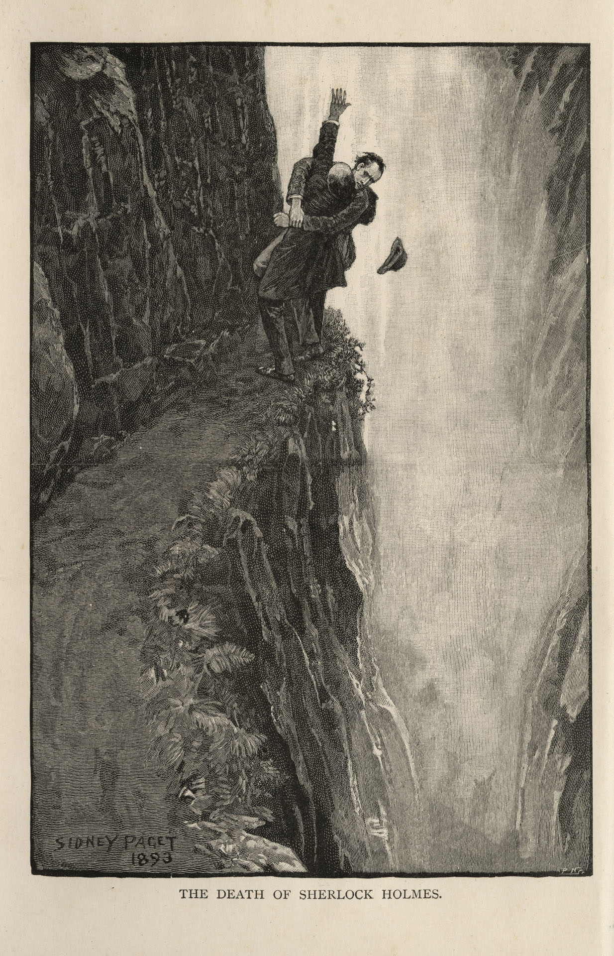
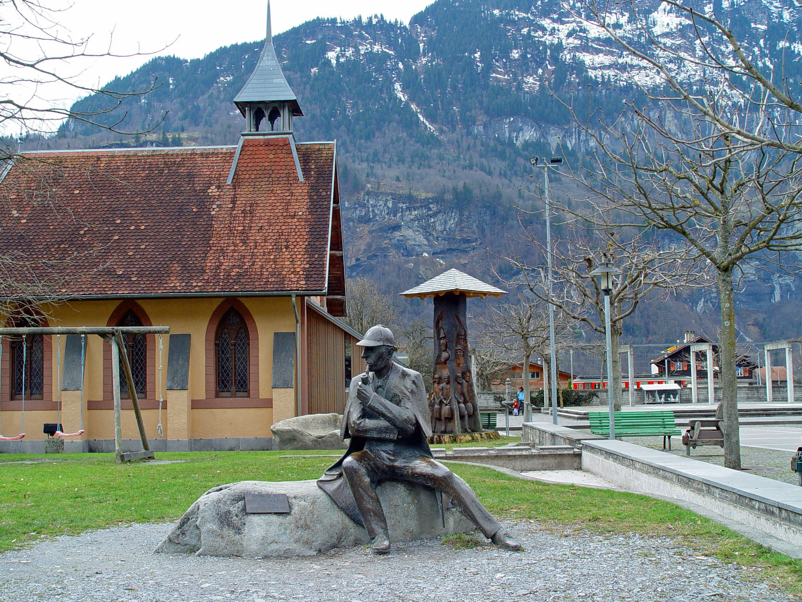
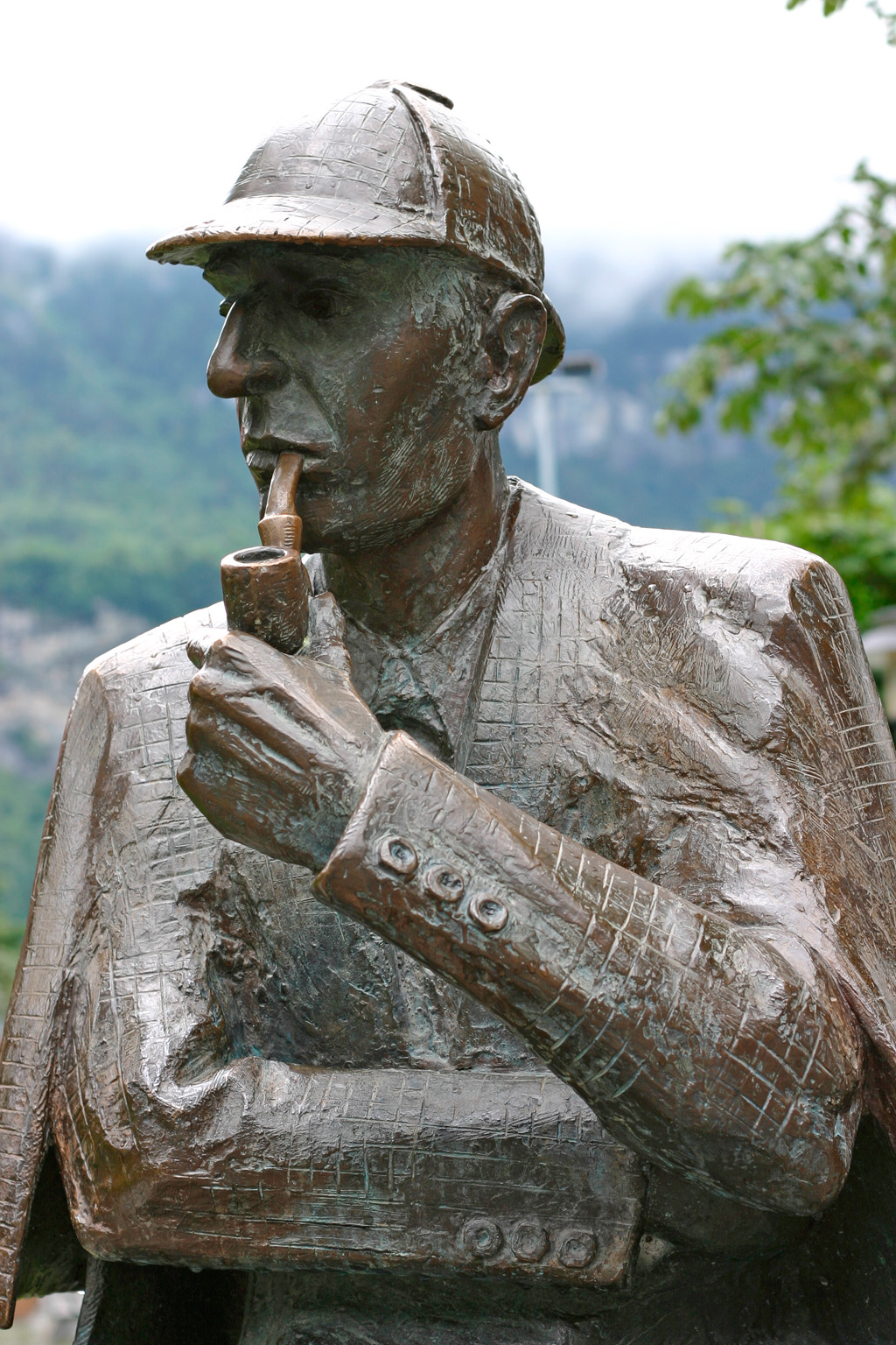
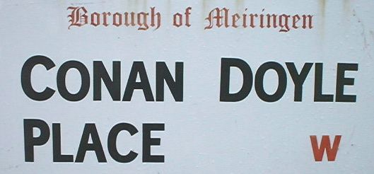
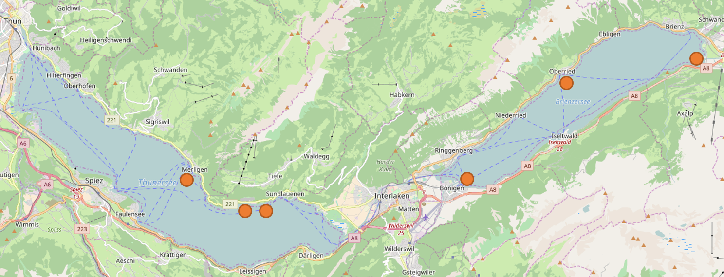
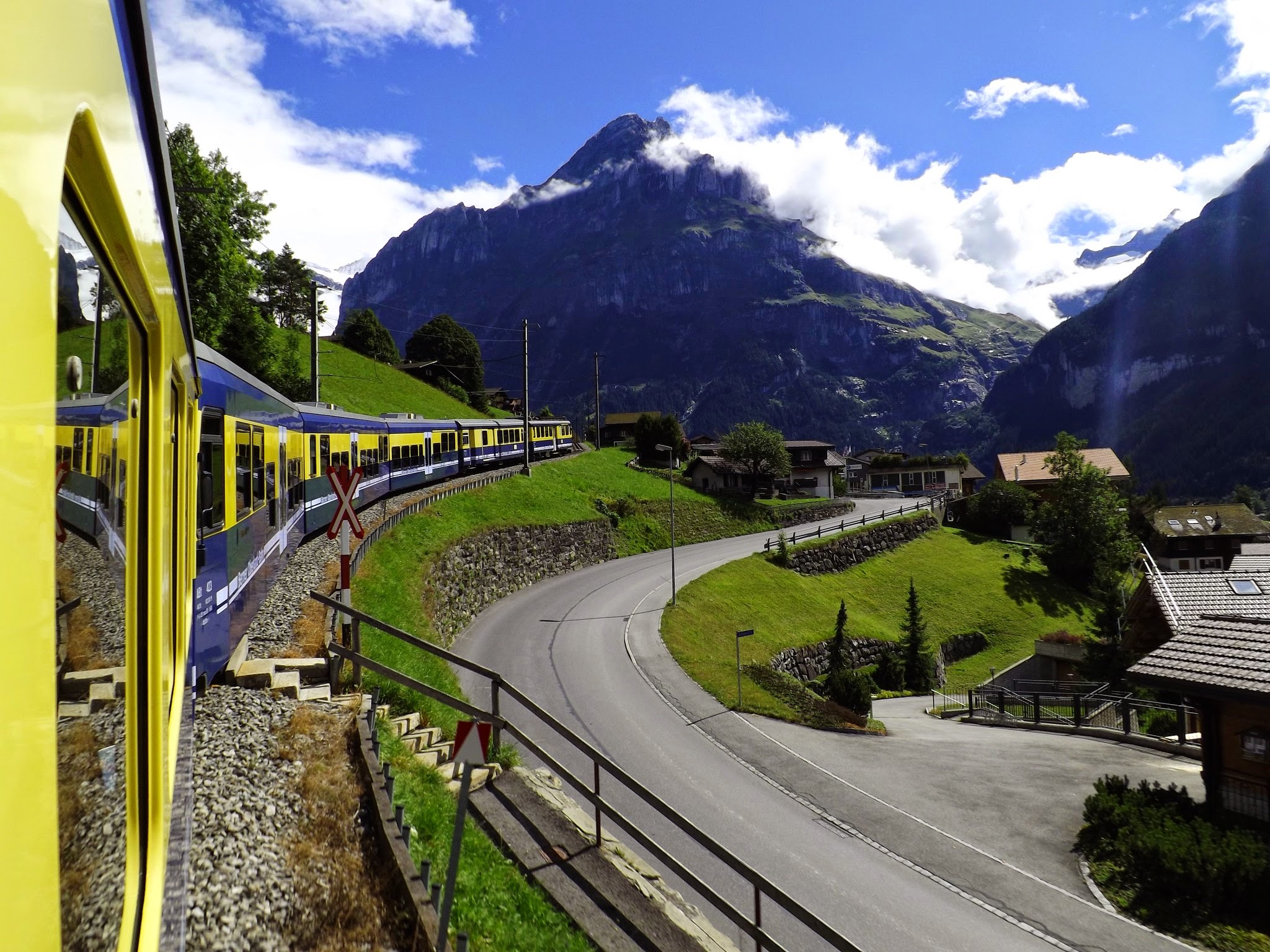
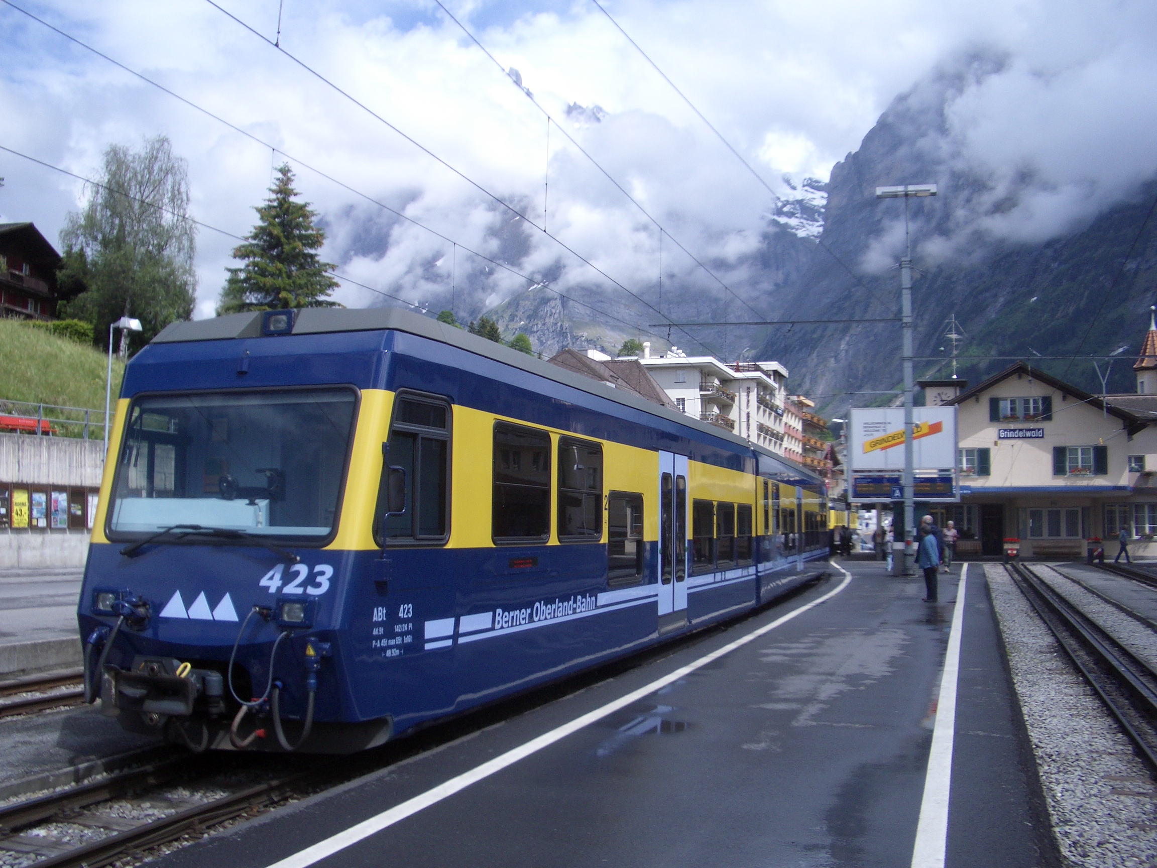
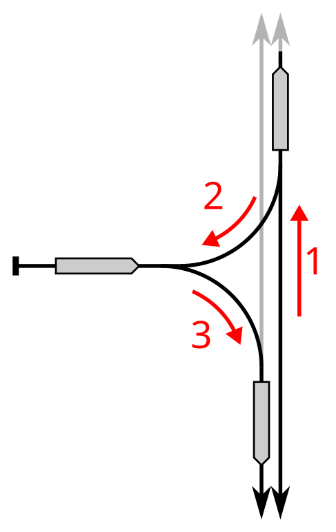
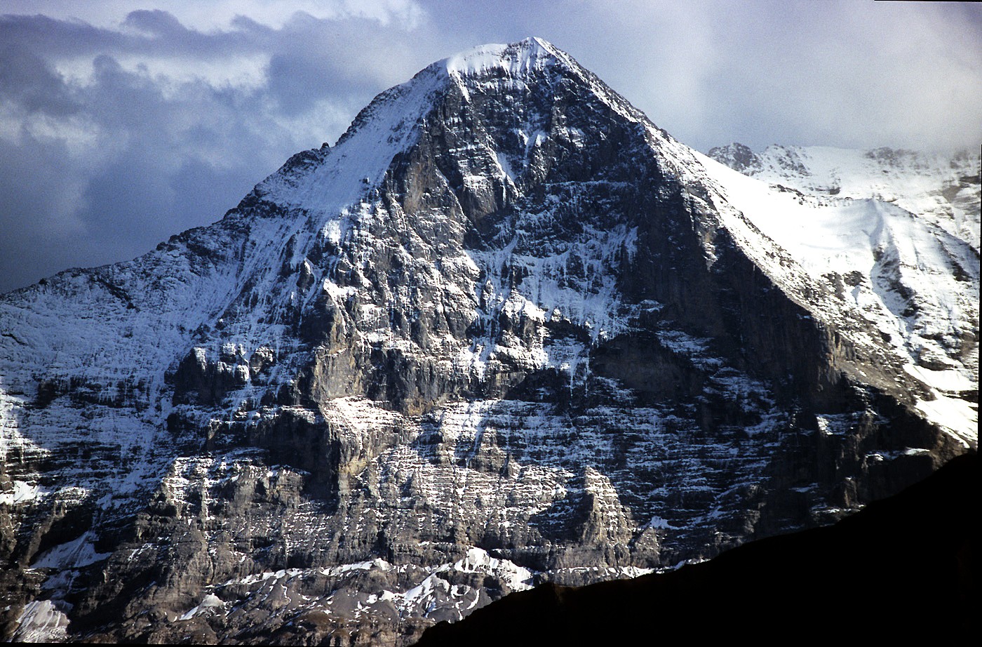
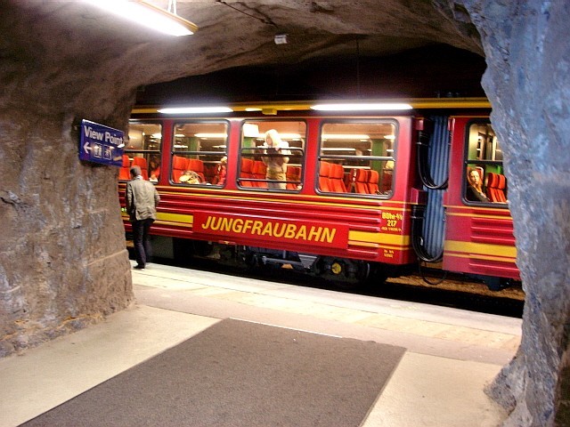
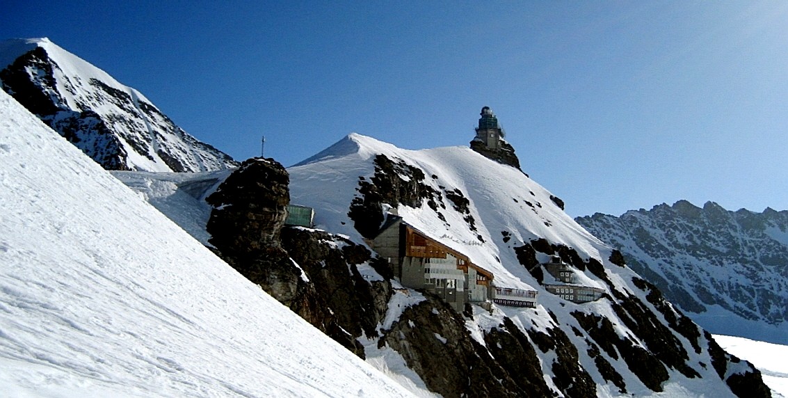
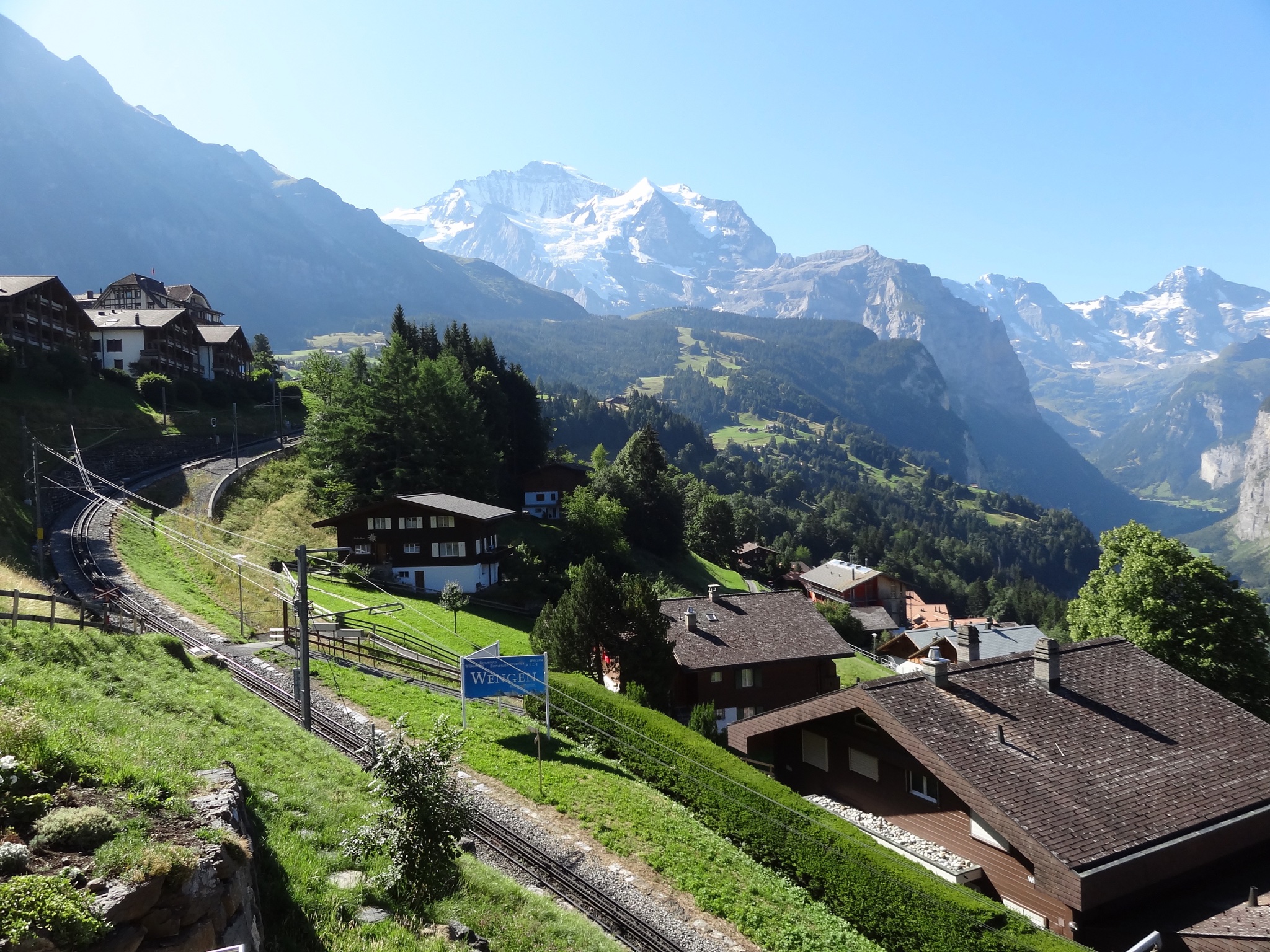