|
Reflections 2024
Series 10
October 1
Hudson Circuits II: Visiting the High Line Spur & the Vessel – The Plinth – The Moynihan Connector –Ferry to Weehawken – "Nothing-to-See #1"
| | Mid-Manhattan Hudson Circuit We are still discussing the Mid-Manhattan Hudson Circuit whose Midtown foundations we laid in 2024/8. Because of the suicide notoriety the Vessel has gotten we discussed jumper suicides in 2024/9. We are now back in Hudson Circuits II where we'll discuss Simi's and my actual visit to Hudson Yards on 29 June 2021 in terrible heat. This was a month after the second phase of visits to the Vessel had started, and to the day, a month before the fourth suicide occurred. The next day, on the 30th, I continued on my own to Weehawken for my freebie solo night away, before returning home in continuing high heat.
As the Poughkeepsie Hudson Circuit earlier on food had been, this circuit was a rectangle around the river, but now in Mid-Manhattan and now by "rail 'n' sail". It was north by rail (subway), west by "sail" (ferry), south by rail (light rail), and east by "sail" (ferry).
| | | | The Heat I've mentioned several times the horrible heat that defined this short excursion, which actually involved two half-days, roughly from noon Tuesday to noon Wednesday. I rank it as the second worst bout with heat during travel I've ever experienced.
I recently described the following worst bout with heat during travel, but I'll summarize it again. The tour we set up in 1965 around the Mediterranean brought us to Egypt. We took an overnight air-conditioned sleeper round trip from Cairo south to Aswan and Luxor, where we stayed on the 2-3 August. But in that desert area. It was SO hot, that our organized tour would leave the air-conditioned hotel after dawn for a few morning hours, then we'd spend noontime and early afternoon hours in the hotel, only to venture out again in the late afternoon and into the evening. Those were the heat conditions under which we saw most if not all sights of southern Egypt.
For some reason, Beverly and I went on a special side trip by car to see the Aswan High Dam, and I don't recall that that car was air-conditioned. When we got back to the hotel, the two of us went straight to the bar and each purchased a full liter bottle of ice-cold Egyptian beer. Some people like to drink from beer bottles (we didn't), but no one drinks from a liter beer bottle. Yet standing at the bar and not even taking a seat, Beverly and I were so hot that we each downed a full liter of beer all at once, pausing only for an occasional breath. It had been the hottest experience we'd ever had, and only after downing that ice-cold beer did we begin to recover.
But during the Mid-Manhattan Circuit in NY-NJ, I'd have to classify it as the second worst heat experience. There was a terrible heat wave both Tuesday & Wednesday. I recall hearing that the temperature both days was about 95°F (35°C) but with the humidity, the heat index made it feel like 105°F (40.5°C). Simi and I stayed in the shade where we could, but couldn't at the top of the Vessel, which is what shortened that visit considerably.
| | | | The Visit I'd planned it this way: At Hudson Yards, I planned to just take a quick look at some sights, such as the Shed, the Edge, the Public Square, and whatever else. I really only wanted to see two things, (1) the High Line Spur, with the restaurant below it, and then (2) the Vessel. I'd worked it out backwards. Since I had to leave on the ferry to arrive in Weehawken at about six, right before that we'd see the Vessel, and I purchased the timed tickets online for 4:00. Then if we went to the Spur and restaurant by 2:00, all would work out well, time-wise. (Normally when I dine out, it's for dinner, but lunch seemed to make more sense on this occasion.)
THE NORTHBOUND LEG It being summer, I wore shorts and sandals, but I still had no idea it was going to be so hot. Even if I had known, the hotel, Vessel, and lunch were all already booked. On the walk from home to the subway, I didn't notice the heat.
https://www.new-york-city-travel-tips.com/wordpress/wp-content/uploads/2016/02/NYC-subway-map-2017-1.jpg
https://www.dattner.com/wp-content/uploads/2020/05/7Line_SitePlan.jpg
Click on the first link for the NYC subway map. From lower Battery Park City I walked to the Rector Street station for the #1 train in red northbound to Times Square/42nd Street. (For now, note the ferry terminal in upper Battery Park City that I would return to the next morning, followed by a longish walk back.) At Times Square I changed to the #7 in purple for one long stop to 34th Street/Hudson Yards. That connection is shown in detail on the second link, a map we've seen before (hold on to it till later). The southern exit leads right to the Public Square and Gardens.
It was at this point that the first crisis of the day developed. As I stepped off the train onto the platform, "intestinal distress" suddenly developed. I went up one level, but the restrooms were closed due to Covid. I'd wanted to take one of those two deep inclined elevators up to street level, but instead ran to one of the escalators. I was glad I'd ridden one of the inclined elevators on that previous visit.
https://media.architecturaldigest.com/photos/5c893eb5fd05a62d5ad09aa5/master/w_1600,c_limit/Acr988333841344-185584.jpg
Here's our map again of Hudson Yards. I came out of the subway exit at the purple 7, and someone directed me to a restaurant in what I see now is 55 Hudson Yards. I was able to go in and discretely find the restroom with no trouble.
On leaving is when the heat of the day first struck me, adding to my confused, slightly disoriented state from the experience. I walked across the gardens, and this is how I got my first live view of the Vessel. It's gleaming copper-color in the bright sun was impressive, tho I found the bright sun was the last thing I needed. Fortunately, I'd left enough time in my schedule so that I'd arrived 25 minutes early, and just made it in time to meet Simi at the restaurant a couple of minutes before the 2:00 reservation.
https://gothamist.com/attachments/jen/2019_03_hudsonfood.jpg
Here is a selection of restaurants—we're looking southeast. #7 is the subway exit leading thru the Public Square and the Vessel. 10 Hudson Yards includes a restaurant called Mercado [Market] Little Spain, which, somewhat confusingly includes three sub-restaurants. We were headed to the Spanish Diner. You see how the High Line in green passes it by. Actually the Spur enters the building and forms the roof of the Spanish Diner.
https://cdn.vox-cdn.com/thumbor/DeVJaXaz4ZijcTfHoDzB5ae_HpE=/0x0:2048x1360/1200x0/filters:focal(0x0:2048x1360):no_upscale()/cdn.vox-cdn.com/uploads/chorus_asset/file/16221409/MLSDiner4.jpg
https://cdn.vox-cdn.com/thumbor/o-50bzzpxn1W755Uts5HZR6KuEI=/0x0:5760x3840/1200x0/filters:focal(0x0:5760x3840):no_upscale()/cdn.vox-cdn.com/uploads/chorus_asset/file/15961834/Mercado_Little_Spain_23.jpg
If it's incomprehensible how a former elevated rail line, now a park, can form the roof of a restaurant, check out both these links. You see how the legs of the el structure penetrate the restaurant and how high the ceilings are, with large fans inadequate for the task on such a hot day. The second link shows what seem to be shaded windows on the right. I believe that, in more sensible weather, they can open and form a sidewalk café on the north side of 30th Street, which would apparently look like this:
https://images.getbento.com/accounts/1657f4f6b3896dd6586d99c265a97178/media/images/59199sd-outside.jpg?w=1800&fit=max&auto=compress,format&h=1800
But Simi and I saw no such thing, and were glad to get in from the pervasive heat outside. A waitress seated us, and I immediately started fanning myself with the menu. This is when the headwaiter came over, who was a highlight of the day. The first thing he did was, without saying anything, reseat us under a ceiling fan. It wasn't a great breeze, but an improvement.
Then Simi and I made a mistake. I'd noticed that they have a prix-fixe menu called the Menú del día, which we'd planned on ordering, but it wasn't on our menu. The helpful headwaiter came over, heard the problem, and actually went to his computer and printed out two copies of the special menu, which we ordered. But the mistake was that it was too hot to eat that much.
We did order some refreshing sangría, and the first course, a cup of wonderful gazpacho, was great. It reminded me of when Beverly and I first "discovered" gazpacho in Andalucía, and would order it in shaded courtyards in Spain's well-known heat. We should have changed plans and ordered instead a full dish of gazpacho, which would have been excellent. When the main course arrived, we both ate a bit of it, then took the rest with us for later.
The final good deed the headwaiter did was when we were leaving, and asked him how best to get up to the Spur above us. Instead of giving directions, he walked out of the restaurant with us down the hall and personally showed us the exit door to the north side of 30th Street. He pointed out the public elevator across the street that led up to the High Line and the Spur. I still remember this headwaiter as a very positive highlight of the day.
| | | | The High Line We've talked extensively about the High Line in the past, so this is just a quick review.
The Hudson River Railroad (HRRR) was chartered in 1846, and the full line opened in 1851.
https://artsourceinternational.com/wp-content/uploads/2018/05/FAN2-1853-HUDSON-500x831.jpg
Above is a map of the HRRR dated 1853. The upper left (click) shows the Albany-Troy area, with westward connections. The HRRR then goes down the eastern shore of the river, with the map continuing in the right column, with the route ending into a still-small NYC in Lower Manhattan, the built-up area hardly reaching today's Midtown. At Kingsbridge there's an unexplained connection to Harlem, which would indicate the edge of northern Manhattan.
After Cornelius Vanderbilt bought the New York and Harlem Railroad running to the East Side of Manhattan, in 1864 he obtained control of the HRRR running down Manhattan's West Side. In 1867, he also acquired control of the New York Central RR, which ran between Albany and Buffalo. Apparently this upstate route in Central New York was what gave the railroad its name, a name that eventually spread to the whole system. Then in 1869, he merged the nascent New York Central with the rest to form what he called the New York Central and Hudson River Railroad.
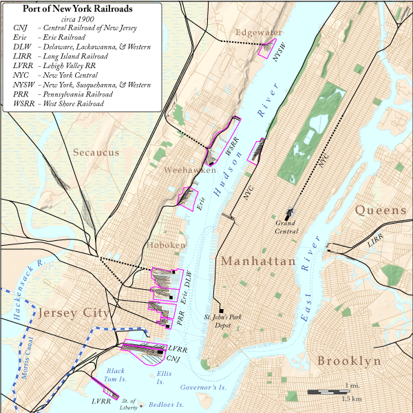
We now move to this map that we've frequently used—and will again--of rail lines and stations in the Port of New York NYC circa 1900 (Map by James R Irwin). For now, just look at Manhattan. On the East Side, the New York Central RR terminates at Grand Central. But on the Hudson, the former Hudson River Railroad, now part of the New York Central, works its way down the West Side all the way to the terminus at the Saint John's Park Depot. The former park is in what is now Tribeca, and now unfortunately serves as the rotary eastbound exit for the Holland Tunnel (!) below Canal Street (Photo by Chester Higgins Jr). This is about 1.7 km (1 mi) south of what has now become the High Line.
We jump ahead to the 20C. The line had long lost passenger service. The route south of 34th Street was elevated in 1934 for reasons of safety to form what we know as the High Line, but then, freight service was also in decline. Portions south of Gansevoort Street (three blocks south of 14th Street) were gradually demolished in the 1960s, the last bit in 1991, and the remaining route was effectively abandoned in 1980. The remaining southernmost section became a park starting in 2009.
| | | | | | To judge what was lost of the 1934 structure before historic preservation took hold, compare these two photos. This is Washington Street on the right in 1936, as the High Line crosses Bank Street. Typical for the line, trains entered the commercial buildings again and again, as needed for pickup or delivery—we see two examples of that here. This Bank Street intersection is five blocks south of the current southern terminus of the High Line at Gansevoort Street. (Dutch-American Colonel Peter Gansevoort fought in the American Revolutionary War.)
https://www.elementalnyc.com/assets/media/2016/03/Westbeth-1-1024x694.jpg
This later picture (note the Bank Street sign on the right) shows that the commercial building has been recycled into residences. The parts of the High Line rail structure that crossed streets are gone, and only the part that had been physically built into the building remains, somewhat grotesquely. It makes one wonder if those property owners don't feel today, with the High Line being a park, that they've been left out of a good thing.
|
| | | | As first described in 2011/8, this map shows my High Line experience (Map by Mj). I'd walked the first third of it shortly after it opened in 2009 (in red). That was as much as was publicly accessible then.
In 2016 I took the cruise on the Saint Lawrence to the Erie Canal and the Hudson, and we docked in Chelsea. There was one day of the cruise remaining "in town" and I used it to walk over to the High Line again, and walked the full length of the viaduct from Gansevoort Street to 34th Street, the red, blue, and green sections on the map (2017/8), taking the subway back. The blue section just extends the red thru city streets, while the green section wraps around three sides of Hudson Yards to 34th Street. The original line circled the rail yard in a C-shape in order to lose altitude, with the viaduct slowly disappearing, in order to go down below street level and join the open cut that still continues north between 10th and 11th Avenues. This cut is still used by northbound trains, directly out of Penn Station.
But the question remains—what is that short, half-block bit in black going down 30th to 10th? It even shows the elevator we used. This is the Spur, which didn't open until 2019, and it was thus ideal for Simi and me to visit in 2021.
| | | | The Spur The Spur, more formally, the Tenth Avenue Spur, is an extension of the High Line that originally connected with the Morgan General Mail Facility at 10th Avenue and 30th Street. Let's start with this aerial image:
https://image.digitalinsightresearch.in/uploads/imagelibrary/Archive/High-Line4.jpg
We're looking south (click) along both 10th Avenue and the High Line park to the point where it crosses 10th at 17th Street, so we cannot see its full length to Gansevoort. In the foreground, the High Line turns west on 30th, and the Spur exits from it, turning east, mostly within the building at 10 Hudson Yards. The elevator structure Simi and I took to access it is in green. The Spur ends abruptly after it veers away from the building and straddles the intersection. The Morgan General Mail Facility stands out at the left, as do the gas-guzzling mail trucks in its loading bays that now service it, since the rail line no longer enters the building as it once did.
The huge Morgan (9-10 Avenues, 28-30 Streets) is a mail processing and distribution center. It's not to be confused with the former main post office in the Farley Building, now occupied by Moynihan Train Hall, which is at 8-9 Avenues and 31-33 Streets. The Morgan was completed in 1933, in concert with the elevated High Line, and was designed to connect with it and create a seamless path for the more than 8,000 mail trains that crossed the US each year before proceeding south alongside the Hudson River on tracks of the New York Central Railroad into Manhattan. The last bit of their journey took them across Tenth Avenue on the specially constructed Spur that led directly into the postal facility, as seen below.
https://live.staticflickr.com/1018/4552700380_db2457a5f5_b.jpg
Back to our visit, starting at the area near the top of the elevator.
https://imgs.6sqft.com/wp-content/uploads/2019/08/26174834/Mercado-Little-Spain-1.jpg
https://s3.amazonaws.com/fhl-website/content/uploads/2019/06/11144423/Hl_Spur_Gallery_Liz_Ligon_2.jpg
https://s3.amazonaws.com/fhl-website/content/uploads/2019/06/11144328/Hl_Spur_Gallery_Liz_Ligon_3.jpg
The first link shows the north side of 30th Street with the restaurant. The Spur is above it, and this first section is called the Coach Passage, destined as a partially covered-over event space, such as for Fashion Week, including those see-thru balconies above the sidewalk. The Coach Passage has 60 ft (18 m) ceilings. The second link looks west down 30th Street, showing how far the balconies extend. On the left, the High Line proper comes up from the south to cross 30th; the view is blocked where the Spur exits from it--tho the Shed is visible--then continues on the right. The third link repeats the scene looking east down 30th. This view shows best how the Spur is physically within the building, tho still open-air. In the distance, the Spur veers out of the building (click) toward the Morgan, but now ends at the intersection, where we see a large black sculpture.
https://gothamist.com/assets_c/2019/06/2019_06_spurhighline-thumb-640xauto-1029806.jpg
https://s3.amazonaws.com/fhl-website/content/uploads/2019/06/11144435/Hl_Spur_Gallery_Liz_Ligon_1.jpg
This first link now moves to another aerial view, showing how the Spur exits from the building and into the intersection. Because of the angle, instead of a square the structure above the intersection is a rhombus (a "leaning square"). Shrubbery narrows the pedestrian path, which still indicates the former rail lines into the Morgan. The Morgan shows the now closed former openings, as well as the loading bays for today's trucks. The second link shows detail, looking back whence we came. And as it turns out, this is what it's all about.
The short Spur originally went via the intersection to service the Morgan, but now we find that it's that intersection itself that's the destination.
| | | | The Plinth The wide end of the Spur over 10th Avenue and 30th Street is now called the Plinth, meant specifically for the display of art—large-size spectacular art. A plinth is the lower square slab at the base of a column, defining this whole end of the Spur as being a base for a large statue. There were excellent views up streets in all four directions. Artworks selected for the Plinth thus become part of the cityscape itself, remaining on display for 18 months. As of this writing, there have been three artworks displayed, with a fourth one ready for October.
The inaugural commission was a monumental 16-foot-tall (5 m) bronze bust of a Black woman visible in all directions from the street below, as seen in the last linked picture. It's called "Brick House" by Simone Leigh from Chicago, who now lives and works in Brooklyn. It was on display from June 2019 to May 2021. The figure's torso is conflated with the forms of a skirt and a clay house. The sculpture’s head is crowned with an afro framed by cornrow braids, each ending in a cowrie shell. The artist combines architectural forms from regions as varied as West Africa and the Southern United States with the human body. The title comes from the term for a strong Black woman who stands with the strength, endurance, and integrity of a house made of bricks.
https://untappedcities.com/wp-content/uploads/2019/04/featured-brick-house-simone-leigh-NYC-untapped-cities1-1.jpg
Above is how the sculpture looked from 10th Avenue, showing how it is part of the cityscape. However, when Simi and I were there, the exhibit had changed, and what we saw was the second commission.
https://s3.amazonaws.com/project-images-2018/_AUTOx1084_fit_center-center_none/HLA_SamDurant_Untitleddrone_PhotoTimothySchenck_0607-1205.jpg
https://s3.amazonaws.com/project-images-2018/_AUTOx1084_fit_center-center_none/HLA_SamDurant_Untitleddrone_PhotoTimothySchenck_0607-1175.jpg
This one bore the name "Untitled (Drone)" by Sam Durant, who was born in Seattle but who lives and works in Berlin, Germany. This was a large-scale fiberglass sculpture in the shape of an abstracted drone atop a 25-foot (7.6 m) tall steel pole, and meant to be a commentary of the use of drones in warfare. It was on display from May 2021 to October 2022.
I have not seen the third commission, but I do find it most striking.
https://img.artrabbit.com/network/features/2023-may/pamela-rosenkranzs-old-tree-on-the-high-line-nyc/image/images/vE62di3TEPRT/1119x920/0,0/1812x1489/Pamela-Rosenkranz-Old-Tree-1.jpg
https://cdn.sanity.io/images/cxgd3urn/production/9f32e7f406bcd391ded0ed0a711d232d9d95b64f-2000x1335.jpg?rect=0,0,1999,1335&w=1920&h=1282&fit=crop&auto=format
It's called "Old Tree" by Pamela Rosenkranz, born in Uri, Switzerland and living and working in Zürich. It's on view from May 2023 thru September 2024, backing up to the date of this posting. It's a bright pinkish-red sculpture representing the tree of life connecting heaven and earth. It's made of man-made materials and stands at a height of 25 feet (7.6 m). The tree’s color resembles the branching systems of human organs, blood vessels, and tissue, inviting viewers to consider the connection between human and plant life.
And surprisingly, we also know what the fourth commission is, even tho it isn't on display until now, October 2024.
https://www.whitemad.pl/wp-content/uploads/2024/09/Dinosaur-_-High-Line-Plinth-Commission-_-Ivan-Argote-_-im03.jpg
https://static.designboom.com/wp-content/uploads/2024/07/aluminum-pigeon-dinosaur-ivan-argote-high-line-plinth-new-york-designboom-500.jpg
It's called "Dinosaur" and is by Iván Argote from Bogotá, Colombia, who lives and works in Paris, further indicating the international scope of these artworks. At 16 feet tall (5 m), the realistically painted aluminum pigeon is amplified to the size of a Tyrannosaurus rex, bringing to life the iconic NYC bird.
| | | | The Moynihan Connector In writing up this visit, I'd expected the above to be the end of it, after Simi and I left the Plinth with its Drone and continued to the Vessel. But then I was shocked—shocked! (kidding)—to see there's now more, which happened well after our visit.
https://untappedcities.com/wp-content/uploads/2021/01/Map-of-High-Line-Extension-to-Moynihan-Train-Hall-Brookfield-West-Hudson-Yards-NYC-768x432.jpg
This updated map was my first indicator of changes. Start on the left. In 2021, Pier 76, at about 36th Street, which had been a car tow pound for years, was incorporated into the Hudson River Park. Apparently they're planning to extend the High Line to connect to it, but this has not happened yet. (NB: the West 39th Street ferry terminal, where I'll be taking the ferry to Weehawken, is a three-minute walk north of it, at Pier 79.)
On the other hand, to my great surprise, the Moynihan Connector, a walkway extending east from the Spur to Moynihan Train Hall, opened in June 2023! It's already a fait accompli! The yellow area on the map is new construction, while the blue area is also of interest. (Note in gray how Dyer Avenue sends uptown traffic under Manhattan West.)
But interestingly, the extension is not built the same, of steel and concrete, as the original 1934 High Line. The extension not only differs from the original, each of its two sections is unique.
https://www.mgmclaren.com/wp-content/uploads/210001.21-Highline-Connector_-crane-support-delegate-design-temporary-shoring-and-more-6.jpg
https://www.som.com/wp-content/uploads/2021/09/221215_000_N6_large-1632802049-scaled.jpg
The first link is a sketch of the two parts of the extension, with the first overshooting the second. The second link is an artist's rendering of what it looks like in reality. (It's a good illustration, but it can't be a photo, since the artist included the original black sculpture on the Plinth.)
The 1,200-foot (370 m) extension runs east along 30th Street for one block to Dyer Avenue, then turns north above where Dyer enters its tunnel underneath Manhattan West. The span above 30th Street uses a V-shaped structure and is called the Woodland Bridge, which contains a 5-foot (1.5 m) deep planting bed. The walkway then turns north toward 31st Street across the Timber Bridge, a span shaped like a Warren truss (based on weight-saving equilateral triangles). It's made up of 163 Alaskan Yellow Cedar beams and terminates at a public square within Manhattan West, where the route turns east again, ending at the west side of Ninth Avenue, directly across from Moynihan Train Hall. Thus the walkway avoids city streetscapes, except for where it physically crosses Ninth. (The names are quite pleasant, but I'm going to argue that these are not bridges at all, but viaducts, maybe trestles.)
I have some pictures. This is the Woodland Bridge as it runs east above 30th Street, and this is the view along the walkway (Both Photos by Tdorante10).
https://www.architecturalrecord.com/ext/resources/news/2023/June/Moynihan%20Connector/High-Line--Moynihan-Connector-1.jpg?1687610409
Lush as the Woodland Bridge is, the Timber Bridge, here looking back towards the Woodland Bridge, is much more austere.
Finally, we have a YouTube video showing the walk from the Plinth to Moynihan. Unfortunately, it runs a lengthy 10:04, but is skimmable. To assist, I'll present the highlights:
0:00 - the Old Tree on the Plinth
0:32 – excellent view of where the tracks used to enter the Morgan, plus the present Woodland Bridge
1:18 – the blending of the old into the new, going eastbound
2:42 – the intersection with the Timber Bridge and turning north
4:00 – entering the elevated plaza at Manhattan West, still going northbound
5:02 – turning east again, within the plaza; look for the Empire State Building in the distance
6:55 – it's a few steps down to street level and the crossing of 9th Avenue to the far west end of Moynihan
7:08 – this is one of the few mid-block street crossings in Manhattan, complete with a crosswalk and traffic light
7:33 – entering the far west end of the Food Hall at Moynihan Train Hall
8:35 – the narrator's Amtrak comment is inaccurate—you both arrive and depart on Amtrak at Moynihan
9:40 – the main Train Hall
9:54 – looking south to Amtrak's Metropolitan Lounge on the mezzanine level
It's really not the end of the walk. You can continue east beyond 8th Avenue to Penn Station, either underground or at street level and go as far as 7th Avenue via the spectacular escalator kiosk of the East End Gateway.
| | | | The Vessel We move back to the center of our discussion at Hudson Yards, the Vessel. As Simi and I walked back from the Plinth and Spur in the oppressive heat, we approached the Vessel from the south, with the Shed on our left, as seen as this picture we've used before (Photo by Epicgenius). We didn't realize it at the time, but I now know that the vertical lines we see from this direction are the elevator tracks. We'll talk all about that, but for now I can point out at a distance the point at the top that Simi and I reached.
You see the eight levels (all with perilously low fences). Use the lowest ones for this description, then apply that to the top level, which is too skewed when viewed at this angle. The area near the tracks is in each case always one of the level walkways, sometimes referred to as a landing. You can see that each one is between two staircases. Now click on the top level, the eighth. The angle is too steep to be able to see where the elevator exits. In addition, the angle makes it look like everything's on one level, but there's a staircase on each side of the landing. The bottom of the right-hand staircase is where Simi and I sat in the heat. It's the only place where we set foot topside, and hardly moved.
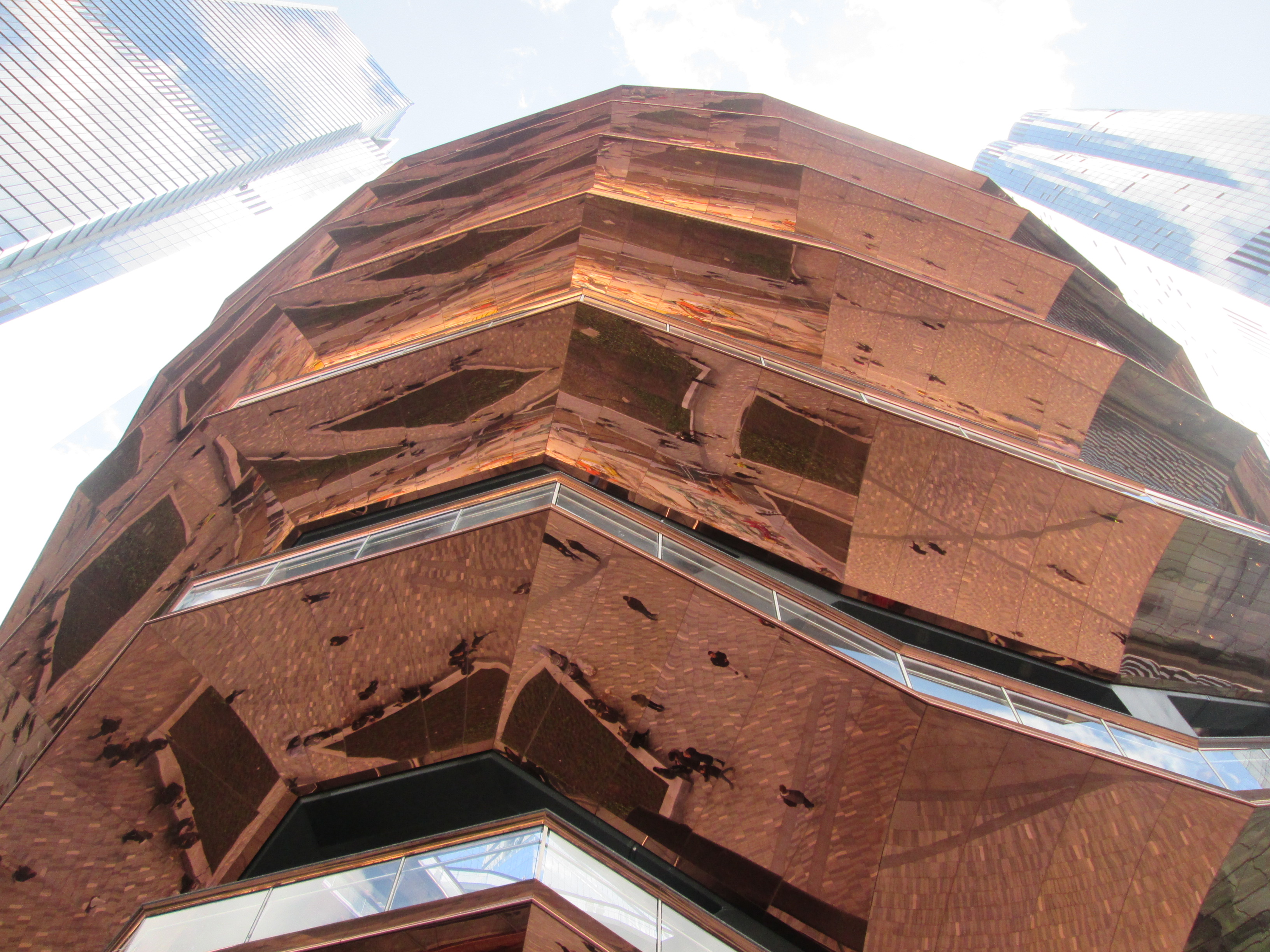
But do appreciate the reflective copper-like surfaces as seen on the exterior. Again, it's not copper, but copper-colored steel covering the framework, reflecting people below in the square, but remaining high enough to discourage vandalism. Since it's not copper, it won't oxidize to green.
| | | | | | The Statue of Liberty is clad in actual copper plates. When it was erected, it was copper-colored, but later oxidized to its familiar green patina. The Vessel will not do this.
https://media.snopes.com/2019/01/sol.jpg
https://as2.ftcdn.net/v2/jpg/05/61/64/59/1000_F_561645975_9eBEpqIBZBXKszbIyKRK7wCR85Nw36D4.jpg
Iron rusts to a reddish color. Copper "rusts" green. People today don't realize that they're looking at a "rusted" Statue of Liberty. I've read that Bartholdi had originally wanted it to be all gold. I've seen that he and his team didn't anticipate it would turn green, but even by the time that it had arrived in the US, it had shifted from the red-brown copper it had shown in Paris to a pure brown. But oxidation eats at the surface of the copper, and cleaning it repeatedly would eventually destroy all the copper, so cleaning it has always been out of the question.
|
| | | | We walked up to the entrance, which is raised several steps to form a kind of plinth (!). The reflective metal is pervasive and seems to surround one, especially when looking straight up from the base—it's like looking into a ceiling mirror (Both Photos by Epicgenius).
But on entering, everything's different. To my way of thinking, the interior, as seen from this view from the top, is even more unique and thrilling than the exterior. While there are still a few copper-colored edges to tie everything together, the color scheme is now different (Photo by Mobilus In Mobili). Click near the bottom, and you'll see a blue quality in the otherwise whitish look. It's in the interior that one sees the scissor-like nature of the staircases much more than from outside.
Look across to the top level. Tho not near the elevator where Simi and I ended up, the theme can be seen of a landing between two staircases, which themselves have landings on top. Again, when we were there, there were even fewer people than can be seen here, because of the heat. Starting from just above the center (click), thru the structure you can see trains in storage in the part of Hudson Yards that is still open to the sky. Keep moving upward and you'll see boats on the Hudson, and the Jersey shore. You're looking at the southern end of Weehawken, tho I'll be sailing to the northern end to spend the night. But notice something important for later. We're looking at the Palisades, and note how the main part of Weehawken (and other cities) lies above the cliffs, while there is still a bit of land below on a narrow shelf along the shore of the Hudson.
While the structure is called the Vessel, I still consider it to be shaped like a basket. Look down toward the bottom and note how much narrower it is there than at the top. Click to find three things right next to each other in this compact area. First, at the bottom of the elevator tracks, the tiny oval, glass-sided elevator car is waiting. Second, directly above that is the indoor side of the entrance we just used, right next to the elevator. And third, on entering next to the elevator, you find you're immediately at "the center of the earth", at its navel. People are gathered at this marked, tight little circle in the center of a star to view the dizzying symmetry of the interior of the Vessel. It was almost magnetic to be pulled over to stand in that "sweet spot", around which the whole structure seemed to swirl.
This is a similar, yet slightly different view from another angle (Photo by 28bytes). Here we are directly above the entrance, with the elevator to the right, but it's still the sweet spot in the star that draws the eye.
https://mediaim.expedia.com/localexpert/658102/7c29d1c5-9707-4c7c-8110-fda18767dc08.jpg
You wouldn't think it could get better, but standing in the sweet spot and looking straight up, you see what I'd say is the most thrilling view of or from the Vessel: the blue sky surrounded by the "open roof" of the structure. The symmetry, plus looking straight up, wants to make you feel you should be holding on to something to keep you steady. At the bottom, the much-too-small elevator rises in its tracks.
https://i.ytimg.com/vi/uig2GYhY2mM/maxresdefault.jpg
And to complement that view, this is the reverse; an aerial view looking downward into the Vessel. This is the top level, effectively the "roof". In the lower left, find the top exit for the elevator and click. You see the short landing in front of it, ending in two staircases. Simi and I spent our time at the foot of the staircase at the bottom, just out of view.
| | | | The Elevator I am not a lover of stairs. My condo apartment has two levels, and Beverly and I, when we bought it and remodeled, replaced the standard staircase near the entry with a spectacular spiral staircase near the two-story window wall. Thus I get my share of ups and downs every day, minimalized as much as possible, but all with a nice Hudson view.
But I realize that many people like the exercise, and would be eager to scramble up and down the Vessel's many staircases, such as Dave, who did so more than once in the first phase of its opening. But when I bought our tickets, my thought was to go up to the top by elevator—which we did—then at most to walk down sixteen stories to ground level—which we did not do, because of the intense heat--we also took the elevator down. I'd planned to walk down because the Vessel reminds me of the Guggenheim museum, built on a spiral ramp. The couple of times I've been there, I've taken the elevator to the top, then looked at the art on the circular ramp going back down.
When I first heard that there was an elevator in the Vessel, I wondered how a freestanding structure would work within the sloped walls. It can't. It was only on arrival (and well before seeing all these pictures) that I realized we'd be dealing with an inclined elevator, so let's review what that is. Traditional movement up and down a slope has been the province of the funicular, which we've illustrated many times. A funicular requires two cars, connected by a cable that goes up around a wheel at the top. When one car goes up, the other goes down. The next step beyond that was the inclined elevator, which can work with just one car (or two, if desired). Usually in this case, there's still a wheel at the top, but there's a counterweight under the tracks, so when the counterweight comes down, the car goes up, and vice versa. Steps away from the Vessel, down in the deeply located 34th Street-Hudson Yards subway station, two excellent inclined elevators next to each other provide rides up a sloping shaft. But the Vessel's inclined elevator works in a different way. There are no cables at all! I suppose this advance in technology should be lauded, and it has been. But in my opinion, the result couldn't be more inadequate to the task.
I find now that the whole elevator operation was not at all by Heatherwick Studio, but an add-on to the Vessel by a local NY-NJ operation, the Liberty Elevator Corporation. In fairness, I'll quote from the Liberty website, tho expect it to be quite self-laudatory:
| | | | | | Heatherwick Studios reached out to Liberty Elevator Corporation to install and maintain an elevator to seamlessly fit within the open structure’s artistic aesthetic while complying with New York’s strict ADA requirements. . . . Liberty Elevator Corporation worked with Cimolai of Italy [who constructed the Vessel] to create a custom elevator "shaft" to fit along the contours of the structure with an oval glass elevator cab that offers 360° views and universal access from its base to the landing at the pinnacle . . . The custom oval glass cab is wireless . . . The wireless controls [are] remotely located, transmitted via Wi-Fi from the elevator room to the cab regulating and tracking all movements without traditional cables. The cab is fully inclusive of all controls, motors and utilities. In order to permit visitors to observe the extraordinary views within the Vessel, the elevators’ mechanics—including the heating and cooling elements—are hidden within the floor. The elevator provides a smooth, quiet ride with extraordinary views of the Vessel’s interior. . . . Liberty Elevator & their partners were recognized for the 2020 Project of the Year Award by Elevator World magazine based on the unique design, advanced technology, extreme creativity & amazing teamwork that went into the installation of the elevator . . . |
| | | | [And blah, blah, blah.] I fully agree that it seems to be an engineering achievement, given the constraints of the venue. But the result is far too small, and much too slow, and totally inadequate to the task. I also recognize the reference to "New York's strict ADA requirements", ADA being the Americans with Disabilities Act, which proves my feeling about why there's an elevator at all. Heatherwick realized it had to accommodate the disabled, so it did the minimal to cover that requirement. However, in no way was the elevator installation meant for masses of non-climbers who might want to start at the top and work their way slowly down, as Simi and I originally had wanted to do. I couldn't imagine this inadequate installation being in the adjacent subway station, which is truly dedicated to the masses and not just to the disabled.
Problems started before we arrived. I'd gone to Related's website to buy the $10 tickets, which are the same for climbers and for elevator users. Elevator use can be booked, or you can take your chances as a walk-in, but I like having my ducks in a row. I didn't understand the online forms, so, unusually, I phoned Related. That's when it was made perfectly clear to me that the elevator was there, not for the masses, but for the disabled. I was told as I bought our tickets that for an elevator reservation, I'd have to declare myself disabled, and Simi as being my caregiver. And that's how more craziness was added to the mix.
After we enjoyed the view from the sweet spot Simi and I went to the guard at the elevator. She told us to stand aside until it was ready. Apparently the mechanism overheats, so the elevator operates only every 15 minutes, in other words, only four times an hour. My understanding is that it overheats even on normal days, so the scorcher that day was not an exception.
Then we found out that, despite all the modern technology, the elevator required an operator!!!! What elevators nowadays do that, especially with all this supposed super Wi-Fi technology? But it gets worse. The tiny cab can hold only five people—and that includes the seemingly superfluous operator!! It was beginning to feel dystopian. Four passengers four times an hour covers only 16 passengers an hour, when (on a normal day) there are hundreds and hundreds of ticket-purchasers.
Want more confusion? We were told the elevator goes up to 8, tho I knew the Vessel was 16 stories tall. However, they never made it clear they were counting by two's! They refer to levels, not floors, so 8 is the top level—and the 16th floor. The difference between levels and floors should have been clearly explained.
They also claim there are intermediate stops at levels 5 and 7, but they were being skipped, and the glacially moving cab was going express (ha!) to 8. I do not see how this tiny four-passenger cab on its slow schedule could ever function serving intermediate stops in addition to the top.
By the time the elevator had taken its nap and the 15 minutes were up, Simi and I were directed into it first, next to the seated operator. However, a group of four, two couples, had just entered as walk-ins. I felt sorry for them when they were told that only two could ride with us, and their group had to split up—or wait another 15 minutes. I also thought it a bit odd when a case of bottled water was brought in to ride up with us, with no explanation.
https://www.libertyelevator.com/upload/cache/portfolio.image/xs/portfolio_767x1100_portfolio.vessel.16.jpg
https://www.libertyelevator.com/upload/cache/portfolio.image/xs/portfolio_767x1100_portfolio.vessel.10.jpg
https://www.libertyelevator.com/upload/cache/portfolio.image/xs/portfolio_767x1100_portfolio_vessel_landing_4.jpg
These are three photos from the Liberty Elevator website illustrating just what it was they created. The first one shows the "sardine can" rising (click). The second shows that the view from the cab into the interior of the Vessel is really quite pleasing. The third is the exit at the top, marked L8, but it should also be marked F16. It was steps away from this that Simi and I spent our entire time, in the blazing sun.
| | | | | | I have to insert an anecdote here. Brooklyn Tech, with 6,000 students, is about ten stories tall, so I had enough experience with staircases. It had an elevator or two, but only for faculty. There was a freight elevator that students could use, but only in the mornings to go to homerooms (called, oddly, prefect classes), which were largely on the 6th floor. The elevator operator demanded complete silence, or he wouldn't start moving. There must have been room for 25-30 guys, shoulder-to-shoulder (Tech went co-ed only some years later). But the freight elevator moved glacially slow, and took forever to reach the 6th floor. I remember on one occasion, amid the silence, one wag boldly stated "this is the only elevator you have to get out and push", which broke up the crowd. Even the operator must have appreciated the witticism, since he didn't object to it.
As the Vessel elevator inched along, I thought back to Tech's freight elevator doing the same. |
| | | | We have a YouTube video (1:51) of the elevator ride up. Note these highlights:
0:08 – the red dot sweet spot next to the entrance and elevator is an ideal viewpoint for the interior
0:11 - the miniscule inclined elevator is evidently powered by caged hamsters on wheels
0:23 - good view of phone-booth sized elevator cab rising slowly
1:00 - view north of Public Square & Gardens leading to Hudson Park showing the two glass-domed subway entrances to 34th Street/Hudson yards station with the two excellent inclined elevators
1:05 - view west over remaining train yards to the Hudson River and New Jersey
1:21 - repeat of the view north
1:29 - unobstructed view to the west
Below is a view across the Vessel to the south and beyond, towards the Shed:
https://live.staticflickr.com/65535/51229724160_993e20df6e.jpg
When we got off, we turned left about two meters/yards from the elevator door and sat down on a lower step of that staircase. At first the guard came over saying sitting on the steps was not allowed, but given the weather, he did not stop us. To our surprise, after a while he came over and gave us each a complimentary bottle of that water that had ridden up with us. Unlike that beer in Egypt, we did not chug-a-lug this prize, but nursed it for the while we were up top, and did finish it.
I'll specify again that, sitting in the direct sun out of the shade from the interior of the Vessel we had no urge to move about. Fortunately, at 16 stories, there was a slight breeze. I considered at least climbing the staircase we were on, but thought the better of it and did not. Nor did we even walk across the landing to the other side. Under no circumstances would I even have considered walking down to ground level, as I had planned.
Still, the views from our perch were quite good, especially to the south and the Shed, and to the west and the river. After about 15 minutes, the guard came over and told us the elevator was leaving, so the two of us joined the elevator operator once again for a private ride down.
There is talk of an additional lift being planned to reach the top. The US Attorney’s Office for the Southern District of New York announced that it has come to an agreement with Related Companies to make the Vessel more accessible to all. Under the terms of the agreement, Related must design and install a lift mechanism that will make it possible for people with disabilities to get to the top levels of the Vessel, which are perhaps the most popular sections of the attraction. (Agreed!) The same agreement stipulates that Related must ensure that the Vessel’s current elevator stops at all scheduled levels, since it's been known to skip the fifth and seventh ones due to crowding issues.
| | | | | | Others have suggested that, for best accessibility, ramps should have been included in the original design. The irony there is that Heatherwick Studios' other project in Manhattan, Little Island (2024/8, which we'll discuss in the future), already did that magnificently. On my visit there, I noticed that there were four staircases, leading to each raised corner of the park, and each staircase going up blended into a ramp coming down (or vice versa). I found this was a pleasant way for everyone, disabled or not, to better enjoy the venue. It would have been equally great at the Vessel. |
| | | | Despite the heat, I consider our trip to the Spur and the Vessel to have been quite successful. Leaving the Vessel, Simi made her way home on the subway and I continued to make my connection across the Hudson to Weehawken for the night.
THE WESTBOUND LEG The rail 'n' sail day continued. After coming north on the subway, I'd scheduled going west by taking the Ferry to Weehawken. But given the weather, that turned out to start off much harder than it had seemed.
https://www.dattner.com/wp-content/uploads/2020/05/7Line_SitePlan.jpg
Look one last time at this map of West Midtown. When planning, I'd figured I'd walk the short distance to the West 39th Street ferry terminal. I was on 34th Street in tiny Hudson Park, between the two subway entrances in purple. The route involved 1 ½ long blocks west on 34th, then turning the corner around the Javits Center, then walking north on 12th five short blocks to 39th. But that was now out of the question. Fortunately, I'd checked out an alternative in advance.
https://www.nywaterway.com/UserFiles/Images/2020/WelcomeBack/B1014_Bus_Map_57thSta.jpg
As this map shows, I'd found out earlier that New York Waterway, which services many routes across the Hudson, has complementary bus shuttle services in Midtown Manhattan. These several routes deliver arriving passengers around Midtown, and later collect them again for the return trip. And its green route returning on 34th Street would be exactly what I needed. But I didn't know where the bus stopped, nor when it would come, and had to hope it used the regular stops of city buses.
I trudged up to a stop right on 34th, but I couldn't stand there in the blazing sun, so I went a few steps further into Hudson Park to sit on a shaded bench. After a few minutes, all hell broke loose.
https://nywaterway.com//UserFiles/Images/2019/AmericanDream/bus_header_banner_2_1400.jpg
All of a sudden, the brightly colored NY Waterway bus pulled up and opened all its doors. But I wasn't at the stop! So I jumped up and ran in that heat, and got there just as the doors closed. I arrived at the rear doors, and feeling like a fool, pounded on them till they opened. Then I stepped into air-conditioned paradise.
It was maybe 5:00 PM and for the first time all day, I felt comfortable, at least for a few moments. As I looked outside, I couldn't imagine actually walking that short distance to the West 39th Street (West Midtown) ferry terminal.
Inside, the terminal was not air-conditioned as I bought my $8.25 senior ticket and waited on line. This is the ferry terminal at Pier 79 as seen looking east from the river (Photo by Jim.henderson). The building is clad in glass, and contains six ferry slips.
https://imgs.6sqft.com/wp-content/uploads/2019/11/06112156/nypd-tow-pound-google.png
This aerial view shows the Javits Center convention hall in green, and my route on 34th Street and 12th Avenue.
The largest pier is the former car tow pound, now Pier 76 of Hudson River Park, at about 36th Street. This is where they're planning on extending the High Line to. Just north of it is Pier 79 with the West 39th Street ferry terminal with the NY Waterway ferry to Weehawken, named at the center top.
https://appassets.mvtdev.com/map/41/l/121/75960420/7338449.jpg
The route is very simple. On leaving 39th Street, the ferry passes over the Lincoln Tunnel, just barely, then crosses the Hudson diagonally in eight minutes to the Port Imperial neighborhood of Weehawken, located below the Palisades. Before leaving this map, note two things.
1) On the Jersey side, note something I at first was oblivious to. The green parkland strip indicates the cliff face of the Palisades, dividing all the towns into a much larger upper area atop the Palisades and then a low, narrow shoreline area. Port Imperial is down by the shore, as the name implies. Each area has a main road, indicated in yellow, but not named. Up above it's (JFK) Boulevard East, and down below it's, not surprisingly, Port Imperial Boulevard.
Very importantly, note the rail line that is now used for light rail. At some point to the west it goes underground, and runs in a tunnel under Weehawken's 48th Street (not named). The tracks exit from under the Palisades via a portal and then turn south close to the shoreline.
2) Note the river route carefully, simple as it is. Port Imperial is roughly opposite 55th and 56th Streets in Manhattan. Also note for later reference where an imaginary line running west from 50th Street would cross the ferry route, pretty much mid-river.
https://i.pinimg.com/originals/bf/0c/5e/bf0c5e1500008c512882e8f6bb73815c.jpg
https://i.pinimg.com/originals/6d/46/5e/6d465e45c88ca1ac9f685e66ca0f1035.jpg
https://c1.staticflickr.com/5/4126/4968897875_345b289684_b.jpg
1) The ferry looked something like this. Note the Empire State Building in the background. 2) The interior was not air-conditioned. Air flowing in was warm. 3) This is the view from the hotel over the Port Imperial ferry terminal across the Hudson to Manhattan.
This westbound leg of the Circuit might seem quite innocuous, and it was, but just until I got off at the ferry terminal. On a museum-like display there, NY Waterway pointed out how, in 2009, it was instrumental in the rescue of passengers on US Airways Flight 1549, which made an emergency landing on the Hudson River near Port Imperial. I was shocked at the realization. I'd just sailed thru history, the site of the Miracle on the Hudson!
| | | | "Nothing to See #1" Let's recap. On the mid-afternoon of 15 January 2009, US Airways flight 1549--this is the actual plane--left LaGuardia Airport in Queens headed for Charlotte NC, and thence to Seattle WA (Photo by Edmund Seeger). It first flew north, then turned south down the Hudson River, at which point it struck a flock of Canada geese and lost all engine power. However, pilot Chesley "Sully" Sullenberger managed to land it on the river, with some injured passengers, but no fatalities among the 150 passengers and 5 crew. This is the view southward from above the Bronx that Sully would have had (Photo by Ajay Tallam). On the upper left, note the large lake in Central Park (click). The far end of the park is at 59th Street, so judge where 50th Street might be and visually extend that into the Hudson. That's what turned out to be the emergency landing site.
Now follow that scenario on this map (Map by S Bollmann).
| | | | | | The map points out 48th Street as a guide, but I find that they landed at 40.7695°N, 74.0046°W, which seems to be at about 50th Street in Manhattan, while Port Imperial faces about 55th–56th Streets. |
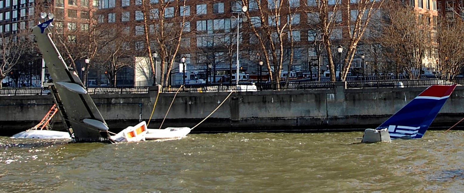
| | | | It was Governor Patterson of New York State who first referred to the incident as the "Miracle on the Hudson". And in fact, the landing was so close to the Port Imperial ferry terminal that it was two NY Waterway ferries that arrived first, in minutes, to start taking people aboard. Then numerous other boats, including from the Coast Guard, arrived on the scene as well. About 140 NYC firefighters responded to docks on the Manhattan side, as did police, helicopters, and other vessels. This view from the Jersey side includes a helicopter and vessels that surrounded the evacuated plane after it sank, showing only the tail in the center--click (Photo by Izno, cropped by Falcorian). Other agencies provided medical help on the Weehawken side of the river, where most passengers were taken, to a riverside hospital not far north of the ferry landing.
The partially submerged plane was towed downstream about 6 km (4 mi) and moored along the Esplanade in Battery Park City, at a point north of my building, but south of the ferry terminal where the present Circuit will end.
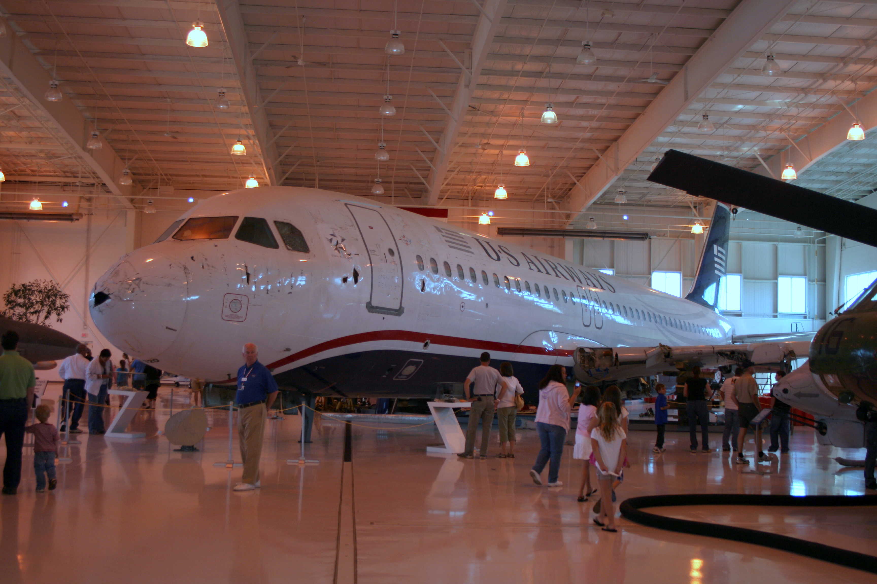
Since the flight was headed to Charlotte NC, the aircraft was purchased by what was then the Carolinas Aviation Museum on the grounds of Charlotte International Airport. Subsequently, the museum was renamed the Sullenberger Aviation Museum, and now houses a permanent Miracle on the Hudson exhibit (Photo by RadioFan). The purchase was helped by a gift of $1 million by a passenger who survived the flight.
On July 28, two other passengers who survived the flight organized a thank-you luncheon for numerous local Jersey emergency responders at the hospital where 57 passengers had been taken. Also present were members of the Coast Guard and NY Waterway Ferries, as well as doctors and nurses who treated the injured.
So that's the saga. How did it involve me? Five days before the landing, I boarded Cunard's Queen Victoria, in snow flurries, on 10 January at the Manhattan Cruise Ship Terminal at 48th Street. On it I would meet friends Neil & Joe from California, who I'm still in touch with. We sailed to the Caribbean, then thru the Panama Canal to Long Beach, after which I flew to the South Pacific to a number of Polynesian Islands, and was gone a total of 50 nights.
We were in the Caribbean when we got word of the emergency landing in waters we'd just sailed thru five days earlier! What a shock! And so, over the years, that had been my tenuous personal connection to the event.
Well, that changed the moment I got off the ferry in Weehawken. Only then did I realize that on the ferry I'd just passed right over the actual landing site!
The picture we've all seen of the passengers standing on the wings of the plane on the Hudson is this, and it's scary. But now I find it's the cropped version. This is the full view, with the Jersey shore in the background. Seeing the isolation of the plane in the Hudson, which is a wide estuary here, is scarier still (Both Photos by Greg L). Also, those snow flurries I'd sailed with can be seen on the ground on the Jersey side. This was winter!
But as the ferry crossed the site, there was absolutely nothing to see!
| | | | | | Let's review the breakdown of the sights that travelers see, as first presented in 2021/9.
Every sight a traveler seeks out (or that suddenly appears!) has a potential of two qualities, "Locus + Visit". By far, most sights have both. You walk up to the Colisseum in Rome and are overpowered by its Locus. HIC LOCUS EST! THIS IS THE PLACE! I've heard about this place my whole life! That initial happy shock is then supplemented by then actually physically visiting the place. Go touch the wall if it makes you happy. Those two facets are the foundation of enjoyable travel.
But not every sight can boast both qualities. I gave the example for "Visit, no Locus" by citing Boscobel, a beautiful early 19C mansion in Garrison NY that was moved in the mid-20C 24 km (15 mi) up the Hudson River shore from its original site to save it from destruction. The house is absolutely worth a "Visit". But it's unfortunately lost its Locus, since the present (attractive) setting is not the one the original owners experienced. (Picture moving the Colisseum to the other side of Rome!)
An even better example are the Cleopatra's Needles (obelisks) on London's Victoria Embankment near Waterloo Bridge and in New York's Central Park behind the Metropolitan Museum of Art. They stood in Alexandria, Egypt for almost two millennia before having their locus rudely shifted in 1878 and 1881, respectively. What a change—and TOTAL loss--of locus, tho highly worth a visit. We'll have an example of "Visit, no Locus" in an upcoming posting, probably the one after next.
The other possibility is "Locus, no Visit". The example I gave was seeing the building in Paris where Benjamin Franklin and others signed the Treaty of Paris that separated the nascent US from Britain. What an overwhelming Locus! But there was absolutely nothing to see there, since the building had gone commercial.
Perhaps an even better example was the time I was on a ship, possibly the Deutschland, going transatlantic to New York. When we were south of Nova Scotia, it was announced that if you looked toward the north, you'd see where the Titanic sank. What Locus! But looking north, you saw the same attractive seascape you'd been seeing all along, so it was "Locus, no Visit".
Now updating: crossing the Hudson and finding out you passed where the Miracle on the Hudson had taken place is powerful Locus, but no chance for a Visit at all. The river was pleasant, but there was nevertheless absolutely Nothing to See.
That was Nothing-to-See #1. There'll be a Nothing-to-See #2 tomorrow morning, discussed in the next posting, but I'd known about that one in advance.
|
| | | | The Weehawken Hotel I will admit starting out that I hadn't fully researched the ferry, nor the hotel and its area, but instead learned on-the-go. Only later did I discover the whole story. I only knew the simple mechanics, that the ferry terminal was across from the hotel, and the light rail to take me home was so conveniently behind the hotel! I should have realized that there was good historic reason why everything fit together so well. I was really remiss, since I should have known the area's history much better in advance. I was certainly aware of the Palisades cliffs and have driven along the top on the Palisades Parkway with its numerous lookouts. I've even written about them. Still I hadn't put two and two together about how they impacted the neighborhood into which I was arriving. That soon changed.
https://live.staticflickr.com/65535/47975056817_e46c1a8181.jpg
This is a view from the northeast. Upon walking from the ferry terminal thru a tiny park (trees at left of photo) and directly across the street, I got my first view of Marriott's EnVue Hotel. Again, I was here because of the Marriott freebie to cardholders, a Free Night Certificate, this one for 2021. I only chose this hotel because of its location between ferry and light rail, and for of course for the view its name hints at. Only later did I realize how nice it was.
And only on arrival did I realize its split personality. The entire lower level of the structure, much more expansive than the hotel itself was a huge parking garage (in gray) for Jersey commuters arriving at the ferry. The EnVue hotel was on the upper level (better view) of its north section.
| | | | | | I can only remember one other split-personality hotel I've stayed at, in Travemünde. There, the Hotel Maritim had the lower floors, while the upper floors (better view) were private condominiums. So, for me, what was down was now up! |
| | | | We now move to a view from the southeast, which shows much more.
http://www.tmiwindows.com/wp-content/uploads/2019/09/PIC-1--725x450.jpg
This view is not visible from the ferry terminal so I didn't realize until the next day that the hotel is at the foot of the cliffs of the Palisades. Only the next morning did I realize how most of Weehawken is on the clifftop running inland, while the narrow shoreline is a much smaller area of town. This is important to understand later events and discoveries.
We see the ferry terminal and tiny park much more clearly. Across the street, the EnVue could only be closer to the terminal if it were attached. As I crossed the street, I found the access area to the hotel in the center. It might look like a lobby, but is tiny, and only has a couple of elevator doors, with a sign saying to ride up to the real lobby on the 6th Floor (my room was on the 8th of 11 floors). The hotel boasts of a rooftop restaurant run by celebrity chef Marcus Samuelson. It is indeed on a rooftop, but not the hotel's! It's that terrace area on the left above the south side of the parking garage, an extension of the 6th floor lobby, but still has the same marvelous view, which I checked out on arrival.
https://www.northjersey.com/gcdn/presto/2020/09/08/PNJM/99f1eec2-14be-426e-b1bb-e85bb08f19a2-marcus_samuelsson_weekhawken_exterior.jpg?crop=1241,699,x0,y20&width=1241&height=699&format=pjpg&auto=webp
Here's an evening view from the Palisades behind the hotel over the restaurant on its terrace. Also standing out is the supertall Central Park Tower—more about that in a moment.
| | | | | | I'd considered having dinner at the restaurant, but it was still much too hot to eat outdoors, and anyway, I had left-over lunch with me for dinner, so I passed up that opportunity. But let me expand here on celebrity chefs.
MARCUS SAMUELSON: I met the Ethiopian-born, Swedish-raised chef when he was an apprentice at Aquavit in Manhattan. I'd brought my whole family to the restaurant, and, when Samuelson stopped by the table, I told him how Beverly and I had also visited the Aquavit branch in Minneapolis (now closed). After that little chat, he had a waiter bring the entire table a glass of complimentary Aquavit, the eponymous caraway-flavored cordial. He now has numerous other restaurants of his own.
WOLFGANG PUCK: When Beverly and I were in Los Angeles once, we dined at Spago, Austrian Wolfgang Puck's first and flagship restaurant. Puck went table to table, and when he came to us, I chatted with him in German, which we all enjoyed.
KURT GUTENBRUNNER: He's perhaps less famous, but Austrian Kurt Gutenbrunner runs the Café Sabarsky at the Neue Galerie on E 86th Street, where I've dined a few times, and also Wallsé, on W 11th Street in Greenwich Village, where I've also dined a few times. On one occasion at Wallsé, Gutenbrunner also came table to table, and once again I chatted him up in German. I may have told him of our studying in Vienna. Afterward, he was kind enough to gift me his book, Neue Cuisine.
JULIA CHILD: This is my most tenuous connection to a chef, and not really food-based. Once, on an Atlantic crossing, Julia Child was doing presentations, and promoting one of her books. Beverly, in a wheelchair, and I chatted her up, as by then Child was using a walker.
|
| | | | I want to use one more picture showing everything of interest around the hotel. I'll use this again in the next posting when we ride the light rail.
https://bccbelle.com/wp-content/uploads/IMG-20180802-WA0053.jpg
This is the most comprehensive view of all. It repeats the arriving ferries at the terminal, but also shows the hotel's unusual almost-triangular shape (unconnected in the rear), next to the restaurant terrace. The cliff face of the Palisades couldn't be clearer, and most of Weehawken can be seen up above. The portal of the rail tunnel can be seen (click) coming out of the cliffside, and to the left, in blue, the overpass to the light rail. As I discovered the next morning, there's a free street elevator that does two things. It brings passengers to the overpass that crosses both Port Imperial Boulevard, and the light rail tracks, and another elevator, or steps, bring them down to platform level. What cannot be seen because of the trees is the extensive staircase bringing passengers from atop the cliff down to the overpass on the other side. As I was discovering, the ferry-hotel-light rail complex here was an interesting amalgam.
On checking in, when the agent saw I was there on a Free Night Certificate, and I told him I was there only for the view, he made sure I had a room facing the river.
https://cache.marriott.com/content/dam/marriott-renditions/LGAAW/lgaaw-guestroom-8567-hor-wide.jpg?output-quality=70&interpolation=progressive-bilinear&downsize=1336px:*
My room was like this, tho it didn't face southward to the trees on the Palisades, it faced eastward across the Hudson to Manhattan, and had a great sitting area by the window. But after a quick look at the view, the first thing was a nice refreshing shower. That was followed by a nap, and I remember, I didn't just flop on top of the bed, I actually got into the cool sheets and napped for a couple of hours. So refreshing after a day like that.
I finally sat down to look at my view and have my lunch entrée as a cold dinner. While I enjoyed the view, there were two things I found disturbing, the oversized and overtall mass of Hudson Yards, and "pencil towers", as typified by Central Park Tower. I continue to be opposed to buildings that are called "supertall", which I call "overtall". I've already expressed my concern with Hudson Yards, so now I'll talk about pencil towers.
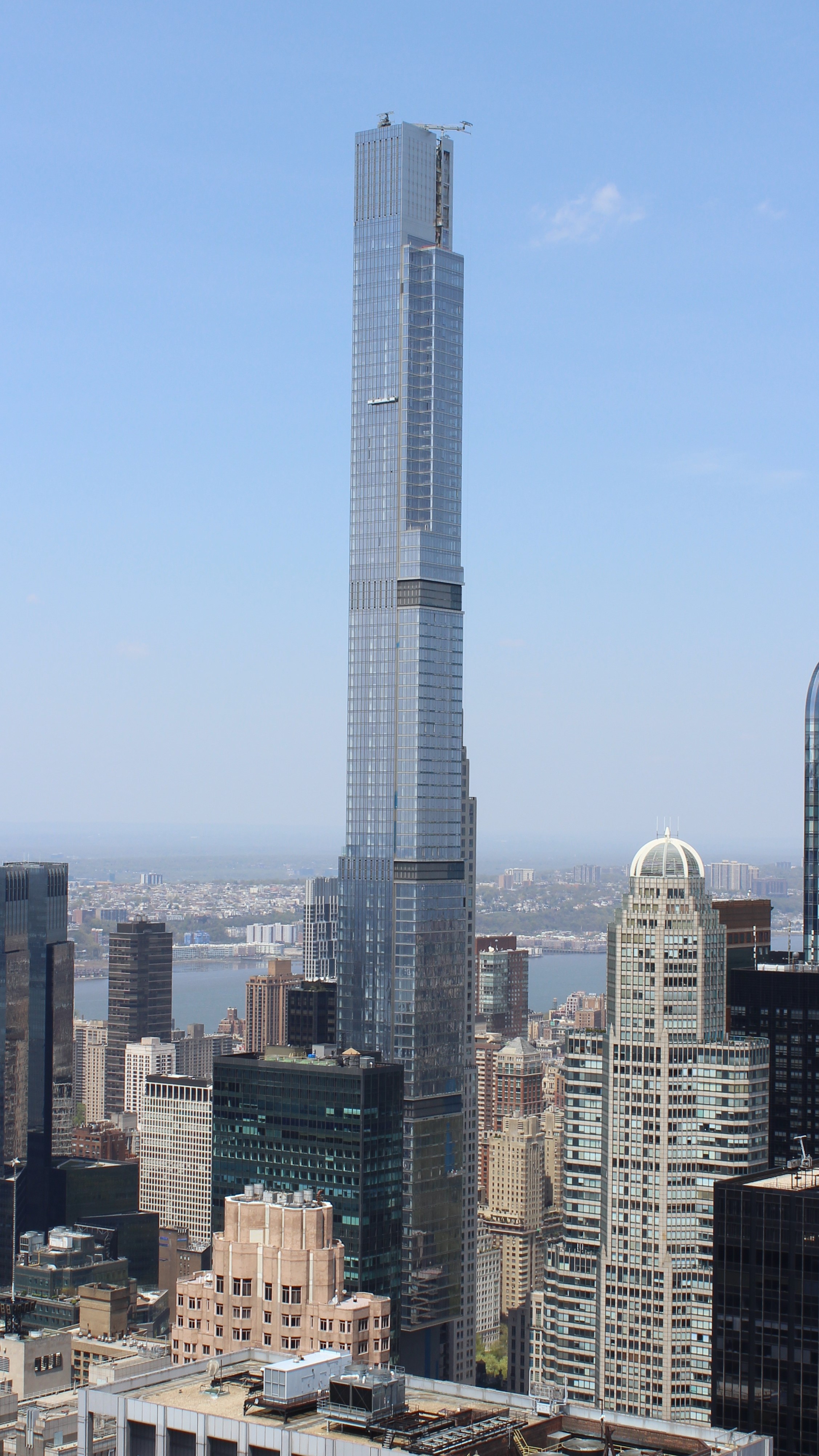
Structural engineers consider a skyscraper as slender if the height to width ratio exceeds 10:1 or 12:1. Tall buildings with high slenderness ratio can be referred to as pencil towers, built so slender as to take maximum (money-grubbing) advantage of a small plot of land. Hong Kong started developing pencil towers in the 1970s. Residential buildings of twenty or more stories with one unit per floor were built over small lots. It has become one of the most common types of buildings in the city, making Hong Kong the world's highest concentration of pencil towers. In the 2010s, pencil towers became a new phenomenon of building design in NYC, centering on 57th Street. Outside of Hong Kong and New York City, Melbourne has become a center of pencil towers.
Central Park Tower (Photo by Percival Kestreltail) is a residential supertall (overtall) skyscraper two blocks south of Central Park, on West 57th Street between Broadway and 7th Avenue. This pencil skyscraper travesty rises 472.4 m (1,550 ft), with 98 above-ground stories and three basement stories, although the top story is numbered 136.
https://www.6sqft.com/wp-content/uploads/2015/11/central-park-tower.jpg
Here's the view south from Central Park proper. It's the second-tallest building in New York City after One World Trade Center and the tallest primarily residential building in the world (Burj Khalifa in Dubai is mixed-use). Compare the 1931 Art Deco Essex House.
https://andrewprokos.com/wp-content/uploads/WEEHAWKEN-SKYLINE-SUNSET-1000PX.jpg
Now let's discuss my view across the Hudson. First, let's look at an earlier, more traditional view of Midtown Manhattan seen from Weehawken (at sunset). Use the Empire State Building on the right, the only real standout, as a guide. While every building is different, there's a certain uniformity in the Manhattan skyline.
https://dynamic-media-cdn.tripadvisor.com/media/photo-o/24/61/9e/e9/9th-floor-room-view.jpg?w=1200&h=-1&s=1
Now look at this view from the EnVue lobby. Beyond the little park and ferry terminal, the Manhattan skyline now seems more lopsided, with the overtall Central Park Tower on the left, and the oversized Hudson Yards on the right.
https://cf.bstatic.com/xdata/images/hotel/max1024x768/448680703.jpg?k=3e85851f9f2c9d9755783e9ed9e8ac00e00dc8035d68459a531058d8e40af557&o=&hp=1
https://image.digitalinsightresearch.in/Uploads/ImageLibrary/Active/2017Q3/5.PMI/Designcurial/Blueprint/BP2018/Hudson-Yards1.jpg
The first link is one last view from the hotel of the skyline with the two outsized entities. The second link yields a novelty shot of Hudson Yards taken from southern Weehawken which faces it directly. When on the Vessel, we saw southern Weehawken across the river; this is the reverse view. It's a novelty shot because they've gotten the Empire State Building to appear to loom over the Vessel (click).
I enjoyed my view for quite a while with my cold dinner, but that didn't turn out to be the last adventure of this first half-day of the Mid-Manhattan Circuit. At about 9:00, the hotel fire alarm suddenly went off! I got dressed and grabbed three things I didn't want to leave in the room, my laptop, the current travel diary, and my phone, and followed the directions on the back of the door (those directions one usually ignores).
It was only steps away to the stairs, but this needs clarification. Thru a door, you entered to what we call in German a Treppenhaus, a word that best describes what it was. A Treppe is a staircase, and a Treppenhaus is a large enclosure—a room'--that has a continuous staircase going round and round on all four sides, seemingly down into infinity. I do suppose the English word "stairwell" is the same thing, but is nowhere near as graphic as calling it a "house of stairs". Let me give a poor illustration, but the best I could find online. Look at this "house of stairs" (Photo by Rogi.Official). Now picture it as a utilitarian shaft three times larger at least, made out of cinder block and concrete, and going counterclockwise instead. That is what I encountered thru the door. In addition, I met a silent, human mass descending round and round. Some were dressed, as I was, but many came in pajamas or lounging robes. What a descending flow of silent humanity! I was startled that some had taken pets to the hotel with them, but what I saw surprised me. One woman had a huge dog on a leash, almost a small pony. Then someone else was leading two very large dogs! It was surreal—and so quiet.
In retrospect, I see the irony of how the day played out. On the Vessel in that heat, we'd refused to climb down 16 floors, but just about five hours later, I was climbing down 8 flights! At least it was only a bit warm, no longer hot. The mass exited the side of the hotel, then walked around to the front. Fire engines were in the street, as firefighters checked out the building. I asked one if he knew what had happened, but it hadn't yet been determined. We waited outside 35 minutes in what was still left of a bit of twilight at the end of June. It's probable that someone had pulled a false alarm as their idea of a prank, I never did find out. But after the all-clear, I walked into the front of the building—as I said, I don't climb staircases in hotels—and rode the elevator back to the 8th floor.
I went to bed promptly after such a crazy day. But the next morning would be just as crazy with the heat returning for the second day, in a vengeance. At least I could look forward to "Nothing-to-See #2".
| | | |
| |
|
|
|

