|
Reflections 2017
Series 11
July 10
Peru II: Cusco I
| | High-Altitude Sickness Redux I appreciate feedback, and some came in after the last posting on this topic, which should be addressed, since the problem will continue to the end of the trip. Oddly, the comments all involve Colorado, where I never had any trouble, either in day trips or overnight. | | | | Friend Terry first mentioned taking the cog railway to the top of Pikes Peak--on my list of Highest Railways in the World, #5 at 4,301 m (14,111 ft). Even at the short stay at the top, he and Peggy "did feel a bit weak in the knees". On the other hand, in the area of Rocky Mountain NP, they stayed at a B&B in Idaho Springs CO just west of Denver at 10,500 ft (3,200 m) and, after a week at altitude, felt fine, negotiating a stairway with no trouble. True, the acclimatization must have helped (it never did me), but it's also possible that otherwise, their "breaking point" might have been at or below the Pikes Peak altitude. | | | | I also heard from friend Sue, pointing out that she lives in Aspen at high altitude, just under 8,000 ft. I wrote her that that means she's used to it, adding: "But on the other hand, there's high and there's really high. On my list of Highest Overnight Stays . . . I have 14 locations over 2,000 m (6,562 ft). The LOWEST four of those are Aspen, Mexico City, Canary Islands, Santa Fe, and I never had any trouble with being in those places, even for several days each. I have my highest overnight location on this trip--and ever--as Yumani, Bolivia at 13,090 ft. I have Aspen officially at 7,890 ft. That puts Aspen at only 60% of Yumani. Put the other way, Yumani is 166% of the altitude of Aspen, or 2/3 higher." Perhaps my "breaking point", aside from ongoing shortness of breath, is at a point higher than Aspen. | | | | I need to repeat a phrase I used twice in the last posting about altitude sickness: "to those prone to it". Some people are prone to allergies. Others are not. A better travel comparison is seasickness. Some people are prone to seasickness, others are not. In many, many trips on the water, I recall only being seasick twice. Once was crossing the Bay of Naples on a launch to Capri, but after an unwisely heavy breakfast. The other was a few instances on the freighter Tuhobić in 1971 crossing the extremely rough North Atlantic very late in the season, for some 10-11 days in November. But other than that, I don't get seasick or motion sick. | | | | But like some others on the Tibet trip, and unlike people I got to know on the Peru and Bolivia trip, I'm prone to altitude sickness, and I'll continue to use the metaphor of wearing concrete shoes when walking around town. Still, I'd say being queasy because of seasickness can substantially ruin the sailing experience, whereas altitude sickness essentially made me walk slower and rest frequently, as you'll see in this and upcoming postings. In no way did it undermine my enjoyment of this trip.
http://www.lib.utexas.edu/maps/americas/peru_physio-2006.jpg
| | | | Cusco We'll start again with our "Peru map" (click) to determine that Cusco and Machu Pikchu are roughly halfway between Lima and Puno/Lake Titicaca/La Paz, and that they all line up, more or less NW to SE. Cusco has been a UNESCO World Heritage Site since 1983. It's not a huge city, though not tiny, either—it has a population of about 434,000. More to the point, it has an altitude of 3,402 m (11,160 ft), which now makes Cusco my 6th highest overnight stay, just below Lhasa, Tibet, once my 1st, now my 5th. That means that there are four more overnight stops on this trip that with surpass both.
| | | | Let's make sure we're saying it right. The first syllable of "Cusco" does NOT rhyme with "muss" or "cuss", it rhymes with "puss" or "wuss". (This example once again shows the perfidy of English spelling, where the vowel letter U is used to spell two very different vowels. There is no way for a non-English speaker to know how to pronounce these four words.) As for spellings, we've already mentioned that the older spelling with a Z, Cuzco, is now out of fashion. The Quechua name, once again, is pronounced with two Os, because Q changes the pronunciation of U to O, which is why the hispanicized spelling is Qosqo. The more authentic Quechua spelling is Qusqu. | | | | | | I'm very pleased to have now found out that my observations were spot-on about Quechua spelling versus the hispanicized version of Quechua words. I now have found out that in recent years, Peru and Bolivia have indeed revised the official spelling of place names of either Quechua or Aymara origin. Peru adopted a standardized alphabet for Quechua in 1975, and I was right—the major changes replaced Spanish HU with Quechua W and Spanish C and Q[U] with Quechua K and Q, as appropriate, so Spanish Coricancha is now officially Qurikancha. A further revision in 1985 moved to using only the three actual vowel phonemes of Quechua, A, U, and I, and avoiding the hispanicized spellings with O and E. So I am right in preferring Qurikancha to Qorikancha and Qusqu to Qosqo.
This now also means that even the word Quechua is now Kichwa, as I'd noticed in Ecuador, and quinoa could be kinwa. But those are not place names, so with these, the Spanish spellings do prevail, including internationally.
But one other thing struck me while in Peru and Bolivia. The Spanish spelling on menus has always been quinua. That would be a regularization of what even in Spanish is a rarity. As we know, WA is usually UA as in guapo. I can think of only three infrequent words where WA is spelled OA: the name Joaquín (hwa.KIN), the Mexican city Oaxaca (wa.HA.ka), and quinoa.
It would be strange if the homelands of quinoa used the simplified spelling quinua, while outsiders were stuck with the older, clumsy spelling. But it's not unprecedented. The pronunciation of the French word connoisseur with OI being as usual WA, changed in French in about 1835, and so did the spelling, where it's now standardly connaisseur. German uses the newer spelling, but English slogs on with the old, awkward, inaccurate spelling. Will it be the same with quinoa/quinua?
|
| | | | Cusco was the capital of the Inca Empire from the 1200s to 1532, when the first Spanish arrived. Francisco Pizarro officially arrived in March 1534, and sacked much of the city the next year. Over time, Inca buildings were removed, and Spanish Colonial buildings were built on the Inca foundations, which means a great deal of Inca architecture still remains, just down below. Inca architecture has almost always proven superior during the frequent earthquakes, when Colonial buildings above may have collapsed, but the Inca foundations continued to hold. A major earthquake on 21 May 1950 caused severe damage in Cusco, with a third of its structures destroyed, but the Inca architecture withstood the quake. | | | | Until the late 1700s, Cusco was the most populous city on the continent, even more than Lima, but because of a major uprising of the indigenous population in 1780, the Spanish population migrated to Arequipa (white flight?), which was considered safer. Thus, until the 20C, the population was largely mestizo (mixed-race) and indigenous. In 1911, explorer Hiram Bingham used Cusco as the base for the expedition in which he rediscovered the ruins of Machu Pikchu, and with the resulting tourist boom, the white population of Cusco has grown significantly, as high as 30%. | | | | Day 3: Travel & Cusco I I was picked up in Lima and driven to the airport for the late-morning LATAM flight I'd chosen from Lima to Cusco that lasted just 1h35. I'd flown with Chile's LAN Airlines on the Antarctica trip, and since then, it merged in 2012 with Brazil's TAM Airlines. They have subsidiaries in most Latin American countries, and so the rebranding of LAN and TAM, dropping the N, as LATAM happily results in a portmanteau word resembling LATin AMerica. It's a clever use of language. I was picked up in Cusco by a rep named Erick and driver from Coltur, the company Amazon Adventures had gotten for me in Peru, and driven directly to my hotel, arriving just after noon. Erick sat me down in the lobby as he filled out papers, and someone immediately brought me a cup of mate de coca from a service area in the corner of the lobby that apparently got a lot of use, self-service and otherwise.
| | | | Erick would return in an hour with my guide for the day, while I settled in. The man showing me to my room walked across one of several pleasant courtyards in the hotel, and up an outdoor flight of stairs. But the atmosphere began to take its toll already, and I was moving slowly. When he moved on to another flight of outdoor stairs, I objected, and had him go back to the office and get a key to a room on the level we'd already reached. It was like the Lhasa hotel all over again, and I didn't want to go up higher still. But the room was pleasant, and the courtyard views charming. | | | | I mentioned Erick by name for a reason. There's a trend I've seen elsewhere in Latin America, and it continued here—the tendency for males to use non-Spanish names. Later I'd meet a Christopher (not Cristóbal) and a Jimmy. But the most curious example would be my guide for this afternoon, Boris. Smile if you will—he was a great guy, but the story gets better. I asked him about having a Russian name, and he laughed. He told me it's really his middle name. His first name is actually Jack! And the reason he doesn't use Jack is that Spanish speakers have trouble pronouncing it. (What, as Hack?) So he moved to his middle name, Boris.
http://www.reyantareshotel.com/wp-content/uploads/2014/08/mapa-antares.jpg
| | | | We have to have a good idea of where things are in Cusco in order to see why it has so much to offer. We have two maps to help us, each one helping us differently, and we'll call this one the Pink Map. I feel you get the most out of Cusco when you realize it is, as we said, a Colonial city superimposed on an Inca city, which continues to form the foundation of everything, literally. You see the Plaza de Armas (click), with the cathedral, #1, plus other churches. Nice, but that's Colonial. It's all great, and worth seeing, but we did see that in Lima already. It's the Inca underlay we want. | | | | Picture the Inca city as bordered by two major structures lying NW & SE of the center. They both have difficult names, with several spellings, which is why we already covered that topic earlier, and we're going to use the most authentic Quechua versions. At the SE corner at #5 is/was the fabulous Temple of the Sun of the Incas, whose remains are hiding underneath the Church of Santo Domingo and forming its foundation, as, unfortunately, is typical. It's the Qurikancha (U spelling best, as in Qusqu), also Qorikancha (O spelling secondary, as in Qosqo). We also have the hispanicized version Coricancha. More later when we visit it. | | | | Diagonally to the NW, way up on the hill, well behind the San Cristóbal church (#8) is the citadel, the fortress that protected Cusco, Saqsaywaman, with the most common hispanicized spelling Sacsayhuamán shown on the map on the road leading to it (and to Pisaq, hispanicized Pisac). We'll see that separately when we go to Pisaq. The rest of the Inca city lies under Colonial buildings in the area that lies diagonally in between these two special monuments. | | | | We'll come back to this map as needed. For now just note the two rail stations at the bottom. On the lower right, Wanchaq Station is the one we'll take on the standard-gauge route to Puno. On the lower left is San Pedro Station for the narrow-gauge line to Aguas Calientes / Machu Pikchu. However, I believe this station only sells tickets, because it's otherwise unused. Trains actually start from Poroy (po.ROI), further down the line. We'll discuss this more when we take that train tomorrow. I'm amazed to see that it shows a track connecting these two stations. I can't imagine what gauge it is or what use it has.
https://4.bp.blogspot.com/-rXYR_xHoYIM/VsMTrFIllQI/AAAAAAAAJo4/TT-HKT69VXo/s1600/cusco-city-map.gif
| | | | This other Cusco map we'll call the Beige Map, and I find it great use its indication of Inca streets. The Incas laid out typical grid plans of narrow streets lined with Inca structures. These layouts are still visible in other places we'll visit, notably Ollantaytambo. But unfortunately, the Spanish remade Cusco to suit European needs, which went beyond just pedestrians and llamas. They had horses, with large wagons, and so many Inca streets were widened, thereby destroying their original nature. But fortunately, quite a number remain as one of the great assets of Cusco. This map marks in gray these Inca streets, now pedestrian streets, that best reflect the city back in the day. They remain a huge asset of the city, and we'll be walking several of them. | | | | We've been looking at modern maps, so let's look at early Cusco. At the time of the Inca Empire (Map by Scarton), Cusco looked like this. We see Saqsaywaman up on the hill at the upper left, and can judge where the Qurikancha is at the lower right. We see two streams flowing downhill, defining the center. You can judge the slope, since the red area is called Upper Cusco in Spanish, and the gold area Lower Cusco. The green area lying outside the two streams seems to be of lesser importance. The Plaza de Armas in the red area seems to be larger, running into the green neighborhood. This is just an intro, and we'll discuss all of this more fully later. But now comes a bit of a surprise. The Incas felt there was an animal shape in the layout of the city, but I know you won't see it until it's pointed out.
http://www.ancient-wisdom.com/Images/countries/American%20pics/Cuzco1860b.jpg
| | | | Defined by the two great monuments at either end, plus the two streams, the sacred center of Cusco was conceived as a stylized, sacred puma (click). Saqsaywaman formed its head, the main square formed its heart, and the convergence of the two streams was the Pumaq Chupen, or Tail of the Puma. Now look carefully, and you'll see that the Qurikancha was considered to form the puma's genitals. Also study the below satellite image with the puma drawn in. I doubt if any of us has ever seen so much symbolism in the layout of a city before.
http://drrimatruthreports.com/wp-content/uploads/cusco.area_.map_.jpg
| | | | It was my interest in the street architecture that led me to choose between the two excellent-sounding, well-located hotels I had found on booking.com when planning and had been considering. While they were still a tossup, I also read that there are only two genuine Inca doorways in Cusco that are actually still in use today. I checked both addresses, and was startled to see that one of them was one of the very hotels I was considering! Not only did I have a chance to live for four nights in a building with a genuine Inca entryway, the rest of the building was a 16C Colonial house, totally modernized into a hotel, with the interior gardens and courtyards I just mentioned. That clinched the deal. That the hotel had a Quechua name, didn't hurt either.
http://cdn1.buuteeq.com/upload/2004182/dsc_4893.JPG.454x340_default.JPG
| | | | This is, in a night view, is the entrance to the Hotel Rumi Punku. It should be no surprise that in Quechua, rumi is "stone" and punku is "door". What I've read about it is that Cusco has only two Inca portals remaining in actual use that are not parts of ruins, and that you should note the double jambs (side posts, door posts) and double lintels (top cross-pieces) which add to its angularity and strength. These features would indicate that the original Inca building was one of nobility, superiority, or importance. The picture also shows the Spanish-style barrel-tile roof above the three windows in the lounge, and a view into the first Colonial courtyard, of which there were three (see first picture below), with two fountains, plus a garden. It was a pleasure to pass through the Inca rumi punku each time.
http://cdn1.buuteeq.com/upload/2004182/rumi-punku-a-alfredo-velarde-007.JPG.1920x810_0_0_10000.jpeg
https://aff.bstatic.com/images/hotel/840x460/474/47459961.jpg
| | | | The second picture above shows the cozy lounge in the foreground and the beamed breakfast area in the background. The brown arch in the distance surrounds a fireplace, lit daily during breakfast to combat the chill. The wall on the left is the street wall—look at the thickness!--and these are those lounge windows we saw in the above picture. | | | | Now refer again to the Beige Map. Coming in from the airport on the lower right, we drove right up Choqechaka to the hotel, listed on the map as #136 under the name Hostal Rumi Punku—technically speaking, a hostal is a hotel without a restaurant, just serving breakfast. You'll note that the street is Choquechaca in Spanish. Drop the Spanish QU and C to see the Quechua sounds that appear, Q & K, so it's Choqechaka in Quechua. Some street signs showed one spelling, others the other. My guess, as the signs get replaced over time, the Quechua spelling will win out. | | | | It took deep post-trip digging to find out what the name of "my" street refers to. It was only in Spanish Wikipedia that I found out that the city of Sucre, Bolivia, the constitutional capital along with La Paz, has had four names in total over time, the first being Choquechaca. The charcas (with an R) were a pre-Columbian ethnic group in that area that were subject to the Inca Empire after the 15C CE. My guess as to why the street has that name is to show the reach of the Incas from Cusco well into south-central Bolivia. | | | | Cuy I have to mention this topic in order to get rid of it, so we might as well do it here and now. We're talking about the guinea pig (Photo by Dugouha), which in Spanish is cuy (rhymes with muy). Find all three in the picture. In most Western societies these rodents are used as household pets, and, despite their name in English, they have nothing to do with pigs, or with Guinea. They are native to the Andes, and, as we know them today, they do not exist naturally in the wild, but are a domesticated version of an ancestor that did/does. The original reason for domestication was for their meat, so you see where this discussion is going.
| | | | We've said that you frequently see llama or alpaca on Peruvian menus. But a high point when it comes to delicacies in the central Andes is cuy. Apparently, it started historically with consumption by indigenous peoples, but since the 1960s, it's become socially acceptable for consumption by everyone. This is one way to prepare it (Photo by Diego Delso, delso.photo, License CC-BY-SA), and it's also fried under a heavy stone. Here it is served on a plate (Photo by Sascha Grabow). Try to avoid thinking of the word "rat". | | | | I understand Peruvians eat 65 million guinea pigs a year. When we were driving in the Sacred Valley, we passed a number of roadside stands wanting to sell us cuy, and the vendors were waving roasted ones on the end of long roasting sticks. It looked like road kill. Nuff said. | | | | Cusco Walk with Guide After a while, Boris arrived, and we started our afternoon walking tour. He was aware I was already dragging, so we took it slowly. This northern end of Choquchaka slopes upward toward Saqsaywaman, so the area is already hilly. Our first stop was to be the Barrio de San Blas / San Blas [Saint Blaise] Neighborhood, which, I'd read, is an atmospheric, artsy, picturesque neighborhood with artisans and craft shops. I knew it slopes uphill from alongside Choqechaka, so I wasn't surprised that, after one block (see map) the pedestrian street called Canchipata was actually a staircase of maybe 40 steps. But we kept on pausing, and I made it. You continue on Carmen Alto, which shows well on both maps, to the main square with San Blas Church (#6), the oldest parish Church in Cusco, built in 1563. Typically for Cusco, it was built over an Inca sanctuary consecrated to the god of thunder and lightning. | | | | On the outside, it's a simple 16C adobe structure (Photo by Jorge Manriquez P.) It was a little better on the inside, but at least offered a place to sit town. Yet it did have something exceptional that made it stand out. On the wall to our left was a remarkable, intricately hand-carved wooden pulpit (Photo by Toño Zapata), which is considered the epitome of Colonial era woodwork in Cusco.
| | | | The Beige Map shows that we leave this little plaza via the Cuesta San Blas. You may recall in Québec that a road coming down from one of city gates was called a côte in French, and cuesta is the equivalent word in Spanish—we're talking about a hill. So we walk down the Cuesta San Blas—which does have car traffic—on a sidewalk that's really a staircase. But as you see, ahead of us is, in gray, a narrow pedestrian street, and possibly the most famous street in Cusco, Hatun Rumiyuq (disregard the hispanicized spelling on the maps). Now when you see rumi in that name, what would you expect the main feature of this one-block street to be? If you've forgotten, check the hotel name again. | | | | Inca Stones Remember that, underneath the Colonial Spanish buildings, the Inca world manages to remain alive in Cusco in the Qurikancha on the south side, Saqsaywaman on the north side, and the Inca stones dramatically forming the foundations and lower reaches of many buildings in between the two. We saw this first in the outside view of the hotel, and can expect a lot more of that as we tour the narrow pedestrian streets shown in gray on the Beige Map. Sometimes these "Inca Stones" line just one side of a typical pedestrian street (Photo by Leon Petrosyan), but frequently they line both sides. Some stones are relatively small, but do note the massive size in this picture of the typically mammoth stones that can make up these walls. These exquisitely carved stones are usually irregular in shape and are NOT held together with mortar, but fit together like jigsaw puzzle pieces. And remember that the Incas had no iron tools, only hard stone tools to carve these. While the Spaniards razed many buildings, they recognized the good engineering in these foundations, and kept them. | | | | Let's work from present to past on this street. The Pink Map indicates, at its south end on the right, the Museum of Religious Art (#15). That's because this building used to be the Palacio Arzobispal / Archbishop's Palace dating to Colonial days. But important places were often built on Inca important places, so the foundations of this museum and palace date from the earlier palace belonging to either the Inca Roca or the Simchi Roca, built with powerful foundation stones. | | | | Let's take a look down the one-block length of Hatun Rumiyuq (Photo by McKay Savage). Start in the background (click), where you see the slope of the Cuesta San Blas we just came down. We're walking along the cobbles here between two sides of Inca walls, which is typical, and the wall on the right is that of the Inca Roca palace. | | | | Fame is an unusual thing, and it's odd how one of these stones can become more famous than others. The clutch of tourists up the street in the picture are looking at the famous Piedra de los doce ángulos / Stone of Twelve Angles, which is viewed as a marvel of ancient stonework, and has become symbolic of Cusco. It's the stone that gave its name to the street, which is the most visited one by tourists, since Hatun Rumiyuq means "the one with the big stone". This is what the Twelve-Angled Stone looks like (Photo by Håkan Svensson [Xauxa]). Go ahead and count the angles. They're exquisitely done and fit perfectly. You can't squeeze a piece of paper in between the stones in these constructions. In addition, only in Spanish Wikipedia did I find this interesting gif revolving the stone (Gif by Rauletemunoz). We also add the below picture to show the size of the stone relative to a person.
https://media-cdn.tripadvisor.com/media/photo-s/07/44/9b/06/twelve-angle-stone.jpg
| | | | Boris made an excellent point when he said that the angles aren't just there for mere artistry. He pointed out that the jigsaw-puzzle nature of these stones made the structure vastly more stable, and remember that the Incas were used to earthquakes. You can imagine how stresses in such a stone would be distributed and to some extent dissipated. It's a matter both of artistry and great engineering. | | | | There are other interestingly-shaped stones with quite a number of angles, some with even more than twelve—we saw one in the Qurikancha. But this one is nicely shaped and well-located to be easily seen by the public on the street, which could account for it's becoming particularly well-known.
https://media-cdn.tripadvisor.com/media/photo-s/03/0b/c9/71/unaytambo-hotel.jpg
| | | | On the Beige Map, follow our route as we zig-zag to the lower left down another narrow pedestrian street in gray, Romeritos, shown above. It's far less crowded, and even more evocative of Cusco of the Incas. It even has a drain down the center, between the cobbles. You'll also note that the stones, on both sides, are of the more regular, even-cut, more finely dressed ashlar style that we most recently discussed on the post office in Troy NY. The Incas did ashlar as well.
http://www.unaytambocusco.com/images/Articulos/calle-romeritos.jpg
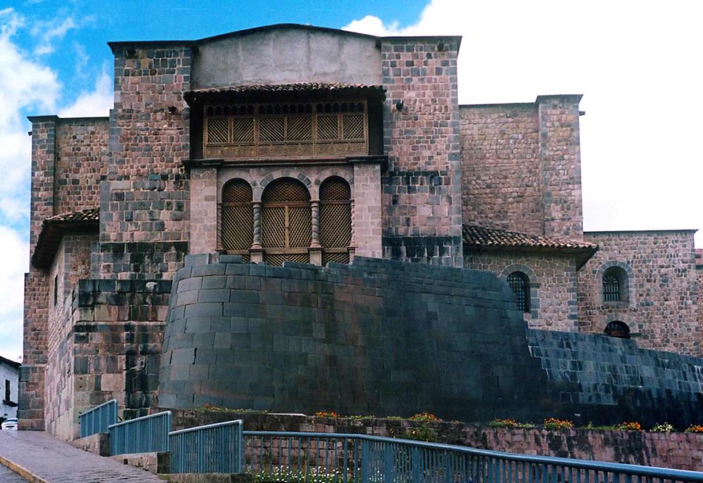
| | | | But as we proceed down Romeritos to the Qurikancha, we pass the Hotel Unitamba, and what do we see at the entrance? Why it's the other ancient Inca portal in Cusco that not in a ruin but is actually in use, as in our Hotel Rumi Punku. | | | | Qurikancha Both maps show equally well that across the street from Romeritos is the Qurikancha. But both maps show a church with it, the Pink Map at #5 also showing an Inca wall. We should expect this. Much of the Qurikancha was dismantled by the Spanish and it's its foundation below that remains to be seen today, and it's fairly well preserved. Up above is the Church of Santo Domingo / Saint Dominick. It's nice enough, and its large cloister is even better, but Colonial churches, even nice ones—we'll take a peek--are a dime a dozen. The Qurikancha is unique. | | | | Let's start with the importance of the Qurikancha. It was the most important temple in the entire Inca empire. It was the central religious site for the Incas, and was dedicated to the sun god Inti. It housed 4,000 priests and attendants. Before the Spanish plundered it and destroyed most of it, Spanish reports tell of opulence "fabulous beyond belief". It featured a huge solid-gold sun disc studded with precious stones. The disc represented Inti and reflected the sun, illuminating the temple. During the summer solstice, the sun still shines into a niche where only the Inca chieftain was permitted to sit. The walls and floors of the building were once covered in sheets of solid gold, including hundreds of gold panels. There were solid gold altars, and life-size gold figures. It was also the main astronomical observatory of the Incas, and also had shrines for the Moon, Venus, Thunder, Lightning, and Rainbows. The building had an adjacent courtyard filled with golden statues, including 20 life-size llamas, each one with its herder. It also had plants with leaves of beaten gold and stems of silver. When the Spanish required the Incas to raise a ransom in gold for the life of the leader Atahualpa, it's telling that most of the gold was collected from the Qurikancha. | | | | Let's now work with the name and see how accurate available translations are of what we're dealing with. First it needs to be said that the original name of the building was the Intikancha, named directly after the sun god. It's also quite easy to discover online that quri is gold. As for kancha the online Quechua-English and online Quechua-Spanish dictionaries (yes, there are such things) seem to describe an image, rather than give one good translation. | | | | Disregarding some useless translations, a kancha is described as a "court, courtyard, patio", also a "palace". Translations into Spanish offered lugar descampado, or "clearing" and espacio cercado, or "fenced-off area", also a recinto sagrado or "sacred enclosure". | | | | Using "palace" and "sacred enclosure", the original name, Intikancha, can be very loosely rendered as the Templo del Sol / Temple of the Sun. But the common name today, Qurikancha, doesn't translate that way. Personally, I'm not sure if the name refers to the entire building when it was filled with gold or to that former courtyard when it was filled with gold. If the latter is true, the word means "Golden Courtyard" (picture all those llamas!). If the former is true, the word means "Golden Enclosure", vaguely referring to either the building, the courtyard, or both. Since that's the most flexible phrase, let's decide to call the Qurikancha the Golden Enclosure. | | | | We enter the building from the plaza before the church and end up on a bench on one side of that pleasant cloister to talk about the building and take a breather. As it turns out, in modern times, much cooler heads have prevailed when it comes to Inca heritage, particularly the Qurikancha. There are two main areas to visit, and both have happily benefitted from the church being cut back to expose more of the Inca structure. The areas are (1) some of the chambers of the inner temple and (2) a rather spectacular curved outer wall out in the garden. | | | | This first picture is particularly revealing as to modern access to the first area, the original chambers of the inner temple (Photo by Colegota). One side of the church's cloister has been removed so you can see and visit these structures. We are looking here through the trapezoidal openings in an Inca chamber back at the area of the Baroque cloister where we've just been sitting under Colonial Cusco School paintings (click). What a contrast of cultures! | | | | Now let's step outside that chamber and look back at the group of several chambers (Photo by Paulo JC Nogueira). We were just inside that first entryway, looking to the cloister off to the right. What do we see? Several smoothly tapered examples of Inca trapezoidal architecture, in the more finely-cut ashlar style. As elsewhere, the stone walls, built out of huge, tightly-fitting blocks of stone, still stand due to their sophisticated stone masonry. The inclination of the walls inward allows them to support each other. The trapezoidal shape of these entryways, as well as that of the niches and occasional windows (Photo by Jorge Láscar), as seen here, all helped to dissipate energy during an earthquake. This last picture also shows the nearness of the cloister of the church. Boris told me to stand on a stone cube in the center of the first chamber and look in the direction of a window. By doing so, you get to observe the perfect alignment and symmetry (Photo by Yoli Marcela Hernandez) of the windows in the row of stone chambers. | | | | The final point is to realize that these bare stone interior walls indicate that the room is naked. So let's take a look at a digital reconstruction of what these rooms probably looked like when they were filled with gold (Photo by Martinangel). We can also see how those niches were used. | | | | Considering these chambers a museum, the museum extended to rooms with artifacts, which we popped into, but I look for architecture, and it was on an original Inca doorway between rooms somewhere in the interior where Boris pointed out to me that one side of the doorway was preserved behind plexiglas. It was a single stone, cut with straighter lines in ashlar-style than the 12-angled stone earlier. It's hard to describe, since this stone faced outward to the corridor, then to the left into the doorframe, zig-zagging around the jamb, then the back of it faced inward into the room, then turned left again around an inner corner. We counted the angles and I know it was more than 12, maybe 16 or 18, including going around the doorjamb. (Because of the straightness of ashlar lines, it would have to be an even number, just as any brick has eight corners. So do dice.) I can speculate that this stone, with more angles, is less well-known because (1) it's indoors and not more easily seen out on the street; (2) it faces several directions, so you have to walk into the room to see it all; and (3) it's cut with straight lines and right angles in the less-exciting ashlar style and doesn’t have all those pleasant rounded surfaces of the free-form 12-angle stone. We'll still see some incredible stones, all rounded, and huge, in Saqsaywaman in two days. | | | | We then move on to the other major area of interest beside those chambers, the curved wall outside that today faces a garden. Since it took me a while to understand just what it was all about, even as Boris explained it, I'd like to explain it in proper historical sequence. First we'll start with another digital reconstruction of this curved wall (Illustration by Martín Rodríguez Pontes) as it extended one end of the Qurikancha. It's tall, and shows gold ornament at the top. If I understood it correctly, inside this point was where the main altar was. Most of this structure is gone, with the entire upper part replaced by the main part of the church. What remains is only about 6 m (20 ft) high, down at the bottom. | | | | This is a photo of what the wall looked like right through the 1940s. You can see how the church had been built right out to the edge of the wall, with those arches and columns located right on top of it, effectively smothering the wall. The wall looks something like an apron for the columns, despite their extremely different styles. | | | | But how do we know that photo is from the 1940s? Because poetic justice struck the Qurikancha. As we said earlier, on 21 May 1950 a severe earthquake struck Cusco, damaging a third of its structures. Any guesses as to what happened here? You're right. At least a good part of the church collapsed, and the rounded Inca wall withstood the quake just fine, thank you very much. Inti must have been smiling. | | | | But the better news is that the authorities realized that something had to be done, so when the church was rebuilt, it was instead set back some distance from the edge of the wall (Photo by Håkan Svensson [Xauxa]). The juxtaposition of the two architectural styles is still startling, but they now give a somewhat individualized look. Try to appreciate the change as we have a view from the left (Photo by Rodrigo.Argenton), showing in addition the street side of the church and its towers, and also from the right (Photo by Håkan Svensson [Xauxa]). This last view shows particularly well that now it's possible to stand where the Inca altar was (where those people are, and where Boris and I went). Also look down that street ahead, because that's where we go next. | | | | On the Beige Map, notice how Pampa de Castillo takes us to Loreto, our next narrow Inca street. Calle Loreto (Photo by Pavel Špindler) has the oldest surviving Inca walls in Cusco. Notice the two styles of ashlar stonecutting, one more severe than the other. | | | | Coming out of Loreto, we're at the Plaza de Armas (see Beige Map), and we take a seat to relax and to survey what is around us. We look back at the exit to Calle Loreto (Photo by Diego Delso, delso.photo, License CC-BY-SA) at the right of this picture, and note one of the features that the Plaza offers dating from the Colonial period is several sets of attractive arcades surrounding the square, many with balconies above that are much more open than the ones in Lima were. Click to inspect the woodwork, and to inspect three signs on the right. Look at the side of this building at balcony level as it faces Loreto and you'll smile when you see the sign that says Starbucks Coffee, which is actually located at this end of the building. If you can't read it, take my word for it, since I clearly remember seeing it. Under the arcade, read that the covered walkways have their own names, this one being the Portal de Carrizos. I looked that word up and they are reeds. There may be a connection to the fact that the Plaza was once a swamp. Even more important is the sign on the arrow directing traffic on the Plaza Haukaypata. That's the Inca name for the Plaza de Armas, which was twice the size in Inca times. We'll say only little now about the square, and a lot more about swamps and the Inca name when we come back all on our own to the square in three days. | | | | Meanwhile, let's stand back and get a better lock at this southeast corner of the Plaza (Photo by Diego Delso, delso.photo, License CC-BY-SA). We again see the Portal de Carrizos and the exit to Calle Loreto, but also the other church on the square besides the Cathedral, which is the Iglesia de la Compañía de Jesús, or Society of Jesus Church, i.e. the Jesuit Church. Finally, let's cross the Plaza to get a wider view of much more of the Plaza de Armas (Photo by Rodrigo.Argenton)—right to left is the Jesuit Church, the Portal again, and the Cathedral. In the center spot the fountain. It includes a statue (click) of Pachacutiq (Photo by Diego Delso, delso.photo, License CC-BY-SA). Note how this view shows the additional arches in the Portales in the southwest part of the Plaza, with blue balconies. More later. | | | | | | Pachakutiq (hispanicized -cutec, -cuti) was, in the mid-15C, the ninth Sapa Inka (note spelling), or Supreme Ruler. In his time, he transformed the Kingdom of Cusco into the Inca Empire or Tawantinsuyu (more on all of this later). He began an era of conquest so that, within three generations, the Inca area expanded from the valley of Cusco to nearly all of western South America. Most archaeologists now believe that Machu Pikchu was built as an estate for him.
This statue of him was unveiled in 2012, and led to controversy. Some agree with the mayor who put it there, that the statue celebrates Inca history despite the later Spanish invasion. Others take the opposite view who say Colonial monuments combine with the Inca heritage to make the modern city. I agree with having the statue as laying more visible emphasis on Inca history, while there's plenty of visible evidence of Colonial monuments, even just around the Plaza.
To counter others that want the statue returned to its original form is the fact that the earlier statue showed a North American Indian warrior with bow and arrow in hand. (!!) It had been brought in the early 20C from New York by someone from the US who was a rector of a local university. Furthermore, that previous statue was of painted fiberglass, while the new one is bronze. The placing of the present Inca statue is a strong claim from the municipal government that Cusco is first and foremost an Inca city.
|
| | | | The only view possible of the entire Plaza de Armas (Photo by Joachim Pietsch) is from up in the hills, in the area of Saqsaywaman. You see both churches, but also the blue balconies on the southwest Portales. | | | | Sitting in the Plaza, Boris then pointed out that his usual next stop would be the San Pedro Market. On the Pink Map is shows as #32, next to the disused San Pedro Train Station. I told him I didn't have the energy to take such a long walk so far out of the way, as colorful as a food market might be. Not only have I seen my share of food markets, but we'd be in Pisaq in two days, and its market was particularly famous, a decision which worked out even better than expected. | | | | I've commented that too often, one church starts to look like other similar ones, unless there's something special within to see. I'd read about something of particular interest that was in the Cathedral, and so I did want to visit it for that reason. | | | | The first cathedral in 1539 had been built on the foundation of a palace of a Sapa Inca. The present main basilica was built between 1560 and 1664, with most of the stones having been taken from Saqsaywaman. In an additional attempt at intentional desecration, when they learned that the very sand spread on the main plaza was considered sacred, they removed it and used it to make the mortar for the cathedral. | | | | Outside, Cusco Cathedral (Photo by G. D. Vicente Torres) presents a Gothic-Renaissance style, typical of Spain of that period. The interiors are late-Gothic, Baroque, and Plateresque, with good examples of Colonial gold work and carved wooden altars. It's also a major repository of the Colonial art of Cusco, which is referred to as the Escuela Cusqueña / Cusco School. It's a Catholic artistic tradition that developed in Cusco in the Colonial period in the 16C, 17C, and 18C. | | | | Cusco School paintings were a form of religious art whose main purpose was to teach, to convert the Incas to Catholicism. Artists from Spain arrived in Cusco to teach locals drawing and oil painting. However, paintings of this style were not just limited to Cusco, despite the name, nor were the local Spanish excluded from learning the style. Most paintings were created anonymously; one exception is one of the last members of the Cusco School, the 18C Inca artist Marcos Zapata. | | | | Characteristics of the Cusco School are exclusively religious subjects, lack of perspective, use of gold leaf, and the predominance of red, yellow, and earth colors. But the most interesting aspect, and the reason we're discussing this, is that they often adapted the topic of the painting to include native flora and fauna. | | | | We spotted some of these paintings in the picture in the Quricancha peeking into the cloister, where the dark colors of paintings in the distance were unmistakable, and the Cathedral, too, has a major collection of them. But the best-known one, the reason I wanted to visit the Cathedral, is the jaw-dropping scene Marcos Zapata painted in 1753 of the Last Supper. It's huge, about 5x4 m (16x13 ft), lacks perspective, and shows the dark colors mentioned. But that's not what drops the jaw. Adapting biblical subjects to local customs, Zapata shows the table laid with cuy / guinea pig. (!!!) Less obvious, is that the glasses are meant contain chicha, a local beer made of corn, which we'll discuss more fully later. The inclusion of these two items would make the event more meaningful to the indigenous people. But then we reflect on religious art we've all seen that shows biblical events in European settings, and it becomes more understandable that all these artists are trying to create a link between a biblical subject long ago and contemporary observers. | | | | We'll leave the Plaza de Armas now, and after two trips out of town, we'll come back in three days to get into the subject more deeply, since the oldest history of Cusco and the Incas is actually bound together with the Plaza. But there's one more thing I tell Boris I want to see on the way back to the hotel, a small street intriguingly called Siete Culebras / 7 Culebras (see either map). Why a street should be called Seven Snakes intrigued me from the early days of looking at Cusco maps. And it turns out, there's even more to see. The street is diagonally across the block that the Cathedral's on (see either map), so to get there, we just go up Triunfo and turn left into Palacio.
https://media-cdn.tripadvisor.com/media/photo-s/05/65/ad/50/plaza-de-las-nazarenas.jpg
http://3.bp.blogspot.com/-Xc4xxyQeOc0/UE-DieOroqI/AAAAAAAAAhA/ty97cfS8i4o/s1600/Hotel+Monasterio+fachada.jpg
| | | | The first picture looks back down Palacio, where we just came from as we arrive in the Plazoleta de las Nazarenas / Little Square of the Nazarenes [Nazarene nuns]. Note the historic stone entry on the left with the flags, much better seen in the second picture. It's the [Belmond] Hotel Monasterio. | | | | | | If you don't know the name, you'll be hearing it quite a bit now, since both luxury trains we'll be taking shortly are Belmond trains. The company goes back to the Venice-Simplon Orient Express, which it owns, along with many high-end hotels. It formerly used the name Orient-Express Hotels Ltd but was rebranded Belmond Ltd in 2014 to give it an umbrella designation for its 32 plush, deluxe hotels, 8 tourist trains, and 3 river cruises in 22 countries. It also owns the 21 Club in New York (2011/15). I'm familiar with all but three of their trains below, particularly after taking this trip:
Venice-Simplon Orient Express (VSOE): 2002/2
Eastern & Oriental Express (E&O): 2010/16
Belmond British Pullman (day train): 2002/2 with VSOE; also twice from London right to the Southampton Dock to board the QE2
Belmond Hiram Bingham (day train, round trip): present 2017 trip
Belmond Andean Explorer: present 2017 trip
Belmond Grand Hibernian (Ireland)
Belmond Royal Scotsman (Scotland)
Belmond Northern Belle (Northern England; day train)
In addition, we'll be tangentially involved with three Belmond hotels today and tomorrow. Tomorrow we'll have afternoon tea at the Belmond Sanctuary Hotel right at the Machu Pikchu restoration; we are now standing in front of the Belmond Hotel Monasterio; at the other end of the Plazoleta de las Nazarenas is the Belmond Palacio Nazarenas.
|
| | | | Though these buildings are both hotels today, they are landmarks, so let's trace what happened on this quiet square. The site of the Belmond Hotel Monasterio where we're standing started out as being the site of the palace of the 19th and last Sapa Inca, Tupaq Amaru, who ruled briefly in 1571-1572. The present building was built in 1592, and in 1598, the Bishop of Cusco founded here the Colegio Seminario de San Antonio Abad College Seminary of St Anthony the Abbot. A major earthquake struck and damaged the Baroque-style building in 1650, and in the process of reconstruction, a Baroque chapel was added on. In 1965, the seminary moved to a new facility and the landmarked building was recycled into a hotel. | | | | We did not enter either of these Belmond hotels, but I understand the former chapel has an 18C Cusco School art collection in gold-plated frames, and there's a large courtyard with a fountain in the center. But in the second picture above showing the entrance, Inca foundation walls can be seen abutting the beautiful stonework around the entry that still has the carvings of two original Spanish Coats of Arms (click).
http://static.panoramio.com/photos/large/29336573.jpg
https://richedwardsimagery.files.wordpress.com/2015/12/belmond-palacio-nazarenas-hotel-a-beautifully-restored-16th-century-convent-cuzco-peru.jpg?w=584
| | | | As we step back in the Plazoleta, we still see the Monasterio, the white building on the right in the first picture, but we can also see its chapel next to it, at least the exterior. Beyond a little alley, the white building on the left is the Belmond Palacio Nazarenas, also seen in the second picture. The story here is similar—it's indeed a typical Cusco story. There had been an Inca building on whose foundation a private home had been built in the mid-16C reusing some of the Inca stones. After a succession of owners, in 1715 it was turned into a convent. By 1977 the last Nazarene nuns had moved out, and in 1999 the lease was transferred to Orient-Express Hotels (Belmond) who opened it as a hotel in 2012.
http://www.nuku.de/pictures/plazoleta-de-las-nazarenas-in-cusco-peru-11422-800.jpg
https://c1.staticflickr.com/6/5774/22673418012_f13d6f5142_b.jpg
| | | | But wait. What was that inconspicuous alley we passed by between the buildings? You can see it better in the first picture above, with a charming arch over it. Check the Beige Map and sure enough, it's the real reason we came to this little square. That alley has been described as one of the most pleasant streets in Cusco—check the second picture--despite its odd name, Siete Culebras/ Seven Snakes.
http://viajeserraticos.com/wp-content/uploads/2014/05/P5150082.jpg
http://eenusa.smugmug.com/photos/520620001_GZJ8b-M.jpg
| | | | I will readily admit I didn't know why it had that name, and so, Boris had to point out to me the seven snakes carved in high relief into the stones in the wall at the entrance. Both pictures above show them at the entrance to the alley, although there's another seven around the corner facing the plaza, one of which can be seen below. The figure in the shadow is one of those in the alley, the one in the sun faces the plaza.
http://1.bp.blogspot.com/_lBWPPsPQZcc/TD5gM0_pAeI/AAAAAAAAHI8/fNQSEdHd2b0/s1600/calle7b.JPG
| | | | We can have one more look via this YouTube video of Siete Culebras. It's only 3:01, but it's in Spanish and also covers other things, so you probably should just watch the short segment from 1:22 to 2:06. The ebullient little man points out the seven snakes on the alley side, but at the end you see how they also go around the corner to the plaza side.
| | | | As the Beige Map shows, walking the one-block length of Siete Culebras brings us out on Choqechaka, and a left turn brings us back to the Rumi Punku (#136) after a half-block, where Boris dropped me off. | | | | Going to dinner that evening was easy, since there was a nice little bistro DIRECTLY across the street from Rumi Punku's rumi punku. (!) I'd heard it would be cold, and was prepared, since, once again, late May in the Southern Hemisphere is like late November in the Northern, and we were high (!) in the Andes to boot. I checked online for Cusco weather, and the evening temperature was a very chilly 10°C (50°F), though it seemed bone-chillingly colder. It also seemed moonless and rather dark out, despite being in town, so the fact that it was such a short walk across the street was welcome. The bistro had the first of several very tall—the height of a person—round, propane space heaters I'd be coming across as the trip progressed, and it was appreciated. Though they took credit cards, their machine was out of order, so I checked if they took US dollars, and typical for the Andes area, they readily did, since US$ serve as a back-up currency in the area. (Remember, the currency of Ecuador actually IS the US dollar.) I was glad, though, I had a lot of small bills, so I wouldn't need change. | | | | I was pleased that for starters, I was able to choose a nice, hot quinoa/quinua soup, shown on the menu as Sopa de Quinua, in that spelling (Photo by ProjectManhattan). It was something new, and delightful. But even before that, despite the chill, I ordered a Pisco Sour, which is considered a South American classic. The first one I'd ever had was at dinner in Santiago de Chile on the way to Antarctica. Frankly, this was only the second, but the first of several on this trip, and I also learned a lot more about it.
| | | | Pisco is an Andean brandy produced in Peru and Chile that the cocktail is built around. These are two bottles of Peruvian pisco (Photo by Fernando Revilla). When I was on the second train, there was an open bar, and I sampled two kinds of pisco. The gentleman on the next stool was from Minnesota, and claimed to have several types of pisco at home, but I'm not a brandy drinker, yet was glad to get to taste the pisco neat. But I'll continue to take mine in a Pisco Sour, thank you. | | | | The oldest use of the word pisco for a brandy dates from 1764, and might be named after the Peruvian town of Pisco, once an important Colonial port located in the Pisco Valley on the Pisco River, south of Lima (see Peru map). But Peru and Chile have an intense rivalry regarding pisco brandy and therefore also the Pisco Sour. Chile manufactures much more pisco, 30 million liters in Chile in 2013 as compared to 9.5 million liters in Peru. Yet despite the rivalry, Chile is the main importer of Peruvian pisco, taking 34%--a third—of what is produced. | | | | But conoisseurs/connaisseurs claim Peruvian pisco is superior. It must be made from grapes coming from the five Denomination of Origin (DO) departments established in 1991. It is produced in copper pot stills as Single Malt Scotch is. It's never diluted and enters the bottle directly, unlike Chilean pisco. As an indication of the worldwide pisco war, this map shows international recognition of pisco (Map by Canuckguy). Countries in red recognize Peru's appellation of origin; those in blue recognize Chile's; those in purple recognize both. (There is little irony in the fact that Bolivia is on Peru's side—remember the loss of its coastline to Chile.) | | | | Historians and drink experts agree that the cocktail as it is known today was invented in the early 1920s in Lima by the American bartender Victor Morris. The Peruvian Pisco Sour (Photo by Dtarazona) of course uses Peruvian pisco, and adds freshly squeezed lime juice (for the "sour"), syrup, ice, egg white (for the froth on top) and Angostura bitters, which are the brown spots sprinkled on the froth. It's consistently served as in the illustration, and is very refreshing. | | | | Tonight is the first of four nights in Cusco. We take day trips the next two days, first to Machu Pikchu, then to the Sacred Valley, and the fourth day will be in Cusco again, for a solo walk. | | | |
| |
|
|
|

