|
Reflections 2019
Series 11
July 28
Trent-Severn Waterway II: The "Quinte" Cruise – Kingston – Falkirk Wheel
| | Day 7 – M Sep 3 - Lakefield to Peterborough (Second Part) We'd just come from the Kawartha Lakes, off the Peterborough Lift Lock, and docked in the cruise home base of the Peterborough Holiday Inn to end what the company calls the "Kawartha" cruise. I'd planned it carefully so that the next departure would not be back to Big Chute, but would instead continue south into the Bay of Quinte and on to Kingston for what the company calls the "Quinte" cruise. | | | | My experience in 2014 on the Rideau cruise was that it was not rare for people to take 2-3 of these local cruises in a row, since, when I boarded in Kingston, several people reboarded from the previous cruise. Thus I was very surprised when I found I'd be the only person taking the "Kawartha" and "Quinte" in tandem. All the passengers I'd been with debarked in Peterborough on arrival at 2:00 PM, and an entire new shipload boarded again at 8:00 PM, for another session at 8:45 of evening snacks and orientation. | | | | If that much was a surprise, I was totally taken aback to find the entire crew did a flip-flop—not only all the servers and deckhands, but also Hostess Sandy and Captain Brian left on the van the company uses to take them back to Orillia for their few days off. It would then bring them days later to Kingston for their next shift, up the Rideau. This van also brought supplies, mostly foodstuffs, to unload. But to my surprise I was the ONLY person that would connect between cruises here in Peterborough. | | | | I was told I didn't need to pack, but should vacate my room, since the staff does clean rooms between cruises (otherwise, you take care of your own room--essentially just making the bed--which I was more than happy to do). I could get off if I wanted to, but I had no more business in Peterborough, so I took my laptop and wrote in the lounge. To show the excellent maintenance on this boat, when the new crew boarded in the late afternoon, a young woman pulled all the chairs away from the walls and damp-wiped down the walls! Where else does this happen? | | | | At one point I'd considered counting this as one single voyage, but that's not so. They're two separate voyages in tandem, given that they're priced separately, that there's a turnover of all the passengers and also the crew. Thus, in the supplement to my "50 Voyages" summary in 2013/7, these are now listed as voyages 58 and 59. | | | | On this Quinte trip coming up, a passenger mentioned off the cuff that Quinte trips were harder to book because there are so few of them. I hadn't noticed that, since on the website, departure dates are segregated, with dates for a given cruise summarized only under that heading. There's no total summary of departure dates. This got me thinking, and I figured out a way to "beat the system" and learn what I wanted to know. On the bulletin board was an indication of availability for the next year (2019), and this one was sequential. At one point during the Quinte cruise I unpinned the sheet and sat down to do some figuring, and was happy to "break the code". This is a summary of one-way trips, alternating north and south:
"Rideau"……….Rideau Canal: 12 one-ways: 4 early, 4 mid, 4 late season
"Kawartha"…..Trent-Severn: 13 one-ways: 6 early, 4 mid, 3 late season
"Quinte"……….6 one-ways a year, connecting early, mid, and late trips on each canal
| | | | Eureka! I now understand what's going on. The company is actually doing just round-trip canal trips on one canal or the other. The Quinte trips are really repositional one-ways between the canals. That explains why there are so few of them, and why they're really sort of filler trips to move the boat from one canal to another. Quinte trips consist of three parts: (1) the southernmost part of the Trent-Severn Waterway, still with many locks; (2) the Bay of Quinte, with no locks, and which is very river-like; and (3) a quick run over to the Thousand Islands to stretch the time and make the trip long enough. Now the ride was just as attractive as the earlier one as to greenery and river and lake scenery, plus pleasant towns, but there was nothing as outstanding as the Marine Railway or either of the Lift Locks. It was still very much worth doing, especially since I wanted to get back to Kingston for a breather and for some good dining.
http://2.bp.blogspot.com/-34ufLwZnsR0/TyBcCXbGpLI/AAAAAAAAAIs/WBex1yM4Tbo/s1600/TSWMap%2B11X17%2BBIL%2Bcopy.jpg
| | | | Day 8 – T Sep 4 - Peterborough to Healey Falls Thus, for the first third of this cruise, we'll continue to need the Parks Map, above, and we'll continue downhill. The Peterborough Lift Lock was #21, so leaving town this morning we have two locks, then get down to the large Rice Lake, which we traverse end-to-end. It's the source of the Trent River, so as we leave the lake, the Trent will take us to the Bay of Quinte. We reach Upper Healey Falls, but dock at the side of the river, leaving the locks for tomorrow morning.
https://pcacdn.azureedge.net/-/media/lhn-nhs/on/trentsevern/WET4/visit/infrastructure/trent-hills/ecluses-locks-15-16-17-healey-falls/Lock16_17A-Banner.jpg?modified=20171201153457
| | | | Day 9 – W Sep 5 - Healey Falls to Frankford We're at Upper Healey Falls at #17-16, a flight of locks (above), which is more interesting than the upcoming single lock at Lower Healey Falls, #15. You can see (click) how there are only three gates, with a common one between the two locks. Flights of locks are handy since they can both be managed by one single crew. As with most locks, they apparently service traffic in either direction. That seems to be a hydroelectric power station next to the locks.
| | | | It's not very far to the other flight of locks at Ranney Falls, #12-11, which allow the canal to avoid where the Trent goes over Ranney Falls (Photo by Robert Taylor). This view looks upstream (we're going downstream), where a boat still in lock 11 entering lock 12. | | | | We continue to Frankford, #6, where we stay overnight, and we do something unusual here regarding excursions. There are next to no excursions or tours on this boat. Passengers are on their own to look around in any towns we stop at, where there is actually little to see, anyway. We did have that great, informative walk with Brian at Big Chute in the beginning, just a few steps away from the boat, and at Bobcaygeon, they opened the local museum for us after dinner, but that was also just steps away up that grassy slope. | | | | But in Frankford, they actually charter a bus for a museum trip after dinner. Though we'll sail to Trenton (#1) tomorrow morning, this evening we're taking a ride to the northeast part of Trenton to visit the National Air Force Museum of Canada, about a half-hour to the south. Frankly, looking at old planes is not my cup of tea. My measurement is always whether I'd want to stop at a place if I were driving myself through an area, and no, I wouldn't stop here. But under the present circumstances, why not try it? | | | | Once again, I was traveling blind, like when the bus took us up to Big Chute. I always like to know where I'm going, and here, all I knew was that the bus was just driving south somewhere. But now, after the fact, I can say that that's why the internet was invented:
http://www.destination360.com/north-america/canada/ontario/trenton/holiday-inn-trenton-map.gif
| | | | I now see we came down along the Trent River to Trenton. We crossed the 401 Freeway—we'll get back to that—and right afterward, crossed the main VIA rail route, whose Trenton stop is on the west bank. It's significant to this story that the CFB Trenton (Canadian Forces Base Trenton) is right there, which makes sense, since the museum is on its grounds, on that north-south road on the west side of the base.
https://bayofquinte.ca/living/wp-content/uploads/sites/3/2014/08/CFB-Trenton-2008-1-700x551.jpg
http://airforcemuseum.ca/en/uploads/2009/02/map.jpg
| | | | The first view is a satellite view of CFB Trenton. Look to the north south road on the west side. The southernmost white building is the museum and that field with pathways to its south is for the outdoor exhibits that don't fit inside. The second view is how we zig-zagged over to it. You are now far more oriented to where we were than I was at the time—as am I. | | | | I found the museum, which is dedicated to preserving the history of the Royal Canadian Air Force (RCAF), maybe just a little more than mildly interesting, which still only placed me at the bottom of the totem pole: I suspect the Canadians were a bit more interested; plane lovers in general would be enraptured; and Canadian plane lovers would be ecstatic. There are also a number of memorials at the museum. Here is an angular view from that road of the back of the museum with the outdoor field (Photo by P199). This being a national entity, you see its name in French, partially blocked: Musée National de la Force Aérienne du Canada. Below is one view of the interior of the museum, and one of the exterior display in the field, which was particularly nicely organized.
https://media-cdn.tripadvisor.com/media/photo-s/10/d3/b1/be/photo4jpg.jpg
https://c2.staticflickr.com/4/3708/18506561833_b9c8fb60a7_b.jpg
| | | | But what stayed with me even more strongly was something I learned just before we got to the museum. It also indicated that I was in a group of Canadians, an outsider trying to learn more. Shortly before we got to the museum, the driver pointed something out as we were on an overpass crossing the main highway. Immediately, everyone else on the bus leaned toward the side windows with great interest, while I was dumbfounded. I asked my seatmate what it was all about, and he told me what the driver had said we'd just crossed, and then elaborated on it, telling the whole story, so I did become aware of this story while I was still there. Now I'll tell it in my own words. | | | | You saw we crossed Highway 401 on the way to the museum. Highway 401, in red (Map by Floydian), is part of the corridor route from Québec City to Windsor, though this map just shows the Ontario section. (The VIA rail route is also part of the Corridor.) | | | | CFB Trenton is where Canadian military dead are flown home from overseas, such as from Afghanistan. Upon arrival, the fallen soldier's body, along with his or her family, is then taken in a military funeral convoy to the medical examiner's office in Toronto, using Highway 401 between the two points. In 2007, a newspaper columnist, with others, suggested that the stretch of 401 between Trenton and Toronto bear the alternate name Highway of Heroes (in French, Autoroute des héros). A petition was started and the change came about later that year. At one point, when the medical examiner's office was moved further away within Toronto, the name was extended to the new location. | | | | But most impressive are the "bridge salutes", where crowds line overpasses to pay their respects as the convoys pass (Photo by Christina Matheson). When the convoy leaves Trenton at about 2:45 PM, the general public, but especially off-duty fire, police, and medical response crews, line most overpasses between Trenton and Toronto as the convoy passes. I find this very moving, and consider learning about it the highlight of the museum visit. | | | | Day 10 – Th Sep 6 - Frankford to Picton The next morning we again go from Frankford to Trenton, but sailing this time, through the last few locks, ending in Trenton's lock #1, the southern terminus of the Waterway (Photo by Carlb at English Wikipedia). Google Maps now shows me the lock is on the west side of the Trent River, right at the VIA rail crossing south of 401. The river ends shortly afterward, and we enter the Bay of Quinte. However, I have to be honest, the Bay at this point is so river-like, and I was expecting it to be so bay-like, that I wasn't fully aware for quite a while that we were now in the Quinte section of the Quinte cruise.
| | | | Quinte is a word of Mohawk origin, and is pronounced KWIN.ti, rhyming with "minty". We can now leave the Parks map and move to this rather good map of the Bay of Quinte (Map by RyanRiWilliams). Find Frankford, Trenton, and the CFB Trenton. Then you'll notice how the Bay of Quinte forms a huge Z by going due east to Deseranto, then making a sharp turn to the southwest to go down to Picton (notice Picton Bay), then bending again to go east to end at Sandhurst, where it barely touches Lake Ontario, yet is considered a bay of it. Tomorrow, we'll be taking the North Channel behind Amherst Island, so we'll hardly see Lake Ontario at all. | | | | | | Every once in a while, I get the urgent need to speculate. Why is the Bay of Quinte so long and narrow, so river-like? Could it be that millennia ago it was simply the lower stretch of the Trent River, that got flooded? Is that why I felt we still were on that river? Food for thought. |
| | | | It's a beautiful ride along the Bay. Today we only go to Picton, where we dock for the night.
https://img.marinas.com/v2/51edc352f7147bf10e32cd8409eae9434b4e9832f878152532a8a84820fb86cc.jpg
Picton and its long, narrow harbor (above--click) are equally beautiful, and very small-townish. That's Picton Bay in the distance with the main channel of the Bay of Quinte just beyond.
| | | | Day 11 – F Sep 7 - Picton to Gananoque You see how, attractive as it is, there's little to describe on the Quinte cruise, and the ride moves along quickly. Today we leave the Bay of Quinte behind Amherst Island for the Thousand Islands, but before we do, let's use the following as a summary:
http://www.spikehampson.com/images/routemap9%20copy.jpg
| | | | It's someone else's route, so disregard his dates. This map shows our entire trip within Southern Ontario. Find Toronto and Oshawa. Trace the Highway of Heroes to Trenton. At Big Chute, disregard any marking to the west, but the rest of the blue line is valid. At the other end, we don't stop at Marysville on Wolfe Island in the Thousand Islands, we stop instead at Gananoque on the north shore, before ending in Kingston, then taking the train (past Trenton and Oshawa) to Toronto. I hope you can now see the whole picture of this trip more clearly.
http://w0.fast-meteo.com/locationmaps/Kingston.10.gif
| | | | Here's the last of the three parts of the Quinte cruise. From Picton we go behind Amherst Island, and then purposely pass Kingston to work our way up the Saint Lawrence River to dock at Gananoque. Actually, if we repeat this map of the Thousand Islands (Map by Stilfehler) that we used in 2017/5 when on the American side the previous year on the Montréal trip, we can see how now we used the Bateaux Channel (not named) behind Howe Island to overnight at Gananoque. The Bateaux Channel is more protected than the main channel south of Howe. [For future reference, note the location of Cape Vincent NY.] | | | | As so often is the case, we come again to a pronunciation problem. Gananoque is ga.na.NOK.wé, with NOK as in "knock". Nearby Kingston, used to be called Cataraqui, and the river north of the harbor still is. Cataraqui is pronounced ka.ta.ROK.wé, with ROK as in "rock". It's particularly odd to pronounce an I as É, but the end result is that these two unusual names, Gananoque and Cataraqui, actually rhyme!
http://s3.amazonaws.com/libapps/accounts/1532/images/Gananoque_Google_Map.JPG
| | | | Gananoque is small. When we docked at the waterfront park near that southernmost point on the above satellite map, I just wandered around the park for a while and not any further. But odd as it may seem, I did come across one building that I thought was so attractive, I couldn't get it out of my mind, and just walked around it, and inside it. Today it serves as the Gananoque Boat Line Office (Photo by Mykola Swarnyk), for cruises to the Thousand Islands, and I could do with seeing fewer signs on it. I think it's just perfect, so symmetrical, with brick work above and stone work below. Some of the detail might be marble. I think the roof is perfect and that this building would do well making a guest appearance in the Williamsburg Restoration in Virginia. | | | | I read that it dates from 1883, and if you click on the plaque above the door, you'll read "Customs V. R." [Victoria Regina], so it was a customs house during the Victorian period, now recycled to this. Given that anglocentric time period, one understands that it would NOT have said Douanes in French. | | | | That evening in Gananoque, a speaker was invited on board for a lecture. It was supposed to be on geology, but the guy was more interested in biology and talked more about animals than rocks. | | | | Day 12 – Sa Sep 8 - Thousand Islands to Kingston (First Part) Let's look again at that same map of the Thousand Islands (Map by Stilfehler) to see how today we sailed from Gananoque all the way up to pass Rockport, then, without any stops, circled around to pass Boldt Castle and continue down the American Channel. When coming up the Saint Lawrence on the Grande Mariner we varied between Canadian and American waters, though once in the Thousand Islands, we stayed on the American side. This was the first time I was in a Canadian boat in American waters. | | | | I would have thought that we would then have sailed on the Canadian Middle Channel south of Howe Island, but my notes say we returned to the Bateaux Channel north of Howe to go on to Kingston. Perhaps the other route was not smooth enough for a canal boat? I'm speculating again. | | | | We pulled in to Kingston at the standard 2:00 PM to debark. I was pleased on shore to run in to Hostess Sandy again from the first cruise, so I suppose it was a complete turnover again of crew—and passengers, since no one else was continuing from the Quinte cruise up the Rideau. | | | | Day 12 – Sa Sep 8 - Thousand Islands to Kingston (Second Part) The final, post-cruise part of the trip was my relaxing stay back in Kingston, to soak in the atmosphere and to dine at the restaurant I'd discovered that first afternoon going on the Rideau trip in 2014. At the time, I told the waitress afterward that I'd come back some day to Kingston to dine there, and we both laughed, but it was now coming true. It would just be two nights and three days, though only the middle day would be a full day. | | | | It might be partially in my imagination, but it seemed to me that the shirt-sleeve summer weather we'd had all along changed slightly the moment I stepped off the boat in Kingston. It was only the second weekend in September, but it was as though autumn had suddenly arrived—and I mean that in the most positive atmospheric way. There was the occasional breeze, and you wanted to wear a jacket. It all added to the atmosphere. As I've said in the past, I distinguish between traveling and vacationing, with travel time being more serious and informational, and vacation time being more laid back and relaxing. Thus, this Kingston time was pure vacation time.
https://www.downtownkingston.ca/sites/downtownkingston.ca/files/img/busker-map.png
| | | | Kingston I (half day) I've found what I consider an ideal map of Kingston to emphasize the pleasure of staying and visiting within the downtown area, trying to feel like a local. I've looked up to find what the reference on the map is to "where the action's at" and have since discovered that Kingston's been hosting an international Busker Festival for over three decades. It apparently originated as Downtown Kingston's July Sidewalk Sale, and street events attract buskers, so that now, it's been described as "one of the preeminent festivals of its kind in Canada." I find that it still takes place, not in September when I was there, but in July—it happened this present month on 4-7 July 2019. But on the map, we can use the busker sites just for guidance, and limit ourselves to the local definition of downtown in brown. We will step out of this charmingly close-knit area only once. | | | | | | I've known the word "busker" for some time, but only now got curious as to where it came from. Since this is a relaxed visit to Kingston, we have time to talk about it now. To understand how meaning shifts, let's first visualize the fact that (1) many buskers wear fancy-dress; (2) while few actually sell items, most do pass the hat, indicating the financial aspect; and (3) beyond that, buskers entertain.
It seems there really is/was a verb "to busk". Starting in c 1300, it signified "to prepare, to dress oneself", further implying "to set out [somewhere]".
It probably came from Old Norse buask, a reflexive verb that actually consists of, bua "to prepare" plus the Old Norse reflexive pronoun sik, which is equivalent to German sich and to the se or si of the Latinate languages. Then sik lost its I when it contracted to form buask "to prepare oneself." But as a verb, "to busk" is now archaic.
Yet it lives on as the noun "busker", an "itinerant entertainer" or "street entertainer". The idea of "preparing oneself, getting dressed up" to go out on the street to work shifted by 1857 to mean "to offer goods for sale ([in bars])", which apparently is what buskers were known for at that time. It then began to refer to people living shiftless and peripatetic lives, as buskers took to the streets to offer public entertainment "for sale". Thus the meaning shift from "prepare/dress" to "sell" to "entertain" makes the original meaning unrecognizable.
https://www.downtownkingston.ca/sites/downtownkingston.ca/files/img/event/buskers_flame_oz_0.jpg
Above is a busker in Kingston. I calculate that he has to be on Ontario Street in front of the historic Prince George Hotel (dark roof), with the rest of the view filled by the Kingston City Hall with its typical limestone façade (Kingston is also known as Limestone City).
|
| | | | Let's now use the busker symbols on our map to orient ourselves. Find the red dot closest to the harbor, on Ontario Street--and that's where the above busker picture was taken. We get there so quickly since we just debarked at Crawford Wharf at the foot of Brock Street. The purple dot is City Hall, with the former Prince George Hotel on the tiny block across tiny Market Street to its south, but we'll get to them both in a moment. | | | | The blue dot near the water is in Confederation Park, right adjacent to Crawford Wharf, so we start there. Taken from the adjacent Holiday Inn (see map), this view to the south (Photo by Timkal) has Crawford Wharf in the foreground. Where the excursion boat is located is where we sailed up the Rideau in 2014, and is where we just arrived from the Quinte cruise. (It looks like an early morning view, so picture this in the mid-afternoon.) The Martello tower (click) is in the marina, and Confederation Park is to the right, so City Hall would be further still to the right. | | | | | | Four Martello Towers were built as a line of defense in 1847, all now landmarked. Above is Shoal Tower, directly in the harbor, but if you look at the proper angle past Shoal Tower (Photo by Boardhead), you see a lineup, including Fort Frederick Tower and Cathcart Tower, both on the other side of the harbor. Murney Tower is also on this side at the water, but in south Kingston, at the southernmost tip of Barrie Street (see map). |
| | | | Confederation Park is not ancient. It was established in 1967 on formerly industrial waterfront land, and includes an unusual fountain under an arch (Photo by EverXAfter). This somewhat dark view of the fountain frames City Hall across Ontario Street.
| | | | Two sights at the southern end of the park are more interesting. Again with City Hall in the background, this is a view of steam locomotive #1095, "Spirit of Sir John A" (Photo by SoftwareSimian), built in 1912 and named after Canada's first prime minister, Sir John A[lexander] Macdonald. Click to see, with difficulty, the name on the tender. To its left is the former railway station, better seen from the diagonally opposite angle (Photo by Andre Carrotflower). Though it's now recycled as a visitor information center operated by the Chamber of Commerce, it's a historic former Kingston and Pembroke Railway (K&P) station—later CP--which once served as the southern terminus of the now-defunct line. Removing the tracks and rail yards, as well as grain elevators, was part of removing an industrial area to make Confederation Park.
We'll discuss the interesting story of the K&P as one of three Kingston stations later when we leave Kingston, yet it's once again ironic that back in the day, one could have arrived in or departed Kingston in the very heart of town, rather than in the northern edge of town. But at least Kingston does have an active station, while Peterborough does not.
| | | | Let's now cross Ontario Street to see the Kingston City Hall (Photo by Alexander49501). With its Market Square behind it (click), it occupies the full city block shown on the map. It's a very prominent Neoclassical building with a landmark dome supported by a round drum (click) (Photo by John Vetterli). Its prominence is explained by the fact that, when it was completed in 1844, Kingston was the capital of what was then called the Province of Canada, and the scale and design of its City Hall were meant to reflect its status as capital. On that basis, it's a National Historic Site of Canada. | | | | It was built of limestone in the form of a T. At the time, limestone was the building choice in the greater Kingston area, since massive limestone beds just under the topsoil. Many of Kingston’s limestone buildings were built by carving limestone out of the ground right where the building was constructed. This limestone was also used to construct the locks on the Rideau Canal. | | | | We know that right to its south, across tiny Market Street is the historic former Prince George Hotel (Photo by Andre Carrotflower), with its notable profusion of flowers. This view is a few years old, and has fewer flowers (Photo by Laslovarga). Note the handsome Mansard roof. There are both Irish and British pubs on ground floor, but it is no longer a hotel, since the upstairs area has been converted into loft apartments. Click to read the 1809 date of its establishment, to see one-block-long Market Street to the right, and to see the Four Points Hotel looming on the left, one block away on King at Clarence (see map). We'll be staying here for our two nights, free on points.
https://images.trvl-media.com/hotels/1000000/460000/457200/457123/457123_138_z.jpg
| | | | As we turn the corner around the Prince George, we're on Clarence Street (above), whose center area shows some traditional vernacular architecture, typical for everywhere in downtown Kingston, these having more Mansard roofs. We see that the Four Points, trying somewhat unsuccessfully to fit in, has a green, faux Mansard roof. Look on the right at the pearl gray building across King from the Four Points.
https://media-cdn.tripadvisor.com/media/photo-s/01/21/a6/4b/custom-house-1856.jpg
http://4.bp.blogspot.com/-XepG58FA-Ys/UBYYnTj2DxI/AAAAAAAAAw8/MfAc_pAKgPQ/s1600/kingston_ontario_st_georges_attraction_chruch.jpg
| | | | That pearl gray building is the former Kingston Customs House, the first picture above. To its left, note the small green dome. Then see it again on the second picture of Saint George's Cathedral, at King and Johnson—this is the King Street façade. Notice the profusion of limestone on both these buildings. | | | | Traveling with a light, "carry-on" wheeled bag makes it easy to do our sightseeing walk on the way from the Wharf to the Hotel. Now look back at the map and see how short that distance is. Everything's so wonderfully compact when you're downtown! | | | | We settle into the hotel and relax and do a little writing, both for current notes, and also to catch up on postings of former trips. In the late afternoon we're on our way to the restaurant, a mere two blocks north on King Street. But we first come across a farmers' market underway at Market Square behind City Hall (hence the name Market Street), on the King Street side (Photo by Laslovarga). | | | | Subsequent research has explained what was going on. We said that City Hall was built in a T-shape, and in the above picture, we see that the T protruding here on its back side was built as a hall for a public market, with individual stalls. I do not know if the actual building is still a public market, since I spent my time browsing outdoors, as shown (click). Anyway, who would expect that a limestone building attached to City Hall could be a public market? I now read that the seasonal farmers' market is the oldest public market in Ontario and takes place from April to November on Tuesdays, Thursdays, and Saturdays. This being a Saturday, I just lucked out. | | | | Saying the restaurant is just two blocks away is literal. On the map, follow our walk from the Four Points up King Street to Princess. The restaurant is a half-block to the left, and its breakfast place is a half-block to the right. So compact! | | | | I discussed the highly unusually-named Chez Piggy last time, but it's worth more comment. While Michelin puts out its famous Red Guide of restaurants and hotels, I was just using its ubiquitous Green Guide, that shows sights to see. It's very rare that the Green Guide mentions a restaurant, but this one did mention Chez Piggy in a special box, so I tried it out, and was glad I did. First of all, you might miss it if you don't know it's there, since it's not visible from the street. It's in a central courtyard surrounded by buildings on the southwest corner of King and Princess.
https://media-cdn.tripadvisor.com/media/photo-s/0f/f9/4a/18/the-shingle-on-princess.jpg
Walking along Princess that time, I found this discrete shingle at an alley (notice the limestone). I decided here that the R in its street number, 68R, meant "Rear", so I knew to go down the alley.
https://media-cdn.tripadvisor.com/media/photo-s/0f/f9/49/2e/entrance-front-king-street.jpg
https://i.pinimg.com/736x/cd/b0/b5/cdb0b5d85adbfebf420a6640383bc4b8.jpg
This time, while walking up King Street, I found this other discrete entrance first, before I got to the corner, and entering, it forked, with Chez Piggy to the right. I think there may be a third alley entrance from Brock Street. How charmingly unusual!
http://1.bp.blogspot.com/-F9OINwW-r7o/UI7QM-cWxnI/AAAAAAAAMBk/dJ7nfqX8eQk/s1600/Chez+Piggy+Ext2.jpg
Within the courtyard, it has this outdoor seating area in the patio on the right, and this is the muted main entrance. Though autumn was in the air, the trees had not turned color yet as in this picture.
| | | | Chez Piggy was opened in 1979. Its location in the building we just saw is a formerly abandoned limestone horse stable built in 1806. Now reflect on that. As buildings today might have garages, in 1806 they had stables in the courtyard, and these stables might possibly have served all the buildings around the courtyard, though again, that's speculation. Chez Piggy is a popular culinary tourist attraction and is recognized as a local landmark. In 2015 it was named Kingston's best-known restaurant by the National Post. In 2016, it received the Ontario Hostelry Institute Gold Award. I'll give it my seal of approval as well, as it has excellent food and service, and its unique venue I find wonderful. It's also as far from pretentious as you can get. The only thing I'd change when I become Emperor is that name. The original owner couple—I suspect they had something of a hippie streak--named it Piggy as a (rather unfunny) joke, apparently based on "eating like a pig". Then, wanting to parody pretentious names like "Chez François" or "Chez Pierre", they named it Chez Piggy. The name has really caught on. Worse, locals refer to it as "the Pig". You can't win.
http://chezpiggy.com/wp-content/uploads/2018/03/01-1.jpg
The small lobby tells you everything—limestone and fine woods. The receptionist sits at the desk and directs you either downstairs, where I sat the first time, and also where I'll sit tomorrow, and upstairs, where I'll sit today.
http://chezpiggy.com/wp-content/uploads/2018/03/13.jpg
| | | | The place was packed, but I remember sitting with my back to the wine rack, so I must have been in that table in the center. I wanted to be as local as possible, so I had a Mill Street draft, which I learned was a local craft beer out of Toronto & Ottawa; steak tartare, then linguini aglio e olio (garlic & oil). Afterward I discovered on the menu a Sandbanks Late Harvest wine (below). I find now that Sandbanks is on Lake Ontario, southwest of Picton, where we just were. It's described as "An aromatic, sweet dessert wine with hints of ripened peach & honey. Serve icy cold." And they did.
https://www.sandbankswinery.com/wp-content/uploads/2015/06/lateharvest2.jpg
| | | | Day 13 – Su Sep 9 – Kingston This is our one full day in Kingston, and counts as Kingston II. I usually just purchase the hotel buffet breakfast, but as I mentioned, Chez Piggy has its own breakfast/brunch/lunch venue, turning right on Princess from King instead of left. Walking up King, I found an antiques market (Photo by DXR) on the way, which I happily browsed though on the way to breakfast. I've now learned that it takes place only on Sundays, so I lucked out again, almost like being a local. In this view, City Hall is off to the left, off camera; the Four Points' faux Mansard roof is ahead, and at the intersection (click) both the former Customs House and Saint George's Cathedral can be spotted. When I was there, it was much busier than this, with more tables and umbrellas. I particularly remember a display of antique tools, something I rarely see, maybe on the Antiques Roadshow on TV.
https://i.pinimg.com/originals/80/a4/20/80a4205b9dda60a1fd577d50223aef2a.jpg
The venue is actually an oversized bakery called Pan Chancho Bakery & Café, located (above) in a traditional limestone (what else?) building that certainly looks like it dates from the 19C.
https://media-cdn.tripadvisor.com/media/photo-s/07/ef/92/d5/inside.jpg
https://vkvk.files.wordpress.com/2017/07/2017-05-20-14-39-06-hdr.jpg?w=1075
The first picture, looking toward the entrance, shows why the bakery is also called a gourmet food shop. The second, looking inward toward the Café, has a sign carrying on the pig theme they can't seem to drop.
| | | | | | The website explains that the bakery started making bread for the restaurant and then took on a life of its own. Instead of naming it the Chez Piggy Bakery, it was explained on their website that one of the original owners thought up something unique. The claim is made—at least on an older version of the website--that "Pan Chancho means "Bread Pig" in an "obscure Spanish dialect from Central America". What drivel. I can see why now there's no longer an explanation on their menu.
Pan is Spanish for "bread". No problem there. I'd never heard the word chancho, so I looked it up. It's another word for "pig" beyond the two I knew, cerdo, puerco. But something seemed odd, so I looked it up in the online Urban Dictionary, which says it's a Mexico-specific word for "pig"—all right--but can easily be used as a term for an overweight person, perhaps on the line of calling someone a "chubbo" or "tubby". I do not think it works for the name of a restaurant.
Worse, you can't put two nouns together in Spanish without something connecting them. To say "garlic soup" (it's great, try it) you use the reverse word order and say sopa de ajo. At the very least, the restaurant's name would have to be Pan de Chancho, which yields "Pig Bread". I think they really made a mess of this name, but it, too, has caught on. What can I say?
|
| | | | I was seated in the back on one side of a little alcove, with a couple already on the other side. Thinking back to the time in France, I chose hot chocolate when I saw it on the menu, which also fit the autumnal mood. There was a variety of breakfast and brunch/lunch type items on the menu, and I chose the following:
http://farm5.staticflickr.com/4059/4701383154_01c7b1e790_z.jpg
| | | | It was called a Southwestern Breakfast Wrap, which consisted of ranchero scrambled eggs, Monterey Jack, and refried black beans in a flour tortilla, covered with sour cream, accompanied by roasted corn salad and chili machismo. It was great, though I wonder about that "machismo" business. Does it mean you have to be extra macho to eat that chili? It's also bad Spanish. But the wrap was really huge and I enjoyed it.
Then it occurred to me how (Anglo) Canadian culture overlaps with US culture. Southwestern? In what country? Southwestern Canada would be, what, Alberta? They're using the term to refer to the US, and that's how the outlooks seem to overlap.
| | | | Somehow a conversation started with the adjacent couple. At first I thought they were Canadian (and that means Anglo, of course) even when they said they were from nearby Saint Vincent NY (see earlier map). It's close, and Canadians might well live across the border. But though I never fully ascertained what they were, they were probably Americans. They'd been to NYC and knew people there. We joked about the "Southwestern" wrap. It was a very pleasant conversation, and, as a solo traveler, it's always nice to meet people when dining. They had a copy of the Sunday New York Times, and when they left, as we shook hands, they gave it to me, and it was gladly received. | | | | When I later called the waitress over to pay my bill, she came with a broad smile. There was nothing to pay, she said, since the couple at the next table had already paid my bill on their way out. What a shocker--in the most pleasant way! The manner in which they did it didn't allow me to protest, but also didn't allow me to thank them. This mitzvah, or good deed, has now become another pleasant memory of Kingston. | | | | | | Now, well after-the-fact, I wanted to feel like a local and felt I wanted to see just how "close" Cape Vincent was to Kingston. I find the situation very interesting, and worth presenting:
http://gobiking.ca/big-maps/wolfe-island-map.gif
The route is via Wolfe Island, with two car ferries involved. The day-trip connection promoted online involves both ferries. From Cape Vincent to the island, Horne's Ferry takes 10 minutes; the distance between the ferries is 11 km (7 mi); the ferry to Kingston takes 20 minutes, both with frequent departures.
Horne's Ferry (summer season) is a toll ferry first licensed in 1802 and still operated by descendents of the first license-holder. It's one of the few privately-held US/Canada border crossings and is said to be an easy and fast customs border crossing, since it's so out-of-the-way. The Kingston ferry is free (!), and runs all year, since it's owned by the Province. But they also boast that, since parking is free in Marysville, you can leave your car there and be carless and carefree in Kingston, since it docks downtown (see our Kingston map for the Wolfe's ferry dock at the end of Barrack Street).
I suppose I'm just trying to create a speculative back story about a day-trip for my breakfast benefactors, but it's highly likely, since their walk from the ferry to Princess at King would have been about the same as my walk from the hotel.
|
| | | | The only activity I'd planned for the afternoon of my full day in town was a neighborhood walk. I'd discovered I wanted to know more about the Sydenham neighborhood because I'd discovered two Bed-and-Breakfasts in my original hotel search, odd as it may sound, and became curious about them and the older neighborhood they're in. It also intrigued me, since this neighborhood is so close to downtown that it must have developed early, perhaps late 19C-early 20C. | | | | From the Four Points, it was only a matter of walking past Saint George's Cathedral, and down Johnson for three blocks to Sydenham Street (see map). The whole neighborhood looked traditional, perhaps historic, with neat houses all along the way, some of brick, some of limestone. But the two destinations had been mansions, more spectacular than the other houses. Both were on the west side of Sydenham Street, the first one a half-block south of William:
http://media-cdn.tripadvisor.com/media/photo-s/04/2f/3d/c7/rosemount-b-b-inn.jpg
https://images.trvl-media.com/hotels/11000000/10990000/10987500/10987449/6454b4ae_z.jpg
What is today the Rosemount Inn (both views above) dates from 1850 and is in the form of a Tuscan villa.
http://www.thislifeintrips.com/wp-content/uploads/2017/08/IMG_4135-1024x768.jpg
http://media-cdn.tripadvisor.com/media/photo-s/02/32/87/bc/hochelaga-inn.jpg
And one block further, a half-block south of Earl, is what is today the Hochelaga Inn (don't ask me to pronounce it), a Late Victorian that dates from 1879 and is in the Second Empire style, indicated by the typical Mansard roofs. It would be nice to know more about the wealthy families that built these two mansions as high points in the Syndenham neighborhood.
| | | | Dinner that evening was back at Chez Piggy. I ordered a robust Ontario red wine; the appetizer was Vietnamese spring rolls; the main course was an excellent cioppino (2018/12). It had a wonderful, spicy tomato broth with shrimp, mussels, clams, and scallops. The "fishy fish" in the cioppino, this being Canada, was Arctic char, which I'd had last in Churchill. Dessert was peach pie with toasted almonds on top. Though it might have also been the wine speaking, afterward I told the waitress this cioppino "should be declared a national treasure." | | | | Day 14 – M Sep 10 - Kingston to Toronto Departure-and-travel day still counts as Kingston III (half day) because I was still seeing more of Kingston on the way to the station for a rail departure just after noon. It's also time to talk about the vagaries of rail in Kingston over the centuries, so let's look for the third time at the 1918 rail map. Zoning in on Kingston, you can also see that the New York Central served Cape Vincent, and is long gone. | | | | You see three black lines out of Kingston, but actually there are four, in the shape of an X, because you have to add a southeast leg going into town, not visible here. One thru line is the Grand Trunk and the other is the Kingston & Pembroke. Over time, there were actually four (!) railroad stations serving Kingston. | | | | The route marked on the map as the Grand Trunk Railway, running thru northern Kingston west-east is now the main line for Canadian National, and so we'll just refer to it as the CN line. The mainline opened in 1856 and was built in three sections. Montréal built west to Brockville; Toronto built east to Oshawa, and it was left to Kingston to build both east and west to bridge the gap. I find it wistful to think how every town was so eager to be on a rail line in order to be linked to the rest of the world. | | | | A station was built on the mainline in 1855, just before the line opened, at 810 Montreal Street at the northern end of town, the CN Outer Station. But it was awkward to access from downtown Kingston since it was a dusty stagecoach ride away; Google Maps tells me it's 3 km (1.9 mi) north of today's Confederation Square (find Montreal Street downtown on the Kingston map). | | | | Fifteen years later after that line was opened, the Kingston & Pembroke Railway (K&P) was incorporated, in 1871. It had the goal of connecting downtown Kingston to inland areas, and is the other arm of the X on the rail map. However, despite its name, it never reached Pembroke, but had to end at Renfrew (due west of Ottawa), 57 km (35 mi) short, since another railroad had beaten them to making that connection. But still, they laid track 178 km (111 mi) north of Kingston. In 1913, the K&P was absorbed into the Canadian Pacific, which is why it's marked as CP on the rail map, so we'll call it the CP line. | | | | But this line had the advantage of running all the way into downtown Kingston—it's the one whose station remains today as the information building in Confederation Square. I'll call it the CP Inner Station. Well as you can imagine, CN and CP have always been competitors, and CN couldn't stand being left at the edge of town, so they built a spur to reach downtown themselves. On our Kingston map, find again the blue dot where the station is that we saw at Ontario and Clarence, and move down one block to Ontario and Johnson, the southeast corner. That's where CN, to remain competitive, employed a waterfront agent, Hanlon's Depot, to serve as the CN Inner Station.
https://churcher.crcml.org/Heritage/heritage-KingstonInner%20Station.jpg
| | | | I did not go to see it when I was there, but do note that beautiful Mansard roof and the corner entrance. However, it's now an Italian restaurant. | | | | We are now at the point of the great mid-20C rail decline. Kingston's then-industrial waterfront and lake port suffered in that decline. CP closed Hanlon's Depot in the 1930s. K&P was largely defunct by the 1950s and the entire K&P/CP line was abandoned. Part of the line has been converted to a rail trail known as the K&P Rail Trail. All waterfront tracks within Kingston were removed in the 1960s, and what was once a sea of CN and CP trackage is now Confederation Park. | | | | The demise of the industrial waterfront with its two stations downtown left the CN Outer Station as the only passenger station in Kingston. But it had a big problem in that it had been built on a sharp curve of the main tracks, and so two things were done. First, in 1974 the present VIA Station was built along the CN tracks about 5 km (3 mi) west of the former CN Outer Station site. What I suppose can be described as the VIA Outer Station is just off Princess Street, a main thoroughfare. Second, the tracks near the old station were realigned a little further north in 1976 to ease the severity of the bend. The site of the historic station is abandoned (I found it on Google Street View). There's a desire to recycle it, just as the inner stations were recycled, but I understand that the neighborhood it's in is not of the best quality. | | | | While we've got the whole morning to get to the present VIA Station, we might as well get started. We can get right to the station's front door by Bus 18, which leaves from two blocks from the hotel. It's great being a local! On our map, follow Clarence for two blocks from the Four Points to Bagot, just north of Brock. This location is called the Downtown Transfer Point. We found the schedule online and they come hourly. But why wait for the 11:05-11:30? We can grab a bite at the station, so let's get the 9:55-10:20. The fare is C$2.50, and we get the correct change at the hotel. | | | | | | Canada (US Lite?) has always been so sensible with its cash. Back when there were low-denomination bills, unlike in the US, the $2 bill was just as common as the $1. If you wanted change of $5, you'd probably get two 2s and a 1, not five singles, as in the US. And unlike in the US, all the bills were of different colors, as upper denominations still are. But very sensibly, in 1987 and 1996 respectively, Canada replaced its paper 1s and 2s with coins. Since the C$1 coin includes a picture of a loon, it's nicknamed a "loonie" (in French huard, which is simply "loon"; also piastre). By extension, the C$2 coin is called a "toonie", a portmanteau of "two" and "loonie". (In French, it's less imaginatively a pièce de deux dollars canadiens, but also deux piastres.)
However, the Canadians are just as much at fault as Americans when it comes to 50-cent pieces. As logical as a half-dollar is, it's found rarely in both countries. Most people replace it with two quarters. But note this: if you need exact change for a fare and paper bills are not accepted, you need a mittful of quarters in the US, 10 quarters to pay a $2.50 fare, but in Kingston I just needed two quarters and a toonie.
|
| | | | It's all organized and made so simple. Below is the Downtown Transfer Point, two blocks away on Bagot at Brock:
https://www.cityofkingston.ca/documents/10180/76983/Map_CanadaDay2017_TransitTimes.png/b8d78eee-3eb7-48a9-b44d-3bd2cd2d8056?t=1498851458058
http://media.zuza.com/8/6/8622ab07-c16b-40e0-b04e-a434f131dbaf/Downtown_Bus_Transfer_Point_-_Brock_St___Gallery.jpg
Clarence (unnamed on this map) enters at an angle from the lower right. I remember arriving on the 4 bus in 2014, and got off right at that corner, called Platform 3 (it's just a sidewalk) on Brock. Now, as online directions had told me, I waited for the 18, headed for the Train Station, on Platform 4 on Bagot. The 2 also stops there, as shown in the second link, where I got my last look at limestone buildings. (These are all local city buses; bus 1 to Montreal means Montreal Street.)
| | | | We now have a pleasant 25-minute ride to the VIA Station, so we can sit back and look at the below map of Kingston bus routes, which also serves as a wide-scale map of Kingston itself:
https://www.cityofkingston.ca/documents/10180/8664501/MAP_AllRoutes-Sep15.pdf/119aa4ec-a273-4da0-a031-51d19a7e6952
| | | | Click the + about seven times, or to whatever magnification you're comfortable with. Find downtown at the lower right and see how it's off the beaten path for east-west rail lines. Now try this: follow to the north the light green route for the 1 bus that we saw went up Montreal Street (the former stagecoach route?). About a half-block below John Counter Boulevard is the location of the abandoned Old CN Outer Station. You can tell by the curve in the streets that the rail line used to curve here. Now move west along John Counter Boulevard those 5 km (3 mi) to where you see the last stop for our 18 bus, and that's the present VIA Station. In 2014, when I checked buses before arriving, I saw no bus connecting the station and downtown, so I walked about ten minutes to Princess Street to take the 4 bus right down Princess, a direct distance of 6.9 km (4.3 mi), meaning the current station is a little further from downtown than the former one was. | | | | I mentioned when arriving in central Peterborough that about half the passengers stayed on once I got off, since they were college kids going to Trent University. I found that's the same situation here. The 18 did not go up Princess directly, but took a roundabout route to pick up college kids. Follow our route on the one of the blue lines, which is actually quite scenic, running thru some nice neighborhoods, making frequent stops. We go down Bagot and up University to stop at Queens University. We go down Union and up Portsmouth to stop at Saint Lawrence College. We finally join Princess, then turn off to pull up right to the VIA Station. I remember the driver being very friendly and chatting me up as I got off the bus. | | | | The 1974 VIA Station (Photo by Michael Nugent), seen here from trackside, is pleasant enough, inside and out, but has no notable historic or architectural value. With plenty of time, I got a panini as brunch, took over a café table, and worked on the laptop until my train at 12:28. The mainline train was part of the present Corridor (Map by Airodyssey)—remember they're considering that new route to take pressure off this route—and I'd chosen an express. It's the purple line leaving Ottawa and stopping ONLY in Kingston on the way to Toronto at 14:40 for a run of 2h20. I didn't even think about passing thru Trenton. I did try to estimate when we'd be in Oshawa, to no avail, and saw nothing as we flew by.
https://www.upexpress.com/Content/Images/Stations/UnionStation/Union_Map_Lightbox.jpg
| | | | We had another overnight in Toronto. On this map, find Union Station at center right. I usually leave to the east to go to the Sofitel, but I decided to try something else just to be different. We walk up a block on York Street and come to the Strathcona Hotel. It dates I think from the 1930s, and the name is an old Canadian family name, and I like the sound of it. They also touted a single room, though it was pricey. The petite room was comfortable enough, with an entire desk wall and large bathroom, but had the smallest window I've ever seen in a hotel. It was like a square porthole, and with the bottom of the window at shoulder level! The view to the right was of the proverbial brick wall, and to the left was a dreary back view. If I were staying more than one night, I'd have changed it. | | | | In the lower level of the hotel, I had dinner in the Strath Pub, which was quite good pub food, and chatted up the waiter, who'd been working there for decades. Since I had an early train in the morning, I wanted to pay my bill in advance. I also wanted to use up as partial payment of my bill the remaining Canadian currency from that $20 I'd gotten on arrival. But since everything had been either prepaid or paid on a credit card, I found I still had $17.50, meaning, to my surprise, that the only cash I'd used was the bus fare that morning! | | | | As it turned out, the person checking me out (in advance) was the hotel manager. He made the mistake of asking if everything in the room was to my satisfaction, and I told him about the window. He started to say "Well, the next time . . . ", but I cut him off before he could talk about potential upgrades, saying there won't be a next time. I'd stayed at the Novotel three times, most recently two weeks earlier, and would go there again. I had to tell the truth. | | | | Day 15 – T Sep 11 - Toronto to New York I got to the station early for the 8:20 departure of the
Maple Leaf, though this sign says 8:30 (Photo by Hobvias Sudoneighm). I took it business class to be more comfortable on the long ride, and got breakfast at the café counter. The prices were Canadian, but of course they take credit cards. That's how things work nowadays.
| | | | We'll repeat the map of the Niagara Falls area for orientation (Map by LtPowers). When we got to Niagara Falls ON (Photo by Andrewrabbott at English Wikipedia), we went right thru, though this picture seems to imply something different.
https://www.railpictures.net/images/d1/8/4/2/4842.1216451860.jpg
| | | | We then immediately crossed the Whirlpool Bridge on the upper level, with motor traffic on the lower level. In the distance, the red-brick VIA station can be seen. This is a YouTube video (1:13) of the Maple Leaf crossing the bridge toward NY. We're looking southwest, and adjacent is that disused rail bridge that we mentioned earlier and that's shown on the map. In the distance is the Rainbow Bridge with the spray from the Falls, but that's because of the location the video was taken. I've NEVER seen, on many crossings, any trace of the falls out the train window, though it's fun to watch here. At the bottom, cars are paying their bridge toll, some perhaps with E-ZPass, as they enter the lower level. | | | | We pull into the Niagara Falls NY station and have to exit the train, with luggage, to go thru customs in the new station. After sitting in the waiting room for a while, we then can reboard the train. And sit. And wait, with this view of the platform--click to read the station sign (Photo by Adam Moss). I remember it being about 12:05, and I stopped a conductor to ask about the delay. She said we weren't scheduled to leave until 12:30, since sometimes there are a lot more passengers to go thru customs. To avoid it being like watching paint dry, I wrote on my laptop. | | | | The route was as usual, except when approaching NYC for a scheduled 21:50 arrival time, we were over a half-hour late. (!) Though we were coming from the Hudson Valley, we did go to Penn Station, since the construction period was over. I wanted to see us go over the reconstructed Spuyten Duyvil Bridge into Manhattan, but it was pitch black and I saw nothing. | | | | Lift Locks Since this posting turned out to be shorter than usual, I decided we had room for an add-on, especially about something that blended well with the lift locks we've been discussing in Canada. Actually, it's longer than a usual add-on, but pertinent. It's the Falkirk Wheel in Scotland, which is in actuality a very special lift lock, and the only one of its kind in the world. We'll get to that in a moment. [While most—not all—content in these postings usually involves personal experience, note that nothing from here on in was personally visited by me—it's all online research.]
| | | | I mentioned that the Kirkfield and Peterborough Lift Locks were the only still operational ones in North America, although there are a number of other boat lifts around the world, notably in Belgium, Germany, France, Russia, the UK, and China. I've done a quick review of a selected list of seventeen of them (including the two in Canada), and find that most use technologies other than hydraulics, including counterweights or inclined planes. It's notable that many are relatively new structures, either newly built or upgraded, so active commercial canal traffic remains alive in the 21C activity. Derelict canals are also being brought back to life. | | | | Of the two boat lifts in the UK, before we get to the Falkirk Wheel in Scotland, I'd like to mention the Anderton Boat Lift in Cheshire in northwestern England, southeast of Liverpool, primarily because of its flip-flop use of technology over time.
https://www.drifters.co.uk/bases/anderton/andertonmap2.gif
| | | | The Anderton Boat Lift provides a 15.2 m (50 ft) vertical link between two waterways, only one of which is a canal: it connects the River Weaver and the Trent and Mersey Canal. On this map, Stoke-on-Trent is in the upper reaches of that river, which flows to the northeast. The estuary of the River Mersey is at the upper left, which then continues past Liverpool. | | | | | | In addition, I see a lot of familiarity on this map of the Cheshire area. The closest I've ever been was in Chester (see map) in 1966 on the way to Wales and the ferry to Ireland. (Cheshire is a contraction of Che[ster] + Shire). As I just wrote in 2018/10 about two "travel people", Tim Littler of the Golden Eagle is in Altrincham (CH=G!), and Penny Liley of the Luciole barge is in Bollington, just above Macclesfield. |
| | | | Built in 1875, the Anderton Boat Lift was in use for over a century, when it was closed due to corrosion in 1983. Restoration started in 2001 and it was re-opened in 2002. But before we show any pictures, let's explain how its technology flip-flopped back and forth. | | | | When Anderton opened in 1875, it operated by hydraulics, just as Kirkfield and Peterborough did a quarter-century later. This is a diagram, not to scale, of the original Anderton hydraulic system. What I've been calling the lock chamber—which is essentially what it is—is also called a caisson, a fancy word for a "bathtub"-type container such as this. You see that the canal level is higher than the river level, and that much of the hydraulic system was set into the river bed. It functioned reasonably well for about a quarter-century. | | | | But the region encompasses salt mines, and the saline groundwater causes the corrosion just mentioned. By the turn of the 20C, the hydraulic system continued to need repairs, so alternatives were sought. The company engineer proposed converting to a system of electric motors and counterweights hanging from overhead pulleys as in this diagram, also not to scale (Both Diagrams by Gandalf61). To support the pulleys above, a new external frame was built around the structure. I find several interesting points about this diagram. | | | | (1) This image is exactly equal to what we all experience when we go up and down in a building elevator. Picture yourself as the black rectangle, in an elevator car, going up or down, in opposition to the counterweights to the side of the elevator shaft, all connected by overhead pulleys. Now picture a boat in a chamber (caisson) doing exactly the same.
(2) The two chambers were now able to operate individually.
(3) This is exactly parallel to the changes we've been noticing where funiculars, operating in pairs, have been updated to inclined elevators, operating individually. It's rail 'n' sail all over again, one blending with the other! We see the rail development of the funiculars being reflected to the water development in boat lifts such as this one (and others in Europe)—to say nothing to seeing both being parallel to passenger elevators in buildings.
The conversion of Anderton took place between 1906 and 1908. Thus Anderton was relinquishing hydraulics just as hydraulics were being built into Peterborough (1904) and Kirkfield (1907).
| | | | During the 1950s and 1960s commercial traffic on British canals declined. By the 1970s the lift's traffic was almost entirely recreational and the lift was hardly used during winter months. The corrosion problems continued, and in 1983, Anderton Lift Lock was closed down.
But during the 1990s British Waterways, as the government corporation that oversees canals and inland waterways was called at the time, wanted to restore Anderton. [In 2012, British Waterways in England and Wales became the Canal & River Trust; in Scotland, it became the public corporation Scottish Canals.] We've seen the "flip". Here's the "flop". When doing historical restoration, say of a building, what date do you restore it to? How it looked when built? How it looked when something famous happened there? British Waterways originally intended to restore the lift to electrical operation, but then consulted with English Heritage, and in 1997, it was decided to restore the lift to a modified version of how it originally functioned, with hydraulics, but using hydraulic oil. The lift reopened to boat traffic in 2002.
| | | | Though the hydraulics were reinstated, the external frame and pulleys added later were retained in a non-operational role, keeping "a little bit of this, and a little bit of that". The weights that used to counterbalance the chambers were not rehung, but have been used to build a maze in the grounds of the visitor center! Now let's take a look:
https://c1.staticflickr.com/3/2207/2496097159_f364ab90bf.jpg
| | | | This is a fine aerial view of the Anderton Boat Lift. The canal is up above and the river is down below. The black triangle center right is the maze made of disused counterweights. This is the front view of the boat lift from the river below (Photo by Boerkevitz). Click to inspect the two moving chambers (caissons) and the disused pulleys on top. Presumably traffic is still just recreational. And we can't leave out that clever idea of the maze (Photo by Mike Peel [www.mikepeel.net]), though I find it surprising that this many counterweights were used over time. | | | | Falkirk Wheel We now reach the main topic of this add-on, the Falkirk Wheel in Scotland, the only other lift lock in Britain—or in the British Isles—and the only lift lock of its kind in the world. If you don't yet know what it is, the concept of putting boats into a Ferris wheel will knock your socks off.
| | | | Sometimes you think you know "stuff", only to find you know next to nothing at all. My vague recollection of having seen the odd picture of the Wheel was that it was hidden somewhere off the beaten track of Scotland, and certainly that it was, like the Canadian lift locks, a product of the turn of the 20C, if not much earlier. After a bit of research, I found that was I ever wrong! It's right in the busy population belt connecting Glasgow and Edinburgh, and is, amazingly, a product of the 21C, specifically commemorating the millennium. Its construction brought back some disused canals (as in Anderton—it's a trend), and it's one of the major sights to see today in Scotland. I've been to Scotland a few times, but how did I miss this? I think it's a story that fits right in with what we've been discussing. | | | | Let's tell its story sequentially, by first looking at a map of Scotland (Map by Eric Gaba [Sting]). We're not talking about some rural area off somewhere, we're talking about the populated Central Belt of the Scottish Lowlands between Glasgow and Edinburgh. You see how narrow Scotland is here, and you would not be wrong if it occurred to you that someone might have decided to build a canal to connect the two coasts between the Firth of Clyde and the Firth of Forth.
https://upload.wikimedia.org/wikipedia/commons/3/35/Clyde.tributaries.jpg
| | | | Let's look a little closer using this detail map of the River Clyde, which runs for 170 km (110 mi), plus its firth (the red line shows its watershed). "Firth" is a uniquely Scottish word used for an estuary, and you see the river gets wider and wider until it's the size you see on the Scotland map. Notice also how many other firths there are. Back on the Clyde map you'll note that Glasgow is on the Clyde, and you'll also note how close the (unnamed) Firth of Forth is on the right. This area must have been screaming for a canal. (Keep Stirling as a point of reference.) | | | | Now we come to the detail of the tiny River Forth, only 47 km (29 mi) long, and the much more famous Firth of Forth, where Edinburgh is located (Map by Eric Gaba [Sting]). Stirling again is our point of reference. Also note Grangemouth for later discussion. | | | | | | The Firth of Forth, aside from its unusual name, which (1) is alliterated, (2) only differs by the vowel in the main words, and (3) sounds like you're lisping, is particularly well-known because of the famous rail bridge, the Firth of Forth Bridge (Photo by Andrew Bell), located 14 km (9 mi) west of Edinburgh at Queensferry, shown on the Forth map. It is considered to be a symbol of Scotland, and is a UNESCO World Heritage Site. In 2001, Beverly and I drove out from Edinburgh to the public viewing area just west of the bridge to get the view as in the picture. Earlier, in 1966, we drove southbound over the Firth of Forth on the road bridge to the west of the rail bridge. |
| | | | Anyway, given the proximity of the rivers and their firths, not one but two canals were built along the Central Belt:
https://www.waterwayroutes.co.uk/wr/70d-map-key-600.png
| | | | The canal that connects them directly has the very sensible name of the Forth and Clyde Canal, with a small branch to connect it right into Glasgow. As you can see, its western end is in the village of Bowling, at the beginning of the Clyde estuary (firth), while its eastern end reaches neither the River Forth nor the Firth of Forth, but connects to the short River Carron, just 22 km (14 mi) long, which then in turn reaches the Firth at the above-mentioned Grangemouth. The other canal was built particularly to bring coal to Edinburgh, and is the Union Canal, whose name makes more sense when you see that it's short for the Edinburgh and Glasgow Union Canal. It connects Edinburgh with the other canal at—oh, my—Falkirk. | | | | The Forth and Clyde Canal opened in 1790 and is 56 km (35 mi) long. Successful in its day, it suffered as seagoing vessels were built larger and could no longer pass through. The Union Canal opened about three decades later, in 1822, and was also successful initially. After losing a bit of length to straightening, its length today is very similar, at 50 km (31 mi). | | | | But we know that railroads were historically canal killers, and that was glaringly the case here. Just two decades after the Union Canal opened, the Edinburgh and Glasgow Railway (E&GR) opened in 1842 (Map by Afterbrunel). As you can see, it duplicated the canals end to end, Glasgow-Falkirk-Edinburgh. It sucked the life out of both canals, with freight transport severely reduced and passenger traffic effectively disappearing. Although the Union Canal was still used for transporting minerals to Edinburgh, any merchandise needed quickly was put on trains. The final indignity was that the Union Canal was acquired by the E&GR in 1849, just seven years after the rail line opened. (The rail line still runs today as the main line between Edinburgh and Glasgow.) | | | | Industrial traffic continued until after WWI, but then commercial traffic steadily declined. Subsidies to the rail network made things even worse. By the 1930s both canals had fallen into disuse, and in 1933, just over a hundred years since its opening, the Union Canal was dormant and was officially closed to commercial traffic, then totally closed in 1965, leaving the canal in a deteriorated state. The Forth and Clyde Canal closed in 1963 to avoid having to build a motorway crossing over it and because maintenance costs of bridges crossing the canal exceeding the revenues the canal brought in, and so it became disused and derelict. By the mid-1970s the Union Canal was filled in at both ends, and was also rendered impassable because of encroachments by a housing development in Edinburgh. The closure of the canals ended the movement of Firth of Forth fishing fleets across the country to fish the Irish Sea. | | | | We refer again to the town of Grangemouth, where the canal reaches the Carron River to enter the Firth of Forth. As an additional indignity, the canal route thru Grangemouth was drained and filled in by 1967 to create a new road for port traffic (but see below). The lack of political and financial foresight was thus removing a historical waterway for future recreational use and as a potential future revenue generator. | | | | But our attention now comes back to Falkirk, where the Union Canal, on much higher ground, required a flight of 11 locks to connect down to the Forth and Clyde Canal below. These abandoned locks had long since been filled in and built over. The connection between the two canals was gone. The outlet to the Firth of Forth was gone. Numerous blockages cut across the canals along their length. Could things possibly get any worse? | | | | No actually, there's good news for once. In the 1990s a general revival of interest in canals developed and a campaign was started by groups and local communities to improve and restore the canals. Then, with the year 2000 approaching, National Lottery funds were used to regenerate both canals as part of the millennium celebrations. The Millennium Commission was created to disseminate funds for selected "good causes", though the Commission would fund no more than half of any project. The result in this case was the Millennium Link, one of the biggest engineering projects ever undertaken by the then British Waterways (Anderton benefitted as well). The flight of eleven locks in Falkirk that used to link the two canals up until the 1930s would be replaced by a spectacular boat lift by 2002 to be known as the Falkirk Wheel, which is thus very much a child of our time, not of the 19C-early 20C, as I had mistakenly thought. [The Millennium Link project also involved building new bridges, some new locks, a new tunnel, and a new stretch of canal (see below).] | | | | Let's take a look at a panorama of the Falkirk Wheel and then talk about it before we expand on how it works and show more pictures and maps (Photo by Cameron Lyall at English Wikipedia). On the right is the hill where the Union Canal arrives from Edinburgh. An aqueduct projecting from the hill (first five arches from the right) extends the canal beyond solid ground more than one usually sees. The last two arches, with distinctive decorative spurs on them, are part of the Wheel, and are holding here the upper lock chamber (caisson), while the other is down below. The two chambers will be exchanged by a de facto Ferris wheel! Beyond the receiving basin for the Forth & Clyde Canal below is that rounded Visitor Center, as this has become a major attraction in Scotland. | | | | Rather than just restoring the flight of eleven locks, planners decided early on to create a dramatic 21C landmark as the link between the canals. I'd say they must have exceeded all expectations. In this last picture, the old flight of locks would be over some distance to the left (east). They used to require 3,500 tonnes/metric tons (3,900 US tons) of water per passage and took most of a day to pass through the flight. The Wheel makes its trip in four minutes. | | | | But the Wheel couldn't totally conquer the same height. The eleven locks covered a 35 m (115 ft) difference in height, while the Wheel raises boats by 24 m (79 ft). To make up the 11 m (36 ft) difference, boats coming down the Union Canal have to first pass thru a pair of locks in order to come down to the level of the aqueduct. Thus we have to clarify that four-minute running time by adding time for the two more locks on the hill for a complete passage. The Falkirk Wheel is the only rotating boat lift (rotary canal connector) of its kind in the world. As with so many canals today, it's now used just for leisure purposes. | | | | Boat trips on the Wheel depart five times daily. They last 50 minutes and from the Visitor Center go up the Wheel, sail onto the Union Canal, then come down the Wheel to return to the Visitor Center. Adults pay £13.50, about US$16.71. Since the Wheel opened, around 4.4 million people have visited and 1.3 million have taken a boat trip, with around 400,000 people visiting the wheel annually. By 2014, the Falkirk Wheel had become one of Scotland's most popular tourist attractions, second only to Edinburgh Castle among destinations with an entry fee.
http://jamescanalpages.org.uk/maps/falkirk.png
| | | | The above Falkirk map shows the contemporary lay of the land. The Union Canal up on the hill is in blue, the Forth & Clyde Canal, shown as far as Lock 8 on the way to Grangemouth, is in green, the ever-present rail line in black. The location of the original eleven locks is, as we said, a bit east of where the aqueduct and Wheel are today. But looking at this new approach to the Wheel, we see boats now go thru the Roughcastle Tunnel and under the Antonine Wall, which requires explanation. | | | | I suspect many of us are familiar with Hadrian's Wall (Map by NormanEinstein), built in stone by the Romans under Emperor Hadrian across northern England as the northern border of the Roman Empire. But until now, I'd never heard of the Antonine Wall, a mere turf fortification connecting the two Firths in Scotland that we're concerning ourselves with now, also built by the Romans, but under Emperor Antonius Pius. It served as the northernmost frontier barrier against the Celtic Britons and Picts. The Wall ran for about 63 km (39 mi) and was about 3 m (10 ft) high and 5 m (16 ft) wide. But only eight years after it was completed, it was abandoned, with the Roman legions withdrawing to Hadrian's Wall. This is the detailed route of the Antonine Wall (Map by Notuncurious). It runs north of Glasgow (see "Glasgow Bridge"), and just south of Falkirk. Roughcastle is where the redirected Union Canal goes under the wall and rail line to reach the Wheel (see Falkirk map). Also note Bar Hill, where the course of the Antonine Wall looks like this (Photo by Chris Wimbush). | | | | As the Falkirk map shows, the rebuilt section of the canal was directed under the Wall. However, the original plans showed it being built straight thru the wall, but this was changed after a public outcry. (It makes you wonder what happened in the 19C when people were less historically minded as they built the original canals and rail line.) The canal goes thru the Roughcastle Tunnel--its name dates from Roman times (Photo by Derek Harper / Roughcastle Tunnel / CC BY-SA 2.0). This view looks north thru the Tunnel to the arches of the aqueduct. Above the tunnel are, in order, the rail line (visible), the Antonine Wall, and the B816 road. Of the remains of the Wall directly above the Tunnel, this is a ditch (Photo by Rosser1954). | | | | After the tunnel, a boat reaches the aqueduct (Photo by Pjt56) and shortly thereafter, reaches the chamber (Photo by Chris Gunns). Right at this last simple arch you can see in the ground the slot thru which a pair of gates will rise, one on the aqueduct, and one on the chamber, sealing off the water in both. | | | | The diameter of the wheel is 35 m (115 ft). The arms, in two sets, extend 15 m (49 ft) beyond the central axle, which has a diameter of 3.8 m (12ft) and length of 28 m (92 ft). The chambers/caissons each have a capacity of 250,000 liters (66,000 US gal). To maintain perfect balance, water levels are carefully monitored and maintained by computer, keeping them within 37 mm (1.5 in) of each other. | | | | Let's now take a closer look at the Falkirk Wheel (Photo by Sean Mack). Note in particular that large gear partially showing. It's a fixed gear, and the "Ferris wheel" superstructure "walks" its way around it (more to follow). Now concentrate on the upper chamber/caisson as it peeks thru its circular opening, which is 8 m (26 ft) in diameter. You see below it (click) the small wheels in that circular groove-with-tracks that the wheels ride in as the chamber keeps itself upright. And you can't miss the four decorative spurs, two up and two down, that give flair to the structure. There's symbolic meaning to them.
https://www.claymore-armoury.co.uk/images/axe_robert_the_bruce/DSC_0010.jpg
| | | | Those spurs are meant to evoke a double-headed Celtic ax / Scottish ax, similar to the one in this picture of Robert the Bruce's battle ax, making the Wheel a kind of Scottish cultural icon along with it being an engineering marvel. The Royal Fine Art Commission for Scotland described it as "a form of contemporary sculpture." | | | | But how does it work? On a Ferris wheel, each car hangs freely, so it keeps on righting itself by gravity. On the Falkirk Wheel, the weight of the caissons would generally be sufficient to rotate them to keep them level on their little wheels, but this is too big an operation to leave such things to chance. Instead, a system of gears ensures that the caissons turn at precisely the correct speed to remain correctly balanced. | | | | Apparently when the chief engineer wanted to explain how the gear system would work to clients and funders, he went to his 8-year-old daughter and borrowed her Lego. This is a reconstruction of the Lego demonstration he used (Photo by RealGrouchy). It really is quite simple, but ingenious. Don't be confused by the five gears. The middle one is the one we saw protruding earlier. It sits fixed and does absolutely nothing. Each caisson has a large gear of equal size to the fixed one (8 m [26 ft]) and a small idler gear. This is how it works: | | | | • Picture a ladder, where each rung climbed yields progress. • Now picture a rack railway on a steep grade, where a fixed horizontal toothed rack lies between the tracks and a gear under the engine "walks" up the "ladder" tooth by tooth. • Now, since we have a circular construction, turn that horizontal rack into a circle, and it becomes a gear, and it appears as that large central gear we saw earlier firmly fixed to the axle so that it cannot rotate. Since it's sits passively, disregard it. | | | | Here we see the actual gears (Photo by Lowattboy). Again, disregard that one in the middle, on the axle, since it's just the "ladder" to be climbed. A gear of equal size surrounds the caisson, which as we can see again, is on wheels within that groove. The next step can be either disastrous or ingenious. Disastrous first. Let's say the two big gears meshed with each other. The central one sits still, while the outer one "walks" along it. Under this configuration, the outer gear would turn clockwise, down to the right, and within moments, it would dump its contents like a dump truck and eventually end up upside down at the bottom. Oops. | | | | So let's get ingenious (keep checking out the picture). We now separate the two big gears, which continue to function in exactly the same way, by a small intermediate gear attached to the framework of the arm so that it cannot move, just turn. Now, as the arm "walks" down the rack of the central gear, it's THIS small gear that turns clockwise, down to the right, instead. That makes the large caisson gear meshing with it turn counterclockwise (British: anticlockwise), up to the left, constantly keeping the caisson absolutely level as it rolls along on its wheels in the groove. It's this little gear, one on each side, that cause a double rotation, the arms turning one way with the caissons turning the other way, keeping themselves stable and perfectly level. Very clever. | | | | Here's a rear view of the Wheel in motion (Photo by AndiW); click to see the gears in action, and do admire those distinctive spurs. Here's a front view of the same (Photo by Henk Monster). Note the three closed gates holding water back, two in the caissons and one at the end of the aqueduct. | | | | We have two YouTube videos of the Falkirk Wheel in action, both in time lapse. As you watch them, remember that it actually takes four full minutes for the caisson exchange. This one shows two rear views (1:05) and this shows other points of view (0:28). On this second one, watch the gears in action at 0:05-0:07 and the pair of gates "magically" disappear under water at 0:10, then reappear at 0:16-0:17. | | | | Grangemouth But with the rebirth of the canals, there's been the strangest development. While the purpose of the Forth and Clyde Canal was, as the name says, to reach the Firth of Forth, the 21C leisure boat activity has instead concentrated on connecting Glasgow and Edinburgh by water via the Wheel, just as the rail line does and highways do. This left the short section from Falkirk to Grangemouth on the Firth, 6.4 km (4 mi) long and comprising a flight of 12 locks and two single locks, an uninteresting backwater, particularly because it was Grangemouth that suffered the indignity of having its stretch of canal running to Grangemouth Docks drained and filled in to make a road, plus housing and factories. Our earlier "Falkirk map" only went to Lock 8, but this map shows the whole route into Grangemouth:
http://www.jamescanalpages.org.uk/maps/falkirktograngemouth.png
| | | | Concentrate on the right side of the map, in Grangemouth. What is labeled as the "original line of [the] canal" is now, according to Google Maps, a road called Forth-Clyde Way, which doesn't make the indignity any better, and maybe worse. Such lack of historical appreciation—and foresight! You can see the canal used to reach the River Carron just before the Firth. At some point along the way—I know not when, possibly even at the time of the diversion—a new connection was made further upstream, by having the canal make a left turn at Lock 3 (see map) and building a sea lock in the river to help equalize tides. But this was not ideal, since the river downstream from the lock was crossed by four bridges, the two road bridges shown on the map, plus two bridges carrying oil pipelines. But problems remained. When the tide was high, there was limited headroom under the bridges—and we know enough about that on the Ohio River. When the tide was low, there wasn't enough water to navigate, and we know about that too, based on our story about the Danube. | | | | Once again, National Lottery funds came to the rescue. A new 870 m (950 yd) extension of the canal was built which joined the Carron further downstream from the four bridges at a new sea lock (see map). That included building a new tunnel under the M9 motorway, inserting a new lift bridge into the A905 road, and rerouting the two high-pressure oil pipelines leading to the refinery in Grangemouth. | | | | In addition, the under-used land to the west of the canal (west of locks 2 and 3), was developed into an urban greenspace called the Helix, including Helix Park. This included building two spectacular monumental statues in the park, called the Kelpies. | | | | The Kelpies Another uniquely Scots word, like firth—and loch, and haggis--is kelpie. In Scottish folklore, a kelpie is a shape-shifting water spirit inhabiting the lochs and pools of Scotland. It's most usually described as appearing in the form of a horse, tho it can also take human form. Almost every sizeable Scottish body of water has a kelpie story associated with it, the most famous and most widely reported one by far being the kelpie of Loch Ness.
| | | | To enhance the area around Grangemouth and attract visitors, two monumental steel statues of oversized horse's heads were erected in Helix Park, called The Kelpies (Photo by Beninjam2000). Tho I've never seen them in person, they appear breathtaking. Each statue has a structural steel framework clad in 990 uniquely shaped stainless steel plates. Click to see that the cladding of the structure is NOT solid; to admire their graceful style; and to compare their size to the people below. Each statue is 30 m (98 ft) high and weighs 300 tonnes/metric tons (331 US tons). | | | | They were completed in 2013. During the first year after the opening, nearly a million people visited The Kelpies, which would indicate success. In our motorized age, the statues are a monument to the horse-powered heritage across Scotland, are intended to celebrate the horse’s role in industry and agriculture, and of course to celebrate their association with the canals as tow horses. Here's another view of the downward-looking Kelpie with a nearby Seagull Trust Cruises canal boat run by volunteers on four locations on Scottish canals as a complimentary service for the disabled and disadvantaged. (Photo by © User:Colin/Wikimedia Commons/CC BY-SA 4.0). You see the lock—it's nice to see a traditional one for once! Compare it to the last map, and you'll see this horse is on the north side of the newest part of the canal reaching out to the Carron and the Firth of Forth. | | | | Visits to Scotland I've been to Scotland three times. The most recent was the stop in the Shetland Islands on the way to Greenland in 2012 (2012/18), so that doesn't apply here. The two earlier times were very lengthy driving trips thru the British Isles, in 1966 and 2001. Below is our time in the Central Belt of Scotland. | | | | 1966 • At the very beginning of this trip we saw more of the Central Belt than we'd planned. We were still newlyweds and trying to save money so we'd taken a charter flight from New York via Glasgow to London. There was a change of planes—and airports!!—in Glasgow. We arrived at Prestwick Airport (near Ayr—see Scotland map) about a half-hour late. Included for the whole planeload of people was a bus ride to Glasgow Airport, west of Glasgow and about an hour from Prestwick. But the driver got lost (!) and we missed our connection. The group was then put onto another bus and sent off to Edinburgh Airport, west of Edinburgh, which took about an hour and a half, and were put on a plane to London. Thus, on the way to start our trip in London, we had an early preview of Scotland!
• This was the trip where we were in Cheshire before going to Ireland.
• To get to Scotland, we took the ferry from Ireland, then drove along the Ayrshire coast on the Firth of Clyde to Glasgow (see Ayr on Scotland map); we went north to Loch Lomond, then well beyond thru the Highlands; we returned south from Perth to Edinburgh to England. I don't see how we'd have come close to Falkirk then, but of course, this was long before the Wheel, anyway.
| | | | 2001 For the part of the trip in Scotland, we stayed in the Lowlands this time. We again came from Ireland on the ferry, drove via Ayr, thru Glasgow to stay in Edinburgh. This is the time we stopped at the Firth of Forth Bridge, but then drove up to Stirling (see Scotland map), for a quick look at the castle, but also to see the Wallace Monument (2001/4), since the movie "Braveheart" about William Wallace had come out in 1995. We were amused to see that on the statue, Wallace was made to look like Mel Gibson. Anyway, this is the time that we must have driven thru the Falkirk area, right along the M9 in Grangemouth (see that map). I suppose the Falkirk Wheel would have been under construction right then, but we'd never heard anything about it; and the Kelpies, built right next to the M9, weren't put up until 2013. Oh, well.
| | | |
| |
|
|
|


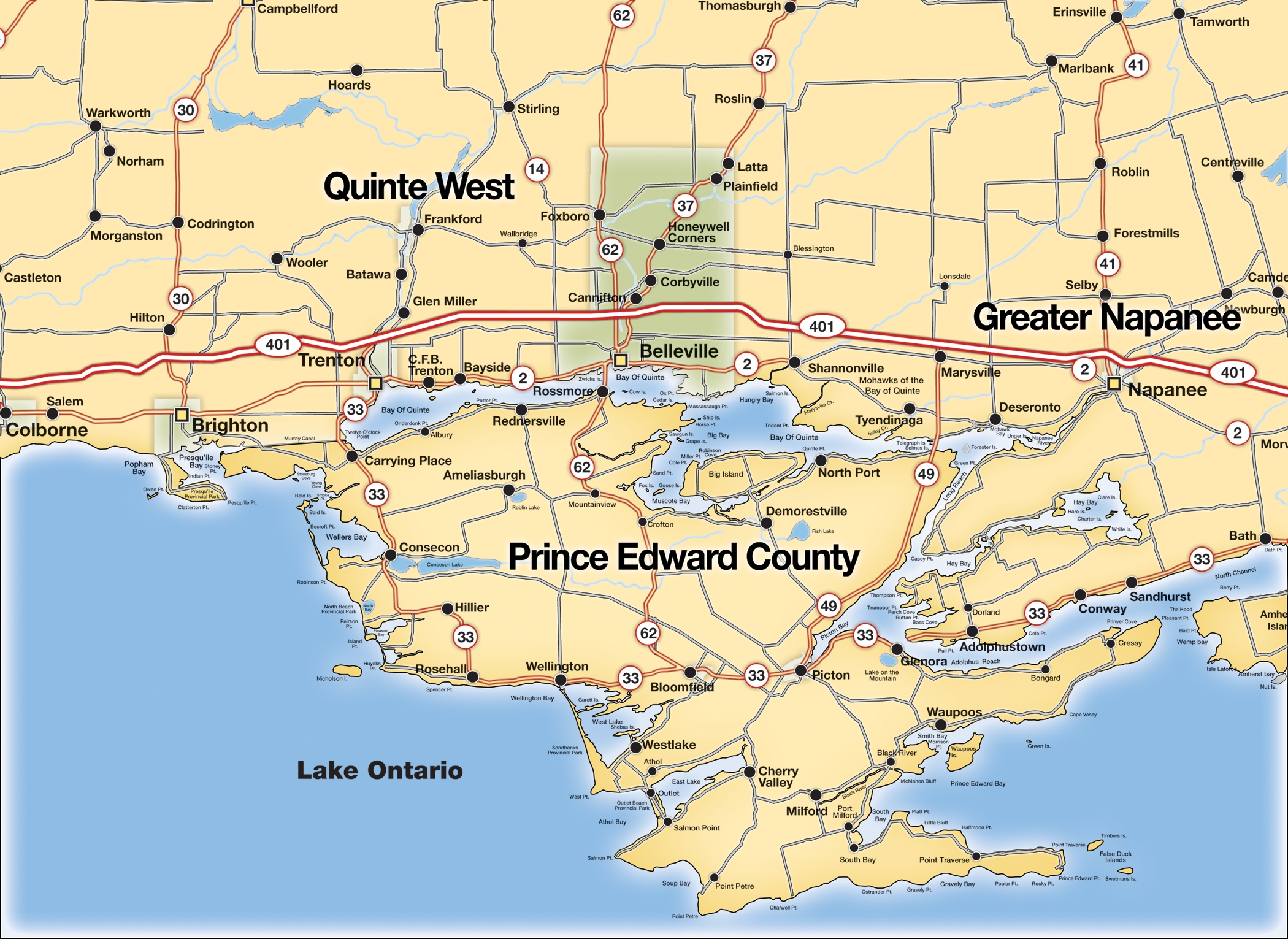
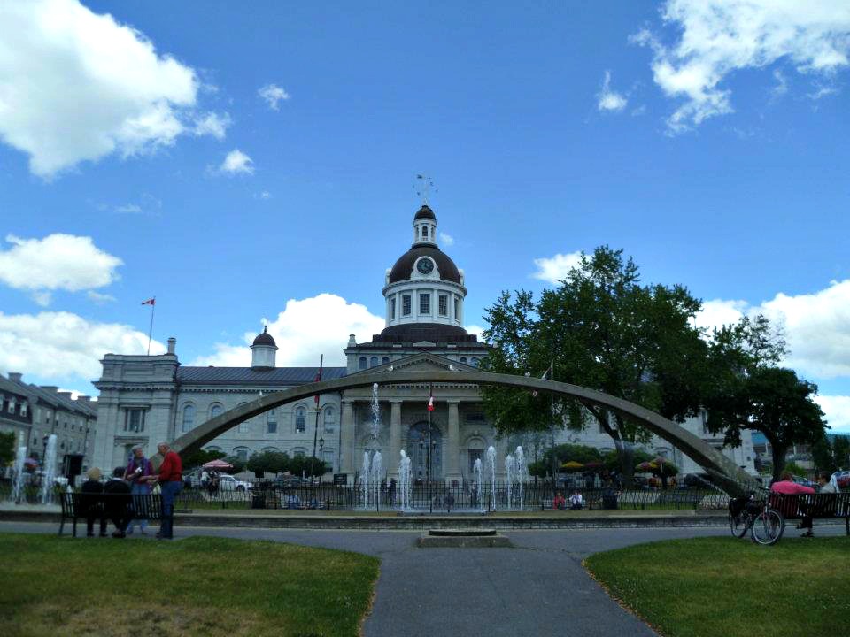
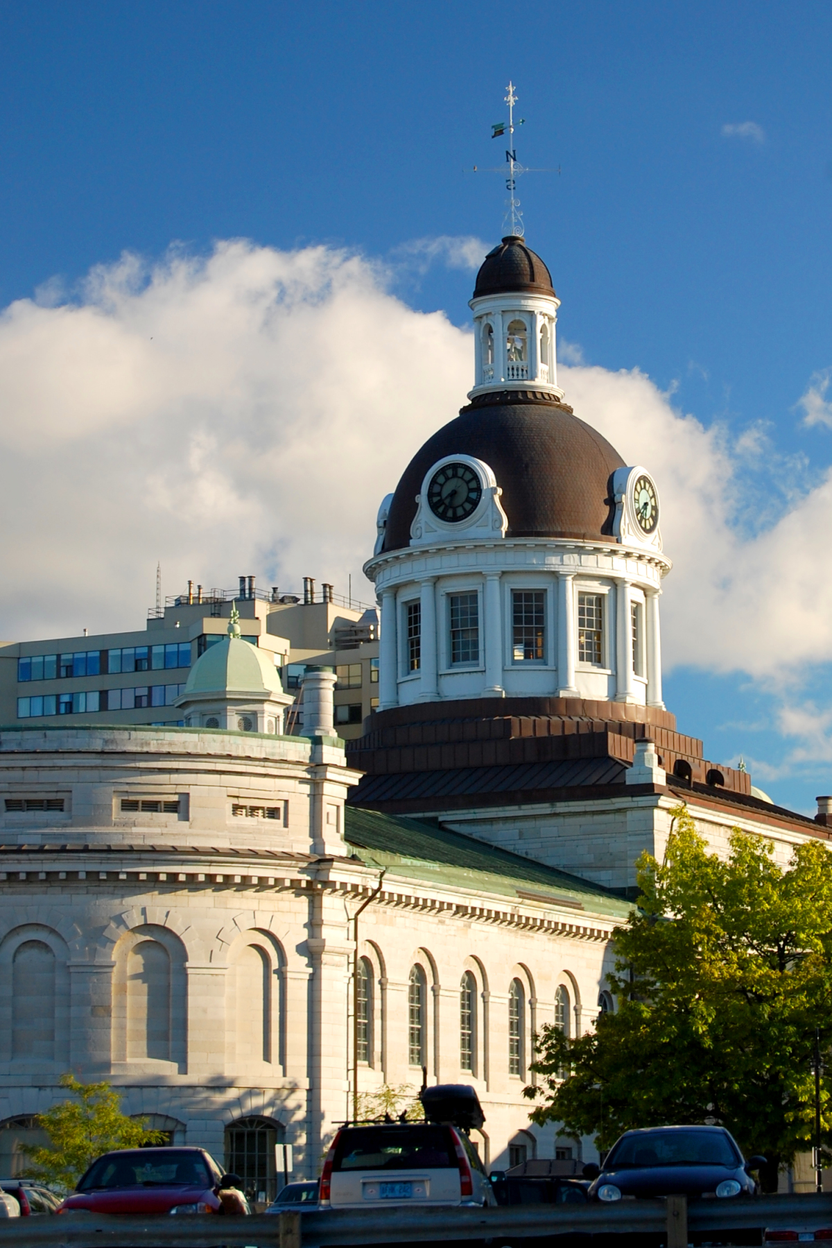
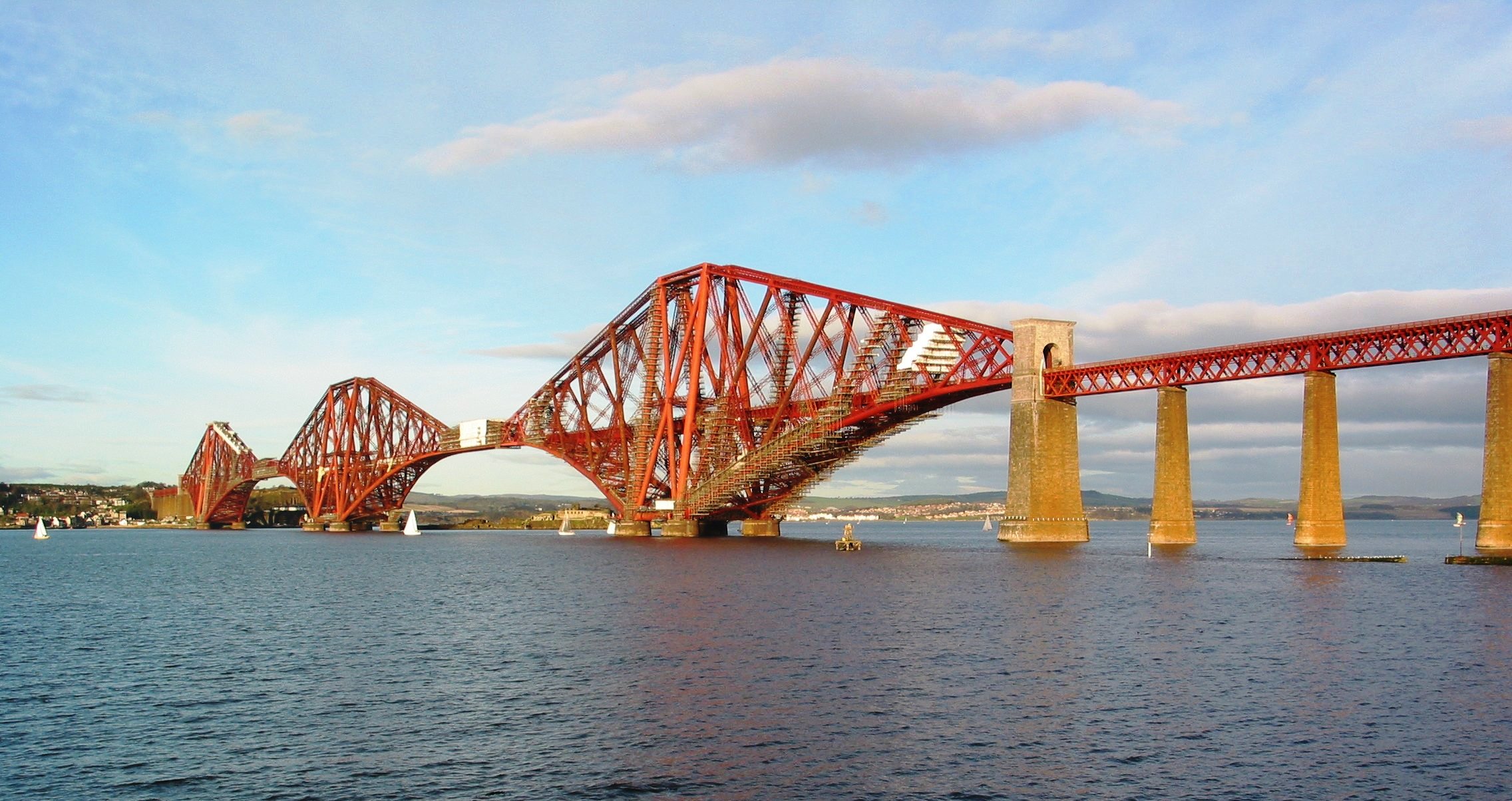
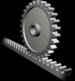
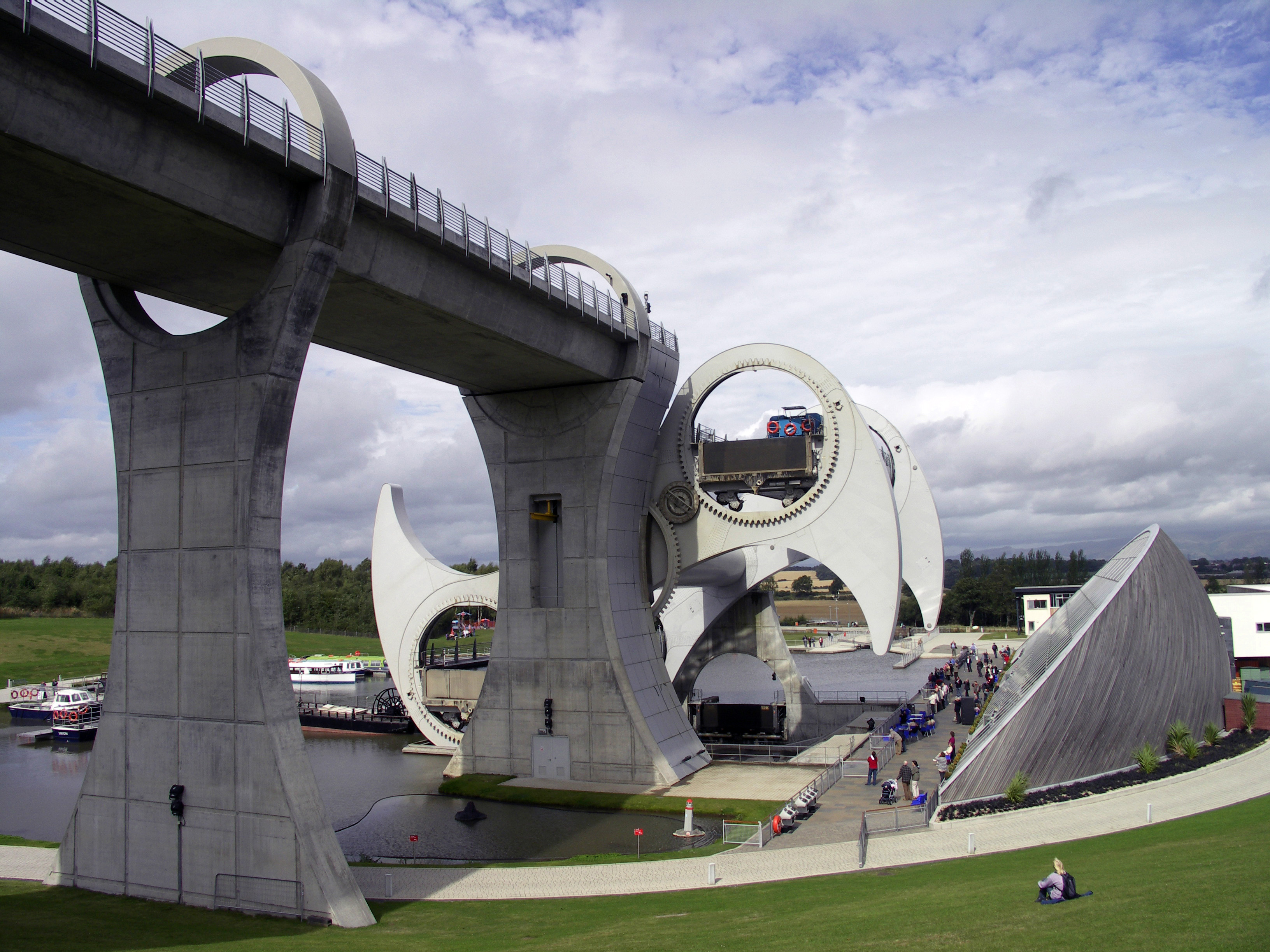
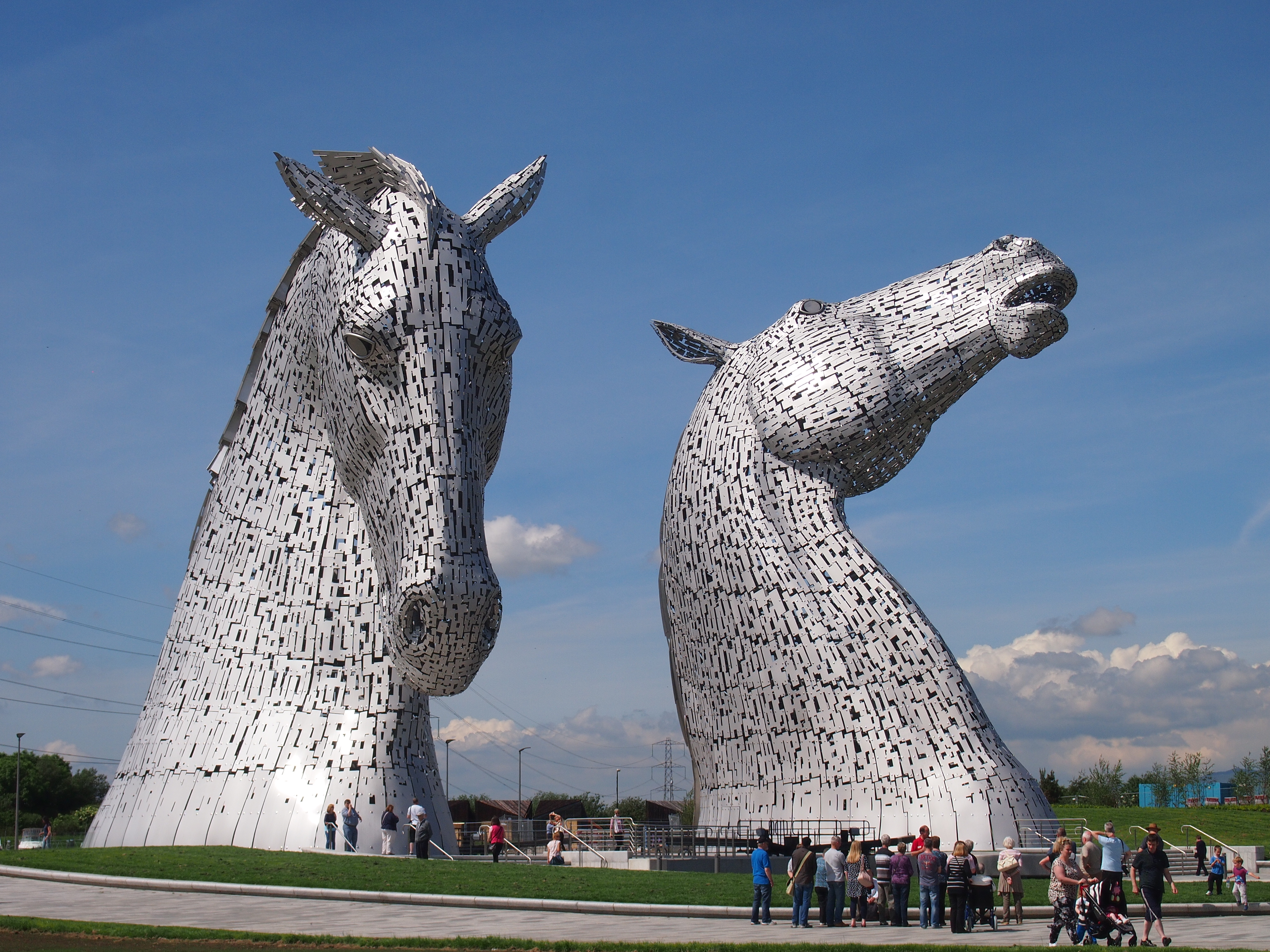