|
Reflections 2020
Series 11
December 10
Orient Express – Southeast Europe - Danube – Sarajevo 1914
| | Because of the two-posting break in this discussion, the following note has been added to the end of 2020/8: [The continuation of the discussion of Nagelmackers & Wagons-Lits will be found in 2020/11.]
And so here we are, needing a quick recap: Train travel had been a domestic matter in most countries when Nagelmackers' company, Wagons-Lits, started making international long-distance connections. Given the geographical shape of Europe, we discussed how long-distance travel of more than one night out of Paris (with London always piggy-backing) had to go east to cover really large distances. Tho we talked about other directions, such as the Sud-Express and Train Bleu, we concentrated on how northeastern Europe was connected to western Europe by the Nord-Express from Paris via Berlin to Saint Petersburg. A basic feature were Kurswagen (thru coaches) that would split off the main route to service other cities. Thus, the Nord-Express, on its way to Saint Petersburg, dropped off a Kurswagen west to Riga and another east to Moscow to connect with the Trans-Siberian. Wars continued to shrink the route until the Nord-Express was finally canceled.
| | | | Nagelmackers Begins In 2020/8, when we pointed out Nagelmackers' initial offerings, we purposely described the two major ones out of order, telling first about his second venture to the east, in this case northeast, the Nord-Express in 1896. But now it's time to go back 13 years to his initial offering to the east, which ended up veering southeast, the Orient Express in 1883. The two long-distance trains together ended up connecting huge swaths of eastern Europe to western Europe. But just as it was worthwhile reviewing what northeast Europe was like back in the day of the Nord-Express, where just two countries, the German and Russian Empires were involved in the route, we need to see what southeast Europe was like. Just where was Nagelmackers trying to send his train? Beyond Germany, there were just two countries, the Austro-Hungarian and Ottoman Empires. | | | | Southeast Europe Europe has seen its share of invasions from many sides over the years, but in this area, most striking is the invasion by the Turks of the Ottoman Empire into southeast Europe. | | | | | | The Ottoman Empire was named after its founder, Osman I, the ruler of the House of Osman. Modern Turkish calls it the Osmanlı İmparatorluğu, and some languages conform to that S-form of the name: GE: Osmanisches Reich; RU: Османская империя / Osmanskaya imperiya. But since the Turkish name Osman was derived from the Arabic Uthman (no S, but T), English and others have developed an alternate TTO-form of the name: IT: Impero ottomano; FR: Empire ottoman; SP: Imperio otomano; DU: Ottomaanse Rijk.
We really should mention here that, as a piece of furniture, the ottoman first reached the West from Turkey in the late 18C and started out as a full-sized backless couch, but today is more likely to be found as a large, backless, often circular piece, used for casual seating or as a footstool (Photo by Raymours Furniture Company, Inc).
|
| | | | Centered in what is now modern Turkey, the Ottomans back in the day reached across North Africa and much of the Middle East, but also far into Europe, famously to the "gates of Vienna". The greatest extent they reached was in 1683 (Map by Atilim Gunes Baydin). Click to confirm that even Budapest and all of Hungary (not named) had been conquered, and that Vienna was just a short distance away and subject to attacks. Vienna withstood Turkish sieges in 1529 and 1683. The second Siege of Vienna in 1683 was the high water mark of the Ottoman Empire, after which its footprint in Europe began to recede, sometimes quite starkly, to the point where Turkey-in-Europe today is so small.
Since the 1683 event was so epochal, on the several trips Beverly and I took to Vienna (Map by Wauteurz), including living there for a while studying advanced German, downtown at the Universität Wien / University of Vienna (Photo by Bwag), founded in 1385 as the oldest in the German-speaking world, we visited the point where the Turks came close to the city walls southeast of the Innere Stadt / Inner City (click) at today's Schwarzenbergplatz (not named) and the area west of it. But the Turks never conquered the city. Nevertheless, one result of this interaction with the Turks was the coffee culture that thereafter permeated Vienna and Western Europe. Also borrowed from the Turks at that point was the crescent-moon-shaped pastry called the Kipferl, the ancestor of the French croissant (see 2018/6 Ctrl-F: croissant). On another trip, we also drove up to the heights of the Wiener Wald / Vienna Woods (actually, hills) to the southwest (not named, but in the gray area SW of Hietzing) and not only got a breathtaking view of the whole city, but a view that made it easy to picture the Turkish sieges.
That's the deeper background, but now let's move up to Nagelmackers' period in the late 19C. This German map shows Europe in 1867. It's roughly accurate for Nagelmackers' 1883 adventure except for the fact that Germany became unified in 1871, so picture dark blue Prussia (Preussen) as now including southern Germany, including green Bavaria (Bayern). We can see that by now, Austrian Habsburgs have taken over Hungary and given it equal status as part of the Dual Monarchy of Austria-Hungary (Österreich-Ungarn), in gold. The Ottoman Empire (Osmanisches Reich) in brown has continued to retreat further to the southeast, while Montenegro, Serbia, and the Principality of Romania seem showing signs of independence, something that at least part of the Kingdom of Greece (Königreich Griechenland) in blue has already achieved. Thus we see that Nagelmackers and Wagons-Lits, once crossing Germany, had in the early years only two large countries to deal with in his train expansion, Austria-Hungary and the Ottoman Empire.
But that was early on. Since the Orient Express lasted well into the 20C, we should look and changes after that. This is Europe in 1914 on the eve of the Great War (WWI). By now, the Ottomans have retreated within Europe to where Turkey is today, with just a small swath of European territory. Of the newly emerged countries, Wagons-Lits now has to deal with Serbia, Romania, and Bulgaria as well. Then, after the Great War, Austria-Hungary is broken up into numerous component nationalities, so in the Interwars (plural) Period there are more countries to deal with during the second Golden Age of the Orient Express. This map shows Europe from 1929 to 1938 (Last Three Maps by Alphathon/Furfur), when Wagon-Lits now has to negotiate with, beyond Germany, a separate Austria, a separate Hungary, a larger Romania, Bulgaria, and a Yugoslavia that now includes Serbia, before reaching the new Turkey.
[For those who want to compare those earlier years with today, we'll repeat from the earlier posting this map of Europe today, showing changes after WWII and since (Map by San Jose).]
| | | | Defining Southeast Europe There's tendency to refer to the area as the Balkans, or worse, as the Balkan Peninsula, so I checked out the reasoning on that. The Balkan Mountains (Map by Rowanwindwhistler) are, as this Spanish map shows, a narrow range running east-west. The eastern end is at the Black Sea and they cut Bulgaria almost completely in half, with only a bit of the westernmost end reaching into Serbia. It's unreasonable to stretch this Bulgarian range to define all of southeast Europe.
Now compare that with this topographic view (Map by Captain Blood~commonswiki). [Map Update: Serbia and Montenegro are now two separate states, and Macedonia is now called North Macedonia.] How did the confusion start? The concept of the Balkan Peninsula was created by the German geographer August Zeune in 1808, who mistakenly considered that the Balkan Mountains run coast-to-coast between the Black Sea and the Adriatic. But note that the mountains to the west nearer the Adriatic are the Dinaric Mountains and not an extension of the Balkans. For those that like to nevertheless call it the Balkan Peninsula, where are the limits? The water borders are obvious, but the northern border is variously defined, yet often given as the line formed by the Danube, Sava and Kupa Rivers, as shown. Yet that line of rivers seems too restrictive. It's reasonable to include all of Romania in the region, plus the smaller areas north of the Sava and Kupa, up to the borders of Hungary and Austria.
But beyond that, the region runs far too wide east-west to be considered a peninsula, especially when compared with slender peninsulas like Italy and Florida. In addition, referring to this large area as the Balkans has acquired a stigmatized and pejorative meaning related to the process of Balkanization, or disorderly, hostile fragmentation. Thus, tho other terms are still used, the preferred term is "southeast Europe".
| | | | Wagons-Lits Potential Destinations Consider Nagelmackers' thinking about his foray into southeast Europe. What cities should be the key destinations for Wagons-Lits to serve out of Paris on his eastern quest? Curiously, his easterly direction very roughly would be following the route of the Danube, shown here in red. Thirteen years later, in 1896, his Nord-Express would connect the two capitals of the German and Russian Empires, Berlin and Saint Petersburg, so now, in 1883, he'd certainly want to similarly serve the two capitals of the Austro-Hungarian and Ottoman Empires he was dealing with, Vienna en route and then Constantinople at the far end (now called Istanbul and Turkey's capital until 1922, when Ankara became the capital). Athens is also distant, and certainly a draw because of its cultural history, but that could always be connected to the network by a Kurswagen later. Anyway, Athens was at a dead end, while Constantinople had Asian Turkey (Anatolia) and the Middle East beyond for further rail expansion.
And how about en route? After Vienna, nearby Budapest is a no-brainer, and it's a co-capital of Austria-Hungary anyway. But after Budapest, we find our choices more or less determined by the Danube. Should take a northerly route and keep to the side of its left bank (looking downstream)? That would get us to Bucharest, but there are no bridges on the lower Danube, and infrastructure to Constantinople is lacking. Maybe we could work around that somehow. On the other hand, there's always the more southerly route on the side on the right bank of the river and in that case, we can cross the Danube early on, before Belgrade, so we can serve Belgrade and Sofia on the way to Constantinople. Let's see what we can do. Maybe try both routes?
| | | | Visits to Southeast Europe Before we get to that history, I want to document my personal experience with the area, which were parts of two visits, both—alas!—now a half-century ago. I've never gone back as I have with many places in western Europe, but that's not because this corner of Europe doesn't have its many delights.
The first time in the area was in 1965, when, from June 29 to September 2, Beverly and I took a very, very long trip around the entire Mediterranean from Portugal to Syria, by ship, air, and a bit of rail. I've talked since about the time in Portugal, on two ships, along the Nile, and maybe more. But the part involving southeast Europe was our visits to Athens and Istanbul in mid-August 1965. Since Istanbul is crucially important to the Orient Express, we'll be discussing that city later.
The second time southeast Europe was on our itinerary was during our 1971-1972 dual sabbaticals with extensive travel and study, mostly by car, and mostly to eastern Europe, which was terra incognita to us. After that period living in Vienna studying, during the four weeks from 25 September to 21 October 1971, we drove thru southeast Europe in a huge loop and saw everything we wanted to see. Only now, 49 years later, do I realize that that loop duplicated Nagelmackers' choice of routes, since outbound we kept to the left bank of the Danube and inbound back to Vienna on the right bank. It was a sensible route to drive, and I now see it as a sensible way for Wagons-Lits to choose its routes. We saw great scenery and interesting architecture, particularly churches and monasteries, and had a number of very memorable adventures, but this is not a travelog, and those descriptions and stories are not for now.
Here is an excellent map of the area, with emphasis on the Danube and its tributaries. National borders and names are shown in pale gray, but are hardly visible. We'll start with this map because major cities are easier to find. Follow the major highlights on our driving route from our temporary home location in Vienna:
Vienna, Budapest, Cluj (KLUZH), Brașov (BRA.shov), Bucharest. We then wanted to see the beautiful Black Sea coast, and cut east within Romania to Constanța (not shown; in Romanian, t with a cedilla, ţ,= ts, so it's kon.STAN.tsa). We then crossed into Bulgaria to Varna, Plovdiv (not shown), Sofia, then into Serbia at Niš (NISH, not shown), Belgrade, then in Bosnia, Sarajevo, then along the Adriatic to Dubrovnik, Split, Rijeka, Trieste (none shown), Ljubljana, Vienna. Do realize that in 1971, all our stops from Niš to Ljubljana were within Yugoslavia, and only now are these separate countries.
While the last Danube map was a nicely simple starter map, for further discussions of southeast Europe we'll be using these next two, so keep them handy.
https://upload.wikimedia.org/wikipedia/commons/a/a4/Donau_Einzugsgebiet.png
We'll call this much more detailed German physical map (click) our "Physical Map" (Map by TomGonzales/Ulamm). I'm sure you'll figure out most place names, and I'll help with others. It again very clearly shows the Danube (GE: Donau, also other local names), but also mountains and other features. We see how the Danube flows from "black-to-black", that is, from the Black Forest/Schwarzwald to the Black Sea / Schwarzes Meer. Find again in Bulgaria the Balkans (der Balkan) as opposed to the Dinaric Range. You see Vienna (Wien) and now on the Black Sea you can see Constanța and to the south, Varna (Warna). You can also see that Sofia lies between Niš and Plovdiv (all these names will be coming up later).
https://www.mapsland.com/maps/europe/balkans/large-detailed-political-map-of-the-balkan-states.jpg
And this beautiful political map, unfortunately named "the Balkan States", will be our "Political Map", which we'll actually have less use for. Remember the updates again: Montenegro and Serbia are separate, and Macedonia is now called North Macedonia. However, it's harder to trace the Danube on this map.
| | | | The Danube and I While we're talking about the Danube, which is the second-longest river in Europe after the Volga, I'd like to summarize the Danube I've experienced personally, mostly on the upper Danube. Follow along on the Physical Map.
In numerous trips to Germany and Austria over the years, we must have seen and crossed the upper Danube by train or by car uncountable times. Of those, I do remember being in Ulm and Regensburg, but I also have some specifics.
In 2019/6 (Ctrl-F: Danube) I told of our beautiful 1981 Danube cruise that was supposed to leave from Passau, in Germany, but because of low water in the river, we found out at the last minute it was leaving instead downriver the next morning from Linz in Austria, so we had to rush to catch it. It was therefore a day trip instead, a beautiful one, that we took to Krems, just before Vienna.
The other river experiences below happened earlier, and were all sabbatical-related.
In 1971, when living in Vienna that time, we crossed the Reichsbrücke over the Danube daily by streetcar between the student housing and the University downtown. In Vienna and its surroundings in the Wienerwald/Vienna Woods (see above) we got a great feeling for the Danube.
In 1971, leaving Vienna for our drive thru southeast Europe, in Budapest we walked across the Danube on the famous Chain Bridge between Buda and Pest. Later on in Belgrade, we saw the confluence of the Sava and Danube, but might not have physically crossed the Danube.
In 1972, in the second part of our sabbatical year, on our way to drive our little VW Beetle thru the Soviet Union, we drove over the Danube from Vienna and entered Slovakia at Bratislava.
http://www.ezilon.com/maps/images/europe/hungary-political-map.gif
On this map of Hungary, find the Danube Bend north of Budapest. When in Budapest back in 1971, on a day trip on 28 September, we drove up along the river to the Danube Bend, making several stops. Beverly wrote in our travel diary: We drove along the Danube to Szentendre . . . Our next stop was Visegrád . . . and then drove up to the 13C-14C castle ruins to get the view over the Danube. Our last stop was Esztergom/Gran [in German] to see the classical cathedral (largest in Hungary). . . . Across the river we could see [what was then] Czechoslovakia [now Slovakia].
https://live.staticflickr.com/5003/5303057593_7b21ab5397_b.jpg
Above is a detailed map of the Danube Bend at Visegrád, (VI.sheh.grad) with town pictures. Judging by the overall length of the river, it's merely a 90° bend, a right turn, but because of that peninsula jutting south just before it, locally it gives the impression of being, quite spectacularly, a 180° U-turn. This is Visegrád castle and its view of the Danube Bend. (Photo by Szvitek Péter) and this is a more distant view (Photo by Achim Raschka / CC-BY-SA-4.0).
The Danube Bend in Hungarian is the Dunakanyar, and I checked, and kanyar means exactly the same thing, "bend". Other languages seem to take a more anthropomorphic stance, since French calls it the Coude du Danube (Danube Elbow) and German and Dutch call it the Donauknie (Danube Knee). The present-day U-shaped loop is probably the result of a volcanic eruption some 15 million years ago, which formed a caldera that the river now flows around.
| | | | Sarajevo 1914 We've been just slightly off-topic, and there's a bit more to be said before we get back to the Orient Express. We've been seeing maps how the Ottoman Empire continued to shrink, with the Great War (WWI) giving it the coup de grâce. But, more spectacularly, the Austro-Hungarian Empire after the war was decimated and its ethnicities were broken down to form the many countries we've been seeing on recent maps. We also know that Wagons-Lits had a golden age centering at the turn of the 20C, then came the war, then came its second golden age. And the countries Wagons-Lits had to deal with before and after the war were not all the same.
We know it was a matter of the tangled alliances of the era, and we needn't go into that. Let's just revisit the spark that started it all. Historians like to talk about the first shot at Lexington and Concord in 1775 that started the American Revolutionary War as the "shot heard 'round the world", but that same term is also applied to the shot—actually two shots—fired in Sarajevo in 1914.
I wonder if everyone understands the import of who Franz Ferdinand was. Perhaps some think he was just some minor member of the Austro-Hungarian nobility. But do realize that he was the heir to the throne. To understand the situation, picture some similar instances of aging heirs. Edward VII, before he became king, played a waiting game with his mother, Queen Victoria, who died at 81, so Edward became king when was already close to 60. Today, Prince Charles at 72 is doing the same with his mother Queen Elizabeth at 94. Franz Ferdinand was assassinated in Sarajevo at age 50 (and a half), and was heir to his uncle Emperor Franz Josef who was 84 at the time. Franz Josef himself died 2 ½ years later in 1916 at 86. If the assassination hadn't happened, Franz Ferdinand could have become Emperor of Austria-Hungary a couple of years later, just short of age 53. But by then, neither he, nor that country, existed any more.
The burning local issue in Bosnia (full name: Bosnia and Herzegovina—see Political Map) was this. Four centuries of Ottoman rule had resulted in the development of a large group of Slavic-speaking Muslims called Bosniaks, the largest of the ethnic groups in Bosnia, beyond the Orthodox and Roman Catholics. But all three Slavic groups were Bosnians, and the turmoil between them was repeated in the Bosnian War of 1992-1995. But in 1914, issues were not the same. As of 1878, Austria-Hungary occupied Bosnia as the Ottomans left, and in 1908, just six years before the Sarajevo event, had annexed it. The annexation angered Serbian nationalists, who believed Bosnians, all Slavs, should be part of Serbia and not have a Germanic overlord. So when the heir to the throne was scheduled to make a state visit to Sarajevo, the capital, six Serbian revolutionaries decided an assassination would change things.
However, there is some irony here. Earlier, the Hungarians had been made equal partners with the German-speaking Austrians, with the formation of the Dual Monarchy, two kingdoms within the empire. It had been rumored that actually, Franz Josef had been in favor, when he came to the throne, of forming the South Slavs into a third entity, making the empire into something of a Triple Monarchy. But that never happened. But then of course, that wouldn't have been independence, either.
So when a state visit to Sarajevo was announced, the six revolutionaries decided to each try to assassinate the heir to the throne. But most of their ham-handed efforts went awry, and the morning in question became what would have been a riotous comedy of errors, except that effort finally did end in tragedy.
The revolutionary assassin that changed not only Bosnian history but world history, is well-known. He's Гаврило Принцип / Gavrilo Princip (C=TS: PRIN.tsip; Gavrilo is the Serbian version of Gabriel), who was a 19-year-old Bosnian Serb who sought an end to Austro-Hungarian rule in Bosnia and Herzegovina. The fateful day in question was 28 June 1914, which is the official date of the start of the Great War (WWI).
Although warned that the trip might be dangerous, Franz Ferdinand and his pregnant (!) wife Sophie took it anyway, and had already been elsewhere in Bosnia for three days to attend military exercises. During their trip they were also celebrating their 14th wedding anniversary. After spending a final night—their last--in a spa town bordering Sarajevo to the southwest, they took the 9:25 AM train to Sarajevo, the capital, where they were due to attend several ceremonial receptions.
http://www.mappedplanet.com/karten/682/1.png
This is an ugly map of Sarajevo with an obsession with parking places, but it does show the lengthy east-west layout of the city along the Miljacka River (mil.YATS.ka). It shows in the upper left Sarajevo's rail station (click) and (in red) the road along the river's north bank, upstream to what turned out to be the area of the center stage of the morning's events, the Latin Bridge, and to the City Hall (today a library).
Shortly before 10 AM the short train trip into town was over and Franz Ferdinand and Sophie arrived at Sarajevo Station. The plan was to review troops, dedicate a new museum, and ride a new tram. But they would be dead within the hour. At around 10:10, they climbed into the open-topped automobile that will take them to Sarajevo City Hall. The six-car motorcade, with the couple in the third car, traveled along the river road, then called the Appelquai, today the Obala Kulina bana. Despite threats of an attack, they were without a police escort, since the military units that had participated in the military exercises nearby are not on hand to provide protection. This is the first ironic step in the ensuing comedy of errors. I'll leave it up to the reader to spot the many remaining ones.
Towards the beginning of the drive up the Quay, the first of six conspirators lost his nerve and did nothing when the cars passed, which was only discovered after-the-fact. Meanwhile, we see the couple greeting locals. Tick-tock.
At about 10:15, the motorcade passed the Ćumurija Bridge (Photo by luigi and linda), coming up the quay from the left past that building with the black onion dome. It was here that the next conspirator, Nedeljko Čabrinović, hurled a hand grenade at the Archduke's car. We can now move to this very precise and informative map (Map by Hmaglione10):
https://upload.wikimedia.org/wikipedia/commons/6/65/Atentado_de_Sarajevo_en.png
This bridge is at (2). The weapon is often described as a bomb, which is what a hand grenade is, a portable bomb. The driver accelerated when he saw the object flying towards him, and the grenade had a 10-second delay, and so it bounced off the back of the Archduke's car and exploded under the wheel of the fourth car, right behind the couple. Two of the occupants were slightly wounded, and about a dozen spectators were hit by shrapnel. At this point, Čabrinović showed that he was not only inept at grenade-throwing, he was also inept at suicide—doubly so. To avoid capture, swallowed a cyanide capsule and jumped into the river to drown, just to make doubly sure he died. But the cyanide pill was either expired (according to one report) or its effectiveness was diluted by the water, and so it only made him sick. And suicide Plan B also failed, since—hilariously--the Miljacka is not only a short, slow-moving river, it's notoriously shallow, only 10 cm (4 in) or so deep—so that didn't kill him either, it only got him a little wet. A few seconds later he was hauled out and detained by police. Are you counting the comedy of errors?
After Čabrinović's bomb missed the Archduke's car, the other conspirators lost their opportunity to attack because of the heavy crowds and because the remaining five cars sped up, past the Latin Bridge and toward the City Hall (3), where they arrived a few moments later. (On a cultural note, check out that most of the local officials are wearing the fez, since Ottoman rule had been so recent.)
At the City Hall, some formal speechmaking was done, but Franz Ferdinand also furiously chastised the mayor for having been "greeted with bombs". At 10:45 they left the City Hall and got back into their touring car. They had five minutes to live.
As the map shows, the car doubled back along Appelquai. This is the last known photo of the couple alive. (Note that Sophie is sitting on the right.)
It was at this point that world history changed. The scheduled plan had been to go to the new museum to ceremoniously dedicate it, but the bomb had changed things. Franz Ferdinand wanted to instead visit the hospital where the injured had been taken, which involved continuing straight down Appelquai. The problem was, in the confusion, no one told his driver of the change, and so when they reached the Latin Bridge (4), he made a right turn into a smaller side street, Franz-Josefs-Gasse (today called Zelenih beretki), which, in a couple of blocks, twisted left toward the museum (see map).
When told of his mistake, the driver slammed on the brakes and put the car into reverse, causing the car to stall. The couple, now in a stationary car in a narrow side street, were then sitting ducks for Gavrilo Princip. Presumably, he would have felt he'd missed his chance earlier at his position near the Latin Bridge, but the car not only came back down the quay, it actually turned in to the side street where he was standing! He was located on the left outside Moritz Schiller's establishment. He stepped forward, drew his pistol, and at a distance of only about 1.5 m (5 ft), fired twice into the car. Sophie was hit first, then Franz Ferdinand. They were both rushed to the Governor's Palace, a few blocks away. They both died at about 11:00 (tho the map says 11:30).
| | | | | | I now see the irony of the street name. Franz-Josefs-Gasse is named after Franz Ferdinand's uncle, the emperor, who he was due to succeed. The last word is also very Austrian. In standard German, a Gasse (rhymes with Spanish casa) is an alley, a lane, a nondescript, tiny street, while Straße is the normal word for street. But Austrian German, tho it also uses Straße, in addition uses Gasse as a very normal, typical word for "street". You see the word in many larger streets in Vienna, for instance. The point is, those who are familiar enough with German will see that the German name of this Sarajevo street was indeed very, very Austrian. |
| | | | The only historic picture available of the famous corner is this one. To the right is the quay, and Princip would have been standing just about here, facing right. Today, this building hosts the Museum of Sarajevo, but at the time was Moritz Schiller's place of business (see below). This picture was taken on 7 October 1908, six years before the assassination; ironically, it shows locals reading of the announcement of the annexation of Bosnia by Austria-Hungary. The atmosphere is still very Ottoman, given the fezes and Arabic writing above (Turkey didn't change from the Arabic to the Latin alphabet until 1929).
With all the photos of the visit, there was no "Zapruder film" of the assassination, but following is the title page of an Italian newspaper dated just two weeks later, on 12 July, time for an artist to produce a very dramatic fantasy illustration (click) of how the assassination of Sarajevo could have looked. It's a fiction of the artist's mind, but based on descriptions available. Having stood on that corner, I can say I find it quite reasonable. The only notable error is that Sophie is shown on the wrong side, since she had been sitting on the right. Other contemporary fantasy illustrations might differ in minor details, such as whether Princip actually had a hat, and might also show Sophie's hat to be less elaborate. There are several bright red fezes in the illustration. I wonder if the artist showed one fez fallen to the ground to symbolize that the Ottomans were now gone from Bosnia, and that this is the beginning of the end for the Austrians. I find this illustration to be quite gripping.
Something else that went contrary to plan--Princip failed to swallow his own cyanide pill and was captured. Because of their youth, both Princip and Čabrinović were sentenced to 20 years in prison. Both were already tubercular, which is one factor why they were ready to give their lives anyway, and it was tuberculosis that killed both, while in prison. Čabrinović died on 20 January 1916, and when Princip died on 28 April 1918 he was buried in the same grave. Both assassins died before the Great War ended and therefore, with the greatest irony, never saw the defeat and collapse of the Austro-Hungarian Empire.
On 28 June 1919, five years to the day after Franz Ferdinand’s death, Germany and the Allied Powers signed the Treaty of Versailles, officially marking the end of WWI.
We saw an Italian newspaper reporting the event, and here's the New York Times doing the same on the very next day (click). The paper would have cost you "ONE CENT". Note the historical English version of "Servia(n)" with a V instead of B.
| | | | | | We should compassionately expand on the sub-headline "AGED EMPEROR IS STRICKEN / Shock of Tragedy Prostrates Francis Joseph", since death seemed to follow him thru life. In 1853, at age 22 Franz Joseph survived an assassination attempt by stabbing by a Hungarian nationalist. But four other tragedies followed over the decades. His younger brother, Ferdinand Maximilian, who'd become Emperor Maximilian of Mexico, was executed by Mexico in 1867; his only son and heir-apparent, Crown Prince Rudolf, famously committed double suicide with his paramour at the Mayerling hunting lodge in 1889; his wife, Empress Elisabeth ("Sisi"), beloved by the people, was stabbed to death by an Italian anarchist while walking incognito on a lakeside promenade in Geneva in 1898; and now came the assassination of Franz Ferdinand, his nephew and heir-presumptive, in Sarajevo in 1914. Thus the headline is quite understandable.
While we're talking about Habsburgs with very bad luck, a century earlier, the famous Austrian Empress Maria Theresa sent Maria Antonia, her youngest daughter, to France to marry, where she used the French version of her name, Marie Antoinette. She married the heir-apparent to the French throne, who later became Louis XVI. I hear neither one of them came out well in that situation, either.
|
| | | | Commemorating the event has always been problematic. Within a relatively short while, and while the Great War was raging, Austria-Hungary put up a memorial column to the couple at what seems to be the Latin Bridge side of the intersection. (The photographer explains the poor quality of the picture due to it having being taken thru glass of an original photo in the adjacent contemporary museum.) But as soon as the war was over and Yugoslavia was formed, this monument was torn down. At one point, Schiller's establishment was remodeled into a museum, which is still there. Also at one time a plaque in Cyrillic commemorative of the event was put in the wall, but by the time we visited in 1971, the commemorative plaque had been converted into the Latin alphabet with an English translation (Photo by Michael Büker).
https://media.gettyimages.com/photos/13th-july-1955-the-footprints-of-gavrilo-princip-in-sarajevo-marking-picture-id76312228?s=594x594
But far more interestingly, as shown in this 1955 photo, a concrete cast of Princip's footprints was embedded into the sidewalk to show just where he was standing. That's the Latin Bridge ahead, and the Quay crossing the intersection left to right. This is precisely where the touring car turned right, towards us, and stopped. Just as all visitors did, Beverly and I each stood in the footprints to get a feeling of history.
Princip's legacy is still disputed. While most consider him a terrorist, including many Bosniaks, the Bosnian Muslims, he is celebrated as a hero by Serbs. There are statues to him and streets named after him. From 1918 to 1993, during the Yugoslav era, the historic Latin Bridge was renamed the Принципов мост / Principov most or "Princip's Bridge", but has since thankfully gone back to its original name. But in a way, Serbian admiration of him can be understood, since what he did did break the South Slav (Yugoslav) lands away from Germanic influence. We've even seen that in the German street names being proudly changed to Serbian ones.
I now understand that the footprints in the pavement were removed in 1992. Google Street View also shows that even the plaque seems to be gone from the side of the museum. But I think that that, pardon the pun, is overkill. Perhaps it was done to tone down Serbian nationalism, but history was made on this corner and visitors should be able to witness it, as we did in 1971.
Ford's Theater in Washington was renovated, and Beverly and I visited it years ago to see just where Lincoln was assassinated. In 2015, when I was in Dallas, I went to Dealey Plaza to see where Kennedy was assassinated (2015/4), and by chance, later in that trip in Memphis I saw where Martin Luther King was assassinated (2015/7). So I'm glad that in 1971 we were able to see the Sarajevo site, to further appreciate history.
I had to find out more about the Латинска ћуприја / Latinska ćuprija or Latin Bridge (Photo by Ed S. Johpvac). It's an Ottoman bridge over the Miljacka, and has the present-day museum (click) at the assassination site on the north bank. It's the oldest preserved bridge in Sarajevo, first mentioned in 1541—note the older lower parts--and gets its name from the neighborhood on the south bank, where Sarajevo’s Roman Catholics once resided.
That would seem to be the end of it, but there's a personal prequel. We were in Sarajevo on 13 October 1971 as part of our drive thru southeast Europe. One month before, while still studying in Vienna, after classes on 12 September we had gone to see the touring car. Located in Vienna's Heeresgeschichtliches Museum / Military History Museum is the 1911 Gräf & Stift Double Phaeton open touring car in which Archduke Franz Ferdinand was killed. Gräf & Stift was once an Austrian car manufacturer founded in 1902 and later absorbed into other companies (Photo by © Hubertl/Wikimedia Commons/CC BY-SA 4.0).
| | | | | | I've been trying to determine just what kind of business Moritz Schiller had. Some said it was a delicatessen, others a café, the 1908 picture earlier had a sign calling it a tea room. But the photo behind the car in this picture declares it to be a Spezerei / Delikatessen. I had to look up that first word, since it's an antiquated term. A Spezerei was once a term for a spice shop, and I would translate it as a "spicery". The word also was formerly used to describe where you'd buy groceries. All in all, I would say that Moritz Schiller was running what we would call a convenience store, with a little bit of this, and a little bit of that. |
| | | | Look at the picture of the touring car again. Do you notice something unusual about it?
Check out the steering wheel. Then refer back to 2013/15 on the subject of left- and right-hand traffic. Do Ctrl-F: Burton to review just how late into the 20C Austria-Hungary retained left-hand traffic. So in 1914, Bosnian drivers were still driving on the left with right-hand steering wheels. If you look back at the photo of the arrival at the City Hall, you can clearly see the driver at the wheel on the right, with the car parked as one does when driving on the left.
| | | | Just what was the Orient Express? We can now leave the war period that separated the two Wagons-Lits golden ages and, before we go into its history, we should first clarify just what the Orient Express was and was not. First, as we've said, Wagons-Lits was NOT a railroad. It had sleepers, also diners, but did not build or own infrastructure such as tracks, bridges, or stations. Furthermore, it was a service, not one specific set of coaches, something we've already pointed out about the Transsiberian. The Orient Express used different rolling stock at different times in its long history, and at any given time it required more than one set of coaches to operate. Since we're discussing long-distance destinations, if there were daily service, a new train would leave every day, and several might be en route before the first train reached its destination. In addition, these were not huge, long trains going from point A to point B like today's 16-car cruise train, the VSOE. They were relatively short trains of individual sleepers from different starting points to different destinations, with cars switched between trains at key interchange points such as Vienna or Belgrade. Diners would be attached for all main sectors, but there would not have been any bars, lounges or pianos. Altho the original Orient Express was simply a normal international railway service, the name did become synonymous with intrigue and luxury travel. While the trains were luxurious, they were also more work-a-day than most people imagine. When we talk about today's "modern Orient Express", the cruise train run by Belmond's VSOE, to an extent more than one might imagine, we're comparing apples and oranges.
The Orient Express (OE) had many routes and seems to have gone "everywhere", since so many cities wished to be connected to it. You remember that the Transsiberian routes were multiple, tho all headed east. No map shows every single detail of the OE routes, and if it did, it would be too confusing. But the below map is as good as it gets to summarize the services and will be our "OE Route Map". Keep it handy on another page (Map by MissMJ).
https://upload.wikimedia.org/wikipedia/commons/thumb/e/eb/Orient-Express_Historic_Routes_%28en%29.svg/1000px-Orient-Express_Historic_Routes_%28en%29.svg.png
Do not try to get ahead of the narrative. We've already roughed out some routes above as an introduction, and we'll explain the routes step by step. This map still lacks a few connections, which we'll point out as we move along. But the main thing to note is that all routes go east out of Paris (with London always piggybacking), and more specifically southeast, and that the capitals of the two empires that existed in Nagelmackers' day, Vienna and especially Constantinople (now Istanbul), were major players from the get-go.
| | | | Paris to Vienna We're going back to a period when railroads were domestic affairs and international rolling stock was a novel idea, put forth by Nagelmackers and Wagons-Lits. Nagelmackers was Belgian, and before Wagons-Lits moved to Paris, he needed political assistance to be able to get the proper contracts with railroads and governments at very least in France, the German Empire, and the Austro-Hungarian Empire. As was already mentioned in 2020/8, it was with the assistance of King Leopold II of Belgium, that he got authorization and signed contracts to run a first sleeping car train, which he paid for by himself, between Paris and Vienna. This train, a test run with invited guests, left Paris Gare de l'Est on Tuesday, 10 October 1882, just after 18:30 for one overnight, arriving in Vienna the next day at 23:20. To emphasize the speed of international travel, he called this test train his Train Éclair de luxe or "Lightning Luxury Train". The consist behind the engine were a baggage car, sleeper, sleeper, diner, sleeper, sleeper, baggage car, in other words, four sleepers and a diner. The return trip to Paris left Vienna on Friday, October 13.
Since the test run was successful, roughly eight months later, on 5 June 1883, the first train named the Express d'Orient or "East Express" left Paris Gare de l'Est for Vienna as a temporary last stop. Vienna remained the terminus for four months, until 4 October 1883. If you look at the OE Route Map, the solid yellow line, altho it's on the map to show something else later on, does effectively also show this very first connection.
This is a sketch of the first Orient Express in 1883, and this is the oldest known photo of the OE, taken in 1885 near Vienna, being pulled by a kkStB-4 locomotive.
That name of the engine is meaningless to me based on any knowledge of locomotives. But I know Austrian culture, and recognize two key elements based on language and culture. First, "StB" has to stand for Staatsbahnen, or State Railways. Secondly, the acronym "k.k." is ultra-Austrian, at least under the empire. As you know, a Kaiser is an emperor, and the adjective kaiserlich, literally "emperor-ly" is "imperial". A König is a king, and königlich, literally "king-ly", is "royal". Since Austria-Hungary was a Dual Monarchy, the Empire of Austria was linked to the Kingdom of Hungary, making Franz Josef an Emperor-King. During that period, k.k. for kaiserlich-königlich, or "imperial-royal" was applied to the authorities and state institutions of Austria Hungary. So, as an indication that Wagons-Lits used local engines wherever it went, this engine, evidently a model 4, belonging to the k.k. Staatsbahnen or Imperial Austrian State Railways, had the name kkStB-4.
| | | | Vienna to Constantinople: Via Bucharest As we indicated in advance earlier to give a hint to where we're going (and to where Nagelmackers went), two routes developed out of Vienna on the way to Constantinople, the other imperial capital in those years. The routes were established just one year apart, but the one via Bucharest came first. As we noted earlier, everything out of Vienna went to Budapest first (it was not only nearby but had the Empire-Kingdom connection, and was a co-equal capital of Austria-Hungary along with Vienna) so the routes actually split only after Budapest. The route via Bucharest is shown in red on our OE Route Map, but needs much more explanation.
As of the above-mentioned date of 4 October 1883, the twice weekly route of the Express d'Orient was extended beyond Vienna on a route to Constantinople via Bucharest. Turn now to the Physical Map and see how the route stayed relatively close to the north side of the Danube. From Budapest it stayed in Hungary to Szeged, then avoided the Carpathians in Romania by going to Timișoara to Craiova to Bucharest.
| | | | | | We said that our driving tour took us to both Cluj and Brașov. You can now see that we were cutting thru Transilvanien/Transylvania before reaching Bucharest. The word "sylvan" means "wooded"; Pennsylvania was named "Penn's Woods". Transsylvania is "on the other side of/across/beyond [the] woods". |
| | | | But on reaching Bucharest, there was a problem. There were no bridges whatsoever across the lower Danube. The only possible solution was the fact that there WAS a ferry across the Danube between Giurgiu and Ruse. Between the Romanian town of Giurgiu across to the Bulgarian town of Ruse must have been a favorable spot to cross, since it was the only international river crossing of any kind between the two countries. To prove its popularity, the rail line shown on this detail map from Bucharest to Giurgiu was the first rail line whatsoever to be built in Romania, in 1869. So at least the OE could reach the river ferry. | | | | | | Giurgiu (JUR.ju) was founded in the 14C as a Danube port by merchants from Genoa. I never realized that the Genoese were this active so far away from Italy--and then I was further surprised to find that they also founded the town of Galata facing Constantinople (more later). But here on the Danube they named the town after the patron saint of Genoa, San Giorgio/Saint George. Now I know that the Romanian version of George is Gheorghe, so Giurgiu I suspect is a Romanian alteration of the Italian version, Giorgio (JOR.jo). Русе is best transliterated as Ruse (RU.seh). Its etymology is uncertain, and the theories are uninteresting. |
| | | | So the earliest iteration of the OE was not a one-seat, but a four-seat ride—follow on the OE Route Map. (1) The OE itself ran Paris-Strasbourg-Munich-Vienna-Budapest-Bucharest-Giurgiu, which at this time was the end of the line. (2) At Giurgiu, passengers crossed the Danube by ferry to Ruse. (3) There, a second train, presumably Bulgarian (shown on the detailed map) would be waiting for the 7-hour journey within Bulgaria to Varna on the Black Sea (see Political Map), where (4) a steamer awaited them for the 14-hour sea voyage to Constantinople, arriving from the north via the Black Sea and the Bosporus. Two years later, in 1885, service increased to daily on the basic Paris-Munich-Vienna section, while beyond that, it continued to run two days a week via Bucharest. The steamer connection remained for six years, until 1889, when a direct rail connection to Constantinople was finally built. | | | | | | This is at least the fourth time we've see ferry crossings being integral parts of rail routes. In just the last posting, we saw the train lines ending in New Jersey with ferries to Manhattan until tunnel connections were built. In 2019/8, talking about a transcontinental railroad, there was a ferry interruption at the Missouri River between Council Bluffs IA and Omaha NE until a bridge was built. And in 2020/1, we saw that train passengers had to use a ferry across the Saint Johns River in Jacksonville until Flagler built a bridge. So back in the day, it wasn't unusual to have a ferry make rail connections. |
| | | | Research Crisis You can check the OE Route Map to see how the red route via Varna was replaced with a direct rail connection, but at this point, I came to a research crisis. I'd always assumed that some railroad or government (not Wagons-Lits!) must have built a bridge between Giurgiu and Ruse for thru rail traffic to Constantinople. But when I looked into it I was quite shocked. Yes, there is today a rail and road bridge there, and trains cross it to connect Bucharest and Istanbul. But that bridge was only built in 1954! Ferry crossings for railroads only last a few years before improvements are made, and I cannot imagine that the OE used the ferry forever. But where did it cross the lower Danube then? Nowhere did I find that detail, just that thru service had begun in 1889, a date that I'm beginning to question. So more research was necessary for a possible answer.
One very helpful tool that Wikipedia has is its lists, and I found a list of all the crossings of the Danube. But I was only interested in the lower Danube, and moved to that section. I found three international bridges listed between Romania and Bulgaria.
| | | | | | The first was historic, but it's fun to list it. On the Physical Map, find Corabia, Romania. This was the site of Constantine's Bridge, built in 328 CE, but destroyed in the middle of that century. |
| | | | For the second one, look downstream. It was the Giurgiu-Ruse Bridge, also known as the Danube Bridge, built for rail and road traffic in 1954 (Photo by Mark Voorendt). Its upper deck is a two-lane roadway and the lower one a railway. This picture shows the rail route before it ducks under the road route. It's today the principle crossing point between Romania and Bulgaria, for cars and for trains, but isn't old enough to have served the OE. | | | | | | For one more fun one, now look upstream to Vidin, but also note the twist in the Danube. This is the site of another rail and road bridge, built in 2013, called the New Europe Bridge (Photo by Uwarf). But I mention it because of this quirk. Because of the bend in the river, tho Romania is north of Bulgaria, at this point, rail and road traffic to Romania go south! |
| | | | But the problem wasn't solved, so I continued in the list further downstream to domestic Romanian bridges over the Danube (check on the Physical Map how the river swings north, away from Bulgaria). All I found was a road bridge and a pair of other bridges. But I was on the right track. I'd said that, when we drove out of Bucharest on our loop tour in 1971, we went east to the Black Sea coast. That must mean we crossed the Danube within Romania, tho my memory of it was weak. I checked our diary, where Beverly had written on 6 October 1971: Leaving Bucharest we . . . later crossed the Danube on the new bridge. The only road bridge I found on the list was the 1970 Giurgeni–Vadu Oii Bridge, which carries the E60 and crosses the Danube to Hârșova on the right bank. Now look at this map of major roads in Romania (Map by Andrein). Follow the green E60 to beyond the river in Hârșova. It opened on 22 December 1970, and so was a mere 9.5 months old when we "christened" it by crossing it. I suppose if this bridge hadn't been built, we would have had to have gone searching to find some ferry somewhere (Photo by Stormhunter). And just look at the width of the Danube at this point. | | | | | | Ah, but that wasn't the only bridge we "christened". In 2019/15 in Rhode Island, we told about an earlier trip where we drove over the Newport Bridge in 1969, two years before the Romania bridge. And that was not months, but a mere three days after it opened. So maybe lightning does strike twice? |
| | | | So we come to that other "pair of bridges" completely within Romania. The best way to describe them is using this smallish picture (Photo by adriansibiu). That's the historic, Anghel Saligny Bridge on the left, a single-track rail bridge, and the Cernavodă Bridge on the right, which has both dual tracks and a roadway. I've never seen them, but follow with me on the road map above to find the A2 highway in gold out of Bucharest, which crosses two arms of the Danube from Feteşti to Cernavodă. I suspect this is the answer to our OE problem.
This historic bridge was built in 1895 and was first named the King Carol I Bridge (Carol = Carl/Charles) and is listed in the National Register of Historic Monuments. I think those "mountain peaks" on the structure are remarkable in style. It has since been renamed the Anghel Saligny Bridge to celebrate its Romanian designer (Photo by Smiley.toerist). When it was completed, it became the longest bridge in Europe and the second longest in the world (a little over 4 km or 2.5 mi). The length is due to the fact that, as the map showed, the Danube is split here into two channels, and both these bridges cross both channels, plus the large island in between. It was the only bridge here (no road bridges) for close to a century, until 1987, when the new Cernavodă Bridge complex, built right next to it, was inaugurated. It's still in some use, but only for freight trains. That first photo again shows the rail lines on both bridges, and how the roadways to the new one snake around both rail lines. This is a view from a passenger train on the new bridge showing both its roadway and the historic bridge (Photo by jeffwarder), giving a good modern view of those "mountain peaks".
Now this is my argument, for which I have absolutely no proof. The OE used the Giurgiu-Ruse ferry, and no bridge was built there until 1954. I cannot imagine Wagons-Lits kept using the ferry for decades and decades. All the other ferries we cited elsewhere were replaced with fixed crossings after a few years. So where did the OE cross the lower Danube? There were no road bridges in the late 19C, and the only rail bridge was the 1895 King Carol I/Angel Saligny Bridge. I am going to have to assume, with no proof, that the OE crossed this bridge. Furthermore, there's no reason to believe that the route included Constanța on the coast. It may have, or might have cut directly south across the land border to Bulgaria, to Varna.
Now this does NOT contradict this above statement: "The steamer connection remained for six years, until 1889, when a direct rail connection to Constantinople was finally built." I now read it to mean that a direct rail connection from Varna to Constantinople in 1889 avoided the steamer. Calling it "direct" I now see makes no reference to avoiding the ferry. I have to guess that the ferry was finally avoided in 1895 when the bridge was built.
| | | | Showmanship The OE was Nagelmackers' first train, and it traversed "mysterious" eastern Europe, so he was not averse to a little publicity. On the very first trip, he cleverly invited two well-known journalists, Edmond About and Henri Opper de Blowitz. About's book De Pontoise à Stamboul (Paris 1884) is considered the "official" report about this inaugural trip.
Nagelmackers realized the luxury and comfort of the OE at a time when traveling could still be rough and dangerous. And the late 19C was also the time of great worldwide interest in the American West, particularly of the stories of the dangers of crossing the expanse, where trains and stagecoaches could be attacked by Native Americans or robbers. One example in my mind of such European interest in the West was Puccini's opera La fanciulla del West, based on David Belasco's play "The Girl of the Golden West" (Puccini avoided "golden" in his name, tho it's always translated to include it). Nagelmackers took advantage of public interest and knowledge of the American West when he recommended to early OE passengers to travel armed, just in case perceived bandits should attack the train while it crossed Europe's own "wild Balkans".
| | | | Count Dracula The OE was also known for its speed in crossing the continent, and that was used as a plot device when the Irishman Bram Stoker (Bram=Abraham) published his Gothic novel Dracula in 1897 (here, the first edition). I have not read it, but have seen this summary of this particular event.
Count Dracula has decided to move from Transylvania to London to expand his "lifestyle". He leaves his castle and boards a Russian ship, the Demeter. Such a route, common in the day, would go from the Black Sea via the Turkish Straits to the Aegean and Mediterranean, around Gibraltar and up to Britain. He sails at first to Whitby, a coastal town in northern England, northeast of York, then makes his way to London. Jumping ahead in the story, he's being pursued, and escapes from England and flees back to Transylvania, traveling back to Varna again by ship. However his pursuers, who have sworn to destroy him, are clever enough to travel to Paris and take the speedy Orient Express, arriving in Varna ahead of him. Gotcha! So Stoker took advantage of the current growing popular awareness that the OE was faster than many shipping routes.
| | | | Vienna to Constantinople: Via Belgrade & Sofia About a year later, the other OE route within southeast Europe was initiated, again out of Vienna (via Budapest) but now headed to Belgrade and Sofia on the way to Constantinople. But it, too, hit a snag. It wasn’t the river that blocked it, it was a segment of rail that hadn't been built yet. Remember that Wagons-Lits was a follower of infrastructure, not an initiator. This map shows the Belgrade-Sofia route (Map by Alphathon & Pechristener):
https://upload.wikimedia.org/wikipedia/commons/a/aa/Chemins_de_fer_Orientaux%2C_1888_%282%29.png
What precipitated this route was that Serbian Railways in 1884 completed the rail route across Serbia from Belgrade to Niš (rhymes with "quiche"). Despite what the map shows, the route was not yet built to the Serbian border town today called Dimitrovgrad (the map also shows the Bulgarian Dimitrovgrad). And so while two days a week the OE went to Constantinople via Bucharest, in 1885, on the third day, the OE began also running on a new route, from Vienna and Budapest to Belgrade and Niš. I've tried to find where they crossed to the right bank of the Danube, and again, the answer isn't specified, even in the list of Danube bridges. But (check the Physical Map) it seems very logical that it was at Novi Sad north of Belgrade in Serbia, but see below.
But beyond Niš the rail line had not been completed, so passengers changed to horse-drawn carriages for the ride to the border town of Dimitrovgrad and into Bulgaria, via Sofia to Belovo.
| | | | | | Today, the jocular term "bustitution" is used when rail passengers are put into buses to be shuttled around construction or other problems. But this is not new. We first saw it in Florida (2020/1, Ctrl-F: stagecoach), when Flagler's rail line only reached West Palm Beach. That posting shows a map that indicates a "Stage Line" giving service beyond, to then remote and underpopulated Fort Lauderdale and Miami. True, that was at the end of the route, and the one that once existed in Bulgaria was mid-route, but it's all the same "bustitution". We'll see this again later at locations in the Middle East with mid-route bustitution interruptions of the Taurus Express. |
| | | | Then in Belovo passengers took another train—not the OE--to complete the trip to Constantinople (it was not yet called Istanbul). This was on the Chemins de fer Orientaux (Eastern [or Oriental] Railways) shown in red on the map, an Ottoman company with a French name operating as of 1870 in the European part of what is now Turkey, now absorbed into Turkish State Railways. As the map shows, Belovo had already been connected to Constantinople for over a decade, as of 1873. | | | | | | There is more history here than meets the eye. Look at how thin Bulgaria looks. That's because the Ottoman province of Eastern Rumelia to the south (with Plovdiv and other cities) was still part of the Ottoman Empire as it slowly shrank to the east. Only in 1885 was it united with Bulgaria, so if you look at the two areas together, you'll finally see the familiar rectangular shape of modern Bulgaria. Edirne, which we'll discuss later, remains in Turkey to this day. |
| | | | Finally, in 1888, Serbia completed the stretch from Niš to Dimitrovgrad and the Bulgarian State Railways completed the Dimitrovgrad-Sofia-Belovo stretch, connecting to the Ottoman rail line in its new territory of Eastern Rumelia. And so as of that year, Belgrade-Sofia branch of the Orient Express had direct access, running from Paris to Constantinople, with thru sleepers. It took 67.5 hours (2.8 days) from Paris. Compared to five years earlier, traveling time over the full length of the route was reduced by over 14 hours. With fewer city stops and short border stops, the Orient Express up until 1914 ran 18 hours faster than alternative express trains. | | | | | | Perhaps at this time I should mention a growing bias toward one of the two routes. The second route completed, via Belgrade and Sofia, became steadily more popular, even during this pre-WWI period. Even tho the Christie novel took place after the war, all the action in the story took place on this route, between Constantinople and Belgrade (and no further).
In addition, refer back to the OE route map to spot its first deficiency. There lacks a colored line showing this second connection Paris-Vienna-Budapest-Belgrade-Sofia-Istanbul. It shows later things that happened to pieces of this route, but not the original 1888 route itself. I suppose there are just too many route changes to show on one map.
|
| | | | Now take a look at this 1888 poster. Click to check out the schedule at the top, and the surprising news about passports.
Note that they're already emphasizing the route thru Belgrade, and only secondarily Bucharest.
The map below might explain this, since it still shows the Bucharest connection with the ferry and steamer.
Look north of Belgrade. This map shows the route crossing the Danube at an unnamed point, but that is where Novi Sad is located, so I feel vindicated on that point.
You'll see on the map that Calais traffic went right to Paris, not to Châlons (route shown in black) to join the train, as was the case later. But also see on the schedule that London traffic went to the Gare du Nord, while the OE left from the Gare de l'Est. Those two stations are almost adjacent, but still are not the same.
The schedule also shows that the trip took 4 days and 3 nights from either London or Paris to Constantinople. That's because London to Paris was a day trip, the earlier part of the first day out of Paris.
On the map, you'll recognize most of the French place names, but notice the former French spellings of Stuttgart as Stuttgard and of Sofia as Sophia. They also use the old name of Plovdiv (Bulgaria) as Philippopolis (dropping the S) and of Edirne (Turkey), by its old name of Adrianople, which I now learn used to appear in French, inexplicably, as Andrinople.
Despite the date of this poster, it was in 1891, when the "Express d'Orient" was officially renamed the "Orient-Express".
Here we have a colorful 1891 poster giving similar information, but really emphasizing Constantinople (Illustration by WLDiffusion), and here is a postcard c1900 showing the OE near Constantinople.
| | | | A Supplemental Train The Orient Express reached many places, some via its own Kurswagen (thru coaches) to various cities. But it also made scheduled connections with other trains. Most notably, between 1894 and 1914, the Ostende-Wien Express (Map by Matsukaze). It brought London passengers to the continent and southeast Europe, not via Calais, but by the Belgian port of Oostende (Flemish)/Ostende (German)/Ostend (English). This train and its connections, tho run by Wagons-Lits, was NOT part of the OE, tho was often confused with it, since its route was so similar. Its route, in red, was Ostend, Brussels, Cologne, Mainz, Frankfurt, Nuremberg, Passau, Linz, Vienna (borders shown are pre-WWI). It also had several Kurswagen, shown in blue. At various times, it had Kurswagen to (1) Karlsbad in season, given the name Oostende-Karlsbad Express; a weekly Kurswagen to (2) Constanţa (apparently including Bucharest, not shown), called the Oostende-Wien-Constanţa Express, with ship connections to Constantinople (sound familiar?); a weekly Kurswagen to (3) Trieste called the Oostende-Wien-Trieste Express; and, most interestingly, a Kurswagen actually connecting in Vienna to the Orient Express to (4) Constantinople. This Kurswagen did actually bear the name Ostende-Wien-Orient Express. But as the map shows, this Kurswagen separated at Budapest and took the Belgrade-Sofia route to Constantinople, already showing its growing importance as the favorite route. The Ostende-Wien Express is also not shown on our OE Main Map.
http://cdn.history.com/sites/2/2017/11/GettyImages_802464192.jpg
This pre-WWI period of 1883 to 1914, barely beyond three decades, was the first Golden Age of the Orient Express. The above illustration shows a Saloon Car on the OE in 1895. The footrests are a nice touch. And here's an 1898 brochure showing the décor of the first class coaches. And, discovered in a museum, how sweet it is to see this historic destination sign spelling out the route from Paris (via Belgrade and Sofia—no surprise) to Constantinople, here in the German spelling (Photo by Reinhard Dietrich).
| | | | Post WWI And then Gavrilo Princip fired two shots in 1914 and the world changed. This disruption obviously included Wagons-Lits, as we already saw was the case with the Nord-Express and the changes to the German and Russian Empires. And so from 1914 to 1919 the Orient Express was suspended. But after hostilities ended, left-over resentment and antipathy continued to cause politics to become a factor. To add to the two routes already in the East, additional routes were added in the West to avoid Germany, which the Allies still did not trust, and also to avoid the newly shrunken Austria.
With the war ending on Armistice Day, 11 November 1918, it was in February 1919 that the Orient Express was reinstated twice a week from Paris to Vienna, Budapest and Bucharest. It apparently did not go beyond that, reflecting that this eastern route was in further decline. But in the West, what had been the original German route (my term) north of the Alps was replaced at first by a route thru the Swiss Alps into Austria to avoid Germany (tho not Austria). This alpine route crossed the Arlberg Pass in Austria and the train was therefore called the Arlberg Orient Express. It ran from Paris via Zürich and Innsbruck to continue on to Vienna and Budapest, with Kurswagen sleepers running onwards to both Bucharest (again, not further) and, via Belgrade, as a new destination, to Athens. The Arlberg OE is shown on our OE Main Map as described, but again keep in mind, that green line also had Kurswagen connecting to Athens. The map can't show everything over a century's time.
| | | | | | The westernmost Bundesland of modern Austria is Vorarlberg (Map by Jensens), whose name literally means "Fore-Arlberg" or "Pre-Arlberg". The Arlberg itself is a massif, a compact group of connected mountains, located on the EAST side of Vorarlberg, away from Switzerland. Vorarlberg was named from the point of view of the Holy Roman Empire and the Swiss Confederation to indicate that it was located on the near side of the Arlberg, with the Hapsburgs at the time on the far side, in the Tyrol. We'll talk about the Albergbahn / Alberg Railway, which crosses over the Arlberg Pass, in a later posting. |
| | | | However, some of the hard feelings dissipated enough so that the German route was eventually reinstated, yet this alternate Arlberg route was also kept. So we're up to two routes in the West. But the total nevertheless did become three, since some Allies (remember that Wagons-Lits was French) had the desire to avoid both Germany and shrunken Austria.
And so the Simplon Tunnel on the west side of Switzerland was brought into play. The east tube of the Simplon Tunnel had opened back in 1906, and construction was only completed by the opening of the west tube in 1921. Nevertheless, two months after the more northerly routes reopened for the Orient Express (OE), even tho the tunnel was still under partial construction, Wagons-Lits was now able to introduce, in April 1919, a route from Paris (Gare de Lyon, this time) southeast to Dijon, Lausanne, [Simplon Tunnel], Milan, Venice, Trieste, Zagreb, Belgrade, Sofia, and Constantinople, on what I'll call the southerly Italian route in the West. To distinguish this route from the others, it was called the Simplon Orient Express (SOE), and it ran in addition to continuing services on the old route(s) of the Orient Express (OE).
| | | | | | I've just learned something I never knew. I always thought the Treaty of Versailles, signed on 28 June 1919, five years to the day after Sarajevo and seven months after the Armistice, was the peace treaty that ended WWI, but that's not the whole story. It only ended the war with Germany. To deal with the two major parts of the former Austria-Hungary, there were two separate additional treaties. On 10 September 1919, the Treaty of Saint-Germain-en-Laye was signed with what was then called the Republic of German-Austria / Republik Deutschösterreich. (The Treaty of Trianon with the Kingdom of Hungary was signed on 4 June 1920.) |
| | | | I bring this Austrian treaty up because of something of particular interest involving the SOE route. Before the war, Austria allowed international services to pass through Austro-Hungarian territory, which included Trieste at the time, only if they ran via Vienna, which is actually quite logical. But the Allies wanted to be able to run the SOE via Trieste without going near Vienna or the new Austria. So there was a special clause in the Treaty of Saint-Germain-en-Laye where Austria was required to accept this train passing thru Trieste, even tho Trieste was no longer part of Austria-Hungary. Of course, the OE still serviced Vienna anyway, but the Allies wanted to cover all bases.
The other notable point about the route of the SOE in the East, is that, coming from Venice and Trieste (see Physical Map), it then connected via Zagreb with the Belgrade-Sofia route to Constantinople, which was a no-brainer, since that was much closer and more convenient to connect to, and was more popular anyway. Now check the OE Route Map again to see the SOE in green, but still keeping in mind that it had a Kurswagen to Athens, which isn't shown.
We can now go ahead and extend a comment made before, where we said that Agatha Christie's "Murder on the Orient Express" took place completely on the route from Istanbul only to Belgrade, on the more popular route. Now we can go further and say that that post-war 1934 fictional trip did not—surprise!—take place on the Orient Express at all. It took place on the Simplon Orient Express headed toward the Italian route in the West! Thus Christie took a little license with her title, which was long enough anyway, and which involved a detail the lay public probably wouldn't understand anyway. That it was the SOE explains why the story ends in Belgrade, where Poirot had to change Kurswagen to get the best route home, whereas the SOE went along the Italian route. We'll talk more about that in a later posting when we discuss the book (the train, not the mystery), but this might whet your appetite. As Mark Smith (Seat 61) says, Agatha Christie knew her trains!
After WWI, the Simplon Orient Express soon became the most important rail route between Paris and İstanbul. In the 1920s and '30s the SOE linked Calais, Paris and Istanbul every day of the week, while the (plain) Orient Express only carried Paris-Istanbul cars three times a week. However, at this late date, there was a route change to the Belgrade/Sofia route. More precisely, the OE and SOE would have been one combined train between Belgrade and Istanbul, which is how Poirot changed Kurswagen. But actually, there were so many variations using Kurswagen that I cannot explain this undated SOE signboard showing a very unusual combination of destinations (Photo by Mouliric).
The Interwars (plural) Period was the second Golden Age of the Orient Express, and was even more popular than the first, since there were now three alternate services running, the OE on the German route, the Arlberg OE across Arlberg Pass, and the SOE on the Italian route. In this period these Wagons-Lits services acquired their reputation for comfort, luxury, cuisine, and service. The Ostende-Wien Orient Express (Map by Matsukaze) also continued to do well in the Interwars Period. This map covers 1925 to 1939 and shows some reductions, but also seems to show in blue a new connection to Amsterdam, and a continuing connection to Karlsbad. But the Belgrade/Sofia route to Istanbul is obviously the winner by now, while the route to Bucharest (and no further) involves a connection in Budapest, which is confirmed in my (reproduced) copy of Cook's Continental Timetable of August 1939.
Do not let the multiple routes make you dizzy, tho you can see that trying to find a one-and-only Orient Express route is a fool's errand, other than the fact that the two classic termini are Paris and Istanbul. But look at this route map to check out some additional details (Map by Alphathon & Pechristener). Disregard the dates and concentrate on the following details, since to some extent you can mix 'n' match the details over both Golden Ages. An advantage of this map is that the main routes are in thick red lines, while Kurswagen routes are in thin red lines.
1) See how the Ostend connection is shown clearly to be just one of the Kurswagen joining the main train en route.
2) Note that London passengers connecting in Calais did not necessarily go to Paris, but were on a Kurswagen that joined the main train out of Paris at Châlons and returning, left it at that point. This Kurswagen is the separate "Calais Coach" Agatha Christie referred to in the alternate title of her mystery.
3) There was apparently a short-lived Berlin Kurswagen called the Berlin-Budapest Orient Express. However, we'll see later that the train in Christie's mystery leaving Istanbul also had a Berlin Kurswagen, and we can use this map as a possible model for that. The mystery also has a Kurswagen coming up from Athens. That isn't shown here, but the OE Route Map shows the Athens-Calais connection that appears in the mystery. The SOE also had an Athens Kurswagen.
4) This map also shows the greater importance of the Belgrade/Sofia route to Constantinople. On the Bucharest route, it does show the Constanţa Orient Express and the earlier Giurgiu/Ruse ferry connection to an alternate train to Varna shown in gray. But it leaves out that this route did end up connecting directly to Constantinople.
We have two more pictures from the Interwars Years. This is a Wagons-Lits 1928 dining car, and this is a Wagons-Lits sleeping car compartment in a French rail museum (Photo by ignis). Click for details, especially of the wood paneling. I can tell you, from having ridden on the modern cruise train in 2002 composed of refurbished original coaches that my favorite amenity was that attractive semicircular cabinet on the left. The two curved doors pull open to reveal a beautifully mirrored sink and vanity area. Of course, as was the norm in those years in hotels and trains, the toilet was down the hall, which is also true on the contemporary cruise train.
| | | | Decline But then it all ended. WWII ceased all operations once again, and after the war, the era had passed. Simpler coaches and couchettes were added to the sleeping car consist, and in Eastern Europe, Communist governments began taking over operations within their countries. Lines were shortened, sleepers removed. Trains lost their luxury and became much more simple affairs. In 1962, there was a general restructuring of the routes.
The Orient Express on the German route stopped running de facto, altho the storied name was carried over to regular local trains for quite a number of years. The Arlberg OE stopped running completely.
The daily Simplon Orient Express was replaced by a slower, lesser service called the Direct Orient Express; "direct" might sound catchy, but is really meaningless. But this then carried the brunt of the OE traffic. It ran daily cars from Paris to Belgrade, and twice weekly sleepers beyond, from Paris to İstanbul and Athens. But then even the Direct Orient Express was withdrawn in 1977.
In surely what must have been a blow to its pride, in 1967, the Compagnie Internationale des Wagons-Lits et des grands express européens" yielded to reality and changed the latter part of its famously long name so that it read Compagnie Internationale des Wagons-Lits et du tourisme" instead, and decided to focus on hospitality, management, and as a travel agency. Then four years later, in 1971, it decided it could no longer maintain and renew the aging sleeping car fleet based only on receiving revenue from sleeper supplements and therefore either sold or leased most (not all) of its sleeping cars to the national railway operators all over Europe, tho some sleeping cars in Western Europe are still staffed by the Wagons-Lits company who provided the sleeper attendant, the bed linen and the on-board catering.
We've told of the end of the three iterations of the Orient Express, but not of the loss of the name, which was kept simply as the name of local trains, as a "nostalgia name". Starting in 1977 the name-only "OE" ran from Paris to Bucharest (Paris-Strasbourg-Munich-Vienna-Budapest-Bucharest). But the route kept shrinking. In 1991, Budapest became the last stop. In 2001, Vienna became the last stop, and this last service was operated by ÖBB, the Austrian Federal Railways as a EuroNight service. It did run daily, listed in timetables as the "Orient Express", until 2007.
Now look back at the OE Route Map, at the yellow line. We used it earlier to say that showed the very first train, the Express d'Orient, from Paris to Vienna in 1883. But it's actually on the map in order to show the 21C situation, run by the (see inset) ÖBB as an EN (EuroNight) service, having shrunk from Budapest (short yellow dashes). The extent to which the Beginning of the OE matches the End couldn't be more ironic. But the broad yellow dashes tell a bit more, where, for the first time, the western end of the route was lopped off! Paris itself was no longer served, even by an Orient Express in name only! Here's why.
High-speed trains (TGVs) had taken over the segment from Paris to Strasbourg, as this 2009 TGV map shows (Map by Classical geographer). Thus, tho a convenient TGV connection from Paris to Strasbourg was provided to then take the name-only "OE" to Vienna, from 2007 to 2009 it involved an inconvenient change of train, which of course, killed it.
The last very ordinary, normal train, but still with "Orient Express" in its name, ran on 12 December 2009 from Strasbourg to Vienna. Its role was reversed: it was no longer a French train to Austria, it was now an Austrian EuroNight Express coming from France, called 469 Orient Express. It had only one ÖBB sleeper, two couchette cars, and a coach car. And then it was gone.
| | | | Personal Connections But that brings me back to a personal story. In 1961, Beverly and I sailed on the Liberté for our year's study in Mainz, with an nine-night stay in Paris on the way. In the evening of Sunday, 15 October 1961, we went to the Gare de l'Est to take our overnight train to Germany, where we'd sit up in coach to save money. I very clearly remember being at the station and looking for the number of our train and seeing—and was very startled to see—that the sign for our train very matter-of-factly said, next to its number, "Orient-Express". I hadn't been aware that anything of the sort still existed, even in name only. I also had no idea it was an Austrian train. Apparently, we had to change before dawn for a connection to Mainz, but I don't remember doing that, just that we'd been on the Orient Express—so to speak.
[Trying to find just where we might have changed trains is impossible. Modern online timetables tell of high-speed TGV and ICE trains, which didn't exist in 1961. I've pored over my above-mentioned copy of Cook's 1939 timetable, despite the 22-year difference, remembering that we arrived in Mainz rather early. I also consulted my other old copy of Cook's for help, from July 1986, despite the 25-year difference, and it did list the "name-only OE". My best guess of a train change might have been in Karlsruhe, following the schedule Paris 23:15 to Karlsruhe 5:44; layover at dawn; Karlsruhe 7:18 to Mainz 8:44. It's comforting to now sketch that out, with the hope of some possible accuracy.]
https://www.seat61.com/images/Austria-orient-label.jpg
The sign we saw leaving Paris was not the above one, but was an earlier incarnation of it, since this one shows a departure from Strasbourg (but also the stop in Karlsruhe). But I so clearly remember looking for the train number and finding "Orient-Express" so casually and shyly written beside it. It was nice to know, but it was a very normal train. And it kept running for almost a half-century longer, from 1961 when we took it, to 2009.
Friend Paul reported similar experiences: As a young teenager in 1958, I rode the Arlberg Orient Express from Salzburg to Paris with my family.
In February 1971 Marya and I wandered over to the Gare de l’Est after a fine dinner nearby just so we could see the thru coaches of one of the Orient-named trains with Istanbul destination boards. That thru service ended not long after.
One can only hope that, given all the high-speed routes being developed in Europe—including Turkey, I now learn--one of them might eventually offer a connection between Paris and Istanbul, just as Moscow runs a weekly overnight train to Paris.
| | | | The Name The remaining elephant in the room is the name of what is surely the most famous of trains. It's SO misleading, and I've never seen a decent explanation of it. I've read of people wondering it if connected to China (no, it was the Nord-Express that connected to the Transsiberian), and have seen articles claiming that its destination, Istanbul, is in the Orient, which is a romantic stretch of the imagination.
The problem is this. English has borrowed two nouns from French (which had gotten them from Latin), Orient and Occident, along with their adjective forms, oriental and occidental. Since Eurasia likes to make believe it's two continents, "Orient" is used to refer to East Asia and its culture (China, Japan, Korea), and somewhat more rarely, Occident to refer to Western Europe and its culture. The derivation of the word Orient involves the rising sun, and Occident the setting sun, which is very picturesque imagery, especially picturing Eurasia as a whole.
It's more likely that Latinate (so-called "Romance") languages will use the words, given their derivation, while the Germanic and Slavic languages less so. German can use them, but also very commonly gets even more poetic with solar images and uses das Morgenland (the "morning land") for "Orient" and das Abendland (the "evening land") for "Occident". Look up "Orient" in other languages; you might find it, but more likely you'll just find their word for "East" instead: Dutch Oosten, Russian Восток / Vostok (as in Vladivostok).
Merriam-Webster lists both words as "old-fashioned". The Oxford Dictionaries online calls them "literary". The general consensus seems to indicate just how imprecise the words are. Some people will actually go so far as to consider "the Orient" to be a lot more of Asia than just East Asia.
So why did Nagelmackers call his train the Orient Express if it didn't go to China? Is Istanbul in the Orient? In someone's romantic fantasy, maybe, but not really. We have to look more closely at how French uses the word—Nagelmackers was a French speaker and it was a French train, after all. Looking at the other Latinate languages will also be revealing.
In additional to just referring to both sides of Eurasia, French has a full set of FOUR adjectives to describe directions. Particularly erudite to my mind are septentrional and méridional. For instance, the northern hemisphere can either be called l'hémisphère nord or, perhaps a bit more grandly, l'hémisphère septentrional. Its opposite is either l'hémisphère sud or l'hémisphère méridional.
But I cite those two just for contrast, and to show that we have a set of four. The other pair are quite a bit more common. If you talk about the West Indies, they're les Indes occidentales and the East Indies (Indonesia) are les Indes orientales. Those two words are simply and purely directional, and quite common. Western Europe is l'Europe occidentale and Eastern Europe is l'Europe orientale, and it doesn't mean you're confusing Czechs with Chinese. It's purely directional. And there's flexibility, because you can also say l'Europe de l'Ouest and l'Europe de l'Est. The pairs of terms are synonymous.
We've recently seen two examples of the ease of use of these words in other Latinate languages. We said that Santiago Calatrava's rail station on the east side of Lisbon is called in Portuguese the Estação do Oriente. That's the East Station, tho people tend to want to translate is as the Oriente Station. But that word just means "east" and doesn't imply it's in Lisbon's Chinatown.
For an example in Spanish, we also talked recently about the train ride in Mexico's Copper Canyon. There are several mountain ranges named "Sierra Madre", which simply means "Mother Range". As the map shows, Mexico has both the Sierra Madre Occidental and Sierra Madre Oriental, including words simply meaning "western" and "eastern". The Copper Canyon trip above was within the Sierra Madre Occidental.
So with that knowledge, let's get down to Nagelmackers' choices. He named trains going in three directions out of Paris (not to the west).
The train leaving the Gare du Nord (note the word order) north to Berlin and Saint Petersburg he did NOT call *l'Express Septentrional. (!!) He didn't even call it *l'Express du Nord (like the station name), a very common word order. Instead he flipped it to a less common—tho quite possible—word order that requires a hyphen in French, le Nord-Express.
The train going south to Lisbon he did NOT call *l'Express Méridional. He didn't even call it *l'Express du Sud. He flipped that to get le Sud-Express.
And finally to the point, about the very first train he sent, leaving the Gare de l'Est east to Vienna and Constantinople. What were his naming options? He didn't call it *l'Express de l'Est, like the station name. He didn't flip that and call it *l'Est-Express. Interestingly, he didn't even call it *l'Express Oriental, using the adjective. He opted for the noun and at first called it l'Express de l'Orient, which he later flipped to l'Orient-Express—with the hyphen that French requires with this word order.
So what do YOU think is meant by the name? Certainly the train was going to an exotic destination, Constantinople (which was nevertheless still within Europe). But I'm convinced he was simply naming his train the East Express in a manner quite common in French. But as with the Lisbon station, other languages clung to using the word "Orient", despite the baggage it came with about East Asia.
| | | | | | I refer you back to the map above where the horse-drawn carriages were bypassing the rail gap to connect with the Ottoman rail company called the Chemins de Fer Orientaux. That last word is a variation of "oriental", so the Turkish company with a French name was Eastern Railways. That name, too, simply meant to point out that they were located in eastern Europe, and had nothing to do with East Asia. |
| | | | But despite whether each language normally uses "orient" or its word for "east" instead, the issue also comes up, how does each language handle the name of the train specifically? I find that most stick to the name as is, either with or without that hyphen; Dutch respells it slightly as Oriënt-Express. But Russian holds its own. Russian calls the train the East Express, outright, that is, the Восточный экспресс / Vostochnyi Ekspress. Here's how--and don't let that long, scary word bother you.
We've seen that the Russian word for "east" is восток / vostok as in Vladivostok ("Lord of the East"). There was also a Transsiberian train called the Vostok. When it gets a suffix, it has a variation ("allomorph") in восточ- / vostoch-, with the K appearing instead as CH; add -ный / -nyi to yield восточный / vostochnyi. Thus the Orient Express is the Восточный экспресс / Vostochnyi Ekspress.
| | | | | | I fear that the impression given is that Russian does weird things that other languages wouldn't do. Nonsense. Here's a bit of language reality that most standard dictionaries hide, since they don't present the linguistic reality of a morpheme (call it a word) and any allomorphs that might derive from it (call them variations). Standard linguistic convention writes morphemes and allomorphs in curved brackets, and the allomorph usually needs a hyphen to show if it connects with something.
The English morpheme {kritik} has the allomorph {kritis-} where the K varies with S. This allomorph appears before the suffix {-izm} to form {kritisizm}. But standard spelling hides this: "critic, criticism".
The French words for "six, sixth" are another example. The basic morpheme is {sis} (rhymes with "cease"). The allomorph {siz-} (rhymes with "seize"), appears before the suffix {-yem} to form {sizyem}. But the S/Z change is hidden by standard spelling: six, sixième. And the letter X has nothing to do with either of them!
Want more strange complications? {sis} only appears that way in isolation, as when counting. When used before a vowel ("six opéras") it again appears as the allomorph {siz}: {sizopera}, and when it appears before a consonant ("six tables") it has another allomorph still, a shorter one, appearing simply as {si}: {sitabl}!
A German example is the words for "child, children" (as in Kindergarten). The morpheme is {kint}; the allomorph is {kind-} appearing before the suffix {-er}. But standard spelling hides the D/T change: Kind, Kinder.
The only real difference is that Russian standard spelling hides nothing in situations like this. The morpheme {vostok} and its allomorph {vostoch-} appearing before {-nyi} appear just that way in standard spelling: Vostok, Vostochnyi Ekspress.
|
| | | | This will conclude our basic discussion of the Orient Express, but we'll get back to it later in connection with Agatha Christie. But before we get to her, we have to explore much more thoroughly the train's principal destination, Istanbul. | | | |
| |
|
|
|


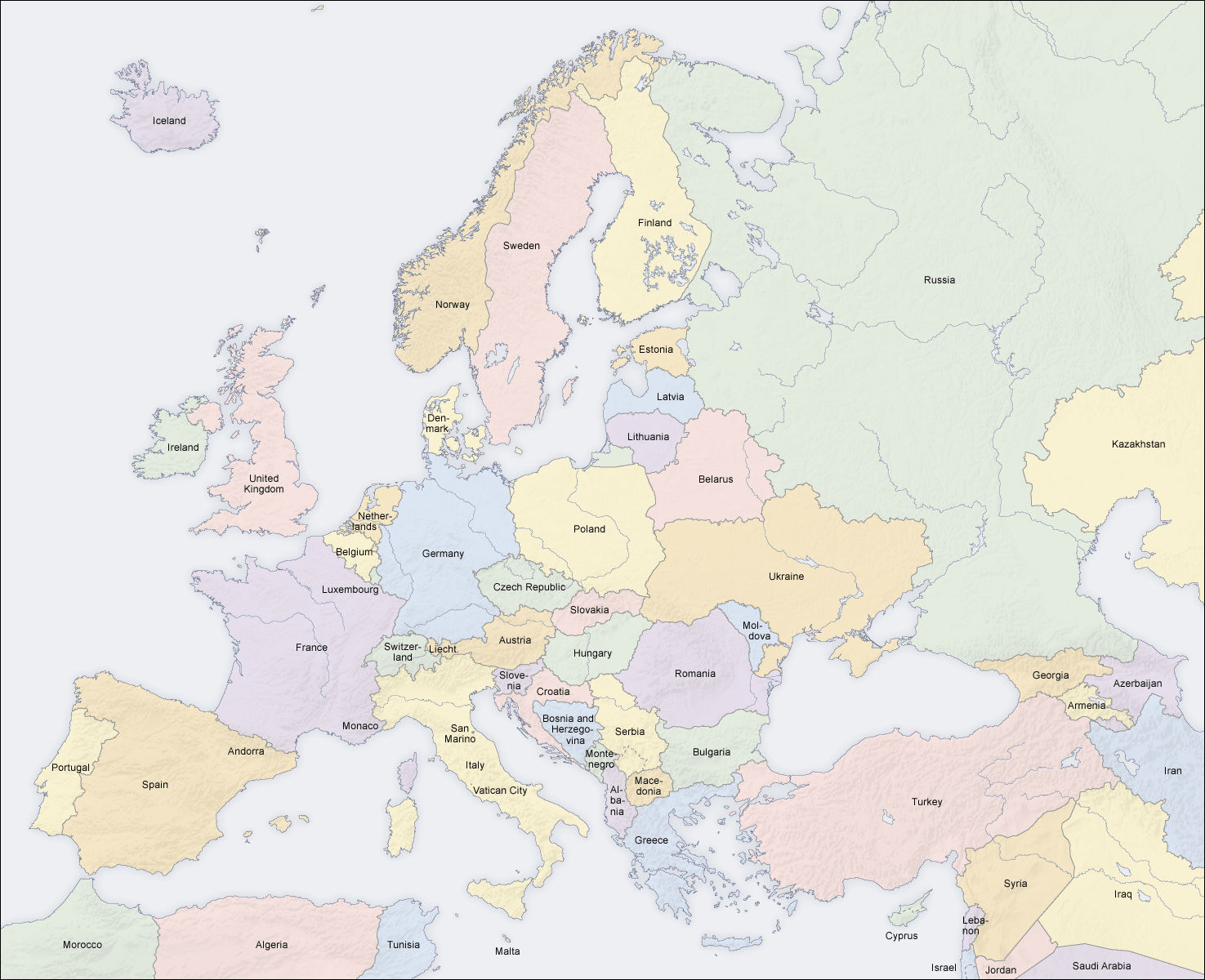
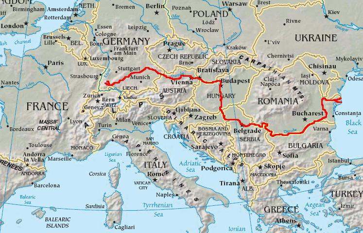
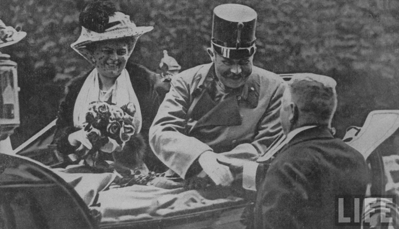
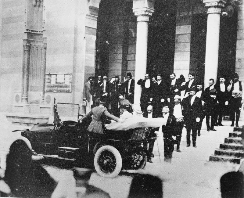
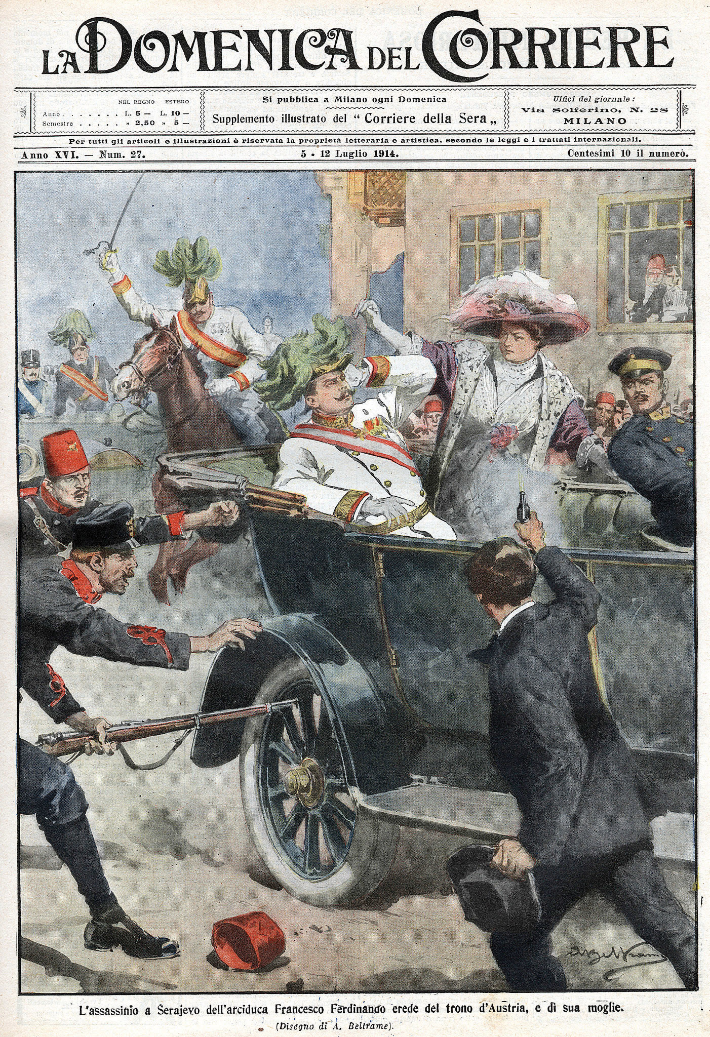
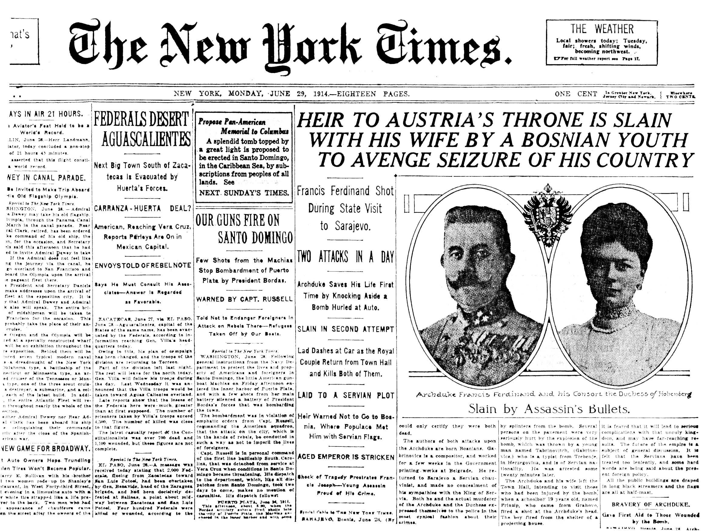
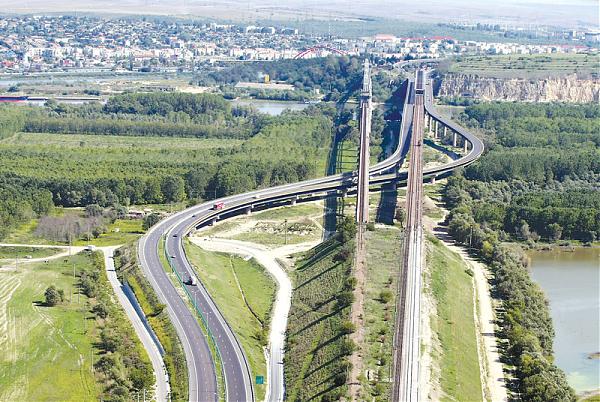
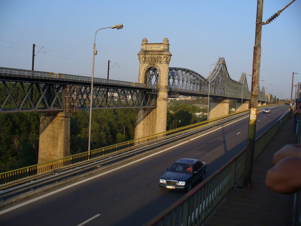
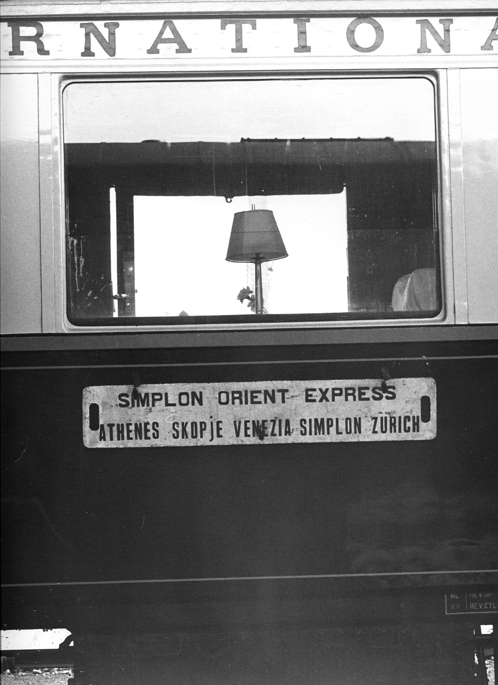