|
Reflections 2024
Series 11
November 7
Hudson Circuits III: Return from Weehawken – "Nothing-to-See #2"
Lower Manhattan Hudson Circuit, Jersey City Newport 2023 – Latinized Names
| | Weehawken We've reached Weehawken, but don't know enough about it. Why are the ferry terminal, hotel, and light rail so conveniently close together? It had seemed like a pleasant oddity when I set up this excursion, but now I find there's very good reason behind it all. | | | | The Palisades Most of all, we need to keep the Palisades in mind. Imposing as they are, it's easy to forget them when looking at a map, yet most of what we have to say on the New Jersey side of the Hudson is greatly affected by them.
As we've said in the past, the Palisades are a line of steep cliffs along the west side of the lower Hudson River in northeastern New Jersey and southeastern New York. The cliffs stretch north from Jersey City about 32 km (20 mi) to near Nyack NY and are visible even north of there. They rise nearly vertically from near the edge of the river, and are about 90 m (300 ft) high at Weehawken tho they increase gradually to 160 m 540 ft) high near their northern terminus. This is a view of the Palisades in Fort Lee NJ, as seen from 187th Street in Manhattan near the George Washington Bridge (Photo by Beyond My Ken).
http://4.bp.blogspot.com/-Sfzh-DeGFwM/T8uzuOQ075I/AAAAAAAACHc/WpWnSDHMPKI/s1600/palisades+map.bmp
To go along with the photo, this sketch shows graphically what the up-and-down lay of the land is around Fort Lee, with the George Washington Bridge cutting right across the view. The bridge enters Manhattan between 178th and 179th Streets. Weehawken is further south, opposite 56-57th Streets, but the Palisades terrain is similar.
The vertical, striated (lined) appearance of the Palisades inspired people to name them. To the indigenous Lenape, they were "Wee-Awk-En,", often translated as "the rocks that look like trees". Take another look to confirm that they do. On the other hand, when explorer Giovanni da Verrazano sailed past the ridge in 1524, he thought it resembled a "fence of stakes,", that is, a stockade or palisade built for defensive purposes. That’s what it’s called on the first map of the New World, printed 17 years later.
| | | | | | Palisade walls of wood were common. The word derives from Latin pālus meaning stake, specifically when used side by side to create a wooden defensive wall. The Romans built border walls at the edges of their empire, notably for their Germanic border. The specific word they used there was limes, with a plural (which looks more familiar) limites. This is a reconstruction of a limes in Germany (Photo by Immanuel Giel).
Here is a map of the limes in southwest Germany in the 2C CE. You'll recognize the four rivers. Argentoratum is Strasbourg. I've lived in Maguntiacum--it's the Latin name from which the name Mainz developed.
When you picture the wall that ran along the north side of Wall Street, what do you imagine? Take a look at the Wall Street palisade:
https://images.nypl.org/index.php?id=809975&t=w
https://www.unamicainviaggio.it/wp-content/uploads/2020/06/wall-street-palisade-lower-manhattan.jpg
The defensive wall was not because of the Native Americans, the Lenape. It was for fear of the English invading from New England, and trying to make Nieuw Amsterdam into New York. And we know how that turned out.
The Wall Street subway station at Broadway has decorative tiles illustrating the Wall Street palisade (Photo by Gryffindor).
|
| | | | COLONIAL TIMES: Weehawken's written history began in 1609, when Henry Hudson, on his third voyage to the New World, sailed up the river on the Half Moon and anchored in Weehawken Cove, located today on the southern border of Weehawken with Hoboken.
https://www.historicpictoric.com/cdn/shop/products/5233245_1wmark_grande.jpg?v=1683484133
On this undated period map, Weehawken Cove (not named) is the roundish body of water, tho here, rail is already encroaching on its north side. To jump ahead in time, NY Waterway's Lincoln Harbor ferry terminal, named for the nearby Lincoln Tunnel in southern Weehawken, is where those tracks used to be, and the light rail also has a station there.
The indigenous Lenape were displaced by settlers from New Netherland. In 1647, a Dutch settler received a patent for a plantation of 68 hectares (169 acres) at what was noted as Awiehaken. In 1674, New Netherland was ceded to the British, and the area became part of the colony of East Jersey.
Again the Palisades were a factor. Most settlement was along the top of the cliffs, since the low-lying areas along the river were mostly marshland. Up top, there was apparently excellent land for growing vegetables and orchard fruits.
As early as 1700, the governor of New York granted a regular, if sporadic, ferry service from Weehawken to Manhattan, not from northern Weehawken like today, but from that area on the north side of Weehawken Cove. It was a sail and row service later superseded by steamboat service. In 1752, King George II made the first official grant for ferry service, and it was at the ferry house north of Hoboken that was primarily used for farm produce which was sold at the Greenwich Village landing in the area that became Weehawken Street.
| | | | Weehawken Street Yes, Weehawken left a trace of itself in Greenwich Village, right off Christopher Street. I've been along the latter, and may have peeked up into Weehawken Street, but never did explore it. Take a look at this 1904 map of the West Village and click at the lower left. As you see, it runs for just one block from Christopher up to West 10th, between Washington and West Streets. Today, the far side of West Street borders Hudson River Park, with walkable Piers 45 and 46 jutting out into the river. Weehawken Street takes its name from that colonial-era ferry landing and connection to Weehawken NJ.
On the map find 6 Weehawken Street in yellow, as it juts out a bit, seen here from the north (Photo by Beyond My Ken). It also has the address 393 West Street. In 1834, the City owned this area and built Weehawken Street and the Greenwich Market on it, which was known informally as the Weehawken Market, both names obviously because of the upriver source of the produce. The City closed the unsuccessful market in the 1840s and subdivided the property into lots. Since then, the buildings have had many positive and negative uses. However, in 2006, the NYC Landmarks Preservation Commission designated all the buildings on Weehawken Street, plus additional properties on West Street and Christopher Street, as the Weehawken Street Historic District, with this comment: "The picturesque enclave of fourteen buildings and the street plan that together comprise the Weehawken Street Historic District represent several phases of construction spanning a century of development along Greenwich Village's Hudson River waterfront, from 1830 to 1938."
https://splicetoday.imgix.net/uploads/posts/photos/19343/14-500x365.jpg?ixlib=rails-2.1.2&auto=format&dpr=2&fit=clamp&w=544&widths=[544%2C%20768%2C%20992%2C%201200]&s=3fdf521db2dd3f426f9d9f96b2eb922c
https://www.hmdb.org/Photos5/506/Photo506390.jpg?1231201954900AM
The red banner declaring the historic district at Weehawken and Christopher Streets includes a map, seen more clearly in the detailed view.
| | | | Weehawken Geography But when talking about Weehawken and other towns on the west shore of the Hudson, the up-and-down situation of the Palisades has to be considered. Thus it had concerned me how the farmers up top reached the colonial-era ferry down below, at the south end of Weehawken. So I dug deeper and found Pershing Road.
https://www.freecountrymaps.com/map/free/united_states/weehawken-map-united_states-158827461.png
Hold on to this rather good map of Weehawken for a while. At the bottom you see near the Lincoln Tunnel today's Lincoln Harbor on the north side of Weehawken Cove, just off the map, where the oldest ferries sailed from. As further proof that, in this area, the Palisades are always a factor, note how inland traffic, way up top on the Palisades, requires the spiral bridge known as the Lincoln Tunnel Helix to lower traffic not only to the foot of the Palisades (dark pink), but then underground to enter the tunnel under the river (light pink).
Now let's move up the Palisades (in green) to northern Weehawken, where we see the modern Port Imperial with its ferry terminal. That large triangular gray block across from it is more than the hotel, it's the much larger parking garage. For the moment, note that east-west walkway from its southern point—more later.
In the last posting, we pointed out two main roads, and we see them again. At the foot of the cliff is Port Imperial Boulevard, and up top, it's officially called JFK Boulevard East, about which I now know more. It includes the word "East" because, if you look to the left of the map, that other orange road to the west, inland from the Palisades, is officially called John F Kennedy Boulevard, believe it or not. In everyday usage, this western one is just called Kennedy Boulevard, and this one is simply called Boulevard East.
At the top of the map, find 48th Street in Weehawken. It's one of the few two-way streets here, and has two distinctions. It has a rail tunnel under it (we see tracks coming out of the tunnel portal) and across Boulevard East, Pershing Road takes off to connect down the cliffside. It crosses both the tracks and Port Imperial Boulevard to connect to the low Port Imperial level of Weehawken. I know that earlier names for Pershing Road have included Clifton Road, named for the estate on whose land it was located, and Hillside Road, which would speak to its location. Still, I do not know the age of the road, but can certainly imagine it as a good candidate for going back to colonial times to connect up with down.
This is the view looking south from Boulevard East at Columbia Terrace, five blocks south of where the Palisades overlook the ferry terminal (Photo by Luigi Novi). In the center background is the Goldman Sachs Tower in Jersey City, opposite my building.
One last thing on the Weehawken map. Note where Boulevard East makes a sharp turn inland, then trace down the cliff to the river. You see an extremely narrow strip at this land down below in gray, just south of Days Point, wide enough only for tracks, road, and shorefront buildings. This is a very surprising area that we'll talk about more in a moment, and more fully in the next posting. All I'm saying now is that this strip of land is the site of what I'll just identify as the WDG, an acronym I'll explain later.
THE RAILROAD AGE: We already saw the rail line running thru our area of interest, and that's the next historic development in the region. We know that the New York Central got its name from running east from Buffalo thru "Central" New York to Albany, then crossing the river there and turning down the Hudson Valley to Manhattan. The West Shore Railroad did almost the same thing, but as the name implies, at Albany it didn't cross the Hudson but came south along its West Shore. How far? To Weehawken, of course.
The West Shore was organized in 1864 as the Saratoga and Hudson River Railroad, a competitor to the New York Central and Hudson River Railroad, but was soon taken over by that company. This map shows both of them (Map by SPUI). West to east, follow the blue Erie Canal, then the Hudson River. In purple, running down the east side of the Hudson is the New York Central, and in red on the west side of the Hudson is the West Shore Railroad.
Let's look at Weehawken again, but before the railroad arrived. This is the Weehawken portion of an 1841 map. As we know, most habitation was along the top of the cliffs—at that time, with a lot of farmland, while the low-lying areas along the Hudson were mostly marshland. Today's hotel and current ferry terminal would be in the middle of Slaugh's Meadow, north of Days Point. Hoboken is the large settlement at the bottom, squeezing itself in where the low shoreland widens out (to this day, 16th Street is the upper extent of Hoboken). Interestingly, the area today near the older ferry landing that we've called southern Weehawken is the only are identified as Weehawken at all.
Now let's look at the same area after the arrival of the railroad, as seen in this 1921 map. Weehawken is clearly marked, and now we see that most of the activity has moved to northern Weehawken, as we know it today. Click on the upper left to see the West Shore Railroad (WSRR) come south, then turn toward the river. When it encounters the Palisades, it goes into a tunnel (under 48th Street) and emerges from a portal in northern Weehawken.
https://images.cf.nycsubway.org/images/i44000/img_44231.jpg
It then arrives at a major ferry terminal. Other tracks turn north for the WSRR rail yard in the neighboring town of West New York NJ. (We'll discuss the important southern tracks in a moment.) Note the two ferries from 42nd Street in Manhattan, one to Weehawken and one to West New York.
This is the terminal of the West Shore Railroad at Weehawken c1900 at the foot of the Palisades, with rail lines connecting with ferry lines. Pershing Road clearly descends from above the Palisades to the lower level. The tracks exit from under the Palisades via a portal under 48th Street in Weehawken. The terminal functioned from 1884 to 1959. The complex contained five ferry slips, sixteen passenger train tracks, car float facilities, and extensive yards.
The last ferry to the West Shore Terminal was appropriately named the Weehawken. It sailed on March 25, 1959, at 1:10 am, ending 259 years of continuous ferry service.
To look ahead, the current Port Imperial ferry terminal and the Hudson Bergen light rail, forming an intermodal facility, are successors to this major rail and ferry intermodal facility of the past.
Now let's look again at the SAME map we just saw to inspect it further, and now we'll look to the south. The NYCRR not only owned the WSRR it also established the local New Jersey Junction Railroad (NJJ), which connected from Weehawken to rail facilities on the Hudson waterfront to the south. Again looking ahead, this is what eventually became the Hudson Bergen Light Rail (HBLR). Note how the route, arriving in Hoboken, curves inland to go down its west side. Then at the bottom we see how it intersects with a number of other rail lines to other terminals, ending in Jersey City. (For full disclosure, see the top of the map, where the NJJ later owned an extension to the north, separated by the Weehawken railyard from the original line.)
It's now time to go back to a map that's an old friend, but that I failed to visualize in regard to Weehawken; I've always paid more attention to the rail lines further south. Mea culpa. Let me give the link so you can review it again:
https://upload.wikimedia.org/wikipedia/commons/f/f2/New_York_City_Railroads_ca_1900.png
As we've seen, it shows the railroads in the Port of New York c1900 (Map by James R Irwin). On the Jersey side, I've always paid most attention to the former terminals in Jersey City, opposite Lower Manhattan, ending at Hoboken, the only terminal still in operation. But now we're concentrating on the next one north, in southern Weehawken, evidently used by the Erie Railroad, and particularly on the one after that, in northern Weehawken, the home of the WSRR. This map shows it all—the tunnel from the west, the ferry terminal, and the rail route to the south. On this Hudson Circuit, we'll be going from Weehawken to Jersey City on the Hudson Bergen Light Rail to the former PRR terminal at Exchange Place in Paulus Hook, to ferry back to Manhattan.
https://upload.wikimedia.org/wikipedia/commons/5/56/ISS-39_New_York_City.jpg
In addition, we have a fun way to track our route in advance. Above is an aerial view of the Hudson. North is on the left, so click on the Jersey shore of the Hudson, right in the middle of the view. You'll find you've landed at Weehawken Cove, next to Hoboken, where the green line of the Palisades cliff turns inland.
Glancing to the left (north), you'll see a white triangle. This is the parking garage whose northern half is surmounted by the EnVue hotel. The next promontory to the right is Days Point; then comes the very narrow point of the shoreline that we've been calling the WDG (to be explained shortly).
The south side of Hoboken to the right is very obviously the rail line to the Hoboken Terminal, the only one still in use. Right after that you can see the rail line move closer to the river, where it makes three stops in Jersey City. We'll get off just before the Morris Canal Basin (just a basin--the canal is long gone). Beyond that, there are two islands. The first is Ellis Island, the second Liberty Island with the Statue of Liberty.
MODERN TIMES: We know that Port Imperial is the Weehawken community that is down by the Hudson centered around an intermodal transit hub served by New York Waterways ferries and buses, Hudson Bergen Light Rail, and NJ Transit buses. But how did that come about?
In 1981, NJ businessman Arthur Imperatore Sr purchased a 4.0 km (2.5-mi) length of waterfront in Weehawken and West New York from the bankrupt Penn Central railroad for $7.5 million. The site consisted of abandoned and dilapidated rail yards, and Imperatore planned to convert his purchase into a residential development. However, to attract residents he needed to make it commutable to the Manhattan, which was hampered by congested bridges and tunnels. In 1986 Imperatore started the NY Waterway ferry service between Weehawken and Manhattan. There were as few as five passengers on the first trip and the ferry was derided as "Arthur's Folly". However, its popularity grew and the company eventually managed 36 ferries and 80 buses, carrying 32,000 passengers a day. The service enabled development of Weehawken and many other riverside areas.
| | | | | | The street between the ferry terminal and the EnVue Hotel has the unusual name Avenue at Port Imperial. A block northeast of the hotel is a side street called Imperatore Place after you-know-who. |
| | | | NY Waterway is a private transportation company running ferry and bus service in the Port of New York and New Jersey. The company utilizes public-private partnership with agencies such as the Port Authority of New York and New Jersey, New Jersey Transit, New York City Department of Transportation, and Metropolitan Transportation Authority to provide service and maintain docking facilities. It uses ferry slips at three terminals in Manhattan and terminals and slips in Weehawken, Hoboken, Jersey City, and Edgewater, among others.
This map shows NY Waterway's weekday ferry service (Map by MTATransitFan) between the Jersey terminals and the three Manhattan ones (also two separate upstate ones). We took the green one to Jersey, and will take the bright red one back to Manhattan.
Port Imperial is northern Weehawken, Lincoln Harbor is southern Weehawken.
Paulus Hook (Exchange Place)—where we're headed--and Liberty Harbor/Marin Blvd are in Jersey City.
The real estate developers Brookfield Place, who took over the former World Finance Center, likes to style the Battery Park City terminal as Brookfield Place after themselves, but common usage still calls it Battery Park City, which is the entire area served.
The weekend ferry schedule (Map by MTATransitFan) is much reduced, but notably adds service to the IKEA shopping area in Red Hook, Brooklyn.
| | | | SOUTHBOUND LEG The first leg of the Circuit was northbound by subway in Manhattan, followed by the westbound leg, interstate by ferry to New Jersey. We're up to the southbound leg, all in New Jersey, to be followed by going eastbound by ferry back to Manhattan.
We've seen the earlier rail connections on the Jersey shore of the Hudson. They've been taken over by New Jersey Transit, founded in 1979 to become the largest statewide public transit system in the US, and run under the name Hudson-Bergen Light Rail (HBLR), starting in 2000 and completed in 2011. For those who wish to open the route map in a separate window for easier reference here's the link to the SAME map:
https://upload.wikimedia.org/wikipedia/commons/thumb/b/b0/HBLR_diagram.svg/1000px-HBLR_diagram.svg.png
Note for later reference the stations at Port Imperial in Weehawken; 9th Street in Hoboken (you'll see why); the three routes, and how the yellow thru route we'll be taking avoids stopping at Hoboken Terminal; Pavonia/Newport (now just called Newport), where we'll stay on the next Circuit; and Exchange Place in Jersey City, our last stop; and in gray, the PATH system, part of which we'll use on our next Circuit.
Most of the HBLR route is along the shoreline at the foot of the Palisades, tho its northern end and its western branch both travel up onto the Palisades. However, the name is a misnomer, since Hudson–Bergen Light Rail only serves Hudson County and was never built into Bergen County to the north. Even the town of North Bergen on the map is in northern Hudson County. While it's suggested that an extension be built from the current northern terminus at Tonnelle Avenue into Bergen County, only that would make the HBLR name make full sense.
| | | | | | Hudson County (Map by Wikid77) is the smallest and most densely populated county in New Jersey. The county seat is Jersey City, which is the county's largest city in terms of both population and area. Note the extensive water borders of most of the county. It's eastern side borders the Hudson River, whence its name, facing Manhattan, and also Upper New York Bay. Its southern edge is on the Kill Van Kull, facing Staten Island. To the west lies Newark Bay, and for a large part, the Hackensack River. However it does have a central projection beyond that river to the Passaic River, bordering Newark. That includes the town of Harrison, where I used the Marriott Free Night Certificate, for connecting to nearby Newark (in Essex County) to celebrate my "Birthday in the Ironbound" (2020/10), as the first of my one-nighters. The second was of course in 2021 in Weehawken, and the third will be in the next small Hudson Circuit in 2023 in the Newport neighborhood of Jersey City. Hudson County does seem to serve these purposes well. |
| | | | Now that we're oriented, from now on, let's use this below map of our route (click), which shows more of the territory the HBLR traverses in Hudson County in Weehawken, Hoboken, and Jersey City:
https://www.visithudson.org/wp-content/uploads/2019/08/Hudson-Bergen_LightRail.jpg
We'll start the morning of the second half-day of this Circuit. When I got up, I enjoyed my skyline view one more time, then decided to skip breakfast to try to beat the heat before noon (I wasn't in the least successful). Let's look again at this view used before:
https://bccbelle.com/wp-content/uploads/IMG-20180802-WA0053.jpg
It shows it all (click)—perfectly! The ferries, the terminal, the triangular EnVue with its open far end, atop the huge parking garage. Behind is the main upper level of Weehawken atop the Palisades, with the tunnel portal showing beneath, right behind the hotel. But now I direct your attention to how all this connects so nicely with the light rail line. That morning, I really didn't know what to expect when I walked to the corner, and was surprised to find a complimentary street elevator to an overpass. This was just like the way Simi and I had reached the Spur the day before. The overpass first keeps pedestrians above Port Imperial Boulevard, then crosses the uptown rail tracks to get to the central platform, via another elevator or staircase (shown).
https://c1.staticflickr.com/3/2424/5834135311_8e5f4bbf9a_b.jpg
But a surprise I found out about later and didn't realize at the time was that the overpass then continues with multiple staircases all the way up the Palisades! I see now that that would allow those on top of the Palisades to use both the light rail and the ferry service. But it's a lot of steps!
| | | | | | Talking about steps, the Vessel reopened to the public on 24 October 2024. I continue to have strong reservations about the steel-mesh barrier safety measures put in place. The two lowest levels will remain fully open, as ever, but there will be security guards in place. Above those, "four stairwells and the adjoining platforms" will get the barriers, which will make up about half the area that used to be open to the public. The very top floor will remain closed to the public, but to me, that's the culmination of the experience, with the best views. It's like closing off the 86th floor observation deck of the Empire State Building and allowing the public to only look out the windows on the 85th floor or below. It's not the same. At least there will be public access again, and I don't think the mesh will harm the view, but it's still not what it was. |
| | | | There seem to be lots of pictures of this overpass access system:
https://pix10.agoda.net/hotelImages/8250469/93782710/8f7a8abd18fa49ae351de060d2ce18ce.jpg
https://ir.4sqi.net/img/general/original/2479824_Nbr5510R9WJDIAQzeLMC1qC92PzOkZMcS9uru7CwKFs.jpg
https://live.staticflickr.com/3663/3516897650_d94e7d49f3_z.jpg
The first link is the view southward from above the hotel and garage. The staircase up above is largely hidden in the trees. The second link seems to be from the staircase, showing the garage, but not the hotel. The third link shows the light rail platform access via either elevator or staircase, with a train pulling in. Beyond those, this wintry view over Port Imperial Boulevard shows more clearly how the staircase links to the overpass (Photo by Jim.henderson), and finally, this is the platform view looking north of a southbound light rail train arriving (Photo by Luigi Novi).
I bought my ticket from a machine on the platform, and validated it by an adjacent canceling machine, since the system only does spot ticket checks, which is very European. When the train arrived, it was a pleasure to sit in the air conditioning.
| | | | "Nothing-to-See #2" I knew in advance what was coming up momentarily, but I had to calculate an approximate location, maybe 2-3 minutes south of the station. This is the point that I've referred to above as the WDG, which is my acronym for the Weehawken Dueling Grounds. Quite a number of duels were held here back in the day, including the one that's by far the most famous, the Hamilton-Burr Duel in 1804.
But as I said earlier, to the right of the light rail (west) is the wall of the Palisades cliff. To its left (east) are both sets of light rail tracks, then the road which today is Port Imperial Boulevard, then a single string of shorefront buildings. There is absolutely nothing to see here, no marker at the site, nothing nearby. At least on the river yesterday afternoon, where there was also nothing to see of the plane's landing, there were pleasant river views over to both shores. But where the train was crossing, HIC LOCUS EST / THIS IS THE SPOT where a very famous event had taken place just under 220 years earlier.
https://static1.realtyexecutives.com/site-files/18729f3f-a8f8-4d50-8b74-4dba10a9c7ad
Now you can find the site of the WDG on our Weehawken map (unmarked), but it might be slightly clearer on the above one. The blue symbol shows the ferry terminal, followed by Days (Deas') Point. You then see a green stretch representing the Palisades. The tracks aren't shown, but Port Imperial Boulevard is clear in the following narrow stretch. By my measurement on Google Maps the correct spot is about 0.8 km (0.5 mi) south of the station, and roughly across from 44th Street in Manhattan. There was a ledge here, long gone, surely due to landfill, that was just 11 paces wide and 20 paces long, situated about 6.1 m (20 ft) above the Hudson. This ledge was the site of 18 documented duels and probably many unrecorded ones in the years 1798–1845, including Hamilton-Burr in 1804.
Now you can't miss on the map that there's a Hamilton Park here, but that's up on top of the Palisades, not at the duel site. Right where JFK Boulevard bends inland, a small L-shaped Hamilton Avenue goes straight. It was here that a Hamilton monument was put up in the 1930s, to replace one that had been vandalized and lost down below. However, I'm sure that people who seek out this monument think the duel took place where the monument stands, at the edge of the cliff. How could Hamilton and Burr and their parties have rowed across the Hudson to end up on a cliff? It's all wrong, and even Google Maps identifies the monument up top as being the site of the duel.
https://4.bp.blogspot.com/-2aZRgq_PKmw/WjG7RXN-eUI/AAAAAAAABpI/WMnVpbDLAGwjFikG49A4xkZ9PWtJMIjRACEwYBhgL/s640/20171124.XG5A2736.jpg
I have not been to the monument up top, but this is the view from it, on the cliff edge of the Palisades. On the Hudson you can see the single string of shorefront buildings, and Port Imperial Boulevard. The light rail tracks where the duel took place are closer, but can't be seen because of the shrubbery and the steep angle. I will include now this drawing of the duel (you can see it's down below at river level), but will keep a nicer, colorized version, and several others, for the next posting, which will be totally devoted to this very interesting subject.
| | | | An Unusual Connection I mentioned earlier to take note of the 9th Street Station in Hoboken. Coming south, as we pull into that station, we get this view (Photo by Nightscream). What's that unusual structure in the station? And what's that green thing protruding out of the top into the shrubbery?
https://c2.staticflickr.com/8/7570/16134680206_0044e57163_b.jpg
Leaving the station and looking back, we get a better view. We also see a longer name for the station, also on the newer map we've been using. The station is more correctly named 9th Street-Congress Street. Why? Is that some intersection in Hoboken? Not at all. 9th Street is indeed in Hoboken, and Congress Street is in another city. How is that possible? Remember the Palisades. The tower contains an elevator leading from the platform to Congress Street in the Jersey Heights neighborhood (Palisades!) of Jersey City. Thus this station is notable for having an elevator which runs upward along the face of the Palisades cliffs between the platforms at their base and the neighborhood at their crest.
http://www.railfanwindow.com/gallery2/_data/i/galleries/TempByDate/album234/IMG_0910-me.jpg
This is the Jersey Heights view of the station entrance at the foot of Congress Street where it meets the historic Paterson Plank Road (no longer planked!). This entrance is highly unusual. There are many subway stations—34th Street/Hudson Yards being among them—where one enters a short distance, then takes an elevator, an escalator, even an inclined elevator down to track level. But all of those entries are surrounded by bedrock. People here do the same thing, but their connection down to the tracks is surrounded by—air! Marvelous!
https://i.pinimg.com/originals/ed/d3/f4/edd3f452ddfde55063d75f59f92cc144.jpg
This interesting sketch shows just where we are (click). At the top, the light rail has swung inland, still under the Palisades, to go around the west side of Hoboken. The 9th Street elevator is misplaced at 12th Street, but you see the Paterson Plank Road in Jersey Heights that it connects to. Our route swings around the bottom of Hoboken to approach Hoboken Terminal (oddly, not shown, but next to the PATH Hoboken station).
| | | | | | To clarify the Hoboken layout, check this out:
http://www.realtransit.org/images/HS1.png
The red routes are all the tracks leading into Hoboken Terminal, the only rail terminal still functioning on Jersey's Hudson shore, and with ferry connections. The PATH Hoboken station is on its north side, with its tracks running underneath. The blue lines show the HBLR tracks with two routes connecting to the HBLR Hoboken station south of the terminal. Our yellow route, however, bypasses this, as shown.
|
| | | | As we turn south into the non-Heights part of Jersey City, the sketch map then shows clearly the Newport neighborhood of Jersey City and its huge mall; we'll spend a night in Newport on the next Circuit. It also shows Exchange Place where we'll get off the train, and Paulus Hook, where we'll take the ferry home. Confirm these locations on the route map, where it's clearer that the Exchange Place light rail and PATH stations abut each other, just above the Paulus Hook Ferry Terminal.
https://infrastructure.aecom.com/hubfs/proj-nyc-hudson.jpg#keepProtocol
A southbound train crosses Montgomery Street, the main street in the Exchange Place neighborhood of Jersey City to the station on the south side of the street. The roundish building on the far left is the PATH station; the graphic statue on the esplanade just one block away is the Katyń Memorial for the Polish victims of the 1940 Katyń massacre; straight ahead, across the Hudson, is Battery Park City and One World Trade Center. This is the Exchange Place station looking north where we just came from (Photo by Sebastian Sinisterra).
| | | | EASTBOUND LEG Exchange Place is both a neighborhood and financial center of Jersey City. It's named after a small square of the same name at the foot of Montgomery Street. This square was created by filling in part of the shore of Paulus Hook, and has long been a major transportation hub. The Paulus Hook Ferry Terminal is three blocks south of Exchange Place.
Paulus Hook is also a neighborhood of Jersey City, just south of Exchange Place. The Paulus Hook neighborhood (settled in 1633!) runs along the basin of the long-gone Morris Canal south of it.
| | | | | | As we discussed in the past, "hook" in NY-NJ place names comes from the Dutch word "hoek" (rhymes with "Luke"), which corresponds to, among other things, "angle", and such an angle is further interpreted as a "point of land". An early Dutch settler was Michael Paulez/Pauluson, hence the name Paulus Hook. Also note Sandy Hook in NJ and Red Hook in Brooklyn. In addition, south of Albany is President Martin Van Buren's home in Kinderhook NY ("childrens' corner", originally spelled in the Dutch manner as Kinderhoek). |
| | | | The final leg of this Circuit was a total disaster, and I feel lucky I actually made it home. Once I got off the air-conditioned train, this time the heat really hit, even tho it was only late morning. It was that one block from the station to the river esplanade, where it would have been pleasant sitting and watching the river. I'm glad I'd been there a couple of times before, because this time I was sneaking from one tree-shaded bench to another.
This is a view of the area from Exchange Place on the right to Paulus Hook on the left (Photo by Gryffindor). The actual Exchange Place is that square (click) at the end of the L-shaped pier. The Exchange Place PATH station is to its right and the esplanade runs three blocks to the left, where a boat is departing the Paulus Hook ferry terminal—and another arriving. It was a difficult walk. I got my ticket and took the seven-minute crossing—with no air conditioning—from this pier (Photo by Fred Hsu). Under the orange windsock, the low white-topped building across the river is my building, the Regatta. Above the people's heads, the white "sails" are the Battery Park City ferry terminal, with another ferry in place. Directly to the right of those black columns, the white arch is the front of the Winter Garden. Did I think I'd make it home in all that heat? I had my doubts.
The arrival on the Manhattan side was here, at the wing-roofed Battery Park City terminal, officially called Brookfield Place (Photo by Beyond My Ken). It's on a floating dock anchored to the BPC Esplanade.
Finally, we have this panorama of the Downtown Manhattan skyline with One World Trade Center standing out, as seen from Paulus Hook (Photo by King of Hearts/Wikimedia Commons/CC-BY-SA-3.0). Somewhere along this stretch of the Esplanade is where the Sullenberger's plane was tied up after being towed downriver. To the right of the terminal is North Cove, with the darkish Winter Garden set back. I paused there in the air conditioning. My building is on the right, with the white top, to the left of the indented South Cove. I wondered if I'd make it. As I left the Winter Garden/Brookfield Place complex, I was on my street, South End Avenue, and I made it one block to the air-conditioned ATM lobby of Citibank. It was 3 ½ blocks to go, but I had my doubts. Then it struck me that the free Downtown Connector shuttle service stops there, and it was due. When I boarded, I joked with the driver that I was only going one stop, just because of the intense heat. And so I made it.
At home I immediately took my second shower of the morning, then took a nap on the couch, to help me recuperate. This Hudson Circuit was a doozy, and memorable for more than one reason.
| | | | Lower Manhattan Hudson Circuit To recap: the first Hudson Circuit was a day trip to Poughkeepsie with four others, and was done on foot in 2010. The major one, the second rail 'n' sail one in 2021, we just heard about. Two years later, in 2023, came the third, and only encompassed the part of Jersey opposite Lower Manhattan, only as far north as Greenwich Village.
What precipitated it was another Free Night Certificate from Marriott, the third one-nighter that worked out best for me to use in Hudson County NJ. The first was in 2020 in Harrison for Newark's Ironbound; 2021 was Weehawken; and 2023 was at the Westin Jersey City Newport. The hotel says it that way to indicate that, while it's located in Newport, that's actually a neighborhood of Jersey City.
It was actually a coincidence that the only new part of the Circuit was actually getting to Newport, since the return trip from there duplicated, under much better circumstances, the end of the return from Weehawken. It was almost rail 'n' sail. I could have walked inland to take the subway northbound, then walked back toward the river, but that was foolish, just to keep the trip purely rail 'n' sail, so I took the M20 city bus from my corner right to where I needed to be in Greenwich Village, at Christopher Street.
Thus this Circuit was: north by bus, west by rail (PATH), south by light rail, east by ferry. This time I chose a weekend for the 2023 one-nighter within two half-days: Saturday-Sunday, June 17-18.
https://urbanscale.com/wp-content/uploads/2013/11/West-Village-Map.jpg
NORTHBOUND LEG: This map shows a part of western Greenwich Village. You can judge where my M20 bus came up Hudson Street and stopped exactly at the corner of Christopher Street, marked by the blue symbol for the PATH station, just steps to the west. By following other blue symbols, you can also trace how the PATH line comes down 6th Avenue (Avenue of the Americas) to get there: on the right, find the PATH stations at 14th Street and 9th Street, where the route bends to run the full length of Christopher Street, including the station there, the very last stop in this part of Manhattan.
I've been on all branches of the PATH system, either to get somewhere or to do some joyriding to experience PATH, but the Christopher Street station is rather unusual, and fun. Most subway station entrances—and PATH today functions as an alternate subway--are what you'd expect a subway entrance to look like, with a street kiosk and staircase leading underground. This is the entrance on 6th Avenue to the 23rd Street station, which also serves the regular subway station there (Photo by Elvert Barnes). Other subway entrances are via an adjacent building, like these next two, at 14th Street (Photo by Adam Moss) and 9th Street, right up the line (Photo by Jim.henderson). This was my only experience at the unusual Christopher Street station, and it was fun.
The sole entrance to the 1908 station (Photo by TFSyndicate) is in its own free-standing building, made to fit in with the town houses on the block. The inscription on the top of the building (click) reads HVDSON & MANHATTAN R R CO, the original builder and predecessor of PATH. The building also serves as a ventilation shaft for the subway tunnel (see upper "windows"). The quaint entranceway has a restored marquee (click) that still displays the original "Hudson Tunnels" name, along with nearby signs saying it's now PATH. One has the feeling of entering someone's townhouse, but then scurrying down into its basement. Passengers descend a narrow stairway (Photo by Ludovic Bertron) with several curves before arriving at the southern end of the narrow center-island platform, where I used my Metrocard to purchase a one-way ticket from a machine (Photo by Kai Schreiber). I liked being at this station, but the single entrance to the very narrow central platform with massive columns gave a whiff of claustrophobia. The station was an unusual experience, all by itself.
WESTBOUND LEG: As usual, there's a lot to say about our destination, Newport, in different time periods, but it's best to start specifically with how we're getting there. We discussed PATH before, but let's review (maps to follow).
The system was built by the Hudson & Manhattan Railroad (H&M), whereby "Hudson" does NOT refer to the river, but to the fact that, with one single exception, the Jersey routes lie exclusively in Hudson County (only the westernmost station crosses the Passaic River from Harrison in Hudson County to Newark in Essex County.) The tunnels it built under the Hudson River were called by the peculiar name, the Hudson Tubes, for many years, as shown by this mosaic directional sign still remaining in the Cortlandt Street subway station (Photo by Tdorante10). In addition, the 14th Street PATH station includes this older sign (Photo by 10sefirot).
However, in the 1960s, the system was taken over by the Port Authority of NY & NJ, and renamed the Port Authority Trans-Hudson (PATH) system. It has four routes serving 13 stations between the two states, and is 22.2 km (13.8 mi) long. It operates as a subway in Manhattan and on the Jersey City/Hoboken riverfront up to Grove Street. After that, the lengthy branch out to Newark runs in open cuts, at grade level, and on elevated track. The system began in 1908 and was fully completed in 1911. Altho operated as a subway system, it is legally a commuter railroad. While NYC's first subway, today the IRT Lexington Avenue Line, opened in 1904, nevertheless, the H&M is considered to predate it, since construction started on the NJ side in 1873, tho it had to be intermittently abandoned for over three decades.
Curiously, the H&M (PATH) goes under the river twice, both to Midtown and Downtown Manhattan. The Uptown Hudson Tubes opened to passenger service in 1908 and were completed by 1910. The Downtown Tubes were completed in 1909. By this time, the Interborough Rapid Transit Company (IRT) had become a viable competitor, with a proposal to connect its Lexington Avenue line to the H&M at three locations: Fulton Street, Astor Place, and Grand Central–42nd Street, tho none of this ever happened.
https://i.pinimg.com/originals/b9/74/3c/b9743c46d00c162ca53e50482037bcea.jpg
Now let's compare what we've been reviewing to the above period map of the H&M. The map shows that the original goal had to be connecting railroad stations, and that the heart of the system lay on the Jersey shore of the Hudson. Click to find the connections between the Hoboken Terminal (still in use) and the now defunct Erie Terminal (where Newport is today, our goal this trip), and the defunct Pennsylvania Terminal, now the Exchange Place neighborhood. (It was the PRR's building of the Midtown tunnels and Penn Station in Manhattan that began the move for other terminals, who mostly instead shifted to Hoboken or Penn NYC.)
Also note the black dotted lines, showing the extent that streetcars connected the area. What was originally the Grove-Henderson Street station is now the Grove Street station, the last fully underground one. The Summit Avenue station is now the Journal Square station. It wasn't until 1911 that the line was extended to its original Newark terminus; when Newark Penn was opened in 1937, the H&M moved there instead.
The Uptown Hudson Tubes were the first tunnels under a major US river. Given the difficulty of doing so, it's unusual that they are two separate one-way tunnels. So are the Downtown Tubes, and more unusual still, the Downtown ones form a loop, so that trains turn around right in the station!
As for Manhattan, if the original goal was to connect railroad stations, that plan fizzled out. There are no railroad stations in Lower Manhattan, so the H&M built its own, the Hudson Terminal buildings. But we can see on the map that it was hoped for that the connection wouldn't be a terminus. The solid black lines are els, and the dashed line is the innovative IRT Lexington Avenue subway line. There were direct transfers from Hudson Terminal to both the 6th Avenue and 9th Avenue els. However, the subway connection at Fulton Street to IRT's Lex line never happened. Actually, none of the three hoped-for connections ever happened, including the 9th Street connection to the IRT's Astor Place Station, nor the extension beyond 33rd Street at Herald Square up to 42nd Street and the possible IRT connection at Grand Central.
| | | | | | It's also quite a distance from Herald Square over to Penn Station when you're in a hurry to catch a train. I've gotten off the BMT subway twice and hoofed it over that long block to Penn—it's no fun—so I think you can safely say that the H&M never made it to NY Penn. |
| | | | We have one more historic map that adds more information. This one shows even more future hopes that never happened. It isn't dated, but has to be after 1904, when the IRT was built, and before 1911, when the Newark extension was added. The most surprising feature was that there were plans to extend the home base on Jersey's Hudson shore from three stations down to a fourth, at the Central RR of NJ station. Never happened. It's also a fantasy of cooperation of the H&M with the IRT, which also never took place. If they'd connected at Fulton Street, there were hopes the H&M could have used the IRT to reach Brooklyn, and its Long Island RR terminal. The proposed extension beyond Herald Square isn't even indicated. Perhaps there was more hope of the never-built connection to the IRT at Astor Place leading H&M trains on that line to Grand Central—and perhaps beyond, to Uptown.
Note that the "New York & Jersey RR" indicated on the Uptown Tube was an early name for the H&M.
| | | | | | There is another factor for H&M not running on IRT tracks. While all NYC tracks are standard gauge, the IRT system, now called Division A, was purposely built narrow, affecting tunnels, platforms, and cars, which are only 2.62 m (8.6 ft) wide. The BMT system (later copied by the IND), now called Division B, was wider, with cars at 3.05 m (10 ft). Thus, to this day, trains from one Division do not run on the other. PATH cars, and presumably the former H&M cars, are 2.8 m (9.19 ft) wide. It would seem they also would have been too wide to run on the IRT system. |
| | | | Back to today. This is what the four routes of the weekday PATH system look like now (Map by Voyager). The red line crosses from the rebuilt World Trade Center loop station to Exchange Place, spanning the river. Then after Grove Street, it's no longer a subway as it goes, via Journal Square, to Harrison, the last stop in Hudson County, to Newark's Penn Station. This is exactly the route I used for my birthday in Newark's Ironbound in 2020.
The green line leaves the WTC for Exchange Place, but then connects to Hoboken via Newport, formerly called Pavonia/Newport—more about that name later. The blue line is a direct connection from Hoboken to the five stops in Manhattan ending at 33rd Street (Herald Square). And finally, the gold line connects many disparate locations, running from the Manhattan stops directly to Newport, thence to Grove Street and Journal Square.
So it would be a one-stop cinch under the Hudson for us now to go from Christopher Street to Newport. But it's the weekend, and that won't happen. The PATH system is now much less a connector or railroad stations than a simple commuter line, and few commuters commute on weekends. So this is the PATH weekend schedule (Map by Voyager). The four lines are down to two. The red line is the only one that remains the same as during the weekdays. The green line disappears, but is replaced by a two-seat connection: WTC to Grove on the red, then the consolidated gold-blue line to Hoboken—or even directly on to 33rd Street if desired. Most notably, the gold line, usually 33rd to Journal Square, is altered to consolidate the blue line by simply adding the one additional stop, Hoboken, even tho it's out of the way from a direct route.
| | | | | | For the sake of completeness, I'll illustrate here the three PATH termini we will NOT be using on this trip. This view looks south at the 33rd Street station terminus adjacent to Herald Square (Photo by Bill Benzon). The trains, having reached their last stop, face the entrance turnstiles.
In Newark's Penn Station, the PATH routes blend into the regular tracks, as shown in this schematic (By SPUI). This is a street-level entrance to the tracks on the upper level (Photo by Pi.1415926535).
At the WTC adjacent to the Oculus, this is the PATH mezzanine leading via those turnstiles to the tracks below (Photo by Kai Schreiber).
https://newyorkyimby.com/wp-content/uploads/2015/06/subway.jpg
But to me, this remains the most interesting terminus, because, as the above shows, it's a counterclockwise loop track under the mezzanine, turning a west-east arrival direction temporarily south-north, and parallel to the adjacent #1 subway line, as well as to all the other subway lines on the way to the Fulton Transit Center.
|
| | | | Let's get back to describing our Westbound Leg across the Hudson from the Christopher Street station. As our weekend map shows, we don't go directly from there for one stop to Newport, but find ourselves instead turning in the "wrong direction" to reach the Hoboken PATH station first.
http://www.realtransit.org/images/HS1.png
We used this map earlier, but we need it again. All the red tracks go to Hoboken Terminal. We were on the light rail in blue that went thru and skipped the HBLR station in Hoboken, tho other routes went there. Now look for the pale gray tracks coming up from the bottom center and going UNDER the rail yard to the PATH station on the far (north) side of the terminal. This is where we now are. This is the Hoboken PATH station entrance at street level (Photo by Wallyg from flickr.com) and this is the Hoboken PATH station itself (Photo by Antony-22). Notable are the massive headers on the columns, as well as the H on them.
However, Hoboken is not like the WTC with its loop turnaround. It's a regular terminus. So our train pulls in and waits until the motorman closes up his station at the front of the train, walks its full length, and opens up at the end, which now becomes the front. Thus, at Hoboken PATH, we change direction! This 1909 illustration, looking northeast, shows the complex underground intersection (click) we've just passed thru twice, in different directions. The tower in the distance is Hudson Terminal. At the lower right, the tubes specify "to Erie RR", which is the original name for the Newport PATH station.
We then promptly arrive at PATH Newport (Photo by Adam Moss) and recognize the same thick columns with the massive headers. And the first thing I looked for is something I'd read about. To this day, the PATH Newport station columns are marked with the signature letter E, tho painted over, for the Erie Railroad. Some history can and will not be erased (Photo by Jim.henderson).
| | | | Local History We've already gone thru H&M/PATH history in order to reach Jersey, but it will work out best to take local Jersey history a bit in reverse: first the 1800s, then the 1600s. As so often the case is, things start with ferries, then move on to rail. | | | | Pavonia Ferry The Pavonia Ferry began running in 1854 along a route that had been established some decades earlier. In 1859 the Erie Railroad Company purchased the lease on behalf of the Pavonia Ferry Company. The Pavonia Ferry ran between Chambers Street in Manhattan—not that far from City Hall--and the foot of Pavonia Avenue across the Hudson, in what is now Newport.
Thus, Chambers Street was the entrance to Manhattan for passengers coming cross-country on the Erie Railroad. This is a 1938 view of West Street at the foot of Chambers Street, the site of the Erie ferry connection.
http://www.mappery.com/maps/Battery-Park-City-Map.jpg
This map (click) shows how this area is now blocked from the river by the landfill of Battery Park City, tho Chambers Street now has been extended two blocks further west, INTO Battery Park City, past Stuyvesant High School (at #2-3). Look back at West and Chambers to see where the ferry once docked.
| | | | Erie Railroad So whence came the Erie Railroad? I'm glad you asked, since its route is interesting. Simply put, it came from Lake Erie, but there's more to it than just that.
It's most helpful if you picture a triangle connecting NYC and Buffalo. As we know, the NY Central went east out of Buffalo, following the Erie Canal, then turned south at Albany along the Hudson to NYC. This remains Amtrak's so-called Empire Route. In contrast, the route of the Erie formed the hypotenuse of that right triangle.
Follow on this 1918 map to see the diagonal route of the Erie. Start on the right at Jersey City (for New York) and see how, after servicing the local area of Jersey and adjacent NY State, after Port Jervis NY, the route runs diagonally to Buffalo—and Lake Erie—with some side connections in Pennsylvania and upstate NY. (An interesting point: north of Buffalo, see how the Erie services a place called Suspension Bridge. This is now the city of Niagara Falls NY. The route did not go into Canada at that time.) For the sake of completion, this second map shows how Erie's route extended from western NY state further along Lake Erie into Ohio.
We saw the Manhattan connection of the Erie, so let's now look at the Jersey side. We've already discussed Weehawken, further north, so these maps show the five railroad terminals crowded in to the Hoboken and Jersey City area.
http://www.vizettes.com/kt/jersey-city/images/1891-jc.jpg
www.vizettes.com/kt/jersey-city/images/jc-rr-yards-1898.jpg
We start with two late 19C maps of Jersey's Hudson waterfront. The first, from 1891, only points out four, but does show the extensive ferry system all had, including the Pavonia ferry. The top one is Lackawanna's Hoboken Terminal, followed by the Erie (at the end of Pavonia Avenue), Penn RR at Exchange Place, and the Central RR of NJ. The second, color-coded map from 1898 is clearer, and shows the apparently shared situation of the southernmost two. On the left, we see at least one indication of the Erie going thru the Palisades in a tunnel. Again, only the Hoboken Terminal of the former Lackawanna survives; all the others were demolished in the 1960s.
http://www.vizettes.com/kt/jersey-city/images/jc-rr-yards-1947.jpg
http://www.vizettes.com/kt/jersey-city/images/jc-rr-yards-overlay1.jpg
These two maps are similar, but bring us up to the mid-20C. The first, from 1947, indicates two tunnels thru the Palisades. The second, from 1967, is at the Beginning of the End.
| | | | Pavonia Terminal The Erie railroad terminal on the Hudson was the Pavonia Terminal.
https://alchetron.com/cdn/pavonia-terminal-57a7a99d-ded7-4a27-8c7e-4baa999f778-resize-750.jpg
The station opened in 1861 and closed in 1958 when the Erie Railroad moved its passenger services to the nearby Hoboken Terminal, owned by the Delaware, Lackawanna and Western Railroad (DL&W). In 1960, the two railroads merged, since both had similar diagonal routes to Buffalo. Pavonia Terminal was demolished in 1961, the year of its centennial.
https://live.staticflickr.com/4446/36981159564_fbb5c8ee4a_b.jpg
https://static.flickr.com/75/180749057_d71609957e_o.jpg
The first link is an aerial view of the region just before its demise. At the very top can be seen how the houses in Hoboken always seem to appear coming right up to the Lackawanna tracks leading to Hoboken Terminal, whereas the Jersey City areas seem more "all-rail". The Erie pier appears in the center, indicated by tall buildings at either end. The second link shows the transformation of the Erie area now known as Newport. The Hoboken buildings at the upper right still seem to thrive, bordered by the tracks to Hoboken Terminal, but the former Erie area is, temporarily, a wasteland. The Erie pier is still distinguishable by the two white buildings at either end. You are looking at the area to be recycled into the new Newport neighborhood of Jersey City.
| | | | Newport PATH Station We now return to where we started, arriving at the Newport PATH station. It was opened in 1909 as part of the H&M, originally constructed to connect to the Erie Railroad's Pavonia Terminal. During the Erie period, the station was busy with over 30 passenger trains that ran in and out of the station hourly, which averages out at a train every two minutes.
https://i.pinimg.com/originals/3b/4b/9c/3b4b9c649ea6c5918b0dd361e5dee1b1.jpg
There was one problem with this connection. This period map shows how the H&M stations connected well with the Lackawanna's Hoboken and the Penn's Exchange Place stations, but was actually at some distance from Erie's Pavonia Terminal. That was the result of wanting to use previous infrastructure from earlier tunneling attempts when building the H&M system, and so the tubes at this point were far inland and were thus poorly integrated with the terminal. Therefore, a lengthy walk through inclined pedestrian tunnels was necessary in order to connect from the H&M to the passenger trains. For that reason, in 1954, the H&M installed a 84 m (277 ft)-long moving sidewalk, the first of its kind in the US, which moved up a 10% grade at a speed of 2.4 km/h (1.5 mph).
After the 1960s takeover making it the PATH system, the station was renamed Pavonia, or also Pavonia Avenue, for the east-west street above. In 1988, the station became known as Pavonia/Newport to reflect the redevelopment of the former railyards along the banks of the Hudson River to residential, retail, and recreational uses under the Newport name. However, in 2010, the name was shortened to simply Newport. Even Pavonia Avenue above was renamed Town Square Place, running perpendicular to the new north-south Washington Boulevard, a modern thoroughfare in Newport.
The headhouse of the Newport PATH station reflects modern times, as seen in this view looking north from the former Pavonia Avenue, the present Town Square Place (Photo by Jim.henderson). Washington Boulevard runs behind the trees on the left, and the modern buildings that typify Newport are in the background. One is a Marriott's Courtyard Hotel, my alternate choice, tho I chose Marriott's Westin for my freebee, a block to the south of PATH.
| | | | Latinized Names Our next step is to explore the interesting name Pavonia, rapidly disappearing from the area. To do so, it's worth going off on one of our tangents to review Latinized names in general.
In Rome in the Classic period, names in Latin were often easily recognized. Many—not all—male names tended to end in –US, and many female names in –A: Bacchus, Augustus, Claudius, Gaius Julius Caesar; Minerva, Diana, Flora. The man we know in English as Mark Antony was actually Marcus Antonius. Get the drift? This also extended across the Roman Empire during this period. The governor of the Roman province of Judea that we know as Pontius Pilate, with one –US, was actually Pontius Pilatus, with two.
| | | | | | I really want to insert a high school anecdote here to show the extent that people recognize the suffix –US as being from Latin, even when not used on names. In my high school years at Brooklyn Tech, all students in NY State were required to take Regents Exams in major subjects, put out by the State Board of Regents, in place of final exams. These were scheduled statewide at different times of day over a few days at the end of the school term. However, it was inevitable that in the cases of a few students, there would be a schedule conflict. I believe this may have happened to me at least once. Students with a Regents conflict were specially scheduled in a conflict room to take the two major conflicting exams, one right after the other. I recall the student newspaper once jocularly referring to this situation as a student having a case of Regentus Conflictus, a phrase that has remained with me to this day. |
| | | | In addition, there was a Jewish religious figure known in Hebrew as Yehoshua, a name not uncommon in Judea. It would be Joshua in English if it had come down to us that way. However, in the style of the time, the Romans renamed him Iēsūs—compare the root JOSH- with the root IES-. In full, he was called Iesus Nazarenus, Iesus Christus, with a plethora of Latin endings. The name came instead down to us in the form Jesus, but still retaining the Roman –US.
This practice continued into the Middle Ages, not only because the Roman Catholic church used Late Latin, but because it was the lingua franca among intellectuals, scholars, and universities. Even the Gutenberg Bible was published, not in German, but in Latin.
A favorite example of mine involves the famous 15C-16C Polish astronomer, Mikołaj Kopernik. You never heard of him? Sure you did. (Hint: despite the Polish M, his first name is like Nicolai or Nicholas.) Kopernik willfully Latinized his name to Nicolaus Copernicus, which remained the version of his name for the rest of his life—and beyond.
There are lists of dozens, if not hundreds, of historical names that were Latinized. Now it's hard to say if the individual did it himself, like Copernicus, or if others did it for him once he became famous. Surely the Chinese philosopher Kong Fuzi used that as his name. It was only when his reputation reached the West that people there called him Confucius.
Then there's the Italian violinmaker, Antonio Stradivari. I don't know if he, or others, used the version Antonius Stradivarius, but today, if you were to talk about a Stradivari violin and not a Stradivarius, people would think you made a mistake, even tho it's the same maker.
Latinized male names did not always use –US. Tommaso d'Aquino was Latinized to Thomas Aquinas.
Then there's the string of Swedish kings with similar double names, but we'll use as an example the most famous one, who made Sweden a major power. He was Gustav Adolf at home (also Gustav II Adolf) but is known internationally as Gustavus Adolphus. After his death, he was also called Gustav Adolf den store, or Gustavus Adolphus the Great, tho the Latinized version was Gustavus Adolphus Magnus. Swedish settlers in Minnesota in 1862 founded Gustavus Adolphus College.
Let's look at a famous name the other way around, the French reputed clairvoyant Nostradamus. The –US tells us it's Latinized. Also note the A in the middle. He's usually referred to by one name, but it turns out his real name was Michel de Nostredame. Note the E in the middle. It's also a fact that the sound combination OST in older French words lost the S, becoming ÔT, but curiously leaving a written remnant in the form of a circumflex accent above the Ô: Latin costa, Old French coste, Modern French côte (also cote in a different meaning). Now compare that with the word for "our": Latin noster, Old French nostre, Modern French nôtre (with limited use), usually notre. Now go back to Michel de Nostredame. Can you see that his surname is of religious origin, built on Notre Dame / Our Lady? The Latinized form Nostradamus almost completely hides that.
In most Latinized names, the original version can still be recognized. But most fun are the total translations. I never heard of these people but their names are fun:
Nikolaus Gallus had been Nikolaus Hahn – both Hahn and Gallus mean "rooster";
Zacharias Ursinus had been Zacharias Baer – both Baer (Bär) and Ursinus mean "bear";
Johannes Piscator had been Johannes Fischer – both Fischer and Piscator mean "fisherman".
| | | | | | When I saw this last name, it rang a bell. I never heard of Johannes Piscator, apparently a 16C-17C theologian, but am familiar with Erwin Piscator, the 20C German dramatist whose name and work are associated with Bert Brecht. I find that Erwin Piscator is a descendant of Johannes Piscator. I'm mildly surprised that such a striking, non-German name should have survived over the centuries. |
| | | | For a slight variation, we have two very famous Latinized names that also became place names. First was the explorer Amerigo Vespucci, who, shortly after Columbus (four voyages from 1492 to 1504), sailed several times to the New World between 1497 and 1504, including to Venezuela, Haiti, Brazil, and Patagonia, sailing further south than anyone before him. He was the one who realized it wasn't Asia, and, in a letter to Florence, called South America the New World, and the name stuck. He had two booklets of his trips published under his name. They were very popular, and raised awareness of the New World. Starting in 1507, cartographers began to apply the Latinized form of his first name to the New World, which became standard. It's unknown if Vespucci was even aware of this honor. In any case, Amerigo Vespucci became known, possibly by others, as Americus Vespucius. "Americus" had the masculine ending -US dropped, and a feminine –A added, to form "America", a name that also stuck. If they'd used Amerigo, "America" would have a G in it today, as *Ameriga. I find it amazing how all this developed so casually.
The other name is, of course, his contemporary, Cristoforo Colombo. Both were Italian and both were explorers in the same decade. Colombo is the Italian word for "dove", so was he Chris Dove? Just kidding. He surely used the name Colombo, tho history recalls him as being Christophorus Columbus, which English alters, only slightly, to Christopher Columbus. Have you ever pictured names like Columbus, Stradivarius, Copernicus, Jesus, not being original, but Latinized?
Then the strangest thing happened. His Latinized surname "Columbus" (with a U in the center) had the –US removed and an –IA added to form the place name "Columbia". Except that Columbia in that sense is not a place. The best it became was a symbolic alternate name for America—not all the Americas, but specifically the US. Yet still, the name is the United States of America, not the *United States of Columbia. Isn't having this alternate name unusual? Isn't is odd that the capital city of the US, Washington, is in the District of Columbia and not in the *District of America?
There was one very political change that I never realized until recently had been so political. In 1754, King's College was founded on the grounds of Trinity Church in NYC, with a name showing definite loyalty to Britain. But after the American Revolution, the name was changed in 1784 to show strict loyalty to the new nation. It became Columbia College, now Columbia University. But why Columbia College and not *America College"?
In the Pacific Northwest we have the Columbia River, and over the border is British Columbia, named after the river on the US side. There are numerous places across the US named Columbia, most notably, the capital of South Carolina, tho I find it difficult to understand the national connection to a local town. And of course Columbia Pictures is a major film studio.
It gets weirder still. In South America, Spanish speakers went back to the original name, Colombo (with an O in the middle) to form the name of the country Colombia. Thus we all inherit the spelling difference between Columbia (Latinized) and Colombia (from the original).
| | | | Pavonia We now come full circle, back to the place name Pavonia, taken from the 17C European settlement of Pavonia, New Netherland, and from the ferry that served it. We can now delve into that history. Thus we have to go back from the present and via the 19C back to the 17C.
Michiel Reyniersz Pauw was a Dutch merchant-nobleman who had been both a director of the Dutch West India Company and several times burgermeester (burgomaster, or mayor) of Amsterdam. He decided he wanted a piece of the New World for himself, and purchased a large piece of land in 1630 on the west back of the Hudson. As was required, he purchased the land from the indigenous population, although the concept of ownership differed significantly for the parties involved, typical in the New World.
I see no indication that Pauw personally crossed the Atlantic at any point, either to purchase or visit his property, tho I have no proof, so the 1630 purchase would have had to have been thru a third party.
https://www.publichistoryproject.org/wp-content/uploads/2022/03/1643_final-2022-2048x1389.jpg
This map shows Pavonia in 1643 overlaid on the current coastline, showing a great deal of landfill. Ellis Island (not named) is at the bottom. I assume the ridge is the Palisades. Compare with the earlier map to identify the long, very wide Erie pier.
He purchased two tracts from the Lenape covering the entire area between the Hudson and Hackensack Rivers now known as Hudson County. He also made a third purchase of Staten Eylandt (Staten Island), not shown on the above map. Initially, a small hut and ferry landing were built at Arresick, called Powles Hoek (Paulus Hook). But Pauw failed to fulfill the conditions set forth by the company, which included populating the area with at least fifty permanent settlers. Thus in 1633 he was required to sell his speculative interests back to the company.
As for the name Pavonia, my guess is that one step was skipped in naming it. I see no proof that Pauw's surname itself was Latinized, so I believe that's the step that was skipped. However the place name is based on what his Latinized name would have been. Most sources skim over this, but we can look more deeply.
Pauw, which sounds like "pow!", is Dutch for "peacock". (The name of DePauw University in Indiana, named after a major donor, means "The Peacock".)
The Latin word for peacock is pavus, but this doesn't entirely explain Pavonia. In the Latinate languages, Italian is pavone, French is paon, Portuguese is pavão, Romanian is păun.
| | | | | | A language quirk: Spanish has inherited the word pavo but it refers to a turkey. In Spanish, a peacock is a pavo real (ré.AL), which is literally a "royal turkey"! Isn't language innovative when needed? |
| | | | In pavus, the root PAV- is clear, but how does that become PAVON- in Pavonia? My theory lies in the concept of augmentatives, which are suffixes that make something larger or more powerful. I read that Latin had no augmentative suffixes, but Italian (and some other descendants) most certainly do, with some influence on English.
Italian uses the suffix –ONE as an augmentative, with the following examples that have reached English:
While a minestra is a soup, minestrone is a thick, hearty vegetable soup.
While a provola is a kind of cheese, provolone is literally a large provola.
While mille is a thousand, a thousand thousands is a milione, or million.
While carta is paper, cartone is cardboard; this appears in English as carton and cartoon.
I also wonder about the words matron and patron being strikingly similar to mater and pater. I find that matron, a married woman, usually of rank, derives from Old French matrone which comes from Latin mātrona, which in turn comes from māter "mother".
Patron, a "supporter", derives from Old French patron, which comes from Latin patronus, in turn coming from pater "father".
These words seem to belie what I've read, that Latin had no augmentative suffix. I do not see why Italian should have had any influence in the development of the name Pavonia. It would seem it had indeed been Latin—but who am I to say?
Pavonia does look like PAV+ON+IA, including an augmentative. While Pavonia suggests a literal meaning of "peacock land"—maybe "big peacock land"?--it really just refers to the owner's surname. Was Pauw—or whoever came up with the name—trying to flatter himself with an augmentative?
Although the entire region was originally Pavonia, the name now tends to be associated with what is now the Newport area. But since the 1980s the former site of the Erie Railroad's Hudson waterfront Pavonia Terminal at the end of Pavonia Avenue, and the Pavonia Ferry, as been redeveloped as Newport.
What irks me is that, while for a period, the historic name Pavonia was kept, it's now been eliminated. The Pavonia Terminal and ferry are gone. Pavonia Avenue is now Town Square Place, in an obvious attempt to give Newport a town center. Not only the PATH station was for a while called Pavonia/Newport, so was the light rail station! But now both have been whitewashed to just Newport.
Pavonia is a distinctive name. Newport is a pleasant name, but not rare. I think of Newport, Rhode Island and Newport, Wales, and there are numerous others. New Jersey alone has two other Newports. But I suppose they wanted to emphasize the new, to the detriment of the old.
| | | | Visiting Newport I obviously found lots of history to talk about in Newport, but actually, it's a new place, and as such, it's not particularly interesting. It's surely a nice place to live and work, but has little to otherwise attract a visitor beyond a nice river walk with Manhattan views. Such modern entities, including others that replaced rail yards along the riverside, are essentially quite sterile, with lots of glass boxes varying with brick boxes, that still need time to build up character to go with the nice parks and views. | | | | | | Two pictures will show what I mean. This view looks east and shows residential and office buildings in Newport. Using Staples as an guide, and with the light rail crossing at the bottom (click), this has to be Newport Parkway (11th Street) looking out toward the Hudson. This panoramic view of Newport looks south from Hoboken (Both Photos by King of Hearts). It reminds me of that barnacle view of Manhattan's Hudson Yards from the Jersey side. Don't stare too long at these two views. Their mundanity might fry your brain. |
| | | | I'm not being hypocritical about this, because where I live is the same. Battery Park City didn't replace anything other than some old piers, but it's built on landfill, so it too is stridently modern. It also has wonderful river views, especially along the Esplanade, but is otherwise just as sterile as Newport. We do have the spectacular Winter Garden, but I have to leave BPC and cross West Street to get the pleasant jolt of seeing a neo-Gothic building, and I'm glad I have to do errands on Lower Broadway and Wall Street to be surrounded by history.
So why did I go to Newport? The free hotel for one night, as well as the chance to get away for a bit. But beyond the history we've discussed, I was not acting as a traveler on this short trip, but just a vacationer, looking to get away, walk around, and dine out well.
Also, Hudson County jokes that it's the "Sixth Borough", since it faces a lot of Manhattan. And Jersey City is the second most populous city in NJ after Newark, which is another reason PATH connects the two.
https://media.nj.com/hudsoncountynow_impact/photo/lightrailjpg-140e87cfbe11edc0.jpg
Let's start by reviewing the region. In gold is the earlier light rail we took, which bypassed Hoboken Terminal. When we leave Newport tomorrow, we can take either the gold or brown routes to Exchange Place, where we'll connect again to the ferry at Paulus Hook. In brown are the PATH connections we've just described, ending in Newport.
https://4printablemap.com/wp-content/uploads/2019/07/jersey-city-map-free-printable-maps-printable-street-map-of-jersey-city-nj.jpg
I'm repeating this simplified map primarily to show that, at one point, Pavonia/Newport was not only the name of the PATH station in light blue, it was also the name of the HBLR light rail station in dark blue. This lasted for about a decade, and both are now just called Newport. It should also be pointed out that these two are a principal transfer point between HBLR and PATH, since it's just a four-minute walk along and across Washington Boulevard between them.
https://redpawtechnologies.com/downloads/2014/12/JerseyCityNJ-new-1140x1123.jpg
But I think this is the best map to best understand the Jersey City area (with Hoboken). You by now recognize both the PATH and HBLR routes. Click to review in the south the Paulus Hook and Exchange Place neighborhoods of Downtown Jersey City. Then in the north, move from Hoboken and its terminal to the Newport neighborhood of Jersey City between the Newport Centre shopping mall and the Hudson. Note to the west of Newport's mall the numbered streets of Jersey City. Because of the former rail yards, only four of these continue into Newport.
Newport starts in the north at about 18th Street in white (not named, but count up from 14th). 14th Street comes thru. 11th Street comes thru, but changes its name to Newport Parkway. The last one that comes thru is 6th Street (count up from 2nd), which is the southern border, just including the Westin Jersey City Newport, where I stayed.
Newport hugs the Hudson east of the Mall. The main (and only) north-south thru street is Washington Boulevard. I haven't been able to find out if it predates Newport, but it does seem to follow the route of the PATH line, so perhaps those two grew together.
https://www.111tsp.com/wp-content/uploads/2012/10/area_details1.jpg
The only two actual maps I find of Newport are heavily commercial, like this one, the better of the two. It's also on its side, so north is on the right. You see 18th, 14th, 11th (Newport Parkway) and 6th Streets, all crossed by Washington Boulevard. South of Hoboken Terminal is a lot of parkland I did not explore—I wandered about pretty much along the left (south) side of the map, where there is also plenty of parkland.
Start with the PATH station, our arrival point. As we saw in the earlier picture, gray 1 indicates Marriott's Courtyard hotel, which I considered, but opted for Marriott's Westin. You can see where the former Pavonia Avenue is now Town Square Place leading to green 7, the (new) Town Square park, all of which is an obvious effort by real estate developers to make believe there was an earlier town here—or give the feeling that there is one now.
Let's step out onto Washington Boulevard and go south (left) for a block or so along green 2, the Marina Park & Garden, at the end of the marina (gray 11) to reach the Westin (brown 2) at 6th Street, with its restaurant, Fire & Oak (orange 8).
https://pix10.agoda.net/hotelImages/147/147146/147146_17021204250050947853.jpg?s=1024x768
The full name is the Westin Jersey City Newport, all needed to clarify its location. It's both the lower area and the high-rise. Tho it's hard to read (click), the dark brown part of the building on the right is the Fire & Oak restaurant, which actually was a major attraction for me. I don't often get to go to a Sunday brunch, but now in full vacation mode, I planned to take advantage of the fact that Fire & Oak did both a Saturday and a Sunday brunch.
On arrival Saturday, it was a short walk from PATH to the Westin. I checked in, left my bag, and went right to brunch, which included a mimosa and eggs Benedict.
Saturday afternoon was the only real sightseeing time, and involved mostly walking around. By far the most fun was going along the river. Start at Town Square and stroll along the river past light blue 9, 2, and 3, which are all residential buildings. Only upon reaching green 1 do they point out that you've been all along on the Hudson River Waterfront Walkway, which was really delightful, as this picture shows:
https://www.newportnj.com/wp-content/uploads/2023/03/NPT_amenity_walkway-view_Z-08181-min.jpg
This picture features One World Trade Center. You might also recognize the white "sails" of the Battery Park City ferry terminal. But one thing irked me, and still does, because it's an obvious fake. Look at the protruding area marked by green 4 on the map. This is a pleasant riverside park area with lots of picnickers. But right among them stands the so-called LeFrak Lighthouse (Photo by Mark Wyville). The lighthouse is a sham. The most respectful statement I've read about it is that it's "not an artifact from the past", which means it's useless object fooling the public. It's a self-built monument to Sam LeFrak, one of the real estate developers. I'm uncomfortable including it in this summary, except for the fact that it's in a very nice location. It's 12 m (40 ft) tall, with a diameter of 4.4 m (14.5 ft), none of which is too impressive for a lighthouse. It's purely decorative, but that point isn't advertised to the public. I've seen faux Roman ruins and a faux Mosque in the royal park of Schwetzingen Palace in Germany, and similar "follies" elsewhere, as they are called, but visitors know these are faux. That isn't the case here. I've also seen, and climbed, some interesting genuine lighthouses in New Jersey. I don't like the public being fooled.
Fortunately there's also something quite positive. In the picture of the Walkway, you saw the park benches. In addition, there was a wonderful touch: along the route, there were a few clusters of Adirondack chairs! They did do the trick of giving a historic and homey look to the Walkway. Let's look into that.
The Adirondack chair (Photo by GoldPace) is an outdoor lounge chair with wide armrests, a tall slatted back, and a seat that is higher in the front than the back. Its name references the Adirondack Mountains in Upstate New York.
The chair was invented between 1900 and 1903 in Westport NY but was patented by a friend who added some minor adaptations to make it more suitable for convalescents. The chairs were popularized in nearby tuberculosis sanatoriums, where they were favored for the way the armrests helped open up the sitter's chest to breathe more easily. The earliest chair, however, had a single plank for the chair back; it was not until 1938 that the fan-shaped back with slats was patented. Thus the chair was developed in the early 20C, tho it seems much older than that. Wondering why it's so comfortable, it seems to me that lying back, bed-like, takes a lot of body weight off the thighs and butt and puts it on the back. I stopped at each cluster of Adirondack chairs to sit back and enjoy the view.
Dinner that evening at Fire & Oak included New England clam chowder and key lime pie, celebrating locations up and down the US east coast. Then Sunday morning, after checking out, but leaving my bag at the front desk, it was back again for brunch. This time it was French toast "Bananas Foster style", which was a bit different, and with it, I tried a cocktail Fire & Oak was touting on their website, the Bellini.
I hadn't known what a Bellini was, so I'd looked it up (Photo by John Phelan). A Bellini is a cocktail from Venice made with the Italian sparkling wine Prosecco and puréed white peaches. It was invented sometime between 1934 and 1948 by Giuseppe Cipriani, founder of Harry's Bar in Venice. He named the drink the Bellini because its unique pink color reminded him of the toga of a saint in a painting by 15C Venetian artist Giovanni Bellini. Marinating fresh peaches in wine is apparently an Italian tradition. It was good. While a Mimosa is orangey, a Bellini is peachy—in more than one way!
SOUTHBOUND & EASTBOUND LEGS: Our map shows it's just a short walk again to the HBLR light rail station. Tho I had no interest in shopping, I did pop in to the Newport Centre Mall, since it has such a large presence in the area, but a mall is a mall is a mall.
While we saw that some light rail stations had elaborate overpasses and elevators, the Newport station, here looking north, merely had a pedestrian crossing across the tracks! (Photo by Jim.henderson). You can see the crossing in the lower right, with the rather elaborate ramps up to the platform (click) and ticket machines, plus the self-validators. If you look carefully, this machine still identifies the station as Pavonia-Newport.
From here, it was a mere three stops down to Exchange Place, plus a one-block walk to the river esplanade (see aerial view above, from the earlier Circuit). Exchange Place is sometimes referred to as Wall Street West due to the concentration of financial companies that have offices here. Since the 1990s it has overtaken Journal Square to the west as Hudson County's major business district. However, tho a stock exchange has had its headquarters here recently, Exchange Place was named much before that.
I always thought Exchange Place in Jersey City was a financial name, but have learned that the Pennsylvania RR coined the term, since passengers "exchanged modes of transport" between the former PRR terminal there and the Manhattan ferry that used to leave at that point. Thus, tho people sure assume a financial connection, it's really all about transportation.
| | | | | | On the other hand, Exchange Place in Manhattan, which is one block south of, and parallel to, Wall Street, goes back to Dutch days.
https://c8.alamy.com/comp/H6F993/road-map-of-the-new-york-financial-district-stock-exchange-H6F993.jpg
https://live.staticflickr.com/3258/2705347574_a4286925a5.jpg
It was founded in 1657 as two separate streets on either side of Broadway (see map at first link), and it was put together and given its current name in 1827 because of the proximity of the NY Stock Exchange. Thus the NY street does have a financial name while the NJ street has a transportation name. The map also shows that it's four blocks long, but that the single block west of Broadway, because it's uniquely quite narrow, is instead called Exchange Alley; the second link shows walking up towards Broadway. When I'm headed to Lower Broadway on an errand, I always use Exchange Alley to get there. When cars were allowed, it was one way, as it's only the width of one car, but now it's for pedestrians only.
|
| | | | Back to Exchange Place in Jersey. To its south are the two tallest buildings in Jersey, followed by New York Waterway's Paulus Hook Ferry Terminal, which also has a long history. As early as July 1764 a ferry began operating from Paulus Hook to Mesier's dock at the foot of Cortland Street in Manhattan. This later became the Cortland Street Ferry Depot, and is where, more or less, the Battery Park City Ferry Terminal is located today. The first steam ferry service in the world was established in 1812 by Robert Livingston and Robert Fulton and traveled between Paulus Hook and Cortlandt Street in Manhattan. It reduced the journey time to a then remarkable 14 minutes.
But what we've said about the Manhattan side needs clarification. This 1857 map shows where the "Jersey City Ferry" arrived at Cortlandt Street. Note how Maiden Lane (upside down on the right) becomes Cortlandt Street beyond Broadway (unnamed), which then runs three blocks to the Hudson, crossing just Church and Greenwich Streets (both unnamed) before reaching the waterfront. That would have been the location of the Jersey City Ferry slip, seen here c1860.
By the 1890s, this became the Cortlandt Street Ferry Terminal, servicing the Pennsylvania Railroad from Exchange Place (and the West Shore Railroad out of Weehawken). But how things have changed!
https://c8.alamy.com/comp/H6JRMJ/map-downtown-manhattan-world-trade-center-new-york-city-H6JRMJ.jpg
Click to find Maiden Lane again at the lower right, and see how, beyond Broadway, Cortlandt Street is now just one block long, ending at Church Street! However, one block beyond Church, as far as Greenwich Street, has been reconstituted as a pedestrian route called Cortlandt Way (unnamed). But look how much of Cortlandt Street has been lost, first to the original World Trade Center site as far as West Street (probably the old ferry site), but also to Battery Park City. While we saw above that Chambers Street still thrives, and has even been extended beyond its old ferry terminus INTO BPC, truncated Cortlandt Street has had quite the opposite experience.
Thus it's only an approximation to say the BPC Ferry Terminal is a replacement for earlier services. If you trace where Cortlandt Street WOULD have reached the Hudson if it had survived and been extended, you still have to go north a block or two to get to today's terminal.
In any case, on both sides of the Hudson and on the ferry in between, the weather was perfect in contrast to the heat two years earlier and the stroll home was a pleasure.
| | | | Jersey I was going to end it here, but there's one more language issue that we can discuss. There are four states that include the word "New" in their names: New York, New Hampshire, New Mexico, and New Jersey, but only the latter can be shortened to one word—and all along, we've been referring here simply to "Jersey". This may not be so nationally, but it's definitely the case in the Northeast, as in "he lives in Jersey" or "I'm taking the ferry to Jersey". Why should that be? You can't do that with the other three.
The second largest city in Jersey is Jersey City, and the lack is built into that name as well, as it's not called *New Jersey City. While I've come across comments on this phenomenon before, I've never come across any reason for it.
I suspect it has to do with the state's "in-between" geography. New Jersey just started out being the area between two rivers, and over time, ended up between two out-of-state metropolises. To the west is the Delaware River separating it from Pennsylvania, with Philadelphia, and to the east is the Hudson River and New York Bay, separating it from NY State and NYC.
Note these developments. Today, it's common practice (tho not official) to divide its "figure 8" shape into North Jersey and South Jersey, both lacking "new", as in saying that Newark is in North Jersey and Atlantic City is in South Jersey. The supposed vague division would be somewhere near the state's wasp-waist. At least part of North Jersey lies within the New York metropolitan area, and South Jersey in Philadelphia's.
However, I suspect that most people do not realize that, in colonial times, there were actually two legal British colonies for a period, tho the borders in between them were in dispute (Map © 2003 by Matthew Trump). They were East Jersey and West Jersey, both lacking "new".
https://www.westjersey.org/njc_lawr200.jpg
This map suggests the four possibilities over time of being referred to by the four cardinal points, all without "new".
So let's go back to the beginning (ab ovo, "from the egg") and see why New Jersey was not named *New Guernsey after the other well-known large Channel Island off the French coast instead (Map by Hannes2).
New Jersey was named in 1664, when James, Duke of York granted this piece of land to Sir George Carteret and Lord John Berkeley. It was named in honor of Carteret's defense of the Island of Jersey during the English Civil War, and it was proclaimed as New Jersey. Thus it was not a matter of New Jersey being named for immigrants from Jersey, but for a military matter.
But just a decade later, it was divided into two separate colonies: East and West Jersey, so the word "new" started disappearing early on. Notable is that Benjamin Franklin, as a Founder of the US in Philadelphia, was estranged, for obvious reasons, from his son across the river, who had become the Royal Governor of West Jersey.
The political division existed for 28 years, from 1674 to 1702, when East and West Jersey were reunited as the royal colony of New Jersey. "New" was evidently reinserted to have the name make sense.
As for Jersey City, a group called the Jersey Company applied to the New Jersey Legislature to incorporate the Town of Jersey, and so in 1820, the legislature enacted "An Act to incorporate the City of Jersey, in the County of Bergen". The word "new" never seemed to come into question.
And so, New Jersey has a long history of avoiding "new" when referring to itself. Could that be the reason why, to this day, it's so often referred to simply as Jersey?
This would end our discussions of Hudson Circuits, except for the fact that we still need to say a lot more about the Hamilton-Burr Duel which took place in Weehawken, so the entire next posting will discuss the story around that duel.
| | | |
| |
|
|
|


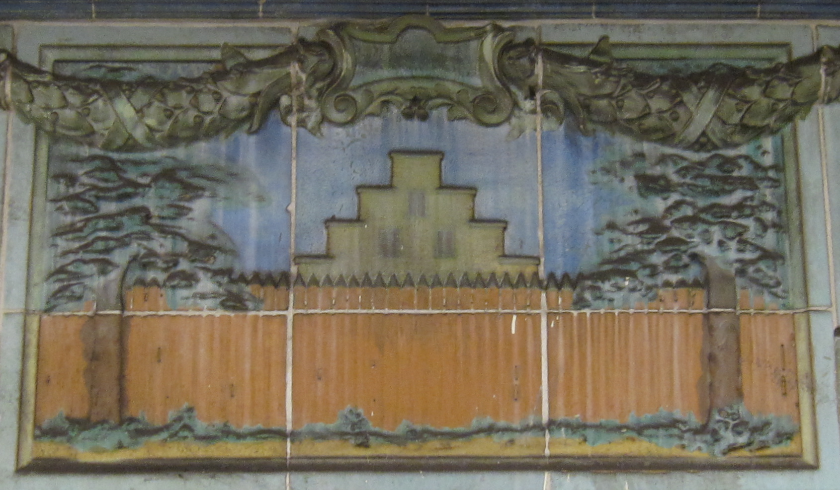
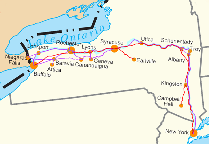
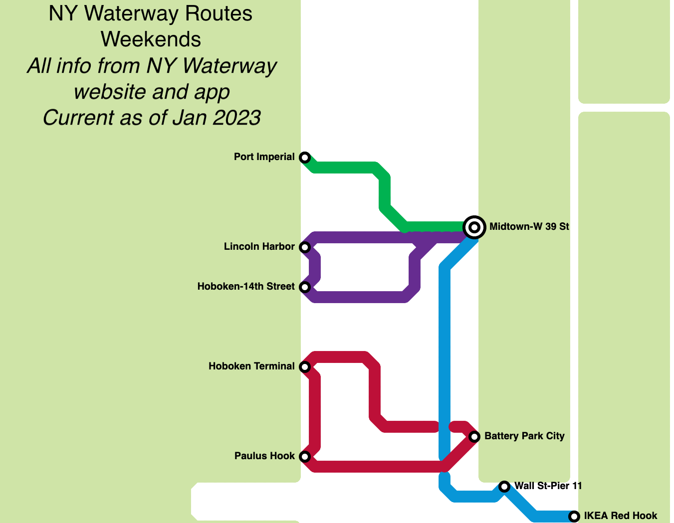
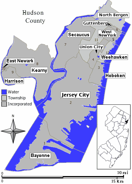
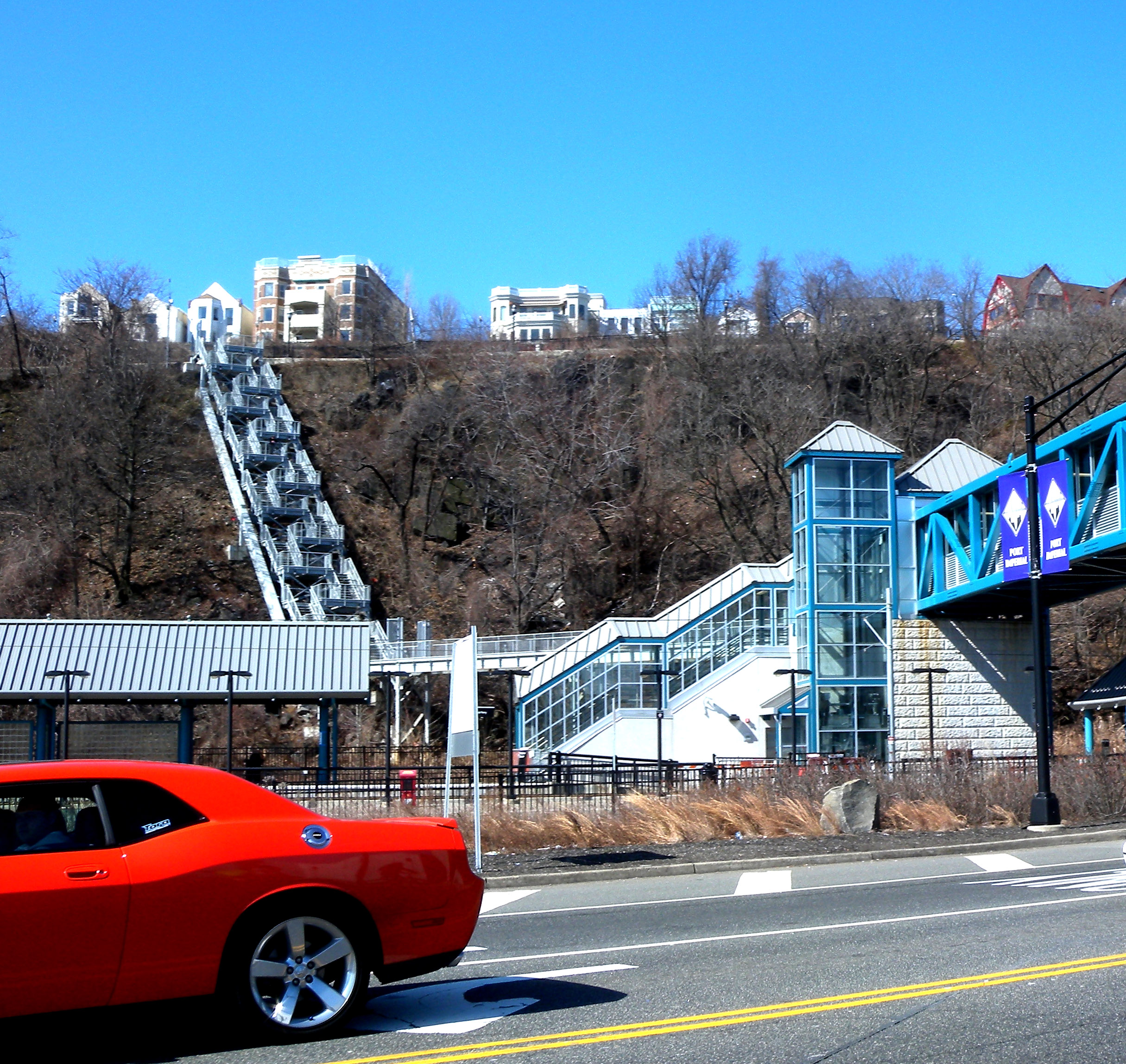
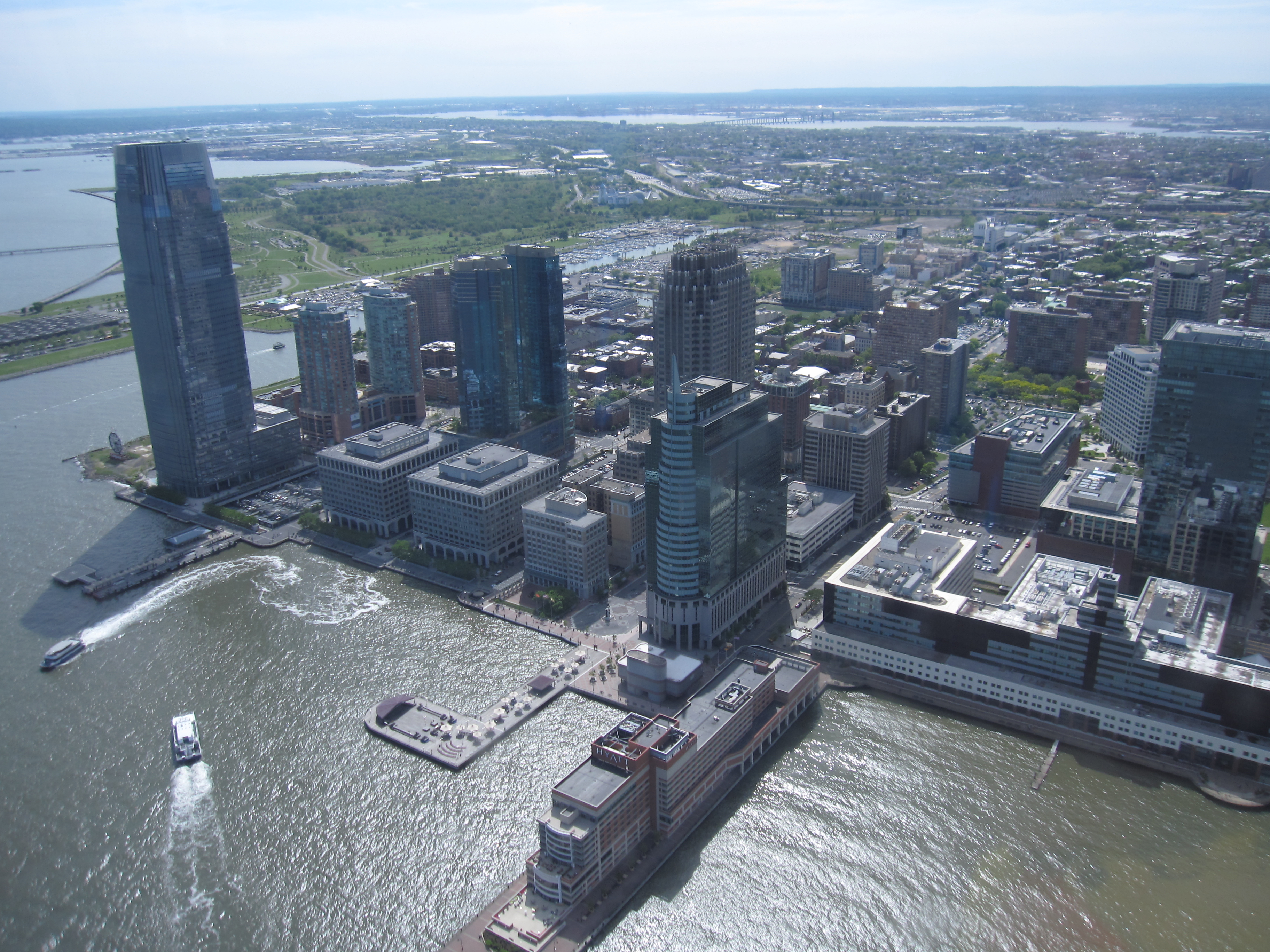
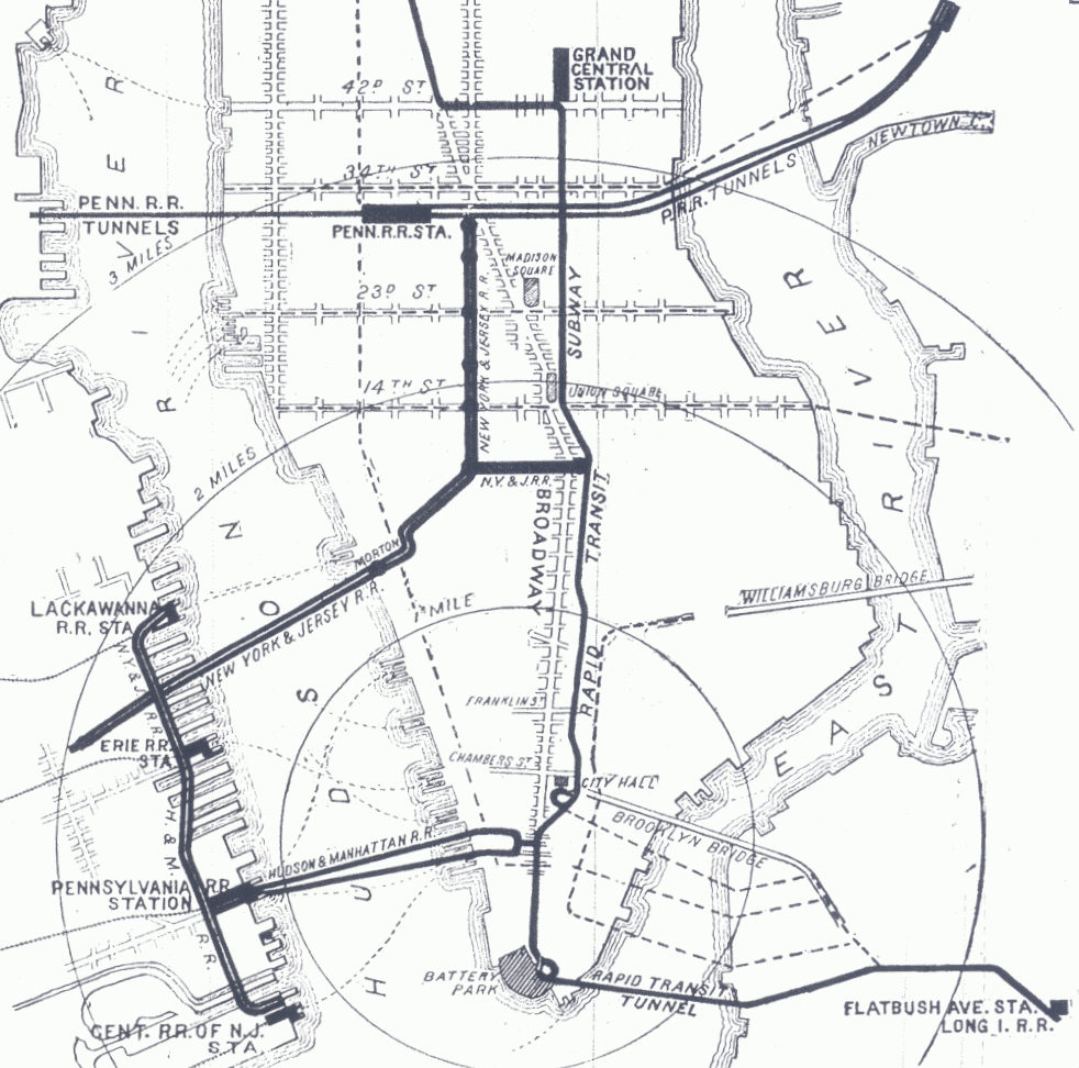
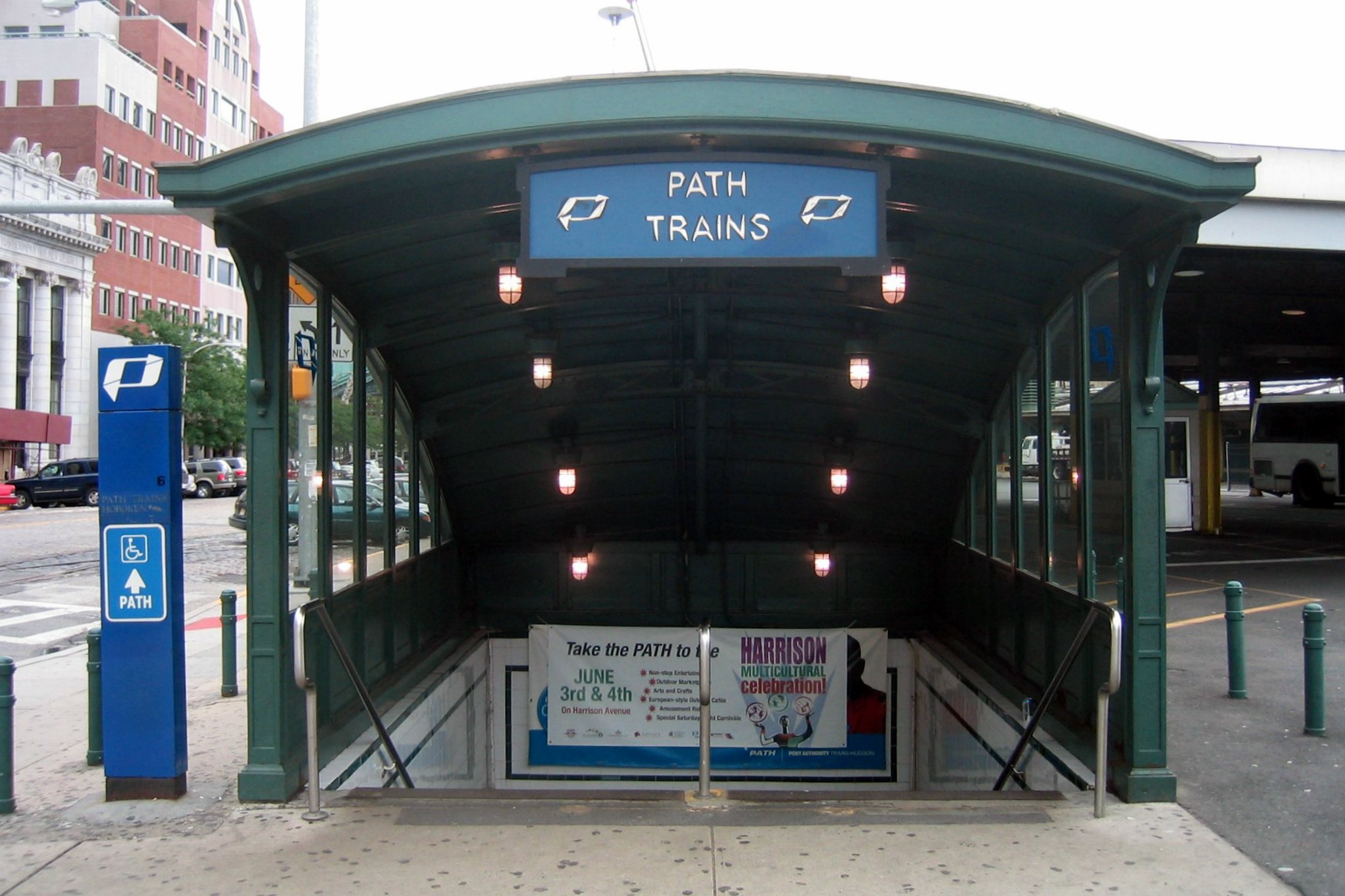
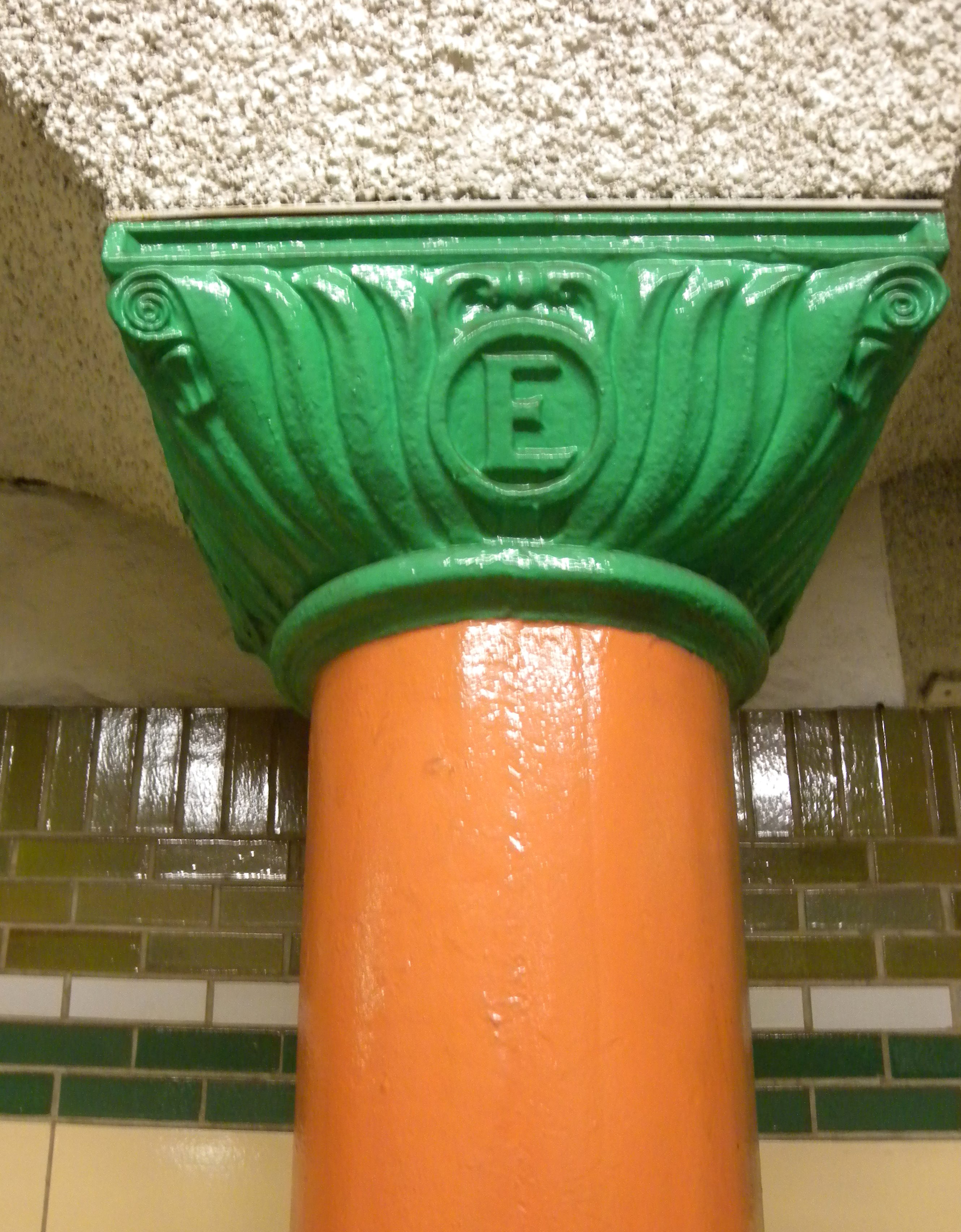
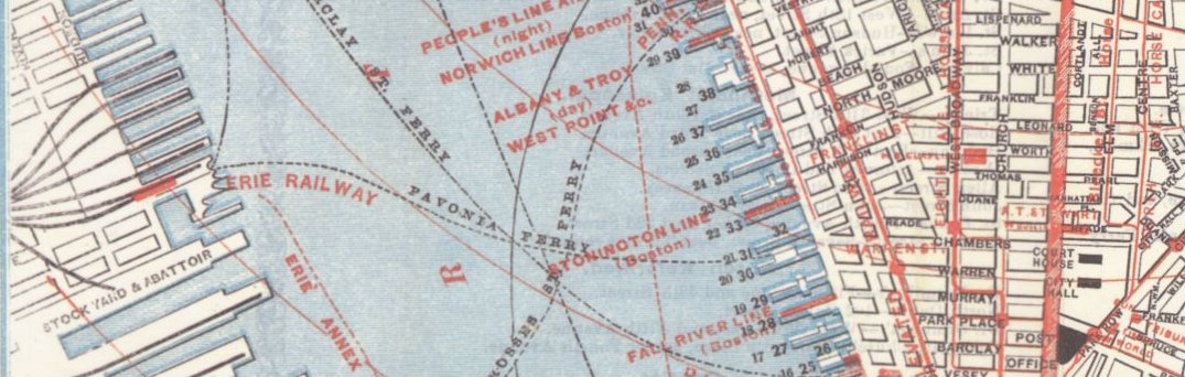
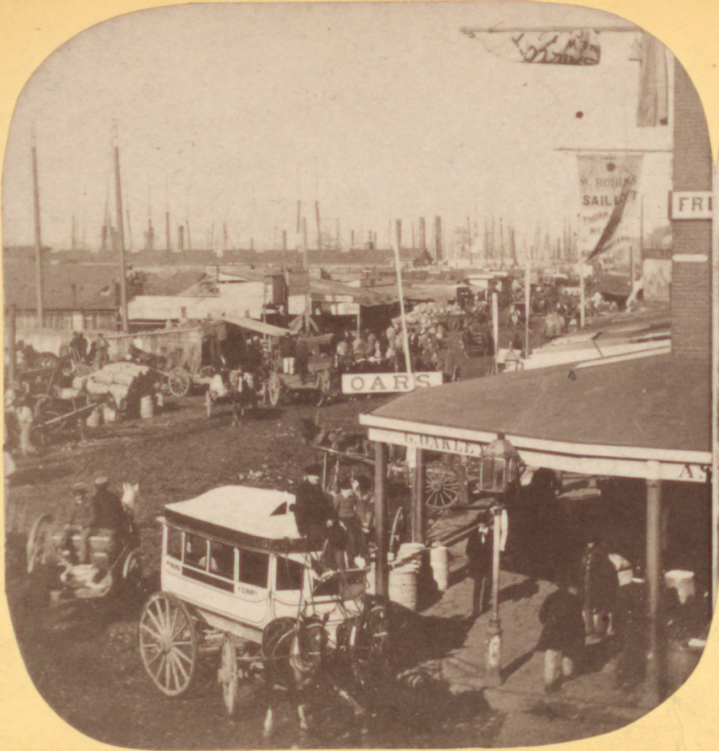
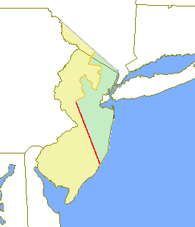