|
Reflections 2006
Series 12
September 25
Northeastern United States
| | Maine It was time to go on from Boston to Maine, which for quite some time had lost all rail service. Only a few years ago, the Downeaster was established to connect Boston to Portland. Now I understand the State of Maine is talking of extending it even further up the coast. The Downeaster leaves from Boston’s North Station, which otherwise has just suburban rail now. | | | | When the Big Dig was being planned, rail enthusiasts were pushing for adding a rail tunnel (even a single track!) to the road tunnel to connect primary South Station with secondary North Station, which has, as its name suggests, access to all routes north, especially considering that the route of the Big Dig passes by both stations. But this was never done (as it was in Brussels), so any routes to the north remain isolated, and no thru service is possible. At any rate, North Station is currently being rebuilt in its smaller format into a pleasant, utilitarian, modern station. | | | | The Downeaster takes 2 ½ hours from Boston to Portland, with several stops in Massachusetts, New Hampshire, and Maine. It uses standard, traditional coaches. Business Class costs just a small premium extra and covers half a coach next to the café, has much wider seats and legroom, and includes soft drinks and a newspaper.
| | | | I picked up my rental car in Portland and, before leaving, drove through its traditional neighborhood called the Old Port Exchange. The charm of this reviving neighborhood, visibly improved since the last time we were there, is its large selection of 19C buildings, all recycled into contemporary uses, such as restaurants and boutiques.
| | | | But my goal for the one night I’d planned in Maine was Pemaquid Point. On our travels through Maine in the past, we had enjoyed being there, and said we’d come back. Of course, we never did, so carpe diem! and here I was.
| | | | Damariscotta is about an hour north of Portland along the coast and is the access point to the long peninsula, typical of this coastline, leading to Pemaquid Point. The short little lighthouse at the Point, still in use, is now accessible. When the lighthousekeeper used to live here, he had to trim wicks and polish glass all the time, but now it’s all electrified. You get a nice view up and down Maine’s proverbially rocky coast. This lighthouse is used as a symbol of Maine, and is the one that appears on the Maine quarter.
| | | | But this coast is not unique. The east coast of North America undergoes a dramatic change here. From New Hampshire south all the way through Mexico, the coast is beachy, and further typified by long narrow, barrier islands immediately offshore, such as Jones Beach, Coney Island, Atlantic City, Hilton Head, Palm Beach, Miami Beach, and on around the Gulf coast. But from Maine north the coast is totally different. It’s a rocky coast typified by cliffs. It is not just Maine, but continues up to Canada, notably along the Nova Scotia coast. | | | | At Pemaquid Point you can go down on the rocks, as I remember we did years ago, and wander closer to the sea. It’s noteworthy that geologic forces have made vertical the originally horizontal layers of stone, sort of resembling thick pages of a closed book pointing upward, each layer having weathered to a greater or lesser extent. I was pleased to be here, but I think I enjoyed just a bit more sitting on the cliffs with the roaring surf below last summer at Peggy’s Cove in Nova Scotia, where the sign suggested you “savour the sea”.
| | | | White Mountains The next day I drove to the White Mountains of New Hampshire, which actually start to some extent on the Maine side of the border as I approached. My goal was multiple, but primarily it was more carpe diem. I had said in Skagway, Alaska, this time last year that after many years I wanted to finally take the Mount Washington Cog Railway, for one. I also wanted to stay in the fabled Mount Washington Hotel. Years ago Beverly and I, driving through this area, took the auto road up to the top of Mount Washington on its east side. It was relatively clear at the top, and we could see the vast Mount Washington Hotel down at the bottom of the west side. We also saw the cog railway as it had arrived at the top, and said to ourselves, one day, we’d experience them both. Well, now was to be the time, plus there were several other things I wanted to do in this area, which explains why, on an otherwise total rail trip, I rented the car for both Maine and New Hampshire, and beyond as well. As will become apparent, this trip involves tying a number of loose ends together, from things to be experienced (or re-experienced) to hotels we had thought it would be nice to stay in someday, such as with the Marriott Long Wharf in Boston.
| | | | I never realized that the White Mountains were so prominent, much moreso than the neighboring Green Mountains in Vermont. I was startled to read in Michelin that even Verrazzano had sighted them from the coast in 1524, and I later came across a plastic contour map with raised elevations where you could also note their prominence. The valleys are glacial, as so many geographic features are in the north, and are referred to as notches, a term for valleys unique to the White Mountains. Apparently early settlers, who would cut down trees by chopping a notch on one side first, and also used notches to hold logs together on log cabins, saw a resemblance of these valleys to those notches and the name stuck. In from Maine, I went down Pinkham Notch and passed the entrance to the Mount Washington Auto Road (toll). I then came up Crawford Notch to Bretton Woods, my destination, and later went down the nearby most famous and most attractive of the notches, Franconia Notch. | | | | Entering the mountains, I was surprised at the number of birches you saw. I was even more surprised at the number of moose warnings, in Maine, Vermont, and especially in New Hampshire, which had quite a few signs warning about accidents.
| | | | But one thing that pleased me was the result of dumb luck. I had originally planned this trip for late August-early September to wrap around my birthday on September 1, but then it struck me how foolish it would be to travel unnecessarily during the Labor Day weekend, so I moved up the departure date to two days after Labor Day. I didn’t realize that I’d be going far enough north, where the leaves start turning quite a bit earlier than in New York. I didn’t see full fall foliage, but there was the red tree here and orange branch there, giving an indication of what was to come in a short time. Still, it was dumb luck. | | | | Mount Washington Hotel These mountains were once full of major resort hotel destinations, where travelers, usually wealthy, would arrive by train, often for the entire season. The trains, unfortunately, stopped running by the 1950’s and many of the hotels are gone. I understand that there are four others besides the Mount Washington, which is probably the most famous, for reasons I’ll come to shortly. | | | | A digression first: everyone hears of Dixville Notch at presidential election and primary time, the northernmost of the White Mountain notches (I didn’t go there), all of whose voters gather right after midnight as Election Day starts to cast their ballots, allowing Dixville Notch to be consistently the very first precinct in the country reporting. As it turns out, the 1866 hotel called the Balsams Grand Resort Hotel in Dixville Notch is where local voting takes place, and even has a room designated as the Ballot Room set aside for this quirky practice, typical of individualistic New Hampshire.
| | | | Another quirkiness is that the New Hampshire town of Bretton Woods at the northern end of Crawford Notch consists of nothing more than the Mount Washington Hotel and Resort, its outbuildings, golf courses, and so on. The hotel has in its lower lobby the United States Post Office that services Bretton Woods.
| | | | The hotel, white with red trim, is starkly imposing as you come across it, set way back from the road on the hillside. It has three wings, the two side ones angled sightly forward, as on an altarpiece. It’s a large hotel, but its style and location makes it look even larger. Behind it the Presidential Range, including the highest, Mount Washington, also Mts Adams, Jefferson, Madison, Monroe, and others named after (mostly early) presidents. It’s in Spanish Renaissance Revival style and dates from 1902, in the midst of the period when so many grand hotels were built. As a matter of fact, Henry Flagler, who built so many hotels in eastern Florida in connection with his railroad, recommended the architect for the Mount Washington. It is the largest wooden structure in New England. When built, it had its own phone system, each room had its own facilities, it had its own generator and sewer system, and was generally self-sufficient. Edison engineered its lighting system. Some of its decorations were Tiffany glass. Coolidge, Wilson, and Harding stayed here while President; Gore while Vice President; the senior Bush after he was President.
| | | | There is a large grandfather’s clock in the lobby. For most of its existence, the hotel was seasonal, and maintained the custom that the first guest arriving every season would wind the clock, and the guest leaving last at the end of the season would stop the pendulum. This custom unfortunately had to end in 2001 when the hotel acquired ski facilities and became an all-year resort.
| | | | The rooms are actually quite simple—a lot of floral patterns and chintz, but all have nice views. In the lobby area there are three fireplaces, which were all operational (OK, they’re gas now, but let’s not quibble). The dining room is formal, with good food. A verandah, with some rocking chairs, almost surrounds the building, which is a National Historic Landmark. | | | | I still haven’t touched upon why Bretton Woods is recorded in history books around the world. Two events of international importance have taken place in New Hampshire. First, in 1905 in Portsmouth on the short New Hampshire coast, hosted by the US Navy and the State of New Hampshire, Theodore Roosevelt presided over the signing of the Treaty of Portsmouth, which ended the Russo-Japanese War.
| | | | Then, in July 1944, as World War Two was coming to a close, 44 countries sent delegates to the Mount Washington Hotel in Bretton Woods for the UN Monetary and Financial Conference, to compose and sign the Bretton Woods Agreements for international monetary management. The agreement established the World Bank and International Monetary Fund, set the gold standard at US$35, established the US$ as the backbone of international exchange and set fixed values for other currencies to create financial stability in the initial postwar years. Much of what was established lasted at least until the early 1970’s, and some beyond.
| | | | It is ironic that one of the reasons Bretton Woods was chosen for the conference was the easy access by ship to Portland and Boston, and easy rail access from there. It is amazing how transportation priorities have changed.
| | | | The conference lasted 22 days and included over 700 delegates. Many rooms have plaques on the door saying if a delegate stayed there at the time. The Agreement was signed in the Gold Room off the lobby, which can be viewed.
| | | | Mount Washington Cog Railway Mount Washington, at 6288 feet, is the highest mountain in New England. In 1852 a man named Sylvester Marsh proposed building a cog railway to its summit from the western, Crawford Notch side (the modern road is from the eastern, Pinkham Notch side). The New Hampshire legislature allowed that he might as well go ahead and try, famously laughing that he “might as well build a railway to the moon”. The Cog Railway’s gift shop today offers a number of items with a moon theme, so HA! | | | | On steeper grades, a regular railroad’s wheels would slip. A cog railroad’s purpose is not to merely overcome some slightly steeper grades, it’s meant for extremely steep grades. The principle is simple. The engine has a gear below it. In the center of the two tracks is a rack, which looks like a larger rail with slots along its top for the gear to grab onto and pull itself, and the train, up the slope. The regular tracks are for guidance purposes only. The last cog railway I took was in Korea last year, going down the steep access tunnel to see the tunnel North Korea had dug in the Demilitarized Zone (Reflections 2005 Series 7). | | | | The Mount Washington Cog Railway opened in 1869. While so many other railroads and funiculars have been modernized, such as the funicular in Bergen this summer, this one remains an absolute antique, which is a great part of its charm. Actually, that’s not quite accurate. The first engines, one of which is on display at the base station, were quite small, and could make it only halfway up, where there was a halfway house for passengers to change to another train for the rest of the trip. Those earliest ones were replaced with larger ones in the 1890’s that could make the whole trip. Aside from necessary boiler replacements, that’s what you ride in today.
| | | | It is worth noting that in the Panama Canal there are to this day cog vehicles called “mules”, one on either side of a ship passing through, that move uphill (or down) to drag the ship from a filled lock into the following almost-empty one. These Panama Canal “mules” were based on the Mount Washington Cog Railway.
| | | | The tracks go up a trestle up the mountain, usually close to the ground, sometimes spanning larger gaps. Up front is a single normal railcar, of somewhat antique style. Sitting down, you tilt backward from the start, and moreso later. The engine is in the rear and is of unique design (Google it). It’s almost wedge-shaped, so when it’s on flatter areas, the boiler points decidedly downward. There’s a fireman who stokes coal regularly going uphill (not down), and an engineer. In the railcar rides a brakeman. When the engineer blows the steam whistle, you hear it all the way up and down the mountain. | | | | There’s one surprising catch. The two vehicles are not attached. Picture a snow plow that pushes a pile of snow uphill, then backs up, and the snowpile backs up as well with it. That’s how this works.
| | | | It is regularly expected that an uphill train will meet two coming down. The first meeting place is the only part of the route that has two tracks, one on each side of a water tower, where the uphill vehicle takes on 1000 gallons (3785 liters) of water. Further up, the train coming down has already backed uphill onto a side spur, and waits for you to go by before proceeding.
| | | | Again, Mount Washington is 6288 ft (1917 m); the base station is about 2700 ft (823 m), for a difference of about 3600 ft (1097 m) in altitude that you climb. The 3.25 mi (5.2 km), traveling at 3 mph (4.8 kph), takes roughly an hour to go up (it’s a half hour down, you’ll see why). The average grade is 25%, but the maximum grade, going up a trestle called Jacob’s Ladder (that even has a bend in it!), is an amazing 37.41%.
| | | | As you go up, all the trees seem at an angle to your windows. Passing halfway house, there is a line on it that says “This line is STRAIGHT”, so you can see that the bottom of your windowsill forms a bowtie with that line. When you’re going up Jacob’s Ladder, someone in the front of the car is 14 ft (4.3 m) higher than someone in the rear. To stand in the aisle, which I did, you have to lean forward considerably.
| | | | Coming back down, you go BACKWARDS! The backs of the seats in the railcar have been flipped forward so you can face forward. The brakeman explains that the two vehicles will not be touching (is this still a railroad?). The engine lets itself down by releasing air pressure. The railcar comes down by the brakeman manoeuvering two brake wheels at the back of the car facing the engine, which is now the front. As I said, we were down in a half-hour.
| | | | The weather was clearing when I decided to go up. Near the top, though, we went into a cloud, and saw nothing from the top. I’m glad I remember seeing the view, and the hotel, from the top years ago. This time, it started to rain at the top, then sleet a bit, then hail a bit, and lightning struck twice. As it explains at the meteorlogical station at the top, Mount Washington boasts of having “the worst weather in the world”. It has 300 days a year of bad weather at the top. It also holds the record for the highest wind speed ever recorded on earth, 231 mph (372 kph) in April, 1934.
| | | | For my remaining days in Bretton Woods the weather was pristine, so I suppose I went up on the wrong day for the view, but it was fine to experience the train. From one of the red rocking chairs on the verandah in the back of the hotel, I could see Mount Washington and the others perfectly (actually, they all blend together into one single wavy ridge). You can see very clearly from this distance the route of the railway, and every once in a while, a puff of smoke or steam shows you where a train is. When I first saw the slope from the distance of the hotel, I was really shocked. I went up THAT? It looks like a fly climbing a sloped roof, it’s that steep. Actually, I’d do it again.
| | | | In the museum at the base station after my ride, I saw two things of interest. First was something called a Devil’s Shingle, a genuine one of which was shown on a mockup of tracks. It looks like a sled, and is attached to that central rack that the gear grabs hold of. Apparently from 1870 to 1920, employees were allowed to ride that Devil’s Shingle down the mountain on the rack. It took two minutes and 45 seconds. I have no idea how the idiots—I don’t say daredevils, I say idiots--that tried it braked at the base station.
| | | | The other thing I noted was that this was the oldest cog railway in the world. It did say that the oldest in Europe was on Mount Rigi, built two years later in 1871. I know the Rigibahn is near Luzern/Lucerne in Switzerland, and rode it many years ago, with little present recollection. Now that I’ve finally ridden this one after all these years, I’ll have to add the Rigibahn to my to-do list once again. One step forward, one step back. It did remind proudly though that this one had a maximum grade of 37.41%, and merely an AVERAGE of 25%, while the Rigibahn has a MAXIMUM of 25%. So there.
| | | | The Old Man of the Mountain I went to visit the Old Man of the Mountain, and he wasn’t home. But I knew that. He hasn’t been home for over three years, when he suddenly went missing one day. Actually, he’ll never be back. | | | | His other name is “The Great Stone Face”, but in any case, he’s not there any more. At least Beverly and I had seen him on our earlier visit, when he still looked like this, taken six days before the collapse (Photo by Jeffrey Joseph):
Old Man on 26 April 2003
| | | | From the hotel, I drove over to Franconia Notch on a Monday, which by chance would limit crowds (to almost no one, as it turned out). I pulled off at the Old Man exit, parked at the little museum, and walked the trail to Profile Lake, named for the Old Man’s profile. I read the explanatory signs, then sat on a bench. The sun, sky and lake were splendid, a couple of trees here and there on either side of the Notch had turned, the view of the mountiain was ideal.
| | | | As you look up the wooded mountain on the west side of Franconia Notch, there seems to be a large wooded hump at the top. At the left end of this hump the trees disappear, and there’s a granite outcropping visible, now rather flat vertically. This outcropping is a full 48 ft (14.6 m) high, and, before our first visit, I had expected it to be huge, but since it is located 1200 ft (366 m) above Profile Lake, if you held a quarter out in your line of sight, you’d block out your view of it. | | | | For 12,000 years, there had been more rock there. From Profile Lake, and from this angle only, it looked amazingly like a man’s jagged face: out for the brow, in for the eyes, out for the nose, in for the mouth, out for the chin. And now it’s gone, seemingly sheared off vertically. Although there were never any ears, what is left would be from the area where ears would be backward into the mountain. How could it have happened? This is granite. Granite is solid, right? It’s the symbol of solidity.
| | | | The Old Man of the Mountain is the symbol of the State of New Hampshire. Every road sign in the state giving a route number has that number on a silhouette of the Old Man. Every license plate in New Hampshire has the Old Man in between the numbers. In 1955, a US postage stamp was issued with the Old Man’s image (note that he can also be referred to as the Old Man of the Mountains): Old Man Stamp (PD-STAMP). The commemorative State Quarter issued by the US for New Hampshire in 2000 has the image of the Old Man on it: Old Man Quarter (PD-COIN).
| | | | All the signs at Profile Lake and in the nearby museum continue to speak of the Old Man as if he were still there up above. It’s the same way as how you still speak in the present tense of someone who’s died.
| | | | But there’s one sign at the lake that gives the explanation of his disappearance, and it’s actually one of the most interesting aspects of the case. Fascinating, as a matter of fact.
| | | | The Old Man was not solid. His height was composed of five slabs of granite balanced one on top of the other. The first slab formed the brow, the fifth the chin.
| | | | That by itself is not necessarily a problem. He still could have lasted thousands of years more. But, just as occurs in classical drama, the Old Man had a tragic flaw.
| | | | Blocks 1-4 were just as solid as you’d imagine, and were projections out from the mountain. Block 5, the chin, was not. Somewhere in time it had become separated, and the part that actually formed the chin had a substantial cavern behind it. Even that might not have been too tragic, but it gets worse.
| | | | 80% of the block that forms the chin had no support from below, and actually hung out in open space. Only the inner 2 ft (0.6 m) of the chin block actually rested on the cliff. If it wasn’t attached, what kept it from falling?
| | | | If you set most of a shoe box hanging over the edge of a table and let go, and it will fall. But if you put your hand on top of the box to apply pressure, it will hang out over the edge of the table. It was the pressure of the four upper blocks on the separate chin block that held the chin block in place. Looking at this situation from the other point of view, the only support that the four upper blocks had was the 2 ft (0.6 m) that the chin block was holding on to the cliff. Talk about hanging on by your fingertips. Given the explanation of this mini-toehold, it’s amazing that the whole structure—really very fragile—ended up lasting as long as it did. | | | | In time, water and ice had their effect. It’s also assumed that acid rain didn’t help either, on any of the five blocks. On May 3, 2003, the chin block finally slipped off the cliff, then one after another, blocks 4, 3, 2, and 1 broke away, probably one at a time that day. It all collapsed like a house of cards. I remember that it made the front page of the New York Times. | | | | Now the Old Man of the Mountains is gone. Does it still make sense to visit the site of something that USED TO be there? Of course! You visit the Western Wall in Jerusalem as the remnant of the temple that used to be there. You visit Pompeii to see the remnants of the town that used to be there. You visit Gettysburg for the battle that once took place there. To visit this beautiful site of what remains of the Old Man makes the same sense. Here is a composite before-and-after view, which gives you an eerily ghostly feeling: Old Man Composite View (Photo by Rob Gallagher). | | | | Les Cantons de l'Est I put a day aside for an extensive drive out of Bretton Woods, a loop up to Québec and over to Vermont and back. Years ago we had made a short stop in les Cantons de l’Est, had said we’d go back, and never did, so ....
| | | | I try to emphasize that worlds don’t change because of crossing a political border. I just ran a parallel between the rocky coasts of Nova Scotia and Maine. Well, there’s a virtual piece of New England that’s not in New England, but over the border.
| | | | Consider the area north of Vermont and New Hampshire, but east of Maine. The Saint Lawrence River cuts off this area to almost form a triangle. This is an area that we discovered was scenically very similar to New England, although with rolling hills instead of mountains. I feel to a large extent, Americans are unaware of this area.
| | | | Because it’s east of Montréal, this little corner of Canada is called in English the Eastern Townships, and les Cantons de l’Est in French. Based on that word Est, it’s also called l’Estrie in French, which would correspond to something like East-ria.
| | | | There is another good reason for a parallel to New England. After the Revolutionary War, many Loyalists were either forced to leave the US, or felt more comfortable doing so. (I’ll refer again to Frederick Philipse of Philipsburg Manor, who was forced to leave.) Many, especially New Englanders, settled right across the Canadian border, in nearby Nova Scotia or here in the Eastern Townships, giving the towns a look reflecting their New England heritage. However, it should be pointed out that the Loyalists were only the first settlers. After 1850, French speakers started moving in to the area, and it ended up becoming entirely Francophone. There are many towns with such English names as Sherbrooke and Drummondville, which, along with others with more French names, are entirely French-speaking. | | | | I drove north from New Hampshire via Vermont into Canada, just to take a drive of a couple of hours through the area. Just before the Canadian border, a sign indicated we were passing the 45° North parallel, halfway between the Equator and the North Pole. Long, narrow Lake Memphrémagog is partially in Vermont but mostly in Québec. At its head is the charming town of Magog, which that weekend was celebrating the Fête des Vendanges, the Grape Harvest Festival. I had come up one Vermont interstate, I-91, drove through Magog and the southern area of the Cantons de l’Est, and re-entered the US via the other Vermont interstate, I-89, further west, toward Burlington.
| | | | South of Burlington, on US 7 going toward Middlebury, I caught a glimpse of Lake Champlain, but more exciting was the breathtaking view I had from a rise in the road. On my left, to the east, I could see Mount Washington and the Presidential Range, clear as can be, one state over in New Hampshire, and on my right, to the west, I could see layer upon layer of the Adirondacks in New York State.
| | | | Middlebury I’ve told before how I first went to Middlebury College’s German School the summer of 1959, the Spanish School in 1960, and again the German School in 1961, where I met Beverly, and our friend Rita was also in attendance; we all three spent the following year in Mainz to get our Master’s in German. Beverly and I returned in 1975 and ever summer through 1980, when our two mothers and my sister Chris came up to watch us get our Doctorates, the DML, the Doctor of Modern Languages in German and French. My point in repeating this is that we’ve spent a lot of time in Middlebury. We were never year-round undergraduates there, but we’ve seen the College and town change over the years, more than some others, perhaps.
| | | | I would be tempted to state two things, that I’ve never seen Middlebury since the five of us drove away the day after the graduation ceremonies in August, 1980, and that I’ve never seen Middlebury in winter.
| | | | Technically, that would be a double lie, but only technically. There was a time in the 1980’s where we spent a winter weekend at the Trapp Family Lodge (“The Sound of Music”) in Stowe, Vermont, and on the way back we drove through Middlebury. I’ve seen pictures of how pretty Middlebury can look under a layer of white snow. But as we drove through, we saw it under a layer of gray slush, which was under a gray overcast. As I recall, we zipped around town and up to the campus and never got out of the car. I refuse to count those ten minutes, and will maintain again that I’ve never been back to the Middlebury of fond memory in the 26 years since 1980.
| | | | I will begin with the caveat that I know that Thomas Wolfe said “You Can’t Go Home Again”, and I agree. You also can’t step into the same creek twice, and I wasn’t expecting to. But after over a quarter-century, it was time to take a look again.
| | | | In town, I pulled up to the Green, a sloped triangle with Middlebury Inn at the top. In those first years, the German school was especially active in learning folk songs and singing, a practice that had been dropped by the time we went back in the 1970’s. Groups of us would often go singing of an evening over a glass of beer in the Inn’s Pine Room, to us, das Tannenzimmer. There are several very New England-ish churches around the Green, and one of them within it. A lot of the buildings around its edge have memories. Most people don’t realize that the single-track rail line goes artfully through a tunnel right under the Green, the entrance and exit hidden by shrubbery. The former station is a block away, now a car parts dealership. Still, the Ethan Allan connects New York to Rutland, and there is always talk of reinstating ridership further north. | | | | In 1976, we spent the US Bicentennial at an old-fashioned Fourth of July on the Middlebury Green. My best memory of the event remains the stately, tall, distinguished white-haired local lady barely leaning on a cane, who was celebrated as being 105 years old, and therefore five years old at the time of the US Centennial in 1876. Come to think of it, she must have been born the year the Cog Railway opened.
| | | | Further west I crossed the bridge over Otter Creek, with its waterfall below. Over the years we saw improvements come, such as all the craft shops in Frog Hollow and the wonderful selection of new restaurants.
| | | | Still further west I came to the Campus, sometime referred to as the College on the Hill. At the bottom of the hill is historic Old Stone Row dating from the early 1800’s, with Starr and Painter Halls (I spent a summer in each one) on either side of Old Chapel. The view to the top of the hill was to Mead Chapel, where we graduated. We took pictures of us in our caps and gowns—and Middlebury blue-and-white doctoral cloak—the next day before returning them. The most fun was the picture we took afterward of both our mothers wearing the outfits.
| | | | I drove to the top of the hill and stepped inside Mead Chapel. Hepburn Hall to the left of it was where I lived in the Spanish School; I never lived in Gifford Hall to the right, but it was there that Beverly and I met. There were so many students that year that the basement level was being used as a dining hall. When the family members came for graduation, we tried to at least peek in the window, to no avail. This time, it was worse: the downstairs area had been converted to dorms.
| | | | Across the road was Hillcrest, a wooden home converted to College use, where we also dined in those years. Finally, a bit further away, was Pearsons Hall, center of the German School, where so many activities had taken place, and where Beverly and I lived during those years in the 1970’s. It looks down another hill at Le Château, modeled on a Loire structure. | | | | It was late Sunday and there was some activity going on. I stopped a young woman (as the years go by, you start using expressions like “young woman”) and asked her when school started. “Tomorrow” she said. It’s a good thing I hadn’t arrived during the confusion that would take place the next day. I mentioned that I had gotten my degree 26 years earlier, in 1980, and she smiled. I could only wonder what she could have been visualizing by “26 years earlier”, since she was probably only about 18. Oh, well. It was nice to see how everything looked, anyway.
| | | | As I drove back to New Hampshire, I took a minor, but special route over the Green Mountains. At East Middlebury, you drive over the Middlebury River (what else?), then up through the mountain village of Ripton, where Robert Frost lived. Further along you come to Middlebury’s respected Bread Loaf School of English, housed in a former mountain resort from the 1920’s, with typical wooden buildings. Once, in the early years, a bunch of us drove up to Bread Loaf to hear Robert Frost speak. First the English students had priority, and second, we probably arrived a little late, so we were in the back of the lecture hall, and my view of Robert Frost was of a tiny white head above a podium in the distance. | | | | Beyond Bread Loaf it was over Middlebury Gap, then down the other side to New Hampshire, and later, to Bretton Woods. | | | | When it was time to leave Bretton Woods, I drove back to Portland, took the Downeaster again to Boston’s North Station, and stayed free on Starwood points for one night at the Westin on Copley Square, dining at Casa Romero on Gloucester Street in Back Bay. The next morning I took the T to South Station to stop at Club Acela, then took the Acela its entire length from Boston to Washington in 6 ½ hours. We made the same stops to New York and saw the view again from the Hell Gate Bridge. At New York Penn Station I was aware that it was there that Beverly had gotten emotional about the X2000 being Swedish on our last high-speed train to Washington; but this was the Acela instead. Crossing under the Hudson we stopped at Newark Penn Station, Philadelphia, Wilmington, Baltimore Penn Station, and Washington Union Station. Amtrak fed us so well again, on both sides of New York, that I cancelled any thought of dining that evening in Washington as I had planned. There had been a lot of businessmen in suits and businesswomen in suits on the Boston-NY leg, and even moreso on NY-Washington. It seems everyone had something electronic sticking in his ear or in front of her mouth, and Blackberries, cell phones, laptops—it was like an electronics convention. And I just kept typing away on my own laptop. | | | | During the course of this entire trip I either visited, or passed through on the Acela, every one of the New England and Middle Atlantic states, but my goal here at the southern end was the District of Columbia and Pennsylvania.
| | | | Washington & the District of Columbia Historically, the rail station situation in Washington had been confused. There was even a rail station right on the Mall at one time. The magnificent Union Station near the Capitol Building was the answer to this confusion. But in recent decades, we watched Union Station be abandoned, and Amtrak put up on of its “Amshacks” behind it near the tracks. The station was a national disgrace, with leaking roofs and mould growing on the marble. We lived through the attempt to make the station a National Visitors’ Center, which was another catastrophe. Finally a public-private consortium took over, and we watched Union Station become what it is today, a beautifully restored rail station with destination restaurants and shops. | | | | We usually stayed in the DuPont Circle area, but had noticed that, opposite Union Station, the 1922 former Commodore Hotel, which the National Trust for Historic Preservation lists on its Historic Hotels of America, had been taken over by an Irish group and renamed the Phoenix Park Hotel, after the park in Dublin. I had come to Washington for two reasons. First, because it was at the other end of the Acela route, and second, to see the new World War Two Memorial. We regularly made it a practice to stop and see newly opened attractions, most recently the Franklin D. Roosevelt Memorial, which we stopped and saw driving back from Florida a few years ago, and now I had another new destination to see. | | | | But first Washington’s layout: Centered on the Capitol Building, Washington is divided into four quadrants by North Capitol Street, East Capitol Street, South Capitol Street and—surprise—the Mall. There is no such thing as West Capitol Street, as the Mall takes its place from the Capitol to the Lincoln Memorial at the Mall’s western end. That this street is missing is a good trivia question, corresponding to the fact that there’s no Central Park East in New York, since Fifth Avenue retains its name along Central Park.
| | | | Washington’s four quadrants are logically NW, NE, SE, and SW. SW is tiny for reasons explained in a moment, and NW has most of the sights. North-south streets have numbers and east-west streets have letters (the letter J is skipped—another trivia question). Avenues are named for states, such as the famous Pennsylvania Avenue, and run diagonally, which makes for beautiful views, but becomes a driving nightmare, especially with one-way streets, and is not too easy for pedestians, either, since very often, an avenue will be the third street in an intersection.
| | | | [More trivia: The two B Streets exist only under aliases. Along the north side of the Mall, then all the way to the DC border, B Street goes under the name Constitution Avenue instead. Along the south side of the Mall, and beyond, B Street is known as Independence Avenue. The A Streets exist only to the east of the Capitol. On the Mall, they start out being known as Madison Drive and Jefferson Drive, and west of the Washington Monument they disappear entirely.] | | | | My hotel was, curiously, right on North Capitol Street, on the NW side, and Union Station was on the NE side, about a block away. The hotel was at F Street (NW), which, at Union Station, became F Street (NE). At this intersection, Massachusetts Avenue came zipping through at an angle, so you had to wait for a lot of lights to change before you could cross the three-way intersection. Count your letters, and you’ll see that F Street is six blocks north of the Capitol. There would be another F Street, both SW and SE, to the south of the Capitol, but it’s been obliterated by a freeway, so it goes from E to G, but you get the point. | | | | In a similar way, two blocks west of my hotel is 2nd Street, and two blocks east is another 2nd Street, which is why you have to indicate if you mean NW or NE. Both these streets continue south of the Capitol with the same names, so you have to indicate there if you mean SW or SE. Got it? | | | | We also have watched the Washington Metro grow over the years. It’s beautiful, with large barrel-shaped stations with coffered ceilings. Lights at the platform’s edge flicker when a train approaches. The only problem with it is that it hardly ever goes where you want it to. | | | | I call some subways street-oriented and others neighborhood-oriented. New York’s is street-oriented. If you want to go to 45th Street, you have a choice of stations at 42nd and at 50th. Boston’s is similar, as are others.
| | | | I’ve mentioned that Moscow’s and Saint Petersburg’s is neighborhood oriented. You go either to this neighborhood or to the next one way over there, and have to then continue to work your way to your local destination. This is the situation with Washington’s Metro. For visitors wanting the eastern end of the Mall near the Capitol it’s not bad, as both the Archives and Federal Triangle stations are at about C Street NW, but to get to the western end near the Lincoln Memorial, you’ll walk seemingly forever.
| | | | The new World War Two Memorial is on 17th Street NW/SW. It’s centered on the Mall at where 17th Street changes quadrants. Since the Mall is wide at this point, A Street is obliterated here; B Street, as always, is Constitution Avenue.
| | | | The closest Metro station is at Farragut (Square) North, which is directly on 17th Street NW, but way up at K Street, so count the longish blocks I had to hike to get to my destination. Well, I could use the exercise. If you got eleven blocks, you’ve forgotten that there’s no J Street. It was ten blocks, but both going and coming.
| | | | Preservationists’ concerns at locating the World War Two Memorial right in the Mall were that it would block the world-famous view down the length of the Mall. Since the Memorial was largely sunken into the ground, that, I discovered, was not a problem. The front entrance is at 17th Street, with your back to the Washington Monument right across the street. (By the way, the Washington Monument is on a mound of earth, so from street level, the lower part of the view eastward to the Capitol is slightly blocked.)
| | | | Facing the new memorial, which was opened in the Spring of 2004, you look over it down the Mall to the Lincoln Memorial at 23rd Street. Since it was late afternoon by now, the lights had gone on and the view of the Seated Lincoln inside was impressive. The oval memorial right before me had a sunken plaza with fountains, and had two rotundas at either end, one marked for the Atlantic theater and one for the Pacific. All around the oval perimiter there were individual smaller monuments with bronze wreaths on them, one for each state and territory. There were also appropriate quotes from Roosevelt, Truman, MacArthur, Marshall, and others.
| | | | Hiking up and down 17th Street I had plenty of time to think. I thought of our last visit to Washington, to the then-new FDR Memorial. And, as I was walking down to the Mall, between D and C Streets I passed the columned building that is the National Headquarters of the Daughters of the American Revolution, which includes Constitution Hall, and recalled the famous incident there in 1939 where the DAR gave itself a black eye. Do you remember what I mean? | | | | Famed Contralto Marian Anderson was scheduled to sing at Constitution Hall, but the concert was cancelled because Anderson was black. Eleanor Roosevelt, bless ‘er heart, resigned from the DAR, then stepped in and arranged for Anderson to give her now historic and highly symbolic concert on the steps of the Lincoln Memorial that same year on Easter Sunday in front of an audience of 75,000. The concert was broadcast nationally on radio. Old newsreels show Anderson singing, among other selections, “My Country ‘Tis of Thee”. | | | | Some years ago, mindful of what may have been the most significant historical event involving Constitution Hall, Beverly and I visited the building. At the time, to our consternation, I don’t recall seeing any reference whatsoever to the event in 1939, but now, reviewing the DAR website, I find they do state that the event was “one of the first milestones in the struggle for Civil Rights in America”, to which I would add that they were on the wrong side of that struggle. They point out that Washington was a segregated city at that time (which is true), and that Constitution Hall limited performances to white artists. (I should be noted that decades later, Sammy Davis Junior was at first not allowed to stay at the Las Vegas hotels where he performed.) Apparently the DAR did change its policy, and I find it very interesting that “Miss Anderson sang at Constitution Hall six times after 1939 and launched her farewell tour from our stage”. | | | | It is not only informative but also it’s often highly satisfying to do online research. I also just came across a press release from last year from the DAR from last year saying that the US postage stamp in the Black Heritage series honoring Marian Anderson would be issued on January 27, 2005, and that the first-day-of-issue ceremony would take place in—Constitution Hall. I suppose what goes around, comes around.
| | | | [More trivia: Washington street addresses usually indicate the crossing numbered street. For instance, the White House’s address of 1600 Pennsylvania Avenue tells you that it’s at 16th Street. The DAR’s building faces 17th Street as mentioned, but they actually use the address of the side street to take advantage of 17th Street, for obvious reasons: 1776 D Street NW.] | | | | The other thing besides Anderson going through my mind on that walk dealt with our visit to the FDR Memorial and its controversy. There is no doubt that Franklin D. Roosevelt became physically handicapped because of polio sometime in the 1920’s. However, during his entire national political career the matter was not discussed. Presumably it was felt that a physically handicapped person could not be elected to national office, and those that thought so, given the lack of sensitivity that was common in the period (see Anderson above), were probably right. Just as there were those who, despite Anderson’s musical talents, would have her shooed out of the spotlight, there were probably many voters who, despite Roosevelt’s political and leadership talents, might not have voted for a cripple, to put it in blunt language. So were the times.
| | | | Therefore, no one talked publicly about the handicap and those in the know played a gross charade. Pictures of Roosevelt showed him seated in a chair, at a table, or in his car (with hand controls), but never seated in his ever-present wheelchair. I understand there are only 2-3 photographs extant of him in his wheelchair, and they were never made public in his lifetime. Whenever he was shown standing, which was usually at a podium, his leg braces were locked in the vertical position to hold him upright while he supported himself on the podium. It must have been very uncomfortable, and grossly embarrassing. I recall that, on his address to Congress on his return from Yalta, shortly before he died in 1945, he is shown seated behind a table, and he even has to go to the extent of apologizing at the beginning of his speech for sitting in front of Congress, but he’d “been very tired lately”.
| | | | The most wrenching film clip I’ve seen of him shows him “walking” in order to further perpetrate the charade. He’s doing no such thing. The clip show him slowly coming down a red carpet, one of his sons is supporting him under his left arm, and a Secret Service agent is supporting his right. Just as you would “walk” a heavy armchair across the floor by tilting it onto two legs, then rocking from one leg to the other to achieve forward motion, these two were propelling him forward. It is most likely his signature megawatt smile, all teeth, that distracts the viewer’s eye from seeing details of the perpetration of the charade. How degraded he must have felt. | | | | Clearly Congress, reporters, and anyone else who saw him being transported in his wheelchair had to have known the truth, but everyone held tight lips.
| | | | A few years ago, Beverly and I went to Warm Springs, Georgia, where FDR died. We saw the sanitorium pool where he swam with kids with polio, we saw the now disused rail station where he and his entourage would arrive, we saw the room he died in, and reviewed the circumstances. We also saw his car with the hand controls. There was also a museum, just as at his home in Hyde Park, New York, of gifts that been given to him, by both the powerful and by the common people. But there is one thing that illustrates in my mind to perfection the lack of public knowledge of his real condition. There is a room in the museum, perhaps the size of a large living room, and on all of its walls, spaced only a few inches apart, are walking sticks and canes, wooden ones, metal ones, fancy, humorous, on and on and on. It was clear that the public realized he had perhaps a minor walking problem, but certainly one that a cane could easily help, right? The public didn’t realize that a whole forest of canes couldn’t get him across the room. They also say that for every letter someone writes to a politician, there are X people with the same opinion that don’t actually write. I would extend that to say that for every person who sent in a cane .... | | | | So back to the FDR memorial in Washington. It’s out-of-doors, has a waterfall, has different statues, such as of a man listening on a period radio to a Fireside Chat, Depression bread lines, and more. The controversy there was interesting. The major statue of him does does show FDR sitting in a wheelchair. The only problem is that his signature cape is swirled around the chair as he sits on it, and only if you really look closely, or from the back, do you really see the wheels of the wheelchair, which the cape otherwise hides. This had advocacy groups up in arms, arguing that there was finally some sensitivity—just not too much. As a result, FDR’s genuine wooden wheelchair—it looks like such an antique—was put on display in a glass case in the Visitor’s Center, sort of in compensation. | | | | Given the Anderson and Roosevelt stories, and also given that former Governor of Texas Ann Richards, who was in the national spotlight and could have had national aspirations, died the same day I was thinking about all this while walking down 17th Street, one could ponder the following.
| | | | One might ask when we’ll have our first woman President. One might ask when we’ll have our first black/Latino/Asian President. One might ask when we’ll have our first physically handicapped President. But wait—we’ve already had our first physically handicapped President. | | | | We just didn’t know it at the time. | | | | [A note of a bit more trivia to lighten things up: do you know the terms POTUS and FLOTUS? These were used by railroad dispatchers (also by the Secret Service) to refer to Franklin and Eleanor Roosevelt. They are primarily railroading terms, for when the two were traveling by rail to various destinations. The terms were also used later for the Trumans and others when they traveled by rail. Can you tell what the words stand for? It’s simply “President of the United States” and “First Lady of the United States”, as in “POTUS is arriving in Warm Springs today, and a FLOTUS train will arrive next week”.]
| | | | Finally, something about the District of Columbia. If you ever looked at a map that showed DC, you may have wondered about its unusual shape. You will recall my saying that unusual map shapes, either political maps or geographic ones, usually have a story behind them, and DC is no exception. On a map, DC looks like it’s trying hard to look diamond-shaped, but hasn’t succeeded. Instead, it looks like a giant Saltine that someone’s taken a bite out of on its lower-left hand side. Why? | | | | We learn in school that after New York, Philadelphia, and some other places had their turn being national capital, the states decided to set up a special District of Columbia. Even in those early days there were North-South rivalries, so a location somewhat between the two was chosen, on the Potomac River between Maryland and Virginia. Maryland contributed a piece of land from its side, and so did Virginia. This is as far as most people are aware of. But it’s not the end of the story.
| | | | A diamond shape was indeed formed for the District, a diamond that was ten miles on each side. However, the land on the two sides of the river were not equal. Maryland’s contribution was maybe 2/3 of the total, and Virginia’s 1/3. In other words, the Potomac flowed through the original District on the diagonal, cutting off the southwestern third, the Virginia part.
| | | | The land that became DC was not vacant. What had been Georgetown, Maryland became Georgetown, DC, and what had been Alexandria, Virginia, became Alexandria, DC. The City of Washington was laid out to the east of Georgetown, and that was Washington, DC. | | | | However, the major activity, and the national capital, were on the original Maryland side of the district, to the north. There were no bridges at the time, and access from the totally rural (except for Alexandria) former Virginia side was difficult, and the voters there felt left out. Therefore, in 1846, Alexandria petitioned retrocession back to Virginia along with the rest of the land on that side, and that’s what happened. Alexandria, DC became Alexandria, Virginia again, as it still is.
| | | | Look carefully at a map of the DC area, and you’ll see the land that was ceded back. It is now Arlington County, Virginia, which kept its original shape from having been a corner of DC. Because of its unusual history, Arlington County is the smallest county in the entire United States. | | | | Three of the original “points” of the diamond are still part of DC. Only the western point is now part of Arlington county. Also, over time, the City of Alexandria has grown and extended its boundaries, eating into the southern end of Arlington County.
| | | | As time passed, within the remaining, northern part of the District, Washington DC grew and devoured Georgetown DC, and today, Washington fills the remaining district, with Georgetown just a neighborhood of Washington. Actually, Washington has overgrown the District as well, and for all practical purposes, a huge swath of suburban Maryland and suburban Virginia is part of Washington’s metropolitan area, ironically including once again, Arlington County and Alexandria.
| | | | All of the NE and SE quadrants of Washington are within the district. As for the NW quadrant, a chunk of it would have been on the Virginia side, including the town of Rosslyn, Virginia. However, the bulk of Arlington County would have been in the SW quadrant of DC, which is why the remaining piece of SW in DC is so tiny. Included in what USED TO BE SW is Arlington National Cemetery and, surprisingly, the Pentagon, both of which are in Virginia.
| | | | The concept of a District of Columbia might have been a good one originally, but I am not the only one who thinks it has outlasted its usefulness, especially given the precedent that the Virginia side has already been ceded back to Virginia. Over the years there has always been controversy about DC’s representatives in Congress, and DC’s citizens’ votes. | | | | More than one solution has been suggested. I do not think that the remaining part of DC should be ceded back willy-nilly to Maryland as happened in Virginia. But there is another solution that I like personally, and which has an interesting international precedent. | | | | This solution is to keep the District of Columbia, but shrink it. It would shrink down to an area including the White House, Congress, and appropriate adjoining buildings. All the rest of Washington City would then revert to Maryland, just as Alexandria reverted to Virginia. In addition, pieces of the district could be non-contiguous with the main part, so that the Pentagon, now in Virginia, could be an exclave of DC.
| | | | There is most definitely international precedent for this. Around Rome, the Papal States at one time were a large political area. The Lateran Treaties of 1929, shrank the Papal States down to just the Vatican within the city of Rome, and the rest of the city became part of Italy. Also, don’t think that the Vatican is all in one piece. Across Rome, the Lateran Palace and Basilica are an exclave within Rome of Vatican City. I’m not saying this solution will happen in DC, but of those remedies suggested, it’s the one I personally prefer. | | | | Philadelphia After the short visit to Washington, I was back on the Acela to Philadelphia, also for only one night.
| | | | Philadelphia’s layout is quite simple. Its central area faces the Delaware River (and New Jersey) on the east and faces the Schuylkill River on the west. Schuylkill is pronounced SKOOL.kill, and should be recognizable as a Dutch name down in the Delaware River Valley, primarily because of SCH being pronounced SK and also because Kill, refering to stream, is the same as in the Hudson River Valley (Peekskill, Catskill, Fishkill, and so on). | | | | Market Street is the main east-west thoroughfare, where all streets are named. Numbered streets go north-south, starting at 1st Street at the Delaware (uniquely under the alias of “Front Street”) and run into the high Twenties. Over the Schuylkill is 29th Street and 30th Street. I mention this, since that’s where the main rail station is, called 30th Street Station, even though its front entrance is on 29th Street facing downtown. Go figure. | | | | In this narrow strip of land there are two centers of interest. The historic district (“Old City”) starts pretty much at the river, but with Independence Hall and the Liberty Bell being between 5th and 6th Streets. What is known as Center City is very close by, perhaps between 11th and 19th Streets. It’s all really very compact, with most places of interest a couple of blocks either north or south of Market Street.
| | | | It should also be noted that 14th Street is very special and goes under an alias, too. It’s known instead as Broad Street, and the intersection of Broad and Market is considered the center of things. | | | | I had purchased a transportation day pass online and it was mailed to me, so right out of 30th Street Station, I validated it and off I went. There are only two subway lines, one along Market (1907) and one along Broad (1928). I dropped off my bag at the hotel and rode around a bit, since I could get on and off with my pass. I stuck my head out of the ground at 5th Street for five minutes, to “say hello” to the historic district, but we’ve enjoyed that many times in the past. Most notably, when the Broadway musical “1776” came out we saw it, also the movie, and then when the Bicentennial came, and we heard that “1776” was being presented on Independence Mall in Philadelphia in a tent, we went to see it again. It was great seeing it right near where it happened. The Guthrie Theater in Minneapolis is presenting “1776” next summer in the theater’s new location, and I’m planning on seeing it again. | | | | I stayed at the Westin on 17th Street right off Market, and walked around Center City. Rittenhouse Square is a beautiful park, once purely residential, now more commercial. Along South Broad Street, also referred to as the Avenue of the Arts because of the many art venues there, there is a walk of fame in the sidewalk for Philadelphia musicians. I was amazed at all the names, Marian Anderson, Pearl Bailey, Chubby Checker, Frankie Avalon, Dick Clark, Nelson Eddy & Jeanette Macdonald, Eddie Fisher, Dizzy Gilespie, Patti LaBelle, Bill Haley, Mario Lanza, Ricardo Muti, Eugene Ormandy, Bessie Smith, Leopold Stokowski, and Ethel Waters were all Philadelphians cited on the walk. | | | | Philadelphia has done a good job connecting up its commuter rail service. The former Broad Street Station of the Pennsy (1891), once the biggest RR station in the world, is now Suburban Station and the former station of the Reading Railroad (1893), now the Market East Station, are now all connected by a 1983 tunnel to 30th Street Station (1930) and all commuter lines are integrated. The Reading Railroad will be remembered as a property in the game Monopoly. | | | | The most interesting and beautiful building in Center City, once called “an ugly monstrosity” and not torn down because it would have been to expensive to do so, is City Hall. It has the perfect location, right at the intersection of Market and Broad. It’s a tall square building with a tall tower. Vehicular traffic goes around it, but there are archways in it so that pedestrian traffic on Market and Broad goes right through it. It is being restored, and is coming out a gleaming white, a century of coal dust having blackened it. | | | | Some buildings in the last century look traditional, but were built with a steel frame. Such is the case with Saint Patrick’s Cathedral in New York, whose steel frame sets it apart from the cathedrals of Europe built stone upon stone. Philadelphia’s City Hall does NOT have a steel frame, and, as an article in the New York Times reports, remains the highest masonry load-bearing building in the world. It is stone and brick stacked upon more stone and brick (there are 88 million bricks). Its tower is 548 feet high, and surpasses all the cathedrals of Europe. On top is a 37-foot high statue of William Penn, which is the largest statue on any building anywhere. The Penn statue is roughly four stories tall, and is ¼ the height of the Statue of Liberty (without Liberty’s pedestal).
| | | | City Hall’s floor space—it has 700 rooms--makes it bigger than any other city hall in the US, bigger than any state capitol building, and bigger than the US Capitol.
| | | | Its story is this. In 1871 Philadelphia wanted to build the tallest and grandest building in the world. But construction was slow, and took 30 years, being completed in 1901. Other buildings had surpassed it in height, and it never broke a world record. After the Civil War, the French Second Empire style, which included many small columns and a Mansard roof, was popular, but by the building’s completion it was almost obsolete and embarrassingly out of fashion. As the Times says, imagine that the 1928 Art Deco Chrysler Building in New York, built promptly, had taken a similar 30 years to complete. It would have ended in 1958, a time when glass-and-steel boxes were instead being built. That parallel also brings to mind the long periods of time taken to build cathedrals of Europe. Some architects modernized as they went along, which explains those buildings whose oldest parts are Romanesque and whose newest are Gothic, for example.
| | | | Only the huge cost of demolition saved City Hall, until it could survive the long dislike of Victorian design to the point where some now call it a masterpiece.
| | | | It is amazing how a city can take a fictional character to heart. There were signs saying that “Philly Loves Rocky Week” was coming up, referring to Rocky Balboa, the prizefighter of the Rocky films. That reminds me that on our last trip to Philadelphia, Beverly and I finally visited the Philadelphia Museum of Art. Before entering the building, however, at the top of the outdoor grand staircase, we noted in the pavement the two footprints where Sylvester Stallone stood in jubilation at the close of Rocky I. Beverly was still walking then, and of course, we stood in the footprints.
| | | | I don’t often comment about hotels, but the lobby of the Westin in Philadelphia was special. From street level you took an elevator one floor up to one of the quietest, most sedate lobby areas I’ve seen. Everywhere there was a pecan paneling, lending to a feeling you were in Colonial Williamsburg. Coming back in the evening, I chatted with a gentleman coming up to the lobby, and after getting refreshed in my room, since Amtrak had again fed me too well on the Acela, I reluctantly avoided the beautiful dining room and chose to eat at the bar. I then spotted that the man I had spoken to was James, the maitre d’, and we chatted some more. A young couple came into the bar that James knew, they both had the same birthday, and it was that day, so James broke out a bottle of Rioja wine from his private stash and treated us. It was a Gran Reserva, and any grand reserve wine is going to be special. I also chatted quite a while with John, a lawyer from Atlanta, and the evening flew by. I maintain that it was the atmosphere of that paneled lobby, bar, and restaurant that added to the pleasant evening.
| | | | Pittsburgh The next morning it was a short walk down Market to the station, where I caught The Pennsylvanian to Pittsburgh. It was again a standard Amtrak train, like the Downeaster had been. It left Philadelphia down the Main Line, past all the stations of towns denoting Philadelphia society and colleges mentioned earlier. It was the original route that the Pennsylvania Canal had used, but I was assuredly the only one riding the train who pictured people in canal boats on the trains as they went originally. The train didn’t go directly to the Susquehanna, but cut through Pennsylvania Dutch Country at Lancaster to Harrisburg, only then crossing the river. After Altoona, there were many of us who leaned over to watch us go around Horseshoe Curve. You could easily see the viewing area that Beverly and I had visited in the center of the curve, with the small funicular connecting the park area with benches to the visitor center below.
| | | | On arrival in Pittsburgh I had two poignant surprises. There is now little enough train traffic in Pittsburgh so that a small, tidy Amtrak station below the elevated platform is sufficient. Leaving that, you walk forward into a tiny park and garden, with a wall to the left. I went around the wall and saw a stunning building. The original Pennsylvania Station in Pittsburgh (1900-1902) had had its main building converted into condominiums and office space, and was inaccessible, but in front of the building was the largest rotunda I can remember seeing. It stood on four massive legs and was bigger than a lot of churches in rotunda form that I’ve seen, yet the purpose of this rotunda was just to shelter a huge traffic circle for vehicles arriving at the former station. It was very impressive. | | | | I was on the watch for the end of the Pennsylvania Canal, which had been described online as being in this area. Sure enough, on closer inspection of that park I had just walked through I saw the historic marker, which said, in part: “Pennsylvania Canal. The loading basin and western terminus of the State-built railroad canal and Portage over the Alleghenies uniting eastern and western Pennsylvania was here....” The key words to me were “uniting eastern and western Pennsylvania”, which is just my contention for what the canal and later railroad did for this Janus state, but I was further amazed that the canal ended right where the rail station was. That means that, not only did the Pennsylvania Railroad take over the Main Line railroad near the Philadelphia end, it must have physically converted the Pittsburgh end, which was definitely a canal, into a rail line, through landfill. It was a strange feeling to perceive, essentially, that the rail line and station were also the end of the canal.
| | | | Pittsburgh was named for William Pitt, who later became Prime Minister of Britain. It’s development is another instance of the tail wagging the dog. I had mentioned that it was Saint Anthony on the Mississippi that was the established town opposite upstart Minneapolis across the river, and the upstart overwhelmed the established town and Saint Anthony is now a neighborhood of Minneapolis. (You could almost make a similar argument for Georgetown and Washington, but the situation was a bit different there, with Washington having been declared the national capital from the start.)
| | | | In this area, the town of Allegheny on the north side of the rivers was slated to become county seat, but Pittsburgh usurped that honor for itself, and in 1907, Pittsburgh annexed Allegheny to become one of its neighborhoods. It should be pointed out though, that Allegheny didn’t take it lightly, fighting all the way to the Supreme Court.
| | | | Pittsburgh is quite walkable. The Allegheny River comes in from the NE and the Monongahela from the SE, and when they join, they are referred to the Ohio River from then on. The three rivers together look like a slingshot with the fork pointing east and the handle west. Within the fork is downtown Pittsburgh, running up to about 11th Street, where the station and my hotel, again a Westin, were. This area, once heavily industrial and polluted, is now called the Golden Triangle, and the rundown buildings at the the very tip, at the confluence of the rivers, have been removed and made into a state park.
| | | | My full day in Pittsburgh was a Saturday, and I made a last minute change. Instead of walking downward from 11th Street into the Golden Triangle, I decided to walk in the opposite direction, up Penn Avenue to 16th Street and beyond. I had just read in Michelin that this was called the Strip District, and since the 1920’s, there’s been a lively street market in these few blocks. When it also said that Saturday morning is the best time to go, I altered my plans and started here. I’m glad I did.
| | | | For six blocks there were shops and boutiques, complemented by sidewalk stands, selling everything that a flea market would, including Italian pastry, jewelry, Korean stir-fry, on and on. But it was my first impression that will be the one that says with me longest.
| | | | As I crossed 16th Street to where it started, two things caught my attention. The first was a younger Amish guy selling homemade pastries. He looked the role. He had the hat, the overalls, and the chin-beard, just as you’d expect, except I’d never seen a blond Amish man before, and the blond beard looked unusual (going home on the train, there was an entire Amish family going east. Do they ride trains? I suppose they do.)
| | | | There were a number of street musicians of all sorts, but right beyond the Amish man was a guy playing a loudly amplified accordeon, including polkas. Now I ask you this: for a first impression, what says “Pennsylvania” more than an Amish guy selling pastries and an accordeonist playing polkas?
| | | | I looked at the plastic-wrapped pastries he was selling; different kinds of large cookies, and several kinds of mini-pies, maybe five inches across. I recognized apple and others, and then there were the dark brown mini-pies. “Is this shoo-fly?” I asked him with a smile. “Yes it was”, he smiled back.
| | | | To recognize some of the songs I like, you have to be d’un certain âge, but I suspect many readers are, and will recognize what went through my head in the Strip District, from the 1940’s: | | | | | | Shoo-fly pie, and apple pan-dowdy
Make your eyes light up, your tummy say howdy.
Shoo-fly pie, and apple pan-dowdy
I never get enough o’ that wonderful stuff!
|
| | | | It only occurs to me now what I should have done in the Strip District: ask the accordeonist if he knew “Shoo-fly Pie”. Wouldn’t that have been fun? In any case, here it is on YouTube: Shoo-fly Pie
| | | | [Note: There’s an expression: “The French have a word for that”. Well, that’s nonsense, because you can find useful words and expressions in many other languages that you’d love to import into your own, which may lack a word for something you’d like to express. But in this case, the French really do have a useful expression not in English: “esprit de l’escalier”. If you’ve just left a party at someone’s home and are walking down the front steps, and only then does the perfect response occur to you that you should have said to that guy inside, you’ve had an esprit de l’escalier, which literally means a “staircase thought”. A staircase thought is a great idea, but it’s just too late to make any good use of it. Since an esprit de l’escalier implies some now useless killer response to something someone said to you, it doesn’t exactly apply to my not talking to the accordeonist, but it comes close.]
| | | | Finally turning my attention to the Golden Triangle, I explored the wealth of architecture, both historic and contemporary, and I’ll mention one of each. The Allegheny County Courthouse is a massive stone structure, dark in color, with massive blocks, and huge rounded arches over doorways and most windows. Sound familiar? Just as with Trinity Church in Boston, this muscular 1888 building is an example of Richardson Romanesque, and is considered one of the country’s preeminent 19C buildings. | | | | Three Pittsburgh buildings advertise what their tenants sell: the USX Tower (United States Steel) has exposed steel I-beams and the Alcoa Building is made of aluminum. But by far most impressive is the 1984 PPG Place (Pittsburgh Plate Glass). I’ve never seen anything like it. Centered around a large, very European-looking plaza with tables and chairs and a dancing basinless fountain in the center splashing onto the paving stones, it consists of a tower and several flanking buildings, all covered in dark, reflective, extremely attractive plate glass. They were modeled after the Houses of Parliament in London, and have dozens of pointed turrets, even the points being made of plate glass pyramids. I don’t often get excited about modern buildings, but this was most impressive, and I spent quite some time sitting in the plaza enjoying the fountain and admiring this set of buildings.
| | | | It is also very pleasant to go to the rounded tip of Point Park and watch the rivers merge, again with a large fountain behind you. Pittsburgh’s location is unique with the confluence of the three rivers, the Point, and the surrounding hills, especially the long ridge of Mount Washington on the south side across the Monongahela.
| | | | From the park, I walked along the pedestrian walkway on the Fort Pitt Bridge to the south side. That I was the only one doing so did not bother me a whit. I research where I want to go and how to get there. I then took the Duquesne Incline up, walked a distance along the long ridge of Mount Washington that was equal the full length of the Golden Triangle back across the river, and then took the Monongahela Incline down. I am now convinced that Pittsburgh’s geographic location is unequaled by many other places. From near where the top of the Duquesne Incline is today, George Washington once surveyed the lay of the land. First the view, then the inclines.
| | | | This ridge is like a balcony in a theater. If you sit at the front of the balcony, you have a close, yet bird’s-eye view of the stage, yet still can look upward into the height of the theater. Similarly, as one walks along the aptly named Grandview Avenue, one is at a height halfway up the skyscrapers across the river, and still has their tops above one’s head. The view keeps on changing. The Duquesne Incline is to the west, even just a bit further west than the Point, and one has what can be called more of a splendid geographic view: before the Y-shaped intersection of the rivers and the Point and Golden Triangle to the right. As you walk along to the east, there are periodic lookouts to look at the changing view, and on reaching the Monongahela Incline, the view has changed instead to a splendid architectural view. The view is now of buildings, and the Point lies way off to the left. (Yes, it was a long walk, but with plenty of park benches.)
| | | | I’m much more used to calling these structures funiculars rather than inclines, but the name incline seems ingrained in American usage. Pittsburgh once had 17 of them (a map is at the Monongahela Incline), some near the rivers north and south, others further away, but as years went by, in the infinite wisdom (??) Americans tend to exhibit, all but these last two were dismantled over the years. As with the railroads, we build a beautiful infrastructure, then destroy most or all of it. As a matter of fact, the Duquesne almost closed some years ago, and is now operated by a group of enthusiasts.
| | | | A cog railway as on Mount Washington (the one in New Hampshire, not this Mount Washington in Pittsburgh) is definitely a railway, since it is powered by a locomotive. A funicular/incline has much, much more in common with a cable car, as in San Francisco. A cable car is totally unpowered and just sits on the tracks. Only when it grabs the underground cable does it move forward.
| | | | A funicular/incline varies from a cable car as follows. Since it goes up a steep hill, the car is always wedge-shaped so its base is angled to the hill, but the passengers above sit straight. There is also a cable, but it doesn’t run continuously under the street. To understand how it works, picture this. You’re wearing a long scarf around your neck, with a fist around each end of the scarf. As one fist pulls the scarf down, the scarf moves around your neck and pulls the other fist up. Now transfer that image to a funicular/incline. Your fists are the cars; the scarf is the cable; your neck is the big wheel in the powerhouse at the top. The two cars counterbalance each other, which is why there is always a pair. As with the cable car, they are not motorized. The motor in the powerhouse just turns that big wheel.
| | | | It struck me that these two inclines were different from others I’ve been on because they were two-tracked; the left car ran on the left track, and the right on the right. You may wonder what my point is, but I don’t recall seeing that before. Most funiculars have a single track most of the way, except for the double-tracked mid-point, where each car pulls to the side on its own track. (The cog railway also did that at one point.)
| | | | There are those that say they’re things of the past. Granted, as roads were built and buses and cars could go up the mountain, the urgency for inclines declined, but people always have to get up hills, and both inclines were doing constant business while I was there. Also, these two are maintained as antiques, but that needn’t be. The funicular I took in Bergen up to Fløyen this summer had the most modern, new cars. As a matter of fact, the ticket they issued looks like a credit card, and I’ve kept it as a bookmark. Here are some of the things stated on it. See how much Norwegian you can either remember or logically figure out before you bail out to my translation. | | | | | | Velkommen til Fløibanen!
Fløibanen åpnet i 1918.
Øvre stasjon 320 meter over havet.
Maksimal stigning: 26%
| Welcome to the Fløibane!
The Fløibane opened in 1918. [åpen = open]
Upper station 320 meters over the sea.
Maximal grade: 26%
|
| | | | As a reminder, picture meters as being about the same as yards. Now let’s compare Pittsburgh’s two inclines. Note that the elevation here means above Pittsburgh, not the sea.
| | | | Monongahela Incline: 1870; length 635 feet; upper elevation 367 feet; grade 35.58% | | | | Duquesne Incline: 1877; length 800 feet; upper elevation 400 feet; grade 30% | | | | Both travel at six miles an hour. The Monongahela is the oldest of all 17 inclines that once existed. The cars are entirely different. A car on the Duquesne is like a small wooden streetcar sitting on top of a wedge. The Monongahela has instead a triple cabin on three levels, like theater seating. | | | | One of the original 17 was a vehicle incline, and was situated right next to the Monongahela. It originally took horse-and-wagons up, and survived into the automobile age, closing in 1935, since the new roads being built were better than waiting for an incline. The incline we rode some years ago in Johnstown remains to this day in use for both vehicles and foot passengers. In my mind’s eye, it was primarily an open platform.
| | | | Pittsburgh has been reviving its streetcar lines, and a number of lines—with new cars—come out of a tunnel in Mount Washington near the base of the Monongahela Incline, and have a dedicated bridge over the Monongahela River back into the Golden Triangle, where the streetcars become Pittsburgh’s miniscule subway (1984). Considering that the Golden Triangle is relatively small there are only four subway stops, but they gleam. There was still a fare from where I got on, the last stop on the south side of the river, but there is no subway or bus fare anywere in the Golden Triangle, if I had wanted to use them earlier in the day.
| | | | The Westin here was not as elegant as in Philadelphia, and does a lot of convention business. The second night I went into the bar area for dinner. It was the nicest of the public areas, and had that beautiful wood paneling again. I was chatting with the bartender over my dinner and I mentioned what had happened the night before when I arrived. Little me with my one bag on wheels got into the elevator alone at the lobby level, then one flight up, on the convention level, this bruiser got on. He was easily twelve feet tall (well, considerably taller than me, anyway) and had shoulders out to HERE. He held the door open for his friends, and 2, 3, 4, 5, 6 of them got on, all looking the same. I was hoping I wouldn’t get poked in the eye with one of those shoulders. I felt we must have made a stop in Steroid City. As we went upstairs, I said out loud “I’m the smallest guy in the elevator!”, to which they all laughed. Now I’m not stupid, and I figured football was somehow involved. Maybe they thought I should have recognized them, but of course, I hadn’t a clue. The bartender filled me in when I told him the story. I had been in the elevator with a good part of the Michigan State football team.
| | | | After a while this woman appeared behind the bar as well. She turned out to be the Maitre d’. We talked for a while, mostly about travel, and I pointed out the difference between vacationing and traveling. If you visit the Great Wall of China, that’s traveling, even if you use “vacation” time to do so, but if you sit poolside or at the beach, you’re vacationing, even if you have to “travel” to get there. She liked that thought quite a bit, and before she had to leave, she said my first drink was on the house.
| | | | Now I have to think. In the last few months, that Norwegian guy in the hotel bar in Oslo bought me a Linie Akvavit, and acquainted me with it; that Swedish guy in the Russian restaurant in Stockholm bought me a vodka (although I bought him a beer); I was one of several people that the maitre d’ in Philadelphia treated on Gran Reserva Rioja; and now this. Was it because of that “magnetic personality” of mine that I joked about with that guy setting the compass on the Deutschland in Kiel? | | | | Going home on the Pennsylvanian via Philadelphia to New York, I was aware as the train went uphill out of Johnstown to Allegheny Mountain of how the wall of water of the Johnstown Damburst lifted up an entire Pennsylvania railroad train on this stretch and brought it back to Johnstown. There were even more railfans than the first time going around Horseshoe Curve. One informed me that the Pennsylvania Railroad had been so proud of this world-famous curve that the time of passing it was printed on the timetable, and conductors were required to call out to passengers when it was approaching. Also, similar to how people today go by car to visit that viewing area on the Curve, I also understand that at one time, there was a small station on the Curve (maybe where the viewing area is today?), because people would want to arrive by train and sit and watch. Our train was only about five cars long, so you couldn’t get the best affect, but when you watch a long freight train going around the Curve, you look to one side at a train going one way, then to the other at a train going the other way, then you realize it’s the same train going around Horseshoe Curve.
| | | | Northeastern United States The purpose of this trip was multiple. I had said last year it was time to ride the Mount Washington Cog Railway, so carpe diem, including the other places in Northern New England. I wanted to ride the Acela its full length. I wanted to relive the historic trip from New York to Boston I had written about, although I had taken that train before, and I wanted to relive the Pennsylvania Canal/Pennsylvania Railroad trip across Pennsylvania, which I had never done. I though it was all quite compactly done in only ten nights. Now, two final quick points. | | | | Music City Star Rail is slowly reviving. Old routes have come back to Boston, California is extending routes, as are other places. When visiting relatives in Nashville, it always concerned me that, even though the old Louisville & Nashville had been a historic player in town, there was no rail service whatsoever in Nashville today, and its beautiful railroad station, now a fine hotel and restaurant, sat over empty rail yards. The Sunday I returned from Pittsburgh, in my mail was my copy of the bulletin of NARP, the National Association of Railroad Passengers. I read it on Monday, and it said that a new Nashville commuter train called the Music City Star was starting that very day from Lebanon, east of town, via the Hermitage to Nashville. It doesn’t go to the historic station, but has a stop in town on the Riverfront, where there is an extensive park. Rail progress continues to be made. | | | | The Athena A few days after returning, I looked out my window at the river to see a handsome ship going upstream. It was rather petite and was painted a bright white with some blue trim, Greek colors to match its name, the Athena. I would have thought little of it, except I had just read an article about it in the Times a couple of hours earlier.
| | | | As I did with the Klimt paintings, I’ll tell the story sequentially, with facts gleaned from the Times article. In 1948 a 16,000-ton ship was built in Göteborg (Gothenburg), Sweden. It had an ice-breaking prow (for reasons I don’t know) and was named the SS Stockholm. Just seven years later, the Stockholm, carrying 550 passengers out of New York eastbound to Scandinavia, encountered dense fog off Nantucket. The Italian liner Andrea Dorea, which had left Genoa westbound with 1134 passengers and was due to arrive in New York, also encountered this dense fog, and the rest is history. In the fog, on July 25, 1956, the Stockholm rammed the starboard side of the Andrea Doria—remember the Stockholm had an ice-breaking prow—and fatally wounded her. She sank after eleven hours. The Ile de France was sent to rescue passengers. There was a total of 51 deaths. The Stockholm reversed course and limped back to New York, docking at Pier 97, looking like a big piece had been bitten out of her front. | | | | Last year the ship, now run by a cruise line based in Southampton, was given a new hull, new innards, and a new name, the Athena. Two months more than a half-century after the collision, she returned to New York and docked at Pier 90, just a few docks away from where she had limped back 50 years ago. The mostly British passengers were aware of her history, but unpreturbed. Still, the Times described the event by saying that the vessel that sank the Andrea Doria had returned. You can’t get away from history. | | | |
| |
|
|
|


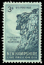
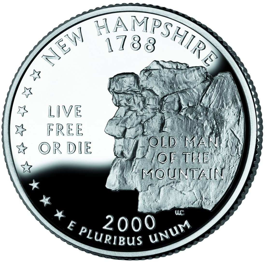