|
Reflections 2019
Series 12
August 9
New England Coast I: Acela - Boston Long Wharf – Boston Harbor
| | Rationale This was not a trip I'd been planning, but it worked out very well. As a matter of fact, quite unusually, I had no plans for 2019 after the Ohio River and two Canada cruises in 2018. But in August, just before I left for Canada, I got a mail from American Cruise Lines (AMC) regarding the Ohio trip. I did have my issues with that trip, even tho I'd resolved them all to my satisfaction, but to my surprise, this letter didn't touch on that. Instead, it considered it a problem that the boat had never reached Pittsburgh due to the high water in the river, but that never bothered me, since anything I'd missed I didn't need to see or saw somehow else. As a matter of fact, it made the trip a little more of an adventure. But ACL said in the letter that it was concerned, and wanted to offer a 25% discount on any of their trips booked before the year was out. | | | | The problem is, to put it very bluntly, that I've seen most of the best places they have to offer and was little interested in repeats. Let me explain, which you can follow on my updated list of Voyages on 2013/7:
Voyage 15 in 1984 was with the former owners of ACL on their New England South Shore Cruise (CT, MA, RI). What ACL does today extending that—this cruise--is explained below.
Voyage 17 in 1988 was with the former owners of ACL on the US East Coast from Jacksonville FL to Charleston SC. The present ACL continues doing this trip.
Voyage 18 in 1988 was on the Columbia River in OR, WA, ID with a now defunct company whose route has been taken over by ACL, who unfortunately has reduced a round trip on the river to a one-way.
Voyages 52 & 53 were on the Lower Mississippi in 2014 and the Upper Mississippi in 2015 respectively, with the superior American Queen Steamboat Company. ACL also does these two routes.
Voyage 54 in 2016 was with ACL on the US East Coast from Charleston SC to Baltimore MD.
Voyage 57 in 2018 was with ACL on the Ohio River.
Voyage 60 in 2019, the present trip (please note that total, which I'm pleased to have reached), will be entered as being with ACL on their Grand New England cruise.
Tho I've sailed with ACL five times, they only count it as three, since the first two were with the previous owners. That's irksome, but no big deal.
They also have some cruises I'm not interested in, including on the Cumberland River in Tennessee, which is too close and too similar to the Ohio. I'm also too familiar with what they do in Florida, Alaska, and on the Hudson.
| | | | In their online listings, the only thing I considered—I wasn’t going to throw away at 25% discount--is their 11-day Grand New England cruise, and I'm glad I chose it. This was my thinking. The 1984 cruise was very enjoyable, but limited to the area south of Cape Cod. | | | | | | It started in East Haddam CT, across the river from the Goodspeed Opera House, and was the only time I ever sailed down the Connecticut River. It stopped at Block Island RI, Nantucket, Martha's Vineyard, Newport RI, New Bedford MA, and back up the Connecticut River to East Haddam. Block Island was new to me, otherwise, I've been to all the other stops either since or earlier. |
| | | | While the Grand New England cruise repeated the area south of the Cape, it also went north of the Cape and visited coastal Maine, which intrigued me. While we had done car trips the entire length of Maine from New Hampshire to New Brunswick and had visited many coastal villages and larger sights, this would be visiting them from the sea, which would be a great plus. I also recalled the train trip on the Downeaster in 2006/12, continuing out of Boston to Maine ending in Portland, then in a rental car on to Damariscotta and Pemaquid Point, which I'd said I'd wanted to come back to earlier, and did. These places and others would be great to see from the sea.
| | | | So despite Voyage 15 to southern New England and despite having driven along the coast—the Maine coast is so jagged that you rarely see the sea—I chose the Grand New England cruise for my discounted trip. | | | | It was on the American Queen trips on the Mississippi that I first encountered an unusual, but pleasant practice. The cruise rate included a hotel night the night before, in Memphis going south and in Saint Louis going north. This assured that all passengers would be already gathered together at departure time the next morning. ACL duplicated this in Saint Louis on the Ohio trip, but doesn't do it normally, not in Charleston nor now in Boston. This I always see as a challenge. I just explained on the Canadian trip how I easily worked out my arrival and departure to my full satisfaction. I'd done something similar in Charleston, where I worked it out to return my rental car to Enterprise on the cruise morning, then took advantage of their drop-off service to bring me to the ship. At the Baltimore end, I just walked a couple of blocks to the hotel I'd be staying a few extra days at. | | | | Though I usually do my own bookings online, I do have an agent book most cruises (not the Kawartha Voyageur—they're so local that they don't work thru agents), since I get a rebate from him before sailing. The first thing he reported to me was ACL's Boston hotel deal they touted to him, that took into consideration that the ship departed from the out-of-the-way Charlestown neighborhood to the north of the harbor, not from central Boston. They had a "deal" for a night at a hotel with an unconscionably high rate—why would anyone already paying for a cruise want such an expensive stop-off the night before? Included would be a tour of Boston the next morning—I could probably lead my own tour—and delivery to the ship in Charlestown. This was obviously another challenge to "beat the system". | | | | Over the years I'd stayed in many parts of Boston, downtown, near the Fine Arts Museum, in Cambridge near Harvard—and also on Long Wharf. As a matter of fact, on my 2006 trip (2006/11) I stayed at the Marriott Long Wharf, which is located directly on that wharf. And now that Marriott has taken over Sheraton Starwood, I now get Marriott points, so I could stay free of charge that one night. That's a good start.
http://photos1.meetupstatic.com/photos/event/e/4/9/a/600_312658522.jpeg
| | | | I'd never taken a ferry in Boston, but found out online that there's a ferry from Long Wharf to Charlestown (see above) that takes ten minutes. Another step forward! In addition, I wanted to go to Provincetown at the tip of Cape Cod after the trip as vacation time after the "serious travel" of this trip, and found a great place to stay there for a few days. And one of the two Provincetown ferries in Boston leaves from Long Wharf! How ideal. (The other ferry I took on an earlier trip, out of South Boston). Thus it seemed ideal to use Long Wharf as my hub. It would play out as follows: | | | | | | THE HUB: I'd take the train to Boston's South Station, and walk 14 minutes up Atlantic Avenue to Long Wharf. I'd stay at the Marriott and dine at Legal Sea Foods, also located on Long Wharf. The next morning I'd take the ferry to Charlestown and walk two piers east to where the ship would be leaving. After the cruise, I'd take the harbor ferry back to Long Wharf, then take the Provincetown Ferry. Returning from Provincetown to Long Wharf, I'd walk to South Station and take the train home. Since I again had a fistful of Amtrak points, the round-trip train ride would be free, as would the hotel. And so my trip from New York to the ship in Charlestown would cost me just $3.50 for the one-way ferry ride. This is what I call beating the system! I booked the two hotels and the Provincetown ferry online. The round-trip harbor ferry tickets had to be bought at the last minute at Long Wharf. And I was all set. Imagine Frank Sinatra singing "[I did it] My Way". |
| | | | One very happy note involved the choice of train. There are regular trains to Boston, called Northeast Regional, both coach and business classes, and the Acela Express, both first and business classes. In the past, I've tried all four. The Acela is a wonderful train, but it's not the high-speed train you'd find in Asia or Europe. It's referred to as "higher speed" as opposed to "high speed". Its traditional winding, non-dedicated route cuts off only a half hour or so from the trip. But I had a fistful of Amtrak points burning a hole in my pocket and decided to once again go Acela First Class, since the point count was reasonable. Returning I took a North East Regional train, but business class. The reason I did not take First Class Acela returning was because (1) I'd be returning on a Friday, when weekend rates are used and when the number of points needed was ridiculously high compared to the outbound trip on a Thursday; (2) even if the points were the same, I just didn't have THAT many; (3) trying it out once a decade is enough; and (4) the Acela is at best only a half-hour faster. A little bit of first-class novelty is enough. | | | | | | Though not on a par with Asia or Europe, Acela Express trains are the fastest trainsets in the Americas, and can attain speeds of 240 km/h (150 mph). The fallacy of that statistic however is that that speed is not reached consistently, just in spurts, since it doesn't have a dedicated route, but has to share the tracks with other trains, so the average is less than half that speed. However, it uses tilting technology to lower lateral centrifugal forces, which allows it to travel at higher speeds than the curving route would allow, without disturbing passengers. Still, in fiscal year 2016, Acela carried more than 3.4 million passengers, second only to the Northeast Regional, which had 8 million. On board, you can access the free WiFi and get a GPS map that shows just where you are, and also shows the speed you're doing, which is how you can determine just what high—or low--speeds you're doing. |
| | | | There was only a minor kerfuffle. I filled out the passenger information form all cruises require and mailed it back to ACL months in advance. As requested, I included my train arrival times, emphasizing it was a train I'd be taking, and where I'd be staying the night before the cruise. As the time approached, my agent said ACL had contacted him to find out what my flight arrival times were. Flight times!! I told him the form I'd duly sent had all the information—which ACL later confirmed—and said he should call them back telling them so, because if I did, I wouldn't be responsible for my choice of vocabulary. All then went well. | | | | Day 1 – Th Ju 6 - Acela & Boston Since Acela trains are Amtrak's flagship service, there are indeed some nice features, like frequent departures. During the day they leave New York for Boston hourly, at three minutes past the hour. I like that. I decided that the noontime train leaving at 12:03 and taking four hours to the minute to arrive at 4:03 would fit nicely into my travel day. Rather than walking over to the subway, I simply took the M20 bus from my street corner to the west entrance of Penn Station, which is the side Amtrak is on anyway, and got to the Acela Lounge by 11:00 for complimentary coffee and pastries. The lounge is also for sleeping car passengers on any other trains.
https://c1cleantechnicacom-wpengine.netdna-ssl.com/files/2014/08/Acela-Express-Interior-Layout.png
| | | | The title here is self-explanatory. The direction of travel is to the left. There are power cars at either end, and most of the train is business class (Photo by Ben Schumin), with its own café car (click) in between (Photo by Daniel Case). The First Class car is the last one, with either single- or double-width seating.
https://www.amtrak.com/content/dam/projects/dotcom/english/public/images/content/acela-express-diagram-h.1a.jpg/_jcr_content/renditions/cq5dam.web.1200.675.jpeg
https://www.pointswithacrew.com/wp-content/uploads/2018/05/Acela-1stClass-Refresh_006.jpg
| | | | The first link shows just the First-Class car, but in this diagram, the direction of travel is to the right. When making an online booking, you're arbitrarily given a seat, single in my case, then told how to modify it if you wished. I modified it to seat 8F, since it (1) was also single, but (2) faced forward, and (3) had half of a full-sized table, rather than a fold-down one. The second link is the First-Class car, with overhead storage, power outlets, and the type of extendable table I had, good for a laptop and food service. | | | | Among the premium amenities, at-seat onboard beverage and meal service is included. Here an attendant serves beverages while one in the background might be preparing the meal (Photo by Len Edgerly). This is a meal display (Photo by Ryan Crierie) taken on National Train Day 2011 at an open four-seater table. Click to read the special name cards of the display items.
https://www.amtrak.com/content/dam/projects/dotcom/english/public/documents/menus/routes/Acela-Express-First-Class-Menus-0519.pdf
| | | | This link leads to the three menus for the First Class Acela, which rotate every two weeks. Mine was the green menu, and I chose the Braised Chipotle Short Rib meal. With the "Welcome Snack" beforehand, I'd wanted a Mimosa (see beverage menu), but they were out, so I took a Bloody Mary. Afterward I had a Bailey's Irish Cream, and was quite satisfied with the entire experience. | | | | This is the route of the Acela Express (Map by Kmf164 & Aude), which I've ridden in its entirety in the past. Going to Boston, in Connecticut we stopped in Stamford and New Haven, tho not in New London as shown. Our Rhode Island stop in Providence was not far from where we'd be on the cruise when in Newport RI. And then there are always the triple stops in Boston, first suburban Route 128, then in town at the Back Bay station, and finally at Boston South Station (click), just as we see this Acela doing (Photo by Das48). When we step outside, we look back and see the iconic placement of Neoclassical South Station right at the rounded point of a street corner (Photo by ArnoldReinhold), with Summer Street on the left and Atlantic Avenue on the right. Our route is northbound Atlantic Avenue off to the left. That gray structure in the center behind the lamppost is an elevator down to the subway, Boston's "T", also reachable from within the station.
http://www.vanshnookenraggen.com/_index/wp-content/uploads/2017/08/boston2-1.png
| | | | Boston I'd much earlier decided the 14-minute walk was preferable to taking the T, even as pro-subway as I am, but I think it's fun to show why. The above map shows the approaches to South Station in purple at the bottom. Commuter lines arrive from two directions, but we've arrived from the west via Back Bay Station. Last time we took a ferry to Provincetown, we took the one that left from South Boston, involving a right turn out of the station and over a bridge on the Fort Point Channel, site of the Boston Tea Party. However this time, our goal is Long Wharf, which is not named on this map, but is the wharf just to the north of the one that contains the Aquarium. The green line is the modern Greenway area above the submerged interstate infamously called the Big Dig, but use it as a guide, since Atlantic Avenue hugs the east side of it. It's not a bad walk, even with a wheeled bag.
| | | | But look at what would be involved to take the T. You'd take the Red Line from South Station one stop to Downtown Crossing, then the Orange Line one stop to State Street, then the Blue Line one stop to the Aquarium stop. It's fun to plot, but would be more work than walking, especially with a wheeled bag. Now discard that map, and let's use this map of central Boston:
http://illdave.com/images/illustration/amBostonmap.gif
| | | | Here we see more clearly South Station at its street corner and South Boston across the Channel. The Interstate is shown still exposed, before being buried as the Big Dig, but you can trace the arc of our walking route up Atlantic Avenue directly adjacent. After we pass the dock with the (unnamed) Aquarium, we see Long Wharf with the Marriott. If the wharf doesn't seem that long, we'll see why in a moment. It's important to understand something that's not totally clear here. Long Wharf is an extension of State Street, and both the Marriott and Legal Sea Foods on the wharf have a State Street address. Move your eye up State Street until you come to the Old State House, which, oddly, has a T station in its basement, and consider State Street and Long Wharf one single historic unit. | | | | Coastal Shipping One has to realize how appropriate it is to make Long Wharf our hub, since it's the historic entrance to Boston. Picture traditional coastal shipping, which today might only exist, other than on cruise ships, in the form of an odd ferry or two. Lift away the historic layer of air travel, that of rail travel, and that of road travel on paved roads, in place of bumpy stagecoach rides on dirt roads. If you wanted to go from New York to Charleston, you'd take a boat; or from Sydney to Brisbane (that's a fact), or anywhere in Europe. But coastal boat travel was greatly reduced and almost died out with the coming of the other modes of travel. | | | | Lower Manhattan Wharfs Though we've just arrived in Boston by train, it would fit the mood of using Long Wharf as a hub if we illustrated formerly being able to go by boat. Boats to Boston used leave from Lower Manhattan right where I live. I was pleased to find a few weeks ago that a new pavement marker has now appeared on my side street, West Thames Street, showing where historic Piers 5 and 4 used to be just to the south of the street. Let's first use this clever, excellent map to illustrate:
https://archpaper.com/wp-content/uploads/2016/10/Lower-Manhattan-Map-_Then.jpg
| | | | I've always described how landfill historically changed the original slender V-shape of the southern tip of Manhattan into a pudgy U-shape, and this shows that perfectly. It's a layering of several maps covering the centuries. At the tip, note how the original protective wall at the fort on Bowling Green was later replaced and supplemented by Battery Park. But concentrate on the western side of this area, on the Hudson. | | | | Trace the 19C landfills. The shoreline was originally at the back of Trinity Church, so the oldest map we see here already shows a landfill extension. But click to concentrate on the later extensions shown to Washington Street and to West Street, which originally had numerous piers along the river. While West Street is a major boulevard today, it no longer is on the shore in this area. Take a good look at the former piers. At the former Pier 12, Albany Street got its name because you could once catch the overnight boat up the Hudson to Albany from the pier its foot. | | | | Now picture all the piers gone and look at the shadow of Battery Park City replacing them in the late 20C, all the way up to about Pier 33. Move down to the former Pier 6. The modern street crossing it is my side street, West Thames Street, and about at the mid-point of the former Pier 6 is where the new historic marker on West Thames points out that Piers 5 and 4 were just to the south. Understanding that, you can see that the large, irregularly-shaped building on the water between 6 and 5 is my building, the Regatta, whose location is well beyond the former pier line. I now know the precise piers that used to be in this area. | | | | With that background information, the biggest revelation comes now, with this 1867 map of Lower Manhattan. For those who'd rather have it in another window for easier reference, here's the link to the same map:
https://upload.wikimedia.org/wikipedia/commons/6/6c/Dripps_Manhattan_Sheet_03_publ._1867.jpg
| | | | But there's even more than we'd expect. Let's start on the East River on the right. We'll disregard the international connections we'll find in favor of just the coastal shipping we're discussing. I find boats sailing for Savannah, Philadelphia, Baltimore; up further at Peck Slip are the steamboat connections to nearby Connecticut, to New Haven, and to Hartford (misspelled) on the Connecticut River. | | | | Now move to the west side. In addition to the international connections to Havana, London, Mexico, and Jamaica, there are boats to nearby Raritan and Delaware Bays. There's nothing specific for Piers 6 & 5 that used to be "near me", but Pier 7 will get you to Baltimore; just beyond that is New Orleans, Portland ME, Philadelphia, and—there it is, to Boston at Pier 11! It goes on with connections to New Bern NC, Savannah, New Orleans; later Norfolk & Richmond. Then there are more Boston connections, combined with RI connections, either Providence or Newport, with Fall River MA. Coastal shipping was thriving! | | | | | | At the top end of this map is something quite unique, especially regarding our recent discussions about transcontinental travel. Pier 29 had a boat that would get you to California via Nicaragua! We know there were boats that would bring you to Panama, have you take a stagecoach across the isthmus, then another ship to California. It's also known, that Nicaragua has always been considered the location for a potential second canal via the large lake in its center, Lake Nicaragua. But I was unaware of a former California boat service via Nicaragua—and leaving from my area, to boot. |
| | | | Long Wharf At the other end, ships arriving in Boston also had a selection of wharfs, but Long Wharf stood out (pun intended!), tho this map dates from 1743, about a century earlier. As a sign of the times, what was King Street leading onto the wharf became State Street after the Revolution.
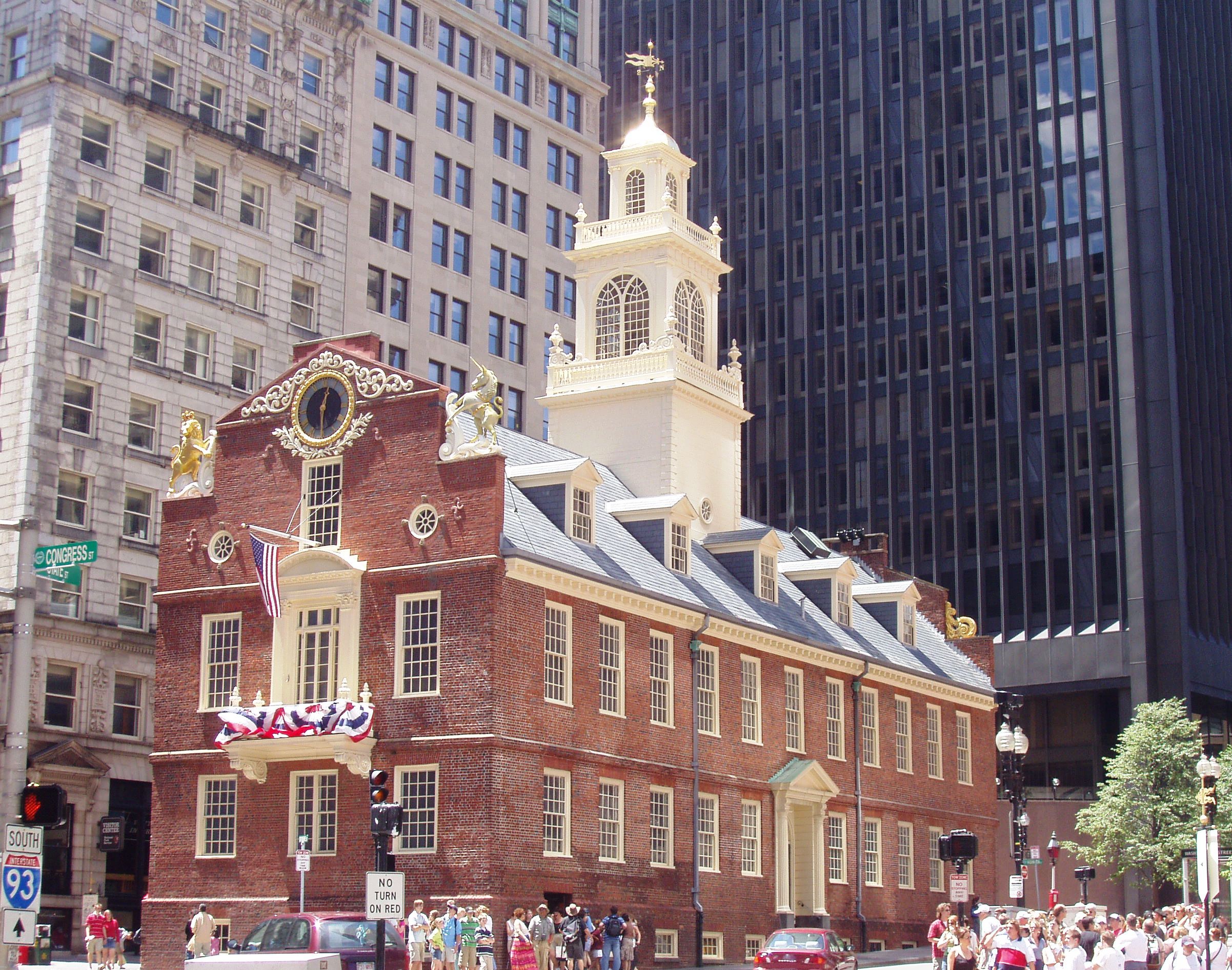
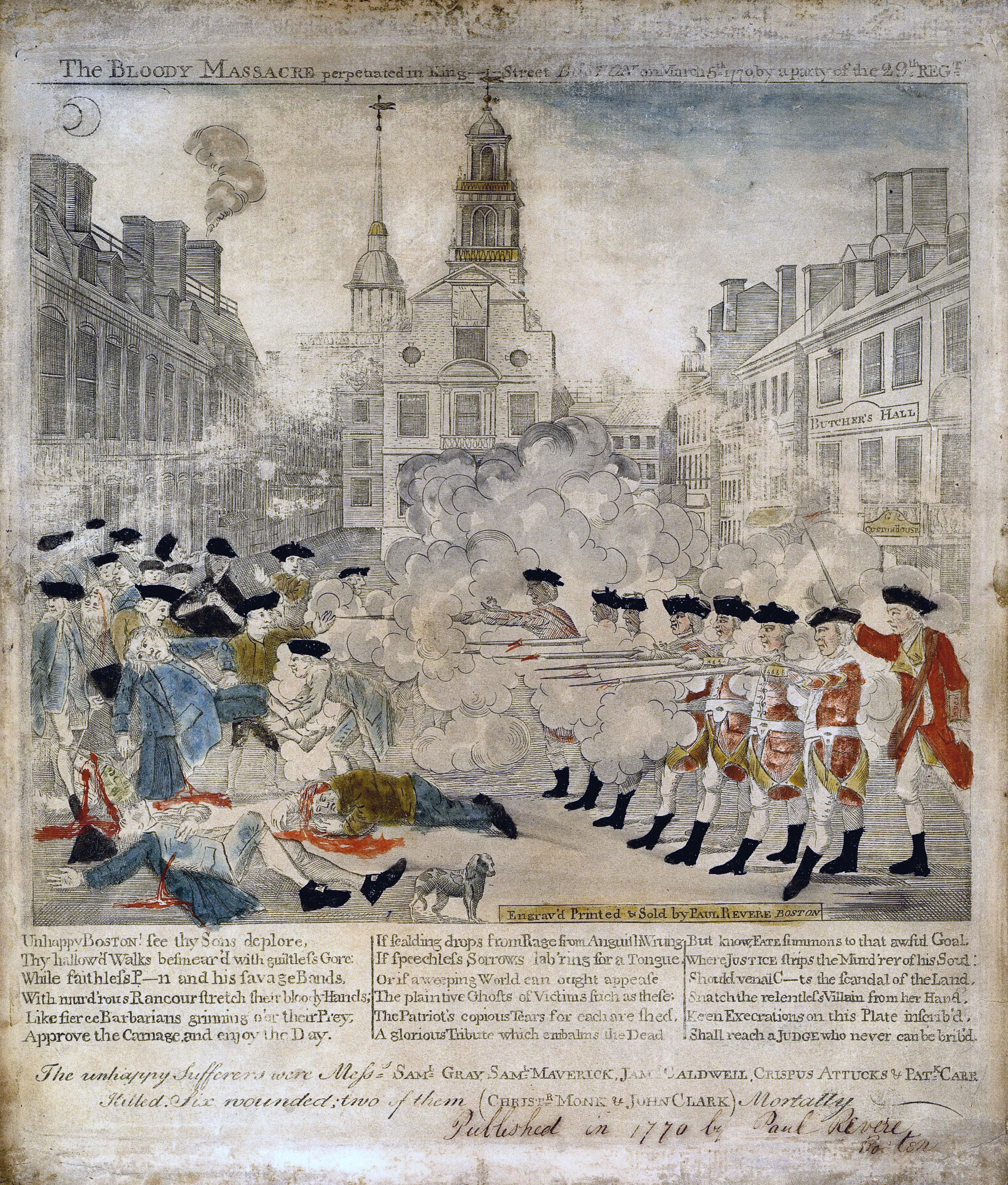
| | | | Keep in mind the lineup of the Old State House, State Street, and Long Wharf, and you'll see how this route was the principal maritime entrance to Boston, and certainly the grandiose, official one. This is the Old State House today, now a museum (no attribution). Built in 1713, it's one of the oldest public buildings in the United States and the oldest surviving public building in Boston. As indicated by the circle in the pavement, it was the site in 1770 of the Boston Massacre, known to the British as the Incident on King Street (Photo by Dion Hinchcliffe). It's illustrated here as "engrav'd, printed, & sold" by none other than Paul Revere (click).
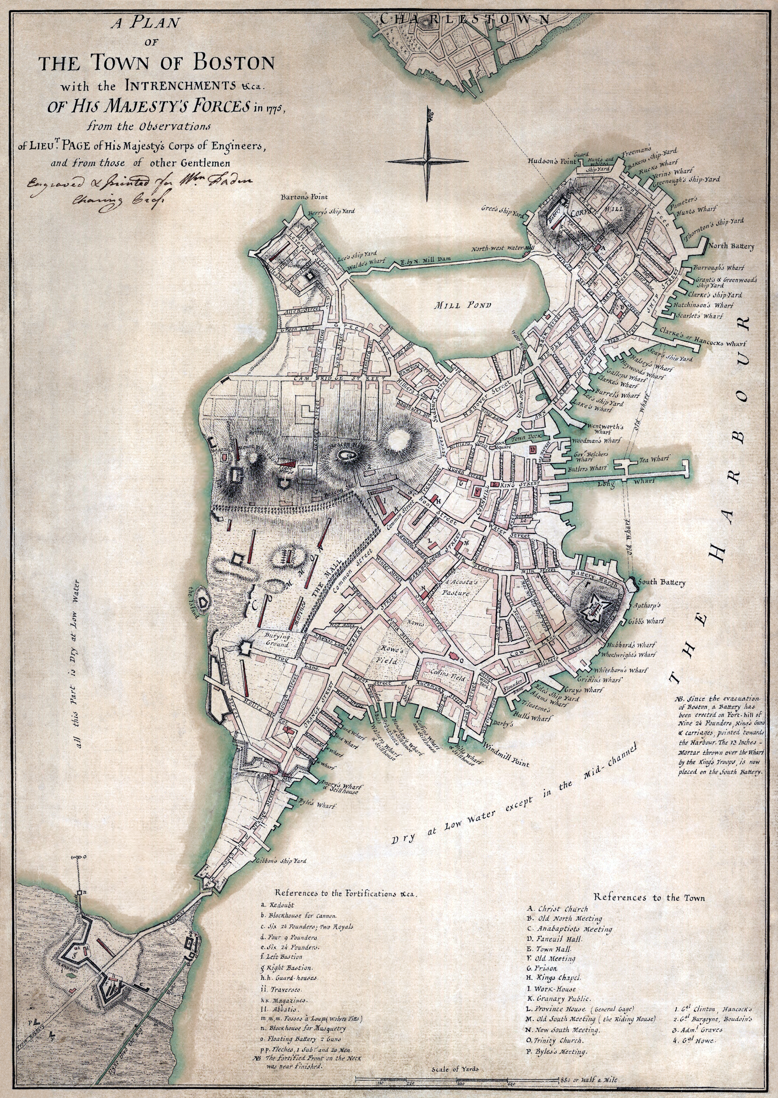
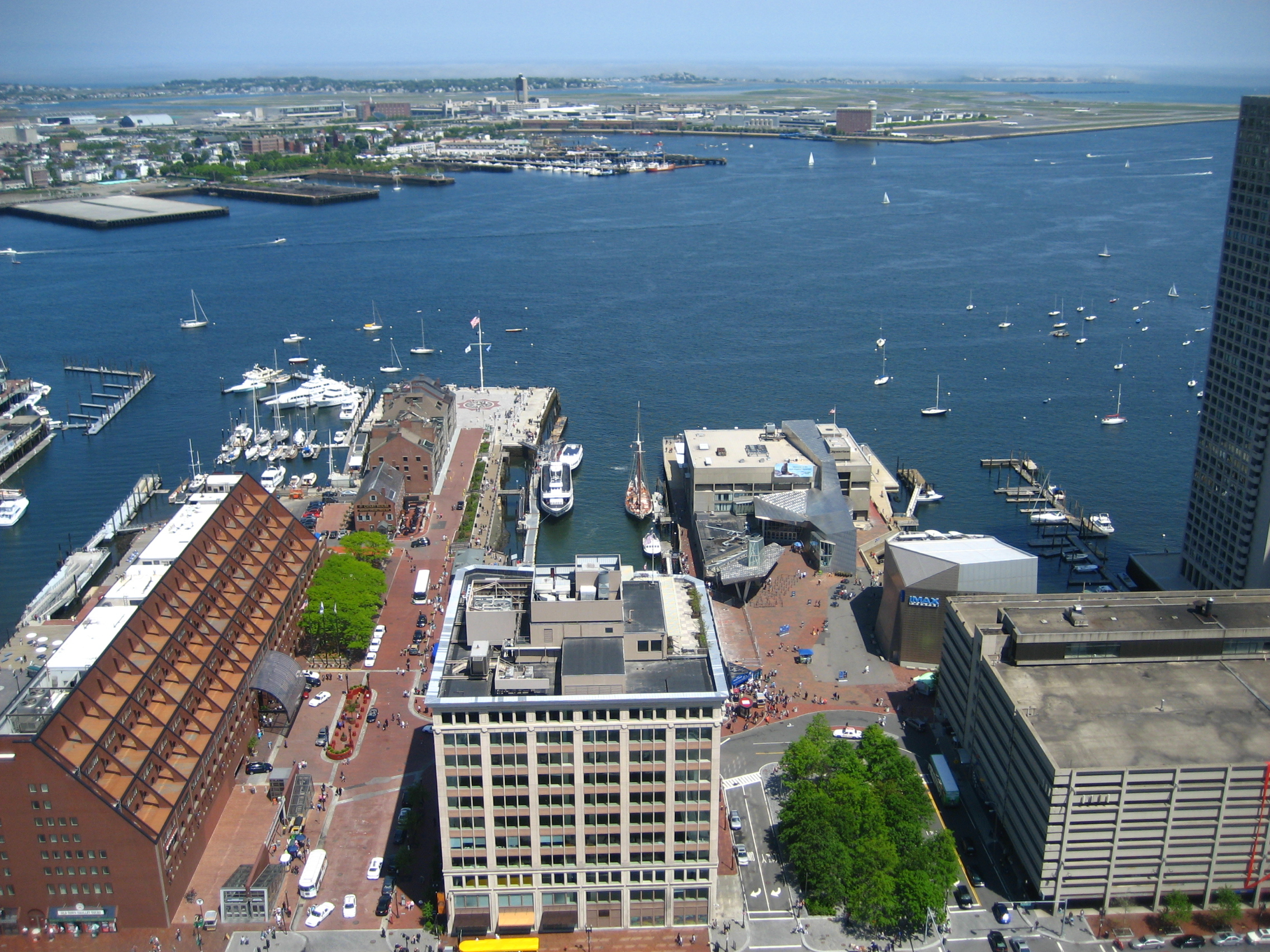
| | | | State Street is one of the oldest streets in the city and is where, in 1630, the first Puritan settlers built their houses. The marketplace was located where the Old State House stands today, and by 1636 the street was known as Market Street. Between 1708 and 1784 it was called King Street, as can be seen in this detail of a 1775 map. It was only during the Revolutionary War that it took on its current, non-royalist name. Note how far inland the harbor reached back in the day. We know about landfill in Manhattan, and Washington has quite a bit of fill around the National Mall and south of it. But without a doubt, the map of Boston changed most radically due to the extensive landfill it underwent. Long Wharf is shorter now, not because the end was cut off, but because its inland end was filled in so much. All the other wharfs seen here either disappeared, or were moved outward, with all the landfill changes. On our modern map, you'll see North Street. It's southern end is still called Dock Square, which makes no sense, since there's no water in sight. On the older map, you can see Dock Square when there really was a Town Dock leading up to it. | | | | Let's look at the complete 1775 map, and we find that the shape of the city is unrecognizable from what it is today. Boston consisted of the Shawmut Peninsula, connected by a tiny neck (click) to the mainland. At the top, Charlestown is here a separate municipality, while today it's part of Boston and just forms the north end of the harbor, from which we'll be sailing. Between them, the Charles River has a HUGE estuary, most of it now filled in. The Mill Pond west of downtown was long ago filled in to become the logically-named neighborhood of Back Bay, which today includes Back Bay Station, where we stopped. On the south side, you can see that the Fort Point Channel was huge, and today's South Boston more distant. It's more logical that the Boston Tea Party took place in this larger stretch of water, rather than in the narrow channel it is today. | | | | But to the point, we can see that Long Wharf really stood up to its name, and worked well as the splendid entryway to State (King) Street and the city center. Judging by eye the distance from what is today the Old State House at E (on this map serving as the Town Hall, as the key says) and the end of Long Wharf, it would seem the land section is about a third of the whole length, with two-thirds on the Wharf. I'd say today, with the land having been filled outward, I'd say it's just the opposite, with Long Wharf just encompassing about a third of the traditional entire length. | | | | Long Wharf was built between 1710 and 1721. This is a colored reproduction of a 1768 engraving, once again by none other than Paul Revere. Long Wharf and King/State Street stand out, and are obviously the major entry into town. Only some of those historic buildings lining the Wharf still exist, on the outer end. But Revere's concern was the British ships arriving and landing their troops. All eight ships are numbered, with a key at the lower left. At the lower right, three wharfs are lettered, with A being Long Wharf. If you can read the text, Revere reports that the ships had their cannons loaded, as if for a siege. The next day, large groups of soldiers landed on Long Wharf and marched up King Street "Drums beating [?], Fifes playing, and Colours flying . . . Each soldier having received 16 rounds of Powder and a Ball." If that isn't history taking place on Long Wharf, I don't know what is. | | | | But with the landfill, by 1899, the layout was much different. Atlantic Avenue had been put thru, Long Wharf was markedly shorter, and other wharfs had been built, including Central Wharf, which is where the aquarium is today. Yet as we walk up Atlantic Avenue we see contemporary buildings and streets reflecting the names of Fosters Wharf, Rowes Wharf, and India Wharf, so the history lives on thru the names. The modern Boston map makes a particular point about Rowes Wharf. | | | | The plague of late 20C history is having historic areas fall into decline, but since about 1990, Long Wharf has been transformed from a failing commercial waterfront area into a recreational center, as have the other wharfs, as we've noticed. Long Wharf as we now know, no longer has British soldiers marching along it, but instead functions as a dock for passenger ferries and sightseeing boats. Specifically, Boston Harbor Cruises (BHC) operates these services under contract to the Massachusetts Bay Transportation Authority. | | | | Coming up Atlantic Avenue, we arrive at Long Wharf to our right, while State Street lies to our left (Photo by M2545). The Old State House (click) looks a little different under 21C circumstances. | | | | There's a tall building called the Custom House Tower on State Street from which this picture of Long Wharf was taken (Photo by Jeremy Keith). Central Wharf with the New England Aquarium is on the right, and Atlantic Avenue crosses in the foreground. The Marriott Long Wharf where we're staying is the large red building on the left and Legal Sea Foods where we're dining this evening is on the street level of the white building in the center, but facing the water and away from us here. Obviously, Long Wharf is no longer all that long, but at the far end are some of the remaining historic buildings. | | | | Taken from another nearby building, this angular view (Photo by Matt Laskowski) also shows the BHC ferry to Charlestown waiting near the ramps on the left, opposite Legal Sea Foods, in shadow. Looking back inward from the harbor, we see the BHC Provincetown Fast Ferry, the Salacia, arriving next to two BHC charter boats (Photo by Chris Wood). In the distance is that Custom House Tower, with the pointed roof and clock. The Salacia is a fast ferry because it's a catamaran. You can see that most of its center is above the water level to reduce friction, while it rides on the two dark-blue "water skis" on either side. One last view shows how it looks when the Charlestown ferry arrives at Long Wharf (Photo by Eric Salard) moving to dock near its ramps at Legal Sea Foods (click). Being here gives such a positive feeling because of the history and because Long Wharf will work so well as a hub for this trip. | | | | We walk to the end of the wharf just to get reacquainted with it, then check in to the hotel. After settling in and a rest, we go out for dinner, but stop first to get the only tickets we're still lacking, the two ferry tickets to Charlestown and back. Then it's off to Legal Sea Foods. | | | | I'm not big on chain restaurants, but Legal Sea Foods is in a class by itself. It has 35 restaurants in the Northeast, but with a concentration in the Boston area, where it was founded, as follows: MA 26, RI 1, NJ 2, PA 2, VA 2, DC 2. Legal Sea Foods' clam chowder has been served at every presidential inauguration since 1981. | | | | The chain developed out of a 1904 grocery store in nearby Cambridge that gave trading stamps for groceries called Legal Stamps, so the store was called the Legal Cash Market. When it opened a next-door fish market, to distinguish the name from that of the grocery store, they called it Legal Sea Foods. When the fish market added a restaurant the name continued to be used. They use the punning motto "If it isn't fresh, it isn't Legal".
http://voyagesvege.com/wp-content/uploads/2013/08/Restaurant-Legal-Sea-Foods-Long-Wharf-Boston-sans-gluten.jpg
https://resizer.otstatic.com/v2/photos/large/25142569.jpg
| | | | The Long Wharf Legal Sea Foods has an attractive sidewalk terrace (first link), but that usually doesn't appeal to me. It was busy inside, but I found a seat at the bar, and the service was very good. I was tempted by the clam chowder, gazpacho, lobster bisque, and more, but I'd checked long in advance to decide on what I wanted, cioppino again, the first time since that final night in Kingston. It was described on the menu as "lobster, scallops, shrimp, calamari, littlenecks, mussels and whitefish in a light tomato broth." I knew I didn't want the calamari, and they were very flexible, so that wasn't too uncommon. She asked if I wanted extra shrimp instead, and then it was all set. This time I was handed a plastic lobster bib, and I was ready to go.
http://media-cdn.tripadvisor.com/media/photo-s/06/ec/7c/fd/legal-sea-foods-long.jpg
| | | | It was a big meal. It looked like the above, except for the piece of calamari on the right. I immediately put the bread aside—no sense filling up on that, and dug in. But as time passed, I realized I wouldn't make it. That's why when I travel on my own, I never stop for lunch. Just a big breakfast, then a good dinner. But today I'd had that big lunch on the train, and I was now limited. I'm pleased to say I finished all that marvelous broth, all the scallops, shellfish and lobster, and much of the shrimp. If I dislike something, I'll leave it on the plate, but I hate leaving things I do like, and taking it with me this time would be impractical. I decided to sacrifice the whitefish but was also left with three delicious shrimp that I regretted leaving behind. More's the pity. But the rest was great. | | | | | | I can now say in advance that, by pure chance, this wouldn't be the last cioppino of the trip. Later, on my final night in Provincetown I happened to go to the Lobster Pot and they also served a cioppino, meaning cioppino served as dinner "bookends" on this trip, as first and last dinners. And with Kingston, that would make three cioppinos within nine months. It's a good meal. |
| | | | Day 2 – F Ju 7 - Boston/Charlestown This morning I was eager, not so much to start the cruise, but to continue executing my well-thought-out plan to use Long Wharf as a hub. Instead of having to buy the usual buffet breakfast at the Marriott, I was very pleased to see that they had a mini-Starbucks in the lobby, just a counter and little more. I got an egg sandwich and coffee, enjoyed them in my room, then walked just steps away to the ferry landing, my ticket ready to go. Since the ship would be sailing at 1:30, I had great flexibility of time. At this time of day, the ferries go every 15 minutes, so I took the 10:30 to 10:40 one, which looked like this as it came in from Charlestown to pick the next group up (Photo by Chris Wood). On my run, there weren't any more than a half-dozen people, and I went up to the sun deck to enjoy the ten-minute ride.
| | | | This is a panoramic view of the Boston skyline from the upper part of the harbor (Photo by King of Hearts). Click left of center to find the Customs House Tower, and again at the water's edge at the extreme left to see the aquarium with the historic brick buildings on Long Wharf to its right.
https://www.boston-discovery-guide.com/image-files/800-water-taxi-boston-harbor-cruise-map.jpg
| | | | This map of Boston harbor is very instructive. First note how pared down in size the water area is compared to the historical map we saw. Disregard all the green numbers, as they're water taxi stops, but at the bottom note that #7 in South Boston (click) is where the other Provincetown ferry, Bay State Cruises, that I used the last time, leaves from. | | | | But again to the point: #18 is Long Wharf. Follow the dotted line saying "Charlestown-Long Wharf Ferry"—also marked "T", since it's part of the MBTA, as is the subway system--to its landing at #45, which is Pier 4 in Shipyard Park. Our goal is just steps away, #47, Pier 8, in the Charlestown Marina. Do not fail to see an extra perk of arriving this way, that nearby Pier 1 is the home of the USS Constitution, or "Old Ironsides". | | | | To see where we're heading, we have this excellent panorama of North Boston taken from the Custom House Tower (Photo by Rene Schwietzke). If you want the very same picture in another location to analyze more leisurely, here's the direct link:
https://upload.wikimedia.org/wikipedia/commons/5/53/2011_BostonMA_6273512600.jpg
| | | | First some other things. Click on the building in the extreme left foreground to find the ugliest building on the face of the earth, the Boston City Hall, in Brutalist style, a style that says it all. It was built in 1968 on Dock Square, mentioned earlier, and I remember visiting Boston shortly afterwards and just gasping. The building has suffered near-universal public condemnation, and even while under construction, calls came in for its demolition. Move a bit to the right to a white building labeled TD Garden. I only mention this arena because it was built on Boston's North Station, with services to northern suburbs, New Hampshire and Maine. Calls for connecting the two stations have been steady for years. Interstate traffic coming across the adjacent bridge then goes underground to the infamous Big Dig, with that parkland right above it that we discussed. | | | | Although we're near Long Wharf to the right, we can't see it, since this view is toward North Boston. Just right of center, click to inspect the white tower of Old North Church, of Paul Revere fame. Behind it, the Charles River enters the harbor. To the left of the steeple you can see the three slender white masts of the USS Constitution, "Old Ironsides", docked in Pier 1. Scan a bit to the right until you see a massive red building with a green roof. Below its left façade is the spot in Charlestown where the Boston Harbor Ferry from Long Wharf docks, on Pier 4. It's then a simple matter of walking in front of that building and on that path behind the white building on Pier 6 to reach Pier 8, where our ship, the American Constitution (usually just called the Constitution) is docked. Most of Pier 8 is hidden here, but our ship would be at its very end, visible here, beyond that little white boat. | | | | Google Maps told me that the walk along the piers from 4 to 8 should take 8 minutes. Once I got off the ferry, I found that a pathway and boardwalk had been established called the Boston Harborwalk (Photo by NewtonCourt) that made it a particularly pleasant stroll. Then, halfway there, another plus. There apparently is a parking garage midway along the piers, but ACL hadn't announced—at least not to me—that there was a complimentary golf-cart shuttle between the garage (not the ferry) and the ship. When the golf cart passed me, he asked if I wanted a ride, and so my walk was half of what I'd expected. After the cruise I was able to get a ride halfway back to the ferry again. I checked in on the dock, boarded the ship, and started to unpack.
https://img.marinas.com/v2/f72a6ba2df655c3c7de20f625b15d794594b410b984b8a0560bef4d8b4376097.jpg
| | | | This is beautiful aerial view of the Charlestown Marina, looking south, back to downtown Boston and the lower harbor. North Boston with the white steeple of Old North Church (click) blocks out the view of Long Wharf, tho the Custom House Tower can be made out. Beyond that red building with the green roof you can see Pier 4 where we got off the ferry. Pier 5 is disused, then comes Pier 6, and the white building development is on Pier 7. Pier 8, our goal, is totally surrounded by the marina. The golf cart carried us out to that last cross-dock where here, five larger boats are docked, but where we arrived at the (American) Constitution. | | | | Boat-to-Boat At lunch it was fun to talk to people about arriving at the ship. Most had the usual ho-hum arrival, by car, or by plane. I'm going to guess that no one arrived by train, because so many Americans just don't think about that as a possibility, so my train arrival alone was probably unique in that respect. But my actual arrival by water for a trip also on the water was unique enough to have aroused interest when I discussed it. | | | | Still, it wasn't the first time I'd changed ships, and the earlier time, in 2006, was even cooler, because it was between two overnight, sleep-in-a-cabin sailings. After a while in Norway, I had been in Oslo, and was to take the Deutschland in Germany in the late afternoon to backtrack north to Spitsbergen (2006/6). I took the Color Fantasy (Voyage 34), a huge cruise-ship type ferry, overnight from Oslo to Kiel, to board the Deutschland (Voyage 35): | | | | | | In the morning we pulled . . . into Kiel, and docked at Norwegenkai/Norway Quay . . . . I knew I had planned all this quite carefully, but just how well it worked out surprised me. . . As the Color Fantasy pulled into Norwegenkai, there sat the Deutschland in the next berth at the very same terminal. It was perfect. I dropped off my bag to be loaded onto the Deutschland later on, and had the beautiful day to myself. I joked with people that day that, although people usually transfer between subway lines, trains, [planes,] streetcars, or buses, in this case I was doing a change between ships. |
| | | | (American) Constitution The ship is new, launched in the spring of 2018, making it just a year old at the time of sailing in June. It carries 175 passengers, but on this trip there were 154--I like to check such things--making it running at 88% capacity this trip. I was absolutely ecstatic as to how I chose my cabin, a single one. Look at these two deck plans, checking out cabin 202 on each:
https://usarivercruises.com/wp-content/uploads/2017/07/american-constitution-deck-plan.jpg
https://americancruiselines.azureedge.net/images/default-source/deck-plans/american_constitution_deck_plan_jpg_web.jpg?sfvrsn=fdbe783_0&size=900
| | | | You can see that most cabins have outdoor balconies. Been there, done that. Maybe they're worth the extra expense on a transatlantic trip where you can sit and look out on a vast, melancholy ocean, but I doubt even that, because I rarely would use mine except for just before going to bed for a couple of minutes in order to tell myself I'd "used" the balcony I was paying for. On the Ohio trip, it was the same thing—there was nothing I couldn't see on the shore that I couldn't see out a window or by stepping to a nearby lounge. So let's clear away the issue of an expensive balcony, including the single ones about the ship, in purple. | | | | Of the less expensive, non-balcony cabins, 201-204, above the Main Deck, were the furthest forward on the ship—something I already liked--and were less expensive for also being narrower, due to the curving line of the ship. While on the older deck plan (the first link) only 203 was a single, on the newer plan (the second link), both 202 and 203 were single. Aha. My calculations were that 202 had started out as a double, was too small, and was reconceived as a single. And I was right. It did have a single bed, and the cabin was unusually roomy.
https://cdn.cruisecritic.com/aW1hZ2VzL3VzZXItaW1hZ2VzLzViYzhmMzYzOWJmNjI2OTYyOTI1NzkuanBn/eyJ3aWR0aCI6OTg4fQ/american-constitution-american-cruise-lines-128455.jpg
| | | | The closest picture I could get to what 202 looked like was this, but you have to picture some changes. Behind the camera is the desk I'd work at, and behind that, the bathroom. But (1) change this double bed into a single. While that picture window was quite adequate for my needs, on the wall to the left, next to a (2) wall TV in the corner (important for a later story) were (3) two large, round portholes, which not only gave me a forward view—rare to find on a ship—but also allowed me to watch the deckhands at work, such as for running the winches that raise or lower our anchors. I never use a ship TV except for when one channel shows a map of the ship's location, as was the case here, which is interesting to follow, just like the map on the train.
http://quirkycruise.com/wp-content/uploads/2018/01/American-Constitution-will-sail-the-U.S.-East-Coast-Photo-American-Cruise-Lines-e1515318120606.jpg
| | | | The rest of the (modern) deck plan is quite simple (click). The Main Deck had the dining room aft, which abutted the square back of the ship. It was here that we exited to board the tender into town. Above me, the Third Deck had the main "Chesapeake" lounge forward; conveniently, there was a staircase immediately outside my cabin door that brought me right up into the middle of it. The Fourth Deck had the Pilot House and the secondary "Sky" lounge aft, with a seating area outside. Here several fast-food items were available in case one wanted to skip a meal in the dining room. Also, both lounges were used for the complimentary 5:30 happy hour before dinner—I always used the Sky Lounge. There were two sundecks up top, which I only visited the first day touring the ship. The terrace outside the Sky Lounge was otherwise perfectly adequate. Most decks also had a lounge midships, which virtually no one used and which were a waste of space.
http://ww1.prweb.com/prfiles/2018/04/16/15415172/American_Constitution_1MB.jpg
| | | | This profile of the Constitution shows the dining room windows below aft near the square back of the ship; a lot of balconies; those lounge windows midships; my picture window on Second Deck WAY forward; the Chesapeake Lounge windows above that; on Deck Four aft the Sky Lounge windows and terrace; the two Sun Decks above.
https://images.cruisecritic.com/image/8102/american-constitution_x400_41.jpg
| | | | But I particularly enjoy this angular picture, since it shows my two portholes right above the word "American", along with my picture window adjacent. In addition of the portholes giving me my forward view when underway, I could observe the work area up front above that one anchor below.
http://cem.sbi.org/web/images/cem-map.jpg
| | | | Old Ironsides While I was unpacking and settling in, something pleasant occurred that let me know that this captain was aware that there were other things to see on the way other than the scheduled stops. Just before lunch and before we left at 1:30, he got on the pipe and wisely made an announcement about Old Ironsides and what it was doing.
| | | | The above map shows again in green the Boston National Historical Park at Pier 1 where the USS Constitution, "Old Ironsides", is docked (click) with the Bunker Hill Monument in the distance (Photo by Elmschrat Coaching38). In the past I'd seen the ship from afar, notably from the top of the Monument (see 2011/21 for pictures), but had never visited the interior, having been on other, similar wooden ships. | | | | In sum, Old Ironsides is a wood-hulled, three-masted frigate of the US Navy named by President Washington after the US Constitution. Launched in 1797, she's the world's oldest commissioned naval vessel still afloat. To my knowledge, she stayed in her berth and was no longer an active ship—at best, being towed out periodically into Boston Harbor on special occasions. But on this day I learned I was wrong. A few years ago, she was made seaworthy again, and today sails out into Boston Harbor periodically on her own (click). | | | | So what was the Captain's announcement? Even as we were still docked, he suggested you move to a well-located angle to see Old Ironsides returning to her berth with a fireboat salute preceding her. I ran up the staircase next to my room to the Chesapeake lounge for a perfect view at a two-o'clock angle. I've found two very good YouTube videos showing this. The first one (2:25) dates from 2013. It showcases the fireboat first, then at 1:40, shows Old Ironsides firing her cannons. The second one (1:04) is similar, but has the advantage of being the very sailing we saw. I later found out the sailing was celebrating the 75th anniversary of D-Day (6 June 1944), in 2019. However, I cannot account for the fact that we witnessed this on 7 June, not 6 June. Was the celebration delayed? Was it a two-day celebration? I don't know. One additional point adding to the fun of this event was that we had the same name: we were on the (American) Constitution watching the USS Constitution. | | | | After lunch, we sailed out of Charlestown at 1:30. I wonder if we'd have been delayed if the harbor exercise had taken place an hour later. But as we sailed down once again past downtown and Long Wharf, it occurred to me that this was not my first time sailing in Boston Harbor. Nor was the Provincetown trip in 2009 when I took the other ferry from South Boston. The first time Beverly and I found ourselves on a ship in Boston Harbor was in 1971, on Voyage 8. See the voyage summary in 2013/7 for additional details, but we were completing the first half of our mutual sabbatical and returning from Europe for the winter. We took the Yugoslavian freighter Tuhobić out of Genoa, our only freighter trip ever. Coming from Yugoslavia around all of Italy, it was delayed three days by strikes in Italy. It was an interesting 11-day crossing in rough November weather. We then found out that we wouldn't be going to New York after all, since there was also a longshoreman's strike there! Instead, we pulled into Boston harbor and they bused the two dozen or so passengers to NYC. In Boston we did dock downtown, but I don't know at which wharf—certainly not Long Wharf. | | | | Of the 19 transatlantic crossings I've done, this one was unique at each end. All the others connected on the Europe side with either England, France, or Germany, and this one was the only time the connection was with Italy, or even with the Mediterranean. And on the US side, the Boston connection was the only time I didn't connect with NYC.
https://americancruiselines.azureedge.net/images/default-source/maps/new_england/grand_new_england-2016_700x700.jpg?sfvrsn=4
| | | | As we pull out into Massachusetts Bay, let's look at the plans (above), remembering they're not written in stone. Even the map isn't completely accurate. We swing around Cape Ann and Gloucester (Map by NormanEinstein). We do not stop here as it shows, but are scheduled to stop here on the way back from Maine. (Spoiler alert: we didn't.)
| | | | Actually, it's easiest to divide this trip, not by the Cape, but by Boston, first north of Boston, then south of Boston, which then includes the Cape. Most of the part north of Boston is in Maine, which I'm very pleased about, but again, not in the order shown. We go to Portland at the near end, then right to Bar Harbor at the far end, then fill in the middle with Rockland, adjacent Camden (didn't happen), and Boothbay Harbor. Heading for "south of the Cape" and skipping Gloucester, we cross the Cape Cod Canal, a highlight I'd been looking forward to. We'll add New Bedford (not shown) in place of Gloucester, then flip Newport and Martha's Vineyard, reversing the scheduled order. A stop in Provincetown will be extended by me after the cruise to a mini-vacation as an add-on. But now we're off to Maine. | | | | New England History in a Nutshell Of all the regional groupings of states in the US, the six states of New England are the most recognizable as a grouping and least subject to alternate interpretations. How did that uniformity come about? They were almost uniformly settled as a group and have maintained that character. | | | | Boston functions today as the de facto capital of New England, which makes sense, since Massachusetts is where New England started. The first British colonists established Plymouth Colony in 1620 around Cape Cod Bay, with a capital in Plymouth (Map by Hoodinski), and Massachusetts Bay Colony in 1630, with a capital in Boston, around Massachusetts Bay, as its name says (Map by Kmusser). Then, as the latter map shows, a royal charter was issued in 1691 unifying, under the new name Province of Massachusetts Bay, both Plymouth Colony and the Colony of Massachusetts Bay—but also Martha's Vineyard and Nantucket, laying the foundation for modern Massachusetts. Yet actually there was more. Also included in that charter was an eastward expansion (see again the latter map), covering territories that roughly encompassed present-day Maine (officially--it had effectively already been integrated with the colony by 1652) and Nova Scotia (which then still included New Brunswick). Just five years later, in 1696, NS (+NB) was split off, but the area that became Maine remained. This was the first time Massachusetts was extended into totally new territory. But the fly in the ointment proved to be that little green area between them marked NH. | | | | Europeans first settled what became the Province of New Hampshire in the 1620s in a small number of communities along the very short seacoast. In 1641 the communities were organized under the government of the neighboring Massachusetts Bay Colony. But in 1691, just as MA got its new charter (above), NH was issued a separate royal charter forming the Province of New Hampshire (Map by Kmusser), and so NH became a spoiler forming a physical barrier between MA and ME, meant to be its extension, which was thus cast in stone. [On this map, also note that both NH and NY lay claim to what was to become Vermont.] We'll talk a little more about Maine history shortly, when the ship gets closer. | | | | So much for northern New England. In southern New England, the Connecticut Colony (Map by Kmusser) was, in 1633, originally a number of separate, smaller settlements such as at Saybrook, Hartford, and New Haven. But the main body of settlers came in one large group in 1636 from Massachusetts Bay Colony, once again because of separatist religious beliefs, and it was these latter settlers who established the Connecticut Colony at Hartford. In 1662, a royal charter was obtained which united the settlements of Connecticut. | | | | We've so far mentioned colonies and provinces. To my surprise, Connecticut remained a colony and to my knowledge was never raised to Province status. That seemed to by typical for southern New England, since Rhode Island was in the same position, a colony, never a province. | | | | But Rhode Island has surprised me even more. I think most Americans learn about Roger Williams (1636) and others (1638) being banished from Massachusetts Bay because of religious beliefs and settling what became Rhode Island. It developed under the unwieldy name Colony of Rhode Island and Providence Plantations, the details of which I never understood until now, and we'll explain this later when we reach RI. What surprised me even more was the way in which RI developed from bits and pieces, which explain both its small size and its complicated, tangled eastern border with MA. I think I'm beginning to think the history of how RI was formed might be the most interesting of that of all six New England states.
https://i1.wp.com/thehistoryjunkie.com/wp-content/uploads/2011/08/NewEngland.jpg?resize=909,830
| | | | To make sure we've got all this clear, let's summarize it this way. The six New England states have an entwined history centering around MA:
Within the earliest part of the colonial era, the 1600s:
What is now MA began with the Plymouth Colony in 1620 followed by the MA Bay Colony in 1630.
In 1636 & 1638, what is now RI was founded on Native American land by settlers leaving MA Bay for religious reasons.
In 1662, the CT settlements, largely populated by settlers from MA Bay for religious reasons, became independent to become the Colony of CT.
In 1691, NH, which had become affiliated with MA Bay, broke away to become the Province of NH.
In 1691, MA was unified (MA Bay, Plymouth, more) as the Province of MA Bay, and ME was added.
Not until a century later, after US independence:
In 1791, Vermont (not shown on summary map), part of NY but also claimed by NH, broke away from NY to become the 14th state.
In 1820, Maine broke away from MA to become the 23rd state.
And so then there were six.
| | | | Maine We've seen how Maine was attached to the Province of Massachusetts Bay in the 17C, and with American independence, it continued as part of the Commonwealth of Massachusetts. I understand there were long-standing political disagreements between them, but I continue to think that a major factor in their eventual divorce was that Maine was physically separate from the rest of Massachusetts. | | | | | | I think the poster child for physical separation causing political divorce is Pakistan as it was original established, in two parts separated by India. Eventually they split, and East Pakistan became Bangla Desh, and West Pakistan became simply Pakistan. |
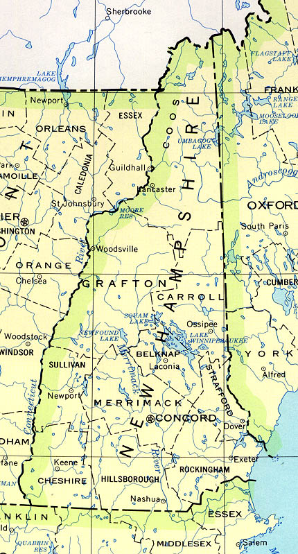
| | | | New Hampshire has the shortest coastline of any of the 50 states, only 29.89 km (18.57 mi) long. To get to Maine, I've driven that coastline and have taken the train, the Downeaster. Yet it's still sufficient to keep the other two states physically separated. Finally, Massachusetts agreed to permit Maine's secession, sanctioned by voters of the rapidly growing region, which took place in 1820. | | | | What we've been seeing on maps of Maine so far is a stable coastal area, and a relatively fixed border with NH, but its eastern and northern borders are shown as very iffy. This is how they got resolved. In 1838-1839 there was a military and civilian confrontation called the Aroostook War—more of an international incident than a war—involving the Maine border with New Brunswick, then still a British colony. Here are the issues (Annotations on an 1888 map by Magicpiano). The yellow line is today's border as eventually agreed upon. The red line shows how much of Maine the British wanted and the blue line shows how much of New Brunswick the Americans wanted. | | | | American and British diplomats met in Washington and forged the compromise, the Webster-Ashburton Treaty of 1842 (Map by Q-Rieux & Dr Wilson). This French-language map also shows the border adjustments between Maine and Québec. The green line is again the final compromise, as it is today, while the red line shows the British claim against Maine, and the purple line shows the American claim against Québec. | | | | With Maine's inland boundaries finally settled, it turned out to be the largest state in New England. Altho eastern states, including New England's, are as a whole much smaller in area than western states, Maine's area takes up almost half of New England, 49.1%. Phrased differently, Maine has an area that's 96.6% the size of the five other New England states combined. This map of the counties of Maine shows that the more forested inland counties are larger because of lower populations. We also see the connection between Aroostook County and the above "war". Portland is the biggest city, and was once the capital, which was later moved to Augusta. | | | | Consider the following:
Maine is the only US state whose name consists of exactly one syllable.
Maine is the only US state that borders just one other state.
How does one name a street after Maine? Call it Maine Street and, despite the spelling, it will be taken for Main Street. Washington DC does have a Maine Avenue south of the Mall, since fortunately all DC streets named after states are called avenues.
While there is no definitive explanation for the origin of the name "Maine", the most likely origin is that early explorers named it after the former French province of Maine (Map by Boldair), shown here in 1789. In 1790 they were abolished when the départements were established.
https://cdn-files.apstatic.com/climb/113796347_large_1510025911.jpg
| | | | We can use this map of Maine regions for reference. Once again, the Aroostook region, consisting of the county, stands out inland. I've never been there. I believe the only time I've been deep inland in Maine is in 2011 when I crossed over from NH for a quick stay in Rangeley Lake (center left, in blue—see 2011/24, "North Woods: Maine"). Otherwise, all visits have been along the coast, end to end. | | | | One last point before we arrive in Portland involves a geographic term that's not frequently used, more's the pity. It wasn't mentioned on board, and I'm sure very few passengers had ever heard of it, as appropriate as it is. But most of this cruise is taking place in the Gulf of Maine, and the part south of the Cape is taking place just beyond it. Have a good look at the Gulf of Maine as we discuss it (Map by Canadaolympic989). | | | | Most of the Gulf is roughly rectangular, with the open side to the southeast facing the ocean. It extends from Cape Cod along the coast to include the southwest coast of Nova Scotia. Also note the continental shelf, with access thru two channels. Despite use of the appropriate name "Maine", it includes Cape Cod Bay, Massachusetts Bay (Boston), and all of the numerous bays on the Maine coast, including Casco Bay (Portland), the large Penobscot Bay—shown on the map—with many working harbors, including Rockland, and Frenchman Bay (Bar Harbor). That's as many bays as we'll get to, but in the past we've discussed Passamaquoddy Bay that forms the international border (2016/8) and the Bay of Fundy (2014/17), famous for its phenomenal tides. While the Fundy tides are extreme and home to the highest tidal variations on the planet because of the funnel effect of its location, all the bays in Maine feel some of this high-variation tidal effect as the tidewaters rush up to Fundy and back. Particularly notable is Bar Harbor, since it's as close as it is to the Bay of Fundy. It gets its name from the tidal variation, which we'll explain when we get there.
Having left Boston in the early afternoon, we arrive in Portland tonight at 10:30, so we'll talk about it in the morning during our visit.
| | | |
| |
|
|
|

