|
Reflections 2019
Series 13
August 21
New England Coast II: Maine: Portland – Bar Harbor – Rockland; (Gloucester?)
| | Day 3 – Sa Ju 8 - Portland There are so many places in North America, especially in New England, that are copies of place names in Britain, so I don't usually go chasing after the original place, but Portland is different, because it has a triple connection. I remember being in Portland, Oregon a few years ago and mentioning how settlers from Maine had named it after Portland, Maine, yet how over time, the child outgrew the parent, and when the word is heard today, one tends to think of Portland, Oregon first. But now I see there's even more to it than that. I find that Portland, Maine is named after Portland in Dorset in England, making that Portland the grandparent!
| | | | Located on the south coast of England, Dorset (see inset map) is west of Southampton and east of Cornwall (Map by Steinsky). I remember taking the ferry from Poole to the Channel Islands. But south of Weymouth is the limestone Isle of Portland, the southernmost point in Dorset. But it isn't exactly an island—it's a "tied island", which is a type of peninsula, with a connection that's particularly tenuous. In this case, the connection is a barrier beach called Chesil Beach, seen here looking north toward Weymouth (Photo by Steinsky). A barrier beach is formed like a barrier island, but one that's gotten itself attached. Anyway, this is the Portland whose name was taken by Portland, Maine, whose name was taken in turn by Portland, Oregon. | | | | When we were in Paris recently, we traced plaster of Paris to its origins under Montmartre, and so we can now do the same with Portland cement. Its name is derived from its similarity to Portland stone, a type of limestone used for building that was quarried on the Isle of Portland. Saint Paul's Cathedral in London is built of Portland stone. Portland cement was developed in Britain in 1756 relating to the planned construction of a lighthouse, and largely replaced other cements by the 1850s. So when you think of Portland cement, move backwards to the grandparent: forget Oregon, forget Maine, and think of Dorset.
http://www.rususa.com/city/images/citymap_portland_me.gif
https://www.visitportland.com/pictures/Maps/map3_portland_vicinity_web.jpg
| | | | Visiting Portland We arrived in the dark last night at 10:30, crossing Casco Bay to dock right downtown. The first map of greater Portland shows how its downtown is L-shaped and lies protected behind barrier islands. Note how downtown faces the city of South Portland, which wraps around most of the south shore of the Fore River, which is really just a short tidal estuary. Since the Fore and Casco Bay are on the Gulf of Maine with the Bay of Fundy at its far end, Portland experiences moderately high tides, so the water level during the day varies greatly, leaving mud flats at low tide. South Portland is the fourth largest city in Maine, with Portland being the largest, so South Portland adds considerably to the metropolitan area. The coastline to the south leads to Cape Elizabeth, with the Portland Head Lighthouse (see below). | | | | The second map is a detail of downtown Portland, which is centered on the north shore of the Fore River facing South Portland. In the morning we discovered we were docked to the right of the Cruise Ship Pier of the Maine State Pier at the foot of Franklin Street. We also saw that, docked perpendicularly to the Cruise Ship Pier of the Ocean Gateway Terminal was the Celebrity Summit of Celebrity Cruise Lines. I was able to find this picture of the Portland port area (Photo by Bd2media), but that's not us! Docked perpendicularly on the right where the Celebrity Summit was is the Adventure of the Seas (click), and docked parallel on the left where we were is the Norwegian Gem. But it gives you an idea of what the scene looked like—and you couldn't be docked closer to downtown. | | | | In 2006 I arrived by train on the Downeaster for a quick visit here before driving further up the coast (2006/12). I wrote: I picked up my rental car in Portland and, before leaving, drove through its traditional neighborhood called the Old Port. . . . The charm of this reviving neighborhood, visibly improved since the last time we were here, is its large selection of 19C buildings, all recycled into contemporary uses, such as restaurants and boutiques. It was my goal on this trip to take more time in the Old Port, self-guiding myself on a walking tour. But we were here for the whole day, with great weather, and I'd do that after lunch, since we had a complimentary bus tour of Portland in the morning. While much of the tour I found wanting, it did include two big pluses. | | | | The Bus Tour While I'm not a fan of tour buses, I'm particularly peeved by a bus that's referred to as a "trolley", tho it has rubber tires. In American English usage, a trolley has traditionally been an alternate word for a streetcar or tram, and remains a favorite word of mine, tho I no longer can use it in its original sense. I looked up the derivation. In the early 19C, it referred to a cart with flanged wheels running on a track that would go "trolling" along. By the late 19C the sense was transferred to a vehicle with a wheel that "trolled" along the overhead power wires, by then called the trolley wheel. From the overhead wheel, the meaning "trolley" transferred to the entire vehicle, first as "trolley-car" and then shortened so that the entire car was called the trolley. It's a remarkable shifting of meaning from referring to something on the ground level to something on overhead wires to the entire vehicle.
| | | | For reasons hard to imagine—is it cuteness?—tour buses started decking themselves out like trolley cars, not modern sleek ones, but like 19C Victorian ones, often with Gothic windows, sometimes even with hard wooden benches. These have now usurped the meaning of "trolley", so you really can't use it to refer to a streetcar or tram anymore. And this has happened internationally. | | | | We were put on buses twice on this trip, now in Portland and later in Provincetown, each one looking like the corpse of a long-dead Victorian tram. I refuse to show a picture of any one of these. It's possible to call this type of bus a "tourist trolley", tho those of us who are not tourists but "travelers" or "visitors" don't appreciate the double insult. But now I've learned that the American Public Transportation Association (APTA), which promotes the use of public transportation, has given this type of vehicle the name trolley-replica bus. Now THAT's a vast improvement in the name, tho not in the fact that such a vehicle remains a wolf in sheep's clothing. | | | | At any rate, we climbed onto the trolley-replica bus and sat on the hard benches. But this one was particularly annoying. The back half of the vehicle where I was sitting had a roof, but didn't have windows, so it was open-air. The guide was up front, and once we got moving, the inrush of air made it difficult to hear the PA system. I think I may have heard 75% of what he said, no more. Is this a way to tour a city?
http://www.portlandmaine.com/wp-content/uploads/2015/07/map-1-1024x1007.jpg
| | | | Hold on to the above map of the Old Port. Much of the tour was humdrum, such as driving thru the East End and West End neighborhoods as time fillers, or driving thru areas better seen on foot, like the Old Port (the dark areas on the map, which I would do on my own in the afternoon). But in total fairness, I will say the tour had two big pluses, two very strong redeeming factors. | | | | On this Old Port map, look to the left to find the Victoria Mansion (Photo by Staib). I hadn't considered it to be something worth walking over to in the afternoon, but when the bus stopped in front of it, it totally won me over. It's been described as a landmark example of American residential architecture, is recognized as one of the finest, least-altered examples of a large Italianate brownstone home in the US, and is a National Historic Landmark. | | | | I have two better pictures to follow, but this last one shows the magnificent brownstone on the villa as it first strikes the eye. Most of us get to know of the brownstone craze of the 19C by way of the row houses in many cities, who are actually defined as "brownstones". I can't think of any other building stone whose name defines an architectural genre in this way. Marbles? No. Granites? No. Brownstones? Yes. Just appreciate the lush, dark-chocolate color of the brownstone in the Victoria Mansion. I understand the interior is just as splendid as to design, furnishings, and early technological conveniences. | | | | It was completed in 1860 as a summer home. After the owner's death in 1893, his wife sold the house and its contents intact to a second owner, whose family occupied it until 1928 without making significant changes to it. Then came the Great Depression, and the home declined. It was repossessed in 1939 because of back taxes, and was then abandoned with an uncertain fate. There were plans by an oil company to buy the dilapidated building, demolish it, and build a gas station. (!!) However, a benefactor saved it, named it the Victoria Mansion after Queen Victoria, and opened it to the public.
http://victoriamansion.org/wp-content/uploads/2016/11/IMG_0416correctedd.jpg
https://media-cdn.tripadvisor.com/media/photo-s/01/9e/84/f2/victoria-mansion-from.jpg
| | | | The first view here seems to have been taken in the early morning and the light brings out entirely new features of the brownstone, turning the dark chocolate into gold. This picture in particular showcases its huge Italianate overhanging eaves, ornate windows, its veranda and its entryway, while the second picture, taken straight on, brings out its distinctive asymmetric form, including the four-story tower. | | | | The other big plus I knew was coming, as the early tour description said the tour would end with a stop at the Portland Head Lighthouse out on Cape Elizabeth, about a ten-minute ride south. It was the only place where we got off the bus, so I felt much more on my own while there and not a sheep following a tour guide. I've been to many lighthouses, and have climbed to the top of my share, but too many is still not enough. I'll discuss later my thoughts of the more remote Pemaquid Point and the Pemaquid Point Lighthouse, but for now let's enjoy the Portland Head Light on Portland Head, part of Cape Elizabeth, which protrudes into the Gulf of Maine adjacent to Casco Bay.
https://www.weather-forecast.com/stnlocationmaps/Cape-Elizabeth-weather-station.10.gif
| | | | I find our travel diaries say that Beverly and I had driven out here in 1984, but the memory of that has not stayed with me. Anyway, it's worth seeing and this is the only way I could see it on this trip. We didn't see it on the way in to Portland at night, but I'm sure it helped guide the way. Unlike remote Pemaquid, this lighthouse being so close to Portland, it was surrounded by visitors, but it was still easy to get the feel of the building, the keeper's house (a museum, since the light is now automated), and the surrounding rough, rocky landscape. It was completed in 1791 under the directive of George Washington. I got my best views from the east side, but this is the view from the west (Photo by Rapidfire). Click to find the other headlands in the distance protruding into Casco Bay. In the late 19C, this western view inspired William Aiken Walker to paint "Portland Head Light, Maine", oil on board, circa 1870 –1890. | | | | I'd walked over to the east side of the lighthouse to enjoy this view (Photo by Bd2media). That was apparently the view that Edward Hopper preferred in 1927 when he painted the watercolor Lighthouse and Buildings, Portland Head, Cape Elizabeth, Maine, today in the Boston Museum of Fine Arts. (In 2017/18 we showed Hopper's The House by the Railroad to illustrate Second Empire Mansard roofs.) | | | | I've said that a motto of mine is never to pass by a historic marker without reading it, and was rewarded at the lighthouse to find out that Henry Wadsworth Longfellow, who was from Portland and whose house we'll take a look at this afternoon, used to like to stroll out of Portland out to the lighthouse to clear his mind. It's believed he wrote his 1849 poem "The Lighthouse" based on the Portland Head Light, so I later went to find the poem online.
https://uslhs.org/sites/default/files/attached-files/Poem-%20The%20Lighthouse.pdf
| | | | I like the land/sea imagery: The rocky ledge runs far into the sea describes right where we're standing. We turn to the side and see each projecting cape . . . along the ocean's verge. This being a trip by ship, I particularly like his description of a ship as a floating bridge spanning the ocean. | | | | After lunch on the ship, I finally have the tour guide off my neck showing me what he wants me to see, and I'm totally on my own to stroll the Old Port. It consists mostly of 19C brick buildings, and still has some cobblestone streets. But like so many smaller cities and towns, it's been recycled for modern use. As its name indicates, the buildings are no longer used for port business and warehouses. After the Old Port had suffered the familiar downhill cycle, it was transformed in the 1970s when developers purchased derelict buildings and refurbished them into rental apartments, condos, offices, and retail space, such as boutiques, restaurants, and bars. At the same time, the Old Port Association was formed which helped halt the city's demolition of historic buildings and lobbied for streetscape improvements. The Old Port is a Historic District. As I said, this is not my first visit, and I'm able to see the changes over time. | | | | Click on the lower right of our map of the Old Port to find the Maine State Pier where we're docked, and let's turn left on Commercial Street (here unnamed), which I'm told once had railroad tracks along it to serve the piers. In only a block we come to the US Custom House, which in reality fills the entire block it's on. It's strikingly handsome from all sides, but let's walk up to Fore Street where we find the main entrance to the Custom House (Photo by Daderot), which you can read above the entry (click). | | | | It's different from all the other architecture in the Old Port in its high style and in its pearl-gray New Hampshire granite façades. It was completed in 1872 and was built to replace a building destroyed by fire. It's a testament to Portland's maritime history, reflecting the maritime wealth of 19C Portland, which was one of the most significant seaports in the US after the Civil War. | | | | It's a blend of the Second Empire and Renaissance Revival styles, popular in the US in the mid- to late 19C. The rounded windows are flanked by Doric columns. Square pilasters mark the building's corners. A cornice with a balustrade above it surround the entire building. There are twin square cupolas at either end, which have Mansard roofs, which are the defining feature of the Second Empire style, as we discussed in Paris. | | | | Noticeable on the right, the Custom House is on a sloping lot with the Fore Street entrance a floor higher than the Commercial Street entrance. It has a fully exposed basement, accented with that rusticated granite finish. That means that three streets surrounding it (except Commercial) are set back from the building, which explains the need for that beautiful cast-iron railing composed of ovals that surrounds these three sides, over the setback. But, typical of the Old Port, the Custom House is also recycled, as the Customs Service moved elsewhere in 2012, so the building now houses other federal agencies. | | | | There is actually very little that's specific to see in the Old Port. It's really the ensemble of style and of atmosphere. Michelin suggested strolling along Fore, Middle, and Exchange streets for the best viewing. We'll do that, and also see what serendipity brings us. | | | | | | The following walk is close to the actual one I did, with some editing. I pretty much saw what the pictures show, and was surprised I could find as many pertinent pictures as I did. Some locations were only vaguely named by the photographer, but from that, Google Street View allowed me to precisely identify locations. |
| | | | Looking at the Custom House from the angle we were at means we were on Fore at Pearl. One block west brings us to Fore and Silver, and we start seeing interesting architecture on the southeast corner (Photo by Alex Kehr). Click to see the Custom House on the extreme left. Two blocks further west brings us to Fore and Moulton (Photo by Bd2media). If we go downhill on Moulton, we can look back at Fore and see a brick building with a beautiful Mansard roof on the corner (click). Peek thru the trees to see a yellow Gothic window. When we go back up to Fore just east of Exchange (Photo by Macadamiaman), we find the distinctive Gothic Revival façade of what was the Seaman's Club Restaurant, now a public restaurant. | | | | Now walking up Exchange north of Fore (Photo by Xmatt), we come across a typical genre scene, including buildings with distinctive double and triple bay windows.
https://c1.staticflickr.com/3/2160/2413336379_ddb2b4775e_b.jpg
At the end of the block, we reach tiny Milk Street and from the southeast corner of Milk and Exchange (above), we look back down Exchange to Fore for the reverse view.
| | | | Another block brings us to Middle Street, and we find a double oasis, Post Office Park on one side and Tommy's Park on the other, and we enjoy a park bench in Tommy's Park right on Middle Street. We then turn west on Middle Street (Photo by Bd2media)—that's Tommy's Park on the right—to come across a row of striking buildings including the Casco Bank Block (the three bays in white). It has some dates in stone above, including its original name, tho the building is also recycled and is another bank now.
https://www.publicartportland.org/wp-content/uploads/2013/03/The-Maine-Lobsterman.jpg
| | | | Continuing to the corner, at Middle and Temple, we come across something unexpected, so that's serendipity at work. In Lobsterman Park (no possessive -'s) we find as a centerpiece a statue called "The Maine Lobsterman", which was exhibited at the 1939 World's Fair. Click to inspect the fine detail, including that of the lobster. | | | | While that really concludes the walk in the Old Port per se, we have one last stop, one that the tour bus zipped by before I even knew we were there, so I'm glad we could check it out now. It's Henry Wadsworth Longfellow's childhood home—tho not where he was born. It was the place from which he'd take those long walks out to Portland Light. The house is located a couple of blocks away from Lobsterman Park, on Congress Street (see map). It's called the Wadsworth-Longfellow House. | | | | The house has not only literary importance, but also historical importance, since it's also the oldest standing structure on the Portland Peninsula. It was the first wholly brick dwelling in Portland when it was built in 1785-1786 by American Revolutionary War General Peleg Wadsworth. His daughter Zilpah and her husband Stephen Longfellow IV were married in the house. Their son Henry, however, was not born here in 1807 but was born instead nearby at the home of an aunt. He and his parents moved into this house when he was eight months old, and spent the next 35 years here. That there were two sequential owners of the house explains both its name and Henry's middle name.
https://noveldestinations.files.wordpress.com/2010/09/wadsworth-longfellow-house.jpg
| | | | Above is the front façade of the Wadsworth-Longfellow House. I had no interest in touring it, but there was easy access to the main part of the garden behind the house from the front garden to the right. In the back there was a narrow but lengthy garden, perhaps four times the length of the house. I enjoyed strolling back there, sampling one bench surrounded by flowers after another, until I reached the final bench next to lilacs in bloom. | | | | They were putting up signs in the Old Port saying that tomorrow, Sunday, there'll be an Old Town Festival. I appreciate the enthusiasm for the revived neighborhood, but was glad there was no festival today to impede my walk. | | | | We sailed out of Portland at 5:30, and I have to give the Captain credit once again. About a half-hour out of town, he got on the pipe and told everyone to look starboard as we passed the Portland Light on Cape Elizabeth. It was spectacular to see us passing by the lighthouse on the craggy rocks. Pointing out landmarks along the way is the sort of thing that always should be done on shipboard. | | | | Banjo! I usually avoided the bland entertainment in the Chesapeake lounge right above me, but when the daily bulletin announced who was going to perform this evening, Saturday, I was immensely pleased, both because I knew it would be excellent, and because I knew the entertainer.
http://www.thomasmemoriallibrary.org/wp-content/uploads/2014/01/peter-stairs-color-380x500.jpg
http://www.peterbanjo.com/images/bg_quotes2.jpg
I'd met Peter Mezoian, a master banjoist (first picture), eight years ago on the Regatta on Voyage 49 in 2011, which ran for 3 ½ weeks thus: Miami-Caribbean-Amazon River-Caribbean-Miami. Peter came on board in the latter part in Barbados and stayed on after Miami, going on to Bermuda. He told me he'd always wanted to do stand-up, and so includes comedy in his act, as stand-up repartee between selections (second picture). This is an excerpt from the posting of 2011/14:
| | | | | | It’s his small stature that helps, and he jokes about it in his act: "Life is short--and so am I!" . . . . One piece he featured was a simulation of four banjos playing at the same time. . . . [T]he morning after Peter’s second show, Peter and I had a late breakfast together. We talked for over two hours, after they closed down the buffet area for breakfast and sat there until the lunch people started to come in. Later, I was having lunch with some people and he stopped by again and several of us had a talk of over an hour. For the most part, we did straight travel talk, particularly about ship travel, but not exclusively. Peter is from South Portland, Maine, and has a great deal of interest in Québec City, and we discussed the Northeast in general quite a bit. . . . I also invited him as my guest to our trivia session that day. The very last night before Miami Peter joined several of us for dinner for more travel conversation. . . . What I enjoyed about talking to Peter is that his travel interests coincide so well with mine. |
| | | | The Regatta is a large ship, and Peter was able to perform for two nights there on a low stage with orchestral accompaniment. On the Constitution, the performing space was just the end of the lounge, with only a piano, so his act was necessarily more muted, though equally excellent, with him sitting on a stool. His humor was also topical. He pointed out that the town of Cape Elizabeth, just south of where he lives in South Portland, is very ritzy. He claimed it's so frou-frou that it considers itself frou-frou-frou.
I went up to say hello—he remembered the Regatta--and we chatted for a few moments. I hoped I could see him again in the morning. This is a YouTube promo tape (4:52) of Peter Mezoian performing.
https://cdn-files.apstatic.com/climb/113796347_large_1510025911.jpg
| | | | Day 4 – Su Ju 9 - Bar Harbor ME Overnight we traveled as far from Portland as we we're going in Maine, up to Bar Harbor on Frenchman Bay. We repeat our Maine map above for easy reference (click). I had breakfast, and as I was about to leave, Peter arrived with his wife, Susan Hamilton at a nearby table, so I asked if I could join them. I had a cup of tea while we chatted and they dined. I learned how they're moving into Peter's parents' home and redoing it. Somehow dual heritages came up, and I said that, despite my Italian name, I had both Italian and Belarusian heritage, and, as it turns out, despite Peter's Armenian name, he also has Greek heritage on his mother's side. They'd both be getting off here in Bar Harbor, and ACL is providing a rental car for them to have a leisurely drive back along the coast to South Portland. I found our conversation—with Susan as well—to be a most pleasant experience.
https://upload.wikimedia.org/wikipedia/commons/1/15/NPS_acadia-map.jpg
| | | | This is a map of Mount Desert Island (MDI), where Bar Harbor is located, in its northeast corner (click). MDI also hosts Acadia National Park, so here we hit a trifecta. Check our Maine map to see that MDI is the largest island on the Maine coast. Compared to the two well-known MA islands, MDI is just barely larger than Nantucket (103%), and considerably larger than Martha's Vineyard (124%). You see the Acadia NP borders in green. You can follow on the map that the Park encompasses a series of mountains running from SW to NE, ending in Cadillac Mountain, at 466 m (1530 ft) the highest natural point on the Atlantic Coast of North America--within 40 km (25 mi) of the shoreline--between the Cape Breton Highlands in Nova Scotia and peaks in Mexico. If you include South America, it's second along the entire western shore of the Atlantic only to Mount Corcovado, in Rio de Janeiro at 710 m (2329 ft). Before it was renamed in 1918, Cadillac had been called Green Mountain. | | | | The bay off Bar Harbor is Frenchman Bay, named after Samuel de Champlain, who visited here in 1604. He wrote an observation in his journal that the tops of the mountains had no vegetation as seen from the sea. Had there been a forest fire? Who knows. But based on his observation, he named the island L'Île des Monts-déserts, the last word meaning "deserted, barren". It's still called exactly that in French, the Island of Barren Mountains. When that name was put into English, it went thru a meat grinder and came out almost unrecognizable. First the plural Monts-déserts was put into the singular, as though there were only one mountain. In the singular, the first word became Mount, as in Mount Everest or Mount Rushmore. The French word order was kept, and instead of the last word becoming "barren" or even "deserted", It was left as "desert", as though one should expect sand and camels. Thus "Mount Desert" is a name without meaning. I've also found that there's one more twist. Almost everyone pronounces the last word as DE.zert (think "sand"), but there are some MDI residents who pronounce it in a pseudo-French fashion as di.ZERT (think sweets), even tho the actual French pronunciation is dé.ZÉR. What a mess. On top of that, the fact that the highest peak was originally called Green Mountain does seem to belie Champlain's observation of barrenness. | | | | Up until the mid-19C the island was populated by fisherman and farmers. Then it was discovered by outsiders who became summer visitors. In the beginning it was artists and journalists who popularized the island to the world. Among the earliest of these were painters of the Hudson River School, who glorified the island in their paintings, inspiring patrons and friends to visit as well. This is Fog off Mount Desert by Frederic Edwin Church (1850). We discussed Church's Ecuador paintings in 2015/16. This is Church's Newport Mountain, Mount Desert (1851). Both works are in the National Gallery of Art in Washington. Another artist of the Hudson River School is Thomas Cole, who painted this View across Frenchman's Bay from Mt Desert Island, after a Squall in 1845; it's in the Cincinnati Art Museum. | | | | The first record of summer visitors vacationing on the island was in 1855, and by 1868, steamboat service was inaugurated from Boston—people arriving by boat just as we did today. These summer visitors seeking a rustic retreat were nicknamed rusticators and they sought out the local fisherman and farmers who would put them up for a modest fee, not minding simple accommodations and simple food. When those simple accommodations proved to be insufficient, the hotels appeared, and by 1880, there were 30 hotels competing for vacationers, who were arriving by ferry and train. | | | | As the island was developed, the Green Mountain Cog Railway was built in 1883 from the shore of Eagle Lake (see Park map) to the summit of Cadillac Mountain (then still called Green Mountain) with an average grade of 25%. But the season was short, and competition from a new carriage road was fierce, and the railway closed down in 1890 after only seven years. The Green Mountain Hotel at the summit that it served burned down in 1895. That year, the railway's two steam locomotives, one of which is pictured below, were sold to the Mount Washington Cog Railway in NH after five years of disuse, and the remaining infrastructure was disassembled.
https://i.pinimg.com/736x/49/95/0b/49950bdc2e4069742242ae51fad97f4f.jpg
| | | | This is the view from the summit of Cadillac Mountain (Photo by Mfield) over Bar Harbor, Frenchman Bay, and Bar Island, left of center. Click to see if you can discern a faint white line in the blue water next to the island, which we'll discuss below. | | | | Once the island was established as a viable summer retreat, the wealthy families followed, including names such as Rockefeller, Morgan, Ford, Vanderbilt, Carnegie, Astor, and Pulitzer. They were nicknamed cottagers, because they called the elegant estates they built "cottages". This was just like the wealthy who summered in Newport RI who called their palaces "bungalows"—this is the understatement of the rich. Indeed, Bar Harbor developed into a Gilded Age resort that rivaled Newport. | | | | Acadia National Park was founded in the early 20C, largely by cottagers and other rusticators. John D Rockefeller Jr is one who made huge contributions of land to the Park. He also financed the construction of carriage roads in the Park (shown in yellow on the map) from 1915 to 1940. There is strong irony, given that Rockefeller money was based on petroleum, that he valued so strongly having quiet, carless carriage routes instead of cars. Acadia was the first NP in the US east of the Mississippi, and is the only NP in the Northeast. It had over 3.5 million visitors in 2018.
After WWI, the Gilded Age became less gilded. The opulent lifestyle suffered from the effects of the new income tax, then the Great Depression. But the "cottage era" still hobbled on. And so as I've said so often on recent postings: What could possibly go wrong?
| | | | Conflagration A huge forest fire is what made all the difference. Today we hear of major fires in the US West, and not too long ago, in Australia. Bar Harbor could be said to have had two faces, divided by the year 1947, when the cottage era came to an abrupt end to become the simpler Bar Harbor we see today, a pleasant seaside village.
| | | | We've used the term "north woods" in the past as we traveled thru northern New England. 90% of Maine was forested in 1947 and there was little preparation for fighting wildfires. Most towns didn't have a fire department; there was no warning system, no mutual aid agreement, and no centralized command. There had been a drought leading into October 1947, and fire first broke out across Maine in that first week in several locations. By 17 October, 200 separate fires were burning in Maine. Ad hoc firefighting crews were joined by the Army Air Corps, the Navy, the Coast Guard, National Park Service workers from the East Coast, and students from two universities. The fires across the state wiped out nine towns entirely, destroyed 851 houses and 397 seasonal cottages, leaving 2,500 people homeless, with the fire on MDI described as one of the worst. The burned area of all of MDI is shown in black on the below map:
https://www.fireleadership.gov/toolbox/staffride/media/staff_ride7_map.jpg
| | | | About 41 sq km (16 sq mi) of Acadia NP burned. An additional 28 sq km (11 sq mi) of MDI outside the Park were consumed as well. As the map shows, Bar Harbor was not entirely wiped out. While its business district to the east survived, fire consumed no fewer than 67 of the seasonal estates of the cottagers (close to a third of the 222 that existed at the time), notably along Millionaires' Row along Frenchman Bay to the northwest of town. In addition to those estates, it destroyed 170 houses and five grand historic hotels close to downtown. This is the front page of the New York Times reporting the story:
http://images.rarenewspapers.com/ebayimgs/10.23.2015/image008.jpg
And this is a YouTube video (1:13) of a newsreel of the day.
The conflagration was declared under control on 27 October, but it still smoldered along the ground until 14 November, so the life span of the fire was four weeks. The below map concentrates on the fire's effect on Bar Harbor itself:
https://swhplibrary.net/digitalarchive/files/original/BHT_1947_Bar_Harbor_Fire.jpg
| | | | First concentrate on Millionaires' Row to the northwest of town, centering on Eden Street (Eden was Bar Harbor's original name, from 1796-1918). You can see that the architect-designed summer estates inland of Eden Street and closest to the Park are the ones destroyed by the fire, while those along the shore were mostly spared. That explains the existence today of the Harbor-Lane-Eden Street Historic District. (Harbor Lane is the first perpendicular street west of the inlet.) Closer to the center of the village is the West Street Historic District, on West Street just east of the inlet. It extends a block beyond Bridge Street. This is the mansion named La Rochelle in the West Street HD (Photo by NewTestLeper79 at English Wikipedia). In the style of a French chateau, it dates from 1902 and has 41 lavish rooms and was one of the area's showpiece houses. A few places like this are the principal remnants today of the Gilded Age in Bar Harbor. However, I did not get to see these areas, having stayed in the downtown area around Main Street, which as you can see, the fire did not reach. | | | | In addition the "cottages" of wealthy summer vacationers and the homes of locals, there were those five historic grand hotels that were destroyed. One of the five, the DeGregoire Hotel, was located on Eden at West Street, where we've just been looking. Move down to where Eden becomes Kebo Street, where I can illustrate some of the destruction. This was the Malvern Hotel on Kebo Street, seen here on a c1912 postcard.
http://www.portlandmonthly.com/portmag/wp-content/uploads/2014/03/Bar-Harbor-fire.jpg
https://media.mainememory.net/images/640/75/14449.JPG
The first link shows the area of the Malvern Hotel after the fire. The Belmont Hotel was at Kebo and Mount Desert Streets, and the second link shows that area afterward.
| | | | Aftermath After the fire, the forests in Acadia NP and the rest of MDI that we see today were allowed to regrow naturally. We've heard that forest fires are normal, and essential to the natural regeneration of the forests, removing the old and replacing it with the new. Thus the fire changed the composition of the forests in the Park and island. It wiped out stands of mature spruce and fir, and replaced them with sun-loving birch, aspen, and oak, which hadn't been able to grow in the shade of the evergreens. But now, Acadia's forests turn red and yellow in the autumn instead of remaining the monochromatic evergreen they used to be. | | | | Bar Harbor was also changed by the fire. While most of the permanent residents rebuilt their houses, most of the grand summer "cottages" were never replaced. In fact, many of the seasonal residents never came back at all. The estates on Millionaires' Row have been replaced by motels that house the growing tourist population. Thus 1947 marked the end of Bar Harbor’s once-grand, splendid cottage era, with the flames providing a final blow to its gradual decline.
I'm sure that most people coming off the boat with me, as well as other visitors, see Bar Harbor merely for what it is today and have no concept of its pre-1947 cottage era persona.
| | | | Visiting Bar Harbor This is another view of Bar Harbor from high in the Park, possibly from Cadillac Mountain (Photo by Tim Sackton). Click to inspect the two cruise ships. We, too, were at anchor in Frenchman Bay, more in the area of the ship on the right. That meant we had to tender into town for the first time this trip. You'll recall that that involved going to the dining room, where a back door led out to a platform, next to which our tender had pulled up. It was a 15-minute ride into town, and we docked at a pier in that space between the town and Bar Island (the island that the left-hand ship is behind). | | | | | | A contingent of passengers had signed up for an Acadia NP bus tour, for which there was an extra charge. Even if it had been free, I'd have skipped it, since I was there years ago with Beverly. We always composed travel diary entries together and she would write them up. On 8 July 1969 she wrote: "We drove through Acadia Natl. Park (top of Cadillac mountain and ocean drive)." On 10 July 1984 she wrote: "After a look at Bar Harbor, we took the loop drive through Acadia Natl. Park and up to the top of Cadillac Mountain for a panorama." As you can tell from these two entries involving driving the loop road thru the Park (see Park map), this was the extent of our enthusiasm with Acadia NP. Nice views, but where to next? Many people may visit national parks for recreation, which doesn't interest me. I want to see something special, besides all the trees. It's a nice forest ride, with some very nice views. It can't compete with the arches in Arches NP, the pinnacles in Bryce Canyon NP, or the alligators in Everglades NP. I have a similar lack of enthusiasm for the Great Smoky Mountains NP. It also has nice views, and nice forest drives. I understand it's the most visited NP in the US, but for me, once was pleasant, but enough. And I've already driven thru Acadia twice. |
| | | | I have similar feelings about Bar Harbor. Today it's a pretty, seaside town, and I enjoyed visiting it, but it's lost its special feature, the "cottages", which demote it to just another nice Maine seaside town, of interest to me as an ensemble rather than individually. | | | | | | Let me expand on my visits to many Maine coastal towns by summarizing more of that 1984 trip to the Park out of travel diary entries. On 26 June we saw York and Kennebunk. In Portland we boarded the Scotia Prince for an overnight trip to Yarmouth on the south coast of Nova Scotia (Voyage 13). On 9 July we returned on the Bluenose ferry—a day trip--from Yarmouth to Bar Harbor for an evening arrival. Beverly wrote: "Coming into Bar Harbor we had a nice moonlight view of Cadillac Mountain." I find we stopped in Bar Harbor at the Cadillac Motor Inn on Main at Livingston (see map), of which I have no recollection. The next day, after the above Acadia drive, we continued down the Maine coast. We drove around the next peninsula (see Maine map) to "Deer Isle . . . and stopped in the pretty village of Castine. We drove through Bucksport (view over the Penobscot River and Bay). In [Camden] we drove down to the pretty waterfront as well as to the harbor in Rockland. We then went out to Pemaquid Point with its lighthouse and pounding surf." We continued to Damariscotta, Boothbay Harbor, Wiscasset, Bath, Brunswick (Bowdoin College), and Freeport (LL Bean). In some cases we found places to visit, in others we just passed thru to take a quick look. I'll say again they were pretty towns, but best considered as an ensemble, with few surpassing the rest. |
| | | | We'll use this modern map to guide our walk thru Bar Harbor.
https://acadiamagic.com/maps/barharborstreets.png
To connect this with the older map we saw, check out Eden and western West Streets again, where the historic districts are, as well as Kebo Street. Otherwise, we'll limit ourselves to eastern West Street and, after the L-shaped bend, Main Street. Our tender docks at a wharf on West Street, on the next promontory west of the Town Pier, one block west of Main. We mosey over to the bend in the streets, and find Agamont Park (not shown on map), which fills out the entire city block south of the Public Pier on the east side of Main Street (Photo by giggel). It's a very pleasant spot for strolling, sitting, and watching the harbor.
| | | | I very rarely shop when traveling, but this time I needed something. It was chillier in Maine in June than I'd expected, and also chilly on the ship. I had short-sleeved shirts and a jacket with me, but no sweater, so I decided I could use a long-sleeved T-shirt. So my time strolling up Main Street also involved browsing in T-shirt shops. And believe me, there were plenty of those. | | | | Here we are standing at the L-bend on West, looking south on Main (Photo by Skeezix1000). Agamont Park is at the left. And we see the duality of today's "pretty villages". All those buildings look authentic, but they're no longer filled with residences, grocery stores, or hardware stores, as a proper Main Street should be. All the historic, otherwise attractive buildings are given over to tourist schlock, the bane of the late 20C and 21C. On the left, just look at the lobster hanging outside a building, and the lobster claws protruding from the purple building. And all this opposite charming Agamont Park. | | | | As we walk up the hill and turn back, the view of the schlock does not improve (Photo by Mourial). We find a brown bird of some sort, and get an even clearer view of the pièce-de-résistance, that framework of a moose standing on the roof of a building that was surely once a residence. But if you can't beat 'em, join 'em, and I stopped into the white building and bought a nice long-sleeved T with a logo saying "Bar Harbor". At least I'd be warm enough. | | | | Continuing down Main, we browse up to Mount Desert Street and the Village Green (shown on map, but not named). This is the east side of Main, looking south (Photo by Adavyd). The Village Green (see map) is about two blocks further, on the right. Here it starts to look a bit more normal, with much less schlock. I browsed these shops, and found another Bar Harbor tee, green, but with short sleeves, which was half price, so I was now up to two. By the time I got back in Boston, I'd have four!
This is a c1908 postcard looking north on Main Street from the Village Green. I think the buildings are reasonably similar to the last picture. At least those telephone poles are now gone.
| | | | The Bar I'd wondered about the name Bar Harbor, and discovered something probably most locals know, and maybe some visitors, but I don't think most visitors are aware of this. I wasn't, and I'm one who particularly looks for this sort of thing. It's the bar. And it's hiding in plain sight. It's the white line visible from that earlier picture from up above.
| | | | Look on our Bar Harbor map. Out from Bridge Street you see a dotted line leading to Bar Island labeled "land bridge at low tide", which explains the name of the street. On the Park map—Bar Island is in green, as it's included in the Park--the same location is labeled "Passable at low tide". I started my walk a block east of Bridge Street, going east, and I didn't notice anything unusual in the harbor, since it was apparently high tide, and there was nothing to see, as this picture of Bar Island shows (Photo by Thomsonmg2000). If I'd seen something of interest, I know I would have investigated. It's a sand and gravel bar that's exposed only a couple of hours at low tide that connects Bar Island to town.
http://www.citrusmilo.com/acadiaguide/maps/joebraun_barisland.jpg
| | | | This detail map is particularly good at showing a few things: it's actually referred to as the Bar Island Trail, and continues in an L across the island. Water depths are shown, and the maximum width of the tidal flat is shown, which extends to that promontory where we docked. I wonder if we could have docked there if it had been low tide. Maybe. But there was enough water so that I certainly couldn't have seen any trail. (Also note that this map shows Agamont Park at upper Main Street marked "Pk", and shows what a perfect location it has for water views.)
http://www.mainetrailfinder.com/images/trails/trail-system/walking-the-bar-2-large.jpg
http://www.mainetrailfinder.com/images/trails/trail-system/Bar-Harbor-and-the-Bar-2-128.jpg
These two links from Maine Trail Finder show how, at low tide, visitors can walk across the bar to the island. The first one looks out toward the island, and it would appear that the tide is just receding. The second link shows a drier trail, and looks back to town, including part of the former Millionaires' Row, plus some Park mountains. I looked up the website of the Maine Trail Finder and they say the round trip walk is 1.9 mi (3.1 km), and have these comments:
| | | | | | For three hours during low tide, 1.5 hours before and after the exact low tide time, a gravel bar is exposed connecting the town of Bar Harbor and Bar Island. The bar provides opportunities for investigating small tide pools. Once on the island, the trail gradually ascends through the forest on an old road. At the next junction, bearing right leads to an old home site with a view of Bar Harbor. Bearing left, the trail gradually ascends to the highest point and provides another view of Bar Harbor. Time your hike carefully for exploring the uninhabited island. Be aware that the timing of low tide changes by approximately 50 minutes each day, so you should find a tide chart and follow it carefully. |
| | | | I've read, and can well imagine, that incautious people have been known to be stranded on the island when the tide floods the sandbar part of the trail again, with few options. I've also read that some people park their cars on the bar while hiking. Curious, I looked at Google Maps Street View to find Bridge Street and "walked" down to the water. There's a yellow sign at the end of the street clearly saying "Tidal Area – Flood Zone – No Parking on Sand Bar". But some people don't listen. Here are a couple of bad decisions:
https://i.ytimg.com/vi/20b3lRjpZUI/hqdefault.jpg
Still, I continue to think that The Bar in Bar Harbor should be promoted more and managed better. There should be signs promoting it and showing how to get to it, with tide tables being handed out at Bridge Street. I think the bar is the "hook" that would give Bar Harbor that special edge over other towns.
Now back to names: I suggest that neither the town nor the island is the original source of the name, which came about in several steps. As I see it, the ensemble is named after (1) the come-and-go [sand]bar in the harbor. Thus the island reachable by this sandbar is (2) Bar Island. The harbor defined by a sandbar at one end (plus the island and the town) is the physical (3) Bar Harbor. And the town also calls itself (4) Bar Harbor after its harbor with a bar at one end. All in all, this is another example of the noteworthy tidal influence all along the Gulf of Maine so near to the Bay of Fundy.
| | | | Day 5 - M Ju 10 - Rockland ME We sailed overnight from Frenchman Bay to Penobscot Bay. Refer to our Maine map (click) to follow the route, and to see that the two bays are not that far apart. Our next stop was Rockland on the western shore. Once again, we sat offshore at anchor, and were tendered into town. | | | | Rockland is another of those many seaside towns in Maine that are interesting as an ensemble, and may be nice places to live or to vacation, but have little to cause one to stop. Michelin New England gives is no stars whatsoever—but at least it does list it. However, once you're already there, Michelin gives the Farnsworth Art Museum two stars. ACL had set up a bus shuttle within Rockland between four locations, the Farnsworth, two other museums, and a very special lunch venue. I was uninterested in the two other museums, and felt ACL was using them like an elementary school teacher gives "busy work" to fill time between the end of a lesson and the bell to go home. I find cruise lines in general want to give "busy work" to fill the day and make those passengers happy who'll go visit anything, willy-nilly. But I could tell right away which two stops I wanted to make, and would then have the rest of the afternoon free on board the ship.
https://rocklandmaine.gov/wp-content/uploads/2018/09/2018_rockland_outdoor_map-pdf.jpg
| | | | This is a decent map of Rockland, but with the usual caveat that it's turned around. Being on the west shore of the Bay, Rockland is oriented north-south, and on this map, north is to the right, so be aware of that. Click left of center to find the purple dashed line showing the Public Landing where cruise ship tenders dock. Knowing the Farnsworth was just a few blocks away, I thought we'd walk from the pier, but the shuttle was waiting, so we all took it. We turned north on Main Street (Photo by Hannahjones), with its 19C vernacular façades that were apparently actually still used by locals and hadn't been recycled into tourist boutiques. | | | | Farnsworth Art Museum We then turned left onto Museum Street, where the Farnsworth fills the entire block, down to Elm and over to Union. #4 is its outdoor sculpture garden. If you move up to the pink "Art" box at the top, you'll see that #9 there is the main building of the Farnsworth, while #19 across Union Street is the former Methodist Church now used as the Farnsworth's Wyeth Center.
http://boojblogbucket.s3-us-west-1.amazonaws.com/landvest/2018/02/20120538/Farnsworth-Art-Museumc.jpg
http://www.405magazine.com/June-2012/WanderlustJune-01.jpg
| | | | The first picture taken from the top of the former church centers on Elm Street with Museum Street on the left and Rockland harbor in the distance. It shows the Farnsworth Sculpture Garden in the foreground, followed by the 1850 Greek Revival Farnsworth Homestead (not open to the public), with the main body of the museum behind it. The second picture shows the ex-Methodist church that is now the Wyeth Center of the museum. The church interior is on two levels, connected by a grand staircase and very large elevator, of freight size. It was confided to me that the elevator car used to be the pastor's study! | | | | The Farnsworth has works by a number of artists I like, such as Thomas Eakins, Childe Hassam, and Winslow Homer. This, at the Farnsworth, is Seven Boys in a Dory, done in 1873 by Winslow Homer. But the Farnsworth is particularly known for being one of only two centers in the US dedicated to the three generations of the Wyeth family: NC Wyeth, son Andrew Wyeth, and grandson Jamie Wyeth, who is still active. | | | | | | During spring vacation in April 1983, Beverly and I drove down to the Brandywine River area of Pennsylvania and Delaware (Map by Kmusser), then on to the Chesapeake. This included visiting the Brandywine River Museum in Chadds Ford PA, which is the other one that showcases the three Wyeths. While they lived in Chadds Ford, the Wyeths vacationed in Rockland, which is what their association with this area is. |
| | | | I cannot find pictures of Wyeth paintings at the Farnsworth, and so I decided instead it's much better anyway to show the most iconic, the most famous picture made by any of the Wyeths. It's not at the Farnsworth and is not at the Brandywine, either. It's at the Museum of Modern Art (MoMA) in NYC.
http://1.bp.blogspot.com/_yROgVUGnRfA/S_IFtmaqEEI/AAAAAAAAAbk/2GqkT9Pqglw/s1600/Christina%27s+World.jpg
| | | | You'll likely recognize the iconic painting as Christina's World, painted in 1948—right here in Maine--by Andrew Wyeth, probably the most significant of the Wyeths. It's one of the best-known, iconic mid-20C American paintings, done in realist style, and considered Andrew Wyeth's masterpiece. It shows a semi-reclining woman sitting in an open field, looking up to the horizon at a gray house with outbuildings. The woman is Christina Olson, and the house is the Olson House, in Cushing, Maine. We now come to the connection with the Farnsworth: the Farnsworth owns and operates the Olson House, which is open to the public. It's a National Historic Landmark and is also on the National Register of Historic Places, for no more reason that it appears in the Wyeth painting. Google Maps tells me that Cushing ME is a 22-minute drive southwest of Rockland. The house has been restored to match its appearance in the painting. However, Wyeth took artistic license and separated the house and barn and also changed the lay of the land in the painting. This is what the Olson House looks like today (Photo by Ryan Prescott). If you compare it to the painting, the front façade of the building is facing right, and we're also looking at one side. | | | | The Olson House is a 14-room Colonial farmhouse, built in the late 1700s, but substantially altered in 1871 by enlarging the top floor and adding the steeply pitched roof. Christina Olson and her brother Alvaro inherited the house from their mother and lived there. Andrew Wyeth also depicted this house in other paintings and sketches between 1939 and 1968. He was inspired to paint "Christina's World" by the story of Christina Olson, who had lost the use of her legs. Wyeth befriended the Olsons and even maintained a studio in the house. He created nearly 300 works at the house, including many actually OF the house. Christina and Alvaro Olson lived in the house until they died, she in 1968 and he in 1967. Andrew Wyeth, tho he died in Chadds Ford (in 2009), is buried with the Olsons in the Olson family cemetery on the property, so strong is his connection to them. | | | | | | I've found another painting of his, done at the Olson house, that I think is becoming a favorite, since it lives and breathes Maine.
http://3.bp.blogspot.com/-DVg6fVUcYpQ/TdPCxl1aSnI/AAAAAAAAAGU/i6qhxglGDnw/s1600/Andrew+Wyeth+-+Wind+from+the+Sea.jpg
It's called Wind from the Sea, done in 1947, the year before Christina's World, and was donated by its most recent owner to the National Gallery of Art in Washington, though they don't have it on display. (!!) In his finely detailed style, it depicts an inside view of an open top-floor window in an abandoned room in the Olson House, as the wind blows the thin and tattered curtains into the room, offering a view over the surrounding Maine landscape. He'd opened the window to cool down the room he was working in and was inspired how the incoming breeze brought life to the tattered curtains. To capture the moment, he immediately made a sketch of the window. He then spent months making studies of the window in various materials.
I've read that the view supposedly includes the cemetery that the three of them would eventually be buried in, tho I don't see it myself. Still, the cemetery, the muted colors, and decaying interior are typical of the somber style he developed following his father's death. Andrew Wyeth painted this when he was 30. Two years before, in 1945, his father NC Wyeth, at age 62, and a four-year-old grandson, were killed when the car they were in was struck by a freight train at a railway crossing near his Chadds Ford home.
|
| | | | As for the Olson House, an official of the Farnsworth has said "This nondescript saltwater farmhouse and its connecting structure has become one of the most recognized images in American art." To that I can add that I see an interesting parallel between the iconic status of two houses depicted in famous paintings, the "Christina's World" house in Cushing, based on the 1948 painting by Andrew Wyeth, and the "American Gothic" house in Eldon, Iowa, based on the 1930 painting by Grant Wood, discussed at length in 2011/18 in regard to its Carpenter Gothic Style, also very evident in Oak Bluffs, Martha's Vineyard. | | | | But how did MoMA get Christina's World? Because of a sharp eye. When it was first exhibited in a Manhattan gallery the year it was painted, 1948, it received little attention. A founding director of MoMA wisely snapped it up for only $1,800. He promoted it at MoMA and it gradually grew in popularity over time to the point where today it's considered an icon of American art. | | | | Shore Dinner On our Rockland map, follow our shuttle route to our other stop by going south (left) on Main Street, then turning sharp left on Mechanic Street. Down at the waterside, #9 indicates what I now know is called Snow Marine Park at Sharp's Point, which has a large, open-sided pavilion and its own public landing. We'd been told there'd be a "tent" for our event, which I assumed would have been set up just for us. Silly me. I don't like being left out of knowing what's going on, and this sort of tour mentality just leads people along like sheep. Anyway, I now know it's a public park with the above name that we're in, and the pavilion seems to be a permanent fixture in the park. While open-sided on all four sides, perhaps the roof was canvas, I'm not sure. But we're early, so we watch the local workers set up the meal. They're caterers I suppose. No one's explained how all this has been set up, so some of this is necessarily guesswork. | | | | I have to commend ACL for setting up this event—actually twice, since we'll be doing this again in Newport. I've been on many ships, but never on one that provided an on-shore meal, especially one that's tied in so well with the local culture. These two events being connected to a cruise are unique in my experience. | | | | I've never attended an event like this before, but I've heard of them and I've always thought this type of meal was called (1) a Shore Dinner, or more precisely, a (1a) New England Shore Dinner. I've also heard it called (2) a Clambake, but never before a (2a) Lobster Bake, which is what ACL was touting these two events to be. | | | | I prefer (1), shore dinner, since it specifies it should be held as a picnic on or near the seashore, which evokes a beautiful image and pleasant atmosphere. The variation (1a) adding "New England" is OK, but is perhaps gilding the lily, since the dictionary I consulted says the term "shore dinner", describing a meal featuring an assortment of seafood, is specifically American English, and further specifies it is "Chiefly Northeastern US" usage. This meal is local, right here in New England, and so all the more reason for having it. | | | | I find (2), clambake, to be an interesting term. It does fit the situation, but its meaning now spreads out all over the place. The Online Etymology Dictionary says "clambake" evolved in 1835 in American English with the meaning "picnic feast consisting chiefly of a mass of clams baked on heated stones". While that also fits general use for a meal with other seafood such as we're having, even one that doesn't even include clams, it seems wishy-washy. But most of all, the problem I see with the word is that its social connotation has taken flight, so that it can nowadays also describe any gathering, more often than not a political one, such as a rally, even without any food at all being served, such as in "We had a clambake in Chicago where the debate was being held." Somewhat indicative of the change of meaning is that it's written as a single word. I think that's an amazing development of the word, but it saps the meaning out of its being used for an actual shore dinner. As far as I'm concerned, if someone says "clambake", they're not talking about food at all, but a meeting, probably a political rally. I think the word has almost lost its original meaning, a situation exactly parallel to what happened to "trolley". | | | | I would speculate that that loss of meaning might have caused the development of (2a) Lobster Bake—spelled as two words, giving more power to each--especially since lobster is almost de rigueur at such an event. Still, baking is only one possibility, one that will be done in Newport, while here it'll be a "lobster boil" if that’s a term. I'm glad we'll be trying both methods of preparation, since I've read that food for a shore dinner is "traditionally baked on heated stones covered with seaweed or boiled or steamed in a large pot." We'll see how spectacular the "stones & seaweed bake" is when in Newport, while here we'll go with the "boil in a cauldron"—or 3-4 cauldrons. While the variety of terminology attests to the popularity of this type of event, I'll stick to calling it a shore dinner. | | | | Asking what a shore dinner consists of is like asking what a barbecue consists of, where there certainly are basics, but beyond that, a huge variety of possibilities. Or trying to define what a Thanksgiving dinner consists of; turkey with gravy and stuffing, also cranberries, are a given. But what else? Sweet potatoes, maybe, but not always. It's not really quite that set a meal as one might think. The same for barbecues and shore dinners. | | | | One requirement for a shore dinner is lobster, even if it's called a clambake. Then comes shellfish, either clams or mussels. We had mussels in Rockland and clams in Newport. What surprised me was always finding, even in pictures, corn on the cob. Oddly, both times it was served with the husk on, so you had to husk it while it was hot. Corn on the cob is something I love, but hadn't prepared it at home in years and years. Since the June trip, I've had it at least once a week, while it remains in season. Beyond these items, as far as I could tell, you can pretty much make it up as you go along. Here in Rockland, with the lobster, mussels, and corn, we had potato salad and coleslaw. It's hard to imagine a more thoroughly American—or New England--meal. And we won't even get started with the New England origins of a Thanksgiving dinner. | | | | I found a website called Roadfood.com, on which this comment was made: Along the Northeast’s Atlantic coast, the term "shore dinner" doesn’t just mean some seafood on a plate. Descendant of Algonquin clambakes in which clams and corn were layered in seaweed over hot stones, it is a mighty feast, traditionally built around lobster and clams, but also including red potatoes and corn on the cob boiled in the same salty water as the lobster. This brings up the Native American element—like Thanksgiving--as well as pointing out that corn is traditional, and that the stones/seaweed preparation (in Newport) might even add additional authenticity. | | | | But this shore dinner was boiled, which is actually a more normal way to prepare lobster. When I got to the pavilion early, about a half-dozen workers were getting ready. At the edge of Penobscot Bay, on a slight rise above a boat-launching ramp, they'd dug a wide firepit earlier, which by now consisted of glowing embers. Above that were 3-4 huge cauldrons with water that was close to boiling.
https://ak8.picdn.net/shutterstock/videos/5794598/thumb/1.jpg
| | | | This picture is just to create the proper atmosphere. In place of this fire, picture a firepit with the bay in the background. In place of the two covered cauldrons, picture 3-4 lidless cauldrons, each perhaps triple this size. Remember, there are 154 passengers on this ship, meaning 154 lobsters, plus sufficient mussels and corn, all to be boiled. | | | | As the group assembled, I watched the group of workers start to take lobsters out of large tubs, pull the bands off their claws, and toss them into the water. It was almost amusing to see about a half-dozen workers, all playing "lobster-toss" at the same time. | | | | The pavilion was large. I'd estimate for that number of passengers there were about 20 picnic tables, in two rows. Then the servers from the ship arrived, with beverages (beer and wine are complimentary with meals on board) and assistance. When all was ready, we were asked to move from the tables to line up at the buffet, where the local workers and ship staff served. I had to smile when a whole lobster was plopped onto my cardboard plate—it seemed so outsized and odd, easily taking up 2/3 of the space. Then a scoop of mussels, a cob of corn, potato salad, coleslaw filled the rest of the plate. At the table there were bibs, napkins, drawn butter, and packaged wipes for cleanup. And so we delved in.
https://farm4.staticflickr.com/3718/9502280738_bdf687edbb_z.jpg
https://newengland.com/wp-content/uploads/new-england-clambake-locations-1.jpg
| | | | I've chosen these two online pictures to illustrate our shore dinner. Neither is exactly the same as what we had, so you'll have to make a mental composite. In the first, you see the cardboard plate and the lobster overwhelming it, also the mussels (with clams). In the second, along with the lobster is a cob of corn that still has to be husked after boiling, also drawn butter for the lobster (and clams). | | | | We now come to a caveat. Years ago, when Beverly and I first drove up to New England, we eagerly sought out lobster restaurants to dine on whole lobsters. In that regard, you may recall my talking, in the posting on palatability (2018/12), about my not liking inedibles on a dinner plate, and preferring boneless chops and chicken, and that also extends to lobster shells: | | | | | | I'll mention the topic of inedibles on a dinner plate, something that in no way is a deal killer, but is just annoying. While shellfish shells, escargot shells, and even corncobs necessarily appear on the dinner plate, other inedibles are just bothersome and unnecessary.
I love lobster, and have several times dined on a whole lobster, all of which were in New England, and certainly along the Maine coast. It's fun to put on a bib, crack the shell, and pick out the meat. But that gets old very fast, and I no longer do it. The most I'm willing to do now is crack a lobster claw in my bouillabaisse or cioppino, and don't do that enthusiastically as I once did. And if I order a lobster tail, I expect it to be cracked, largely (or completely) pulled from the shell, and ready-to-eat.
|
| | | | So what to do in this situation? I'd asked on the ship, and was told they'd have someone come around and do it for you, a service many took advantage of, some of which I'm sure never had a whole lobster before, and others like me who probably had, but were ready to pass on the shell-cracking. One of the young servers from the ship came around, broke up the lobster leaving only the parts I wanted, and shelled those parts. I've been told that this is not rare, and is referred to as a "lazy lobster". Lazy indeed--I was happy as a clam. | | | | | | Once I got home, I was curious about these lobster dinners, so I went thru all the travel diaries for entries on New England. I found the following, which may or may not be complete. I list them for the record. (They're all July dates, since teachers usually travel in the summer.) The first 2-3 may have been whole lobsters, but I doubt that the rest were. Beverly wrote:
7-7-69: "We . . . stopped for a lobster dinner at the Lobster Pound near Camden." [I checked, and it's still there, about a half-hour's drive north of the pavilion. Could that have been our first whole lobster?]
7-20-79: "We drove along the New Hampshire coast and had a lobster dinner."
7-28-80: "We stopped in Augusta, Maine, to see the state capitol . . . In the evening we had a lobster dinner . . ."
7-10-84: "In Damariscotta we had a lobster dinner at the Cheechako restaurant on the river." [I just checked—this place no longer exists.]
|
| | | | When the meal was over, I was done for the day, as were about two dozen others. Many started moving toward the shuttle bus, either to complete their museum trips, or even to start them, since they perhaps hadn't come ashore in the morning. Then there was a pleasant development that I was really happy about, because it completed my shore trip perfectly. They said that, since so many were ready to go back, we didn't have to ride the shuttle back into the center of town to catch the tender. Instead, they'll send the tender to the public landing right here in the park at Sharp's Point. That worked out so well. I was pleased not having to backtrack, but instead being able to make a triangular route out of it: ship to town/Farnsworth to park/shore dinner to ship. I spent the rest of the afternoon onboard. | | | | Bucksport Late in the afternoon, a change took place. Our next stop was to be Camden, which I thought odd from the beginning, since Camden is the neighboring town to the north of Rockland (see Maine map) and is only about a 14 minute drive. In addition, tho it may be a nice town, it has nothing to see, despite the fact that a local trip had been scheduled. Since it was so close, we weren't supposed to leave Rockland until late at night. But when in my room just before dinner, I noticed activity on the work area in front of my two portholes. The deckhands were working the two automatic winches that pulled the chains that raised our two anchors. Why?
| | | | The Captain then made an announcement to explain what was going on, tho not as completely as I'd have liked. The weather had been perfect since Boston, but he said a storm was coming. For that reason, we'd be skipping Camden (thank goodness) and heading to the north end of Penobscot Bay and a bit up the Penobscot River estuary to spend the night and next day in Bucksport instead (see map). Now the most that happened was some rain. What I saw that evening and the next day wasn't more than a drizzle. What the Captain didn't explain was why we fled (my word) up to Bucksport. The ship was medium-sized, not huge, but it wasn't a rowboat, either. He couldn't have been concerned with people getting seasick. I once again have to go with conjecture. Maybe being at anchor in Camden would have made it difficult for tendering in to town? Here in Bucksport we were moored to a wharf. I wish he'd been more open as to his reasoning. But anyway, in the early evening we took flight up to Bucksport to overnight there. | | | | Day 6 - T Ju 11 – Camden -> Bucksport; Pemaquid Point Light It continued to drizzle all day in Bucksport. From the wharf, little of the town could be seen, nothing of interest. Since ACL felt there had to be SOME activity—and truth be told, some passengers might have felt the same—they arranged a bus tour to a certain Fort Knox—no, not THAT one, it's in Kentucky—across the river. It's a site of local interest, and I know I've seen enough historic forts—just recently Fort Sumter in Charleston, Fort McHenry in Baltimore, even Fort Anne in Annapolis Royal, NS—that I didn't need "busy work" prepared for me, especially in the drizzle. So I spent the day on board. | | | | | | Now, two months after the fact, when checking the travel diaries, I find, as I mentioned earlier, that Beverly and I had driven thru Bucksport, and down thru Camden and Rockland in 1984. I had no recollection of having been there at the time, since the Maine coastal towns had just been a pretty blur, one after the other. |
| | | | While on board, they decided to have a reception for past passengers, for which they'd given me credit for three trips, not the five, as mentioned earlier. Though I went, I thought the whole thing was bogus, since a couple of hours later there'd be the daily happy hour, anyway. Then they announced they were going to give a prize to everyone there, an apron with the ACL logo. When she came past me, I politely refused it, since (1) I don't need it, and (2) I don't feel one should accept something one doesn't want just because it's free. She was slightly taken aback, but so be it. | | | | Then they announced the names of people present with high numbers of ACL cruises. As part of the speech, they also mentioned some woman, who was not on board, who had taken 59 ACL cruises. I'm glad she loves to travel, as I do, and this is, as mentioned, my 60th voyage. But just think of it. My 60 have been on a variety of lines and places, while her 59 were all on ACL. Has she no imagination? | | | | Pemaquid Point Light I said that on that 1984 trip we proceeded after Rockport to Damariscotta and Pemaquid Point. Please check those places on the map. I went back to both on my own in 2006, as I described in 2006/12: | | | | | | [From Portland I drove my rental car to Damariscotta, which] is about an hour north of Portland along the coast and is the access point to the long peninsula, typical of this coastline, leading to Pemaquid Point. The short little lighthouse at the Point, still in use, is now accessible. When the lighthouse keeper used to live here, he had to trim wicks and polish glass all the time, but now it’s all electrified. You get a nice view up and down Maine’s proverbially rocky coast. This lighthouse is used as a symbol of Maine, and is the one that appears on the Maine quarter. . . . At Pemaquid Point you can go down on the rocks . . . and wander closer to the sea. It’s noteworthy that geologic forces have made vertical the originally horizontal layers of stone, sort of resembling thick pages of a closed book pointing upward, each layer having weathered to a greater or lesser extent. . . . I was pleased to be here . . . , sitting on the cliffs with the roaring surf below [just like] at Peggy’s Cove in Nova Scotia, where the sign suggested you "savour the sea". |
| | | | The name "Damariscotta", to my recent surprise, is not five syllables long, but drops the second A and has a secondary stress on the first syllable, so that it might appear to have a double stress: DAM.ri.SKA.ta. It looks Italian, but isn't. It's come a long way from its source, the Algonquian word "Madamescontee", or a "place of an abundance of alewives", which are small, salty fish that spawn in Damariscotta Lake. The alewife is a species of North American herring, related to the shad. | | | | The peninsula to its south leading to Pemaquid Point served as a station for European fisherman as early as the 15C, and was one of the first regions of the coast to be settled, in 1626. Pemaquid Point Lighthouse, here at sunrise, was commissioned by John Quincy Adams in 1827, and built that year (Photo by Tiger635). As mentioned, it's a marvelous place to admire Maine's proverbially rocky coast--click for beautiful detail. I can amend the sign posted at Peggy's Cove, "Savour the sea" by adding "stormy as she may be."
| | | | Finally, since we showed Utah's State Quarter in 2019/8, we can now also show Maine's State Quarter depicting Pemaquid Point Light and the adjacent coastline, as well as Maine's date of statehood, 1820. | | | | Knowing that tomorrow's stop is Boothbay Harbor, just beyond Pemaquid Point (see map) I knew there was no hope of seeing the lighthouse during daylight. But my picture window faced west, which was the right direction. Might I see it at night? I had someone ask the Captain when we'd be passing the Point, and at first he said at 1:00 AM. Now when I'm home, I work very late—the majority of what you read here is written well after midnight—and get up correspondingly late. But when traveling, I totally reverse course and am up for breakfast, either on my own as in Paris, or on a ship, and go to bed correspondingly early. Hard as I find it to believe, I'd get sleepy on board at 10:00, so I was sure I'd miss seeing the Light at night. But then, while it was still early enough to do so, the Captain made an announcement on the PA. He corrected our time at the light to 11:00 instead. Since I was the only one interested I'm sure, was he just talking to me? Still, I went to bed at 9:30 or 10:00, but an early call of nature got me up at 10:50. I looked out the window. It was absolutely pitch black out. On the distant horizon, a few lights from houses could be seen. But then I saw it. On. Off. On. Off. | | | | I've been on a lot of ships at night and suppose we might have passed lighthouses guiding us, but I was unaware of them. This was the first time that I watched a lighthouse, and a favorite one at that, blinking at us to guide us to keep away from the rocks. Sure, I know the ship has radar and GPS and all other sorts of technology, but who cares? We were being guided by a lighthouse.
https://c1.staticflickr.com/5/4855/31981441398_3e73dd9c9c.jpg
http://rlv.zcache.com/pemaquid_lighthouse_at_night_canvas_print-rad614fe0fd464af2957b3c626988a94c_wth_8byvr_512.jpg
| | | | I searched online for a long time to get the right nighttime pictures of this very same lighthouse, but as with the above shore dinners, I've found two that I like, so again, you'll have to make a mental composite. The first picture shows the inky blackness of the night and how the top of the lighthouse appeared. But I don't know why the whole complex is illuminated here, perhaps for some special photo session. In actuality, you couldn't see anything but the light itself. Now imagine this image over on a distant horizon. The second link correctly shows the dark tower with just the light itself showing. And no, it doesn't really blink, it revolves. When it's shining towards you, it's "on". When it's facing away, it's "off", something like a full moon and new moon. | | | | Day 7 - W Ju 12 - Boothbay Harbor ME We woke up the next morning in Boothbay Harbor, at anchor just 'round the corner from Pemaquid Point. I've since found out that we were also here in 1984 driving down the coast. The name Boothbay Harbor shows another instance of a tail wagging the dog. Further inland is the town of Boothbay. In 1889, the harbor area of Boothbay broke away to become the town of Boothbay Harbor, which today is probably the more famous of the two.
http://4.bp.blogspot.com/-lBV-TcdRjuY/Tjk_kHYtwkI/AAAAAAAAAtk/Co4A3HW840o/s1600/_DSC6298.jpg
http://fishermanswharfinn.com/wp-content/gallery/Hotel/DJI_0012.jpg
| | | | At about 9:30, I took the tender into town, and my first impression was exactly as the first picture shows. The tender moored at the Town Dock on the right, where the sailboat is (click). I remember that little staircase leading up into a small park, a nice way to enter town. The second, rather overexposed, picture shows an aerial view of the same. The town was very nice looking, often with historic wooden architecture, but the whole town center was taken over by boutiques, restaurants, and the like. That oversized building on the right in both pictures is the Fisherman's Wharf Inn & Restaurant, which proves my point. It had been a wharf for fisherman, now they've built a tourist hotel on it. The town was still attractive, and might even be a pleasant resort for vacationing, but there was nothing I wanted to see. | | | | I spent my time on Commercial Street, the first cross street I started with that shop with the three peaks on it, right across from the park. It sold tee-shirts, so I reverted to the shirt syndrome that had overtaken me in Bar Harbor. I found a nice long-sleeved tee that showed Boothbay Harbor, so now we're up to two long-sleeved ones and one short-sleeved one. And the syndrome hadn't yet played out. I took the 11:00 tender back to the ship and spent the rest of the day on board. | | | | A Paper Poke One meets lots of people when traveling, especially in a ship's dining room. Many are quite interesting, others are "just folks". It was probably at lunch this day that a woman was telling about something and said she brought it home in a paper poke. (A plastic poke would be the same thing.) I have to be careful when commenting on a person's pronunciation or use of words, for fear that they think I'm criticizing them. I asked her about using "poke" in that way, and commented I'd only heard the word in the phrase "buying a pig in a poke", meaning buying something sight unseen. I talked about regional use of words, which is something people interested in language are well aware of. I told her I usually call it a paper bag (or plastic bag), while others would talk about a paper sack (or plastic sack), usually depending on the region they're from. She turned out to be from southern Kentucky, and said that "poke" is the normal word they use there. She seemed interested in what I was saying about regionalisms.
Afterward, I extended the topic in my own mind. It's odd; I use bag in "paper bag" yet talk about a sack of potatoes or a flour sack, but a bag of laundry. Clearly, there's a marked degree of standard variation within one's own usage.
But I wanted to know more about "poke", thought it thru, and figured the whole story out. Then, I checked with the Online Etymology Dictionary, and I was absolutely right in what I'd figured out. The word is Norman French. (I'm glad I didn't go back and tell the lady that. It might have overwhelmed her!) Let me sketch two items of background.
| | | | In the past, we've discussed 1066 and the (Norman) French invasion of England and how Norman French blended with the native Anglo-Saxon, but as an overlay. One aspect we mentioned about the difference between Norman French and Standard (Parisian) French is the difference between a K sound varying with an SH sound (or sometimes CH). My favorite example is "candle". That's of French origin--not Parisian, but Norman, because of the K sound. To make an educated guess, the Norman French word might have been candelle, while the Standard French word definitely is chandelle. Notice the K versus SH sounds. But what word do we have for a large candle holder suspended from the ceiling? Logic would have it as a *"candelier", but English has no such word. We use "chandelier", the Parisian French word. So just inserting candles into a chandelier illustrates this one difference between Norman and Standard French. Another involves the words for a ditch in the ground. "Canal" is Norman, "channel" is Parisian. Now hold that thought. | | | | Think about how people carried coins centuries ago, in a little purse. Robin Hood would steal a rich man's purse, for instance, not a wallet. They still exist, but we call them change purses, used by some women in their handbags (a purse in a purse!). Now picture this: we cut a slit in the side of a pair of pants, put a cloth purse on the inside, and sew the purse edges to the open seam in the pants. What do we have? A pocket! A person carrying "pocket change" should realize that historically, pockets were meant for coins. Keys are interlopers. | | | | Now we're ready to go. I found I was right in figuring out that "poke" (in the sense "bag, sack"), which dates in English from the early 13C, was in 12C Norman French poque "purse". Now what do we have in Standard Parisian French like it? We have poche, "pocket". And there's our K versus SH variation—as long as you recognize the historical connection between a purse and a pocket. | | | | But do we all use "poke" on a regular basis? Sort of. Look at the word "pocket" and split it into its two elements. I see "poke" + the diminutive "-ette". So a pocket is a little poke—a "poke-ette"! The Online Etymology Dictionary puts it this way: the meaning "a small bag worn on the person, especially one sewn into a garment" dates from the 15C. It started as Norman French poque plus the diminutive "-ette" and in the 13C became "pokete" and in the mid 14C became "pocket". So our Kentucky lady's poke lives on in our pockets. | | | | An Entanglement We were ready to leave in the late afternoon, but were delayed from leaving until 6:30, into the dinner hour. When in my room, I'd noticed again the deckhands working the electric winches to raise the anchors. But there was some additional activity. From my picture window on the side, I was able to see the tender next to the ship, where two deckhands with a hooked pole (a gaff?) were trying to poke at something in the water under the ship. They worked for quite a while unsuccessfully. The problem was later explained. Lobster traps with their attendant cables/ropes are supposed to be kept clear of shipping lanes, but something had gone wrong. Either that, or it was a buoy line, but something had gotten tangled into our bow thruster. I heard the next day that a diver had untangled the line from the thruster at 4:30 AM so we could depart. Another unique experience.
| | | | Day 8 (early) – Th Ju 13 – Gloucester? While most of the trip north of Boston was in Maine, we'd passed Gloucester MA on the way north, and were supposed to stop there on the way back, before going on to the part of the trip south of Boston. I'll mention again that I gave a spoiler alert when leaving Boston that we did not stop here after all. Still, I'll repeat this map to show how Cape Ann, part of Boston's "North Shore", protrudes into Massachusetts Bay (Map by NormanEinstein) and how Gloucester on its south side is an easy stop from Maine to the Cape area. | | | | Another pronunciation dilemma. Think of it as Glo[uce]ster, and eliminate the three totally useless and misleading letters to get GLO.ster, rhyming with "foster". Then think "old", 17C old. It was founded in 1623, and was one of the first English settlements in what would become the Massachusetts Bay Colony, predating both Salem (1626) and Boston (1630). It's also the oldest seaport in the US, and was one of the world's leading fishing ports--its schooners once sailed between Virginia & Newfoundland. | | | | A lengthy bus tour was planned for a fee, which I was totally uninterested in, even if it had been complimentary. I respect Gloucester's venerable maritime history, but find there's little in town I want to see—just one thing. It's a statue that's become very famous, which many, if not most, will recognize. I'll identify it in a moment.
https://capeannvacations.com/wp-content/uploads/2014/03/Gloucester_map_inset.jpg
| | | | Having a laptop when traveling is invaluable. I can't imagine how I once traveled without one. Before leaving home, I'd printed out the above map for guidance. I'd been told that the tender would dock at 6 Rowe Square, located at the beginning or Rogers Street east of the green area, so I checked when on board with Google maps, which told me to walk west on Rogers to Stacy Boulevard to what is shown here as #2. The 1.0 mi (1.6 km) walk would have taken 20 minutes. The goal of this walk is officially called the Gloucester Fisherman's Memorial, but is far better known as "The Man at the Wheel" (Photo by Paul Keleher). It's Gloucester's most noted landmark, a tribute to the thousands of Gloucestermen who have died at sea. Truly this reflects the history of Gloucester going back to 1623. | | | | The info I've found on the statue describes it as an 8 ft (2.4 m) tall harborside bronze statue of a fisherman in oilskins braced at the wheel of the sloping deck of his ship (click) and looking out over Gloucester Harbor. He's posed as if he were facing a windstorm and headed toward dangerous rocks while straining to hold the wheel firmly. The bronze letters of the inscription below read THEY THAT GO DOWN TO THE SEA IN SHIPS 1623-1923, since it was erected on the 300th anniversary of the founding of Gloucester, with the 400th coming up now in four years. | | | | I find the quote as being somewhat evocative, but also abrupt, leaving one to wonder: What about them? The quote is apparently taken from Psalm 107:23. I'm hardly a biblical scholar, but I looked it up online. The ongoing reference is best summarized later, in verses 28-29-30: "Then they cry unto the Lord in their trouble. . . He maketh the storm a calm, so that the waves thereof are still. . . . [H]e bringeth them unto their desired haven." Thus the quote on the statue is actually primarily making a religious point much more than commenting on the valor of seamen. | | | | Anyone who hasn't seen a picture of the statue itself, might have seen its image on a package of frozen seafood from Gloucester's most famous seafood business, Gorton's of Gloucester, whose logo is seen here, including "Gorton's Fisherman". Gorton's produces fishsticks (British: fish fingers) and other frozen seafood. When I left on the trip, I still had a Gorton's package in my freezer at home. Gorton's has been headquartered in Gloucester since 1849, starting out as a family business under the name John Pew & Sons. And as it turns out, right at the beginning of the walk I'd have passed Gorton's Seafood Center and main office on Rogers Street. | | | | But that morning, right after breakfast, while we were in the area of Gloucester, the captain made an announcement that, because of rough weather, the Gloucester stop was being canceled. There was no further explanation. It was overcast and raining, but not stormy as far I could see. Could it have been a problem for anchoring? I doubt it. A problem with tendering into town? Maybe. But we were told no details, as we continued south on Massachusetts Bay. | | | | But we might as well take a look at something positive. This is "Gloucester Harbor", painted by Winslow Homer in 1873, presently in a museum in Kansas City. We also showed a picture of his that's in the Farnsworth in Rockland. | | | | But our Gloucester story has a happy, tho amusing and somewhat embarrassing, ending. You must keep in mind that, when one travels a lot over time, sometimes it becomes unclear if one actually has seen a famous object, or just knows it from pictures. Doing research after the trip, I just found an entry in one of our travel diaries dated 21 July 1979 (again indicative of frequent summer travel by teachers). Beverly wrote: "Our first stop on our drive along Cape Ann and the North Shore was Rockport [MA]. . . . In Gloucester we stopped to see the Fisherman's Monument." Smile, if you will—I did. But who knew? | | | | A Gloucester Novel—and Film As we continue across Massachusetts Bay having skipped Gloucester, we have some time to talk about a well-known novel and film whose action took place in the waters we are in, as well as further out in the open Atlantic. Do you associate any famous author with Gloucester? I admit, I hadn't. | | | | It was none other than Rudyard Kipling, and the novel was his only novel set entirely in the US, Captains Courageous (1897). This is the cover of the First Edition. The story involves fishermen on the New England coast, including Gloucester and Boston. | | | | It's a coming-of-age classic: a spoiled rich teen boy gets washed overboard from an ocean liner, is rescued by a Portuguese-American fisherman on a Gloucester fishing boat, and the captain of the boat takes him on as crew member. The captain's son befriends him during a three-month season at sea, and he matures by becoming acclimated to the fishing lifestyle, even becoming skillful at it. He's finally brought to Gloucester, where his parents come to meet him and the fishermen are rewarded. | | | | In 1937 Captains Courageous was made into a film classic with an all-star cast, starring Spencer Tracy (fisherman), Freddie Bartholomew (boy), Lionel Barrymore (captain), Mickey Rooney (captain's son), John Carradine (another fisherman) and Melvyn Douglas (boy's father). Spencer Tracy won the 1937 Best Actor Oscar for his portrayal, and the film was nominated for the 1937 Best Picture Oscar. Backgrounds and exteriors for the film were shot on location in Newfoundland, Nova Scotia, and in Gloucester itself. This is Spencer Tracy & Freddie Bartholomew in a publicity shot from the film, both looking very young. This is a poster from the film, and the imagery of the boy wearing oilskins at the wheel just screams Gloucester. Here is a YouTube video (3:32) of the Captains Courageous trailer. As we cross Massachusetts Bay, watch Gloucester fishermen doing the same to venture out into the open Atlantic. The trailer is dated as can be—it's over eight decades old—but enjoyable as a period piece--of a period piece. | | | | Title The title is a particularly powerful part of this work. The words "Captains Courageous" come from a ballad about "Mary Ambree", a heroic English army captain who fought against the Spanish in the 1584 siege of Ghent. The opening lines are: | | | | | | When captains courageous, whom death could not daunt,
Did march to the siege of the city of Gaunt,
They mustered their soldiers by two and by three,
And the foremost in battle was Mary Ambree.
|
| | | | Condensed into blunt prose, the four lines are simply saying that captains assembled their soldiers before battle, including Mary Ambree. While the captains are more courageous than the soldiers is unclear.
Gaunt is an older English variation of Ghent. The English 14C prince John of Gaunt was born in Ghent. | | | | Do you remember our discussing stress patterns and meter? If not, try an enjoyable romp back thru 2008/17, where it's explained completely. But for now, let's list the choices. A stress can be an iamb (da.DA; to.DAY), a trochee (DA.da; BOS.ton), a dactyl (DA.da.da; FLO.ri.da), or an anapest (da.da.DA; un.der.STAND). Meter is how many of each you have: monometer, dimeter, trimeter, tetrameter, pentameter, hexameter, heptameter, octameter. What do you see in the four lines above? Try it—it's fun. | | | | I see anapestic tetrameter. However, the only line with four perfect anapests is the last one, starting with (and.the.FORE). Each of the first three lines shortchanges its first anapest down to an iamb (when.CAP), but that's valid--just say the whole thing out loud and you'll see how well it still works. | | | | Word order is a strange tool. As you know, Germanic languages usually use adjective-noun word order (ENG blue blouse; DUT blauwe blouse; SWE blå blus; GER blaue Bluse), while the Latinate languages use noun-adjective order (FRE blouse bleue; SPA & POR blusa azul; ITA blusa blu). But flip-flops are available for special effects. If in English someone is said to be "interested in things French", that's a stylistically elegant way of expressing the thought which is much more colorful than "interested in French things". Also think of the fairy tale character Snow White, and what would be lost if her name were *White Snow. In Dutch, too her name is reversed from normal word order: Sneeuwwitje. In the Latinate languages, her name is also flipped, but in the reverse order from the normal, in French Blanche-Neige, Italian Biancaneve and Spanish Blancanieves, just to name a few examples.
| | | | But back to English. Keeping this stylistic technique in mind, if "Captains Courageous" had instead been *"Courageous Captains", either in the ballad or in Kipling's novel, it would have been like letting the air out of a balloon. | | | | Kipling in New England But we're trying to tie a literary work and film with the sense of place we get by traveling. As it turns out, Kipling did write the book in New England at a time when he was living in Brattleboro, Vermont. But what about the seacoast and Gloucester? How did he familiarize himself with the life of a New England fisherman? From what I can tell, he never actually did go to Gloucester, but did go nearby, spending time in Boston harbor studying fishermen's life there.
| | | | Kipling recalled in his autobiography about using an individual as a consultant who "had served in [the Gloucester] fleet when he was young. . . . My part was the writing; his the details. This book took us . . . to the shore-front, and the old T-wharf of Boston Harbour . . . We assisted hospitable tug-masters . . . all round the harbour; we boarded every craft that looked as if she might be useful . . . I wanted to see if I could catch and hold something of a rather beautiful localised American atmosphere that was already beginning to fade. Thanks to [my consultant] I came near this." | | | | Reading that largely satisfied me about background, but opened another can of worms (pardon the fishing metaphor). What was this "old T-wharf" in Boston harbor? It seemed like something we should know about to tie all of this together. A little more online research found me two pieces of information. One said that the T-wharf was built between 1708 and 1718 "as a relatively unimportant appendage to adjacent Long Wharf." Long Wharf?! What's that all about? Where is it now? The other piece pointed out that the T-wharf was attached to Long Wharf's northern side, creating the shape of a T. It confirmed that it served as a center for fish trade in the 19C and early 20C, which confirms Kipling's story, but it was removed in the 1960s.
http://fitzhenrylaneonline.org/supplemental_files/images/boston%201848%20almanacTremontColor.jpg
| | | | This set off an immediate search for a map of the T-wharf, and look what I found on the above 1848 map. It's turned around with north at the lower right, but click on Long Wharf at the bottom, and what do we see but Kipling's T-wharf about a half-century before he was there! | | | | So what did we miss on the two maps we looked at in the last posting? Here's the Paul Revere 1768 map again. Now that I look with the T-wharf in mind, I find it's been hiding in plain sight, though smaller at this earlier date, close to a century before. And here's the 1775 map we used, still early. We also see the T-wharf, but here it's spelled Tea Wharf! Where's the error? While tea is well associated with Boston harbor at that period, the "Boston Tea Party" took place in the channel south of town. I'm going to have to speculate that the reason it was called T-wharf was because of its shape as it was attached to Long Wharf, and that it was the cartographer of this last map made a—very logical—spelling error as "tea".
| | | | But we can now see that, when Kipling and his consultant were interacting with fishermen on T-wharf as background for Captains Courageous, the only land access to it could have been via Long Wharf, the hub around which our present trip is built. These are the footsteps of history. | | | | Ship Lecturers We'll continue further south in the next posting. This is an add-on to the current posting, which tells how I seem to "collect" ship lecturers as friends and correspondents. Not all ships have good lecturers or even any, including the Ohio River trip and the current New England trip at the time I took it. | | | | I've told about Harold Cones before. He lectured on the ACL Charleston-to-Baltimore trip, and his narration of our entrance to Baltimore was a high point (2017/2). He was interested enough to ask to be put on our mailing list, and so he remains in touch. | | | | Every once in a rare while I get positive comments on the website, which I appreciate. Some of the earliest ones are on the home page, but nowadays I keep them in a special file. Harold's very positive statements about recognizing the hard work that goes into these postings are enough to make one blush, if one were inclined to blushing. And Harold has told me about following a posting in real life--last August he wrote: We rode on the St. Martin Canal last year and so very much appreciated your commentary. | | | | I met Will van Dorp when he was the lecturer on the Blount trip from Montréal to NYC (2017/4). He was also the guest essayist in that posting, telling about his adventure with a green mamba. He asked to be on the mailing list as well, but since he lives nearby in Queens, in addition he's been at a couple of events at my place, where he spoke about sailing on the Hudson, and again related his mamba story. When I booked my trip next June sailing from Chicago to NYC on Blount again, I checked with Will, and he'll see if he can get himself to be assigned to lecture on that sailing, so we might travel together again. | | | | | | Only now does it strike me that I met both my lecturer friends in the same year, 2017. And while I'm limiting this discussion to ship lecturers, I should also mention the two other travel professionals who follow these postings, Tim Littler of Golden Eagle rail, whose comments appeared in 2019/9, and Penny Liley of the hotel barge Luciole (picture on 2018/10). |
| | | | But the purpose of this discussion deals with Harold. Right after the last posting, he emailed on 11 August that he considered it a "great job on the first installment of the Grand New England cruise! I leave Wednesday to AMTRAK from Newport News to Boston to join a Grand New England cruise, so the timing was perfect. I was asked to also do the next cruise to help train a new lecturer, so will be 20 days on the New England coast." This means that Harold will be doing this cruise—he's done it before—into early September. I'm glad there's now a good lecturer on board to point out everything properly, but particularly the "non-stops" like Pemaquid Point Light and the Cape Cod Canal, also the fact that that they're in the Gulf of Maine with the Bay of Fundy at its end, which accounts for the high tides all along the coast. I'm also pleased that he, coming from Virginia, took Amtrak from Newport News to Boston. Bravo! | | | | On the 16th, he wrote from Boston: The company put me up at the Four Seasons and just around the corner was a Legal Sea Foods Restaurant, so based on your recent blog, decided to try it. I had a sort of seafood platter and it was fantastic-very fresh. Without your advice I probably would not have tried it, so thanks! Now in Portland, will do a walking tour in the morning, and then a city tour with a guide. Again, it's rare that someone tells me they've followed what I'd talked about. It was great to hear. | | | | But knowing he'd be in Portland, the thought struck me that ended up being the most pleasing part of all this. I told Harold about Peter Mezoian, who, if he wasn't working elsewhere, might be coming on board to entertain, so Harold should say hello. And so on the 18th, Harold wrote: I enjoyed Peter this evening and had a great talk with him and another passenger about 70s music. He says to tell you hi and he will email you soon. Funny how all these paths cross. | | | | Just think: I put together in Portland someone I met on a ship coming up from the Amazon River, Peter, with someone I met on a ship sailing to Baltimore, Harold—and did it long-distance, by email from NYC. Travel brings people together over time and distance, and sometimes in ways we least expect. | | | |
| |
|
|
|


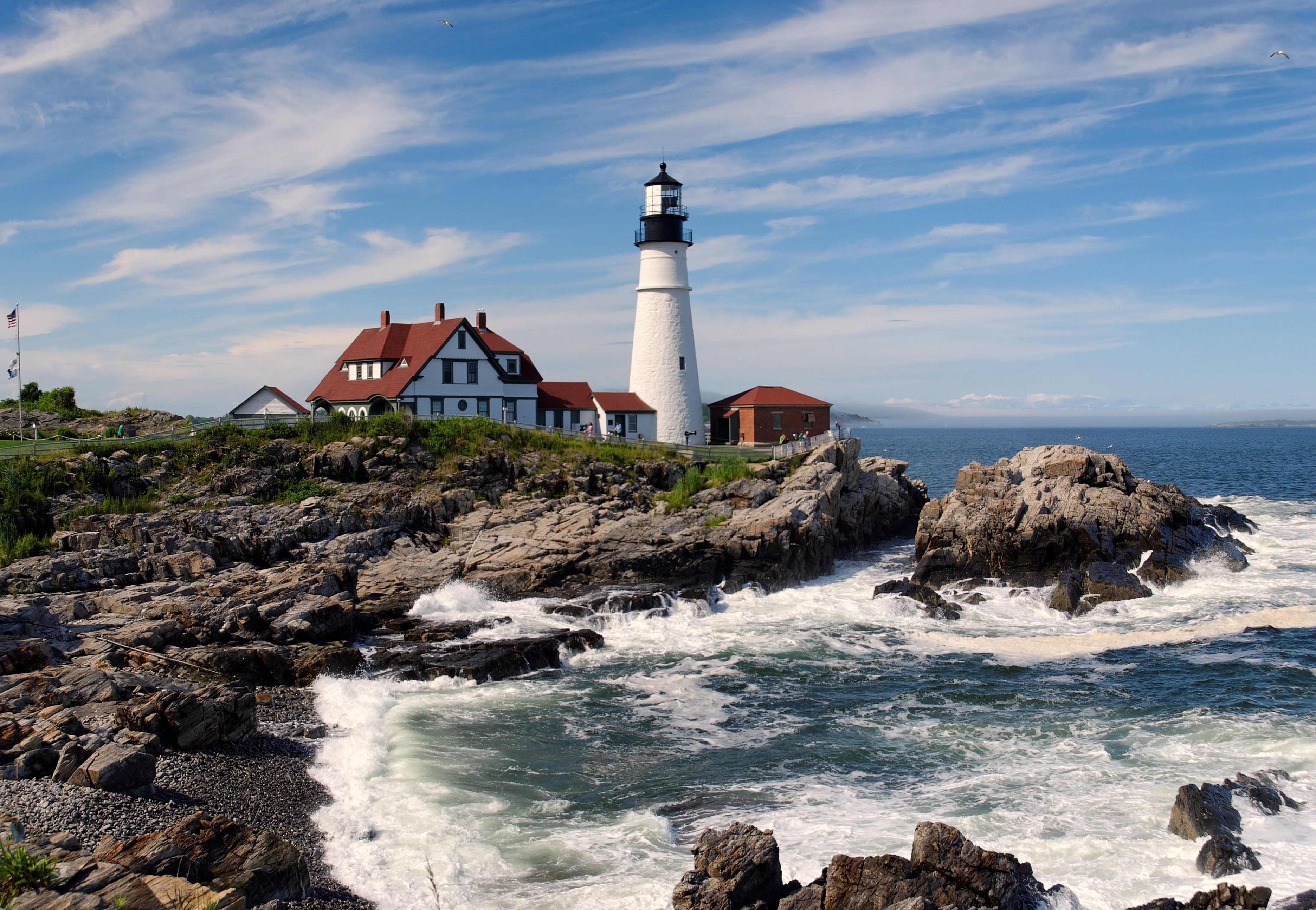
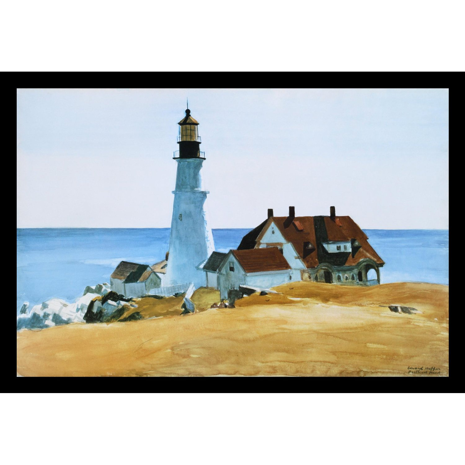
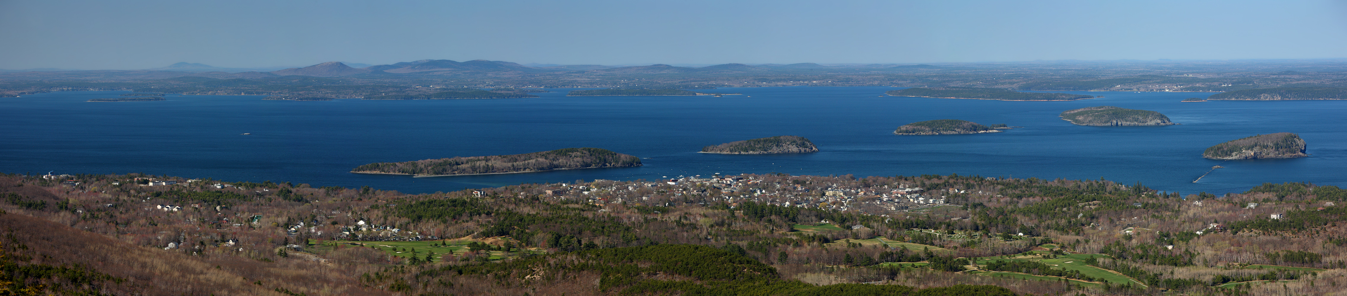
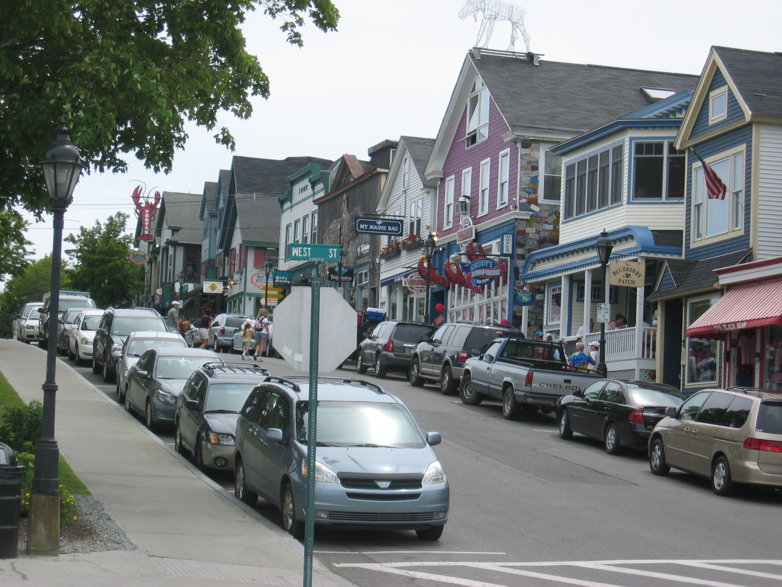
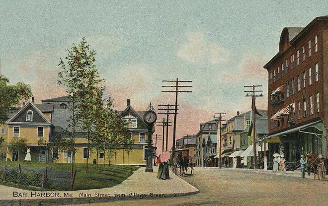
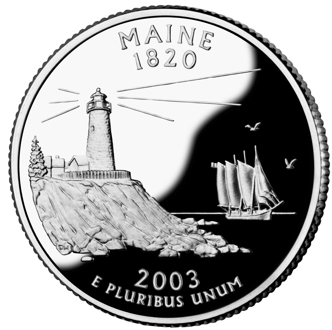
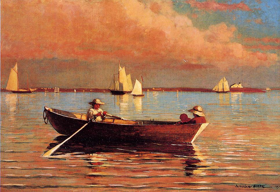
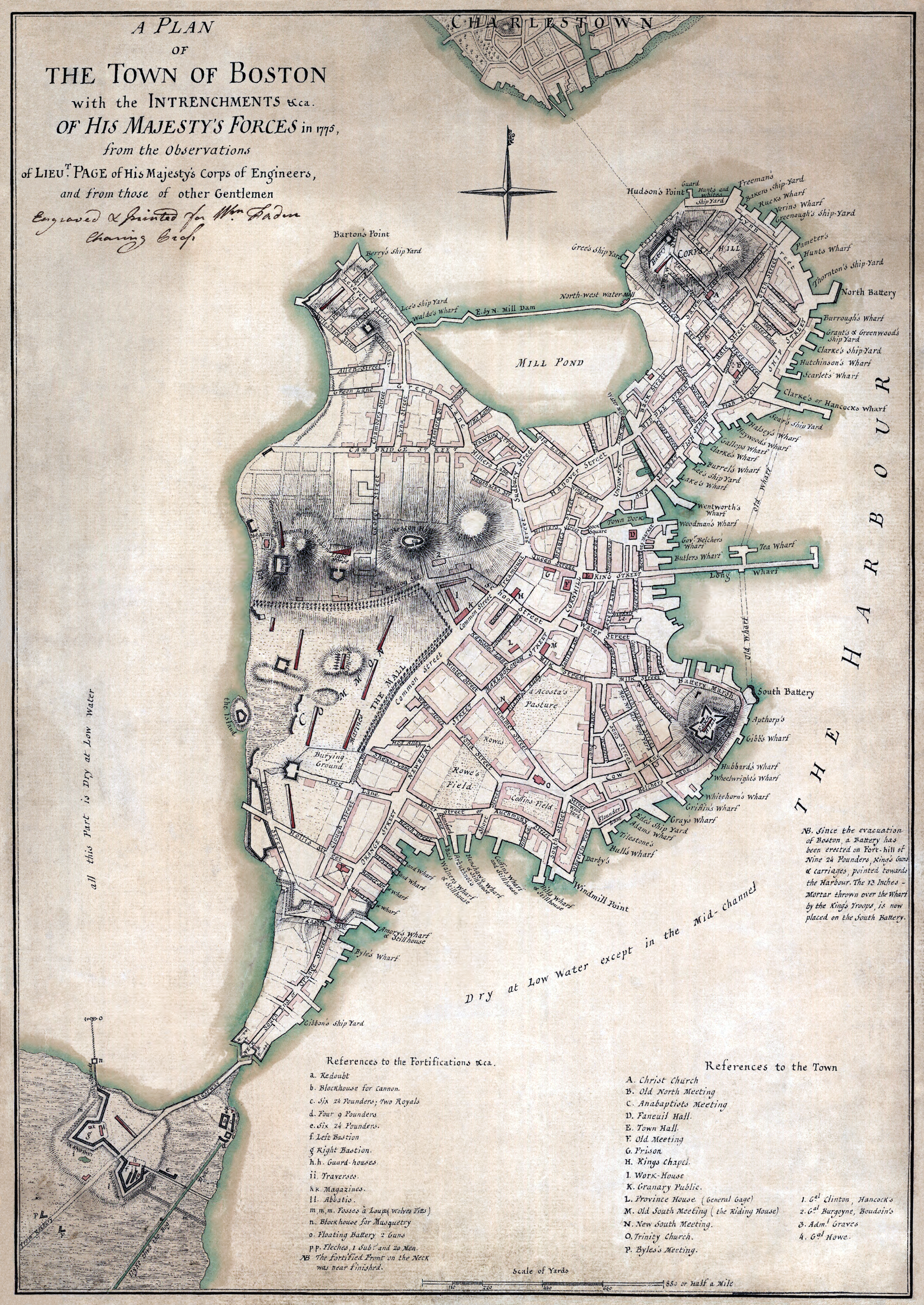