|
Reflections 2006
Series 14
November 14
Rail & Sail - Santiago de Chile - Easter Island
| | Rail & Sail There are such bright happenings in the international rail field that it just makes it all that more depressing that the US rail scene is so underfunded, underused, and disrespected. At least what we have left of the national system in Amtrak keeps on functioning. We do have the Acela high-speed between Boston and Washington, but there’s no excuse for it wating a full half-hour in New York to exchange passengers. If the Acela were in Europe, it would be in-out, zip-zip. Oh, well. | | | | As you may know, the excellent French high-speed is the TGV (Train à Grande Vitesse/High-Speed Train), and the German one is the ICE (Inter-City Express, which needs no translation). Rather than running on old rights-of-way these trains have new, dedicated rights-of-way for high-speed travel exclusively. The latest news is that in June 2007, the newest TGV line will enter service, the TGV Est (East), connecting Paris and Strasbourg, on the Rhine and on the German border. Planned are 16 (!!!) daily nonstop (!!!) round trips in 2 hours 20 minutes each way. Shortly, when one additional section is completed, the one-way time will drop to 1h50 (!!!).
| | | | I discussed in Reflections 2003 Series 7 two of the new high-speed routes being planned to cross Europe, as I read about them in Italy in Corriere della Sera. The one north of the Alps, as reported in the paper at the time, will connect Parigi--Strasburgo--Stoccarda--Monaco--Salisburgo--Vienna--Bratislava—Budapest. Can you still figure out, as you discovered then, what those Italian names are in English? In any case, this Paris to Strasbourg stretch is part of that. | | | | German ICE trains are scheduled to connect Paris and Frankfurt in 3h45, while French TGVs will connect Paris and Munich on this new route in 4h45. Here are some distance comparisons with American cities, each pair being approximately the same (as the crow flies) with the Paris connections. All of these cities do have Amtrak service connecting them, but it’s the old kind, not high-speed. | | | | Paris-Strasbourg-247m/397k: 1h50
Paris-Frankfurt---297m/479k: 3h45
Paris-Munich-----425m/685k: 4h45
| | | | Philadelphia-Pittsburgh-------254m/408k (Pennsylvanian): 7h20
Fort Lauderdale-Jacksonville-294m/473k (Silver Star): 10h15
Atlanta-New Orleans---------429m/691k (Crescent): 11h25
| | | | In Reflections 2006 Series 5 I talked about Beverly and me taking the overnight train in 1961 from the Gare de l’Est in Paris to Mainz (just short of Frankfurt) to begin our year’s study. I assume the train had sleeping cars, although we sat up in coach to save money. The route is not that far for a sleeper—we left Paris very late at night and got to Mainz very early in the morning—but in any case, with the new high-speed service coming in, that overnight train is now being cancelled (sic transit gloria mundi). Why have overnight service when you can make the round trip in a day, including time for a business meeting at midday? | | | | The other rail news does not involve high-speed, but it does involve Berlin Hauptbahnhof. I just reviewed Reflections 2005 Series 10 and find that I never made a point at the time as to where in Berlin the train from Moscow arrived. In postwar Berlin, with the loss of most of the old Berlin rail stations, all rail service from Moscow (and Kiev), after changing wheel carriages at the Polish border, came via Warsaw to Berlin, but stopped at Berlin-Lichtenberg, which is an S-Bahn station in the eastern part of the city. It’s a local station and has absolutely no international facilities. I would presume use of this station had a lot to do with the Soviet occupation and was a remnant of the Cold War. I knew in 2005 I would be arriving from Moscow in Lichtenberg, and I had to take the S-Bahn some half-dozen local stops further to the center of Berlin.
| | | | Now, as of December 2006, all rail service from Moscow and Kiev, via Warsaw, will go directly to Berlin Hauptbahnhof for easy connections to other services. And it will go a bit further.
| | | | Remember that in a number of cities, in order to provide the best service to the entire city, intercity rail service “overshoots” what may seem to be the logical last stop. In Brussels, for instance, trains from the south do first stop at the Zuid/Midi (South) station, but then they go on to Centraal/Centrale and end up at Noord/Nord. Last summer, my train from Hamburg entered Berlin from the north, stopped at Hauptbahnhof, but then went on to Südkreuz (South Crossing) for its final stop. Therefore, similarly, the new service from the East, after stopping at Berlin Hauptbahnhof, will actually terminate in the West at Berlin-Zoo.
| | | | And some sailing news. Cunard has announced that the new Queen Victoria will enter service in December 2007, which will be the first time that Cunard will have three Queens sailing at once. You may recall that, shortly after the Queen Mary 2 entered service, a ceremonial dual sailing was arranged in New York harbor on Sunday, 25 April 2004, where the QM2 and QE2 sailed past my windows, with family watching, to be greeted by fireworks near the Statue of Liberty. It was a great sight, although you’d never know what it really looked like from the bogus paintings hanging all around the lobby of the QM2. These highly idealized paintings (for sale) show a side-by-side sailing in bright sunlight, not the reality of the QM2 leading the QE2 down the nighttime Hudson, both ships illuminated, up to the Statue for the fireworks.
| | | | Well, it’s going to happen again. In just over a year, on Sunday, 13 January 2008, the QM2, QE2, and QV will all sail from New York harbor once again. Some problems might cross your mind, as they did mine. Surely all three cannot fit at the new Brooklyn Terminal, so we’ll have to see how they work it out between there and the New York Terminal, but I cannot imagine that Cunard would schedule to bring all three ships to New York at the same time and yet would not parade them up and down the river alongside Manhattan, so we’ll see at the time how it goes. Stay tuned.
| | | | One additional piece of trivia. I’ve always enjoyed Captain Paul Wright for his personality and humor, and his table on the QM2 was the only Captain’s Table I’ve ever been invited to sit at for dinner. He had captained the QE2 starting in 1999, and then the QM2 starting in 2004, and now he’s been named to be the Master (that’s MAH-sta) of the Queen Victoria when it sails in 2007. That makes Paul Wright the only person who will have served as Master of all three Cunard Queens.
| | | | An additional note: Word just came in today as I’m preparing to fly to Chile tonight that Christie’s has auctioned off the four additional Klimt paintings that were hanging in the Neue Galerie along with Adele Bloch-Bauer I, which Ronald Lauder had purchased for the Neue Galerie. The four paintings sold for a total of $192.5 million, far above their pre-auction estimates. Christie’s did not announce who the various buyers were, but presumably they did not include the Neue Galerie.
| | | | Santiago de Chile This trip is southbound, which makes it quite different in several ways. For instance, I will not be crossing many time zones, so there should be no jet lag (just the exhaustion from sitting up in a plane all night). But first, I have to review quickly what I said at the time of the Caronia trip around South America. The two Americas are not located exactly as their names imply, just north-south of each other.
| | | | As I said at the earlier time, the more accurate names would be North(west) America and South(east) America. It’s as if you divide a square into quadrants. North America is at the upper left. South America is at the lower right. Above SA, in the upper right quadrant, is much of the North Atlantic, between Bermuda and the Azores. South of NA, in the lower left is a large piece of the Pacific, including Easter Island (and not much else).
| | | | From the above it should be clear that traveling south from the EAST coast of NA you arrive at the WEST coast of SA. This is the start of my trip.
| | | | New York is at about 74° W of Greenwich. Santiago is at about 71° W, and so is Boston. As the crow flies, Boston to Santiago is due south, while New York to Santiago is at the slightest of angles.
| | | | While New York is at about 41° N of the equator, Atlanta is at about 33° N. Since Santiago is at 33° S, you can see that Atlanta and Santiago are equidistant from the equator in opposite hemispheres.
| | | | The next time zone east of Eastern Time is Atlantic Time, in Nova Scotia and in the Dominican Republic. Santiago is also in this time zone, one hour later than New York. However, as we in the northern hemisphere are now in fall and have just dropped daylight savings time, it’s spring in Chile and they have just started it, making it a two-hour offset, in other words, two hours later than New York.
| | | | The international flights I’m mostly used to are to Europe. This summer I flew from Newark to Oslo in 7h35 over a number of time zones. Last year, when I flew from Vancouver to Seoul over many time zones, it took 11h20, and remains the longest flight I’ve taken.
| | | | There are many Santiagos, but there’s a story there. The Spanish name for James that resembles the English name is Jaime (HAI.me; AI as in AIsle; E as in cafE), but the more common one is Diego, and there are numerous places called San Diego, after Saint James. However, an older form of Diego was Tiago, which is no longer used as a name. Tiago remains, though, only in the form Santiago—always written as one word. So places named San Diego and Santiago essentially have the same name.
| | | | The most famous Santiago is in Spain, which I’ll be revisiting next May. It’s the shrine of Saint James, to which pilgrims have traveled for centuries. When it needs to be made clear which Santiago you mean, this one is called Santiago de Compostela. There are others, including a Santiago de Cuba, and the city to which I’m traveling, Santiago de Chile. You shorten these names only when it’s already clear which Santiago you’re talking about.
| | | | All flights on this trip are on LAN Chile, as was the charter flight Cunard had arranged from the Caronia when we overflew the Antarctic Peninsula 2 ½ years ago. Since you can tell your route on the plane from the maps provided on the TV screens, I can say that we—surprisingly to me—hugged the US coast very closely and even overflew Cape Hatteras, only then going south and passing Miami somewhat out to sea. We overflew Cuba and Panama while I was asleep (??) and were overflying Ecuador and Peru for arrival in Lima at six in the morning. After an hour’s stay in Lima, we started cutting east to overfly Chile for arrival in Santiago. New York-Lima was 7 hours’ flight time, plus 3 more to Santiago, so I was in the air 10 hours, not surpassing Vancouver-Seoul, but the maximum direct flight was only seven hours anyway.
| | | | The seating was seven across (2-3-2) in Cattle Class. I had arranged to have a window seat on the left for the views, and knew that there would only be one person next to me. I lucked out. Although the flight was quite full, no one had the seat next to me overnight to Lima, so I stretched out (???) over two seats. First class was 2-2-2, and with wider seats of course, but even so, I wasn’t interested in the price difference and accepted the trip in Steerage. (Actually, given the restrictions of Sardine Class, LAN did a decent job, with three meals, including Chilean wine, also Scotch if you wanted it.) I was very surprised that about 80% of the passengers got off in Lima, and also surprised that the plane filled up again to Santiago. | | | | I have said that one does get jaded about the views from above you get when flying. So often they’re humdrum, but occasionally you do get to see San Francisco, or the Grand Canyon, or Niagara Falls, or New York below you, and that IS a treat. This was one of those times. I was glad I had thought to get a window seat on the left, because I saw the Andes from above. Nearer the coast they looked black-brown, but just a bit more inland, they were snow-covered. I don’t mean with a solid ice-pack, but with snows going down valleys, giving all those mountains a black-and-white-striped zebra effect. It was very impressive. | | | | It seemed odd that Peru, protruding west, is in the Eastern time zone. It being near the equator, it doesn’t do daylight savings time, so Lima time was exactly the same as New York. It’s a funny feeling flying seven hours and still being in the same time zone. Chile, however, being further east is, as I’ve said, on Atlantic time. It being in the temperate zone, it did just start DST in October, so the offset was two hours, which were all lost between Lima and Santiago, the three-hour flight looking as though it were five hours.
| | | | The purpose of this trip had nothing to do with seeing Santiago. It was just a connecting place. The provider arranged for people to fly in, be put up in a hotel with a quickie bus tour of Santiago, and then fly on south. But I am very pleased with three things: the fact that all the extra arrangements I did on my own have worked out like clockwork, I really liked Santiago, and, as far away a side trip as it is, I was very pleased with Easter Island. | | | | I’ve already said I arranged my own flights from New York to Santiago, connecting to Easter Island; bought an inexpensive hotel+transfer+daytour package there; and arranged for three car transfers in Santiago. I also had to stay in Santiago one night, since the flights didn’t mesh. Here’s how it went.
| | | | I found online a car transfer service in Santiago and made reservations, to be paid for on arrival. Their services were perfect. They brought me to the San Cristóbal Tower of the Sheraton Hotel (free on Starpoints) in the upscale Providencia neighborhood of Santiago. There I had a great view of the Andes just east of Santiago, some of them over 6000 meters/21,000 feet. The service picked me up again the next morning to go back to the airport for Easter Island. Hotel transfers, the hotel, and the day tour worked very well there also. Back in Santiago, the last transfer to the Grand Hyatt in the also upscale Las Condes neighborhood went well. This hotel, where I stayed two nights, was part of the tour package that followed. | | | | Part of the careful planning I had to do that first day in Santiago involved the fact that I knew I’d have a half-day to see Santiago on my own, and I wanted to know in advance just what I’d do and how I’d do it. When a Michelin isn’t available, a less-good, but alternate choice are the Frommer guides, since they also use a star rating system for sights (also hotels and restaurants). So in advance, I knew just what I wanted to see, I had printed out a map of the subway, and was ready to go.
| | | | Santiago is not a destination city, as Buenos Aires or Rio de Janeiro are. I can understand people flying all the way to South America to see one of those cities, but not Santiago. When the Caronia docked in Valparaíso, the port for Santiago and maybe an hour or two away from it, on 6 February 2004, there were bus tours offered, but from what I had read in Frommer, Santiago didn’t offer enough for me to try to get Beverly and her wheelchair on a bus to go there, so we satisfied ourselves with Valparaíso. That said, once I was here for other reasons, I was amazed how much I enjoyed this very attractive city.
| | | | In addition to maps of downtown, I had printed out a map of the upscale Providencia neighborhood and, walking from the hotel to the Metro, was surprised at the attractive condominiums on interesting middle-class streets, with a number of sidewalk cafes. I used two of the several lines of the new Metro to get downtown in about 20 minutes, and the tickets are inexpensive, about the equivalent in pesos of 70 cents, the trains are attractive and each station is decorated artistically. Santiago is old, being founded in 1541, and has five million people. The fact that it’s 2000 feet above sea level didn’t cool it off appreciably, since the temperature was in the 80’s. Do not picture a tropical city, though; this is a temporate climate. I saw no palm trees.
| | | | I started at the Mercado Central/Central Market, to see the fish, meats, fruits, and vegetables from the region, all under a wrought-iron canopy originally imported from Britain. There were plenty of pedestrian streets downtown including street performers such as a clown, a young man singing opera, and two guys doing a comedy routine. The Plaza de Armas, just like the Place d’Armes in Montréal, was originally meant to distribute arms to the militia. Today it’s an attractive tree-lined park with historic buildings around it, including the cathedral. It’s a nice place to sit and people-watch. San Francisco church is the oldest surviving building in the city (it survived three earthquakes); its construction started in 1586.
| | | | My main impression of walking the downtown streets is that I could have been in Toronto, or any other city where there is business hustle-and-bustle downtown, occasional monuments, and plenty of street life. Once or twice I had to actually remind myself where I was. This is South America! This is Chile! This is Santiago! Reflecting back, I feel that when we were on the Caronia going around SA, it was like outsiders peeping into a house. I suddenly realized that, as much of the continent as we had seen before, this was the first time I’d actually stayed in a hotel in anywhere in SA. It really was a jolt to my perspective. I felt much more that I “owned” SA now, or at least this piece of it. I’m also glad that I’ve gotten a feeling for Santiago now, having walked its streets for a few hours. I don’t feel seeing these things from the bus the providers have planned for before going south will be the same.
| | | | As for technology, aside from the Metro, coming in from the airport the driver pointed out that the freeway runs under the river for four kilometers. They had excavated the river, built the freeway (even with a couple of exits) in the bed, then re-ran the river on a new bed in that stretch that was essentially the roof of the freeway tunnel. It was very impressive to be riding along in the “basement” of a river.
| | | | Easter Island Easter Island is considered the remotest inhabited place on earth. It is roughly west of Santiago (just 5° further north), but 2360 miles/3800 kilometers out into the Pacific. The next stop beyond is another 1240m/2000k west, and it’s Pitcairn Island, where the survivors of Mutiny on the Bounty settled, and which has always been known as the image of inaccessibility, even today not having an airport. The next stop some considerable distance west after that, and with an airport, is Tahiti. All that leaves Easter Island in the middle of a considerable chunk of very, very empty Pacific.
| | | | We talked about North(-west) America and South-(east) America, and this piece of the Pacific falls then in the southwest quadrant. We said that both Santiago and Boston were at 71° W. Easter Island is way out at 109° W. To draw a parallel distance in the US, take a look at Four Corners (where I’ll be next September). It’s the point where four states with straight-line borders come together at right angles. The line forming the border where Utah and Arizona are on the west, and Colorado and New Mexico are on the east is the 109th parallel, so going from Santiago to Easter Island is like going from Boston to Four Corners. | | | | The outbound flight (go ahead, ask me if it was non-stop) took 5h40, which gets pretty close to my seven-hour flight from New York to Lima, but going back it was scheduled at only 4h14, maybe because of good tailwinds. But, I met a New Zealand couple who said Easter Island is “on the way home” from Santiago, so they’ll fly on to Tahiti from here. Actually, my return flight to Santiago had come in from Tahiti.
| | | | Easter Island is two hours earlier than Santiago, but watch this: New York is on EST; Lima is in the same time zone; Easter Island seems to be in the Central time zone, but like all of Chile, does observe daylight time, which puts it the equivalent of Eastern time, so—Easter Island is now the same time as New York! That means that stopping in Santiago for one day popped me two hours later, I changed back for Easter Island, then back to Santiago time.
| | | | The indiginous population is Polynesian, as far EAST as the island may be from the other Polynesian islands. It is estimated that 40,000 years ago the Polynesian population began expanding to other Pacific islands, finally arriving here in about 400 CE (Common Era, =AD). We get used to seeing a Polynesian population under English-language influence in Hawaii, and under French influence in Tahiti, but it’s a bit strange to see it under Spanish-speaking influence here, it being part of Chile. The population is essentially bilingual. | | | | It was in 1722 that Western influence first arrived in the form of a Dutch (!!) ship, later followed by ships of other countries. That Dutch ship arrived on Easter Sunday, hence the Western name of the island. In Spanish it’s Isla de Pascua, French Île de Pâques, German Osterinsel. On the plane I was sitting next to a Swedish gentlemen, and I asked how you say it in Swedish. I should have known. I did really know in the back of my mind that Påsk is Easter (it’s a short å, so instead of OH, say the word paw and add SK), and I think we discussed that Swedish for island is, curiously, just ö, so the island in Swedish is Påskön, including the N for “the”.. Notice the similarity between Påsk, Pasc(ua), and Pâqu(es). I believe all those versions of the name go back to the paschal lamb. | | | | However, erase all that from your mind. The people, language, and island all use the same name, Rapa Nui, and all signs do, too. Therefore, it is accurate to say that the Rapa Nui speak Rapa Nui and live on Rapa Nui. I will usually be using that name from here on in. | | | | Rapa Nui is a mere 15m/24k by 8m/12k, a mere spot in the very open ocean. It is therefore all the more incredible that all that time ago, when they left from the west and rowed canoes (!!!) these distances toward the east, they actually found the island. At least the Mayflower was considerably larger than a canoe and people already knew America existed. The island is triangular, with dormant volcanoes at each of the three points. The longer hypotenuse is the SE coast, opposite the NE and NW coasts. The 3800 inhabitants all live in the capital, Hanga Roa, which is near the SW point. The (tiny) airport is right in (the tiny) town. | | | | The island is pleasant, but draw this image: somewhat tropical, with palm trees and overgrown vegetation; rural; dirt roads; many corrugated-roof buildings in town, some rusty. Call the style tropical-tacky. In these ways it is somewhat like Carribean islands, and I would hazard a guess, other Pacific islands. It should not be surprising that somewhat simple hotels should be expected. There were plenty of greeters outside the airport building, and many of us got flowered leis around our necks, and a welcome (fruit juice) drink on arrival at the hotel. The van went down some paved streets in town, then turned down a number of bumpy dirt roads to the hotel that a number of us on the flight were staying at, the Taha Tai on the water (remember, you can google any of the things I mention; that’s how I found the hotel website last February). The temperature was maybe in the 70’s, and the next day on tour, 80’s. The Taha Tai was unmarked from the road, with only a small sign upon entering. It did have ocean views, but there was a highway between the back of the hotel and the ocean with traffic.
| | | | I’m trying to paint a picture here so you can get a feeling, which I’m sure looks negative, but now I’ll get to the “good news”. The hotel was very pleasant inside, and efficient, getting us settled in promptly. Most rooms in the main building had views with small balconies across the garden, past the restaurant (and that road) to the ocean. And I had my own villa. | | | | I know people think it strange that I make these plans so long in advance, but I’m sure I got one of the villas because I made this reservation in February for November. Earlier reservations get better accomodations. Picture a square room-and-bath attached to another, like Siamese-twin diamonds. There were several of these, and I think I got the best. There were windows out to the garden all around, and a desk facing out the patio doors. There was an ocean view (beyond the traffic). There were banana trees on the side with two huge bunches of bananas. And opposite my front door were growing about a dozen large, pretty white lilies. Imagine, Easter lilies on Easter Island! I also saw them in a number of other places.
| | | | Flights to the island are not daily, and it worked out that either I stayed only two nights or something like five. I decided on two, mostly because I knew I could see what I wanted to in that time on such a small island, and also because this is only a side trip on the way to Antarctica, so it worked like this. Saturday was the flight in, and with the time gain, a 5h40 flight was only 3h40 on your watch, so I had a half day on my own. Others may have taken walks along the road, or other simple activities, but I used the time to relax in my little villa and sit at my desk writing, looking at my Easter lilies before going to dinner across the garden. At dinner, local recorded music was playing. It was sort of Hawaiian-like, yet distinctive.
| | | | Sunday was the full-day tour I had arranged in advance, which will be the centerpiece of this article. After coming back, I did a repeat of Saturday, relaxing and writing. Monday was the flight back to Santiago, but with the time loss of two hours, it was a lost day.
| | | | First a comment about the day of the tour, which was along the shore. The weather turned perfect, and the Pacific was a perfect blue. Most of the coast is rocky, so the waves would break high on these rocks in spectacular high arcs of white seafoam. It was worth just staring at. Also, a horticultural comment about eucalyptus: years ago, I remember Beverly and me enjoying driving through Portugal, often coming across eucalyptus trees and recognizing them by their very characteristic scent, and stopping to pick up some of their narrow, elongated leaves to break them open for a concentrated kick of the scent. On the tour I took here, which was primarily along the longer SE shore of Rapa Nui, there was little vegetation, but both at the picnic area where we stopped for the (included) lunch, and then all along the central road down the island going back, which was otherwise unremarkable, there were groves and groves of eucalyptus, the scent coming in the open windows. That alone could be enough to remember Rapa Nui for.
| | | | But not really. One comes here for the statues, the moai. If you are not familiar with what they look like, have Google help you. I knew they, and their story, would be interesting, but it all knocks your socks off. I’ll give you the story as I pieced it together during the day’s tour, and then describe what I saw.
| | | | The Rapa Nui brought with them what I will describe as a burial culture. When important people died, such as tribal chiefs or priests, they were cremated and buried along the shore under platforms, called ahu. These ahu were long, but not wide, and made of assembled stone, such as if you’d build a stone wall, in a rectangle, then fill the center area with stone as well. In time, they started building statues above each grave, sort of as tombstones. These statues are called moai (AI as in AIsle), and represented the dead personage, turning into a god. They consisted of a very typically elongated head, on a large torso. There are arms along the side of the torso, sometimes hard to notice, but no legs, since the moai is meant to be spiritual, and legs are earthly things. Since it was also the custom in life to wind one’s hair onto the very top of one’s head into a topknot, many if not all of the moai had huge topknots on top, as large as the head and half as high. The moai are of a dark, blackish stone, but the topknots were quarried elsewhere from a reddish stone, and were finished being carved once placed on top of the statue. Thus there would be a row of moai standing the length of the ahu (platform). It has been proven recently that all the statues had eyes inserted, made of coral, obsidian, and red basalt. It was believed that the powers of the individual while alive would survive after death and emanate from the person’s moai through these eyes. That’s why the ahu were built along the shore. The moai on top of the ahu had their back to the sea, and a village would develop in front of the moai, where the gaze from the eyes could protect the village. (Curiously, one style of house in the villages was in an upside-down canoe shape, but out of stone, since the Rapa Nui felt if the canoes got them to the island, a canoe-shape would continue to shelter them.)
| | | | Earlier moai were smaller, but in time, bigger ones were built. This is human nature: “mine’s bigger than yours!” It should be noted that, as with the pyramids in Egypt, construction was often started on a moai during the person’s lifetime. On some ahu older, smaller moai have been found underground, recycled as landfill for newer moai above. A moai of 3 meters/yards could weigh 50 tons; 9 meters/yards 100 tons. And they got much bigger than that.
| | | | There are about 300 ahu around Rapa Nui, some in ruins, some in decent shape, a few restored. That would imply that there had been about 300 villages at one time. There are about 887 completed moai, while hundreds of others are partially completed and still in the quarry. Since it’s hard to count ruined figures, let’s say there are under 900 moai.
| | | | But most of the moai lie toppled, and flat on their face. So what happened? | | | | It’s felt that construction on the moai went from about 400 to 1600-1700. Now remember that the present population is about 3800, all in Hanga Roa, and food and water supply and trash removal are problems today. (Most fruit has to be imported; I understand an apple costs the equivalent of about $4; I hear a child offered a chocolate or an orange might well take the orange.)
| | | | It is estimated that by 1600, the island population had exploded to about 14,000. It is considered that it was tribal, inter-clan warfare that did in the old moai culture in on the overpopulated island. A group wanting to take over a village would go and topple all its “protecting” moai to simplify their warfare. And so most moai lie face-down today.
| | | | It occurs to me—and it seems to be true—that the outside world didn’t know about the moai, or even much about Rapa Nui, until the 1950’s, when the Norwegian Thor Heyerdahl sailed his Kon Tiki on the Pacific and wrote about it and Easter Island/Rapa Nui. He conducted excavations around the island, and tried to see if present islanders could carve a moai (they could, but it took so long that they did only a head, in situ in the quarry). Now the whole world knows about the moai on this tiny island.
| | | | Today, what one gets to see, is an eyeful. I’ll describe it as three types of things you see, and to my way of thinking, one is more impressive than the last. First, you stop at some shore locations with the obvious remnants of a village, outlines of houses, of kitchens, and the like. Near the water will be perhaps a smaller ahu, partially in ruins, and a row a toppled moai. Since they are smaller moai, they are older. One thing is important to realize: these moai were not toppled in contemporary times, but in historic times. The fact that they lie face-down is part of the history of the island. Some restoration is desirable, but not total restoration.
| | | | I never thought the second area we saw would top seeing the toppled moai, but it did. We went to the one of the three volcanoes, Rano Raraku, which had the quarry from which 90% of the moai came. It was a long hike to the top, several hundred meters/yards above sea level, where we saw the lake inside the crater, but what was worth seeing was on the way up. First you come across a smallish moai that Thor Heyerdahl found, buried up to its neck. It now sits fully exposed on the side of the path, and it’s unique. The moai is squatting down on its knees and sitting on its legs. The fact that this moai had legs seemed to Heyerdahl to suggest the native civilizations of the Americas, and to his suggestion that perhaps the local population came west from South America instead of east from Polynesia. This remains contraversial.
| | | | Then you get to see there in the quarry on the side of the path how the moai were carved. There are hundreds of moai that were never completed, and remain in the quarry as of when work stopped. All moai were carved in situ, as part of the stone wall of the side of the mountain. The first we saw were lying down. The statue was carved with a “keel” below. When the statue was finished, the keel holding it up was broken and the statue moved to its site. How that was done, considering the weight, could have been the way the Egyptians moved stone, by rolling it on logs, but there are other theories. | | | | Other moai were carved partially upright, but at about a 45° angle. Presumably this would have helped lowering them down the mountain. At some places you could see dozens of statues that had been started. Our guide found two more she had never noticed before. That’s what the side of this quarry looks like, like a puzzle where you see how many heads you can find, carved in the rock in different places. There are probably some 300 moai in various stages of completion. There were signs of recycling: a moai that had been started had broken in the middle, so the upper half had been re-started as a smaller moai. | | | | One takes a side path to see a very special moai. Lying at an angle is the biggest moai ever found, though incomplete. It is 26.6 meters/yards high, would have weighed 250-300 tons, and when set up, would have been the height of a seven-story building. Some statue.
| | | | The third sort of thing you see are the few examples of restorations by archaeologists. Near Anakena beach are two restored ahu, one for a single moai, and one for about a half-dozen. The moai are of medium size, not tiny, not huge, but it’s interesting to see them standing, right where they were meant to be.
| | | | But the absolute best restoration is at Ahu Tongariki, and this restoration comes with a story. Fifteen large moai had been toppled from their ahu in historic times, but in 1960, a tsunami hit the cove they were in and thoroughly dispersed the remnants. Then, in the early 1990’s, the government of Japan had a plan. If Rapa Nui would lend a small moai for exhibition at the Osaka World’s Fair (otherwise a big no-no—moai to not leave the island), Japan would pay the complete costs to restore the ahu and all fifteen moai at Ahu Tongariki. | | | | And what a sight this restoration is; it gives goosebumps. As you walk down into the wide open area of the cove, the blue Pacific is crashing white seafoam on the shore in the background. A perfectly restored ahu that has to be several hundred feet long, and at least 50 feet wide has on top all fifteen moai in a row, facing inland of course. Not all moai are perfect; there may be a nose missing here, an ear there (but keep in mind what the Venus de Milo is still missing). This moai are huge. As I eyeballed it, most of them must be the height of a four-story building. Of the fifteen, the fifth from the right stands head-and-shoulders above the rest, so let’s guess five stories. (Maybe it’s another case of mine-is-bigger-than yours.) Although many might have had the reddish topknots, only the second from the right has had its topknot restored. I understand it was felt that most of the statues might no longer have been able to support the weight of a topknot on top. I also understand that Japan continues to maintain the site, including renewing some sort of sealant to help preserve the stonework.
| | | | Parts of Rapa Nui are a UNESCO World Heritage Site, but particularly this cove at Ahu Tongariki has a sign on it wherein UNESCO declares it part of the Patrimonio Cultural de la Humanidad. I think the phrase sounds even more stirring in Spanish, but it translates as the site being part of the Cultural Heritage of Humanity. I certainly agree, without reservation. Antarctica’s going to have to be pretty good to beat this. | | | | These are some links of interest on the subject of Easter Island: | | | | | | This is an orthographic projection (a map giving a 3D affect) centered on Easter Island showing its great distance from other places.
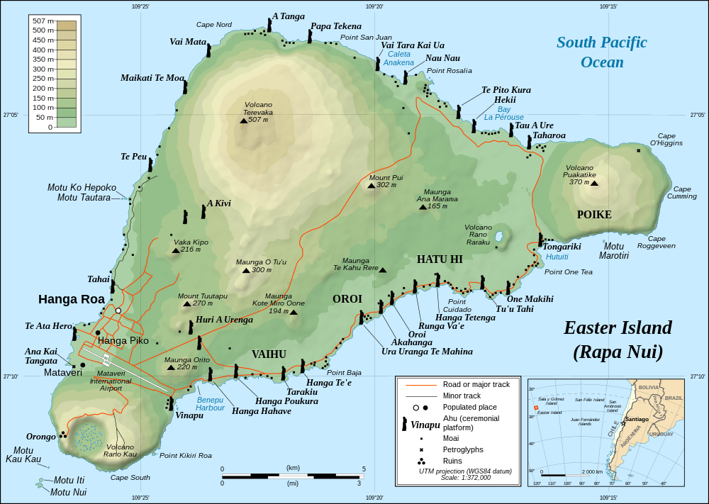
This map of Easter Island shows Hanga Roa and the airport, with major ahus (stone platforms) being marked by symbols of moai (Map by Eric Gaba [Sting], translated by Bamse). Ahu Tangariki at the east end of the south shore.
This ahu is Ahu Tongariki (Photo by Ian Sewell), with fifteen moai excavated and restored in the 1990’s, facing inland. All 887 moai on the island were carved from 1100-1680 CE.
This is a detail of six of the fifteen moai at Ahu Tongariki (Photo by Rivi).
These moai heads are set in a hillside at Rano Raraku (Photo by Aurbina). Whle usually referred to as “heads”, they have torsos, usually ending at the top of the thighs, and a very few show a complete body, though kneeling. Over time, soil movement has buried some moai up to their necks. Some 95% of the moai were carved out of easily-worked tuff (solidified volcanic ash) found in one place, the extinct volcano shown here, Rano Raraku. One moai took a team of 5-6 men about a year to complete, although many projects were worked on at the same time. Only a quarter of the statues ended up being installed, about half stayed in the quarry, and the rest are at scattered locations, probably on their way to an installation.
|
| | | |
| |
|
|
|

