|
Reflections 2019
Series 14
September 15
New England Coast III: Sea Canals-Cape Cod Canal–Outer Lands Redux– Rhode Island
| | Day 8 (later) – Th Ju 13 – Gloucester -> New Bedford - Cape Cod Canal One thing I've failed to bring up so far was that this cruise director was very good. I even took her aside one day and told her she was very good at her job. She held daily briefings in the evening about the events of the next day, which were really very helpful. She also was the one who'd contacted the Captain for me about when we'd be passing Pemaquid Light. | | | | But I bring this up for a special reason, to show how very naïve so many cruise passengers can be about their surroundings. Early in the trip, I raised my hand and asked her if we'd be going thru the Cape Cod Canal in daylight, since it was very important to me. She said she'd check with the Captain. | | | | It was very clear to me from the online map of the trip and general knowledge of the geography of the area that we would be connecting thru the Canal. But that was apparently less true with some of the others. Several days later, someone came up to me and asked me just what that "special place" was that I'd asked about. I explained politely, but was taken aback that the person had no idea of where we were going. | | | | That point about passenger naïveté now leads me to this next point I want to make, that earlier I purposely didn't quote the Captain completely when he told us after breakfast this morning that we'd be skipping Gloucester. His complete comment was that, because of rough weather, the Gloucester was being canceled, and replaced with a stop in New Bedford. Period. Not a word more.
http://www.vidiani.com/maps/maps_of_north_america/maps_of_usa/massachusetts_state/large_detailed_roads_and_highways_map_of_massachusetts_state_with_all_cities.jpg
| | | | Use this map of Massachusetts (with Rhode Island) as an ongoing guide (click). My point is that I'm good at geography. I've been to New Bedford, knew its whaling history (similar to Nantucket's) and visited its Whaling Museum when we went to New Bedford as a side trip out of Newport on that cruise to southern New England. Nevertheless, with the Captain's terse remark, I was totally confused. Wait—where was New Bedford again? Was it on the North Shore near Gloucester? What's going on? It was a moment until I unraveled the Captain's incomplete and confusing statement and realized that he was implying, without saying so, that we'd now totally leave the area north of Boston, cross Cape Cod Bay, go thru the Cape Cod Canal to reach New Bedford south of the Cape. But if I was confused, what about everyone else, especially the more geographically naïve among the passengers? I'm sure many had no idea where they were going. I didn't like how he handled this at all. Skipping Gloucester and replacing it with another seafaring town—which was obviously the Captain's point--wasn't that big a deal, but the lack of information for the passengers was inexcusable. | | | | But the good news was this: after crossing Massachusetts Bay (see map), we'd also cross all of Cape Cod Bay, something I've never done before. I've driven all around it, between Provincetown and Plymouth (also on the open Atlantic sides of the Cape), but never sailed across it like the so-called Pilgrims would have. Even that ferry (see map) I took to Provincetown some years ago hardly entered the Bay. And in addition, we'd also go thru the Cape Cod Canal in daylight, tho under overcast and in a drizzle. (The return would be at night.) That would further imply that, if we'd spent the whole day in Gloucester, we never would have seen the Canal in daylight, which I still find bad planning, just like skipping Cairo IL and planning a nighttime arrival in Pittsburgh on the Ohio trip. ACL does some good things, but they have a lot to learn about taking into consideration places en route that are not official stops.
Anyway, we were now headed across the Bay to the Canal, near Sandwich, and the overcast wouldn't dampen our current adventure. But to fully enjoy a travel experience like this, we need sufficient background, including on our sea canals of the past.
| | | | Sea Canals I've visited and talked a lot about canals, and only now does it strike me—and I've never seen anyone else make this distinction—that there are two kinds of canals, which I'll call "land canals" and "sea canals". Land canals are man-made rivers, usually long in nature, and often intertwining with rivers. Like rivers, they're internal, and have ports along the way in towns. The bodies of water they connect are usually internal as well. Think of the canals we've discussed in the past, the Erie, Oswego, Champlain, Chesapeake & Ohio (C&O); the Canal du Nivernais; the Mittellandkanal.
| | | | What I'm calling sea canals are not internal but coastal. They're comparatively short waterways that connect seas, oceans, and bays. They make relatively small, local connections where "nature forgot" to do so, sometimes completing major connections, oft times lesser ones. I can mention here the Suez Canal (Map by Io Herodotus) connecting the Mediterranean (and the Atlantic) with the Red Sea (and the Indian Ocean). I've never seen it, even from the shore, but I can state that it's entirely at sea level, with no locks. | | | | Otherwise, to complete our background lead-in for the Cape Cod Canal, I'll limit myself to the six I've discussed in the past because I visited them, tho just from the shore. (The only one I sailed thru before the Cape Cod was the Panama, twice, as mentioned recently, but I also saw it from the side when riding the Panama Canal Railway—see map below.) | | | | •(1) The most prominent of the sea canals visited would be the Panama Canal (Map by Thomas Römer/OpenStreetMap data), connecting the Caribbean area of the Atlantic with the Pacific. I suspect most people don't realize that it's unique, being a canal "up in the mountains". Most of the others we'll mention here are sea-level canals—or close to sea level. You may recall that the French tried building the Panama as a sea-level canal, attempting to cut thru the mountains, but had to abandon the effort because of the difficulty. When the US took over, they instead built the canal, not at sea level, but over the mountains. Well, I say that for effect, and for the imagery of it. The Panama has an altitude of 26 m (85 ft). I estimate that's about the height of a building of 8 to 11 stories. Having to raise and lower ships that high above sea level is enough for me to consider it "up in the mountains". | | | | | | Supposing you want to put a kiddie wading pool in the back yard, but a shed is in the way, so you put the pool on the flat roof of the shed instead. That means you need two ladders to access the pool, one on each side. Keep that image in mind.
To build the non-sea level canal, the Americans dammed rivers to flood mountain valleys to form the artificial Gatún Lake up in the mountains, like our kiddie pool. (Much of the route is on the lake; otherwise there are "cuts" that are more canal-like—see map.) At one end, three locks bring ships up to lake level, and at the other end, three locks bring them down, just like the two ladders. Thus, ships cross the Isthmus of Panama "up in the mountains". Confirm this by going back to the Canal map and clicking on the profile at the bottom to compare sea level with lake level.
|
| | | | •(2) After the major Panama (and Suez) are two sea canals of intermediate importance. Let's first talk about the Kiel Canal (Map by Maximilian Dörrbecker [Chumwa]), which connects the North Sea with the Baltic across the bottom of the Jutland Peninsula. As the map shows, it has only two locks at each end, so, tho not exactly at sea level, it's only 7 m (21 ft) above it. In Boston I recently mentioned the time I "changed ships" in Kiel, and had the whole day in town to myself. I took the train for a day trip to Rendsburg (see map). You can review that visit in 2006/6, Ctrl-F: Rendsburg, but I'll give a quick summary now. | | | | I wanted to see three things, two of which are mentioned on the map as "railway bridge with suspension ferry". The train would arrive in town by passing over the Hochbrücke> "high bridge" and it was fun to see the train gain altitude to cross high above the canal, then loop downward to reach Rendsburg. Under the bridge—not as a stand-alone structure as in Newport, Wales (2001/2, with pictures), but actually hanging from the rail bridge--was a transporter ferry for vehicles and pedestrians to cross over the canal. And there was also a visitor attraction, the Schiffsbegrüßungsanlage or Ship Greeting Facility (Schiffs+begrüßungs+anlage), a restaurant complex to enjoy the canal, bridge, and ferry view. Eventually we saw the Europa come sailing thru. | | | | Since 2006/6 fell in the period before we included illustrations on this website, I'll add them on now. This is the Rendsburger Hochbrücke/Rendsburg High Bridge (Photo by Malte Hübner), with the transporter ferry crossing under it mid-canal. Here we have the Rendsburger Schleife/Rendsburg Loop (Map by Inselmann). While trains have a lot of area south of the canal to gain altitude, in town they need the loop to come down quickly to stop at the Bahnhof. You can see the short walk I had from there to the canal's edge under the bridge. Here's the transporter ferry hanging mid-canal--click to see the car and pedestrians (Photo by Nightflyer). This shows the ferry docked to one side as the Norwegian Dream sails under the High Bridge (Photo by Stefan.straub). And in case anyone is still in the dark as to how a transporter ferry works, here's a gif animation illustrating it (Gif by Y_tambe), tho this one being illustrated is free-standing as in Wales and not hanging from a bridge as in Rendsburg. | | | | Finally, this is the Ship Greeting Facility at the bridge (Photo by Xocolatl) as seen from across the canal. Passing ships are announced, including telling where it's coming from and where it's going. The large German flag on the pole near the building is dipped, which is the international maritime greeting signal, and the ship's national anthem is played, from a taped collection of 220 anthems on hand. Sometimes the captain will respond on his signal horn. It's particularly spectacular in the summer when over 100 big cruise ships pass by. | | | | This is the Saga Rose passing under the bridge with the transporter gondola on the south side. I cannot explain why the Swedish flag is shown here, since this ship was never Swedish. But do click to note all the passengers watching the show, as well as locals and other visitors on shore. I mention this to illustrate how a clever point of interest can be developed on a short sea canal for both local and international enjoyment. | | | | | | Rendsburg has the second ship greeting facility of the two that are in Germany. Wedel on the Elbe downstream from Hamburg has the original, which I visited in 2006, taking the S-Bahn out of Hamburg (2006/9, Ctrl-F: Wedel). Shortly afterward, when I sailed from Hamburg on the Queen Mary 2, I passed it again. |
| | | | One last language point about the canal. We've all heard about something being untranslatable, and the canal's name is a good case in point. Its actual name in German is very descriptive, yet totally untranslatable. Here's why.
The North Sea in German is the Nordsee--no problem. But the Baltic Sea, tho it can sometimes appear as the Baltisches Meer, is by far more commonly called the Ostsee, literally "East Sea". So the name of the canal is the Nord-Ostsee-Kanal, which identifies the connection it makes more accurately than any other. Can you imagine calling the Panama Canal the "Atlantic-Pacific Canal"? Yet it's meaningless to translate this name in other languages as the North-Eastsea Canal, because (almost) no one else calls the Baltic the East Sea. Hence, the original name is avoided, and it's named instead after the big city nearby as the Kiel Canal, FRE & SPA Canal de Kiel, SWE Kielkanalen, DAN Kielerkanalen, POL Kanał Kiloński, RUS Кильский канал / Kil'skii kanal. You can confirm this by looking up the subject in Wikipedia, then flipping thru the language column to the left.
But wait! What's the West Germanic language physically closest to German? Might it also name it in the original German way? It sure does. In Dutch it's the Noord-Oostzeekanaal.
| | | | •(3) The other intermediate-sized sea canal closest to the Kiel in my mind is the Chesapeake and Delaware Canal, which we recently visited extensively in 2016/11. Its name is totally descriptive, as it connects Chesapeake Bay with the Delaware River & Bay across the top of the Delmarva Peninsula. You'll recall our stay in Chesapeake City, where we finally saw a huge freighter coming down the canal. You may also remember that, while it originally had locks, it was rebuilt as an entirely sea-level canal. | | | | •(4) There are many more smaller sea canals, but we'll just talk about the three I've visited. In 2011, on my visit to the South Fork of Long Island, including the Hamptons and Montauk Point, I stopped to see the Shinnecock Canal that cuts across the narrowest point of the South Fork (click).
https://www.tideschart.com/maps/en/Shinnecock-Canal-United-States-tides-map.png
| | | | This map shows the area in more detail. The route leads from the open Atlantic thru tiny Shinnecock Inlet in the barrier islands to Shinnecock Bay, then thru the canal to Great Peconic Bay. You can see that the canal is crossed by both the Sunrise Highway (Rte 27), the Montauk Highway (Rte 80), and the LIRR (the thin gray line between them).
https://c2.staticflickr.com/4/3037/2914300897_1271207994_z.jpg
| | | | This aerial view (Upside down! North at bottom!) shows clearly from the top, the Inlet and Bay, the Canal with three crossings, and the Great Peconic Bay at the bottom. You can see that the canal is totally at sea level. But if you look at 2011/10 (Ctrl-F: Great Peconic) you'll see a picture of a lock—just one. How can that be? In a sense, that it's just one single lock is a clue. If the canal were crossing a rise, you'd need at least two locks, one at each end. | | | | The answer is that sea canals—uniquely—might possibly require a sea lock. It's not because of a rise in the land, it's because of tides. If the differential in tides at either end is large, without a lock, tidewater would come rushing thru the canal one way, then later on, the other way. Not only could that make passage difficult if one arrives at a bad time, the constant strong movement could erode the canal infrastructure. Therefore a sea lock keeps a high tide on either side in place. If a boat arrives at a time of equal waters, it traverses the sea lock without changing height. But if one side is at a higher tide level than the other, the sea lock makes up the difference. Again, not all sea canals require a sea lock, but a sea lock IS unique to them. | | | | CAPE BRETON CANALS: The other two of the three smaller canals visited are near each other in Nova Scotia, specifically on Cape Breton Island (not named here), located at the northern part of Nova Scotia. It includes the inland sea, or bay, called the Bras d'Or "Lake" (Map by NormanEinstein), and it's separated from the mainland to its south by the Strait of Canso (not named).
http://www.mappery.com/maps/Cape-Breton-Island-Trail-Map.jpg
| | | | This closer map of Cape Breton Island will be more helpful. Click on the lower left to see the full length of the Strait of Canso, between Saint Georges Bay and Chedabucto Bay. The strait is the site of one canal. Then move east along the south coast till you see the red dot for Saint Peters, the site of the other canal. 2014/19, right from the top, tells about Cape Breton Island and about both of these canals in greater detail, with more pictures. | | | | •(5) Bras d'Or "Lake" has its natural opening to the sea at its northern end, but "nature forgot" to connect it at its southern end. Therefore, on the east side of Saint Peters runs the Saint Peters Canal to resolve that defect. It connects the Bras d'Or to Chedabucto Bay, an arm of the Atlantic.
https://media-cdn.tripadvisor.com/media/vr-splice-j/04/cb/40/f0.jpg
| | | | This amazingly complete photo shows the Saint Peters Canal in its entirety! Caution! Again, it's "upside down", with north at the bottom. We are above the Bras d'Or looking south along the canal up to Chedabucto Bay. The red building center right is the Bras d'Or Inn, where I stayed. From the shore, I visited this canal thoroughly. I admired it from that bridge and walked the entire length of the canal along its right side (it's a short distance). Altho it's here hidden in the bend, it does have a sea lock because of tidal differences (Photo by Verne Equinox).
http://www.wolterland.com/images/uploaded/358_14.jpg
| | | | For our other Cape Breton canal, use this map, which shows the (here unnamed) Strait of Canso more clearly. You can see where Saint Peters is just off the map center right. It's very clear on this map that there's a crossing of the strait, the Canso Causeway, carrying the Trans-Canada Highway (green symbol), appearing as highways 104 and 105. The Strait of Canso is a natural waterway that connects Chedabucto Bay on the Atlantic with Saint George's Bay on the Gulf of Saint Lawrence (Map by Benoit Rochon). | | | | •(6) This is an aerial view of the Canso Causeway (Photo by Swampfoot at English Wikipedia). Careful again! It's almost upside down--the mainland is on the other side, and we're on Cape Breton Island. The Trans-Canada Highway is two lanes wide at this point, and the causeway also carries a single rail line, no longer used for passengers. But the important thing to look for is near us, the cut of the short Canso Canal and bluish-appearing Canso Canal Bridge crossing it. | | | | Why the canal? It has nothing to do with what "nature forgot", but instead with what man imposed on nature. Road and rail traffic used to be ferried across the strait, but when a fixed crossing was planned, instead of a bridge, which would have accommodated land traffic above sea traffic, this causeway was built allowing land traffic to trump sea traffic, since the causeway completely blocks the Strait of Canso from all shipping—and tidal movement as well.
https://img.marinas.com/v2/aea0aa44dcbb2c81bb6b521c551682e7839cec0030935f5f3ef18e0c5a5272d1.jpg
| | | | This is a wonderful view straight down on the Canso Canal and Canso Canal Bridge. When I drove off the road and pulled up to see it, I parked in the lot at the right gate, where the red dot is (click). I was of the mistaken impression at the time that the whole area was landfill, just as the causeway is, but now I know that the Canso Canal cuts thru a natural point of land, Balache Point on Cape Breton Island, which is perfectly obvious as you look at the shoreline on this view. I find it of mild interest that the canal is 24 m (79 ft) wide, but am fascinated by the fact that it's only 570 m (1,870 ft) long. In other words, this tiny canal is barely longer than its lock chamber! Check the picture!
I had to go back and check on lengths of the two other smaller canals we've mentioned. The length of the Shinnecock on Long Island is 1,448 m (4,752 ft), meaning it's 254% longer than the Canso.
Nearby Saint Peters is 800 m (2,624 ft) long, meaning it's 140% longer than the Canso. The Canso is tiny! We'll find that the upcoming Cape Cod Canal is some 20 times the length of the Canso. The Canso is not only the tiniest sea canal I've ever seen, it's the tiniest of ANY canal I've ever seen!
On the picture, click on both the causeway and Canso Canal Bridge to see the two-lane road and single track. It would appear that the top of this swing bridge would pivot from the 1:00 to the 3:00 position to allow passage on the canal.
| | | | Standing in that parking lot at the Canso Canal, one gets this view of the chamber and its gates, as well as of the lighthouse located on the point. This is the reverse view from the Balache Point Lighthouse that shows the pivoting mechanism under the bridge (Both photos by Dennis Jarvis). Evidence that the Point predates the lighthouse, canal, bridge, and causeway is the cemetery located on it. This is the only lighthouse located in a cemetery in Canada, and probably in the world. There are six headstones for seven people. The oldest headstone is dated 1795 and the latest 1880.
I think about all the people that must pass over the causeway and do not stop here for a moment to take a look, not realizing how amazing the Canso Canal and its bridge are. It's their loss.
| | | | •(7) Before we shortly traverse the Cape Cod Canal (CCC), we need some background. Building a canal in this narrow neck of Cape Cod was first considered by Myles Standish of the Plymouth Colony in 1623, and even then, the Colonials scouted the present low-lying stretch of land between two local rivers for potential routes. The two rivers in the valley were the Manomet (also other spellings; later called the Monument) flowing southwest, and the Scusset flowing northeast. These rivers were separated by a little more than 1 mi (1.6 km) of land which was no higher than 33 ft (10 m) above sea level. | | | | I find this 1834 French engineering map of the Manomet and Scusset to be fascinating, since it shows the whole basis for the canal. Click on Buzzard's Bay on the left (Baie de Buzzard!) enter the Manomet at its mouth and move upstream to the point I like to call the Big Bend. This is the point closest to the much smaller Scusset, and so is where the canal connected the rivers. Trace the Scusset downstream to its mouth. I have no idea why the French were interested in this project in the early 19C, but it does show ongoing interest. The black line tracing a proposed canal is not definitive, particularly at the two ends. I'm quite sure the south end ran eventually along the mouth of the Manomet, and I'm sure there is no reversal of the bend at the north end. I suspect it was built right to the mouth of the Scusset. The only thing that's for sure is that the Big Bend is still there. | | | | Over time efforts to build a canal came and went. But if you have the impression that the CCC was a 19C affair, as many canals were, you'd be wrong. The successful effort was made by a name we heard recently. In 2019/1, talking about the Kentucky Derby and the Triple Crown, we said that August Belmont Jr was a financier who built NYC's first subway (the IRT), the Cape Cod Canal, and Belmont Park. Thus Belmont was the impetus behind the finally successful CCC in the early 20C. Construction finally began in 1909 under the direction of Belmont's Boston, Cape Cod & New York Canal Company. The canal opened on a limited basis in 1914, and it was completed in 1916. This is a postcard showing the breaking of the dam that separated the two rivers, thereby joining the waters of Cape Cod Bay and Buzzards Bay, on Independence Day 1914.
https://upload.wikimedia.org/wikipedia/commons/1/14/1922_Cape_Cod_Canal_plans_edited.png
| | | | As built, it was a privately-owned toll canal that shortened the water route from New York City to Boston by 100 km (62 mi)—see above 1922 map--and also avoided the rough waters of the open Atlantic, especially at the tip of Cape Cod, known as the Provincetown Spit. But it still failed to pay its way. Remember that the coastal shipping that was so popular earlier was dying out by the early 20C. Who would have thought that? | | | | Four months before the end of WWI, German submarine activity caused the US government to take over jurisdiction and operation of the canal, and in 1928, the government purchased the canal, considerably enlarged it, and made it a free public waterway, maintained toll-free by the US Army Corps of Engineers. The 11 km (7 mi) long canal still mostly follows the two tidal rivers, now widened to a width of 150 m (480 ft) and deepened to a depth at mean low water of 9.8 m (32 ft). There are about 14,000 annual users, largely recreational and commercial vessels. There are traffic lights at either end that govern the approach of vessels over 20 m (65 ft). The canal is used occasionally by whales and dolphins, which can cause closure of the canal. That must be some sight to see!
Since it's a sea-level canal without a sea lock, a swift running current changes direction every six hours, and during the receding ebb tide, the current can reach a speed of 8.4 km/h (5.2 mph). I would have loved information on whatever current we had—if any--while we were in the canal, but alas, that sort of information is never disseminated.
| | | | Take a look at all of Cape Cod, including the CCC (click). The indentation on the left is Plymouth MA, the site of Plymouth Rock. The CCC is easily spotted, connecting Cape Cod Bay with Buzzard's Bay. To the south, Martha's Vineyard is on the left and Nantucket on the right. Provincetown is at the northernmost tip of the Cape, with Race Point as that westernmost point and the twisted-back tip being Long Point. This then is the Provincetown Spit then encircles that harbor like a spiral, which goes round and round and reminds me of a snail shell (Photo by Tori2019).
http://www.mobilemaplets.com/thumbnails/5235_thumbnail-1024.jpg
| | | | But let's get back to the CCC because our ship will be there shortly. We'll use the above map, where you'll see that the Big Bend (my term) is still there, connecting the former rivers. I've already seen the Canal from the bridges and shore. In 2009/27, when circling Cape Cod Bay out of Provincetown, I wrote that I toured the Cape Cod Canal, driving down one side, then over the other vehicular bridge, the Bourne Bridge . . . , and then back up the other side to Sandwich, a charming New England town. Sandwich was famous in the 19C for Sandwich glass, utilitarian glass items in very pale colors, which today are collector’s items. In 1975 we visited the Sandwich Glass Museum, which I just passed by on this trip along the Bay. | | | | From Cape Cod Bay we pass the two jetties that protect the east end of the canal (see map) and pass a state park on the right and the Sandwich marina on our left. (Our trip back will be at midnight, and I'll happen to wake up for a moment to just see the illuminated Sandwich marina area as we're just leaving this end of the canal.) Here's a better view of the two jetties where we just entered the canal (Photo by Andrewrabbott).
https://upload.wikimedia.org/wikipedia/commons/6/62/Sagamore_Bridge_Panorama.jpg
| | | | This is a nice panorama of the northern vehicular bridge, the Sagamore Bridge (see map). If I'm reading Google Street View correctly, this photo was taken in our direction, so we're about to approach the Big Bend. It's not really much further before we're at the southern vehicular bridge, the Bourne Bridge (Photo by Denimadept). The caption for this picture says it was taken from the west side of the canal, meaning in this case, our ship would be coming toward us under the bridge. | | | | Finally, so close that it can be seen from the Bourne Bridge is the Buzzards Bay Railroad Bridge (Photo by John Phelan). Our ship would be coming towards us in this view. Some think the peaks at the top make it reminiscent of Tower Bridge in London. It's a vertical lift bridge and the central span, 165.8 m (544 ft) long, can be lowered in less than three minutes to allow a train to pass. Trains once went as far as Provincetown, but the most distant track is gone now. Today, thank goodness, there's once again a passenger train, called the Cape Flyer, but it only runs summer weekends. It connects Boston's South Station with Hyannis (see MA map), making six stops along the way, the last two being the Buzzards Bay Station, on the west side of the canal, just before the rail bridge, and the Bourne Station on the east side, under Bourne Bridge. A heritage railroad called the Cape Cod Central Railroad periodically sends excursion trains from Hyannis as far west as these two stations. | | | | Extending commuter rail from Boston has also been discussed, without fruition. These were the original routes of the Old Colony Railroad over this rail bridge (Map by Marcbela). Notice the connection way out to Provincetown, and also all the way to Newport RI. However, plans are presently being made to reinstate rail to Fall River MA and New Bedford MA. | | | | South of the Cape It takes about an hour for us to traverse the Cape Cod Canal, and then we exit into Buzzards Bay (Map by NormanEinstein). The name was given to the bay by colonists who were unfamiliar with an osprey and called it a buzzard, also known in some regions of North America as a turkey buzzard or turkey vulture (Photo by Cathartes_aura_-Florida_-USA_-flying-8.jpg: Dori).
With the unexpected addition today of New Bedford, we'll now have three stops south of the Cape, including Martha's Vineyard, and Newport RI (on the map, it's unnamed at the southern tip of the larger island, on Rhode Island Sound). Two of these stops will fizzle, but one while be magnificent. Then we'll have one final stop, actually on the Cape, Provincetown, to end the cruise.
| | | | From Buzzards Bay, it was a short run to New Bedford. I'm well aware of New Bedford's long whaling history (along with Nantucket's), which is why we were eager to stop here in 1984 on Voyage 15, ACL's South Shore Cruise. We spent a lot of time in the New Bedford Whaling Museum, the main sight to see in town. I see no reason to repeat it. We docked in the harbor, rather than having had to be at anchor in Gloucester, which I'm sure pleased the Captain. It was drizzling, gloomy, and I saw no reason to take the bus provided to the museum, so I spent the rest of the afternoon on board. Fizzle number one. | | | | In the late afternoon, we were ready to depart, and the Captain surprised us again. He simply announced calmly that we're headed for Martha's Vineyard, with no explanation; a surprise since Newport was supposed to be first. He'd reversed them, and didn't feel we needed an explanation. What if someone had made plans to meet someone, or to rent a car? I'll give him the benefit of the doubt--he must have had a good reason—but he should have told us what it was. | | | | Day 9 - F Ju 14 - Martha's Vineyard MA Beverly and I visited Martha's Vineyard and Nantucket years ago, by car. I visited Martha's Vineyard (Map by NormanEinstein)--and Nantucket--again in 2011 (2011/18), using the Seastreak ferry from Kips Bay in Manhattan. We showed an Albert Bierstadt painting ("Gosnold at Cuttyhunk, 1602") of an explorer's visit to the outmost of the Elizabeth Islands (see map), and stayed at and visited, Oak Bluffs, discussing the former Methodist Camp with its Carpenter Gothic building style, and included Grant Wood's American Gothic to illustrate. I bought a one-day bus pass for the local bus system and went to Edgartown, then to the headland at Gay Head (now called Aquinnah) to see the colorful beach views. It was a fabulous visit, and I saw no reason to reinvent the wheel this time. | | | | The Steamship Authority has two wharfs in Martha's Vineyard. The one at Vineyard Haven is open all year for ferry arrivals and is therefore considered the main port of entry. The other one in Oak Bluffs, where I arrived in 2011, is seasonal. When I took the Seastreak ferry, I made sure it went to Oak Bluffs, which has so much to offer, and which I thoroughly enjoyed. Edgartown is nice enough, and there's a bit more to see on the island, but to me, it's all Oak Bluffs. I'd never been to Vineyard Haven, since I felt it had nothing to offer. This despite the fact that it, as anywhere on the island, can be a very nice spot to vacation in. But I rarely vacation, I usually do more serious travel (an exception will follow in Provincetown). | | | | I think the biggest problem in this case was ACL's decision to dock in Vineyard Haven and not Oak Bluffs. Did some regulation prevent them from doing so? Was it cheaper to dock here? Of course, I get to hear nothing about that. But from the beginning, Vineyard Haven was the plan. | | | | They did announce a bus tour. I don't remember if it was complementary or for a fee, but I avoided it. They didn't have a regular bus, the Chamber of Commerce provided a school bus. It was to do the usual triangular tour of the triangular island, in 90 minutes—but with no stops! Not to see anything, not for potty breaks. If we'd docked in Oak Bluffs, I'd have spent time enjoying that town again. But in Vineyard Haven, since the clouds had lifted and the sun came out, I decided to go on shore on my own. But we were docked in the middle of nowhere. There were two houses in walking distance. One was an antique shop—but closed. There was nothing else to do, and I got back on board for the rest of the day.
At dinner that evening, I spoke to two passengers who'd solved the problem in different ways. One couple had arranged to rent a car—possibly from Enterprise who'll pick you up and bring you back—and toured the island. Another couple did figure out how to use the local bus system and did spend time in Oak Bluffs. Good for all of them. Still, we should have docked in Oak Bluffs. Fizzle number two.
Just before dinner we pull back out into Vineyard Sound as we leave for our third stop south of the Cape, Newport RI, and that will prove to be a great day.
| | | | Ice Sheet Geography I have a trick question. If you're not sure of the answer, just check the Massachusetts map we've been using, which includes Rhode Island. How many states does RI border? The superficial answer most would reach would be two, CT and MA. But strictly speaking, there are three, including NY. Recheck the map, and click on the bottom center. Within LI Sound, the maritime border between NY and CT gets closer and closer to shore, and as it goes around Fishers Island NY, just off the Watch Hill area of Westerly RI, it becomes a maritime border between NY and RI. Fishers Island is only 3 km (2 mi) away from both CT and RI. | | | | The purpose of asking the question is to bring up another one, not geographic, but political. Why is Fisher Island part of NY, and not part of CT, which it faces, or even of RI, which it points to? I'm glad you asked. We can supplement that question by also asking why Fisher Island points right to that RI peninsula that Watch Hill is on. Could it have once been attached? Another good question, thanks. For the answers, which I find fascinating, we have to once again go back to the Laurentide ice sheet that covered this area millennia ago. That's where we'll find the answers to our geographic questions first and to our political ones afterward. | | | | Outer Lands One of the most enjoyable postings I've done I also personally found among the most interesting. It was 2010/26, and covered exclusively the Outer Lands of New York and southern New England ranging from Staten Island to Cape Cod. It's entirely appropriate that we review that again, since we're right in that area as we speak, and reviewing the subject will answer these and lots more questions. However, if the subject interests you, you may want to go back to the older posting, since there are other issues of interest brought up there. | | | | The OUTER LANDS are huge deposit of material that was made from Staten Island to Cape Cod millennia ago by the Laurentide ice sheet in the form of two terminal moraines. The moraines consisted of some 20 m (65 ft) of surface material scraped up as the ice sheet advanced. When new snow added to the north of the ice sheet was equaled by the amount of melting at the south end, equilibrium was reached and the sheet stopped advancing, leaving a ridge of rubble at its southernmost point, which is the southern moraine. When melting exceeded new snow, the sheet retreated. In the case of the Outer Lands, after the ice retreated the first time, snowfall again exceeded melting, so it advanced a second time, not as far, leaving the northern moraine before finally retreating permanently.
http://www.easternct.edu/oakleyb/files/2014/01/LIS_LGM_Oakleyt.jpg
| | | | I have searched and found a number of maps that supplement well what was posted earlier. Some may seem repetitious, but each adds a little more. This map shows the area in question 26,000 years BP (Before the Present). The ice sheet has reached its southernmost maximum in this area. The blue area was the narrow continental shelf at the time. The heavy black line was the shoreline during the ice sheet. The green area was the part of the shelf exposed at the time of the ice sheet, but was flooded once the ice sheet melted. In other words, at this point, the ice did not border the ocean. | | | | The blue line indicates the southern moraine, running across Staten Island, Long Island, then south of Block Island, then making a graceful swerve around the north of Martha's Vineyard, explaining the shape of its north coast, then continues around Nantucket. But at this point, this was all dry land. Obviously parts of the terminal moraine have since been flooded and are underwater, but I'm getting ahead of myself. Yet of particular interest is the ice area between the blue line and the present New England coast in the north. Stay tuned. | | | | I'm going to call this blue line showing the southern moraine the Former Lower South Coast of New England, and the south coast of New England as it is today I'm going to call that the Upper South Coast. Much of our story involves these two "south coasts". | | | | | | Not exactly pertinent, but too interesting not to repeat from the earlier posting, is the fact that the terminal moraine originally connected Staten Island and Long Island at Brooklyn. It was the Hudson River, starting from the time when it originally drained the Great Lakes, that broke thru the moraine. It then continued in the exposed green area forming its own Hudson Shelf Valley, then hit the ocean at the blue area, digging the Hudson Canyon underwater. That break the Hudson cut between SI and LI is where the Narrows is today in New York harbor—and explains why it's so narrow, not much wider than the river. |
| | | | The Outer Lands south of the moraines are OUTWASH PLAINS that consist of fine material that sifted thru the gravel and loose rock with the glacial meltwater and sloped southward from the moraines. This is particularly obvious on Long Island's sandy south shore as opposed to its rockier north shore. Most of Cape Cod consists of outwash plains, as are all of Martha's Vineyard and Nantucket.
http://www.geo.hunter.cuny.edu/tbw/Iceland.Field.Trip/Lectures/18.Glaciers.Ice.Ages/ESSGEO5_1816c.jpg
| | | | But we've only shown the southern moraine, not yet the northern. That's why we have several maps. This one shows the area today, so start where they overlap in Staten Island, note the Narrows where the Hudson broke thru, then trace the two moraines to where they split on LI. Once the concept of the moraines is understood, it couldn't be clearer why LI has two forks at its eastern end, Orient Point in the north and Montauk Point in the south (once an island—see the old posting). We see where the moraines were flooded with the ocean's rise due to the melting of the ice sheet. But it also becomes clear that Fisher Island, the Elizabeth Islands, and Cape Cod form an extension of the North Fork of LI, and Block Island, Martha's Vineyard, and Nantucket form extensions of the South Fork of LI. Perhaps it's becoming clearer why I like to call the southern moraine the Former Lower Coast of New England, and how the northern moraine at least partially accounts for the Upper Coast of New England. But that's just me.
https://pubs.usgs.gov/of/2012/1005/images/f4_bisound_moraines.gif
| | | | This smaller map, published by the USGS (US Geodetic Survey) shows a few more details (tho they forgot to include SI). First of all, do not miss Fisher Island. Here it's much clearer that it's all moraine, and does lead directly to the continuation of the northern moraine on RI. I also like the way this map clearly identifies the Buzzards Bay Moraine as having formed the Elizabeth Islands, and how very close it comes to the Martha's Vineyard Moraine, forming Vineyard Sound, which we're crossing as we speak. | | | | North of the Outer Lands, the glaciers kept on melting, and the Outer Lands blocked all this fresh water from running into the sea, thus forming huge GLACIAL LAKES north of the Outer Lands, but still relatively near the coast. This sketch shows the glacier, with the meltwater lakes being blocked by the terminal moraine (Image by Hans Hillewaert). In addition lake beds were formed by isostatic depression, which you'll recall is the sinking of the earth due to the huge weight of the ice. Thus the weight of the ice formed lake beds, the ice retreated by melting, filling the lake beds, and the Outer Lands prevented all this fresh water from reaching the sea, so a string of glacial lakes formed just inland of the Outer Lands. These glacial lakes are the ancestors of Long Island Sound, Block Island Sound, Rhode Island Sound, Buzzards Bay, Nantucket Sound, and Cape Cod Bay. They're also responsible for the more inland Narragansett Bay. | | | | The glacial lakes near the coast were then connected to the sea by FLOODING, which was due to the rising seas as the ice sheet melted all across the Northern Hemisphere. Parts of the moraines became submerged, breaking the Outer Lands into smaller pieces yielding Staten Island, Long Island, Block Island, the Elizabeth Islands, Martha's Vineyard, Nantucket, and the south shore of Cape Cod, plus intermediate smaller islands. The flooding then connected all the freshwater glacial lakes to the ocean, as we see them today.
https://pubs.usgs.gov/fs/FS-008-99/images/CT_fig04.gif
| | | | West End of the Outer Lands So what we have to look for now between the two moraines (or between the Former Lower South Shore and Upper South Shore of New England) is a string of land masses, mostly islands, from LI to Cape Cod, and a string of sounds and bays just north of them. The above map shows LI, but we also see how Glacial Lake Connecticut was impounded by LI all the way over to Fishers Island. The moraine dam that impounded Lake Connecticut failed at a point between the North Fork of LI and Fishers Island, and seawater flowed into the basin and transformed it from a nontidal freshwater basin to a tidal saline arm of the sea. | | | | | | An additional outlet to the sea also opened at the lake's western end. This is NYC's East River (Map by Julius Schorzman), #2, which to this day connects LI Sound, #3, with Upper and Lower New York Bays #5-6. [My conjecture: the Hudson coursing down from emptying the Great Lakes had broken thru the moraine at the Narrows; the waters of Lake Connecticut didn't have the force to do so, and instead found their way southwest, joined the Hudson, and "went along for the ride".]
The East river is really a strait technically flowing thru a drowned valley. It was formed c11,000 years ago and its L-shape belies how it was glacially formed. The upper portion, as far as Hell Gate, runs east-west, largely perpendicular to the glacial motion and is wide and meandering, with deep narrow bays on both banks, scoured out by the movement of the ice. The lower portion runs north-south, parallel to the glacial motion, and is much narrower, with straight banks and all present or past bays being wide and shallow.
|
| | | | Central Area of the Outer Lands To the east beyond Glacial Lake Connecticut came other glacial lakes:
http://www.easternct.edu/oakleyb/files/2014/01/Figure_1_Study_Area_Locus_varve-1024x1019.jpg
| | | | Abutting was Glacial Lake Block Island, then Glacial Lake Rhode Island, which when flooded by the ocean became the sounds with the same names, and formed the chain of such sounds that we have today. This Central Area has the least amount of remaining land on the south side, making these waters the most completely connected to the open Atlantic (Well get back to Glacial Lake Narragansett.) | | | | East End of the Outer Lands The most interesting of the areas is the East End, because of its greater complexity, such as having Cape Cod not an island, but attached to the mainland. Also, the bays and sounds developing here are more unique, Cape Cod Bay being actually on the north side of Cape Cod. This complexity is partly the result of glacial lobes. | | | | The concept is simple. A lobe is any rounded, tongue-like projection, most obviously an earlobe. Rounded parts of the brain or lungs are called lobes, as are rounded parts of some leaves. Glaciers do not always move forward uniformly. Sometimes a tongue of ice gets ahead of the game, perhaps because of a depression in the bedrock that it's crossing, and later adjacent ice catches up to it. Thus the ice front can be irregular, appearing as lobes, with seams between them. Hopefully, this image will become clearer with this somewhat simplistic sketch to introduce the topic:
https://www.7seaswhalewatch.com/wp-content/uploads/STWB-21000-years-ago.jpg
| | | | Massachusetts was affected by three different lobes of the ice sheet. This map is limited to showing just the ice at the more northern terminal moraine. Most striking is the rounded Cape Cod Bay Lobe, since it obviously was instrumental in forming the iconic shape of Cape Cod Bay as well as the south coast of Cape Cod. (Actually, it also formed Nantucket Bay during a further projection.) The seam between it and the Buzzards Bay Lobe helped form the mainline coast of Massachusetts up thru Boston, and debris in the seam between it and the South Channel Lobe formed most of the east coast of Cape Cod.
https://fopnews.files.wordpress.com/2010/03/lobe1.jpg
| | | | As we said, every map discovered online shows a little more. This one shows the formation of both terminal moraines. It shows how the Buzzards Bay Lobe worked in the west and at the first go, formed the terminal moraine on the northwest coast of Martha's Vineyard. The second time around it shows how it formed the Elizabeth Islands and eventually, the lake that made Buzzards Bay, giving the lobe its name. But this map is pure gold in how it shows how the Cape Cod Bay Lobe first formed what is now Nantucket Sound, along with the rest of Martha's Vineyard and Nantucket, and on its second try, formed Cape Cod Bay, along with the south coast of Cape Cod running east-west. Everything to the south on the Cape and two islands is outwash plains. But the South Channel Lobe was also responsible for the Cape. From the south, it completed Nantucket, formed that slender peninsula that to this day "hangs" from the "elbow" of the Cape, and most importantly, formed the entire north-south cape section of Cape Cod (except for the northern tip, the Provincetown Spit). If you ever wondered why Cape Cod looks like a flexing arm, with an east-west section plus a north-south section, it's thanks to the two separate lobes of the ice sheet.
https://pubs.usgs.gov/of/2016/1119/images/ofr2016-1119_Figure2_800.png
| | | | And this map adds still more insight. We can see best here how the terminal moraine on the Cape is shaped like an inverted V, and now understand that each side was the edge of a lobe, with the point indicating the seam between lobes. This map also shows particularly well the two major glacial lakes that the central Cape Cod Bay Lobe formed at different stages, tho I find best the illustration of Glacial Lake Cape Cod Bay. It shows the Bay with the ice sheet still blocking its northern side, with no debris left to form land, explaining why Cape Cod Bay today is open to the north. But most invaluable is that three blue arrows show the three outlets that Glacial Lake Cape Cod Bay apparently had for its outflow. I've found them named before, but this is the only map that shows them. | | | | One of the original outlets is thought to have been Orleans Harbor on the eastern Cape, and another was the Bass River near South Yarmouth on the south shore. Both are visible on our Massachusetts map. But the biggest surprise is that Glacial Lake Cape Cod also drained, perhaps principally so, via an outlet to the southwest into the lowland that was to become Buzzard’s Bay. When the ice was gone and Cape Cod Bay ended up being joined to Massachusetts Bay to its north, the low-lying, abandoned, nearly waterless outlet remained, and became the obvious location in the early 20C to dig the Cape Cod Canal. What goes around comes around!
https://pubs.usgs.gov/of/2008/1288/images/figure2.jpg
| | | | This map should complete the series on Cape Cod itself. The point is simple. Blue are the moraines, but it's the green and red areas that are important here. The green areas are the oldest outwash areas, while the red outwash areas developed later, so the further out on the Cape one goes, the younger the area is. The other surprise here is that the Provincetown Spit, in yellow, has absolutely nothing to do with the glaciers at all. While the last glacial period ended c12,000 years ago, the Provincetown Spit was formed by marine deposits over the last 5,000-8,000 years. Generally, currents in Cape Cod Bay move in a counter-clockwise fashion, moving south from Boston, past Plymouth in the west bay, along the south bay and east bay, ending up leaving marine deposits at the very tip, in Provincetown, forming the unique spiral shape of the tip of the Cape. More later in Provincetown. | | | | | | The more I think about it, the more pleased I am about the Seastreak ferry that took me from 34th Street up the East River, the length of LI Sound, surely south of Fishers Island at the point where the eastern outlet had been, then across Block Island Sound, Rhode Island Sound, and Vineyard Sound to Martha's Vineyard. Separately, on that and earlier trips, I took the ferry across Nantucket Sound to Nantucket. On this trip, sailing for the first time across both Cape Cod Bay and Buzzards Bay, I find I've sailed on all the former glacial lakes of the Outer Lands. |
| | | | Northern New England We should clarify why the coast is so different north of Boston as compared to here in the Outer Lands:
http://www.easternct.edu/oakleyb/files/2014/01/General_LIS_Model.jpg
This illustration shows that the (1) approaching ice sheet (2) covered all of southern New England up to the coastline and lingered there, which allowed the Outer Lands scenario to unfold as a coastal phenomenon. But to the north, the ice sheet over Maine and Nova Scotia went far out into the ocean, so it was not a coastal, but a maritime phenomenon. When it retreated (3), it formed the Gulf of Maine but did not linger on the coast, resulting in a very different coastline in Maine and Nova Scotia, whose coastlines are similar to each other.
| | | | Colonial Political Divisions Boston is on an east-facing coastline, and historically, all access by sea came from that direction. Thus Massachusetts expanded up and down along that coast. The south coast of New England was the "back door" of Massachusetts. | | | | New York, on the other hand, altho people might not think of it that way today, centers on the Hudson Valley, with NYC at the southern end, and the capital, Albany, further north. To expand westward, New York was blocked by NJ and PA, so only the upper part of the Hudson Valley could expand west, hence the bulk of the state from Albany to Lake Erie. However, NY could expand eastward from its southern end at NYC, and thus NY expanded across all the islands of the Outer Lands, all the way to Nantucket, except for Block Island. Put differently, the "lower south coast of New England" became New York's bailiwick. Check the below map to envision how New York could have had the potential to stretch almost all along the southern length of New England.
https://i.imgur.com/yq6e3h3.png
| | | | It was easy for NY to gain LI—at least the western end--since it was so close to the Hudson. This "Dutch map" shows the Dutch influence on what was then spelled Lange Eylandt, and then New Netherland was taken over by the British to form the Province of New York. But how about the islands far to the east, Martha's Vineyard and Nantucket? How did they become part of New York? | | | | Political jurisdiction over the islands south of Cape Cod was granted by the English monarchy in overlapping claims to two different British nobles, and Massachusetts Bay Company settler Thomas Mayhew purchased the islands from them in 1641. But in 1665, Mayhew's lands were included in a grant to the Duke of York. In 1671, a settlement was arranged, allowing Mayhew to continue to rule locally while placing his territory under the jurisdiction of the Province of New York. At this point, let me copy what I said about the Outer Lands in 2010/26: | | | | | | In 1683, the Province of New York established within its jurisdiction its first 12 counties, including four counties with royal names, Kings, Queens, Dutchess, and Dukes. At the western end of Long Island were both Kings County (today contiguous with Brooklyn), and Queens County (Queens). Further afield, it established to the north Dutchess County in the mid-Hudson region, on the east bank of the Hudson abutting New England, and to the east, Dukes County, which comprised Nantucket, Martha’s Vineyard, and the Elizabeth islands. Dukes County also abutted New England just off Cape Cod, but this county and these islands remained part of the Province of New York for only eight years. In 1691 Dukes County legally became a part of New England, specifically of the Province of Massachusetts Bay (Massachusetts). At that point, Nantucket County was formed to encompass just Nantucket, while Martha’s Vineyard and the Elizabeth Islands retained the original name of Dukes County. |
| | | | As additional information, I'll add that the three areas in question encompassed all of Mayhew's lands when Dukes County NY was established on 1 November 1683, so Mayhew was a New York landowner for those few years until two things happened simultaneously on 7 October 1691. It became Dukes county MA, but reduced in size, since Nantucket County MA was taken from it. But Mayhew was again a Massachusetts landowner. | | | | At the other end of the Outer Lands, Connecticut had a similar claim to what was geographically its other, extended south shore, Long Island—or at least a claim to the eastern part of it. Two postings ago, we showed this map of the Connecticut Colony (Map by Kmusser) to show how it originated, but we'll repeat it here to see how logical it was for CT to claim most of LI until 1664, the part that lay due south of CT. | | | | The background is this: the British took over control of Dutch Nieuw Amsterdam in 1664, which is why the matter was settled at the time of that changeover. Tho British settlers on eastern LI accepted the CT claim, a 1664 land patent given to the Duke of York included all the islands of LI Sound, which apparently included LI and up to Fishers Island, despite its nearness to CT & RI. The Duke of York had a grudge against CT, since the New Haven settlers had hidden three of the judges who'd sentenced his father Charles I to death in 1649. As for the settlers in eastern LI, the NY governor threatened to eliminate their rights to land if they didn't yield, which they did by 1676, so all the islands of LI Sound went to NY. Thus Connecticut never GAVE Fishers Island to NY—it was NY that just never relinquished it. | | | | | | On an everyday, practical basis, things aren't what you'd think. While Fishers Island exists legally as part of the town of Southold in Suffolk County NY, its only access is by ferry from New London CT; it has a zip code that starts with 06, as those of CT do; it's the only part of Suffolk County where phone calls from the greater NYC area are considered long distance and not regional; the only way for NY State troopers to reach the island is by crossing CT to take the ferry; athletic teams play CT teams; trash is sent to CT. |
| | | | On the above "Dutch map" it appears as "Vishers Eylandt", a slight error, since "Visschers" would be the accurate Dutch period spelling. The modern Dutch spelling would be Vissers Eiland. | | | | | | Do you see anything odd about the English name? I'd always assumed it was named after a guy named Fisher, but I see no indication of that. Pronounce "Visschers Eylandt" and you'll see that "Fishers Island" is just an anglicization of that pronunciation. And anyway, English doesn't call people who fish *fishers, but fishermen.
It's also unclear if we're seeing a singular or plural. A fisherman, singular, is a visser, and fishermen, plural, are vissers. But the rub comes in that the possessive looks and sounds the same. While written English uses apostrophes to distinguish between boy's and boys', in spoken English the words are exactly the same. And since Dutch doesn't use apostrophes like that, the words are the same in Dutch in both the written and spoken forms. Thus we don't know if Fishers Island is meant to be Fisherman's Island or Fishermen's Island. I'd guess the plural, but it remains unclear. But the craziness continues, since in English "Fisherman's" and "Fishermen's", tho written differently, are pronounced the same anyway!
|
| | | | That just leaves us with the middle of the Outer Lands, Block Island, appearing as "Blocks Eylandt" on the Dutch map. NY never had a stake there. This is an aerial view of Block Island from the south (Photo by Timothy J Quill), with the RI coast in the distance (click). Verrazzano sighted it in 1524. Nine decades later, Dutch explorer Adriaen Block charted the island in 1614, named it for himself, and the name stuck. Sixteen families from the English colony of Massachusetts settled on the island in 1661, and in 1664, it became part of the English Colony of Rhode Island, being incorporated by the Rhode Island general assembly in 1672.
| | | | Rhode Island I said earlier that I felt that what I've learned of Rhode Island recently makes its story one of the most interesting to me. Physical geography? Amazing. Political geography? Unique. Formation as an entity? Weird. Meaning of its name? Vague. What's not to love?
https://www.worldatlas.com/webimage/countrys/namerica/usstates/lgcolor/ricolor.gif
| | | | Physical Geography Let's start with this first "RI map" to show the most striking feature of physical geography in the state, Narragansett Bay. It's the largest bay and estuary in New England and takes up a large part of the state. It's the only glacially-formed New England feature we haven't discussed yet. But note for now the shades of blue water, indicating depths. The bay and immediate coast are shallower than the sounds and bays further south.
http://www.easternct.edu/oakleyb/files/2014/01/Figure_1_Study_Area_Locus_varve-1024x1019.jpg
| | | | We used this "glacial map" earlier for the glacial lakes that are now offshore bays and sounds. Here we'll point out that Glacial Bay Narragansett was a corresponding northerly phenomenon that is now located inland and was never part of the partially-exposed continental shelf where the other glacial lakes were. In that case, located where it is, how did it form, and why is it so severely broken up, with so many islands? | | | | On a coastline, there are two features created by glacial action--plus later flooding--that we haven't yet discussed. These are rias (drowned river valleys), and estuaries (drowned mouths of rivers). Thus, river action was involved in the formation of Narragansett Bay—confirm how that could be on the glacial map, then inspect this next map.
http://www.narragansettbay.info/maps/400_mainmap.gif
| | | | On this "Bay map", note the north-south orientation of everything you see, the islands, the shorelines, and the sections of the bay. The bay, and therefore much of RI, is a child of the glacier.
Narragansett Bay consists of not one but three rias, three drowned river valleys, that remain open to the sea. Between the west shore and some smaller islands is the West Passage river valley (not named here); between those smaller islands and the large island that includes Newport is the East Passage river valley; between that island and the east shore is the misnamed Sakonnet "River" valley, which is no more of a river than the other two passages—all three are arms of the bay. Mount Hope Bay is actually part of Narragansett Bay as well.
| | | | The reason there are three rias with corresponding land areas in between is that the bay was formed by dropped blocks of land in a "horst and graben" system. We last discussed this phenomenon in 2013/1 in the Saguenay Fjord, which involves "sunken areas" and "raised areas" in a geological sense. In that posting I used this imagery: | | | | | | Picture bending a bread roll in order to tear it apart. The first thing that happens is that parallel cracks appear. When pressures pull the earth apart, the same type of parallel fissures appear. If enough spreading occurs, slippage might occur as well, and the land between two parallel fissures might drop down into the rift—and we have a graben forming between horsts. |
| | | | In other words, a low area forming between two high areas, and then this low area takes on water and floods. Now picture the bay as three low-lying, flooded graben—the three passages—between four higher land-area horsts: the west shore, the smaller islands, the large island with Newport, and the east shore.
The centrally-located East Passage is by far the deepest. The average depths of the three passages are as follows: the East Passage is 37 m (121 ft) deep; the West Passage is 10 m (33 ft) deep, or just 27% of the East; the Sakonnet River Passage is 7.6 m (25 ft) deep, or a mere 21% of the East.
| | | | But as you know, estuaries can appear along with the rias, where the mouth and lower portion of a tributary river gets drowned, and becomes tidal itself for a distance. On the above "Bay map", look to the northeast and note how the Taunton River leading into Mount Hope Bay is a broad, tidal estuary, leading well inland. Compare this satellite map with the "Bay map". The purple area is Fall River MA, just across the state line from Tiverton RI, and both are on Mount Hope Bay where the Taunton River enters it. Now visually trace the Taunton upstream. As far as it remains wide, it's tidal. Actually, look at the MA map, and find the city of Taunton—the Taunton River is tidal up to here. Compare the wide part of the Taunton with the Sakonnet, and they're pretty much the same length, so the tide does go quite a bit inland.
| | | | Back on the "Bay map", trace the Bay to the northwest and see how far inland that river estuary goes. To understand it, and also some political borders based on it, we need to talk about the Blackstone River (Map by Kmusser). Coming from MA, it enters RI from the north and cuts diagonally across the northeast corner of the state, forming a triangle on its east bank. We'll get back to that. | | | | In Pawtucket it goes over Pawtucket Falls (Photo by John Phelan), where it powered the historic Slater Mill, a 1793 cotton spinning mill, said to be responsible for starting the Industrial Revolution in the US. Beverly and I visited it years ago. | | | | A short distance after the Blackstone River goes over Pawtucket Falls, it reaches sea level, meaning that's the northernmost point of Narragansett Bay tidewater. It also changes its name, since the Blackstone is all above sea level and not tidal. From here on in, it's known as the Seekonk River for a while. In Providence, this wide river picks up the puny Providence River from the west, but then, oddly, takes over its name, implying that the small Providence suddenly becomes so very wide, which is nonsense. Despite three different names, it's all the same river, with the upper Providence being a tributary. It finally enters Narragansett Bay using the Providence River designation. Thus the full length of the river between Massachusetts and the Bay should actually be considered the Blackstone-Seekonk-Providence River. But the point is that tidal waters from the Narragansett flood up this estuary past Providence and up to Pawtucket. | | | | There are two high tides and two low tides daily in the bay. The average difference in tidal height is about 1.2 m (4 ft). At the mouth of the bay, they run about 1.1 m (3.6 ft), but inland, at the head of the bay, tides are deeper, about 1.4 m (4.6 ft). | | | | Political Geography Rhode Island is famous for being the smallest state of 50 in the US, but that's just in size. Because of its large urban area around Providence, its population is over a million and RI is 44th in population, followed by DE, SD, ND, AK, VT, & WY, each of which has a population below a million, with WY's population being only a little over half of RI's. | | | | It has the longest, and weirdest, official name of all the states. While in everyday speech, it's [the State of] Rhode Island, it's officially called the State of Rhode Island and Providence Plantations. I always wondered why, and by the time we're done, we'll understand how that name came about and how it influenced the common name—which could have ended up differently. | | | | I've looked long and hard at the map, and now see it clearly. No one else will tell you this, but, small as RI is in area, it consists of three very distinct areas. Go back to the "RI map" and follow along.
By far the largest of the three areas is western RI, which I'll call the Mainland (no one else does). It has very sensible borders between CT and the west shore of the Bay; the only variation on the straight-line CT border is where it very logically follows the Pawcatuck River, as it has done since RI's original charter of 1636 (Map by Kmusser). But be wary! When we mention the west shore of the Bay we mean to extend that shoreline all the way up the riverbank of the Blackstone-Seekonk-Providence River(s), thereby separating Providence from East Providence, splitting Pawtucket in half, and NOT including the corner triangle in the northwest. You'll see why soon. So the mainland has CT on the west, MA on the north, and a water border along its full length, from the Blackstone to RI Sound.
| | | | The next area is easy to define. I call it the Bay Islands. It includes that large island that Newport's on, the few mid-size islands to its west, and all the tiny islands in the Bay, west shore to east shore. It does NOT include either river estuary, neither the Providence, nor the Taunton. It's probably the smallest of the three areas, even including the water. | | | | By far the most interesting of the three areas involves the crazy political geography RI has experienced. I call it the Eastern Shore of the Narragansett (no one else does), with the understanding that that designation extends way to the north to include the Eastern Riverbank of the Blackstone. Start at the bottom of the map. The area includes Little Compton, Tiverton, Bristol, all the way up to East Providence and the eastern half of Pawtucket, and the corner triangle in the northwest. It also accounts for that crazy zig in the border near Pawtucket.
Keeping these three areas in mind will help us understand RI history, that crazy eastern border with MA, and will clarify why the name of the state says "island", when the state is not an island.
| | | | The history of all of southern New England involves religious controversy. The settlers from Plymouth who were headed for Jamestown VA and ended up off-course in Cape Cod in 1620, who are customarily referred to as "Pilgrims" for reasons I cannot fathom, were religious dissenters fleeing England. But one level of religious intolerance was apparently not enough, and just sixteen years later, in 1636, Roger Williams was banished from the Massachusetts Bay Colony for his religious views. But his banishment didn't involve any great distance. From Boston he simply moved over to the edge of the colony and settled to the west of Narragansett Bay, on land sold or given to him by Native Americans, calling his site Providence Plantations. I assume the first word had religious significance, and the second a farming connotation. But now we see how the city of Providence got its name. I used to wonder just where Providence Plantations was, beyond the city of Providence. I now know it corresponded exactly to what I'm calling the Mainland of RI—as ever, minus that northeast triangle. | | | | Just two years later, in 1638, after conferring with Williams, Anne Hutchinson and other religious dissenters also left Boston, but did not join Williams (more dissention?). Instead, her group settled nearby, on the large island in Narragansett Bay on land also purchased from local tribes. | | | | | | This sort of near-by banishment reminds me of people getting rid of others they felt undesirable by sending them off beyond the borders of the town. While RI back in the horseback days was reasonably away from Boston, still I've always felt that RI "faces" Boston, rather than any other direction, such as CT. In modern times, Providence is so close to Boston that rail and road connections are immediate, including Boston commuter rail: Boston's MBTA Providence/Stoughton Line serves Providence and beyond. This symbiosis makes the former bickering described below about Eastern Shore borders seem more like a domestic rather than interstate quarrel. |
| | | | That large island that Hutchinson's group settled on has two names. It's called either Aquidneck Island or (today, less so) Rhode Island! (More about that to follow.) But Hutchinson's group settled on the northern third of the island calling itself Portsmouth (see RI map). The southern part of the island, after further disagreements, became the separate settlement of Newport (more dissention!). As you see on the map, both settlements are still there, and one developed in the middle called Middletown! | | | | If all this dissention had continued, we'd today have numerous mini-states in this area, but fortunately, in 1644, Portsmouth and Newport, now united under the name of their common island, Rhode Island (including the other islands in the Bay), joined with Providence to form—and here's that lengthy name—the Colony of Rhode Island and Providence Plantations. (Note that it was a colony, and not a province.) We now have the Mainland joined to the Bay Islands—but nothing more. | | | | Now understand this. Was it by chance? Was it willful? Portsmouth/Newport got the name of their island first in the official name, even tho they were the younger settlement. Then, when the name of the colony-cum-state was shortened, it was called just Rhode Island, even tho the state is not an island. Well, this is the point where we need more speculation. What if it had been named the *Colony [State] of Providence Plantations and Rhode Island? If that version had been shortened would the state be called simply *Providence today? That would have avoided the "island" confusion. Then, just as Oklahoma City is the capital of Oklahoma, *Providence City would have been the capital of *Providence. Just a thought. | | | | In recent years, the word "plantation" in the state's name became a contested issue with its overtones of slavery, and the Rhode Island General Assembly voted to hold a general referendum determining whether the three words "and Providence Plantations" would be dropped from the official name of the state. The referendum was held in 2010, and the people voted overwhelmingly (78% to 22%) to retain the entire original name. The voters apparently thought that historical significance was more important than practicality. Thus the lengthy official name of the state refers to the "Mainland & Bay Islands", but makes no reference to the thin strip of what I'm calling the Eastern Shore. | | | | | | Update: On Election Day, 4 November 2020, the question was put to voters once again, and this time it did pass, by 53%, so the state is now officially called just Rhode Island, which is what people have been calling it for years. |
| | | | As for the dual meaning of "Rhode Island": my feeling is that, given that the state name is better known than the island name, Rhode Islanders are allowing the alternate name of Aquidneck Island to take over in place of calling it something like "Rhode Island island". We drove the length of it this time, round trip, with many signs saying "Aquidneck" and few to none saying you were on the actual island of Rhode Island. I would guess that no one else in the group was aware of the fact they were on the island the state was named after. Tho not much can be done in the spoken language, I would like to see the island referred to in road signs as "RI Island" or as "Rhode [Aquidneck] Island", tho that's a little lengthy. This is RI Island in comparison to the entire state (Map by "Cleared as filed" at the English language Wikipedia). As we'll see shortly, it's appropriately colored red. | | | | Eastern Shore The further development over time of the Mainland and Bay Islands areas are of no real interest. You'll recall the map two postings ago showing that the Connecticut Colony (Map by Kmusser) had a claim to what I'm calling the Mainland area of RI until 1728 (northeast triangle not included, you'll note). Earlier in this posting we also saw this map to see how CT had a claim on most of LI. Both claims made sense. Why shouldn't CT have the area to its south? Why shouldn't CT have a natural eastern border along the west shore of Narragansett Bay? But neither claim came to anything, and RI's western and northern borders (other than the triangle) have been remarkably stable.
| | | | But it's been very different with RI's eastern border with the Plymouth Colony (Map by Hoodinski)—and a bit with the Massachusetts Bay Colony, both of which later became Massachusetts. Williams and Hutchinson had both purchased their land from local Native American tribes, so that was not an issue. Still RI laid claim to what I'm calling the Eastern Shore of the Bay, plus the Eastern Riverbank further north, right up to and including the northeast triangle. These are highly irregular bits and pieces of land which don't really join into a strip—each section tends to complement the area facing it. Yet over time, most (not quite all—there's one interesting exception) of the cross-hatched area shown on this map became part of RI. (Do not leave this map without appreciating that the Elizabeth Islands, Martha's Vineyard, and Nantucket are still shown here as part of the Province of New York.) | | | | I also found a clever little gif animation (Gif by Golbez) that shows the changes in RI over the centuries, particularly the counties. It goes very quickly; disregard everything except the changes to the eastern border and how they appear, disappear, then appear again, and then we'll discuss them.
http://ontheworldmap.com/usa/state/rhode-island/rhode-island-road-map.jpg
| | | | To continue, it's best to now discard the simpler RI map we've been using in favor of this more detailed one from here on in. With the added detail, take a second look (click) at our two river estuaries. Out of Mount Hope Bay, you can see better how the Taunton River is a long estuary, not only past Fall River MA, but also most of the way up to Taunton MA, from which the river gets its name. Also, trace the slender shape of the Eastern Shore bits and pieces from Little Compton and Tiverton to Bristol and Barrington, to East Providence and Pawtucket, and up the Blackstone River to the Cumberland triangle at the top.
https://2.bp.blogspot.com/-DIQ3Y0r27yA/V8HQfQfFTHI/AAAAAAAACm8/etkZXeYMtCgBdzvS4kgOAffT1k8FH1ScwCLcB/s1600/Scan%2B1.jpg
| | | | The Border is Moved To give historic support to our modern RI map, we have this township map covering both RI and MA, which elegantly illustrates what happened to the border between the two areas from the mid-1600s to the mid-1800s. Follow the discussion on both maps.
From early on there had been the natural water border between MA and RI, from the Blackstone down to the eastern shore of the Narragansett. While natural borders would seem to be desirable, there was also an apparent wish on the RI side to include in its territory the riverbanks to the east.
In 1663, RI obtained a patent extending its territory in certain places three mi (4.8 km) east of Narragansett Bay.
In the very next year, 1664, a royal commission appointed by Charles II upheld the claims of Plymouth (= MA) to all lands east of Narragansett Bay (which Plymouth had duly purchased from local tribes).
Three decades later, in 1693, William and Mary issued a patent once again extending RI's territory to three mi (4.8 km) "east and northeast" of Narragansett Bay, despite the claims of Plymouth Colony.
For a half-century, the conflict was not looked into again. Then in 1740, RI appealed to George II. Royal commissioners from both colonies were appointed in 1741, and decided in favor of RI. Both colonies appealed once again, but the King affirmed the settlement in 1746, which is the date of the first significant change in this border. And so, the royally approved new boundary moved several Eastern Shore/Eastern Riverbank towns from MA to RI.
| | | | The towns transferred from MA to RI in 1746 can be grouped into three areas (see township map):
(1) in the south, Little Compton and Tiverton
(2) in the center, Bristol (to the south), Warren (to the east), and Barrington (to the west)
(3) in the north, Cumberland (the northeast triangle). This 1831 map of Cumberland shows that area more precisely:
http://www.old-maps.com/z_bigcomm_img/ri/town/1831_StateMap/Cumberland_1831_web.jpg
| | | | Perhaps the most unusual of the three was the central change. As the township map shows, the only MA county east of RI is Bristol, seen more clearly here as one of 14 counties in MA. (Note that Norfolk County has two exclaves, Cohasset and Brookline.) But when Bristol, Warren, and Barrington were transferred to RI, these three little townships were formed into a new RI county, also called Bristol County, making it the smallest of the five RI counties. As you can see, the two other areas transferred simply were made extensions of Providence or Newport Counties. This also means that Bristol County MA no longer has within its borders the city it's named after--Taunton is the county seat—tho Bristol is the county seat of Bristol County RI. | | | | | | For the sake of completeness, we'll add this information on counties. In 1703, the colony quite logically created two counties from its two founding segments, Rhode Island County and Providence Plantations County. In 1729, Rhode Island County was renamed Newport County, and Providence Plantations County was renamed Providence County. However, at the same time, Providence County being the larger, it was subdivided by forming Kings (Washington) County from it. Then, in 1746, Bristol County was created. (I would wonder why it wasn't added on to Newport County instead, as were Little Compton and Tiverton?)
In 1750, Kent County was also created out of Providence county, bringing the total to five. In 1781, after the American Revolution, Kings County was renamed Washington County. The reason might seem obvious, yet that didn't happen consistently, since Kingston NY has retained its name to this day, as has Brooklyn's Kings County.
|
| | | | The 1746 changes of three areas still left two areas in between unresolved. Let's use the metaphor of a hand. The three changes in 1746 changed the odd fingers, 1-3-5, but that left the two even fingers in between, 2-4 just as they were. As for the northern one of these intermediate areas, I can insert here a personal story. | | | | | | I'll summarize my RI visits later, but for now, let's just tell this story, which has stuck in my mind to this day. The travel diary says it was on 24 June 1984 when we'd driven from home up the CT coast, then drove up to Providence for the night. It was still the era when we didn't prebook hotels, just searched ad hoc when we needed one. This is how I remember it, tho it's not quite accurate—I'll clarify it below. We drove from the southwest thru downtown Providence and figured we'd look for a motel on the east side of town, and then would come back and visit Providence the next day. We crossed what would have been the Providence River and saw we were in East Providence, which we mistakenly took to mean the eastern part of Providence. After what I now calculate to be a mere 4 km (2.5 mi), POW! we saw the sign "WELCOME TO MASSACHUSETTS", and POW! "WELCOME TO SEEKONK". To our surprise, we'd not only left Providence, we'd left RI completely. We did find a nice motel in Seekonk MA for the night, but this, which I consider our "Seekonk interlude" struck us as an odd way to spend what would have been our first night in RI—by sleeping in MA, which was THAT close! Anyway, the next day we visited the state capitol and Brown University in Providence, and went up to Pawtucket to tour the Slater Mill, then moved on into MA. |
| | | | It was at a later date that the issues of the (1) northern intermediate area and the (2) southern intermediate area were resolved. The northern intermediate area was the one lying between the earlier north and central areas, and it happened this way, going right back to tribal ownership. In 1641, the Plymouth Colony purchased from the local Native Americans a tract of land which today includes East Providence RI (extended in 1645), eastern Pawtucket RI, Seekonk MA, and Rehoboth MA (see township map). In 1661, Plymouth purchased in addition what is today Cumberland RI (that northeast triangle that went to RI in 1746), plus Attleboro MA and North Attleboro MA. The "town center" of this entire area fell in what is today East Providence. | | | | But that large tract was not necessarily subdivided yet. In any case, in 1812, after a court case, the western section of Rehoboth was set off as Seekonk MA (running down to the river), but stayed within the state. | | | | Finally in 1852, both states brought the ongoing border matter to the Supreme Court, and the final decision came about in 1862, the second date of consequence (other than 1746) in this border matter. At this time, the western part of Seekonk, the part that lay on the east bank of the Providence River, was further cut away and ceded by MA to RI and incorporated as East Providence RI. | | | | | | We can now update my personal "Seekonk interlude" using this map:
https://www.peddle.com/Images/GMapImages/sell-car-east-providence.png
As we drove in 1984 from downtown Providence across the river, we didn't realize we were leaving the City of Providence, part of the original "Mainland" area going back to Roger Williams. We didn't realize we were then entering the City of East Providence, which was part of what I call the Eastern Shore/Riverbank, which had been added. Because of its history, it's not very wide, just the short 4 km (2.5 mi) that we drove (officially 3 mi, but it apparently varies). That's why we found ourselves in MA so quickly. And that quirky adventure sticks with me to this day.
|
| | | | As part of its 1862 decision, the Supreme Court didn't just rely on royal land grants centuries earlier, but on common sense, and that reflected on Pawtucket, whose resolution completes this northern intermediate area, and Fall River, whose resolution covers the entire southern intermediate era. In both cases, cities were divided across state lines, and it would be to the benefit of all to unify these cities. | | | | As for Pawtucket, forget that W and say pa.TUCK.et. As it developed along the Blackstone River, the thickly settled area lay in two states. The area that lay west of the Blackstone, was legally part of the City of North Providence (see township map), which went back to the days of Roger Williams. The area east of the river, which included the downtown, had also had its origins in Rehoboth MA—in 1828 that section of Rehoboth became a new Massachusetts town, Pawtucket MA (!). You can inspect that in this 1848 map of Pawtucket MA--it sounds so funny to say it that way. (At this point the tidal part of the Blackstone was apparently called the Pawtucket River, not the Seekonk as it is today.) These are the two sections that the Supreme Court wanted to unify as one city, Pawtucket RI. | | | | There are two other points we can note from the township map. Tiny Central Falls, north of Pawtucket, had been a town in Massachusetts, but is today Central Falls RI. Also note that while Rehoboth gave birth to Seekonk which gave birth to both East Providence and part of Pawtucket, Attleboro (also N Attleboro) yielded nothing to RI, yet the town line of Attleboro accounts for that unusual zig-zag in the interstate border. | | | | The final area of change is a reversal. The (2) southern intermediate area is the only place RI lost territory to MA. Look at the township map and you'll see that Fall River MA is shown in red for this reason. But not all of Fall River used to be RI territory, just that southern projection closest to Tiverton RI. | | | | The issue was the border between Tiverton RI and Fall River MA. Northern Tiverton had developed as an industrial extension of southern Fall River, resulting again in a division of a thickly settled area. In 1856, Tiverton actually decided to spin off this northern section, calling it Fall River RI (!) abutting Fall River MA. But that lasted for only five years, until the Supreme Court made that 1862 decision. When it joined the two populous parts of Pawtucket in favor of RI, it joined the two populous parts of Fall River in favor of MA. Thus that red area on the township map shows the larger size of Fall River after consolidation. (You can also see in red a sliver of former RI territory that was given to Westport MA.)
https://www.mapsofthepast.com/mm5/graphics/00000001/MAFA0003_a.jpg
https://www.southcoasttoday.com/storyimage/NB/20161102/NEWS/161109829/AR/0/AR-161109829.jpg
| | | | The first map (click) shows Fall River in 1871, nine years after its southern boundary was extended in 1862. The previous southern border had been on Columbia Street, which is the southernmost street in that orange area. As a point of reference, note that park, which is today called Kennedy Park. Compare that park's location on the second map, which shows the modern southern border of town quite a bit more to the south, running along the appropriately named State Avenue (not named here) and zigging down to Hancock Street. (It also shows the Westport sliver.) But urban growth cannot be contained, and ironically, since the mid-20C, Tiverton RI, especially is "new" northern section, has grown as a suburb of Fall River MA. | | | | It should also be noted that, before these eastern shore border changes, MA had had a substantial presence on the length of Narragansett Bay, which was almost totally eradicated, except for the Fall River area. However, with the Fall River extension of MA along Mount Hope Bay, Narragansett Bay is no longer exclusively RI waters. | | | | Naming "Red Island" We've now seen how the state of RI took its name from Aquidneck, or RI Island, where Newport is located. But how did that island get called Rhode Island in the first place? I very easily get bothered by fanciful, non-factual theories, and there's one of those here. I'll state it so we can reject it. There's a legend that the explorer Verrazzano, when he passed the area in 1524, saw some island near the mouth of Narragansett Bay that reminded him of the Greek island of Rhodes in the Aegean Sea off the coast of Turkey (Map by NormanEinstein). My feeling is that that story must have been popular during the Neo-Classical period when all things classical were admired, and when Rhode Islanders were eager to associate themselves with Classical Antiquity. In addition, when I quickly reviewed Verrazzano's bio, his sailings all included North America, with no mention of having visited the Eastern Mediterranean to take a peek at Rhodes.
In my opinion, the only RI connection with the Greek island of Rhodes is that Rhode Island is spelled, not with a simple R, but with an RH, which is artificial, non-historic, and simply in imitation of Greek spelling practices. More about that below.
| | | | The explanation of the name that makes much more sense also involves an early explorer, Adriaen Block, (Block Island is named after him), who passed by Aquidneck Island / RI Island, during his 1614 expedition, which he described in a 1625 account of his travels as een rodlich Eylande ("a reddish island"). Dutch maps from as early as 1659 call it "Roode Eylant" or Red Island, which is how it's named on this map we saw earlier:
https://i.imgur.com/yq6e3h3.png
Among the other Dutch names in the region, find in the inset the Roode Hoek neighborhood of Brooklyn, called Red Hook today, tho hoek actually means a point [of land], not a hook.
Back to RI: tho Dutch today would refer to RI by its English name, the phrase "red island" in modern Dutch spelling would be rood eiland, and both the historical spelling roode or the modern spelling rood would rhyme with the English word "rode". So while in Brooklyn, roode/rood was translated to "red", in RI, the word instead developed an anglicized spelling "Rode".
| | | | Now to this, you can visualize the above-suggested classical mania that would change the spelling of "Rode" to "Rhode". If my educated guess is true, it would be just as silly to "rhide" to the "rhiver" to "rhest" on a "rhock". | | | | But this begs the question: Why red? The answer is the red clay soil that was found in Red Hook, Brooklyn and also in our area of study. I can personally attest to some well-known red clay soil in Aquinnah on Martha's Vineyard (Map by NormanEinstein). Just north of town are the spectacular, colorful Gay Head Cliffs (click), which consist almost entirely of natural red and brown clay. Gay Head was named sometime between 1602 and 1662 by English settlers admiring the "gaily colored" cliffs. Until 1997, the town of Aquinnah was called Gay Head as well.
http://www.asergeev.com/pictures/archives/compress/2004/376/jpeg/15x.jpg
| | | | Now RI is just across the water from the Vineyard. The above view is of RI Island/Aquidneck, where the redness is quite apparent. This view is on the east ("back") side of Newport not far from the Sakonnet River. Specifically, it's taken from Sheep Point along the famous Cliff Walk (discussed later), looking back at three mansions in Newport: impressive Rough Point on the left, also New Lodge and Ocean View. | | | | | | Only those of us who know the origin of the name RI will see the irony of the following. There is a special breed of domestic chicken that was developed in the late 19C in RI and MA. The color of the plumage of this breed ranges from a lustrous deep red to almost black, with the tail being mostly black. The breed is known as the Rhode Island Red. This is a proud Rhode Island Red rooster--click to inspect the plumage (Photo by HeatherLion). It's the state bird of RI, with the irony that two words in its name refer to the color red. |
| | | | Greek Rho We'll get into Newport in the next posting—you can consider this piece as an add-on. We've decided on the probable Greek cultural influence on spelling "Rhode" with RH. But why does the RH spelling exist at all? And what about its ugly cousin RRH, making a word like "hemorrhage" so hard to spell? I don't know much about Greek, either Ancient or Modern, but I've investigated this matter online and find it quite interesting. I think I can explain it quite clearly. | | | | In Greek, the Latin R appears as the letter rho. While the R looks like it's taking a step forward, rho does not, making it look instead like a Latin P. So be it. Rho is written uppercase as Ρ, lowercase as ρ. | | | | H Sound Ancient Greek also developed an H sound (now lost), for which it had no separate letter. Instead, it developed accent marks to indicate the presence, or, rather oddly, the absence, of an H sound. These accent marks were called breathings, since an H is nothing more than breath. With the H sound being long lost, since 1982, the breathings are no longer used in writing Modern Greek. Nothing of this is left! So why look into the breathings? They affect modern spelling, in English and in other languages. | | | | Used only in Ancient Greek, the so-called rough breathing—the name just means "say an H"—was written above a vowel and appeared as a left-hand single quote: (῾), such as in ὕμνος (hýmnos) "hymn". (That first vowel has both a rough breathing and an acute accent, meaning "stress this syllable".) Count the letters, and you'll just see five: ýmnos. It's the rough breathing that indicates that there's also a sixth sound, an H. Without the rough breathing indicating the H, people today would be singing "ymns", and water would consist of "ydrogen" and oxygen. Then H2O would have to be Y2O! Right? | | | | The smooth breathing was also written above a vowel and appeared as a right-hand single quote (᾿). It meant "don't say an H", but it's unclear to me just what use it would have had. | | | | R with and without Voice Now let's leave the matter of an H and consider rho. The R in Ancient Greek—rho—was trilled on the tip of the tongue. It sometimes appeared as a regular R, which is voiced (said with voice in the throat), but also appeared, oddly, as a voiceless R, in other words, whispered. If you try saying an R—any kind of R—with breath and no voice, you'll come close. The only parallel I can find is in a French word like quatre. That E is silent, so it's pronounced KA.tr. While some francophones drop that R in casual speech, it's normally pronounced as a voiceless R. This being the French uvular we're talking about, this voiceless R sounds a little like KH. | | | | | | From what I've seen, it appears unknown to modern scholars if these two R-sounds were separate phonemes—"sounds" in their own right—or if they were just two variants of R, called allophones of the phoneme R. (In French, it's obvious that the rare voiceless R is just a variant, not an independent phoneme.) Fortunately, that's not of importance in our matter. What does bother me is finding pundits saying that the voiceless R is an R with a preceding H, or an R with a following H, which means they don't know what they're talking about, and don't know what a voiceless R could possibly be. |
| | | | RH & RRH While the rough breathing written over a vowel meant an H-sound, the rough breathing mark actually served double duty—to also indicate a voiceless rho.
A voiceless rho was written with a rough breathing mark above it to indicate its voicelessness: (ῥ). This was ALWAYS the case with a rho at the beginning of a word. This voiceless rho has come down to us—in English and in other languages--in words of Greek origin with the spelling RH: ῥυθμός (rhythmós) "rhythm". Think of words such as "rhapsody, rhetoric, rhinoceros". Take note of that last word of Greek origin, which apparently had both a (voiceless) RH at the beginning, but a regular (voiced) R within. In English—and, ironically, in Modern Greek--they're the same R, but the spelling in English and other languages shows the ancient heritage of two kinds of rho. But Modern Greek is not encumbered with this matter.
| | | | Sometimes a double rho would appear within a word. In that case, only the second one would get the expected rough breathing mark. The first one would get the smooth breathing mark! They'd look like this: ῤῥ as in διάῤῥοια (diárrhoia) "diarrhea" (don't be misled by the acute accent on the A to show stress). It's hard to imagine how two different Rs would be pronounced next to each other. I suspect this is just a writing convention, and both Rs are voiceless, but that's not important. Anyway, this situation gives modern languages the RRH spelling, as above, and in other words you always hated to have to spell, such as "hemorrhage, hemorrhoids, cirrhosis, gonorrhea, pyorrhea, catarrh, pyrrhic, myrrh". Aren't those fun? All but the last two make you want to see a doctor. | | | | | | Try this spelling trick, realizing that RRH is a unit, and that the H is not part of the next syllable. First visualize leaving out the abomination and sensibly using a simple R: "hemoroids". Then drop the sensible R and bow to Ancient Greek by inserting RRH: hemorrhoids. |
| | | | It's SO ironic that both the H-sound and the voiceless rho have disappeared from Ancient and Modern Greek, both orally and in writing. Greeks don't have to worry about these weird spellings, but we, who follow the Ancient Greek writing conventions of RH and RRH, are stuck with those spellings. | | | | Beyond Ancient Greek This RH heritage from Greek has occasionally spread to non-Greek words. The presumed Gaulish name of the Rhone River in France was *Rodonos or *Rotonos, with a simple R, but the Ancient Greek name is Ῥοδανός (Rhodanós)—the rough breathing was written before a capital letter, not above it. Again, Modern Greek no longer is plagued with this! It writes it Pοδανός (Rodanós)! But the Ancient Greek form influenced the Latin Rhodanus which in turn influenced the English and German "Rhone", also the French (and others) Rhône. But it didn't influence all languages universally: ITA Rodano; SPA & POR Ródano; POL Rodan; others. | | | | It's the same with the Rhine. The Gaulish name was Rēnos with a simple R, but French has Rhin, German Rhein, English Rhine, all with the RH, under the influence of Greek Ῥῆνος (Rhenos), and later on, Latin Rhenus. This is also not universal, either: ITA & POR Reno; SPA & CAT Rin; POL Ren; DUT Rijn; and of course Modern Greek Pῆνος (Renos), without the rough breathing, and others.
So why wouldn't this also have happened in changing Rode Island to Rhode Island?
| | | |
| |
|
|
|


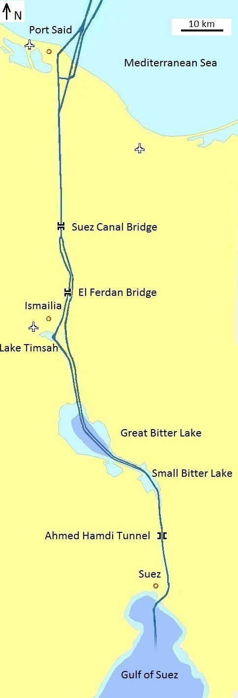
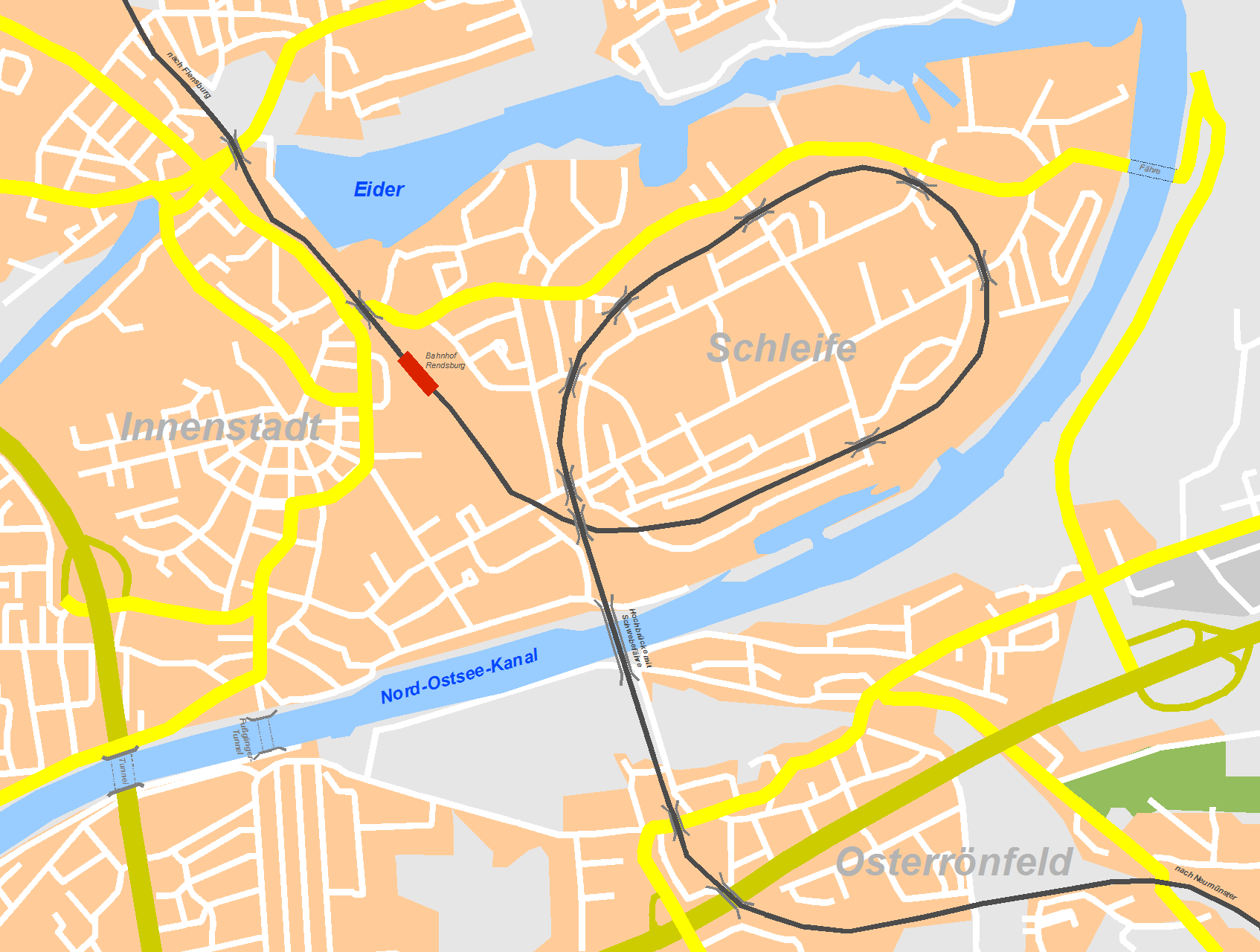
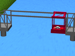
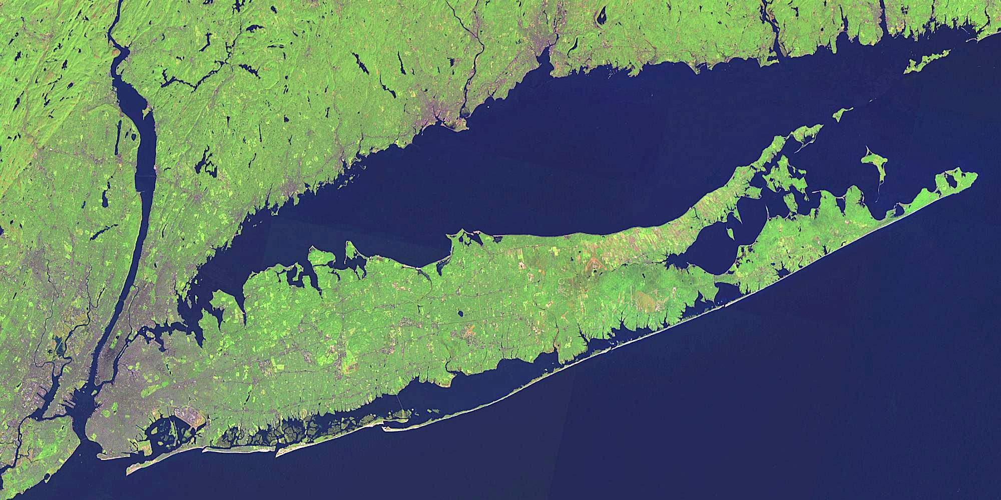
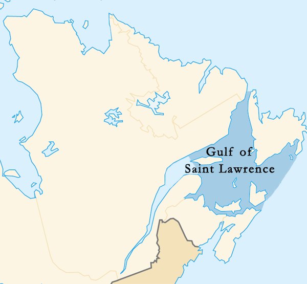
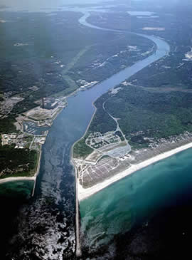
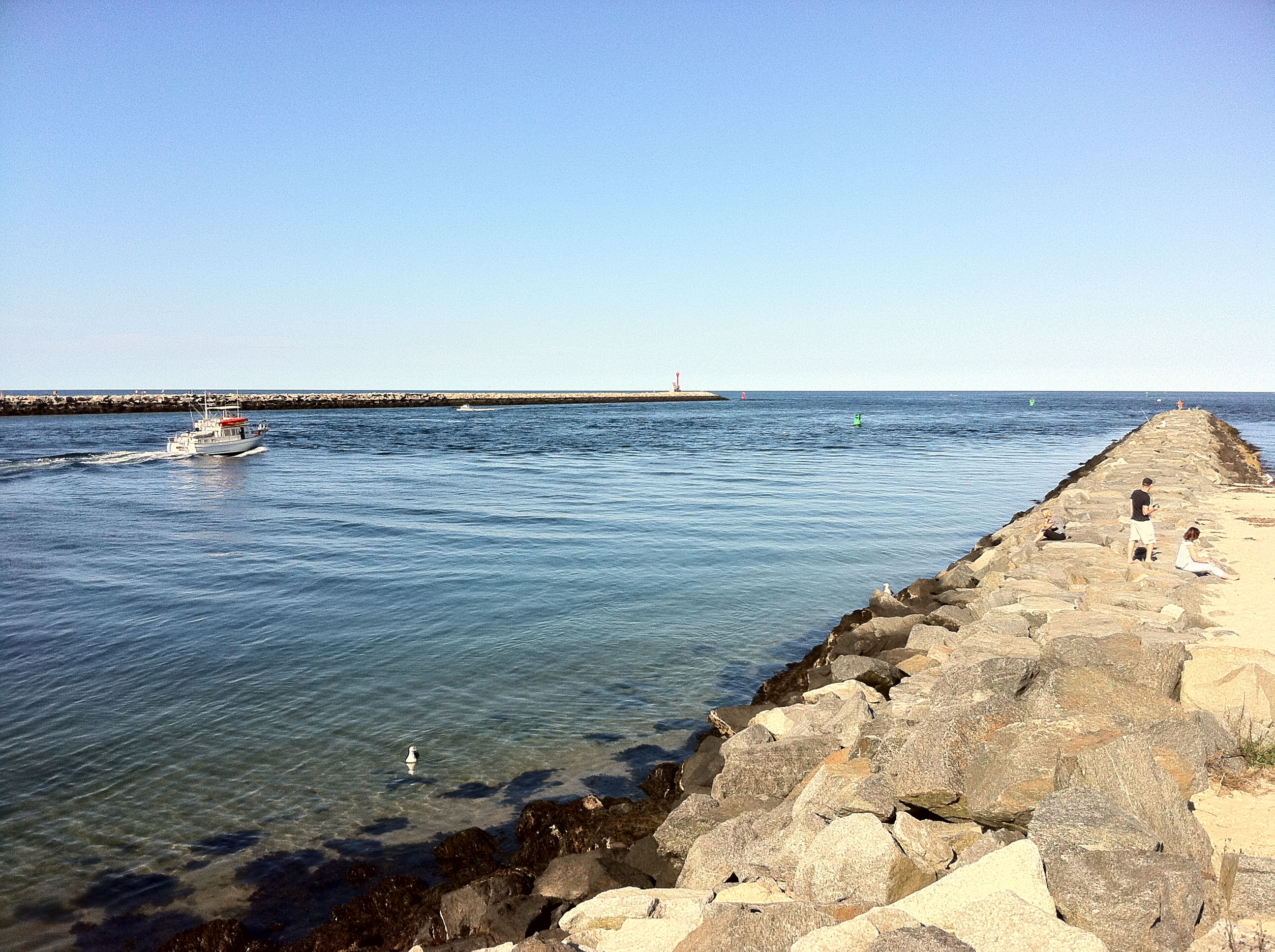
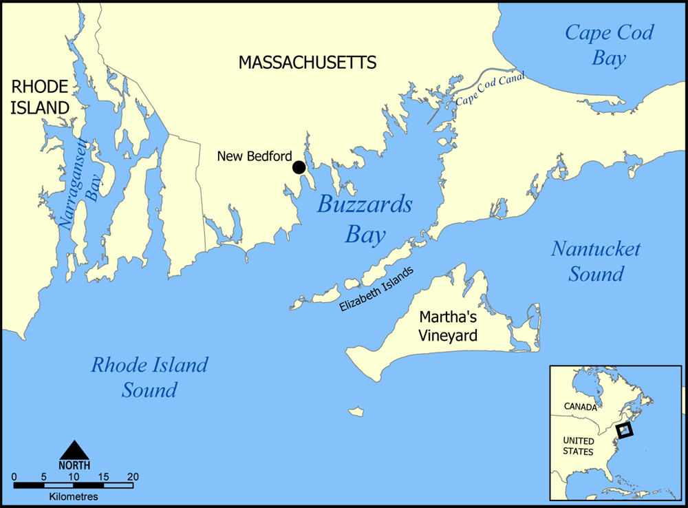
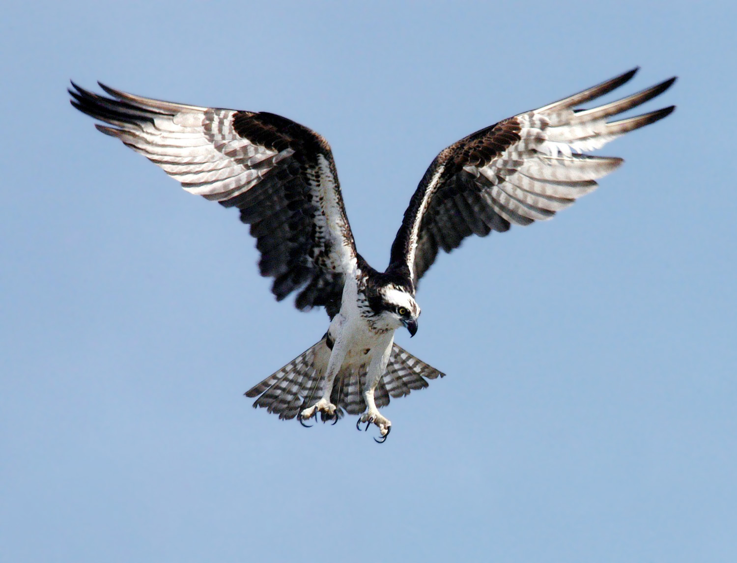
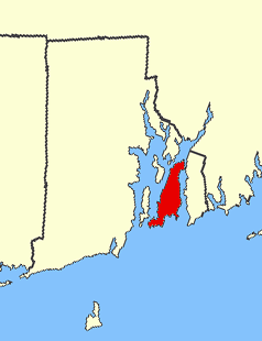
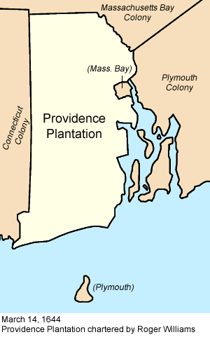
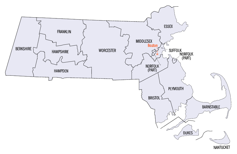