|
Reflections 2017
Series 15
August 26
TCC 150; Central Andes III: Bolivia I: Lake Titicaca in Bolivia; Berlin Redux
| | TCC 150 As I crossed under that graceful arch on the Peru-Bolivia border and also stepped over that pavement marker, there was extra significance for me in that Bolivia was the 150th destination I'd reached as a member of the Travelers Century Club (TCC) giving me, once I emailed the appropriate form in to the TCC, Silver Status, symbolized by a pin, a certificate, and mention in September's TCC newsletter. Since some readers won't know what the TCC is, I'll explain it again. | | | | The TCC has existed since 1954 for people who travel a great deal and have visited at least 100 destinations. It has chapters mostly in the US, but also in Canada, the UK, Germany, and Spain. Just as a student having studied for years wants that diploma to recognize his or her educational status, from the time I heard of the TCC decades ago, I wanted membership to recognize my frequent-traveler status. The "Century" in the name indicates the number 100, but the nice thing about the TCC is that it doesn't list countries, which for a frequent traveler is much too vague (colonies? islands? sub-national major divisions?). Instead, the TCC maintains a careful list of what is now 325 destinations, which are much more significant to a traveler. These destinations are a list of places distinguished by political jurisdiction. Thus rather than listing the UK as one country, it includes England, Wales, Scotland, Northern Ireland, Jersey, Guernsey, the Isle of Man (the latter being only one there I have not been to). While that is an extreme example, the point should be obvious. Not everyone who visits England also visits Scotland, and that should be recognized. Large islands and island groups are also considered special destinations, such as Sicily, Sardinia, Corsica, the Balearics, Madeira, the Canaries, the Azores, Svalbard (Spitzbergen). These are all integral parts of various countries, yet are separate destinations that the TCC recognizes. This is the current TCC list of the 325 destinations they recognize, which varies as politics change:
http://travelerscenturyclub.org/countries-and-territories
| | | | In December, 2004, on a Caribbean cruise on the Deutschland (2004/20; also 2013/7, Voyage 31), after stopping at some islands I'd already been to plus some new ones, I hit my 100th destination: I'm in Road Town, Tortola, British Virgin Islands, and I've never been here before. I've hit 100. I knew I would just make my last five on this trip. I have the application to the Travelers' Century Club in my luggage and will mail it when I return to New York. In 2004, Tortola was 100. As for recent years, in 2013, all four TCC destinations in China (Hong Kong, Macau, PR China, Tibet) were 145-148. In 2015 the Galápagos were 149. In 2017, Bolivia is 150. Other places stopped at in recent years were all repeats, including Ecuador and Peru (from the Caronia). It took 13 years to increase my total by 50% to Silver Status. | | | | I need to clarify my preferences about the TCC. I'd never been to a chapter meeting, which didn't suit my taste, but in early 2017, a private TCC member, Stefan, organized an ad hoc reception in a restaurant in Midtown, and I went, bringing friends Simi and Allan as guests. We enjoyed ourselves, but the evening was very revealing. We met several people who regard the organization pretty much as I do. These people had visited destinations perhaps in the range 100-200. We also met people who had much higher totals, and the feeling I got was that they felt differently about the whole thing, that it was more of a rat race to raise numbers. | | | | An example I like to use involves Pacific islands. I'd been to Hawaii and Easter Island, and later added the Galápagos. When it was time for a Pacific tour in 2009, I read up carefully on the numerous islands, and decided to go to the Samoas, Fiji, and the Society Islands (Tahiti, Bora Bora, others) and was fully satisfied. I read about Guam, Tonga, and so many small ones, and they offered me nothing of interest. On the other hand, Stefan and others were eager to exchange notes on how to reach the most remote, to me uninteresting, flyspeck places. | | | | So I now have in my mind's eye two groups of TCC members, those that tend to visit what I consider interesting destinations and those that who seem to travel to increase their numerical totals, where the importance of the destination is apparently of little consequence. To each his own, but I prefer my way to travel, which I consider quality above quantity. I respect the other group, but that's not my cup of tea. I also don't really expect to add many more destinations, and will be satisfied with my 150, or perhaps a little more. Revisits are great fun, as indicted by my upcoming visit to France in September. I've been there many times before, but there's always something new to do and see.
http://www.ezilon.com/maps/images/southamerica/map-of-Bolivia.gif
| | | | Bolivia As we're entering, after Ecuador and Peru, the third country in the Central Andes in this series, we should take a look at Bolivia, the poorest country in South America, particularly as it appears on this relief map (click). It might surprise some how much of Bolivia, often visualized as a mountainous country, includes the Amazon jungle, the same as with Peru and Ecuador. We see Lake Titicaca and how far into Bolivia that dried-up Lake Poopó actually is. La Paz is in the Andes, not far at all from Titicaca. Also in the Andes is Potosí, famous since Colonial days for its silver mines—also tin. We also see Sucre (SU.kré), indicated together with La Paz as a capital, which needs explanation.
| | | | Since the early 19C, Sucre has been the national capital of Bolivia, as recognized in its constitution, where La Paz is not mentioned at all. The Supreme Court is also in Sucre, making it the judicial capital as well. In the early 20C, the seat of government moved to La Paz, since Sucre was remote and the Potosí mines were in decline. We'll be visiting Plaza Murillo in La Paz, the location of the Palacio Quemado (the Presidential Palace) and the Palacio Legislativo. I suppose the bottom line is that, while technically, Sucre is the national capital, only the judicial branch is located there, with the executive and legislative branches being in La Paz, making it what is called the seat of government. | | | | | | You are probably aware of a similar situation in the Netherlands. According to the Dutch constitution, Amsterdam is the capital, although the legislative, executive, and judicial branches of government are all located in the Hague. So de jure, the capitals are Sucre and Amsterdam, while de facto the capitals are La Paz and . . . Amsterdam again! Somehow, Amsterdam manages to win out both ways, even without the government being there. It can also be noted that Amsterdam, with no branches of government, is zero for three, while La Paz does at least have two branches, making it two for three. |
| | | | There's again the curiosity of time zones. New York is in the same zone as Ecuador and Peru, while, to the east, Halifax lines up with Bolivia, one hour later. That sounds simple enough, but it works that way only in the northern winter. In the northern summer, much of North America goes on that blasted Daylight Savings Time, which means New York moves over to Halifax time. The Central Andes do no such foolish thing, so, when in mainland Ecuador, we ended up having a time change. The same thing happened when entering Peru this trip. But now, entering Bolivia, we're back on New York time, so we have to set our watches ahead an hour after we walk across the border. Then, flying back to Lima for, we again go back an hour during the layover, then return to La Paz/New York time on the final flight to New York. Crazy?
http://laketiticacatours.com/puno-photos/Lake-Titicaca-map.png
| | | | But our trip in Bolivia only has two segments, to see, following the Peruvian part, the Bolivian part of Lake Titicaca, and then La Paz. We will continue to use this map as a guide for the lake area, so let's review that. We've signed up for a Crillón two-night package tour, staying in two of their hotels, having lunch tomorrow in their restaurant, and riding on their hydrofoils, then we have an add-on for La Paz. It goes like this (see map). | | | | We've just crossed the border from Yunguyo, Peru. Today we visit Copacabana, then take a hydrofoil to Isla del Sol/Sun Island to spend the night in Yumani. Tomorrow we go down to Yumani Harbor for lunch, stop at Isla de la Luna/Moon Island, pass through the Estrecho de Tiquina/Tiquina Strait to stay in Huatajata. Then we go on to La Paz. Keep the map to follow our route. | | | | Day 10 (continued): Lake Titicaca in Bolivia: Copacabana & Sun Island/Yumani Only the very beginning of the day was in Peru, and here we've just met Maria, who'll get us through Bolivian immigration. We hope. | | | | However, this day would turn out to be the quirkiest of the trip, though everything would work out nicely in the end. Never forget Murphy's Law: Anything that can possibly go wrong, does. Day 10 turned out to be the day of two wonky misadventures, one governmental, one dealing the with the high altitude--in triplicate. | | | | Before 1914 there were no passports and no visas. People just came and went. WWI changed that, and governments got suspicious of each other. Despite the fact that visitors had money to spend, they were treated with suspicion, and had the burden of proof to show they were coming for legitimate reasons. In other words, they were guilty until proven innocent. | | | | For citizens of most countries visiting most other countries, a passport is all that's needed. At the border, the passport is stamped, and that's considered a "visa" giving permission to enter the country. However, some countries are sticklers. They insist you get a special visa, usually for a fee, usually in advance at their embassy of consulate, sometimes at the border. Often it's worth paying an expediter to do this for you. China was the worst. China had an online visa application of some 40 pages in Chinese and English, which an expediter's program helped me complete. I used the word "stickler" as a feeble punning attempt because visas you pay for are sometimes preprinted, gummed forms the size of one passport page that they literally "stick" onto a page of your passport, or sometimes tape it. Others are stamps, but, also large, full-page ones. I just checked two old passports plus my current passport covering the years since 1997 and I've found these visas, all full-page: Russia (sticker), Belarus (sticker), Brazil (stamp), Brazil (sticker), Zambia (stamp), Zimbabwe (sticker), Tanzania (sticker), China (sticker), Bolivia (sticker). I hope I found them all. | | | | I realize one of the biggest bothers is for those who want to visit the United States, which has a visa application and a fee. I checked an official website online and found this: The application fee for the most common nonimmigrant visa types is $160. This includes tourist, business, student, and exchange visas. | | | | The situation in South America is dodgy. Some countries, including Ecuador and Peru, require no visas and just stamp your passport on entry—and on exit, as we noticed. But a number of countries, obviously because of national pride, charge what is euphemistically called a reciprocity fee, which I call a spite fee. It's tit for tat—you charge our citizens, we'll charge yours. Travelers to South America have to be particularly careful, because these fees appear and disappear, and vary by country the visitor is from. I'll only mention two, which are already obvious above. Both times I went to Brazil, I was hit with a reciprocity fee of $160, in order to get my visa, and I knew well in advance that I'd pay the same fee again to enter Bolivia. | | | | I like to have all my ducks in a row, and wanted to be prepared, so I thought I might get the visa in advance at the Bolivian consulate in New York on 43rd Street. However, Coltur advised me it was much easier to do at the border. They also gave me a list of pesky other nuisance requirements similar to this list:
http://2.bp.blogspot.com/-kGRE1W5sxLw/VN6KnZmVyMI/AAAAAAAABXU/2o1xSi-RnU0/w1200-h630-p-k-no-nu/WP_20150108_005.jpg
| | | | I knew I had to have six months' validity left on my passport, but that's common for a number of countries. Still, that's what postponed this whole trip from Fall 2016 to Spring 2017, so I went to Canada which didn't need six months, then got a new passport. I don't know where the above list is posted—I just show it for effect--but the most current regulations Coltur sent me didn't include my Inoculation Certificate (which is up to date). What they did say I needed in addition to the $160 and application form (that had been handed to me in the van in Peru) was a copy of my itinerary (which I printed out at home), a copy of my exit ticket (I printed out the email of my flight back to Lima) and a printout from an ATM showing my bank balance (which I brought with me, and which they didn't need, after all). | | | | But that nuisance stuff was easy paperwork. The two big irritations were that they wanted a color passport photo of me that had to be just so. It would have been a big bother, but since I was getting a new passport anyway, I just got enough pictures. The other irritation was that the $160 had to be in US currency, and the bills had to be in good shape. I don't like carrying cash, and certainly not through South America, but I got eight twenties, folded them in a money belt I had, and carried them throughout Peru. Below is the Bolivian immigration station Maria and I walked into. I had all my ducks in a row. What could possibly go wrong? Wanna guess what caused my governmental wonky misadventure?
http://www.2fortheroad.co.uk/wp-content/uploads/2012/09/kasani-border-office-bolivia.JPG
| | | | Inside, there were three regular windows to get your passport stamped, and on the left was a fourth one marked "Visas". Londoners Brian and Maureen, with their own guide, went to a regular window and in no time were on their way to Copacabana. But Maria sat me, as a US citizen, down, took my stuff, and gave it to the gnome at the visa window. He went through the papers, and counted out the eight twenties. For four of them he said Problema. Problema. Problema. Problema. The other four were OK. María brought the four offending notes to me and showed me the problem. I won't ask if you want to guess, because you never will. Ever. | | | | At the bottom of each note, in the center where they had been folded, was a nick of something like 3 mm (1/8 in), and so the four notes were not pristine enough, and he wouldn't accept them, so only half my "ransom" had been paid. Was I to be a bride abandoned at the altar? | | | | | | We need a little more amplification. I must be understood that the US dollar is a standard backup currency in South America. Do remember when we said that Ecuador even abandoned its currency and uses the US Dollar in its place. That's why even in Cusco, both small restaurants were glad to accept US dollars in payment for dinner (I was glad I'd brought a lot of small bills so I could pay exactly and not need to get change in soles.) But I must say that one woman, when I gave her a twenty, started walking back with it, but then decided it was OK. Also, when we were in La Paz, María showed the hotel clerk the offending twenties from the border and asked if he'd hypothetically accept them in payment, and he said no. So it wasn't just the gnome that was acting obsessive-compulsively, the whole region does. Good US notes are pristine US notes, also without dog-eared corners. Apparently if they're fresh from the bank, so much the better. |
| | | | But María was unfazed. She asked if I had an ATM card with me and fortunately I did. "No problem" she said. "There's no ATM here at the border, but plenty in Copacabana. We'll work it out there." She said a few words to the gnome and he started processing my papers. He called me up to the window, and on the grille was a camera. He took my picture for the visa, which turned out to be black-and-white and printed out the sticker and stuck it in my passport. He gave it to me and we went to another window for the standard stamping, and off we went. Do you notice another problem worthy of consternation? If he took his own black-and-white picture, what happened to the color passport photo they had me bring with me? It's probably stuck to all the red tape in his inbox. | | | | | | At one point in the days I traveled with María I noted her excellent English and wondered if she'd been to the United States. When she said she'd been in Saratoga Springs (NY), I thought that an odd location, and inquired further. It turns out she went to Skidmore College for four years and got her degree in Latin American studies. (!) |
| | | | Now if I'd been a tourist on a commercial bus I would have held up the other passengers in the first place by my needing a visa, but with the invalid bills, the bus would have left and I'd have been stranded. If I'd come in my own car, I might have had to recheck into Peru and drive back somewhere looking for an ATM. As it turns out, María explained that, since Crillón was a trusted company, the clerk knew things would be all right. It was not much more than five minutes into Copacabana, and the driver stopped us off at an ATM. It wasn't working. We went to a second, which dispensed, to my surprise, both US dollars and bolivianos. María said they'd actually accept bolivianos instead of the US dollars they'd insisted on, which was great, but confused me even more. I tried getting dollars from the ATM and it suddenly said it was out of order. She was ready to move on, but I guessed the message was just stupidly phrased, and they were just out of dollars. Sure enough, on a second try it dispensed the 560 bolivianos we needed. After the driver dropped us off to sightsee, she gave him the Bolivian cash to take back to the border to pay my "ransom" after-the-fact, leaving me with $80 in US cash to carry around that I didn't need, and couldn't use in Bolivia, so I'd have to take it home. Thus the governmental wonky misadventure worked out—and made a pretty decent story.
http://www.mappery.com/maps/Copacabana-Tourist-Map.jpg
| | | | Copacabana Copacabana is the main Bolivian town on Lake Titicaca and I found it very pleasant. As the map shows (click), facing a main square it has a large 16C Spanish Colonial shrine, the Basilica of Our Lady of Copacabana, who is the patron saint of Bolivia. Over on the lake (note spelling), #8, at the northern end of the beach, indicates what is mentioned at the bottom as lanchas a las islas/launches to the islands (Sun & Moon). Note at the top Cerro Calvario/Calvary Hill. While we didn't go up there, this is a charming panoramic view of Copacabana from up there (Photo by Christopher Crouzet), looking south—I believe the hills in the distance would be in Peru. It was taken in the late afternoon (we're here in the late morning), so here we get to see the effects of a sunset on Lake Titicaca. Click to inspect the port area, near us in the north, from which we'll soon be sailing. I remember that gray building with the orange roofs as being where the Bolivian navy is, as we saw some sailors lining up for an exercise. Remember, the navy has only the lake to patrol. Swing to the left of the panorama where the Basilica is catching the sun's rays. Here's a detail of the Basilica and its compound earlier in the day, as we actually get to see it (Photo by User:Anakin). | | | | It was a figure in ancient Andean mythology named Kotakawana who is the source of the pretty, but unusual name Copacabana, which otherwise evokes a beach in Rio. Say both words aloud and you'll hear the similarity, since, disregarding the spelling with a K or Spanish C, the differences are only two: T developing into a P and W developing into a B. Kotakawana was the androgynous god/goddess of fertility who lived in the lake, and is therefore the equivalent of Greek Aphrodite or Roman Venus. | | | | Before 1534, Copacabana was an Inca outpost. Nearby Sun Island and Moon Island were then called Titicaca and Coati, respectively, and so the lake derives its name from Titicaca Island. The first Inca, Manco Cápac, considered the son of the sun god Inti, is said to have emerged from a prominent crag on Titicaca (Sun) Island, and so the Incas considered the crag to be the dwelling place of the sun, and a temple was built there. They considered Copacabana as the key to the shrine on the island. When the Spanish visited the islands in the 1530s, the old religion was abandoned and the Dominicans made Copacabana the center of their missions. The present Basilica was built where the Temple of Kotakawana had stood as one religion supplanted another. | | | | I was particularly impressed with the exterior of the Basilica (Photo by Henry.loayza), particularly the courtyard, which was in Moorish style. Click to see the detail, particularly the very Moorish mosaic-like patterns on and near the roofs, the domes, and the arches. I found the interior more mundane and less impressive. | | | | There is a wooden statue of the Virgen of Copacabana that is venerated across Bolivia, just as the famous Virgen of Guadalupe is in Mexico. But I found the story María told me about it to be odd to the point of humorous. We went up to the altar and at the top of it was a niche, inexplicably with a curtain over it. Maria explained that the venerated statue is in that open niche, but most of the time, it's kept facing Lake Titicaca, "watching over and protecting its lake". The curtain is there to cover the back of the statue. However, during Mass, the curtain is removed, and the statue is revolved so it faces inside, after which the process is repeated. This shows a fascinating transfer of inference. Kotakawana used to be patron/patroness of the lake, and oversee it, and now this statue of the Virgin of Copacabana does so. We then stepped into a side room that had about a dozen or more wooden copies of various Virgin statues, including one of Guadalupe, and one of Copacabana. However, this copy doesn't seem to have the same supervisory powers as the original.
https://elviajedetan.files.wordpress.com/2014/12/image2.jpg
| | | | We then had time to enjoy Copacabana, just driving around a bit, seeing excellent scenes such as above. It doesn't get much better than this. I'm tempted to use the word "costumes", which is totally improper, since these very colorful outfits are merely everyday wear, as are the bowler hats. Indigenous women dressed in this distinctive way, both Quechua- and Aymara-speaking, are called cholas, and, even more affectionately, in the diminutive, cholitas. | | | | There were plenty of people selling things. This woman sampling her own wares (Photo by Elemaki/José Porras) has a sign (click) boasting: Hoy: el mejor ceviche de Copacabana/Today: the best ceviche in Copacabana. | | | | The van then brought María and me down to the waterfront (Photo by Mac9). This is the marina (click), while the launches left from further to the right. We sat in a little waiting area and met the others, two Australian couples and the Londoners, until our hydrofoil arrived to zip us over to Isla del Sol/Sun Island. | | | | Isla del Sol The Isla del Sol, whether you've heard of it or not, is a major attraction in Bolivia. The Frommer guide gives it the maximum of three stars, even as La Paz gets only two. At the beginning of the guide it gives lists of "The Best of South America". Among "The Most Unforgettable Travel Experiences" are both "Floating on Lake Titicaca" and "Walking in the Sun's footsteps on the Isla del Sol", later calling it "one of the most spectacular places in all of Bolivia". Among the "Best Small Towns & Villages" is "The Isla del Sol", with its small villages with locals herding llamas on car-free dirt roads. Later it cites the largest village as being Yumani, on the south end. So this was to be a major stop on my list. With no vehicles on the island, I realized much of the high rating involves hiking across the island to reach sites and get views from other sides, possibly staying for more than one night. But I wanted to see what I could, the package included one night, and Yumani and the hotel looked very enticing. | | | | | | A quick flashback. Beverly and I have always relied very strongly on the Michelin Guides, since they rank sites, hotels, and restaurants, which we always found extremely helpful, rather than merely listing them. I give Michelin Gold Status. Also giving star rankings are the Frommer guides, which I give Silver Status. Arthur Frommer first published "Europe on 5 Dollars a Day" in 1957, which revolutionized travel, showing people it was not necessary to spend a fortune on room and board. Beverly and I used it for years, even as the title changed to $10 and more. Yes, for students and young teachers on a tight budget it WAS possible to do, at least in those years, and we did it. It only dealt with major European cities, but had a supplement at the end called something like "A Tale of Many Cities", which listed readers' write-in suggestions. In later years, the format of the Frommer guides was totally reconstituted by world regions, as it remains today.
However, stopping in Genova/Genoa in November 1971 to sail back home on a freighter, the Tuhobić (2013/7 Voyage 8), we discovered pesto sauce for pasta. I now know Genoa is famous for it, but it was new to us, and I don't think it was known very well internationally at that time. We wrote in the names of the two Genovese restaurants we had enjoyed it at, and were published by name the next year under "Genoa" in the "Many Cities" section of $5 a Day, receiving a complimentary copy. Tales from the past.
|
| | | | The point is, I was determined to see the Isla del Sol, even on the package's one-night and two half-days. But I was concerned, since it would be the highest place on the trip, higher even than La Paz, and higher than any place I've ever spent the night, and I didn't want anything to go wrong. Which is why the caveat bothered me that Crillón explained on its website, that from the boat there was a "45-minute" hike necessary to the hotel along an Inca trail they romanticized as a "llama trek", since there are indeed plenty of llamas on the island. I didn't like that caveat from the get-go, given the altitude, and I'd considered dropping the visit to the island completely, which would have been a major change. | | | | But I'd searched online, and one former visitor mentioned that you could get a free mule ride instead. Now that really intrigued me. I've ridden various animals, but never a mule, and that sounded like a lot of fun, in addition to solving the practical issue of long walk uphill at that altitude. I'd contacted Crillón well in advance, and they wrote back, claiming that on arrival, trekking/climbing can be done in 30-60 minutes, most visitors doing it in 30. Some like to walk slowly and take pictures, or faster. And yes, they could also provide me with a free mule to get me to the hotel (Photo by Juan R. Lascorz). It seemed like a totally win-win situation—I not only wouldn't have to worry about exertion at high altitude, but I'd have a new animal-riding experience. While still in Peru I mentioned the mule and Abad, the guide, laughed at me, thinking I was kidding. Then he got on his phone to check, after which he agreed that the mule would be waiting. | | | | I did find this quote online somewhere: Regardless of your destination, plan on hiking at least 30 minutes uphill from the boat port. Nearly every property is staggered high on the slope, which means that both altitude and fitness should be taken into consideration. I digested this information as well, but if they were providing me with a ride up the slope I knew was there, all bases seemed to be covered. What could possibly go wrong? I'm sure you weren't able to guess at how my wonky misadventure with the visa went wrong. Wanna try again? | | | | I've decided the best way to tell this story—and it was a really memorable series of events—is to first summarize the three parts of this wonky misadventure involving the altitude problem, and then to narrate the actual story, while also explaining the research I did post-trip that finally allowed me to understand why Crillón set the arrival up in this very peculiar way. | | | | WONKY MISADVENTURE SUMMARY: (a) I'd assumed the mule would be waiting at the dock, and that I would then slowly ride up a rising path to the hotel. Easy. That's what everything written had led me to believe, but that wasn't the case. We had to first climb a winding dirt path up a cliff that was the equivalent in height to a mid-size high-rise building. The mule was waiting at the top. The others seemed to manage it reasonably well and went on to the hotel. I did make it, with help, but it was much harder for me. (b) When I reached the mule and tried a graceful mount, I slipped and slid down underneath the mule. (!) (c) When the mule ride got going, it was a very rough ride. I felt like a rag doll being bounced in all directions most of the way.
http://images.summitpost.org/original/308397.jpg
| | | | I'd printed this map out to have with me as a guide at the time, but it didn't actually help very much, because I hadn't gotten decent explanations of how the planned route coincided with the map. I now understand it perfectly, and understand much better the altitudes involved. | | | | Don't be misled by the fact that the map is a double map. The main map is on the right, with the enlarged, detailed inset on the left. It should really have a darker dividing line between the two. One thing it makes totally clear is how the Isla del Sol/Sun Island is actually a breakaway piece of the peninsula Copacabana is on, while the Isla de la Luna/Moon Island just stands off to the right. It becomes easier to understand the close relationship the Incas had between Sun Island and Copacabana. | | | | Click to find Copacabana at the bottom of the main map and follow our hydrofoil route through the Estrecho de Yampupata/Yampupata Strait which separates the island from the mainland, and past tiny Isla Chelleca/Chelleca Island. But what are those two possible landing sites? Pillku Kaina (with many other spellings) is an Inca temple, and the Escalera del Inca/Inca Stairs, is another landmark. The inset map shows this in detail, and that the stairs are near Yumani, which is where the hotel is, but how will all this work? How will my mule get me from the dock to the hotel? And which dock are we talking about? Why didn't anyone tell me anything of value? | | | | | | At this point we can bring in a geographical note, that Sun Island is about 9 km (5.5 mi) long and 6 km (3.75 mi) wide, making it the largest island in Lake Titicaca. All the roads shown are dirt (and carless), and the terrain on this rocky, hilly island is harsh, more suitable for hikers than other visitors. How does this jibe with the mule ride? |
| | | | It was only on arrival that I found out that we, counterintuitively, were docking at the southern pier, the one below Pillku Kaina, and only standing on the dock did I see there was no mule at the dock but a steep, zigzag path up a barren slope past the temple. María said the mule was at the top, that this part was too steep for the mule. No one had clarified this in advance. This is a partial view of the slope (Photo by Phil Whitehouse) we encountered. We're looking south to the mainland, and see the strait coming in from the right, plus that little island. We see the dock, and the Pillku Kaina Temple roughly halfway up the steep slope (click). Maybe three-quarters of the way up, we see some wild mules frolicking, but the man with our mule would be higher up than that. | | | | I will admit that the others on the boat started up the path and did seem to make it to the top, then moved on to the hotel. I didn't think I could make it, but María took me by the right elbow and we'd walk ten steps, then rest, then ten more, and sit on a rock. I found it very hard going. | | | | We finally reached the temple and sat down in front of it. As I was catching my breath a bit, I could notice the typical trapezoidal windows. This view outward, from the interior gives an idea of the height above the dock, and this is only halfway up the lungbuster path (Both photos by P. beaudroit).
http://www.rontravel.com/Web_Photos_Happy_Cannibal/K_South_America/Bolivia_Titicaca_Island_Sun_Woman_Llama.jpg
| | | | About three-quarters up we came across a woman in native dress with a llama, similar to the above picture I found online. Only now, in a dreamy backflash, can I appreciate the quirkiness and humor of the very touristic moment, at which point María explained that it wasn't an accidental meeting, since the woman was a Crillón employee. I suppose that goes for the llama as well. Perhaps you could call them "trail decoration". Then, probably because María and I were the last ones coming off the boat, the woman with her llama continued up the path behind us up until we—at last!--reached the mule and its handler waiting on the main path above. I thought arriving up top would be the end of the wonky misadventure, but I soon learned it was only the first third that was over. | | | | But before we continue, I'm exceedingly pleased to have figured out a number of things involving the climb, the altitude change of the road from here to the hotel, and the descent the next day, all stuff no one would tell me while I was there. To figure that out, I resorted to a tool I used in Ecuador to determine the height of those magnificent hotels the train stopped at for overnighting, La Andaluza (2015/15) and La Ciénega (2015/16). If you want to play the "game" yourself, go to www.elevationmap.net and type in "Isla del Sol, Bolivia" and search around. Otherwise, just follow my lead. Just keep in mind, when you're measuring down from a satellite, you have to allow some margin or error in the readings.
http://tinyurl.com/ycv22clv
| | | | If you follow this link, you'll see I have it set at a screenshot that shows, aside from the narrow width of the island here at its southern end (click + to get closer), the dock, Pillku Kaina in the middle, and the red marker showing the location of the waiting mule, where the winding uphill path meets the dirt road. Here are the altitude readings I got. You can check them yourself afterward, allowing for that margin of error. | | | | | | The waiting mule: 3,876 m (12,716 ft)
[Pillku Kaina Templo del Sol: 3,855 m (12,646 ft)]
Lake Titicaca 3,836: m (12,584 ft)
|
| | | | If you subtract the altitude of the lake from that of the mule, you get a difference of 40 m (131 ft), with the Temple being just about halfway to the top. If you allow a generous ten feet per story, the climb we took is equal to a 13.1-story building, and that at this high altitude. If Crillón HAD made that clear to me all those months in advance, I might have cancelled this stop, just like I ended up cancelling Taquile Island with its 550 steps at the last minute (2017/14). I've since read that Peru, in its rivalry, promotes Taquile Island as it's "answer" to Sun Island in Bolivia. Only now do I see why. [If you like, you can move along on this screenshot up to the hotel, but it's not necessary, as I'll be providing another screenshot when we get there.] | | | | Up top, the mule faced right, in the direction of the hotel, and the handler was in front. The woman and her llama took up a position near the right side of the mule. The mule's left side, the mounting side, faced inward as I arrived, adjacent to a low stone retaining wall holding up a slope of earth. María had me go around the mule and onto the slope, so I could stand on the narrow retaining wall, which was just the height of the stirrup. All I had to do was move my left foot from the wall into the stirrup, then swing my right leg over the mule. What could possibly go wrong? | | | | My right foot slipped off the narrow top of the wall. My left foot started toward the stirrup, but never made it. I slid—slid, not fell, as María feared—down along the low wall and UNDERNEATH the mule. I ended up looking upward at prime mule belly. I was fine, except that I'd lost all dignity long before this. The only scary thing was when the handler then walked the mule forward, and both hind legs stepped over me. I'm glad mules are sure-footed enough to know what they're doing! So I got up easily, got up on the wall, and mounted the mule with no trouble at all. It was going to be a fun ride. What could possibly go wrong? | | | | The last third of the wonky misadventure was the ride itself to the hotel. Let me start by making sure we're all on the same page as to what the horn on a saddle is (Photo by Borsi112). It's that knob-like appendage attached to the pommel, the upper front of the saddle. It's more than decoration. It turned out to be my life-line, since I clutched it tightly with both hands during the entire ride so I wouldn't be jostled off. The first problem was that, the handler, holding the reins, started walking at a rapid pace, and the mule followed his lead. I suppose I should have objected, and told him to slow down, but I was bouncing too much, and never got to.
http://desto3.com/wp-content/uploads/2017/03/Bolivia-10.jpg
| | | | The second thing is that the road kept on rising, often with primitive steps such as in the picture. You can see why Crillón referred to it as a llama trek. When the mule went up a step, I was thrown back. When the hind legs followed up the step, I was thrown forward, all while being jostled side-to-side, frequently with a precipitous drop on my right. However, there was plenty of local color all the way, as in the picture. | | | | After a while, I wised up. Though it was even less comfortable, I stood up slightly in the stirrups. My weight on the two stirrups, plus the horn, gave me three solid points of contact with the saddle and mule. After a while, I asked the handler in Spanish if it's what, another 10-20 minutes? When he said Media hora, my heart sank. Another half-hour? | | | | I suppose I'd over-romanticized the thought of mule-riding based on Ferde Grofé's On the Trail from his Grand Canyon Suite, described in 2016/7, where we had Leonard Bernstein conducting the New York Philharmonic for 7:29 on YouTube: On the Trail. At that time I wrote: It involves the guided mule ride one can take down the precipitous trail from the rim of the Grand Canyon to the bottom. The selection is notable for the music evoking the obvious rocking of the mule ride . . . . I never rode a mule when I was at the Grand Canyon but was seduced by the rocking, gentle, sweet ride indicated musically at 1:33. Yet in Bolivia, the ride for me seemed more like the bouncy, speeded-up ride at 6:36! It wasn't quite like that, but it seemed so!
http://l450v.alamy.com/450v/c0wxjf/elderly-lady-with-donkey-on-sun-island-lake-titicaca-bolivia-south-c0wxjf.jpg
| | | | About halfway to the village of Yumani and the hotel, while I cannot say the ride became more comfortable, it did become more tolerable, especially when a comic interlude occurred. The above picture only sets the scene, of the landscape and of the two players. As the event actually happened, it was a bit different. In front of us on the road, going in our direction, was a native woman trailing behind a donkey, holding on to a rope around its neck. At one point, she became distracted, and dropped the rope. Seeing an opportunity, the donkey suddenly ran off, with the woman in hot pursuit. Thus the scene showed a donkey with a trailing rope, a running woman, a mule handler, and Raggedy Andy bouncing on muleback. It must have been priceless. In a few moments, the donkey turned to the right to munch on some greenery it found, and the woman picked up the rope, then turned and smiled the biggest smile to us. It was a very simple, but great moment. | | | | | | While the rest of the half-hour ride ticks away, I can contemplate my five lifetime animal-riding experiences. Most were disasters, but one was an outstanding experience. They were, from worst to best:
CAMEL1: Talking about the Mexican pyramids in 2017/9 I mentioned our visit to the Egyptian pyramids in August 1965. It was unbelievably hot, so much so that, as I spun around, my heavy, horn-rimmed glasses spun off my head, hit the ground, and cracked a lens. The guide was having it repaired, so my vision was fuzzy when we got to the pyramids. Beverly and I were put on camels walking past the pyramids, which itself was too much at once—should you concentrate on enjoying the pyramids or the camel ride? But the very worst was that, tugging at our right pant legs were the handlers demanding tips: Baksheesh! Baksheesh!. Horrible.
ELEPHANT: Rather than recount the experience again, go to the trip to Thailand in 2010/18 and do a Ctrl-F for the paragraph headed "Elephant Ride". It was like sitting on a cafeteria tray, gripping on to the edge so you didn't fall off; otherwise like being on a window sill one story up with your legs outside during an earthquake. Go read it.
MULE: I suppose the current mule ride fits somewhere in the middle.
HORSE: We just talked in 2017/13 at the horse show about Beverly and me riding in the Dominican Republic on Paso Fino horses in incredible heat and direct sun for 1 ½ hours, with the group of horses trailing each other and each of us having no real control of the reins. It was OK, but if we'd been alone, I'd have cut it short after 20 minutes.
CAMEL2: It's ironic that the most delightful experience by far ever riding an animal—actually, the only really good experience—brings us back to the camel. It was in Australia in the center of the Outback near Uluru ("Ayers Rock") and was billed as a Camel Sunset. I just reread the short account in the posting of 2010/20 and suggest you take a look, including two short videos. Do a Ctrl-F for "Camel Sunset", and go to the second click. Wonderful.
|
| | | | It only now strikes me that the mule ride was the only animal ride I ever took that was real transportation. Taking a cruise on a ship nowadays is just a touristic "going for a ride" and almost never involves arriving—and staying—at some destination. Transatlantic crossings are genuine transportation, as they always had been, if you stay on the other side for a visit. If you fly right back, it's a touristic "going for a ride" again. On the Rideau Canal, those of us who stayed in Ottawa on arrival and then continued further, got more out of the canal ride having used it as originally intended. Those that got on the provided return bus to Kingston to pick up their parked cars, not so. More recently, the train ride to Puno was genuine transportation for the few of us who stayed in Puno and then went beyond, not so for those who flew back to Cusco, or home. With all this in mind, look at the animal rides above. Four were "going for a ride". Only the mule ride was genuine transportation from Point A to Point B with no backtracking, which, as rough a ride as it was, makes me appreciate it that much more. | | | | Not too much longer after the running donkey escapade, we approached Yumani. This Sun Island village street scene (Photo by Ximena Medina Sancho) could possibly be Yumani—click for the distance view--but in any case, portrays the charming atmosphere of the area. | | | | Our destination was a hotel run by Crillón Tours (which also owned the hydrofoils, the restaurant down in the harbor for tomorrow's lunch, and tomorrow night's hotel—you can see why this was a Crillón tour). But the hotel for tonight here in Yumani was what I was particularly looking forward to after all this trouble. It was called the Posada del Inca. The first word means "inn", already a cozy image, and so the superficial translation is the Inca Inn. It's accurate, but the translation is ambiguous. What do you understand is the reference here? Hint: think plural versus singular. | | | | Even if you translate the name, not in the Germanic word order, but in the Latinate word order "Inn of the Inca", you can still get the inference in English that it refers to the entire Inca people, which it does not. If it referred to everyone, it would have been called Posada de los Incas. I'm sure most guests don't realize—or care—that the Inca Inn refers to the one and only Sapa Inca, perhaps the first one that legend says was born here of the Sun, perhaps not. But the name is definitely much more of a local island reference than I'm sure many visitors realize, and is a fact only attainable by knowledge of the language. | | | | | | Regarding the primitive nature of the island, Frommer's guide had warned: Most of the accommodations . . . are, to put it kindly, rustic. Very few rooms have private bathrooms, and it's almost impossible to find a hot shower here. But once all the day-trippers leave, you will have the island to yourself. I think it's worth it to stay here just to feel the magic of the island. This was one of the many things that intrigued me to come here, and to endure a mule trekking over a so-called llama trek. But the guide continued: There is one exception to the rule, however: Crillón Tours's Posada del Inca ** [two stars] is probably one of the best hotels in all of Bolivia. By Sun Island standards, it's luxurious—all rooms come with private bathrooms, hot showers, and electric blankets (a nice touch on those freezing nights). The Spanish-style adobe hotel feels like an old farm. The rooms are cute, with handmade bamboo beds and Andean area rugs. Overall, the hotel is unbelievably charming.
I rarely pay attention to the Fodor guide, since in my experience, it doesn't have a ranking system, but online it said: Your stay at this lovely posada begins with a 30-minute mule ride . . . from the boat dock to the garden-lobby, where fruit trees shade handmade reed couches. Rooms in this beautifully restored colonial-style hacienda are attractively furnished with reclaimed wood, and all have private baths. Hot-water showers, wall heaters and electric blankets are all powered with solar energy. The hillside location offers sweeping views of the lake. It also added that . . . guests gather around the fire in the cozy bar . . .
|
| | | | Because of the use of solar energy, the full name of the hotel is the Posada del Inca Eco-Lodge. I'm a little bit startled with Fodor talking about a 30-minute mule ride from the boat dock, as no one else was involved, and leaving from the dock is a gross exaggeration. Otherwise, I'd looked forward to all these features, they proved to be accurate, and I ended up enjoying them all.
http://www.aracari.com/wp-content/uploads/2015/10/Resize-posada-del-inca-eco-lodge-1.jpg
| | | | This is a picture of the Posada del Inca that I like a lot. Still, I have to call it the picture of the two lies. First, it was taken from an upper part of Yumani that I never went to, since my arrival was exerting enough. I therefore can't be quite sure just where the entrance gate is in this picture from this angle. But the main lie is those beautiful mountains. We'd been told that there are snow-capped mountain views from all along the lake, including views from Yumani, as here; views from the ride to La Paz; and views within La Paz itself. But while the weather can be relatively clear, mountains notoriously get socked in, and I never saw a flake of snow on top of a mountain such as this. Anyway, that should be Isla de la Luna/Moon Island in the mid-distance. | | | | | | But never let it be said that I never saw snow-covered Andes at all, because I did see them vertically. I wrote the following in 2006/14, on the Antarctica trip, flying from New York via a stop in Lima to Santiago de Chile. In other words, it was somewhere between Lima and Santiago, right in the present area: I was glad I had thought to get a window seat on the left, because I saw the Andes from above. Nearer the coast they looked black-brown, but just a bit more inland, they were snow-covered. I don’t mean with a solid ice-pack, but with snows going down valleys, giving all those mountains a black-and-white-striped zebra effect. It was very impressive. That'll do me. |
| | | | Thankfully, as we entered Yumani, the handler slowed his pace and Raggedy Andy on muleback settled down a bit. While I see now that we never reached the upper parts of Yumani, we made a turn and arrived at the adobe wall of the Posada del Inca, as the first picture shows:
https://media-cdn.tripadvisor.com/media/photo-s/06/b6/00/f7/posada-del-inca-lodge.jpg
https://media-cdn.tripadvisor.com/media/photo-s/07/ca/96/43/posada-del-inca-eco-lodge.jpg
https://media-cdn.tripadvisor.com/media/photo-s/08/00/85/21/posada-del-inca-eco-lodge.jpg
| | | | The double-door wrought-iron gate was kept closed by a loose chain, which the handler undid as he led the mule and me inside. I was immediately aware on entering that I'd read the term "garden-lobby" (second picture), which is exactly what it felt like I was in. It even looked like a hacienda, and had the Spanish-style barrel tiles on the roof. On this picture, note the picnic table and double benches on the right. We pulled right up to the table (third picture), where a couple was sitting on the far side of the table. It was an Australian couple, not one of the recent ones, but the one from Tasmania I met on the Belmond Andean Explorer, before Puno. Small world. I quipped to them "This isn't as elegant as it looks!" They laughed, but in retrospect, maybe it was a somewhat elegant way to arrive. Or at least, rather unique. | | | | The handler guided the mule's right side, the dismounting side, next to the closer bench, which I stepped onto with my right foot as I dismounted, quite gracefully this time, I'm pleased to say. As the handler and mule left, I sat down and thoroughly enjoyed being there for a good long while, talking, taking in the glorious lake view to the east, and enjoying the ambience. Someone came out from the house with a cup of mate de coca/coca tea, which never does me much good, but was nice and warming. The interlude here was one of the nicest of the day.
http://www.rainbowtours.co.uk/upload-files/product-hotels-gallery/b/posada-del-inca-eco-lodge_2_posada-del-inca-eco-lodge.jpg
| | | | María appeared from somewhere and showed me to my room. This picture gives a good idea of what it was like, except that mine was a cozy single room, with a single bed. While one review called the handmade bedframes bamboo, and the other reclaimed wood, the style, along with the wall hangings, rugs, and brown ceramic bowls and vases added to the traditional Andean atmosphere. I was so glad that Frommer pointed out how rare modern facilities are on the island, making the bath with shower (see picture) that much more enjoyable. At 3,936 m (12,915 ft) the Posada del Inca in Yumani was the highest altitude I ever spent an overnight at anywhere, including Ecuador and Tibet. Being high on the island, it was even slightly higher than the next night's hotel on the lakeshore and which itself was slightly higher than the later stay in famously high La Paz, which lies in a bowl, somewhat below the level of the Altiplano. Keeping in mind both the altitude and the approaching winter season, find the white control box on the nightstand and white cord connecting to the electric blanket, another modern amenity well appreciated along with the Andean ambience.
https://media-cdn.tripadvisor.com/media/photo-s/08/00/84/c6/posada-del-inca-eco-lodge.jpg
| | | | But it was still afternoon and there was time to look around inside the Posada. Notable was the inner patio with its sitting area, where the review had referred to fruit trees and handmade reed couches. I assume they were also made of the totora reeds that the boats were made of (and those islands on the Peru side!). While it was too late in the season to sit here unless the sun warmed it up, it was still enjoyable to see. After peeking in to the lounge, María and I proceeded to the comfortable dining room (below), where a late lunch was being served. I think the full group consisted at this point of the two Australian couples, the Londoners, and me, each with their own guide.
https://media-cdn.tripadvisor.com/media/photo-s/0a/86/9b/1f/posada-del-inca-eco-lodge.jpg
| | | | Afterwards, since the afternoon continued to be at leisure, I remained comfortably ensconced at the Posada. But at dinner that evening, the Londoners said they'd gone with their guide to see the sunset. Remember, we're on the eastern side of the island, looking further into the Bolivian side of the lake, so we didn't face any sunsets. The Londoners hadn't had all that much trouble climbing at the dock, but they said this time their guide took them to a spot to look west towards the sunset, and claimed it was easily four times as difficult to climb as earlier—and that despite the fact that they'd brought (collapsible) hiking sticks with them. I think I know enough when to stay put. | | | | But there was one great advantage being at this altitude, in the rural Andean darkness we'd been having, particularly since that week was moonless—you could see the stars! The sky was as clear as any I'd seen and the view was beautiful.
https://media-cdn.tripadvisor.com/media/photo-s/08/c1/6b/f4/posada-del-inca-eco-lodge.jpg
http://www.titicaca.cruises/wp-content/uploads/2016/07/POS003.jpg
| | | | After dinner, I had my mind on that fireplace I'd heard about in the lounge, and asked everyone if they wanted to join me there. It was disappointing that the Australian couples wimped out and wanted to go to bed early, but Brian and Maureen—we were at the same table—were ready to do so. María came with us to light the fire, which was already set, but didn't stay (first picture). Other than that, the three of us stayed for well over an hour, enjoying each others' company and the cozy pre-winter Andean atmosphere gathered around the roaring fire in this "lodge" (second picture). It being off-season, the bar wasn't open, but that was not a problem. This cozy pre-winter Andean atmosphere, in retrospect, was the same I enjoyed two years earlier in Ecuador. I was up in the mountains approaching Quito at exactly the same time then, the end of May to the very week, and remember the coziness of the country houses La Andaluza and La Ciénega (2015/15-16). | | | | Day 11: Lake Titicaca in Bolivia: Sun Island/Yumani & Huatajata After breakfast, the morning was also at leisure. But it was overcast and chilly, and without the sun, you could feel the approaching winter. Afterward, everything cleared up, and we were back to normal. It was a morning spent around the Posada, and in the cozy room. At around noon, it was time to leave, but leaving had always been intended to be local, within Yumani. María and I left a little earlier than the others, since I needed more time, and we descended down to Puerto Yumani/Yumani Harbor, with me using a tall walking stick María had gotten hold of, which was surprisingly helpful.
http://c8.alamy.com/comp/C0WYTN/incan-steps-up-to-yumani-sun-island-lake-titicaca-bolivia-south-america-C0WYTN.jpg
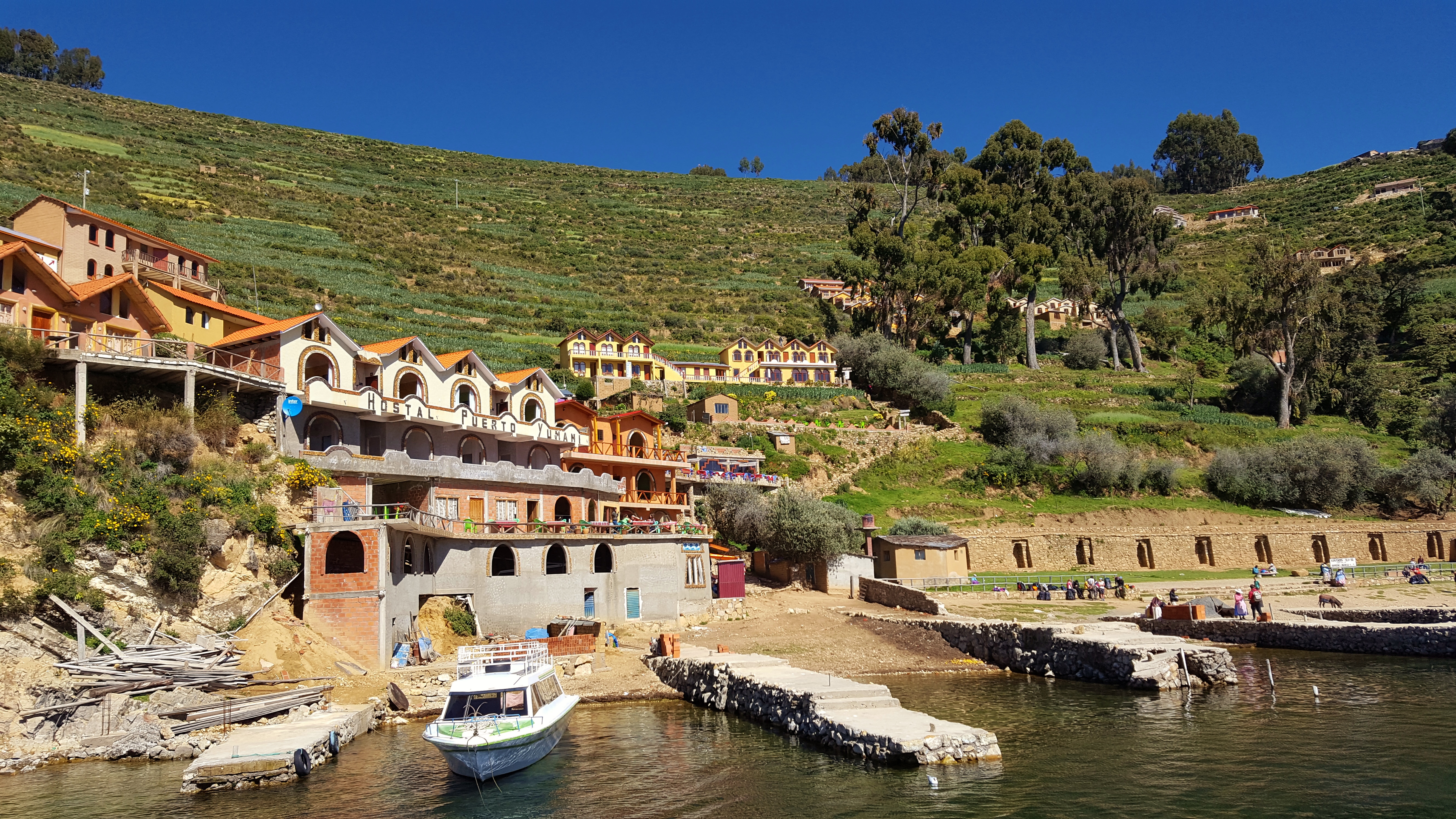
| | | | Again, the steps were not always ideal; sometimes a step was just rocks to be maneuvered over or around. But this route definitely had its charms. In my mind's eye, Yumani is like a barbell. The main town, some of it higher than the Posada, is one ball, and the other ball is Yumani Harbor (Photo by Chtiwiki)—click to see the Hostal Puerto Yumani--the urbanized route downward being the bar connecting the balls. Thus, it was just like walking through the town, just downward, with houses, kids playing, and areas where women were displaying their crafts. As we got nearer the harbor (Photo by Alexson Scheppa Peisino) and close to the bottom, but not yet at it, there was a sharp turnoff to the left, and in a few moments down a side path, we are at the Uma Kollu Restaurant for lunch.
https://media-cdn.tripadvisor.com/media/photo-s/06/b5/ff/a0/posada-del-inca-lodge.jpg
| | | | I knew this had been the plan all along, and also that the restaurant was another property belonging to Crillón Tours, but I didn't expect lunch to be outdoors on a grassy terrace (above) with a beautiful panoramic view over Lake Titicaca, though not so high above it as we had been. Everyone had their own table, with their guide, but I went over and spoke to the Londoners, to learn they'd be leaving us. They'd be taking a hydrofoil to Moon Island as we'd be doing, but then going back to Copacabana and Puno. It seemed a little odd to have come this far and not go to La Paz, and then to backtrack so much, but so be it. | | | | The last things to see in the area of Yumani Harbor were the Fuente del Inca/Inca Spring, universally mistranslated as "Inca Fountain", which it is not, and, descending below it, the Escalera del Inca/Inca Staircase. Note again, as with the Posada del Inca, we're referring just to the individual Sapa Inca here, a fact lost, I'm sure, on most visitors. The Staircase was usable, but ran parallel to the main stairs we were coming down, and we didn't actually need to cut over to use it. Coming down the regular stairs, the Inca Spring (Photo by Pavel Špindler) is just off to the side, at the head of the Inca Staircase. You really must note how much more lush this area is than the arid area where we originally docked. While this picture shows the steps so nicely, the below similar picture shows the triple outlets of the spring.
http://www.andeantreks.com/sites/default/files/INCA%20STEPS%20SUN%20ISLAND%202%20CR%20LB.JPG
| | | | María explained an interesting fact, that the water in the spring is not from the island, but from the snow-capped mountains opposite (that we never saw) via an aquifer underneath (!!) Lake Titicaca. That was proven by a standard-type experiment I've heard about in the past where harmless dye is entered into the water, in this case near the mountains, and in time, it appeared in the Inca Spring, proving the connection underneath the Lake. | | | | At the bottom of the regular stairs, we can cut over and get a better look at, and up, the Inca Staircase (Photo by Pavel Špindler) leading back up to the spring, whose overflow can be seen (click) both above and below. But to be totally honest, I just viewed this from the bottom of the other steps. The Inca Staircase is brutally overrestored, and those two painted statues are pure kitsch, reaching the threshold of being ur-kitsch. They belong in a carnival sideshow, not here. | | | | We have a YouTube video of Yumani and the Posada del Inca. It's a commercial video, put out by Crillón Tours. If you've been paying attention, you'll recognize everything you see in it without comment by me. It only runs 0:59, and, since they were trying to squeeze in as much as possible, it moves quickly. I suggest you pause it repeatedly, even every 2-3 seconds, to inspect details, from the inn, down the steps, to the restaurant. Here's the video. | | | | It's now time for the last thing we promised, measuring the altitude between Yumani and Yumani Harbor as opposed to between the boat dock and the waiting mule. Here's the appropriate screenshot:
http://tinyurl.com/yc9a7bn7
| | | | You can see the Posada del Inca in Yumani, and the parts of Yumani to the right that are even higher. While the tree cover in Yumani Harbor hides the Spring and Stairs, you can see the blue curved roof of the restaurant. To check my figures (allowing for that margin of error) click anywhere and choose "show elevation". | | | | | | Posada del Inca: 3,936 m (12,915 ft)
[Restaurant 3,861 m (12,669 ft)]
Lake Titicaca 3,836 m (12,584 ft)
|
| | | | To start on a minor point, the restaurant is 25 m (85 ft) above Lake Titicaca. Again allowing a generous ten feet per story, that means that the view from their lawn terrace is the equivalent of an 8.5-story building.
More to the point, Yumani is 100 m (328 ft) above Yumani Harbor. In a building, that would be 32.8 stories. It's certainly better to walk down that much than up. Now let's compare that with the figures at the boat dock, 40 m (131 ft) or a 13.1-story building. I now fully understand why Crillón Tours had us arrive that way--40 m is just 40% of 100 m, and that route is indeed the lesser of two evils.
If you then compare the altitude of the waiting mule with that of the Posada, you find that the road itself gains about 60 m (200 ft) on its way to the Posada. That means that the mule, as it saved distance walking forward also saved my rising 20 stories—of course; the distance up must equal the distance down. But if we hadn't done the present calculations, we never would have known what was the basis for the wonky misadventure—or adventure--of the mule ride.
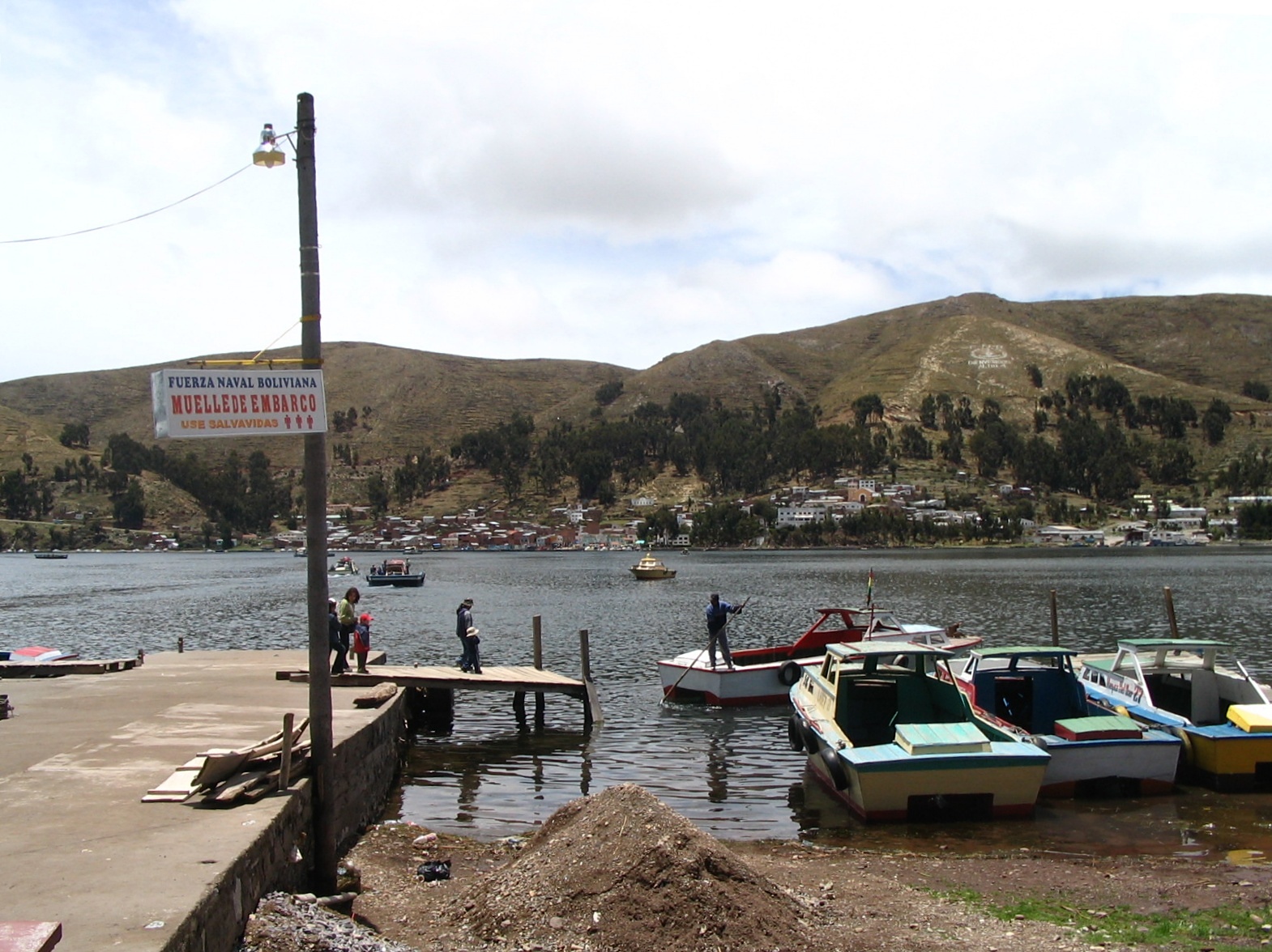
| | | | We were now two Australian couples plus me and three guides. We boarded the hydrofoil in Yumani Harbor for the 15-minute crossing to nearby Isla de la Luna/Moon Island, formerly Coati. While this is a gorgeous view of the Isla de la Luna (Photo by Francesco Bailo), as said, we never got a view of snow-covered mountains while in Bolivia. | | | | The only thing Crillón makes a fuss about on otherwise uninteresting Moon Island is a minor Incan ruin, the Iñaq Uyu (Photo by Sylvio Martins). If it were on a driving itinerary and I were driving, I'd skip it, but commercial enterprises like to pad their itinerary and not skip anything. It dates from 1000-1500 CE and implies a burial place for noble Incan women. Moon Island obviously got its name because of Sun Island, and because it was set apart from Sun Island, the implication was that it was a virgin of the sun. Thus, by extension, the temple roughly translates to "house of the virgins of the sun".
| | | | Knowing I wouldn't want to climb up anyway, María was wise enough to point it out to me as we were pulling up, and I got a clear mid-range view of it, which satisfied me fully. It reminded me of my viewing of the ruins in Ollantaytambo by standing at the bottom and looking up the hillside. It was the same here. I saw it and stayed onboard while the others had a half hour to scramble up the hillside, see it up close, then scramble down the hillside. I was perfectly satisfied. | | | | Go back and take another look at our Lake Titicaca map to review the placement of Copacabana, Sun Island, and Moon Island on the one hand, then the Estrecho de Tiquina/Tiquina Strait and our destination for tonight, Huatajata, on the other. Note that Huatajata is not far by road from La Paz. The map shows how the strait separates the larger and smaller basins of the lake. At its narrowest point, the strait is 850 m (2,790 ft) across. Road traffic (see map) uses barges to get ferried across the strait. We were told there was talk about a bridge, but the small communities on either side are objecting. | | | | You'll recall that Bolivia, having lost its Pacific coastline, still maintains a navy, but based on Lake Titicaca. We saw a bit in Copacabana, and here at the strait, I was surprised when our hydrofoil paused and the captain announced that technically, he had to get permission from the Navy post on one side to go through the strait. Sure enough, they raised a flag and we proceeded. This view across Tiquina Strait (Photo by StarbucksFreak) includes a sign (click). The middle line in red says Muelle de Embarco/Embarcation Pier. The bottom line in orange advises use salvavidas/use life jackets. But the top line in blue says this message is from the Fuerza Naval Boliviana/Bolivian Naval Force[s]. | | | | Huatajata This is where we're spending the night. I had trouble remembering this name from the get-go, and put together a mnemonic to do so. It's silly, and the Australians laughed when I told it to them, but I guarantee, when you finish reading this--and the entire posting--you'll remember the name Huatajata (wa.ta.HA.ta). Just think of walking up to a stove and saying "What a hot[-a pot!]". | | | | I have since learned that Huatajata in general, and Crillón's Inca Utama Hotel in particular, is a favored warm-weather destination for Paceños (people from La Paz). It's just a couple of hours away for a lakeside escape to Titicaca for a meal, for a weekend, or longer. I've seen pictures of the huge dining room crowded, of people filling the pier, boating, and generally enjoying themselves in the area. I can't say I knew that when I booked, but I did think that, after the night in Yumani, another stop along the lake would be enjoyable before going on to La Paz. All in all, I'm pleased with my decision, although things turned out to be a bit different from what I expected. | | | | Our hydrofoil arrived mid-afternoon, and the hotel was literally steps away from the dock. But it was off-season and the place was deserted. One couple from the boat had made arrangements to be driven with their guide right into La Paz. I suppose they'd have arrived before dinner-not a bad plan, either. There were no other guests at the hotel, and so that left just the other couple, me, and the two guides to populate this resort for the night. | | | | The hotel was average, but it had another of those height-of-a-person, artsy-looking propane heaters in the lobby. I'd had one each in each Cusco restaurant, and they, perhaps counterintuitively, gave a cozy feeling similar to a fireplace. I was glad to see it, and there'd be another at dinner. I checked in to my room, which had a semi-lake view only if you stepped out into the breezeway and looked right. No matter. Outside there was dim light and a gray sky—the whole place looked gray—and one got the feeling that winter was coming and that one could look forward to a cozy evening. The bed here, too, had an electric blanket, another nice touch. | | | | Now Crillón has another gimmick here. On the hotel grounds, it runs a museum complex to illustrate the culture and history of the area. They call it the Andean Roots Eco Village, and the Altiplano Museum. I didn't expect too much from it, and so I wasn't disappointed. Perhaps it would look more alive in the warmer weather, with more activities and more visitors. There were replicas of mud houses some Andean villagers supposedly still use; there was supposed to be a weaving exhibit of alpaca shawls that was nonexistent. There was supposed to be an evening program with a shaman and some sort of an observatory, that I was not interested in, and doubted would take place. But there were two highlights. One was a pen containing maybe a dozen llamas and alpacas. Being farm animals, they were a little scruffier than ones we'd seen earlier, but it did give the atmosphere of an Andean farm. There was also an exhibit of live guinea pigs, which you may take for what it's worth. | | | | The bigger highlight involved Norwegian explorer Thor Heyerdahl of Kon-Tiki fame. In 1947 he sailed a raft made in Peru of balsa logs and other native materials to prove ancient South Americans could have settled Polynesia. Kon-Tiki was said to be an old name for the Inca god Viracocha, whose name we've come across before. The original raft is now in the Kon-Tiki Museum in Oslo. | | | | In 1969 Heyerdahl wanted to prove as well that the Atlantic could have been crossed by ancient Africans, such as Egyptians, and had a boat built according to Egyptian plans in Lake Chad out of papyrus reed from Ethiopia. It was called Ra after the Egyptian sun god and sailed from Morocco, but because of a construction error, the ship broke apart close to its goal and the crew had to be rescued. | | | | The following year, 1970, Heyerdahl wanted to try again, but this time he came to the Bolivian side of Lake Titicaca in the Huatajata area and employed Demetrio, Juan, and José Limachi to build the Ra II out of the totora reeds with which we're all now so familiar. The Ra II also sailed from Morocco and successfully reached Barbados, proving the ancients could have done it as well, by sailing with the Canary Current. The original Ra II is now also in the Kon-Tiki Museum, which, by the way, is on the Bygdøy Peninsula along with other museums, notably the Viking Ship Museum discussed in 2012/12.
http://c8.alamy.com/comp/AJPPNR/reed-boat-a-copy-of-ra-ii-boat-at-the-andean-roots-eco-village-at-AJPPNR.jpg
https://media-cdn.tripadvisor.com/media/photo-s/0d/33/e1/88/andean-roots-eco-village.jpg
| | | | And so we return to our little museum and the more interesting of the two highlights other than the llamas. María greeted an elderly man in a native outfit by name, the only person busy at the museum. She then introduced me to Demetrio Limachi, one of the three brothers that helped build the original Ra II, and later ones, for Heyerdahl. I understand the other two brothers also greet visitors on occasion, and also that all three served in the crew for some of these epic journeys. The above picture is the local full-size replica of the Ra II that Demetrio showed me, and then we stepped inside his little display area nearby and he showed quite a number of smaller replicas of other boats they'd built for Heyerdahl. I'm not sure if that's Demetrio in the second picture, but it at least gives an idea of the museum scene. | | | | By now it was really beginning to get dark, so we retired to the hotel until dinner, which, as it turned out, was a most enjoyable part of the day. When I came down and went into the huge barn of a dining room, it was mostly dimly lit, but one table was brightly lit, and had one of the cozy propane heaters next to it. Sure enough the only guests in the hotel were the one Australian couple, me, and the two guides. While the supper and conversation were great, what really made it was when, at the beginning, as part of the meal, we were asked if we wanted mulled wine, which we all eagerly accepted. We were given our mulled red wine in a simple, souvenir brown ceramic cup with the hotel's name on it. The cup was the size of a large shot glass, and just fit nicely in the fist. It now sits next to my desk by the Torito de Pucará from Peru. | | | | The mulled wine warmed internally, the fireplace-like heater warmed externally, the food fed the body, the conversation fed the mind. It felt like the northern winter holiday season, though it was late May, awaiting the southern winter.
The next morning we'd be leaving for La Paz, our last stop in Bolivia.
| | | | Ogden Nash We'll be leaving the Altiplano tomorrow and its famous fauna. Ogden Nash always liked to play with language, and so one thing that keeps on coming back to me is his tiny poem, possibly his most famous, The Llama, which really has to be visually seen, not spoken, or it loses a lot: | | | | | | The one-l lama,
He's a priest.
The two-l llama,
He's a beast.
And I will bet
A silk pajama
There isn't any
Three-l lllama.
|
| | | | Anyway, I've seen my one-l lamas debating in Tibet; I've seen my two-l llamas grazing in Bolivia; but I'm sure I can keep from adding to my bucket list any sighting of a three-l lllama. | | | | Berlin Redux After discussing walking across Checkpoint Charlie in the last posting, I received comments with additional information, which I extended, as follows. | | | | I studied in Mainz in 1961-1962 in the Middlebury program, and traveled around Germany then and frequently thereafter. Friend Jonathan was in the US Military in and around Mainz in 1974-1977, and traveled frequently in Germany. Friend Allan was also in the Middlebury program in Mainz, but later, in 1983-1984, and also had traveled in Germany, including Berlin, earlier, in 1977. Because the three of us have experience centering in Mainz, I call us the Three Mainzketeers. | | | | | | TEENS TO EUROPE: Agewise, of the three of us, Jonathan got there first as a 15-year-old to Barcelona and beyond for a full year, and was quoted in 2016/3; Allan got there as a 16-year-old to Hamburg and Berlin; I didn't get there until I was an elderly (?) 17-year old, to Paris and beyond. |
| | | | After the Berlin discussion, I got the following from Jonathan, reflecting a military point of view: | | | | | | While I lived in Germany for three years (39 months to be exact), I never got to Berlin. Because of what I did (and what I had knowledge of), I had a "Class 2 travel restriction". What this meant was no travel to Iron Curtain countries. It also meant that my only way into Berlin, if I wanted to visit it, was via the "duty train", a locked, guarded (and armed) railroad car that would be taken through East Germany; otherwise a US flag air carrier. In those days there were only three airlines servicing West Berlin: Pan American, Air France and one of the predecessors to British Airways--again, the Allied powers. I never felt the desire to go, as there was a whole lot more to see in West Germany. |
| | | | Since all our early experience fell during the period of the Cold War, I then checked with Allan about his youthful Berlin experiences in 1977, before Mainz. He described what he saw from the bus in East Germany and also the dreary conditions in East Berlin, things that I didn't report on since they were outside the purview of the Walkable Crossovers posting. But here are some of Allan's comments that do apply: | | | | | | This was during my first time ever in Germany, as a 16-year-old exchange student in Hamburg. We were a group of about 10, with one teacher . . . Our trip to Berlin was by bus . . . and we entered West Berlin at Staaken and on Heerstraße . . . Our entry into East Berlin was not in the usual way for Americans. We got on the S-Bahn at I think the old Lehrter Bahnhof to go one stop east (otherwise we probably got on at Zoo) to Friedrichstraße, and we entered that way. . . . On the street we walked down Friedrichstraße to the East German side of Checkpoint Charlie and sat on the tank traps you mentioned. We also rode around on the East Berlin U-Bahn and noticed how old the trains were and how dingy the stations were. . . . We also took a guided bus tour, which was in our own West German bus with an East Berlin guide who came on board, and some of us kept on joking with the tour guide about whether she really liked it in the GDR and that she should defect to the West and we'd help her escape! |
| | | | You'll find on a map in that last posting the location of the crossing at Staaken/Heerstraße, toward the west. On one trip, Beverly and I also entered East Berlin on the S-Bahn at Bahnhof Friedrichstraße, and were forced to exchange a certain amount of West marks for East marks on a 1:1 basis, which we had to scramble to try to use up, since they couldn't be taken back across the border. But I have no story whatsoever to compare with the incredible image of 16-year-old Allan & Co on the East Berlin side of Checkpoint Charlie sitting on tank traps! Fabelhaft!
http://footage.framepool.com/shotimg/qf/100403099-tank-trap-border-installation-soviet-sector-propaganda.jpg
| | | | The picture shows typical tank traps, not the ones Allan was referring to, which were at Krausenstraße, two blocks north of where Zimmerstraße crossed Friedrichstraße. As it turns out, Allan never got to ride through Checkpoint Charlie itself, but did try walking, yet he managed it only halfway (!!) two years afterward at age 18, which is another nice story: | | | | | | I did try to walk through CC in 1979 . . . I asked the GI on duty whether they would still let me in at 2300, and he said, "I don't know, go try and see", so I got as far as the East Berlin counter in the trailer . . . I gave him my passport, he asked me why I was there, to which I answered, "Ich möchte eine Stunde spazierengehen" [I'd like to go walking for an hour] to which the Grenzbeamte [border official] got a little angry, threw my passport back at me, and shouted "Zurück nach [Back to] West-Berlin!" . . . So . . . I got thrown out of East Berlin [and] never made it all the way through CC. When I came back out I said to the soldier, "Oh well, that didn't work." |
| | | | Although she didn't walk across Checkpoint Charlie, friend Simi offered this additional input about riding through it: The West to East Berlin trip and back I did on a tour bus in 1971. I actually found it a bleak and somewhat frightening experience. Armed guards were posted everywhere at Checkpoint Charlie and they conducted routine searches of the buses and beneath the buses. I fully agree with her, having experienced that not only on my own bus crossing, but also on another occasion when I drove a car across. All in all, walking across was easiest, since there was less for the East German Grenzbeamten to check. | | | | Reviewing these comments, I get the feeling it was rarer than I thought to walk across at this point. After all these years, I reflect why we wanted to walk across, even after having ridden across in a tour bus a couple of days earlier. I think now it was our compulsion toward normalcy, toward the original way of doing things. Before the Berlin Wall, people walked across streets between East and West as a normal thing. Beverly had been to Berlin a couple of years before we met as the recipient of an NDEA scholarship. She described walking back and forth through the Brandenburg Gate, and could have—though she hadn't—walked up Friedrichstraße right across the Zimmerstraße intersection. Thus walking across Checkpoint Charlie was an affirmation to us of earlier normalcy, which thankfully returned, but only years later. That was obviously also the case when we purposely went out of our way to take the U-Bahn underneath Checkpoint Charlie and through those ghost stations as an affirmation of normalcy. | | | |
| |
|
|
|

