|
Reflections 2019
Series 15
September 24
New England Coast IV: Newport; San Gennaro
| | Newport We've talked a lot about RI, about which there's a lot to say. While Providence and Pawtucket are interesting, it's Newport that's spectacular. While I have good memories of earlier Newport visits, this one was perhaps the best.
http://ontheworldmap.com/usa/state/rhode-island/rhode-island-road-map.jpg
http://myhometownmap.com/maps/wp-content/uploads/2010/11/NEWPORT_Map.jpg
Let's first get a fresh copy of our clickable RI map, to be kept on the side for occasional reference. For now, confirm where Newport is, on the southern tip of RI Island (Aquidneck Island). As a hint of what's in store, the only two sights mentioned in Newport on this map are the Touro Synagog NHS in the town center, and The Breakers, the most spectacular of the mansions on or near Bellevue Avenue.
| | | | But the second, also clickable map shows Newport itself very nicely, and how Newport looks like a boot facing left. I'd like to point out the three general areas of interest. (1) The "toe" of the boot is on the East Passage of Narragansett Bay with a little peninsula called Newport Neck to its north (a pompom on the toe of the boot?) housing Fort Adams. (2) Beyond the Fort is Newport harbor facing the "shin" of the boot, the historic downtown colonial area of Newport with a number of historic sights, including the synagog. (3) The "heel" of the boot on the right encompasses Bellevue Avenue and its mansions, with The Breakers a couple of blocks off Bellevue to the east. South of that is Sheep Point on the Cliff Walk, where in the last posting, we saw the red clay in this area of "Red Island" in a view south toward the Rough Point mansion. This area is not directly on the Sakonnet River, but not far from it, either—check the RI map. | | | | Previous Visits to Newport You may recall that early on, Beverly and I took two monumental, summer-long trips in our VW Camper, in 1968 on a huge swoop of the western US and Canada, then in 1969 on a huge swoop of the eastern US and Canada. When we were done, we'd visited every state except AK and HI and every province. So our first time in Newport, according to our travel diaries, was a quick visit on 1 July 1969. We took a quick look at the historic center, then at Bellevue Avenue and the Cliff Walk, noting only having seen (surely not visited) Marble House and The Breakers. | | | | But what seemed a triviality at the time now looms as a more significant experience—so true about life. For this, you have to look at the RI map to be reminded of the extent to which Narragansett Bay divides RI in two. All road traffic routes up until that year coming from CT had to swing up to Providence, as rail routes still do. Other than by using ferries, all road traffic could reach eastern RI only by crossing the Providence River to East Providence, then by working one's way south, such as to Newport. That could have been done on the RI side, but more likely on the MA side, even thru Fall River. | | | | The northern end of RI Island, at Portsmouth, had been connected to the mainland at Tiverton since 1907, with the current Sakonnet River Bridge connecting Portsmouth and Tiverton dating from 2012. But otherwise, Newport was dependent on ferries for road transport. That was simplified somewhat in 1940 when a bridge was built over the West Passage, connecting the mainland with Jamestown on Conanicut Island, the second largest in the Bay. This was replaced in 1992 by the present Jamestown Verrazzano Bridge. But that route still required a ferry across the East Passage to Newport. | | | | That was solved by the opening of the Newport Bridge (see RI map), which opened in 1969. This is a splendid aerial view of the two bridges and Conanicut Island, with the mainland on the left and downtown Newport just south of the bridge on the right (Photo by Doc Searls). This completed a southern route across RI, reaching over to Fall River MA and beyond. But the fun reason I'm citing this is that the Newport Bridge opened on 28 June 1969, just THREE DAYS before we crossed it on 1 July 1969, a fact we were well aware of at the time, and which is also entered in the travel diary. In some ways, I feel it's "our bridge". This is a view of "our" Newport Bridge and the East Passage, as taken from Fort Adams (see Newport map), in the foreground (Photo © Ad Meskens / Wikimedia Commons). | | | | Our second visit to Newport came in two sections, almost four weeks apart, at both the beginning and end of an extended drive via New England to the Maritimes and Newfoundland. At the end of the trip we'd scheduled our first time on ACL, the New England South Shore Cruise, Voyage 15 in 1984. But on the outbound drive, well before the cruise, we also stopped in Newport, this first time still with our car, allowing us to see things you needed to drive to. Our return to Newport the second time that summer would be from the boat, walking around on foot. | | | | The pre-cruise visit was on 24 June 1984, where we came up from CT, crossed the bridge, and spent a few hours driving around Newport. Beverly wrote: In Newport we took the Ocean Drive with a stop at Fort Adams for a view of the harbor and town. We toured Hammersmith Farm, the home of Jackie Kennedy . . . . Their wedding reception was held here.
https://www.cardcow.com/images/set444/card00006_fr.jpg
| | | | On the Newport map, find Ocean Avenue looping around the "toe". This is the Ocean Drive Michelin recommended. As for Hammersmith Farm, seen above, the estate (not named) fills the area on our map west of Fort Adams Drive between Harrison Avenue and Lincoln Drive. It's a Victorian mansion and estate that was the childhood home of Jackie Kennedy and the site of the reception of her 1953 wedding to John Kennedy. During his presidency, it was referred to as the Summer White House. The 28-room main house was built in 1887 for John W Auchincloss, the great grandfather of Hugh D Auchincloss, Jackie's stepfather. It was open to the public from 1977 to 1999, and were there in 1984. After extensive restoration, it's now a private home again, which is why it's not on our map. | | | | We did not stay in Newport at this point, but drove north, so this is the time we ended up in Seekonk MA out of Providence as described in the previous posting. Our first night "in RI" ended up being instead in MA. We visited Providence and Pawtucket's Slater Mill the next day, then headed northeast: | | | | | | [Scotia Prince overnight from Portland to Nova Scotia, visiting there; ferry to Newfoundland, visiting there; ferry to Saint-Pierre et Miquelon; more visiting in Nova Scotia; ferry to Bar Harbor; Boston; drive to East Haddam CT on the CT River to board ACL's former MV Savannah; sailing to Block Island, Nantucket, Martha's Vineyard, New Bedford; docking in Newport] |
| | | | I do not have a memory of where we docked in Newport, but have reconstructed the facts. To have docked in town, we must have sailed into the East Passage and into Newport Harbor. I now learn that large ships dock in the harbor and tender passengers into downtown. The 2019 schedule includes the Queen Mary 2, Norwegian Dawn, Celebrity Summit, Zuiderdam, and more, doing this. Smaller ships, such as all the ACL and Blount ships, dock at the South Alofsin Pier on the east side of Fort Adams (see map). All ships then tender passengers to Perrotti Park, which is that unnamed greensward on our Newport map, just steps away from the historic downtown. | | | | Thus it was on 19 July 1984, just 26 days after having driven around in Newport, that we then completed the 1984 visit by having a chance to walk around Newport. We visited the colonial center, but will discuss those locations when we talk about the present trip. (One item of importance was that on that day, the Touro Synagog was open to the public, so we got to visit its interior on that visit as well as the exterior.) Then we walked over to Bellevue Avenue to see the mansions and Cliff Walk. | | | | Newport Mansions Newport's colonial center is very visitable, but to be honest, nice as it is, it isn't unique. There are other colonial centers of towns one can visit. But there is something unique in Newport, and that is its mansions. As to that, I have to make a distinction that I haven't seen anyone else make, one between mansions and palaces. There are lush mansions in Newport, ones anyone would be happy to live in. One was, for instance, the Hammersmith Farm. Also, in the last posting showing the red earth, along with stately Rough Point, there were two handsome, yet simpler mansions shown, called New Lodge and Ocean View. I will have to surmise that the so-called "cottages" in Bar Harbor, most of which were burned in the fire, were of this type of mansion. | | | | But Newport has over-the-top, splendid mansions, some in marble, which, if they were in Europe, would be called palaces. These palaces, if not unique to Newport, certainly Newport's having several of them is unique. But one has to smile on hearing that the superrich here also referred to these buildings as "cottages", using the wry understatement of the very rich. | | | | Beginning in the mid-19C, wealthy Southern planters seeking to escape the heat began to build summer "cottages" on or near Bellevue Avenue, such as the early Kingscote (1839). Around the middle of the century, wealthy Yankees also began building mansions, such as Château-sur-Mer (1852) nearby. Most of these early families made a substantial part of their fortunes in the Old China Trade (see 2014/2 "Salem and Canton's 13 Factories"). | | | | By the turn of the 20C, many of the nation's wealthiest families were summering in Newport, including the Vanderbilts, who constructed the largest "cottages", notably The Breakers (1895). They resided for a brief summer social season in grand, gilded mansions with elaborate receiving rooms, dining rooms, music rooms, and ballrooms—but with few bedrooms, since the guests were expected to have "cottages" of their own. The social scene at Newport is described in Edith Wharton's 1920 novel The Age of Innocence, of which this is the first edition dust jacket. | | | | So we left Newport's center that day to walk down Bellevue Avenue and then hike the Cliff Walk back. On our Newport map, use Touro Street (click) as a starting point of reference, then walk it down to where it changes its name to Bellevue Avenue. The Bellevue Avenue Historic District starts south of Memorial Boulevard, from Spring Street/Coggeshall Avenue east and south to the water. At its the southern end, Bellevue turns sharply to the west, where the Cliff Walk is accessible, which then leads north again to its end at Memorial Boulevard.
https://i.pinimg.com/736x/48/79/b0/4879b06f104ab46dbeda574c7c2f396e.jpg
| | | | But this detailed map will help us better in this neighborhood. There are many mansions on or near Bellevue Avenue, many open to the public. As over time the lifestyle changed and they became expensive to maintain, the residents left, and fortunately, the Preservation Society of Newport County (PSNC) has acquired title to a number of them, including eight on or near Bellevue, others elsewhere in the county. But you certainly don't want to tour all of them, because even marble palaces can get repetitious. So how do you know which ones are those that shouldn't be missed? You get a guide that ranks sights, and none is better than the Michelin. Three stars (3*) are must-sees, then it goes to 2* and 1*. | | | | According to what the diary reminds me, we made it a very full day. We ended up touring two with 3*, one with 2*, and viewing four others from outside, all seven being PSNC properties. In addition to being within the Bellevue Avenue Historic District, so many of the mansions are National Historic Landmarks and on the National Register of Historic Places that I won't bother to mention it each time. Continue to follow our walk on the Bellevue map. This view looks south on the mid-section of Bellevue Avenue itself (Photo by Daniel Case). | | | | The Walk Beverly's entry starts out mentioning our first six mansions: We . . . started down Bellevue Avenue to see the mansions: Kingscote, the Elms (tour), Château sur Mer, Rosecliff, Marble House (tour), Belcourt. Let's follow that on the Bellevue map and mention others with interesting stories. Remember, this list is not definitive of all the mansions in Newport, tho it includes those of greatest interest. | | | | We were unaware at the time of the Edward King House, a block west on King Street (Photo by Daniel Case), since it was not listed by Michelin, but it now seems worthy of mention. I read now it's an early representative (1847) of the Italian Villa style. When built, it was the largest and grandest house in Newport. King made his fortune in the China Trade. It was donated to the City of Newport, and is now a senior center. | | | | Our first stop was at Kingscote [1*] (Photo by Dms1788), an 1839 Gothic Revival cottage that was the first large house in the city built for a summer resident. Adapting Gothic Revival motifs to private residences, and in wood, not stone, was a new trend in American architecture. Note the asymmetry, with gables, arches, eaves, and varied rooflines. It was at one point added on to by Stanford White, and was eventually bequeathed to the PSNC. | | | | The Isaac Bell House [1*] (Photo by Dms1788) was designed by McKim, Mead, and White and is one of the outstanding examples of Shingle Style architecture in the US, and the first in Newport. The Shingle Style developed after the 1876 US Centennial, and English influence was combined with Colonial American architecture, using the plain, shingled surfaces of colonial buildings. At one point, the building was broken up into apartments and served as a nursing home until a benefactor helped the PSNC buy it, which won awards for its restoration. | | | | Our second stop was at The Elms [2*] (Photo by Daderot), where we took our first tour of an interior. The Elms, 1901, is in Classical Revival style, and was built to imitate the Château d'Asnières in the northwestern suburbs of Paris (Photo by I, Parisette), which would seem to indicate a "palatial" European connection. The Elms was one of the last mansions to maintain the Gilded Age lifestyle, with 40 servants on staff right up until the last family member died in 1961,. The family then auctioned off its contents and sold it to a developer who wanted to tear it down. Shortly before the wrecking ball was due in 1962, the PSNC managed to purchase it. | | | | Named after a Welsh castle, Chepstow [1*] is an 1860 house in the Italianate style, donated to the PSNC (Photo by Kenneth C. Zirkel). | | | | Our third stop was at Château-sur-Mer [1*] (Photo by Daderot). Its name is partly accurate. While it is a château, and not far from the sea, it's not exactly "on the sea", as the name would have you believe (others are). It was built in 1852 as an Italianate villa, whose grand scale and lavish parties ushered in the Gilded Age of Newport. It was the most palatial mansion in Newport until the Vanderbilts arrived in the 1890s. It's an interesting illustration of how tastes change. In the 1870s, it was remodeled in Second Empire style—just look at those Mansard roofs! The situation of the building was different in that it was inhabited as a year-round residence, as the family members were New Englanders. The house was purchased by the PSNC in 1969. | | | | As a fourth stop we chose Rosecliff [2*], built in 1902 by the heiress to the Comstock Lode fortune (Photo by olekinderhook). Stanford White modeled it after the Grand Trianon at Versailles (Photo by Anitsircana)—another palatial European connection—but smaller, reduced to a basic H-shape, and with a second story added. This story has a balustraded roofline that hides the set-back third story, for servants quarters. In 1971, the owners donated the estate and its contents to the PSNC, with a $2 million operating endowment. | | | | Our fifth stop was at Marble House [3*], where we took our second tour (Photo by Daderot). It was built in 1892 for William Kissam Vanderbilt, who was the one who hired the architects of today's Grand Central Terminal. The building changed Newport from a summer colony of wooden houses to a legendary resort of opulent stone palaces. Its 50 rooms required 36 servants to maintain. The building required 14,000 m3 (500,000 ft 3) of marble to build. [The same year, his younger brother built Rough Point (see below)]. But the scale of Marble House was then promptly surpassed when William's older brother built the largest of the opulent Newport "cottages", The Breakers, between 1893 and 1895 (see below). All three brothers were grandsons of Commodore Cornelius Vanderbilt.
| | | | The Beaux Arts design of Marble House is again inspired by Europe, in this case by the Petit Trianon, also at Versailles (Photo by Starus). In addition, its temple-front portico, which also serves as a porte-cochère, somewhat resembles that of the White House (Photo by Юкатан). In 1963. the PSNC purchased the house from its then owners with funding provided by Vanderbilt's youngest son, and virtually all the original furniture was donated directly to PSNC.
https://www.newportmusic.org/wp-content/uploads/2017/12/Belcourt-Castle.jpg
| | | | Our sixth and last stop directly on Bellevue was at Belcourt Castle [1*] (above). It was completed in 1894 and was one of those intended to be used for just 6-8 weeks during the summer season. It was built for Oliver Hazard Perry Belmont, brother of August Belmont Jr, who, as we've said a couple of times, built the Cape Cod Canal, NYC's first subway (IRT), and Belmont Park racetrack. His maternal grandfather was Commodore Matthew Perry, who opened Japan to the West in 1853-1854, and his maternal great-uncle and namesake was Commodore Oliver Hazard Perry, the victor of the Battle of Lake Erie in 1813.
Belcourt is eclectic in style, with an emphasis on French Renaissance and Gothic. Once again, it harks back to Europe, since it's modeled after Louis XIII's 17C Hunting Lodge, which was later replaced by the Palace of Versailles. Belcourt has passed thru other owners, and remains privately owned.
| | | | Just beyond Belcourt is Rough Point [2*], which we first got a peek at in the last posting showing local red clay (Photo by John Phelan). It was built in the English Manorial style in red sandstone and granite for Frederick William Vanderbilt, the youngest of the three Vanderbilt brothers who built in Newport, and was completed 1892. The home's last owner was Doris Duke (until 1993) and is currently open to the public as a museum owned and operated by the Newport Restoration Foundation. The NRF was founded by Doris Duke to preserve Newport's early housing stock, including 18C homes. She purchased and restored over 83 houses; the NRF now owns 78 historical properties, almost all in Newport, including Rough Point. 72 are rented to tenants. | | | | Before we visited our last mansion, we decided to blend in our hike (see Bellevue map) on the Newport Cliff Walk (Photo by Skinsfan2512). It's one Newport's top attractions, a public walkway along the shore line running for 5.6 km (3.5 mi), which has been designated a National Recreation Trail. We walked a bit west on Bellevue to the first public access location (beyond the trees on the below view) and proceeded around the point and up the east side.
https://shewenttocalifornia.files.wordpress.com/2015/06/img_0053-0.jpg
| | | | In doing so, one gets to see the other side of Rough Point, as well as the landscaping done by Frederick Law Olmstead, who did Central Park. Notice the red clay again. It was with quite a bit of understatement that Beverly wrote this: At the end of the peninsula we started up the Cliff Walk (beautiful seascapes, but difficult walking in the beginning). | | | | What happened was this, and I'm sure it happened right in this area. We were determined to take the whole Cliff Walk, and suddenly came across a total washout. The weather was perfect and there were no warning signs, so it might have been there for a while. There was a dropoff to the right, a two meter/yard missing part of the trail in the middle, and it was impossible to scurry around the left side. But the oddest thing was that a chain-link fence had also collapsed in the washout, and was covering the opening. The fence seemed very strong, tho bouncy, and the two of us clambered up onto the horizontal fence as tho on a trampoline and bounced our way across. We made it fine, and continued on our way. That was the "difficult walking". | | | | As the Newport map will confirm, that first point of land is called Sheep Point, near Marble House. This view is northward from behind Marble House showing Sheep Point Cove with some houses and a tiny pavilion (Photo by Andre Carrotflower). Click at the bottom to see the Cliff Walk behind the (NOT chain-link) fence covered with barbed wire. A little further along, closer to Rosecliff, this is a closer view (click) of the pavilion at Ochre Point (Photo by Giorgio Galeotti). You see walkers on the trail, and the pavilion. However, I know the trail's been renovated and upgraded after a recent storm, so it might be a little different than I remember it. Then we temporarily interrupted our walk. As Beverly says: We got off to tour the Breakers. | | | | You see on the Bellevue map the additional access points, so we did our seventh stop and third tour at The Breakers [3*] (Photo by Menuett). This was the one built between 1893 and 1895 by Cornelius Vanderbilt II, the eldest of the three Vanderbilt brothers who built in Newport. | | | | | | There are and were numerous Vanderbilt buildings of note, but to make the present trio of brothers into a quartet, we can note that the youngest brother, George Washington Vanderbilt II, commissioned the construction of the fabulous Biltmore estate in Asheville, North Carolina between 1889 and 1895, which is still owned by Vanderbilt descendants. (We toured it in 1999; for a picture, see 2013/3, Ctrl-F: Biltmore) Thus all four brothers were building their residences over exactly the same few years. |
| | | | Let's first make sure everyone is on the same page as to visualizing the oceanside image the name refers to. This is a breaking ocean wave (Photo by Gabucha95), which can be called a breaker. I just measured the distance of The Breakers from the Ochre Point shoreline on Google Maps. The southeast-facing back of the building is about 113 m (271 ft) from the breakers coming in off the Atlantic via Rhode Island Sound and striking Ochre Point. | | | | | | Just for fun, I also checked the distance of Château-sur-Mer to the nearest shoreline (just north of The Breakers), and tho the building does lie well to the east of Bellevue Avenue, it comes to about 660 m (2166 ft). "Castle-on-the-Sea" indeed! |
| | | | The Breakers is in the Italian Renaissance style, and huge. While the estate covers 5.7 ha (14 acres), the footprint of the house alone covers about 0.4 ha or 4,000 m2 (1 acre or 43,000 ft2). There are 70 rooms with a gross area of 11,644 m2 (125,339 ft 2). Of that, the actual living space is 5,805 m2 (62,482 ft 2) on five floors. | | | | The interior was created using French and Italian marble, alabaster, and stone, plus rare woods and mosaics from around the world. Some architectural elements were purchased from French châteaus, such as the fireplace in the library. Upon its completion in 1895 it was the largest, most opulent house in the Newport area. Today, it's a symbol of the Gilded Age, and is Newport's signature mansion. It's also the most-visited attraction in all of RI, having welcomed about 450,000 visitors annually as of 2017.
https://upload.wikimedia.org/wikipedia/commons/4/42/Breakers_Great_Hall.JPG
Given the status of The Breakers, it's worth showing a bit of the interior. Above is the Great Hall, which is 15 m (50 ft) in all three dimensions. Click for detail, including the spectacular array of columns, pilasters, marble plaques, and ornate cornices.
https://upload.wikimedia.org/wikipedia/commons/d/d0/Breakers_Library.JPG
The coffered ceiling in the library (not visible here) has a dolphin motif, which is symbolic of both the sea and of hospitality. Below that is an area of green Spanish leather embossed with gold, and below that is walnut paneling impressed with gold leaf in the style of leather-bound books. We now get to see that French fireplace, which came from Burgundy, and was taken from a 16C château in Arnay-le-Duc, the Château Condé (Photo by François GOGLINS).
| | | | | | I had to search to find out the name of that château, and also found that its fuller name is the Château des Princes de Condé. The southeasternmost point we reached on the Luciole canal trip was at the end, on the excursion to the Château de Bazoches on the edge of the Parc Natural Régional du Morvan. Google Maps tells me that Arnay-le-Duc is about 59 km (37 mi) further southeast of Bazoches, on the other side of the park. |
| | | | I think you'll agree that this building--and some others—qualifies for being a palace. You may be seeing visions of Downtown Abbey at this point. Let's add one more location in the building:
https://upload.wikimedia.org/wikipedia/commons/d/d9/Breakers_Kitchen.JPG
The well-ventilated kitchen has a 6.4 m (21 ft) cast-iron stove. The work table is made of zinc, a metal which served as the forerunner to stainless steel. In front of it is a marble mortar used to crush various ingredients. Ice cut from the local ponds kept the side rooms cool where food was stored. There was also a colder room for the assembling of confections. The kitchen and baking pantry each had one dumbwaiter that traveled to the basement level where groceries were delivered and refuse removed.
| | | | But all good things come to an end. Vanderbilt enjoyed The Breakers for only four years, since he died of a cerebral hemorrhage caused by a stroke in 1899 at age 55. His wife inherited it, and she lived to age 89 in 1934. Eventually the PSNC bought the estate from the family, but agreed to allow the family to continue to live on the third floor, which is not open to the public. | | | | You might think this would be the end of a long day, but I found this in the diary: After dinner, we went back to finish the Cliff Walk . . . I have no recollection of where we went for dinner. Not in this residential area certainly. Back to the boat? But then we apparently came back to the Cliff Walk access at The Breakers (see Bellevue map) to complete the hike as well. I do know that this time, in contrast to the Seekonk experience, we did stay in Newport, and therefore in RI, for the night. The next day we sailed back to East Haddam to pick up our car and conclude the New England and Maritimes trip. | | | | Leaving Martha's Vineyard We left the narrative having sailed from Martha's Vineyard headed for Newport. The Captain had earlier flip-flopped the two stops with no explanation, so now Newport would be the last stop before we went back thru the Canal to see Provincetown. We sailed before dinner and crossed Vineyard Sound and Rhode Island Sound; tho the weather was beautiful, there were higher winds and somewhat rough seas, but it was invigorating and not really bad.
| | | | I had checked with the deckhands that ran the tender about how things were done in Newport. They told me we docked at Fort Adams, and then could tender across the harbor into downtown, which is apparently what we'd done in 1984. I also knew there was a special mansions tour, for a fee, that would set off from Fort Adams, then come back for lunch, at which point they could also tender to downtown. For something that could have been complicated, it sounded perfect. | | | | | | Needless to say, I had no interest in a mansions tour, even if it had been complimentary. I also didn't see how a relatively short bus tour could do Bellevue Avenue any justice whatsoever—and forget the Cliff Walk! I don't recall if that bus tour included touring one of the mansions—I have my doubts. I felt sorry for those who had never been to Newport and wanted to do it all in one day. I suppose it's possible, but incredibly compressed. |
| | | | Once again, I didn't tell all that the Captain said as we left Martha's Vineyard. It was during happy hour when he made the announcement, and I didn't hear all of it. He mentioned the Sakonnet River, a name I'd never heard before—but now know quite well. We'd be going up the Sakonnet River, then dock in (mumble, mumble), and tomorrow we'd be bused to Newport. And once again, he explained nothing else and gave no reasons. Was it too rough to sail up the East Passage into Newport Harbor? I couldn't imagine that. I recently checked the docking schedule for the pier at Fort Adams, and it still says we were due there that day. But I'd already been in Newport Harbor, and this Sakonnet business was a new adventure. The good news is, my time in Newport was excellent, and this mode of entry just spiced it up a little more. I said in Maine that we "fled" up the Penobscot River to Bucksport, but bad weather actually did follow. Now again, we were apparently "fleeing" up the Sakonnet, but for reasons unknown, and to a mumbled destination. | | | | Follow our route on the RI map. The Sakonnet is really river-like, more than I'd imagine, even tho it's really a tidal strait. There were views of the nearby green shores on either side, and it was a pleasant late-afternoon ride. But how far were we going? This is a northbound view from Tiverton to the Sakonnet River Bridge (Photo by Marcbela). After the bridge we were in Mount Hope Bay and were running out of RI territory! And sure enough, we crossed the state line and were in Fall River, Massachusetts, where we'd spend the night! And so history repeated itself. | | | | When writing this I did want to confirm that, on three trips to RI, I did indeed spend at least one single night physically in RI, but it was just that one, on the boat in 1984. Earlier, on the driving part of that trip, we "used up" Providence and ended in Seekonk MA, and this time we "used up" Tiverton and ended up in Fall River MA. What an unusual turn of events! It was because of these adventures on the RI/MA border that I became so interested in the "Eastern Shore" territories of RI that lie between them. | | | | Fall River So if we're going to visit Newport RI tomorrow out of Fall River MA, we might as well get comfortable with where we are.
https://www.southcoasttoday.com/storyimage/NB/20161102/NEWS/161109829/AR/0/AR-161109829.jpg
https://newenglandboating.com/wp-content/uploads/2012/11/Fall-River-State-Pier.jpg
The first map above we saw in the last posting. It shows the modern state line at State Avenue (not mentioned); beyond Kennedy Park in green, the next major street was the MA border until 1882, Columbia Street. Well, we docked in that small cove south of that bridge, so we spent the night in what always was MA and never was RI territory. Keep this map a bit for reference, and note for later Watuppa Pond on its east side. (Massachusetts LOVES to call some of its lakes "ponds", which elsewhere implies a smaller body of water. Certainly the most famous of these is the lake known as Walden Pond, of Thoreau fame. See 2011/22, first paragraph.)
| | | | The second, satellite map names the Braga Bridge, and identifies what I now know from this map—but which wasn't announced when we were there—that we were docked at the Fall River State Pier, which lies partially under the bridge. (I think it's obvious that I can't stand being treated paternalistically. We're all adults!) This map also showed me that there were twin locations on the north side of the bridge (look closely) that we were not made aware of: (1) Battleship Cove, a maritime museum and war memorial that includes the 1942 USS Massachusetts and (2) Fall River Heritage State Park, which includes a restored 1922 carousel. Here's a closer view (Photo by Electroengie). Many of us had time when we got back from Newport the next day and it looks like the ships are on the other side of the very same pier we were on. But maybe ACL didn't know, since it was last-minute, or wanted to keep all of its fledgelings on board for the 5 PM sailing. | | | | Look again at the satellite map and see if you can barely discern that a river empties into Battleship Cove. This is the very short, 4.3 km (2.7 mi), Quequechan River, that became highly industrialized in the 19C with textile mills using it for power, which helped Fall River grow. It drains Watuppa Pond (see above). Tho it's mostly a slow-moving, placid river, in downtown Fall River a quickly declining grade causes it to speed down the hill. Thus, tho there is no river in Fall River by that exact name, it's the Quequechan that "falls" and is the basis for the name of the city. And of course, it doesn't hurt that in Wampanoag, the local Native American language, Quequechan means "Falling River" or "Leaping/Falling Waters". Today, the downtown portion of the river has been placed underground, with I-195 above it. | | | | This map of Fall River in 1812 shows how the Quequechan looked at that time, draining Watuppa Pond, as it still does. I believe you can see the part downtown where it "falls", before entering what today is Battleship Cove. I also know for a fact that we were docked at the end of Anawan Street, and I'm delighted to see that that street is one of the few mentioned on this early map. It's also great fun to see the old MA/RI state line right near downtown, before it was moved down to State Avenue. Thus, south of the line is Taunton RI, which at the last minute formed Fall River RI, before the two Fall Rivers were merged by the Supreme Court. But we WERE docked in the original Fall River MA. | | | | Lizzie Borden Tho we rarely took weekend getaways, we did do so over the Columbus Day weekend in 1975. We left directly from work Friday for a weekend on Cape Cod. I have very fond memories of walking a lonely seaside trail in the National Seashore, and collecting fresh cranberries at the side of the road, which Beverly later made into cranberry muffins. But I digress. En route, I remember clearly going thru Fall River and stopping to take a look at something that interested us. On 4 October 1975, Beverly wrote: In Fall River we drove past the Lizzie Borden House . . . | | | | Her name and murder trial are completely associated with Fall River, a fact I had to make clear to some unaware tablemates on the ship. The story is almost legendary. I recall watching at least one full-length TV show retelling the story. For those who need details, I suggest looking it up, tho I'll say a few words here. | | | | Fall River was home to the infamous 19C Lizzie Borden murder case, which has remained a topic in American popular culture into the 21C. The Borden family was wealthy and high-profile, and Lizzie was accused of committing a double ax-murder in 1892, killing both her stepmother and father, Abby and Andrew Borden. She was eventually acquitted. The family wealth, the lurid gruesomeness of the crime, and Lizzie's acquittal in 1893, all added to the notoriety. The event and trial are still debated today. | | | | She has been depicted in various works of art, including Agnes De Mille's 1948 Ballet "Fall River Legend". She was further immortalized by the well-known children's rhyme: | | | | | | Lizzie Borden took an axe
And gave her mother forty whacks.
When she saw what she had done,
She gave her father forty-one.
|
| | | | Well-known, but inaccurate: the stepmother actually suffered 18-19 blows, the father 11.
After Lizzie's trial (in New Bedford) and acquittal, she and her sister Emma did not return to the house, located at 92 Second Street (renumbered to 230 in 1896). Instead, Lizzie bought another house located at 7 French Street (now 306) that she named Maplecroft. She lived there until her death in 1927.
In 1975, we just drove past the house. I know we passed it another time with friends, and I've had difficulty finding the exact date, but I believe it could have been in 1994. In other words, both times I saw it, it was still a private residence, because it's now a bed and breakfast, and has been so since 1996, after I was there. The 1845 house is called the Lizzie Borden Bed & Breakfast/Museum (Photo by dbking), because guides in period costumes also give guided tours (click). I found this floor plan:
https://i.pinimg.com/736x/32/b9/c5/32b9c592ba5b0429109caf80b12f9cd2--virtual-museum-crime-scenes.jpg
The owner says the room where the stepmother, Abby, was killed is the most requested room. The Fall River Historical Society promotes the Lizzie Borden B&B as a tourist attraction.
https://i.dailymail.co.uk/i/pix/2017/09/11/18/4429CF3E00000578-4873660-Lizzie_and_her_sister_Emma_Borden_bought_the_home_above_with_the-a-73_1505150281472.jpg
In 2018, the current owners also bought Maplecroft (above), which has 14 rooms and was built in 1889. It's also in the process of becoming a B&B. Architecturally, I find that left-hand gable set at a 45° angle to be quite arresting. Look at the link—the picture's from the Daily Mail in the UK, which further indicates widespread interest in the case to this day.
https://www.mapsofthepast.com/mm5/graphics/00000001/MAFA0003_a.jpg
| | | | The easiest way for us to ease into the 19C era of Fall River is to look again at this map from before (click). It shows Fall River in 1871, 21 years before the 1892 Borden murders. Once again, we were docked roughly at the end of Anawan Street, but with the huge Braga Bridge and interstate cutting across the area. The continuation east of Anawan into the green area is called Borden Street (!); the Lizzie Borden House is just south, on that first street, Second Street. And we have more. From here, move past a pink, then a green area to a second pink area. French Street is the third street in, and Maplecroft is right before the street bends to the northeast.
Now here's food for thought. The Borden trial took place in 1893 to widespread interest. The three Vanderbilt mansions in nearby Newport were built in the 1890s. It's likely the Borden case was discussed at the time in those buildings plus all the others in Newport and beyond.
| | | | Day 10 - Sa Ju 15 – Newport We got ready after breakfast to leave Fall River for the day to see Newport, about an hour's drive away. The new order of things also made good sense. The bus for the mansions tour left first. Afterward, they'd have lunch with us at the fort, then they could see downtown afterward with the shuttle. For the bulk of us, it was just as simple. Our shuttle left the ship right after theirs for the center of Colonial Newport. We could then shuttle to the Fort for lunch, and then shuttle home, right thru downtown, with a stop who hadn't seen it in the morning. The simplicity of it was startling. I didn't think ACL had it in them (wink, wink). I suspect the home office did most of the arranging, not the ship's staff. | | | | Moving south out of Fall River, I was so pleased when we saw a sign saying we were crossing State Avenue, meaning we were entering RI, which we'd just sailed thru the evening before! Now refer to the RI map. We cut thru Tiverton and got on the main highway to take us over the Sakonnet River Bridge to Portsmouth on RI Island (Aquidneck Island). We then drove most of the length of the island to Newport. This was where I saw so many uses of the word "Aquidneck", with little or no reference to its other name.
Move to the Newport map. We came down W Main Road to Broadway to Marlborough Street, right to the center of town. Now move to this map of the colonial center of Newport:
https://trailsandwalksri.files.wordpress.com/2014/03/tw-npt6.jpg
It's very good (click when necessary), but note two things. It's on its side, and north is on the left. Also, disregard the distracting blue routes indicated. Everything we need is on the extreme left (north) side of the map. But first take note how Beverly and I that time walked from Touro Street right into Bellevue Avenue, where, after Memorial Boulevard, the Bellevue Avenue Historic District begins, with Kingscote, the Isaac Bell House, and The Elms.
| | | | Colonial Newport Let's start by finding where our tender would have arrived from the Fort to Perrotti Park, had we docked on Newport Neck. Note the adjacent Brick Market Place, an outdoor shopping center where our shuttle bus dropped us off after coming down Marlborough Street on the left. Tho our cruise director was generally quite good, she had pointed out the shopping! shopping! shopping! opportunities here and gave absolutely no guidance as to what to see here, including no map. I, of course, had printed out my own map before leaving home. But this drop-off point would also be our pick-up point.
| | | | The real basis for calling it the Brick Market Place (other than its brick pavements) was the Old Brick Market-- a fact that I'm cynically sure that was lost on most visitors (Photo by Daniel Case). It dates from 1762 and is located next door on Thames Street (see map). It was the commercial center of Newport, with open market stalls on the ground floor and offices above. It now houses the Museum of Newport History, owned and operated by the Newport Historical Society. The long façade with seven bays is on the side, while the three-bay façade is the front, on Thames Street, with its cobblestones. | | | | Now let's cross Thames Street (This and the Next Three Photos are by Andre Carrotflower) while looking southward along its cobblestones. Click on the right to confirm this is the Brick Market Place shopping mall. | | | | Once across Thames, we find ourselves at the triangular park called Washington Square, which lies at the convergence of the street by that name and the beginning of Touro Street. Actually, because the apex of the triangle is lopped off with planters (click) the park is actually trapezoidal. The red building in the distance is the Old Colony House (see below). | | | | This is by far my favorite view of Washington Square. We are looking down the slope; to the left of the statue are the three bays of the Old Brick Market. On my walk, I sat and rested on that bench behind the man in the cap. It was very relaxing here. Turning to look uphill in the park, we see the Old Colony House again, plus the courthouse behind the trees, typical of many government buildings around the Square. | | | | I've since learned that what is now Washington Square was the heart of the original 1639 Anglo settlement of Newport and remains its geographical and historical heart. At one point the colonial long wharf projected out from it. But tho colonial in origin, much of its present shape, form, and name are 19C, and even into the 20C. The original house lots clustered close to a fresh water spring uphill from the shoreline. The spring is still there, tho underground now. The only remnants of the 17C are the adjacent street names and street layout itself. | | | | Another of the historical quirks of RI is that it didn't have a fixed capital for a long time. Instead, the legislative sessions were rotated among five cities: Providence, Newport, Bristol, East Greenwich, and South Kingstown. Finally, in 1854, the locations were reduced to just Providence and Newport, representing the two original settlement areas, and Newport was finally dropped in 1900, leaving Providence as the state capital. But as we've seen in two pictures already, Newport still has its Old Colony House, sometimes called the Old State House, since it was one of the seats of government when RI was both a Colony, 1739-1776, and State, 1776-1900. As we saw, the Old Colony House (Photo by Kenneth C. Zirkel) is at the upper end of Washington Square, illustrating the importance of the Square as lying between a government center and commercial hub, the Brick Market. The brick Georgian-style building was completed in 1741, and is one of the best-kept surviving Georgian public buildings from the colonial era in the US (click for detail). | | | | From the Old Colony House, we'll take a two-block detour to the left (north) up to Marlborough Street (see map), where our shuttle bus first entered. To the right of the intersection, set back behind a large lawn, is the very large Great Friends Meeting House (Photo by Swampyank), a building with a misleading name. It isn't a pub, where "great friends" meet, it's a large-sized meeting house of the Quakers (Friends), built in 1699 to accommodate the large Quaker community in Newport. It's now a museum run by the Newport Historical Society and is the oldest surviving religious building in RI. | | | | But if, historically, a pub WAS needed, right across the street is the striking, and beautifully restored White Horse Tavern (Photo by Swampyank). It's Georgian—click to inspect those entrances—and was built before 1673. It's believed to be the oldest operating restaurant in the US and is acknowledged as the tenth oldest in the world. | | | | We now backtrack to go behind both the Old Colony House and Courthouse to turn up Touro Street to see what I consider the pièce de résistance of colonial Newport, the Touro Synagog. There's a great deal of history here, of many kinds. As you approach it up the hill, you come to its large fenced garden, with the Touro Synagog (click for detail) behind it (Photo by Swampyank). As is the custom, it sits irregularly on its plot in order to face east toward Jerusalem. | | | | In 1658, a group of Jews was welcomed to settle in Newport. They came from the Caribbean (see below) after fleeing to the Americas from the Inquisition in Spain and Portugal. The Newport congregation, Jeshuat Israel, is the second-oldest Jewish congregation in the US. It meets in Touro Synagog, named after Isaac Touro, an early prayer leader. It was built in 1873, and is the oldest synagog in the US, the oldest surviving synagog building in North America, and the only US synagog dating from the colonial era. It was designed by the same architect that designed the Brick Market. It's a National Historic Site and is listed on the National Register of Historic Places. | | | | | | I checked further on that. The oldest congregations in all the Americas were all Sephardic, based on those fleeing the Inquisition. (Ashkenazi congregations appeared only in the early 1790s, starting in Charleston SC, then Philadelphia.) The oldest congregation in the US is four years older than Newport's; it's Congregation Shearith Israel, founded in 1654 on the Upper West Side of NYC (Central Park West & 70th; see the interesting story below). Its present building dates from 1897, and is also called, appropriately, the Spanish and Portuguese Synagog. |
| | | | When Beverly and I stopped here in 1984 before going to the mansions, I know we saw the interior of Touro (Photo by S.d.touro), and my recollection is that it was free of charge. However, now admission is only by tour; but on top of it, this was a Saturday, and services were about to start. Thus, I only got as far as the stone gate (Photo by Swampyank), where a guard confirmed it was closed to the public that day. But I still enjoyed being there. | | | | I haven't yet told the signature important story involved with Touro. On 17 August 1790, three months after RI had joined the US by ratifying the Constitution, George Washington chose to visit Newport for a public appearance to rally support for the new Bill of Rights. As part of the welcoming ceremonies, the then president of the congregation was one of the community leaders given the honor of addressing Washington. He expressed support for Washington's administration and good wishes for him, also raising the issues of religious liberties and the separation of church and state. | | | | Four days later, on 21 August, Washington sent the congregation a letter in response, which read in part: ... the Government of the United States ... gives to bigotry no sanction, to persecution no assistance. ... May the children of the Stock of Abraham, who dwell in this land, continue to merit and enjoy the good will of the other Inhabitants; while every one shall sit in safety under his own vine and fig tree, and there shall be none to make him afraid. May the father of all mercies scatter light and not darkness in our paths, and make us all in our several vocations useful here, and in his own due time and way everlastingly happy. Washington’s response has come down to us as a key policy statement of the new government in support of First Amendment rights.
https://arago.si.edu/media/000/026/838/26838_lg.jpg
| | | | The above 20-cent commemorative stamp was issued in Newport on 22 August 1982, featuring the Touro Synagog and Washington's words. For some time now there has been an official ceremony each August at the synagog where noted speakers recite Washington's letter aloud. Speakers have included Supreme Court Justices Elena Kagan and Ruth Bader Ginsburg. This year, the 72nd annual recitation took place on Sunday, 18 August 2019; the letter was read by Jack Reed, the Senior US Senator from RI. | | | | But over time, things did not always go smoothly at Touro. The Sephardic congregation was never large, despite the addition of some Ashkenazim by the 18C. After the Revolutionary War, Newport never regained its stature as a leading seaport and the Jewish community, long active in commerce, dispersed. | | | | Finally came what the Touro website describes as the "quiet years". At the start of the 1800s, the synagog was closed for regular services, and opened only as needed for funerals, high holiday services, and similar special occasions. Stephen Gould, a member of a local Quaker family (remember the Meeting House) and good friends to many of the former Jewish residents of Newport, was engaged as caretaker, and the keys to the building were turned over to him. The Jewish community removed the Torah scrolls and sent them for safekeeping—along, fatefully, with the deed to the building—to Congregation Shearith Israel in NYC, mentioned above as the oldest in the US. | | | | From the 1850s on, the building was occasionally reactivated for the convenience of summer visitors. Finally, after an influx of Ashkenazi Jews from Eastern Europe, Jewish life in Newport revived, the congregation was reestablished, and Touro was reopened in 1883 on a regular basis. However, all during this time, Congregation Shearith Israel in NYC retained the deed, and thereby the rights to the building. Even after considerable litigation in high courts in recent years, it's been determined that the New York congregation still owns the building! So even tho the congregation has been predominantly Ashkenazi for a century, it is constitutionally obliged to use the Sephardic ritual and the Sephardic prayer book, and once a year representatives of the New York community visit and hold a service in the Spanish and Portuguese style. | | | | But the issue remains in my mind—where did the original Sephardic founders in Newport come from, that is, after they left Spain and Portugal? I've always understood that they probably came from the synagog Beverly and I visited in Willemstad, Curaçao, which is the oldest active Jewish congregation in all the Americas, dating to 1651, and I've seen online references suggesting that may be the case. | | | | I checked the Touro website, and I'm sure there's an error there, or perhaps wishful thinking. It states that: The earliest known Jewish settlers arrived from Barbados, where a Jewish community had existed since the 1620s. That could possibly mean a few families, but not a congregation or building. I find online that The Kahal Zur Israel Synagog in Recife, Brazil, erected in 1636, was the first synagog erected in the Americas. As for the oldest synagog in Barbados: Nidhe Israel Synagog in Bridgetown, Barbados [is] one of the oldest Synagogs in the Americas, standing since 1654, restored and used by the Jewish community in Barbados to this day. The Touro website's claim of a few families in 1620 in Barbados seems only remotely possible. | | | | I got more information I could lean on from the Hasidic website of Chabad.org. As for background: When the Spanish Inquisition expelled the Jews from Spain in 1492, Jews were forbidden to live on Spanish soil, including the Spanish colonies in South America. When Jews were expelled from Portugal in 1508, the expulsion was not fully applied to their colony, Brazil. However, there were people who searched out the hidden Jews in Brazil and sent them back to Lisbon to be tried. The Portuguese eventually enforced the laws of the Inquisition in Brazil as well. | | | | After leaving Spain and Portugal, and after Portugal made Recife dangerous, Chabad says: These Jews came from Recife . . . First finding their way to Suriname, Barbados, Curaçao, and Jamaica, these Jews eventually made their way to Newport. | | | | I'm sure 17C records of people fleeing are not conclusive, other than that their last stop had been in one of the Caribbean locations. But Chabad also says: The Dutch were more accepting of the Jews, and many Jews were employed in the Dutch East India Company. To me, that explains the large Jewish community Curaçao once had. I feel I should believe what I always thought, that the immigration to Newport was from Curaçao, and that's what I want to discuss. And if it wasn't Curaçao, their situation in another Caribbean location would have been similar. | | | | Curaçao While I'm not a great fan of the Caribbean—we'll get to that another time--I've always loved Curaçao (Map by Kmusser), located off the coast of Venezuela between Aruba and Bonaire (the "ABC islands"). Beverly and I flew there in 1977 for a few days during the February school holidays, referred to in 2007/4. It also happened to work out later that the Deutschland stopped there in 2004 (2004/19), and also the Queen Victoria in 2009 (2009/2).
| | | | In Willemstad, the capital, Beverly wrote in our diary on 21 February 1977: We . . . stopped first at the Mikve Israel Synagog (1732-oldest in Western Hemisphere--sand floor—blue windows)." I clearly remember going there, but honestly did not remember those two final points, which is a huge advantage of travel diaries. I recently collected the following information to extend that.
>
| | | | The Jewish community in Curaçao dates back to 1651, when Sephardic Jews from Spain and Portugal fled here by way of the Netherlands and Brazil and established the Congregation Mikve Israel. By the late 18C, Jews made up approximately half of the European settlers on the island. (!) After decades of emigration, however, only about 500 Jews remain today. The Mikve Israel-Emanuel Synagog is the oldest surviving synagog in all the Americas. It's a major tourist attraction, and is commonly referred to as the Snoa, which is a variation of esnoga, an old Portuguese and Ladino word for synagog. I find it fascinating how SP & PO sinagoga developed first into esnoga and then into Snoa. And sure enough, its website is snoa.com. | | | | The first synagog building was purchased in 1674; the current synagog building dates from 1732. (Photo by Bgabel at wikivoyage shared). I would say the façade looks very Dutch, typical for Willemstad.
| | | | The impressive interior includes brass chandeliers and a mahogany bimah, a raised platform for Torah readings. Click to inspect the azure stained-glass windows that Beverly referred to. Finally, we see this mahogany pulpit with brass candlesticks (Both photos by Dolly442). But even more memorable is the sand floor below. There are two reasons for the unique sand floor. Totally symbolic is that it's meant to remind of Moses leading his people out of Egypt. But more practical was the fact that it was needed during the Inquisition to muffle footsteps and other sounds while services were being held in secret, so as not to arouse suspicion of potential denouncers. The sand was no longer needed once in Curaçao, so it, too, is now just symbolic and pays homage to earlier generations.
I still like to think the original Newport Jews coming from the Caribbean did come from Curaçao.
| | | | Ladino Earlier this year (2019/4, Ctrl-F: Ashkenaz; Sepharad) we discussed the difference between Yiddish, springing from German, and Ladino, springing from Spanish, yet had little to no examples of Ladino. But the Wikipedia entry on the Snoa also has a short Ladino entry on the Esnoga de Kurasao. I've copied about half of it below. Those who know Spanish should have little trouble at least getting the gist of it, especially since we now know the history, but everyone should be able to follow the comments on the short quote. I don't know a word of Ladino, but was able to translate it, followed by some comments. I also had to correct some obvious errors, both spelling and factual. All in all, the following is a healthy exercise in language study, and an additional attempt to understand a culture. | | | | | | La Esnoga Mikvé Israel-Emanuel . . . es la esnoga mas aedada de las Amerikas. Es uzualmente konosida komo la Snoa (achikamyénto de la palavra "Esnoga"). La Keilá egziste desde la anyada de los 1650s, i esta konformada por djudios Espanyoles i Portugezos ke yegaron a la . . . izla de Kurasao desde Olanda i Brasil. . . . La priméra frágua de esta esnoga fue komprada en el anyo 1674; la frágua aktuala es del anyo 1732.
The Mikve Israel Emanuel Synagog . . . is the oldest synagog in the Americas. It's usually known as the Snoa (archaic form of the word "Esnoga"). The Congregation has existed since the decade of the 1650s, and is formed of Spanish and Portuguese Jews who arrived on the . . . island of Curaçao from Holland and Brazil. . . . The first building of this synagog was bought in the year 1674; the present building is from the year 1732.
◊ LAD es la esnoga mas aedada = SP es la sinagoga más vieja "is the oldest synagog"; the Ladino word is obviously based on edad "age"
◊ LAD Es uzualmente konosida komo = SP Es usualmente conocida como "Is usually known as"
◊ LAD achikamyénto de la palavra "archaic form of the word"; the first word I do not know, but it resembles "archaic [form]" and logically would mean that; SP palabra is "word"
◊ LAD La Keilá; also unknown, but logic demands that it means "The Congregation"
◊ LAD egziste desde la anyada = SP existe desde la década "exists [has existed] since the decade"; tho SP uses a word similar to English, LAD uses a word based on año, with a suffix implying "length of [years]"
◊ LAD i esta konformada por djudios Espanyoles i Portugezos = SP y está compuesta de judíos españoles y portugueses "and is formed by Spanish and Portuguese Jews"; the third LAD word looks like "formed", while the SP word looks like "composed"; the most interesting revelation is the word for "Jews"; the SP word starts with J, pronounced like KH in Spain, H in the Americas, but the LAD word seems to imply it's pronounced more like an English J
◊ LAD ke yegaron a la . . . izla = SP que llegaron a la . . . isla "who arrived on the island"
◊ LAD La priméra frágua de esta esnoga fue komprada en el anyo = SP El primer edificio de esta sinagoga fue comprado en el año; "The first building of this synagog was bought in the year"; that third word is unknown, but can only logically mean "building"; SP uses a word that resembles "edifice";
◊ LAD la frágua aktuala es del anyo = SP el edificio actual es del año "the present building is from the year"
|
| | | | Fort Adams & Shore Dinner It's an easy return from the Touro Synagog to the Brick Market Place shopping mall, which had a park area with benches to sit down and continue to enjoy the day until the next shuttle bus came. When it did, it had people on it who stayed on the boat until now. Follow on the Newport map our route around three sides of Newport Harbor, ending at the northernmost point of Fort Adams Drive on the east side of Fort Adams and Newport Neck, right where we would have docked in the first place! Note on the map the fine views available from the Fort to both downtown and over to the spectacular Newport Bridge. | | | | Fort Adams is a former US Army post established in 1799 as a coastal fortification to protect Newport harbor. It's named for President John Adams, who was in office at the time. The current structure was built between 1824 and 1857. It was active from 1841 to the first half of the 20C and is now the centerpiece of Fort Adams State Park. The large open space surrounded by the Fort's walls hosts both the annual Newport Jazz Festival and Newport Folk Festival.
https://tribwtic.files.wordpress.com/2016/11/090305sndh-5505.jpg?quality=85&strip=all&w=1200
| | | | This first aerial view is from the southwest and roughly to the north, just the way we arrived (near that parking lot on the right). We're looking at the front façade of the oddly-shaped Fort, where paying visitors enter but which we did not see, a fact which is already fun. Instead, our buses drove around to the far side of the Fort, near that marina. You may recall that the picture we showed earlier of Newport Bridge was from the concrete wall at that marina. You can also see the pedestrian path entering thru the northwest battlements. The buses pulled up on the grass, and we entered thru the "back door" of the Fort, which was great fun. Our shore dinner reception was inside the first three bays in the battlements to the left of that entry. You can also see how there's plenty of room for the Newport Jazz and Folk Festivals.
https://media.xogrp.com/images/0b8d6484-1ebc-47c2-8b38-86801026c9a8~rt_0-rs_840.h
| | | | I also think this other aerial view, roughly from the northwest, is very informative. It doesn't quite show downtown, off to the left, but the rest of our route around Newport harbor coming here on the shuttle. I would also estimate the Bellevue Avenue mansions would be top center, in the distance. I believe we would have docked at that T-shaped pier to the left of the Fort. But you can see our "back door" entry to the Fort, where the buses parked on the lawn. I'm very pleased with these two aerial views, since it brings me back to a nice adventure and should demonstrate just where it took place. Let's go in.
http://4.bp.blogspot.com/-nlvxk11PWBk/ThOHphAcJAI/AAAAAAAAAZI/05ngByLvQoE/s1600/uvs110705-007.BMP
http://ncarchitects.com/wp-content/uploads/2013/02/detail.jpg
| | | | We're now inside, and the first view is the slightly sunken inside of the "back door", with the slightly raised terrace at the first three bays to the left, with a close-up in the second view. Click to see the sunken entry. This lawn-terrace is where the buffet tables were set up for our Shore Dinner, which was, however, again promoted as a Lobsterbake. When you entered thru one of those white doors, you were in an area where cannons were once fired thru openings—now small windows—to the left (Photo by Chuck D). The white arcs on the brick floors show where the back wheels of the cannon could be moved left or right to adjust the aim. As I recall, this area had been repainted much better than this picture shows. Picnic tables perpendicular to the walls were all along these three bays. Since there were 154 passengers, at eight to a table, I'd estimate there had to have been 20 tables, all set with place settings plus a waste container in the center. | | | | After a while, another bus apparently arrived directly from the ship, since all of a sudden, the ship's dining room staff was there, and had brought a supply from the ship of beer, wine, and soft drinks, all of which were complimentary at meals, anyway, so we were able to socialize while waiting for the food. However, quite paternalistically, nothing about what was going on was explained in advance, including the method of preparation of the shore dinner, so we didn't know exactly what to expect. Would it be like the shore dinner in Rockland? Different? | | | | Fortunately the crew of 5-6 guys (local caterers? Who knows?) were not only good at preparing the food, but very good at explaining the method they were using, and demonstrating it. After we'd settled in, we were all asked to come outside onto the lawn a short distance from the building. What they showed us was as much fun as dining on the food itself. The shore dinner in Rockland was very good, and prepared as lobster usually is, by boiling in those huge caldrons. But this dinner was just a notch better because it was literally what it was advertised as, a lobsterbake—or clambake. Rather than my explaining it, I'll let the New York Times explain it, as it did in this article I found online from 3 July 1985: | | | | | | They are always called clambakes, altho lobsters are the quintessential ingredient and the gastronomic focus of these feasts. . . . This picnic is a daylong project, starting at low tide when scavengers dig for clams in the mud flats and comb the shore for seaweed and driftwood to build an enormous fire. In a pit on the rocky beach the fire burns for hours, until a thick bed of embers forms amid the hot stones. Then layers of seaweed and lobsters, seaweed and clams, seaweed and husk-wrapped corn are piled on. Covered tightly with a tarpaulin, the mound is left to steam for an hour or two, until the clamshells open and the lobsters are bright scarlet. When the hot seaweed is raked away, diners confront a combination that is both elegant and primitive: tender clams, succulent lobsters and fresh young corn flavored with the briny salts of steaming seaweed and a hint of wood smoke from the fire. |
| | | | Now let me compare that with what we actually experienced. We walked over to these guys standing around a huge mound in the grassy area, perhaps two meters/yards long and one wide, and, as we later saw, at least one high, with half of that into the ground. It was all covered with a tarpaulin, with wisps of steam escaping. The guy in charge explained the entire process, pretty much as above. We were not on a beach, and there was no mention that the clams had been scavenged in some mud flats (!), but he asked for a round of applause for his colleague, who had indeed risen very early that morning to go wading out somewhere to actually harvest enough of the kind of seaweed required. They then started pulling the tarps off and we saw our shore dinner / lobsterbake / clambake half buried in the ground, heavily intertwined with green seaweed.
https://divajessdomesticgoddess.files.wordpress.com/2012/01/clambake-sketch030.jpg
| | | | I'm so pleased to have found this drawing, which illustrates it so well. Now beyond the basic ingredients of lobster, shellfish, and corn-on-the-cob, there are no restrictions, just like a barbecue can include whatever the host desires. We did not have the onions or sweet potatoes the drawing shows. We did have lobster, clams (last time the shellfish was mussels), and corn; also in the bake was chouriço and chicken. | | | | After it had all been moved to the buffet, a salad was added. Once inside, I made my lobster into a so-called "lazy lobster" and had one of the waiters crack it for me and get rid of the waste, so I could simply dip the meat into the drawn butter.
It was a great meal, with good food, the historic kind of preparation, and socialization inside the stone walls of an historic venue.
| | | | Rockweed Learning of the importance of seaweed in this style of preparation, steaming as opposed to boiling, I couldn't let that go without learning more. It turns out the type of seaweed is called rockweed, and is a large, common cold-water seaweed that grows only in the northern Atlantic. From east to west, it's found on the northwest coast of Europe, in Iceland and Greenland, and on the northeast coast of North America. Any areas further south than that are two warm for it. Rockweed has olive-green, long, tough, and leathery fronds with large, egg-shaped air bladders set in regular intervals along the fronds, which can reach 2 m/yd in length and are attached to rocks and boulders (Photo by Dozens at en.wikipedia) .
| | | | I also found online a commercial seller of rockweed, who explains that they hand-harvest it to keep it long. It's just used for lobster bakes and clambakes, and the "pockets", as they call them, rupture during cooking to provide moisture for the steam and also to provide sea salt to add flavoring to the food. Meanwhile, the stones maintain the heat of the original fire. The canvas tarps are also soaked in seawater to keep the steam in until the unveiling, which was fun to watch. | | | | Chouriço Portuguese chouriço is so common in New England that the guy explaining the lobster bake just said it was in the pit with no comments. But again, I wonder how many in the crowd knew what he was referring to. On the other hand, several might have been more familiar with Spanish chorizo, which is really the same thing. Well, nothing's ever exactly the SAME thing. The sausage is made all across the Iberian peninsula, each region having its own slight variation.
| | | | But I wonder how many realize the extent of Portuguese-American influence in New England. In many places in the US, Italian sausage, Polish kielbasa, German Bratwurst and more are well-known; less so with this Iberian sausage. If known at all, it's much more likely known by its Spanish name, chorizo. But Portuguese culture permeates New England, particularly in southeastern Massachusetts. Actually, the heritage of many of these Portuguese-Americans is more likely Azorean-American. Azoreans are Portuguese, but are located much further west. Fishing brought the Portuguese to the Azores, and also brought the Azoreans to northeastern North America. When we get to Provincetown in the next posting, we'll mention its famous Portuguese Bakery, and will refer to the Portuguese parade scheduled for the following week. One night I had "Portuguese soup" as part of dinner. I've found this ethnographic map of New England (Map by Thesouthernhistorian45) showing the ethnic pluralities by counties. Bristol County MA (which we've discussed), directly adjacent to RI and where Fall River is located, is shown as having a self-reported Portuguese plurality. | | | | This came home to me on a practical basis in 2012, when I was planning my "Atlantic Isles" trip (2012/6 ff). I was connecting first to the Azores, then other islands by air, then sailing on the Deutschland to northern islands, including Iceland and Greenland. To get to the Azores, my starting point, the airline was SATA, the Sociedade Açoreana de Transportes Aéreos. I was mildly surprised—and amused—when I found that the only direct connection to the Azores from the US was from Boston! (There's also a Canadian connection from Toronto.) That actually made total sense, since New England is where their client base is located. So I took Amtrak to Boston to fly to the Azores.
Given the above, it surprised me nary a whit when the guy casually told the group that there was chouriço baking in the pit. And he did not use the Spanish name, but the Portuguese.
| | | | But that last point is moot. In English BOTH words are anglicized as cha.RI.zo (or maybe cha.RI.so). Otherwise, in Spanish, chorizo is cho.RI.tho in Spain (TH as in think), and cho.RI.so in the Americas, while the Portuguese pronounce chouriço as sho.RI.su. In any case, it's a type of pork sausage that gets its deep red color—and distinctive smokiness—from dried, smoked, red peppers. | | | | In a Spanish restaurant, I enjoy chorizo (Photo by Enricopedia) as an appetizer, served sliced and fried, as shown below.
https://farm5.staticflickr.com/4149/5195452394_32e5b74d81_z.jpg
In a Portuguese restaurant, chouriço (on the left--you can tell by the red color) is also served as an appetizer (Photo by Adrião) but very often in a more spectacular way. It's served in a flaming ceramic dish (Photo by amaianos), whole but scored, as on the left, for easier slicing.
https://saltydogboatingnews.com/wp-content/uploads/2015/04/476434-585x480.jpg
| | | | The above picture is as close as I can find to the shore dinner served at Fort Adams. It has the lobster, with drawn butter, the clams, and the corn (ours were whole, on the cob). However, I like it also because it does show pieces of sausage being served, altho it's not red enough to be chouriço.
| | | | The following YouTube video is a bit lengthy (8:37), so I suggest you skim it. But do watch a bit of this clambake preparation (click to enlarge). Remember, we didn't see the preparation, only the unveiling of the tarps, and we weren't on a beach. The rockweed comes in at 2:12, and 6:55 shows what it looked like as we arrived to see the unveiling.
We were done with the shore dinner at about 2 PM, more or less. There was an invitation to tour the fort, but I've seen more than my share of forts, and where we dined was enough fort for me, so I joined an early bus back to Fall River (some got off downtown), up RI Island, across the Sakonnet River Bridge, thru Tiverton and back into MA. The whole ride was about an hour. That left the late afternoon relaxing on the ship before we sailed at about 5 PM. Then, back into RI (!), under the bridge, down the Sakonnet in the late afternoon sunlight, and into Rhode Island Sound and Buzzards Bay.
| | | | I had hoped we could see the Cape Cod Canal a second time in daylight, but Provincetown wasn't that far away, so we weren't hurrying. I was asleep when we reached in the midnight hour, but woke up for a usual call of nature at 12:20. It was pitch black outside my picture window, but down below I could see the street lights all along what I now know is the Sandwich Marina, so we were just about to leave the north end of the CCC. Right after that I saw the jetty leading into Cape Cod Bay, and then the blackness of the night. | | | | I'm also glad I got to sail across Cape Cod Bay when coming southbound, emulating what the settlers in the Plymouth Colony did all the time over three centuries ago, since now it was all dark. By morning we woke up docked perpendicularly to the end of MacMillan Pier in Provincetown, ready for our next adventure there. | | | | San Gennaro I haven't written a posting in real time in a few years, but with Provincetown in the next posting, we'll be completely up-to-date on past travel. It's September in New York, the weather was fine, fall was coming, I had some spare time, and suddenly decided I wanted to sample an old New York tradition, a street fair similar to an urban county fair, and everything came together for a couple of hours. I enjoyed it so well that I felt I had to share the experience with friends, mostly fellow Manhattanites, so I wrote them the below email on 19 September 2019. The email came off rather well, and I was pondering if it would make a nice add-on to a posting. Several friends responded, and friend Simi's response was particularly encouraging: Sounds like fun and what a vivid description. I feel I was there. So the slightly modified email follows, plus further commentary. | | | | I had a nice little outing today for a couple of hours. It must have been forty years ago that Beverly and I went to the San Gennaro festa on Mulberry Street in Little Italy, and that was the only time. We must have been living in the North Bronx at the time, and so had to schlep into Manhattan to do it. This year, I saw on TV it was on, and decided today would be the time for a long-overdue repeat. The Indian Summer weather was perfect, and it's just four days to the start of fall on Monday. If you look on Google Maps for Mulberry Street, for now it shows the area in purple dashes announcing the "Feast". | | | | It's as great as ever. It's the equivalent of a County Fair if Manhattan had one. I took the R to Prince Street and walked over. Of course, it's changed, just as Little Italy has changed. The premise is still Italian, as is much of the food. But beyond that, diversity rules. Gyros, shish kebab, Chinese, even fried pickles on a stick. And some of the things on sale are all over the map, such as sunglass stands, jewelry, what-have-you. I stopped at a booth where they were selling collapsible wooden baskets from Jamaica. Very interesting, but I have more tchotchkes than I need. The only thing I was interested in is the best thing served, a sandwich of Italian sausage with peppers and onions. I found a stand with a guy I liked--maybe because I saw he actually took credit cards! Did he have hot sausage? Sure, both hot and sweet. Could he wrap it for me to take home? No problem. Of course I dropped my last name to emphasize the Naples origin of the festa, and when I said I liked it spicy, he added an extra hot pepper. He said he was Tommy from Staten Island. He offered that he's in real estate and owns several apartment houses. He started to say "I do this . . . " and I finished his sentence for him: ". . . because of the tradition and because it's fun." He invited me back next year. Maybe I'll go. | | | | Altho many eat while walking down the street, I remember from the first time how awkward it is with something like a sandwich, so I preferred enjoying it at home. Again I'll say that, while the premise remains Italian, since the feast was started by Neapolitan immigrants as a religious celebration, it was obvious that today, Little Italy is a shadow of what it once was and there are plenty of outsiders just enjoying a great urban street fair. | | | | San Gennaro is the patron saint of Naples. Technically, his name in English is Januarius, but I've never heard anyone actually use anything than the Italian version, Gennaro. My delving into history shows that the Festa di San Gennaro was first held in NYC in September 1926, right here on Mulberry Street, which is always blocked off to vehicular traffic during the feast. That makes this the 93rd annual feast. Tho his Saint's day is 19 September, the feast ran this year from Thursday, the 12th to Sunday the 22nd of September. It's pure coincidence that I happened earlier in the week to have chosen the 19th to go, San Gennaro's day. The parade was on the 14th, and there's also such nonsense as a meatball-eating contest and a cannoli-eating contest.
https://pasarelapr.com/images/little-italy-new-york-map/little-italy-new-york-map-11.jpg
| | | | The map shows how the remnants of Little Italy, in pale green, run between Houston and Canal Streets. Mulberry Street dates from at least 1755 and once did have mulberry bushes growing on it. Taking the subway to an urban "county fair" makes perfect sense--I took the R train to Prince Street (in green under Lafayette Street) and it was just steps to Mulberry. Tho the feast extended from Houston to Canal, a lot of it is repetitious, and I concentrated on the upper blocks as far south as Kenmare. The street is narrow to begin with, and when the stands fill both sides, the walkway in the middle of the street is quite narrow, and one is walking shoulder-to shoulder, slowing progress. This view looks north on Mulberry from below Grand Street (This and the Next Four Photos by Jazz Guy). | | | | There were all sorts of culinary temptations, such as cannoli and other pastries, stuffed artichokes, roasted corn-on-the cob on a stick, but I got what I came for, a sandwich on Italian bread of sausage and peppers--and onions! | | | |
| |
|
|
|


![Kingscote [1*]](https://upload.wikimedia.org/wikipedia/commons/d/d5/Kingscote_2018-06-14.jpg )
![Isaac Bell House [1*]]( https://upload.wikimedia.org/wikipedia/commons/6/6b/Isaac_Bell_House_2018-06-13.jpg)
![The Elms [2*]](https://upload.wikimedia.org/wikipedia/commons/c/cb/The_Elms%2C_Newport%2C_Rhode_Island_-_View_from_Great_Lawn_edit1.jpg)
![Chepstow [1*]]( https://upload.wikimedia.org/wikipedia/commons/b/bd/Chepstow_mansion_in_Newport%2C_Rhode_Island.jpg)
![Château-sur-Mer [1*]]( https://upload.wikimedia.org/wikipedia/commons/f/f4/Chateau-sur-Mer%2C_Newport%2C_Rhode_Island.jpg)
![Rosecliff [2*]](https://upload.wikimedia.org/wikipedia/commons/8/8c/Rosecliff_as_seen_from_the_front._Built_by_Theresa_Fair_Oelrichs%2C_heiress_to_the_Comstock_Lode_fortune._-_panoramio.jpg)
![Marble House [3*]](https://upload.wikimedia.org/wikipedia/commons/c/cf/Marble_House%2C_Newport%2C_Rhode_Island_edit1.jpg)
![Rough Point [2*]](https://upload.wikimedia.org/wikipedia/commons/5/5d/Rough_Point%2C_Newport_RI.jpg)
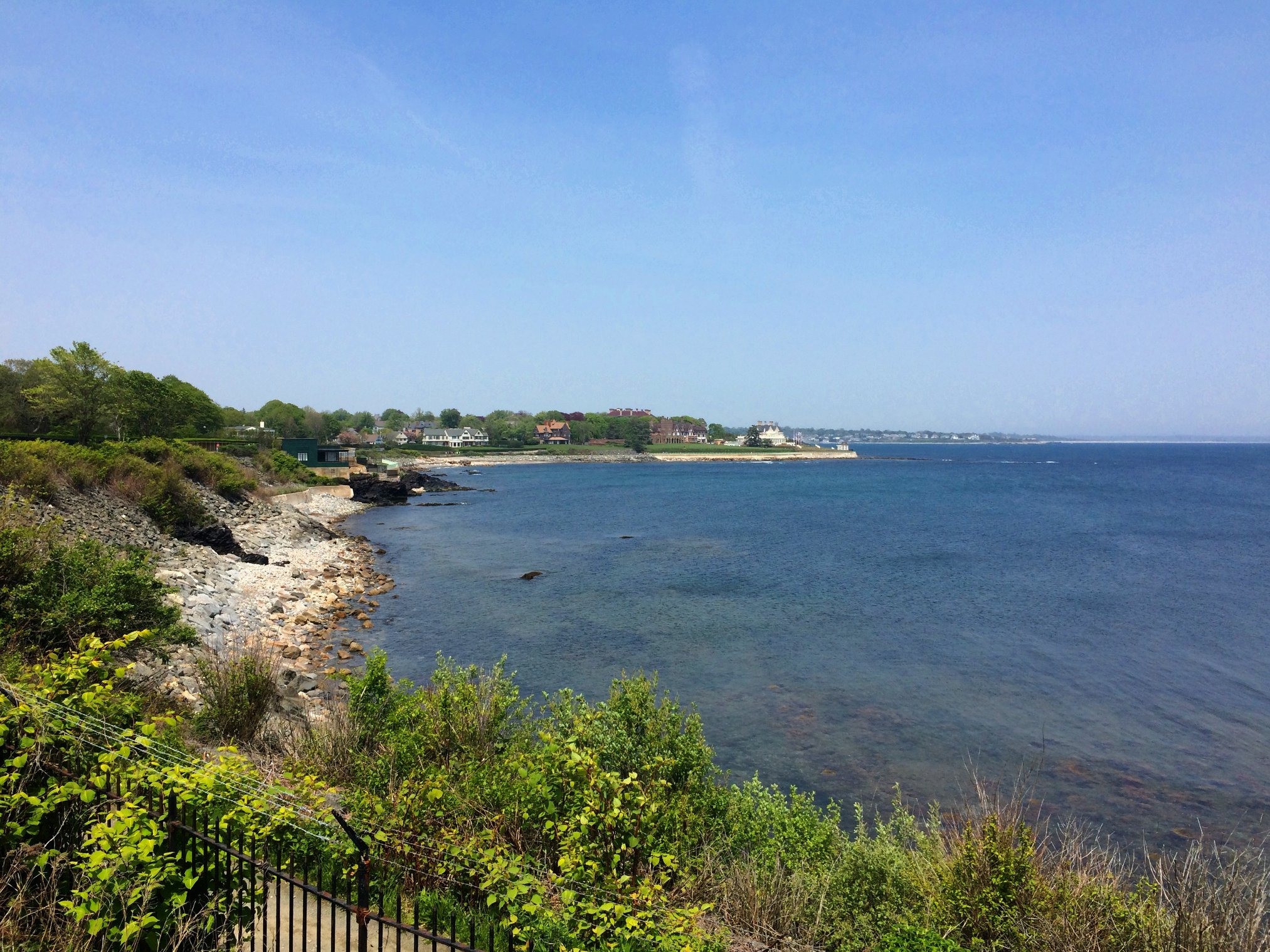
![The Breakers [3*]](https://upload.wikimedia.org/wikipedia/commons/2/28/The_Breakers_2010-07.jpg)
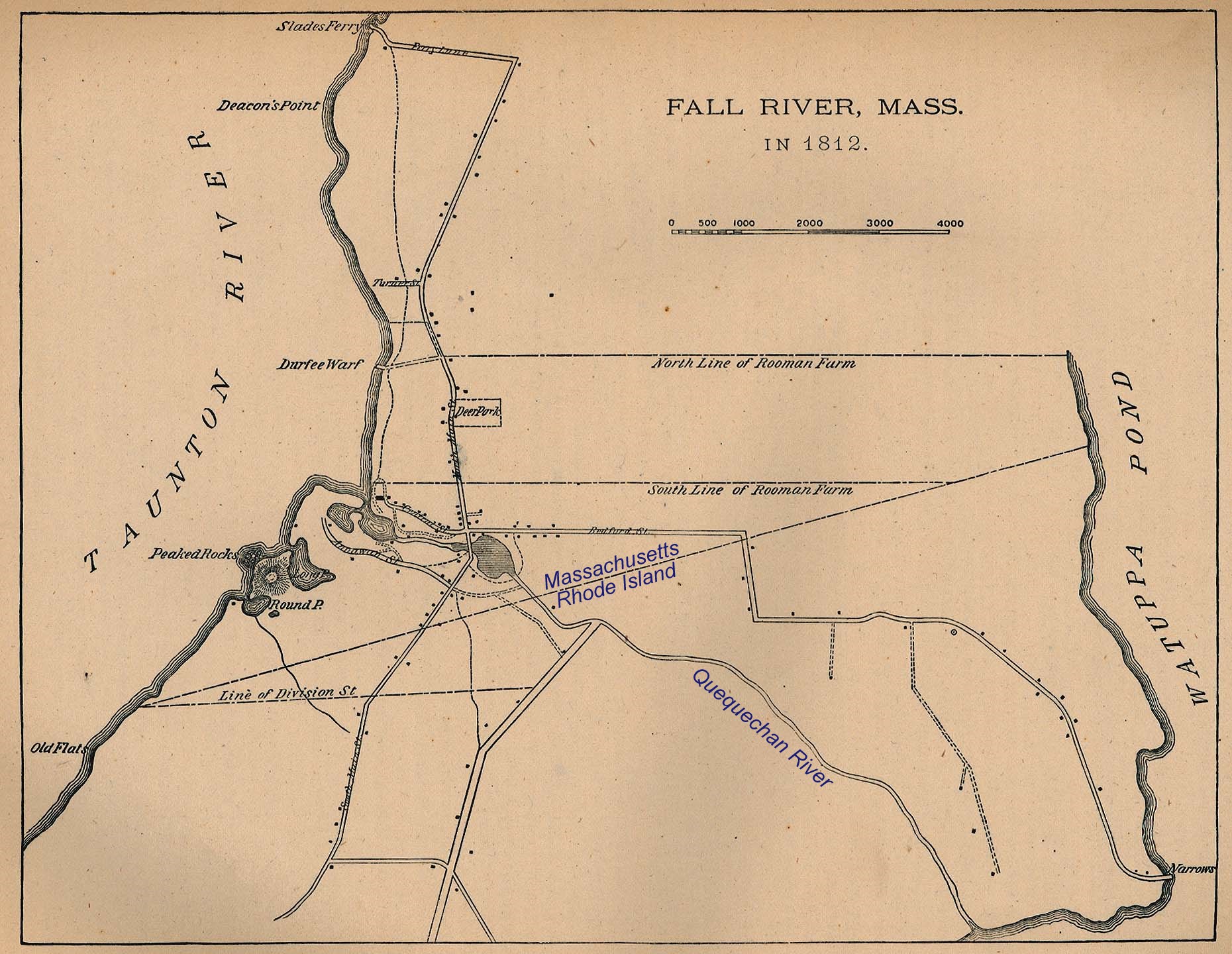
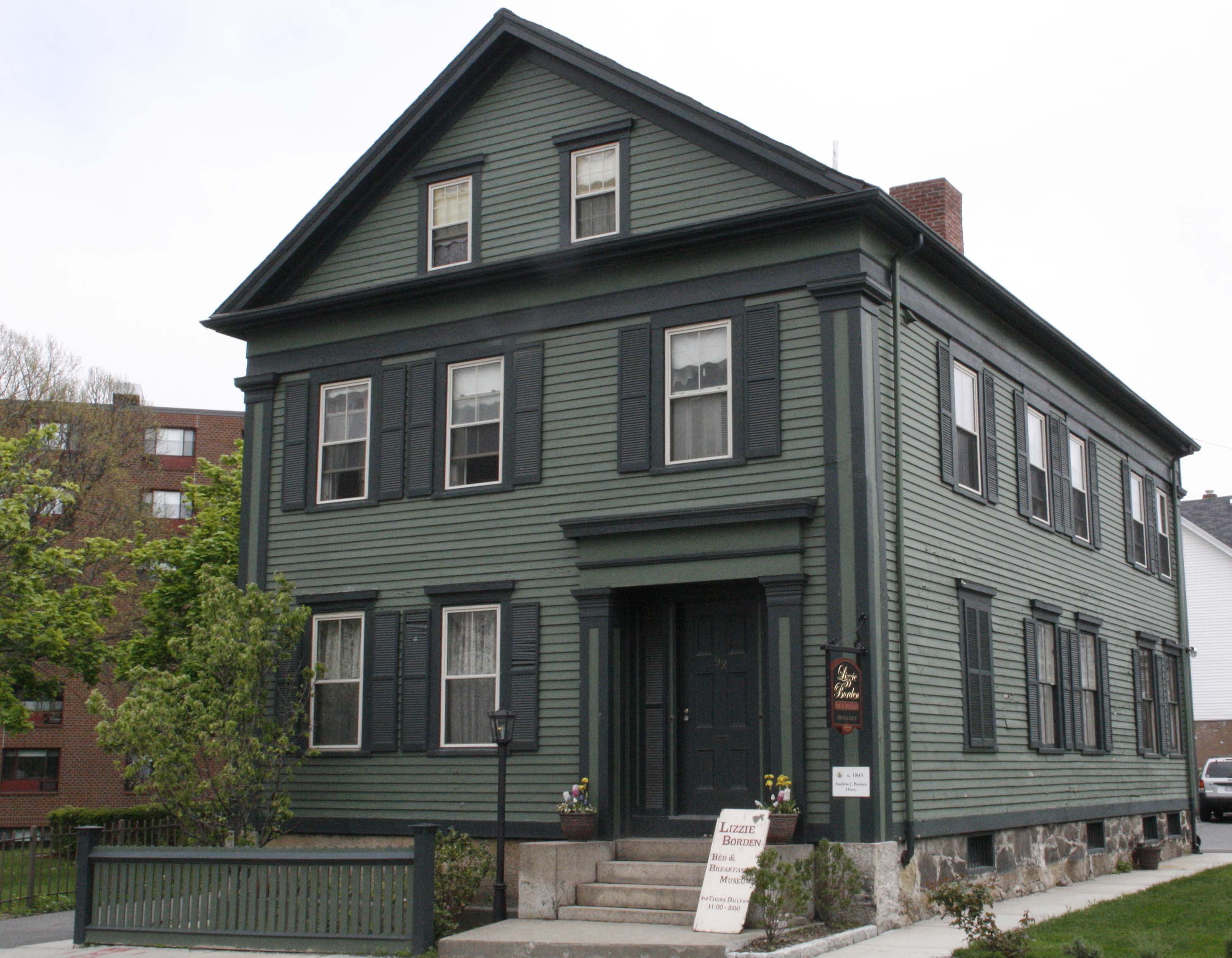
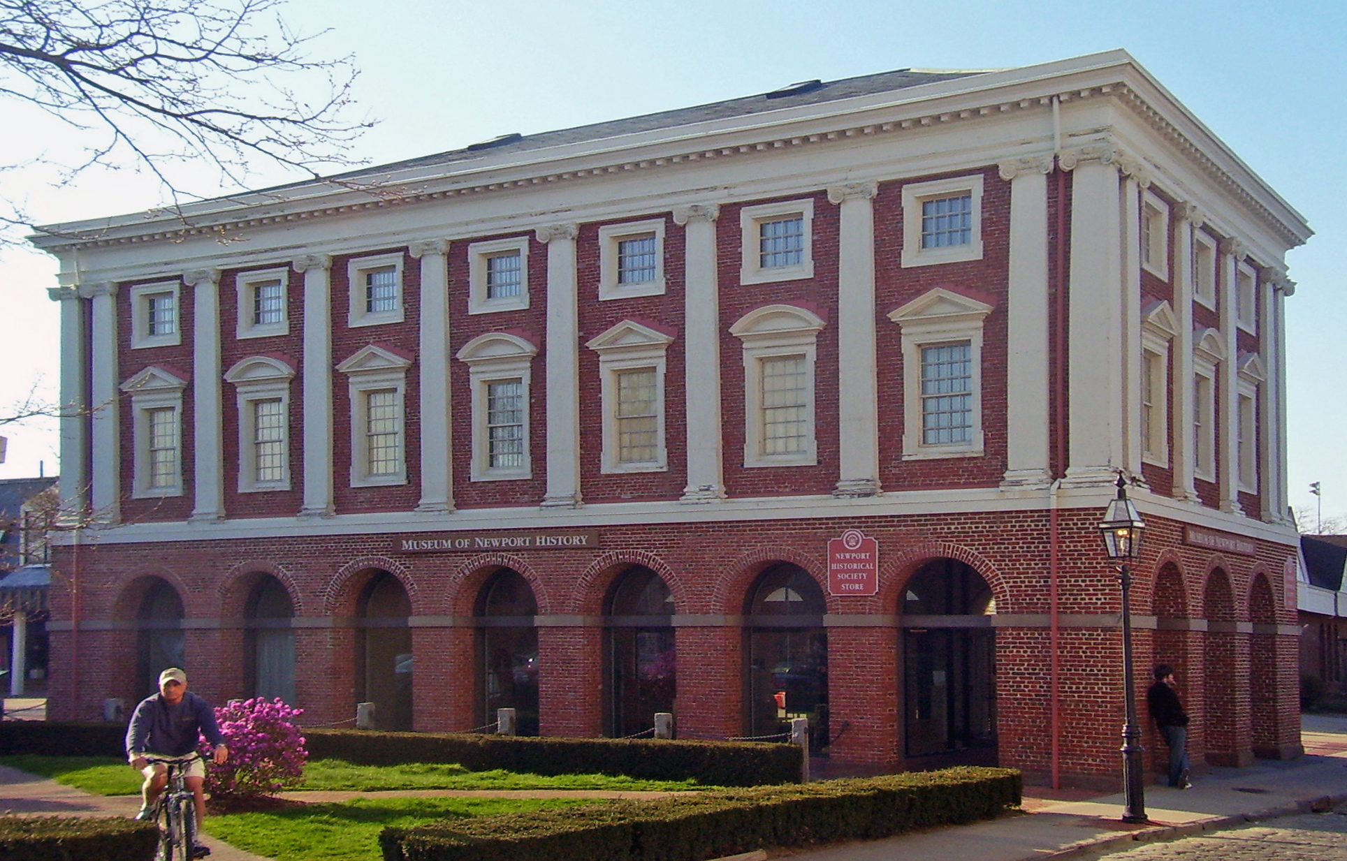
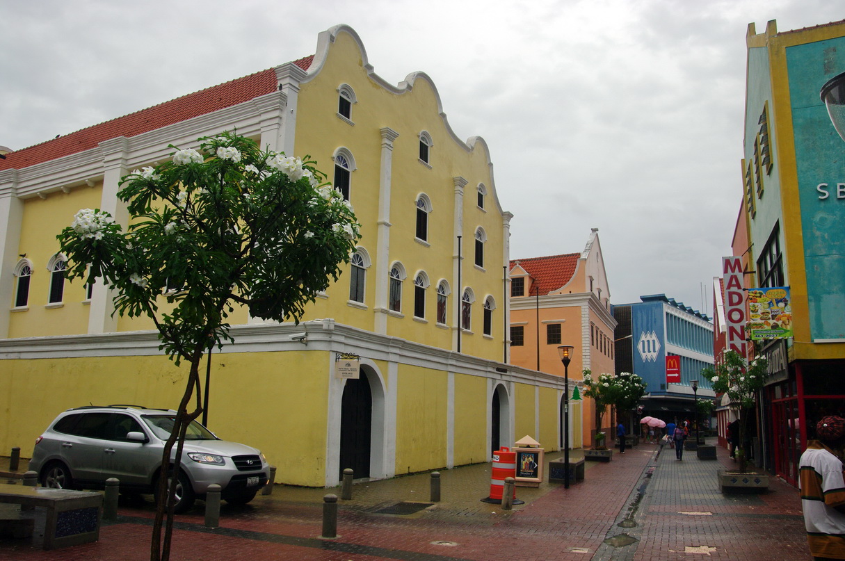
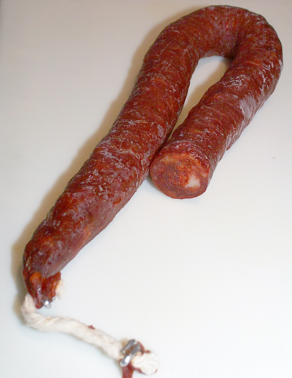
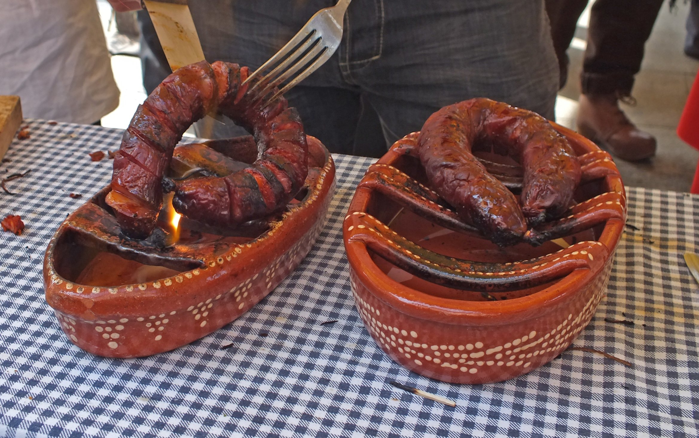