|
Reflections 2017
Series 16
August 30
Bolivia II: La Paz; Lima Airport
| | La Paz We've talked in the past about travel routes from the Pacific, to Arequipa, to Puno, across Lake Titicaca connecting to La Paz, and beyond to Potosí and its famed silver mines. Those were Inca routes, then Spanish Colonial routes to get the silver to Spain. When rail lines and the lake steamers were built, it was really just a more modern continuation of ancient travel routes. Before La Paz was La Paz, it was an Inca settlement along this commercial route. When conquistador Alonzo de Mendoza crossed the Altiplano and arrived here in 1548, he founded La Paz on the site of the Inca settlement.
http://www.centellas.org/miguel/img/2003/october/lapazmap.jpg
| | | | But as we consider La Paz, we have to realize that it not too long ago split in two (see above map). What had earlier been the western La Paz district of El Alto, lying above the rest of the city up on the Altiplano and coming to a precipitous end at the edge of a cliff, was politically separated from the City of La Paz in an administrative reform in March 1985. In 1987, El Alto was formally incorporated as a separate city, shown above in gold. The rest of the former La Paz, which is now the entirety of La Paz, lies in a rounded bowl formation below the Altiplano, and is shown on the map in green. | | | | You can judge how flat El Alto is, being on the plateau, and how hills break up the rounded bowl of La Paz, leaving many valleys. Otherwise, the purpose of this map is to show highway routes in and out of the metropolitan area, so we can mention that, when we arrive from Huatajata, it will be from the uppermost road on the left, via El Alto. You will also note that there's only one airport serving both cities, El Alto Airport, from which we'll leave in a couple of days. So as it turns out, we will be both arriving in, and leaving from, La Paz via El Alto. | | | | The largest single city in Bolivia in population is Santa Cruz (de la Sierra) in east-central Bolivia (1.4 million). The second city is El Alto and La Paz is only third. But since El Alto and La Paz are twin cities, the combined population, including suburbs, forms the largest metropolitan area in Bolivia at 2.3 million.
http://ats.abris-a.com/bolivia/map/bol-m-el-alto.jpg
| | | | This map shows how El Alto, and the Altiplano, end abruptly above La Paz, shown in white on the right, with roads then twisting down below. The dry and inclement plain above La Paz that is now El Alto was uninhabited until 1903 when the newly built railways from Lake Titicaca and Arica reached the rim of the canyon. That was the location of the La Paz terminus, where rail yards and depots were built along with a settlement of railway workers (a spur line down into the canyon opened in 1905). In that sense El Alto started as a railroad town. | | | | El Alto is the largest city in Latin America with a mostly Amerindian population. About 76% of its inhabitants are Aymara, 9% are Quechua, 15% are Mestizo (descendants of Amerindian and White Europeans), and less than 0.1% are Criollos/Creoles (White). | | | | The geography of metropolitan La Paz (and in particular the altitude) reflects society. El Alto is largely working class, and the lower areas of the metropolitan area are the more affluent areas. While many middle-class residents live in high-rise condos near the center of La Paz, the houses of the truly affluent are located in the lower neighborhoods to the southeast. And looking up from the center, the surrounding hills are plastered with makeshift houses of those less economically fortunate.
http://1.bp.blogspot.com/-BGCRFDuMOf0/USOudQsJsuI/AAAAAAAACgA/UQgaR-6RA1U/s1600/PLANO+TUR%C3%8DSTICO+OFICIAL+DE+LA+PAZ+-+CENTRO.png
| | | | This is the map of La Paz we'll be using (click). The most striking thing is the main boulevard running northwest-southeast. Find the part named Avenida Mariscal [Marshall] Santa Cruz, right in the center of the Historic District, since our hotel, La Casona, will be on the south side of that avenue at that point. But whenever you see a wide street winding through an old city, get suspicious that it wasn't always a street. | | | | La Paz lies in a canyon created by the Choqeyapu River. The river is now mostly built over, and lies beneath this main thoroughfare. The covered-over river in Cusco on which the Rumi Punku Hotel was located was the Choqechaka. I think we can do a quick analysis to see at the Aymara (maybe also Quechua) word for "river" is choqe. | | | | La Paz, at 3,640 m (11,942 ft) is the highest national capital in the world. But remember, it's slightly lower than Huatajata on the Lake, which in turn is slightly lower than Yumani, above the Lake. If you're used to water boiling at 100°C (212°F), note that it boils in La Paz at 88°C (190°F). | | | | We talked about bowler hats/derbies in the Ecuador posting in 2015/15, how they arrived to South America, and ended up being used by Aymara and Quechua women. But we also said that Bolivia was and is the epicenter of that use, so I'd like to repeat it: It came about in the 1920s in Bolivia, which will explain why wearers are more numerous there. I've heard two versions of the same story, and . . . it involves . . . British railway workers working in Bolivia. A shipment of bowlers arrived in Bolivia for the railway workers, but was rejected. One version says they were too small, another the wrong color, brown. They didn't want to send the shipment back. One version says they were given away to indigenous women. The other, more likely, says they were sold to them by telling them it was the height of fashion for European women, thereby opening up a new market in women wearers of bowlers, and the style caught on. I'll also repeat from that posting this cute picture, which was taken in La Paz in the first place, of a chola wearing a sombrero hongo (Photo by Tabea Huth at the German language Wikipedia). A hongo is a mushroom, so bowlers/derbies in Spanish are "mushroom hats", a very perceptive name. | | | | Names There are three names that come up in La Paz that have interesting stories, so let's delve a bit into language and culture.
| | | | LA PAZ: The name La Paz means "peace", which doesn't really seem to make any sense—you'd expect the next to find cities named Faith, Hope, and Charity. Nice concepts, but unlikely names for cities. But the story has a cultural bent, the tendency for the Spanish to give religious names to cities, especially in the New World. Cities named after saints are usually named after the original church founded there, which had been named after the saint, such as San Francisco, Santa Monica, San Diego, Santa Bárbara. | | | | But also in California we come across a city called The Angels, which like Peace, is really quite unusual. In this case, there was no church involved, as the original settlers came up with the very lengthy urban name El Pueblo de Nuestra Señora la Reina de los Ángeles de Porciúncula/The Town of Our Lady, Queen of the Angels of Porciúncula. That lengthy name was shortened to Los Angeles. Early Bolivians weren't quite that verbose, but they did name their city Nuestra Señora de la Paz/Our Lady of Peace, which in turn got shortened to La Paz. | | | | | | I have told the Los Angeles story before, but never was able to figure out about that last word. I have the answer now, and also know the answer to the chicken/egg issue. When the settlers of LA arrived, it was on 2 August 1769 and they camped at what is today the Los Angeles River. There were two Franciscan missionaries in the group who were aware that 2 August is the feast day of the Queen of the Angels, an honorific of the Virgin Mary. They first named the river El Río de Nuestra Señora la Reina de los Ángeles de Porciúncula/The River of . . ., so we now know the river was named first, and the town-cum-city was named after the river. Porciúncula is the Spanish version of the church where St Francis of Assisi carried out his religious life. Early on, the river was even called the Porciuncula River, but that was later dropped. |
| | | | EL ALTO: I will readily admit that I walked down the garden path with this name and totally misunderstood its origin. If you didn't, let me lead you down the same garden path. Alto is "high" in Spanish, right? Also think of altitud/altitude, even Altiplano. The whole area is high above La Paz, right? So the name must mean The Height[s], right? | | | | Wrong. It's a homonym problem, and an unlikely, but much more interesting answer. Germanic words from northern Europe entered Latinate languages in southern Europe going back to the Germanic invasions of the Goths, Visigoths, Vandals, Gauls, and others. That's why Italian has two words for "blue", the native azzurro and the Germanic blu, related to English "blue" and German blau. That's why English "helmet" and German Helm, appear in Spanish as the borrowed version yelmo. | | | | That's also why you'd better stop when a Spanish cop shows you his palm and says ¡Alto!--just think of English and German "Halt!", because that's what the borrowed Spanish version appears as. Well, that much I'd known, but I was unaware that it could be used in the form El Alto, since The Halt doesn't seem to make sense. But it does, when you know the story. Alonso de Mendoza, crossing the Altiplano, came to an abrupt stop up on that cliff on 23 October 1548 on his way to founding La Paz. Though routes down into the valley were found, the edge of the plateau where he had to halt has been called El Alto/The Halt ever since. | | | | STANNUM BOUTIQUE HOTEL: Just as I'd originally had two Cusco hotels in mind, I'd also had two La Paz hotels in mind. I'm delighted that I found the Boutique Hotel La Casona, a historic 17C building with ties to the construction of the adjacent Basilica de San Francisco. When I told Crillón that's what I wanted them to book for me after their earlier tour, they said I'd made a good choice. | | | | The other hotel I'd considered, the highly praised Stannum, was a quarter hour and 3 km (2 mi) southeast of the center. It was unusual that it was on two floors of a high-rise, with the lobby on the 12th floor. I liked it, but liked La Casona better. But I have to say it was that name, Stannum, that totally intrigued me. It was obviously not Spanish, and had to be Latin. It looked familiar, but what was it? You may have already figured it out if you took high-school chemistry as I did, but I was rather slow on the draw here. The way my mind works, before I considered an answer via chemistry, I automatically went through a strategy of language analysis. | | | | Final Position: I knew that Latin words ending in –UM and –US, many of which were artificially borrowed into non-Latinate languages such as English, were taken whole: museum, opium, helium; genius, exodus, detritus. But in a Latinate language such as Spanish, they developed as follows: these words dropped the M or S, and almost always shifted the remaining U to an O: museo, opio, helio; genio, éxodo, detrito. This is the development that accounts for so many Spanish words ending in O, sometimes used for humorous purposes in English, such as "el jerk-o". | | | | | | It's interesting to find Spanish words that never quite completed their "jump over the fence". Latin impetus, spiritus, appearing as borrowed words in English in the form "impetus, spirit" to this day appear in Spanish as ímpetu, espíritu, with that final U never having quite made it to the expected O. |
| | | | Initial Position: That last Spanish word leads us into another development. In many languages, words that begin with an S plus any consonant, noted linguistically as "sC-", have developed irregularly. I'll avoid some interesting cases (Italian, German, even English a bit), but will mention all four westernmost Latinate languages. Apparently sometime in the past, pronouncing initial sC- started to feel difficult, and a vowel was muttered first to help out. This vowel developed uniformly into E, and so sC- became esC- in these languages. Using the above "spirit" as an example, in addition to Spanish espíritu we have Portuguese espírito (which, interestingly did get its final O), Catalán esperit, and French esprit. This development also obviously accounts for why "Spain, Spanish" appear as España, español. | | | | | | French has notoriously always demonstrated the most change from the original. In this case, in a number of words French has gone on to change the esC- to éC-, losing the S entirely. Thus "school, state", in Spanish retains the S in escuela, estado, while French has dropped it in école, état.
This footnote also needs its own footnote. In Caribbean Spanish, S in these and other positions is also dropped colloquially, resulting in the pronunciations "ecuela, etado". This would indicate that Spanish might be headed in the same direction France took—but that's conjecture. Educated conjecture, but still conjecture.
|
| | | | Medial Position: This is the rarest of these three developments, and I'll only cite one example that I'm quite familiar with. Latin had long consonants, written with double letters. I know that Latin NN could become Spanish Ñ, which accounts for Latin annus and Spanish año "year", including the ending we'd expect. | | | | Now let's put these three developments together: ST+A+NN+UM should have developed in Spanish to EST+A+Ñ+O, and as soon as I saw that, I recognized the Spanish word for "tin", estaño, and realized that that's exactly what had happened! It was only the next step flashing back to chemistry class and remembering that the symbol for tin is Sn, for stannum. Thus I arrived at the same answer via two routes.
https://dpzls65sd6tj8.cloudfront.net/content/econgeo/100/8/1647/F1.large.jpg
| | | | That Bolivia has traditionally been a major exporter of tin is a fact that stayed with me since we studied this area in 5th or 6th grade. I now learn that Potosí, famous for its silver mines since Colonial days, is also in the center of Bolivia's tin belt (above map), as is La Paz. What goes around, comes around. | | | | Well, maybe not quite. I now read that mining has been a main feature of the Bolivian economy since 1557, starting with silver being sent to Spain in the colonial days via the route to the Pacific we've discussed, but then tin mining supplanted silver by the 20C. Beyond that, there then was a strong drop in output between 1975 and 1985, so things are no longer as they were. | | | | We've been discussing Germanic and Latinate languages, and can expand on that in regard to tin. The word is shared among Germanic languages and can be traced back to reconstructed Proto-Germanic *tinom; cognates include Dutch & Danish tin, Norwegian tinn, Swedish tenn and German Zinn (pronounced TSIN). Similar variations have also entered non-Germanic languages as borrowings from Germanic, such as Estonian tina. | | | | For centuries tin was regarded as a form of silver debased by lead, which explains its figurative use pejoratively in English, as in "tin ear" or a "tinny" sound. The first alloy used on a large scale was bronze, made of tin and copper, which gave its name to the Bronze Age. Pewter is an alloy of 85–90% tin with the remainder commonly consisting of copper, antimony, and lead. | | | | As for Latinate languages, the Latin word stannum originally meant an alloy of silver and lead, and came to mean "tin" only in the 4C BCE. The earlier Latin phrase for it was either plumbum candidum or plumbum album, both of which are literally "white lead". The Romanian word staniu apparently has changed very little, while the French étain seems to have changed the most, including losing the S. Keep in mind that the NY sound written in Spanish with Ñ (estaño) is written in Catalán with NY (!) (estany), in Portuguese with NH (estanho), and in Italian with GN (stagno). That's a spelling quirk, so those words are a lot more similar once that's taken into consideration. | | | | | | Romanian and Italian are the only ones that never added the initial E, but now I can mention something I purposely left out earlier, how Italian is indeed affected by the initial sC- problem. Grammatically feminine words in sC- are not affected, and the article remainsla no matter what, such as la stella (star). But masculine words in sC- cannot use the usual masculine article il, as that would awkwardly bring together three consonants in a row: -lsC-. Instead, Italian uses the special masculine article lo, whose final vowel avoids the problem: lo stagno. |
| | | | Historic Destinations When I reviewed what there was to see in La Paz, there were quite a few things that didn't interest me and that struck me as much more touristy than I was willing to put up with. What I'm saying is, if I were walking the streets on my own, I would have ended up with the following list, despite what the "standard" city tour encompasses. There's a lot of contemporary Lima I skipped this trip, because of lack of interest—I delved into the traditional. Without a doubt, Quito is for me the best of the three capitals, as it's historic enter was truly outstanding, including the historic hotel. In La Paz, I had my historic hotel, and a rather short list of historic places of interest, all nearby, that I wanted to see in my two days.
| | | | (1) I wanted to see the Basilica de San Francisco, located on the Plaza Mayor de San Francisco. My hotel had a historic connection with this church, and was just a few steps away from the church and square. Adjacent to the Plaza was the Calle Sagárnaga (sa.GAR.na.ga), whose name enthralled me—sometimes one is just taken with words. I'd read it was a major shopping street, but it turned out differently from what I'd imagined. | | | | (2) I wanted to see the Terminal de Buses/Bus Terminal. That sounds absolutely ridiculous, I know. But it was designed by the French architect Gustave Eiffel, who not only did the Eiffel Tower, but the inner structure of the Statue of Liberty. The building here, though was originally a train station. | | | | (3) I wanted to see Plaza Murillo, the historic main square of the city, that boasted the Legislature, the Presidential Palace, and the Cathedral around a charming public park. | | | | A Modern Destination To my mind, La Paz has a contemporary site that beats everything else, and it's worth visiting the city for this alone. It's not a building or bridge, nor is it on rails. It's new, and only began operation on 30 May 2014, so its oldest parts were barely three years old when I used them this May. This modern showcase in La Paz is the new system of gondola cable cars called Mi Teleférico/My Cable Car. | | | | The term "cable car" in English is ambiguous. It can describe the cars that grab onto an underground moving cable like in San Francisco, and like New York and other cities once had. What we're talking about here are above-ground cables, but those also carry chair lifts and large-cabin aerial tramways that shuttle back and forth. What we're talking about here are smallish gondola cable cars, which hang from a moving cable running in a circle around the tops of several towers. A silly, but helpful parallel is that they're like clothes drying on a moving clothes line. One that's just like these was in Madeira, from Funchal on the coast to Monte in the mountains (2012/8). Above-ground cable cars are common in Switzerland. Part of the ride in Luzern, coming down from Mount Pilatus, was on four-seat gondola cable cars (2008/14). Others described, such as in Sankt Moritz, were more of a large-cabin aerial tramway (2008/16). | | | | | | We last talked about a gondola cable car recently, in 2017/4, when in the Albany-Rensselaer Amtrak station, where a gondola connection over the Hudson to Albany is being considered, called the Capital District Gondola Project. I've gotten more news from a New York Times article on 14 August 2017. It seems it's still being discussed, but now I understand they're thinking of not one, but two stops on the Albany side, one downtown and the other at the State Capitol complex.
Also under consideration, according to the article, is the so-called East River Skyway, a gondola cable car that would start with two stops in the Williamsburg neighborhood of Brooklyn, run parallel to the north side of the Williamsburg Bridge, then continue straight down Delancey Street in Manhattan as far as Christie Street. This will bring to mind the Roosevelt Island Tramway that runs parallel to the north side of the Queensboro Bridge, however that's not a gondola system. I've ridden it, and it's an aerial tram with one large cabin that shuttles back and forth between stations in Manhattan and Roosevelt Island, while a gondola has many smaller cabins running continuously in a circle.
|
| | | | Once we realize what the continuous, smallish gondola cable cars are, we can point out that they usually appear singly, in mountains, or not, as in coastal Funchal. What's unique in La Paz is that, since subways or streetcars are impractical because of the geography, the city is building an entire metropolitan area rapid-transit system based solely on gondola cable cars. Having a gondola network like this is unique, and engineers from around the world are visiting La Paz to see how it's working out.
https://skiliftblog.files.wordpress.com/2016/07/mapateleferico_zps3pt00if6.jpg
| | | | It's time we look at what all the fuss is about in La Paz. Hold on to this map, the newest I could find, which is from July 2016, and is rapidly being outdated as the system grows. Of the eleven (!!) presently proposed routes, four are complete. As you can see, the entire system is totally color-coded, where gondola cabins and stations are always the same color. The effect is striking. | | | | Phase One, consisting of the Roja/Red, Amarilla/Yellow, and Verde/Green lines, opened in 2014. Those were chosen because they're the color of the Bolivian flag (Image by Caleb Moore). At 10 km (6.2 mi) in length, the three lines of just Phase One are considered to be the longest aerial cable car system in the world, and Phase Two will extend the system length by some 20 km (12 mi).
http://www.la-razon.com/sociedad/Instalaran-Linea-Roja-Infografia-Razon_LRZIMA20140104_0040_4.jpg
| | | | This is an older illustration showing the building of the Red line. The main thing I note of interest here is that it shows using a helicopter to hang the cable. I also heard they used drones to do that. (I've learned that the Spanish word is dron.)This is a very 21C project. | | | | The first line in Phase Two, Azul/Blue, opened in 2017 (March 3), just 2.5 months before I rode it in late May. While all the other lines have, or will have, either three or four stations, the Blue is the longest, with five. To allow you to judge the whole system, I'll give the statistics on just this one line. It runs 4.981 km (3.095 mi), has 208 cabins, and 38 towers. The ride takes just over 20 minutes. | | | | The other seven lines either under construction or planned are: Naranja/Orange, Blanca/White, Morada/Purple, Celeste/Sky Blue, Café/Brown, Plateada/Silver, Dorada/Gold. Hard to find on the map is the short Brown line, which is next to the White line. The Silver line is shown, but hasn't yet been summarized at the right. Neither is the /Gold line, which isn't even properly shown on the map—it's in blue dots way to the east. That's how fast things are developing.
http://gondolaproject.com/wp-content/uploads/2016/02/Silver-Line-602x300.jpg?lbisphpreq=1
| | | | This special illustration indicates that the Silver line is now under construction, following the Purple line. I found an older article dated February 2016 with this information: In just 22 months, the La Paz urban gondola network has surpassed 40 million riders. That’s an average of about 1.8 million passengers per month, or 60,000 per day. A new cable car, the Silver Line (Linea Plateada) was announced while construction works for the Purple Line (Linea Morada) began. Once designs are complete, construction of the Silver Line could start in 2017 and be operational by 2018/2019. The cable car will effectively unify and integrate 4 separate lines (Yellow, Purple, Blue and Red). | | | | As you can see, two lines (Red and Yellow) connect La Paz and El Alto, which are separated by an elevation change of about 400 m (1,300 ft), so travel between the two has always been a challenge, and was previously limited to heavily crowded, winding streets. The system was built by Doppelmayr Garaventa Group. Doppelmayr was an Austrian company and Garaventa a Swiss company, when the two merged in 2002 to form the largest cable company of its kind in the world. | | | | Showing the importance of indigenous culture, all stations have both a Spanish name and an Aymara name, although not all Aymara names are shown on this map. The fare is 3 bolivianos (US$0.43), with a 50% discount for students, seniors, and the disabled. The fare is designed to undercut the 5 boliviano bus fare between the two cities. Each car seats 10 passengers. Cars depart every 12 seconds, and the network is open 17 hours a day. It's estimated that there could be up to 16 lines in the La Paz Teleférico system by 2030. I've also read that, right from the beginning, the system has become an immediate must-see by all visitors, since it's now a principal attraction of La Paz. | | | | Day 12: La Paz I After breakfast in the Huatajata hotel, the driver picked María and me up to go to La Paz. While I'd told her just what I wanted to do in my two days there, which were, happily, much more time than I needed, she hadn't detailed how she'd planned on working things out, but I couldn't have done it better.
http://w0.fast-meteo.com/locationmaps/La-Paz.10.gif
| | | | Gondola Cable Cars: Blue & Red Lines Find Huatajata on this map well to the west. She had mentioned it was a two-hour ride. The road was dusty, bumpy, and under construction, and during the dreary drive I lay down in the back of the car to doze, but in an hour in a half, I saw we'd arrived. She'd cleverly planned it that we'd start our sightseeing before arriving, and simultaneously lop a half hour off the drive, because we were in western El Alto at the Río Seco terminus of the Blue Line. Meanwhile, the driver would go into La Paz and meet us at the far end of our gondola ride. Not only did this save time, but it was a magnificent way to enter the metropolitan area, and also, as on the mule ride (!) I was using the gondola system for real transportation from Point A to Point B, and not backtracking (though on the second day we'd backtrack).
http://www.boliviatv.bo/web/images.php?src=images/noticias/2017-03-04/images/a89192_IMG_8538.JPG&w=800&q=100&s=1&zc=1
https://cde.laprensa.e3.pe/ima/0/0/1/6/3/163353.jpg
| | | | The stations seem all to be two-story, with elevators and escalators, as the first picture shows. You buy tickets or passes downstairs and depart from above. This is one of the stations on the Blue Line—you can't miss those colors!—though it seems to be an intermediate station--I doubt it's Río Seco. Most of the route of the Blue Line was flat, as is El Alto, and continued along a main boulevard as in the second picture. There were no dizzying gorges here to cross over, and most of the route was as shown, a couple of stories above the street. Note how many gondolas you see at once, which is typical. | | | | When we changed to the Red Line, I was rather surprised to find that there are no transfers, and each line charges a new fare. While that's unusual with rapid transit, it might be an inherent necessity based on the infrastructure of the system.
http://2.bp.blogspot.com/-uZXOyJM7zAE/U2goyBvSLUI/AAAAAAAASuc/2SlF2ceecLI/s1600/teleferico.jpg
http://www.eabolivia.com/images/stories/lp/teleferico-metro.jpg
https://i0.wp.com/eju.tv/wp-content/uploads/2014/07/image10.png?fit=604%2C401
| | | | It's obvious the first picture shows where you board the Red Line, and that it's a terminus, where the cars have detached themselves from the main cable and are rotated around to the opposite direction. The second picture shows how there's always an attendant to help passengers to board the cars, which usually are moving slowly. While the third picture shows the same thing, I think it's priceless, showing how The Traditional meets The Ultramodern, where an attendant helps an elderly chola wearing a sombrero hongo board a sleek, supermodern gondola car. | | | | I was looking forward in particular to ride the Red Line because it's the one that, as soon as it leaves the 16 de Julio station, PLUNGES over the cliff and glides down those 400 m (1300 ft) into the valley. It's thrilling. And if you look at it in the right angle, do you think the uniform color of the many cars at once seem to be a space invasion? (Both photos by TheGamerJediPro) | | | | Take a last look for the moment at the gondola map to note that the Red Line ends at the Estación Central/Central Station, where we get off. Then go back to the La Paz map and note on the very left the Estación de Ferrocarriles/Railroad Station, which is the same thing. Also take note how close the gondola system, which we started riding way to the west in El Alto, has brought us to our hotel.
http://www.eldiario.net/noticias/2014/2014_11/nt141127/f_2014-11-27_58.jpg
| | | | There's one misleading issue here, though. We saw how the former rail station in Lima has been recycled. It turns out, trains stopped running at the La Paz station (above), some time ago. While I've read online opinions wanting trains back, at the moment, the La Paz Rail Station has taken on a new life as a terminus of the Red Line! | | | | The Historic Center Continue following on the La Paz map. The driver picked us up, and we drove around local streets where Sunday markets of all sorts were in full bloom. We then entered the southern end of Calle Sagárnaga and drove to where it ends in the T-intersection with the main boulevard, called here the Avenida Mariscal Santa Cruz. But remembering that that replaces a river, it's understandable that Sagárnaga would have originally been on the riverbank, and would slope down to the river.
http://www.lapazlife.com/wp-content/uploads/2014/07/Sagarnaga-street-la-paz-bolivia-2.jpg
https://ssl.c.photoshelter.com/img-get/I0000gL3I9fkc76A/s/650/650/Calle-Sagarnaga-Iglesia-San-Francisco-La-Paz-Bolivia.jpg
| | | | The first thing I noticed is that Sagárnaga, while a major shopping street as I'd read, was not the elegant thoroughfare I'd imagined, but a standard narrow street with numerous market stalls, as in both pictures above. Very colorful, but not what I'd pictured. I just love the sound of that name—it turns out he was a revolutionary hero. You see the slope in the first picture, meaning the T-intersection with the Avenida is behind the camera. The downhill view of the second picture shows that this is the direction we're actually headed in. That's confirmed by our seeing the back of the tower of the Basilica de San Francisco. | | | | Now let's get more oriented with our neighborhood. Find the T-intersection on our map. To the left, #21 is the Basilica de San Francisco and #7 is its former convent, now a museum. The vast area in front of it is the Plaza Mayor de San Francisco. Precisely at the T-intersection, but to the right, is a large white corner building, but the second building in on the Avenida is La Casona, our hotel. We are right in the midst of things. | | | | The driver drops us off at the T-intersection, drops off my bag at the hotel, and goes home for the day. María and I walk across the Plaza and enter San Francisco (Photo by User:Anakin). From this angle you see the white corner building, so you know how close the hotel is. | | | | San Francisco was built between the 16C and 18C in the style called Barroco Mestizo (Mixed-Culture Baroque) or Barroco Andino (Andean Baroque). It had been a part of the adjacent convent complex that is now a museum. The vast Plaza in front of it that bears its name can accommodate 100,000 people and constitutes the largest open public space in La Paz. All year long the Plaza welcomes fairs, expositions, and concerts. Since we were there on a Sunday, the Plaza was particularly busy, including some fair booths on the far side.
http://www.lapazlife.com/wp-content/uploads/2014/07/Interior_de_la_Iglesia_San_Francisco-la-paz-bolivia.jpg
http://farm4.static.flickr.com/3641/3370989358_c3b0bf8fc3_b.jpg
| | | | The church was impressively large, and attractively decorated, as both pictures show. It being Sunday, a Mass was in session, and the church was full, as we wandered quietly around the outer aisles. We then left and crossed the Plaza to go to the hotel.
https://www.viajablog.com/wp-content/uploads/2015/02/La-Paz-Bolivia-12.jpg
| | | | I'm delighted to have found this picture online, because it shows everything we've been discussing in "our" neighborhood. It looks south from the downtown historic district and shows the bowl-like formation around La Paz with humble houses rising up the sides. It shows Sagárnaga coming downhill to join the Avenida at the T-intersection. It shows the white corner building with red-roofed La Casona to the left. It shows San Francisco, with the huge convent museum to its right. It shows the huge size of the Plaza Mayor de San Francisco. This is our stage setting. What could possibly go wrong? | | | | The High-Altitude Event María and I walked diagonally from the church to the edge of the Plaza near the T-intersection. By chance I spotted some people there I knew. As we were to find out, both Australian couples from Sun Island were staying at La Casona, one of which I'd met on the train even earlier. It was the train couple, Laurel and Mal (Malcolm), who had skipped Huatajata and had come here directly, who were on the Plaza with their guide. I walked up and greeted them, then gave Laurel a bear hug. I then turned to my right and reached out my hand to shake Mal's hand . . . | | | | That didn't happen, because just then I passed out and collapsed to the ground. It was so strange, and so fast. I "saw" blackness for a split second, as when lights in a house flicker during a storm. From that point, I was fully aware of my knees buckling and of me going down. I twisted my left knee slightly, but was unaware of it the whole rest of the day—only the next day did it start to bother me somewhat, which lasted for weeks. Oddly, a Red Cross nurse in full white-and-red regalia came rushing up. I assume she was there because of the events on the Plaza. As soon as she saw me getting up with the help of the others, she left. As I've said since, if the high altitude had to get to me once like this, and out on the street at that, I'm glad it was in the company of others. It's also good that the sightseeing of the day was over and we were going to the hotel, anyway. On the other hand, it was suggested that the adrenaline rush of unexpectedly suddenly seeing familiar faces that put me over the top. | | | | Later, in my mind's eye, I smiled as I thought of the incomplete handshake reminding me of Michaelangelo's Sistine Chapel ceiling (Photo by 1a2b3c?), and, as soon as I got up, I had my wits completely about me and I completed the handshake. The guide with the couple then gave me some very good advice that I found very helpful. He told me to breathe IN through my nose and OUT through my mouth. I don't know why that helped, but it did. Though I didn't have any more problems such as this, for both nights in La Paz I did sleep fitfully, and would wake up taking a deep breath. Using the breathing technique helped, as did taking a sip of water each time. I found it easier both nights to sleep raised on a couple of pillows. But no big deal. | | | | We all walked to La Casona, and María sat me down in the beautiful lobby while she registered me. I was only a bit bothered that it was under negative circumstances that I was seeing this beautiful building for the first time, but no matter. I enjoyed checking it out later. María said she had to report the event to Crillón, and I said that was fine. She also suggested I have their on-call doctor check me out. She said he's good, and would visit the hotel for $60, which I found reasonable, so I agreed. | | | | I still had at this point, along with some smaller bills, those three "suspect" twenties that had been rejected at the border. They would cover the doctor bill perfectly, but María wanted to check things out. This is when she took them to the hotel clerk and ask him if they'd theoretically accept these bills in payment. He saw the nicks, and said no. | | | | It was an interesting experiment in "the way things are". No problem. She and I walked down the Avenida a few doors to another cash machine and took out 500 Bolivianos. That was a little over what I needed, and the extra went towards a restaurant bill. Weeks later, the low-level travel insurance I'd taken out even reimbursed me the $60. Since María lived in La Paz, there was no need for her to stay at the hotel, and she went home until the next day. | | | | The Doctor I worked in my room until the young doctor arrived. His business card showed an address just one block down Sagárnaga; he was on the same block as the hotel, and didn't even have to cross a street to get here! That gave me just that much more of a feeling of being part of a local neighborhood. He spoke slightly halting, but good, English, and checked me out. Everything was fine. I couldn't have mentioned my left knee since it didn't start bothering me yet, but he couldn't have done anything, anyway. But it was an interesting and enjoyable meeting. | | | | First, I never paid attention before to that little clip a doctor puts on your finger to get some sort of reading. It turns out it measures oxygen levels in the blood. He explained that a normal oxygen level elsewhere gives a reading of 98. Weeks later, at my doctor's in New York, that's just what my reading was. But this doctor pointed out that "we" in high-altitude La Paz have a normal reading of 91-92, and mine was 92. I was glad to fit in so well with the Paceños. | | | | The other thing I found so interesting was a subject the doctor brought up about sports teams as we sat around chatting. It was not a new subject, because I've clearly remembered over the years being told in 5th or 6th grade that, because of the high altitude, sports teams arriving in La Paz come several days earlier in order for the players to become acclimated to the altitude. Though I already had this in mind, the doctor brought it up as well, but what he said somewhat contradicted what I'd heard, and spoke more to my own situation. He said if an arriving team played right away, some will do well and some will have altitude problems. But then he also said that if a team arrived several days in advance, some will still do well and others will have altitude problems, and in either situation, no one can predict who will be affected and who will not. In other words, it's a gamble, as it had been with me. He also smiled proudly when he said home teams, because they're used to the altitude, do quite well against some of their biggest and most famous, opponents. It was a nice conversation. | | | | La Casona I had allowed two full days in La Paz, the arrival day and one more, and I'm glad I did. Since the little amount of sightseeing I'd planned each day left plenty of time, I had the late afternoon both days to explore La Casona. I'll summarize both afternoons now.
| | | | It was built in the 17C, right here in the historic center of the city, and it's a Colonial legacy building with a link to the San Francisco church. The church and convent were built by the Franciscans, who owned a great deal of adjacent property along the riverbank of the river that is now the Avenida. Construction took a long time, and the Franciscans sold off parcels of land to finance continued construction, and completion, of the complex. It's believed that the piece of land on which La Casona is built was turned over to one of the master builders of the project as part of his honoraria. It took eight years to carefully restore La Casona at the present time, and during that period, numerous architectural building features were found that were the same as in the church and convent. Because of La Casona's original 17C colonial architecture, local authorities landmarked it as representing the Patrimonio Arquitectónico de la Ciudad de La Paz/Architectural Heritage of the City of La Paz. | | | | From its name, I learned a new word. As a casa is a house, a casona, literally a large house, is a mansion. The Spanish/Spanish definition I found is even better, stating that a casona is a casa grande, antigua y señorial, a large, ancient, baronial house. And that it is.
http://www.intolatinamerica.com/wp-content/uploads/2015/12/hotel-la-paz-la-casona-exterior-653x383.jpg
| | | | This picture, while including San Francisco's tower and Plaza, also the white corner building, features La Casona in red and its Spanish barrel-tile roofs. It also shows the width of Avenida Mariscal Santa Cruz, covering the river below. Note, on the roof of La Casona what is called the 3rd-floor terrace, which includes a bell tower. Also note the grayish annex behind, with its dome. This is where my room was, on the 5th floor, with elevator service. It was a single room, with a single bed (oddly, usually called a twin bed in English) which I always prefer. It had parquet floors, a cozy desk area, bath, and shuttered windows facing opposite directions. It was my own little aerie. Since I was already in my room after the doctor left, I did my self-guided tour starting from the top to the bottom.
http://la-razon.com/suplementos/escape/Alojamiento-Gobierno-Autonomo-Departamental-Norteamerica_LRZIMA20150717_0086_4.jpg
https://www.llamatravel.com/media/image-cache/ba429617-d8fb-44c8-9f52-40f0aabc0b65/1016-0--509-338/1469635959-la-casona-hotel-la-paz.jpg
| | | | I started by taking the elevator from the 5th to the 3rd floor to visit Las Terrazas del Campanario/The Bell Tower Terraces, open to all in the hotel. In the first picture, it's only a guess, but my little aerie could be that small window in the annex showing to the right of the bell tower—at any rate, I had a nice downward view from it. The second picture shows more of the sitting area, used in warmer weather to enjoy good city views, although now was late autumn. I do not fully understand why a bell tower was built here. What I've read seems to say it was meant to be part of a church, which would be odd on a roof. It was still an enjoyable spot to visit. Going down to the main level, below is a charming sitting area behind the lobby.
https://exp.cdn-hotels.com/hotels/10000000/10000000/9996400/9996379/9996379_7_z.jpg
| | | | Once we're down on the main floor, another story unfolds. In Colonial days, before banks existed, where did a person of means keep his money and valuables? Not only away from thieves, but in case of an uprising or invasion? He'd have to hide them away in a strongbox, perhaps in a secret room, or in a hidden cellar. And if something should happen to that person, and he was the only one who knew the secret, the location of the hoard would be lost. | | | | These hidden places bore the unusual name of tapado. I had to look that up, and it seems to refer to some sort of an overcoat. Perhaps given the 16C period, we should imagine more of a cape, or a hooded cape. I can only guess at the connection, but the secrecy imparted by a hooded cape might carry as a metaphor of the secrecy of a hidden room or cellar. | | | | At any rate, during the long restoration of La Casona, they found a cellar with hidden valuables, right near the above sitting area behind the lobby, and it's been made into the Museo El Tapado/ El Tapado Museum, with free entry.
http://www.lacasonahotelboutique.com/system/images/museo-detalle4.jpg
http://www.lacasonahotelboutique.com/system/images/museo-detalle2.jpg
http://www.lacasonahotelboutique.com/system/images/museo-detalle.jpg
| | | | The first picture shows the staircase down to a cellar level in the tiny museum, walled-off now at the bottom where the green light is. The second shows the display at the green light, meant to give a feeling of discovery. The third shows, near the top of the stairs, a display of artifacts found. | | | | But the most spectacular location within the hotel was an elegant area known as the Patio de la Caballeriza/Stable Patio--the name sounds vastly more elegant in Spanish. It was the location right off the street where tired horses and mules (!) would arrive to have their saddles removed, get fed, drink water from the trough, and be brushed, before actually entering the stable. They were also shoed here. I'd been wondering where this place was, and finally realized it was the same elegant area being used as the entrance to the hotel!
https://exp.cdn-hotels.com/hotels/10000000/10000000/9996400/9996379/9996379_6_z.jpg
http://cdn4.hotelopia.com/giata/bigger/19/195631/195631a_hb_a_002.jpg
| | | | Just look how attractive this two-story patio is (click). Can you imagine it being used for horses and mules? You can see the Avenida through the glass doors. When I first arrived here, that bench is where María sat me down while she registered me. This patio continued to be a soothing, comforting place the whole time I was there. The second picture is the exact reverse of the first, showing the view from the street through the glass doors, including the reception desk. The doors on the right lead to the sitting area, museum, and elevator to my room. Hard to see to the left of the desk is the framework of a stone doorway, which leads down a couple of steps to the restaurant.
https://media-cdn.tripadvisor.com/media/photo-s/05/5d/38/bb/la-casona-restaurante.jpg
| | | | This is the long, narrow hotel restaurant. I had dinner both nights here, and the raised rear area is where the included breakfast is served—the yellow buffet is visible. The entrance from the lobby is on the right (not visible), and behind us is also a street entrance. Only well after the fact did I learn the reason for the long narrow shape and why it's set slightly apart, yet adjoined to the hotel. During the Colonial period, the restaurant was a family church connected to the mansion! | | | | Day 13: La Paz II After breakfast, María and the driver appeared. While yesterday we did The New followed by The Old, today we'd reverse that order.
| | | | The Historic Center On the map of La Paz you'll see to the left how close the Terminal de Buses/Bus Terminal is. While Gustave Eiffel is known primarily for the Eiffel Tower and the structure within the Statue of Liberty, he did work all across Europe and had numerous projects in South America, including designing here what was originally a rail station, and is now the Bus Terminal (Photo by Elemaki [José Porras]). | | | | | | I've come across some additional information I found interesting, so I'll take a little detour at this point. We recently talked about Ogden Nash's one-l lama as opposed to a two-l llama. For some time, I've had a similar one versus two problem, not with L vs LL, but with F vs FF. It as only during the year I was studying in Mainz that I learned about the Eifel Mountains in Germany near Belgium—and that name has one F. The Eifel is the same mountain range known as the Ardennes on the Belgian side. Way back then I thought of two-FF Gustave Eiffel, but never knew if there was a connection or if the similarity was just a coincidence. I've now learned (1) what the F vs FF is all about, (2) that Gustave Eiffel was not exactly born with that surname, and (3) that original-language research gets you more information than in other languages—although I knew that already.
English Wikipedia referred to Eiffel as "Alexandre Gustave Eiffel (born Bönickhausen)", and points out that his birth registry uses that latter name. He was a descendant of Jean-René Bönickhausen who had emigrated to Paris from a German town in the Eifel Mountains at the beginning of the 18C. The explanation then coolly explains that the family adopted the name Eiffel in reference to the region of its origin, with Gustave officially changing it only in 1880. Ba-da-bing, ba-da-boom. Good, but actually quite superficial.
French Wikipedia tells a lot more, although it involves knowledge of the French word dit, dite as used for a man or woman, respectively. As English would indicate an alternate name in the middle, and when written, in quotes: John "Shorty" Doe, if English used the French word, it would be John Doe dit Shorty. The French word implies "better known as". The best example I have of this is on a visit to Père Lachaise Cemetery in Paris (2005/10) when I sought out the grave of Edith Piaf, buried with her younger husband of Greek heritage, a musician and actor. Her gravestone said Madame LAMBOUKAS dite EDITH PIAF, and his said Théophanus LAMBOUKAS dit THEO SARAPO.
Keeping that in mind, French Wikipedia lists Eiffel as being born, not merely as Bönickhausen, but instead with the double surname Bönickhausen dit Eiffel, which the family had always used (with Ö sometimes written as O). The explanation goes back to the original émigré, who felt the French couldn't pronounce his regular name, but could manage Eiffel (presumably misspelled from the original right at the beginning). As it is, the French pronounce the longer name bo.ni.ko.ZÃ, that last nasal vowel as in enfant (ã.FÃ).
Gustave, as a Frenchman born in Dijon, was bothered about having a German name during the time of the Franco-Prussian War, especially when someone accused him of being a spy for Bismarck. He applied to have his double surname legally shortened to just Eiffel, which was done in 1880. I have my doubts that the whole family shortened the double surname before Gustave did. Maybe so, but one would think they did it only after he did, and also after he got famous.
So what do we have? Eiffel was an early misspelling of Eifel, that got standardized. Eiffel was the secondary, add-on part of his original surname, and not something he and the family adopted ad hoc. And researching in the original language gets you a lot more information than otherwise.
|
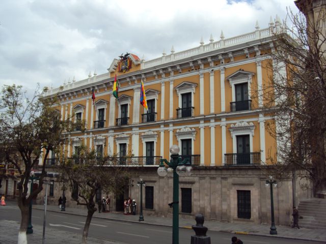
| | | | On the La Paz map, you can see that Plaza Murillo, our next stop, is very close to the Bus Terminal, and also to La Casona. The very attractive Plaza centers on a statue of Pedro Murillo (Photo by Elemaki [José Porras]), a revolutionary hero who was hanged in the Plaza now named after him. It's a pleasant park and serves as the main square of the city, especially considering all the official buildings around it. Behind the statue in the picture is (click) the national legislature, officially known as the Asamblea Legislativa Plurinacional / Plurinational Legislative Assembly. Bolivia is very aware of its many ethnicities, and the official name of the country is the Estado Plurinacional de Bolivia / Plurinational State of Bolivia. The legislative building had earlier been a monastery and also a university. María and I sat on a park bench here and chatted about the government. She pointed out that Evo Morales is very popular, and the first indigenous President, of Aymara ethnicity. Morales was the one who sent the legislature a bill in 2012 for the construction of the gondola cable car system. | | | | If we turn just slightly to the right, we see both the legislature and the Presidential Palace (Photo by Dimitry B), the residence of Evo Morales. A view like this reflects the fact that La Paz is both the legislative and executive seat, while the judicial seat is in Sucre. The presidential palace has an unusual name, the Palacio Quemado (Photo by Wilfredoc2011), or Burned Palace. Its nickname originates from the fact that it was set aflame and burned almost to the ground during an uprising in 1875. It's since been rebuilt and revamped a number of times, but the name stuck. | | | | As we continue to turn to the right, we see both the Presidential Palace and Cathedral (Photo by Rodrigo Achá). The full name of the Neoclassical building (click) is the Catedral Metropolitana [de Nuestra Señora] de La Paz (Photo by Elemaki [José Porras]). | | | | Gondola Cable Cars: Yellow & Green Lines Check again with the gondola map to see how we ended our short day, riding the two other completed gondola lines. We were headed for the Yellow Line, but, of its four stations, María decided to just have us connect two, which I didn't mind, and we drove down to the Supo Kachi station and took it to its connection with the Green Line, which we rode to the end.
http://d2zsthqks7l41m.cloudfront.net/wp-content/uploads/sites/28/2015/03/Teleferica_LaPaz_Bolivia_1-885x586.jpg
| | | | Of course, the stations and gondolas here are bright yellow, as above, or green. But these two lines move down to the lower altitudes, and the more affluent areas, and one finds oneself hanging over gorges (Photo by Grullab). You can see here how chopped-up the geography of La Paz is, especially here in the southeast, as compared to flat El Alto. Our trip ends on the Green Line (click) at Irpawi Station (Photo by EEJCC), where the car picks us up for the drive back to the hotel. | | | | Day 14: Travel & Lima Airport Though that was the last day in La Paz, it wasn't quite the last day in the Central Andes. One would think that any national capital would have intercontinental air connections. But La Paz is limited in that regard, and the culprit is the usual one—the high altitude. Because the air is so thin in La Paz it will support less lift than otherwise, and so only mid-size or smaller planes can land and take off. Long distance planes need to be big and heavy, with a large fuel capacity, and you'd only be able to fill them with passengers to partial capacity to keep them light enough. | | | | Ideal would have been for me to arrive in the Central Andes in Lima and leave from La Paz, but that just wouldn't work. La Paz flights tend to be intermediate, within South America. Anyway, I'd gotten a good round-trip deal out of Lima. When planning months earlier, all I needed was to get back to Lima to get my flight home. At first all I could find were flights that stopped in Cusco, with long layovers, but finally found a direct connection La Paz/Lima, and comfortably in the late morning. A good deal. | | | | Well, not exactly. The only direct flight of the day to Lima got in noon-ish, and my flight home left in the late evening. The total layover in Lima would be 11h05, which is horrific. I know that you can stay in specialized airport lounges for a fee, which I was ready to pay, but your time limit is four hours, and that wouldn't work. | | | | My solution was the airport hotel in Lima, the Costa del Sol Wyndham Lima Airport which is well-reviewed and was literally across the way, connected by bridge. I'd tried online to get a day rate, but couldn't, so took what seemed to be a reasonable overnight rate and considered it to be my day rate. This would be only the second time EVER I used a day rate, and the only time between planes. The other time was ship-to-plane, when I got off the Queen Victoria in Los Angeles one morning in January 2009, got a day rate at the Travelodge at the Los Angeles Airport, then flew out to Samoa that evening (2009/2). | | | | María had told me yesterday that it was her birthday, but she wanted to finish her guide time with me, so instead she'd be taking today off, and after breakfast a pleasant young man with a driver picked me up for the trip to El Alto Airport. The weather was slightly unusual, since there was a mild drizzle as we drove up the road to El Alto. Remember, our arrival was by gondola cable car down the cliff, and now we were driving up the mundane road instead. | | | | María had mentioned something to me earlier that I thought odd, that it "never" snows in La Paz because of the bowl-like geography. I didn't think too much more of it until now, because as we rose up to El Alto on the Altiplano, the drizzle changed to light snow flurries! María had been right. It was hardly sticking; mostly, the ground was wet with thin patches of snow. But it struck me that, though I hadn't seen any snow-covered mountains in Bolivia, the snow was coming to me, and I was experiencing (barely) an Andean snowfall. | | | | The transfer took only about 25 minutes. The airport outside in the flurries looked only average, but inside it was as glitzy and flashy as the gondolas. I should mention that El Alto International Airport is the highest international airport in the world at 4,061 m (13,325 ft). That's absolutely true, but has to be understood in context. It's the highest airport for passengers. It's actually the fifth highest airport after four higher ones in China that apparently only deal in freight. While my experience would be leaving, I'm told that arriving passengers may notice a drop in cabin air pressure when the aircraft doors are opened as the "sea-level" air pressure in the cabin pushes out into the less-dense air outside. | | | | Remember the clock craziness. New York on daylight time is the same as Bolivia, while Peru, normally the same as New York, is now an hour earlier, so there'll be flip-flopping of watch settings today. | | | | On the first day of this trip, in Newark Airport, I was wheeling my bag down an endless corridor to my gate when a woman driving an indoor van with other passengers asked if I wanted a ride. I was delighted to ride along this way for the first time. Now, it struck me, with the ongoing extra exertion needed for walking in this atmosphere, why didn't I ride in a wheelchair? So when we went in, the young man walked me up to the beginning of the check-in line, arranged for a chair, and for the first time ever, I rode in style. While I always have only my one bag as a carry-on, I decided it wise to check it this time. He processed me, checked my bag, and turned me over to an airport worker, who took me through the inevitable immigration "check-out" from Bolivia, security, and got me to the gate. It was very comfortable, and the airport was very up-to-date. | | | | At boarding time, I expected a jetway, but the airport wasn't quite THAT up-to-date, and I was wheeled down a ramp that ended in about five steps. Before I could say I'd walk, several burly men appeared to lift the chair with me in it to go down the steps and across the tarmac. Finally, I was able to stand up and said I could make it up the stairs myself to the plane. But of course, I couldn't dare to tap-dance like Fred Astaire up the staircase, so I, for the first time, had to lay it on a bit thick and look a bit more like an invalid making his way up into the plane. | | | | They had also changed my seat to one close to the door, so that was easy. They closed the door and we were ready to leave on time at 10:25. What could possibly go wrong? 10:35. 10:45. Finally, the Captain announced, in Spanish and English, that the airport was closed because of the weather. But we'd sit and wait to see what happened. For once, I was glad I had such a long layover in Lima. | | | | We sat for 2 ½ hours, then the Captain announced we'd be leaving shortly, as soon as they de-iced the wings. My Andean winter interlude had almost turned on me, but we'd be on our way shortly. I'd heard of de-icing wings to make the plane lighter and to improve lift, but had never experienced it. I can't say it was ever on my bucket list, but in any case, I checked it off. The 2h flight to Lima was otherwise uneventful. | | | | Lima Airport Hotel A woman was waiting for me with a wheelchair in Lima, and I told her I was going to the hotel. She took me to get my bag and through immigration, since I wasn't in transit, but was technically leaving the airport. With no trouble, we went the few steps across the road right to the hotel. She worked hard, and earned her tip. | | | | I had a pleasant experience checking in. I wanted to be sure they knew I wasn't staying the night, and told them, also that I'd looked for a day rate online but didn't find one. She said they do have a day rate, but don't publish it online. However, the promotional rate I'd gotten from booking.com was lower than their day rate! That was the second time this trip, after the Libertador in Puno, that booking.com did a good job for me. | | | | It was a nice room, and I wrote and relaxed. However, I wanted to break it up with a late-afternoon dinner in the hotel restaurant, so at 4PM I went down to check it out, and had a very nice experience. First, the hotel gives you a coupon for a free drink—a Pisco Sour, of course. Instead of taking it at the bar, I took it before dinner in the restaurant. | | | | I had gazpacho first, which was as good as any I've had in a long time. The main course I ordered was listed very mundanely on the menu as "spaghetti and meatballs". It sounds like they're downplaying what they're serving, which was really quite good—but you had to read the fine print next to the menu listing to see how good it would be. They weren't just "meatballs". They were chicken and quinoa meatballs, specifically ground chicken meatballs in a "breading" of finely ground quinoa. Where else could you get that? The "spaghetti" was actually whole wheat linguini, also something special. Finally, the sauce was a thick tomato and piquillo pepper ragout, which rounded it out perfectly. But why didn't they name something so good more elegantly than they did? | | | | | | It was so good, that I looked up piquillo peppers when I got back to the room. The piquillo pepper (Photo by Espencat), clusters of which are shown here drying in the sun in Spain, is a variety of chili having a sweet taste with no heat. They're only about 7 cm (2.75 in) long. The name is cuter than you think: a pico is a beak; the diminutive piquillo (pi.KI.yo) is a little beak. They're mild, closer to bell peppers than chili peppers. They're roasted over embers, which gives them a distinct sweet, spicy flavor, then peeled and de-seeded by hand. They were great blended with tomatoes in the pasta sauce. |
| | | | It was still early, but I paid my bill, and wanted to take advantage of another service I'd read about. I went to the large concierge desk, gave him my passport, and he got my boarding pass for later that evening out of a machine. Thus, when I was ready to leave, I could avoid the lobby entirely, go down only to the 2nd floor, and just walk across the bridge to the airport for my 10:30 overnight flight. | | | | Day 15: Return For some reason, I slept unusually well on the 8h flight to Newark, from where I took the New Jersey Transit train into Penn Station in New York. I also made a point in my travel notes about light. As inky dark as it got in Peru & Bolivia with short days and early sunsets leading into the southern winter, it was remarkable to be back in New York at this time, leading into the northern summer. At one point on my second day I caught myself feeling sure it was about 3 PM, when it turned out to actually be 7 PM with broad daylight.
| | | | Updated Altitude Statistics The last time we summarized altitude statistics was in 2015/16, after Ecuador. I've put a cross-reference there to this summary, further updated after Peru and Bolivia. | | | | Highest Railways in the World Ridden Below is a list, in the order of altitude, of non-cable world railways I have ridden whose highest point is over 2,000 m (6,569 ft). Still, there are quite a few others. The sequence of each entry is:
COUNTRY; OPENING YEAR; LINE; HIGH POINT; ALTITUDE
Tibet (China); 2006; Xining-Golmud-Lhasa; Tanggula Pass; 5,068m (16,627 ft)
Peru; 1872; Cusco-Puno/Lake Titicaca (Ferrocarriles del Sur; Belmond Andean Explorer); La Raya; 4,313 m (14,150 ft)
USA; 1891; Manitou & Pikes Peak RW; Pikes Peak Summit; 4,301 m (14,111 ft)
Ecuador; 1908; Guayaquil-Quito (Tren Crucero); Urbina; 3,609 m (11,841 ft)
Peru; 1928; Poroy-Aguas Calientes (Ferrocarril Santa Ana; Belmond Hiram Bingham); Poroy; 3,570 m (11,710 ft)
Switzerland; 1912; Jungfraubahn; Jungfraujoch; 3,454 m (11,332 ft)
Switzerland; 1898; Gornergratbahn; Gornergrat (at Matterhorn); 3,090 m (10,138 ft)
USA; 1881; Cumbres & Toltec Scenic RR; Cumbres Pass (CO); 3,054 m (10,020 ft)
USA; 1881; Durango & Silverton RR; Silverton (CO); 2,837 m (9,308 ft)
USA; 1928; Union Pacific Railroad, Moffat Tunnel Subdivision; Moffat Tunnel (Amtrak's California Zephyr); 2,816 m (9,239 ft)
Germany; 1930; Bavarian Zugspitze RW; Schneefernerhaus; 2,650 m (8,694 ft)
Mexico; 1961; Ferrocarril Chihuahua al Pacífico (Chepe); Divisadero; 2,400 m (7,874 ft)
USA; 1866; BNSF Raton Pass Line; Raton Pass Tunnel (Amtrak's Southwest Chief); 2,312 m (7,585 ft)
Switzerland; 1909; Bernina RW (Bernina Express); Ospizio Bernina; 2,253 m (7,392 ft)
Switzerland; 1889; Pilatus RW; Mount Pilatus; 2,073 m (6,801 ft)
Switzerland; 1926; Matterhorn Gotthard Bahn (Glacier Express); Oberalp Pass; 2,043 m (6,703 ft)
| | | | Highest Overnight Stays The minimum threshold for this category is also 2,000 m (6,569 ft). Only in the smallest communities, sometimes rural, is the hotel mentioned by name:
Posada del Inca, Yumani, Isla del Sol, Bolivia 3,936 m (12,915 ft)
Inca Utama Hotel, Huatajata, Bolivia 3,830 (12,566)
Puno, Peru 3,826 m (12,552 ft)
La Paz, Bolivia 3,640 (11,942 ft)
Lhasa, Tibet: 3,490 m (11,450 ft)
Cusco, Peru 3,402 m (11,160 ft)
Hacienda La Andaluza, Ecuador: 3,287 m (10,783 ft)
Hacienda La Ciénega, Ecuador: 2,980 m (9,776 ft)
Quito, Ecuador: 2,824 m (9,267 ft)
Schneefernerhaus, Zugspitze, Germany: 2,656 m (8,714 ft)
Aspen, Colorado, USA: 2,405 m (7,890 ft)
Posada Mirador, Posada Barrancas, Mexico: 2,300 m (7,546 ft)
Mexico City, Mexico: 2,240 m (7,350 ft)
Cañadas del Teide, Tenerife, Canary Islands, Spain: 2,152 m (7,060 ft)
Santa Fe, New Mexico, USA: 2,134 m (7,001 ft)
| | | | Highest Overnight Stays in Capitals The four highest capital cities in the world are all in the Andes and Himalayas, and are all in the upper twenties or higher in meters and over 8,000 feet in feet, quite a bit above the next ones on the list. But if Tibet were an independent country, note where Lhasa would fit in. I've now been to the top three.
La Paz (Bolivia): 3,640 m (11,942 ft)
[Lhasa (Tibet): 3,490 m (11,450 ft)]
Quito (Ecuador): 2,820 m (9,252 ft)
Thimphu (Bhutan): 2,648 m (8,688 ft)
Bogotá (Colombia): 2,625 m (8,612 ft)
| | | |
| |
|
|
|

