|
Reflections 2019
Series 16
October 20
New England Coast V: Cape Cod & Provincetown I
| | Cape Cod We came thru the Cape Cod Canal and across Cape Cod Bay in the dead of night, and woke up in the morning finding ourselves docked perpendicularly to the end of MacMillan Pier in Provincetown. To confirm that, and for the sake of further reference, we'll reprint the MA map we were using and will also point out why Cape Cod is unique in so many ways, some of which even locals may not be aware of:
http://www.vidiani.com/maps/maps_of_north_america/maps_of_usa/massachusetts_state/large_detailed_roads_and_highways_map_of_massachusetts_state_with_all_cities.jpg
| | | | Up & Down For instance, "up" and "down" on the Cape can be confusing. We customarily associate "up" on a map with north, so you'd assume that, if you were driving to Provincetown, since it's furthest north, you'd be driving up the Cape, but no, you'd be driving down the Cape. I've seen some reasons for this, and two of them make good sense. | | | | The first deals with maritime history. The prevailing fair-weather winds favorable for sailing in New England and the Maritimes generally come out of the southwest and blow to the east. Sailing ships riding on these winds would find that going downwind meant going east, which resulted in the term Down East to refer to Maine in the northeast of New England. Amtrak's train from Boston to Maine is called the Downeaster. There are still those in Maine who talk about going "up to Boston", even tho it lies to the southwest. | | | | But a very common-sense explanation is the fact that anyone looking at a map of Cape Cod sees its similarity to a human arm. An arm at the shoulder is the upper arm, and below the elbow is the lower arm. That's how it is in the Cape. Where it's attached to the mainland at Bourne and Sandwich is the Upper Cape, and further out is the Lower Cape. | | | | Upper, Mid, Lower, Outer Keep the arm analogy in mind, and the terms fall right into place. Let's use this map to show the sub-regions of the Cape (Map by Grolltech). The dashed lines are the borders between towns, not named here, and the towns group themselves as follows.
The towns in green, up at the "shoulder", are on the Upper Cape, nearest the mainland. Note that only once having driven over the Cape Cod Canal many motorists feel they're in Cape Cod. That's close, but not accurate. It's not the border, and a strip of Bourne, plus a bit of Sandwich, do lie west of the Canal. As we said in 2019/14, Buzzards Bay Rail Station lies west of the Canal, yet is part of Cape Cod. The large town facing the Elizabeth Islands is Falmouth.
In purple are the Mid-Cape towns including Barnstable (the first one), which gives its name to the county--it's the county seat--and includes the well-known village of Hyannis.
In gold are the towns in the Lower Cape including the charming Chatham at the "elbow". Historically, the next sub-region in brown was also included in the Lower Cape, and many still do describe it that way, but perhaps most today call the north-south area of the Cape the Outer Cape, a term that intuitively seems more logical. The furthest town is Provincetown, and before it is the town of Truro.
| | | | | | When discussing Provincetown, we'll need to talk about neighboring Truro, so let's clarify some things. We've talked about towns in MA, which are actually townships, and which will include some villages (such as Barnstable versus Hyannis). Truro is a town comprising two villages, Truro and North Truro. (Compare this map with the MA map). Within the Town of Truro, North Truro (village) is more densely populated than Truro (village) because of its proximity to Provincetown, but we'll be talking about both the town and its villages.
You are bound to confuse, as I often have done, the name Truro here with the famous Touro Synagog in Newport. Look at the differences: TRU.ro versus TU.ro. The first syllables differ importantly in that the town's name has a clearly audible R. They also differ by a triviality, the spelling of the U sound as either U or OU. Truro is named after a town in Cornwall UK.
|
| | | | Capes Someone asked me recently just what a cape is. Actually, the definitions I found vary quite a bit, but I can condense what I found down into this basic point: all definitions describe it as being a projection of land into water beyond adjacent land. Almost all say it's a projection from the mainland, and say usually it extends out into the sea. One goes so far to say it juts out as a peninsula. All that sounds pretty good, except there are also capes in rivers (tho most do jut into the sea), and some capes are on islands having nothing to do with a mainland. And whoever wrote a definition saying it's on a peninsula was thinking just of Cape Cod, because that's not usual. Many say capes are on high headlands with precipitous drops into the sea. That's sometimes true—and spectacular--but that certainly doesn't describe quite a number, including Cape Cod, which is quite low level and on sand dunes.
I think we just have to envision land protruding from other land, probably into the sea, but also in rivers, possibly protruding from a mainland, but also on an island, possibly with a high drop, but also from sand dunes. And the protrusion can bulge out, but can include a relatively straight stretch of beach.
All of this got me curious as to which capes I've visited. Offhand, I could only think of a few, but one invaluable source for lists of things is Wikipedia, probably more inclusive than an almanac, and with more variety, so I consulted the entry for "Cape (geography)". There are a lot of world capes listed there, and I was rather amazed to find I've stood on, was mere steps away from, or sailed past, 21 capes! I won't bother to illustrate them with pictures or maps, or give references to elsewhere in the website, where some of them are described--please look up any you're interested in. The below summary lists internationally-located capes first, then those located elsewhere in North America, then in the US:
Cape Saint Vincent/Cabo de São Vicente, Portugal; magnificent ocean view from a protruding high headland with cliffs; the southwesternmost point of Europe
Cape Leeuwin WA, Australia; beautiful ocean views from a low-lying rocky area; southwesternmost point in Australia
Cape of Good Hope, South Africa; rocky mid-level cliffs; NOT the southernmost point in Africa, tho close to it; divides the Atlantic and Indian Oceans
Cape Horn/Cabo de Hornos, Chile; on the southern side of Hornos Island (island!), around which the Caronia circled on waters uncharacteristically so still that even the Captain was amazed. Altho some tiny islands further south are technically the southernmost point in South America, in most people's minds, and practically speaking, it's Cape Horn
North Cape/Nordkapp, Norway; the northernmost point in Europe that can be reached by car; is popularly considered THE northernmost point in Europe, tho another nearby point is actually a bit further north; it's a steep cliff, but is actually on an island (!) with a bridge to the mainland. The first time I was there I stood on the cliff and saw nothing below because of dense fog; the second time I was there I saw everything I'd missed, but from the water level, looking upwards from the ship
Cabo San Lucas, Baja California Sur, Mexico; actually a city at the southern point of Baja; I stopped there on the Victoria
Cape Breton Island NS, Canada; the actual cape is the northeastern part of the island
Cape Diamond/Cap Diamant, Québec City, Canada; a cape in the Saint Lawrence River (!), where a small river joins it; its high promontory is the hallmark of the city
Cape Spear, Newfoundland, Canada; mid-level rocky cliffs; easternmost point in North America
Cape Sable FL, US; in Everglades Park, southernmost point on the FL mainland; this one IS, unusually, on a peninsula facing west toward the Gulf of Mexico, tho the southernmost point itself is near the Visitor Center on the south side
Cape Coral FL, US; on the Gulf; partly formed by a river on one side
Cape Canaveral FL, US; low-level beachy area
Cape Fear NC, US; on an island south of Wilmington
Cape Hatteras NC, US, located on a long, narrow, relatively straight, sandy barrier island
Cape Henry VA, US; on a low-level rounded promontory at the entrance of Chesapeake Bay
Cape Charles VA, US; opposite Cape Henry to the north; at the north end of the Chesapeake Bay Bridge-Tunnel
Cape Henlopen DE, US; and (see next entry)
Cape May NJ, US; are both flat and beachy, they're opposite each other at the mouth of Delaware Bay; I took the ferry that connects them
Cape Elizabeth ME, US; south of Portland, with lighthouse; a rocky headland; on the current trip
Cape Ann MA, US; relatively low and flat, is the location of Gloucester; on this and an earlier trip
Cape Cod MA, US; on this and earlier trips, relatively straight strip of low-lying land with sand dunes, with a "shepherd's crook" at the top.
| | | | So what common element do we have? Nothing more than a projection of land into water beyond adjacent land. Most are in the sea, but some involve rivers. The more spectacular ones (Cabo São Vicente!) involve cliffs on a promontory. Others are island-based and consist of a quiet seashore. Probably Cape Henry was the most obvious as having a rounded promontory reaching out into the water. Some are points of land, others are just stretches of beach. | | | | Where's Cape Cod? So now we come to what might seem to be a trick question. It's a matter I've never seen anyone discuss. It sounds dumber when spoken (tho equally valid) and perhaps easier to understand when written because of capitalization. The question is: where on the Cape is the cape?
| | | | The situation is this. Over time, it's become ingrained in US culture that the entire peninsula is called Cape Cod, eradicating in everyone's mind that it really IS a peninsula, something no one ever calls it. Common usage has allowed all of Barnstable County, covering the entire peninsula, to be considered Cape Cod, while only part of it is actually forms a genuine cape, a point of land with sand dunes--not rocky cliffs in this case--that actually faces the sea. If you're still in doubt take a look at where the Cape Cod National Seashore (CCNS) is located (Map by EricM). You can consider the CCNS designation as guide for the actual, physical location of the cape, facing out to sea.
To help us narrow it down, we can use Cape Hatteras as an example. On this satellite view, we can see that the actual protruding cape is that point of land reaching out into the Atlantic. Look at how its protrusion affects the ocean currents. But just how much of the point consists of the cape? Where does the cape end? Common, everyday usage refers, by extension, to those long beaches on the barrier islands north and south of the actual point, which also take the brunt of severe weather. So we have a cape plus beaches extending from it, and both might use the name.
| | | | Historically, the reference to Cape Cod referred to only the very tip of the cape, the Provincetown Spit, that which is today Greater Provincetown. That extended out far enough for the so-called "Pilgrims" to have come across it as the first land sighted, and to eventually land there. But by extension, it would seem that the east-facing beaches on the Atlantic leading up to the tip, roughly the National Seashore area, is by extension part of the physical cape. And then from there, the public mind has rather amazingly extended it to the entire peninsula, which, tho the common designation, cannot in any way be accurate. | | | | In addition, the word "Cape" is so ingrained in people's usage as referring to the peninsula where Barnstable County is located, that when anyone in the northeastern US talks about going to the Cape, you can rest assured they're not talking about Capes Hatteras, May, Henlopen, Fear, Henry, or any others, they're talking about Cape Cod--in its most extended sense for the entire peninsula—and so not about the tip or even the seashore. Thus in reality, the Cape Cod Canal does not bisect the physical cape itself, but a part of the peninsula, and Marconi built his transatlantic broadcasting station (see the last map) on the physical cape because it extends further out to sea, as any true cape would. Also, note on our MA map just where the words "Cape Cod" are located, way over to the right. And it's the only cape I know of named after a fish, a fact I don't think people realize, since the name is so ingrained as simply a place name.
https://pubs.usgs.gov/of/2008/1288/images/figure2.jpg
| | | | Geology Using the above map, we also discussed in 2019/14 the geology of Cape Cod. Here's a quick review with some of our updated terminology. The Upper Cape (starting at the "shoulder") has the remnants of glacial moraines (in blue). They're oddly shaped, since they show the rounding effects of two lobes of the ice sheet. The area from the Upper to the Mid-Cape is almost as ancient, consisting of older outwash (in green) from melting glacial waters running west-east along the bottom of the Cape Cod Bay lobe. Later, more outwash (in pink) extended this Outer Land area around the bottom of the same lobe across the rest of the Mid-Cape to the Lower Cape (the "elbow"). But this later outwash also filled in the seam between the Cape Cod Bay lobe and the South Channel lobe, this time forming the Outer Cape (the physical cape, the Seashore) up to North Truro, that is from the "elbow" to the "wrist". But how about the "hand" of the Cape with the "fingers" pointing back at Provincetown? The map shows that glacial deposits formed most of the Cape, but not the yellow area on the map, known as the Provincetown Spit, which is all sand, and marked on the map as "beach & dune". This is the point where glacial deposits end (at a point in Truro—see below) and marine deposits of sand begin. And that is precisely the area of our concentration. | | | | Hydrology We mentioned this in the last posting: The Provincetown Spit was formed by marine deposits over the last 5,000-8,000 years. These deposits created Provincetown Harbor, a large, bowl-shaped section of Cape Cod Bay. Generally, currents in Cape Cod Bay move in a counter-clockwise fashion, moving south from Boston, past Plymouth in the west bay, along the south bay and east bay, ending up leaving marine deposits at the very tip, in Provincetown, forming the unique spiral shape of the tip of the Cape. So while most of the Cape was formed by geology, the tip was formed by hydrology.
| | | | Refer to the MA map to confirm that, driving onto the Cape, such as on US 6 (extending from California), one starts out going roughly east, and upon reaching the Outer Cape, one turns north. Now continue on this official map of the Cape Cod National Seashore (CCNS). | | | | | | First find High Head Road. High Head is the point in Truro where glacial deposits from the south end and marine deposits of sand to the north begin. |
| | | | Toward the top of the Outer Cape, north becomes northwest, but not alarmingly so. But note the highly unusual extent to which Cape Cod turns back on itself. By the time one approaches Provincetown, our northwest direction becomes west, meaning one has turned 180° from the start of the drive on the Upper Cape. But the spiral gets tighter and tighter, and west becomes southwest at the point where US 6 ends. Note right now that the spiraling is so stark that Provincetown stretches northeast to southwest, meaning it faces southeast. | | | | North of where US 6 ends is the westernmost of this tip of the Cape, Race Point, with a lighthouse. This is where one can imagine that nature was trying its best to push its sand deposits around to Plymouth and close off the Bay, but that never happened. Instead, the sands continued to spiral to the southeast, past where US 6 ends, to the southernmost point of this tip of the Cape, Wood End, also with a lighthouse. And again the sands didn't stop, but kept on turning up to Long Point--again with a lighthouse—with the tip pointing northeast! On the MA map, compare the directionality of Long Point with the area further south, around Orleans to see how similar they are. A spiral is a spiral is a spiral.
This is an unusual aerial view of Long Point with its lighthouse--click (Photo by Mslanka). Tho the spiral tends to confuse--north would be at the right, so that Wood End is to the left, tho I can't spot its lighthouse, which is identical to Long Point's. All three lighthouses are low and stubby; the total height of the Race Point Light is just 14 m (46 ft) and the other two are both 12 m (39 ft). There are no high cliffs to protect ships from, just sand banks, so great height is not necessary.
Tho I've never done it, Long Point is walkable along the outer beach (in the distance) from the end of the road. When you've gone around in circles to reach Long Point, you're as "up-Cape" as you can be! (But I've been to the end of US 6, and so Provincetown will do for me.) As the last picture shows, there's a dike on the inner side of the spiral apparently to prevent erosion that could perhaps make Long Point into an island. You can also find that dike on the CCNS map above.
It's SO much fun (as long as you're well oriented and know where you are and what you're doing) to arrive here on the ferry from Boston and first spot, not only the very flat Spit, but also the lighthouses (Photo by Argos'Dad) sticking up their tiny heads above it—this one is Long Point Light. While Provincetown itself is only visible later on around the bend, earlier, at the proper angle, you can see the tall tower of the Pilgrim Monument (Photo by WorldTraveller101). It's in town, but from here seems to tower over the sandy Spit indicating that you're almost there. Great fun.
| | | | Provincetown as an Island? We're not done with the uniqueness of Provincetown. I never realized before, even after having been here in the past, the early remoteness of the town. We just showed how the narrow strip of beach that connects Long Point to the rest of the mainland needs to be protected by a dike so that it doesn’t get washed away in a storm and make Long Point an island. That was originally the situation with all of Provincetown—it hung by a thread to the rest of Cape Cod by a strip of sand dunes on the Atlantic side. There were no roads and no railroad. Provincetown relied almost entirely upon the sea for its communication, travel, and commercial needs. Virtually anyone who wanted to come to Provincetown had to come by ship, which is another aspect of the fun of arriving on the Boston Ferry—you're duplicating history. This is less so with ACL, since it comes and goes in the dead of night and you see nothing—we already saw that on our current arrival, and we'll also depart at midnight.
| | | | It WAS possible to arrive by land, as long as you walked, and that doesn't mean on roads, but by slogging along those sand dunes on the Atlantic side. Which means I have to modify my statements about Thoreau made in 2009/27 (check it out for details if you like). They dealt with Thoreau's four visits to Cape Cod between 1849 and 1857. I talked about the railroad not yet being completed and his having to take a wretched stagecoach ride the rest of the way, and on another occasion when the railroad was lengthened a bit, about him deciding to walk the rest of the way. But I now understand that the stagecoach couldn't have gone all the way no matter what. | | | | | | I've now learned more about Thoreau's first visit to the Cape in 1849 at age 32. He wasn't alone, but made the trip with a male companion. The Cape Cod Railroad at the time ran thrice weekly from Boston to its temporary terminus in Sandwich (see MA map). At Sandwich he took that uncomfortable ride on the stagecoach, which carried nine passengers, by way of Yarmouth to Orleans. Accommodation in Orleans was available at Higgins's Tavern. Early in the morning of Thursday, 11 October 1849, Thoreau and friend set off to walk the 48 km (30 mi) of uninterrupted beach facing the Atlantic at the tip of Cape Cod. Thoreau took three days to walk the seacoast, spending two nights on the way before reaching Provincetown.
The first night Thoreau found lodging in a Wellfleet house (see MA map) that's still standing. The second night they stayed in North Truro at the Highland Lighthouse (see above CCNS map) which has since been rebuilt. From it he "could see the revolving light at Race Point, the end of the cape, about nine miles [14 km] distant, and also the light on Long Point, at the entrance of Provincetown Harbor, and one of the distant Plymouth Harbor lights, across the bay, nearly in range with the last, like a star on the horizon."
At the end of the third day, they were close to Provincetown, and climbed a high dune. "We overlooked Provincetown and its harbor, now emptied of vessels, and also an expanse of ocean. As we did not wish to enter Provincetown before night, tho it was cold and windy, we walked along the beach again nearly to Race Point, being still greedy of the sea influence."
This is a portrait of Henry David Thoreau as a young man, probably in his twenties and therefore just before his first Cape Cod trip. These are his notes on Cape Cod, published posthumously.
But the ocean has been beating on the Cape Cod National Seashore for 10,000 years, redistributing its sand. Some parts of the coastline have retreated about a meter/yard a year so that the actual path where Thoreau left his footsteps is now more than 122 m (400 ft) offshore.
|
| | | | East Harbor Disappears We have a few excellent historical maps to show us just how the Provincetown area has changed physically over time. This first map that follows was made by US federal engineers in 1833-4-5 and we'll use it first for the Greater Provincetown area and later again for the town itself. It shows what it calls the "Extremity of Cape Cod" looked like as of 1835. Note that the map is not oriented due north, but points to about the eleven o'clock position. | | | | Leaving the town proper for later discussion, review how Long Pont was riddled with waterways like Swiss cheese. At Wood End, the land connection is miniscule, and the entire central area that's now protected by a dike was water, even including an island. There are more tiny harbors as we move up to Race Point, to the point that the Atlantic coast here is almost—but not quite--a barrier island. Circling around town, we come to the border between Provincetown and Truro, and find that just to the right the border, the Bay shore is broken at the entrance of East Harbor. The Bay coast then continues starting at Beach Point. At the far side of East Harbor, the terrain becomes marshy, developing into the smaller Moon Pond Meadow and the larger Salt Meadow. Both meadows lie at the foot of High Head, the end of the part of the Cape formed by glacial deposits, which is so clearly defined here. On the map, the low sandy area seems to fit onto High Head like a thimble on a finger. | | | | Tho both Truro coastlines are indicated, the town of Truro is left incomplete. Now look at the Atlantic Coast at Salt Meadow. This is the string of tall, rolling sand dunes and thin strip of beach called the backshore route that, almost useless for practical purposes, connected all of Provincetown and the northern part of Truro to the mainland. It had no road; the only road indicated here in Truro leads up to the Holden and Pendegrast [sic] properties above the Salt Meadow, both of which seem to have a nice downward view. And in a storm, the string of sand dunes would be in danger of a washout, with the hope that nature would reconstitute them afterward. Thoreau would have had to have used the backshore route, and speculation would have it that the view he got over Provincetown MIGHT have been from High Head. | | | | Now let's concentrate on East Harbor. It's a tidal estuary of Cape Cod Bay within Truro that was once used as a genuine harbor. It still exists in altered form, but it originally was a natural embayment deep enough to shelter Provincetown's fishing fleet during the winter despite being in Truro. The inlet from Cape Cod Bay at Beach Point was about 300 m (1,000 ft) wide. | | | | Of course today, Provincetown is NOT an almost-island and has normal overland connections in addition to its water connections. That meant that East Harbor was in the way and had to disappear--the fishing fleet would have to use the less-protected Provincetown Harbor (it has a breakwater today). So what great impetus existed in the mid-19C that would push its way overland to Provincetown? It certainly wouldn't be a road, given the namby-pamby, rutted, bumpy dirt roads of the era that the stagecoaches traveled on, and that Thoreau grumbled about. The great 19C constructive force was the railroad! (And today, it no longer reaches Provincetown!) | | | | The next map is actually a pair of contrastive maps. The upper one looks familiar, since it's just an artificially colorized version of the more authentic 1835 map we just saw. Take a quick look. But it's the lower, uncolorized map dated 1887 that shows the great changes. The Thoreau posting mentioning his four trips here between 1849 to 1857 talked about the railroad only having been built to Sandwich on one of his trips and to Orleans on another, so he apparently never got to take the train all the way to Provincetown when it was completed in 1873.
| | | | Click on the 1887 map at the bottom, and you'll find that most of it is the same as the 1835 map above it, with two interesting changes. The railroad has arrived all the way to Provincetown, serving (among many other stops) North Truro on the way. In addition, not only has Truro developed a number of roads (dirt, of course) with pathways in dashed lines, a road also runs next to the rail line to bring road traffic all the way to Provincetown as well, which is now open to land traffic of all sorts. | | | | This was accomplished starting in 1868, when a dike was built across the inlet that had served as an entrance to East Harbor, separating it from Cape Cod Bay. But in this era, environmental concerns weren't yet what they are today, and the dike cut off tidal flow to the harbor and marshes around it. The dike then had track laid along it for the railroad, which reached Provincetown in 1873. We'll discuss in-town rails shortly, but as you can see, in addition to a passenger station in town, the trains went out to Railroad Wharf, the predecessor of today's Macmillan Pier—which might explain the long length of today's pier. Well after that—showing the priorities of the day—a road out of Truro finally joined the rail tracks along the dike into town in 1877. | | | | While the arrival of the railroad changed Provincetown fundamentally, it also changed East Harbor and the marshes fundamentally. The cutting off of the tidal flow changed East Harbor into a salt marsh lagoon. Without its salinity being refreshed regularly by the tides, it then turned into a stagnant freshwater pond, and native flora and fauna died out completely, allowing exotic species to invade, including non-native cattails. Finally, in 2001, an attempt at restoration was made. A one-way (outbound) drainage pipe was altered to allow two-way exchange of salt and fresh water. Despite the fact that the pipe is small, just 1.2 m (4 ft) in diameter and that it runs some 210 m (700 ft) underground, there's been significant recovery of salinity and marine life in East Harbor and its meadows, all of which are now within the Cape Cod National Seashore. | | | | To complete our set of historical maps, we'll also show the same area in 1908. Much is the same as 21 years earlier, tho we see here that the road into Provincetown is much more clearly defined, and we get to see the territory further south on the Outer Cape. The rail stations in South Truro and Truro (Village) are marked, tho the one in North Truro is not. | | | | I always wondered why the railroad had the charming name of Old Colony Railroad, and now I can see why. Here's the map we saw earlier of the Plymouth Colony from 1620 to 1691 (Map by Hoodinski). It ran from Narragansett Bay to Cape Cod Bay, and along the Bay as far north as Scituate (like saying SIT+chew+ate or SIT+chew+it), tho the Plymouth Colony lost Hull and Weymouth to the Massachusetts Colony in 1630. (But then again, the two colonies merged in 1691.) | | | | Now to this map we'll add two railroad maps that helpful in understanding local 19C transportation. This first one shows the Old Colony Railroad in 1893 (Map by Marcbela). Click to see how closely it matches the old Plymouth Colony. In the north it goes past Situate to include Hull, then go into Boston. The only addition incursion to what had been the Massachusetts Colony was that double fork to the northwest. Otherwise it covers Narragansett to Cape Cod Bays quite completely, the "Old Colony". | | | | | | Tho SO much of this network has been lost, Boston's MBTA commuter rail has been restoring service on several lines. The MBTA actually calls three of them the "Old Colony Lines", where service now runs again to Middleborough, to Plymouth, and to Scituate (see old rail map).
Additional plans are in the works to extend a line to Taunton, with a branch to New Bedford and another to Fall River.
Further in the future might be extending the line from Lowell in the north into New Hampshire, and the Middleborough line as far as Buzzards Bay, tho not really into the Cape Cod peninsula.
|
| | | | That first map has its advantages, but so does this map of the Old Colony Railroad in 1888, just five years earlier. This map concentrates on the Cape Cod Division with more detail there. You can see (click) how this line came thru Middleborough and down to Buzzards Bay, that section that could possibly be restored some day. But then on the Cape, it was a main line with three branches, one to Falmouth and Woods Hole for the island ferry, one to Hyannis and Hyannisport, and one to Chatham. We can also trace Thoreau's trips, the one to the temporary last stop in Sandwich, and the other to the temporary last stop in Orleans. He never made it to Provincetown by train, always by stagecoach part of the way, and then walking, even the whole way. But we see the three Truro stops, and Provincetown. But do note that Greater Provincetown is called the actual Cape Cod, and Provincetown Harbor is called Cape Cod Harbor. | | | | Gosnold We had earlier the straightforward geographic description, that the actual cape is Provincetown Spit, complemented by the seashore on the Outer Cape to its south. We can now add some history to back that up historically to show how things started.
We talked in 2011/18 about the Seastreak trip to Martha's Vineyard. I need to quote from that posting about Bartholomew Gosnold, someone who deserves to be better known than he is, and his . . . discovery of Cape Cod. He was the English explorer who pioneered a direct sailing route due west from the Azores to New England, a route followed 18 years later in 1620 by the Mayflower. He arrived in early 1602 in Maine, and followed the coastline to what is today Provincetown Harbor, where he discovered and named Cape Cod. He then discovered Martha’s Vineyard at Gay Head, sailed past Nantucket at Sconset, and discovered and established a small post (later abandoned) on what is today Cuttyhunk Island, the outermost of the Elizabeths. In his honor, all the Elizabeths today constitute the town of Gosnold MA. . . . [Since it's fun to] include paintings of historical events, I’ve found this charming 1858 picture by none other than the German-American artist Albert Bierstadt, of the romantic Hudson River School, entitled Gosnold at Cuttyhunk, 1602. I’m pleased to find this painting, since most of his spectacular landscapes are not of the east, but of the American West.
I repeat that charming painting because it sets the atmosphere so well for Gosnold in the early 17C in all of New England. He was instrumental in founding Jamestown VA, but died in 1607 at 35 after four months there. It's also believed that Martha's Vineyard was named for his second child Martha, who died in infancy, as well as for the luxuriant growth he found on that island.
But we now have, as so often is the case, a bit more to add to the Gosnold story. It was on 15 May 1602, and Gosnold was arriving from the west. That fits in with the above, since he was working his way down the coast from what is today Maine, so he would have sailed across the mouth of Cape Cod Bay—which, to my great pleasure is exactly the route the ferries from Boston take to Provincetown! That means that, when we say he discovered Cape Cod, more precisely what he discovered and gave that name to was the Provincetown Spit, which adds credence to defining the cape as the tip. By now we should also not be surprised to learn that he thought it was an island. Of course! How would he know about the slender backshore route? And as we've said, there are other capes on islands, notably Cape Horn in South America. So why not here?
Gosnold was going to name the "island" he discovered "Shoal Hope" an odd combination of words that one can speculate about. But later that same day, they went fishing and caught a large number of cod, so Gosnold changed his proposed name to Cape Cod instead. Now remember, in Gosnold's mind, Cape Cod was an island off the northern tip of what turned out to be a peninsula. Let's put that in modern terms. The entirety of Gosnold's Cape Cod was Greater Provincetown, just the point we've been making here.
| | | | | | I've now also noticed another curiosity. If you refer back to those older maps, only the 1887 one calls Provincetown Harbor by that name. The 1835 map on the same page calls it "Cape Cod", and the other 1835 map calls it "Cape Cod Harbor". This would seem to indicate that, as late as 1835, people were still considering Greater Provincetown to be the entire actual cape. |
| | | | The "Pilgrims" I suppose we have to rehash once again the story of the so-called "Pilgrims". I'll explain again that I'm antipathetic to that religious name for what were merely European settlers who were not on any sort of a pilgrimage, and continue to object that they were NOT the original British settlers in North America, nor was the Mayflower that brought them to Cape Cod in 1620 the "original ship" bringing "first-time" settlers to what became the US. That's all hyped-up mythology made into sugar-coated legend that's been blown all out of proportion. | | | | I became particularly irked about the inaccurate mythology told in the US when I was in Australia and learned how accurately they tell their story, using the term First Fleet to describe the original settlers from England. The First Fleet consisted of 11 ships carrying 1000-1500 settlers (yes, some of which were convicts) that arrived first in Botany Bay, just south of Sydney. When it proved to be unsuitable, they moved slightly north to what is today Sydney Harbour, arriving on 26 January 1788, which is celebrated today as Australia Day, the national holiday. How nicely the Australian celebration fits the facts.
The "Pilgrims'" arriving in 1620 on the Mayflower, first to Provincetown Harbor, which proved unsuitable, then moving across Cape Cod Bay to settle Plymouth and the Plymouth Colony is so nicely parallel a story to Australia's, but unfortunately, it only deals with settling Plymouth Colony, and hence Massachusetts, not settling the United States. The US does not get its national holiday out of this story, altho it does get Thanksgiving, so not all is lost. Let's get the US story straight.
| | | | British Settlements in North America The first permanent British settlement in all of North America took place a full 13 years before the "Pilgrims'" arrival. It was in Jamestown, Virginia in 1607, when 144 people arrived on three ships. The Susan Constant carried almost half of them, 71, the Godspeed had 52, and the smaller Discovery had 21. The three crossed the Atlantic in four months, arriving at Cape Henry first (see 2016/19 "Cape Henry") and exploring the Chesapeake area for two weeks before selecting what became Jamestown on 13 May 1607. Let's call this group the Jamestown Settlers. Altho the land grant to the Colony of Virginia was vast, this is the de facto size of the Colony of Virginia around Jamestown (Map by Til Eulenspiegel at English Wikipedia), covering land that is today VA and a bit of NC. The red line separates the Colony from local Native American tribes, and the red dot on the James River shows Jamestown, the capital. The rounded Cape Henry can also be seen on the Atlantic. | | | | | | In a world parallel to Australia's, the US National Holiday would be 13 May, and people would brag about ancestors coming over on the Susan Constant (or Godspeed, or Discovery). At least this story of Cape Henry-to-Jamestown is parallel to Botany Bay-to-Sydney. And I suppose, also parallel to Provincetown-to-Plymouth. |
| | | | Before sailing on the Mayflower, the "Pilgrims" had been English exiles in Leiden in the Netherlands for 11-12 years. It was there that they heard favorable reports of the area around today's NYC that had been visited by Henry Hudson on his Dutch-sponsored voyage in 1609. They sailed from England with a royal patent to settle the land grant allotted to them, as shown here (Map by Decumanus). Both land grants were huge, stretching to the Pacific, and they overlapped. You see Jamestown (J) as the capital of the Colony of Virginia in red. You see in green the land grant that eventually became the Plymouth Colony of the "Pilgrims", with its eventual capital in Plymouth (Pl). But you can also judge that what is now New York Bay and the mouth of the Hudson was also just barely within their land grant, and my latest information is that that's where they were headed. [Of interest in the north is Québec (Q) and Port-Royal (R), present-day Annapolis Royal NS. In the south, in Spanish Florida, is San Agustín/Saint Augustine (SA).] | | | | | | At this point, I have to adjust my thinking, and make a major correction. I understood one fact about this story for years, and wrote about it that way in 2009/25 as part of an extended colonial history ("The Thirteen Colonies, 1600-1800"), but it's apparently wrong: The Dutch tried to get them to try to settle on the Hudson River, which they considered, but they preferred to maintain an English identity. (The Dutch got their New Amsterdam settlement going four years later, in 1624). These English settlers instead decided to go to Virginia, since Jamestown was already established there, but considered setting up their own colony so as not to duplicate the political environment they had left in England.
Well, the information I had was half-right, the Hudson River was in contention. But present information says nothing about Jamestown being a possible destination as I had always thought. To further back-up this new information, I have a quote from History.com: . . . the Pilgrims aboard the storm-tossed Mayflower finally spied the New England coastline . . . [but they] also knew that that the Atlantic Ocean’s fierce storms had driven them . . . northeast of their intended destination—the mouth of the Hudson River. . . . During their years in exile in Holland, the Pilgrims had heard favorable reports of the lands around present-day New York City visited by Henry Hudson on his Dutch-sponsored voyage in 1609. They sailed from England with a royal patent to settle the region . . . The history section of the Plimoth Plantation website (it's the historic replica village near Plymouth MA) further confirms this.
Now that we've clarified their original destination, let's tell a little more about their arrival at Cape Cod, where they eventually founded the Plymouth Colony. From this point on, I'll avoid the term "Pilgrims", which I totally discredit, and refer to people that established this second permanent British settlement logically as the Plymouth Settlers.
|
| | | | The Plymouth Settlers NEVER used the word "Pilgrim" to describe themselves, nor was it in common use for 178 years after their arrival. William Bradford from the Mayflower used the word in passing when he waxed poetic about their trip in quoting the book of Hebrews from the Bible which mentioned "strangers and pilgrims" wandering off looking for a better life. The word only came up after that in passing when people were quoting Bradford, otherwise it never came up at all, not until 1798. It then became more common when Daniel Webster used it in 1820 speaking at the Plymouth (and the settlers') Bicentennial, and with him giving it cachet, it mushroomed from there. It was well established at the time of the Tricentennial in 1920, as seen on this US postage stamp. Next year is 2020, and in November will fall the Quatercentennial (it's a word—I looked it up) of Plymouth and the settlers. I can see celebrating their arrival as the second permanent British arrival, particularly important for Massachusetts, who took over the Plymouth Colony, and of somewhat lesser consequence to the US as a whole, given Jamestown. But I know it's not gonna happen that way—the mythology will again overwhelm the history. | | | | But let's now get a little more deeply into the story of the Plymouth Settlers, since this is the area we'll be visiting shortly and we need to know what's what. The sugar-coated mythology is such, that I suspect that, just as the general public is unaware that the people they know as the "Pilgrims" didn't call themselves that at all, the public is equally unaware:
(1) that the settlers who arrived in Provincetown are the same ones who settled Plymouth Colony across the Bay,
(2) that there were already signs of European settlers in Provincetown when they arrived,
(3) that encounters with the Native Americans were not always peaceful,
(4) that the settlers did NOT land on something called Plymouth Rock in the town of Plymouth, and
(5) that they didn't get to Plymouth first at all, but Provincetown.
There seem to be as many fairy tales and misunderstandings in American culture regarding these "Pilgrims" that the Grimm Brothers could have been the ones who recorded them.
| | | | This is far from their complete story, but merely a bare-bones summary of their arrival in Cape Cod. After a lengthy backstory in Britain and the Netherlands, they finally set sail on the Mayflower from Plymouth in Devon on the south coast of England (Map Attribution:Contains Ordnance Survey data © Crown copyright and database right). | | | | | | In 2000, Beverly and I stopped in Plymouth to visit the Mayflower Steps at the harbor, which are "near, sort of, maybe" where the ship departed. See 2000/1 "Plymouth" for a short paragraph and picture.
[That entire posting is very short, just a few paragraphs long, and is the very first posting on this website, made after-the-fact to summarize past travel history. It also explains why this is my Third Travel Cycle. You might like to take a look at it.]
|
| | | | The Mayflower carried 102 settlers, fewer than three-quarters of the 144 that the three ships to Jamestown carried. After a rough crossing of 66 days, they sighted land on 9 November 1620, and the land they sighted was a cape reaching out towards them into the ocean, which they confirmed to be Cape Cod. How did they know it was called Cape Cod? Remember, this was not a pristine land mass devoid of European influence. Gosnold had been here 18 years earlier in 1602, so the name of the cape was already on maps. | | | | They were in the area of the actual cape on what is today the Provincetown Spit. But they just used it as a landmark, and sailed right by on their search for the Hudson. They estimated that the storms they'd encountered during the crossing had blown them some 354 km (220 mi) northeast of their intended destination, the mouth of the Hudson River. However, they had trouble (headwinds, shoals, breakers, and difficult currents) around that long Monomoy Island at the Cape's elbow (see MA map). It's odd to think that, after such a long trip, it was just at the elbow that they were stymied and turned back. But with supplies running low and fears of a shipwreck running high, they turned around and headed back to the Provincetown Spit, entered what is today the very west end of Provincetown Harbor, and anchored there on 11 November. In the harbor they drew up the Mayflower Compact, a contract of how to run the colony. | | | | Let's use again the map of the CCNS to examine Greater Provincetown. Find the spot where the dike connects with the end of town at the westernmost end of Commercial Street. It's amazing to look at the spiral shape of this entire area and to understand that they went as far in as they could so that the land wrapped around them in as much of a circle as possible.
https://bb91ibsq1zwfhuw9-zippykid.netdna-ssl.com/wp-content/uploads/2014/10/Pilgrim-Rock-Pilgrim-Landing-Park-in-Provincetown.jpg
https://buildingprovincetown.files.wordpress.com/2015/09/185_02-province-lands-00-19-e1441679587357.jpg
I was prepared to say I'd never visited this landing spot, but digging into our travel diaries, I found this entry for 1969, the year we swept all around the East. On 3 July, at the time of our visit of just a few hours to Provincetown, Beverly wrote: We drove . . . [along Commercial Street] to the point where the Pilgrims landed. So I've been there, but have no recollection. Anyway, I've read that there's a small park called Pilgrims' First Landing Park (first link) and has a small monument explaining the history (second link). You can also see how the breakwater leads out from here toward Long Point. They really squeezed themselves in as far as possible.
| | | | When they were able, they started to explore the immediate area. But contrary to what I suspect is popular opinion, the area was not pristinely devoid of European influence. They not only found an iron kettle, but they also encountered an old European-built house (!), both of which reflected past visits by some ship's crew that had stopped there. Altho the Provincetown area had great fishing and a wonderful harbor, it was far too beachy and not appropriate for the farming community that they had in mind. So an exploration party set out in a small boat to search the area around Cape Cod Bay. | | | | The local Native American tribes in about 1600 (Map by Nikater) were the Nausets on the Cape peninsula and the Wampanoags on the mainland. (These are precisely the two areas that became Plymouth Colony.) We most recently heard of the Wampanoags in the last posting when we said that the Quequechan River in Fall River was a Wampanoag word meaning "Falling River". The local tribes were already familiar with the English, who had intermittently visited the area for fishing and trade earlier, and they had not always been treated well. One individual had attempted to kidnap 27 locals to sell them as slaves in Europe. | | | | The first stop around Cape Cod Bay that the exploration party made was about a month after they first spotted Cape Cod. It was on 8 December in what is now Eastham MA (see MA map), an area settled by the Nausets. It was a friendly encounter, and is commemorated by a plaque at what is known as the First Encounter Beach. Look toward the bottom of our map showing the CCNS to find Eastham (it was a stop on the Old Colony train to Provincetown—the route is now the Cape Cod Rail Trail, in red dashes). But on the Bay you'll see the First Encounter Beach.
http://s3-media4.fl.yelpcdn.com/bphoto/Q00XmRydx74HcgACRKbbPA/o.jpg
As this picture shows, it's one of those many places that seemingly has "nothing to see". It's a pleasant beach, but just like all the others nearby. But anyone with even a single history bone in their body will "feel" the historic significance, which is expressed in that Latin phrase I made up: HIC LOCUS EST. Tho it's just another beach in front of you, nevertheless THIS IS THE SPOT where a memorable event happened. And yes, I DO remember being here. I find in the diary it was the same day in 1969 that we did our short visit to Provincetown. We also stopped at the Marconi Station that time, where he broadcast across the Atlantic (see CCNS map).
| | | | They resumed exploration around the Bay and reached the west, or mainland, side, and on 17 December came across the protected harbor of what is today called Plymouth Bay. See the MA map to see the two slender natural breakwaters that still exist, one from the north, and one from the south, forming Plymouth Harbor. Note how the ensemble of Plymouth and Duxbury are almost directly across from Provincetown. Also take note of this satellite image. The gray area lower center is today's city of Plymouth. | | | | The party explored the area for three days. What they discovered was a Wampanoag village called Patuxet that had been abandoned because, between 1614 and 1620--the very year of the settlers' arrival--a series of plagues had decimated the indigenous peoples of New England and the Maritimes. The epidemics were especially devastating to the Wampanoag and neighboring Massachusett peoples with up to 100% mortality in many villages. Thus the misfortune of the Wampanoags proved to be fortunate for the landing party, since they found the land already cleared and ready for building. Also, tall hills around the site provided a good defensive position. On 20 December the exploration party made the decision to choose this place, which they eventually named New Plimoth. The party must have returned quickly to the Mayflower at the Provincetown Spit—tho it's not that far from Plymouth—because the next day, 21 December 1620, the settlers officially disembarked at Plymouth and proceeded to build their town. Now look at a historic map of the area:
https://etc.usf.edu/maps/pages/8500/8523/8523.gif
| | | | On this map, even the Mayflower is shown in the harbor, as it is in this 1882 painting by William Halsall showing his vision of the "Mayflower in Plymouth Harbor". It's also quite clear what great protection those natural breakwaters give. | | | | You see just where New Plimoth was built replacing Patuxet on Town Brook, which still runs today for 2.4 km (1.5 mi) into the harbor. It provided the settlers with drinking water, and they built a grist mill along it. Parallel to the north bank of the brook they laid out Leyden Street (they'd spent 11 years in Leiden in the Netherlands), where the first houses were built. Leyden Street has been used continuously since the original settlers built houses along it and claims to be the oldest continuously inhabited street in British North America. In this sketch, note Town Brook on the left (south) side. Leyden (ex-1st) Street is just the harborside block. Beyond King (now Main) Street, the street was known, oddly, as Town Square, and still is. | | | | Since they used the spelling "Plimoth" back in the day, the outdoor living history museum southeast of Plymouth that replicates the original 1627 settlement does the same, and is called Plimoth Plantation, here showing Leyden Street (Photo by Muns). Beverly and I visited it on that same 1969 trip as we were leaving the Cape.
http://2.bp.blogspot.com/-W5CKPiQSVFw/UdS1e8XblzI/AAAAAAAAE2A/4wAknX_OVEA/s1600/Map+of+Plimoth+Plantation.JPG
It also has a replica of a 17C Wampanoag homesite (above), and the museum features costumed role-playing tour guides. I only remember visiting Plimoth Plantation, but Beverly wrote that we also went into town to see the Plymouth Rock Monument and the full-sized ship replica, the Mayflower II (click), in the harbor (Photo by GmaJoli). The replica is under the jurisdiction of Plimoth Plantation. Fortunately, in 2009 I revisited downtown Plymouth and saw the Rock and ship for what I now realize was a second time.
https://c.o0bg.com/rf/image_960w/Boston/2011-2020/2016/11/23/BostonGlobe.com/Metro/Images/23pilgrims_graphic1.jpg
| | | | The above shows, in the lower-left inset, where Plimoth Plantation is located, 4.3 km (2.7 mi) southeast of central Plymouth. The red overlay shows the shape of the reconstruction in regard to the original settlement. Town Brook is at the bottom; Court Street becomes Main (ex-King) Street dividing the settlement and, running left-right across it is Leyden Street (right) and Town Square (left). | | | | Unfortunately, on the historic map, the romantically inclined mapmaker decided to show a rock at the end of Town Brook to feed the fairy tale of Plymouth Rock. The polite way to put that bit of nonsense is that this or some other rock was the "traditional" site of the disembarkation. The legend is the same as with the word "Pilgrim". There was no reference to any Plymouth Rock in the writings of any of the settlers. | | | | The first time it was referred to in writing was in 1715 when it was described as "a great rock" in the town boundary records. The first documented claim that the rock was the landing place was made in 1741, fully 121 years after the fact. That's the point where the story went viral, and without any basis in fact, became a legend in its own right. And the question remains, what's the point of making a fuss wherever they landed in Plymouth? They'd been in North America for seven full weeks already, since sighting Cape Cod on 9 November, and then landing in Provincetown. | | | | Despite the romanticized charm of this 1877 painting by Henry Bacon called "The Landing of the Pilgrims", it encompasses two inaccuracies. None of the Plymouth settlers ever described such a thing happening, the these people never called themselves "Pilgrims". Both were romantic fantasies fabricated many decades later.
I've always been amused when some celebrities are described as being "famous for being famous". I'm sure you can name several. Well, when visiting Plymouth, among visiting other sites, despite the inaccuracy, yes, do visit Plymouth Rock, just because it's famous for being famous. Below is what you'll find.
https://s3-media1.fl.yelpcdn.com/bphoto/qm7aLchIPnNrEve1toDS-A/o.jpg
| | | | The map shows Town Brook on the right, with Leyden Street adjacent. Along the harbor is Pilgrim Memorial State Park, created during the Tricentennial in 1920. It includes the Plymouth Rock Monument, the Mayflower II replica, and other sites. This park is the smallest in the Massachusetts state park and forest system, but it's also the most heavily visited. Landfill was brought in and the shoreline changed on either side of the Rock monument. That may have beautified the area, but extends the vagueness for a location for a possible landing site. An open-air portico, designed by McKim, Mead and White, was built around Plymouth Rock to protect it (Photo by Upstateherd). | | | | When one enters the portico, the boulder known as Plymouth Rock never fails to underwhelm by its apparent small size (Photo by David Dugan). It rests in a bed of sand some 1.5 m (5 ft) below street level with an open-air view to the harbor. It's had accidents over the years, and people used to chip away at it for souvenirs. The most notable accident happened in 1774, when it was being pulled by a team of oxen to a patriotic display connected to the coming Revolution, and the rock split in two. The bottom part of the rock was left in its original location, and the top was displayed in various places over the next century. Finally, in 1880, the two pieces were reunited and cemented together and, to add "icing to the cake", the date "1620" was carved into the boulder. (I'll bet there are people who picture that the date was already carved in the rock when the "Pilgrims" were "landing" on it.) Given its history, it's estimated that what is left is between a third to a half of its original size, and only a third of it is visible, with the rest being buried under the sand. | | | | The crack in the rock runs diagonally across it (Photo by John O'Neill). Click to inspect the cement bond—you can also judge size by comparing the boulder with those pennies tossed on and around it. The rock is located about 200 m (650 ft) from where the initial settlement was thought to have been built (see town map). Just take the whole landing story with a grain of salt. | | | | One never hears what happened to the original Mayflower. On 5 April 1621, the Mayflower departed Plymouth and returned to England. Its captain and part owner died in 1622, and the ship was out of service from then to 1624, when it most likely was broken up and the wood recycled. | | | | One of the things that did occur that everyone's aware of really did happen, but perhaps not as immediately as some people imagine. The new arrivals settled Plymouth just before the end of the year of 1620, so the first harvest came the next year. And so it's perfectly true that sometime in late September to early October 1621 the first Thanksgiving took place. That really is a genuine legacy of the Plymouth settlers and their Native American neighbors. This painting, done between 1912 and 1915 by Gene Leon Gerome Ferris is called "The First Thanksgiving, 1621". It shows an interesting blend of cultures, with the Native Americans more comfortable sitting on the ground and the settlers gathering around the table. | | | | Naming Provincetown I always like to look into names, and usually, the derivation is of some interest. But looking into how Provincetown got its name, I found a lot more history than I expected. I think it's one of the more interesting place-name derivations. | | | | We're at the point where the Plymouth settlers have abandoned their temporary home of seven weeks for Plymouth across the Bay. But while the Provincetown Spit was not suited for farming, it was more than ideal for fishing, which is why it's named after the cod, and did have a great harbor. Therefore, 34 years after abandoning the Spit, in 1654, the Governor of the Plymouth Colony purchased the land from Long Point to East Harbor from the Chief of the Nausets to be used as a money-making source, a cash cow. | | | | We're familiar with government bodies owning land for specialized purposes. For instance, states own state parks, the Federal government owns National Parks, and also owns army and navy bases, and so on. But I can't picture a similar situation of a government body buying land as a money-making proposition for its own benefit. It worked this way. The Plymouth Colony (Map by Hoodinski) began leasing fishing rights to roving fishermen and the fees collected were used to help fund schools and other projects within the colony. Things even got better financially in 1678 when the Plymouth Colony opened the fishing grounds to include fishermen from the adjacent Massachusetts Bay Colony. | | | | But as we know, the days of the Plymouth Colony were numbered—it lasted from 1620 to only 1691. As of 1692, a new Royal Charter was issued that combined the Plymouth and Massachusetts Bay colonies into the Province of Massachusetts Bay (Map by Kmusser). In fact, this was a demotion for the Plymouth Colony, since, as the combined Province name shows, Plymouth lost its independence, and the center of political gravity left Plymouth for Boston, where it remains to this day. It's further surprising, since Massachusetts Bay was the younger of the two colonies by a decade, having been founded in 1630. However, at this time, remember that Maine was still a part of the Massachusetts Bay Colony, making it much larger than Plymouth Colony, which might explain why it was put in charge. And being raised from colony to Province status was a prestigious honor. While adjacent New Hampshire was also a Province, both Rhode Island and Connecticut remained colonies until the American Revolution. | | | | | | It's not unreasonable to picture how things would be today if this demotion had not happened. There would very likely be a State of Plymouth located between the State of Rhode Island (and Providence Plantations) and the State of Massachusetts, which would be correspondingly smaller without Plymouth. |
| | | | With the move of local government functions to Boston, the ownership of the Spit moved as well to the new Province of Massachusetts Bay. So therefore, as of the 1692 merger, the Spit was officially renamed after the new entity that owned and operated it, the "Province Lands". | | | | Now these "Province Lands" on the Spit (the actual Cape Cod) had never been settled since the Mayflower left, but it wouldn't be unheard of if fishermen who leased fishing rights not only anchored there, but became squatters—not on the Atlantic side, but on the protected harbor side. And they apparently did so, with interest in local government eventually growing.
| | | | The first record of a municipal government with any jurisdiction whatsoever over the Province Lands appeared in 1714, with an Act that declared the tiny settlement the "Precinct of Cape Cod", under the control of the only official town nearby, Truro. Then finally, after harboring ships for over a century, on 14 June 1747, the Precinct of Cape Cod was incorporated as a township. And since a new name had to be chosen, the inhabitants picked . . . Herringtown! Why not? They depended on fish, including cod and herring. | | | | But that name was rejected by the Massachusetts General Court, which felt that the town that grew within the Province Lands was the Province [Lands] town, which became Provincetown. But Provincetown was still on Province lands, so the act of incorporation provided that inhabitants could be land holders, but not land owners. Individuals got a quit claim to their property, without title, which the Province retained. It wasn't until 1893 that the Massachusetts General Court changed Provincetown's charter, giving townspeople deeds to the properties they held. But the state still reserved title to unoccupied areas on the Spit.
https://upload.wikimedia.org/wikipedia/commons/8/89/NPS_cape-cod-map.pdf
| | | | This is the same map that we've been using for the CCNS. Keep it handy from now on, as we study its northern end, which covers "Greater Provincetown", which is what we'll name it. With our present knowledge how the town was cut out of the Province Lands, we now understand better how it's so clustered around the harbor, and not much further. We can better understand how the Province Lands went from the state to the federal government to form part of the CCNS, and so the name of the Province Lands Visitor Center now makes a lot more sense. And when we spot on the left both Herring Cove and Herring Cove Beach, we better understand why the inhabitants originally wanted the name Herringtown. | | | | Nickname I think "Provincetown" is a pretty name, but behind it is the fact that it originally simply meant nothing more romantic than "Government Town", since it was a town on government (provincial) territory. And as usually happens, that name became frozen over time. After the Revolution, when the Province became a State, the name (thankfully) did NOT change to "State Town".
Furthermore, you probably know that people often refer to Provincetown in writing as P'town, also spelled P-town or Ptown, eliding 7 of the 12 letters in the word. I prefer the first spelling, since elided letters in a written form are usually indicated by an apostrophe (as in "don't"), so that Brooklyn becomes B'klyn, eliding three letters. But B'klyn is only a written form. When speaking, you still say the whole word and not the form with the initial—no one ever says *Bee-klyn. But the "in" thing to do in the case of the written form P'town is to actually say Pee-town when speaking, as tho one were in search of a urinal. It's no great saving of speech, as three syllables just go down to two, not a big deal. I'm not a big fan of saying it, or even writing it that way, and avoid doing so.
| | | | A Very Linear Town We've been discovering the many unique features of Provincetown. Here's another. Many settlements start along a beachfront, but then usually follow up by expanding inland, which Provincetown never did. It never could, since the lands north of it remained Provincial Lands. Provincetown is so linear, that it actually consists of just two streets parallel to the harbor. Look again at our map of Greater Provincetown. You see US 6 cutting behind town, and not so much in it, to reach its end at Herring Cove Beach. US 6 serves as a bypass, squeezing in between town and the CCNS. Disregard it. The older version of US 6 breaks away from it in North Truro and it sneaks into town beside the newer road. It's now designated State Route 6A, and it serves the two streets in town. It originally only served the principal street, very narrow Commercial Street, since that was the only one it was. When the somewhat wider Bradford Street was added as a sort of bypass, traffic was directed onto that, with traffic on Commercial running only inbound, since it's been made one-way. Bradford eventually rejoins US 6—which was the second bypass--at its terminus, which is within the Seashore limits. Leaving from that terminus is a road to the park Visitor Center. Leaving from Conwell Street in town (not named here) is another road to the Visitor Center, the airport, and another beach. Otherwise, very linear Provincetown centers around Commercial, also Bradford. Considering the narrowness of the town, Commercial Street's length of about 5 km (3 mi) end-to-end is quite noteworthy.
https://upload.wikimedia.org/wikipedia/commons/3/3b/Provincetown_map.png
| | | | Now also keep this map of "Central Provincetown" handy for future use. In the upper left you can see (click) US 6 on the edge of the very narrow town, but again, the serious town streets are Commercial, also Bradford. You can see the numerous side streets connecting the two, most stretching a little further inland, but not beyond US 6. The only exception, again, is Conwell Street, which runs over to the Atlantic side. | | | | No Roads at All Provincetown stories keep on surprising, as will this one. In the beginning, Provincetown had no roads at all. None! And it didn't need any. To see why, let's go back to this 1835 map that we used for the outskirts but not yet for the "Province Town Village", as the name appears on the shoreline. Click on the harbor and note the tide lines: Extreme Low Water, Mean Low Water, then, very close to each other, the Ordinary High Water Line and the Extreme High Water Line. Now find the few houses that existed back then and note how they line up with the high water lines on the beach. In addition, a few wharves were built out a little beyond that. | | | | What you see tells the whole story. The layout of the village reflects the historic importance of the waterfront, the only (practical) means of communication and commerce with the outside world for a village that was, for all practical purposes, on an island. As the village grew, it expanded along the harborfront, but with no road leading into town, there were no carts, carriages, wagons, horses, or oxen, so who would have needed a road within the town? Movement was all about foot traffic. There were footpaths from houses to boats, to the neighbors, to school, to church. And at low water (see map), the hard-packed beach in front of the houses served as a road that was refreshed twice a day by the tides. The beach is where all business and socializing took place. | | | | But early deeds did refer to a "Town Rode", which was a footpath that ran behind the houses, connecting them. And so it was right in the year of our map, 1835, that County Commissioners made a change, declaring that narrow footpath to be Front Street, later renamed quaintly Commercial Street. Having been based on a footpath, it was extended thru town at the narrow width of 22 ft (6.7 m), which seemed at the time to be wide enough for all possible purposes that were envisioned, such as for two teams of horses to pass each other. This explains the quaint narrowness of Commercial Street today, and why today it's one-way (inbound). | | | | Now you'll recall that, after the railroad arrived in 1873, a road was brought in from Truro in 1877, which at first connected just to Commercial Street, as we can see when we look again at our 1908 map (click). For the first time, Provincetown's only street, Commercial Street—still two-way—was connected to the outside world. | | | | But all the houses had been built to face the water, meaning that it was their back doors that faced Front (Commercial) Street. Some houses were eventually turned around, but several have their fronts still facing the water to this day, a point that I suspect most visitors—and perhaps a few locals--don't necessarily notice. | | | | This is a modern panorama taken from MacMillan Pier toward the east (Photo by Robert Linsdell) and way down to the East End. Frankly, I haven't seen the tide this low myself—it's usually closer to the buildings. But imagine how the beach once served as a pathway between the houses. Click to find the couple of piers reaching out onto the beach, and particularly note the blue-and-white one, which is Pepe's Wharf, a nice restaurant with a harbor view we'll be dining at in a few days. Now let's stay at the same spot but turn our heads to the left.
https://ashleythomasmemory.files.wordpress.com/2015/06/mcmillan-pier.jpg
| | | | We're now looking into town from MacMillan Pier (it's much longer than this) and see how close (and tall!) the Pilgrim Monument is. The beach is also a little wider here due to the influence of the pier trapping sand. But again note that many buildings face the harbor, then click on the narrow building in the center so that you can see that it's the "Lobster Pot Restaurant", with two levels of harbor view where we'll also be dining shortly. Now we walk off the Pier, turn right on Commercial—noting its narrowness, as well as the Portuguese flags--and the second building in that first block is again the Lobster Pot Restaurant (Photo by ingawh). Click on the tiny façade of its building to see not only how very narrow it is, but that it's the backside of what once was a private house. Between that side window and the front window is the tiny door to the restaurant, which was clearly the back door to the house (more later). | | | | Once outside traffic started to enter, Provincetown struggled with being a one-street town, especially as narrow as it was. By 1871, plans were made for a street parallel to Front (Commercial) called Back Street, now Bradford. The terrain was not helpful, since three hills had to be lowered and a meadow and salt creek filled in order to build it, but it was ready to relieve Front Street traffic in 1873, almost four decades after Front Street was laid out. (Actually, I think the Front and Back Street designations were more charming than the later names.) | | | | I cannot explain why Bradford Street does not appear in our 1908 map above, since it had been in existence for 35 years. In any case, more than eight additional decades would pass until Route 6 was extended behind town in four lanes in 1955 to further relieve traffic. Check our Greater Provincetown map to again review the location of the three roads and see how it's "edge of town" location doesn't give it the same "town" feeling as the other two. | | | | Provincetown Station(s) I've wondered since my last visit to Provincetown ten years ago just where it was in town that the Old Colony Railroad had its station, and now I've finally found out--that it had two of them! We need to take one last look at the 1908 map to get a clue. Follow the rail route from Truro along the dike built for it and watch it cut a wide arc so that it didn't end up arriving at too sharp an angle in town. It stopped just two blocks or so north of what is today MacMillan Pier and was then Railroad Wharf, and then made a second, commercial stop, right on Railroad Pier.
| | | | One of the popular illustrative map types in the 19C was the bird's-eye view, and we have one of Provincetown in 1882, tho not to scale. It shows Provincetown in its heyday, when the harbor was full of ships, and is apparently at high tide. You can identify Commercial Street simply by all the houses on it; the much more open Bradford Street can also be seen here, especially on the right. Also on the right you can see a train approaching, something cartographers of the day knew people were very proud of and would want to have illustrated, Note that the tracks are shown at some distance from Bradford, just as US 6 is today. In the center, you see High Pole Hill, with its namesake high pole. Since 1910 it's been the site of the Pilgrim Monument. To the right of the hill, you can make out—with difficulty—a more open area with tracks and Provincetown Station. From there the tracks lead out onto Railroad Wharf.
https://pp.walk.sc/tile/e/0/1496x1200/loc/lat=42.062778/lng=-70.148575.png
http://www.ptownproperty.com/images/485_19B_Priscilla_Alden_Map_Street.gif
| | | | I've been able to plot more precisely how the tracks entered town. Click on the first link, which shows the East End of Provincetown as well as Shore Road (Rte 6A) on the embankment at East Harbor leading into Provincetown's East End and Bradford Street (also Commercial Street, one way inbound). It also shows US 6 taking over the former rail route into town, but US 6 veers away from the dotted green line, which is the continuation of the former rail route, now a 2.1 km (1.3 mi) trail and greenway called the Old Colony Nature Trail Pathway. (Keep this "East End" map a little longer, as we'll have two literary references to it.) Not shown is where the trail changes its name to Rear Howland as it approaches Howland Street, then becomes Harry Kemp Way, named after a local poet. The second link picks up the route in the town center. Notice how Harry Kemp Way ends at Conwell Street, the one that goes north to the Atlantic, but then points across a blank area toward Bradford Street at the bottom. There is also a Railroad Avenue (quaint-sounding today, not uncommon back in the day). My B&B was on Johnson and Bradford, just one block south of Railroad Avenue. | | | | Now shift to our Provincetown map. You'll find that Harry Kemp Way is misnamed here as Willow Drive, perhaps an older name, but we see that that blank area it leads into is now a huge parking lot, obviously former rail yards, with Railroad Avenue (unnamed here) leading into it. The lot ends at Bradford and Standish, Standish being a continuation of the road on MacMillan Pier. But we've found our destination, and can step down from our train at the Provincetown Station—also referred to more quaintly back in the day as the Provincetown Depot--of the Old Colony Railroad located at the intersection of Bradford and Standish, with its back to Alden Street (see town map). | | | | We have some marvelous illustrations. This is a c1900 view of the back of the station taken from atop High Pole Hill about a decade before the Pilgrim Monument was built there. It therefore looks over Bradford Street running east to the upper left. The tracks swing down from the left, then continue to Railroad Pier to the right. I believe that Standish Street, or at least the part of it south of Bradford (see town map) was probably exclusively a rail route and only became a street after the railroad was gone. | | | | We also have a period view, c1890-1900, of the front of the station, a two-room depot from 1873. Here we see High Pole Hill—with its high pole—behind the station. On the left we see Bradford Street westbound, and the tracks going off to the Wharf to the left. I would have to guess that those are large milk containers on the platform waiting for pickup, another sign of the times. | | | | And of course we need to see a view of the side of the station, but primarily because this postcard shows a train having arrived, c1907, releasing a spray of steam (click). Bradford runs east off to the right. The horse-and-buggy and period clothes are so much of the times. | | | | | | A photography note: as you're aware, before color photography, it was not uncommon for black-and-white photos to be hand-tinted, sometimes rather garishly. This is the same postcard as above, but colorized. Do compare the two versions. |
| | | | After making a passenger stop at the Depot, the train would continue for about two blocks to Railroad Wharf over what is now Standish Street. After one block, the route crossed Commercial Street, as in this view from the 1890s. We're looking east down Commercial, with the Depot to the left and the Wharf to the right. I think it's obvious here that, what is today Standish Street, at the time was exclusively a rail route. Again, the period transportation and outfits are priceless. Now jump ahead a century and a quarter. This intersection of Commercial with Standish leading to the Pier is the main crossing in town, often with someone needed to direct traffic. The building that replaced the first one on the right is where I bought a T-shirt, and one of the next couple of buildings now houses the Lobster Pot Restaurant. Things do change. | | | | In one more block, the train would pull onto Railroad Wharf, as shown in this c1905 colorized postcard. Here it could pick up the day's fresh catch from the fishermen, then back up off the pier before turning around (where?) to deliver it back to Boston. Thus, Railroad Wharf, not the Depot, was the terminus of the Cape Cod line. | | | | Once the railroad arrived in 1873, President Grant visited Provincetown for the official opening of the railroad in 1874, which shows the importance of the event at the time. Nevertheless, the successor operator of the Old Colony lines, the New York, New Haven & Hartford Railroad, discontinued passenger service to the station in 1938, and commercial freight service in 1960, when it formally abandoned the line. About the same time, daily passenger rail service to all of Cape Cod ended in June 1959. In 1978, the tracks east of South Dennis were abandoned and replaced with the Cape Cod Rail Trail, as we saw on the CCNS map. But given the infamous car traffic in Cape Cod, especially on summer weekends, it would seem that tearing up the tracks was a hasty move. | | | | Demographic Changes Provincetown has had several demographic changes, with each successor group not eliminating previous ones, but becoming an additional layer to those earlier ones.
| | | | YANKEE & PORTUGUESE FISHERMEN Following the American Revolution, Provincetown grew rapidly as a fishing and whaling center populated by a New England Yankee demographic. The second half of the 19C was Provincetown's Golden Age. It was the richest town per capita in Massachusetts, with 54 long wharves, 56 whaling ships, a mackerel fleet, and ships sailing to the Grand Banks of Newfoundland (Map by Treeman) and to the Georges Bank off the Gulf of Maine. Sometimes there were 700 ships crowded into the harbor, and the town supplied them all. In 1863, Provincetown was the second-largest whaling port in the United States, after New Bedford. | | | | But by 1840, as we noted in the Newport posting, Portuguese sailors and fishermen began to arrive, particularly from the Azores, bolstering the population in Provincetown and elsewhere, and participating in the Golden Age. They'd come as extra hands on fishing and whaling vessels, and quickly began to displace Yankees in the fishing industry. | | | | To complement the Yankee heritage going back to the "Pilgrim" memorials, today there's an interesting Portuguese memorial, but it's limited to the Portuguese women who stayed at home while the men sailed away. Immediately parallel to MacMillan Pier is Fisherman's Wharf, or Cabral's Pier (see map, tho it's not named). On the Wharf is an old fish-packing plant with a 2003 art installation called They Also Faced the Sea (Photo by Peter Whitlock). It consists of five large portraits, four on one side and one on an end, of local Portuguese-American women photographed by Norma Holt. From left to right they are Eva Silva, Mary Jason, Bea Cabral, and Frances Raymond; visible only from the harbor is a similar-sized portrait of Almeda Segura. | | | | In addition, there's the annual Portuguese Festival. When I was there this time, there were already Portuguese flags (top) flying on Commercial Street in preparation for the festival the following week (Photo by Andreas Faessler).
https://www.visit-provincetown.com/wp-content/uploads/2016/06/1_Blessing_flag-1024x1024.jpg
https://www.thefuriesonline.com/wp-content/uploads/2015/05/Provincetown-Portuguese-Festival-Dancers.jpg
| | | | These pictures illustrate the brass-band parade (click) and folk dancing from previous Festivals. It also illustrates how Commercial Street is so pedestrian-friendly, not only for a parade, but even on a daily basis, when cars, moving very slowly, have to yield to the many pedestrians. I wouldn't mind if it were further restricted on an every-day basis to all thru traffic, allowing only delivery vehicles and such.
https://dgrunwald.files.wordpress.com/2010/07/10-0712-blog-photo-provincetown_portuguese_bakery.jpg?w=768&h=1024
| | | | As for Portuguese food, the Provincetown Portuguese Bakery is well-known and well-visited, but it just serves breakfast and light lunches. Provincetown could use a good, full-service Portuguese restaurant. Some other restaurants included a Portuguese item or two, but with no real ethnic selection. | | | | ARTISTS & BOHEMIANS While the Yankees and Portuguese are still there, by the turn of the 20C a new demographic arrived as an overlay. It happened at the turn of the 20C following a disaster. On 27 November 1898 a storm known as the Portland Gale blew for 24 hours straight. It sank 20 ships in Provincetown Harbor and damaged other ships, wharves and houses. 500 people died, including 127 on the steamship Portland, which gave the storm its name. It was a serious blow to Provincetown and damaged its fishing industry. | | | | During the ongoing boom in the 1890s, Provincetown had begun to develop a resident population of writers and artists, as well as a summer tourist industry. After the Portland Gale resulted in many abandoned buildings, members of the town's art community expanded into a number of them. Into the 20C, the town had acquired an international reputation for the arts, particularly painting and theater. | | | | Painting In 1899, Charles Webster Hawthorne founded the Cape Cod School of Art in Provincetown, the first outdoor summer school for figure painting, which grew into one of the nation's leading art schools, helping to establish Provincetown as one of the oldest and largest art colonies in the world, as noted in 1916 by the Boston Globe, which directly called it "The Biggest Art Colony in the World." This is Hawthorne sketching outdoors, c 1910, with his class looking on, and, a decade after he was gone, this is an art class on the beach in 1940. This is one of Hawthorne's own paintings, Provincetown Fisherman, c 1915. | | | | The school attracted such luminaries as the American impressionist Childe Hassam, who painted Building the Schooner, Provincetown in 1900.
A well-known student was Norman Rockwell, who studied with Hawthorne one summer while he was enrolled at the Art Students League, which was apparently while Rockwell was in his upper teens. During his student years, he sometimes escaped to Provincetown to rest and to sketch outdoors, and this seems to have been part of that.
https://i.pinimg.com/736x/19/b2/dd/19b2dd93ade4585345aee1bb439bd11b.jpg
When he was 61, he presented the above, Mermaid (A Fair Catch), inspired by his time in Provincetown, to the Saturday Evening Post for its 20 August 1955 cover. He had used an 81-year-old Gloucester lobsterman as a model. For the mermaid, he hired a professional model from New York, since he suspected that, if a recognizable local woman were to pose, there might be a problem. As for the fish--he donated that to a local restaurant. Tho inspired by Provincetown, the wharf says "Lobsters", which is not what Provincetown is known for, so it probably portrays a lobster-producing town such as Gloucester, if not further north. But looked at with today's eyes, the picture is considered sexist.
| | | | It seems that the school has shortened its name by one word, and is now known as The Cape School of Art. In the summer of 2014, it returned to Charles Hawthorne’s original barn studio, whose address is in the woods off Route 6 in the West End. I looked at its schedule of classes for this past summer, and one particular outdoor class seemed charming. In the late-day hours of 4-7 PM, on 9-10 June and again on 8-9 September, students were able to take the class "Watercolor Sunset Painting on MacMillan Wharf".
I'm not usually a habitué of art galleries, but going to and from dinner on this trip, I did enjoy stopping in a few rather nice galleries, and confirmed that art is still very alive in Provincetown.
| | | | Theater Some of the great artists and writers who have spent time in Provincetown include Jackson Pollock, Jack Kerouac, Sinclair Lewis, and E.E. Cummings, as well as two of the greatest 20C US playwrights, Eugene O'Neill and Tennessee Williams. We'll concentrate here on the theater and the two playwrights. | | | | Important and well-known in American theater history is the experimental theater company called the Provincetown Players, and this, despite the fact that they functioned in Provincetown for such a short time, then moved away, where they lasted a bit longer, tho not much.
They were a collective of artists, writers, intellectuals, and amateur theater enthusiasts who ushered American theater into the Modern era. They produced two seasons in Provincetown, in 1915 and 1916, then moved away to Greenwich Village (where they had come from) in NYC, where the original members remained for only six more seasons, continuing in 1916 and lasting until 1923.
| | | | With Provincetown having developed into a haven for artist-painters, it also became a popular summer outpost for other artists and writers, bohemian residents from Greenwich Village. Among them were some friends who had become disillusioned by the commercialism of Broadway and wanted to present new plays, and thus the Provincetown Players were organized in July 1915.
https://buildingprovincetown.files.wordpress.com/2010/01/571-commercial-street-wharf-provincetown-nd-03.jpg
They were given the use of an old fish house on Lewis Wharf (above) way out on the East End, where a makeshift stage was assembled and used for the two seasons, 1915 and 1916. To locate it on the edge of town, return to the East End map from earlier. Find Duncan Lane above Bradford Street. If Duncan were extended to the water, that's the former location of Lewis Wharf, at 571 Commercial. From the area of MacMillan Pier, it's 1.5 km (0.9 mi) east on Commercial.
| | | | Perhaps the Provincetown Players' most memorable development was to help launch the career of Eugene O'Neill. It was in their second season, in the summer of 1916, that they introduced a play by a young (27) and then unknown Eugene O'Neill, his first (!), called Bound East for Cardiff, launching his career as a playwright. | | | | | | Eugene O'Neill introduced into American drama techniques of realism associated with Chekhov, Ibsen, and Strindberg. His drama Long Day's Journey into Night is considered among the finest US 20C plays, along with Tennessee Williams's A Streetcar Named Desire and Arthur Miller's Death of a Salesman. O'Neill was awarded the Pulitzer Prize for Drama four times, in 1920, 1922, 1928, & 1957, and the Nobel Prize in Literature in 1936.
Fun Fact: A plaque (Photo by SteveStrummer) on an office building at 1500 Broadway, directly on Times Square in the heart of New York's theater district, indicates that Eugene O'Neill was born in a building on that site in 1888, which would seem prophetic for his later career. The building was a hotel, the Barrett House, on the northeast corner of Broadway and 43rd Street.
It remains a fun fact, tho two realities diminish its impact. As was explained in 2018/2, in 1888, it would have still been called Longacre Square, and would only become Times Square in 1904 when the New York Times moved there. And as was also explained there, even as late as that same year, 1904, when George M Cohan wrote Give my regards to Broadway, remember me to Herald Square . . ., the section of Broadway he was singing about was in Herald Square in the 30s, not the section of Broadway in the newly-named Times Square in the 40s. The theater district, ever moving uptown, would eventually reach Times Square after WWI. But it's still a fun fact.
|
| | | | Lewis Wharf was lost in the 1920s, but a scale model of it (below) was made for the Provincetown Museum, further illustrating its importance to Provincetown.
https://buildingprovincetown.files.wordpress.com/2015/05/comm-571-2-e1432494911529.jpg
A cairn-mounted commemorative plaque, which I have seen, remains at the site on Commercial Street, showing that this is still a place of pilgrimage.
| | | | In September 1916, the company moved to NYC to a theater on Macdougal Street in Greenwich Village, just off the southwest corner of Washington Square, meaning that their last season in Provincetown abutted their first season in Greenwich Village. The six seasons there added several new O'Neill plays, and poet Edna Saint Vincent Millay joined the troupe as an actor, and one of her plays was introduced there as well. | | | | This is the façade of the Provincetown Playhouse (Photo by Beyond My Ken) on Macdougal Street, actually its second location on that street. It's been greatly modified, and is now owned by NYU. And the following picture is really a prize. It shows the Provincetown Players, with Eugene O'Neill on the ladder, setting up the stage for his first play, Bound East for Cardiff in 1916. The year is right, and I'd love to say the picture was taken on Lewis Wharf, but alas, it's dated September, so this was taken just as they moved to Greenwich Village. But it's still a historic shot. | | | | Still discussing historic theater in Provincetown, we jump some 2 ½ decades forward, to discover that Tennessee Williams spent four summers in Provincetown, in 1940, 1941, 1944, and 1947, between the ages of 29 and 36. But his experiences there were different from O'Neill's. For one thing, Williams was gay, but beyond that, he also lived a more vivid lifestyle while there. He experienced a lot of drama offstage as well as on. He fell in love, had his heart broken, survived a purported attempt on his life by an ex-lover, and experienced both poverty and wealth, moving from being an unknown to being famous. He drank, he swam, he was photographed both clothed and nude there (in both group pictures below, he's the second from left).
https://i.pinimg.com/736x/1b/7d/9d/1b7d9d4fcff9920e84c52ccdb0ac900d.jpg
http://d279m997dpfwgl.cloudfront.net/wp/2014/09/williams-edited-beach.jpg
https://i.pinimg.com/736x/16/6c/d4/166cd44c82af03035edd7feda4178290.jpg
Thru it all, Williams wrote every morning. He wrote plays, short stories, and poetry. Of his plays, while in Provincetown he either completed or initiated The Glass Menagerie, A Streetcar Named Desire, Summer and Smoke, The Night of the Iguana and Suddenly Last Summer. During his first summer there, in 1940, he wrote an autobiographical play set in Provincetown called The Parade, which he later abandoned.
As noted above, Williams is considered to be among the Big Three 20C US dramatists, with O'Neill and Miller. He won many awards, including two Pulitzer Prizes, in 1948 for Streetcar and in 1955 for Cat on a Hot Tin Roof.
| | | | I find the most interesting story about Williams in Provincetown occurred in 1947, his last summer there. Plans were being made for the opening of Streetcar on Broadway in December, and the iconic role of Stanley Kowalski had not yet been cast. In July, the producers had considered John Garfield, but the deal fell thru in August. They then considered other actors, including Gregory Peck and Burt Lancaster, to no avail. Then, on 29 August, a young (23) relatively unknown actor's name came up, Marlon Brando, who seemed promising, since his demeanor was similar to Kowalski's. The producers approved of Brando, only Williams needed to be convinced, and so Brando was sent up to Provincetown to read for the role, in other words, to audition in front of Williams. | | | | At the time, Williams was living with his boyfriend in a rented, rustic shingled bungalow directly on the water way in the East End. Refer back to our East End map and click. While Lewis Wharf had been in the Duncan Lane area, Williams was living way out at 773 Commercial Street, roughly opposite the Maple Grove Bird Sanctuary, which is about 2.8 km (1.7 mi) down Commercial from the MacMillan Pier area. | | | | Not untypically, with time of the essence, Brando arrived four days late. He'd been given $20 for transportation, but since he was broke, he decided to keep the money and hitchhiked to Provincetown! Worse, on arriving, Brando found the Williams household in a mess. The kitchen floor was flooded, since the toilet had overflowed, and there was no power, since a fuse had blown.
https://secure.i.telegraph.co.uk/multimedia/archive/03034/marlontennessee_3034938c.jpg
| | | | Williams said of Brando (picture above) "He was just about the best-looking young man I've ever seen". He was also amazed by Brando's skill. Brando fixed the lights by inserting a penny in place of the burnt fuse, and managed to also unblock the pipes. Williams said "You’d think he had spent his entire antecedent life repairing drains." | | | | It wasn't until an hour later that Brando's reading started, but within ten minutes it was clear he had the part. Williams wrote that it was "the most magnificent reading" he'd ever witnessed. Four days later, on 3 September 1947, Marlon Brando was signed to play Stanley Kowalski on Broadway in December. In that little house in the dunes of Provincetown a great actor had met the great writer whose drama would exhibit his acting abilities. | | | | Since 2006, the Provincetown Tennessee Williams Theater Festival has presented his works as plays, films, dance, and so on. Significantly, indicating a change of public attitude since it was written, the first festival presented the world premiere of Williams' 1940 gay romance The Parade. | | | | LGBTQ Community Ever since the start of the 20C as the artists' and writers' colony developed, there had been a gay presence in Provincetown. Tennessee Williams is just one example of that. By the 1970s, the gay population had become significant, especially during the summer tourist season. It's the sort of community that can be referred to as a gay enclave, or a gay neighborhood, sometimes a gay village. In 1978 the Provincetown Business Guild (PBG) was formed to promote gay tourism in general. Today more than 200 businesses belong to the PBG, and Provincetown is perhaps the best-known gay summer resort on the East Coast. | | | | It's always been difficult to count the percentage of gays in a population—what kind of accurate survey would one take? And nowadays when personal sexuality is recognized in such an LGBTQ variety, it's more undefinable than ever. One measurement that can be done is to count the number of same-sex couples on census data, and that's not going to be totally accurate, nor include single individuals. But it can give a reasonable estimate. The 2010 US Census revealed Provincetown to have the highest rate of same-sex couples in the country, at 163.1 per 1000 households. For comparison, Manhattan has 19.3 same-sex couples per 1,000 households, and Manhattan includes a number of gay neighborhoods. But Provincetown's total population is just under 3,000, meaning about 489 LGBTQ couples, or 978 individuals, plus all the uncounted singles. I suppose one can estimate that at least a third of Provincetown residents are LGBTQ, and probably more. Of course, that doesn't include the summer influx of visitors, including those who are LGBTQ. | | | | | | There's an interesting historic parallel with Cherry Grove on Fire Island. The resort had been developing as others had, but was devastated by the Great Hurricane of 1938. As described in 2011/10 (Ctrl-F: Great Hurricane), the damaged Cherry Grove became undesirable, and the gay community began to fill the vacuum, and so today, it's a largely (tho not entirely) gay community. In the case of Provincetown, it was the Portland Gale of 1898 that left buildings abandoned. In this case, however, it was the artists' colony that filled the vacuum, which included members of the gay community, which then increased. Thus Provincetown has a basis of being a Yankee town, with overlays of Portuguese-Americans, then artists and writers, then the gay community. And again, while the number of gays is noticeably quite large, there is still a substantial straight presence in locals and visitors. |
| | | | The gay enclave signals its presence by the everyday profusion of pride flags, such as here on Commercial Street among its traditional Yankee buildings (Photo by Elisa Rolle), as well as in the annual Provincetown Carnival (Photo by Ted Eytan), when the LGBTQ community comes out in force.
| | | | In 2019/13, I mentioned again that Harold Cones, the ship lecturer, would be taking this same New England Coast cruise for two trips later in the summer, and I mentioned then some of his comments on his trip. In late August, he wrote of a change, down to one trip only: I had been asked to stay for the next cruise to help train a new person but half way through my cruise I was told that Sales had sold my room and there was no room for me on the ship, so home I came, earlier than I planned. That is fine by me but I do feel for the new lecturer . . . Ptown was really hopping this time--I love how vibrant and liberal the place is, and let us not forget the Portuguese Bakery!. | | | | I would think that many people would know of the large LGBTQ presence in Provincetown, but I suppose some with their heads in the sand don't. What I would say to them on arriving is . . . nothing--it's a demographic that they'll learn about when they get off the boat, just like learning about the Portuguese. That's part of travel. But as the official lecturer of the ship, Harold felt it was his duty to give some passengers he spoke to a heads-up: I had told everyone the evening before that they might see men holding hands with men and women with women and if they were offended, they needed to just overlook it so they could enjoy the fantastic town. I find that perfectly rational advice. However, he added this: We did have a couple who said they were not going to leave the boat because of all the "Queers" in town--it was certainly their loss. Every one (except that couple) seemed to enjoy the town . . . I'm sure that Harold is much more of a gentleman than I am, because I would have had some choice comments to give that pig-headed couple to take home with them as a souvenir of Provincetown.
Surely the most famous line from Streetcar (other than "Stella!!!") is when Tennessee Williams has Blanche Dubois say "I have always depended on the kindness of strangers." I suppose Blanche never met that pig-headed couple.
| | | |
| |
|
|
|


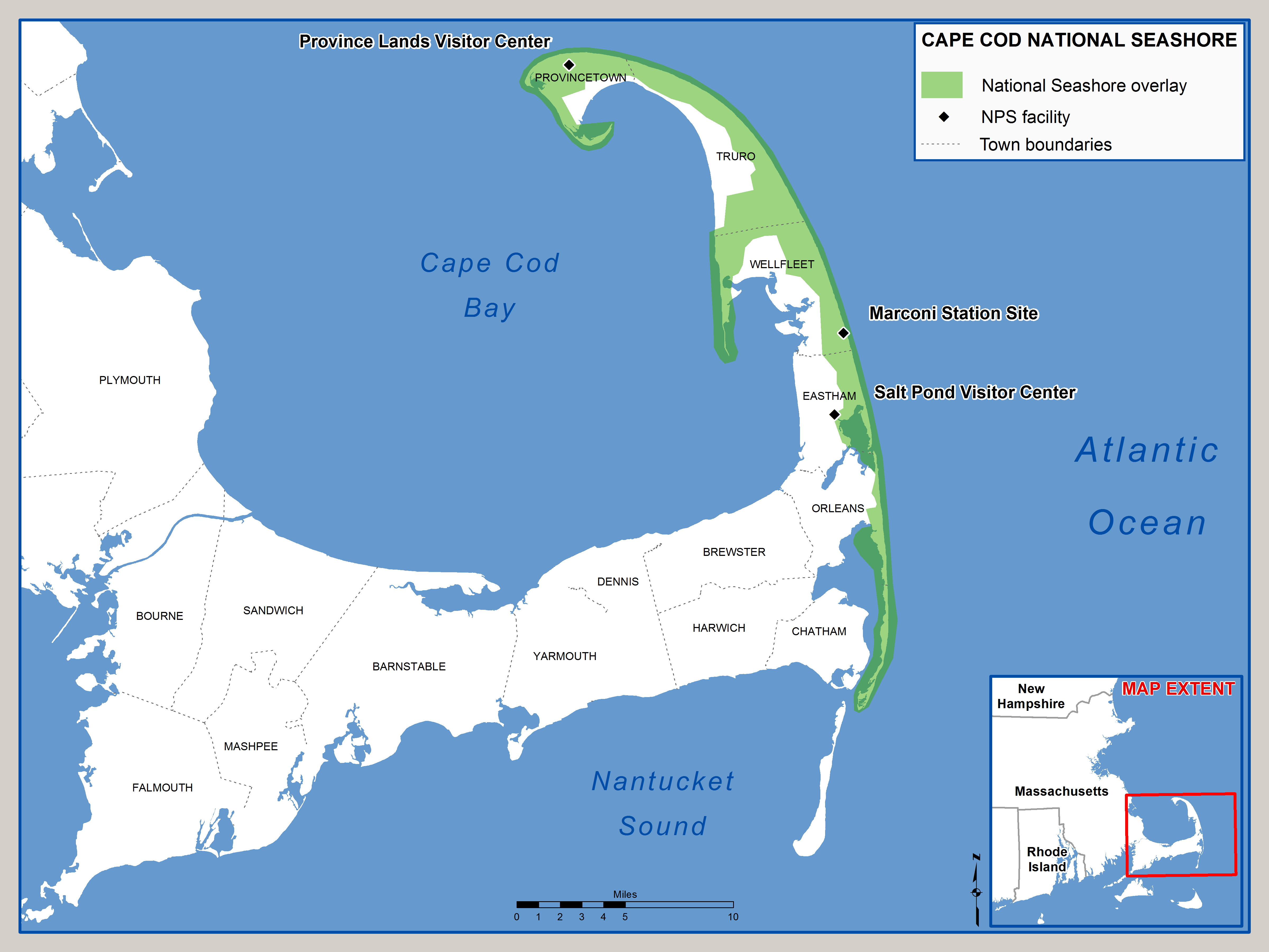
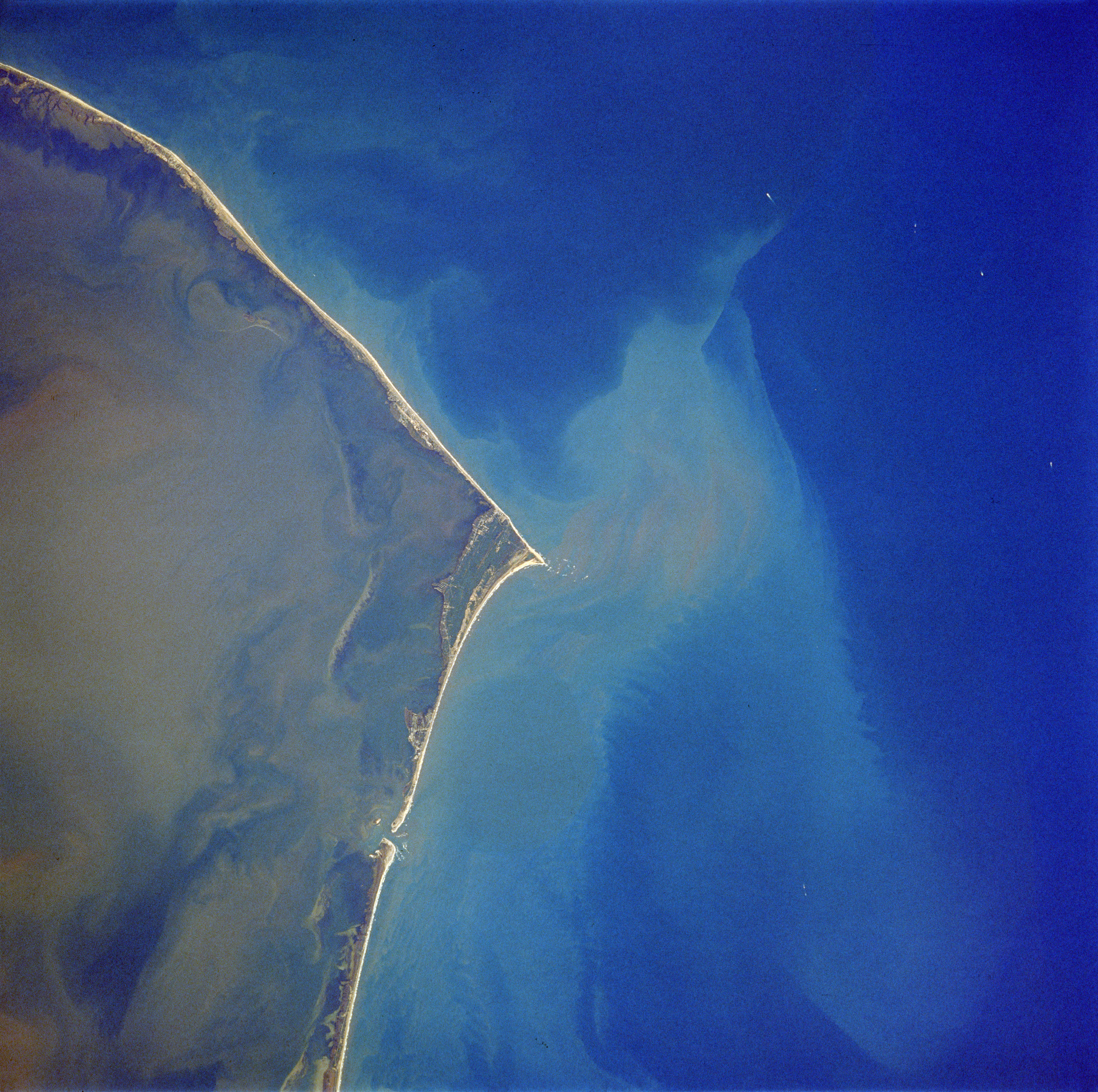
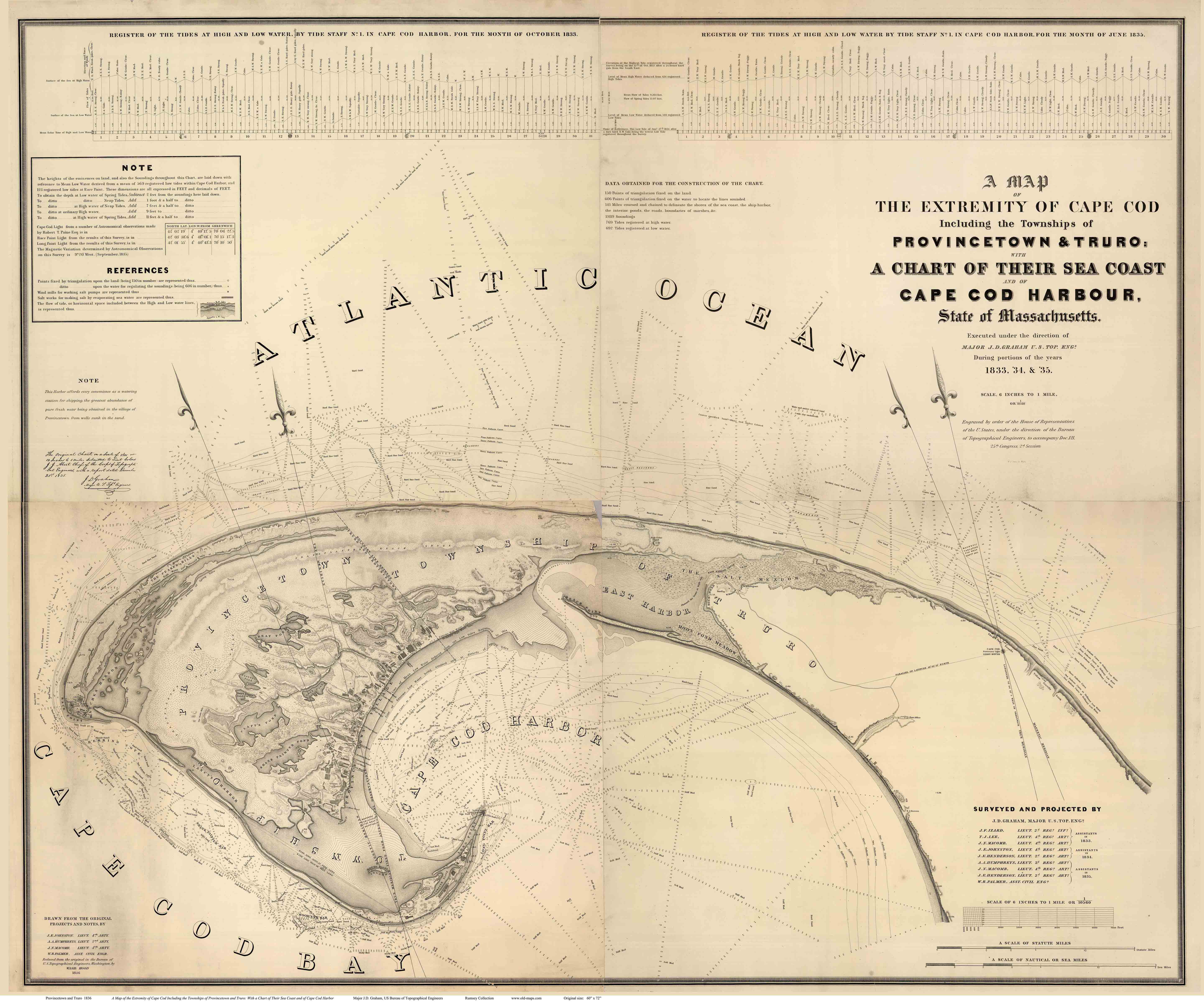
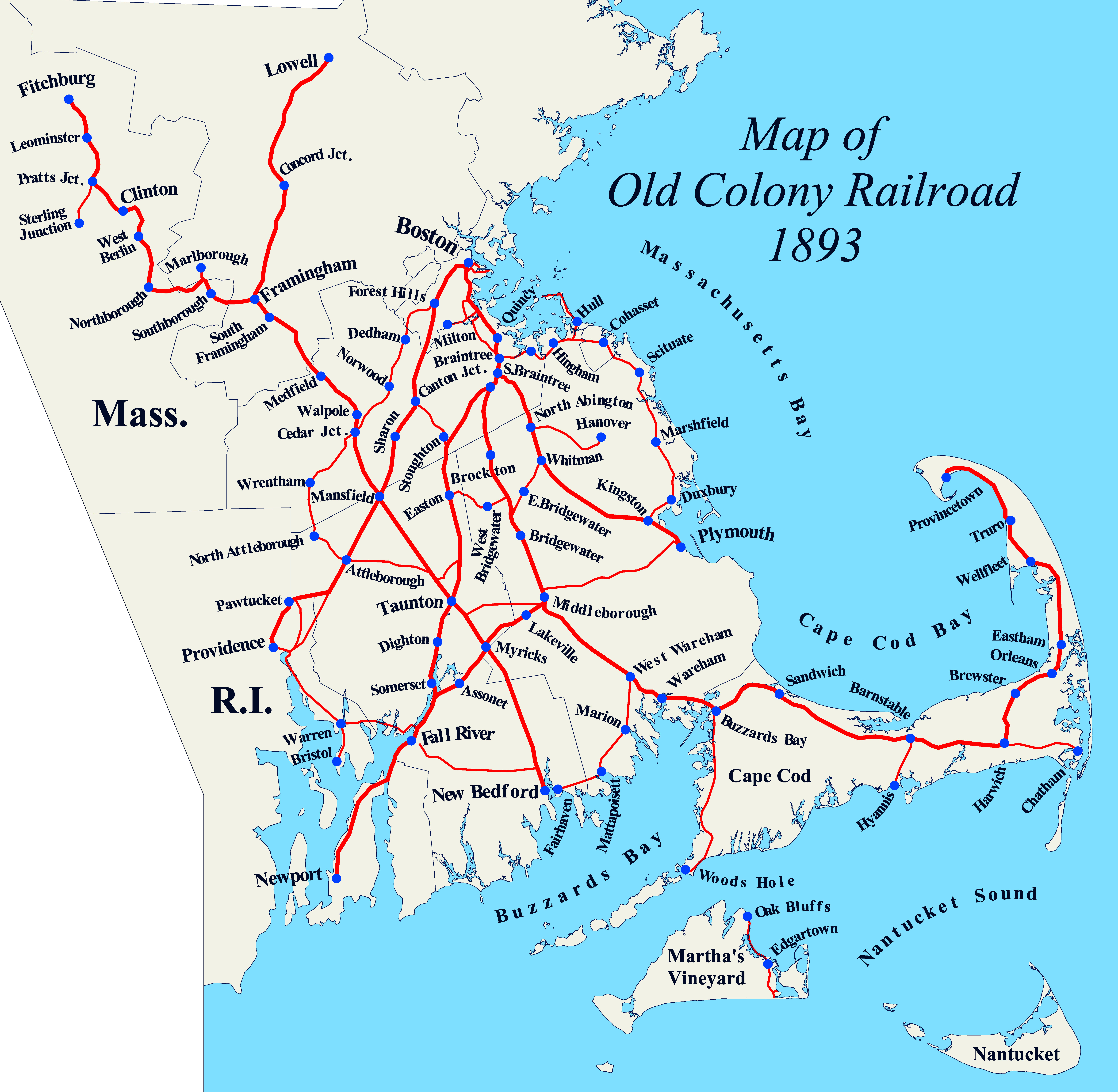
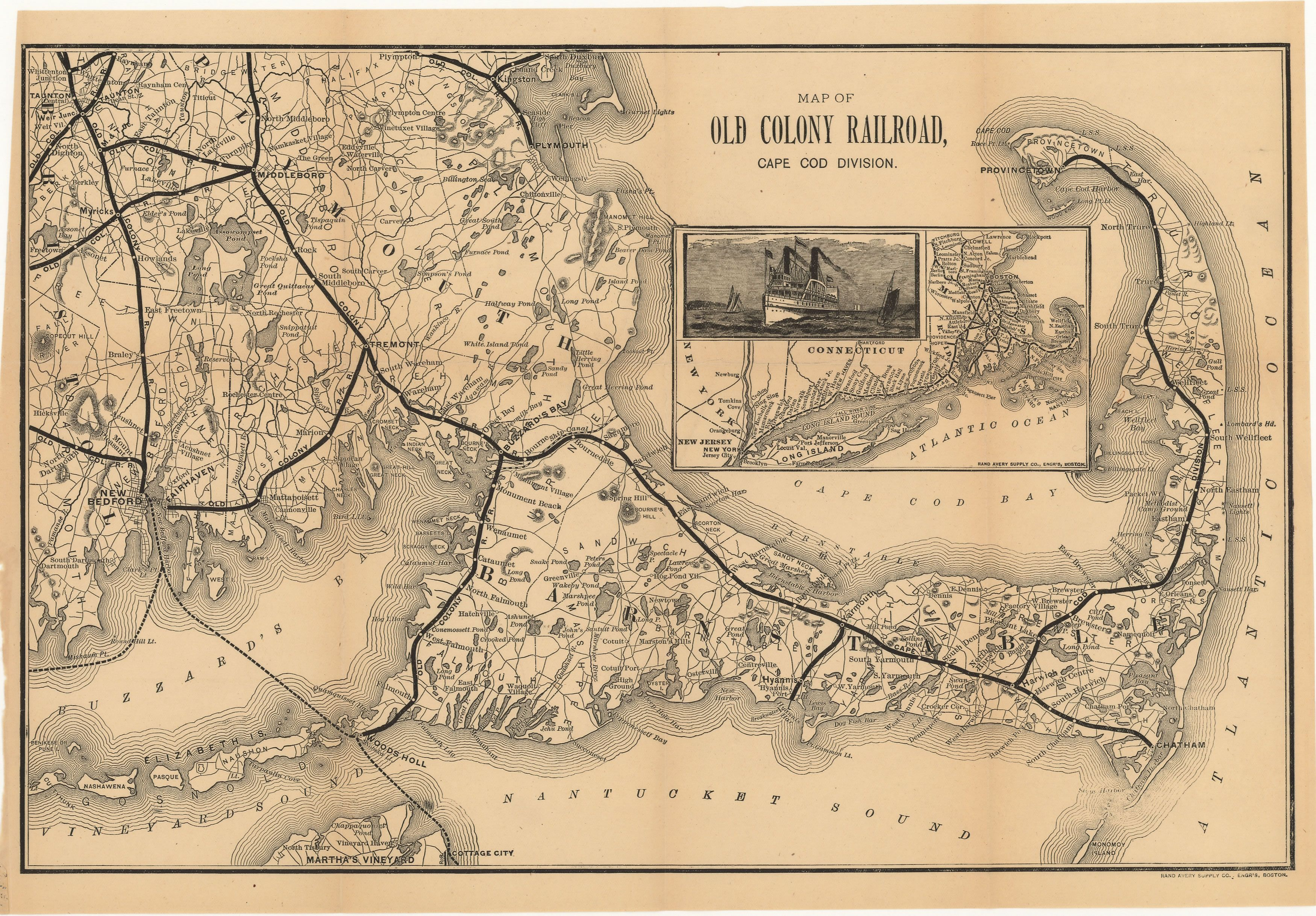
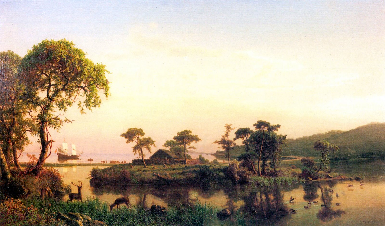
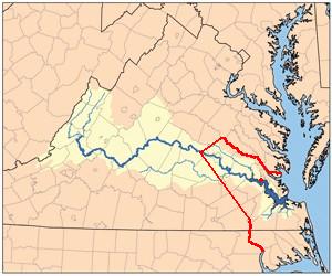
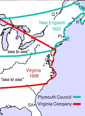
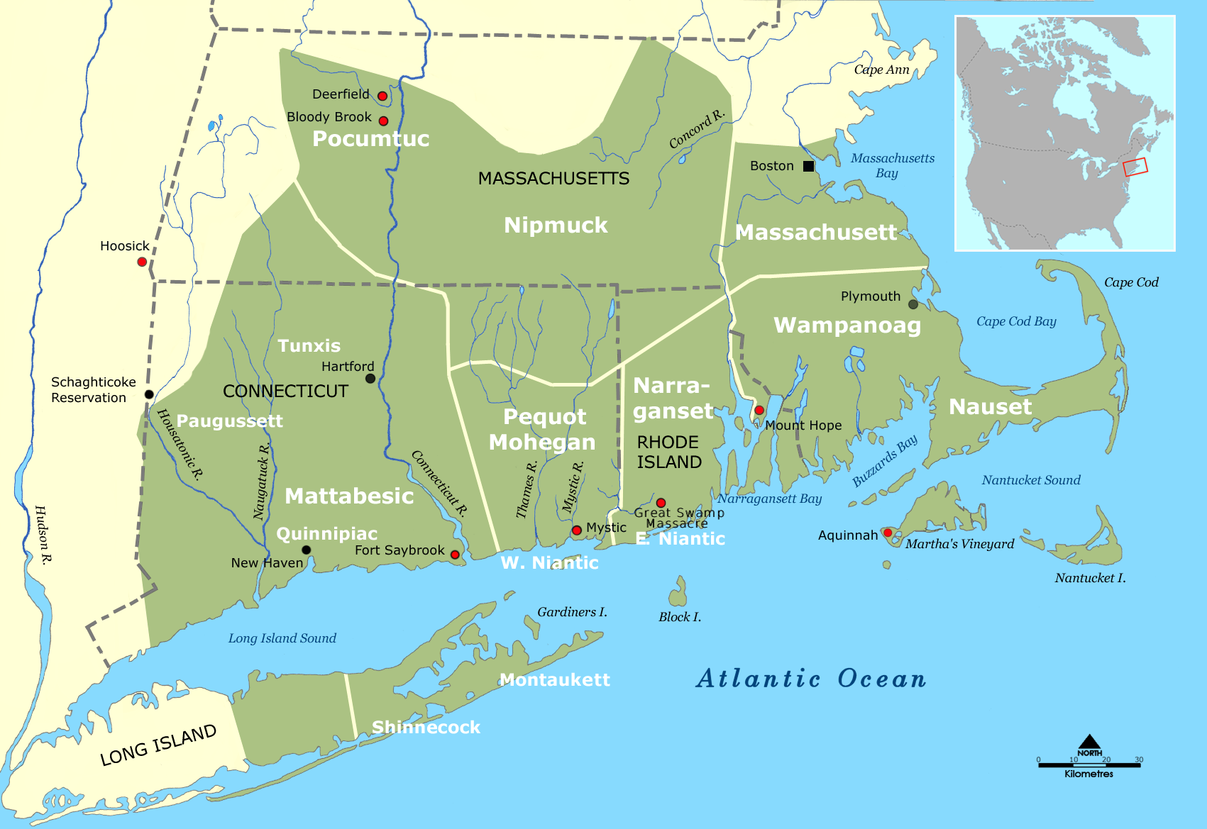
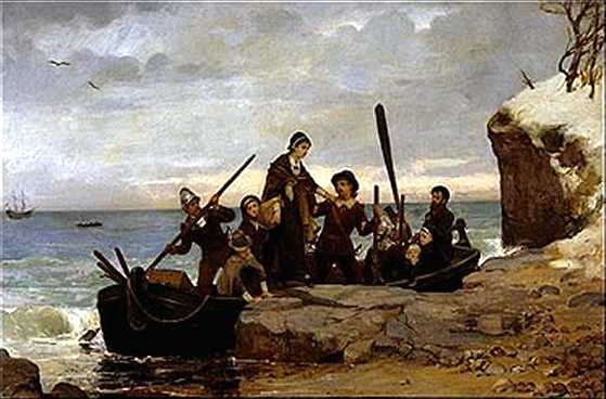
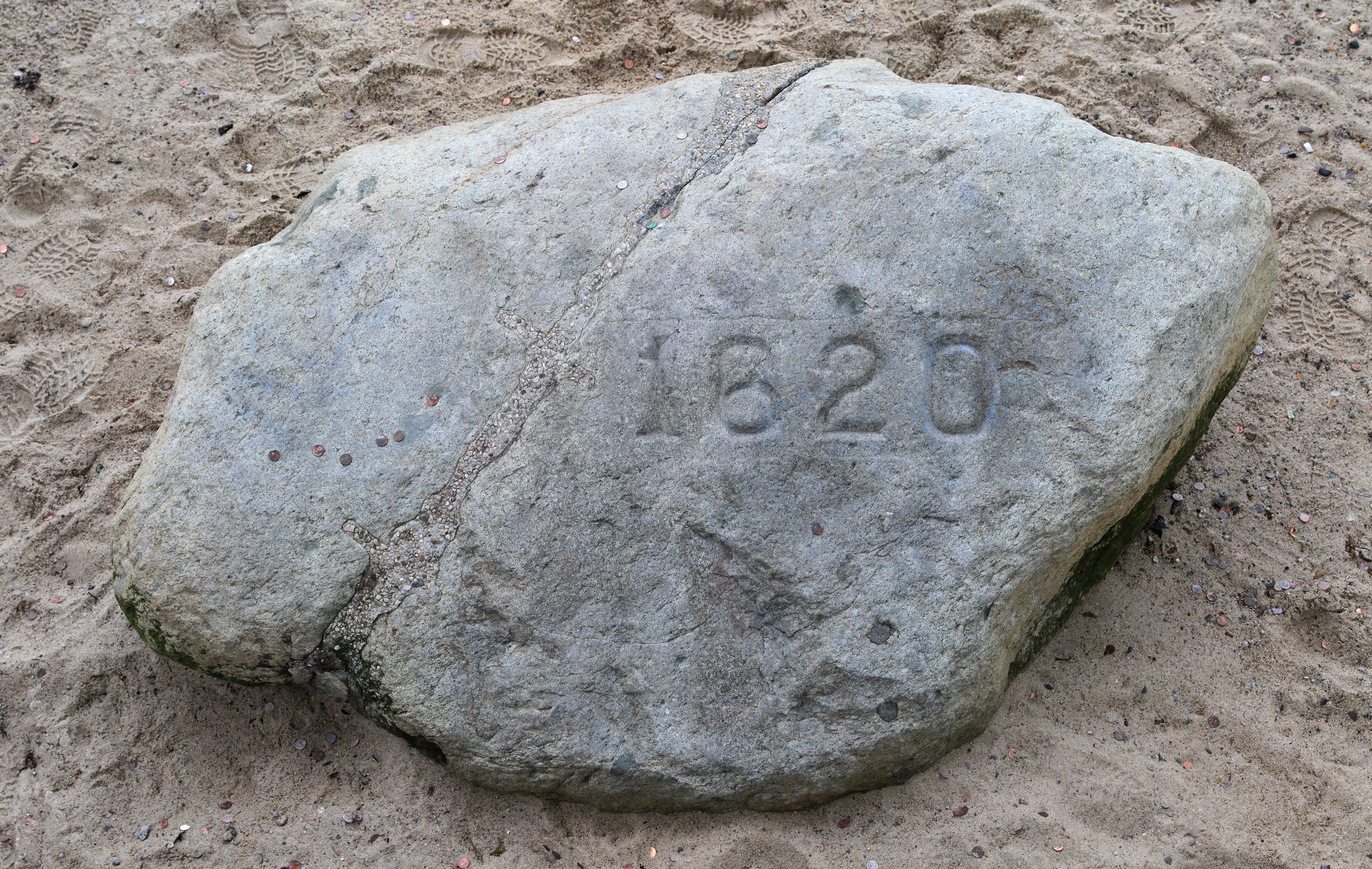
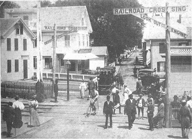
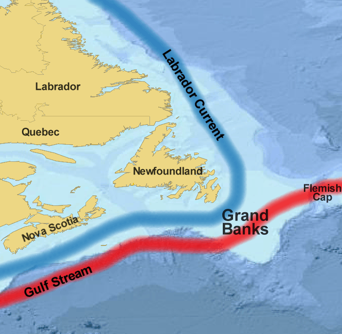
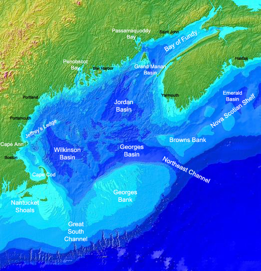
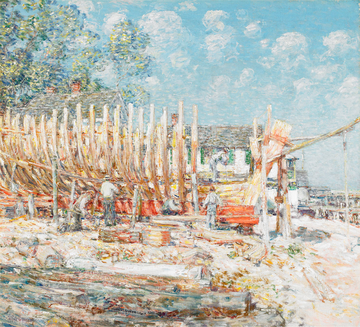