|
Reflections 2017
Series 17
October 27
Jubilees – Paris I: Its Historic Circles – Total Solar Eclipse
| | Rationale In recent years, I've always enjoyed starting the reporting of a trip by giving its rationale, and this is no exception. In January 2017, well before the spring trip to Peru & Bolivia, I felt it was time to think about the fall trip. For some time, I've had my eye on joining together a pair of cruises running the length of the Trent-Severn Waterway in Ontario offered by the same company as did the Rideau Canal cruise, and for a long time I was on their waiting list for that one single cabin they have, but that wasn't going to work out for 2017. | | | | | | Update: While in Paris of all places, I got an email from Canada informing me that I moved up and off the waiting list and now have the single cabin for the back-to-back twin trips running in 2018 from August 29 to September 8. As I always say, travel planning is best done well in advance if you want something specific. |
| | | | But with canals on my mind, it struck me to look elsewhere. Maybe it was finally time to go back to Europe. Of the European countries that offer canal cruises, France is best-known, and has the greatest variety. Searching online, it was the same old story—the single supplement. I didn't want to pay up to twice the fare for single use of a double cabin. | | | | Finally a note I found online said that the Luciole hotel barge on the Canal du Nivernais in Burgundy had two single cabins, which seemed to be close to unique. In addition, the venue and sights seemed excellent, since I wouldn't do something I didn't feel worthwhile just to save the money—better not at all. I'd been to Burgundy years ago—I remember being in Dijon—but never in what turned out to be northern Burgundy, so I made arrangements. As an additional positive point, they send a van free of charge to Paris to pick up their dozen passengers and return them at the end. It was getting better and better. | | | | I don't like to go that distance for just six nights, and the Paris connection made it obvious what to do—revisit Paris first. I found a nice place to stay in Paris for five nights, in Passy, to the west of the center, a relatively new neighborhood for me. It was the Hôtel Aéro, which describes itself as an hôtel de charme. Including travel nights, it would end up neatly being a two-week trip in early September. | | | | While in the past, I've traveled to Europe with some frequency, in recent years travels have taken me to Asia, South America, and around North America. My last time to set foot on the European continent was five years ago during the Atlantic Isles trip in June 2012. I was in three cities on the Continent, Hamburg and Travemünde in Germany (2012/11 "Continental Interlude"), and the ship, the late, lamented Deutschland, later stopped in Stavanger, Norway. I had come to the Continent from the Azores, Madeira, and the Canaries; the ship afterward went on to the Shetlands, Faroes, Iceland, and Greenland. Lots of Atlantic Islands—that was the point, after all—but little of the Continent. But my travel diaries tell me I haven't been in Paris for 12 years, since 2005. It would seem it's high time for a return to a familiar place, a topic I mentioned in the last posting regarding the TCC. | | | | Jubilees I promise you this trip evolved as above. But as often happens—quite happily—it will look as though it had been planned as an anniversary trip, but that turns out, believe me, to be just a coincidence. | | | | A Golden Jubilee celebrates 50 years, and a Diamond Jubilee, 60. Traditionally, Diamond Jubilees were originally intended for 75th Anniversaries, but that changed when Queen Victoria celebrated 60 years of rule in 1897 when it was called her Diamond Jubilee, repeated with Queen Elizabeth's Diamond Jubilee in 2012. | | | | Let me summarize personal gold and diamond travel jubilees, a bit out of chronological order, then summarized afterward more neatly. In 2007/7, I had an entire posting about my Fiftieth Reunion of the Class of 1957 of Brooklyn Technical High School. But as part of that I wrote, under the heading "Golden Jubilee of Travel": It seems that 2007 is turning out as a 50th Anniversary Year for me in two ways. I graduated from Brooklyn Technical High School that year, and did my first international travel that year as well, to Europe, quite extensively. | | | | | | I was, as I recently stated, 17, and went with a well-traveled high-school friend I'd known since junior high. We went round trip on the original Queen Elizabeth (2013/7, my very first Voyages, 1 & 2). His parents had fled Germany about the time I was born, as he and I were the same age—he had been born in Tangier en route. The family regularly returned to Europe on business, but on this trip, my friend and I parted ways from them after Paris and met them again at the end of the summer in London, where I turned 18.
Incidentally, when confronted with a language requirement at Tech and a choice between German and French, I chose German because I was concerned, and felt this friend could "help me with my homework". But as it turned out, I didn't need help, I say with a big smile.
|
| | | | But I supplemented that in 2013/7: In 2007/7, I declared a personal Golden Jubilee of Travel on the fiftieth anniversary of my first international trip, when I sailed at the end of June 1957 to France, my first destination outside the US. . . . But that Golden Jubilee was accurate only for international travel. My first major trip ever was a domestic US one . . . when, at the end of March to early April 1953, my family took a car trip . . . from New York to Chattanooga, exciting for all of us, but seminal for me. I now realize that just a couple of months ago that 1953 trip reached its 60th anniversary, which means that actually, considering all travel that influenced my world outlook and education, I have now celebrated my Diamond Jubilee of Travel. | | | | And then a full decade went by with a snap of the fingers and on April Fool's Day (!!) 2017, the Tech Class of 1957 had its 60th Anniversary. As usual, we had a full day at the school's annual Homecoming, with 36 members of the Class of 1957 present, and most of them also attended the Class Dinner that evening. Afterwards, I, representing the humanities among all the engineers, had the notion afterward to write up the day, including the delightful dinner. I distributed the two pages online to several friends, and the upshot was that my summary would be put into the Class Archives. Below are a few pertinent lines: | | | | | | We had 32 at our dinner that night at the Vanderbilt Restaurant . . . [in Brooklyn, nearby], but that included 7-8 spouses, not just alums. . . . Volunteers were asked to stand up between courses to make a statement, such as how Tech had affected their careers and lives. Friend Don McCann spoke about coming across other Technites far afield during his career. Harold Shair . . . , [a] dentist [I'd spoken to earlier in the day], rose to talk about how his career moved away from engineering to dentistry. . . I had a thought or two about the past, but always tend to remain hesitant, until fervently nudged by Don across the table to stand up.
I started by deciding to channel Don and spoke first about the time in South Africa when I'd taken the luxury overnight Blue Train out of Pretoria. As I noted in 2008/10: As the Blue Train approached Cape Town, I met in the observation car someone who, as it turned out, was a graduate of Brooklyn Tech, who introduced me to another Technite he was traveling with, so we had a minor, three-alumni high school reunion. That anecdote seemed to go over well, so I then channeled Harold, as someone, like me, who'd considered engineering but who also had moved into another field. I told how, as part of the College Prep language requirement at Tech, I discovered German, majored in it at Queens College where I added Spanish, then learned French on my own. At QC I was guided to the Middlebury summer language schools, where I ended up spending nine summers between 1959 and 1980, met German major Beverly from Minnesota there in 1961, where we spent the year in Mainz for our Middlebury MAs, then returned a decade later to Middlebury to get our Doctor of Modern Language degrees for a career in secondary-school teaching. It was also a story that blended in well at a reunion such as this.
[As a "history repeats itself" follow-up, Don was at my house during an Oktoberfest party this month talking about Tech when friend Ed reminded me of something I knew, but had slipped my mind in the excitement of the moment—that he, too, was a Technite, of the Class of 1971. So the three-way mini-reunion that happened near Cape Town in 2008 repeated itself in my living room nine years later.]
|
| | | | Booking the French trip in January, then having a 60th BTHS Reunion in April, still didn't jostle me immediately into the realization that, if I did my first international travel the summer after I graduated, and if that trip's first stop was Paris, this summer was going to be my 60th Anniversary of International Travel—and I was going to Paris again! So the upshot is that this trip fell in the year of my Diamond Jubilee of International Travel. Here's the summary: | | | | | | Domestic travel—and all major travel—began for me, as above, in March/April 1953.
My Golden Jubilee of Domestic (and all) Travel, 50 years, fell in 2003.
My Diamond Jubilee of Domestic (and all) Travel, 60 years, fell in 2013.
International travel began for me, as above, in June 1957.
My Golden Jubilee of International Travel, 50 years, fell in 2007.
My Diamond Jubilee of International Travel, 60 years, falls now, to my surprise, in 2017.
|
| | | | Previous Paris Visits While I'll often refer back to a previous visit to a place, I'm not in the custom of summarizing frequently-visited places, but maybe it's appropriate that I do so for Paris. Thank goodness for those travel diaries—19 and starting the 20th next year. I remember most trips that included Paris, but thumbed through the diaries for details—and found more! I think (hope) I found all the trips. | | | | 1) 1957 On that first visit with my friend and his parents, they chose to stay at the Grand Hotel. I knew it was sumptuous, but didn't know its lengthy history until now. After its opening in 1862, it became a center of artistic life, attracting names such as Victor Hugo, Émile Zola, Guy de Maupassant, Oscar Wilde, Marcel Proust. In 1869, publisher James Gordon Bennett met here with Henry Morton Stanley to convince him to go to Africa to search for David Livingstone. I also now only learn that the hotel's almost-triangular shape on its uniquely almost-triangular block was the result of Haussmann's redevelopment of Paris with new streets and boulevards, of which we'll speak extensively later. Its mansard-roof style is also the result of having to conform to general architectural and design standards set forth by Haussmann. The Grand Hotel is now the Intercontinental Paris Le Grand; in addition, Intercontinental now only manages it, having sold it to Qatari owners. Sic transit for tradition, but it still looks nice:
http://www.jll.com/Documents/Hotel-Migration/banner_new/InterContinental%20Paris%20Le%20Grand.jpg
| | | | On the right is the Paris Opéra, now called the Opéra Garnier, located on the Place de l'Opéra. On the left is the Grand Hotel—I'll stick to the original name—where the Place cuts off what would otherwise have been one of its three triangular points. I used the full posting of 2004/24 to tell of my arriving in Paris the first time, but I only will repeat here one of my favorite travel-cum-language stories. | | | | On the left in the picture is the south façade of the Grand Hotel on Boulevard des Capucines. This is where my friend and I had our room. In addition to the fact that I was absolutely overwhelmed actually being in Europe!, in France!, in Paris!, I remember looking out at night—probably the very first night, and seeing a neon sign that I remember clearly to this day. Keep in mind that I'd just graduated from high school with three years of still-shaky German. I didn't know a word of French. The sign advertised Gauloises cigarettes. Below it said avec ou sans filtre. If you know French, you know what that means. If you don't, you can probably guess, which is what I did. But what electrified me was that, not knowing French, I nevertheless understood it directly, without translating it. It was an epiphany. In other words, other than the experience of going from visual concept via one's native language to comprehension, this was purer than that, going directly from concept to comprehension with no "middleman" and without even knowing the language involved. I didn't need the intermediate crutch of "with or without [a] filter". It was an enthralling experience. | | | | 2) 1961 Just four years later, Beverly and I had met at the German School summer session at Middlebury and crossed on the Liberté (2013/7, Voyage 3) via Paris for our year of German studies in Mainz. Without reservations, we managed to find, late at night, what turned out to be our romantic hideaway for ten days. It as in the Left Bank's Quartier Latin, the Hôtel Paris-Latin, in the Rue Monge, room 51. I didn't need our travel diary to remind me of that, although I checked, and it didn't have the house number on Rue Monge. As far as I can tell, the hotel is gone now. If you want to know why I remember that fifth-floor room number, read the first full paragraph of 2006/5. | | | | 3) 1971 This was the first year of our dual sabbatical, where we spent several months in Europe in studies and travel, came home for the winter, and then did the same thing in 1972. We crossed on the France (2013/7, Voyage 7) and our first stop was Paris. The travel diary says we stayed at the Hôtel d'Orient, 43, rue de l'Abbé Grégoire. I have absolutely no memory of this hotel or of its location, which seems to be east of Le Jardin du Luxembourg. We had leased a Simca from the factory (a very poor choice—see 2005/16), which was in or near the Passy area to the west, apparently the only other time I was ever in Passy, fleetingly. | | | | 4) 1974 This year, returning from a trip to Germany, we stayed not in a hotel, but with friends in Paris, and right after that, with other friends in Haslemere, England. We first met the friends in Paris, Norm and Tricia, as across-the-hall neighbors in White Plains, but then Norm was transferred to Paris and they lived there for a while. We visited them in mid-July at 2, Passage du Guesclin, which is just south of the Champs de Mars and Tour Eiffel. It was very enjoyable being with friends, and a different way to see Paris. | | | | 5) 1981 We flew to Brussels on Sabena (now gone) and took the Trans-Europe Express (now gone) to Paris, where we again stayed in the Quartier Latin, only a block off the Boul' Mich', the Boulevard Saint-Michel, at the Hôtel Central des Écoles, 3, rue Champollion (now gone; it's now the Hôtel Central Saint-Germain—is there a theme here?). Picasso had lived there in 1902-1903. I have no specific memories of the hotel. | | | | 6) 2003 While 2003/13 discusses visiting Paris that year, for some reason, I didn't discuss the hotel we stayed at until the next visit two years later in 2005/10. This is the information lacking: in 2003, returning from Italy (see "train connection" below), we stayed elegantly on points at the Hôtel Prince de Galles ("Prince of Wales") on the Avenue George V [Cinq] (No. 33), just off the Champs-Élysées. I remember it was August, when the French leave on vacation en masse, and so there were empty streets in Paris, I could park my rental car in front of the hotel, right on the Avenue George V, and was easily able to drive everywhere around the city, particularly convenient because of Beverly's wheelchair. | | | | | | I knew little about the hotel, but research is now easier than ever. The Art Deco hotel opened in 1928. That the Avenue George V uses the English spelling, and not the French spelling "Georges" indicates it's a reference to King George V of England. In connection with that, the hotel was named after his son, the Prince of Wales, who became Edward VIII, then abdicated to become the Duke of Windsor. Over the years, Sir Winston Churchill and Marlene Dietrich were residents, and Charles Laughton visited. Somewhat amusingly, when Elvis Presley was doing his military service in Germany, he'd spend weekends in the hotel.
For reasons I can't explain, I've seen a number of pictures online of some VERY fancy cars parked in front of the hotel. This picture shows a Pagani Zonda F Roadster parked right in front of the Prince de Galles. While I did park in that area, this is NOT my rental car! Neither is this Rolls Royce Ghost (Both photos by Falcon® Photography). Despite what you're thinking, the hotel was really quite pleasant and didn't have all that much of the typical lush 'n' plush flavor I do not appreciate.
|
| | | | 7) 2005 This was the year of going Round-the-World by Rail, getting used to traveling solo after Beverly's passing in October 2004. Being in Paris alone for the first time in decades, I'd decided to go back to my original roots, despite the cost, and I'd booked a room online at the Grand Hotel (2005/10). When checking in, I told the receptionist it was a sentimental journey, as I'd stayed there on my first visit at age 17 in 1957, two years short of a half-century earlier, facing Boulevard des Capucines. I wondered if this time, maybe I could have a room facing the Place de l'Opéra? She said she'd check, that I should come back shortly. When I did, a young man was at the desk and he looked at what I was given and said boy, did I get an upgrade! I got a room one flight up (out of six) directly facing the Place de l'Opéra and the Opéra (see earlier picture, the short, right-hand façade). I'm a huge fan of good views—I live on the Hudson for good reason--and this is possibly the most magnificent view from a hotel room I've ever had. On this visit I remember dining at, and having both breakfast buffets in, the glitzy Café de la Paix (Photo by User: [WT-shared] Riggwelter at wts wikivoyage) within the building. It faces the Place de l'Opéra, and one of those windows on the right might have been the upgrade I was given. The Café is named after the famous Rue de la Paix, which exits the Place just a short half-block to the south of here—the hotel had originally been the Grand-Hôtel de la Paix. This is an interior view of the Café—click to inspect the architectural detail (Photo by Marianne Casamance). Though very different, this second visit to the Grand Hôtel was nevertheless a sentimental journey. | | | | 8) 2017 All those destinations, Right or Left Bank, were more or less centrally located, so our visit this time to the Hôtel Aéro in Passy to the west is further out of the center. The dozen years between 2005 and 2017 are the second longest break away from Paris after the 22 years between 1981 and 2003, but that stretch took in all of the 1990s, when we did no international traveling at all, only cautious domestic travel, due to the upheavals of life, such as Beverly's illness, our retirements, and temporarily moving to Florida. But this visit has an extension. At the end of this trip the return from Burgundy to Paris is at midday, but the flight home is in the morning, so we've booked a second hotel, at the airport, the Ibis Styles Hotel. Uniquely this, my 8th visit to Paris, involves two different hotel stays. | | | | Passing Through Paris I also find there are just two instances of just passing through Paris, once by train, and only once by plane. | | | | TRAIN CONNECTION: You will find that the early postings, from 2000 on, are very meager, as I hadn't yet developed a decent style, nor knew how to include pictures and maps. So are the entries in the travel diary, as Beverly was no longer capable of doing them, and I made only sparse notes. In 2003, we did our last crossings on the QE2, round-trip, our 6th and 7th (2013/7, Voyages 26 & 27). Our goal was the Channel Islands, then Italy. We made our way from Southampton west to Poole by train, then took the ferry to Guernsey for a night, then to Jersey for a night, then to St Malo in France, connecting to Rennes for the night. This story is inadequately told at the end of 2003/6, but here supplemented. | | | | We then took the high-speed TGV to Paris to the Gare Montparnasse, also barely adequately told at the start of 2003/7. With the wheelchair and luggage, we had to take a taxi to connect across town to the Gare de Bercy, which abuts the Gare de Lyon, to take our special overnight train to Rome. I particularly remember that taxi ride and chatting to the young woman driver, who was very helpful with the wheelchair and luggage. It was when we were returning from Italy that we stayed at the Prince de Galles, above in "2003", which tends to further explain the confused inadequacy in writing up that trip. | | | | PLANE CONNECTION: On all the above trips the final arrival in Paris was always by train, sometimes car. The only time we were ever at a Paris airport was once, to make connections. Coming back from the Middle East (Haifa via Naples to Nice) in 1965 on the Bilu (2013/7 Voyage 5) we went to Marseille, then flew home via Paris. The diary doesn't note which Paris airport we connected in, but it has to have been Orly, which had been open since 1932, while Charles de Gaulle Airport opened only in 1974. So a round trip to Paris by air this trip is a new experience, and it will be the first time at CDG. | | | | Paris In no way are the current postings meant to be a Paris travelog. There are many famous locations and sights in Paris. I've seen them, often more than once. I have absolutely no intention of discussing them here. If the names Tour Eiffel, Louvre, Notre Dame, and others come up, it'll be because they're in the background of what we're discussing—which is quite nice, actually. We're instead going to discuss Paris as it developed historically, in a number of circles and in many long, straight lines. The lines will be in the next posting. These circles and lines made Paris what it is today. Come along for the ride—I think you'll enjoy it. | | | | Also, you may speak French, or know a bit. In any case, I always translate the essential, but am going to leave some French words in names untranslated, which will add to the flavor of the posting. Practice them here: Tour Eiffel [tower]; Rue de Passy [street]; Pont de Grenelle [bridge]; Gare de Lyon [rail station]; Île Saint-Louis [island]; Place de l'Opéra [(city) square]; Château de la Muette [castle].
Do not be misled by the word hôtel. In French it refers to a large mansion or public building. When it's been borrowed by other languages, it's only been taken in the meaning a public building that's an inn, a hotel. The word does cover that meaning in French, but when we visit the Hôtel de Sens in the Marais, don't look for bellboys, because that's the medieval Sens Mansion, or Sens Town House. And, as mentioned earlier, the Hôtel de Ville is the City Hall.
| | | | Paris and Its Historic Circles We start at the beginning. The settlement that became present-day Paris was first called Lutetia, Lutèce in French. (Lutèce was also the name of a very famous and highly-praised restaurant in New York City from 1961 to 2004.) The origin of that name is unknown. It was founded by the Gallic tribe of the Parisii, but in 52 BCE the Romans crushed the Gauls and took control of Lutetia, so it was then a Gallo-Roman city. The Romans also called it in Latin Lutetia Parisiorum, or Lutetia of the Parisii. | | | | | | Do not confuse Lutetia with a U with the female name Letitia with an E. This name exists in most languages, but is very rare today. The only person I've ever heard of with that name was Letitia Baldridge, the writer on etiquette. |
| | | | We know Who, so now we need Where. Look at this Elevation Map of Paris (Map by ThePromenader), which also shows present and past hydrology. We'll come back to this map in the future, but for now note Paris in its modern borders. Click to enlarge to first note an error (don't always believe what you see in print, especially if you know better!) The Seine flows from east to west through the center of Paris. It comes in from the south at the bottom of the map, and the Marne, coming from the east, joins it. You'll note the rivers' names are reversed on this map. Otherwise, it shows pretty well what we need to know. | | | | Note the swampland that historically spread out on both sides of the Seine. We noted earlier that the center of Cusco in Peru was also built on drained swampland, so, to be French about it, this is déjà vu! The swamps were eventually conquered, but find in the center of the map, the modern 4e (4th) arrondissement. This charming neighborhood, which we'll walk through later, is to this day called Le Marais (The Swamp), and so this map shows us why. But you also see how the marshland would have limited early settlement. There are two islands in the Seine. The smaller is the Île Saint-Louis, and the larger, slightly further downstream, is the Île de la Cité (neither is named on this map). | | | | Also be aware that river banks are name based on travel going downstream, so in Paris, the Rive Droite / Right Bank is to the north of La Cité, and the Rive Gauche / Left Bank is to its south. | | | | Several hills are also shown, and we all recognize the name Montmartre. But for now, locate instead the Montagne Sainte-Geneviève. Today, the Pantheon sits atop it and the famous rue Mouffetard, which we'll also visit later, runs down from it and then to the southeast of it (not shown here, either). | | | | It was originally believed, from Caesar's "Gallic Wars" that the original settlement was completely located on the Île de la Cité, away from swamps and invaders, but apparently that's not the whole story. The Gallo-Roman city developed mainly on the Montagne Sainte-Geneviève, like La Cité also away from the swamps, and on this hill starting in the 2C CE, public works and monuments were constructed. But during the barbarian invasions of 285 CE, the settlers on the hill abandoned it and took refuge on La Cité, where the population now concentrated itself. The island received new fortifications for protection, with the eastern half of the island being protected by a wall built of rocks recycled from the Arènes de Lutèce, which lay well to the southeast, and which we'll visit on this trip. I've read that, in 360 CE, based on the Gallic Parisii tribe, Lutetia was renamed Paris. Frankly, my opinion is that perhaps it's more accurate to say that "Lutetia Parisiorum" was simply shortened to just "Paris", which explains the change more logically. | | | | | | I'm rather sure that many non-Europeans might misunderstand the meaning of "Cité" and picture the island as being something like "City Island". Actually, that could be a valid translation, as long as you know what you mean by "city", since that term is easily misunderstood. It works this way.
In North American English, and possibly beyond, "city" refers to an urban conglomeration, period. In European English, the word has two meanings. The first is as above, but secondly, it's also as a reference to the original settlement of the town. Many are used to the fact that, when someone living in London says he works "in the City", that's a reference to the actual original, small settlement in the East of urban London, today largely a financial center. German has also adopted this latter meaning from English, so that, while "the City of Hamburg" is die Stadt Hamburg, you can also say in German that you're shopping downtown in Hamburgs City.
So let's move over to France. "The City of Paris" is la Ville de Paris, and the City Hall is the Hôtel de Ville. So how would you translate "Île de la Cité" into English? "Early Settlement Island", while the most accurate, is too clumsy and just won't do, and "City Island" is misleading, because it hides reality. Best leave it in the original.
|
| | | | We can also mention here that Lutetia/Paris wasn't particularly important in this period. It was NOT the capital of the Roman province it was in. That was Agedincum in today's Burgundy, known today as Sens (pronounce the final S). Sens is downstream on the Yonne from Auxerre, where we'll take our barge cruise later. Not only was Sens more important than Lutetia/Paris in Roman times, during the Middle Ages the archbishops of Sens held the prestigious role of primates of Gaul and Germany. The Hôtel de Sens in Paris, which we'll see, was their official residence in that city. But at that time, Paris was no more than an outpost of Sens. | | | | First Wall Here's the Gallo-Roman city of Lutetia/Paris on the Île de la Cité (Map by Starus) in about the 4C CE. The modern course of the Seine is shown (and even the silhouette of the not-yet-built Notre Dame is on the lower right), while the blue lines show period river banks. The Gallo-Roman Wall is in red, while dark red indicates the Roman palace. The red lines don't quite form a circle—it's more of an oval due to the shape of the island—but growing from here outward came many more circles. This 1705 map shows Lutetia during the Roman Empire, once it was consolidated on La Cité, along with the local Roman roads running mostly north-south. | | | | This is the one-block long Rue de la Colombe / "Dove Street" (Photo by PHGCOM) on the northeast side of La Cité (click). I have not been here, but obviously the view from there has to be over the Seine to the Right Bank. The footprint of the Gallo-Roman Wall is shown in the street paving. Apparently somewhere along the street (click) is this plaque about the wall (Photo by Reinhardhauke), which translates as: "Gallo-Roman Wall of La Cité; the marking on the surface of this street shows the location of the vestiges discovered in 1898". | | | | Second Wall This next map shows the city in 508 CE after expanding to the north, to the right bank. It would appear that some sort of fortification already appeared here. But the Carolingian Wall, also called the First Medieval Wall, which surrounded both the island and the northern expansion, today the heart of Paris, dates to the 10C, having been built because of a Viking siege in 885. (I had to look up the precise definition of Carolingian: the empire founded by Charles Martel [Carol(us) is the medieval Latin form of Charles], followed by his younger son Pépin le Bref [Pepin the Short], then followed by HIS elder son Charlemagne.) The fortification had a 12 by 3 meter/yard wide ditch and was likely to have been supported by a wooden fence. The Left Bank didn't have any defensive walls. The best defensive hope was the walls of the abbeys. Note on the map how east-west roads have developed, particularly the one closest to the Seine, and note the three indications that the riverbanks are still soggy areas of marais. | | | | Before we continue, we can present a preview of what's coming as to the city limits of Paris from the 4C to today—more circles (Map by Paris 16). These will be named as we proceed, but we can see (click) in darkest green on La Cité, (1) the Gallo-Roman Wall and then (2) the Carolingian Wall in lighter green, covering La Cité and the adjacent Right Bank. You can then see how the circles continue, ever outward, based on newer walls that were built over time. Today, they're all gone except for a few remnants. So that you can get used to the names of walls 3-7, we'll mention them now in advance: (3) the Wall of Philippe Auguste, (4) of Charles V, (5) of Louis XIII, (6) of the Ferme générale, and (7) the Thiers wall. That's a lot of circles!
http://belairsud.blogspirit.com/media/01/00/1111680143.JPG
| | | | Keep this summary map of the walls handy as we continue. It doesn't show the Carolingian Wall—but it IS on the green map--probably because not only is the least known about that wall, but also because it was only in 1995 and 2009 that the first vestiges of it were uncovered. Otherwise, this map names all the walls. In my mind, they group together quite neatly like this:
FIRST MILLENNIUM WALLS: Walls 1-2 are the most ancient, 4C-10C, and cling closest to the area of original settlement.
CLUSTERED WALLS: Walls 3-4-5 are 12C-17C, and still cluster together in central Paris forming variations on a single theme. Each one piggybacks on the earlier ones and forms an extension thereof.
OUTLYING WALLS: Walls 6-7 are the newest, 18-19C, and are the first ones to spread out over a much wider area. These are the most circular in nature, and the most free-standing, since they do not abut any of the older walls, like 3-4-5 abut each other.
| | | | Third Wall We've seen the first group of two, so let's look into the second group. One definition I've found of the Middle Ages has them covering the period of 476-1517, the period right in the middle, after the Classical Era and before Modern Times. That makes our third wall, the Wall of Philippe Auguste the second medieval wall, since it was built between 1190 and 1213, on both sides of the Seine. That king is listed in French Wikipedia as Philippe II dit "Philippe Auguste", using that marvelous French word dit / dite to indicate not so much "also known as" as "better known as". He had the stone wall built before leaving on the Third Crusade, to protect Paris in his absence. This wall was 2.4 m (8 ft) thick, was protected by wide, deep ditches, and had 500 towers. This third wall of the city is the oldest of whose plan is accurately known. | | | | Many of its elements were later incorporated into private buildings, or into the fourth wall, that of Charles V, so more traces of it remain than either of walls built before or afterwards. We will visit the largest remaining part, with pictures, when we're in the Marais, but here is a portion I did not see of a curtain wall visible in the rue de Clovis (Photo by GdG). I looked up what a curtain wall is, and in medieval military architecture it's the portion of the wall connecting two towers or two bastions. Click to see the ashlar facing with the core constructed of rubble. I find the Rue Clovis is very near the Rue Mouffetard, which we will be visiting later. | | | | We have here a map of Paris circa 1180, ten years before the start of construction of this wall. Other than what we've seen before, click to inspect three locations of interest. Note the clearly identified Château du Louvre to the west, well outside the older city walls. Its use as a fortress against invaders coming upstream is apparent. Just north of center is the village of Le Beau Bourg ("The Pretty Town"). It's now the Parisian neighborhood of Beaubourg, location of today's Centre Pompidou. And on the Left Bank, a bit to the west, is L'Abbaye Saint-Germain, surrounded by meadows (prés). The abbey is now gone, and only its church is left, Saint-Germain-des-Prés, in the neighborhood of the same name. | | | | | | The last time we saw that word was in Nova Scotia, where Grand-Pré was Evangeline's village (2014/17). A similar naming situation comes with the Church of Saint Martin-in-the Fields, which once lived up to its name being located way out west from the original City of London, but whose present building, on the same site, now finds itself on the northeast corner of busy Trafalgar Square. |
| | | | We move up several decades to 1223, and see that the Wall of Philippe-Auguste now includes both banks of the Seine. The Louvre is now right outside this wall, which now includes Beaubourg, and some open land. The old wall seems to have been removed. Roughly the eastern third of what is now enclosed is much of the modern Marais district. | | | | Note the clustered medieval streets on La Cité, and Notre Dame is in the lower right of the island. On the Left Bank, the Abbey is outside the walls, but still owns land up to what is today the Boulevard Saint-Michel, the main street coming off La Cité. As you may imagine, it has more influence on the part of the areas it oversees that are outside the wall. | | | | Those maps are fun, but are quite old-style. For a real treat, look at this modern-style map of Paris between 1300 and 1330 (Map by Caroline Bourlet, Nicolas Thomas, Cédric Roms). Start by clicking to see the Abbey "in the fields"; what today is the Boulevard Saint-Michel on the Left Bank was then called the Grande Rue Saint-Jacques and is bordered by the Sorbonne, founded in 1257; note the Rue Sainte-Geneviève coming down from its mountain; most of it today is called the Rue Mouffetard, which we'll visit; on La Cité you see the Palais Royal on the site of the Roman Palace; on the Right Bank we get a better view of the Louvre abutting, yet outside, the wall; we see the famous food market, Les Halles; note the Grand Châtelet, a government stronghold protecting the palace—the Châtelet was replaced by a city square. On the east side, note the Porte Saint-Antoine in THIS wall. We'll be visiting a remaining section of this wall that's in the second block south of it. Also note that the Church of St Paul and the Rue Saint-Antoine are outside the walls. To get them inside the city would be an impetus for the next wall, with a new Porte Saint-Antoine and a very, very famous structure built solely to protect that new gate. | | | | Fourth Wall Le Palais de la Cité, seen on this last map but gone today, had been the royal residence, located pretty much where the Roman palace had been. Charles V had always wanted to move elsewhere, especially since the palace was invaded in 1358 and some of his counselors killed right in his bedchamber. He also wanted to spend time outside the walls of Philippe Auguste to get away from the bothers of the city and to more easily reach the Château de Vincennes (in today's Bois de Vincennes) east of the city. | | | | Starting in 1361, Charles V had a new royal residence built in the part of the Marais just outside the old walls. It ran (see last map) from the south side of the rue Saint-Antoine down to the Seine, between the Rue Saint-Paul and what was then the Rue de Pute-y-Musse (a name since altered to Rue du Petit-Musc). The residence surrounded, but did not include, the Saint-Paul Church, which we'll visit later, along with this whole neighborhood. The new residence was called the Hôtel Saint-Paul (also spelled, oddly, -Pol). | | | | But being outside the walls, the Hôtel Saint-Paul was poorly protected. What to do? Build a new wall, of course, now known as the Wall of Charles V. But the new wall didn't exactly replace the old one—it supplemented it, as shown in this 1572 map, made at a much later date. Don't let yourself be confused, Paris is on its side with north being on the left. The blue almost-circle shows the old Wall of Philippe Auguste. As you can see, no change was made on the Left Bank, so the southern part of the old wall continued to be of use. The brown C on the left indicates the new Wall of Charles V, and it becomes clear that the northern part of the old wall was abandoned, and replaced by the larger arc of the actual Wall of Charles V per se. Compare this with the summary map of the walls. | | | | With construction of the residence starting in 1361 and the new wall being built between 1356 and 1383 (running into the reign of his son, Charles VI), he started the wall before he started the residence, an obvious precaution. As a companion map to the earlier modern-style map, we have this updated one of Paris in 1380 (Map by Cédric Roms). Click to see that the Left Bank and La Cité are hardly changed, but on the Right Bank, there are two startling differences. On the west side, the Louvre is now, for the first time, inside the walls and has lost its function as a fortress. Charles V transformed it, between 1360 and 1380, into yet another royal residence, and in later centuries, it would become the art museum it is today. Talk about recycling! But do notice the original shape of the Louvre, a square, built around the Cour Carrée ("Square Courtyard"). All later extensions went westward from this original structure. | | | | Now let's get back to the east side. We see Charles V's new royal residence, the Logis [residence] Royale de Saint-Pol built around, and avoiding, the church of Saint-Paul. Beyond the old Porte de Saint-Antoine, the Rue Saint-Antoine, once a Roman road, is now also within the walls, and leads to the Nouvelle [new] Porte Saint-Antoine in the new wall. And how to further protect all the mansions of the now extended Marais, and the new royal residence? You now see where La Bastille fits into this wall, and into history. | | | | Charles V decided to build what was first called the Chastel Saint-Antoine, chastel being an old word for château/castle. It was a strong fortress with eight towers protecting the gate. It was later called the Bastille Saint-Antoine, "bastille" being another word for "castle", and also related to "bastion". The name was finally shortened to just Bastille. It's known less for defending the eastern approach to Paris as for the state prison it became, which was stormed on 14 July 1789 in the Revolution. It was later demolished and replaced by the large Place de la Bastille, which we'll also visit. The Hôtel Saint-Paul was used as a residence only by Charles V and his son and heir, Charles VI, and was later abandoned and demolished by their successors in favor of the Louvre. We can look at one more period view of Paris around 1600. We see the Wall of Philippe Auguste up front on the Left Bank and the Wall of Charles V on the other side. Note the enclosed Louvre in the west, Notre Dame in the center, and the Bastille in the east. And what's that hill just outside the city limits to the northwest? Montmartre, of course, still not part of Paris. | | | | Fifth Wall We now come to the Wall of Louis XIII, which is probably the least individualistic of all the walls. I find no good maps of it other than the summary map, so take a look at that now. Western defenses of Paris had become a concern, and between 1633 and 1636 this wall was built, essentially extending the Wall of Charles V further west by tearing down the western part of the old wall and recycling the material into this new, larger wall to the west. Thus walls 3-4-5 all clustered together in the same area and supplemented each other.
| | | | Demolition & Grands Boulevards The most startling change in the walls came about only 3-4 decades later, when Louis XIV was king. He decided that because of his conquests, Paris had been made a secure city. From about 1670 onwards, he ordered all remaining walls taken down. Now when that happens, in Paris and other cities—Vienna comes to mind, with its Ringstraße—you're left with a large open linear space. When that happened to former rail lines, like the High Line or Promenade Plantée, they were made into long, linear parks, but when that happened with the demolition of the walls, the space was made into a long, wide boulevard. But in the European tradition, it's rare to use a single name, and various sections of the boulevard got their own names:
https://1.bp.blogspot.com/_J4qS1sYILco/R5iZrE00A7I/AAAAAAAAE_M/lQ0Dmc9Xh-Q/s400/Google+%2B+revised.jpg
| | | | This picture is a little small, but it shows just where a linear boulevard replaced the remaining walls, with each section getting a different name. You may recall that my earliest room in the Grand Hotel faced the Boulevard des Capucines (see photo-map), so that would have once been part of the wall. Because of the multiple names, this semicircle is referred to in the plural as the Grands Boulevards. I personally also call it the First Ring, because there will be two more. This one is only a half-ring, though the next two will be complete. | | | | Reading history within an urban map is an easily learned art. For this next exercise, locate on the last map Boulevard de Bonne Nouvelle. Now click to find it in the upper right on this map of the 2nd Arrondissement of Paris (Map by Mark Jaroski). Here's the question: How do you explain that the Rue de Clery and the Rue d'Aboukir are parallel to each other, are misaligned with all the other nearby streets, and abut Bonne Nouvelle at that odd angle? | | | | This is how the street grid can reflect history. Obviously, this was an intersection of walls. The Wall of Philippe-Auguste, coming west on Bonne Nouvelle, apparently turned here to the southwest and the two streets developed on either side of it. When the Wall of Charles V extended the old wall, it must have done so right down Bonne Nouvelle, so we're seeing where that part of the old wall was demolished to build that extension. When all walls were demolished, Bonne Nouvelle became a Grand Boulevard, but Clery and Aboukir were already streets, so the area between them was developed with buildings. I know because I double-checked on Google Maps, Satellite View. | | | | Sixth Wall With military worries put to the side, you'd think there'd be no more walls, but the next wall had, to my mind, the oddest reason for its existence—paying taxes. Worse, it used oblique terminology, which up until recently, had me thinking agriculture was involved. It is not--it's just tax payments. The wall we're referring to is the Wall of the Ferme générale. The term means "General Farm". Sounds like agriculture, right?
| | | | In France under the ancien régime, the government didn't collect its own customs, excise, and other taxes, it outsourced collecting them to private contractors, just as we hear today of outsourcing of prison management and hospital management. I assume this outsourcing worked similarly to the expression in English "farming them out", and so tax collection was outsourced to a private operation rather surprisingly called the Ferme générale ("General Farm"). Such outsourcing is apparently really called tax farming. This entity in turn collected duties on behalf of the King, plus getting hefty bonus fees for itself, under renewable six-year contracts. The system was unfair, and thus highly unpopular. The tax collectors were called fermiers généraux ("farmers-general", a name structured like the term "attorneys-general"). Note again, that, despite the highly unusual terminology, there's no agriculture involved here, just cash. | | | | It gets weirder. To aid in its forcing the payment of the octroi, a tax on certain foodstuffs entering Paris, it arranged to have the Wall of the Ferme générale built between 1784 and 1791. Our best map of this wall is our summary map, which shows how this non-military tax wall ran completely around what by the late 18C was a larger Paris. It was 24 km (15 mi) long, was close to circular, and didn't connect with any previous—and long-gone—walls. | | | | This unusual wall was destroyed about 70 years later when the limits of Paris were extended in 1860 up to where the Thiers Wall is today (see summary map). That expansion will be covered below. And just as the earlier walls were replaced by boulevards, so was this one, in a series of streets that I call the Second Ring. Copy and paste this link to this simplified map of Paris ("the colored map") we'll be using later:
http://parismap360.com/carte/image/en/paris-attractions-map.jpg
| | | | To estimate roughly where the Wall of the Ferme générale was located, click to find these streets on this map, starting on the upper left with the icon for the Arc de Triomphe and moving in an arc to the northeast: Courcelles, Batignolles, Clichy, Rochechouart, la Chapelle, la Villette, Belleville, Ménilmontant, Charonne, Picpus; (cross the river) Vincent-Auriol, Auguste-Blanqui, Saint-Jacques, Raspail (misspelled on map), Montparnasse, Pasteur, Garibaldi, Grenelle; (cross the river again) Kléber and back to the Arc de Triomphe, circling the Place to the east, leaving the monument outside. | | | | The route of this wall also led two Métro lines to form a circle around central Paris. This is the geographically accurate route of Metro Line 6, connecting the Arc de Triomphe on the Place de l'Étoile with the Place de la Nation. You see the southern half of the wall route, and recognize station names from the above street list such as Kléber, Pasteur, Montparnasse, Raspail, Saint-Jacques, Picpus. This is the geographically accurate route of Metro Line 2 connecting Nation back to Étoile (and a bit beyond) along the northern half of the wall route via stations named Ménilmontant, Belleville, la Chapelle, Clichy, Courcelles (Both diagrams by Sémhur). | | | | Some portions of the wall still exist. On Line 2, find the station for (Place de la Bataille-de-) Stalingrad, the location of the most impressive remnant, completely intact and recycled, which we'll pass by later. It's the Rotonde de la Villette (Photo by Coyau), a building that was actually a portion of the wall. The rotunda was used by tax agents to prepare taxes. Today it houses a restaurant and a modern art gallery. Click to admire this most impressive building, but also to see the elevated Métro line on either side behind it, the line following the route of the actual wall itself. On the "colored map" the rotunda (not named) has its back to the Boulevard de la Villette and looks forward, quite magnificently, down the Bassin de la Villette on the Canal Saint-Martin—which we'll travel on later. | | | | Seventh Wall First Millennium Walls 1-2 and Clustered Walls 3-4-5 all made sense for their time, when cities needed military protection of that sort. Louis XIV made a reasonable decision when he had the walls demolished. When we come to the Outlying Walls 6-7, things get a little more offbeat. An entire wall to make sure people pay taxes for goods they bring in? Strange. Good riddance of that in 1860. But almost two decades before that came down, ANOTHER wall was built further out still between 1841 and 1844, so for close to two decades, there were two concentric walls around Paris (Map by ThePromenader), both further out from the center than any earlier walls. You see that blue shows the Wall of the Ferme générale, and red the new wall. As a military wall, it apparently encompassed a swath of suburban territory roughly evenly distanced from the inner wall, making it roughly into a circle as well. | | | | This seventh wall was called the Thiers Wall, pronounced TYAIR, rhymes with "pair". It was built under a law enacted by the government of the French prime Minister Adolphe Thiers. One can only speculate about what he had in mind by building such a medieval defensive system for the 19C-20C. And it did last into the 20C, being demolished in stages only after WWI, between 1919 and 1929. It ran for 33 km (21 mi) around Paris, and had 94 bastions, 17 gates (portes) for major road crossings, 23 minor road crossings (barrières), 8 railway crossings, 5 waterway crossing points (rivers, canals), and 8 posterns (secondary gates, often concealed). | | | | Again, good riddance. Look again at our "colored map" of Paris to see the nature of this wall and its striking, lasting effects. Its location roughly defines the circular (!) shape of Paris today, although the modern borders do include the "protruding ears" of the two parks, the Bois de Boulogne and the Bois de Vincennes. In addition, the concept of the vanished portes is still with us. Scan the perimeter of Paris and note the many, many "gate-less" portes that remain even on modern maps, not only as place names, but as crossing points for major roads. This next map shows the portes in detail (Map by Gregory Deryckère). These can be given as locations to describe one's position around the perimeter, as though on a clock face. They are often the last stop of a Métro line. For instance if you're going north on Line 4, you look for a train headed for the Porte de Clignancourt (12 o'clock), and Line 2 ends in the west at the Port Dauphine (10 o'clock). | | | | While borders and road crossings are intangible results of the Thiers Wall, there are also four (four!) kick-the-tires, actual physical circles caused by it around Paris. Click on any edge of the colored map and you'll see two concentric street-and-road circles going entirely around Paris. Neither of these was the actual route of the Thiers Wall, which ran between them. | | | | The inner road was once a military road just within the wall, and is now one long circular boulevard around the city, but again, in the European tradition, it keeps on changing its name every so often—you do see the various names--so it's considered a series of 19 boulevards running for 33.7 km (20.9 mi). It has a bicycle path running its length. These roads are named after the Marshalls of France, bearers of a high military designation, and so this inner circle is called, in the plural, the Boulevards des Maréchaux / Boulevards of the Marshalls. I call this route the Third Ring of roads within Paris, although unlike the first two, it doesn't replace a wall, it was laid out just within one and was merely guided by its shape. | | | | The new, but incomplete Paris Tramway Line 3 (3a & 3b) runs about three-quarters around Paris along the Boulevards des Maréchaux, and so this is the second circle based on the Thiers Wall. Buses fill in the incomplete area in the west and northwest. You'll see a map of the streetcar line when we ride it in its entirety later on. | | | | The third circle caused by the wall is the other road, the outer one, that we saw on the colored map, a road built along the outer edge of the broad glacis, the sloping area outside the wall that once also existed for military purposes. This is the Boulevard Périphérique, usually shortened to Le Périphérique, or even Le Périph'. It's identified on signs by "BP". It is, logically, just slightly longer than the Boulevards des Maréchaux, running 35.04 km (21.77 mi). This is the route of Le Périphérique (Map by Tibidibtibo). If it looks just like the map showing the portes, that's no surprise, since it logically connects all of them—they serve as the exits from it. | | | | This is Le Périphérique near the Porte de la Muette (Photo by Remi Jouan). Find it on the map. It's in Passy, in the west, where we'll be staying, also in the La Muette neighborhood, also using the La Muette Métro station, so get used to the name. The sign says its two minutes to Porte Maillot and 13 to Porte de la Chapelle, so we must be looking north. It also says that Porte Dauphine is 600 m ahead (almost 2,000 ft), and indeed, it's the next exit. The speed limit is 80 km/h (50 mph). Check the colored map to see that we're in the Bois de Boulogne—and under it, in tunnels. | | | | You can see that in naming this road, they went "boulevard-crazy". It's a motorway that serves as a ring road or beltway, and is as much of an urban boulevard as the German Autobahn or the New York State Thruway are, that is, not at all. But that's what it's called, to be consistent with the other rings. In the past, I've driven part of it, and it's really nothing special. Locals object to its noise, and air pollution. But because this motorway was based on a wall around the city, no other European capital has a beltway closer to its historic center than Paris.
http://a54.idata.over-blog.com/0/47/13/34/EVADEO/20130713-velo.JPG
| | | | I like this picture because it shows two things. The Boulevards des Maréchaux are in blue—actually it's the bicycle path running along them, extended to the southwest, that's being shown. For the sake of completion, we can say that the new modern (incomplete) tramway line runs in a backwards C from a bridge over the Seine just east of the Porte de Saint-Cloud to the Porte de la Chapelle—and you'll note how using the names of the portes is so helpful. The other thing is that Le Périphérique is in yellow right outside the first ring, with its other road connections. | | | | | | What follows is outside Paris, but it does involve rings around the city (circles! circles! circles!), so we'll discuss it in an aside. This is the local motorway system (Map by Roulex 45). Le Périphérique is in black, and other motorways, or almost-motorways, are in yellow. See how Motorway A 86 serves as the Parisian Super-Périphérique.
Now we go further out. On this map (Map by Eurocommuter), Le Périphérique is in light yellow, Le Super-Périphérique is in blue (note how it serves Orly Airport), and in green is another developing road, La Francilienne, much of which is the A 104. Note how it serves Charles de Gaulle Airport (CDG is almost obliterated in the upper right). As for the name, the area around Paris, the région parisienne, also has the historical name Île-de-France, literally "Island of France", which is also the name of a historic ocean liner. Someone or something from Île-de-France is called francilien, francilienne.
Let's spread out further still. On this map (Map by Eurocommuter), the tiniest, innermost ring in orange is Le Périphérique; in dark blue is Le Super-Périphérique; in green is La Francilienne; and the large, outer blue ring is Le Grand Contournement de Paris, the Grand Paris Bypass. The incomplete, dotted section is currently postponed. Look how far out it is—Auxerre in Burgundy is where we'll go for our hotel barge cruise, and it's two hours from Paris.
|
| | | | So, influenced by the Thiers Wall, we have the Marshalls, the Tramway, the Périph'. What's the fourth thing? For this we move to rail. This little map is a real winner:
http://bbretelle.free.fr/Trains/images/gares_PC/Carte_PC.jpg
| | | | I'm guessing it's dated early 20C because the Thiers Wall still seems to be standing. Note all the rail stations that came into Paris then, most of which still do. If you've ever wondered why it seems like pins stuck into a pincushion, it's usually because a station was built at the edge of town, to cause the least disruption, so if you play follow-the-dots with the stations, you can see roughly where the edge of Paris was back in the day (or of London, Berlin, Moscow, St Petersburg . . . ). | | | | All the stations on the Right Bank still exist except the Gare de Vincennes. That's the line that went to Place de la Bastille, but which was closed down due to duplication of service with the newer east-west Line A of the suburban RER system, which has stops at both Vincennes and the nearby Gare de Lyon and crosses all of Paris. We'll ride it later. The former station is now the Opéra Bastille, and its route is the greenway known as the Promenade Plantée. | | | | On the Left Bank, there have been two changes. The Gare du Luxembourg is now a station on the newer north-south Line B of the suburban RER, which has stops at both Luxembourg and the Gare du Nord (we'll ride that, too, entering from the airport). The other we discussed in 2014/14 in regard to scripophily—along the river, the Gare d'Orsay (now the Musée d'Orsay) has been connected to the Gare des Invalides, and they're a part of Line C of the RER. We'll travel this very stretch on our arrival in Paris later, reaching it from the RER B. | | | | But how were all the rail stations connected earlier? You see a black circle (!) inside the Tiers Wall. This is a circular rail belt line called La Petite Ceinture ("The Little Belt"). It was a double-tracked line that ran for 32 km (20 mi) just inside the Boulevards des Maréchaux. It was opened in sections between 1852 and 1869, just for freight at first, then for passengers. It was dealt a fatal blow with the coming of the Métro in 1900, when passengers deserted it. Passenger service ended in 1934 and freight ended in the early 1990s. The line is abandoned today, with all sorts of plans for it, but nothing definitive. You would think that Paris is so good with Métro lines and newer RER lines that something could be done with a belt line within city limits . . . | | | | | | With the drawing of so many circles around Paris, the existence of La Petite Ceinture begs the question: how about La Grande Ceinture ("The Big Belt")? And sure enough, some 15 km (9 mi) out from the Thiers Wall, to connect all incoming lines, guide rail traffic around Paris, and take the pressure off the Petite Ceinture, a Grande Ceinture (Map by OpenStreetMap) was built between 1882 and 1928.
Today, the north and east sections of the Grande Ceinture, between the 11 and 5 o'clock positions, are used very heavily for freight, almost to the point of saturation.
In the west, a short section between 10 and 11 o'clock is used both as a branch of the RER A line in Paris as well as for part of the Paris-Rouen-Le Havre rail line.
In the south, the section between 8 and 5 is used for a branch of the RER C line as well as for part of the TGV between Le Havre-Rouen-Lyon-Marseille. There has been other TGV use of the Grande Ceinture as well.
The stretch from 8 to 10 is partly abandoned, with freight and some passenger trains using another route. However, since 2004, the area between 9 and 10 has been reopened to passenger trains after 68 years of closure. In the long run, this section is a candidate for tram-train service. A tram-train is a special vehicle equipped to run on streetcar tracks, then seamlessly switch over to regular rail tracks. When we take Le Tramway later on in Paris, we'll discuss these other suburban lines that are either trams or tram-trains.
|
| | | | That would seem to end the series of circles around Paris that started with an oval fortification on La Cité. But I like this last historic map that illustrates some of them very nicely. It shows Paris in 1911. To confirm that, click on the lower-left inset box. #25 directs you to the Austro-Hungarian Embassy, so this has to be pre-WWI, since that country was broken up afterwards. First inspect the form and shape of the Thiers Wall, which now is just parkland, and note its numerous gates, with major streets going through them. It's much to early for Le Périphérique to be shown, but inside the wall, note the Boulevards des Maréchaux, but without the modern Tramway. Right nearby you'll find the Petite Ceinture. | | | | Go up to the upper right and again find the Arc de Triomphe, then trace leading out from it something I've not seen on other maps. Follow the underground Métro tracks south down Avenue Kléber and keep on going. This map shows perfectly (1) the route of the Wall of the Ferme générale, (2) the route of all the boulevards that replaced it, which I call the Second Ring, and (3) the routes of Métro Lines 6 and 2 roughly along these boulevards out to Place de la Nation and then back to Place de l'Étoile with the Arc de Triomphe. | | | | Haussmann I mentioned a name earlier in passing, Haussmann, which I suspect few will recognize. Even those who have been to Paris, and also those who have a visual image of Paris, in greatest likelihood do not realize they are seeing a confection created by Haussmann—they probably feel, as I used to feel, that Paris must have always looked that way, going way back. But if Haussmann hadn't created his magic, Paris would be a much more medieval-looking city, with far many more narrow, winding streets than it has. (Of course, that has its charm, too—and many are still left.) The boulevards that replaced the walls would still be there, but not all the additional ones he built. Many familiar streetscapes would be much more mundane, since Haussmann also initiated a high-style building code narrowly defining what could be built, and how buildings had to conform to the streetscape. I've also been surprised to learn he engineered the expansion of Paris between the two newest walls, and established the modern arrondissements, the second series to have been created. It wouldn't be the same Paris without Haussmann.
| | | | I first heard the name on that very first visit to Paris, with my friend in 1957. Just a block north of the Grand Hotel and right behind the Opéra was the Boulevard Haussmann. I remember thinking it odd that a major street would have a German name. I later learned that he was a big builder of boulevards, but never knew any more than that, right up to until researching the present posting. As I've often said, all this research extends my education. Though he's best known for the boulevards, we haven't finished discussing the expansion of Paris that he maneuvered, and I'd rather continue with that first, getting to the boulevards in the next posting on "Lines". Later, we'll explain how he got his power to make the incredibly fundamental changes he did, but for the moment, let's just say that he was given his power by the dictatorial Napoléon III and his government. | | | | Although we can trace Gustave Eiffel's roots to Germany (2017/16), I couldn't do that with Haussmann. Although Georges Eugène Haussmann, who styled himself Baron Haussmann, was born in Paris, I believe the family might have been Alsatian. Hausmann in German is an older word to describe a male domestic worker, as may be obvious, and as a family name, it would be subject to variations in spelling. Haussmann in French is pronounced os.MAN, with "os" rhyming with "pos[t]". | | | | Expanding Paris At first I felt I had a chicken-or-egg situation: was Paris expanded first, and then the Thiers Wall built, or vice versa? It could have gone either way. But then I came across the wall dates of 1841-1844 as compared to the expansion date of 1860, and that settled it—the wall came first.
http://ekladata.com/DLQ1cQIrc7xPU5sPQ5ZKME3L2HA.jpg
| | | | That also made "geometrical" sense. If the expansion had occurred first, absorbing the surrounding towns and villages in their entirety would have left a very ragged, zigzag border to Paris. But instead the Thiers Wall was built first, and being military in nature, it was built at a roughly even, concentric distance from the Wall of the Ferme générale. In this way, while it included some surrounding communities in their entirety, it also cut others ruthlessly in half. We'll see that in a moment, when the borders were expanded to the Wall. | | | | But on the above map, notice how the new area formed a "donut" around the traditional area of Paris, which served as the "donut hole". Also, remember how on that elevation map showing the hills of Paris, Montmartre was way out of town. If you think it always was a part of Paris, you can see here that it became part only with the 1860 expansion. We'll also be concentrating heavily on the area we stayed in on this trip, Passy. Note that it, too, became part of Paris only in 1860. | | | | One last point on this map—the cemeteries. The Wall of the Ferme générale was built between 1784 and 1791, and at the start of the 1800s, new, rural cemeteries were built outside the wall in each cardinal direction. To the east, we see the famous Père Lachaise (where "everybody" is buried, including Haussmann). I now learn a small one was also built in Belleville (not shown). To the south is the Cimetière du Montparnasse. To the west is the one in northern Passy (not shown here), and to the north is the one in Montmartre. But with the expansion, all these formerly rural cemeteries were now within Paris—but we understand their locations better. I've visited Père Lachaise in the past (2005/10), and on this trip, we'll do quick visits to those in Passy and Montmartre. | | | | Before we jump the borders up to the Thiers Wall, we should discuss the arrondissements of Paris. Most people today are unaware there have been two sets, one set for older Paris within the Wall of the Ferme générale, and one entirely new set for the new borders. Noting the penchant for circles throughout the geographic history of Paris, the meaning of the word should be looked into. We start with rond, ronde "round", which becomes a verb arrondir "to round [out]", and then the noun arrondissement, which is literally a "rounding [out]", but practically corresponds to "borough" in English and "Bezirk" in German. | | | | The first division of Paris into arrondissements came after the Revolution, on 11 October 1795, when the city was divided into just 12 arrondissements, which lasted just to the 1860 expansion. They have nothing at all to do with the new set of 20, since they were put into a blender, chopped up together with pieces of the suburbs, and came out entirely refurbished. You'll note when you see them that the old 12 were "less round" than their name implies. While the new ones were not really round either, nor were they long and thin gerrymandered shapes. | | | | This map shows the 12 former Revolutionary arrondissements. They vary in size. Note for now their subdivisions in lighter red, which we'll discuss in a moment. The numbering starts in the western outskirts. There's a west-to-east strip of nine on the Right Bank, and a west-to-east strip of three on the Left Bank. Follow the numeration, and you'll see now IV, VII, and IX are way out of line, suddenly plunging to the center from the outer edge. This map shows the relationship between the 12 in red and the new areas in blue (Both maps by Starus). | | | | On 1 January 1860 Napoleon III, guided by Haussmann, officially annexed the suburbs of Paris out to the Thiers Wall. The annexation totally abolished eleven suburban communes (towns or villages) in order to include them within Paris.
(1) Of the eleven, four were absorbed entirely, Belleville and La Villette in the northeast, and Grenelle and Vaugirard in the southwest (see "donut" map).
(2) The other seven were absorbed in large part, but not totally, the left-over bits and pieces going to other suburban communes: at 11-12 o'clock on the map, Batignolles[-Monceau], Montmartre, La Chapelle; at 3:00 Charonne; at 4:00 Bercy (not named here); at 8-9:00 Auteuil, Passy.
3) Thirteen other communes were just the opposite of (2). Bits of pieces of them were taken by Paris, but enough of them remained so that they otherwise continued to exist as suburbs.
| | | | You can picture that, if the expansion had occurred before the wall, it's highly likely that there wouldn't have been any bits and pieces, since the expansion would most likely have taken in communes in their entirety, making an irregular city line, not like the relatively even circle created by the military wall. | | | | The Département de la Seine existed around Paris from 1790 to 1968 (more later). This map shows how it appeared in 1860 (Map by Starus) as Paris was about to be extended and its 12 arrondissements readjusted. Of the category (2) communes, the ones that were abolished and mostly absorbed, but not completely, we can cite Montmartre (see map), whose unabsorbed territory went to Saint-Ouen (pronounced as though written Win, rhyming with vin), and Passy (where we'll be staying) and Auteuil—the unabsorbed areas of both went to the commune of Boulogne). Of the 13 communes that continued to exist and just lost bits and pieces to Paris, four bordered old Paris directly, while the others bordered the next tier of communes that were themselves absorbed. | | | | The new set of 20 post-1860 arrondissements were much more compact, and laid out in a sensible pattern. They are the ones that still exist today. Here are today's 20 arrondissements (Map by Paris 16). Note that they start, quite sensibly, in the center and spiral out clockwise to the city limits. Since a spiral is a circle whose radius keeps on extending, we're back to circles again! | | | | For a long time, I had trouble picturing where a given arrondissement was, but I now find it's really quite easy. The Trick: you have to count by fours, 4, 8, 12, 16; at each multiple, change direction, until ending at 20. Now try it with the map and you'll see that it works. Start with 1-4 eastbound in the center, then flip; continue 5-8 westbound and flip; 9-12 east and flip; 13-16 west and flip; 17-20 east, where it ends. This puts three eastbound "runs" on the north side and two westbound ones on the south. | | | | Now, without the map to check, close your eyes and try to visualize the location of Passy's arrondissement, the 16ème (seizième) / 16th, frequently written in Roman numerals as XVIème / XVIth. I'm pretty sure you can find it now, even without the map. | | | | Les Quartiers de Paris We rarely use "quarter" in English to mean section of a city, although we do refer to the French Quarter of New Orleans, and the Latin Quarter of Paris. The French use it that way, too, referring to Le Quartier Latin, the place where, in the Middle Ages, students and professors at the Sorbonne coming from all across Europe spoke Latin as a common language. Le Marais is similarly referred to vaguely as a quartier of Paris, pronounced kar.TYÉ. | | | | But I was surprised to learn that French also uses the word absolutely literally in a geographic sense, meaning one-fourth,. Think back to the map of the 12 old arrondissements of Paris and remember the light red lines. They divided each of the old arrondissement into four parts—quarters! And so it is with the modern arrondissements. This map shows both the 20 present arrondissements, but also their subdivision into four quartiers each (Map by Hmaglione10). We talked about St-Germain-des-Prés. Look into the 4ème to see that that, too is a quartier. I mentioned La Muette earlier. Click to see that La Muette is a quartier of Passy in the 16ème, one of four, of course. | | | | | | You can see on that last map that the 16ème was put together from three formerly suburban villages, Chaillot (sha.YO) on the north, Passy (pa.SI) in the middle (here referred to as La Muette), and Auteuil (o.TÖY) on the south. Chaillot had already been split once. When the Wall of the Ferme générale was built in 1787, it cut Chaillot in two. Three years later, in 1790, with part of Chaillot already within Paris, the exterior part was given to Passy, doubling Passy's size. It's a curiosity of the circles of walls around Paris that, when the limits were extended to the Thiers Wall, "lost Chaillot" also found itself located within the city, although still considered part of Passy.
Taking its turn among the suburban communities being abolished, Auteuil was then split in two (Map by Karldupart). Within the wall was northern Auteuil, a little less than half the territory, here in red, which became part of the 16ème (click to see north of that the Porte de Passy and the La Muette Métro station). The southern part, here in yellow, was attached to Boulogne-Billancourt, the suburban community to the west. You can see the curved line between the two parts approximately indicating the Thiers Wall. This yellow area at the time was the least built-up and by far the least inhabited.
This is a closer view of the four quartiers of the 16ème (Map by Starus). It's essentially a wealthier area of Paris, and predominantly residential, including embassies and consulates. Although the Bois de Boulogne belonged to Paris, at first it was under the jurisdiction of two suburban communes, the above-mentioned Boulogne-Billancourt to its south, and Neuilly-sur-Seine to its north. The Bois was officially annexed to Paris in 1925 (southern part) and 1929 (northern part). It was then piggy-backed onto the 16ème:
http://planmetro.paris/wp-content/uploads/2014/12/planparis16.jpg
Including the Bois, the 16ème became the greenest arrondissement of Paris, but look carefully to see that just the green area on this map is the Bois, while the yellow section is the built-up residential area of Passy, always distinctive because of that curve at the southern end caused by the Thiers Wall.
|
| | | | With the expansion, the population of Paris grew instantly from 400,000 to 1,600,000 and its area grew by 227%. While the suburban residents didn't necessarily want to lose their independence or have to pay the extra taxes, such as that octroi on certain foodstuffs, they had no choice. Napoléon III was emperor, and the government allowed him to arrange boundaries as he wished. Here are some comments in political cartoons of the time:
http://books.openedition.org/psorbonne/docannexe/image/2393/img-2.jpg
http://books.openedition.org/psorbonne/docannexe/image/2393/img-1.jpg
http://clouscard-alerte.org/wp-content/uploads/2016/12/femme-enceinte.jpg
| | | | The caption of the last cartoon is in pseudo-medieval spelling and says: Wonderful thing for a woman to be carrying twenty lively kids.
https://itsgoodtobeback.com/wp-content/uploads/2013/04/extension-de-paris.jpg
| | | | Let's put it all together in this map. You see old Paris with its extension, and overlaid are the 20 new arrondissements in Roman numerals. You see (1)the totally absorbed communes; (2) the mostly absorbed ones with their lost territory; and (3) the somewhat absorbed ones that still exist. You also see something I can only guess at—the 1860 border in purple seems to be within the Theirs walls, while the modern ones in red are outside it, possibly including the glacis. In addition, the red border also includes the two Bois, giving the circular "head" of Paris two "protruding ears". | | | | Fusion But there's a surprise. Take a close look at those first four arrondissements, covering the heart of Paris, even including La Cité. Early in 2016, the mayor of Paris proposed, on the basis of low population, the fusion of Arrondissements I-II-II-IV by 2020, and it was approved by the Assemblée Nationale on 16 February 2017.
http://md1.libe.com/photo/847242-paris-en-17-arrondissements.png?modified_at=1454079192&width=960
http://www.lepoint.fr/images/2016/08/03/5011368lpw-5033944-jpg_3703683.jpg
http://s1.lprs1.fr/images/2016/11/16/6333825_1.JPG
| | | | It's very controversial, with liberals being for it and conservatives against.
The first map above shows what it will look like.
The second map shows the population of the arrondissements in thousands. You can see that, for the most part, old Paris—the donut hole--is low in population while people living within the city limits are concentrated in the expansion area—the donut.
The third map involves an additional proposal made, even more controversial since it goes a step further, suggesting that perhaps two more consolidations still should be in the works. In blue is what is happening, the proposal coming from the city, while in gold is the suggestion of another politician, to add to additional fusions to the first. The figures in blue and gold show how each would bring the population more into line. At the lower left are, on the left, the present average population and what the average would be if BOTH propositions took place.
| | | | Circles in Outer Areas We said earlier that the Département de la Seine existed surrounding Paris from 1790 to 1968. At that point, it was broken up into four new départements, and its 81 communes divided between them. These are the four new départements (Map by Starus): (1) Paris, consisting of one single commune, became its own département, as well as being a city. (However, the same law merging four arrondissements is also splitting up these two identities of Paris); (2) 27 communes to the west, in gold, became the Hauts-de-Seine; (3) 24 communes to the northeast, in gray, became Seine-Saint-Denis; (4) 29 communes to the southeast, in pink, became Val-de-Marne. So now, Paris has another circle around it, a circle of départements. This ring of three départements around Paris is known as the petite couronne ("little crown"). It's actually an inner ring.
| | | | Now let's move out one level. There are already four additional départements encircling the petite couronne forming an outer ring, and these are, logically, the grande couronne ("big crown"). Note on this map the ensemble of eight départements (Map by Jome). Paris (P) is in the center; the inner ring (A, B, C) is next; and the outer ring consists of Val d'Oise in green, Yvelines in yellow, Essonne in blue, and Seine-et-Marne in purple. These eight départements, the région parisienne, is what is known as Île-de-France, and so we finally have that area defined. | | | | We've gone large; now let's shrink that a bit. On 1 January 2016, an administrative structure was formed called the Métropole du Grand Paris ("Metropolis of Greater Paris"). It consists of 123 communes in the center of Île-de-France (Map by Superbenjamin): Paris, the entire inner ring (thereby reconnecting the old Département de la Seine) but also seven additional communes in two of the outer-ring départements, as shown on the map. Grand Paris has a population of 7 million. | | | | While we haven't yet said much about the 14 lines of the Paris Métro, we can mention at this point that it's being readied to extend out to Grand Paris. This is the proposal of projected service (Map by Hektor) to be known as the Grand Paris Express. Paris is shown in brown dashes in the center. There will be an extension of two present lines, the 11 (in brown) and the 14 (in dark blue). There will also be four entirely new lines, 15, 16, 17, 18. Notable are direct connections to Orly Airport in the south, and Charles de Gaulle Airport in the north. The routes are expected to open in stages through 2023. | | | | Up in the Skies A change of pace. We usually remain terrestrial in our discussions, but on occasion have looked skyward during a trip. If you look way back to 2004/6 and search for, or scroll down to, Southern Cross, you'll find a short description of a group of passengers on the Caronia (2013/7, Voyage 28) going up on deck at night and looking skyward. We apparently also got a good view of the Milky Way. I had to just refer back to the travel diary, and found the ship was just off Buenos Aires on 18 February when this sighting occurred. Since I didn't illustrate postings back then, here's a view of the Southern Cross (Photo by JoKerozen), and this is the Milky Way (Photo by Marcio De Assis), as seen from nearby southern Brazil. Much more recently (2016/18), while sailing out of Charleston SC, we saw and had a discussion of the full moon known as the blue moon and also saw Mars.
| | | | This past August there was a total solar eclipse. When the time got closer, it was all over the news, and everybody heard about it. But I had gotten special, personal notice about it well in advance, the previous December, from friend Terry Johnston. And therein lies a tale. | | | | Terry and I started teaching at John Jay High School in the same "entering class" of new teachers in September 1964. We were together until I retired after 28 years in 1992. He recently clarified when he left, saying "I graduated in 1997 after 33 years." Beverly and I socialized pretty much monthly with Terry and Peggy for dinner at each other's homes—and elsewhere—over those decades. | | | | From the beginning, I taught German and Spanish and for a while organized and ran a Russian Club after school, and Terry taught Chemistry. I knew he also had a deep-seated passion for Astronomy, and that he had an Astronomy Club after school. But I just checked with him, and was really quite surprised to find out—or perhaps relearn—that he also taught astronomy, something that time had apparently erased from my memory. I asked him for details, which you may wish to review, as background for his expertise:
I taught Astronomy for almost 30 of my 33 years at JJ. The classes were just for one semester but I usually had both a fall semester class and then a spring semester class. (Different times of year means different night time constellations although the same course.) Each student was required to do three of the five “night labs”. They were given the option of doing them at home OR attending the ones held at school one night a month. Although the Dec. and Jan. ones were the coldest, they also could start earlier since . . . it was dark by 5 pm. June’s night lab had to begin around 8:30 pm. The usual lab lasted about an hour and a half to two hours. Any parent who wished to attend was also welcome. A few did over the years.
The Astronomy Club, which usually had 20 or so members, also attended whatever night labs they wished to. I had kids . . . who were members for four years as well as taking the course. We often managed a trip a year to an observatory or at least a planetarium. Some were even at night. . . .
I did write the book(let) designed especially for the course . . . The kids got to keep [it] . . . [T]he Astronomy Club did once upon a time get a mention as to its existence in Sky & Telescope magazine; . . . a club member had taken several great moon pictures and we sent them into the magazine. They didn’t publish the pictures but they did mention the club.
| | | | In any case, Terry was always the go-to guy for matters of astronomy, and so I wasn't at all surprised when I got this PS to a holiday email on 26 December 2016: Don’t miss the total solar eclipse here in the US on Aug. 21, the day before our 53rd anniversary. Notice how astronomy news is so casually joined with news of a personal event. I later learned that, as an extension to one of their favorite holiday locations in Colorado, Estes Park and Rocky Mountain National Park, they'd be taking a side trip to Wyoming to experience the total solar eclipse. | | | | Total Solar Eclipse I know people say it's hard to visualize just what causes a total solar eclipse, so let me use this movie theater metaphor. You (the Earth) are watching the screen (the Sun). Suddenly some bozo (the Moon) in the row in front of you comes sidling in with his popcorn. As he slowly shuffles sideways in front of you, he gradually blocks your view of the screen, totally eclipsing it for a few moments before moving on. This is a total solar eclipse. His kid is not as tall, and when he sidles by afterward, you only miss part of the screen. This is like a partial solar eclipse. | | | | As special as an eclipse is, I think few people realize the coincidence of size. The Moon is just the right size and at the right distance so that at the moment of totality, despite the fact that it's so much smaller than the Sun, it just seems to fit over the disc of the Sun so that the Sun's corona can be observed. If the Moon were larger—or closer, so that it seemed larger—it would entirely block everything, including the corona. That's as if the bozo crossed right in your own row. If it were smaller—or farther away, making it appear smaller—it would block much less of the sun and appear something like a donut hole passing across a donut. The corresponding metaphor is if the guy crosses in front of you several rows in front of you, making his disturbance much less noticeable.
https://upload.wikimedia.org/wikipedia/en/e/eb/ET_Moon.jpg
| | | | Copy-and-paste this, because I'm nervous about copyright restrictions. To illustrate smallness, this iconic bicycle-flying image from E.T. the Extra-Terrestrial is not quite the same, but similar. Here the bike is passing in front of the Moon, but is too small to obscure it entirely. Our situation is different. Picture the Moon itself being too small to obscure more than some of the Sun, and appear as a donut hole, or a ring. | | | | | | Ah, but wait. That CAN happen, and it's called an annular eclipse, which occurs when the Moon's orbit is such that it's farther away from Earth, and thus appears smaller. It then can block the Sun only incompletely. This is an absolutely spectacular photo of an annular eclipse (Photo by Kevin Baird) photographed at sunset in eastern New Mexico on 20 May 2012. The Moon is too far away to appear big enough to block everything, so it appears as a huge, orbiting donut hole, with the Sun being the donut. More scientifically, the Sun appears as a very bright ring, or annulus, surrounding the Moon. In geometry, an annulus (Latin for "little ring") is a ring-shaped object, the area between two concentric circles. Here's an animation of an annular eclipse, where the moon doesn't quite cut the mustard (Animation by Locutus Borg). (We can tie this phenomenon into the previous discussion: picture the ring-like expansion area of Paris between the Wall of the Ferme générale and the Thiers Wall, and again you have an annulus.) |
| | | | But we're going for broke, and want to see totality. We have two diagrams that will help. A total solar eclipse is illustrated by Solar Diagram 1. It's not to scale by a long shot, since the Earth and Sun are shown as the same size. The Moon, like the bozo in the cinema, has positioned itself between the two, partially blocking the view of the "screen". But the whole show involves the light and shadows. It's night on the far side of the Earth, so it's dark. | | | | On the day side of the Earth, two things happen. Only the area right below the moon is protected from sunlight, and gets full shadow. This shadow area is cone-shaped, based on the roundness of the moon and projecting down to the Earth, where it appears as a dot of total darkness, the tiny area of total eclipse. But this is a coincidence of distance. If the Moon were further away, the end of the cone wouldn't reach the Earth at all. The sunlight going around the round Moon casts a round shadow on the day side of the Earth. But it's only a half-shadow anywhere on the circumference of the cone, since extraneous light from the other side keeps it from being fully dark. This is a partial eclipse. Note the scientific terminology of these two areas: "umbra, penumbra", which we'll get back to. | | | | Both of the two different diagrams we'll be seeing appear online in several languages, and I've chosen here the Italian version of Solar Diagram 1 as well (Both versions of Solar Diagram 1 by Fastfission). (You'll note the error—the half-shadow on the day side of the Earth was inadvertently omitted.) But note the terminology: ombra, penombra. | | | | While Solar Diagram 2 shows the same thing, it's at a different angle and may help in visualization. It shows particularly well the dot of total darkness hitting the Earth and the circle of half-darkness around it. But it, too, is not at all to scale. And here we'll include the German version of Solar Diagram 2 (Both versions of Solar Diagram 2 by Sagredo). Note the terminology: Halbschatten, Kernschatten. | | | | Now let's discuss the terminology used above. Italian is a Latinate language. The everyday Italian word for "shadow" is ombra, with an O, used here scientifically as well, and it's not a great leap for Italian schoolkids—or adults—to understand that the penombra would be the half-shadow. | | | | German is a Germanic language. The everyday word for "shadow" is Schatten, used scientifically here as well. Building on that, Halbschatten for "half shadow" wouldn't puzzle any German speaker of any age. Its interesting, though, that the other word prefixes Kern ("core"), so that Kernschatten very precisely is the core shadow. | | | | On the other hand, English, also a Germanic language, is noted for being a fickle, eclectic show-off, and prides itself, particularly scientifically, in using complicated words where small words would do. English uses two Latin words, "umbra, penumbra" (with a U), which are clearly the ancestors of the Italian words, but which have no other meaning in English. For that reason, an instructor in English would be wise to present to schoolkids the easily understood Germanic terms "shadow, half-shadow" when discussing eclipses, and only later pasting on the technical terms "umbra, penumbra" for the sake of completeness. So it's a bit more vocabulary for English speakers to have to learn, that might not be necessary in other languages. This situation arises in many other words. | | | | | | Before we get to the actual eclipse in August, it's worthwhile to also bring up how a lunar eclipse occurs. For an everyday metaphor like the cinematic one above, picture a neighborhood bully (the Sun), an older brother (the Earth) and a kid brother (the Moon). To get away from the bully, the kid brother runs BEHIND the older brother for protection. And to illustrate it, we have a Lunar Diagram (Diagram by Sagredo) matching the previous one.
Note that, while a solar eclipse involves the daytime side of the Earth, a lunar eclipse takes place on the nighttime side of the Earth where, simply put, the Moon has "fled" to avoid the "bully". You'll note that a reversed conical shadow is involved, surrounded by a half-shadow. And it's when the Moon enters the "sweet spot" of this dark cone that sunlight does not hit it and it goes dark.
Watch this animation of the Moon sliding into this dark sweet spot resulting in a Lunar Eclipse (Gif by Mnasiri7). One last point in summary: note the comparison of a solar and lunar eclipse (Diagram by Scrawler). It all comes down to where the Moon is located to have either one or the other type of eclipse.
|
| | | | The Wyoming Viewing The solar eclipse of 21 August 2017 obviously only was visible from that part of the Earth that was in daylight. Look at this wonderful animation of the eclipse. First note the rough circle of the half-shadow (ok, penumbra) passing from morning darkness and ending in evening darkness. But then look close at the little black dot of totality. It crosses oceans, but the only land it crosses is within the United States, from northwest to southeast. Now study this map showing the path of totality across the US (Map by Wolfgang Strickling), and click on Wyoming for closer inspection, the third state east of the Pacific coast. Note in particular Interstate 25 coming north from Denver to Cheyenne, then making a sharp bend to the west before going on to Casper and beyond. That bend is right in the path of totality. But we have better road maps:
http://image40.com/wp-content/uploads/2017/05/US-Road-Maps-Online.jpg
http://us-canad.com/images/55%20wyo.jpg?crc=246477050
| | | | Click on the first map, of Colorado, to locate I-25 from Denver to Fort Collins on the way to Cheyenne WY, plus Terry and Peggy's final vacation destination of Estes Park and Rocky Mountain NP. Click on the second map, of Wyoming, to visually connect Cheyenne with Casper and beyond, but concentrate on that sharp left bend to the west, at Glendo. But before that, note US 26 to Guernsey and on to Scotts Bluff, Nebraska. Now we're all set. | | | | Terry's Report In August, with all the news about the eclipse, I remained well aware about Terry and Peggy going to Wyoming, but didn't think much about it beyond that. But afterwards Terry wrote an enthusiastic email to friends about their trip, and once I read it, I knew a good thing when I saw it. I edited out personal news and whittled it down to a publishable account of an astronomy enthusiast describing being in the midst of a major astronomical event. I sent the edited version back to Terry and asked if he wanted to serve as the ad hoc "Wyoming Correspondent" of this website, and he agreed. So, here's the report from out Wyoming Correspondent: | | | | | | [Flying from Tampa via Dallas,] we arrived in Denver around noon mountain time. There we picked up our Hertz car and drove north to Fort Collins . . . . Back in January I made reservations for us at a Hampton Inn in Fort Collins FORTUNATELY!! Early the next morning . . . [we drove] north some 140 or so miles [(225 km)] in THE worst Interstate highway traffic ever. It took hours and sometimes we got up to 30 or so mph [(48 km/h)]!
Glendo was our original destination but as the date approached and little Glendo . . . began to realize that they might have 100,000 or more people attending, we decided to look a bit further south on I-25. We ended up at a rest stop in a place called Guernsey. Not the place itself nor even its park, but pulled off of a road, with many, many other people . . . at the route 26 exit from I-25.
We found a spot at an overly crowded rest area in the path of totality (2m 28s) and watched (using the approved glasses) the entire thing! I cannot describe what the sun looks like during totality, except to say that the thousands of eclipse pictures I had seen over the years before and the many I have seen of this eclipse do not capture what it actually looks like. The sun’s corona was silky and shimmering and being in the flat Wyoming landscape, the 360 degree sunrise/sunset effect is mind boggling to say the least. And dark with Venus and Mars to the right of the sun and Jupiter to the left. They say Mercury was to the left also, but I was too busy staring with my mouth open at the corona and listening to the . . . silence and then the cheering from the thousands of people in our area to see it. Did that 2:28 go fast! Then we watched as the sun reappeared (another enormous cheer from the crowd) with its diamond ring and all but with our glasses firmly in place. . . . When you look at totality, the moon is the blackest black you’ve ever seen with that amazing corona around it. A life changing experience . . . [as we were told] it would be. We left in another traffic jam at the end of the eclipse with the sun shining brightly in the cloudless sky. We lucked out big time! It took almost the same amount of time to get back to Fort Collins. Tired doesn’t tell the story! The news people estimated that 6 hundred thousand people made that trek! Wyoming never in its history had that many people.
|
| | | | As to Terry's last point, Wyoming, with a population estimated in 2016 at 585,501, ranks dead last in population of the 50 US states. Guernsey is in Platte county, which is 17th in population out of 23 Wyoming counties. Look a little north on the map to Lusk. It's the county seat of Niobara county, which ranks dead last in population in Wyoming, which is in turn last in population in the US. So there could not have been many locals among the crowds Terry and Peggy met in Guernsey. | | | | Well, pictures may not be as good as the real thing, but we have to show something, and what we found is as close to what Terry saw as possible. This is the total solar eclipse as seen from nearby Casper by a team of European Space Agency astronomers. The image shows the moment of totality, when the Moon passed directly in front of the Sun, blocking its light and revealing the details of the Sun’s atmosphere, its corona. This is another of their views, showing the corona a little differently. In addition, just as the Sun almost disappears—and again when it starts to reappear--we get the diamond ring effect (All 3 Photos by ESA/M.P. Ayucar).
| | | | Though it runs a longish 4:11, you may want to watch this YouTube video showing the Moon's shadow crossing the Earth. I don't know just where it was taken. Also that the arrows at the upper left will move the image in four directions. | | | | Terry mentioned some planets. This is an image of planets and stars (Image by Tomruen) that day from a viewing location near the border of Missouri and Kansas. Terry reports that he saw Venus and Mars to the right (as shown) and Jupiter to the left (not shown). He says he was too busy staring at the corona to have seen Mercury also to the left (shown). | | | | We've also found pictorial corroboration of the crowded interstate. This is traffic waiting to get on I-25 at Glendo (Photo by David Moulton) right after the eclipse. (You can find anything online!)
http://www.king5.com/img/resize/content.13newsnow.com/photo/2017/05/28/eclipse2_1495998066860_9582254_ver1.0.png?preset=534-401
| | | | Beverly and I used to follow newly issued stamps quite closely when we were collecting them, but no longer, so I was surprised when, shortly after the eclipse, friend Dave sent me an item in the mail with the above US postage on it, of the August eclipse. To be sure, the stamp was issued in Laramie WY, just west of Cheyenne (see map). | | | | Oregon Trail When finalizing this posting, two thoughts struck me, and I checked, and both were accurately remembered. First, much of US 26, where Terry and Peggy watched the eclipse at Guernsey, follows the path of the historic Oregon Trail, and so does I-25 from that junction to Casper. On this Trail map, follow the segment from Scotts Bluff, Nebraska into Wyoming at Torrington, Fort Laramie (also named on the Wyoming map), Glendo, Orin, Douglas, Glenrock, Casper, and compare them to the modern Wyoming map. Just think of standing on the historic Trail and looking up at a solar eclipse.
| | | | Second, only after the fact did I realize that I have been very close to the area we've been discussing, but not exactly in it. In 1968, Beverly and I were in our VW camper on our huge ten-week circular drive around the Western US and Canada. Coming up from Denver, we wanted to see a bit of Wyoming and a bit of Nebraska, but particularly the remnants of the Oregon Trail there, on the way to the Black Hills of South Dakota. | | | | As always, Beverly and I always composed the daily travel diary text together, which Beverly then wrote in the diary. On 4 August 1968 she wrote (follow on the Wyoming map): We drove to Cheyenne [to see it] . . . In Nebraska, we went to Scotts Bluff National Monument, a stopping point on the Oregon Trail. From the top could be seen the North Platte Valley and Chimney Rock (25 miles [40km]) away. One could still see the Oregon Trail going through Mitchell Pass. While we wouldn’t have been in Guernsey, we would have taken the more eastern stretch of US 26 into Nebraska, almost a half-century before the eclipse. Also, on the hotel barge trip this summer, there was a couple from Lincoln, Nebraska, in the eastern part of the state, and I had just been pointing out to them that the only time I was in Nebraska was in Scotts Bluff, which now I see was on the 1968 trip. | | | |
| |
|
|
|


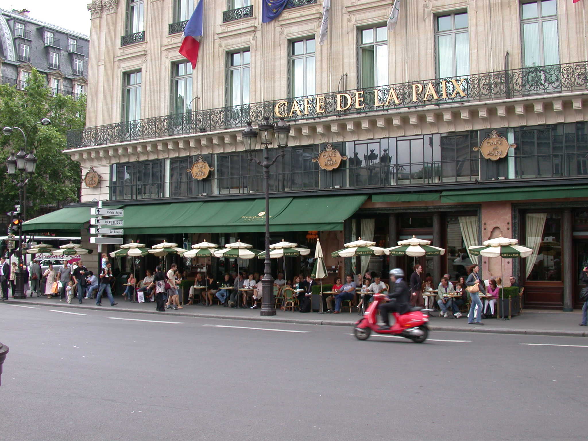
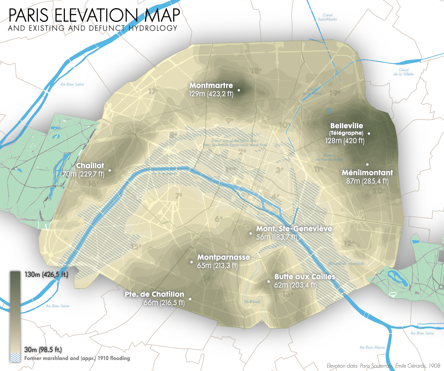
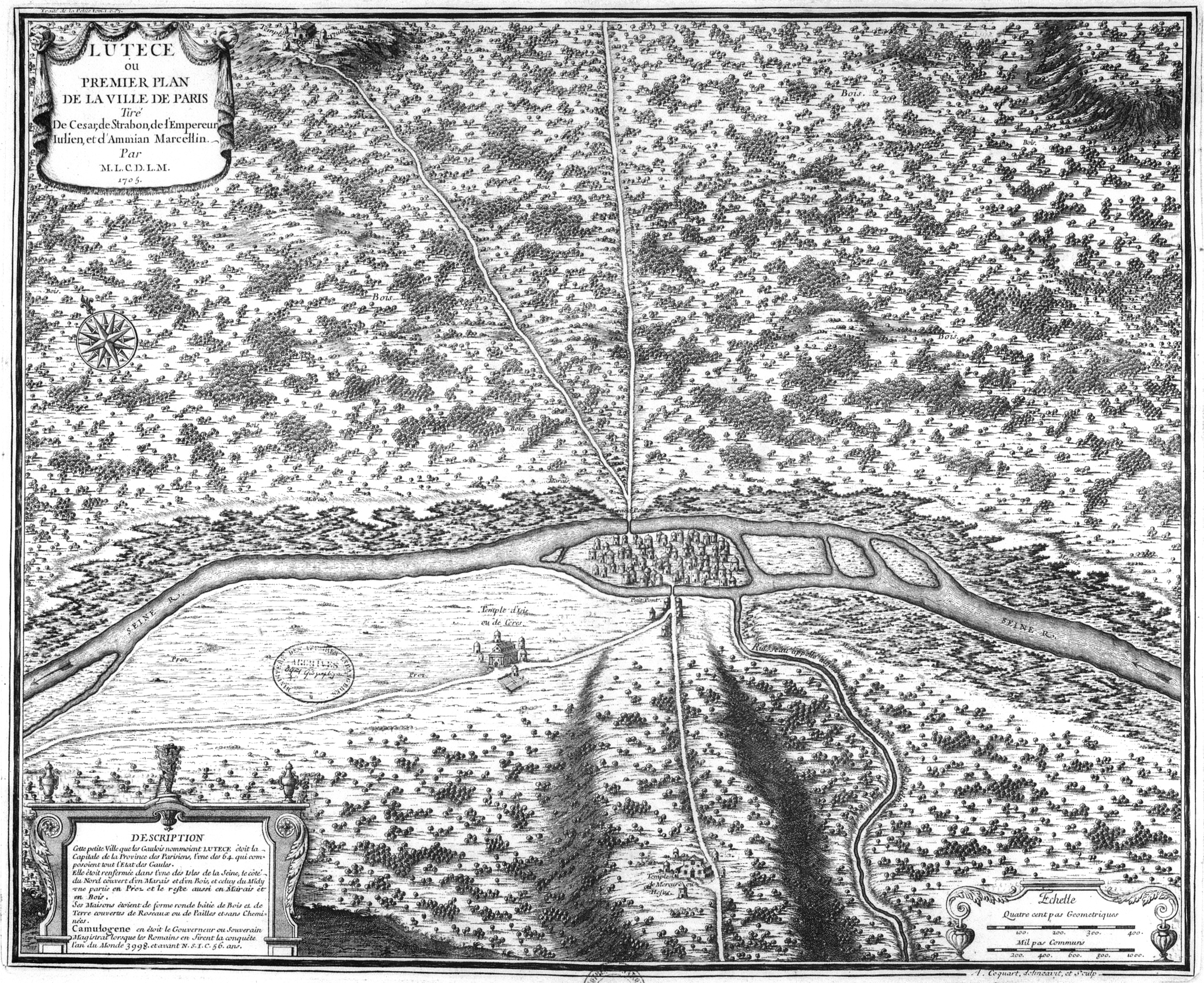
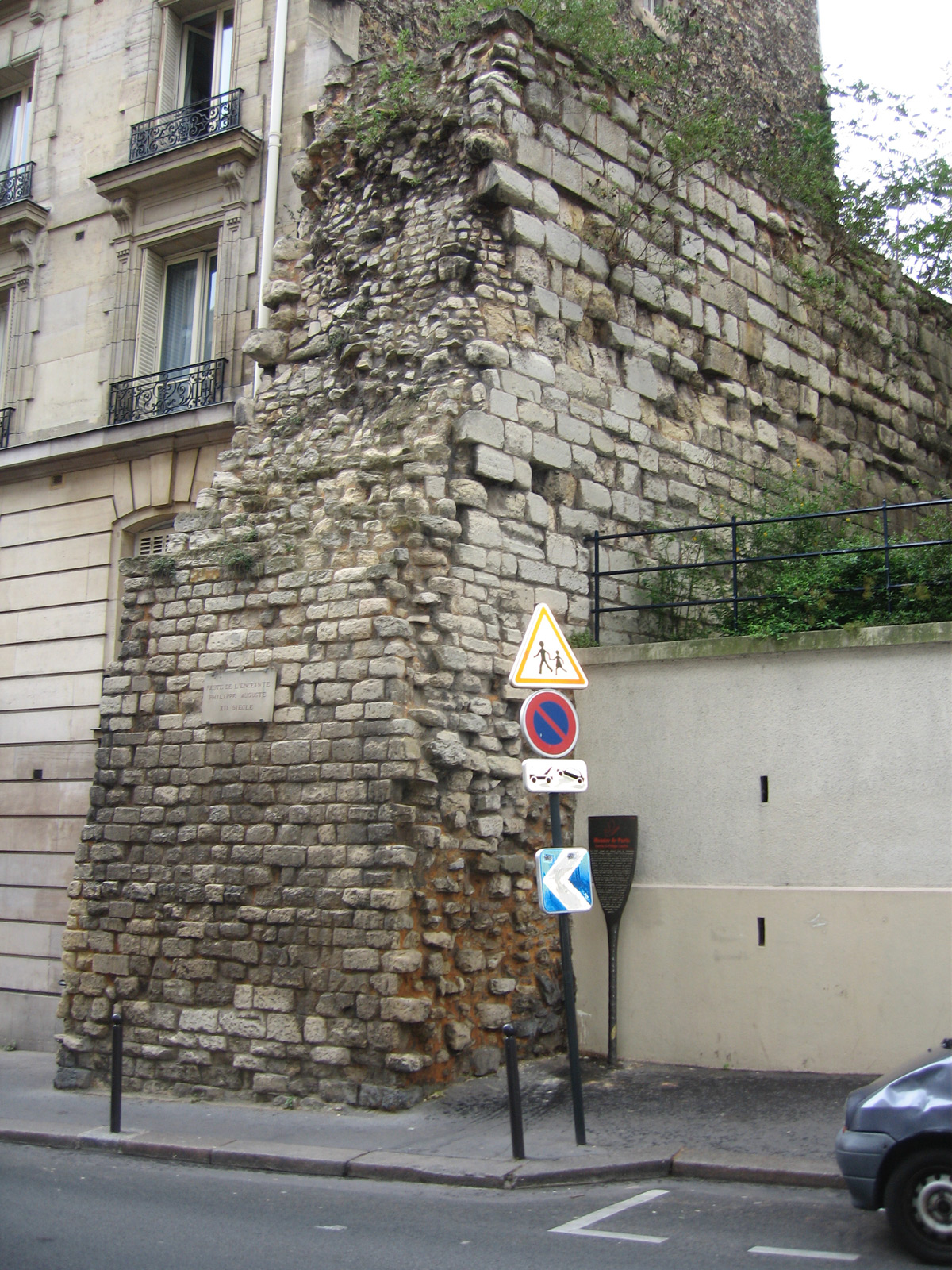
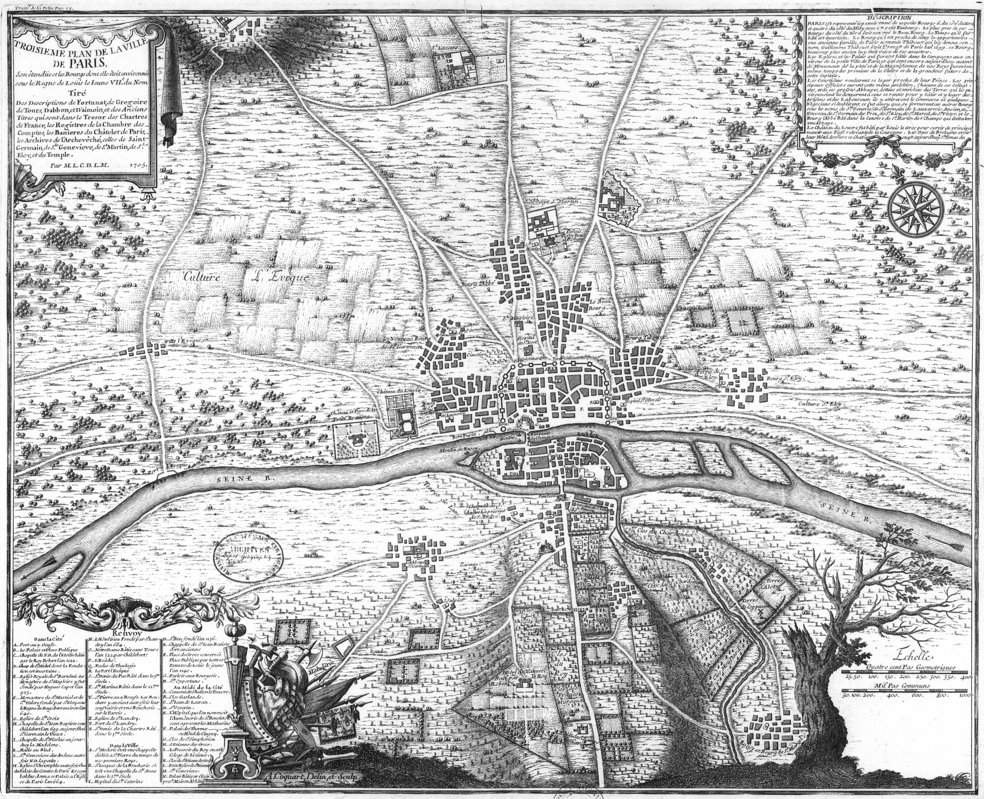
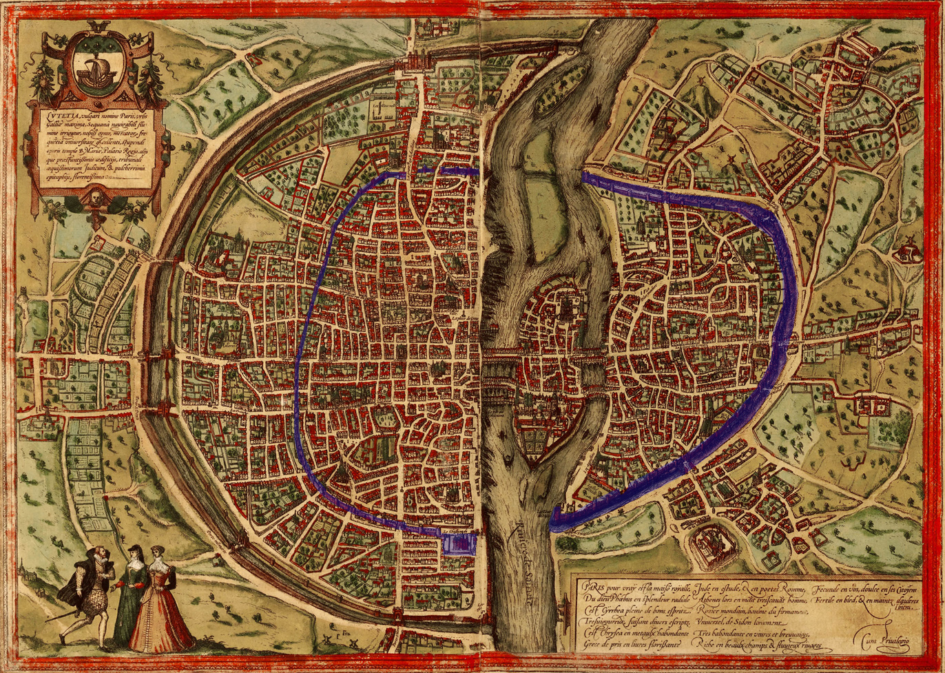
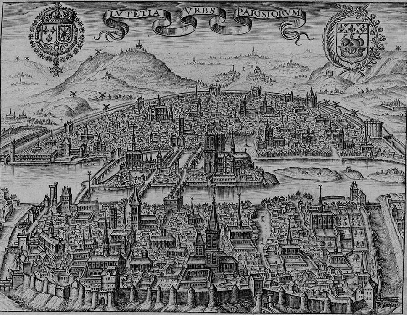
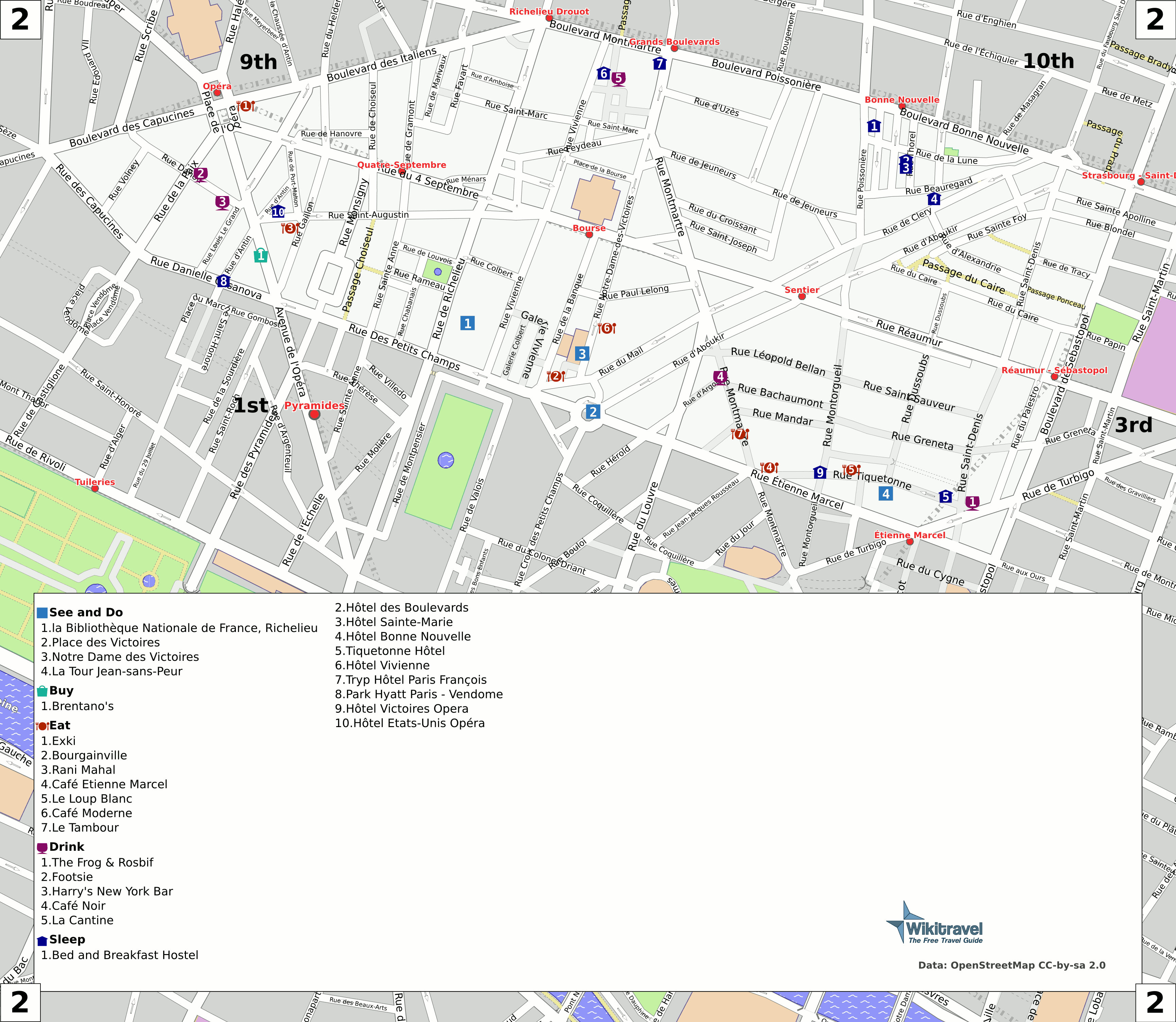
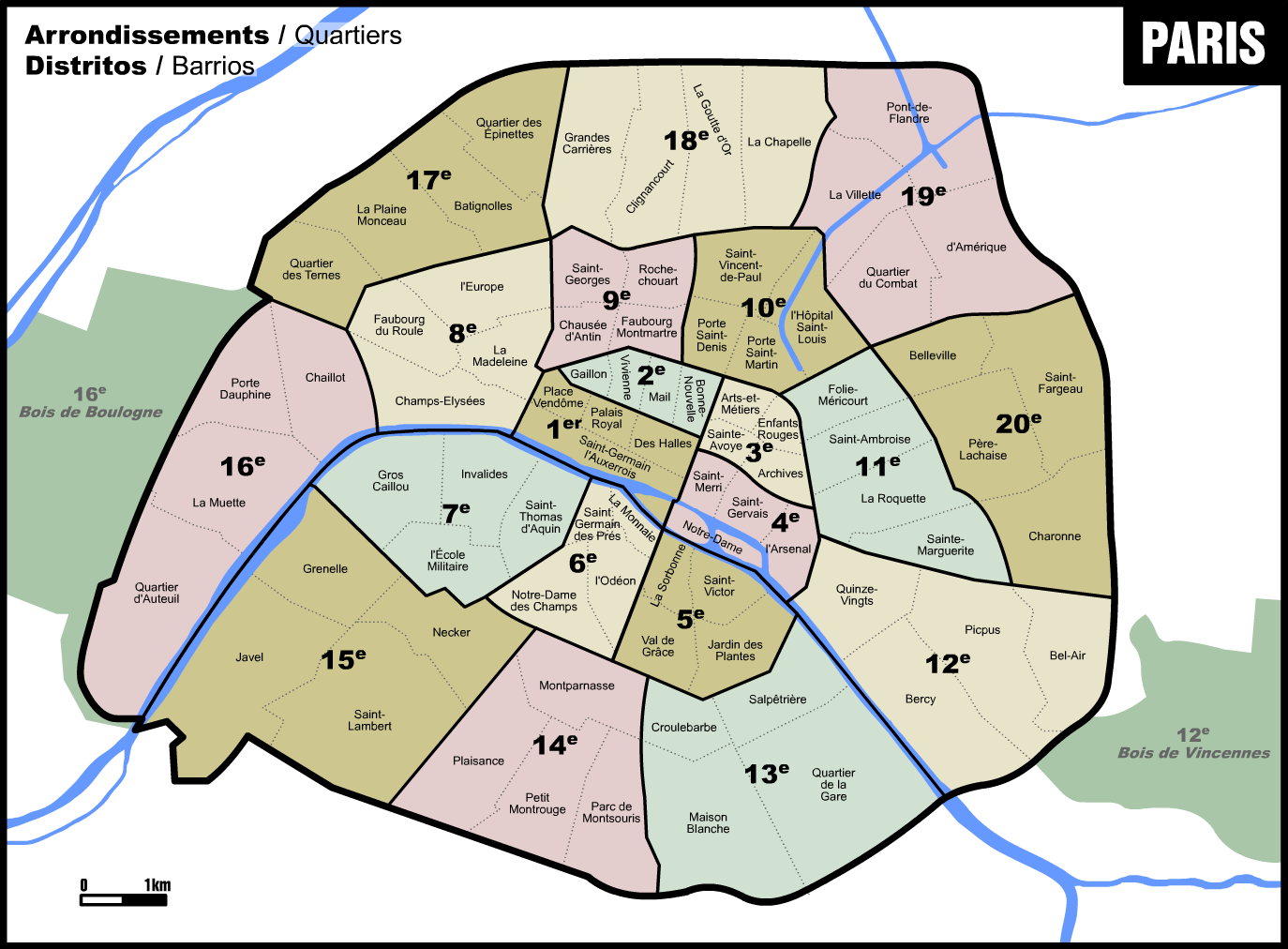