|
Reflections 2017
Series 18
December 27
Paris II: Its Historic Lines
| | Historic Lines We've followed historic circles through the ages around Paris, now we look at its historic lines, mostly straight lines, in the form of boulevards, specifically those built by Haussmann. But while earlier boulevards simply replaced walls, what Haussmann did would be equivalent to the following. Picture a birthday cake with icing and a birthday message. Now picture five fingers scraping gouges through the icing across the top of the cake. The original surface is still visible between the finger gouges, but the message now reads "Ha..y Bi..th..y". In other words, the gouges have disturbed the original message, now discernable only with some imagination, since it's now fractured into smaller pieces. In our analogy, the gouges are the new boulevards cut through the urban fabric, destroying everything in their path, both residences and public buildings. Former streets that now become cross streets are cut into sections. The broken-up birthday message is the street pattern of old, perhaps decrepit, perhaps charming, but at least intact. If you want to walk the length of a traditional street, you have to piece it together, just as in the birthday message. You have a bit of that quiet backstreet, then cross a busy boulevard, before finding yourself in the next quiet section of the original street. | | | | Paris was not the same before and after Haussmann. He's probably remembered best for his boulevards (in addition to the city expansion, parks, utilities, and more), but he also was responsible for embellishing these new thoroughfares, giving much of Paris the look it has today. That has to be considered mostly a Good Thing, though much of medieval Paris was lost in the process. Not all of it was, though, but you have to look to find the charming back streets hidden off the sides of the splendid boulevards, which we'll be doing shortly. | | | | You can't turn a city on its head unless you have great power. Haussmann's power came from Louis-Napoléon Bonaparte, the nephew of Napoléon Bonaparte, who later became Emperor Napoléon III. To see how that came about, we should review the confusing (but fascinating!) revolving-door changes in France in the 19C between monarchy, republic, and empire. There was a time in high school when I could rattle a good part of this off from memory, but alas, now I had to verify some shaky memories online, to say nothing of determining precise dates. | | | | French Governments & Napoléon III After the French Revolution (1789-1792) and the First French Republic (1792-1804) came the First French Empire under Napoléon I (1804-1814/1815). | | | | | | Louis-Napoléon was born during that latter time, in 1808, but went into exile with his mother in 1815. They lived in various places in Germany and German-speaking Switzerland, and he was educated in both countries. For this reason, for the rest of his life, his French reportedly had a slight, but noticeable, German accent. At age 15, he moved with his mother to Rome, where he studied Italian and saw the sights.
He later moved to London, then Brazil, then New York, where he socialized with high society and met with Washington Irving. He returned to London and its high society, and met Disraeli and Charles Dickens. At two different times, he unsuccessfully tried to organize armies to invade France.
|
| | | | After the First Empire came two different periods of royalty.
● First was the more conservative Bourbon Restoration (1814/1815-1830) under Louis XVIII and Charles X.
● Then came the July Monarchy (1830-1848) following the July Revolution to oust Charles X, also known as the French Revolution of 1830, and as the Second French Revolution. A more liberal constitutional monarchy was established under Louis Philippe I, a member of the more liberal Orléans branch of the same Bourbon royal family until it, too, was overthrown in the Revolution of 1848.
| | | | | | We need a very necessary aside here I think. I need to understand something that always confused me, and many others, I'm sure. Just where does the climactic barricades scene of Les Misérables fit into French history? I'm sure there are those who mistakenly assume that the action in Les Miz is part of the French Revolution, but that's another century, and there's no Bastille involved in Les Miz. Perhaps it could be one of the above revolutions, in 1830, or even 1848. But no, it turns out that it's neither. They were all successful, but Les Miz portrays the unsuccessful June Rebellion.
The June Rebellion came in 1832, two years into this July Monarchy. It's also known as the Paris Uprising of 1832, which lasted two days, the 5- 6 June. It was an anti-monarchist insurrection by republicans to rid France even of the more liberal king, Louis-Philippe. It was at this point that a 30-year-old Victor Hugo was writing and heard gunfire in nearby Les Halles, the traditional market area. He followed the sounds and came upon some of the many barricades that had been set up in the streets. He flung himself against a wall, and found shelter between some columns. For a quarter hour, bullets flew both ways. The royalist government finally crushed this republican rebellion, killing 800. Three decades later, Hugo would write about this experience, including it as the pivotal barricades scene of Les Misérables. Now I finally understand just where the climax of Les Miz fits in historically.
We really have to include something from Les Miz reflecting the doomed insurrection at the barricades. This is the YouTube video (3:32) from the film, with Hugh Jackman singing Bring Him Home, with Eddie Redmayne. Starting at 3:17, note the aerial streetscape with the barricade clogging the traditional, narrow streets of Paris.
We also have the end of another clip, preset to run from 2:21 to 3:44. It's more precise, being of the climactic scene at the barricades. We can more fully understand that Victor Hugo in Les Miz was poignantly representing the June Rebellion of 1832, which he personally experienced, but which failed.
|
| | | | But the July Monarchy under Louis-Philippe, while it survived this early insurrection, finally succumbed during the Revolution of 1848, one of many that year across Europe, all essentially democratic in nature. In France this was the start of the short-lived French Second Republic (1848-1852). | | | | In 1848, Louis-Napoléon was allowed to return to France, and not only ran for Président, but won. At age 40, he was the youngest person ever elected Président of France until Emmanuel Macron was elected Président in 2017 at age 39 (he's turning 40 in December). However, Louis-Napoléon was the only Président the Second Republic ever had, since he made sure the Republic disappeared. According to the 1848 constitution, he had to step down at the end of his one term, so he sought a constitutional amendment to allow him to run again in 1852, which failed. He finally staged a coup d'état in late 1851 and had a new constitution drafted under which he was automatically reelected president, an office in which he could now serve an unlimited number of ten-year terms. He alone could now initiate laws, declare war, sign treaties, and form alliances, so he now had all the governing power in France. | | | | But he wasn't satisfied just being an authoritarian president of the Second Republic. On 2 December 1852, the 48th anniversary of the coronation of Napoléon I, he declared himself emperor and took the throne as Napoléon III. This was now the French Second Empire (1852-1870). To this day, he remains the longest-serving French head of state since the French Revolution. His downfall came with France's loss in the Franco-Prussian War. He was first exiled to Germany, then settled near London, where he died in 1873 at age 64. | | | | | | While this is as much history as we need to be able to discuss Haussmann, for the sake of completeness, we'll bring things up to date:
Third Republic (1870-1940)
Vichy France (1940-1945)
Fourth Republic (1946-1958)
Fifth Republic, established by De Gaulle (1958-today)
|
| | | | Powers Given Haussmann I've read where Napoléon III took credit for all the changes in Paris, the expansion, the boulevards, and all the other improvements. I suppose that's valid, since Haussmann was working for him. Napoléon III commissioned the work, and Haussmann did direct it, but the crucial point is, he also designed it. I suspect most people reflecting back see it was mostly Haussmann making the changes.
| | | | Napoléon III came back from his exile with ideas for Paris, particularly from London. He was very impressed with London's Hyde Park, which he later used as a model for the Bois de Boulogne, though he made it much larger. He was impressed by London's wide streets and squares, which he wanted to copy, too. He wanted an effective manager to make changes to Paris by means of taking the government position of Prefect of the Seine, which was that département that existed around Paris from 1790 to 1968, when it was broken down into four départements, and he chose the Alsatian Haussmann for that position. He had that position from 1853, a year after the Second Empire began, to 1870, the year it ended. He was given instructions to aérer, unifier, et embellir Paris, or aerate, unify, and embellish Paris. Under instructions from a dictator, and a government official himself, he wouldn't have had the worries of holdout properties that private developers have, since the government has powers of eminent domain. (I now learn that the obscure-sounding term "eminent domain" is called much more clearly "compulsory purchase" in the UK, Ireland, and NZ, "compulsory acquisition" in Australia, "Enteignung" ["de-owning"] in German countries, and "expropriation" in many countries including France, Canada, Italy, and Spain.) | | | | While the mandate to embellish is important, but cosmetic, and the mandate to unify involves the expansion, it's the mandate to aerate that was the most pressing. The narrow medieval streets in Old Paris were sometimes overcrowded hotbeds of disease (see Mimì below), and often of crime, and opening them up to the light of day via large boulevards and squares would also improve circulation. His outsized powers included the authority to take the land on either side of a new street, which is how the projects were financed. Investors got the rights to develop real estate along the route.
https://parismap360.com/carte/image/en/paris-attractions-map.jpg
| | | | We'll again be using this "colored map" of Paris, so keep it handy. Haussmann's work involved demolition of medieval neighborhoods that today might be considered charming, but then, as the saying goes, you can't make an omelet without breaking some eggs. Furthermore, he had no compunction about destroying the house where he was born, which you can approximate on the colored map east of the Arc de Triomphe, where the Rue du Faubourg-St-Honoré crosses the Boulevard Haussmann. (!) As might be understood, there was fierce opposition to his work, but he did have that autocratic mandate. Even after he no longer was Prefect in 1870, work on his projects continued, until 1927. | | | | Old Paris In the mid-19C, central Paris still looked much as it had in the Middle Ages. The narrow streets impeded traffic circulation and made the overcrowded city dark, dangerous, and unhealthy. Wagons, carts, and carriages moved with difficulty through the streets, the widest of which were about a mere five meters/yards wide, and the narrowest only three. When living in London, Louis-Napoléon had been impressed how it had been rebuilt after the Great Fire of 1666, especially to the west, and London served him as a model of modern urbanism for Paris, and he charged Haussmann to do it. | | | | We have two period photos of the narrow streets of old Paris. This is the narrow Rue des Marmousets on the Île de la Cité in the 1850s. The site is near the Hôtel-Dieu hospital, on the north side of the island, just right of center, and not far from Notre-Dame. If you click, you can see that the small side street is the Rue de Perpignan, and I see no trace of that street on current maps, either. The other picture is of the Rue du Jardinet on the Left Bank in the same time period, which was demolished by Haussmann to make room for the Boulevard Saint-Germain, which we'll visit later. | | | | Historic Lines: Haussmann's Boulevards We now come to the lines that compliment the circles we discussed earlier. Do remember that there were already some boulevards close to the city center, but they were arc-shaped, where city walls had been, primarily the Grands Boulevards of what I call the First Ring and Second Ring. Haussmann would utilize these in his grand plans, but mostly he built new, straight boulevards cutting across great swaths of land, and dictated architecture along the rights of way to achieve uniform vistas. Haussmann started immediately by building the Grande Croisée de Paris on the right (north) bank. It's a bit hard to translate. A croix is an actual cross, and a croisée is a crossing, or intersection. Call it the Grand Paris Crossing.
| | | | To get an idea of how he got started, let's use this preliminary, rough map showing in red
some early boulevards (Map by Mark Jaroski) that he built in the 1850s. We'll have a more comprehensive map later. For those who want to keep this map in another window for reference, here is the direct link:
https://upload.wikimedia.org/wikipedia/commons/1/1d/Paris-haussmann-centre.png
| | | | Click on the red intersection just north of Île de la Cité, and you'll be in the center of the grande croisée de Paris/ Grand Paris Crossing. You'll recall in the last posting that we talked about Le Marais, and the Rue Saint-Antoine that led to the Porte Saint-Antoine and later to the Bastille. Find that at the far right. Although that historic street was pre-existing, he did widen it, saving some historic buildings but demolishing others, along with some historic medieval side streets. He then extended the rue Saint-Antoine to the west, as shown. What today is the western part of the Rue de Rivoli was built by Napoléon Bonaparte to celebrate the Battle of Rivoli that he'd won. Haussmann cut through what is now the central and eastern parts of the Rue de Rivoli to join the Rue Saint-Antoine, thereby creating an east-west axis across Paris. This period drawing shows, as the caption says in French, night construction work on the Rue de Rivoli (click) illuminated by electric lights. | | | | To complete the croisée with a north-south axis, from the intersection he moved north, cutting through what is now the Boulevard de Sébastopol, which then, as is customary, changes its name, in this case, to the Boulevard de Strasbourg further north (see map). Doing so, he cut through some of the most crowded neighborhoods of Paris. He continued the axis southward across the Seine, cutting right through buildings and streets on the Île de la Cité. On the left bank, the route continued as the Boulevard Saint-Michel. | | | | That intersection where Haussmann's two axes crossed is the Place du Châtelet (shat.LÉ), an archaic diminutive meaning "little château"—think "château-ette" or "castle-ette". It's named after the sinister, and oxymoronically named, Grand Châtelet fortress demolished back in 1802. He widened and improved the square, adding public buildings, including two theaters, and it became Haussmann's city center. | | | | | | I have to admit I don't recall ever having been on the Place du Châtelet (Photo by Jean-Christophe Windland), even on the current trip, although I may have passed it by, not knowing what it was. That doesn't mean I haven't learned how to describe this picture (click): it's taken from the Tour (Tower) Saint-Jacques, showing the theaters on the square with the Pont au Change crossing a channel of the Seine to La Cité. Notice the uniform Haussmann architecture. On the horizon is the you-know-what. The Tour Saint-Jacques (Photo by MarkusMark), seen here from the Rue de Rivoli, is a tower in the flamboyant Gothic style, the only remnant of a 16C church demolished during the Revolution.
Saying I haven't been here is actually quite ironic, since I've been numerous times directly below, or adjacent to directly below, the Place du Châtelet on Métro and suburban RER trains. What I mean is illustrated by this sketch showing the largest underground station in the world, the underground complex known as the Châtelet-Les Halles Station (Sketch by Moi). To accustom yourself, first find the Place du Châtelet and the Pont au Change (not named) crossing the Seine; the Rue du Rivoli and Boulevard de Sébastopol; also the Tour Saint-Jacques. The station is named after the Place and the nearby former market of Les Halles.
It's so large because it's actually three stations joined together. Look at the southern end of the complex, which shows (1) the Métro station Châtelet, serving five Métro lines, the stations being marked M. Lines 7 (lilac) and 11 (brown) physically stop under the Place, which is a terminus for 11. Lines 1 (yellow), 4 (purple), and 14 (dark blue) actually stop across the Rue de Rivoli, on its north side, but the two parts of the Châtelet station are connected by a long corridor (see map).
Now look at the northern end of the complex which shows (2) the Métro station Les Halles, also marked M. It also serves line 4 (purple), meaning that line 4 has two stops within this complex. Those two Métro stations date from the early 20C, so finally, look at what in more recent decades has been built between the two, the station for the commuter rail system RER, which has logically been named for both older stations (3) Châtelet-Les Halles, since it connects the two. This station, with four platforms, is the terminus for the D line (green) coming in from the south, so the D uses the center track with a platform on each side. The A line (red) and B line (blue) together use the side platforms, which has the benefit of making same-direction connections between A and B on the same platform. On the map, the Ascenseur is the elevator/lift, and very importantly, the Tapis roulants are the rolling sidewalks in each of the two long corridors connecting the parts of this huge station.
So what's the bottom line here? Well, trivially to say that I've been UNDER this area many times, but not on the ground; but more importantly, to show that the very location Haussmann chose for his grande croisée de Paris, the hub of street and boulevard traffic, has developed underground to a major hub of rail traffic, not only for the city, but, regarding in particular the RER lines, of all Île-de-France.
|
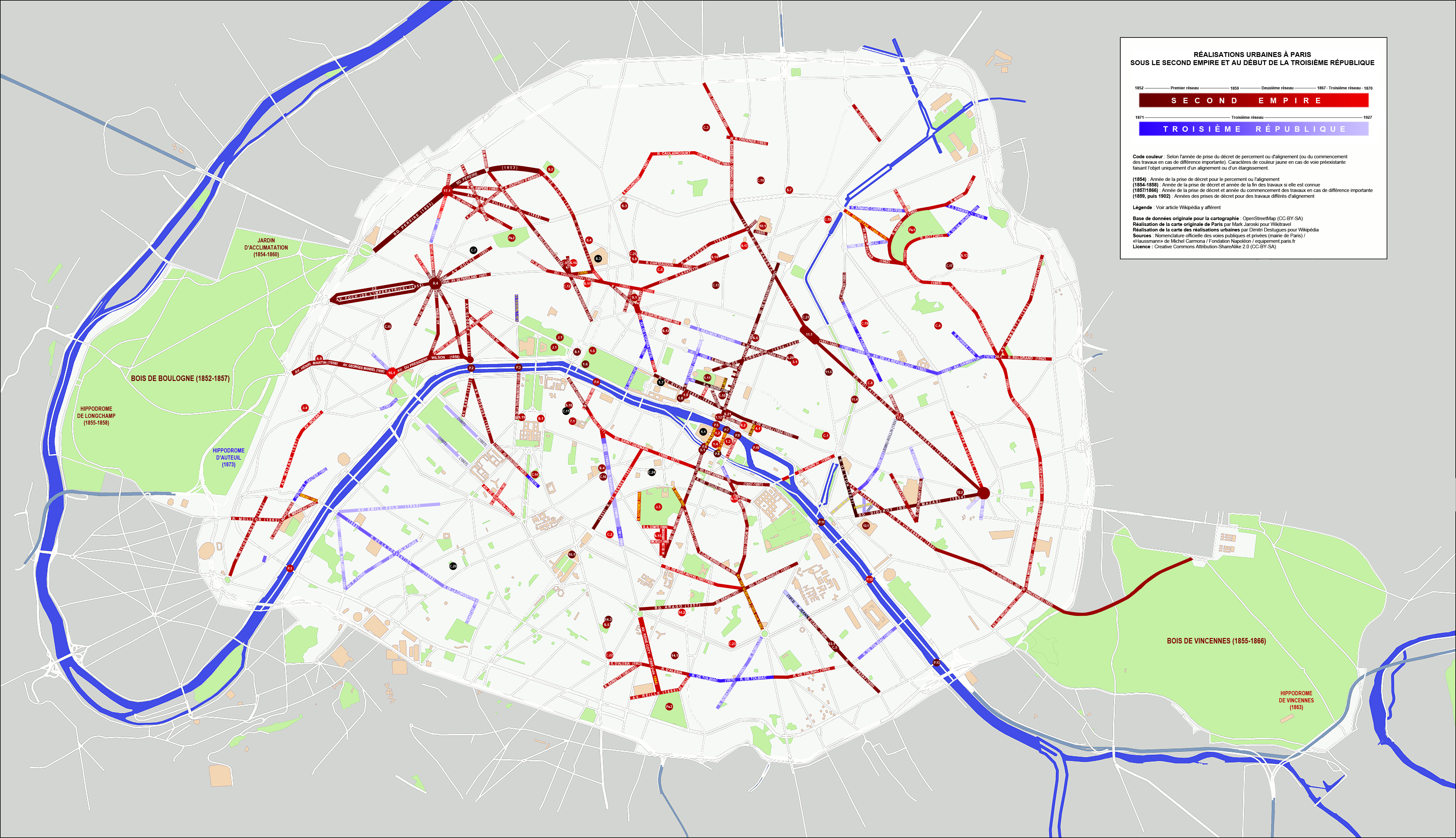
| | | | Now go back to the "red-boulevard map" and note some of the other earlier boulevards built to supplement the grande croisée in the next phase of construction. While in the first phase he built 9.467 (5.883 mi) of new boulevards, in the second phase, begun in 1859, he planned to roughly triple that, planning 26.294 km (16.338 mi) of new boulevards, avenues, and squares. His goal was to connect central Paris with the rings of grands boulevards (note on the map those roads that spread out like spokes), and also with the new railroad stations being built, connecting Paris to the outside world. We'll just give some highlights, using the current names, since many street names have been changed. We'll also abandon the simpler "red-boulevard map" in favor of this more complete "new boulevards map" (Map by Dimitri Destugues). If you want it in a separate window for easier reference, this is the link:
https://upload.wikimedia.org/wikipedia/commons/0/09/R%C3%A9alisationsUrbaines2ndEmpire.jpg
| | | | This map was based on the previous one, and is more complete. Move up to the insert on the upper right and click. You'll see that works done under the Second Empire are in brown-red, more brownish for earlier works, more reddish for later. Works done under the early Third Republic are in blue, darker blue for earlier works, lighter blue for later. Precise dates are noted on the map for each road. We also see the breakdown of the three work periods overlapping everything. The Premier réseau (First Network) of 1852-1859 falls here. You see the Second Network running from 1859 to 1867 and the Third Network from then, beyond the change of government, into 1927. | | | | White lettering indicates brand-new Haussmann work, while yellow lettering indicates pre-existing streets that Haussmann realigned or widened. (It would seem this should include the Rue Saint-Antoine in the Marais connected to the Rue de Rivoli, and I don't understand why that wasn't included here.) I feel it would be helpful to compare the rather touristy "colored map" of Paris with this one, particularly if one's sense of Parisian geography is weak--or non-existent. | | | | On the colored map, locate right of center the Place de la République (Republic Square), and to its southeast, the Place de la Nation (National Square). Haussmann built or modified both. They are referred to in everyday speech as "République" and "Nation", respectively. | | | | | | Names change. Until 1879, République was called Place du Château d'Eau (Water Castle Square), after a huge, elaborate, 1811 water fountain in its center. Today, the center is occupied by a bronze statue of Marianne (Photo by Pol), the personification of France (click).
Nation has been even more political in its naming. It started regally as the Place du Trône (Throne Square). Then it became the Place du Trône-Renversé (Toppled-Throne Square) during the Revolution, when the square had the most active guillotines existing during the Revolution. It got its present name in 1880. It also has a large bronze sculpture in the center called the Triumph of the Revolution (Photo by Siren-Com). On top is, of course, Marianne. But old names don't die out so easily. Check any map to see the large, double-wide street leaving Nation at about 4 o'clock called the Cours de Vincennes. Its first block, closest to the square, is still called Avenue du Trône!
I always like to give full disclosure. If I was ever physically located in République or Nation—I don't remember—it would have been during that visit when I had a car and drove all around the city, particularly to experience the grands boulevards, best seen by car. But I can definitely say, as I did earlier, that I've been UNDER both squares numerous times on the Métro and RER suburban trains.
|
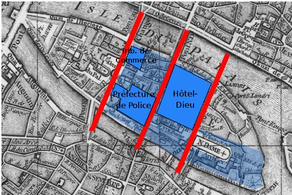
| | | | Of the streets emanating from these squares, note in particular the Boulevard Magenta connecting République to the Gare du Nord and Gare de l'Est, and Boulevard Voltaire, one of the longest streets in Paris, connecting République to Nation. Now move to the "new boulevards map" and see if you can appreciate the same connections, despite the fact that République and Nation are not named. (The map shows two names for Boulevard Voltaire, but—names change-- today the whole street is named for Voltaire.) If you move to the upper left of this map, you'll find the new Rue de Rome, which made a new connection to the Gare Saint-Lazare. | | | | Use both maps to guide you to the Place de l'Étoile (Star Square), commonly called "Étoile" (é.TWAL), with the Arc de Triomphe. Haussmann totally redesigned it with a "star" of new—or redone--avenues leading out of it making it look much more like a star, or starburst. You can use just the new boulevards map to move over to what is now the Avenue George V (Cinq), which we discussed earlier as to a hotel I stayed at, and other streets, including the one now called Avenue du Président-Wilson. They intersect in Haussmann's new Place de l'Alma, at the Pont de l'Alma. Across the bridge on the Left Bank, the new Avenue Rapp and Avenue Bosquet continued the route. Another change on the Left Bank was the cutting through of the Rue Monge (look south of La Cité on the boulevard map), the construction of which helped uncover the ruins of the Arènes de Lutèce, which we'll visit later. You'll also remember Beverly and I quite memorably stayed at a hotel on the Rue Monge. | | | | There's more to talk about regarding projects in the second and third phases, but let me close out Haussmann's personal participation now. Haussmann himself didn't have time to finish the third phase, since, as time went by and governments were about to change, he came under attack from the opponents of Napoleon III, who then had to reluctantly dismiss him in early 1870. Later that same year during the Franco-Prussian War, Napoleon III was captured and his Second Empire overthrown; he died three years later. Nevertheless, the Third Republic completed and extended some of the major goals of Haussmann, right through 1927. As we discuss the following projects, some were done under Haussmann directly, others were done or completed by his successors. | | | | But as we know, the heart of Paris has always been centered around the Île de la Cité, and we've seen the intersection built at the Place du Châtelet just north of it, whose location near Cité is not a coincidence. Use both maps to confirm. This is what the island looked like in 1771. Aside from the ancient Pont Neuf ("New Bridge", ironically the oldest in Paris to this day) we see the Pont du Change (at Châtelet) leading a road to wend its way across the island, then over the Pont Saint-Michel to the Left Bank. (For later reference, note the Quai des Orfèvres along the riverbank.) In this central area, there's another road with two bridges that does the same. We can make out the Palais / Palace on the left and Notre Dame on the right, encircled by buildings and streets. Otherwise we see a tangle of winding, medieval streets. | | | | Consider that to be the "pre-Haussmann" map of Cité, because the "post-Haussmann" map looks like this, showing how the island became a huge construction site. To generalize, we have the red lines (straight as an arrow, once again) showing where Haussmann rebuilt the Pont du Change, moved the Pont Saint-Michel, and cut through a wider road to cross them and the island. He did the same with the next crossing we just saw, and built an entirely new third one. | | | | In dark blue are new buildings. We'll mention the new Préfecture de Police, located on the Quai du Marché-Neuf (Newmarket Quay)—French quay is KÉ and English "quay" sounds like "key". And, especially because of its large size, we'll mention the expansion, as shown, of the Hôtel-Dieu, an ancient hospital founded in 651, still functioning, which started under religious auspices, hence its religious name (Dieu is "God"). It's the oldest hospital in Paris, and the oldest worldwide still operating. | | | | You can see how many old streets were replaced by this expansion. To judge what was lost, note the short street across the road from its northeast side. We know this street from 2017/17, since it's the one that has the footprint of the Gallo-Roman wall. It's the one-block long Rue de la Colombe / "Dove Street" (Photo by PHGCOM), with the view over the Seine. Click to remind yourself about the old winding streets of Paris that were lost, including with the adjacent "improvements" for the Hôtel-Dieu. | | | | Finally, in light blue are the new public spaces created, most notably the huge amount of open space around Notre-Dame. To the front was built an open square, and gardens around the other three sides.
http://footage.framepool.com/shotimg/qf/980565967-highlights1513-sainte-chapelle-pont-neuf-ile-de-la-cite.jpg
| | | | In the foreground is the Préfecture de Police; bordering it is the road connecting the Pont du Change on the left with the Pont Saint-Michel on the right; the huge size of the Hôtel-Dieu is obvious, as are the square and gardens around Notre-Dame. Beyond that is the small area of older buildings that were spared. In contrast is the Île Saint-Louis immediately upstream, which has no monumental buildings but is today a sought-after residential neighborhood and a wonder to walk through its streets, which is something I have done in the past. | | | | You may wish to inspect these current maps of the Île de la Cité and the Île Saint-Louis (Both maps by Paris 16). Click on each to inspect their differences—you can even locate Rue de la Colombe. | | | | Le Figaro is a French daily founded in 1826, and thereby the oldest surviving French daily. In March 2009, Le Figaro published a number of pictorial before-and-after pictures as we've been discussing. I found the article online, and have chosen to use several of the pictures, one of which we'll look at now. On the modern map of La Cité, locate again the Prefécture de Police on the Quai du Marché-Neuf, and then take a better look at the name of the road that we mentioned earlier, the Quai des Orfèvres on the other side of the Pont Saint-Michel. Then inspect the following:
http://i.f1g.fr/media/ext/x_crop/www.lefigaro.fr/medias/2009/03/27/20090327PHOWWW00141.jpg
| | | | The upper photo looks across the Pont Saint-Michel to the northwest and shows the row of older houses that once bordered the Quai. This sort of building, upgraded today, can still be found to some extent elsewhere on these islands and elsewhere in Paris. But the lower picture shows what's there today, an 1868 extension and remodeling of the adjacent Palais de Justice. | | | | Le Commissaire Jules Maigret As we stand here at the Quai des Orfèvres, we'll do an aside here to look into Jules Maigret, a favorite fictional character of mine who works at the Police Judiciaire. Start with this picture:
http://cdn3-europe1.new2.ladmedia.fr/var/europe1/storage/images/europe1/societe/police-le-36-quai-des-orfevres-fete-son-centenaire-580880/11787790-1-fre-FR/Police-le-36-Quai-des-Orfevres-fete-son-centenaire.jpg
| | | | We see again the Pont Saint-Michel and the extended Palais de Justice next to it. The Gothic building at the top surrounded by somewhat newer structures is the famous Sainte-Chapelle. But I call attention to the large building in the foreground directly on the Quai des Orfèvres. This is another police building, the DRPJ Paris, the Direction Régionale de Police Judiciaire de Paris. Let's cut that long name up. The first two words just mean it's the Regional Directorate, in other words, the Main Building. What we're talking about here is the Paris office of the Police Judiciaire. This needs further explanation. | | | | There are two national police forces in France, the Police Nationale and the Gendarmerie Nationale. Readers may have also come across, in films or novels, the name of the Sûreté Nationale, literally the National Security (Force), often referred to as just the Sûreté. It was founded in 1812, and served later as an inspiration for Scotland Yard, the FBI, and other departments of criminal investigation throughout the world. But in 1966, its name was changed to the Police Nationale. It's a civilian police force, notable for its detective branch, with jurisdiction in cities and large towns. | | | | The other national police force is the military Gendarmerie Nationale, dating from 1306, with jurisdiction in smaller towns and rural and border areas (ports, airports), as well as serving as the military police. Word fans will be interested to know that the word gendarmes is derived from the medieval expression gens d'armes, which is roughly "armed men". | | | | To establish a bit of a rule of thumb, it would seem to me that the Police Nationale, being urban, would be similar to US police departments and the Gendarmerie Nationale being (roughly) rural is closer to the state police in the US, with small-town jurisdiction. | | | | | | It's a wonder of the human language experience how foreign words will be taken up by a language, but often inaccurately. We have an example right here. Ask any English speaker what the French word for "police officer" is, and they'll probably say "gendarme", a word that's become fixed in English. But from the above, it's obvious that a visitor to France having an encounter with an actual gendarme, while possible, is improbable. At the airport, perhaps. In a small town, maybe. Join the French Foreign Legion, more likely. But it's highly unlikely in Paris or any other big city. The police officer directing traffic or patrolling past one's café table is an agent de police or a policier. |
| | | | Both national police forces have within them two types of police, but we'll here concentrate on just the Police Nationale, which will be illustrative enough. One type is the Police Administrative (Administrative Police), which upholds public order, oversees traffic, checks safety, and so on. These are the regular beat cops you see every day in the street, and we've seen above their headquarters, the Préfecture de Police. They do NOT investigate crimes. | | | | Then there's the Police Judiciaire (Judicial Police), abbreviated PJ. They handle penal law enforcement and investigate crimes and felonies under the authority of two Juges d'Instruction (Examining Magistrates) in every case. | | | | If I had to estimate, I'd say that police stations in the US, and perhaps elsewhere, have both groups within the same precinct, with beat cops being the administrative police and detectives being the judicial police, except that in the US, detectives have to get a search warrant from (and settle other legal matters with) an outside judge rather than conveniently having an in-house magistrate to assist them with this. | | | | So we're talking here about the PJ detectives of the National Police. Now back to that building in the last picture. Some addresses are well known, and naming them refers to the activity therein, such as 10 Downing Street and 1600 Pennsylvania Avenue. As it turns out, that's the case with the DRPJ Paris. Its address is 36, Quai des Orfèvres, and it's known to most Frenchmen as a synonym for the PJ. Just saying Quai des Orfèvres is also a police reference, and I'm told that even saying the number 36 does the same.
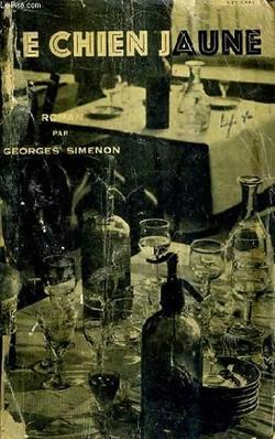
https://upload.wikimedia.org/wikipedia/en/5/50/QuaiDesOrfevres.jpg
| | | | The above is a poster for a 1947 French film. The title alone tells French speakers that it's a police procedural drama about solving a crime. By the way, I will readily admit that I only just now learned that an orfèvre is a goldsmith, so the street is the Quay of the Goldsmiths, or better, Goldsmith Quay. Keeping in mind that east of the bridge it's called Quai du Marché-Neuf (Newmarket Quay) reminds one of the long-gone medieval commercial function of this entire area. | | | | | | Another full disclosure is necessary. Just three months ago, in September 2017, the main headquarters of the DRPJ were moved elsewhere in Paris. Most of its services, which had been dispersed, are now concentrated in that new building. But crime investigation remains on the Quai des Orfèvres, for arguably the most serious of crimes, since the BRI subdivision of the PJ of the National Police remains there. That's the Brigade de Recherche et d'Intervention (Research and Intervention Brigade), a major unit of the PJ that is often called the Brigade Antigang (Anti-Gang Brigade) or simply l'Antigang. The BRI specializes in serious criminal cases such as armed robbery and kidnapping. They typically attempt to catch offenders in the act after monitoring their activities, a technique that explains the full title of the unit. |
| | | | Now, finally, more to the point. Because of its history and iconic status, the Quai des Orfèvres has often been mentioned in novels and films, such as above. It was also mentioned in the novel and film The Da Vinci Code as the entity that found out key elements in the story. But arguably the best-known and certainly the longest running fictional connection with the PJ was that involving the fictional detective Commissaire Jules Maigret in the 76 novels and 28 short stories written by the Belgian author Georges Simenon between 1931 and 1972, all translated into all major languages and a number of them filmed. Simenon was an amazingly prolific writer, able to write 60-80 pages a day. Commissaire Maigret was based—where else?--at the Quai des Orfèvres, which is the first time I'd heard of it. Simenon wrote the first Maigret story while boating in the northern Netherlands, in Delfzijl. Today, this statue of Maigret in Delfzijl (Photo by Gerardus) commemorates that fact. | | | | I'm a great fan of the detective story, known in French as the roman policier, or even just policier, including Conan Doyle, Agatha Christie, today's John Grisham, Scott Turow, James Patterson. But I also got deeply into Simenon's Maigret, and, I'm pleased to say, read one Maigret novel completely in French. It was his fifth novel, Le Chien jaune (1931), translated into English as both "The Yellow Dog" and "Maigret and the Yellow Dog". I remember in particular that I wanted to see how good a translator I could be, and remember typing five full pages in English (now lost), translating the beginning of the book. That I said "typing" shows how long ago this was, pre-computers. | | | | But I now understand much more about the PJ and the Quai des Orfèvres, and have also learned just what Maigret's rank, a Commissaire [de police], involves. Every commune (= town) has at least one commissaire in charge of a detachment of police; larger ones have more, with Paris having over 100, each having both an administrative and investigative role. That describes just what Maigret does. | | | | The other location in Paris that constantly comes up in the Maigret novels is the Boulevard Richard-Lenoir, where Maigret would stroll with Madame Maigret every evening after dinner. When we take the Canal Saint-Martin cruise later, on the Seine we'll pass the Quai des Orfèvres and on the Canal we'll pass the Boulevard, which is the closest I've ever come to visiting either. | | | | L'Opéra We first talked about the Grand Hotel when I explained in the previous posting how I stayed there with my friend and his parents on my first trip to Paris and Europe as a 17-year-old in 1957, and then again in 2005 on my seventh trip to Paris, previous to this one. We used this picture at that time, centered around the Place de l'Opéra, with the exit to the Métro station "Opéra" in the center foreground:
http://www.jll.com/Documents/Hotel-Migration/banner_new/InterContinental%20Paris%20Le%20Grand.jpg
| | | | That first time we stayed on the left, facing Boulevard des Capucines; the other time I successfully got the room upgrade I asked for facing the Place de l'Opéra as well as the Opera House. On neither of those trips did I realize that virtually everything seen in the picture was laid out or built by Haussmann. This map will make it even clearer:
https://www.gralon.net/plan-ville/cartes/planr-place-de-l--opera-paris-3988.jpg
| | | | Next to the Boulevard des Capucines you see the block that’s almost an equilateral triangle filled entirely by the Grand Hotel; however, one corner of the triangle is flattened out where the block and hotel abut the Place de l'Opéra. You now see that the picture was looking down the length of Rue Auber crossing Rue Scribe; then comes the Opéra, which has a Rue Scribe address; it's now called the Opéra Garnier, to differentiate it from the Opéra Bastille on the Place de la Bastille. We also see other "new" streets leading down back to Capucines. But everything is symmetrical—note that the block across from the Hotel has the same shape, though occupied by many buildings. At the bottom is the Rue de la Paix, which was a pre-existing street we'll discuss later, though the Grand Hotel [de la Paix] and Café de la Paix were named after it. While three Métro lines converge at the Opéra station, you can see that the suburban RER line A crosses the Place, but does not stop there. Its stop is on Auber, just beyond Scribe, but off the map. | | | | Since we've already discussed some of this area in the past, perhaps you can figure out why the entire complex of streets and buildings as shown on the map is off-kilter. In other words, the Avenue de l'Opéra (here unnamed) which comes out of the bottom of the square isn't at 6 o'clock but more at about 5. Any ideas?
https://1.bp.blogspot.com/_J4qS1sYILco/R5iZrE00A7I/AAAAAAAAE_M/lQ0Dmc9Xh-Q/s400/Google+%2B+revised.jpg
| | | | In my opinion, it goes back to the fact that, when the first walls were torn down and replaced by the Grands Boulevards—what I call the First Ring—the Boulevard des Capucines was one of them, as shown in orange on the above map we used at the time. Because Capucines was preexisting, I purposely said that almost everything on the map was due to Haussmann—just not Capucines. So he obviously used Capucines, though already at an odd angle, as a base line from which the Place and Avenue de l'Opéra were perpendicular. From the four corners of the place, four other streets exit at roughly a 45° angle. Fortunately the preexisting Rue de la Paix (1806) fit well into being one of these. | | | | The neighborhood, the quartier de l'Opéra, did not appear all at once. The Place de l'Opéra was created in Haussmann's first and second phases, while the third phase saw the building of the opera house itself and the Avenue de l'Opéra. This map nicely shows the Haussmann changes to the Quartier de l'Opéra (Map by MOSSOT). The Hôtel, Opéra, and Place are clearly marked, as is the lengthy route of the Avenue de l'Opéra, which was sliced right through down to the Louvre and Tuileries at the bottom of the map. | | | | | | Also shown is the location of the former Couvent (Convent) des Capucines, after which the boulevard is named. I find it a very pretty word. There are two different threads of meaning, but both end up having to do with a cap, cape, or hood.
First, a capucine is a nasturtium (Photo by Jamain), since the flower supposedly resembles a capuchon, or "cap, cape, hood"; to the French at least, it's also the orangey-red color typical of a common variety of nasturtium; and it's a girl's name, used virtually exclusively in the francophone area.
But more to the point here, it's a Franciscan nun that's the equivalent of a capucin, or Capuchin monk. The next time you enjoy a cappuccino, think of these monks, since the beverage is named for them in Italian, based on its brown color being reminiscent of their hooded capes. A cappuccino is an Italian diminutive, a "little Capuchin". So we come full circle. Either referring to people (or coffee), or referring to the shape of the flower, it's all based on the shape of a cap or cape, and these two English words are therefore also related to these French or Italian words.
|
| | | | But on the map, also note other new streets leading north of the Opera. Boulevard Haussmann connects the Quartier de l'Opéra and the Grands Boulevards westward to the Quartier de l'Étoile (not shown). Rue Auber connects the Quartier de l'Opéra via another short street to the Gare Saint-Lazare.
https://static.mediapart.fr/files/Micha%C3%ABl%20Hajdenberg/StyleHaussmanien.jpg
| | | | Click on this magnificent air view to hugely enlarge it. By now you should be able to recognize much in the lower half, but note the uniformity of architecture, still to be discussed. Find Auber leading up to Haussmann and eventually to the Gare Saint-Lazare complex at the top. Try to judge how similar streets to the center right also link neighborhoods eastward.
https://static.mediapart.fr/etmagine/default/files/Micha%C3%ABl%20Hajdenberg/PerceeHaussmannienne.jpg?width=1074&height=1932&width_format=pixel&height_format=pixel
| | | | This air view (click) has at the bottom the Boulevard Haussmann running eastward at 2 o'clock, but running at 12:00 is the rue de La Fayette, starting here just beyond the Opéra, then running between the Gare du Nord and Gare de l'Est (both black rectangles) to the Rotonde we discussed earlier, on the Canal St-Martin. On the left, that seems to be the Rue de Maubeuge running to the Gare du Nord. A picture like this shows the stark difference between Haussmann's boulevards and the surrounding neighborhoods. Find these areas on the boulevards map and on the colored map to compare. | | | | We now come to the Avenue de l'Opéra. Check the map again to see how it cut a swath diagonally through contemporary buildings, then inspect the demolition involved as shown in this 1876 photo. We are looking across a space filled with builders' rubble and partly demolished buildings, with the already completed opera house visible in background through a gap in the doomed buildings. This 1877 photo shows similar destruction.
http://i.f1g.fr/media/ext/x_crop/www.lefigaro.fr/medias/2009/03/27/20090327PHOWWW00145.jpg
| | | | This is another before-and-after comparison from the article in Le Figaro. It uses the first of the two above pictures to compare with today. (Note again the uniformity of architectural style.) The article points out that the wall of Charles V used to pass through what became the Place de l'Opéra up ahead—we know that, because that's why Boulevard des Capucines is there—and adds that on this side of the wall, there used to be a low rise called the Butte des Moulins (Mill Hill), and to open up the perspective shown in the lower picture, the hill had to be razed. The article drolely adds that the area around the hill used to be devoted to gambling and the sex trade, anyway. | | | | But, as we've said earlier, you can't make an omelet without breaking some eggs. This is an 1898 painting showing the view from the southern end of the avenue by Camille Pissarro. It's called Avenue de l'Opéra, soleil, matinée d'hiver (sun, winter morning). Clicking with enlarge it slightly so you can see the opera house at the far end and the uniform architecture. | | | | Finally, click on this map of the area to find how these changes look today, as well as others nearby we've discussed. | | | | The last of the projects we'll discuss more fully is on the Left Bank, the Boulevard Saint-Germain. Find it on the new boulevards map. It's a bit unusual, since it's not quite straight. As you can see it's bent, and looks like a parenthesis connecting two points on the Seine. Look at its center and you'll see, in brown, the church of Saint-Germain-des-Prés (Saint Germain in the Fields)—which we'll visit later--the only remnant of the former abbey that once spread out here. Perhaps you can remember from the last posting how the abbey stood alone on the Left Bank, outside the city walls. The boulevard was cut through right along the side of the surviving church. | | | | Once again, we have a drawing, dated 1870, of the destruction involved in the cutting through of the Boulevard Saint-Germain. But I particularly like this 1878 view of Paris, during a World's Fair. You can see we're looking east, upstream on the Seine. The Boulevard Saint-Germain had been renovated and redesigned by Haussmann, and was now completed (click). It's surely exaggerated in width, yet gives an interesting perspective on how a wide boulevard compares with the older streets around it. Halfway along, you'll see the church on the left (north) side. On the left side of the picture, you can see the Place de la Concorde, the Tuileries, and the Louvre. This is a modern view (click) of the Boulevard Saint-Germain (Photo by David McSpadden). | | | | We have three remaining views from Le Figaro, which are of interest, but which don't relate to any topic we'll otherwise be discussing:
http://i.f1g.fr/media/ext/x_crop/www.lefigaro.fr/medias/2009/03/27/20090327PHOWWW00143.jpg
| | | | 1) For the first one, look at the boulevards map at the Île Saint-Louis and note the road that crosses its upstream end, the Boulevard Henri-IV (Quatre). It starts at the column in the Place de la Bastille, and Haussmann's idea for a great perspective was to point it towards the dome of the Panthéon on the Left Bank. Compare the before and after views looking northeast toward the column.
http://i.f1g.fr/media/ext/x_crop/www.lefigaro.fr/medias/2009/03/27/20090327PHOWWW00148.jpg
| | | | 2) On the map, look south of the church on the Boulevard Saint-Germain down the Rue de Rennes. Turn east on the second cross street, the Rue du Vieux-Colombier (Old Dovecote Street), and look further to the east to the Church of Saint-Sulpice. That is what this pair of pictures shows. The street was originally quite narrow, but had its charm. But this is a street where Haussmann used a slightly different technique. Instead of tearing down buildings on both sides, he did so on only one side. As the French caption to this picture points out, the right (south) side of the street, especially from the intersection on, hasn't changed much, or at least not due to Haussmann, but the left (north) side has been haussmannisé, or haussmannized.
https://www.tuxboard.com/photos/2011/08/Paris-rue-Soufflot-1877-et-2011.jpg
| | | | 3) You'll have noted that some of these smaller streets don't show up on the new boulevards map, and for this last picture, we should turn to the colored map. Look south of La Cité and you'll find the Panthéon, mentioned in 1), which is connected to the Boulevard Saint-Michel (Boul' Mich') by a four-block street called the Rue Soufflot, named after the architect of the Panthéon. These pictures show Rue Soufflot in 1877 and today. The older picture doesn't even have the same perspective, since at the time, Soufflot was only two blocks long, terminating in a dead end, a bit before the Panthéon. | | | | Other Improvements Beyond what we've discussed, Haussmann was responsible for numerous other improvements. He added numerous parks throughout Paris. We'll just mention the largest, the Bois de Boulogne (1852–1858) to the west and the Bois de Vincennes (1860–1865) to the east. He added numerous public buildings. We've already mentioned the opera house and the theaters on the Place du Châtelet, but he also built the Gare du Nord, the Gare de l'Est, and rebuilt the Gare de Lyon. He built numerous markets, including the reconstruction of Les Halles, the central market, and completed the last wing of the Louvre. | | | | Haussmann took advantage of his street building to add extensive utilities. Under his boulevards he built an extensive tunnel system to allow for new water supply, sewers, and other utilities. The most interesting of the utilities was the gas supply for heating and lighting. He consolidated six different private gas companies into one, and consumption of gas tripled between 1855 and 1859. In 1850 there were only 9,000 gaslights in all of Paris. By 1867, the Paris Opera and four other major theaters alone had 15,000 gaslights. Almost all the new residential buildings of Paris had gaslights in the courtyards and stairways, and the monuments, public buildings, squares, boulevards and streets were illuminated at night by gaslights. In the 1860s, the boulevards and streets were illuminated by 56,000 gas lamps. | | | | Paris had had street lighting of some sort since the late 17C, when homeowners were required to put lanterns in their windows to help light the street, which is an image I enjoy visualizing. The first public gaslights appeared way back in 1816, and this system is what was extended by Haussmann. All during that time Paris had already developed a nickname because of its extensive street lighting, but after Haussmann, it particularly deserved to be called La Ville Lumière, the City of Light. | | | | | | Two points about that. It's believed that Londoners first referred to Paris as the City of Light, and that phrase was only later translated into French. Also, metaphorically, Paris has always been a center for learning and for the Enlightenment. While people might visualize that that reputation was the "light" being referred to, it's believed that, in actuality, it was, in the beginning at least, the extensive street lighting. |
| | | | This is an 1878 photo of a lamppost with three gas lamps at 4, Place de l'Opéra (click to read street sign). Google Maps indicates that the street up ahead would be the Rue du Quatre Septembre leading southeast out of the square. | | | | The Mansard & the Mansarts A very popular style roof emanating from France is the mansard [roof], a unique sloped style that's spread around the world. I know what it looks like, as I'm sure most of us do, but I wanted to analyze the steps in its development, which took some online research. There are many variations in roof style, so this summary is necessarily simplified, and aimed at getting to our main topic, the mansard. | | | | A roof can be flat, otherwise hipped, which simply means sloped. A hip roof can have four slopes, facing four directions. On a rectangular house, this results in a rectangular hipped roof; on a square house, we get a square hipped roof, also known as a pyramid roof. There are also shapes that are more irregular (Both sketches by Billbeee). | | | | | | Also common are houses with two slopes, facing two opposite directions, with the alternate sides being vertical. This results in a gable roof (Sketch by Shannon), meaning the style is not defined by the slopes, but rather for the vertical, pointed gables at either end. I'll only mention the variations because we've discussed them in the past, in 2011/20, when in Massachusetts. Search (Ctrl-F) there for the Macy-Colby House, which is a typical New England "saltbox". It has a gable at either end, and the front slope exposes two stories below, but the back slope is extended considerably so that it exposes only the lower half of the ground floor. Then continue to search for the picture showing the House of Seven Gables, a fantasy style that repeats what would be two end-gables all around the house, giving extensive variety to the slopes. |
| | | | But let's limit ourselves to the basic four-sided hip roof. It can be varied further by "breaking" each of the slopes (Sketch by Pearson Scott Foresman) into an upper, less steep section, and a lower steeper section. This type of broken-slope hip roof is called a gambrel roof. | | | | Note in the illustration that any sort of hip roof, including a gambrel roof, can have dormers, almost always with windows, pierced through them to add to the interior space. The dormer itself can reflect the basic style by itself being hipped. Obviously, it can only slope on three sides, as shown, or on two sides, with the window side can being vertical, making the dormer a gable. | | | | | | For the sake of completion, we can add that a two-sided hip roof (with gables at the other ends) can also be a gambrel roof, as with this barn (Photo by Lars Lentz). |
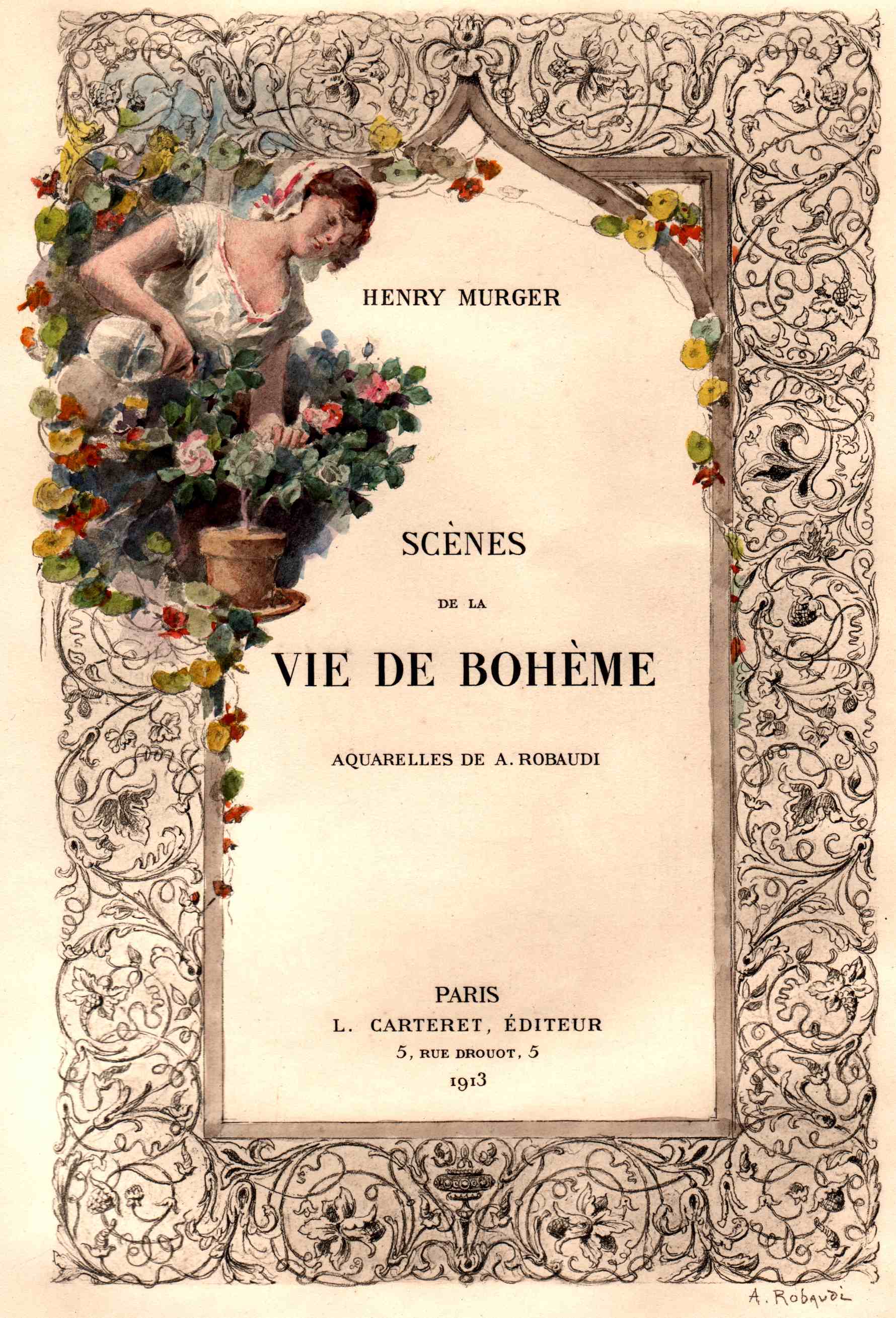
| | | | We now have a four-sided gambrel [broken] hip [sloped] roof (to remove the architectural jargon, it's a "four-sided broken-sloped roof"), and dormers with windows have been added in the lower, steeper slope. Why I do believe we've just built ourselves a mansard! We just need to add the early 17C style of François Mansart (with a T) to get our mansard (with a D). (Either way, it's pronounced in French mã.SAR, the first vowel being a nasalized A). He did not invent the mansard roof, which dates from the 16C, but he did popularize it, and so his is the name that's associated with it. | | | | Important as he was in the early 17C, very little of his work remains, most having been remodeled or demolished. His legacy was assumed and carried on by his grandnephew, Jules Hardouin-Mansart, in the later 17C. He hyphenated his granduncle's famous name onto his own after studying with him, and later reused some of his granduncle's plans. Though Mansart was the precursor, much of the traditional mansard buildings we see today is the legacy of the equally famous Hardouin-Mansart. He was the one that was Louis XIV's chief architect, doing work, for example, at Versailles. | | | | Hardouin-Mansart notably used a mansard roof in building, between 1675 and 1683, the Château de Dampierre (Photo by Patrick Giraud) in Dampierre-en-Yvelines southwest of both Paris and Versailles. This garden view from the rear shows just one single façade of the four-sided mansard roof. Click to inspect details. On the other hand, this next view shows the more irregular multiple-façade front (Photo by Lionel Allorge) and how harmoniously it blends in with the ensemble of outbuildings (click). | | | | Hardouin-Mansart spectacularly used the mansard roof as part of his architectural design for the Place Vendôme in Paris, which we'll visit, discuss, and illustrate later. But for now, we'll introduce Place Vendôme (click) via this wide-angle view (Photo by Giorgio Galeotti). Don't be misled—it really is square-shaped, but wildly distorted in this view. The Rue de la Paix, entering it from the north (on the right) is directly opposite the other entrance on the left. | | | | Aside from the attractiveness of the style, there might be another reason why the mansard roof became popular. I've read that buildings once had to pay taxes based on their height, but the height was measured to the base of the roof. With a mansard, at least one floor, if not 2-3, could be added to the building tax-free. This view from Notre Dame to the Left Bank shows not only many mansards (click), but also varying numbers of levels on some of them (Photo by Cristian Bortes). | | | | The mansard style enjoyed a huge revival under Haussmann, when it was known as the Second Empire style (more later). Under that name, it spread around the world, very much so in North America to rail stations, hotels, civic buildings, and private homes. For example, this is a building on Union Square in NYC (Photo by Ad Meskens). The style did not escape the attention of artists. This is an 1878 painting by Gustave Caillebotte called Vue de toits (effet de neige), or View of Roofs (effect of snow). | | | | Architecture We've been hinting for some time to look at Haussmann's architecture, and now's the time to discuss it. But we first need to see what came before his changes in order to see the differences. | | | | Pre-Haussmann: In 18C Paris, buildings were usually narrow--a common width was 6 m, almost 20 ft--but quite deep--possibly up to 40 m, about 131 ft. But they could be quite tall, up to 5-6 stories. The ground floor usually had a shop, with the shopkeeper's family living above it. Other families lived in the walkups above. The top floor, really an attic, was originally for storage, but as the population grew, it was usually converted into a cheap residence, the classic Parisian garret. Before Haussmann's stone construction appeared, most buildings in Paris were made of brick or wood and covered with stucco. | | | | Since we're talking about Parisian garrets, it seems appropriate to use as an illustration an image many of us already have in our minds, that of the poor artists living in a garret in Puccini's La Bohème. The story takes place in 1830-1831, well before Haussmann's time (from 1853 on), so its styles can be considered indicative of the period. The location of the story is, of course, the artsy Quartier Latin on the Left Bank, so we can fantasize if construction of the Boulevard Saint-Germain, Rue Monge, Boulevard Saint-Michel, or other Haussmann upgrades, plowed down the type of location we'll now be discussing. | | | | Various set designers visualize the scene somewhat differently, but this is one set design of a top-floor garret for Act I (Set Design by Reginald Gray). That it's a walk-up is indicated by the high view out the window, and further indicated by the staircase on the left. As for the outside, this street scene (Drawing by Henri Meunier, Set Design by Albert Dubosq) might indicate what the exterior and neighborhood might look like. It's a drawing of a set design for Act II showing a typical street that might have been seen around the Café Momus. Note the narrowness of both streets and buildings, and their heights. | | | | | | La Bohème (bo.EM) is the French name for Bohemia, the province surrounding Prague. Based on a mistaken association with the Roma (Gypsies), the word began to refer to a community of unconventional people, particularly artists. This use is attested in French by 1834 and was popularized by Henri Murger's stories from the late 1840s serialized in a magazine (shades of Sherlock Holmes! Same genesis!). The stories were later collected in a novel called Scènes de la vie de bohème (Scenes of Bohemian Life )—this shows a later edition. These stories were based on Murger's own experiences as a desperately poor writer living in a Parisian attic, and were the basis of Puccini's opera (in Italian, but with a title in French) "La Bohème".
For additional full disclosure we should add that Murger then collaborated with a dramatist to write a theatrical version, with the shortened title La vie de bohème. It was only in the play that the dramatic interest was concentrated in Mimì's tuberculosis and her death in the tragic final scene. It was really the popularity of the play that expanded Murger's concept of the arty, bohemian life, and that attracted adaptions, such as Puccini's.
Digging in French Wikipedia—a lot of this information is not available in English—I find that the Café Momus, immortalized by Murger and fancifully illustrated above in the Quartier Latin, actually existed in the early 19C, but on the Right Bank! Murger was a frequent visitor and based his stories there and nearby. It's unclear if the play moved the location to the Left Bank, or if Puccini did—I'd guess the latter. This is a watercolor of the actual Café Momus done by Henri Lévis in 1849. Facing a church on the left, it's two lower floors of the building on the right—click to read the name. We're showing this not only out of general interest, but to illustrate the charming, winding, narrow streets also located here, east of the Louvre, but before the nearby Pont Neuf at the west end of La Cité (see colored map).
|
| | | | This is a YouTube video of the final scene of La Bohème. It's the best one I've found, but runs for 11:22. You might like to watch the whole clip and allow yourself to really get into it (it's good, so have a tissue handy—after all, this is Puccini), but at least do watch it starting with the cough at 5:40. Keep an eye out over on the right for the dramatic "arm-drop" at 8:39, Puccini's well-known indication for the audience, and watch the drama right after the line at 9:08 "Marcello, è spirata!". | | | | But the purpose of this exercise is to recognize Paris in (the revolutionary year of) 1830 and 1831, before the changes by Haussmann. They are living in a top-floor garret, where it's cold and Mimì appreciates her muff to keep her hands warm. Disease is prevalent, and Mimì finally succumbs to tuberculosis. At the very end do appreciate the tableau vivant within the scenic design of a Parisian garret of the era. | | | | Post-Haussmann: Once Haussmann took over and made the sweeping changes we've been discussing, the look of Paris changed. While the old look can still be found, thank goodness, the new look seems to characterize the city. The new streets became much wider, doubling in width from an average of 12 m to 24 m (39 ft to 79 ft), and in the new arrondissements in the expansion, often to 18 m (59 ft) wide. | | | | But despite the destruction involved, the genius of what Haussmann did involved what I consider to be a clever overkill. Cutting a road diagonally through existing buildings would logically include the width of the roadway, plus sidewalks on either side, up to what would be the new building lines. But instead, Haussmann usually cut deeper on either side—with more destruction—to reach what would become the REAR building lines on either side. There were two huge advantages to this overkill. | | | | First, as mentioned earlier, he largely financed his projects by getting funds from his investors. The payback to the investors were the real estate rights to build new apartment buildings all along the length of his new roadways. The second advantage was that Haussmann was able to dictate what the façades of these buildings would look like. While building owners could do what they wished with the interiors of these apartment houses, Haussmann strictly regulated what the exteriors would look like, and this regulation became arguably the most famous and recognizable feature of Haussmann's renovation of Paris. Street blocks were designed, not as individual buildings, but as homogeneous architectural wholes, in a sense, as though they were all one long building. Façades were strictly regulated, and, to appear harmonious, they had to be the same height, color, material, and general design. | | | | This unified the urban landscape and raised the importance of having an attractive streetscape. While this uniformity might be derided in tract housing as a "cookie-cutter" effect, the actual effect in Paris is, arguably, quite pleasing to the eye, as we've indicated in earlier pictures by urging to note the architectural style. | | | | | | Included in this uniformity was the de rigueur mansard roof, a revival in the later 19C of what the Mansarts had done earlier. The architectural style resulting from this strict regulation is known as the Second Empire Style, which reflects Renaissance and, particularly, Baroque antecedents, usually under mansard roofs. It's the heritage of the period of Louis-Napoléon, and was popular into the early 20C, particularly in Paris and Vienna, but also in Rome and London. In French it's called le Style Second Empire, but also le Style Napoléon III. In the UK and the US/Canada (and very possibly Oz/NZ) it's one of the many styles included under the heading of Victorian architecture, used both for public buildings and private residences.
To wit: the Second Empire Philadelphia City Hall (Photo by Versatile Aure) and the Montréal City Hall (Photo by Jean Gagnon)—there's another picture in 2017/4. As for private residences, this is a Second Empire home known as the Heck-Andrews House in Raleigh NC (Photo by Mark Turner).
https://eve512408.files.wordpress.com/2014/05/house-by-the-railroad-edward-hopper-1925.jpg
Recently, I sent railfan friend Dave a copy of a 1925 Edward Hopper painting I like, The House by the Railroad (above), totally Second Empire. I understand it's a fanciful portrait of a Second Empire Victorian house by the tracks at 18 Conger Avenue in Haverstraw NY. Google Maps Street View shows this house is now gone. However, it supposedly inspired the look of the Bates house in Hitchcock's 1960 film Psycho:
https://upload.wikimedia.org/wikipedia/commons/2/2d/Psycho_House-Universal_Studios-Hollywood-California4481.JPG
Frankly, I don't see the similarity, though they're obviously both in the same style.
http://1cqgxm3l59yi2wwbnn3qy35h.wpengine.netdna-cdn.com/wp-content/uploads/2015/07/Meet-Me-in-St.-Louis-movie-house-in-Spring.jpg
http://hookedonhouses.net/wp-content/uploads/2010/11/Classic-Cheaper-by-the-Dozen-house-ext.jpg
In contrast to Psycho, Second Empire houses have often been treated positively in the arts. The first picture above shows the family house (a stage set) built on the MGM back lot for the 1944 Judy Garland film Meet Me in Saint Louis. The second picture shows how MGM recycled the same set for the 1950 film Cheaper by the Dozen. Flip between the two to experience "movie magic".
But as much as Second Empire residences were admired, that the style was used in Psycho is indicative of an unusual and surprising trend. Into the 20C, the style was viewed as out-of-date and excessive, which allowed the domestic version of the style, especially older, dark, elaborate, decaying houses, to be viewed as weird and creepy, the embodiment of a haunted house.
http://resources3.news.com.au/images/2014/08/20/1227030/323747-fd60643e-27f6-11e4-b931-680703526eb9.jpg
http://1.bp.blogspot.com/_x03M3xlM3b8/TLMYYXstF0I/AAAAAAAAAOU/A0raAyCYtTE/s1600/Munsters-10.jpg
When cartoonist Charles Addams created his macabre Addams Family, he designed a typical Second Empire mansion as their home, as shown in the first link above to the television series. The same was true for the equally spooky family, the Munsters. In Frank Capra's 1946 It's a Wonderful Life, when he wanted to show an aging, decaying house that the couple would be moving into, he used one in the Second Empire style. For much of the early and mid-20C, Second Empire design would be associated with sinister and haunted houses, but starting in the latter part of the 20C, with the rise of the preservation movement, the style has been rethought, and appreciated.
|
| | | | After that lengthy aside, let's get back to just what it was that Haussmann required. I found a perfect example of haussmannian architecture in this picture of the building at 25, Rue Monge (Photo by Thierry Bézecourt), just steps north of the Arènes de Lutèce, that we'll visit later. If you want to get a feeling of "being there" find that address in Google Maps, and go to Street View. You'll find the side street as Rue d'Arras, and can see that the bookseller on the ground floor is now a branch of the Crédit Mutuel, a major French bank. | | | | But to the point: compare the following to the picture:
1) The ground floor (also the basement) has thick, load-bearing walls, and is usually commercial, a shop or an office.
2) Above that is a mezzanine, or entresol. It has a low ceiling (you can tell in the picture), and is usually used by the shop or office.
3) The second floor will usually have a balcony all around. It was the most desirable floor, and had the largest and best apartments, one reason being that the buildings were walkups (elevators came later) and this floor was the most accessible.
4) The third and fourth floors were similar, but often lacked balconies and had less elaborate stonework around the windows.
5) The same for the fifth floor, except it, once again, had a wrap-around balcony.
6) On top was—what else—the 45° mansard roof, that had garret rooms and dormer windows. The mansard level was originally meant to be occupied by lower-income tenants, but over time, it became occupied by servants, concierges, and other staff for the apartments below.
| | | | There might be slight variations, but the general pattern had to be followed. To remind you of earlier pictures we've seen with rows of these apartment buildings, let's look at this view of the Boulevard Haussmann (Photo by Thierry Bézecourt)—how appropriate!—just north of the Opéra, to see the lengthy uniform streetscape stretching into the distance. In addition, if you recall the picture of the Grand Hotel, it fit this pattern perfectly on all of its sides, including its mansard roof, resembling rows of apartment houses, even though it's a single building. | | | | You can tell, looking down a street, that the Haussmann façade was based on horizontal lines from building to building. There were no projections or alcoves to interrupt continuous balconies and cornices. He required that buildings be either built or faced with cut stone, usually the local cream-colored limestone, creating another level of uniformity. Furthermore, instead of simple stone facing, new technology in stone sawing and heavy-duty steam transportation allowed for the use of massive stone blocks. He also required, under the threat of a fine, that all façades be regularly maintained, repainted, or cleaned at least every ten years. | | | | But change comes to everything. Regulations that came out later, in 1882 and 1884, and even moreso in 1902, broke the uniformity of the classic haussmannian street by permitting lush roof designs, projections, and extensive statuary and embellishment, as exemplified by this building (Photo by Selbymay). Click to get in close to the details—you'll love it. | | | | Legacy & Influence It's been estimated that Haussmann modified almost 60% of Paris. In 1851, there were about 30,770 houses in "old Paris" (before the extension), of which 4,349 were demolished. But when you include the 1860 extension to the present city limits, between 1852 and 1868, including the above figure, some 18,000 houses were torn down to conform to Haussmann's changes.
| | | | You may have noticed that his name developed to an adjective haussmannien ("haussmannian") to refer to urban development achieved by destruction of old houses and neighborhoods, including the construction of large, sweeping boulevards. | | | | I have read that the following French cities were the ones most influenced by haussmannian changes: Rouen, Dijon, Angers, Lille, Toulouse, Avignon, Montpellier, Toulon, Lyon, Nîmes, and Marseille. Algiers, being a French colony at the time, was apparently also largely rebuilt in those years. Outside of France, I understand that a number of cities, trying to imitate Paris, saw similar changes: Brussels, Rome, Barcelona, Madrid, and Stockholm, and to some extent, Istanbul and Cairo. I have been to many of these French and other cities, but have no firsthand experience or knowledge of such changes. | | | | In the next posting, we'll discuss "Other Teardown Cities" where changes were either planned, or took place, some times tragically, as in Bucharest, sometimes not too badly, as in Berlin, and sometimes sloppily, as in New York. | | | |
| |
|
|
|

