|
Reflections 2019
Series 18
December 9
A Failed Trip to Cuba-Its FL Replacement–An Uncommon Snapshot of FL-Plant & Tampa
| | Failed Trips In my travel experience, planned, yet failed trips do happen on occasion. One that comes to mind was my planning to drive the full length of the Alaska Highway some years ago. I had done all the research and had collected a lot of notes and materials. I would have taken VIA Rail Canada to Edmonton, Alberta, during the summer, rented a car, and driven thru the wilderness to Alaska on the Alaska Highway, in red (Map by Luigi Zanasi). What an adventure it would have been! After reconstructions since it was built during WWII, it's presently 2,232 km (1,387 mi) long, plus the distance reaching it from Edmonton and continuing on to Fairbanks. I had a list of motels along the way, and was informed that, since most of it was still gravel, one should have protection along the front of one's car to protect from damage from flying gravel. Now I read that it's less of a rough, challenging drive, since it's now paved over its entire length. Tho the phrase is "no pain, no gain", I decided it was too much pain for too little gain, and dropped the project.
I've been to Alaska twice, and the second time (2005/12-13) I drove from Skagway over the Canadian border onto the South Klondike Highway to Whitehorse, in the Yukon (see map). In 2005/13, I wrote: The highway . . . passes by one beautiful lake after another, most at the foot of huge mountains. . . . [T]he South Klondike Highway ends at the Alaska Highway . . . , so I finally got to drive on the Alaska Highway, although only about ten miles each way from here into Whitehorse and back. Driving the South Klondike Highway was a gorgeous, sunny-day experience with impressive natural sights, so perhaps that should suffice me for driving in this area.
| | | | The Caribbean and I I very clearly remember Beverly admonishing the two of us that, with all the travel we'd done, we should never become jaded about where we've been. That's good advice. I know many will disagree strongly with this next comment, but I've been frequently to the Caribbean, often on a ship, occasionally flying, and I'm so jaded with going there that my face must have turned jade-green by now. | | | | There's nothing wrong with repeat visits. As a matter of fact, they can be more enjoyable than an original visit, such as with recent revisits to Provincetown and Kingston. But the Caribbean (click) appeals more to vacationers rather than to academic travelers. To paraphrase Gertrude Stein, a beach is a beach is a beach, and that includes the frequent trips I took to the north coast of the Dominican Republic for condo meetings on my investment in Eden Bay Resort there. I also don't like the heat, and there can be so much poverty in that area. I can say this much that's positive. I love Curaçao, have recently mentioned it again, and could even go back sometime. I enjoyed a couple of hours' stop on a cruise at St Barts. Guadaloupe and Martinique were nice, so was Barbados. But other than the odd nice mountain view or beach here and there, I really only find the old cities of Santo Domingo and of San Juan to be worth exploring, and there are few other places like that. | | | | Cuba & Beyond Given those feelings, would you expect I'd have planned another Caribbean cruise for the second week of November this year? But this one fizzled out on its own, to my great pleasure, actually. It all started in the last couple of years when I saw ads to go to Cuba, now that the US government was allowing American citizens to do so. I've been so many times to the Dominican Republic, and remain convinced that the two can't be all that different. The only thing would have been to have seen historic Havana, and to have witnessed the lack of development in Cuba over the last half-century, with its famous 1950s cars still on the streets. Cuba was for me an unenthusiastic remnant on my bucket list. | | | | I saw ads for land tours, in which I had no interest at all. There was a ship that sailed from Florida and circumnavigated Cuba with quite a number of stops, but that was far more involvement with Cuba than I wanted. Finally, I came across information about the Veendam of the Holland-America Line (HAL) having a cruise out of Fort Lauderdale, just north of Miami, and then would reach Cuba, where it would make just two stops, one day in Havana and one in Cienfuegos, after circling the western end of the island. Knowing there would be a lot of red tape, it seemed to satisfy the short visit I was (warily) looking for. | | | | | | Still, I'd heard from my cousin Gary who'd taken a land tour of Cuba that the infrastructure was so shoddy in the hotels, that clients were asked to place used toilet paper in special containers, since it might otherwise damage the system. What kind of place was this? |
| | | | However, it made a lot more stops after that. The rest didn't really interest me very much, but I warily went along with the schedule. This is a summary of stops (grouped--not in the order in which they were scheduled):
(1) San Juan PR and Saint Thomas VI are OK, but I've been there and saw no real reason to return.
(2) New stops for me would have been, other than Cuba, Jamaica, the Caymans, and the Turks & Caicos, but the stops there were at resort-type places I wasn't interested in.
| | | | | | Jamaica has always interested me, but when people visit Jamaica, they visit resorts on the north coast in Montego Bay or Ocho Rios. I've never heard of anyone who's gone to Jamaica to visit Kingston, its capital, on the south coast. Nothing to see? Dangerous? I don't know, but it's hard to picture many countries where you'd avoid the main city to be sequestered within resort compounds. Could you imagine doing that in New Zealand? Japan? Austria? |
| | | | (3) While I've been to Nassau & Freeport in the Bahamas, which were pleasant enough, the scheduled stop at Half Moon Cay (say "Key") in the Bahamas I saw as an abomination. It's one of those fake (more polite: faux) destinations cruise companies have established in the Caribbean, on islands owned completely by them, so they can get all the profit for themselves. It might fine with vacationers I suppose, and a bane to a traveler like me. It isn't really a "place". Google Maps shows me it's a flyspeck island called Little San Salvador Island among the 700 islands that make up the Bahamas. It's now a private island that Holland America Line bought and made into a resort, marketing it using the alternate pseudo-name of Half Moon Cay, possibly because it sounds more exotic and less workaday. They've made it into a resort along a curved beach (Half Moon?) on the west side. There's no harbor, so a tender is needed for passengers to reach shore. It's nothing but a beach stop located in the middle of nowhere. I'm categorically opposed to such places, as being a fake, non-destination. Still, I was grudgingly willing to go along with it. | | | | With trepidation, I paid a deposit on this cruise. I only needed to plan two other things, all without charge. I booked round trip roomettes on Amtrak points, on the Silver Star one way to Fort Lauderdale and on the Silver Meteor the other, since their schedules fit best. I needed one night stayover in Fort Lauderdale. Starwood has been taken over by Marriott, who issues an annual free-night certificate, so I booked a Marriott hotel in Fort Lauderdale with the certificate, which didn't even use up points. I was prepared to call it my "Cuba & Beyond" trip, a name that indicated my levels of interest, and everything was set. | | | | Restrictions HAL then explained that the US government had a list of some dozen allowable reasons for US citizens to visit Cuba, and none of them included casual sightseeing. Either you were visiting family, going for educational reasons, for religious reasons, yada, yada, yada. But one of the allowable reasons was people-to-people contact, so tours, for substantial fees, had been arranged to take advantage of that loophole. The tour in Havana was what one would expect, except that later in the afternoon we'd stop at an artisans' collective where they were making pottery. In Cienfuegos ("Hundred Fires") the extra add-on was at place promoting local rum and cigars, with samples—odd, for those of us who don't smoke. But actually, both those special stops, tho nothing I would have done on my own, might have been interesting. | | | | The above limitations were due to US regulations, but Cuba put up some roadblocks as well. HAL sent additional paperwork to allow for entry to Cuba. There was some sort of a visa-type document that they took care of at the last minute on boarding, but for a substantial fee.
And then there was the cash. While tours were to be paid for on board, in US$, it was advised that gratuities at restaurants where we'd stop for lunch were not included, nor cash for any incidental purchases. So how was that handled? Not well. Cuba would not allow visitors to use dollars, euros, or pounds. However, visitors could NOT use the regular Cuban peso (CUP) either, but had to use the special Cuban Convertible Paso (CUC). No surprise—the dollar is artificially set to be on a par with the CUC and 1 US$ would get you 1 CUC, which is actually a pseudo-US$. Both are used in Cuba by locals, with the CUC, sometimes actually called the dólar, having about 25 times the value of the CUP. But in actuality, the CUC and US$ are not really on a par, since all exchange between them is subject to a 10% Cuban tax on top of all the exchange rates. And I haven't converted currency in years and years, since on arrival, I go to an ATM and take local cash out of my bank account, which converts my even-amount withdrawal to odd-amount dollars back at home. The whole deal is just simply unpleasant and thoroughly irritating. I've gone thru over the years with this sort of monkey business, driving from Slovakia into the Soviet Union in 1972, for instance, where we were, among other things, made to declare the wedding bands on our fingers, and repeatedly at the Berlin Wall for entry into East Germany, where eastern and western currency was the issue. This matter put a really sour taste in my mouth. I've done enough of this sort of monkey business with cash. But I was loath to make changes, so again I let it ride.
| | | | Salvation! On 5 May 2019, I opened the New York Times and found a small article at the bottom of an inside page that I've clipped and have held on to. The headline was "Cracking Down on 'Veiled Tourism', US Announces Cuba Travel Restrictions". The Trump administration was reversing what had been done under the Obama administration saying the people-to-people program was, quite correctly, tourism in disguise. But it said that plans already made would be OK, just that no new plans could be established. Nevertheless, by the end of that day, I had an email from HAL saying they'd be dropping the two Cuba stops from their itinerary. While I think the Trump administration had made a wrong move, it had extricated me from something I was happy to get out of, and with no financial loss to me.
| | | | HAL said they'd be restructuring the itinerary, and deposits would be returned to anyone dissatisfied. That would include me, since the whole point had been going to Cuba, but I decided to wait for my refund until I'd heard about the new schedule. But my first thought was, how should I replace this trip that started and ended in South Florida? From early on, I could hear Key West and South Beach calling to me to come back to them. | | | | When traveling, I usually have two projects going, expanding notes on the current trip, plus writing up a previous trip. That means that in New England in June, I was working on (1) New England, (2) writing about Canada, and in addition, thinking (3) about how to work out South Florida. It still was fun! | | | | Shortly after I returned from Boston, HAL sent out its change of itinerary. I see they did what they had to do, having had little choice. Just the first two days needed to be changed, and on the new schedule, most of the stops were exactly the same, just shuffled around. I counted just four differences, with similar November dates:
(1) Th 7 – Havana replaced by Key West
(2) Sa 9 - Cienfuegos replaced by moving up the Caymans
(3) M 11 – the original Caymans day replaced by an at-sea day
(4) T 12 – the original at-sea day now replaced by a second stop at the abomination of Half Moon Cay in the Bahamas, making two in total!
| | | | If you disregard the shuffling, you can say that Cienfuegos was replaced by doubling up on that faux destination, whereby HAL puts more money in its own pocket. It was only a mild surprise that Havana was replaced by Key West, since they virtually face each other. But there's irony here. I ended up booking the Key West hotel during the first week of November when the prices were better, meaning I would be in Key West when the Veendam docked there on Thursday, 7 November! Since it's always fun to walk over to Mallory Square (where cruise ships dock) to watch the sunset, I ended up greeting the Veendam after all.
http://www.orangesmile.com/common/img_city_maps/florida-map-0.jpg
| | | | Replacing a Failed Trip With that trip gone, I wanted the replacement to have at least some connection to South Florida. When we were based in Tampa in the early 90s, plus the annual revisits afterward to our condo there, we visited huge swaths of Florida (see above map), probably every well-known location you can see. There was particular concentration in the Tampa area, but also in the Miami area, because Beverly's brother and his family had moved there and we visited frequently. Sometimes, her mother would fly down from Minneapolis as well, for a mini-family reunion.
| | | | But for a repeat, I thought Key West would be ideal, even tho we'd been there four times, each time driving the length of the Keys and back. This if nothing else, disproves how nice and attractive revisits can be. We visited Miami Beach's South Beach while in the Miami area, and on one trip even stayed overnight. We'd seen a lot of the Miami area, but only fleetingly Miami Downtown, and had never stayed there overnight. It seemed that using downtown Miami as a hub for Key West and South Beach seemed like a good idea. | | | | Beverly and I once stayed at a clothing optional resort on the south side of Key West, but that's now gone. On the other three trips, we stayed at the Eaton Lodge from 1886, a nice B&B right in the center, only a half-block from Duval, the main drag. It's now the Old Town Manor. Time marches on. But a little online research led me to the Equator Resort, which is also clothing-optional, and only a short walk east of Duval. It was particularly easy to find a room on their website, based on the map they provide. Each room showed availability, and the price for each day. I saw that the best room for me was cheaper up until the week before my original plans, so I moved the trip a week earlier, to start exactly on 1 November. Midweek had lower rates then weekends so I booked five days midweek. It was so easy to book. | | | | Based on that, I saw that, due to an evening train arrival, it would be best to stay in downtown Miami a night. Then, since I'd never been in a hotel downtown where I could walk around the historic center, I made it two nights, since they would be free, anyway, and I'm very glad I did. | | | | I needed to rent a car, and I always turn to Enterprise, located right in a downtown hotel. I actually booked it, before I realized they were being persnickety, and, returning from the Keys, I could not leave it in Miami Beach. I found another agency nearby in a most unusual manner. I was using Google Street view for the streets near the hotel, when I saw a Sixt car rental agency. I'd never heard of them, but to my consternation as a Germanist who should have known better, I found that Sixt, owned by a family by that name, was founded in 1912, has its headquarters in Munich, and is the largest car rental agency in the three German-speaking countries of Germany, Austria, and Switzerland, plus two other countries. On top of it all, I could rent in Miami and return in Miami Beach, and their rates were lower. Win-win. | | | | Searching in Miami Beach, I really wanted to be as far south as possible in the Art Deco Historic District in South Beach, often referred to as SoBe. The streets are numbered, and I wanted to be in the teens, and close as possible to the southernmost residential area, called South of Fifth (SoFi). I was very pleased to have found some good rates at the 1937 Art Deco Beacon Hotel, right on Ocean Drive, with an ocean view, located right at 7th Street. I now had my three stops set. I only needed to make two other adjustments. | | | | If I cancelled the Amtrak trip, I'd lose points, so I called in the change and was amazed at how easily it was done. I told her (1) my dates were a week earlier, (2) the round trip was further, to Miami, and not to Fort Lauderdale, and (3) instead of one Silver Star and one Silver Meteor trip, my schedule now needed the Silver Star both ways. She took care of it immediately, and it was easily done. As for the Marriott free night, I switched it from Fort Lauderdale to Miami, and used points to extend it to a second night in Miami. And that is how a failed "Cuba & Beyond" trip morphed into a "Miami Downtown-Key West-South Beach" trip.
Thus the trip was this: Silver Star to Miami, two nights downtown there; car to Key West, five nights there; car back via downtown Miami to Miami Beach's South Beach, five nights there; Silver Star back to NYC. It was easy to plan, book, and make changes, and afterward I went back to writing the postings which have since been published online.
| | | | An Uncommon Snapshot of Florida Over all the years of my involvement with Florida, I've written quite a bit about its very unique past, which is very different than most people realize. However, it's probably time to review some of what I see as the basics.
UNDERWATER FLORIDA In the early 90s, when we first became involved with Florida, we toured it extensively, including Tallassee, the capital. The most impressive recollection I have of that visit was on what the travel diary tells me was 10 July 1991 on our visit to the Museum of Florida History. There was an exhibit in a large glass case that had what seemed to be a ceramic map of Florida in the bottom. There was some dark blue viscous liquid around the map representing the ocean. When you pressed a button, more liquid was added from underneath, and most of Florida was covered with "water", which remained for a moment, then subsided. This represented the change between today and two million years ago, when Florida was mostly submerged, which also indicated how very low-lying it is to this very day. To put it in highly exaggerated terms, peninsular Florida is an exposed sandbar. (But not quite really.)
| | | | Now we need to modify about Florida being covered over with these two following points. Refer back to our Florida map and notice the areas in darker green, indicating (somewhat) higher altitudes. Now look along the higher areas along the northern border, much of which is along the Florida panhandle. These higher areas were not submerged—but then, they're not peninsular Florida. Now click towards the west and find Britton Hill. At 105 m (345 ft), it's the highest natural point in Florida. But being located on the border with Alabama, it barely makes it, almost on a technicality. It's the lowest state high point in the US, a full 31 m (103 ft) lower than the second lowest, in Delaware, also on a state line, with Pennsylvania. | | | | But more interesting to me was always the other somewhat higher point. On our Florida map, move down the peninsula about halfway, and you'll find that the peninsula actually has a north-south "spine", centering on Lake Wales, just east of Tampa. This spine is called the Lake Wales Ridge.
https://media.npr.org/programs/re/elements/2003/florida/florida7_300.jpg
During the time of the inundation two million years ago, the peaks along this ridge appeared as a series of small islands. I think it boggles the mind that all of the peninsula was reduced at that time to just several small islands. It's a sand ridge—sand shouldn't surprise, in "sandbar" Florida—that runs for about 240 km (150 mi), named after the city of Lake Wales at its midpoint. The highest point of the ridge, which is also the highest natural point in peninsular Florida, is Sugarloaf Mountain, at 95 m (312 ft). (Our map shows it only at 92 m). Iron Mountain, at 90 m (295 ft), is another well-known high point on the ridge, and is the location of the famous carillon, Bok Tower (Photo by Averette). Click for details of the glazed ceramic mosaics and the Gothic Revival style.
TWO FLORIDAS I suspect that a lot of people are unaware that Florida once came in two east-and-west pieces. It happened this way.
The Spanish Florida was the first place in the continental US to be visited and settled by Europeans, who arrived with the Spanish conquistador Juan Ponce de León. (The Fountain of Youth story is hogwash—they came to claim and settle land.) They landed on the peninsula on 2 April 1513. He named it La Florida (la.flo.RI.da), literally "flowered", equal to the obsolete meaning of "florid" as "covered with flowers". He did this not only because its lush, verdant landscape, but because it was the Easter season, called in Spanish Pascua Florida, or [Religious] Festival of Flowers.
| | | | | | I've seen this standard explanation many times, and agree with it, but it glosses over why the word ends in an A, a grammatically feminine form. In Pascua Florida, it's clear--Pascua is a feminine noun ending in A, therefore so does the adjective. But why didn't he use the masculine form in O, florido? That would have been the case if he'd have called it a paisaje florido, a flowered landscape. So perhaps he was calling it a tierra florida, a flowered land. Thus it still ends in an A, but for a different reason—based on a different feminine noun. Picky, picky, but accurate.
One of the meanings of English "florid" is "flowery, ornate" as in "florid prose". But that's a figurative meaning. An earlier, but obsolete, meaning was more literal, meaning "flowered, covered in flowers". This would be closer to the Spanish basis for naming Florida.
|
| | | | The British After the French and Indian War / Seven Years' War, Britain acquired Florida from Spain. It found the territory too large to administer as a whole, and divided it into two colonies separated by the Apalachicola River, called East and West Florida (Map by Drdpw). It's interesting how East Florida comprised not only most of Spanish Florida, but specifically, ALL of the Florida Peninsula. West Florida comprised the Florida panhandle, and was gradually eaten away when the French took over Louisiana, and it and more of West Florida became part of the US. British rule lasted just two decades, from 1763 to 1783.
The Spanish, Again It ceded both Floridas back to Spain after the American Revolution, and Spain continued them as separate colonies from 1783 to 1821.
The United States Spain ceded East Florida plus what was left of West Florida, to the US in 1819, and in 1822, the US organized them as a single unit, the Florida Territory, putting them back together as they had started out.
The Oldest City We've been speaking again recently about the oldest permanent British settlements in the US, the Jamestown Colony, then the Plymouth Colony. However, that really is a parochial point of view, since the Spanish settled areas of what is now the US well before those. But finding the oldest Spanish settlement can be a little problematic. We can eliminate venerable Santa Fe NM, since it was founded in 1610, well after our two Florida candidates. But what you pick in Florida depends on how you word it.
| | | | Saint Augustine, on the Atlantic coast, was founded in 1565, and was the capital of Spanish Florida (and of later East Florida). Pensacola, on the Gulf coast, was the capital of West Florida. It is the site of the first Spanish settlement in what is now the US, in 1559, six years before Saint Augustine—that looks good—but a hurricane destroyed it (after all, this IS Florida), and it wasn't reestablished until 1698—oops! | | | | On the other hand, if you include all US territories, San Juan PR was founded in 1521, and it takes the cake! So here is how you have to tip-toe around the matter: you use the words "permanent" and "continental". That's how you can state that Saint Augustine is the oldest permanent European settlement in the continental US. However, Pensacola and insular San Juan will continue barking at your heels! | | | | Tallahassee I remember in elementary school learning that Tallahassee was the capital of Florida, and I couldn't believe that it wasn't Miami. What and where is Tallahassee? And, putting later Miami aside, with old cities like Saint Augustine and Pensacola, how did IT get to be capital. The answer is so simple—perhaps simplistic—that it's hard to believe. What I'd heard was that it was a compromise capital, since it lay at the halfway point on a trail between Saint Augustine and Pensacola (see Florida map). It's true, and while that sounds rather frivolous, and certainly parochial, I've found more details about how it came about. | | | | One must keep in mind that up until the US established a reunited Florida Territory, political muscle resided in both former capitals of the two Floridas. When the first legislature of the new Florida Territory met on 22 July 1822, it was in Pensacola, the former capital of West Florida. Also, this was still the era of the coastal shipping we've been talking about, and so delegates from Saint Augustine had to travel around the dangerous waters off southern Florida (remember the infamous sunken Spanish galleons) to get to Pensacola. I read it took them 59 days, which sounds dubious, since two months is a long time to do that trip, but let's just agree that it was a long trip. | | | | Then the second session in 1823 took place in Saint Augustine, and Pensacola delegates needed 28 days for the trip around the peninsula in (still long, but why half as much?). It was at this session that delegates decided to travel by land in the future instead, and to meet at the halfway point on the trail connecting the two cities. There was an abandoned native village at what is today Tallahassee, and that site was selected.
Finally, in 1824, the third legislative session met in what became Tallahassee in a crude log building that served as the territorial capital. The city grew, and remained the state capital.
| | | | THREE FLORIDAS From two Floridas, we go to three Floridas, except that this is not an official division, but a historic and cultural division that developed over time, with some of its roots in the two-Floridas period. The three divisions I consider are (1) the Panhandle Plus, by which I mean a strip of land that includes the the panhandle but that's extended to the Atlantic to include Jacksonville and Saint Augustine; (2) the balance of Peninsular Florida; (3) Key West & the Florida Keys. | | | | Panhandle Plus We've just seen this strip across North Florida as the basis for European-American settlement of Florida starting in the late 1500s, and which ran to the late 1800s. This was where most Floridians lived; this was the commercial center. Its proximity to other southern states would indicate that its politics at the time of the Civil War were similar, and would account for Florida joining the Confederacy in 1861 as one of the first six states to do so (out of eleven). Much of the Panhandle Plus retains cultural characteristics of the Old South. Since the actual panhandle blocks most of Alabama and all of Georgia from what would have been their logical coastlines on the Gulf, panhandle beaches today are often jokingly referred to as the Redneck Riviera because of these neighbors crossing into the panhandle to vacation. An appropriate phrase for this situation of North Florida being culturally connected to the Old South is to say that here, "north is south". | | | | Peninsular Florida It's hard to imagine today that the peninsula was considered a wasteland for centuries, best left to the Native Americans such as the Seminoles or Calusas, plus a few European-American settlers here and there. It was considered full of alligators, snakes, mosquitoes, swamps, and hot weather. It was not considered particularly good for agricultural use. It was Florida's "Siberia", or perhaps we should say "tropical Siberia". | | | | One name says it all. Once Florida became a territory, several counties were formed—in the north, of course. Look at this map of Florida, which is undated, but quite early. All across the Panhandle Plus we see names of counties. We even see a number of railroads in this "civilized" part of Florida. Now look further south, and you'll see that a huge swath of the central peninsula in 1824 was given the name Mosquito County (also spelled Musquito)—and you can just imagine why. | | | | When Florida became a state in 1845, they renamed Mosquito County Orange County. Apparently they'd found that citrus did well there, and the name is more attractive for locals and outsiders. Tho Orange County still exists as a piece of the original retaining the original name, a total of eleven counties were carved out of Mosquito County. | | | | It is not a joke that it was tourism that strongly helped populate peninsular Florida. We'll speak shortly once again about the two Henrys, Henry Flagler and Henry Plant, who brought railroads to Peninsular Florida and built resorts along the way to give northerners a reason to come. Compare the railroads limited to northern Florida that we just saw to potential extensions into the Panhandle. But then with northerners populating peninsular Florida over the last century, we can understand how the opposite could be valid here, that "south is north". | | | | Key West & the Florida Keys We'll talk a lot more about the Keys shortly as well, since we're going there, and because of the fabulous infrastructure that Flagler accomplished there. But for our purposes now, just picture how isolated Key West and the other Keys were. Way in the North of Florida was "civilization". In between was "Siberia". Why should either of them have any influence on these little totally isolated islands? | | | | During the British and subsequent Spanish periods there were few or no permanent inhabitants in the Keys. But what two nationalities do you suppose would occasionally visit the Keys? I'm sure Cubans would pop into mind, since Cuba is famously "90 miles" (145 km) away from Key West, a number that became particularly well-known during the Castro era, with its subsequent migrations. Well, back in the day, Cubans would visit to fish, but not to settle—migration came later. And the other country? | | | | While cartographers do a great job in creating interesting maps, far too often they compartmentalize, just showing a country (or state, or province) in isolation, and not in relation to its surroundings. Thus it was hard for me to find something like this:
https://www.nationsonline.org/maps/bahamas_map.jpg
My experience is that most maps of the Bahamas show it in isolation, but this one shows its two neighboring countries very nicely. The first impression when seen this way is how huge the Bahamas are. True, they're largely water, but they extend almost as far as Cuba does. Now compare the Bahamas with the Florida Keys, and you'll see why Bahamians regularly visited the Keys, in order to, as I understand it, fish, catch turtles, cut hardwood timber, and salvage wrecks. There were also smugglers and privateers in the Keys from everywhere, with no nation in control.
| | | | | | At this point, we can repeat this more detailed map of the area, not only to stress again the proximity of Key West to Havana, but also to show just how close the Bahamas are. While the bigger islands are further east, note here the uninhabited key called Cay Sal (Spanish Cayo de Sal, Salt Key) in the center of Cay Sal Bank only 50 km (31 mi) off the coast of Cuba, hence the Spanish name. It's the westernmost point in the Bahamas and again shows how close the Bahamas are to Key West as well. The proximity of Cay Sal is even more impressive when seen on our Florida map. |
| | | | After the War of 1812, there was a third influence on the Keys when fishermen from New England visited the area, but neither Cubans, Bahamians, nor New Englanders established any permanent settlements. Finally, on 25 March 1822, Lt Commander Matthew C Perry, the same person who in 1854 would be involved in the opening of Japan to the West, sailed into Key West and planted the US flag, claiming the Keys for the US. It then grew with settlers from the US. However, the influence of the Bahamas was not lost. | | | | Continue to keep in mind the dangerous waters around the southern tip of Florida and the Spanish galleons that had been sunk there. Then note above that salvaging wrecks of any kind continued to be a major occupation of Bahamians in the Keys. But in 1825, US law was changed, now providing that salvaged goods had to be brought to a US port. In the decades that followed, hundreds of Bahamians relocated to an otherwise largely uninhabited Key West, including wreckers, boat builders, and those in related trades. Some even disassembled and shipped their houses with them from the Bahamas--two are located at 703 Eaton Street (which I've seen) and 408 William Street. By 1860, two-thirds of Key West’s 3,000 residents were of Bahamian descent, and their heritage was reflected in the island’s architecture, industry, culture and cuisine. In Bahamian houses one finds tropical pastels, gingerbread, and wraparound verandas. Today there's an Afro-Bahamian neighborhood called Bahama Village in Key West. | | | | After a failed early Cuban war for independence (1868-1878), thousands of Cuban cigar-industry workers migrated to Key West, resulting in the greatest building surge in Key West's early history. Cuban cigar barons built factories, but also built small cottages for their workers, usually referred to as "shotgun cottages" since the rooms lined up in a row, like a shotgun bullet's course. When I was living in Tampa, I saw a lot of this cigar-industry influence, and cottages in the Ybor City neighborhood. In the last quarter of the 19C, this cigar-making and other industries made Key West the richest city in Florida, reflected in the Queen Anne architecture with its towers, turrets, balconies, and porches. | | | | In sum, the physical isolation of Key West and the Keys from the rest of Florida, heavily subject to Bahamian and Cuban influence, set it apart from Panhandle Plus Florida and from Peninsular Florida as a culturally "third Florida"—at least that's how I see it. | | | | The Florida Railroad Before we get to the two Henrys bringing rail and "civilization" to the Florida Peninsula after the Civil War, we really should look into a most interesting development in the Peninsula before the Civil War. I've described it in the past, but it's worth a second look.
We have to keep in mind, oddly, Panama at this time. Before transcontinental rail became a reality after the Civil War, we know that to get to the US West Coast, specifically California, passengers and shippers of merchandise had two options. Either they could sail totally around South America—dangerous at the southern end—for a long, but one-seat ride, or they could opt for a three-seat ride. As we know, this involved taking the always available coastal shipping from the US East Coast to Panama, then--after an early period of overland stagecoach connections—as of 1855 take the Panama Railway for their second seat, then connecting to Pacific coastal shipping for their third seat.
| | | | That Panama story is relatively well-known, but the fact that the same thing happened in Florida is less so. We've talked about the rough waters south of Florida, and the loss of Spanish galleons; about Bahamians in the Keys who made a living salvaging shipwrecks; about the British establishing two Floridas to avoid having to shuttle back and forth to govern a single one; about early Florida legislators who had trouble making that same trip and ended up founding Tallahassee to avoid doing so. If the Panama Railway offered a three-seat trip, why couldn't a Florida Railroad do the same? | | | | This is how I discovered this. When we took Voyage 17 in 1988 out of Jacksonville to Charleston, our very first stop was Fernandina Beach. If you look at the FL map, you'll note it's the northernmost city on Florida's Atlantic coast. When you go to the north part of town and look across the Saint Mary's River, you're looking into Georgia. It was a delightful Victorian town, and we liked it so much, we drove back some years later to stay a couple of nights in a Victorian B&B. | | | | One thing stood out to me. On the inland side of town, on the water, there was a former rail station (Photo by Ebyabe), now serving as a visitor center. It seemed out of place, since Fernandina's location on Amelia Island was out-of-the way. The historic marker explained this route, that it crossed Florida diagonally to Cedar Kay on Florida's West Coast (see FL map). After I learned more about the railroad, Beverly and I visited Cedar Key several times out of Tampa for dinner, also a pleasant trip.
http://fcit.usf.edu/florida/maps/pages/9500/f9560/f9560.jpg
This is a map of the Florida Railroad, completed in 1861, which went precisely by that name, connecting Fernandina Beach with Cedar Key. The way it was used paralleled the use of the Panama Railway, opened six years earlier in 1855. We know about all the canals built in the Northeast to reach the Ohio River to get to New Orleans. This was the alternate route. One could take coastal shipping—or send merchandise--the long way around the southern tip of Florida for a one-seat ride, or could take coastal shipping to Fernandina Beach, change to the Florida Railroad, and at Cedar Key take coastal shipping up to Mobile or New Orleans, for a three-seat ride. Not only was the danger of a shipwreck avoided, but the route was 800 miles (1,287 km) shorter.
| | | | It happened this way. In 1853, the Florida Legislature chartered the Florida Railroad to build a broad-gauge (5 ft / 1524 mm) route across the Peninsula from Fernandina to a fledgling Tampa, with a branch to Cedar Key, under the leadership of US Senator David Levy Yulee. Yulee decided to complete the branch to Cedar Key first (perhaps because it was shorter?), but then financial difficulties prevented the connection to Tampa to be built. At 156 mi (251 km) in length, it was the longest railroad built in Florida before the Civil War. And just barely. On 1 March 1861, the first train arrived in Cedar Key, just about six weeks before the Civil War began on 12 April. With the Civil War, much of the newly built railroad was destroyed, but rebuilt after the war. After that, it was reorganized and renamed repeatedly. After seven name and ownership changes, in 1986 it became part of CSX Transportation. | | | | | | This is an 1857 hand-colored map of Fernandina. Click to see the location of the station and the original route, first south, then west off the island. Locations across the top are in Georgia. At the other end of the line, this is an 1884 bird's eye view of Cedar Key. Click to see just how trains arrived at the dock for a transfer to steamships. |
| | | | It's hard to find information on service on the Florida Railroad after the Civil War. Yulee's failure to reach Tampa left that possibility opened to Henry Plant, who opened his route to Tampa in 1884, at which point Tampa took shipping away from Cedar Key. There are still tracks in Fernandina and in between, but none in Cedar Key. It's ironic that what killed the Florida Railroad as a cross-Florida connection was—railroads! Not only in Florida, but across the US, rail connections sped passengers and freight across the country, and coastal shipping declined. With shipping reduced, the Florida Railroad, whose reason for being was to connect coastal shipping ports, had lost most of its usefulness. Sections disappeared, and other sections were repurposed.
http://floridahistory.org/FHIC%20RAILROADS.jpg
| | | | The Two Henrys Beyond the Florida Railroad, we've already indicated that Peninsular Florida was given a huge push in its development by the extension of rail lines into the area in the late 19C and by the enticing of visitors to come to Florida by building luxury hotels along the rail routes. The two men responsible for this development were Henry Plant and Henry Flagler, who were friendly rivals as railroad moguls and who split the state in two, for minimum conflict. The above map summarizes, in simplified form, the bottom line of what each Henry accomplished. Each developed a system of railroads and shipping companies known as the Plant System and the Flagler System. We'll discuss Plant here, and Flagler in the next posting, tho their stories are intertwined, and both names will be coming up together—as they are right now. | | | | | | There is a minor defect in the map. On the Flagler side, the names in red are all hotels he built to attract tourists along his primary rail route, with the main cities affected shown in black: Saint Augustine, Palm Beach, Miami, and Key West.
The names in green are all Plant hotels as well, not towns. There is no name in black for any city the Plant system served, which comes down, notably, to Tampa, the location of the Tampa Bay Hotel and to Port Tampa, the location of The Inn, the two venues we'll be concentrating on. (Unnecessary for our purposes is the spur that went to Punta Gorda, the location of the Punta Gorda hotel.)
It's very easy to remember who went where initially. Picture Plant's initial and principal foray to the west coast as appearing like the letter J. Picture Flagler's initial and principal foray along the east coast as appearing like a right parenthesis, and you can then picture the whole story. Of course both Systems expanded well beyond what is shown in this map, as the Punta Gorda extension already indicates.
I now learn something new. I'd always assumed that, since Plant was to take over the west coast of Florida, he would have entered Florida somewhere in the west. But as this and later maps show, both Plant and Flagler entered Florida way to the northeast.
|
| | | | Henry Plant & Tampa Henry Plant was a railroad and shipping magnate who had consolidated rail and steamship lines into one company, which eventually became the Plant System. We'll just mention the initial venture Plant made into Florida down to the Tampa Bay area, which will be the remaining topic of this posting.
Early on, the two Henrys decided to divide Florida into two fiefs, east and west, tho not quite like the way the British had separated West Florida (the Panhandle) from East Florida (the Peninsula). With the Henrys, it was all about developing the previously largely ignored Peninsular Florida, as the above map shows.
| | | | Plant started out on his Florida venture in Georgia. The original line of the Plant System were two railroads in SC and GA, which he took over, consolidated, and renamed the Savannah, Florida and Western Railway (SF&W), shown in this 1882 map. (This map also shows The Florida Railroad from Fernandina to Cedar Key.)
By March of 1884, the SF&W had absorbed the Waycross & Florida, East Florida, Live Oak Tampa & Rowland's Bluff, and Live Oak Tampa & Charlotte Harbor railroads. But these all gave him a route that ran due south in eastern Florida, and he needed to go west to Tampa.
https://www.mapsofthepast.com/mm5/graphics/00000001/FLSO0001_a.jpg
| | | | This map dated 1888 (click) shows the South Florida Railroad's planned route, eventually built by Plant under the SF&W name, running from Sanford to Tampa (a better map follows). Previously isolated Tampa was Plant's goal, and so Plant acquired a controlling interest in the South Florida Railroad, and by 1893, it became part of the Plant System. Since it ran roughly west, it formed the bottom of the J of the final Plant System route. We can also understand that any further rail extensions later on (to Punta Gorda, to Naples), were further developments. Plant wanted Tampa Bay because he could then connect his rail to his steamship lines, and still reach the southernmost part of Florida by water instead. This map shows the steamship connection to Key West, tho connections were also made to Havana and beyond. | | | | Here's a detail of the northern portion of the same map, which covers our area of study. It's important to note is that it wasn't the railroad itself that issued this map, it was the railroad's land department, an indication of how good transportation attracted development. The lower portion of this map gives this explanation: | | | | | | The Townships, which are 6 miles square [6 x 6 mi (9.7 km x 9.7 km)], are subdivided into 36 squares, called Sections, each containing one square mile [2.6 sq km], or 640 acres [259 ha]. |
| | | | Click on this last map to see the detail of the land for sale. You can also see much better how the connection started in Sanford and that the route stopped in Winter Park, Orlando, Kissimmee, and Lakeland on its way to Tampa and Port Tampa beyond. There are also many tiny stops in between that no longer have service. Amtrak's Silver Star makes these same five major stops today, tho not in Sanford or Port Tampa. The extended route diagonally along the Interbay Peninsula to Port Tampa was needed at that time to reach deeper waters for shipping, but Tampa's been dredged now, so that extension today is at most used for freight. Note on the line that Plant City was named for Plant, and that Haines City was named for Henry Haines, who organized the construction of the line. | | | | Here's a surprise. The Florida Railroad (Fernandina-Cedar Key), thru numerous subsidiaries, appeared in the form of the Florida Transit & Peninsular Railway (some sources call it the Florida Central & Peninsular Railway) and was ready to build its long-promised line to Tampa! Thus two railroads were in a race towards Tampa, but the South Florida managed to get there first, and obtained the best route, including the best port, Port Tampa. The final stretch to Tampa opened on 10 December 1883, and on 25 January 1884, service began over the full line. But here's another surprise. The line had been built to 3 ft (914 mm) narrow gauge! It wasn't until 20 February 1886 that the feeder line to Sanford upgraded to standard gauge, and the South Florida followed suit seven months later, on 22 September.
http://tampabaytrains.com/images/1886PreSALandACL.jpg
This map is the first one of four I'll be using by providing links to the informative website tampabaytrains.com. This first map, from 1886, shows the Plant System at that date a little better as a complete unit. His original main line came in from Waycross GA (click) to Jacksonville to Sanford and continuing west as we saw.
Finally Plant had connected Tampa to the outside world. However, at that time, it still was a fishing village on the east bank of the Hillsborough River built around the military post of Fort Brooke. Its population in pre-Plant 1880 was 720. In post-Plant 1890 it had zoomed to 5,532, an increase of 668.3%, and kept on growing into the 20C.
| | | | But of course Plant built (or purchased) hotels as well as railroads, some of which we've seen. There were eight in all, built in just over a decade. He started in Sanford in 1887 with the PICO Hotel (PICO was the Plant Investment CO), followed by the Hotel Punta Gorda in 1887, the Inn at Port Tampa in 1888, the Hotel Kissimmee in 1890, the Seminole Hotel in Winter Park in 1891, the Tampa Bay Hotel in Tampa in 1891, the Ocala House in 1883, the Belleview-Biltmore in Clearwater in 1897, and the Fort Meyers Hotel in 1898. | | | | Tampa and I We will now go slightly off-topic for a bit to describe my connection to Tampa and will get back to Plant's connection to Tampa in a moment. Some will be aware that I have long ties to Tampa, which will explain my additional experience with the area. Beverly and I first visited Tampa in February 1990 as vacationers at a resort a half-hour's drive north of Tampa, in Land o' Lakes, with a Lutz mailing address. We liked it so well that, in early 1991, we bought a studio vacation condo at the resort. Shortly thereafter, we traded it in for a one-bedroom corner unit further down the breezeway, which we remodeled, and used as a improved vacation residence for short-term use in 1991-1992.
However, between selling our Westchester house and moving into our present NYC condo, we decided to live in the "vacation" condo full-time from 1993 to 1995. Only after we remodeled and got settled in my present NYC condo did we return to the pattern of spending only about a month per year there until I sold it in 2015. In any case, for the 25 years from 1990 to 2015, I've had a quarter-century enthusiastic connection to Tampa and its region.
| | | | And the connection was indeed more to Tampa, and less to the suburban region to the north. We had lots of friends in and around the resort, but found that few had any interest in going into town, enjoying, for instance suburban restaurants, which we didn't feel were up to par. We were always in Tampa for its fabulous restaurants, but also for its history, which brings us back to the late 19C-early 20C. On occasion, we took friends to the historic sites and restaurants in Tampa, but their center of interest remained a half-hour north. | | | | We immediately were taken by the former Tampa Bay Hotel, and became members of its museum directly upon discovering it. I know we joined right in the beginning, in 1991, since we noted at the time on a historic marker that it was the centennial of the hotel's 1891 opening. At the museum gift shop, Beverly bought me for my birthday a small hand-colored ink drawing of the hotel, which we promptly had framed and hung in the condo, where it stayed for years. Today, it hangs in the bedroom of my NYC condo as the only tangible constant of our time in Tampa. As museum members, we were invited to cocktail receptions on the front veranda of the former hotel. We also knew the Museum Director, Cynthia Gandee.
http://vacationsdream.com/wp-content/uploads/2019/01/tampa-map-free-tampa-subway-maps-tampa-metro-maps-tampa-map-_10.gif
Hold on to this map of Tampa (click), which we'll be referring back to. The original Tampa—and today's downtown, as mentioned--was on the central part of the east bank of the Hillsborough River, with Fort Brooke just to its south, as the below 1852 map shows. The site is now the location of the Tampa Convention Center (compare with the Tampa map).
http://www.tampapix.com/Ft-brooke-plat-1852.jpg
| | | | We drove everywhere in the Tampa vicinity. I'm sure we were the only people in our circle of friends who ever drove from downtown Tampa (west, along Polk Street—see map) along the tracks all the way to Port Tampa, just to see what the port looked like today and then imagined it in Plant's day. I'm also sure we were the only ones we knew of who drove east of Tampa's Ybor City to inspect the Tampa Wye, used for trains to turn around, which we'll discuss more at a later time when our train uses it.
Find the Tampa Theater on Franklin at Polk. It's a 1926 movie palace that fell on mid-century hard times. We became members of the now not-for-profit Tampa Theater (on the National Register of Historic Places) and would enjoy art-house showings of new and classic films, including short pre-film concerts on the "Mighty Wurlitzer" organ.
http://www.discoverintown.com/interactiveMap/images/Ybor/map.gif
| | | | Here's the Ybor City extension found on the upper right of the downtown Tampa map. Ybor City (Ybor rhymes with keyboar[d]) was founded in 1885 and was promptly annexed by Tampa in 1887. It was a cigar-making city established and populated by Cubans, Spaniards, Italians, and some Germans. As a city founded and populated by immigrants it was unique in the American South. Notable are the palatial ethnic mutual-aid societies and social clubs for the various groups, most of which we managed to visit on various museum tours: El Centro Español, El Círculo Cubano, El Centro Asturiano, L'Unione Italiana. We were from early on members of the Ybor City Museum Society within the Ybor City Museum State Park, and went to their garden parties and tours of the elegant ethnic social clubs. I knew Chantal Hevia, the Museum President. | | | | | | As a reflection of the ethnic diversity of Ybor City, in 1922, a newspaper called La Gaceta "The Gazette" started publishing in English, Spanish, and Italian. It was and remains the only trilingual newspaper in the US. Today, the third generation of the founding family remains the publishers and editors. It's today a weekly, and perhaps now has more English than Spanish or Italian, but it survives. An illustration of its integral nature to the community is the statue that was erected showing the original publisher/editor reading his own paper (Photo by Zeng8r). The statue stands to the side of the landmarked Centro Español (click to find statue), one of the social clubs of Ybor City (Photo by TampAGS). |
| | | | Ybor City today is the descendant of a fabulous ethnic world. It's a National Historic Landmark District on the National Register of Historic Places. The main commercial thoroughfare is Seventh Avenue, known also as La Séptima, short for La Séptima [Avenida] or "The Seventh [Avenue]" (Photo by Joe Giannotti). It was recognized as one of the "10 Great Streets in America" by the American Planning Association. | | | | | | Confirm on the Ybor City map that the Historic District runs between 6th and 10th Avenues from 13th to 22nd Streets. However, the actual neighborhood extends south to Adamo Drive (=1st Avenue), north to I-4, and west to Nebraska Avenue (on the main Tampa map, the site of Tampa Union Station, also of the Centro Asturiano and the former German Club, below). |
| | | | There was also a palatial German-American Club built in 1909 that was forced to close at the time of WWI because of anti-German sentiment (see our discussion of Over the Rhine in Cincinnati). While most of the ethnic groups were directly involved in rolling cigars, the German specialty was engraving decorative cigar-box art, as below:
http://i.ebayimg.com/images/i/161071103836-0-1/s-l1000.jpg
| | | | What better example of illustrating Tampa than showing the Tampa Bay Hotel with its minarets across the Hillsborough River—even tho the view is highly idealized?
Starting at about the time we were active, the City of Tampa purchased and refurbished the former German-American Club building and it's now been recycled to modern use. Actually, at that point, all of Ybor City was reestablishing itself after the serious decline of the 1950s-1960s, where the population had gone from the tens of thousands to perhaps one thousand inhabitants, but new construction added to the historic buildings and gentrification is bringing it back. Ybor City's Seventh Avenue is today the center of the entertainment and nightclub area of Tampa.
| | | | I've talked about the many excellent restaurants in Tampa, but the historic queen is the fabulous Columbia Restaurant in Ybor City, the original one, now with branches. On the Ybor map, it's that block-long building (Photo by Infrogmation) on the south side of Seventh between 21st and 22nd. Here's a detail of the main façade on Seventh Avenue (Photo by SharkshockUSA). Click for further detail, including the green historic marker on the right. How many restaurants have historic markers?
| | | | Serving Spanish and Cuban food, it dates from 1905, is the oldest continuously operated restaurant in Florida, the oldest Spanish restaurant in the United States, and one of the largest Spanish restaurants in the world with 1,700 seats in 15 dining rooms. It was named a "Top 50 All-American icon" by Nation's Restaurant News magazine. It's been owned and operated by five generations of the same family. Their signature salad is called their 1905 Salad, prepared tableside. It can be a fabulous meal by itself, or, in a smaller version, an appetizer. There are also flamenco shows in the evening. | | | | I remember dining at the Columbia, waiting for its 2005 Centennial to come, and now that's way in the past. Of all the dining rooms at the Columbia, over my 25 years I ALWAYS chose the monumental Indoor Courtyard dining room (Photo by Zeng8r at English Wikipedia). And not just anywhere. I always wanted one of the six tables (four visible here) that surrounded the bubbling fountain in the center of the room. | | | | One last point will bring us from Ybor City back into downtown Tampa. Tampa lost its streetcars in 1946, and the Tampa & Ybor City Street Railway Society has been operating since 1984 to bring them back. We became members early on here as well, and watched the group not only campaign to establish a new streetcar line, but also watched over time how artisans restored heritage Birney streetcars, including one that had been discovered in someone's back yard being used as a tool shed. The TECO Line Streetcar System opened on 19 October 2002, and is 2.7 mi (4.35 km) long, with 11 stations. The system is single-track with several passing sidings, and mostly follows a dedicated right-of-way. | | | | You can follow the route, starting on the Ybor map, where it (in red) runs along Eighth Avenue, right in the center of the Historic District. It turns south on 13th, where it connects to the rail storage yards (lines in red). When the line opened, the Streetcar Society was given a reception here. I estimate that this picture of one of the streetcars in Ybor City (Photo by Infrogmation) was taken there because of all the tracks showing. | | | | Switch back to the Tampa map and you'll see how the line runs down the Channelside neighborhood, where today's cruise terminals are, and then swings downtown to the intersection of Franklin and Whiting.
https://whoistampabay.com/ilovethisplace/wp-content/uploads/2013/03/Downtown-Network-Map.jpg
I'll add this streetcar map (click) to unify the image of the route, but also to indicate where it mentions on the left the name of stop #3 in Ybor City: Streetcar Society Station.
I remain very pleased with my quarter-century involvement with Tampa and Ybor City. I remain connected thru friends in the resort area and beyond, and also by the fact that Andy M in Brandon remains my tax accountant and Barry T remains my financial advisor, with both continuing on my website mailing list.
| | | | Tampa Bay Hotel Let's now go back to the late 19C. We said Plant's railroad arrived in Tampa in 1884 and he built the magnificent Tampa Bay Hotel in 1891. We are now in a position to understand the impact all that had on the growth of not only Tampa, but of Ybor City, founded right after the railroad arrived. Let's now go visit the former grand hotel and discuss its specifics.
| | | | On the Tampa map, we just got off the streetcar at Franklin and Whiting. Let's walk up three blocks to Kennedy Boulevard, a major east-west thoroughfare, and turn left to cross the river. (Tho I've driven across this bridge dozens of times, I never actually walked across it.) In Plant's day, the downtown portion of Kennedy was known as Lafayette Street and ended where it joined what was then called Grand Central Avenue. The road was renamed for President Kennedy in 1964 by unanimous vote of the Tampa City Council. Just four days before his assassination in Dallas on 22 November 1963, he'd visited Tampa on 18 November, and his motorcade had driven along about 5 mi (8 km) of Grand Central Avenue. The map shows the remaining several blocks of Grand Central Avenue east of the junction, which retain the original name. (There's also a small Plant Avenue.) Below is a view of the Lafayette (Kennedy) Bridge back in the day, looking west, with the hotel minarets in the background. Use this to keep in mind what transportation looked like at the time.
http://www.tampapix.com/lafayette-st-bridge-ca1900.jpg
| | | | But at Kennedy and Hyde Park Avenue we turn right and enter the grounds of the former Tampa Bay Hotel, a lavish urban resort which was Henry Plant's premier hotel of the eight he built or bought. Tho I always refer to the building as the Hotel, and will continue to do so, most of it is now the University of Tampa (leased from the City of Tampa for $1 a year), along with many outbuildings, old and newly built. But the southern end of the building instead was designated to become the Henry B Plant Museum. Note the oddity in the building's shape. Most of it runs north-south (which I consider by far the most interesting part), but the upper section bends left at a 45° angle, yet it was all the same building. | | | | The University calls its part of the building Plant Hall, and the expansive hotel grounds leading up to the Hillsborough River are now called Plant Park (see map). We attended at least one of the several picnics the Museum held in Plant Park. | | | | | | Two related issues. I've mentioned in the past that some dedications are wasted. While everyone will know that Jacksonville is named after someone named Jackson, perhaps even President Jackson (it is), virtually no one, least of all me, for many years, will be able to tell that Annapolis is named after Queen Anne, and I call that a wasted dedication. In the present case, everyone in eastern Florida will know that all the Flagler Streets—and Flagler College—are named after someone named Flagler—maybe they'll even know Henry Flagler. But poor Henry Plant has a surname that's a regular word, and those are always trouble. One would imagine that someone being told about Plant Hall at the University might think it was a greenhouse. And Plant Park is obviously named for all the plants therein, right?
But the best example here is one that actually happened to me. After arriving in Tampa in 1990 and learning that Plant City was nearby, I gave it little thought, but pictured Plant City as being a place with a lot of flowers. When that thought soured, I pictured just the opposite, a place with a lot factories—manufacturing plants. Only later did I learn who Henry Plant was. It's a losing battle with these wasted dedications, but there doesn't seem to be any way around them.
The other issue is the matter of what a resort is. Today, almost anything that calls itself a resort will have beach access, or, barring that, lake or river access for swimming. While the resort we lived in near Tampa had none of those, it was at least festooned with a couple of swimming pools and hot tubs for outdoor living. A resort today is almost always an outdoor place, to enjoy sun and water. But in the late 19C, it was perfectly normal to have an urban resort, such as the Tampa Bay Hotel. There was much more dressing up and staying indoors. There was outdoors activity, but less than we envision today. We'll also see this to be true later in Flagler's former Royal Palm Hotel in Miami, which was also on a river—and bay—but was not really a part of either.
|
| | | | I was lucky enough to find this 1899 fire insurance map of the Hotel, with far fewer outbuildings than the University has today. For those that want to study this more carefully, here's the link to the SAME MAP to post in another window:
https://upload.wikimedia.org/wikipedia/commons/0/0b/Sanborn_Fire_Insurance_Map_from_Tampa%2C_Hillsborough_County%
2C_Florida._LOC_sanborn01352_006-30.jpg
| | | | Most striking is that peculiar 45° bend in the building. But click to inspect what it was that Plant offered his guests. Start at the main entrance to the grounds off Lafayette Street (today's Kennedy Boulevard). Let's walk in and follow the carriages arriving along the carriageways at the east entrance to the Hotel (facing the river and Tampa). To our right are the "Hotel Grounds Full of Tropical Trees". Today it's Plant Park, but back in the day, it looked like the view below, to go along with the carriages we're following in:
https://www.plantmuseum.com/getattachment/About/The-Museum/2003-078-015.jpg.aspx?width=600&height=348
| | | | Before we continue with the 1899 map, let's flip-flop a bit between Then and Now. Here's an aerial view of the hotel today, looking west:
https://i.ytimg.com/vi/wtqlvUQtG9g/maxresdefault.jpg
| | | | You can see the area next to the entrance from Kennedy on the lower left. I've often parked my car right where you see those, since that's the Museum parking area. You see Plant Park is still lush, but the divided carriageways are now simplified to a simple roadway. While you see one of the domes on the right, it's the six minarets that are by far the most striking. On the ground, you're too close to see exactly where they're located. It's only now that I can see that there's a pair at the south end, a pair at the north end, and a pair set further apart, flanking the east entrance.
https://i2.wp.com/www.historicalflorida.com/images/gallery/other/rc02415_700w.jpg
http://4.bp.blogspot.com/-QGPMm8fA9WA/UtGY0jRB5NI/AAAAAAAAAb4/O3yqHzUeJpA/s1600/tampa_bay_hotel._tampa_florida._1900.jpg
| | | | The first link is to a period picture from the north, showing the angular section. It must be an earlier picture, since trees are missing. Lafayette/Kennedy Boulevard would be on the south side behind those trees on the left. The view in the second link is more lush and shows more of the carriageways and walkways. Click for a very nice view of the east front and its lengthy verandas. | | | | The entire building (under the name "Tampa Bay Hotel") is a US National Historic Landmark. It's in the style of a Moorish palace and was famous for its fanciful Moorish and Victorian architecture. The Moorish Revival theme was chosen by Plant because of its exotic appeal to widely traveled Victorians, his primary customers. The hotel has the six minarets we've seen, four cupolas, and three domes. The building is enormous--0.25 mi (0.40 km) long—and covers 6 acres (2.4 ha), while being situated on 150 acres (60.7 ha). | | | | There were 511 rooms and suites, which were the first in Florida to have electric lights and telephones. Most rooms also included private bathrooms, complete with a full-size tub. The price for a room ranged from $5.00 to $15.00 a night at a time when the average hotel in Tampa charged $1.25 to $2.00. The building was equipped with the first elevator ever installed in Florida. The elevator is still working today, making it one of the oldest continually operational elevators in the US. (I've ridden in it.) | | | | Back to the 1899 map. The two southern entrances to the building now lead to the Museum, while the rest is the University. However, the Museum has access as needed thruout the building for occasional programs, and I've not only scoured the Museum, but have visited important rooms within what is now the University. Today, this is the south end of the east façade, the location of the Museum. The Moorish horseshoe arch (click), one of many, is one of the entrances to the front veranda, and to the museum. The main Museum entry is that staircase partly hidden behind the tree on the right. I recall that, at the Museum's front desk, was a large picture showing the visit of Queen Elizabeth II a few years before we were there. This is a detail of the horseshoe-arch entry to one of the verandas (Both photos by Ebyabe).
http://idighardware.com/wp-content/uploads/2013/02/Stair-a-682x1024.jpg
https://images.trvl-media.com/media/content/shared/images/travelguides/destination/3517/Henry-B-Plant-Museum-176230.jpg
| | | | As for the Museum, the first link shows a staircase within the Museum wing. The second link shows an adjacent corridor that reflects the elite, Gilded Age lifestyle of the Hotel's guests. From 1889 to 1891, Plant had scoured Europe collecting objects to lavishly decorate the hotel. Art was said to have arrived by the trainload--literally. But as big as the building was, there were far too many objects, and it overflowed, so the surplus had to be sold at auction. After the hotel closed, much of the original art and furnishings were sold off, but the Museum has preserved and/or restored its wing, including retrieving period objects. Again, this is the only part of the building that looks so historic. The rest looks like the plain college campus it now is.
http://vivaflorida.org/var/site/storage/images/explore/gardens-and-parks/henry-b.-plant-museum/11020-3-eng-US/Henry-B.-Plant-Museum_poi.jpg
| | | | A favorite of mine within the Museum is the former Writing & Reading room, which has been restored to what it looked like back in the day. It was so typical of its time. We are at this point well before electronic communication, and phones were a luxury. People wrote more letters then, and writing rooms were much more common, also on ocean liners. | | | | Back to the map: What is here called the Office is, to my knowledge, the Lobby of the Hotel, and remains the lobby and common room of the University. First note the east entrance (at the steps) with its adjoining verandas (in yellow). This view shows the Moorish-looking east entrance to the main lobby. Click to examine the typical horseshoe detail. Before we enter, we turn left to examine the south veranda, located partially in front of the Museum (Both Photos by Ebyabe). This is where we attended some rather elegant evening cocktail receptions were held for museum members. It's also where the Museum on occasion had experts in antiques hold a public evaluation of them, similar to what Antiques Roadshow does, tho we never had reason to attend.
http://fscomps.fotosearch.com/compc/UNS/UNS087/u10371921.jpg
https://usercontent1.hubstatic.com/4981256_f520.jpg
https://media-cdn.tripadvisor.com/media/photo-s/07/77/0c/c7/henry-b-plant-museum.jpg
| | | | On entering the lobby today (first link), most of the original decoration is gone, but we see here one of two round sofas under statues, which are obvious remainders. I've sat on this one, and it's quite comfortable. The second link brings us back to the past. The men on the right are sitting on "my" sofa, while the other one is in the distance under its statue. Notice how the lobby ceiling was open to an upper level. The third link brings us back to today. The decoration is much more spare, and contemporary. Both round sofas are visible, tho with a different fabrics than in the other picture. Note how the ceiling has been filled in to make more floor space upstairs--the elegance of past days fades to modern practicality. The east entrance is behind us, but we see that there is also an equally large west entrance. What could that be for? We'll reveal the answer below. | | | | Back to the map, where we see that the angular extension led to the Solarium and the Dining Rooms under a Dome. The yellow outbuilding out front was called the Casino, but housed a theater over a covered, heated swimming pool, plus game rooms in the rear, and a bowling alley to the side. The grounds also included a golf course and a racetrack. The adjacent pink building supplied electric power. Nearby was a greenhouse (a "plant hall?"). There were two boat houses on the river. The Servants' Quarters were on the upper left. All in all, there were 21 separate buildings on the campus of the hotel. The Hotel was, however, a winter resort, only open between December and April. This is noted in the comments on the map for fire insurers—remember, this is a fire insurance map.
Now go back to the central Lobby and let's confirm that, while the east entrance was the carriage entrance, the west entrance was—hold your hat—the railroad entrance! Plant ran trains right to the west front of the Hotel, and guests had only a few steps to take to enter via the west veranda, near the fountain. I never knew before seeing this map that there was apparently also a freight entrance directly to the kitchen! On either side of the west entrance were two projecting rounded rooms, one the Parlor, and the other the Music Room, with which I am more familiar, and will discuss more fully shortly.
https://www.tampabay.com/resizer/ROJ5pXLlECxrkOkG0qbNbCA8VYQ=/992x0/smart/filters:quality(60)/arc-anglerfish-arc2-prod-tbt.s3.amazonaws.com/public/KIX2BGDOC5AEZKXULXSYBII3N4.JPG
| | | | I searched for a long time to get a picture that shows this, and the sepia color makes it even better as it sets the period scene. This is the open-air train station at the west façade of the Hotel, just steps from the building. I find such door-to-door rail service amazing. Taking a subway to an urban hotel is not the equivalent, nor is staying in a hotel near a railroad station. This was direct train-to-hotel private service and it's remarkable. | | | | Here we see the west façade with its entrance to the Lobby as it looks today. It would have been hectic back in the day, tho today its reason for being is compromised, with no trace of any trains. The brick and latticework arches here (click) complement the east façade. You see the two round projecting pavilions, the Parlor on the left and the Music Room on the right. Both pavilions appear in the sepia picture, with guests waving from the Music Room veranda. Turning slightly to the right, we get two good views of the Music Room, one featuring its spectacular dome (click)--the Parlor has a marching dome--and one featuring its full-length windows (click). I'm sure the large Music Room was not only for concerts, but also served as a ballroom, which is why all the windows around it went right to the floor, and could be raised to the ceiling so that each one became an exit, to step outside on a warm evening, more notably in the pre-air-conditioning years (All Three Photos by Ebyabe). | | | | | | Before we get to the Music Room, we have to insert here an account of a most unusual historic event that the Hotel was involved in. It happened in 1898, when it was obvious that the US and Spain were headed toward what became the short-lived Spanish-American War, instigated by the blowing up of the USS Maine in Havana harbor and ending up running only from 21 April to 13 August that year, just under four months. But it resulted in the independence of Cuba from Spain and the acquisition by the US of Puerto Rico, Guam, and (temporarily) the Philippines.
The Hotel being a winter resort only, plans had been made by the resident manager to close at the end of the 1898 season on 1 April and remain closed until December. But that year, things moved differently, since it remained closed for only several weeks before reopening. Henry Plant had convinced the Secretary of War to allow Tampa to be the official port of embarkation for troops going to Cuba. The government chose Tampa because of its geographical location, deepwater port, and Plant's rail, shipping, and hotel facilities, but also because of Plant's lobbying and connections to the War Department.
Thus the hotel was selected as army headquarters and therefore served as residence for people who were connected to the war, including correspondents. Generals and high-ranking officers stayed at the Hotel to plan invasion strategies, while enlisted men encamped either on the hotel's acreage, or nearby.
https://www.tampapix.com/1898-Col-Roosevelt.jpg
Of particular note that, among the 30,000 troops massing in seven camps in Tampa and at the hotel by late spring, Colonel Theodore Roosevelt (above, in Tampa) and his contingent of soldiers known as the Rough Riders was among them. "Rough Riders" was the nickname given to the 1st US Volunteer Cavalry, so "rider" was to be taken absolutely literally. They were one of three such regiments raised at this time, and the only one that saw actual combat. Roosevelt at this point was three years before becoming US President, from 1901 to 1909. He had a suite at the hotel, and during the day he led his men in battle exercises on the property and ran training drills on horseback, altho the encampment for the Rough Rider group was about 1.25 mi (2 km) west of the Hotel, some 20 blocks down today's Kennedy Boulevard.
https://i.pinimg.com/600x315/16/d5/48/16d54810747e3bed16d9b292c1b6e28f.jpg
https://www.floridamemory.com/fpc/reference/rc20117.jpg
The first link shows Colonel Roosevelt (left) in Tampa; the second shows a war camp on the hotel grounds. A lot of time was spent waiting for the order to ship out, but with trains coming right up to the west front of the hotel, troops, officers, and officials constantly came and went. Plant's trains took them to Port Tampa and back, only 14 km (9 mi) away, to handle cargo and supplies. And of course, when the time came, they'd be shipping out from there.
While waiting for the call to begin, the enlisted men in their camps endured mosquitoes, stifling heat, wool uniforms, and boredom. Meanwhile, inside the luxurious hotel, the generals planned their campaign, often in the Writing & Reading room we just discussed, where Roosevelt also talked about military strategy. For this reason, the war was occasionally called the "Rocking Chair War", since officers could be seen rocking on the Hotel's veranda sipping iced tea during their discussions of strategy, politics, and current events.
http://www.tampapix.com/Rough-Riders-at-TB-hotel-UF.jpg
http://tampapix.com/Gen-Wade,-McClure,-Ramsey.jpg
The first link shows Rough Riders in front of the Hotel. The second shows three generals chatting on the front veranda. Tho they are not in rocking chairs, there are rockers in the right background.
Another famous name in attendance at this time was Clara Barton, the founder of the American Red Cross, gathering supplies for the Red Cross and frequenting the Hotel. But I particularly like her story.
https://c1.staticflickr.com/4/3500/3465709352_8e6d57927e.jpg
This is an extremely rare photo of Barton in Tampa in 1898. Here's she's the woman in black to the right of the coffee urn as she and her Red Cross colleagues picnicked on the hotel grounds near the Hillsborough River. She was at first stationed in the plush hotel, but then moved to more modest quarters over on nearby Plant Avenue. The reason was that she was extremely frugal with the Red Cross's funds, and unless she was given a free room—something Plant surely wouldn't have done—she wouldn't waste money at the Tampa Bay Hotel. Attagirl!
|
| | | | We'll continue with the soldiers when we talk about Port Tampa and see how they got there. For now, it's back to the Music Room.
https://idighardware.com/wp-content/uploads/2013/02/Lounge-a-1024x682.jpg
| | | | The reason I'm particularly familiar with the Music Room is that I've been there for one, or possibly two, theatrical events. It's in the University part of the building, but it's one of the areas that the Museum gets to use. It's a stunning room. Just admire those window/doors from inside. Behind us, on high, was a small balcony where musicians could play for ballroom activities. Here it seems to be set for University use, but folding chairs can be set up across the room facing the low stage, also behind us. | | | | These are the theatrical events the Museum puts on here, and I've never heard of anything like it in a museum setting. There's a live theater program called Upstairs/Downstairs at the Tampa Bay Hotel, where actors portray workers and guests who were at the hotel at the turn of the 20C who talk about their experiences. The Characters are based either wholly or in part on actual guests or staff of the Hotel. | | | | At the time when I saw one or two presentations in the Music Room, they did them in groups of four on a Sunday afternoon at 2. Now they do them one at a time, in rotation, September thru May, and the presentation is included in admission. Various actors play these roles, left to right in this picture:
https://www.tampasdowntown.com/wp-content/uploads/2019/08/Cast-1-1024x683.jpg
| | | | | | Maggie Stroud, Laundress, 1920
Pauline Smith, Telegraph Operator, 1913
Arthur Schleman, Hunting and Fishing Guide, 1895
Henry B Plant, President of the Plant System and builder of the Tampa Bay Hotel, 1899
Theodore Roosevelt, former Colonel of the Rough Riders, 1900
Henry A Dobson, Spanish-American War Soldier, 1898
Edith Roosevelt, Guest and First Lady, 1901
Otis Freedman "The Bishop", Head Waiter, 1905
|
| | | | I never quite realized before the extent of the huge risk Plant took in building this Hotel. I've seen an opinion that said that it never paid off the way Plant expected. It was never as profitable as Flagler's resorts, and—most surprisingly—was never booked to capacity with paying clients.
But during the almost four decades it was in operation, from 1891 to 1930, the Hotel housed thousands of guests, including many celebrities. Other than those already mentioned, they included Sarah Bernhardt, Stephen Crane, the Prince of Wales, Winston Churchill, Ignacy Paderewski, and Babe Ruth. As a matter of fact, Babe Ruth signed his first baseball contract in the Grand Dining Room.
Still, the Great Depression severely curtailed tourism, especially this most expensive kind, and the Tampa Bay Hotel closed in 1930. It remained empty and unused for three years until the University and Museum took it over in 1933.
https://c2.staticflickr.com/4/3934/15264687879_cd990dfbe7_b.jpg
Given the nighttime illumination of the minarets, cupolas, and domes, I'm convinced that it's impossible to get a bad night view of this building. This is from across the river in downtown Tampa. After dinner in Tampa, on the way back to our resort, I'd usually want to drive to the Kennedy Bridge to see the spectacle. The minarets have become a symbol of Tampa.
https://c1.staticflickr.com/3/2219/2150470678_53d9c88155.jpg
This is a closer view, one you'd get when attending an evening cocktail reception for museum members on the veranda.
https://live.staticflickr.com/3145/2468142134_63d7056dac_b.jpg
https://live.staticflickr.com/5800/22779692753_0a0bccc631.jpg
But it all comes down to those minarets, singly--or in a cluster.
| | | | One last thought. Why did Plant call it the Tampa Bay Hotel and not the *Tampa Hotel? How odd to use a body of water in its name when the Hotel wasn't even directly located on it. If anything, the hotel in Port Tampa should have had such a name, right? And here's a bit of total conjecture, but it seems logical to me. Today, Tampa is one of three major cities, along with Saint Petersburg and Clearwater, to join with many smaller towns in a large urban area. Lately, the name "Tampa Bay" has come into popular use to describe the metropolitan area, even tho there's no legal entity with that name. With Tampa newspapers having declined, in 2012 the Saint Petersburg Times renamed itself the Tampa Bay Times to speak to the whole metropolitan area, and sports teams are named after Tampa Bay. Could all of this have started with Plant naming his building the Tampa Bay Hotel? | | | | Rail in Late 19C Tampa After years of living in Tampa and having only a rough idea about how Plant serviced the city and his hotel with rail, I was delighted when I recently found three additional maps from tampabaytrains.com. Now so much more falls into place, even tho additional questions are raised.
http://tampabaytrains.com/images/1884TampaDowntownRR.jpg
| | | | This first map is from 1884, the year Plant's Savannah, Florida and Western railway arrived in town, beating the competition. Coming down along the route from Sanford, Lakeland, and Plant City, the route runs down 6th Avenue in Ybor City before swinging southwest into downtown Tampa. Note where it passes Nebraska Avenue, a major road, since this is where Tampa Union Station (TUS) will be located years later, with Amtrak's Silver Star following this original route just up to TUS. But the line then runs down Polk Street to an SF&W passenger and freight depot on trackage along the Hillsborough River on Ashley at Madison. Note the wye junction (wyes will be discussed shortly) allowing trains to turn either way along the river. Since the train couldn't turn around here, it's possible it might have backed out from the station to the wye to then continue either west or east. Check out TUS and Polk Street on the modern Tampa map, and note that freight trains still make street runs down Polk Street, tho only during the night.
http://tampabaytrains.com/images/1899TampaDowntown2RR.gif
| | | | Our second map jumps fifteen years ahead, to 1899, and shows that Tampa's second railroad is now established, having arrived in 1890. The Florida Transit (Central?) & Peninsular Railway (the former Florida Railway from Fernandina to Cedar Key) has now also made it to Tampa by entering via Ybor City's 1st Avenue (now Adamo Drive), then swinging into downtown Tampa on Whiting to an FC&P Depot at Franklin. But what surprises me here seems a little eerie. We just saw that today's TECO Streetcar coming from Ybor City goes up Franklin to a last stop a Whiting. I know of no reason why that particular intersection had this double use over time. | | | | But Plant's line had major changes by now. Start in the upper right, where we saw Plant's route entering the area. Our first surprise is that there's a station in Ybor City on 6th & 16th. It's long since gone, but it shows how the railroad promoted growth, Ybor City being founded within a couple of years of the 1884 arrival of the railroad. | | | | Beyond that, Plant had two other principal destinations here besides downtown. The route now crosses the river and proceeds to Port Tampa, a destination we'll discuss shortly, which was developed starting in 1895. But, spectacularly, the route also services the west front of the Hotel, eight years old by this time. | | | | | | Note that this map is simplified and neglects to show the wye downtown. Also note how close this station is to the bridge at Lafayette Street (now Kennedy Boulevard). It strikes me as particularly unusual that the everyday station and the luxury station were just a few steps across the bridge from each other. |
| | | | But with this knowledge, additional questions arise. How did Plant service these three stops with trains coming into town? Did they do them in sequence, downtown, hotel, port? Did they go to the Hotel first, and then to the other two, and if so, in what order? I've found no schedule that answers this question. | | | | | | This is as good a point as any to discuss what a wye is. Anyone who's driven a car knows what a three-point turn is. If you want to reverse direction and can't make a U-turn, you pull forward into a driveway, then back out into the opposite lane, before continuing on your way in the new direction.
https://fthmb.tqn.com/KOrRMIaZeaSfebHa2mx8-8YH1OI=/960x0/filters:no_upscale():max_bytes(150000):strip_icc()/wye-584f908a3df78c491ec10dcb-5967ce1c5f9b582c35648160.jpg
Where rail lines meet, tracks would be laid out in a triangle as above called a wye in North America and a triangular junction in British usage. "Wye" sounds like "Y" and is merely a respelling of the name of the letter because of the Y-shape of the intersection. There's a railroad switch (set of points) at each corner connecting to each incoming line.
The primary use of any wye is to merge one line into a central point of another, much as a T intersection does on a road. But any wye can also be used to reverse direction, by pulling in forward, then running backward back out to the main line. In some cases, a "turning wye" might be purpose built, not leading anywhere at the third point, but just to turn trains around.
|
| | | | We'll see how there's a purpose-built turning wye in Port Tampa, but it would seem that the two tracks leading into the Hotel off the main line could be used as well to turn trains as they backed out of the Hotel grounds. | | | | But there was a third railroad that made it to Tampa, the much smaller Tampa Northern Railway (TN), incorporated in 1906 by an Atlantan whose goal was to have a direct rail route between Tampa and Atlanta. The Tampa Northern was meant to reach Thomasville GA to connect with the another railroad owned by the same man that would then connect to Atlanta. But this never happened, and construction ended in 1908.
http://s3.amazonaws.com/rrpa_photos/54590/ghs4776.jpg
| | | | This route map and 1907 schedule are informative to look back and see one more example of how well-laid plans never reached fruition. The line, with some branches, was completed only from Tampa to Brooksville, which, according to the timetable, is 48.7 mi (78.4 km) and 2h50 away. On the right, it says the route is under construction to Dunnellon, and the map shows wishful thinking leading to Thomasville, but neither ever happened. On the right, it brags about connections in Tampa to the successors to both earlier companies located there, including to Plant's steamers on the Gulf of Mexico. One curiosity is that, under the date, the times are declared to be Central Time, tho today, Florida is on Eastern Time. | | | | | | Tho not mentioned on this early schedule, north of Stemper, but before Drexel, were eventual stops at Lutz and Land o' Lakes. Lutz is the mailing address of our resort, which is physically located in Land o' Lakes. Only now do I realize that the tracks, frequented by occasional freight trains, that run north-south directly outside the resort originally belonged to the Tampa Northern. So much is now falling into place. |
| | | | Now it's time to look at our third tampabaytrains.com map, which dates from 1915, 16 years after the previous one, where our third railroad is added.
http://tampabaytrains.com/images/1915TampaDowntownTracks.gif
Click to see that, after Henry Plant's death in 1899, the Plant System (locally called the SF&W) in 1902 became part of the Atlantic Coast Line (ACL). The Ybor City station seems to be gone already, tho that may just be a simplification of the map, which certainly is the case of the missing Hotel and its rail connections, plus the missing wye for the downtown station. The Seaboard Air Line (SAL) took over the FC&P, and would soon do the same to the Tampa Northern. The SAL seems to have built the trackage into its depot into a large loop to turn trains.
| | | | Now look to the right, starting at the bottom. The Tampa Northern began down at Hooker's Point, with its own terminal facilities. It then turned east to run roughly south of 20th to 30th Streets in Ybor City, then turned north up 30th Street. It then crossed the SAL, but with a wye connection, and then crossed the ACL on its way north. | | | | | | The two rivals, ACL and SAL, merged in 1967 to form the Seaboard Coast Line Railroad. Both are today part of CSX Transportation. |
| | | | So much of these tracks are gone. Compare this map with the modern Tampa map. There are actually no tracks remaining at the Hotel, nor any trace downtown of either depot or of hardly any tracks leading to them. All that remains is the Plant mainline thru Ybor City down Polk Street to Port Tampa, and just the north-south segment of the other route over in the Channel District. | | | | Tampa Union Station But very noticeable on the 1915 map is that now, Tampa Union Station is shown for the first time, so we should discuss that there is a rail station heritage problem in many cities because individual railroads each had built their own stations. This is still very noticeable, for instance, in London and Paris, each with several stations. In North American cities, multiple stations were frequently replaced by a common station, called a "union station" to indicate the union of rail line passenger services for the convenience of passengers. Notable are Washington Union Station, Los Angeles Union Station, Chicago Union Station, Portland Union Station, and Toronto Union Station, which is the busiest one bearing the name "union". While Tampa was never in that league, in 1912 it did build Tampa Union Station. Confirm its location on the modern Tampa map, right at Nebraska Avenue, that major road.
| | | | On our first arrival in Tampa in 1990, I wondered why the station was way over on the east side of town and not more centrally located. These maps couldn't make it clearer. The incoming routes came close to touching each other there, and it would have seemed logical to join the routes at that point, despite the somewhat out-of-the-way location. Thus, TUS was meant to combine passenger operations of all three railroads at a single site. Their former waterfront depots were then used only for freight, and are now gone. | | | | This is TUS in 1922, when it was just a decade old. But with the rail changes over the years, service had been curtailed and the station had declined. On our first arrival in Tampa in 1990, we were surprised to find the building not only closed, but boarded up with plywood. That was the period when Amtrak operated a small so-called "Amshack" behind the station near the platforms. While we were in Tampa we saw TUS restored. This is what its Italian Renaissance style front façade looks like today. We also attended its formal reopening in 1998, where there was a reception with dance music in its Main Hall and Waiting Area (Both Photos by TampAGS). What a transformation! (Yes, we danced.)
| | | | | | There was a notable point made on a sign, with a period picture. The 1912 station had had a fence down the middle of the waiting area, with seats on one side marked "White" and on the other side, "Colored". Obviously, this feature was not restored, nor was the fact hidden from view that it had existed. |
| | | | Tampa Bay We hear so much about Tampa Bay, but perhaps not everyone knows its particulars. For our purposes, it's all about the Interbay Peninsula in the top center. Tampa is the gray area on its upper right, and Port Tampa is on its lower left.
The Bay was originally a large fresh-water lake, possibly fed by natural springs rising from the local aquifer. Then, tho the exact process of the lake-to-bay process 6,000 years ago is not completely understood, a massive sink hole might have developed at the south end of the lake. This, combined with rising sea levels after the last ice age, created the seawater connection between the lake and the Gulf of Mexico, resulting in the huge Bay.
https://c1.staticflickr.com/7/6173/6185328071_96a829ffe1_b.jpg
| | | | Port Tampa It's time now to follow Plant's tracks southwest of Tampa to Port Tampa. The above map is again dated 1915 and shows the three railroads within Tampa that, three years earlier, had merged their passenger services at TUS. It also shows nicely the TN route north towards Brooksville.
https://c1.staticflickr.com/3/2834/9177810679_0e5627ce82_n.jpg
| | | | Plant founded the new Port Tampa City (above) in 1885, and his rail line reached it in 1888 (here it's shown under its later name, ACL). Trains went right out onto the dock to transfer passengers to and from steamships, or, if the schedule warranted, to hotel rooms at the dock to spend the night, in order to continue the next day. The Plant steamships connected not only with Key West and Havana, but also with Jamaica, Fort Meyers FL, and Mobile AL.
https://i.pinimg.com/736x/6e/b7/00/6eb700f16cccc0404e7cdcd491a2b716.jpg
| | | | This map shows the town and dock facilities a little more precisely. I remember when Beverly and I drove from downtown and followed the tracks to Port Tampa, which still operates for freight. We ended up discovering and strolling in Picnic Island Park, which we thought at the time was a fluke, but I now see it was there from the beginning. But the most striking—almost amusing—thing about the infrastructure is the fact that a wye was built into the system, a huge one that stretched down into the park. I suppose trains could either pull directly onto the dock, and when leaving, pull into the wye, and then back their way out to reverse direction. It might have be done on arrival instead. | | | | Plant's hotel at this location was The Inn at Port Tampa, which had the distinction of being his only hotel that was open all year, presumably since the others were winter resort hotels and The Inn was meant more to facilitate transportation. This period sepia photograph shows another view of much the same thing. Both views are c 1900 and look west along the dock. That means that The Inn, and its smaller companion Saint Elmo's Inn, added in 1890, were on the south side of the dock (see map to estimate their location, since, they're not shown there). Both were unique in that they were built on stilts about 0.5 mi (0.8 km) from the shore. Guests were not only able to fish from their windows, they could also have the cook serve them what they caught at lunch. | | | | | | I have to interject here to say that to me, being able to transfer between "rail 'n' sail" right on a dock above water is a highlight among travel experiences—to say nothing of a great convenience. In the heyday of ocean liners, it was normal in English Channel ports—and surely elsewhere--to do so. I got to enjoy the tail end of that. On my list of 50 Voyages (now extended) in 2013/7, my very first voyages, 1 & 2, were round-trip on the original Queen Elizabeth in 1957. When my friend, his parents, and I arrived in Cherbourg, the next morning we debarked and walked just steps away to the "boat train" that delivered us to the Gare Saint-Lazare in Paris. Those steps to the boat train were my very first steps in Europe. On the return, we took the boat train out of Victoria Station in London directly to the pier in Southampton, and again had to walk just a few steps to board the ship.
Then, many years later, there was a period of a few years when Cunard arranged with the British Pullmans, heritage coaches that travel Britain on day trips serving gourmet meals, to make the connection to Southampton, nonstop (for a fee). I think we might have done that three times. We'd gather at Victoria Station the morning of sailing, enjoy a wonderful, wonderful meal with wine on route in plush dining cars, then arrive at Southampton Central, where we then unfortunately still had to laboriously find taxis to transfer to for the short ride to the docks. I particularly remember having to manage Beverly's wheelchair doing that. But there was one glorious time where the Pullman was scheduled to go instead directly onto the dock, just like years earlier, and for the final time, we could enjoy having the train pull up right next to the ship.
|
| | | | Think again about the connection rail-sail-hotel when looking at the above sepia picture. Also check the following three:
https://farm9.staticflickr.com/8090/8492682620_352290bb42_z.jpg
https://c1.staticflickr.com/9/8234/8492875458_77e2d7b73d_b.jpg
https://www.tampapix.com/Plant-hotels-port-tampa.jpg
The first link shows a steam train at Port Tampa in 1895. The building, judging by its smaller size, could possibly be Saint Elmo's Inn as seen from The Inn at Port Tampa. The second link looks eastward, or inland. Note the period steam engine and coaches, and also the tiny rail shelter at The Inn. Ships would apparently dock on the near side. In the distance is the wye, and Picnic Island on the right. The third link is the best of all, being the highest. It also looks inland, and we see boats, the station, the hotels. But most spectacular to my mind is the view of the wye from this height. The Port Tampa map implied the wye was on the ground, but these two pictures show that the wye was either in the water, or on ground that the tide would flood regularly. In any case, I'm describing this as "The Wye that Went to Sea".
| | | | As we heard in Tampa, Port Tampa was the primary port of embarkation for the Spanish–American War in Cuba. Wartime notables who passed thru Port Tampa not only included Teddy Roosevelt, the Rough Riders, and Clara Barton, but also Stephen Crane and Frederic Remington.
http://www.tampapix.com/soldiers-on-train-port-tamp.jpg
https://laststandonzombieisland.files.wordpress.com/2018/02/officers-in-the-spanish-american-war-generals-nelson-a-miles-joseph-wheeler-and-staff-in-front-of-officers-quarters-on-picnic-island-port-tampa-city-fla-camp-tampa-1898-via-the-wegm.jpg?w=899
Here we see soldiers riding a Plant train going off to war thru Port Tampa. The officers and staff in the sepia picture are on Picnic Island.
http://fpc.dos.state.fl.us/general/n041303.jpg
http://www.jenniferhallock.com/wp-content/uploads/2016/05/tampa-loading-soldiers.jpg
These two pictures show soldiers detraining and boarding a ship on the dock.
http://tampapix.com/tampa-map-1898-A.jpg
Finally we have a more military-oriented map of both Tampa and Port Tampa. The schedule (click) is presumably for military trains. You can easily spot the Tampa Bay Hotel in purple. Yellow indicates the several encampments, the larger yellow box indicating where the Rough Riders camped a distance west of the Hotel. There were also encampments in Port Tampa, and note the huge wye again.
| | | | It was the lack of sufficient water depth that made Tampa itself inaccessible for the larger ships of the day, while Port Tampa had deeper waters. But later on, once improvements were made by dredging, what used to be called the Port of Tampa, but which since 2014 has been called Port Tampa Bay (a name that is still confusing, to my mind) is now the largest port in Florida based on size and tonnage. You'll recall that the TECO streetcar ran along the Channelside neighborhood in Tampa where cruise ships leave from. Thus Port Tampa became less important and is today used largely for freight. In 1961, Port Tampa City was annexed by the City of Tampa and is now one of its neighborhoods. The Inn at Port Tampa was destroyed in a hurricane in 1921 and no longer stands. After all, as we said above about Pensacola, this IS Florida. | | | |
| |
|
|
|


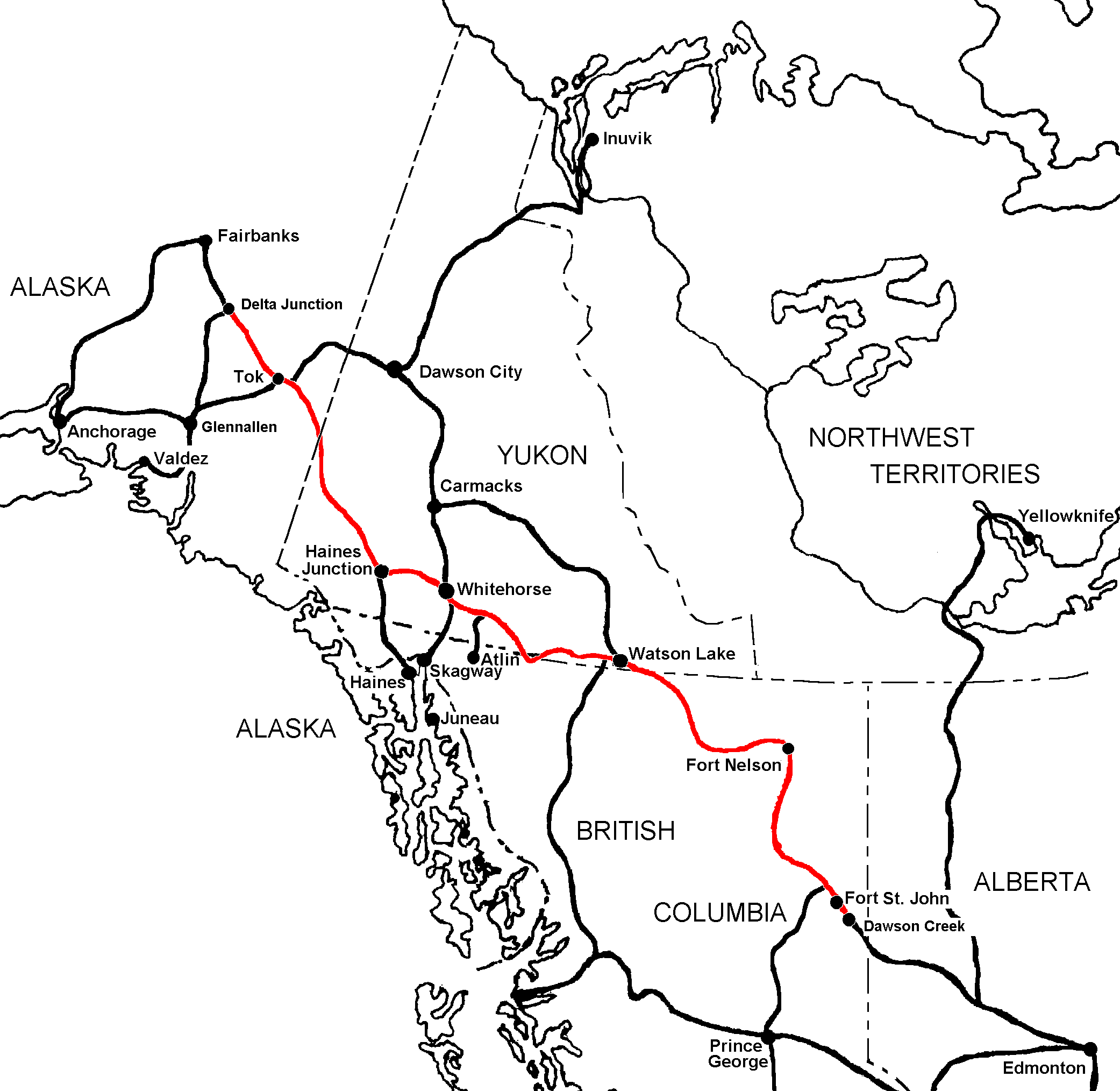
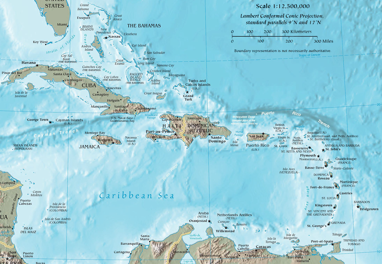
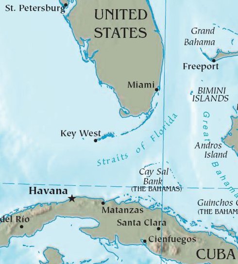
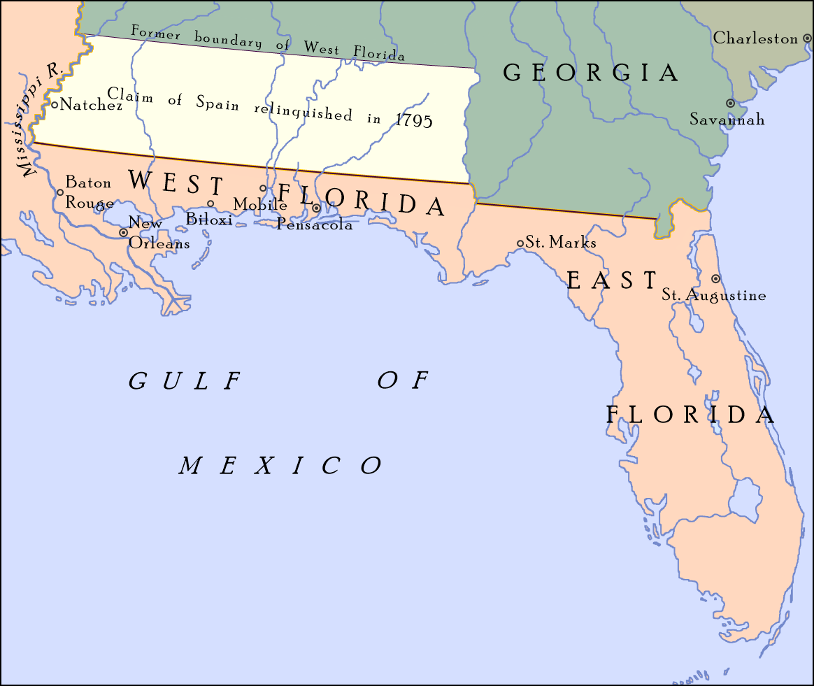
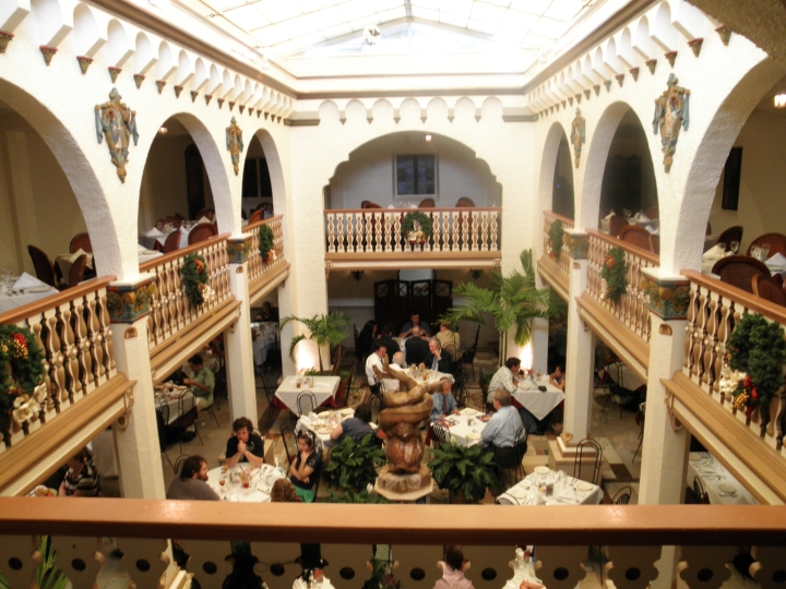
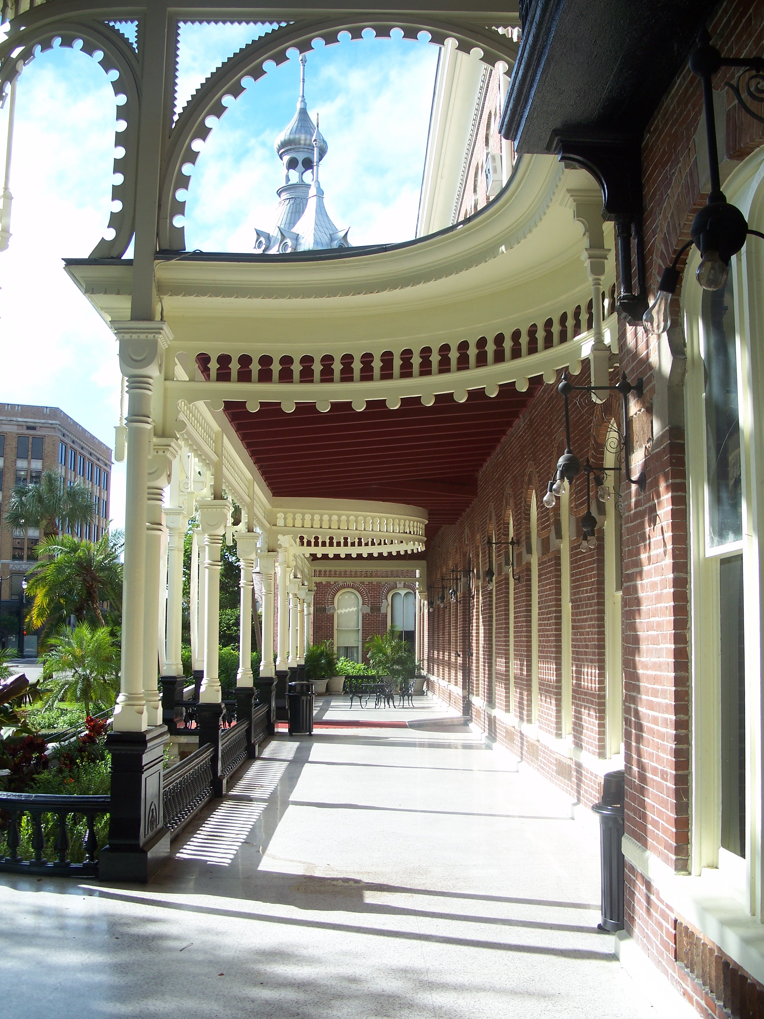
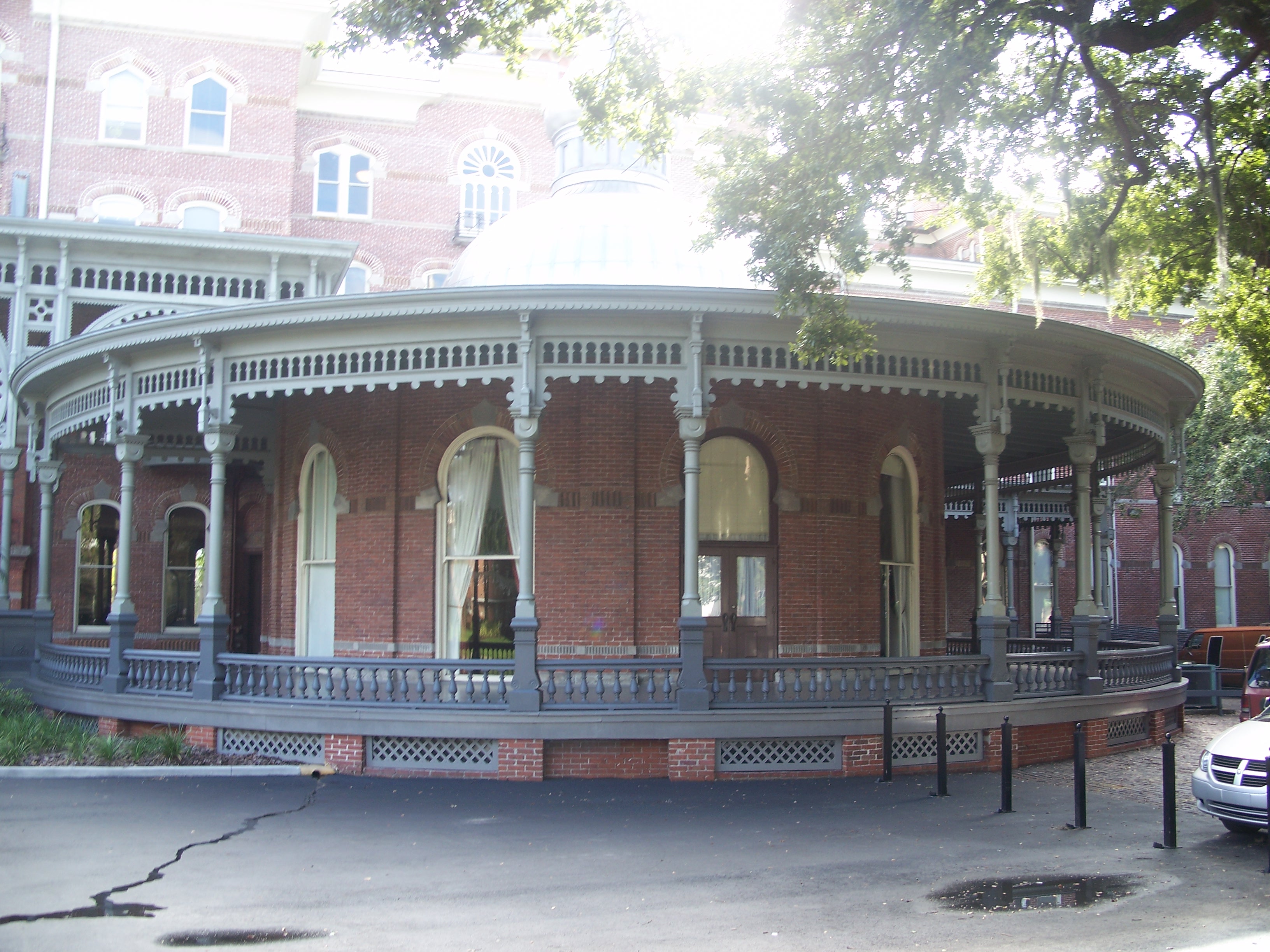
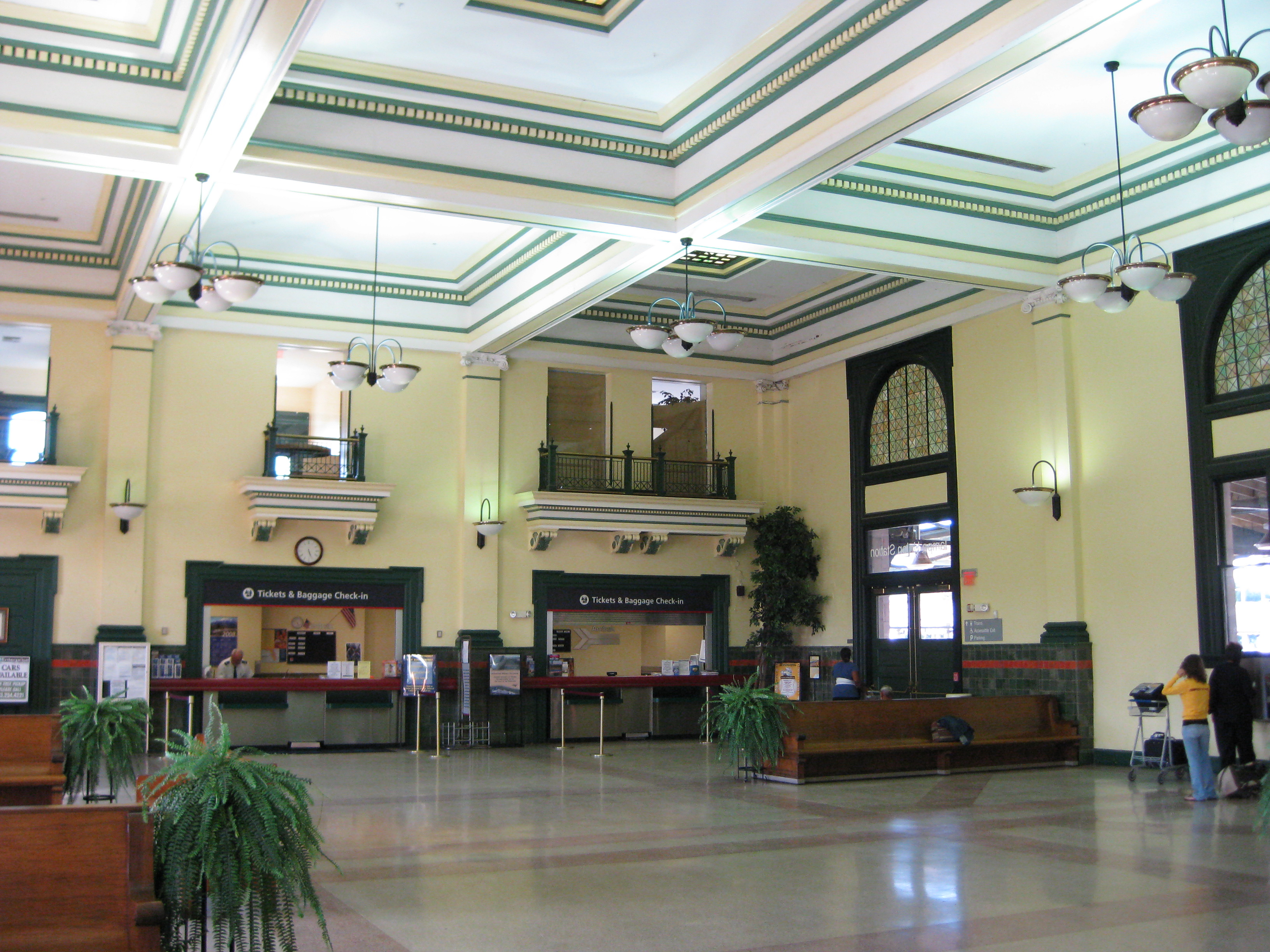