|
Reflections 2019
Series 2
January 31
Ohio River II: Cincinnati – Over the Rhine I: Golden Age - Food - Arrest
| | Having enjoyed the trip to Churchill Downs, we left Louisville and headed overnight to Cincinnati, which would be the second of these two high points of the trip. We'll repeat below the map of the trip (first link), reminding that no mention of Madison IN was still ever made, despite the fact that it remains on their map. Hold on to it for later reference.
https://www.americancruiselines.com/images/default-source/maps/mississippi-river/ohioriver_stl-pitts_700x700.jpg?sfvrsn=2
http://toursmaps.com/wp-content/uploads/2016/07/road_map_of_cincinnati_oh_usa.gif
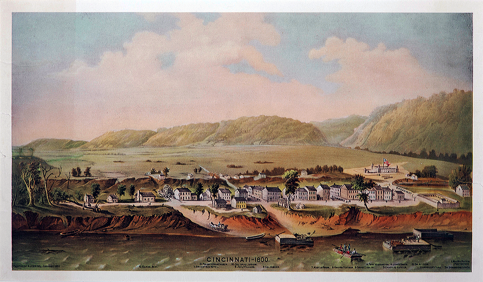
| | | | Greater Cincinnati All big cities have even bigger metropolitan areas, which we rarely have need to discuss here, but in this case, it's worthwhile. The second link above shows Cincinnati's, which is an interstate area, with Ohio to the north, including Cincinnati proper, and Kentucky to the south, centering on Covington and Newport. Cincinnati plus what is usually referred to as "Northern Kentucky" form a de facto unit, which is indicated in the airport name Cincinnati/Northern Kentucky International Airport. [Greater Cincinnati actually is tristate in area (Map by JuliusCaesar/Regoarrarr), even including counties in Indiana to the west.] | | | | | | Before we leave the second-linked map above, take note of the blue line at the bottom. This is the Licking River, a reference to the many local saline springs that attracted animals to its salt licks. The Licking River is the basis for European settlement in the area, since settlers wanted to take advantage of the area's large, flat flood plain. Cincinnati was founded in 1788 opposite its mouth, with Newport founded in 1795 to its east, and Covington in 1814 to its west. This is Cincinnati in 1800, population 750. Look carefully for the four street names Walnut, Main, Sycamore, Broadway, which are still there. Also note the high riverbank, and the mountains. To the right is Mount Adams (Photo by Wholtone), which we'll be referring to later, and in the distance are several other hills lined up at an angle that today form Uptown Cincinnati and which define Downtown Cincinnati as the low land area between them and the Ohio River. Downtown includes the central business district (CBD), Over the Rhine, the West End, and more. These hills also give the neighborhood of Over the Rhine its long narrow shape.
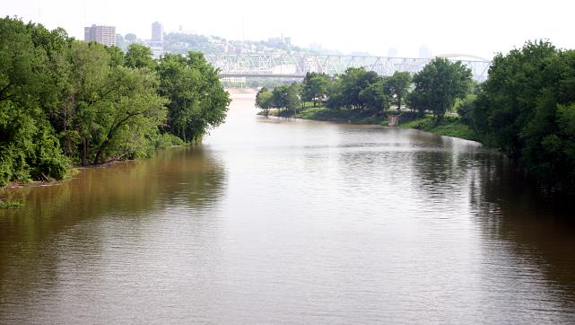
To show the importance of the Licking River to Cincinnati, the original surveyor named what is now Cincinnati Losantville. He made that word up from four elements, thus: l-os-ant-ville. The L was a highly reduced form of "Licking River"; os is Latin for "mouth"; "ant[i]-" is Greek for "opposite"; ville is French for "city". Put "Licking River + mouth + opposite + city" together and you have "city opposite the mouth of the Licking River". Obviously, the name didn't survive, but do not downplay the importance of the Licking River to the history of Cincinnati and its region. "Losantville" was changed to "Cincinnati" in 1790, two years after its founding. This is the mouth of the Licking River where it meets the Ohio (Photo by Rdikeman).
|
| | | | When we speak of twin cities, they're most often within one state, such as Minneapolis/Saint Paul MN, Tampa/Saint Petersburg FL, San Francisco/Oakland CA. They also occur interstate, but then we think less of them as twin cities because they're in different jurisdictions. Since I was first in this area years ago, I always considered Cincinnati OH and Covington KY to be twin cities, but after this visit, I see a more accurate reality of a tri-city area including Newport KY. I found this transit map covering Northern Kentucky-Downtown Cincinnati's CBD (Map by Nate Wessel), apparently for buses, to be especially illustrative of the interconnectivity of these three interstate locations. | | | | We can start with names, and the basis for Losantville being changed to Cincinnati might surprise. We've said that in the mid-19C there was a strong interest in the classics, which is why most US state capitols look like Roman or Greek temples. It also explains why Memphis TN and Cairo IL have ancient Egyptian names why the Greek suffix "-polis" was added to Minneapolis, Indianapolis, and Annapolis, and why we have a Rome NY and an Athens GA. Cincinnati fits right in there with its indirect Roman connection. | | | | Cincinnati's connection is only indirectly to Rome in that it's named directly after the Society of the Cincinnati, made up of Revolutionary War veterans. But the Society in turn was named after Lucius Quinctius Cincinnatus, who left his farm to accept a term as Roman Consul. He was a patrician, statesman, and military leader and became a legendary figure of Roman virtues, particularly Roman manliness and civic virtue. Hence Cincinnati is technically the plural form of Cincinnatus, since the Society members were all considered Cincinnati. When the name was changed from Losantville in 1790, it was not done locally, but by the governor of the entire Northwest Territory, who was president of the Society of the Cincinnati. (I just wish it were easier to spell. Now where does the double N go, and is the T also doubled?) | | | | Covington's name is easy. It was named after General Leonard Covington who was killed during the War of 1812. I wasn't even going to check the origin of Newport, since the name seems obvious. It was a new port on the Ohio, right? Wrong! | | | | The name isn't explained on Wikipedia or elsewhere I looked. Perhaps they also thought it was named as I'd thought. But then I recently was looking up something at the Newport Historical Society and accidentally found the name origin, resulting in an Aha! moment and a head slap. Newport is named after Christopher Newport, commander of the first English ships to settle Jamestown in 1603! It's the same person we discussed in the naming of Newport News VA (2016/19), which also seemed to be based on a "new port" rather than on a person. And why should Newport KY be reverential toward him? Well, Kentucky was the western part of Virginia at the time!
https://www.libraries.uc.edu/content/dam/libraries/arb/images/urban-studies/maps/cincinnati-1819.jpg
| | | | With Cincinnati as the hub city of this triad, let's look into its past. The above link is to a map of Cincinnati in 1819, when it was growing, but still rather petite. Click to find on the shore the Commons, which seems to be a gathering area. On later maps we'll see it's called Public Landing, and I'm sure this is the very wide spot where our boat docked on this trip, even though it didn't look like a major docking area. Another thing I like about this map is its topography. It clearly shows the top of that riverbank we saw earlier, marked "Top of the second Bank or Level". It also clearly shows Mount Adams on the right, northeast of which Eden Park is located today. And very interesting for later use is the city limit at the time at the top, called "Township Line and Boundary of the Corporation". This will become Liberty Street (name explained later). This line also runs due east-west, which shows that the streets in town are not north-south, but at an angle, though based on the river's shoreline. | | | | In the 19C, Cincinnati was a boomtown and rivaled the larger cities in the East in size and wealth. For much of that century it was listed among the top 10 US cities by population, surpassed only by New Orleans and the older, established cities on the east coast. For the two decades between the census reports of 1840 and 1860 it was the sixth-largest city in the US. | | | | Cincinnati received a large number of German immigrants in particular (see below), who founded many of the city's cultural institutions. But by the end of the 19C, growth slowed down and trade patterns altered considerably because of freight shipping declining with the shift from steamboats to railroads. Among inland cities, Cincinnati's population was surpassed particularly by Chicago, which benefitted from the railroads and became a hub, and also Saint Louis, which remained for decades after the Civil War the gateway to westward expansion and migration—hence the Gateway Arch. The 2016 estimate of the population of Cincinnati proper is just below 300,000, ranking it a mere 65th among all US cities. The major inland centers had moved beyond the Ohio Valley. | | | | 1998 Visit & Roebling Bridge I want to talk about Cincinnati by separating some parts from the main narrative. I want to talk about the Cincinnati neighborhood with the most distinctive name I could ever imagine, Over the Rhine, AFTER the narrative, because it's interesting enough to stand alone. Similarly, I'll hold discussion of the 19C Underground Railroad to the next posting for the same reason. And I want to talk about the Roebling Bridge BEFORE the narrative, because of its importance, because it was downplayed on the tour during the current visit, and because we lived right next to it on the earlier trip.
http://www.atlasdigitalmaps.com/media/catalog/product/cache/1/image/9df78eab33525d08d6e5fb8d27136e95/m/i/mimcincinnaticsmain.png
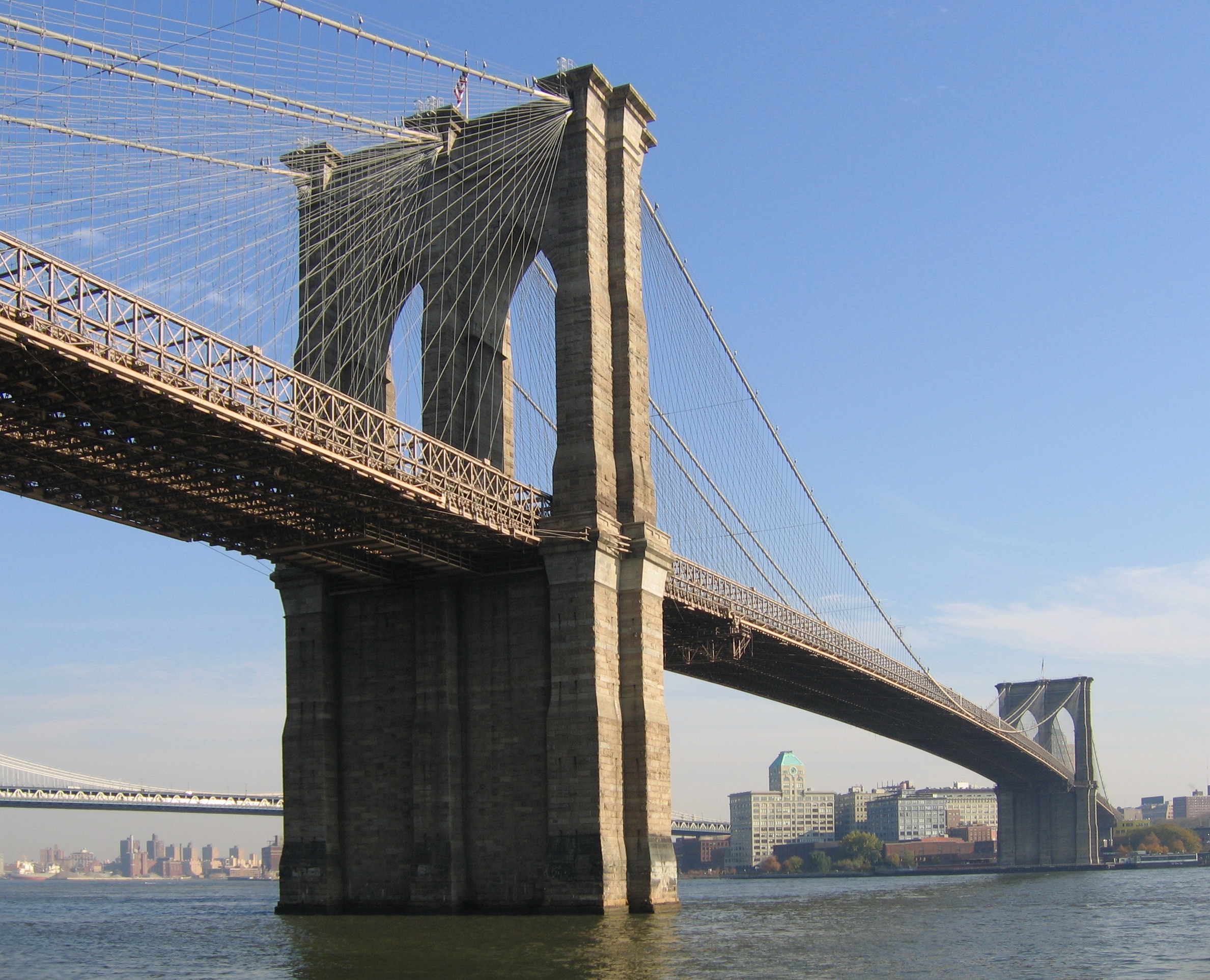
| | | | We'll be using two maps, and this is one, the "gray map". It's a decent map, but it has too many confusing colors and is, unfortunately, dated--on the Cincinnati waterfront, it's lacking the newer stadium and also the museum we'll be visiting. But it's good for the Kentucky side, and we'll come back to it later to see the upper part of Over the Rhine, to the north. Move down to Covington and Newport, and click. | | | | In 1998, Beverly and I flew to the Cincinnati area for a family wedding in Covington. My travel diary for that year says we were there on the 16 to 19 July 1998, as opposed to the current trip on 22 June 2018, so to my great shock, there are two full decades—minus just 24 days--between my visits to this area. My gut feeling is that the wedding and my infatuation with the bridge took place just a very few years ago. | | | | Find the bridge simply called here Suspension Bridge, one popular name it had for a long time, since it was the first bridge in the metropolitan area as well as the first suspension bridge. To its left are two red buildings. The one to the left is the Embassy Suites, which again, to my surprise, has since been swallowed up. The year after we were there, 1999, the whole chain of Embassy Suites Hotels was acquired, and it's now known as Embassy Suites by Hilton. It's hard to keep up with these changes. | | | | Anyway, we had a room with a river view across to Cincinnati, and even more impressive was that we had an in-your-face view of the Roebling Bridge crossing the river to our right. We woke up and went to sleep every day with the magnificent structure in our view. This is a similar view of the Roebling Bridge, looking toward Cincinnati, though seen to the left (Photo by Rdikeman at the English Language Wikipedia). If the name doesn't yet ring a bell, Roebling later built the Brooklyn Bridge. | | | | John Augustus Roebling was a German-born (Prussian) American civil engineer, otherwise named Johann August Röbling. He designed and built wire rope suspension bridges, notably, among others, the Roebling Bridge here and the Brooklyn Bridge, both of which have been designated National Historic Landmarks and National Historic Civil Engineering Landmarks. The Roebling Bridge here is apparently only the second to cross the Ohio after the Wheeling Suspension Bridge of 1849, though that is located way upriver where the Ohio is narrower, and it crosses only the main channel to Wheeling Island, with a minor bridge then connecting the island further across a much smaller secondary channel. | | | | Cincinnati was growing and needed access to the south bank of the Ohio. One major force against the building of a bridge we saw earlier, in Saint Louis (2016/3), where steamboat interests wanted to both maintain their monopoly of crossing the Mississippi (and also wanted to prevent railroads from crossing the river to take away their business). In Cincinnati the railroads weren't an issue at the time, but steamboat and ferry interests kept on insisting on higher and higher clearances so they could pass underneath, and lobbied against any bridge plans. Roebling originally suggested a 370 m (1,200 ft) span with 30 m (100 ft) of clearance at high water to allow steamboats to pass unobstructed, but given that length of the roadway, he included a monumental tower in the middle of the river. But the steamboat and ferry interests continued to lobby against it because of the obstructed waterway. Roebling then attacked steamboat operators for using oversized smokestacks. | | | | The Wheeling Suspension Bridge had an influence here. After the legislature observed its construction, it relented and chartered what is now the Roebling Bridge. But it also mandated even larger, oversized dimensions for the span, without the center tower. When it opened in 1866, it was the longest suspension bridge in the world at 322 m (1,057 ft) across the main span. It remained the longest until—what else--Roebling's Brooklyn Bridge opened in 1883. | | | | | | This is the Brooklyn Bridge facing Brooklyn (Photo by Postdlf). Flip back and forth between this picture and the above one of the Roebling Bridge to see the similarity. The Roebling Bridge towers are a bit more German-medieval looking and have a single opening each, while the Brooklyn Bridge has a double opening in each tower, all four of which are in the iconic Gothic style that sets it so strikingly apart. The Brooklyn Bridge was started in 1869 and completed after 14 years in 1883. It has a main span of 486.3 m (1,595.5 ft). That means that the Brooklyn Bridge is 50% longer than the Roebling Bridge. Conversely, the Roebling bridge is two-thirds (66%) the size of the Brooklyn Bridge.
https://upload.wikimedia.org/wikipedia/commons/f/f8/Brooklyn_Bridge_po%C5%9Dtmarko_DE_2006.jpg
This is a 2006 German stamp issued by the Deutsche Post AG celebrating the bicentennial of Röbling's birth, with the Brooklyn Bridge in the background. Though this is a link to Wikipedia, the image is apparently not in the public domain, so link to it yourself as a third party.
|
| | | | In addition to being referred to as the suspension bridge, it was originally quite logically named the Cincinnati-Covington Bridge. That remained its name from its opening in 1866 until it was renamed in honor of its designer and builder in 1983 as the John A Roebling Suspension Bridge, Roebling Bridge for short. I'm sure a secondary factor was that by then there were so many other bridges connecting Cincinnati and Covington and the name was no longer meaningful. | | | | | | When discussing Paris recently, we said that the Eiffel Tower was uniquely named for its designer and engineer, something that's very rare, and was named so from the beginning. The Roebling Bridge is the only other one I'm aware of named for its designer and engineer, but with the difference that it wasn't named so during Roebling's lifetime, just in the last 3 ½ decades. |
| | | | Not counting freeway bridges, the Roebling Bridge remains the busiest of Cincinnati's four vehicular or pedestrian bridges. Yet during the current visit, I was bothered that our tour bus crossed the river on another bridge, with the guide only casually pointing out the Roebling Bridge downstream. I asked him if we'd be crossing it on our return, and he said no. But I've just been relieved to find out what's been going on. In 2007, Kentucky reduced the weight limit on the Roebling Bridge to 11 tons to prevent future structural damage, and that limit prevents buses from using the bridge. Now I feel better. | | | | In 1998 we rented a car and drove several times across the Roebling Bridge, I'm glad to say. We took an aimless drive through Over the Rhine to look at its decrepit state; north of that we visited the William Howard Taft National Historic Site (the president's birthplace); we went over to Eden Park to the east for river views from the overlook on its bluffs, and saw the cathedral to the south of Covington, surprisingly in such an out-of-the-way location. Only some of that was repeated on the current trip. | | | | We have a few more bridge views. This is an aerial view looking toward Covington (Photo by Wholtone). I don't remember noticing the floodwall there before (click), including a bit of a mural. Based on this picture, I've discovered a local boat company that does day trips, BB Riverboats out of Newport. You're looking at its flagship, the Belle of Cincinnati. This is another view showing more of Covington (Photo by MamaGeek at the English Wikipedia). Click to see the River Queen, the other, smaller boat of BB Riverboats. The Embassy Suites is the third building to the right, with a white top. You can see the floodwalls and murals much more completely here that I'd never known existed until seeing these pictures. We'll discuss later the funky, ultramodern blue building in the center with the unbelievably sloped roof and protruding condo balconies. | | | | Finally, some steamboats (Photo by Bryce Mullet). With the Roebling Bridge in the background, we see on the Cincinnati side the Belle of Louisville out of Louisville docking next to the Natchez out of New Orleans. This was the former Tall Stacks steamship festival, unfortunately now defunct. I'm rather sure both these vessels are quite a bit more authentic steamboats than the intrinsically faux Queen of the Mississippi.
https://redpawtechnologies.com/downloads/2014/12/CincinnatiCBD_v1-01-1140x872.jpg
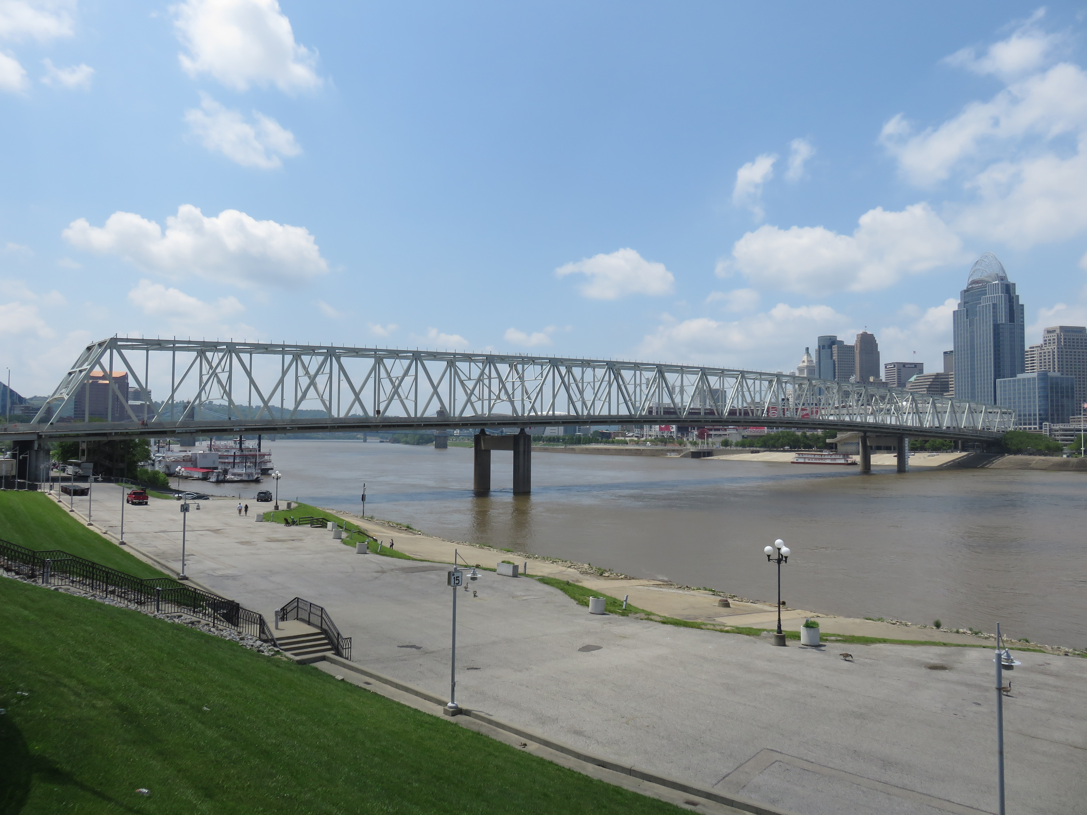
| | | | Day 8: F 22 June (morning): Cincinnati Tour We can now start our current narrative. For downtown Cincinnati we'll need the above "beige map", and we'll alternate between this and the "gray map" as needed. You can see that this map is newer, as it shows both stadiums and the Underground Railroad Museum we'll visit this afternoon in between. We've been sailing overnight and are scheduled to be here from 7:00 AM to 9:30 PM—though that departure varied considerably, as you'll see in later postings. For this one and only time we're docked on the Ohio side, just upstream (east) of the Roebling Bridge. We were also scheduled to stop at Marietta OH, but that stop was a casualty of how this trip ended, so this is the only stop that actually was on the north bank. | | | | But just what state we're in is a conundrum, especially since I really enjoy walking across borders, both international borders (2017/4 "Walkover Borders"), and a good number of state lines in the US. We are well aware that, since Virginia was a colony, the entire Ohio River has belonged to the south bank, presently Kentucky. On that basis, I assumed that the ship had docked in Kentucky waters, though on the Ohio side, and that when we went down the gangway, we crossed from KY to OH, and vice-versa on the way back. But take a close look at both the beige and gray maps. The border is not quite on the Ohio shoreline, a fact corroborated by Google Maps. Evidently, since the border was set on the north shore centuries ago, in some places, notably in Cincinnati, the Ohio shoreline has receded, spreading river waters over into Ohio territory. | | | | So here's the conundrum. I no longer think the ship was docked in KY waters, but was it docked completely in OH waters? Probably. Or was the docked ship big enough so that it was straddling the state line? If so, walking between port and starboard on the ship would have meant changing states. But sadly, we were probably completely in Ohio. | | | | On the beige map, you can see the Taylor-Southgate Bridge (Photo by Antony-22), which we were very close to. It dates from 1995 and doesn't appear on the older gray map. Some people argue that this bridge, seen here from the Newport side, is much too plain for a major urban crossing. But if you click and look under the bridge, where the Majestic is docked across the river is pretty much where we were docked, and is probably the Public Landing that appeared on the period map. Note the steep, concrete riverbank slope to get up into town. | | | | | | The next two bridges upstream from the TSB are enough fun to make them worthy to mention. The older gray map, indicates the L&N Bridge. The original bridge, called the Newport & Cincinnati Bridge, dates from 1872 and was the first railroad bridge spanning the Ohio. I'm assuming it was for the Louisville & Nashville Railroad. It was rebuilt in 1897 adding vehicular, streetcar, and pedestrian traffic, at which point it was finally renamed the L&N Bridge. It was first closed to rail traffic, then car traffic and in 2003 restored for exclusively pedestrian traffic. The public was asked what color to repaint the bridge, and the choice was purple. So today, despite its being officially called the Newport Southbank Bridge, everyone calls this now pedestrian bridge the Purple People Bridge. Viewed here from Newport, you'll see how the Purple People Bridge gets its name (Photo by Antony-22), though it comes off a bit bluish in this picture.
But for bright colors, the next bridge upstream, a freeway bridge, wins. On both maps it's shown as the Daniel Carter Beard Bridge (1976) that carries I-471, but everyone calls it the Big Mac Bridge because of its bowstring-arch style's resemblance to McDonald's iconic "Golden Arches" (Photo by Hannaford). This brightly-colored bridge was pointed out more than once on our tour. In the 1980s, McDonald's considered opening a floating restaurant at its base, but never followed through with the plan.
|
| | | | Anyway, let's leave the river and get on with our tour (beige map). The golf cart once again was a help to those of us who didn't want to climb the steep concrete slope up to the street where the buses were waiting. And thank goodness, the buses, with guides, were from a private tour company that knew what it was doing, not like the Paducah fiasco. Before entering the bus, I asked the guide waiting outside if we'd get to see Over the Rhine, and he assured me we would. | | | | We started by zigzagging through the streets of the central business district (CBD). Much there was humdrum, lots of corporate offices in older skyscrapers and of little interest. For instance, I see our beige map points out Procter & Gamble on Broadway Street between 5th and 6th. We then swung north into Over the Rhine, which we'll discuss as a separate topic after the narrative of the tour. | | | | Returning down Plum Street, we saw at 6th Street Cincinnati's formidable City Hall (Photo by Greg5030 at English Wikipedia), a strikingly massive building completed in 1893 in Richardsonian Romanesque style, as we've seen so many times in the past and will see again in Maysville and Pittsburgh. Typical is the dark, massive stone (click), the huge, rounded Romanesque arches, and the towers and turrets, all popularized by HH (Henry Hobson) Richardson, who, with Louis Sullivan and Frank Lloyd Wright, is one of "the recognized trinity of American architecture", according to architectural historian James F O'Gorman. | | | | On our map, continue down Plum and zigzag over to 5th between Vine and Walnut. This is Fountain Square (Map by aszymier), a public square and event location, that functions as the focus of downtown. The impressive Tyler Davidson Fountain, dedicated in 1871, is regarded as the symbol of Cincinnati (Photo by Niagara66). It's 13 m (43 ft) high, is cast in bronze, and sits on a green granite base. The motif is water, an homage of Cincinnati's debt to the Ohio River, which is particularly significant for our current voyage on that river. The central statue in the fountain is called the Genius of Water. It's a heroic female figure 2.7 m (9 ft) tall, pours down rain quite unusually, through hundreds of jets pierced in her outstretched fingers. It's a stunning sight, and was the only location our bus didn't stop at that I'd wished I'd had a few minutes more to contemplate. There are numerous figures and bas reliefs around the fountain and its pedestal, but I find two statues of particular interest. Under the female figure on one side is a workman on a burning roof, and on the other side, a farmer in a field suffering from a drought. Both are imploring the skies for rain, and the Genius of Water drops her gentle spray on them. | | | | I've since become intrigued by its history. It was not originally meant for Cincinnati, or even built there. Long before its debut, artist August von Kreling in Munich had collaborated with Ferdinand von Miller at the Königliche Bronzegießerei (Royal Bronze Foundry, ß=ss) of Bavaria to design a fountain to rival the great fountains of Europe. This is a sketch Kreling had made for the fountain way back around 1840, but Miller couldn't find any patron to sponsor the fountain, and so the designs languished. But when Cincinnati businessman Henry Probasco went to Munich after the death of his brother-in-law and business partner Tyler Davidson looking for a suitable memorial to him, he liked the design, everything clicked, and the project went ahead. | | | | The primary addition to the project was that Probasco wanted the fountain to be an actual source of drinking water for passersby, and so he added the four figures of boys with animals around the fountain's perimeter. You can see them by clicking on the above photo, and here is a detail (click) of one of them, a boy with a goose--with water coming out of its beak (Photo by MamaGeek at the English Wikipedia). Miller's sons Ferdinand and Fritz designed these four—the other boys are with a dolphin, a snake, and a turtle. | | | | It's a beautiful fountain, but clearly the most striking feature is that the water sprays from the principal figure via her fingers, which to my mind is unique. It was only German Wikipedia that clarified this particular point. Probasco didn't want Neptune or any other mythological figure, and so Kreling and Miller drew inspiration from a statue of the Virgin Mary in France they knew of in which she held out her arms, and beams of light shot out from her hands and fingers. These beams of light were replaced with streams of water for the new fountain. Take another look here at those lush sprays, and click to inspect the details (Photo by Niagara66). | | | | This is a rather decent YouTube video of the Tyler Davidson Fountain. It runs 2:43, but you can skip anything beyond 1:43. | | | | Whence cometh the water? We need a humorous aside here. Fingers are a highly unusual source of water in fountains, probably unique here. Some fountains show logical sources of water. I think of the Trevi Fountain in Rome, which shows a stream flowing out of rocks, or of statues that show a maiden pouring water from a jug. Then we move to the illogical sources, such as water from the goose's mouth above. We move on to human figures, where, as in the case of this fountain in Enkenbach, Germany (Photo by Immanuel Giel)—and in many others--water rather illogically spouts from a human mouth. But there's only one logical place that liquid actually leaves the human body, right?. Might there be a public fountain that shows that? Yes, there might be. | | | | Almost everyone who's been to Brussels has been to see the Manneken Pis (Photo by Myrabella/Wikimedia Commons/CC BY-SA 3.0), showing a boy doing what comes naturally (click). The original centuries-old bronze statue dates from 1619 and is today preserved in the Brussels City Museum, the one exhibited today being a replica from 1965. Though the term Rubenesque usually refers to Rubens' Baroque style of plump women, given the date of this statue, I think the plump figure of the boy can be described as Rubenesque in style. The landmark statue-cum-fountain is a small bronze sculpture, just 61 cm (24 in) tall. This picture (Photo by Kaihsu) shows just how petite the statue is, how it's protected by an iron fence, and how popular it is. It also shows him dressed in one of his thousand donated costumes (a total reached in 2018). They're kept in the Brussels City Museum and are changed several times a week according to a published schedule (Photo by Klever). Most of his costumes are very elaborate and colorful, but obscure much more of the statue than this simple one in judo attire does (Photo by Pbrundel). There are replicas of the Manneken Pis elsewhere in Belgium, and also internationally, in Japan, France, Spain, and more. You can get away with this type of lusty humor with a little boy. Can you imagine a public fountain like this showing an adult male? It would make just as much sense physiologically, but wouldn't be socially acceptable. | | | | | | The translation into English of the name is problematic, and illustrates the difficulty of accurate translation. Start with the Dutch/Flemish word man. Manneken is a diminutive, thus "little man". The word for boy is jongen, but that isn't used here, perhaps since "little man" is cuter, given the situation. The other word is a noun, yielding "Little Piss-Man", grossly awkward in English. I prefer to verbalize it to yield Little Man Pissing as the translation that's closest to the original. I've seen "Pissing Boy" and "Little Pisser", that I don't like as well for being less true to the original, though the last one is cute.
You may not recognize manneken as a word you know, because it's been respelled. Long ago it went into French respelled as mannequin, then the French form was borrowed by English in the 15C.
One of the French meanings, from c 1830, is "a woman who models clothes"--despite the derivation from "man"—as in talking about mannequins walking down a runway at a fashion show. This sense, today very rare in English, first appeared in English in 1902. The far more common sense in English of "a life-size dummy used for displaying clothes", either male or female, was first recorded in 1939.
|
| | | | I've seen the Manneken Pis on two different trips, and I always thought that, while this sort of offbeat humor could work with a boy, it could never work with a girl. Silly me. Though I've never visited the following, I've found online this statue-cum-fountain, also doing what comes naturally (Photo by Aw58). I would say the well-known truism applies here backwards, where "sauce for the gander is sauce for the goose". We've had the "gander" relieving himself for several centuries. Now as a counterpoint we also have the "goose" doing the same. It's called Jeanneke Pis and is a modern fountain and statue erected in 1987. At 50 cm (20 in), it's a little smaller than its counterpart, and being relatively new, is not (yet) as popular. It's located in an alley (Photo by Joseph Brent), right off a main restaurant street, about 7 minutes' walk to the northeast of Manneken Pis. Click to see that it's protected from vandalism by iron bars. | | | | Translation is hard again. Jeanneke would mean "Little Jeanne", or "Little Janie", but the name is used generically here to refer to any girl. The name unfortunately uses neither vrouw (woman) nor meisje (girl), so I'm loath to translate it that way. To have the name most closely parallel to the other statue, I'd just go with Little Janie Pissing. Seeing these natural depictions, maybe having rain coming out of your fingers in Cincinnati isn't so strange after all. | | | | Newport & Covington Leaving the fountain, we crossed the Ohio on the Taylor-Southgate Bridge shown on the beige map. But now we have to move back to the gray map for KY, where we end up in Newport—totally new for me—on that gold route at 3rd Street. On York and 4th, this outdated map shows a city hall. Since I find today's city hall has moved out of this building and is located elsewhere, it must have been the beautiful Victorian Campbell County Courthouse we saw, a marvelous piece of architecture dating from 1883 (Photo by Rdikeman at the English language Wikipedia). Now locate the L formed by Washington and 6th.
http://cincinnatihistorichomes.com/wp-content/uploads/2017/05/CHH_MAP-Mansion-Row-Newport-KY.png
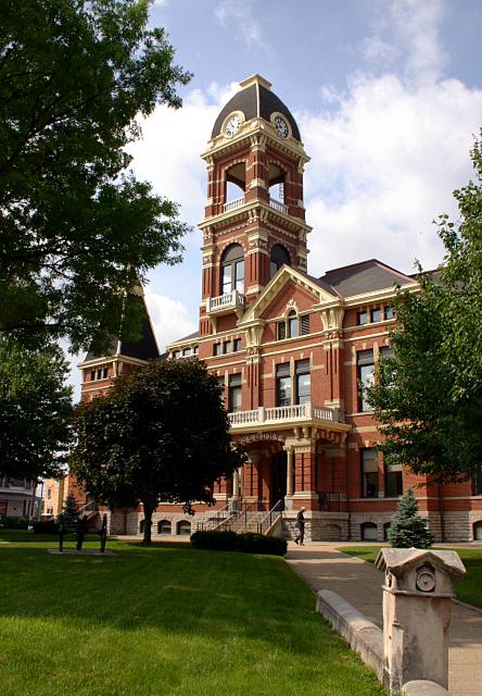
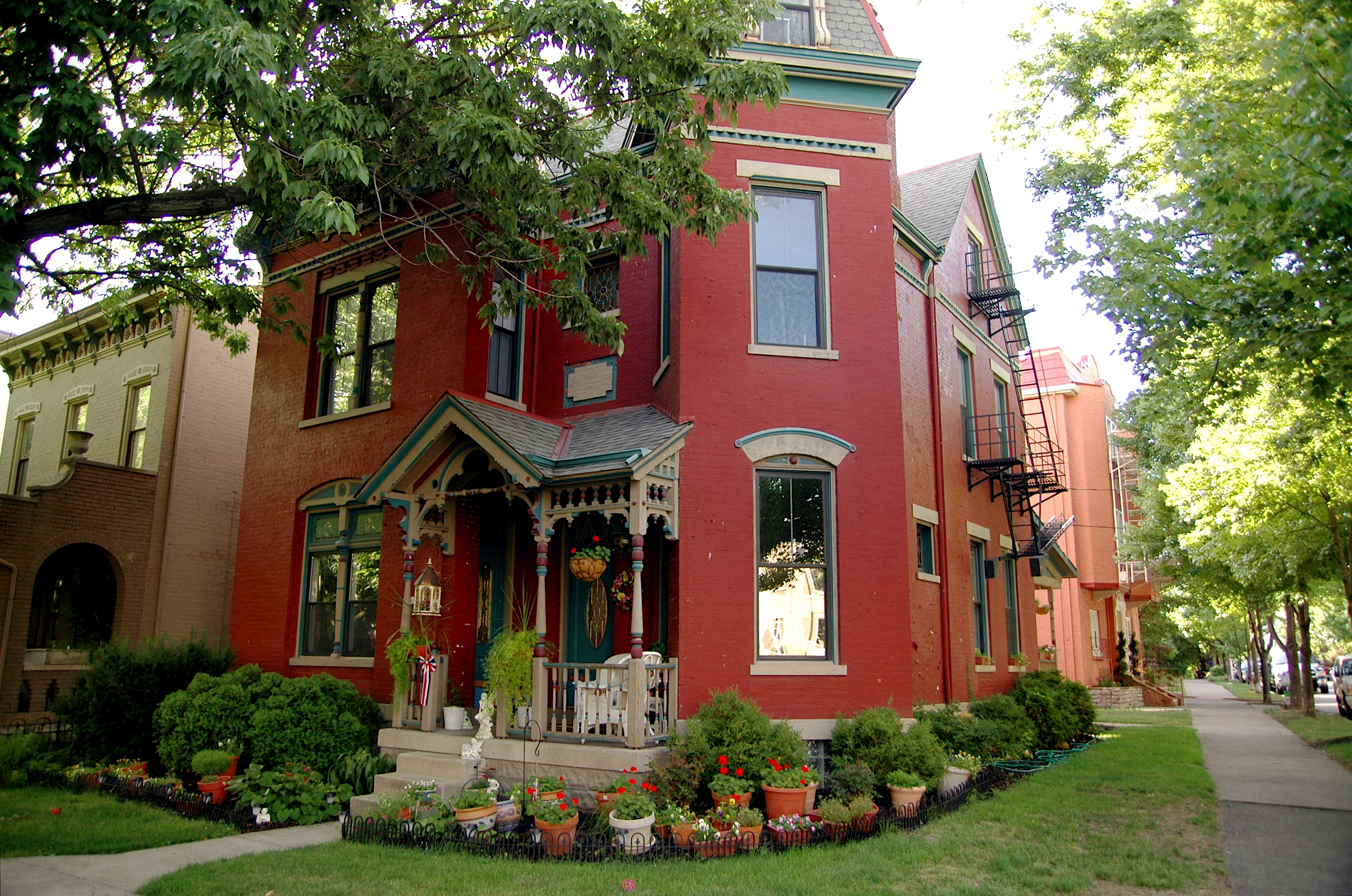
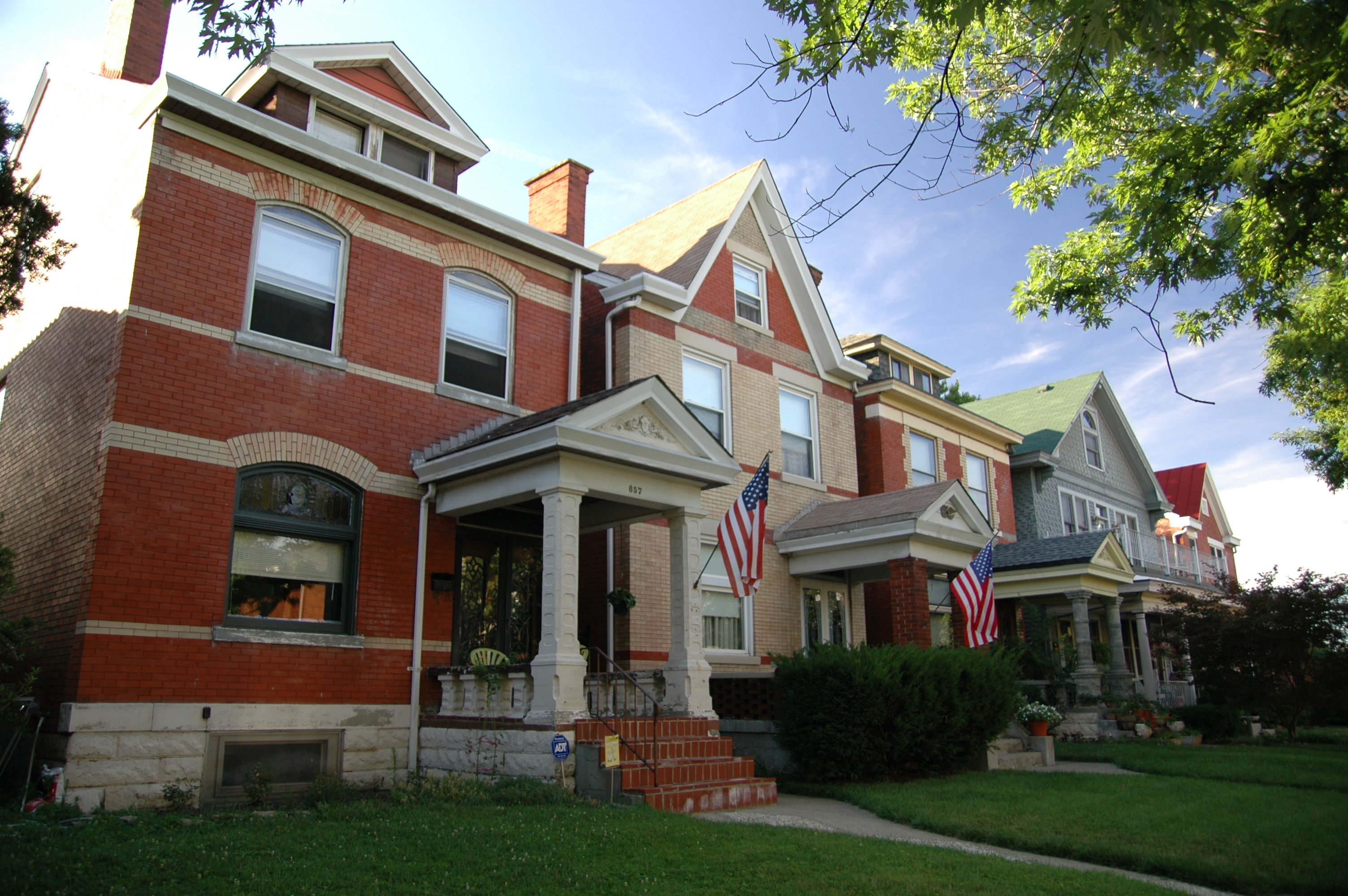
| | | | That L, extended to the river and freeway, is the East Row Historic District, which is home to 1,070 houses and is Kentucky's second largest historic district, created by joining two of Newport's historic neighborhoods, Mansion Hill and Gateway. As the courthouse already indicated, the Victorian era was Newport's most affluent period, as is evident by the East Row's elegant houses. I don't know exactly which ones we saw, but the handsome houses in all these picturesare typical (All Three Photos by Jeff Kubina). | | | | We then crossed the Licking River to Covington on our way to the cathedral. You'd hardly expect to see a cathedral here. In Cincinnati, maybe, but in little Covington? And even stranger, not in downtown Covington, but off in a residential neighborhood in the south end? When it was built, it must have been built out in the fields. On our gray map, find Madison Avenue, in white to the left of the two yellow streets. At the very bottom of the map, between 11th and 12th Streets is the formidable—and unexpected--Saint Mary's Cathedral Basilica of the Assumption--click for architectural detail (Photo by Poghia). | | | | Construction began in 1895 to replace an 1834 frame church whose size was no longer adequate for its congregation. I suppose that it once having been a neighborhood church would explain its out-of-the-way location, but it's formidable that a replacement structure for a local church should have been so grand. Construction ended in 1915, though it remains incomplete, since the planned 16 m (52 ft) towers were never built. Still, its Late Gothic Revival/French Gothic style gives a much larger feel than the reality of its 59 x 44 m (194 x 144 ft) size. The interior (click) is just as formidable (Photo by Mark Byron), with the nave reaching a height of 25 m (81 ft).
| | | | We then continued north on Madison Avenue to the center of Covington and came across streetscapes in a flurry of landmarked historic districts. As I look them up now (see map), there's the Licking Riverside HD, between Scott and that river from 8th to 4th, the Riverside Drive HD on the Ohio, associated with George Rogers Clark, and the one with for me the most interesting name, the Mutter Gottes HD. We are familiar with neighborhoods named in French, such as the Vieux Carré, the French Quarter of New Orleans, and in Spanish, such as El Barrio, the other name for Spanish Harlem in Manhattan. But I'm unaware of a neighborhood and a HD elsewhere with a German name.
http://cincinnatihistorichomes.com/wp-content/uploads/2017/05/CHH_MAP-NorthCentralCovington.png
| | | | It covers only the northeast part of this yellow map. We're coming up Madison in pink, and the Mutter Gottes HD, including 153 buildings, lies west of Madison up to the CSX railway, between Pike and 4th. The cross shows the location of the landmarked Mutter Gottes Kirche (Mother of God Church) that gives the neighborhood and HD its name (Photo by Greg Hume). It was founded by German immigrants in 1841, and the present twin-towered Italian Renaissance Revival structure dates from 1871. Click to read "Mutter Gottes Kirche" above the arches. | | | | Though we usually talk about historic buildings, we've also discussed modern ones. When we spoke of the Roebling Bridge above, we spotted "the funky, ultramodern blue building . . . with the unbelievably sloped roof and protruding condo balconies." The residential tower is called the Ascent at Roebling's Bridge and was designed by Daniel Libeskind, the architect who has done numerous major constructions around the world (Photo by Studio Daniel Libeskind). The summit faces south, so we're looking north toward the river, which is the direction the slope descends in (Photo by Adam Sofen). It was completed in 2008, so it wouldn't appear on our map, but it's located on that odd-shaped block immediately to the west of the Roebling Bridge approach and south of 2nd Street. The curve of the building reflects the curve of the bridge approach. Libeskind cites the Ohio River and the Roebling Bridge as influences for his design, and so he even cites the bridge in the name of the building. | | | | The residential condo building (Photo by Studio Daniel Libeskind) is 89 m (293 ft) tall, has 22 stories, and is clad in a glass curtain wall. The sloped spiral roof is particularly spectacular in this view from Cincinnati, which also contrasts the modern building with its historic namesake. | | | | Though you can use the beige map to trace our route back to Cincinnati's Eden Park via Newport and the Taylor-Southgate Bridge, the park still shows up better on the older gray map. The hilltop park offers numerous overlooks of the Ohio River valley. It had been a private estate called Garden of Eden, but the name was shortened. Of the several sights within the park, you'll note the Cincinnati Art Museum that the guide pointed out in passing, which resulted in a cute little repartee. | | | | The guide, a really nice guy, mentioned that the museum has a large collection of Rookwood pottery, which he admitted he knew little about, but which "you ladies would know a lot more about". Well! When we got off at the overlook, before looking at the view, I first went up to him and told him that I regularly watch Antiques Roadshow and learn a lot from it, particularly about pottery. I'm familiar at least with the names Meissen, Sèvres, and Royal Doulton from Europe, plus several potteries in the US, notably Rookwood. "And you'll notice that I'm no lady!" At this the guide mock-slapped his cheek and said "That was sexist!" We laughed and I said it certainly was. | | | | | | In 2016/4, when in Red Wing MN, we visited and discussed Red Wing Pottery. Also, Newcomb Pottery is well-known and was associated with Louisiana. Three other names that keep coming up are all associated with Ohio: Roseville, Weller, and Rookwood. And Rookwood is located in Over the Rhine!
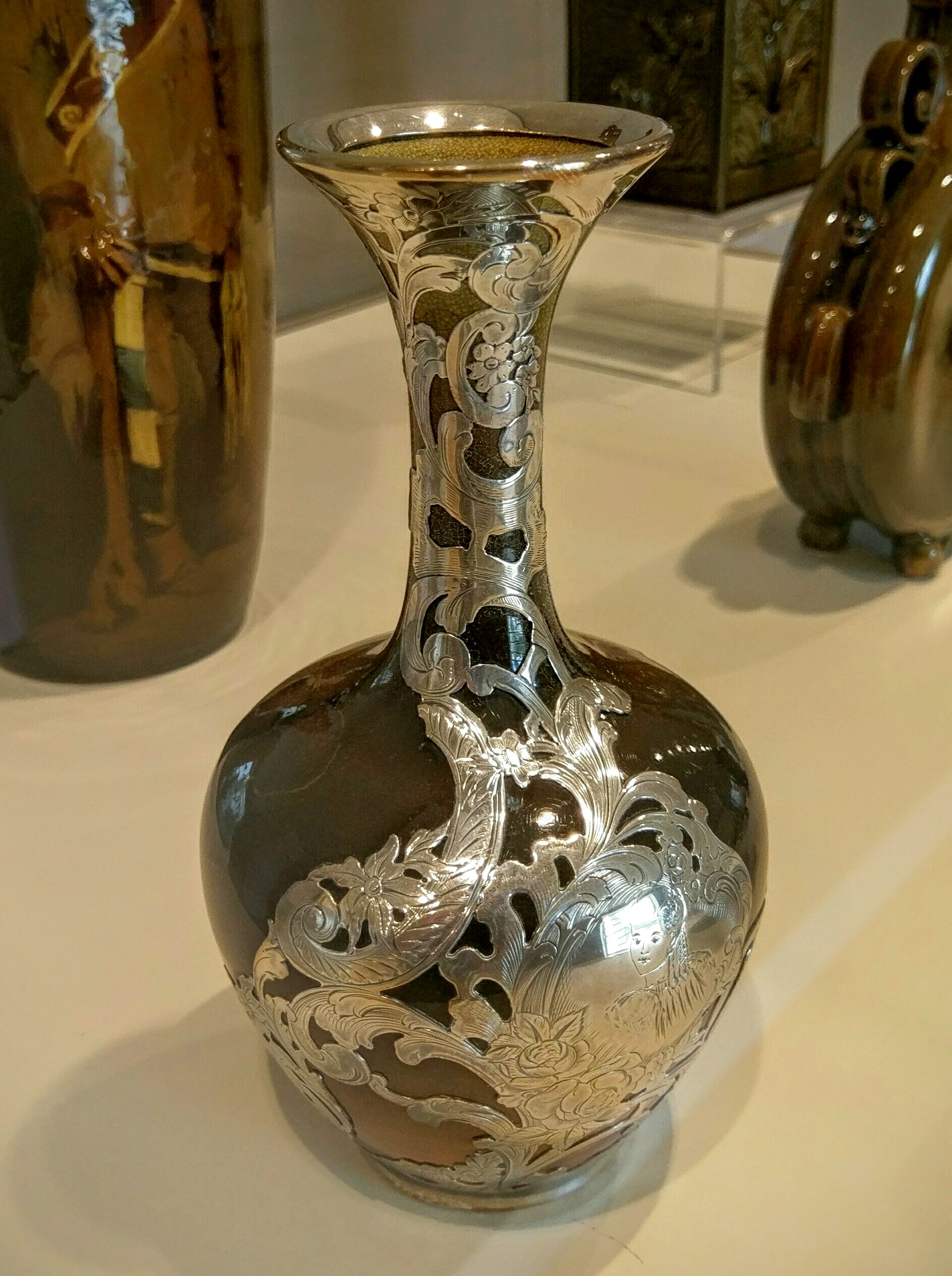
A bit more research shows that Rookwood was founded in 1880 in Over the Rhine. Its art pottery became very popular, but was hard-hit by the depression, when art pottery was a low priority. It went bankrupt, changed owners, moved to Mississippi, but then reestablished itself in Over the Rhine. I find that the Cincinnati Art Museum has a Cincinnati Wing, which in turn has a gallery dedicated to Rookwood Pottery. Though I didn't see the following striking pieces of Rookwood when there, we can look at them now (click for details). They're the nicest ones I found of many online. The museum has this piece with a mahogany glaze (1893) (Photo by Daderot) as well as this floral one (1911-1914) (Photo by Sailko). The DeYoung Museum in San Francisco has this boating scene (1904) and this one exhibiting leaves and earth tones (1900) (Both Photos by Daderot). Finally, the Crocker Art Museum in Sacramento has this striking ceramic vase with a silver overlay (1892) (Photo by Jim Heaphy). The name Rookwood is one of many worth remembering.
|
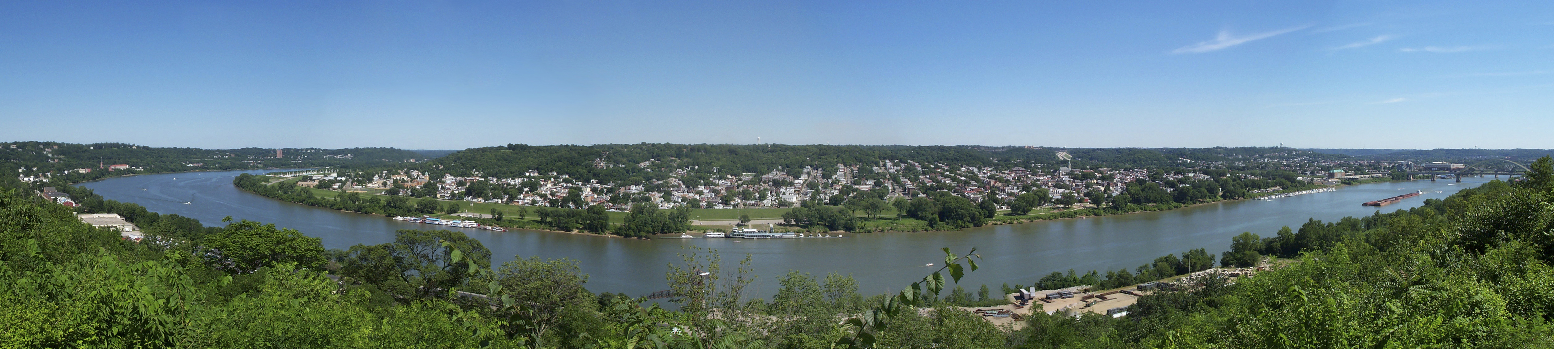
| | | | At the Eden Park overlook we got this panoramic view of the Ohio River Valley (Photo by Greg Hume). Its online caption says it's composed of five images stitched together. We're looking (click) at Kentucky across the river, but upstream (east) from Newport and Covington. To the right, that would be the Daniel Carter Beard ("Big Mac") Bridge, though its gold color doesn't show up here. We then returned to the ship for lunch.
https://www.ezilon.com/maps/images/usa/ohio-physical-map.gif
| | | | Two Canals In order to best understand how Over the Rhine got its name, we have to bring up two canals that I frankly never heard of before, but which I now find form a fascinating link in the canal system of the era. The canals went north-south through Ohio, which I find amazing. First look at the above map of Ohio to get oriented (click). You'll recall that this entire set of online maps we've used before show states tilted counterclockwise, so just disregard that. | | | | You see the major cities. Though Columbus, in the center, is the capital, I've always thought it was one of those smaller capital cities. I was wrong. The populations of the four biggest cities are Columbus 812k; Cleveland 392k; Cincinnati 297k; Toledo 284k, so Columbus is by far the largest. However, the Cincinnati metropolitan area has 2,115,000, so keep that in mind. But our issue is water, and we see that the Ohio River forms every bit of Ohio's southern border, and Lake Erie forms a large part of its northern border. | | | | | | As a preview of what IS and IS NOT in store for the future of this voyage, note the names Maysville KY, Huntington WV, Point Pleasant WV, Marietta OH, and Wheeling WV. Which planned stops will be kept, which will be added, and which will be subtracted? And why? Stay tuned. |
| | | | When talking about canals here in the Northeast, it's usually been a matter of connecting the coast with the Ohio River, otherwise with Lake Erie. The Baltimore and Ohio Canal in Maryland was killed by the railroads before ever leaving that state, and the Pennsylvania Canal did make it to Pittsburgh and thus to the Ohio River, but didn't last once the railroad era took over. New York connected the Hudson via the Erie Canal (which thrived) to Lake Erie, so it did reach the markets on the Great Lakes, but didn't reach the Ohio, the route to New Orleans. Or did it? | | | | That's where the (surprising for me) Ohio canals come into the picture (Map by Sektori). Look at them! What a splendid idea, given the waterbourne thinking of the early 19C. Canals would connect Lake Erie to the Ohio River, which would not only be of local commercial importance, but which would serve as extensions of the Erie Canal. Traffic from NYC and abroad would use the Hudson River, Erie Canal, Lake Erie, and one of the Ohio Canals to reach the Ohio River and be on its way to New Orleans. The two canals would connect all the major Ohio cities, including a spur to Columbus, plus other smaller canals. There was even a Pennsylvania-Ohio secondary canal which connected Akron to a canal in PA that reached Pittsburgh. In addition, the canals served as a water source for industries and towns. How ideal! What a setup for the future! What could possibly go wrong? | | | | The Ohio and Erie Canal was built in eastern Ohio during the 1820s and early 1830s. Cleveland is on Lake Erie and also on the Cuyahoga River, which connects south to Akron. The canal took over there and ran south to Portsmouth on the Ohio (see Ohio map). It carried freight traffic from 1827 to 1861 when the railroads killed it. From 1862 to 1913 it served merely as a water source for industries and towns. Then, after the railroads had their turn killing off the canals, the Great Flood of 1913 completed the job. The flood occurred over three days in late March when rivers in the Northeast overflowed after very heavy rains. Over a quarter million people were left homeless. The overall death toll was estimated at about 650, and the official number for Ohio falls between 422 and 470. These figures place the Great Flood of 1913 as second deadliest after the Johnstown Flood of 1889. After such flooding, much of what was still left of the canal system was abandoned. | | | | The Miami and Erie Canal was built in western Ohio from Toledo on Lake Erie to Cincinnati On the Ohio between 1825 and 1845. It included 19 aqueducts, three guard locks (that replenished water to maintain canal depth), 103 canal locks, feeder canals and water reservoirs. Again, railroads arriving in the area in the 1850s caused its commercial use to decline, and the Great Flood of 1913 finally killed it. Only bits and pieces of the dry canal survive today, with some towpaths and locks. Another factor in the death of these two canals is just that, that they were two canals and not one single one, which spread usage thinly. | | | | | | The name of this canal surely must raise eyebrows. When most people hear "Miami" today, they think of the large city in Florida and not of the Miami River in Ohio. So let's dig in online and find out what's what. It all comes down to two Native American tribes.
Huge Lake Okeechobee in central Florida was originally called Lake Mayaimi ("Big Water") by the Native American people who lived there from the beginning of the Common Era until the 17C-18C, and they took also the name of the lake for themselves, the Mayaimi, a word that was eventually altered in English to Miami. Hydrologically, water in the lake is part of the flow of water out of the Everglades, some of which develops into the Miami River, which flows through, and gave its name to, the city of Miami.
There was a Native American nation that used to live in the Great Lakes region, centering in Indiana but also including southwest Michigan and western Ohio. By 1846, most of these people had been removed to what was then called Indian Territory and is today Oklahoma. Their name for themselves in their Algonquian language was Myaamia, which appears to have been derived from an older term meaning "downtream people". This name, too, was altered in English to Miami, resulting in the current duplication.
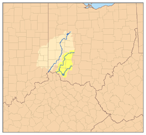
The Miami nation having been originally partially located in western Ohio is what is significant for us, since their name appears in the names of two Ohio rivers (Map by Pfly). This map shows the watersheds of the Great Miami River in beige and of the Little Miami River in yellow. And now we come full circle back to the Miami and Erie Canal, whose route paralleled the Great Miami River, and is partially named for it. The canal also used water from this river to maintain its depth.
And there is also confusion about the name "Miami" in the academic world, since, believe it or not, there's both a Miami University and a University of Miami. The University of Miami is the younger of the two, founded in 1925. It's in Coral Gables FL, adjacent to Miami. Miami University, on the other hand, is over a century older, having been founded in 1809 in Oxford OH, immediately northwest of Cincinnati (see Ohio map). What confusion! Imagine being a grad of Miami University and having to explain that you didn't go to school in Florida. You can understand why Miami University is often referred to as Miami of Ohio.
|
| | | | As for the two canals: I've described the Ohio and Erie Canal and the Miami and Erie Canal from north to south, which suits my purpose to end up talking about Cincinnati. But the phrasing of their names is oriented south to north. Could it be that the planners purposely wanted both names to end with the words "Erie Canal" to hint subliminally about New York's Erie Canal to which they wanted to be considered de facto extensions? | | | | Over the Rhine: Golden Age Now let's bring all this canal talk down to Cincinnati and to Over the Rhine. The former route of the Miami and Erie Canal in Cincinnati (Map by Wholtone) is today paved over, but we know exactly where it ran. Coming south toward what was then all of Cincinnati but is now just the downtown CBD, Central Parkway follows the old route. The route then made a sharp 90° turn left, which Central Parkway today also does. I can only speculate about this sudden turn, that the canal builders wanted to avoid entering the city and instead skirted what was at the time its northern border. It then bent again down to the Ohio River, the route that Eggleston Avenue now follows. For our purposes, it's that east-west L-shaped midsection of the route that's of principal importance. If you click and count the numbered streets, this section of Central Parkway is the equivalent of 11th Street. We make this point because everything north and east of that L-shaped midsection of the canal is the neighborhood called Over the Rhine (standard acronym: OTR). Check out on this map where Liberty Street cuts across OTR west-east. This is the historic divider of OTR. South of it is known today as the Gateway Quarter since it's where the CBD has access to OTR; northwest of it is today known as the Brewery District, for reasons you can guess. | | | | In addition to that map, we also have an excellent period illustration. This is a view of Cincinnati in 1841, right in the middle of the canal-building period, from a hill, very possibly Mount Adams. We're probably looking southwest, and on the horizon we see Kentucky, then the Ohio River, then Cincinnati in its original size, today's downtown CBD. We then come to the Miami and Erie Canal separating the city from the suburban, semi-rural area where we're standing, the future Over the Rhine, along with bridges on which to cross it.
https://overtherhine.files.wordpress.com/2012/06/miami-erie-canal-in-over-the-rhine-1.jpg
| | | | This is an undated postcard (it's amazing how much we can learn from period postcards!) showing the canal and a bridge crossing it. An educated guess is that that's Mount Adams in the background (see beige map), which would mean that we're looking east on the central "L" portion of the canal, and that that's OTR is on the left. This is a 1914 photo of the canal, again facing Mount Adams to the east, meaning just a bit of OTR is on the left and we're mostly seeing the downtown CBD. Click to inspect that we're now in the era where streetcars cross the bridges to connect OTR with the CBD. | | | | | | The canal was drained in 1920, just six years after this picture was taken, I'm sure "in the name of progress". If they'd had the foresight to forego the automobile age rush of turning it into Central Avenue, and to instead maintain it, by today it could have been developed into beautiful parkland with cafés along the sides. I only need to cite the example of what San Antonio did with the San Antonio River by developing its beautiful River Walk (2015/2). |
| | | | German Settlement Germans were among the earliest settlers, some migrating from Pennsylvania, including "Pennsylvania Dutch" country, which is, as I'm sure you know, actually German, it really being "Pennsylvania Deutsch". In 1830 residents with German roots made up only 5% of Cincinnati's population. But just ten years later, in 1840, that had increased to 30%. What brought thousands of German refugees to the US were the revolutions of 1848 in the German states, particularly in the north, in Prussia and Saxony. In Cincinnati these immigrants settled on the northern outskirts of the city, north of the Miami and Erie Canal, where there were plenty of cheap rental units. Many walked to work across bridges over the canal (we saw some in the pictures) that connected this northern suburb to what was then the small downtown. Since the canal, particularly in this central stretch, separated the then downtown from the largely German neighborhood, the canal was nicknamed der Rhein / the Rhine, and the newly-settled German neighborhood north of it became known as Über dem Rhein / Over the Rhine. In 1850, about 63% of the population of Over the Rhine consisted of immigrants from the German states, particularly Prussia, Saxony, and Bavaria. | | | | | | A minor point: über corresponds to "over", to which it's related and resembles, but also to "across". If I spotted you across the street, you'd be über der Straße (ß=ss), and that's "across" not "over". In my opinion, workers downtown living Über dem Rhein would more accurately be described as living "Across the Rhine". While "Over" does also make sense, it's not as good a translation. I think it fell into use simply because of its resemblance to über, but may not have been the most accurate choice. Picky-picky, but this illustrates the challenge of quality, accurate translation. It's not as easy as it looks.
Another point. One of my favorite postings is 2008/17 on Stress Patterns and Meter, which I recommend reviewing (it also presents some really great Limericks, too, worth reviewing for a good laugh).
In it we discussed the iamb (da.DA), the dactyl (DA.da.da), and the fact that an odd syllable may occur or be missing, which just has to be disregarded. Applying that here, we find that:
"Across the Rhine" consists of two iambs, which is iambic dimeter:
da.DA da.DA / a.CROSS.the.RHINE
"Over the Rhine" consists of one dactyl, which is dactylic monometer, plus an extra syllable:
DA.da.da.DA / O.ver.the.RHINE.
Now does the greater pleasantness of one stress pattern or the other influence which translation you'd choose if it were up to you? There's no right answer here. We're just showing the factors that can arise in coming up with quality translations.
|
| | | | During the 19C and well into the 20C, Over the Rhine became thoroughly German in character, as any ethnic enclave does. The new immigrants brought a variety of customs and habits, as well as numerous aspects of German culture and language. This was true with businesses, churches, hospitals, and every aspect of communal life. Over the Rhine was served by several German-language newspapers, including the Cincinnati Volksfreund, which is literally "folk-friend", but actually "People's Friend", a name that certainly seems to welcome newcomers; the Volksblatt or "People's Paper"; and the Freie Presse, or Free Press. The Cincinnati Volksfreund was published between 1850 and 1908, indicating the strongest period of German influence in Over the Rhine, and is preserved on file in the Library of Congress (Photo by Branlon). | | | | I have two period maps that will help us understand what Cincinnati and Over the Rhine looked like in this mid-19C period. This is the area in 1838. Note how neatly nascent Covington and Newport fit into greater Cincinnati. Click on the Cincinnati shore to once again find "Public Landing", where our ship apparently docked on this trip, so I now know the docking area has quite a history. Find the L of the canal, and note that its borders were called 11th or Canal Street back in the day. Where the Orphan Asylum is located between 13th and 14th Streets is today's Cincinnati Music Hall, which we'll discuss later, and the Burying Grounds from 12th to 14th Streets are today's Washington Park. Compare both of these on the beige map. | | | | Note the green line running east-west. It was the city line at this time, and it shows that all the other streets are out of kilter, and lined up with the river. This city line in green is today Liberty Street. It got its name because it separated the city from the outlying land, which was called "Northern Liberties" and not subject to municipal law. You can see that part of it was even then called Liberty Street (the rest was Northern Row). The city didn't annex the Northern Liberties until 1849, so even then, OTR was split by Liberty Street.
https://www.libraries.uc.edu/content/dam/libraries/arb/images/urban-studies/maps/cincinnati-1842.jpg
| | | | This map is only from four years later, 1842, but I like it because some things might be clearer on it. Once again, the colors show the political wards the city was divided into. Click to see some of the things we just discussed, but note how Mount Adams squeezes the city from expanding directly to the northeast. The Northern Liberties have yet to be annexed, but are shown more fully here. But note, too, how the other hills to the north we saw in an earlier picture block development to the northwest and squeeze what will become the upper part of OTR, the Brewery District, towards the west. | | | | As Over the Rhine grew as a German-American enclave during its Golden Age in the 19C, most Cincinnatians regarded it as the city's premier entertainment district. There was not only the German restaurants and similar establishments reflecting German culture, there were all the beer halls and beer gardens throughout, including in what is today called the Brewery District. The English settlers had operated breweries in Cincinnati earlier, but on a smaller scale. When the German brewers introduced lager beer in the 1830s, they became the industry leaders as the 8 Cincinnati breweries in 1840 more than quadrupled to 36 in 1860. Brewers such as Christian Moerlein became community leaders. | | | | As we noted, the brewing industry concentrated itself in the north of OTR, north of Liberty (see gray map) and between McMicken Avenue (mislabeled as Street) and the Miami and Erie canal (today's Central Parkway). In the last quarter of the 19C, 17 breweries were located in OTR and the West End, the adjoining neighborhood to the west across the canal. In 1890, Cincinnati was the third-largest beer producer in the country by population, producing the equivalent of 4.2 barrels of beer per resident per year, though shipping it nationally and internationally. | | | | The OTR beer gardens became strong social centers for German culture and attracted all Cincinnatians to enjoy German food and local beer. Singing societies and other cultural groups would patronize them regularly and conduct their meetings there. Beginning in 1855, commercial activity centered on Findlay Market, splitting Elder Street (traffic goes around both sides of the market) from Elm to Pleasant to Race Streets (see gray map) on land left to the city by former mayor James Findlay. Oddly, Findlay Street itself is one block to the north. | | | | The strongest sense of place now associated with OTR developed largely between 1860 and 1900. Most of the buildings in the area date from then and still reflect everyday life in the community during the late 19C. This was the period when the German influence reached its peak. And so we say once again: How ideal! What a setup for the future! What could possibly go wrong? It was the Golden Age of Over the Rhine. But sadly, it would not last. | | | | In the next posting, we'll deal with [spoiler alert!] D&D: the Decline & Devastation of Over the Rhine.
But somewhat after that will come [another spoiler alert!] R&R: the eventual Revival & Renaissance of Over the Rhine!
| | | | Other Topics Years ago on this website, I regularly mixed topics within one posting, which is why the word "Series" is used in the titles, since a posting included a series of topics. Nowadays, each posting covers much more uniformly one single topic. But I now have some food addenda to earlier postings as well as some breaking news about an arrest, so for now at least, we'll revive the mixed-topics format.
| | | | Lake Shore Limited On the last posting, 2019/1, we reported on Amtrak's serious downgrade of food service on the Lake Shore Limited and Capitol Limited, with just cold meals being served. An uproar of disapproval apparently reached Amtrak, and as of 16 January 2019, a new menu is in force on these two lines. It's still not the dining-car quality that used to be on these lines and that still is in operation on other overnight lines, but it's a step in the right direction. They'll be using a new type of high-speed convection ovens that can cook up to 24 meals at once. This is still not ideal news, but will be an improvement. Here's the new dinner and breakfast menu:
https://www.amtrak.com/content/dam/projects/dotcom/english/public/documents/menus/routes/Lake-Shore-Limited-Sleeping-Car-Menu-0119.pdf
| | | | Burgundy You'll recall the recent discussion on food (2018/12) where I'd said I'd been looking for typical Burgundy dishes on the Nivernais Canal trip in Burgundy, such as I'd had in the past in both Burgundy and New York, but the meals instead were of a Nouvelle Cuisine style and not of Cuisine Classique. Two things I particularly missed were Escargots à la bourguignonne, or Burgundy-style escargots, and Boeuf bourguignon, or beef Burgundy, beef stewed in red wine. I've been meaning for months and months to finally savor those dishes after many years by going to a restaurant I'd just recently found out about.
https://media-cdn.tripadvisor.com/media/photo-s/0b/da/c8/7c/outside-view.jpg
http://www.turismoeeuu.com/wp-content/uploads/2016/02/8.jpg
https://media-cdn.tripadvisor.com/media/photo-s/03/df/96/d8/le-rivage.jpg
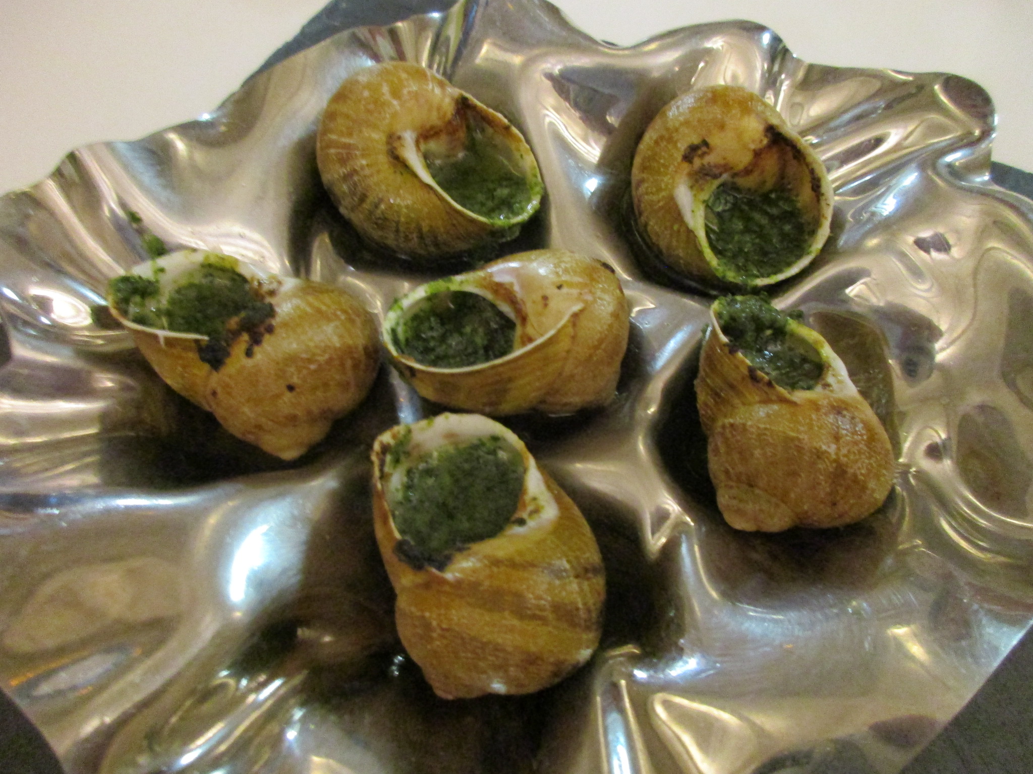
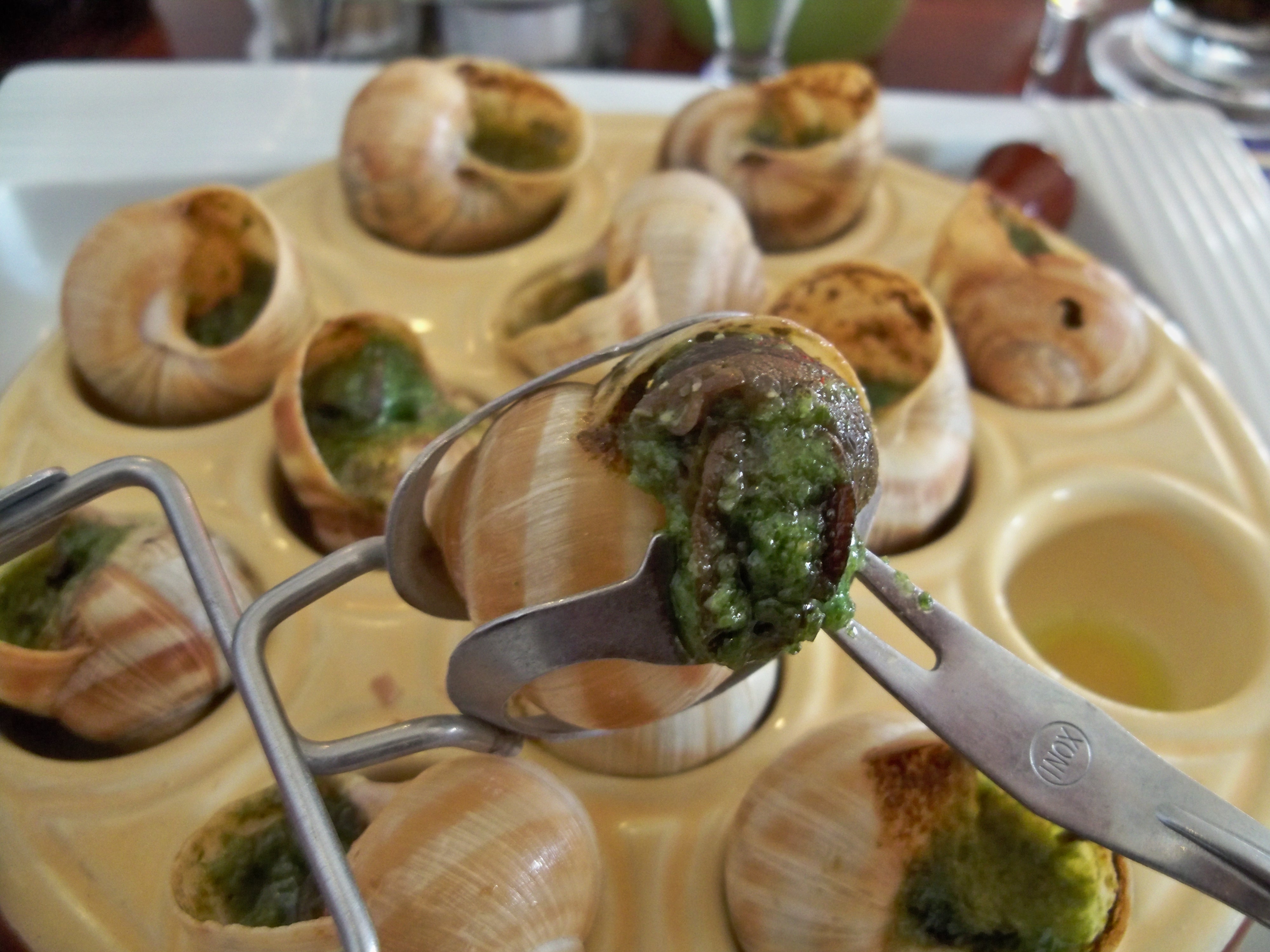
| | | | I finally did so in January. Le Rivage (top link) has been on New York's Restaurant Row, 46th Street west of 8th Avenue, since 1984. It was freezing weather outdoors, and the cozy French country atmosphere (middle link, facing inward) was both welcoming and charming. The paintings around the room (bottom link, facing outward) brightened the atmosphere. I sat at the small round table, left center in the picture. Not only were both items of interest offered, they were also included in the three-part prix fixe menu. | | | | In 2018/12, I described Escargots à la bourguignonne (Photo by Arnaud 25). I said: It's essential, to get it right, which means they should be served with generous amounts of beurre à la bourguignonne, which translates as butter, Burgundy style, but which means butter and garlic, pounded into a paste, and served, as the picture shows, with parsley. Usually, parsley is an herb that doesn't impress me, but it's important here, so let's call it parsleyed garlic-butter. The escargots, usually a half-dozen, are baked in their shells, which adds so much to the atmosphere of the dish. We can now also show escargots in preparation, filled with still-unmelted beurre à la bourguignonne (Photo by Deror avi), and also the two utensils needed, the escargot tongs and fork, used in this manner (Both photos by Marianne Casamance). The first link below is an actual photo of this dish from Le Rivage, also showing the tongs and fork.
https://media-cdn.tripadvisor.com/media/photo-s/13/1e/e6/f0/escargot.jpg
https://irepo.primecp.com/2016/11/307429/Beef-Burgundy_ExtraLarge1000_ID-1964144.jpg?v=1964144
| | | | I'd also been sure in France that at some point we'd have Boeuf bourguignon, or Beef Burgundy, beef stewed in red wine (second link above; this picture is more accurate than the one in 2018/12). You'll note the beef is served on noodles, and that carrots, pearl onions, and mushrooms are a major part of it, all in a deep brown gravy. That's just what I found at Le Rivage—again, an actual picture from there is the first link below.
https://media-cdn.tripadvisor.com/media/photo-s/11/c1/ff/ec/beef-bourguignon.jpg
https://media-cdn.tripadvisor.com/media/photo-s/11/c2/00/03/bread-pudding.jpg
| | | | I might not have ordered dessert, but it was included as the third course of the Prix Fixe Menu, and I'm glad it was. I chose the rather unique, thinly-sliced bread pudding with crème anglaise and raspberry sauce (second link above). This dinner made up for what I missed having in Burgundy. Vive la cuisine classique! | | | | Coquille Saint-Jacques I don't really mean to make this a series of restaurant reviews, but this still connects with my comments on French food. Of the other French dishes I mentioned based outside of Burgundy, I really wanted to also try again a nice Coquille (ko.KI) Saint-Jacques, based on sea scallops. I was going to be in the north of Greenwich Village, and Googled the name of the dish. I came across a wine bar and restaurant called Saint-Tropez on West 4th Street and decided to try it.
https://moon.com/wp-content/uploads/2015/08/01_02_WVillage_Soho.jpg
| | | | What happened to me on the way I found really quite amusing, but wholly predictable and understandable. I refer back to the above map we used in 2018/3. My errand was at 14th Street and 8th Avenue, so I walked down 8th and turned on to West 4th. Saint-Tropez was ahead, just south of West 12th. But remember we said in the renaming of Greenwich Village streets many years ago, West 4th, which ran west like the other numbered streets, had its name extended and recklessly superimposed on what had been Asylum Street, that ran north instead (2018/4). In that way, this end of West 4th actually intersects now with West 10th, West 11th, and W 12th Streets (Photo by WindowsWizard12). | | | | But for me, that was all on paper, yet on this evening I lived it. Crossing the W4 & W12, I was stopped by a confused woman who asked me which direction 19th Street was. I pointed her to the north and told her to ignore West 4th and to pay attention to West 12th Street, since that would be just a few blocks' walk to 19th. I continued smiling to the restaurant. West 4th Street had struck again to find another directional victim!
http://foodandsens.com/wp-content/uploads/2017/12/St-Tropez-Int-DR-with-windows-by-Michael-Tulipan-800x534.jpg
https://thenypost.files.wordpress.com/2017/12/st-tropez-int-w-bar-2-by-michael-tulipan.jpg?quality=90&strip=all&w=618&h=410&crop=1
| | | | Saint-Tropez turned out to be a small charmer of a place with a beamed ceiling. The first picture looks to the right of the wine bar proper, out onto West 4th. The second picture looks to its left, toward the open kitchen. The table I sat at would have been to the lower right, but removed to be able to take the picture. | | | | The food was exquisite. I started with a Tartelette aux Escargots, which came in a palm-sized pastry shell. With the escargots were some tomatoes and zucchini, but oddly, the dish had a sweet taste! There must have been some honey included. Delightful.
https://njbrown.files.wordpress.com/2012/08/dscn1721a.jpg
| | | | The Coquille Saint-Jacques was also excellent, though the presentation was other than the type I expected, as I explained to the waiter afterward. I'll copy both pictures from earlier. Above is the type I was hoping for, made by Julia Child, where the scallops are baked in a cream sauce and served in the shell-shaped dish (coquille) they were baked in. Instead, the Saint-Tropez served the other kind, that looked more like this (Photo by stu_spivack), large scallops in a brown sauce with veggies. Saint Tropez calls its version "Wild Scallops with truffle celery root mash", in other words, it looked like mashed potatoes, but was really celery root (more popular in Germany, where it's called Sellerie). It was outstanding, but not the presentation I had expected. A nice glass of sancerre, a favorite Loire white, complemented the meal. | | | | Things were going so well, I wanted to try a cheese course. Saint-Tropez has an intriguing proposition. They offer five cheeses and four meats (including pâté de campagne) that you can mix and match, at a set price for each. You'll remember my enthusiasm for all the cheeses on the Luciole, but I just wanted a single cheese, and didn't recognize most names, so I asked the waiter if one was a blue cheese. And so I ordered a Fourme d'Ambert (Photo by Hégésippe Cormier), which was served in a very generous portion, contrary to what many restaurants do. I since read it's one of France's oldest cheeses, dating from Roman times. Its blue veining is due to Roquefort spores. I'm also quite pleased to have found this picture of Fourme d'Ambert (Photo by Havang[nl]) for sale at the Bastille Market on Boulevard Richard Lenoir, which we recently discussed. Small world. | | | | Former Student Indicted & Arrested On 25 January this year, just six days before this posting, a former student of mine who had taken three years of high school German with me in the late 1960s and had graduated in 1970, was—at long last--indicted and arrested at his home in Florida. Nine FBI agents in full body armor woke him up at dawn in Fort Lauderdale, he was arraigned the same day, and is now out on bail. The paper in Westchester County, where I taught, reminded its readers the same day that the former student had been a 1970 graduate of John Jay High School. | | | | Using the heading "Finally!!", I immediately emailed Terry Johnston in Florida (see 2017/17 "Eclipse"), the colleague and friend who started teaching the very same day I did at JJHS in September 1964 and had taught chemistry--but not to this student, as he's pleased to say. He emailed back saying that, as his eyes opened in bed that morning, his wife Peggy said words to the effect of "They got him!", and he knew exactly who she meant. I'm sure other teachers and students of the era were equally relieved. | | | | Any reader in the US who's followed the news—and, I'm sure, many outside the US—know that the former high school student we're talking about is Roger Stone, confidant of Donald Trump. Stone was arrested in connection with Robert Mueller's Special Counsel investigation and charged in a seven-count indictment: one count of obstruction of an official proceeding, five counts of false statements, and one count of witness tampering. | | | | Stone has proudly described himself as a "dirty trickster" (I never knew that was a profession!), someone who would do anything to win, no matter how dishonest or unethical. Those of us who knew him back then all heaved a sigh of relief, seeing this coming down the pike for decades, and just watching and waiting. Stone was even back in the day a quintessentially political person, espousing a "with us or against us" attitude. It's totally revealing of his character that he's always been a great fan of disgraced president Richard Nixon, and regularly referred to him reverentially as "Mr Nixon". Coming out of the courthouse on Thursday, he did the Nixon "V" salute, his arms in a V and each hand showing Vs. He even has Nixon's face tattooed on his back. | | | | He has been referred to in media as a "political fixer" and a "seasoned practitioner of hard-edged politics", terms which unfortunately are accurate. But my favorite is when he's been referred to as a "mendacious windbag", which is equally accurate, and tells so much more. He has described his methods as "Attack, attack, attack – never defend" and "Admit nothing, deny everything, launch counterattack." During the 1972 Nixon campaign, Stone hired a spy to drive for Hubert Humphrey. Stone was fired from the Bob Dole campaign when a columnist revealed Stone's dirty tricks. And on, and on. However, Stone maintains he never did anything illegal during Watergate. That may be perfectly true. But he didn't say "immoral" or "unethical". | | | | Actually I got along with him reasonably well in class, and he would on occasion stop by after class for a word. He'd also sometimes stop in my room for a chat at lunchtime. I didn't particularly care for him yet I got along with him reasonably well at the time. I didn't yet have the total disdain for him I now have. | | | | But even in his JJHS years he already showed signs of what he would later become. My two best recollections of Stone are these. When he ran for president of the student council, there were lots of rumors at the time of the dirty tricks he later became infamous for in his so-called career, such as lying about opponents and other "fake news". Such creative tricks and underhanded tactics to win elections are abhorrent at any time and place, but particularly disgusting in student elections, where the school is trying to teach about democracy. | | | | The other point shows what a political animal he was. When I played for the German class the tape of the end of Kennedy's famous speech in West Berlin ending with "Ich bin ein Berliner", he actually had the—stones--to come up after class and very seriously ask me why I didn't also play a speech by "Mr Nixon". He so obviously missed the entire point of the exercise, and was just looking for equal political time. | | | | I am today in regular touch socially with a former musically-inclined student who also was in my German classes in that same era. He wrote me that on hearing the news, he immediately wrote the following comment about Stone to the New York Times to be appended to an op-ed article: | | | | | | I have a unique perspective on Roger Stone. We went to the same high school in the northern Westchester hamlet of Cross River. Not only that: we rode the same school bus. He astonished us daily with his displays of braggadocio, fustian and general obnoxiousness, brandishing Nixon banners and spewing Republican talking points while the rest of us attempted to block out the background noise and attend to our studies. His unsuccessful run for president of the student council was I assume the only time he attempted to reach elective office. The vast majority of students had already seen into his toxic core. When he eventually started to emerge as a familiar media presence I could only laugh and nod knowingly. He had always been "Roger Stone." |
| | | | (It's a bit difficult to find the comment online, but if you wish to do so: go to the NYT online; search for Gail Collins's Op-Ed article "If Trump Were Tony Soprano . . . "; at the bottom, click on "Read 650 Comments"; scroll down sufficiently so that a good number of comments have loaded; Find (Ctrl-F) "I have a unique".) | | | | It's been a half-century since those JJHS events, roughly 1969 to 2019, and there are different recollections about Stone's running for office. I only remember the rumors of dirty tricks, and the former student remembers that Stone was unsuccessful in becoming student council president. But Terry remembers an alternate scenario: | | | | | | I recall Stone’s Student Council election differently . . . In my version, during his junior year he was the VP of the council. He managed to get . . . the then president of the council sacked by the school administration for having a beer or something at a weekend party. Stone then took over as president and ran again during his senior year. I recall sitting in the auditorium when the candidate speeches were given during his senior year. Stone came out to a quiet house when introduced but which erupted when he did his Nixon “V” salute while running about the stage. His latest bit outside the courthouse reminded me of that. |
| | | | In any case, this summary of recollections paints a picture of a Roger Stone pulling the same sort of stunts in his high school years as what he proudly continued doing later. It makes you wonder what his elementary school years must have been like. | | | | | | UPDATE: I just found the answers online to the two issues. Stone has apparently said that it was in elementary school in 1960 that he broke into politics, but in favor of Kennedy and against Nixon!! He has said: "I remember going through the cafeteria line and telling every kid that Nixon was in favor of school on Saturdays ... It was my first political trick." The same online source states that "[w]hen he was a junior and vice president of student government at his high school . . . , he manipulated the ouster of the president and succeeded him. Stone recalled how he ran for election as president for his senior year: 'I built alliances and put all my serious challengers on my ticket. Then I recruited the most unpopular guy in the school to run against me. You think that's mean? No, it's smart.' " Thus it seems that there is truth in each of the above recollections, though I have no indication that he was actually elected to president of the student council in his senior year, exactly a half-century ago. But if I had to guess, he probably weaseled his way in. |
| | | | I find it also odd to picture that for fifty years, while those of us from JJHS, faculty and students, knew about him and would take note whenever he popped up on television or in the papers like a Whac-a-Mole, the general public by and large knew or recognized little. I never had reason to mention Stone to friends or family—who would have known the name anyway? But of course, now things are different, I'm glad to say. Everyone I know now knows the name Roger Stone, not just us from back in the day. | | | | Still, just today, my niece-in-law Rosemary found she had landed on some conservative mailing list and ended up getting a letter from Stone claiming he was broke and needed cash for his legal defense. He used as a closing before his name "In liberty", something I've never seen before, but which seems to be a euphemism for "I've been caught! Send money!" | | | | Similarly, Terry reports: A cartoon in yesterday’s paper showed two men talking as RS walks away after bumping them as he walked by. The one man says “I always heard that Roger Stone was never polite!” Roger walking away is saying over and over, "Pardon me. Pardon me! Pardon me!!" | | | | It's also hard to picture that, just two days after the arrest, during the cold opening on Saturday Night Live, none other than a nationally known comedian like Steve Martin would do a parody, in black-rimmed glasses, with white hair, and with all those gestures, of a kid that sat in my class and whose exams I marked. | | | | Here's something for you to form a mental image of. I've recently been shown a group picture in costume of a production of the Fantasticks at John Jay High School circa 1970. It includes Stone in a top hat, when he would have been a senior. | | | | Everyone who knew Stone seems to agree that the indictment and arrest couldn't happen to a more deserving guy. Well, maybe with one exception. | | | |
| |
|
|
|

