|
Reflections 2020
Series 2
April 17
Everglades – Tamiami Trail - Miami/Dade County – Miami Downtown: Two Grids
| | We left off in the last posting where Henry Flagler was spreading fancy hotels and rail track down the east coast of Florida in the late 19C. Keep our below Florida map available to follow along:
http://www.orangesmile.com/common/img_city_maps/florida-map-0.jpg
While Jacksonville, lying in the "Panhandle Plus" strip of northern Florida (as opposed to the huge Peninsula and tiny Keys), had earlier been the place in Florida to vacation, he kept on changing what the most "in" place was by building new ones further and further south. Thus Jacksonville declined as a destination, and even Saint Augustine with Flagler's prize hotel, the Ponce, declined when new destinations appeared further south still. His associate from Cleveland, John D Rockefeller, was satisfied building his own mansion, the Casements, in Ormond Beach, relatively in the north, but Flagler soldiered on down to his new prize destination, Palm Beach. There he not only built two splendid hotels, he also built his own mansion, Whitehall. He founded twin cities there, Palm Beach for the wealthy on the outer peninsula, and West Palm Beach on the mainland, on the other side of Lake Worth, as a more diversified city. He'd been financing his railroad personally, but finally decided to incorporate his holdings in 1895 as the Florida East Coast Railway (FEC). Its tracks ran a little further south than West Palm to the City of Lake Worth.
| | | | Let's not forget Henry Plant. His Plant System railroad went down the west coast of Florida to Tampa (actually Port Tampa), where his shipping line took over in order to reach Key West, Havana, and beyond. But we need to remember what happened post-Plant, when in 1927, the Plant System was combined into the Seaboard Coast Line (SAL). One route went further south on the west coast, but was not successful, but another route went down the east coast and paralleled Flagler's line. Thus, West Palm Beach was and remains the start of two parallel rail corridors going down to Miami. | | | | But we're getting ahead of ourselves. Flagler arrived in Palm Beach in 1894, then built his two hotels and Whitehall. True, he had a state charter to continue building further, but people wondered, would he? Plant had only come as far south as Tampa, and Flagler's Palm Beach was already considerably further south than that. With today's hindsight, of course, we can't imagine that he wouldn't want to reach the tiny village of Miami, even Key West at the far end of the Keys. But should he? Would he? Floridians weren't so sure at the time. He'd built his own house in Palm Beach. Why go further into peninsular Florida? Even West Palm Beach already bordered on the marshlands of the Everglades. Was forging thru more wetlands really worth it? Remember, all of central east Florida from Daytona to Palm Beach and inland to Orlando was once part of historic Mosquito County. | | | | | | I have to insert here the story of the time Beverly and I visited Everglades National Park. As in many NPs, there were little nature trails off the main park road, and we stopped at one that was on a low boardwalk in a loop that returned to the car, promising sights of flora and fauna. We'd been forewarned about bugs, and sprayed each other with bug spray before leaving the car. We even carried the spray with us. Maybe halfway around the trail, we were suddenly attacked by a primal swarm of mosquitoes, more than I'd ever seen at once. They settled on our heads, arms, torsos. Perhaps we had 15-20 mosquitoes on each of us. We were flailing and swinging at them and even used more bug spray right at them, but they were voracious. We had to run the rest of the loop back to the car to get away from them. Now this is NOT typical for Florida today, and it was the only time it happened in all the years we were in Florida. But I can understand why historically, there was a place further north in central Florida named Mosquito County. We'll talk more about mosquitoes at another time. |
| | | | As we've said in the past, there are three parts to this trip: Miami Downtown (including Brickell), Key West (including the Keys) and South Beach, which is the downtown of Miami Beach and has a huge amount of Art Deco to enjoy. Planning the trip, dumb luck reigned. I'd been to Miami many times, and originally planned just one night there because the Silver Star arrived in the evening and I'd get my car rental for the Keys the next morning. On a hunch, I'd instead planned two enjoyable nights in Miami, and it led to a great deal of understanding about downtown, since in the past I'd visited outlying areas and had only driven thru downtown without stopping, in order to look at sights from the car. On the current trip, I also had the best meal of the trip in Miami. | | | | Alternate Chronologies Most narratives, fiction or nonfiction, are told in linear fashion, in chronological order: 123456789. One narrative technique is the flashback, where a piece of the action is held off to be described later, and told out of chronological order: 2345-1-6789. But there are other, rarer, techniques.
An unusual technique is reverse chronology: 987654321. The only example of that that I'm acquainted with is Harold Pinter's play and film "The Betrayal", about a love triangle told in reverse order. It starts with a couple in an apartment breaking up, then moves scene-by-scene backwards dealing with the triangle until the final scene, where the young couple meets for the first time in the apartment. It's unconventional—which is what makes it fun--but is very effective.
I also have just a single example of another, perhaps even more unusual technique, which I'll call scrambled chronology, something like: 374861295. It's as though you took all nine chapters of a work, tossed them on the floor, and picked them up piecemeal to read. I'd call it a further extension of reverse chronology. My single example is the 1967 British Film "Two for the Road", with Audrey Hepburn and Albert Finney, which I remember seeing at Radio City Music Hall. Each scene involves a vacation trip from England to the French Riviera in different years. Continuity is maintained by the familiar route, stops, and the destination. But the scene with the first trip--I think it was a loving honeymoon trip--is somewhere in the middle, as is the final one, where the relationship has died and they're cursing at each other. Scrambled around these are the other scenes, also out of order, but by the end of the film, everything fits together in the viewers mind.
While these two techniques are unusual, they work closer to how life really works. When we get to know a couple as friends, over time we hear bits and pieces of their story. Friends almost never give a linear narrative of their biography.
This is even truer about history. Few educated people sit down and read a linear history of, say, France. But we learn over time about Vichy France, about Joan of Arc, about Napoleon in Elba, about the French Revolution. And as we learn these things out of order, we assemble in our mind a linear history of France.
I mention this because we're going to do that right now, as we talk about Downtown Miami and the history of South Florida. Our discussion will not be linear, from settlement to today. It'll be mostly scrambled chronology, maybe with some stretches of reverse chronology within it. We'll concentrate on three periods of interest. We'll discuss Downtown Miami today; in its heyday of the 1920s; and in the 1890s, when Flagler and the FEC arrived in Miami to greet Julia Tuttle and the Brickells. And we'll jump back and forth to some extent. Even now, I've just mentioned names from the 1890s that we've never discussed, but which will sound familiar when we get to that period—look at them as flashbacks as yet unexplained. I find that this unusual chronology solves my problem of the best and most comprehensible way to present a rather interesting story.
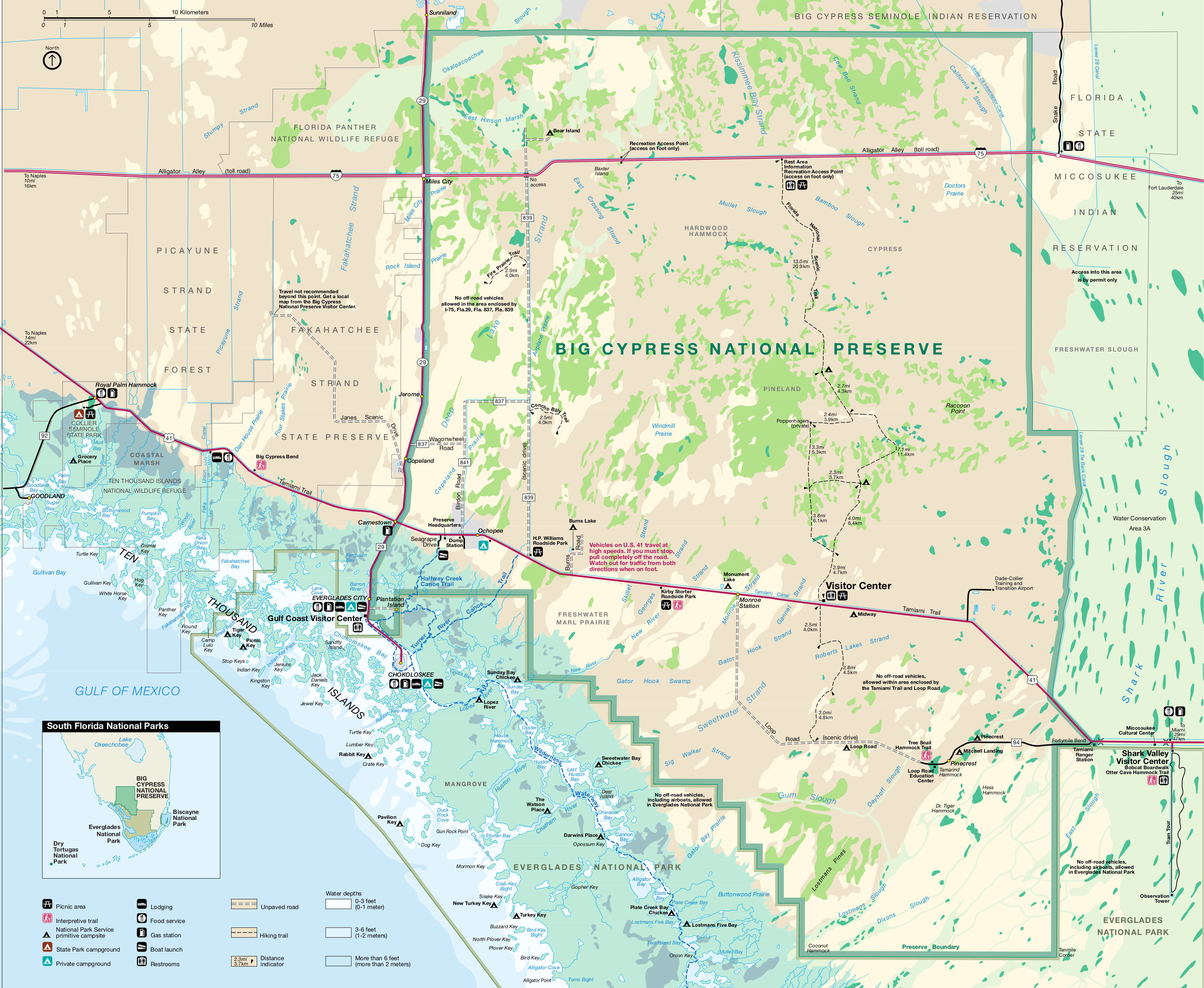
| | | | The Everglades Refer back to our Florida map and once again to the southernmost part of the peninsula, south of Lake Okeechobee. The symbols indicate that all of this area is the Everglades. To remind ourselves about this natural wonder, look again at these two maps from the previous posting. This is a more detailed map of the Everglades (Map by Kmusser), showing just where (click) Everglades National Park (with Cape Sable) and Big Cypress National Preserve are located, and also where the heaviest agricultural area is (in gold), primarily for the sugar cane industry, whose drained area is one of the major factors in interrupting the 6,000-year southerly flow of water to the south.
https://www.sciencenews.org/wp-content/uploads/2018/08/081818_everglades_water-flow-map.png
This other set of maps from the previous posting elaborates on where the water traditionally flowed to the sea, and how the agricultural and other man-made areas using drainage canals to get rid of the water has interrupted that flow.
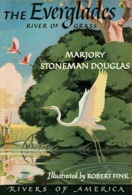
| | | | For the longest time, people didn't realize the value of the Everglades as wetlands, which accounts for the human encroachment, since wetlands were considered wasteland. That began to change with Marjory Stoneman Douglas in 1947, who came to be known as the Grande Dame of the Everglades because of all her activity in its favor, particularly her seminal book The Everglades: River of Grass--here the first edition dust jacket. And it's worth pausing a bit to tell that story. | | | | There's a series of books called the Rivers of America, that tells about US and Canadian rivers, but for the most part written by literary figures rather than historians. The series spanned three publishers and thirty-seven years, describing 65 rivers in 65 volumes, of which "Grass" was the 33rd. Stoneman Douglas was a freelance writer, and her friend was an editor responsible for the series. He asked her to write about the Miami River in downtown Miami, but she didn't find it interesting enough, calling it only "an inch long". But she did begin learning more about the Miami River, whose flow is amplified by drainage canals from the Everglades (see "Miami Canal" on the FL map), and she instead suggested to her editor that she write a story about the Everglades. | | | | In it she asserted that the Everglades was a river, a "river of grass", a term she coined, and she described the degrading of the Everglades and defended it against further efforts to drain it and reclaim land for development. "Grass" redefined the popular conception of the Everglades as a treasured river instead of a worthless swamp. The book's first line, "There are no other Everglades in the world" has become seminal. Its impact is still felt as it is claimed to be a major reason Florida receives so many tourists. The 1926 house she lived in and wrote her works, including "Grass", is a National Historic Landmark. It's in the southern part of Coconut Grove in Miami, where she died at age 108 in 1998. She received numerous awards, including the Presidential Medal of Freedom. In her centennial year, 1990, a high school was named after her in Parkland FL, inland from Boca Raton north of Miami. Unfortunately, Marjory Stoneman Douglas HS was the scene of a deadly mass shooting in 2018. | | | | There are other unpopulated or sparsely populated natural phenomena that separate urban areas. Think of a desert, or of an ice sheet in Greenland. Now look again at the FL map and see that that's exactly what the Everglades does in the southernmost part of Florida. Areas of minor to great urbanization surround Lake Okeechobee and the Everglades like an arch. And so we now come to the question of how we connect via land travel Florida's urbanized west and east coasts here at the southern end of the peninsula. Plant considered crossing it by rail, but that never happened. Even when SAL decided in the early 20C to go to the east coast, their line ran north of Lake Okeechobee (see FL map) as it still does for Amtrak service. As for highways, we have two, and again, we'll take them in reverse chronological order—the newer one first. | | | | Alligator Alley Long-distance overland routes to Miami come from the north and from the west, not counting the much more local route from the south coming up from the Keys. All rail traffic comes from the north, as does a great deal of road traffic—the FL map shows I-95, and the traditional route is US1, which I have used. Coming from the west, there's no rail—even SAL had to go around Lake Okeechobee—and just two roads.
I have driven many times from Tampa Bay thru the Everglades, either to Miami to visit Beverly's relatives, or beyond to the Keys, which, as we just said, can only be reached by land via Miami, and in some ways works as an appendage to Miami. We usually took the Tamiami Trail. Only once did we do a round trip via Alligator Alley, and I find its only advantage is speed, since it's an interstate highway. But travelers don't necessarily need speed, especially if they want to enjoy the region.
On the FL map, follow I-75 coming down the west coast, passing the Tampa area where we were based, then continue down to Naples. On every trip, this was the coastal route we took, for speed. But on that one trip, we decided to try Alligator Alley instead of our usual route. That simply involves staying on I-75 once it turns east, since that's the name of the east-west segment of I-75 that crosses the Everglades. That segment opened in 1968, and was upgraded between 1986 and1992. As part of the upgrade, many bridges and culverts were added to let water and wildlife pass underneath the roadway and to permit the natural flow of the Everglades' waters.
I found the experience to be confining, since Alligator Alley, in its 121 km (75 mi), has only two interchanges connecting with local roads. There are three rest areas, and some scenic outlook points, but they don't much reduce the boredom. Most of it is straight-as-an-arrow, (Aerial Photo by formulanone) good for speed, and also good for a hypnotic effect on drivers. It also is the only part of I-75 within Florida that charges a toll. Finally, the road ends in the Fort Lauderdale area, which is out of the way for Miami, and certainly for the Keys.
In sum, when crossing the Everglades, I heartily recommend the older, slower, narrower, and more winding Tamiami Trail (below) to Alligator Alley.
| | | | | | Of course, we cannot avoid discussing the name, which illustrates a fundamental quirk of human nature. People find they dislike something and insult it with a put-down. Then over time, that put-down becomes not only generally accepted and in daily use, but then becomes the official name. To wit:
When the road was being built, it was very controversial. None other than the American Automobile Association believed it would be a road to nowhere and useless for cars, merely an "alley for alligators", a nicely alliterated put-down. But the put-down became generally accepted, and the state made Alligator Alley the official name in 1966, two years before it opened (Photo by formulanone).
I first experienced this phenomenon years ago regarding the Cow Palace, an arena that originally was to be called the California State Livestock Pavilion in San Francisco, completed in 1941. It's held sporting events, and national political conventions, which is where I first heard about it. As it was being planned, back in the depression year of 1935, a local newspaper asked, "Why, when people are starving, should money be spent on a 'palace for cows'?" The name stuck and thus the arena is still called the Cow Palace (Photo by Dante Alighieri). Note how similar the original phrases are: "alley for alligators" and "palace for cows".
One last one that's much more historical, and goes back to the 12C-15C. The current architectural style had been the Romanesque, characterized by gentle curves and semi-circular arches. As of the 12C in France, a new style appeared, characterized by sharp lines and peaked arches. A pejorative term came about as a put-down for this new style. Since the Goths from Northern Europe had been held responsible for destroying ancient buildings after their conquest of Rome, this new architecture was referred to as Gothic, which at the time could hardly be a more contemptuous term, implying barbarous and rude. Yet today, Gothic architecture is one of the more popular of the historic styles.
|
| | | | Tamiami Trail Much more on a human scale is the Tamiami Trail, also nicely alliterated. Just as the Alley is no alley, the Trail is no trail—both words are there for alliteration. When originally built, the Tamiami Trail was meant to connect Tampa and Miami—hence the name, which sounds like you're saying Tammy Yammy as a rhyme.
http://i1.wp.com/richsride.org/wp-content/uploads/2013/02/google-tamiami.png
This map shows the Alley in white, and the Trail in blue, which goes more directly to Miami, and by extension, to the Keys. Technically, the Trail still connects the two cities, but de facto, it's become a misnomer, since that's not what people think—they picture a route thru the Everglades, as shown. All of the Trail is part of US 41, but let's picture it in three parts locally. From Tampa south to Naples, you don't hear people referring to US 41 as the Tamiami Trail. Actually, I've never driven that stretch, as I always used I-75 to get to the Naples area, no matter how I continued beyond there.
| | | | On the eastern end, the Trail reaches the western side of the metropolitan area at Krome Avenue, also known as State Road 997 and the equivalent of SW 177th Avenue, so it's that far west of downtown. At this point, the Trail is technically still called the Trail as it goes down SW 8th Street, now more famous as Calle Ocho, the Cuban-American enclave, but I've never heard anyone going out for a Cuban meal on Calle Ocho say they're going to the Trail for dinner. Thus on a practical basis, the Trail is really the stretch of US 41 within the Everglades as shown on the map. The Tamiami Trail is the quintessential road to enjoy the Everglades. | | | | The Trail was built in fits and starts, and when it officially opened in 1928, it was considered a feat of engineering, most likely because of this unique section thru the Everglades. The Tamiami Trail has been designated a National Scenic Byway for its unique scenery in the Everglades—a section of it forms the northern border of the National Park—and it crosses the Big Cypress National Preserve. Because less attention was paid to environmental concerns earlier on, the Trail blocked north-to-south Everglades water flow, but in recent years, sections of roadway have been elevated on a causeway to improve the situation. | | | | This is the Tamiami Trail (Photo by Adbar) in the Everglades looking eastbound toward Miami within the Big Cypress National Preserve, tho at this point, the NP is a short distance to the right. It is possible to spot wildlife here, in my experience, mostly herons and other birds. Unlike Alligator Alley, the Trail is only one lane in each direction as it winds naturally thru the landscape. It has no fences to keep wildlife from traversing it so the same precautions have to be taken as in any wilderness area. It might take a little longer to cross the peninsula, but you can enjoy nature on the way.
When reaching the metropolitan area at Krome Avenue, only once, on a business trip with friends, have I continued straight ahead via Calle Ocho to downtown Miami. Otherwise, Krome is always a right turn, either for a short distance to go east again to visit relatives, or to go straight on to the Keys.
| | | | The meaning of "Everglades" is not always clearly apparent, which is a shame. While a glade is a clear, open space in the woods, in American English a glade has also described, since first recorded in 1789, a "tract of low, marshy grassland". By 1823, it was joined with "ever" (in the sense of "endless") to describe an everglade (singular), an "endless low, marshy grassland". But that is today mostly an archaic usage, since the word then went plural with a meaning usually limited to the landscape in South Florida, unique because of its vast size. Thus the Everglades, plural, theoretically refers to one everglade after another, endlessly across the landscape. A literal updating of the poetic name "Everglades" might be "Endless Wetlands". | | | | We have a map centering on the Big Cypress National Preserve in the west. Naples would be off to the left, and both the Alley and Trail can be seen (click). Wander about to see the local minor roads and (real) trails. See if you don't think that what there is to do on the Tamiami Trail doesn't seem to be more interesting than on Alligator Alley. Note the turnoff to the sports fishing center Everglades City, population 479, where we once stopped for a look-see. Up until 1923 its name was simply Everglade (singular). When the Trail reaches the National Park you see where it forms part of its northern border, with a northern entrance to the park. | | | | Now let's move to the east, and also a bit more to the south, with a map centering on Everglades National Park. Follow Tamiami Trail east, and see where Krome Avenue marks the de facto western boundary of the urban area. Straight ahead US 41 goes down SW 8th Street / Calle Ocho, but a turn to the south on Krome could get us to a street like Kendall Drive to visit relatives, down to Homestead and Florida City, where the main entrance to the National Park is, or further still, to the Keys. Entering the NP, you see how the park road in red leads, with many stops along the way, to the Visitor Center at Flamingo on the edge of Cape Sable. We'll discuss more later how the Main Park Road, including the short extension out to Florida City numbered State Route 9336, was, in the early 20C, the main highway connecting Flamingo, with some variations, all the way to Miami. | | | | | | Today, Flamingo is known for its Visitor Center, but before the NP was established, there was actually a town nearby called Flamingo FL, indicated on the map, which today is a ghost town. It was first settled c1892. For a name, the settlers chose the flamingo as the most distinctive bird seen in the area. It didn't breed in Florida, but birds from nearby Cuba and the Bahamas once traveled in large numbers to the area, tho large numbers haven't been seen since 1902. Life in Flamingo could be very unpleasant, since it was infested with mosquitoes and fleas. A visitor claimed to have seen an oil lamp extinguished by a cloud of mosquitoes and that the cabins were thickly sooted from the use of smudge pots against insects. The residents of Flamingo were relocated shortly after the creation of Everglades National Park.
On reflection, perhaps I should consider the above mosquito attack Beverly and I had in the NP as a reenactment of a historical event? More about Flamingo later when we talk about the FEC rail route to the Keys.
|
| | | | Unusual Counties This far south in Florida there are just two counties coast-to-coast, Monroe and Miami-Dade, the southernmost pair in the state. Both are unusual because of the Everglades.
https://www.mapsofworld.com/usa/states/florida/maps/monroe-county-map.jpg
Monroe County is perhaps geographically the weirdest county I've ever seen. Its mainland area is sizeable and takes in a good part of the Everglades. But Monroe, curiously, also includes almost all the islands of the Florida Keys, from Key West, its county seat, east to Key Largo (the very easternmost tiny keys on Biscayne Bay—see Everglades NP map--are in Miami-Dade and in Biscayne National Park). This means that Monroe lies not only to the west of Miami-Dade, but also to its south. And there's no direct connection, so it's necessary to drive thru Miami-Dade to go between Monroe's two segments.
And it gets better. Although 87% of Monroe's land area is on the mainland, because of the virtually uninhabited Everglades, of the over 79,000 people living in Monroe County, over 99% of them live on the Keys, and the mainland population is only 60 people (!) in total (Everglades City is in Collier County).
https://www.studentnewsdaily.com/wp-content/uploads/2016/09/Miami-Dade-county-map.gif
I have two maps of Miami-Dade, but the second one is so good, that we'll use this one to ease the concept in first. We again see a lot of Everglades, and understanding that most of Monroe's population lies away from the Everglades, we begin to understand that the urban area of Miami, too, lies away from the wide open Everglades part of Miami-Dade. Now look at this map of Miami-Dade County (Map by Bastique), and the empty area of the Everglades is particularly startling. For those who want to study it in a separate window, here's the link to the SAME map:
https://upload.wikimedia.org/wikipedia/commons/7/72/Towns_of_Miami-Dade_County_Florida_800px.png
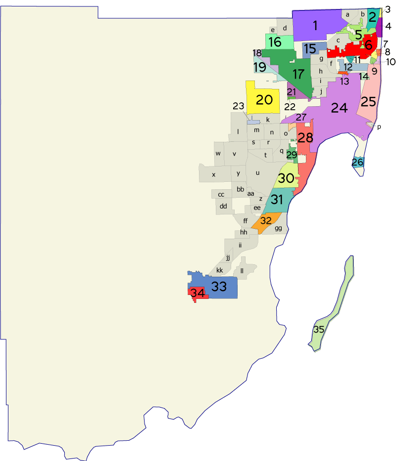
But we also see there are many municipalities here in the Miami metropolitan area. This map gives numbers and bright colors to those that are cities, towns, and villages. A myriad of lesser unincorporated areas are in gray, with letters.
| | | | | | As a point of some amusement, it's fun to point out the eight municipalities other than Miami and Miami Beach that use the word "Miami" in their names, hanging their hats on a famous name: 6 is the City of North Miami; 27 (in orange) is the City of West Miami; 29 is the City of South Miami; 5 is the City of North Miami Beach; 1 is the City of Miami Gardens; 21 is the City of Miami Springs; 16 is the Town of Miami Lakes; 12 is the Village of Miami Shores. How inventive to have found so many variations on a theme! |
| | | | I want to point out some areas of note, along with the date they were founded. In the north, 17 is the City of Hialeah (1925). The Miami Amtrak station is located far from Downtown Miami, directly abutting Hialeah, but physically in unincorporated "h", West Little River.
Way in the southern end are a pair we've already mentioned. 33 is the City of Homestead (1913) and 34 is the tiny City of Florida City (1914). Florida City is the entrance to the NP, but Homestead is larger, and is also often used to generally refer to this southern end of the urban area.
| | | | Cutler On what at first looks like a personal note, but is actually more than that, I want to point out 31, the Village of Palmetto Bay (2002), and 32, the Town of Cutler Bay (2005). | | | | | | Cutler Ridge is that rock formation upon which this area is based. However, instead of choosing Cutler Ridge in 2005 as the name of the incorporated town (a name that many locals still use) it was decided to call it Cutler Bay. |
| | | | Both these entities were incorporated after we visited the area frequently in the 1990s to visit relatives, but Beverly's brother Phil and his wife lived in what is now Palmetto Bay, and his two sons, Dan and David and their families, lived in what is now Cutler Bay. But only now have I discovered that Phil lived a mere four-minute drive from the site of the historic village of Cutler, which it behooves us to be aware of. Cutler was a pioneer town that existed from 1883 to 1915 and is now part of the Village of Palmetto Bay.
http://ontheworldmap.com/usa/city/miami/miami-dade-highway-map.jpg
On this "cluttered map" with too many bright red numbers, find Palmetto Bay and Cutler Bay (click). Then within Palmetto Bay, find the original site of now vanished Cutler, at SW 168th Street/Richmond Drive and Old Cutler Road. A cluster of buildings was located around that intersection, which included the Brown & Moody General Store, shown here in 1900; it served as the post office. Cutler served as the place where people settling in the undeveloped Homestead area went to get their supplies. However, after the Florida East Coast Railway bypassed Cutler in 1903 for the new railroad town of Perrine 4 km (2.5 mi) west, the town fell into a decline as farmers and settlers left to be closer to the railroad. Not being on a rail route in that era was often death for settlements, and those original buildings are now gone. However, the main heritage road in the area was Cutler Road, now charmingly called Old Cutler Road.
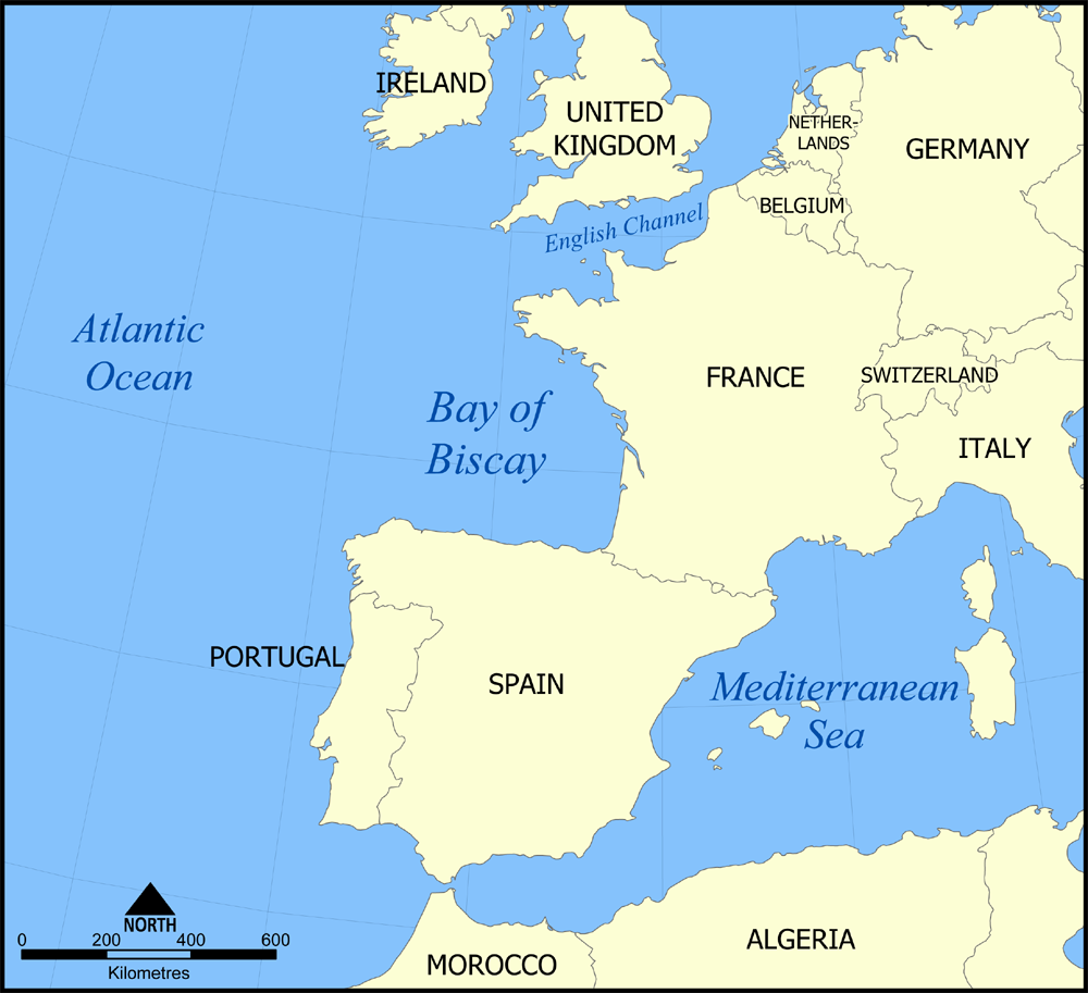
| | | | Old Cutler Road predates the Miami grid plan and runs SW-NE from SW 220th Street and Dixie Highway (see cluttered map) to the edge of Coconut Grove. In 1883, residents of Cutler cut that path northeast to what was then the independent village of Coconut Grove. This Cutler Road followed the natural limestone ridge along Biscayne Bay called Cutler Ridge, and established the first overland route connecting Coconut Grove and Cutler. It was subsequently widened to a wagon trail, and was declared a public road in 1895. | | | | In 1915, Cutler Road was extended at both ends to become a road running from Miami to Cutler to Florida City down to Flamingo and Cape Sable, and in 1916 Dade County renamed the entire road from Miami to Flamingo the Ingraham Highway after Flagler's Land Commissioner, who managed the FEC's real estate holdings. However, that unified road that continued to predate the Miami grid has apparently lost its identity. In the National Park it's been shifted slightly (all old roads show later adjustments) and is called the Main Park Road there, and from the Park to Florida City it's State Route 9336, as we saw. Beyond that, it's apparently been subsumed into the numbered grid and/or has blended with Dixie Highway, but then picks up its route—the original route—again using the name Old Cutler Road up to Coconut Grove, where part of it still is called Ingraham Highway. I believe local main streets in Coconut Grove, Brickell, and downtown Miami complete the route of this historic road. Since this oldest part of the road, Old Cutler Road, maintains the appearance and atmosphere of a country road along much of its route, it functions as a heritage road, and was declared a State Historic Highway in 1974 by the Florida Legislature. This is Old Cutler Road (Photo by Averette) passing thru a tree tunnel in Coral Gables as it approaches its northern end (under that name) to end at Coconut Grove. I've driven most of Old Cutler Road and it is a pleasant experience. | | | | The Big Three We now come down to the Big Three within Miami-Dade. 28 is the City of Coral Gables (1925). It's an independent city of great style. The downtown is at its northern end and its lush elegance contrasts starkly with adjacent Miami neighborhoods, some of which tend to show their age. The contrast is very obvious when you drive or walk across the city line into "the Gables". Over the years, I've enjoyed visiting and dining in the Gables, and in 2011, on the way to board the Regatta in Port Miami for the Amazon cruise, I stayed in a hotel in the Gables for the first time. I also got early experience on Metrorail and the Metromover. Rather than writing about it again here, I refer you to the original discussion in 2011/12 Ctrl-F: Coral Gables. | | | | And so we finally come to 24, the City of Miami (1896) and 25, the City of Miami Beach (1915). We'll talk more about the difference later, but do realize that, tho often envisioned as one, they are two separate cities, separated by Biscayne Bay (see FL map). We'll visit Miami Beach, specifically its downtown, known as South Beach, as our final stop in the area, and will discuss that city then. | | | | | | Any idea what ethnic group Biscayne Bay might be indirectly named after? First of all, it's named after another bay, which in turn is named after the Basques. Biscayne Bay in Spanish is Bahía Vizcaína (V in Spanish is pronounced like B, so the name is just as alliterated in Spanish as it is in English). This bay is named in turn after the Bay of Biscay (Map by NormanEinstein) adjacent to Spain and France; the Basque Country is in the corner between the two, but mostly in Spain. The Bay of Biscay in Spanish is the Golfo de Vizcaya because Vizcaya (in Basque, Bizkaia) is one of the areas comprising the Basque Country, which in Spanish is País Vasco (again, V=B). Vizcaya also appears in the name of the Vizcaya Museum & Gardens in Coconut Grove. |
| | | | It's clear from this map that Miami is the major city in the county, yet has not spread its borders to take over the county, like Jacksonville has done with Duval County, where the two are virtually contiguous. The situation here is different. The county had originally been called Dade County in honor of a man killed in the Dade Massacre in 1835 in west-central Florida, closer to Tampa, where there is a Dade City nearby. But there was public dissatisfaction with using the name Dade, since the event was not local. Also, voters wanted to use the international name recognition of Miami, so in 1997, voters changed the name to Miami-Dade County. | | | | | | We need to differentiate between two types of city-county consolidations in the US. (1) Some were born consolidated, such as Denver, Honolulu, New Orleans, and San Francisco. (2) Others merged later on, such as Philadelphia, or the unique case of New York City, whose five boroughs were merged with five contiguous counties when Greater New York was founded in 1898. (2a) One subcategory of (2) are those geographically incomplete mergers, one of which we discussed earlier: while Jacksonville merged with Duval county, four incorporated areas within the county retained their own governments, and it's the same for Indianapolis, Louisville, Nashville, and others. (2b) Miami-Dade is different in that it's a functionally incomplete merger, working under a federated two-tier government. The county government operates as a superseding entity of county affairs while lower-tier incorporated municipalities each operate their own civil and community services. Thus the map shows in gray the unincorporated entities subject to county rule, while the incorporated municipalities retain local independence. In any case, do keep in mind that the borders of the City of Miami are NOT the same as the borders of Miami-Dade County, despite the present county name, which is more cosmetic in nature. |
| | | | Atlantic Coastal Ridge One might wonder why the urbanized area of Miami-Dade is concentrated where it is. Why isn't it a wetland, like the adjacent Everglades?
https://s3.amazonaws.com/gs-geo-images/8d21c181-b33e-4766-8bc2-8ee62919d20e_l.jpg
That's due to the Atlantic Coastal Ridge (also known as the Miami Rock Ridge), a continuous 130,000-year-old limestone outcropping that ranges from approximately North Miami Beach southwest beyond Homestead into Everglades NP. Tho it's a ridge, its elevation is not high, averaging only around 6 ft (1.8 m). Yet its existence explains the growth of the urbanized area in this southwest direction, providing he former route of the railroad, and current roads to the Park and the Keys, such as Dixie Highway.
Coconut Grove We'll now make a quick reference to Coconut Grove, a part of Miami just south of Downtown and adjacent Brickell. At the Grove's northern edge is Alice Wainwright Park, and this is a view from the park atop the Atlantic Coastal Ridge (Photo by Daniel Di Palma). It shows Biscayne Bay looking toward Key Biscayne, but do notice the multiple rock outcroppings (click), which you wouldn't find in wetlands.
While the purpose of this next map is to show Miami's Metrorail (Map by User:JKan997), which we'll deal with later, we'll instead use it now to check out the underlying communities served. Downtown Miami is at the Government Center station, followed by Brickell, and shortly, Coconut Grove (the rail route then goes on to partially trace Flagler's former route to the Keys). In the Grove, judge the location of the above view across the Bay to Key Biscayne. But also note for later reference the importance of Downtown, Brickell, and Coconut Grove forming a linear unit attracting historic settlement along the west shore of the mainland on Biscayne Bay.
| | | | Miami We've been getting closer and closer to our goal, and finally come to Miami. Let's look at Miami's size as it appears today, since there have been variations over time.
Actually, the first thing we spot is what I call the Big Three, all lined up, Coral Gables, Miami, and Miami Beach. They all border the upper reaches of Biscayne Bay, with all of its artificial islands (those furthest out are real)—more on that later. We see the airport is out of town (click), like the Amtrak station (not shown) next to Hialeah. To the west is not only Flagler Street, but also SW 8th Street (Calle Ocho), which connects to the Tamiami Trail.
At the southwesternmost corner of Miami bottom center you see Old Cutler Road (unnamed) that once connected with Cape Sable and Flamingo, entering Miami via Coconut Grove and Brickell (both unnamed) to downtown Miami. A bit further inland you see South Dixie Highway, usually shortened to just Dixie Highway, the major traditional way to Homestead and the Keys, the drive we'll take later.
But what we should bring away from this map is that, tho the metropolitan area is huge, mainland Miami consists of three prongs, north, west, and south.
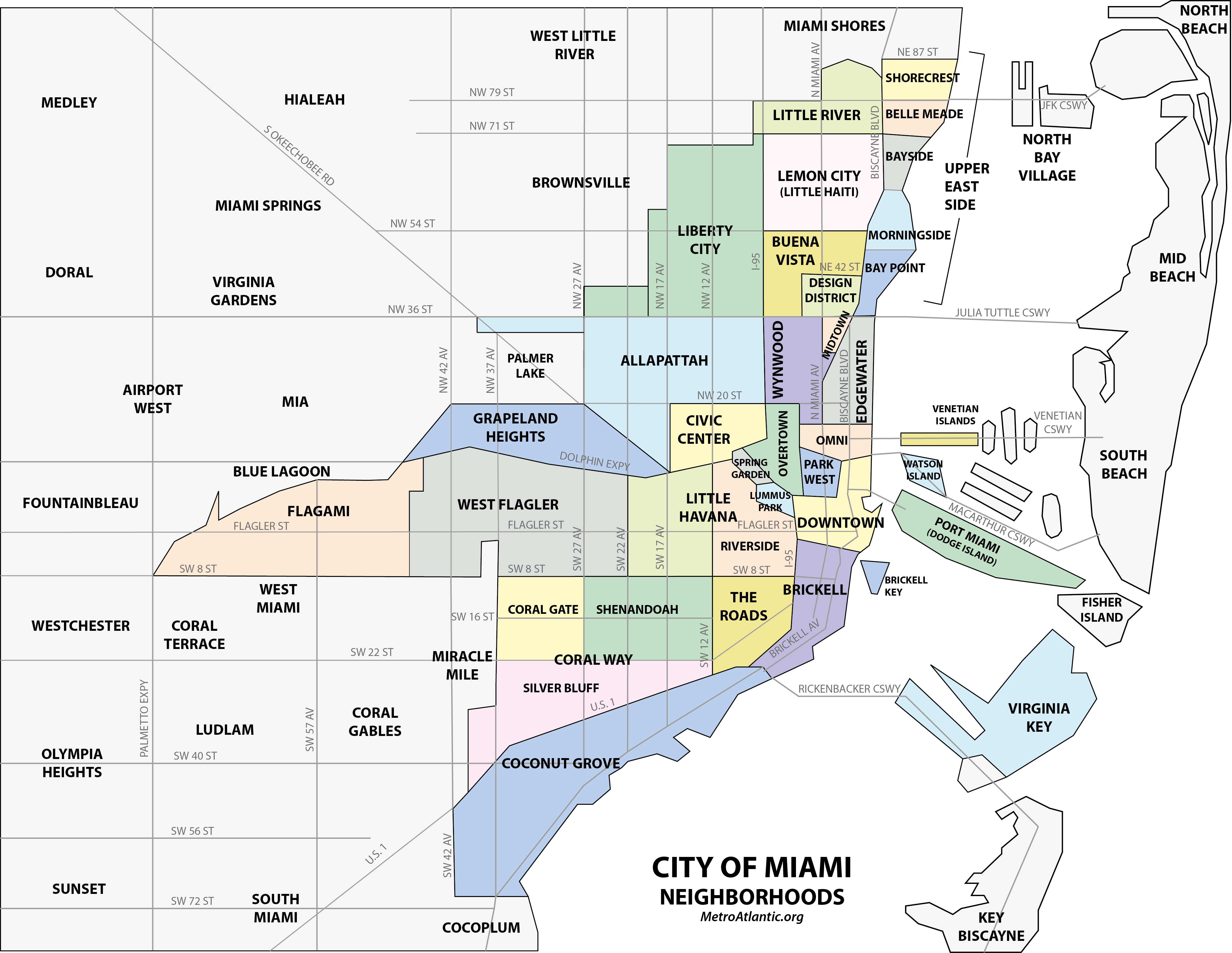
Let's break it down to its component parts, the Miami neighborhoods (Map by Comayagua99 at English Wikipedia). Once again, since we'll be talking about this map a bit and you may want it in a separate window, here's the link to the SAME map:
https://upload.wikimedia.org/wikipedia/commons/f/fa/Miami_neighborhoodsmap.png
We've already referred to our center of concentration as being Downtown and Brickell from this trip, and Coconut Grove from an earlier trip, all in a line along the Bay. We'll also mention that some of the neighborhoods to the northeast are among the poorer ones. Famous to the west of Downtown is Little Havana (La Pequeña Habana), home to many Cuban exiles, as well as to many immigrants from Central and South America. It centers on Calle Ocho, (SW) 8th Street. This is Little Havana's Domino Park on Calle Ocho (Photo by Infrogmation). Playing dominoes is a favorite Cuban pastime.
But the major use of this map is to compare how Miami grew—and also shrank a bit. To do that, we'll need a flashback from the present to the middle of the three periods we'll be talking about, the 1920s. By this time, the Miami that was founded by Flagler and Julia Tuttle in the 1890s was ready to expand from the original Downtown. In 1913, Miami started annexing towns and unincorporated areas of what was then Dade County. Up until then Brickells had resisted annexation by Miami, but their land south of the river was finally annexed. Miami added to the north up to, but not including, Buena Vista, at modern-day NW/NE 36th Street, and to the west to NW/SW 22nd Avenue (click on neighborhood map).
The 1925 annexation added (see neighborhood map) in the south the municipalities of Coconut Grove and Silver Bluff, and in the north, Allapattah, Buena Vista, Lemon City, and Little River (including West Little River) and apparently Miami Shores. And there were great plans to expand even further, as shown in this map, which unfortunately is a bit small, but still legible:
http://cdn3.volusion.com/xnfzh.nvopm/v/vspfiles/photos/FL00027-2T.jpg?1461760131
This map is undated but was apparently shortly after the 1925 annexations. "Miami Today" included the original area plus the annexations. The southern and western prongs look familiar, but look how far to the north Miami had expanded. And look at the plans for 1935! Miami wanted to eat up Coral Gables to the south, plus a huge swath of land to the west and north, all the way to the county line (Hallandale and Hollywood are in Broward County).
Of course, the 1935 expansion never took place. In addition to the devastating 1926 hurricane, the Great Depression followed. Not only wasn't any more territory added, Miami actually shrank, as it gave up its jurisdiction of both West Little River, which became an unincorporated area of what is now Miami-Dade County, and of Miami Shores, which was then incorporated as a village. Those are only the ones I could verify, I don't know if any more was given up. But since then, Miami's borders have remained the same.
It's ironic that West Little River is now the location, abutting Hialeah, of the Amtrak Station out in the boondocks that serves Miami. How ironic that West Little River was once actually part of Miami! But let's leave this flashback into the 1920s and return to the present. And we'll do so again by discussing the three neighborhoods of interest, going northward, Coconut Grove, Brickell, and Downtown.
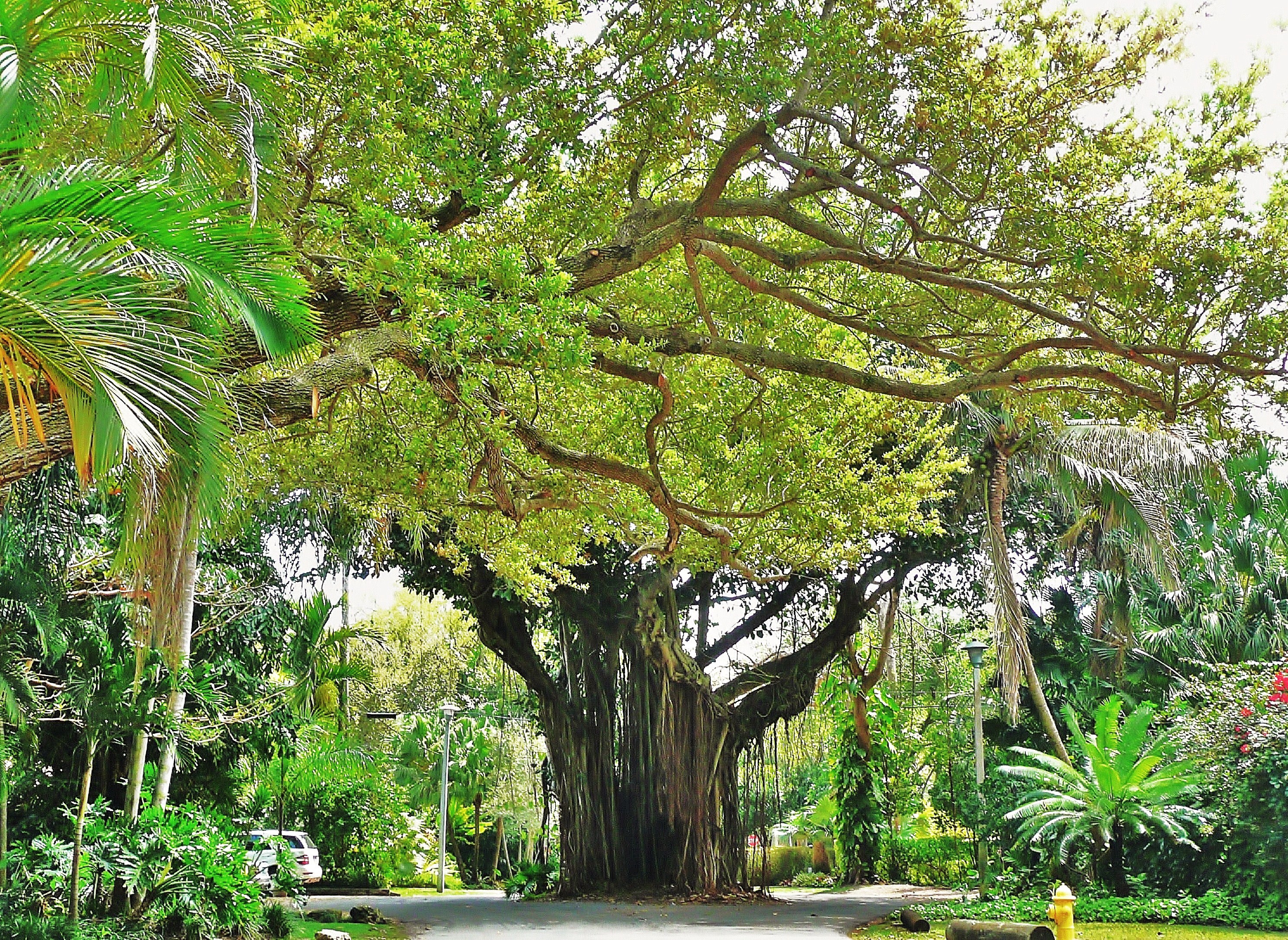
Coconut Grove We won't be visiting Coconut Grove on this trip, but I did so on an earlier trip, and it's a very pleasant place, particularly if you're looking for greenery (Photo by Averette), a pleasant stroll, restaurants, and outdoor cafés (click below).
https://www.ytravelblog.com/wp-content/uploads/2017/09/coconut-grove-street-1.jpg
I found this quote on 25 March 2020 in the New York Times: Coconut Grove [is] a haven of shade trees and cafés. . . . With its profusion of parks and shade trees, Coconut Grove is celebrated for being one of the greenest parts of . . . Miami.
http://aios2-staging.agentimage.com/o/ownmiami.com/htdocs/wp-content/uploads/2014/06/Coconut-Grove-Map.jpg
Use this "pink map" as we discuss the area. You can see how Dixie Highway forms its northern border, and also the small bit of Ingraham Highway at the bottom, which was the extension of Old Cutler Road thru local streets here and into Downtown Miami. In a side street off Ingraham Highway is the former home of Marjorie Stoneman Douglas, built in 1924, where she wrote all her major works.
We also note how extensively Coconut Grove faces the water, probably one reason why it was the site of the first non-Native American settlement in the area, in 1825, making it the oldest continuously inhabited neighborhood of Miami. It was settled in that year when the Cape Florida Lighthouse (Photo by Dr Zak at the English language Wikipedia) came into operation on Cape Florida at the southern tip of Key Biscayne (see neighborhood map to estimate the location). The lighthouse, which is now decommissioned, guided ships away from the Florida Reef, which starts near Key Biscayne and extends southward a few miles offshore of the Florida Keys for their entire length. We'll discuss the Reef when we're on the Keys.
The name Coconut Grove first appeared when a post office was given that name here in 1873. There was then an influx from Americans from the Northeast, British, and, from not far away, white and black Bahamians. Coconut Grove was incorporated as a city in 1919 using the present definitive spelling. Only rarely might one see the more awkward spelling with a "silent" A: "Cocoanut Grove", but it isn't official.
But what we know of as Coconut Grove today was formed by the Miami expansion of 1925, when the city of Miami annexed two areas of about equal size, the only recently incorporated city of Coconut Grove and most of the town of Silver Bluff (see neighborhood map to see the rest of it). As with "the Gables", many refer to this neighborhood as "the Grove".
| | | | The very first hotel on the South Florida mainland was located in Coconut Grove, a decade and a half before Flagler's Miami hotel. It was built in 1882 by a couple from London named Peacock. At first it was the Bay View House, given its location, but they eventually changed the name to the called the Peacock Inn, shown here in the 1880s. This is the Inn c1896, the year Flagler reached Miami and still before his hotel was built. The Inn is gone now, and has been replaced by Peacock Park, which, in a play on the couple's name, actually has peacocks roaming around.
On the pink map, Peacock Park is the large green rectangle to the right of the Barnacle Historic State Park, which in turn contains the Barnacle (Photo by HalWhitewyrm), the oldest house in Miami-Dade still in its original location. It dates from 1891, and its owner was neighbors with the owners of the Peacock Inn. Note that this building, too, is pre-Flagler's arrival in 1896.
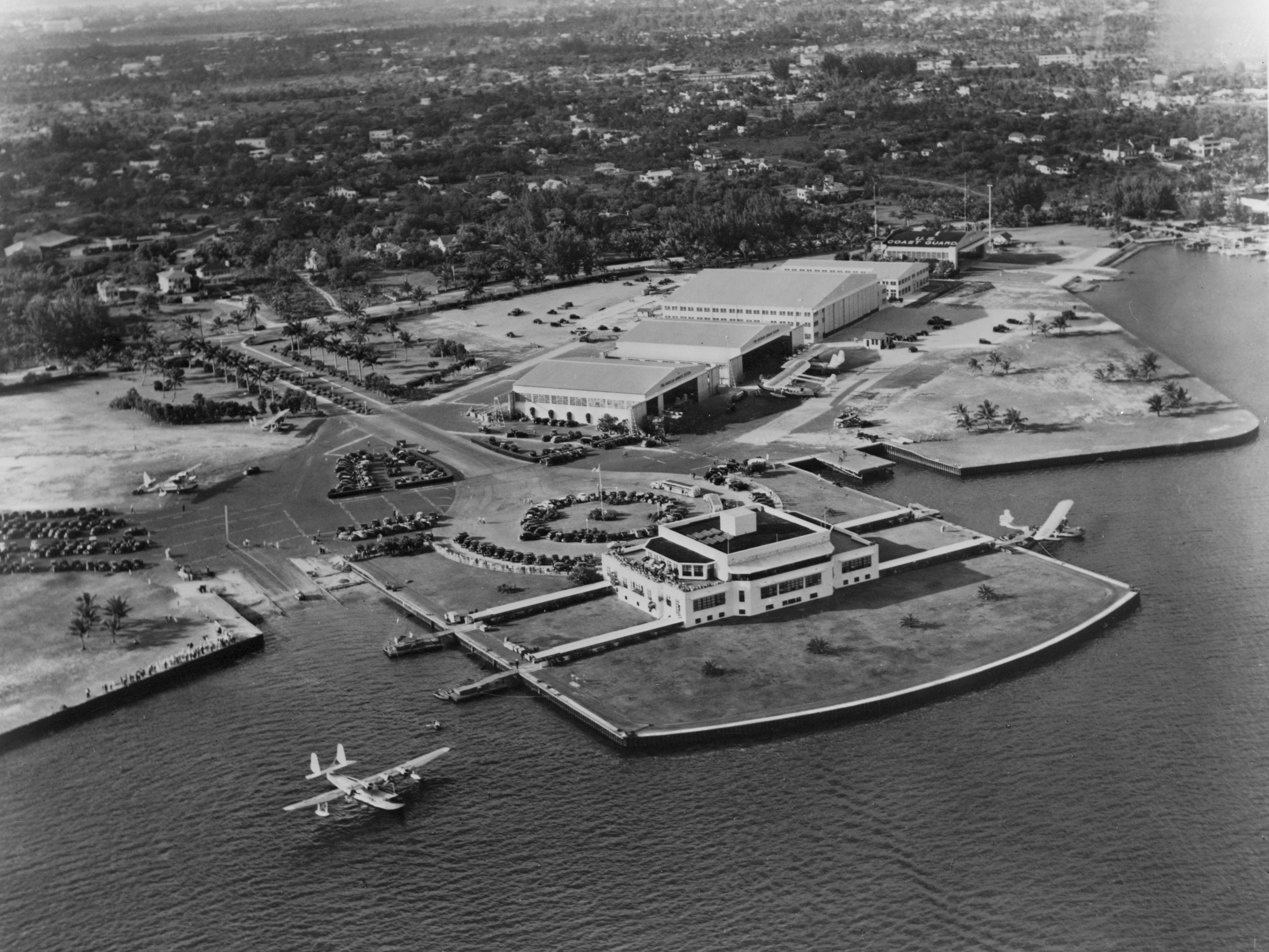
| | | | On our map, note Dinner Key, no longer an island but attached to the mainland. It has had "two lives", both unusual. At first it was an International Pan American Airlines Airport, with a terminal building built in 1934. But the odd thing about this airport—surely there wasn't enough room here for runways!—is that it wasn't a regular airport, but served seaplanes! This is the seaplane airport on and around Dinner Key in the 1930s. Click to inspect the terminal building and other details (Photo Courtesy of Library of Congress, Prints & Photographs Division, HABS FLA,13-MIAM,2—8). | | | | In the 1930s, Pan Am had numerous routes to South America, where not too many regular airports existed, so Pan Am used seaplanes to access harbors in those cities. Pan Am operated seaplane routes from 1932 (even before the terminal building was ready) to 1945, when seaplanes became obsolete, since more cities had been building regular airports for regular planes. | | | | When the seaplane airport closed, Dinner Key assumed its second life. The Miami City Hall had been located in Downtown Miami at Government Center since Miami was founded in 1896, but after 58 years, in 1954, taking over the former airport terminal building, Miami City Hall (Photo by Ebyabe) moved to Coconut Grove! Given that the building had been built in the 1930s, click to carefully inspect the Art Deco motifs in the façade, both in the entry and on the roof, which include the globe logo used by Pan Am. | | | | Finally, move to the north end of Coconut Grove, that abuts Brickell. Here is Alice Wainwright Park, where we saw the view over Biscayne Bay from the Atlantic Coastal Ridge. But more important, note the location on Biscayne Bay of the splendid villa and estate we mentioned earlier, Vizcaya, which is now the Vizcaya Museum and Gardens. | | | | This is a view of the inland façade of Vizcaya (click) with some of the extensive Italian Renaissance gardens (Photo by Averette). Vizcaya was the winter residence of businessman James Deering, and is now owned by Miami-Dade County. The early 20C estate, in the Mediterranean Revival style, was built mainly between 1914 and 1922. Deering used Vizcaya as his winter residence for only nine years, from 1916 until his death in 1925. As for the name Vizcaya, see above about the Spanish name for part of the Basque Country in Spain. Thus, the mansion is indirectly named after Biscayne Bay, which it faces. | | | | And so this is the Bay side of Vizcaya (click), facing the Stone Barge (Photo by Ebyabe), and these are some of the formal gardens (click) (Photo by Daderot). | | | | Brickell & Downtown But my Coconut Grove experience was from an earlier trip, while this trip was concentrated in Downtown and Brickell, and we have "pink maps" of each:
http://aios2-staging.agentimage.com/o/ownmiami.com/htdocs/wp-content/uploads/2014/06/Brickell-map.jpg
http://aios2-staging.agentimage.com/o/ownmiami.com/htdocs/wp-content/uploads/2014/06/Downtown-Miami-Map.jpg
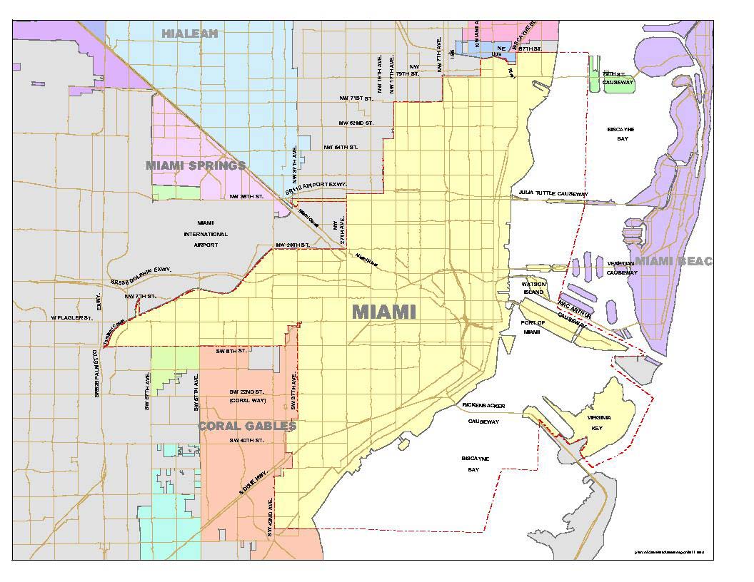
The first map is Brickell. For a long time I mispronounced the name, stressing the end. Stress the first syllable—it sounds like butter brickle, the toffee confection. You can see how it starts on the south bank of the Miami River, where William and Mary Brickle settled. You can see two main roads leading from the Grove (and Wainwright Park) thru Brickell and over the river into Downtown. When we visit later, we'll take the Metromover to the last stop, which you can see is at SW 14th Street. And we can preview the first of many artificial islands. When an island is a perfect triangle like Brickell Key is, you know something is faux. When Flagler had a channel in the Miami River dredged to a depth of 9 ft (2.7 m), what was dug up was dumped to form Brickell Key, which was later upgraded to its present shape. Despite its humble origins, it now supports a number of skyscrapers, similar to most of adjacent Brickell and nearby Downtown.
| | | | The second map is Downtown Miami, where we'll do most of our discussing. It started with Julia Tuttle's property on the north bank of the Miami River, and our discussions of Downtown will be limited to the oldest part, south to the river, east to the bay, west to the Metromover line and north to I-395. | | | | Miami Today & Biscayne Bay The simple pink maps we've been using were just for orientation. As we now move in closer still, we'll introduce the two detailed maps of modern Miami which we'll be using for the rest of this discussion. Keep them both handy in other windows.
http://ontheworldmap.com/usa/city/miami/miami-downtown-map.jpg
This first gold map is labeled Greater Downtown Miami. It shows the street names in very clear detail, which will be our next topic. While it extends (click) much further north than we need--beyond I-395—it also extends south to show all of Brickell in detail.
While there are other causeways further north across the Bay, out of our area of interest, note on the top of the map the Julia Tuttle Causeway, I-195, built in 1959, which departs Miami from roughly the area of NE 36th-38th Streets and arrives in Miami Beach at 41st Street in the Mid-Beach area. We mention it for the name recognition, and also to show that Miami Beach streets, while not exactly following Miami's grid, are nevertheless very close to Miami's numbers. This causeway is the only structure in Miami that mentions Julia Tuttle's name (it's where I first heard of her). No building or street mentions her other than this—and unfortunately, it's not even in the midst of Downtown, where her property was located.
The two causeways very close to Downtown connecting to the South Beach area of Miami Beach are the Venetian and the MacArthur.
http://runinfinity.com/wp-content/uploads/2013/12/Tropical_5K_map.jpg
The Venetian Causeway is the one further north. It departs Miami from NE 15th Street and arrives in South Beach at 17th Street, serving the upper part of South Beach. This crossing was the first one ever built, in 1912, under the name Collins Bridge. It was a 4 km (2.5 mi) wooden structure "hailed as the longest wooden vehicle bridge in the world, and opened up the area as a luxury winter resort and playground." Later, several artificial islands (see above map) were built called the Venetian Islands. From the west, Biscayne and San Marco are in Miami, while San Marino, Di Lido, Rivo Alto, and Belle Isle are in Miami Beach. The original bridge didn't last too long. It was torn down in 1925 and replaced with the "more substantial" Venetian Causeway in 1926.
The MacArthur Causeway departs Miami from roughly the area of NE 11th-12th Streets and is fed by I-395. It arrives in South Beach at 5th Street and serves the lower part of South Beach. It's the one we'll use both ways on this trip, going by car and returning by bus. It opened in 1920, between the two iterations of the Venetian, under the name County Causeway, and was renamed in 1942 after General MacArthur. At its western end, it crosses Watson Island, which was reclaimed in 1926. It then has connections to three other artificial islands, one to Palm, then Hibiscus, and one to Star.
Port Boulevard off NE 6th Street, shown on the gold map, does not cross the entire bay. It leads to Dodge Island, also artificial, the location of the Port of Miami. Cruise ships sail from here, and also cargo ships. Not shown on this map is the parallel rail connection we mentioned on the previous posting, and which we'll discuss later. The present Dodge island is the amalgamation of three smaller islands, built in 1905 in connection with Government Cut, which was dredged to obtain a direct route to the ocean without first sailing down around Cape Florida on Key Biscayne, with its lighthouse. We'll talk more later about Government Cut (shown below), and when we're in South Beach.
https://fishingbooker.com/blog/media/government-cut-miami-fishing-spots.png
Back on the gold map we can see the Rickenbacker Causeway leaving from between Coconut Grove and Brickell, which also does not cross the entire bay. It leads to Virginia Key and Key Biscayne, opposite Coconut Grove. We see this better on this map, which is an overview of the Bay between the Julia Tuttle Causeway and Key Biscayne:
https://pasarelapr.com/images/bay-of-biscayne-map/bay-of-biscayne-map-10.gif
Key Biscayne has always been an island, at least in recent centuries. But we now have two other islands that are NOT artificial, but which haven't always been islands, either. How can that be? For two different reasons.
From the New River in Fort Lauderdale down to here there is one long barrier island, and its southern end is Miami Beach. But at one time, this island almost came down to Bear Cut, the inlet at the north of Key Biscayne. Then, hurricanes in 1835 and 1838 cut a new inlet, separating what is now Virginia Key from the barrier island and forming the inlet that was then called Narrows Cut and is now called Norris Cut. (Can "Norris" be the result of folk etymology working on "Narrows"?) In any case, we have a new "natural" island in Virginia Key.
Then, as we know, in 1905 came Government Cut, running right thru the same long barrier island. This artificial cut separated what is now Fisher Island from the main barrier island, so now we have a new island that isn't quite so natural. The city of Miami Beach now ends abruptly at what is called South Pointe (spelled the French way) and South Pointe Park, a good place to ship-watch. And you do not get a lopped-off feeling in Miami Beach, since its street numbers do start with 1st Street just above the park.
Now it's always easy to speculate. Could Key Biscayne have originally been the very end of that barrier island? Geographically, it seems to look like a continuation. Perhaps Bear Cut was sliced thru by some hurricane earlier than the records show? I don't know, but it's fun to think so.
https://i.pinimg.com/736x/91/ac/e2/91ace2c3429ed92c23b9a7b6a489d2f8.jpg
This beige "Moon map", put out by Moon Travel Guides (click), shows our Downtown area very clearly, and we'll use it when we take our walking tour later. It's an excellent map of what we'll be doing in Downtown and we'll get a lot of use out of it.
But we need to talk about landfill. We've seen that Lower Manhattan was bulged out due to landfill, and downtown Boston is unrecognizable from the Shawmut peninsula it once was because of the huge amount of filled-in land. Similarly, Biscayne Bay is very shallow, with an average depth of only—wait for the drum roll—3 m (10 ft). This is barely beyond the depth of a backyard swimming pool. This fact explains why so much has been dredged to form artificial islands and why, when Flagler arrived in 1896, he couldn't use the Bay for his larger steamers, and so within a decade, Government Cut was dredged, which not only avoided sailing down around Cape Florida on Key Biscayne but also was deep enough for larger ships.
We'll see later that both sides of Miami Beach have seen dredging and man-made adjustments. But for now, let's look at the Moon Miami map. Near Bayfront Park, find tiny NE 3rd Avenue. This was roughly the original shoreline of Miami. Biscayne Boulevard and Bayfront Park plus everything else that reaches further east than the mouth of the Miami River (as does Brickell Key) were all built on landfill during the boom years of the 1920s. Which is our next time destination.
| | | | 1919 Miami We'll now be time-hopping again from the present to the 1920s, which was Downtown Miami's heyday. And 2020 is the centennial of a very unusual thing that happened. Overnight, Miami changed the names of all its streets, overwhelming as that may seem. The change was voted on in 1920, and took effect on New Year's Day 1921.
I'm pleased that, after a lot of online searching, I've found some historical maps of Miami that illustrate and explain a lot. We'll use the first one now, so hold on to it for a while.
https://legacy.lib.utexas.edu/maps/historical/miami_fl_1919.jpg
This is Miami in 1919, just before the name changes from the old grid to the present one. But let's see what's different from today. There's almost no landfill in shallow Biscayne Bay. As a matter of fact, it has a motorboat race course laid out in it. The Collins Bridge has been around for seven years and won't be replaced by the Venetian Causeway for another seven. Brickell Key should be there, but perhaps it's indicated by that bulge in Brickell on the south side of the Miami River. Brickell had been annexed in 1913, so it's already adopted Miami's old street names. Bayfront Park won't appear until 1925, as will the Freedom Tower on Biscayne Boulevard, which itself won't appear until 1927. We'll have more comments on this map later. (Note for later that Flagler's railroad went down Avenue E.)
| | | | The Old Miami Grid I don't know who set up the original street grid for Miami. It has to have happened in 1896, when the city was incorporated, or shortly thereafter. My gut feeling is that it was by Flagler's people, and then approved by the voters on incorporation, but that is pure speculation. Still, that system lasted only about 24 years, 1896-1920. As you can see, it had both numbers and letters. Numbered streets are quite common in North America, lettered streets perhaps a bit less so. Southeast Brooklyn has a complete set, from Avenue A to Avenue Z; Manhattan has only four, on the Lower East Side, Avenues A-B-C-D, the basis for the neighborhood being called Alphabet City. L'Enfant included letters crossing with numbers when he designed Washington DC. For instance K Street (NW) is known as a center of lobbying groups. | | | | On our map, the main streets of the day are in boldface, so find Avenue B, now NE/SE 2nd Avenue. (The avenues run N-S and the streets E-W; this is still the case on the new grid.) Now go closer to the Bay and find the very short street without a name. This is Avenue A, tiny because of the shape of the shoreline. It runs two blocks north (now NE 3rd Avenue) of the more important 12th Street (Flagler Street) then zigzags along 12th to then run one block south, into the park. Its modern version, SE 3rd Avenue, runs four blocks south. We mention this minor street since it's the start of the system. But Miami was not huge, and the system ended roughly in the area of Avenues L and M. | | | | The letter system was not bad. It didn't need to extend to the east because of the Bay, and there was the rest of the alphabet to move westward. After a potential Avenue Z, what? More speculation. Go Greek with Alpha, Beta, Gamma? How about Abel, Baker, Charlie? It never came to that, but the letters were not a bad system. | | | | You see that the city’s northern boundary was at 1st Street, now NW/NE 11th Street. I never found a map of Julia Tuttle's property, but I assume this had to be its northern end. Now look south to the southern boundary that long diagonal street in Brickell, which had been Broadway Street, my guess the equivalent of roughly (Old) 26th Street. This is today SE 15th Road. So let's say there were about 26 streets and 12-13 avenues. That was the size of Miami in 1919. But while the letters could expand, the numbers were another problem. They could increase to the south, but what would come north of (Old) 1st Street? Zero Street? Then Negative 1st Street? | | | | But this was not a major problem. More serious was the fact that the old system had been poorly laid out. Names would change every few blocks and sometimes several streets would have the same name. While this bothered locals, worse was what it did to mail deliveries. After WWI, the US Post Office actually threatened to stop mail deliveries in Miami unless some improvement were made to the street-naming system. | | | | The person who investigated the problem and submitted a plan for the current street system was Miami City Councilman Josiah Chaille. | | | | | | His name perplexed me from the moment I saw it. At first, I didn't recognize it as the French name that it is, but in any case, how on earth is it pronounced? No online source had a definitive answer. In French "Chaille" would be SHA.i, very similar to "shy", but I don't suspect the original French pronunciation is used. I checked online on more than one occasion and came up with the following. A likely anglicization of "Chaille" is probably like the second part of "[shilly-]shally". I don't like it, but that may be the case. The other possibility that was flogged online is an abomination, and I hate to even mention it here. There are sources that suggest that "Chaille" would be pronounced like the vegetable "kale". Horrible. |
| | | | Chaille's system uses numbers both ways, plus a quadrant system. When I thought about the latter, I thought of Washington DC, and sure enough, a source later on said that "Councilman Chaille traveled to New York City, Detroit, and Washington DC to survey their grid layouts, and ultimately emulated the national capital’s directional quadrants as the template" for Miami. | | | | As I describe his plan, I'm going to critique it. Of course, I have the hindsight of doing this a century later, and the knowledge that since the mid-20C, the western part of Downtown Miami declined and isn't the hub it once was (however improvements are coming and the population is increasing). But nevertheless, here goes. | | | | Chaille should have reorganized the numbers-and-letters system and not gone with numbers both ways, which is too numerical and can be awkward. While Manhattan's system of numbers both ways is successful, that's because the island is so narrow, and 12th Avenue is the highest avenue. Also, the number grid of the Commissioners' Plan of 1811 was tacked onto a preexisting set of streets, so that only 1st Street and 1st Avenue intersect, as do 2nd Street and 2nd Avenue. No others do. If I say that the NY Public Library is at 42nd and 5th, everyone knows which is the street and which is the avenue. When I discussed Minneapolis, part of whose system is numbers both ways, you can't say you'll meet someone at 41st & 44th near Minnehaha Park. That's inadequate, since the intersection of 41st Street & 44th Avenue is some distance from 41st Avenue and 44th Street. Those are just too many numbers. | | | | The quadrant system he chose is half-good for Miami as it spread outside the city limits, but is crazy downtown. Let's look at the model he took, Washington DC. Take a look at the NW quadrant and how well the numbers and letters intersect. There's even an allowance for diagonals, with state names. Now move to the Capitol Building, which is used as Point Zero. Find East Capitol Street, then North and South Capitol Streets. The National Mall replaces a potential West Capitol Street. These four easily marked divisions, centered on a major landmark, delineate the quadrants. There is duplication, but it isn't a problem. Find the intersection of D & 2nd NE. Then D & 2nd NW, SE, and SW. They're not too near each other, as long as you name the quadrant. If they were all numbers, it would be more confusing. | | | | The New Miami Grid Washington had been laid out from scratch with the Capitol Building as Point Zero for the quadrants, but since Miami already had existing streets, when Chaille imposed the Washington quadrant system on Miami it made a bad fit. Return to the Miami 1919 map. You see that 12th Street was a major E-W Street with important buildings on it, and actually, it was/is reasonably wide. Chaille renamed it Flagler Street and used it as his horizontal axis to divide north from south, using numbers for parallel streets, meaning there's a 1st Street one block north and another 1st Street one block south, and so on. I find this reasonable. | | | | Then, as the map shows, Avenue D was a reasonably major N-S south street, tho not particularly wide. He used this as his vertical axis to divide east and west and renamed it, not too originally, Miami Avenue. (I think he also made a naming mistake here. I think this should have been Tuttle Avenue, since it all had been Julia Tuttle's land.) Now as I said, I think he should have stuck with letters going east and west, just relettering and updating the old lettered names and correcting any duplications, but instead, he chose numbers again. That means there's a parallel 1st Avenue to the west and another 1st Avenue to the east, and so on. | | | | Now go back to the gold map of Greater Miami and we can see how the new grid looks. Find Flagler street, both E and W, then Miami Avenue both N and S. Now check out how everything radiates from that Point Zero and all names have to include NW, NE, SW, SE. One surprising coincidence is that one street never changed its number. Compare the old and new grids, and you'll see that, purely coincidentally, (Old) 6th Street now has the same number, but it's split between NW 6th Street and NE 6th Street.
https://66.media.tumblr.com/bd83377ea325bc0a85029700a61b3a80/tumblr_inline_pa4rttP7af1qf4400_640.png
| | | | The above map, which unfortunately is not too legible, is an indication that the Chaille plan was meant to go beyond the Miami city limits, even beyond the later city expansion of 1926. It was meant to cover all of what was then Dade County, and the grid has spread over a vast area (more below). But look downtown again. If he expected such expansion, why did he use four quadrants? The east side is at best three avenues wide or so. SE doesn't run too far south, and NE goes quite a way, but it's just as narrow. On the other hand, NW is larger with streets running to the low 200s, and SW is larger still, with numbers into the 300s. Instead of using Avenue D as the divider, if he had used Avenue A, even replacing the letters with numbers, there would be no tiny SE and NE, and only two quadrants, NW and SW, not four, all to the west. Flagler Street would have been the only axis. | | | | The quadrant problem as I see it is less apparent in the NW and very large SW suburbs, but is very noticeable downtown. Let's take a hypothetical walk on the old grid, in a clockwise rectangle using 11th & 13th Streets and Avenues C & E. The sequence is simple, and will be 13th to E to 11th to C to 13th again. Let's start at the Post Office on 13th & D:
Walk west on 13th for one block.
Turn north on E for two blocks.
Turn east on 11th for two blocks.
Turn south on C for two blocks.
Turn west again on 13th for one block to come back to the Post Office.
| | | | Now move to the beige map and we'll take the same hypothetical stroll, but under the present names. I have a very good sense of direction, and nevertheless find this very awkward. Here's the same walk:
Walk west on SW 1st Street for one block.
Turn north on SW 1st Avenue; on crossing Flagler, the second block is now NW 1st Avenue.
Turn east on NW 1st Street; on crossing Miami, the second block is now NE 1st Street.
Turn south on NE 1st Avenue; on crossing Flagler, the second block is now SE 1st Avenue.
Turn west again on SE 1st Street for one block to Miami. Ahead of you you'll see SW 1st Street again.
| | | | I call this sort of thing "walking the ones". One is the only number involved, but you have to be very careful in specifying "street" or "avenue", and of course, the quadrant. It's very awkward, but far less a problem away from downtown. | | | | Chaille's plan was unanimously approved by the Miami City Council in October 1920 and the addresses began to change in November. The Council proceeded to purchase new street signs for the new system to become effective on New Year’s Day, 1921. Still, there was a petition circulated in 1921 which forced a special election to give the voters a chance to repeal it. The vote took place on 28 June 1921 and the results are below.
http://miami-history.com/wp-content/uploads/2019/10/1921-0629-Repeal-Vote-Denied-MN.jpg
The 1922 Miami City Directory was the first published book with the new addresses and street names.
| | | | While Chaille meant the new grid to cover the whole county, it did spread widely, but not exclusively, and there are a number of exceptions to the new grid. For instance, within Miami, Coconut Grove uses names. Next door, Coral Gables tries to be more suave and uses Spanish names to a large extent. Miami Lakes uses named streets. Hialeah uses its own numbering system and clashes with adjacent Miami numbers. When we arrive at the Amtrak Station in Miami and walk to Metrorail, we'll go from NW 70th Street west into Hialeah's E 25th Street. Homestead and Florida City each have their own numbers, so that's a three-way clash with bordering Miami numbers. When we drive to the keys, we'll pass SW 304th Street (Miami's numbers do get high) which blends into Homestead's NE 15th Street. Miami Beach uses numbers E-W that correspond closely to Miami's, but not N-S. Since it's so thin, it uses names N-S, most notably Washington and Collins Avenues, and the very famous Ocean Drive.
Within Miami, there is perhaps an impatience with so many numbers. That would seem to be why a number of avenues especially major ones, are also named, although, with a few notable exceptions, the number is in more common usage among locals. Two examples near the airport, are NW 37th Avenue, which is also known as Douglas Road, and NW 42nd Avenue is also known as Le Jeune Road. And earlier we heard about Krome Avenue at the western edge of the metropolitan area, which is also SW 177th Avenue, and the former town of Cutler was at SW 168th Street, which is also called Richmond Drive.
| | | | As we now leave Miami in its heyday, to flash forward and back between then, today, and the 1890s, we have a surprisingly large number of pictures from the heyday era, all concentrating on what I call Point Zero. All but one are of Flagler Street, showing its far greater importance over Miami Avenue.
http://miami-history.com/wp-content/uploads/2016/05/1913-AveD-12thStreet-MCOTS.jpg
This is the oldest picture I found, from 1913. We're standing at what would become Point Zero seven years later. We're facing east down what was still called 12th Street (Flagler) and Avenue D (Miami) is crossing left to right. It's a great picture, but I still have trouble seeing how Chaille wanted this to be Point Zero.
There's something very important here that we'll find again when we do our walk thru Downtown. Very typical of Miami vernacular architecture of the era due to the tropical climate are the arcades covering sidewalks, often with terraces above. You can see several here, most obviously the one on the right. Most are gone, with only two left, which we'll visit on our later walk.
https://www.floridamemory.com/fpc/reference/rc20451a.jpg
This (click) is now Flagler Street in 1924, no longer called 12th, with streetcar tracks. I cannot figure out the direction or the intersection, but those period cars are beauties and that terrace above the arcade on the left looks like it would be particularly comfortable—after sunset.
https://4.bp.blogspot.com/-Wqnr87NXV9Y/UBXXAJ2wb_I/AAAAAAAAF0I/WXI7tQ-yAec/s400/Flagler%2BStreet%2Bfrom%2BSE1st%2Bave%2B1924.jpg
This is Flagler, also in 1924. What attracts me is the new street sign on the left identifying that it's SE 1st Avenue that's crossing, and no longer Avenue C. If you understand the grid, to the right must be NE 1st Avenue, and Point Zero is straight ahead at Miami Avenue (Old Avenue D). Note the arcade in the distance, and those cars are fabulous. Notice how they avoid the streetcar tracks.
http://miami-history.com/wp-content/uploads/2019/10/1920s-MiamiAve-FlaglerSt-HM-ps-300x169.jpg
This is Point Zero c1926, looking west on Flagler, with a streetcar arriving. Of interest is the ad for the Venetian Islands (here called Isles), which were just being developed. The Great Hurricane of 1926, the end of the Florida land boom, and the Great Depression stunted the plans for the Venetian Islands, which were originally planned to more extensive.
http://ronseckinger.com/wp-content/uploads/2016/06/1933-Flagler-St-Miami-1.jpg
This is Flagler in 1933 (click), during the Depression. Still, it remained a center of shopping, dining, entertainment, and business.
https://miami-history.com/wp-content/uploads/2019/09/Town-Theater-CinemaTreasures.jpg
Our last picture of Flagler pops ahead two decades. To confirm that this is from 1954, I checked, and "The Nebraskan" and "Them!" had come out in 1953. The cars again tell the story, and the streetcar tracks are gone. I have to now remind that the mid-20C was the start of the decline of downtowns in general in the US, and of Miami's in particular. It's no longer a center of daily life, as shown here, no longer a center of shopping, dining, and entertainment, and its business district is now cramped into the SE quarter, abutting Miami's major financial area in Brickell. And very few of the buildings we've been seeing remain.
https://farm8.staticflickr.com/7283/16395994110_7d3ac56243_z.jpg
While that was the end of the Flagler pictures, we do have this single picture of the other, simpler axis, Miami Avenue, looking north from Point Zero back in 1929. I was delighted to find this picture and I immediately recognized just where it was because of that double-arcaded structure on the left, the Waddell Building. I'm very glad to say it's still there, and we'll see it on our walk later. | | | |
| |
|
|
|

