|
Reflections 2021
Series 2
February 8
Taurus Express
Agatha Christie's Middle East, Act I: Archie
| | New Rails to the Middle East We've traced the routes of the Orient Express (OE) and Simplon Orient Express (SOE) from Paris (with London always piggybacking) to its principal destination, Constantinople. We then investigated Constantinople-cum-Istanbul as to its nature, but also as to its early rail connections into Sirkeci station. But we'd also pointed out that Constantinople had been chosen, not only because it had been the capital of the Ottoman Empire at the time, but because it had an advantage over Athens—Athens had no possibility of further rail expansion, while Constantinople had the entire Middle East facing it. Just over a dozen years after the OE, Wagons-Lits ran the Nord-Express to Russia, where it made connections to the Transsiberian and on to the Pacific, and that venture had as a model the earlier OE to Constantinople, where it would also be able connect beyond to the Middle East. This would prove to be via passenger feribot across the Bosporus to Haydarpaşa station on the Asian (Anatolian) side and then via the Taurus Express. But let's not put the cart before the horse. Unlike Flagler and Plant in Florida, who built infrastructure, then ran their own trains along it, Wagons-Lits built nothing beyond its own sleeper and dining cars--it only ran its trains after waiting for others to build infrastructure first, the tracks and stations.
https://www.worldstatesmen.org/Ottoman.jpg
This map will remind us of how big the Ottoman Empire had been in 1798, spanning three continents (light green borders). Before WWI it had lost the purple and red areas, all of which were either in Southeast Europe--which we've already discussed--or North Africa. The remainder was mostly in Asia, but after WWI it shrank further. As of 1923, modern Turkey existed only as the rectangle within the dark green borders, and the orange area in Asia south of it was lost. Let's inspect these latter areas for orientation.
First take a quick look at Turkey. We talked about an express train in the last posting that went clear across northern Turkey from Istanbul via Ankara ("Angora") to Kars. But for now, find Konya and Adana heading to the southern border.
| | | | | | The capital of Turkey is Ankara, but an older version of the name is Angora. That name also came to describe the
◊Angora rabbit (Photo by Ross Little), whose coat has long, silky, soft fibers, called Angora wool, which is shorn every 3-4 months as it's about to be shed (Photo by Emma Jane Hogbin). The city also gave its name to the
◊Angora goat, which produces mohair (Photo by Erica Peterson). Finally, the city gave its name to the
◊Turkish Angora cat, whose fur resembles the rabbit's (Photo by Daly69).
|
| | | | When rail was being built in these areas, only the Ottoman government had to be dealt with, but after WWI, beyond Turkey to the southeast there now existed Syria and Iraq, and to the southwest was Syria, Lebanon, and Palestine, heading towards Cairo, adding additional local governments to deal with.
In Iraq, we have Mesopotamia (meso+potam+ia is "between-river-land"), lying between the Tigris and Euphrates, the site of numerous ancient civilizations. Locate Mosul, Kirkuk, Baghdad, and the port of Basra on the Persian Gulf. I want to refer to the rail route to be built here as the Mesopotamian Route.
In Syria, find Aleppo, a central hub for both routes that we'll talk about later. South of Aleppo find Haifa, Gaza, then Cairo. I want to refer to the rail route to be built here as the Mediterranean Route. Again, both these terms are my own names for them.
| | | | | | I don't usually delve into (very) ancient history, but discussing this area screams to point out the Fertile Crescent:
https://cintayati.files.wordpress.com/2014/09/fertile-crescent.jpg
The Fertile Crescent was of course one of the cradles of civilization, where farming developed when people started domesticating plants as crops. And it was here, principally in Mesopotamia, where technological advances were made, not only in agriculture and the use of irrigation, but also in the development of the wheel, glass, and writing. On this map, in Mesopotamia, note such ancient sites as Ur, Nineveh, and Babylon, whose Hanging Gardens we've all heard of. Note how this crescent area bends around the Syrian Desert to form both the Mesopotamian and Mediterranean areas we're talking about, the latter also called the Levant, a reference to the rising sun.
|
| | | | Anatolian Railway Getting back to Turkey, this period map brings us more accurately back in time for railroad development.
http://www.trainsofturkey.com/uploads/Maps/turkey_schetch_1914.png
It shows railways in Turkey in 1914, just about when Gavrilo Princip fired his two shots in Sarajevo. In violet we see the lines of Turkey's rail outreach to the West that we've already discussed, the Chemins de fer Orientaux, that lay track in Thrace west of Constantinople and built and operated Sirkeci station, which was used by the Orient Express. But across the Bosporus was Haydarpaşa station, so let's look more deeply into what was built out of Haydarpaşa to the east.
The dark blue lines from Haydarpaşa to Konya, with a branch to Ankara, started out as the Anatolian Railway, officially called in French the Chemins de Fer Ottomans d'Anatolie, or Ottoman Railways of Anatolia, a company that existed between 1888 and 1924, and is now part of Turkish Railways. It was the busiest railway in the Ottoman Empire and was the "other" railway operating into İstanbul, having built and operated Haydarpaşa. But like its western twin, it suffered financial ups and downs—remember the Ottoman Empire was in serious decline then--and was built in fits and starts, with help from outsiders. In the end it was financed by the Deutsche Bank and built by Germany. But under its original name, it never got beyond Konya. So what's that pink line going from Konya to Adana, then Aleppo, and on its way to Nusaybin?
| | | | Baghdad Railway That pink line is the Baghdad Railway, which was incorporated in 1904 to continue the line from Konya, thru Adana and Aleppo to Baghdad and also beyond, to the port of Basra on the Persian Gulf. Funding, engineering and construction were mainly provided by the German Empire, which, at the turn of the 20C, had built the Anatolian Railway, which they called the Anatolische Eisenbahn.
The reasoning behind this goes beyond helping a less wealthy country to extend its rail system for public benefit. It's a fundamental question of how to reach the east side of Eurasia from the western side. Since the 1860s, the British and French controlled the Suez Canal, avoiding a trip around South Africa and enjoying a shortcut from the Mediterranean via the Suez Canal to the Red Sea, accessing the Indian Ocean. You can confirm that route on the above map of the Ottoman Empire.
The German Empire did not want to depend on the British and French to reach Asia, nor did they want to depend on the Russian Empire's Transsiberian route. Their thinking was still to make use of West Asia (the Middle East) but it was a matter of rail 'n' sail competing with each other. To avoid the "sail" route thru the Canal, the German Empire wanted to establish a rail route for commercial and military purposes that was precisely parallel to the Suez route, running from Constantinople to Aleppo to Baghdad to Basra to the upper end of the Persian Gulf, also connecting to the Indian Ocean. And instead of building an easier rail route closer to the Mediterranean, a more difficult route was taken somewhat further inland, so that the railroad could not be bombarded from the sea.
The Baghdad Railway subsumed the already-built Anatolian Railway and was therefore considered to start, not in Konya, but in Haydarpaşa, in Istanbul. Planned was a route totaling 1,600 km (1,000 mi) thru what is today Turkey, Syria, and Iraq. This route was also known by its German name, the Bagdadbahn. And indeed, despite the ferry break across the Bosporus, it was also referred to as the Berlin-Baghdad Railway, reflecting on the intentions of its builders.
| | | | | | It then struck me how similar this story was to a much older story we told in the past. In 2009/33 we talked of the travels of Marco Polo starting in 1271, and returning in 1295, which also went via West Asia. First look at this map of the Persian Gulf (Map by Hégésippe), noting how Basra, with the Tigris and Euphrates, is at the upper end, while the Strait of Hormuz is at the lower end. The Strait is named after a former Kingdom of Ormus (or Hormoz) in southern Persia/Iran.
Now compare that with this map we used in that earlier posting of the Travels of Marco Polo (Map by Historicair) and his party. They started out going (red route) to Acre, then Baghdad, but ending up in (H)Ormuz. As I said: This is where they wanted to sail to China, but the ships they encountered were not seaworthy, so they decided to go overland after all at least one way. Years later, they did sail (green route) back to (H)Ormuz and made their way via Constantinople back to Venice. I would venture that there are enough similar Middle East names in both itineraries to see a similarity in the two routes.
|
| | | | But the work on the Baghdad Railway, which started in 1910, went slowly. By the outbreak of WWI, technical difficulties in the remote Taurus Mountains and diplomatic delays meant that by 1915 the railway was still quite some distance short of completion, and wouldn't be resumed until the 1930s. | | | | | | It's at this point that we have to point out a split in our discussion. The 1930s were part of the Second Golden Age of the Orient Express and Wagons-Lits (the first was at the turn of the 20C). For that reason, we're going to concentrate on the Middle East rail situation during that pre-WWII period, and our map also concentrates on that. This also fits in best with Agatha Christie and her writings. We will also sadly afterward point out the depressing post-WWII situation. This differentiation between the pre-war and post-war situation will be true both about the Mesopotamian Route (Syria-Iraq) and the Mediterranean Route (Syria-Lebanon-Palestine-Egypt). |
| | | | This is the (yellow) map that our discussion will center on, so do keep it handy (Map by Matsukaze):
https://upload.wikimedia.org/wikipedia/commons/thumb/3/3b/Taurus_Express_route_map.svg/1000px-Taurus_Express_route_map.svg.png
Again, it shows the important, yet incomplete, rail situation in the 1930s. We're familiar with the Calais/Paris connection to the Simplon Orient Express in light blue, and the Baghdad Railway in red beyond from what is now Turkey into Syria and Iraq (post-WWI borders are shown in light gray). So now the builders were dealing, not with the Ottomans, but with officials from several local countries.
| | | | Mesopotamian Route We can see that construction after Istanbul and Konya had reached the major hub of Aleppo, in Syria, then continued southeast on what I want to call the Mesopotamian Route as far as Nusaybin, mentioned earlier. And there it ended.
There is one point here that I consider rather remarkable. While some borders seem to develop without guidelines, very often a border will be drawn along a mountain range or along a river. But when the Ottoman Empire was being split up after WWI and Syria and Turkey were separated, a long section of border between them actually ran along the Baghdad Railway, using it as a guide! It's the section on our yellow map that starts south of Gaziantep at Al-Rai, Syria (not shown) and runs all the way to Nusaybin (with a branch to Mardin). The border actually runs along the south side of the right-of-way putting the tracks, as well as the town of Nusaybin, on the Turkish side.
https://upload.wikimedia.org/wikipedia/commons/6/63/Syria_2004_CIA_map.jpg
In addition to our yellow map, we'll also be using this map of Syria (plus Lebanon, and referencing Israel). Find Aleppo (click), Halab in Arabic, as is the name of its province. As our yellow map already shows, you'll find tracks coming down from Turkey from the northwest into town, then leaving to the northeast. You can see where they cross into Turkey again. (!) This is the village of Al-Rai (unnamed). Trace the tracks—and border!--for a distance by my measurement of 359 km (223 mi), past the branch to Mardin, up to Nusaybin in Turkey. In the early years the line was only operated to Nusaybin because of the border. A few years later, it was extended into Syria (finally!), but just 13 km (8 mi) to Tall Ziwan (not named). However, we'll work for now considering Nusaybin as the railhead, the end of the line.
Well, what was to happen then? At least in the 1930s, they had to make do, particularly as Wagons-Lits wanted to send its Taurus Express all the way to the far end. They improvised, in two somewhat Rube-Goldbergian ways.
◊The first improvisation wouldn't have worked before WWI, since it involves the fact that this Golden Age time period fell after WWI. It involved another train line.
| | | | | | There were four Central Powers, interestingly also called the Central Empires. The Austro-Hungarian Empire had declared war because of Sarajevo, the German Empire declared war because of its Dual Alliance with Austria-Hungary dating from Bismarck, and the Ottoman Empire declared war—very interestingly--largely because it had gained strong economic connections with Germany through the Berlin-to-Baghdad railway project! Amazing. Little Bulgaria, not at all an empire and only recently independent from the Ottomans, joined over a full year later, in November 1915, as a handmaiden of the Ottomans, based on a defense treaty with the Ottomans from August 1914—and Bulgaria was piqued with Serbia, anyway.
https://www.facinghistory.org/sites/default/files/Map_3.2_Europe_ME_WWI_1914_18.jpg
Let's use this map temporarily to see the four Central Powers. It seems to me we hear so much about WWI battles in France, and the Armistice having taken place there, that, other than horrendous Gallipoli, we tend to forget how the war played out here in the southeast. Look how far the Ottomans had been invaded by October 1918, just before the Armistice, famously on 11/11. Who did this invading? The British, coming into Basra from India. (How's that for copying Marco Polo?)
|
| | | | Starting in 1916, the British invading the Ottoman Empire at Basra saw the need to build a railroad in Mesopotamia in its offensive against the Turks. But the equipment they brought with them from India was all narrow gauge. At first they worked with really itsy-bitsy narrow gauge equipment at 762 mm (2 ft 6 in), but later moved up to a larger narrow gauge, meter gauge, or 1,000 mm (3 ft 3.375 in). In 1920, with the area now Iraq and a British mandate, the military transferred the rail line to a British civilian administration, and it was very sensibly named Mesopotamian Railways. The line reached Kirkuk in 1925. In 1932, Iraq became independent and the UK sold the line to Iraq to become Iraqi State Railways, now Iraqi Republic Railways. Now check this narrow-gauge railroad out on the yellow map as it ran from Basra via Baghdad to Kirkuk. | | | | | | I have to admit, we don't really need this excellent physical map of Iraq, but you might like to take a quick look at it to absorb some local flavor and a bit of geography.
http://www.ezilon.com/maps/images/asia/Iraq-physical-map.gif
I've never been to Iraq—or shall we say Mesopotamia—but we can see how lush the region of the Tigris and Euphrates is. On the left, you see the Syrian Desert, which separates Baghdad, for instance, from Damascus and Beirut, which lie due west on that highway. We can estimate the route of the narrow-gauge railway from Basra (Al Başrah) via Baghdad to Kirkuk. Another familiar name is Mosul (Al Mawşil).
|
| | | | ◊The second improvisation is the one that will surely bring a smile. Look at the yellow map. If the dotted line route to Baghdad isn't built yet, how do you get passengers between the two railheads, from the end of the Taurus Express in Nusaybin to the start of the narrow-gauge railway in Kirkuk? Well, if "bustitution" involved horse carriages doing the job in 1885 from Niš via Sofia to Belovo (2020/11), then 45 years later, we'd expect motor vehicles to do the same. And so it was. The second improvisation was bustitution.
In 1930, a passenger service by road was introduced to bridge the missing section of line between Nusaybin and Kirkuk. At different times they used two different modes of vehicle. I've done my best to illustrate these. The pictures I've found are typical of the era, but are not specific to the bustitution in Iraq.
At one point the shuttle service used, believe it or not, what was described as "Rolls-Royce cars". While I don't have pictures of any in Syria in the 1930s, I do have two examples of genuine period cars that were displayed in a modern antique auto show. This is a 1925-1926 Rolls-Royce open touring car, and, even more unusual, and even closer in age, this is a 1930 Rolls-Royce closed touring car (Both Photos by Biswarup Ganguly). I still have a hard time picturing passengers getting off the train and into a Rolls-Royce, and then onto a narrow-gauge train.
But at other times—perhaps in later years, with more passengers?—Thornycroft buses were used as a shuttle. Thornycroft was an English vehicle manufacturer that built coaches, buses, and trucks from 1896 until 1977. They made eight models of coaches and buses.
https://myntransportblog.files.wordpress.com/2014/11/1919-thornycroft-bus-beamish-tramways.jpg?w=640
https://myntransportblog.files.wordpress.com/2014/11/1919-thornycroft-type-j-replica-charabanc.jpg
The first link shows a genuine 1919 Thornycroft bus used on Beamish Tramways. The Beamish outdoor Transportation Museum is in the north of England, just south of Newcastle. The second link shows a replica of a 1919 Thornycroft Type J bus in a scene that also looks very English. Yet this is the type of alternate vehicle used in Iraq in the 1930s. Nevertheless, Wagons-Lits promoted this multiple-part journey as safe, quick, and economical.
| | | | | | You can also see on the yellow map an Iranian shuttle bus connection indicated by the dotted line from a station on the narrow-gauge route to Teheran. |
| | | | Positive Update 1 That was the train travel situation at the beginning of the 1930s. In 1932, Iraq became independent from the UK. In 1936 construction of the Baghdad Railway had progressed, on the one end, from Syria east to the Iraqi border, while on the other end, construction continued north from Baghdad toward Mosul. Also in 1936, Iraq bought all the railways in its territory from the UK. Mosul was reached in 1939 and a year later the final gap was closed, and so, on 15 July 1940 the railway was completed, and two days later the Taurus Express made its first direct journey from Istanbul to Baghdad. Construction of the Baghdad railway had taken almost 40 years.
A new standard gauge railway opened between Baghdad and Basra for freight starting in 1964 and was also used for passenger traffic at least into the 1970s. This replaced the meter gauge line built in 1920 and for the first time connected the Bosporus with the Persian Gulf without a break of gauge.
| | | | Negative Update 1 However, service from Baghdad to Basra was suspended in 2003, due to the outbreak of war in Iraq. And due to the strained relations between Turkey, Syria and Iraq, continuous traffic remained rare, and other means of transport soon reduced its strategic and economic relevance. Most of the line seems to be intact and in a usable condition, and most of the stations are still original. However, as to that border situation between Syria and Turkey, while the tracks continue to run on the Turkish side as ever, they are now squeezed between minefields on both the Turkish and Syrian sides. If the Taurus Express ever connects to Baghdad again in the future depends on the developments of the war. Thus we see additional reasons for calling the 1930s a Golden Age of rail travel. | | | | Mediterranean Route The other route of the Baghdad Railway, to the southwest, in some ways seems to have been almost an afterthought, yet in many ways, became the route people—and Wagons-Lits—seemed to be most interested in. Our yellow map shows that the main west-east route Baghdad Railway thru Aleppo was supplemented at some time early on by a spur to the south, but only into Lebanon. Let's look into that.
On our yellow map, follow the rail line south out of Aleppo and into Lebanon to a tiny village most accurately transliterated as Riyaq, but here written as Rayak. Then, on our Syria map, do the same. Here you can see the Lebanon Mountains that divide that country in two and give it its distinctive north-south shape. You can also see that the rail line ran down the inland side of the mountains, past Baalbeck with its Roman temples, also to Riyaq/Rayak. So what's important about this village?
One of the older rail lines in the Middle East was the short Beirut-Damascus Line, that connected those two cities, which can best be seen on the yellow map. It was built in the early 1890s as a narrow-gauge route, not at meter gauge, but a little larger, at the odd-sized narrow-gauge of 1.05 m (3.4 ft), which I'll call "super-sized meter gauge". As the route crossed the mountain range, one of its stops was the village of Riyaq/Rayak, and since the standard-gauge line coming down from Aleppo and Baalbeck met it here, it became a major rail hub. Passengers from the north could change here to go west down the mountains to Beirut, or east down the mountains to go to Damascus, and so in the early 20C and up to 1975 and the outbreak of the Lebanese civil war, it was, surprisingly, Lebanon's most important railway center.
| | | | | | I'm rather surprised to be reminded now of how much of this area I've seen. After flying out of Istanbul to Beirut late on 14 August 1965, we spent the 15th seeing Beirut. On the 16th we took a lengthy bus tour from Beirut to Baalbek, to see the Roman temples, then Damascus. Only now do I see that Baalbek is about a half-hour north of Riyaq. According to our diary, we stopped for lunch in Chtaura, which is about a half-hour south of Riyaq. In Damascus we saw the usual sights. It was a long day, and we got back to Beirut at 9 PM.
(Our next stop was prewar-Israel and prewar Jordan, crossing at the Mandelbaum Gate; see 2017/4, then sailing back to the west out of Haifa).
|
| | | | But as the yellow map shows, the standard-gauge line was at some point shifted to the Mediterranean coast, to Tripoli (Beirut came only much later). The Syria map shows that by doing this, it avoided the Lebanese Mountains. So for our study of Middle East rail in the 1930s, just as the Mespotamian Route physically dead-ended at Nusaybin, the Mediterranean Route ended at Tripoli, which served as its railhead. The Taurus Express ran several times a week from Istanbul Haydarpaşa station to Aleppo and Baghdad, with a weekly through sleeper to Tripoli in Lebanon. This is where we stand in the early 1930s. | | | | | | Realize that there is more than one Tripoli ("Tri-City"). Perhaps the best-known one is Tripoli, the capital of Libya. (In the Marines' Hymn, "to the shores of Tripoli" is a reference to fighting the Barbary Pirates in North Africa.) The Tripoli we're dealing with here is the second-largest city in Lebanon. There is also a Tripoli in Greece, Τρίπολη. |
| | | | Similar Improvisations But once again, we find a surprising similarity on the Mediterranean Route at this time as was on the Mesopotamian Route, and it was WWI that made the big difference. Just as the British built Mesopotamian Railways during that war, they also upgraded and consolidated rail in Palestine, and the result was Palestinian Railways, in light blue on our yellow map, running south from Haifa. Could Wagons-Lits improvise here again and make use of this? Yes, it could, and that would be one improvisation on this line. But wait. How do you connect a railhead at Tripoli with a railhead at Haifa? I think we already know the answer to that, and bustitution was the other similar improvisation. But one thing at a time. | | | | Palestinian Railways The history of Ottoman railways in the southern Levant involves numerous bits and pieces, and again, some of it being narrow-gauge construction. The first railway to be built in Palestine was the original Jaffa-Jerusalem Railway (on the Syria map, Yafo is the local name for Jaffa), which, built to meter gauge, ran inland from the coast and began service in 1892. The Ottomans later changed it to that "super-meter gauge" to be compatible with other narrow-gauge routes they'd built. | | | | | | But the Ottomans concentrated their long-distance rail thinking in this area further inland. They wanted to connect Constantinople (Haydarpaşa) to Mecca in Saudi Arabia for use by pilgrims, and they started construction here in the southern Levant by building the Hejaz Railway (Map by Attilios & Degeefe) on an inland route from Damascus (the local starting point) via Amman, reaching Medina, a distance of 400 km (250 mi). As the map shows, the Hejaz (Hiyaz) is that coastal region of Saudi Arabia, and that southern area gave the railroad its name. It existed only from 1908 to 1920. The Hejaz was narrow-gauge, but again not meter gauge, but that 1.05 m "super-sized meter gauge". However, as the map shows, by 1905, they had built a branch to Haifa and other towns in Palestine (including Nablus out of Afula), and this was the only part of the Hejaz in Palestine. |
| | | | But as ever, it was WWI that turned everything on its head, and the British were involved again. The Egyptian Expeditionary Force had been established in March 1916, consisting of British and British Empire units, to fight the Sinai and Palestine Campaign. The EEF began building the standard gauge Sinai Military Railway from Kantara (see yellow map) on the Suez Canal across the Sinai, reaching Rafah (see Syria map) in March 1917. The EEF captured Gaza in November 1917 and their engineers extended the Sinai Military Railroad north, converting the Ottoman tracks to standard gauge, reaching Lydda (locally Lod, on the Syrian map) by February 1918. By June, they also converted the branch to Jerusalem. They then built the standard gauge line on a new route northwest to the coast and then northwards, reaching Haifa by the end of 1918. This Haifa-Kantara route is what is shown on the yellow map (more is to come).
After the war, the Ottoman Empire was broken up, and Palestine became a British mandate. In 1920 the military-built and military-upgraded railroad lines were opened to the public, and remained a government-owned railway in Palestine from 1920 to 1948, called Palestine Railways. Its main line linked Haifa with Kantara, as shown, but a ferry service was available to rail passengers in Kantara across the Suez Canal, with a further rail connection to Cairo.
And so from 1920 on, Palestine Railways developed a daily Haifa-Kantara service, and Wagons-Lits appeared to offer sleeping car and dining car service three days a week, increased in 1923 when it also began daily service. This is a Palestine Railways poster from 1922, boasting in particular of the Haifa-Cairo service, but not mentioning the ferry. It's also questionable how a few of the connections mentioned could be made, in some cases, surely not by rail (aha). And the Israel Railway Museum in Haifa has on display Salon-coach #98 of Palestine Railways, built in 1922 (Photo by Reinhard Dietrich).
https://cdn.retours.eu/nl/51-taurus-express-irak-egypte/enlarge/Wagons-Lits-Palestine-brochure-1930.jpg
Two of Palestine Railways' branches also served Jaffa and Jerusalem off the main line at Lod (Lydda), and this map from a 1930 Wagons-Lits Palestine brochure shows that and other connections. Start right in the center at Lydda (click), and you'll see the updated standard-gauge versions of tracks east to Jerusalem and west to Tel Aviv-Jaffa, which Wagons-Lits advertised as connections off the main Haifa-Kantara route. At Kantara there was then the ferry over the Canal and connecting train to Cairo.
To the east, the narrow-gauge Hejaz route has lost the Medina connection, but at this point still connects part of Jordan, including Amman, to Damascus, where it connects to the same gauge Beirut-Damascus railway, and at Rayak, the standard-gauge extension of the Baghdad Railway goes on to Baalbeck and Aleppo.
But then we see the dotted route from Haifa via Beirut to Tripoli, and if we didn't know what that meant, the French legend at the bottom says that this is the service automobile.
| | | | Nairn Transport An additional child of WWI was a pioneering Middle East bus company called the Nairn Transport Company, and I really like its story. The Nairn brothers were from New Zealand, had automotive knowledge, had served in WWI, and decided to stay in the Middle East. They tried to set up a motor dealership in 1919, but the cars wouldn't sell. They then tried to use those unsold cars to set up a taxi service between Haifa and Beirut, but they came into conflict with the owners of horse-drawn vehicles (!) whose business they were threatening. In 1920, this developed into a mail and passenger service between Haifa and Beirut. This is progress, but the story gets even better.
At this point, not only was Palestine a British Mandate, but so was Iraq, and being able to connect Baghdad in the east with cities on or nearer the Mediterranean, such as Haifa, Beirut, and Damascus, would be a great convenience to British staff working in those places. In 1923, the British consul in Damascus asked the Nairn brothers to examine the possibility of using cars to cross the Syrian Desert (which we saw on earlier maps). Curiously, the Nairns also received encouragement from local traders, who were using camels (!) which were slow and liable to attack by tribesmen. In April of that year, they tried out the route several times, taking three days for the 880 km (550 mi), and it was successful. The Nairns proposed starting a postal service between the coastal cities and Baghdad, which also was successful.
From 1928 on, Wagons-Lits, running from Aleppo to the railhead in Tripoli, was ready to provide a link to the railhead in Haifa, especially since they already serviced Palestinian Railways with sleepers and diners. With us now knowing the Nairn story, it's easy for us to see how Nairn could have provided this shuttle service to Wagons-Lits between the Tripoli and Haifa railheads. The report I found is that "a Rolls-Royce bus of Nairn Transport" was used to shuttle passengers. Now, like earlier, I only found typical vehicles to fit the description, none of which are guaranteed to have been used here.
https://i.pinimg.com/originals/f0/70/ff/f070ffad46531e0675a300a3da8ff1c0.jpg
Probably being shown at some antique auto show, this formidable vehicle is described as a 1937? Rolls-Royce bus. I can only be amazed at the sight. I do not know if Nairn had a similar vehicle or not.
https://1.bp.blogspot.com/-88KX_z691fI/UVEdIXav_2I/AAAAAAAAvRQ/IaoXLgPX9OQ/s1600/Beyrouth+Damascus+Bagdhad.jpg
This period picture would seem to be a more likely Nairn bus. While this route is posted west-east, I don't see why they couldn't have also serviced Tripoli-Haifa north-south. But here's a surprising fact: in the absence of roads, the Nairn bus drove partly on the beach! This 250 km (155 mi) trip took 10 hours.
https://c8.alamy.com/comp/g3be2j/the-nairn-transport-company-operates-this-motor-coach-which-carries-g3be2j.jpg
In 1934 the Nairns introduced two buses specially adapted for them which had 18 tires and two passenger levels. Perhaps the above picture shows it. The Nairns archetypal vehicle was the "Pullman" bus, introduced in 1937. The articulated Pullmans were single level but air-conditioned with refreshment facilities. I do not know which of the above vehicles might have been used as the Wagons-Lits shuttle.
| | | | Taurus Express It's always been that at first, others build the railroads, then Wagons-Lits comes along with its sleepers for overnight international service. So now that we have the two routes laid out by the planners, improvised and jerry-rigged as they may be, we can finally talk about Wagons-Lits bringing the Taurus Express that we've been mentioning again and again.
In 1926 Turkey and Wagons-Lits signed a 40-year contract for the operation of luxury trains with sleeping and dining cars. First of all, as mentioned in the previous posting, Wagons-Lits had sleepers and diners on the Anatolian Express, that started running from Istanbul to Ankara on that separate Ankara branch. Once the schedule decreased travel time in 1930 by adding non-stop nighttime running on the other branch to Konya and beyond (see yellow map), Wagons-Lits introduced the Taurus Express. It connected (by passenger ferry across the Bosporus) to the Simplon Orient Express, and was considered a de facto extension of it. Wagons-Lits now had a direct luxury train from Istanbul to the Middle East, in two branches. Wagons-Lits went further, considering that they now had a connection from London and Paris via Istanbul to the Middle East in two branches. This c1930 map shows both routes separately named, with numerous feeder routes to the SOE. The Legend (click) does point out the three Services automobiles, including the one to Teheran, but no mention is made of the Suez Canal ferry.
The Taurus Express, in Turkish Toros Ekspresi, started running on 15 February 1930. From the first time I saw the name, I was rather "bullish" on its origin, but then I found out it was very logically named after the Taurus Mountains that stretch across southern Turkey (Photo by MartinMAP at German Wikipedia). This German map shows their four sub-groupings, the West-, Central, Southeast-, and Inner Taurus mountains, and so it makes great sense that the first train to cross this natural barrier in southern Turkey into the Middle East should get the name Taurus.
And then I found out that my first bullish thoughts were indeed correct. Many people realize that toro is the Spanish word for "bull". It's the same in Catalan; in Portuguese it's touro and in French it's taureau. To mention the Latinate language we cite less frequently, I looked up Romanian, where it's taur, all of which descend from the Latin word for it, taurus. There's even a constellation called Taurus, the Bull. And outside the Latinate group, even Greek has ταύρος/távros! So what's going on here in Turkey?
It was an easy research find, and goes back into very ancient history. The bull was commonly the symbol used to depict ancient Near Eastern storm gods, and the Taurus Mountains are a place of many ancient storm-god temples. The ancient Syrians considered torrential thunderstorms in these mountains to be the work of the storm god Adad, possibly symbolized by a bull, to make the Tigris and Euphrates rise and flood, fertilizing the land. Thus the Taurus Mountains have a direct link to Mesopotamia and its history, and the Taurus Express is a very logical name for the train.
Wagons-Lits made the most of the pairing of these trains, as shown in this poster (Photo by WLDiffusion). The names of both trains are linked here, and the train pair is touted as a three-continent train, highlighted by using architectural symbols for Europe, Asia, and Africa.
| | | | | | Do continue to keep in mind that nowhere do you see the Orient Express mentioned, the train that took the original northern route thru Germany. It was still running, but its heyday was in the First Golden Age of Wagons-Lits at the turn of the century and up to WWI. We are now discussing the Second Golden Age in the 1930s, and it's very clear that everyone is talking about the Simplon Orient Express that took the later southern route thru the Simplon Tunnel, then Italy.
And we can now give a preview comment about Agatha Christie's very famous title for "Murder on the Orient Express" in 1934. It didn't take place on the Orient Express, but on the Simplon Orient Express, which was by then much more popular with travelers. So she was using literary license, perhaps to shorten an already long title, or perhaps because the Orient Express, at this stage in a secondary status, is to this day still the more famous train, whose name her public would recognize more readily.
|
| | | | Aleppo We've caught up on the name of the train, but we've also been talking about Aleppo a lot, which also stands out on our yellow map as a rail hub, aside from its lengthy historical status. Aleppo is one of the oldest continuously inhabited cities in the world, appearing on historical records much earlier than Damascus. But it's hardly been touched by archaeologists, since the modern city covers its ancient site. The earliest occupation of the site was around 5,000 BCE, as shown by one local excavation. However, we'll be referring to its history only in passing, and primarily about Aleppo being a rail hub, and a favorite stop for Agatha Christie.
Aleppo was the largest city in Syria before the Syrian Civil War, but it's now, after all the horrible fighting and destruction, only the second-largest, after Damascus. It's name in Arabic is Halab, both in ancient times, and today. During the Crusades, and again during the French Mandate for Syria and Lebanon of 1923–1946, the French used the form Alep, perhaps another example, like Hadrian/Adrian, of an initial H being quite fleeting.
Italian then developed the version Aleppo, but—here comes the odd part. English adopted the Italian name. Think about that. English uses the Italian version (Aleppo) of the French name (Alep) of an Arabic-speaking city (Halab)!
| | | | Promotions Starting in 1927, Wagons-Lits ran sleeping cars to Aleppo. In this striking poster promoting the train service, the imposing Citadel of Aleppo is featured as a landmark. This castle attracted early tourists, who are depicted in the crowds at the foot of the Citadel. Interestingly, the poster advertised just the Simplon Orient Express, which only ran as far as Istanbul, and didn't mention the name of the Taurus Express. They are obviously implying here, to fudge a bit, that it's all one train, which it never was, not in spirit and not in any direct connection across the Bosporus. But that's the advertising business—as great as something might be, why not imply that it's even better?
https://i.pinimg.com/originals/e2/d8/08/e2d80850a0bcb50bf8e4f99514b447e5.jpg
Which they did, with bells on. Here's a French poster from around 1930 advertising London being connected to Cairo (Pyramids! Palm trees!) in just seven days by train, and that train is the Simplon Orient Express. A journey on the SOE to the pyramids of Egypt was only possible on paper. From London, it would take five trains, three ferries and a shuttle bus. But, granted, after seven days passengers actually did arrive in Cairo, which was really the point.
| | | | | | In fairness, a 1928 Wagons-Lits brochure did say: From Tripoli passengers are conveyed by autocar via Beirut to Haifa, whence sleeping-cars again run on through Palestine and onward via . . . Kantara to Cairo. It was also made clear that, at Lydda (Lod), Wagons-Lits passengers could transfer to a train for Jerusalem, or could continue via Gaza to Kantara, taking another 14 hours. |
| | | | The map, which shows numerous connections to Istanbul first, is also, shall we say "idealized". It does indicate an interruption for the English Channel, either going to Calais (Paris) or to Ostend (Brussels). It shows no break at all for the Bosporus. After Aleppo, it shows an interruption for the bus shuttle, but not for the ferry over the Canal to Cairo. On the other route, it does show a double interruption after Nusaybin for the bus shuttle and the narrow-gauge railroad, en route to Baghdad and Basra (Bassorah in French).
https://cdn.retours.eu/nl/51-taurus-express-irak-egypte/enlarge/simplon-orient-taurus-express-3-continents-1930.jpg
This is another 1930 poster promising dining and sleeping cars along the whole route. It uses both names, not even hyphenated, yet all the verbs that follow in four languages are in the singular ("links up", "runs over") showing they mean it to be one train. It also indicates very well what I'd been noticing, the emphasis on the Mediterranean Route to Cairo, seemingly shrugging off the Mesopotamian Route to Baghdad as some branch line. We know the SOE went via Italy, avoiding the OE route via Germany. And with the branch to Athens, note particularly the branch to Bucharest, also no longer the original OE route to Constantinople. Was it the policy of Wagons-Lits to also downplay the original Baghdad route in favor of the Cairo route? That seems to be the case, but I'm just looking at ads here.
They brag their trains link up to three continents. Very true. But their "14 countries" figure is pure advertising hype, since you'd have to ride on all the branch lines, including the bus to Teheran, to set foot in all 14. But advertising does involve gilding the lily, doesn't it?
https://www.mediastorehouse.com/p/164/orient-express-map-overland-route-cairo-14371002.jpg
However, the spark of their enthusiasm caught on. I love this item I got from the 19 April 1928 edition of the Illustrated London News Ltd, proclaiming the "Overland Route to Cairo", and "Eliminating the Mediterranean Voyage in the Journey to Egypt". First note that they are more enthusiastic about Cairo than about Baghdad. Then they claim that from London to Cairo there's now only one sea voyage, the ferry from Dover to Calais, and they completely forget about the Bosporus ferry, not to mention the Suez Canal ferry. Their cartographer also didn't get it quite right, as he has the route going via Lyons (Lyon) and Turin (Torino) instead of via Lausanne in Switzerland, missing the Simplon Tunnel entirely. He also misidentifies Haydarpaşa, calling it Scutari (Üsküdar). While he does accurately show on the map where the rail route is not complete, it doesn't mention here that it's a shuttle bus instead. But all that is trivial. This article reflects the enthusiasm of the public upon hearing that you can now easily "reach the moon".
| | | | Positive Update 2 As with the Mesopotamian Route (Positive Update 1), extensive progress on this line was made during the war years by troops from Australia, New Zealand, and South Africa, but after WWII it all came crumbling down.
https://cdn.retours.eu/nl/51-taurus-express-irak-egypte/enlarge/Wagons-Lits-Egypt-brochure-1930.jpg
This map from a 1930 Wagons-Lits Egypt brochure reminds us where the Palestinian Railways line came down from Gaza and Rafa to Kantara and the ferry. In 1941-2, Australian Royal Engineers built a short extension of the rail line along the east bank of the Suez Canal southwards from the railhead at Kantara (click) to El Ferdan (not named) just north of Ismailia on the west bank, and then built the El Ferdan Rail Bridge, a steel swing bridge, across the canal to connect with Egyptian State Railways on the west bank. (Our map shows the short extension on the wrong side.) At this point Palestinian Railways started operating a thru service between Haifa and Cairo.
| | | | | | I recently mentioned having enjoyed, not only longer overnight train trips, but also a number of one-night train trips in a sleeper, and mentioned among others a Cairo-Luxor overnight round trip. It was part of that lengthy 1965 trip, and happened before Istanbul and Beirut (2020/6, Ctrl-F:Cairo). Now that I have the above Egypt brochure, I see the route for the first time, so I'd like to quickly summarize those days in 1965 Egypt—follow along on that French map, where Cairo is Le Caire.
July 31, arrive Alexandria by ship, have a tour, take a 3.5h bus ride to Cairo
Aug 1 tour Cairo; diary: In the evening (7PM) we boarded our train for Aswan and were surprised to find completely modern, air-conditioned sleeping cars.
Aug 2 tour Aswan dam, tour Luxor
Aug 3 tour Luxor; diary: After dinner, we boarded our night train to Cairo.
Aug 4 Cairo, Giza Pyramids; drive back to Alexandria to board ship.
My Cook's reprinted August 1939 guide says there were/are two trains, both overnight, on the Nile Line. Southbound they were: Cairo 19:50-Aswan 10:25, which I believe is the one we took, and Cairo 22:50-Aswan 16:50.
|
| | | | Meanwhile, also in 1942, a new Haifa–Beirut–Tripoli (HBT) railway was built. South Africans and New Zealanders finished the first section from Haifa to Beirut by August 1942, meeting up with the Australians, who were already building the Beirut–Tripoli section, which they completed that December. Thus in 1942, the missing rail link was completed, making Cairo directly connected to Istanbul. Finally a poster could be published with a continuous, accurate red line between Turkey and Egypt. The Baghdad route had already been completed in 1940, so the entire task was now accomplished! What could possibly go wrong? | | | | Negative Update 2 It's a similar story as with Negative Update 1. By the time the British withdrew from the Palestine Mandate in May 1948, railway operations had effectively ceased. After the founding of Israel and the subsequent conflicts, the direct Istanbul/Cairo connection fell into disuse in the early 1950s. Meanwhile, the rise of air traffic made the restoration of the direct rail link less important. Those were the years when the Middle East was first beset by Arab-Israeli conflicts, then there was the Lebanese Civil war from 1975 to 1990, the Iraqi War from 2003 to 2011, and the ongoing Syrian Civil War starting in 2011. With all that conflict, don't expect much to remain of the finally completed rail system.
After WWII, Wagons-Lits gradually withdrew from service in the area, and operation of the Taurus Express was taken over by the Turkish, Syrian and Iraqi state railways. Today the Taurus Express—by that name--operates solely within Turkey, as far east as Adana (see yellow map). There is a chance that the train may continue to its former terminus in Baghdad in the future, but the possibility remains extremely low for the time being. Otherwise, rail traffic in Iraq and Syria would seem to be close to nonexistent.
Rail transport in Lebanon largely ceased completely in the 1970s owing to the country's civil war, and that even includes the old Beirut-Damascus connection.
The HBT Railway connecting Haifa-Beirut-Tripoli is mostly dismantled, particularly sad, given its construction was a wartime effort.
To close the Nairn bus chapter, in 1959, long after its Wagons-Lits shuttle service was over, Nairn Transport was liquidated after border disputes, competition from air transport, and political problems made the service no longer viable.
The former Palestine Railways system is currently in three parts, within Egypt, Gaza, and Israel. Let's work from south to north to inspect results that move from adequate to horrific to excellent.
●In the Sinai in Egypt, infrastructure is slowly being rebuilt by Egyptian National Railways, but only domestically. The wartime El Ferdan Canal bridge was damaged by a steamship and was removed in 1947. Two intermediate bridges were destroyed in wars. The current bridge was built in 2001, but is unusable. That's because, in 2014-2015, the southern portion of the Suez Canal (to my present surprise) was twinned, creating the "New Suez Canal" to the east of the original one, as these aerial views in 2014 and 2016 show. That means that the perfectly adequate 2001 Suez Canal Bridge does not cross the New Suez Canal, and is therefore useless at the moment, with the tracks coming to a dead end. The remedies that were discussed were building a rail tunnel, or physically moving the present bridge to the narrower (presumably single-width) crossing at Kantara, which would have been really amusing, considering that that's where the original ferry was before the wartime troops built their bridge here in El Ferdan, closer to Ismailia. (For more irony, al-Qantara means "the bridge"!) But the final decision is really fitting. They want to build a new double-track bridge over the New Canal to the same current design, then, leaving the 2001 bridge right in the traditional location, convert it from single to double track. I think this reflects well on the service of the wartime troops.
●In Gaza, Rafa, and the entire Gaza Strip (as well as in the West Bank), the rail line is disused and mostly dismantled. Knowing the present Palestinian situation, that's unfortunately not surprising.
●In Israel, the rail status is excellent, including heritage lines. The lines are operated by Israel Railways and are being constantly expanded. Let this introductory map of Israel Railways give the first impression of how extensive they are. Most obvious is that all routes stay within Israel's peculiar shape and avoid the Gaza Strip and the West Bank. Then note that the north-south coastal route from the former Palestinian Railways and the former Taurus Express continues to thrive, but is of course all local, as there are no international connections. The line from Lod (Lydda) to Jerusalem is still there, and is being supplemented by a high-speed line, which is Israel Railway's flagship project. Note the north area (click), where we'll be discussing the routes out of Haifa, and the southern Beersheba/Dimona area as well.
But if you really want to be impressed, look at this stylized version (Both Maps by Maximilian Dörrbecker). We can now see how the network is centered in Israel's densely populated coastal plain, from which lines radiate out in many directions. Early on in Israel's history, rail infrastructure was considered less important than road infrastructure, so the network saw little investment until the late 1980s, but today, the network consists of 1,384 km (860 mi) of track, all standard gauge, with 68 stations, and is undergoing constant expansion. Unlike road vehicles and city trams, Israeli heavy rail trains run on the left hand tracks, matching neighboring Egypt and other Middle Eastern countries, since all of their formerly connected rail networks were constructed by British engineers. In 2018, Israel Railways carried 68 million passengers, and it's wildly clear that it's the most successful rail system in the Middle East, the best reflection of the rail heritage of the past.
EILAT: Note for the moment this next map that includes, in the south, Eilat on the Red Sea. There were plans, for now postponed, to build a high-speed line (in blue on this map), for both passengers and freight south from Beersheba/Dimona to the port of Eilat. The intention of the now shelved project was to facilitate movement from the ports on the Mediterranean facing Europe, such as Ashkelon, to Eilat on the Red Sea for connections to Asia. For that reason, this project got the clever nickname Med-Red. The line was to be a land bridge between these seas, serving, in addition to the local market, Europe and Asia. Inasmuch as it would compete with the Suez Canal in this way (Israel says it wouldn't), Egypt was not pleased.
But look at history repeating itself! Didn't we just talk about a rail line parallel to the Suez Canal, going thru Baghdad to Basra on the Persian Gulf?
HAIFA 1: For the three connections out of Haifa, we can consult the two earlier maps of Israel, but we'll reprint the simpler one here for easier reference. We know the wartime HBT line north to Tripoli in Lebanon was "mostly dismantled", but we can see that doesn't include the part in what is now Israel, where there are now six stops north of Haifa ending in Naharia. This is a 1964 photo at the Lebanese border from the Israeli side of the former HBT rail tunnel that continued on to Lebanon (Photo by שלמה ברג).
HAIFA 2: A 23.5 km (14.6 mi) line to Karmiel was completed in March 2017 (see map). The planning is to eventually extend it, with two intermediate stations, to the northeasternmost point of Israel, to the town of Qiryat Shemona, which lies between Lebanon and Syria. We'll reprint the Syria map here so you can find it.
HAIFA 3: When we spoke about the inland, narrow-gauge Hejaz railway before, we talked about the branch to Haifa as being the only part of the Hejaz in Palestine. This branch ran thru the Jezreel Valley, and actually, the Valley Line to Haifa quickly became the most profitable section of the Hejaz railway, both in freight and passengers, since it connected to the sea.
https://www.casualenglishbible.com/wp-content/uploads/2019/08/Rev-16-Jezreel-copyright-Stephen-M-Miller-1000px.jpg
Above is a bird's-eye view of the Jezreel Valley looking at a sharp southeast angle from Haifa over towards Jerusalem in the distance. The valley is formed by being the low area between the highlands of the Lower Galilee region to the north, including Nazareth up in the hills, and the Samarian highlands to the south including Nablus (not named here). At its western end is Haifa with its port, lying below the Mount Carmel range, and its eastern end adjoins the Jordan River valley in the Jordan Rift, that connects the Dead Sea with Lake Tiberias, known historically as the Sea of Galilee. The largest settlement in the valley is Afula (not named here), near its center and below Nazareth.
This entire area was once part of the Mediterranean, with the Jezreel Valley acting as a channel to the Jordan Valley and thus to the Dead Sea and to Lake Tiberias/Galilee. Then, about two million years ago, the Jezreel Valley rose, and the connection was lost. This lack of an outlet to the ocean is what caused the Dead Sea to shrink due to evaporation.
This resulted in the Dead Sea no longer having a connection to the ocean, and over time, due to greater evaporation than precipitation plus surface water inflow, it has become heavily saline. Lake Tiberias/Galilee, on the other hand, consists of fresh water, with the Jordan River flowing into it from the north, then leaving it to the south to end in the Dead Sea.
The Jezreel Valley railway, or the Valley Train (map not to scale), existed during Ottoman and British Palestine times (Map by Ynhockey). It ran from 1905 to 1948 and was able to connect locations to Haifa that were close, but had no road connection. The only usable roads at the time were just a few for horse-drawn carriages. This map of the historical line shows the original stations in dark black, including Afula, which had access to Nazareth in the north and Nablus in the south. The Valley proper ended at Beit She'an, at which point the route turned north up the Jordan River Valley to Lake Tiberias/Galilee.
https://i.pinimg.com/originals/5f/58/aa/5f58aa1f4236c10e73231ac3ebe5fb17.gif
This map (click) shows the continuation. Moving up the Jordan, it had a stop at what is now the former village of Samakh on Lake Tiberias, and then connected via the Yarmuk River Valley to the Hejaz railway inland. (If you check the Syria map above, you'll see the Yarmuk, as well as the former rail connection, seems to form the border between Syria and Jordan at this point. We saw this between Turkey and Syria.)
But the Samakh station, shown here in 1940, had a ferry that sailed the short distance on the lake to Tiberias, which previously had been completely isolated as to transportation, being several days' overland travel from Haifa. After WWI, a road connection was made between Samakh and Tiberias, cutting travel time from Haifa even more. Again, the Jezreel Valley railway was highly profitable and became the flagship route of the Hejaz railway. Tourism caused previously isolated localities such as Afula (Nazareth), Beit She'an, and Tiberias (Sea of Galilee) to blossom.
But after the post-WWII violence, the line lay dismantled and abandoned for decades. Since it was narrow gauge, its rolling stock didn't match the rest of the Israeli system, and it was too expensive to convert it to standard gauge. Finally in 2011, construction started to build a standard-gauge railway for the 60 km (37 mi) stretch from Haifa to Beit She'an (see both Israeli rail maps) at the end of the Jezreel Valley, largely following the historic route. Passenger service started in 2016, and the railway was used by 1.34 million passengers in 2018.
The line is being extended to the border crossing with Jordan at the Jordan River. Rather surprisingly, there has been talk of further extending the line to Irbid, in Jordan to allow a direct freight connection from Jordan to the Mediterranean Sea at Haifa, but no decision has yet been made on this matter. (Again consulting the Syria map, you can see that Irbid is in the northwestern bulge of Jordan. It has the second largest metropolitan population in Jordan after Amman, of about two million.)
HEJAZ: We've been slowly moving towards Jordan, and we can say a few words about the Hejaz as well, using the below map of Jordan, where you can again locate Irbid and also confirm that the former rail line seems to form part of the border between Syria and Jordan.
https://dlca.logcluster.org/download/attachments/854152/logcluster_JOR_LCA_005_20120810.jpg?version=1&modificationDate=1378915403000&api=v2
The situation with the narrow-gauge Hejaz railway was one of ongoing failure. As we know, in the south, it never reached Mecca, only Medina. After the fall of the Ottoman Empire in 1920, the railway stopped running beyond Ma'an (see map). An attempt at revival was made in the mid-1960s, but this was abandoned due to the Six-Day War in 1967. Today, only two sections of the Hejaz operate, one in the north, the other in the south.
◊In the north, there is passenger service between the two capitals, Amman and Damascus, where the two successor railroads to the Hejaz jointly run the International Train for passengers at 8:00 AM each way, twice a week, and for freight daily. At the moment, this is the only international rail service anywhere in the Middle East. The Syrian section of the Hejaz is owned by the Chemin de Fer de Hedjaz Serie (Syrian Hedjaz Railway), a minor line that operates separately from Syrian Railways, and the Jordanian section by the Hedjaz Jordan Railway, de facto the state railway of Jordan. Both railroad names reflect the corresponding former French and British Mandates of those countries. It's also said that the Hedjaz Jordan Railway still operates today to Irbid, but that's unclear.
◊The southern section is for freight only, In 1975, the railway built a branch line from Ma'an to Aqaba (see map), on the Red Sea (opposite Eilat, in Israel, not shown), and in 1979, sold it to the Aqaba Railway, which transports phosphate from the mines near Ma'an to Aqaba for transshipment.
There is talk for Turkey, Syria, Jordan, and Saudi Arabia to rebuild and/or complete the entire Hejaz route, but don't hold your breath.
| | | | | | I have been referring again and again to that 1965 trip piecemeal, and it's time I put it all together and summarized it now, from notes out of the 1965 travel diary. I remember most of it quite well. In the case of places in the west, such as Portugal and Spain, we visited them many times afterward and I sometimes forget that this trip is when we went there first! And this trip had so many stops! On the other hand, I've never been back to the Eastern Mediterranean. I'm also amazed at how daring we were, and how much we included in one trip, all planned on our own, and before the days of online research. The trip never had a name, and I've now entered this name at the beginning of the 1965 diary: Grand Mediterranean Circuit, covering Portugal to Egypt in 9 ½ weeks. The trip was put together in bits and pieces, skipping some places going, but adding them at the end, such as the south of France. If I string the countries visited on these together west to east, and not necessarily in the order visited, I get: Portugal, Spain, France, Monaco, (Switzerland), Italy, Greece, Turkey, Lebanon, Syria, Jordan (the West Bank was then in Jordan), Israel, Egypt. That's every country bordering the Mediterranean along the north and east coasts, plus Egypt. (Of course, Portugal and Switzerland are not on the Mediterranean.)
Other than Egypt, Beverly and I did only two quick visits to the south side of the Mediterranean in North Africa, both after the 1965 Circuit, to two spots near each other at the far western end, on the Moroccan side of the Strait of Gibraltar. Six years later, in 1971, going home for the winter during our sabbatical, the Yugoslav freighter out of Genoa, the Tuhobić, made a quick stop in Tangier, Morocco (Voyage 8, 2013/7, Ctrl-F: freighter), and in 1990, when we were living and studying in Málaga for the summer, we drove to Algeciras to take a day trip across the Strait to the Spanish enclave of Ceuta on the south shore.
But here's the 1965 trip: June 29 flew to Lisbon and from then to July 19 visited many sites in Portugal and especially southern Spain (oddly, because of a special air deal, with much flying!); 20-23 flew to Geneva and area for a bit; 24 continued to Milan, driven partway by friends, then by train; 25 train to Venice; 26 boarded the "Hellas" (Voyage 4 - 2013/7 Ctrl-f: Hellas); 28 Corfu; 29 Athens; 30 Rhodes; 31-Aug 4 Alexandria-Cairo (see above) reboard Hellas; 5 ship; 6 Crete; 7-12 Athens & area (friends); flew Istanbul; 13-14 Istanbul, flew Beirut (2021/1 Ctrl-F: August); 15 Beirut; 16 Baalbeck, Damascus (see above); 17 flew rickety Royal Jordanian Airlines plane to Jordanian (West Bank) Jerusalem; Bethlehem; 18-19 Jerusalem; 20 walked thru Mandelbaum Gate to Israel (see 2017/16 Ctrl-F: Mandelbaum); 21 Jerusalem, what was then the Israeli side; 22 AM Jerusalem; PM bus to Tel Aviv & Jaffa; bus to Haifa (maybe buses were cheaper than the trains?); 23 Haifa: bus tour to Nazareth and Sea of Galilee; 24 Haifa, then friends drove us to the Bilu (Voyage 5, see 2013/7 Ctrl-f: Bilu); 25-26 ship; 27 stop in Naples; 28 Nice, local trains; 29 Monaco; 30 Nice; 31 train to Marseille; Sept 1 trains to Arles, Avignon, Nîmes; taxi (!) from Nîmes to Pont du Gard; 2 flew Marseille to Paris-Orly (see 2018/5, Ctrl-F: Orly), flew to New York.
I'm taken aback at the many stops in Spain we made, and then also in southern France. I'd forgotten there were so many friends we looked up on this trip. We rented no cars, but took planes, trains, ships, buses, and—I can't believe it—that taxi. I suppose this 1965 trip was our burst of energy back to Europe after having lived in Mainz for the 1961-1962 academic year and not having gone back in between.
|
| | | | Agatha Christie's Middle East, Act I: Archie To further our understanding about the Orient Express and Agatha Christie's mystery based within it we have to understand first her connection to the Middle East. We picture her as a writer from England who writes largely using English settings, and that's a perfectly accurate image. She grew up in a period of large country mansions and knowing about them, and so set many story venues within them. It was a handy device to gather many disparate people together with one of her detectives who then solved a crime with everyone present in one large room.
However, we tend to discount the fact that she not only traveled to many places, but also lived in some of them for varying periods, and wrote about them, most notably the Middle East. I plan to show that secondarily, Agatha Christie was a Woman of the Middle East.
How did it happen? While all her biographical summaries do mention her two marriages, the first disastrous, but the second fulfilling, I haven't yet seen one that points out how the disastrous marriage sent her emotionally and physically away from England and the fulfilling marriage drew her to the Middle East and kept her there for extended periods of time, in varying locations.
| | | | Boilerplate But first we need to get some standard boilerplate out of the way. Of the 74 novels she wrote, Agatha Christie is best known for her 66 detective novels and 14 short story collections. Guinness World Records lists her as the best-selling fiction writer of all time, with her novels having sold more than two billion copies, a total surpassed only by the Bible and the works of William Shakespeare.
But she stands alone as the most-translated individual author. On a list I reviewed of the 26 most-translated authors. Christie was at the top, with over 7200 translations. Next came Jules Verne and Shakespeare, well behind her with both in the 4000s. The other 23 slots were filled by many famous names, all of which we know, but way down in the 3000s and 2000s.
Sometime in maybe the 1970s I went on a mystery-writer reading binge of authors that appealed to me, getting as many books out of the library as I could of a length of time. I read the entire original canon of Arthur Conan Doyle's Sherlock Holmes, 56 short stories and four novels. I used to keep a list of the Agatha Christie novels I'd read, which got to be quite lengthy, but never complete. That's when I read some Georges Simenon (Jules Maigret) in English, with one in French. I read a lot of Mary Higgins Clark, all twelve of Harry Kemelman's Rabbi David Small's novels, and, in translation from the Swedish, a number of Maj Sjöwall & Per Wahlöö's mysteries about Martin Beck. In later years I supplemented it with other authors, such as most of John Grisham, and some selected James Patterson—the Women's Murder Club.
So I do know my way around Agatha Christie. Let's talk about her detectives, of which there are seven, two famous ones and five less so, listed here along with the number of novels and short stories in which each appears:
Hercule Poirot 67; Miss Marple 31;
Mr Satterthwaite 14; Parker Pyne 10; Superintendant Battle 6; Tommy & Tuppence 5; Colonel Race 2
Note that the Poirot total is double the Marple total, which in turn is double the next one.
HERCULE POIROT: I've read that Poirot's name was derived from two other fictional detectives of the era, one named Hercule Popeau and one named Monsieur Poiret, who was a retired Belgian police officer living in London. But the name Poirot (pwa.RO) is actually a relatively common French name. It's a homonym for poireau (leek), but that basis can be discounted. It actually is based on poire (PWAR - pear), and is a diminutive of it—think "pear-ette". But in practice, two sources tell me the name started as a nickname for a seller of pears, then became extended to a nickname for any fruit seller.
Christie wanted a non-English character, but why was he Belgian? For that, we have to think about refugees, which vary by era. Today we think of Syrian refugees among many others, during WWII it was Jewish refugees. But in WWI, when Belgium was invaded, some 800,000 Belgians, or about 8% of the population, sought refuge in the Netherlands, France, or Great Britain. The Belgian refugee influx into the UK, especially on the south coast where Christie lived, came to about 250,000, and was the largest group of refugees in British history. There were some purpose-built villages where Belgians had their own schools, newspapers, shops, hospitals, churches, prisons, and police. These were considered Belgian territory and were run by the Belgian government. But they eventually left, and the only Belgian from that era people are likely to know is the fictitious Poirot, who Christie is said to have met in her home town of Torquay. And the timing is right, as Poirot first appeared in her first published novel The Mysterious Affair at Styles in 1920, which was written during the war in 1916 and discusses Poirot's settling down in England. This is an early depiction of Hercule Poirot, as published in The American Magazine years later, in March 1933. 13 for Dinner was first printed in advance in serialized form (six issues) in this magazine. In Britain in September it was published as Lord Edgware Dies, then republished as 13 at Dinner.
MISS [JANE] MARPLE: The character of Miss Marple is based on a circle of elderly friends of an older relative of hers in Ealing, in West London, who she often visited as a young woman. She said that Miss Marple was "the sort of old lady who would have been rather like some of [those women, and like] old ladies whom I have met in so many villages where I have gone to stay as a girl". And of course she has Miss Marple live in the small fictitious English village of Saint Mary Mead, and also gives her the very English first name of Jane. As for the last name, it involves the fact that from girlhood to adulthood, Christie would visit her sister Margaret south of Manchester. Margaret lived in Abney Hall, a substantial mansion in Cheadle, near Stockport, in Greater Manchester. Christie used the mansion and surrounding area in many works. This is Stockport's historical rail network as it existed before 1978 (Map by Rcsprinter123). Christie would take the train from London-Saint Pancras toward Manchester and pass thru Marple.
Once, while she was visiting her sister, they went to an estate sale at mansion called Marple Hall. She apparently liked and remembered the name of Marple station, and also that of Marple Hall—perhaps one memory compounded the other—and so she used it for her new character, Jane Marple, usually politely referred to as Miss Marple. Technically, Miss Marple's first appearance was in a short story published in The Royal Magazine, "The Tuesday Night Club", in December 1927, from which this first known depiction of Miss Marple is taken, but she's better remembered for her first appearance in a novel, which was in The Murder at the Vicarage, in 1930.
OTHER DETECTIVES: Of the five others, I have trouble remembering Mr Satterthwaite (first name never mentioned), Superintendent Battle (first name never mentioned), Colonel Race (first name spelled variously as Johnnie or Johnny). I do remember reading works with Parker Pyne (full name James Parker Pyne), and with the couple Tommy & Tuppence, whose full names are Thomas Beresford and his wife Prudence (née Cowley), known as Tuppence (=two pence). They have the distinction of appearing in the second mystery novel Christie wrote (after "Styles"), The Secret Adversary in January 1922. This is the first known depiction of Tommy & Tuppence in The Grand Magazine in December 1923. How very typical of the era they appear!
| | | | Agatha, the Person Now, after all that boilerplate, let's get down to the person herself.
TORQUAY 1890: She was born Agatha Miller in 1890 in a wealthy upper-middle-class family in Torquay (tor.KI, rhymes with "key"), in coastal Devon in the West Country, the southwest of England. Over the years, she always lived in various locations in the south of England, including London at times. When she was young, she and her family spent a year on the Continent, mostly in France. Her father died when she was 11, and she became very close to her mother.
EGYPT 1910: Egypt was at the turn of the 20C a regular tourist destination for wealthy Britons, and so she first visited Egypt as a young woman in the winter of 1910. While it's nowhere stated how they got there, there was certainly no train from London to Cairo at that time—who would have thought of such a thing! So it would have been by ship the length of the Mediterranean to Alexandria, as I did (from Venice) in 1965. With her having been born in 1890, you just add 10 to any year to find her age, so in 1910 she was 20, and they made the trip for her coming-out season. She stayed with her widowed mother for three winter months at Cairo’s glitzy and ornate Gezirah Palace Hotel, which had earlier been a 19C Islamic palace and is now run as the Cairo Marriott. It was a time of attending many social functions and dances, and she enjoyed watching polo matches. She did visit some ancient Egyptian monuments such as the Great Pyramid of Giza near Cairo, and made occasional, reluctant visits to the Cairo Museum, but wasn't interested in visiting the Nile, nor did she show the great interest in archaeology and Egyptology that she developed in her later years ("Act II"). But the visit to Egypt did have some impact on her, since that same year, she wrote her very first novel, Snow Upon the Desert, which was set in Cairo. Tho this novel was never published, it's an interesting point that she wrote about the Middle East before she ever wrote about England.
ARCHIE 1912: Back home, she dated four men and was engaged to a fifth, but nothing ever came of it. Then, in October 1912, Agatha Miller was introduced to Archibald "Archie" Christie, an army officer, at a ball in a country house. In August 1914 he went to war as a pilot, and on Christmas Eve that year, when he was on leave, they married. He went back to war two days later. During the war, she worked as a volunteer nurse, then, after qualifying as an apothecary's assistant, she worked in a hospital as a paid dispenser—a pharmacist--where she famously learned about poisons, knowledge she used in her later mysteries.
STYLES 1916: She'd long been a fan of detective novels; she liked Wilkie Collins's "The Woman in White" (1859) and "The Moonstone" (1868), which is considered the first modern English detective novel, as well as Arthur Conan Doyle's Sherlock Holmes stories. So after some other unsuccessful tries at novels, she wrote her first detective novel "The Mysterious Affair at Styles" in 1916, which featured Poirot. Agatha and Archie's only child, Rosalind, was born in 1919. Styles wasn't published until late 1920 (US) and early 1921 (UK).
SEA VOYAGE 1922: Agatha continued writing, with a novel appearing every year, sometimes two. Archie remained in the military until 1922 when he was offered a position as financial adviser in the British Empire Exhibition Tour, whose purpose was to promote the forthcoming British Empire Exhibition, a kind of world's fair, in 1924-1925. The Tour lasted a good part of a year, departing in January 1922 and returned ten months later. This picture includes Agatha and Archie (left) during the 1922 Tour.
On the Tour, they visited many places around the world, including North America, South Africa, Australia, and New Zealand. In her seaboard diary, she called New Zealand "the most beautiful country I have ever seen". They sailed into Wellington in July 1922, surrounded by a cast of disparate shipboard characters that could have come out of any of her ensuing novels. There was the bombastic Major X, his sinister secretary Y, Mr Z, the root-vegetable expert from East Anglia, and his twitchy daughter. (Her characters often have military titles such as Major, and even on this trip, Archie was Colonel Christie.) It's easy to picture how Agatha's template of gathering and isolating a mixed group of characters in a country house to develop her mystery could easily also work on shipboard (Death on the Nile) or a long-distance luxury train (you know which one).
After the Tour, and related to it, Agatha was asked to serve on a committee to develop a certain project for children. This is a 1925 newspaper clipping mentioning the five participants. Typical of the era, they're listed by rank, starting with three women with the title of Lady, then the married one, Mrs Agatha Christie, who would have been 35 in 1925, and finally the younger, and very single, Miss [Nancy] Neele, who would have been 25.
[If you remember the 1950 classic film "All About Eve" with Bette Davis, keep it in mind, since we just witnessed Margo Channing meeting Eve Harrington. And do ponder Bette's (Margo's) classic line "Fasten your seatbelts. It's going to be a bumpy night." Oh, yes. Act I had only four more years to play out.]
DISASTROUS 1926: Agatha and Archie's likes and interests didn't seem to be coinciding well, a bad sign. At the beginning of 1926, they wanted to buy a house. Agatha had wanted a rural retreat, a country cottage—we can picture Miss Marple here—but they went with Archie's choice, which was a large house in Sunningdale, just west of London. Sunningdale was/is full of expensive houses clustered around a golf course, which delighted him. He thought Sunningdale was perfect, as he'd just been elected to Sunningdale Golf Club. He played on the links at every opportunity, and Agatha found herself becoming a golf widow. But they had bought the house jointly (and, I think, very wisely), and endearingly, named the house Styles, a reflection on Agatha's first published mystery.
Then in April that year, Agatha's mother died. Since they had been exceptionally close, the loss sent Agatha into a deep depression. She temporarily moved back to Torquay for several months to arrange her mother's estate. Archie chose just then, while she was in Torquay in August 1926 and emotionally fragile, to go see her to ask her for a divorce, since he had fallen in love with Nancy Neele. Thus this one year or so that they lived at Styles proved to be unhappy for her. Not only had Archie abandoned her for golf, he also abandoned her for another woman. Nancy Neele was ten years younger than Archie, while Agatha was one year younger, but that wasn't necessarily the major factor, it was apparently more a matter of disparate interests.
Things continued as poorly as one could imagine, and at the end of 1926 there occurred the most dramatic, surreal event in Agatha's life. On 3 December 1926, Agatha and Archie quarreled. Late that evening, Agatha disappeared from their home, Styles. Her car was found in the Sunningdale area near a place Archie was staying "with friends", but most likely with Nancy Neele. A major police hunt was undertaken, and Archie was questioned by the police. Arthur Conan Doyle even employed a medium to try and find her.
https://www.terriwindling.com/.a/6a00e54fcf7385883401bb088aac27970d-800wi
https://d.newsweek.com/en/full/280835/3430805.jpg
Agatha was by now well known, and the result was a media frenzy with great public interest. You see above that they had beagles searching for her. The second link shows a highly amusing thought connected to her fame as a mystery writer, coupled with a statement Archie made regarding her ability to disappear. But 11 days later, Agatha was found at the Hydro spa hotel in the resort town of Harrogate in Yorkshire, west of York and north of Leeds, registered as Mrs Teresa Neele—note the surname. Archie went there, and he claimed she didn't recognize him at first and had lost her memory. It was Archie who told the press she had no recollection of what had happened, so it was his opinion that went on the record. This is the story on the front page of the [London] Daily Herald of 15 December 1926.
https://www.biography.com/.image/t_share/MTMzMDMxNzgwNjkyMzI0MzIy/agatha-christie-missing-newspaperjpg.jpg
https://blog.genealogybank.com/wp-content/uploads/2018/01/new-orleans-states-newspaper-1215-1926-agatha-christie.png
The first link also shows that her discovery caused as many headlines as her disappearance. But the clipping in the second link shows what perhaps Archie was trying to downplay, that she promptly greeted him by name. But the clipping also points out that her disappearance "caused an unprecedented sale of her writings", which would have been an additional bonus for Agatha, planned or not, aside from successfully causing Archie acute embarrassment. Her disappearance was never completely explained beyond these assertions, and she never, ever discussed it afterward, even in her autobiography. Some have attributed the event to amnesia brought on by stress, or memory loss due to a "fugue state". Others think she did it as a publicity stunt to deeply embarrass her husband—which I'm sure it did—but that it got way out of control because of her fame as a writer.
| | | | | | I remember seeing the 1979 British film called "Agatha" starring Vanessa Redgrave as Agatha and Timothy Dalton as Archie, focusing on the famous 11-day 1926 disappearance. |
| | | | CANARIES 1927: The month after the disappearance, in January 1927, Agatha, looking "very pale", felt she had to get away, and so sailed with her 12-year-old daughter and her secretary Charlotte Fisher, who acted as governess for Rosalind, to the Canary Islands for a month's stay to recover from the psychological strain and to "complete her convalescence". They arrived in Tenerife, the largest island, on 4 February and stayed at a country villa near Puerto de la Cruz. While the city itself had the usual accoutrements of English travelers of the day—Anglican Church, English library, British school—she avoided all that and wanted local atmosphere instead. While there, she wrote most of The Mystery of the Blue Train, published the next year, in 1928. It was while writing this book that she first realized that writing had actually become her job. She had been accumulating debts, and decided to pay them off with the receipts from the book.
She based another short story on a country estate in Tenerife, "The Man from the Sea", one of a dozen published in her book The Mysterious Mr Quin in 1930. To this day, the people of Tenerife are very proud that she stayed on the island, and there's an International Agatha Christie Festival that takes place in Puerto de la Cruz once a year.
Having completed "Blue Train", she decided she'd grown tired of the fog and mist, and the sloping, volcanic beaches she found in Tenerife, and so after a week, on 27 February they took the ferry to neighboring Gran Canaria and stayed at Las Palmas. While there, she began to write The Companion, a short-story mystery to be included in her collection of 13 short stories called in the UK The Thirteen Problems (1932) and called in the US The Tuesday Club Murders (1933). This story has clear references to Gran Canaria, particularly to the beach of [Puerto de] Las Nieves. On 4 March 1927, they sailed back to England.
DIVORCE 1928: She started divorce proceedings a year later, in April 1928, and they were finalized that October. Archie married Nancy Neele just a week after the divorce, and, in fairness, that marriage was "till death do us part" permanent. Agatha retained custody of their daughter Rosalind, and kept the Christie surname for her writing. She moved out of Styles in Sunningdale and went to live in a flat in London.
Archie remained at Styles so he could sell it (alone or with Nancy I do not know, but can surmise). This is an ad in the London Times he placed in May 1927, just two months after Agatha returned from the Canaries. Notice how important he feels the nearby golf links are. Apparently nothing came of it, and so he placed this later ad in the Times in March 1928. This time he doesn't name the house, but does start by mentioning not one, but two golf courses nearby. Yet he seems to be getting desperate, as the bottom lines show. £1 in 1928 was equivalent in purchasing power to £63.2357 in January 2020, so the £8,000 in "sumptuous" appointments would be today worth £505,885.60 or US$693,378.94, and the £5,950 asking price would be worth today £376,252.41 or US$515,700.58. Remember, Agatha and Archie bought Styles jointly, so she had a financial stake in the house until it eventually sold.
| | | | | | It's unclear to me just when she moved out, and I find no reference to it. I'm sure it wasn't as late as October 1928, when the divorce became final, or not even in April 1928, when she started divorce proceedings. I have to surmise she likely moved out as early as May 1927, when Archie put Styles on the market. If that is the case, then she lived in her London flat for a good 17 months in 1927-1928, before then taking a momentous trip. And of course, she always had her writing. To hark back to her time at Styles, she wrote a short detective story, The Sunningdale Mystery, as one of 15 short stories in the collection Partners in Crime, which was published the next year, in 1929. |
| | | | FIRST MIDDLE EAST TRIP, LATE 1928: The year of the divorce, 1928, was the turning point in Agatha's life. Act I was over. Act II was starting. She was devastated, but her wanderlust helped he build a new life. In late 1928 she left London for the Middle East. I would love to have found a more precise date for this momentous trip, but cannot, but have to surmise it was after the divorce was finalized in October while she was living in London, so let's estimate that this eye-opening trip took place sometime in November-December 1928.
It had all been too much for her: her mother's death, Archie & Nancy, the divorce, the disappearance with all the media coverage, selling the house named after her first published novel. She had to get away from England, at least temporarily, and she wanted to go as far as possible, to forget and to recover from the past. Her first thought was the Caribbean, and she bought herself a ticket on a ship to Jamaica. But in this time period, all London was talking about Baghdad, and two days before sailing, she had dinner at a friend’s house in London where she met a couple who had recently returned from there. She was totally taken by what they had to say about Baghdad and the whole of Iraq, of Mesopotamia, such as the bazaars of Mosul and Basra and the fascinating ruins of the archaeological site of ancient Ur. Ur was being widely reported in the papers because of the discoveries of British archaeologist Leonard Woolley.
She must have first thought about getting there by ship. After all, she'd gone to Egypt with her mother that way (and actually, on her numerous return trips during the 1930s, on occasion, for variety, she'd return to the Middle East that way). But for now she had another thought: the Orient Express. The very next day after that dinner, she canceled her ship ticket to Jamaica and bought a rail ticket to Baghdad. The OE had always fascinated her, and she wrote in her autobiography: "All my life I had wanted to go on the Orient Express. When I had traveled to France or Spain or Italy, the Orient Express had often been standing at Calais, and I had longed to climb up into it." But as we now well know, by the second Golden Age of the OE in the 1930s, the original OE via Germany, Vienna and Bucharest was far less used, and didn't necessarily go to Istanbul any more. Christie would be traveling on the Simplon Orient Express via the tunnel, Italy, and Belgrade/Sofia. This was now the standard train, and people often dropped the word "Simplon", as Christie did in her later novel.
This trip in late 1928 was notable in that it was to be her first solo trip abroad, not with her mother, with Archie, or with her daughter and secretary, as earlier. And it was her very first trip on the OE, the first of many. And we are now about to take it with her. And the way we'll do that is via a period copy of Cook's famous rail guide.
| | | |
| |
|
|
|


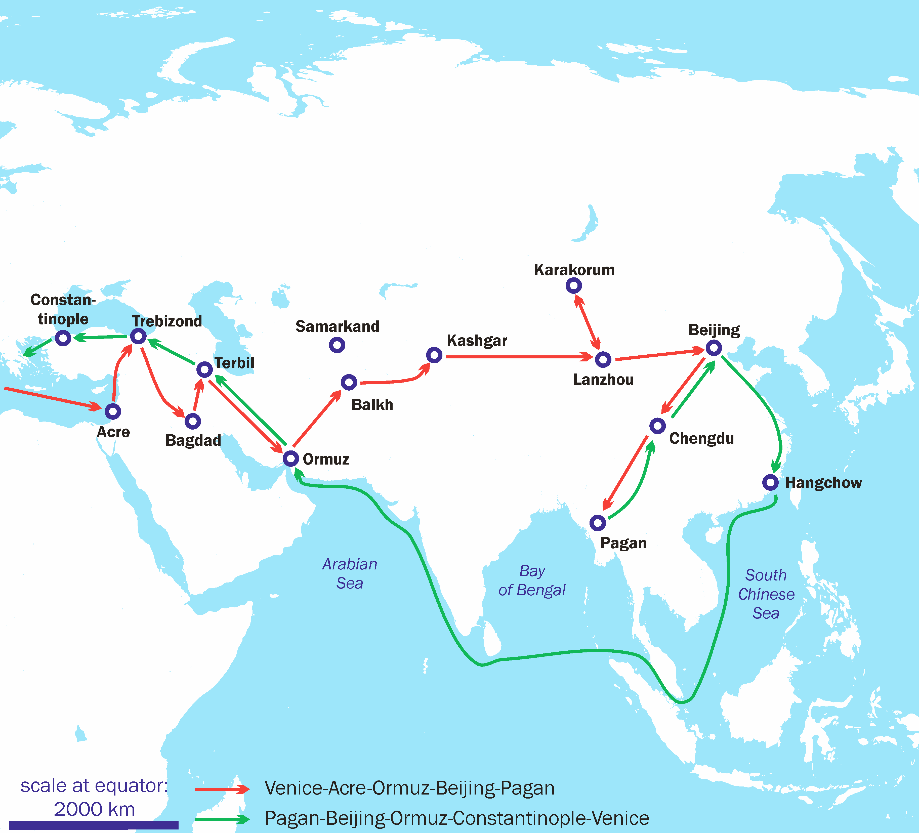
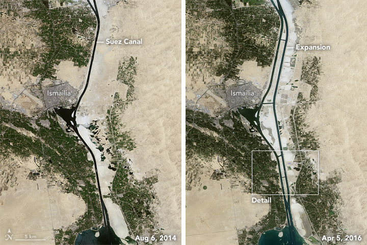
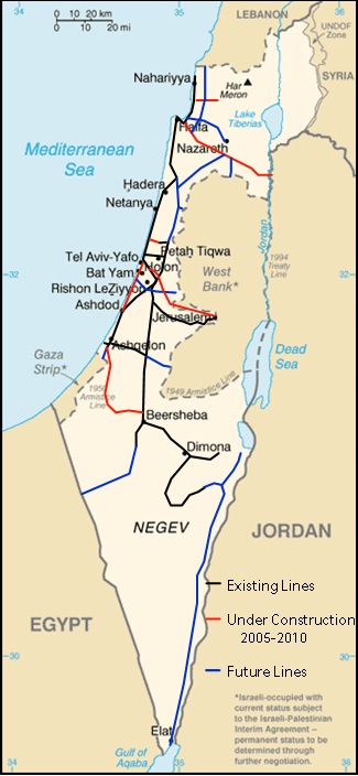
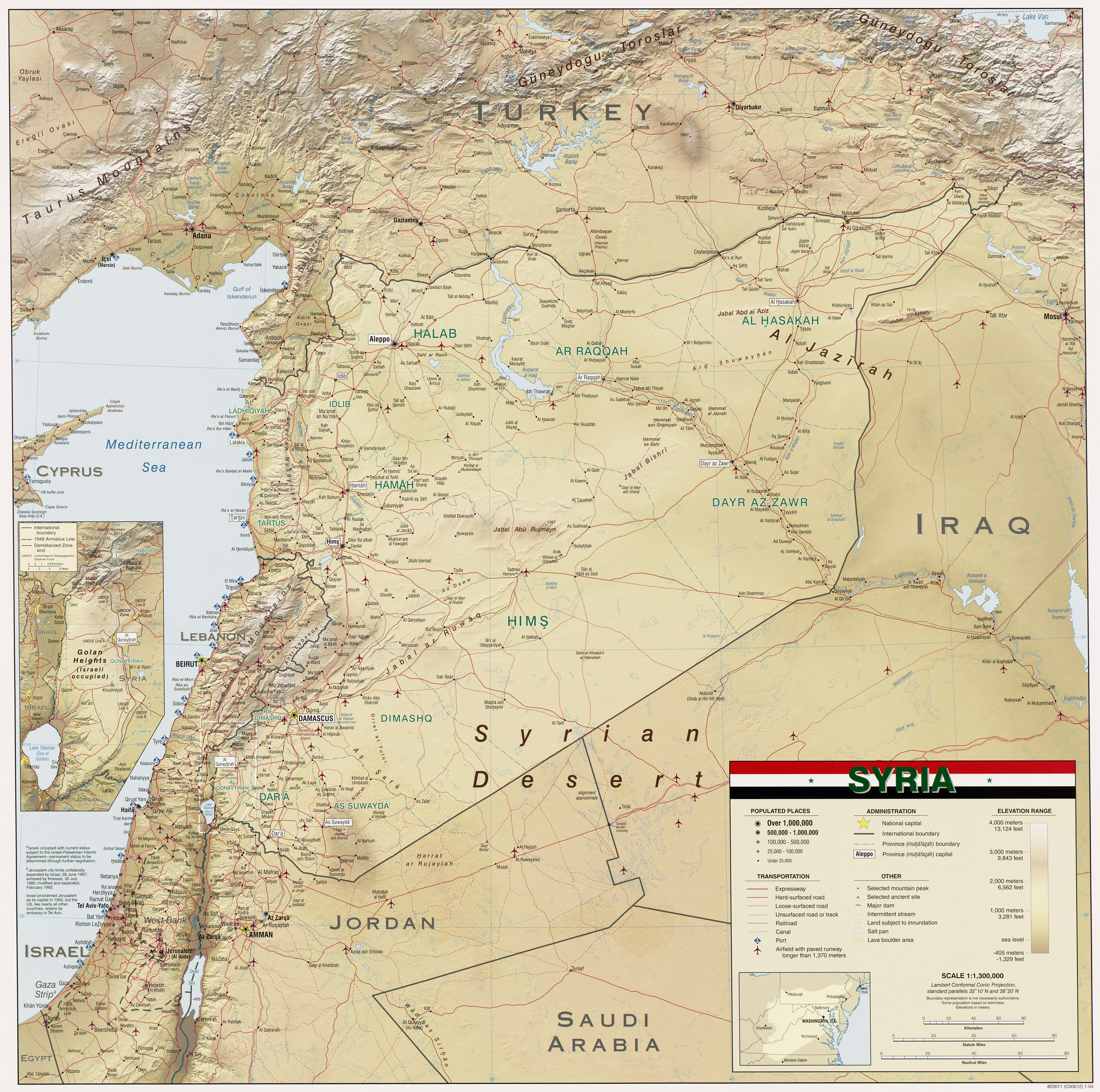
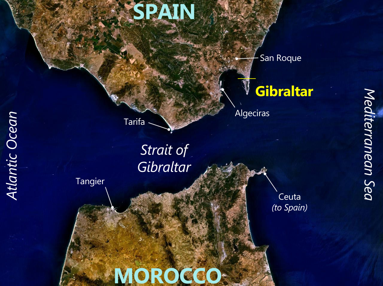
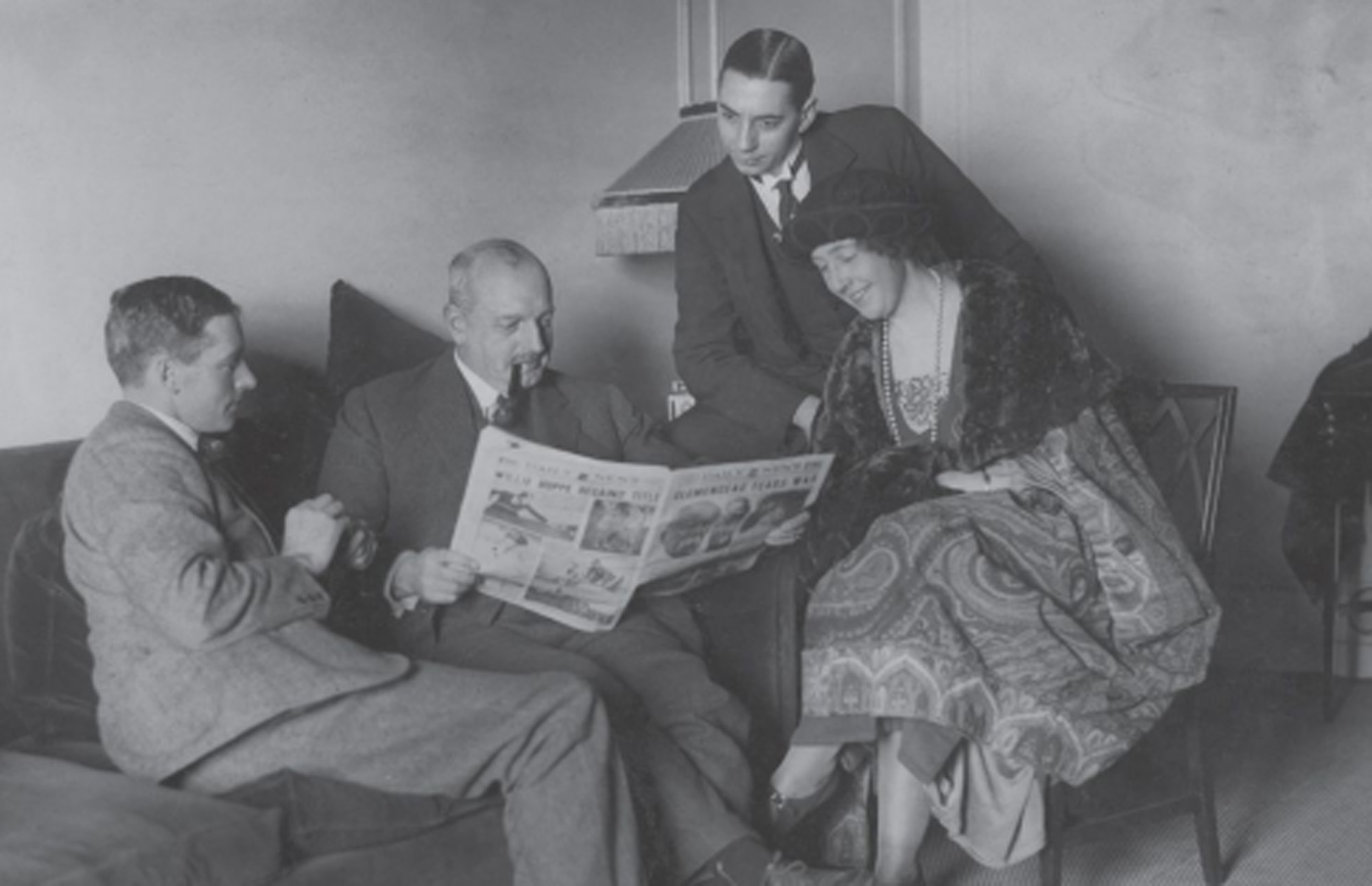
![[London] Daily Herald](https://upload.wikimedia.org/wikipedia/commons/0/0a/Christie_at_Hydro.jpg)