|
Reflections 2022
Series 2
February 10
2008 Swiss Rail Visit III: Lugano–Zürich
Venerable Ships - Gauge Changers II: Switzerland
| | Southern Extensions After visiting Davos we're ready to leave Sankt Moritz for our next stop, this time in the Italian-speaking world, which also means we have to remember where the Italian Swiss areas are:
https://www.treccani.it/export/sites/default/immagini/img_nl/lingua_italiana/scritto/Grigioni1.png
Not named, but located in the south central area, is the canton of Ticino, and the large canton in the east is Graubünden/Grigioni, whose three Italian-speaking areas are in green, each named by the valleys that formed them. Again, the area furthest to the west with two valleys has always felt more at home and associated itself with Ticino. The Bregaglia valley is in the center, and the Poschiavo valley is in the east. Keeping that in mind, there are a few more details to clear up about the Rhätische Bahn (RhB), for which we need to look again at the map of the RhB routes in Graubünden/Grigioni (Map by sansculotte@despammed.com).
https://upload.wikimedia.org/wikipedia/commons/7/76/KARTE_rhb.png
The RhB, being owned by the canton, has been very good to service all areas of the canton, almost always of necessity following the routes of river valleys (plus a notable tunnel or two). But look at the route map and look for the "rail deserts", areas with no rail service, and your eye will be drawn to the southwest, tho not for lack of the RhB trying.
On the map, in the lower left, look at Bellinzona in Ticino and Mesocco in Graubünden/Grigioni. There used to be a rail line here connecting these two. It opened in 1907 and the RhB owned it from 1942 to 2003, totally disconnected from the rest of the system. At one point there were plans to extend it under the San Bernardino Pass (see map) to Thusis (again, all river valleys) to connect it to the rest of the RhB lines, but this never happened. Passenger services stopped in 1972 when it became a freight line, and it was finally closed in 2013. However, that leaves the southwest corner of the canton underserved by rail, which is uncharacteristic. So what's the situation today?
https://i1.wp.com/www.transitmap.net/wp-content/uploads/2014/01/tumblr_mz0smchhvw1r54c4oo1_1280.jpg?fit=1194%2C1688&ssl=1
This stylized map of Ticino rail routes shows local service, but also thru service, connecting Milano/Milan with Luzern and Zürich (click on top of map). At the upper right, it also shows in blue a bus connection between this main line near Bellinzona and Mesocco, indicating again that that western "finger" of Italian-speaking Graubünden/Grigioni functions more closely with Italian-speaking Ticino. I checked, and there is a Swiss PostBus (more later) service continuing over the San Bernadino Pass to Thusis and Chur, which is adequate. But anyone wanting a rail connection finds it would be much longer and more expensive, going from Bellinzona all the way to Zürich, then coming back to Thusis.
| | | | | | While you have this route map, note the following. We said there are only two main standard-gauge (=heavy duty) connections between Italy and central Switzerland, one thru the Simplon Tunnel in the west, and this one thru the Gotthard Tunnel further east. We also said there is no high-speed rail in Switzerland, and I think it's become obvious that it's not needed. But that's the local situation, and international service is different. I've now learned that there's currently a new high-speed train called the Superveloce that was planned to be completed by 2020, connecting Zürich and Milan via the new Gotthard Base Tunnel and stopping only twice in between, a Swiss stop in Lugano and an Italian stop in Como en route. They were waiting for a smaller tunnel in Ticino to be completed, but with the pandemic, there's no news that the train is running yet. Currently, the fastest train takes 3h26, while the new one should take only 2h45. The corresponding road journey would take about 4h00.
Lastly, when I talk later about leaving Lugano, I'll mention having to take a local train, then change in Bellinzona for the Wilhelm Tell Express, which actually left out of Locarno, so have that image in mind.
|
| | | | Now go back to the RhB map and we'll see what happened to the Bregaglia valley. We'd said that the Sankt Moritz station was built for thru service, but is today used instead as a terminus for two lines. During the RhB rail-building era in the early 20C, it was planned to extend the Albulabahn into Sankt Moritz, then via the Maloja Pass (see map), to Chiavenna in Italy, where there was to have been a connection with the Italian railway line that runs along Lake Como to Milan. In Switzerland plans reached an advanced stage, but in Italy, they were less enthusiastic. Then came WWI and the economic recession that followed, and the plans were never implemented, so no rail route exists out of Sankt Moritz into the Bregaglia valley. Instead, this route is also served by a cross-border Swiss PostBus, shown here:
https://www.mystsnet.com/wp-content/uploads/2018/07/Grand-Train-Tour-of-Switzerland-Map-2017.jpg
This is again the route map of the entire trip, so keep it to the end of this posting. You'll see the dotted line showing the PostBus route out of Sankt Moritz that goes beyond Lake Como and actually connects to Lugano. I didn't take this because I wanted to take the Berninabahn (in red) and then take the other PostBus connection to Lugano. So the Bregaglia valley does get served, but not by rail.
Therefore of the three areas of Italian Graubünden/Grigioni reaching south, only the Berninabahn was built, along the length of the Poschiavo (pos.KYA.vo) valley, the one in the east. Check that out on both maps, but let's first concentrate on the RhB map.
| | | | | | We mentioned in the last posting that, when one exits the Albulatunnel, one has left the Rhine watershed (where Davos is) and is going upstream in the Inn Valley, with its own watershed, and where Sankt Moritz is located. The RhB map shows that the Inn starts at the above-mentioned Maloja Pass, then forms several lakes, including the one in Sankt Moritz. You then see how it continues northeast toward the Danube, which leads to the Black Sea. Thus the Inn is the only Swiss River that eventually flows into the Black Sea.
The name Inn is derived from an old Celtic word en, meaning "water". In Medieval Latin it was Enus, then local dialect changes changed E to I so Enus became In. The NN spelling appeared in the 16C, and Inn has been the name since then. But the Romansh name remains En, whence we get the name of the entire valley in which Sankt Moritz is located, the Engadin (ENG.ga.din).
|
| | | | Berninabahn So of the three Italian Swiss projections reaching south from Graubünden/Grigioni, only the easternmost ever got rail service, where the Berninabahn runs over the Bernina Pass (see RhB map). And spectacular service it is, since it's been declared a UNESCO World Heritage Site along with the Albulabahn. The line opened in sections between 1908 and 1910. The original company always tottered on the edge of bankruptcy until the RhB took it over in 1943. The trip on the Bernina Express is a four-hour journey across 196 bridges and 55 tunnels.
Here's a more detailed route map of the Berninabahn that can now replace the previous one, which we can discard (Map by Pechristener). Since many will want to keep this to follow our stops, I'll copy the link to the SAME map here:
https://upload.wikimedia.org/wikipedia/commons/2/28/Berninabahn.png
Following this route map, out of Sankt Moritz, already quite high at 1,822 m (5,978 ft), it crosses the Inn River (click), and makes its first stop at Celerina Staz, which is, at 1,716 m (5,630 ft), the lowest point on the north side of the Bernina Pass. From here it's way up to the pass, reaching it at Ospizio Bernina, at 2,253 m (7,392 ft). You also see the dashed line, which is the watershed marker. After that, it's even further down than it was up, until Tirano is reached at only 441 m (1,447 ft). That's an altitude drop from the pass down to Tirano of 1,812m (5,945 ft). While the ride on the Berninabahn is no roller coaster, those ups and downs are significant, as shown on this graph, comparing meters of altitude with kilometers of distance (Graph by Markus Schweiss & Saibo). The Berninabahn (and all of the RhB) is NOT a rack railway at any point, it just gains traction on the basis of the weight of the train on the tracks, and thus it ranks as the highest adhesion railway in Europe, and--with grades of up to 7%--as one of the steepest adhesion railways in the world. The route over the Bernina Pass is the highest railway crossing in Europe and the third-highest railway in Switzerland. As usual, understand the wording. The Jungfraubahn is the highest, and the Gornergratbahn is second, but they are both dead-end routes, and not crossings of the Alps, as this is.
| | | | The Trip It was now 27 July. The special train on the Berninabahn, the Bernina Express, belies its name (as does the Glacier Express), since, as I wrote in 2008/16, the charming train stops at every charming small town on the route and is the antithesis of high speed. . . . They are frequent, except not all have Panoramawagen; since I wanted one, I made sure I took the right train. The route weaves out of town and passes attractive villages and ski resorts. Cable cars and chairlifts sprout everywhere. As you go up you see waterfalls on the side and an attractive landscape. As you come up the gentle approach to the summit, Piz Bernina is on the right.
Unlike on the earlier posting, I have pictures and maps now. This is the Piz Bernina with the Bernina Express in the foreground—note the panorama cars. I presume Piz Bernina the peak just right of center, with its signature glacier coming down from it (Photo by Iter1). The name is in Romansh, and presumably, also in Lombard Italian, but standard Italian calls it Pizzo Bernina. It's the highest mountain in the Eastern Alps at 4,048.6 m (13,283 ft). It's also the most easterly Four Thousander (a mountain higher than 4,000 m /13,000 ft) in the Alps. While the summit lies within Switzerland, the massif is on the border with Italy. It was named after the Bernina Pass, which, frankly, is just the opposite of what I would have thought. It just goes to show the historic importance of mountain passes in Switzerland—mountains are curiosities, while passes are how you get places to make your livelihood. On our route map, look down from Pontresina to the brown border with Italy, then west from Alp Grüm, and that's where the Piz Bernina is. As for the train, I wrote: It has a well-known livery in a distinctive red . . . and it also has an affectionate nickname: Die kleine Rote. The literal translation of that is a bit clumsy: The Little Red (One). I would improve on that . . . so it really sounds affectionate in English. I’d call it "Little Red".
| | | | Bernina Pass The highpoint of the ride, both literally and emotionally, is the Bernina Pass, which includes interesting geography, history, and language usage. There is so much to take in there, even without ever leaving the train, that I'd like to start with a picture, and only then follow up with a map. It's not rare to have lakes at or near a mountain pass, and we've spoken of that earlier, but this situation was special. I wrote: As we pulled over the gentle, broad and flat top of the pass, they announced two other facts that I reveled in. The area is spacious enough so that there are two lakes there, and they form the continental divide. Study carefully this barren view (above the tree line), of the Bernina Pass looking south toward Italy, in the direction we're going (Photo by Friedrich-Karl Mohr). This is an incredible picture, but you have to know what you're seeing to enjoy it. First note the road, the modern version of the path that's crossed this way for centuries. Click in the center to see the red building, which is an outbuilding of the one to its right, the actual residential building of Ospizio Bernina. That's all there is—it isn't a town. Follow the road down to the lake to see its rail station, on the east shore of the lake. The larger lake, Lago Bianco, is of a lighter color than the smaller two, the larger of which is Lej Nair. The strip of land between Bianco and Nair is the technical summit of the pass and the watershed line between the Adriatic part of the Mediterranean (ahead of us) and the Black Sea (behind us).
You may figure out the Italian name, that Lago Bianco is White Lake. But how's your Romansh coming along? We saw both those Romansh words in Sankt Moritz, and we can figure out that Lej Nair is Black Lake, an interesting contrast of names—and of colors. (The smallest lake is Lej Pitschen "Small Lake"). Now let's see all that on a map of the lakes and pass (Map by Tschubby). Disregard the two colors and the red line between them, since those are the two communities coming together here. Note the German name Hospiz Bernina, for the Italian Ospizio Bernina. Note the two small lakes, flowing north, and the (here unnamed) Lago Blanco, which, as we see, was dammed at both ends in 1910-1911 to make a reservoir to supply power to hydroelectric stations to the south. To understand the Lago Bianco reservoir better, look at this picture of it at low water, now looking roughly towards the north (Photo by Martingarten). The low water level clearly exposes the location of the original Lago Bianco on the left, then the former stream that connected it to the former Lago della Scala on the right. You also see the southern dam. The current reservoir/lake still drains to the south, as did the two precursor lakes.
Now that we see the location of the lakes, let's consider the continental divide between them. Rain—or snowflakes—falling in Lej Nair go north, as we've said, since that's the part of the watershed of the Inn (Map by Thomas Römer/OpenStreetMap data). On the lower left (click), find Piz Bernina and Sankt Moritz for orientation, then follow the Inn (Romansh: En) into Austria, thru Innsbruck (Brücke=bridge), up to Passau in Germany, where it joins the Donau/Danube and ends up in the Black Sea.
But rain or snowflakes that fall into Lago Bianco go south and are within the watershed of the Po (Map by NordNordWest), starting within our Poschiavo Valley with its Poschiavino river into the Adda (see map) and finally into the Po and the Adriatic. We've talked about Swiss rivers going in so many directions: the Rhone goes west to France and the Mediterranean, the Alpenrhein goes north to the North Sea, and here the Inn goes east to the Black Sea and even the itsy-bitsy Poschiavino brings rain to the Adriatic.
That's the geography, now for the history and language issue. The Italian name Ospizio Bernina is the commonly used name for both the building and its rail station, tho the German version is Hospiz Bernina (in both languages Z=TS) and in English it would be the Bernina Hospice. (Latinate languages have lost the H, but Italian is the only one that actually doesn't write it, either. So when you see words like ospizio, umido, Amburgo, Olanda, Amleto, "put the H back" to understand it.)
So we seem to be talking about a hospice, but do not misunderstand this antiquated "Alpine" use of the word. The word "hospice" appeared in English (from French) in 1818 meaning a "rest house for travelers", especially the houses of refuge and shelter that monks kept in Alpine passes. The word "hospice" is related to "hospitality, hospital, hotel, hostel, host". In English, it wasn't until 1879 that the sense developed that a hospice was a "home for the terminally ill". With that modern shift of meaning of Ospizio, Hospiz, Hospice, it would be best to translate the name of this building as "hotel", or better yet, "hostel". Apparently the old name is kept for historic reasons, because if you look up their website, they now call themselves the Hotel Ospizio Bernina, or even just Hotel Bernina. However, a review of the website indicates that the rather attractive building is closer to a youth hostel for all ages. But in any case, appreciate the name Ospizio Bernina for the thrillingly historic name it is, indicating you've reached an Alpine pass where once monks assisted travelers arriving on horseback or wagon, giving them a place to stay, eat, and even change horses. There's a lot of history in Ospizio Bernina, and an interesting shift in language.
About 50 or so meters/yards down the hill from the Ospizio is the Ospizio Bernina rail station on the shore of Lago Bianco (Photo by Hansueli Krapf). Here, a local train is going south to Tirano. This station, at an elevation of 2,253 m (7,392 ft) is the highest station of the Berninabahn, and the highest point of the entire RhB. Here, two RhB power cars pull the Bernina Express away from the station along Lago Bianco (Photo by Kabelleger/David Gubler). Click to see that the first power car illustrates the Landwasserviadukt of the Albulabahn, and the second one shows the Brusio Spiral Viaduct that's coming up on this line. Here you can take a closer look at those panoramic windows from the outside (Photo by Enslin), as well as see what the view is from the inside, tho this is a winter view (Photo by dirt).
Go back to our route map, where you'll see a number of switchbacks to drop (or gain) altitude. This is particularly noticeable at Alp Grüm (click) and again at Cadera, so you can imagine how far we come down from the level of the pass. A little further down, you'll find the small town of Le Prese, which offers something of interest, a street run. I wrote: The best streetcar systems have their own right-of-way, but many traditional ones ride in automobile traffic. Railroads almost always have their own right-of-way, and it’s rare, but not impossible, to find a rail line in a street. The term used is "street running", and it’s a very quaint thing to find. As we neared the southern end of the Poschiavo valley, they announced that the train would be running through a couple of towns, such as Le Prese, "like a tram", and I knew they meant we’d be doing a street run. [Here's a YouTube video (0:37) showing] Street Running in Le Prese. Notice the cars pulling back to the right-hand side of the road once the train has passed. You'll also see an empty log-carrier freight car at the end, which we'll discuss next.
| | | | Brusio Spiral Viaduct On our route map, move down to Brusio, and south of the town there's the indication of one of the major sites on the route, listed as the Kreisviadukt (Kreis="circle"). It's known in English as the Brusio Spiral Viaduct, and it's quite spectacular to see, and more so to ride on (Photo by Kabelleger/David Gubler). This photo shows two RhB power cars bringing a local train from Sankt Moritz to Tirano on the viaduct.
We know that switchbacks aren't enough to change altitude, and so we've seen spirals, usually completely or partially in tunnels, to change altitude quickly. At one point Brusio's was to be a spiral tunnel, but local geology didn't allow it. Thus the engineers built a 360° curve with a 70 m (230 ft) radius going down to (or rising up from) the valley floor, with the nine arches of the viaduct being part of that curve and the route circling back and passing thru one of the arches. The stone viaduct proper is 110 m (360 ft) long, so the name is something of an anomaly, since it's nevertheless used to denote the entire spiral—the actual viaduct is a curve, not a spiral. Still, it's considered to overspan nothing but its own rail line, and in a sense, itself. Opened in 1908, it has nine arches, and serves to adjust the altitude of the line and is meant to limit the line's grade to falling within the maximum of 7% while avoiding the inconvenience of more switchbacks. It's a key structure for having declared the Berninabahn a World Heritage Site and one of its architectural highlights.
Here's an aerial view of the graceful Brusio Spiral Viaduct (Photo by Arne Krueger) and here we have a local train that, having crossed the viaduct, now runs under one of the arches (Photo by Lord Koxinga). But there's a surprise in this picture, that we had a hint of in the last video. Since the single-track line has so much traffic, local passenger trains such as this often have freight cars attached to them. Click and look at the last car in the shadows and you'll see logs on a flatbed car, similar to the empty car we saw in the video.
Then, as our map shows us, shortly afterward, we cross the international border into Italy for the only RhB station not in Switzerland.
https://www.weather-forecast.com/locationmaps/Tirano.12.gif
| | | | Tirano We can now move to this map which shows the area around Tirano from the Italian point of view, since we're in Lombardy, whose local dialect has similarities to Romansh. The map doesn't show rail lines, but roads—the one to the west will be our bus route to Lugano. But as for the connection to Switzerland, the road and rail route are virtually the same. I wrote that the suddenness of the arrival in Tirano surprised me. There was a sign on the side of the route saying you were entering Italy, and I suspected we’d go a short distance until we actually came to Tirano, but no, as we entered Italy, the same signpost said we were entering Tirano, which, I now know, hugs the international border. And then, in no more than 3-4 minutes, we pulled into the station. The suddenness of being there was a shock. So Tirano's limits are larger than you may think from the map. Then, for reasons I cannot fathom, I was suspecting Tirano would be some gritty, industrial burgh of a railhead, but it was beautiful and charming.
https://www.hoteltirano.it/images/cartine/mappa-tirano-punti-interesse-xl.jpg
I consider this map I found (click) to be of great interest, as I didn't have one at the time, so wasn't fully aware of the details of what I was doing as I entered, then left, Tirano. Start in the upper left at Via Elvezia. We've talked about that word before. Do you recognize it? If not, take the earlier advice and "put the H back" and you'll find it's "Helvetia". But we also said that some Italians like to use that word to simply mean "Swiss", so this could have been named *Via Svizzera; either way, it's appropriately Swiss Road or Swiss Way. I checked Google Maps to estimate the distance to the border. From Piazza della Basilica, going up Via Elvezia to the edge of the map is 40% of the distance to the Swiss border, so allow another 60% to see how close Switzerland is.
Now follow the black rail line to find another street run like in Le Prese, perhaps even a bit more surprising. The run starts coming down the west side of Via Elvezia (Photo by Asurnipal). Note how cars have two narrow lanes next to the tracks--at least the tracks are not IN the road, as in Le Prese. This is an RhB train pulling out of Via Elvezia into and across Piazza della Basilica (Photo by Rikki Mitterer). The Basilica itself is off to the left. Click to see the Caffè Basilica on the left, then compare that view with this train (Photo by Geobia) returning north past the Caffè, showing how narrow Via Elvezia is here. Street runs can be spectacular things. I wrote: But I think the biggest shock was that all those 3-4 minutes in town was not only a street run, the route of the street run actually crossed one end of the main square that had the cathedral on it! Take a look [(0:48) at the] street run in Tirano. Behind the camera here is the rest of the main square with the cathedral, and in another moment, the train pulls into the station.
On our map, you can see that the road west—our subsequent bus route--apparently leaves via the piazza, and that to the east, the tracks do separate from the road. Follow the RhB tracks to the station (in red) on the west side of a large square, then locate another station (in red) on the south side connecting to the west. Because of the two stations, the square is the Piazza delle Stazioni (plural). Right to the south of here is the bus station, also in red, with its access by underground passageway. Finally, look at a geographic feature. On the left, having coming down from Switzerland with us is the small Poschiavino River, which off to the side, will join the Adda at the bottom, so those raindrops from the pass will now continue to the Po and the Adriatic. In other words, going west will be a river, a train, and our bus.
https://www.trenino-rosso-bernina.it/archive/cms/images/all/piazza-stazione-tirano.jpg
We'll now go to this rather pleasant piazza to see, to the southwest, our first clear example of two railroad stations next to each other, in this case, they've been marked by flags--the Swiss building is white-gray, the Italian light gold. Then we'll go between them to look back from both sets of tracks northeast to the buildings (Photo by Roehrensee). You see the red Swiss train, on a narrow-gauge (meter) track, and also an Italian train, but it's on a standard-gauge track, so we see that in Tirano we have a break-of-gauge—for those continuing by train, which we are not.
| | | | | | The standard-gauge Tirano-Lecco Railway follows the Valtellina Valley (German: Veltlin), then continues along the east shore of Lake Como (Map by Arbalete). It was, typically for its era, built in two sections by two different companies, each building out of the provincial capital of Sondrio, one west, one east. It was completed from Sondrio west to Lecco, on Lake Como, in 1894, where it was connected to the rest of the Italian network (in black), notably to nearby Milan. Then in 1902, another railway extended the route from Sondrio east back to Tirano. The two railways were combined under the older name and integrated into the Ferrovie dello Stato (FS) / [Italian] State Railways in 1970. Our bus ride will be on the main highway pretty much paralleling the rail route up to roughly the area of Delebio (and Dubino, not shown) near Lake Como. |
| | | | I wrote that, at the RhB station [i]n Tirano, customs officials waved arriving passengers past, and I should elaborate on that, because that wouldn't be necessary today. This is the Schengen open border area today (in blue), including Switzerland (Map by Rob984). (Countries in orange are committed to join in the future.) Tho Switzerland had signed to be a member of Schengen in 2004, the provisions were first implemented on 12 December 2008, some five months after my July visit. Thus there still had to be a perfunctory "wave-by" check in Tirano, again when the bus re-entered Switzerland near Lugano, and finally when my last train left Switzerland into Germany en route to Hamburg. None of these checks would take place today.
http://www.flaviocapra-bernina.net/Immagini/Map-StazTirano1-lav-800.jpg
This clumsy, stylized map is unfortunately not to scale, but you can see the red, narrow-gauge RhB trains headed for Sankt Moritz and the green standard-gauge FS ones for Milan. Trenino Rosso is the same as [Die] Kleine Rote ("Little Red"), and the Dogana is the Customs Area, no longer necessary. The piazza is misnamed here in the singular, Piazza [della] Stazione instead of Piazza [delle] Stazioni. Do look at the buses at the bottom, whose location is also way out of scale. You see the sottopasso / underpass under the tracks to the bus area. This is the open-air bus terminal, and of the yellow bus labeled in Italian bus Autopostale Ferrovia Bernina / Bernina Railway PostBus, which is our Swiss PostBus to Lugano.
| | | | | | PostBus Switzerland / PostAuto Schweiz / CarPostal Suisse / AutoPostale Svizzera is a subsidiary company of the Swiss Post providing regional and rural bus service. A country having its own national bus service involves an interesting history. Early on, the Swiss Post office delivered mail everywhere, including over mountain passes, by stagecoach. For more profitability, the stagecoaches took paying passengers as well. In the motorized era, buses replaced the stagecoaches, but the post office was still in the passenger business. But in 2005, mail services and public transportation were finally separated, and so the PostBus became a separate subsidiary of the Swiss Post.
The PostBus vehicles (Photo by JoachimKohler-HB) are a Swiss icon, with a distinctive yellow livery and three-tone horn, used when the road is narrow or on curves. As is the case in many countries, notably all the German-speaking ones, the image of a traditional post horn is used as a postal logo and is found on mailboxes, post offices, and PostBuses—these are in Germany (Photo by Kandschwar), and this is on the PostBuses. On some mountain roads, there's a sign of a yellow post horn on a blue background that indicates that the PostBus and other public transport vehicles have priority.
The post horn is a valveless, cylindrical brass instrument with a cupped mouthpiece (Photo by Kandschwar). The first metal horns were made at the beginning of the 15C. Since the 16C post riders have used them to signal their arrival or departure, and when mail coaches were introduced in the 17C, they used them as well. This is a 1728 engraving of an Augsburger Postreiter / Augsburg post rider arriving in "Augſpurg". We also have this sheet music issued in Prussia in 1828 of musical post horn signals, telling about what's arriving—No. 2 tells how many accompanying coaches there are, and No. 6 is the emergency signal.
Finally, we really have to hear what a traditional post horn sounds like, don't we? Here's a YouTube video (1:44) of a guy playing a traditional post horn. I find it absolutely thrilling to hear. The only modern parallel is the music played by the ice cream vendor's truck roaming city streets, but that's not so thrilling. Well, for kids, maybe.
Note what he says about Mahler and Mozart. I'm aware of that, and have listened to some of the Mahler piece, but it's played on modern instruments and doesn't fulfill our purpose here.
|
| | | | So we then make our way to the open-air bus parking lot, and find our PostBus:
https://www.bus-bild.de/1024/postautoregie-chur-nr-94-bernina-90492.jpg
Here's the bus waiting in Tirano in 2012 to set off for Lugano, non-stop. I remember it being yellow like other PostBuses (and the Tirano map showed a yellow bus icon), but my memory might be foggy, they may have changed color since 2008, or maybe it was always red to match the RhB signature color. But in any case, even the link says this picture is from the PostAuto Regie (Head Office) in Chur. I learned at the time of the 2008 postings that the RhB has contracted with an Italian company to run buses, without any intermediate stops in Italy, due west from Tirano to Lugano. Since it was a service of the Rhätische Bahn, although in Italy, the Swiss Card applied. This route runs four or more times a day in each direction, but as it turned out, the train I’d wanted with panorama coaches didn’t connect directly, so I had a 2 ½ hour layover. And these buses are popular. They require a reservation, and Rail Europe had told me it was sold out for when I wanted it. I tried again the next day, and fortunately it went through, so I knew the bus would be packed.
As for that delay, I think my memory is clearer than the way I wrote it then. I was dealing with Rail Europe, and my memory is that they did tell me that there was a prompt connection, but it was sold out. I was shocked, since this was MONTHS in advance, even well before Africa. I also knew that all my Swiss connections were put together like a house of cards, and if this connection didn't work, the whole trip would be a disaster. So my memory is that, when I spoke to Rail Europe again, I asked what the next bus was after my sold out one, and it was this one, but had just THREE seats left, so I grabbed one seat, reserved it, and held on to it tightly, and we lived happily ever after. In any case, there was this 2 ½ hour layover in Tirano, but that still left enough time to see Lugano, so all was well.
If you look back at the original Swiss route map, you'll see our bus connection to Lugano in dots, joining that other connection we discussed directly from Sankt Moritz to Lugano. And tho I didn't know about the Veltlin at the time, I enjoyed the bus trip, which took 2h30 thru surprisingly attractive countryside. Follow in this map we've seen before of the Provincia di Sondrio or the Valtellina, or the Veltlin (Map by Idéfix). Again, the road you see was close to the rail line, but I knew nothing about Sondrio or the Adda River. You can't prepare yourself for everything.
I'd forgotten these next couple of bits, so it's good I'd put them in the old postings. I really have to smile, since I'd left Switzerland for a few hours, and this was now an Italian driver working for the RhB. It was soon obvious that the driver wasn’t happy with the traffic on the main road, so, on one of the many traffic circles, he zoomed down a side road in some town, went down back streets, and came out at the next traffic circle, where he could rejoin the main road, or zig down back streets on the other side. And remember, this wasn’t some odd one-time charter bus, this was a regularly scheduled route that ran several times a day. But it was also Italy. And also an Italian temperament and outlook, not a Swiss one. The trip continued on this map to the Lake Como area, near Dubino & Delebio.
http://www.worldeasyguides.com/wp-content/uploads/2013/08/Map-of-Lake-Como.jpg
Pick it up on this map at the same place. I suppose the FS train route must have gone south, while we went north around the top of the lake, where there were beautiful late-afternoon views. Then, as we were about ready to leave the lake and move west again, the driver pulled just off the road and barely onto a small parking lot. There were no rest facilities on the bus, and he announced, in Italian and barely passable, pre-memorized German and English: Quindici minuti! Fünfzehn Minuten! Fifteen minutes!, continuing to explain it was a rest stop, and the facilities, as they were, were in two cafés on the edge of the parking lot. This struck me as so tipico italiano, and not at all tipico svizzero. Afterward, there was a moment or two to walk across the road to the small marina to sigh at the lake. Note on the map that at Porlezza, we reach Lake Lugano. Now switch to this map of Lake Lugano that we've used before, and pick our ride up at Porlezza as we ride along the north shore of that lake, including crossing the border (Map by Tschubby). As we continued west for more "fun", we reached a point where the road was narrow, and added to the current adventure. The bus kept stopping so that oncoming cars could pass us. Finally, someone with a pickup truck couldn’t, so he backed up a block to a wide space. And this was a scheduled bus service running several times a day! At the border, the Swiss officials waved us by and we entered Ticino, and shortly afterward, Lugano. And there was a problem. As we were coming along [the north shore of Lake Lugano], black clouds started gathering. Someone pointed out the huge black, conical mass of Monte San Salvatore at the southern end of town, yet very close, and you couldn’t tell if the mountain or the clouds were blacker. On this last map, notice how the center of Lugano is located on a curve at the northwest corner of Lake Lugano, how Monte San Salvatore is due south of it, and also find on the lake the Italian enclave of Campione d'Italia (2016/8).
| | | | 6) LUGANO While Lugano was gorgeous, there was now another concern. In Meiringen I had barely missed the Alpine cloudburst by just managing to run onto the hotel porch in time, and now another cloudburst was about to hit. How would this go? The bus, 20 minutes late . . . , let us off at the rail station, which has a curious location. The entire west side of Lugano is on a steep hill, and the road and rail routes are halfway up it, way over the town . . . Here's the arrival plaza of the Lugano Station as it looked at the time, but on a sunny day (Photo by Hoff1980). Notice the trilingual insignia of the federal railways, so we're back to standard gauge. (I've since learned that the SBB remodeled it in 2016-2017 when it opened the Gotthard Base Tunnel, to put its best foot forward, and so the station today once again looks as it did when it was fully opened as a thru station in 1882 (it had opened southbound only in 1874) [Photo by Hp.Baumeler].)
Arriving at the station, the first drops started to fall, and everyone rushed inside. I was now convinced that the third part of this day, the early evening visit to Lugano, was going to be a washout. . . . At least I was at the station, and it had been my intention anyway to check out the location of my train the next morning, something I always do for easy movement at the time. But then, in the downpour, I sat down on a step and dug some shoes and socks out of my bag to exchange for my sandals. It was going to be some evening. The street and terrace in front of this hillside station looked down on the downpour hitting the roofs below. Bummer.
First, some clarification. While others might be doing a bus-to-rail change of mode that day, I was not, for two reasons. First, my connecting train north didn't leave until the late morning, and second, I really wanted to spend at least a short time in Lugano. Even with the time lost in Tirano, there was still time to see Lugano in this last half-day, plus a bit in the morning. But would it all be rained out?
I always do my homework in advance, and I knew that this station, quite uniquely, had a funicular connection down to one of the main squares below in the old town, where I’d made a reservation at what sounded like an interesting hotel, the Hotel Dante (the Piazza di Dante was nearby. . .). But how far was the funicular, especially in the rain? How close would it let me off to my hotel?
https://i.pinimg.com/originals/02/6a/62/026a628003c0de25bf609856975bb9ad.jpg
Let's finally take a look at central Lugano in this first of two maps, each showing a bit more than the other. While our bus came in from the upper left, you see the rail line going north-south (between the Gotthard Pass and Italy), and our bus pulled up to the Bahnhof/Stazione/Station, which is way up on the hillside. Our area of interest is from the station down the (vaguely drawn) funicular past San Lorenzo cathedral to at the foot of the funicular and its piazza (poorly shown), then south-southeast thru the old town along a couple of streets including Via Nassa, to the lakeshore. But how will all that work out?
The funicular was not only the salvation, but also huge fun just by itself and super convenient. Let me just say here that because of it, I can list of several more "only in Switzerland" statistics:
Lugano was the only time before or after I ever entered a city by dropping in downward, from above.
The next morning was the only time I ever left a city by rising up out of it.
While others may have made a bus/train break-of-mode connection, this was the only time ever I had a bus/funicular break-of-mode. And to sum up the whole day, it was a double break-of-mode, train to bus to funicular.
When I left the next morning, it would be my only funicular/train break-of-mode (with more to follow).
Meanwhile, keep in mind that this is one of the busiest funicular lines in Switzerland; in 2007, it carried 2.4 million passengers.
| | | | La Funicolare Lugano Città-Stazione The name might sound ponderous, but it simply names the two end stations, the funicular station at Lugano Stazione up above and the once down below at Lugano Città, where città (chit.TA) means "city", but with a strong implication of it being the historic, older, original, central city core and not newer neighborhoods. On our map, compare the parallel grid of streets to the north, in what has to be the newer part of town, with the small, twisting, very pedestrian-oriented streets of the città, our area of interest.
Let's start at the beginning with two revealing pictures. (1) Just two years after the rail station fully opened as a thru station in 1884, the funicular opened in 1886, and until it was electrified in 1855, it operated on water power (see Montmartre funicular, 2018/8). Note a number of things in this picture. We see how the rail station originally looked, which the recent restoration brought back. We see how tunneling was necessary (it still has tunnels). We see how barren the hill is, tho today it's full of streets and houses. We see how steep the hill is, and have to realize that this point—at the cathedral—is only halfway to the bottom. There is, oddly, a stop at the cathedral halfway down, but from one car only (it's still there, more later). (2) This is a strikingly attractive colorized picture postcard of the lower station in the città (it's marked where it leads to, not where it is). Note how quirky it is that the car reaches the open piazza just after coming out from under a building (!), with the tunnel marked in French and German (but not Italian!) "To the Station". At least two of these buildings, probably more, are marked as hotels. So where is it? It was originally called Piazza Cioccaro, which refers to a dialect word describing the bell tower in nearby Cattedrale San Lorenzo. Once the funicular was built, it was renamed Piazza [del] Funiculare, which lasted until 1942, when it was renamed back to its original name, Piazza Cioccaro. Now I didn't know this background at the time, but my hotel's address was Piazza Cioccaro 5, which might have indicated some good news to me.
Back to the trip. After I'd changed shoes in the station, expecting I'd be getting drenched, I turned around to look for my funicular connection and was amazed to see it was there, right inside the station! At the time, the funicular connected directly to the platforms of the station, as also seen here, looking toward the trains (Both Photo by Chris j wood). Click to check out the fare booth, but I had the Swiss Pass, and the funicular was my first local transportation freebie, and down the hillside I went, not having gotten wet yet. TPL on the booth and the side of the car stands for Trasporti Pubblici Luganesi (Lugano Public Transports).
| | | | | | The car would have to be the style I took in 2008, since everything was remodeled in 2016. In addition, I find it unfortunate that during the reconstruction, the funicular station was lowered—still indoors—from platform level into a new lower level foyer and pedestrian level. Because of that, the entire funicular line was shortened slightly from 220 m (722 ft) to 206 m (676 ft), and the vertical distance from station level to piazza level was reduced from 53 m (174 ft) to 50 m (160 ft). |
| | | | Shortly after leaving the station, we pass thru that upper tunnel and then go over the quaint Via degli Amodio, here showing one of the older cars (Photo by Chris j wood). As the whole ride takes only a minute and a half, we soon come to the midpoint with its passing loop (Photo by NAC). These would be the more modern 2016 cars, as photographed in 2017. That should be the cathedral on the right, and at first I didn't realize that the special Cattedrale station is not only on the left, but that the uphill car is actually serving it in this picture, while the downhill car just waits. Apparently passengers have to walk behind and around the portal of this second tunnel between the two locations. And here we have the intermediate Cattedrale station looking uphill (Photo by Chris j wood). It's a request stop, and I assume it's not used all that often. It's unusual in that not only is it a request stop, it only has a single short platform alongside the northern track at the passing loop. Therefore, it can't be served by car 1, but only alternately in each direction, when car 2 on the north side is able to stop there. I understand you request a stop by buttons at the stop and in car 2, and only a single door is opened at this stop. As the picture shows, it also has platform doors to match the car doors. | | | | | | I wasn't aware of this stop at the time, and we didn't stop there either time I was on the funicular. You may recall that the lower funicular in Sankt Moritz at one time had several residential stops, but they were eventually abolished, possibly because they weren't needed any more. Yet Lugano's Cattedrale station remains. |
| | | | After leaving the second tunnel, believe it or not, we emerge into the front courtyard of the Acquarello Hotel and end up at the lower station on Piazza Cioccaro. It's just as that old postcard showed, but the piazza looks different, slightly showing its age, but also with modern buildings. And the ensemble is quite charming.
https://www.orangesmile.com/common/img_city_maps/lugano-map-3.jpg
Now let's move to this second map I mentioned. Click left of center and you'll find the two TPL stations marked, tho oddly, not Piazza Cioccaro (chok.KA.ro). But to my surprise, my hotel, now the Hotel Lugano Dante (they also style themselves as the Luganodante) is shown. While we're at it, find Via Giuseppe Motta (it leaves from under the hotel!) going south, also Via Nassa, which ends in Piazza Luini (not named) on the lake. This is our area of interest. Take a look.
https://www.ticino.ch/pictures/alberghi/verybig4/13680-03.jpg
As we look south in Piazza Cioccaro, we see the Hotel Lugano Dante in its southwest corner, built into several historic buildings. The piazza itself quaintly goes further south under part of the hotel (and part of the next building), later becoming Via Giuseppe Motta, a pleasant walk in the old town, and just two blocks from the lakeshore.
https://images.meetingsbooker.com/images/venues/hotel-lugano-dante-1.jpg
Turning to the southwest, that building with the gold vertical lines to the right is the Acquarello Hotel, and it also straddles a street, Via Cattedrale, which comes downhill from the Cathedral in the northwest.
https://previews.agefotostock.com/previewimage/medibigoff/68d2c7d45df99be6938c95fe075e1c16/mb-03794936.jpg
Turning further to the northwest and to the right-hand side of the Acquarello, we see where the funicular comes down between buildings (!!) to arrive at its lower station in the courtyard at the edge of the piazza. That view shows one of the newer cars, while this view shows on of the cars I'd have ridden in (Photo by Chris j wood). The point in showing this flurry of pictures is how cozy this end of Piazza Cioccaro is, and how unusual, with both streets and the funicular piercing buildings. At the time, I wrote: The tiny lower station was on a square, but built into the front end of a building with a covering that projected, so as I stood there I still didn’t get wet. The curb I was waiting on curved to my right, where there was a doorway perpendicular to me three steps away. But how would I get to the Hotel Dante? Well, I looked again, and, incredibly, that doorway WAS the Hotel Dante, built into several historic buildings right at the funicular. So it turned out that the funicular brought me absolutely door-to-door without a raindrop hitting me in the downpour.
The hotel was a charmer. They had munchies all over, including brownies at the check-in desk, gummy-bear type candies elsewhere, and chocolates. And by the time I unpacked for my one evening there, not only had the summer storm blown over, but perfectly blue sky appeared. My evening in Lugano was salvaged.
https://i.ytimg.com/vi/UvYq9exYvPw/maxresdefault.jpg
My late afternoon-to-evening stroll was mostly on and around Via Motta and Via Nassa. This picture shows the southernmost block of Via Nassa as it enters Piazza Luini on the lake—it's all so wonderfully pedestrian oriented! The old town of Lugano turned out to be great to walk through. Largely pedestrian, the narrow streets have arcades to walk under, and I meandered for quite a while. The longish Via Nassa was the luxury shopping street and led to the southern part of the old town. Via Nassa is just a block . . . in from the lakeshore promenade, where I sat for a while and looked south to the huge black, conical mass of Monte San Salvatore. Right across from it, on the opposite shore, there was one area built up much more than the others, and I knew I was looking directly at Campione d’Italia, the Italian enclave surrounded entirely by Switzerland. Casino money was one reason it was so built up. Walking along the lake you see the swans, which are in all urban lake shore areas, back in Luzern, and also in Zürich later. . . . As I walked back along the lakeshore, first one rainbow came out over the lake, and then a double rainbow, something you don’t see very often. . . . I had dinner in an outdoor café on the square my hotel was on, and yes, I had pasta.
Beyond the old 2008 postings, I now have pictures to illustrate the text. This is Monte San Salvatore as seen specifically from Piazza Luini. It's 912 m (2,992 ft) high and is located due south of Piazza Luini on the same west shore of the lake (Photo by Murdockcrc). But looking across the lake to the east shore, this is the Italian enclave within Switzerland of Campione d'Italia--see 2016/8 (Photo by AxelBoldt). The view is high, because I understand the picture was taken from atop Monte San Salvatore. The ugly, massive brown building in the center that looks like a tuning fork is the Casinò Municipale (Photo by AdmComSRL). It was Europe's largest casino until it went bankrupt in 2018 and is now closed (HA!).
Now that we're in Lugano on Lake Lugano, we can state that the etymology of the name Lugano is uncertain. Two suggestions are that it's derived from Latin lucus ("sacred grove/forest"), or from the Celtic god Lugus. The Spanish city of Lugo in Galicia might also derive from either of these sources.
I was most pleased by the cozy feeling I had in Lugano. From the station, to the funicular, to the hotel on the piazza, to the stroll thru the old town, to the lakeshore, everything I wanted to see was right there, at hand. And as it turns out, Lugano is the largest city outside of Italy that has an Italian-speaking majority, and because it was so Italian—yet not Italian--is why I made sure I had an Italian meal on Piazza Cioccaro that evening.
| | | | | | Switzerland is looked upon as a multilingual country and I'm sure many people perceive it that way, but that's not quite how I see it. On many trips there, I always felt it was—and historically really is—a German-speaking country that over time acquired some French territory from what might have otherwise become France, and some Italian territory from what might otherwise have become Italy (tho losing Valtellina/Veltlin). As for French Switzerland, Beverly and I did visit Genève/Geneva for a couple of nights that time we were driving in eastern France and stopped—to no avail--at Mont Blanc. We did it because Geneva projects so deeply into France and was on our route. We enjoyed it, but that visit was France-Geneva-France with no connection to German Switzerland, so my emotions continue to feel that French Switzerland is something apart. It might have been the same thing with Italian Switzerland, since we drove quickly thru it out of Venice that time when we stopped at Campione d'Italia. But this 2008 one-night visit made all the difference. The whole trip was in German Switzerland before Lugano, and also after, and it felt so unusual on this trip to be in an Italian milieu, yet otherwise traveling in German Switzerland. It was quite a memorable shift between the two. |
| | | | The next morning was 28 July, and I had a little bit of time after breakfast to walk around the streets a bit more, which I really wanted to do. It had been a Sunday evening before, but now on a weekday, Via Nassa and the other streets were more alive, as were stylish cafés, and closer by, the fruit and vegetable stands looked lush, as did the meats, cheeses, pastas, olive oil, and desserts displayed in front of the salumeria. After checking out of the hotel, just [a few] steps away was the funicular again, bringing me right back up to the station. This would be my only funicular/train break-of-mode (with more coming later in the day). | | | | William Tell Express At this point, refer again back to our main route map, the Grand Train Tour. Find Lugano (also Locarno and Bellinzona) and follow the dark blue route that goes via Flüelen and the lake to Luzern. You'll see how, at Andermatt, we cross our earlier route, which completes our eastern loop, and at Luzern, we close the western loop that we made even before that. So from here in Lugano, we're now headed across country ending up back to Zürich this afternoon, via a route called at the time the William Tell Express, since it went right thru William Tell country. However, it's been modified since 2008, which we'll explain shortly.
https://www.seat61.com/images/Bernina-map.jpg
For a closer look, now let's look at this map from Seat61. Across the top is the route going east, then south, to Sankt Moritz, followed by the Bernina route. However, that's drawn to end in Milano/Milan, so swing over to Lugano. I wrote that the William Tell Express actually starts in Locarno over on Lake Maggiore, and from Lugano you take a suburban train for a half hour and change in Bellinzona to meet it. Several other passengers and I understood that the one we met at Bellinzona, which did have the [William Tell] name, was supposed to have panoramic coaches, but it was just a plain train, with not too many people.
In 2021/9, we talked in detail about tunnels at the Gotthard Pass, including the spirals, some fully or partially underground, used to rise up (or down). Follow our route in green thru the older, higher Gotthard tunnel on the left, involving lots of spirals. It doesn't show Andermatt, but this route passes UNDER the valley Andermatt is in in order to go north to Flüelen. I can say now that the trip over the Gotthard Pass was beautiful, but it was "visit, no locus". I say it was no locus, since I was in airhead mode and wasn't fully aware of the importance of where I was, and while I enjoyed it, it had no real significance to me, as it would today.
| | | | | | The completion of the Gotthard Base Tunnel, as shown on the map, has brought about changes. Even Lugano was affected, with the restoration of the rail station and changes to the funicular. On the Seat61 map, the dots of the new, lower route show how the climbing and descent via the spirals no longer takes place for major trains, leaving the old route to local and tourist trains. Also remember we said that that new high-speed train between Zürich and Milan takes this route.
Since my trip, there have been changes to what was the William Tell Express, not least the name, since now it's Gotthard Panorama Express:
https://www.mystsnet.com/wp-content/uploads/2019/12/Karte_92045-1030x612.jpg
Just as the western standard-gauge route makes reference to the Simplon Tunnel it uses, apparently it was thought that—goodbye, Tell—this eastern route would make reference to the Gotthard Tunnel it uses. It's now a dedicated tourist train with guaranteed panoramic windows, while when I used it, it was a regularly scheduled train that just had a fancy name. While the older train went to Luzern with the option of taking the lake steamer there instead—which, of course, I did--this one definitely includes the lake steamer, because it itself doesn't go to Luzern, but to Arth-Goldau, north of the Rigi. And this one does start in Lugano, not Locarno, so there's no changing of trains. Of course, it still uses the scenic, albeit slower, older, higher Gotthard Tunnel with all its spirals. So actually, the changes have been cosmetic, and are win-win.
|
| | | | Flüelen So what's all this about that town no one's ever heard of, Flüelen? I hadn't heard of it either, but learned it's the sweetest change-of-mode location anyone could want. As the main route map shows, it's at the southern end of the Vierwaldstättersee, right in William Tell country. As this map reminds us (Map by Pechristener), Altdorf was the supposed location of Tells Apfelschuss (see 2021/19), with the famous statue of him and his son, and apparently, Flüelen seems to have served as Altdorf's nearby lakeport. As for the red line on the map connecting the two, I'm sad to report that that was a former streetcar line that connected the two from 1906 to 1951 directly to the SBB station. It's now (ugh) a bus line. But as the Reuss flows north here into the lake (to leave at Luzern), so does the Federal Railways main line come north, with a local stop at Altdorf's SBB Bahnhof, so that our train can stop at the SBB Bahnhof in Flüelen on the lake.
The name Flüelen (FLÜ.e.len) strikes me odd, looking particularly Swiss to my mind, so I looked it up. It goes back to Old High German fluoh, appearing in Swiss German as Flue(h). Used in place names as Fluh, it refers to a Felsen, Felswand, Felsabsturz / rock, rock face, rock fall. It's believed that, contrary to my expectations, the suffix is NOT a diminutive ending similar to Swiss German –li (as in Rütli, "small clearing"), but rather based on the Old High German suffix -ila, indicating a location. Thus the original name, presumed to be *fluohila, would have developed into Flüelen meaning "near a rock, near a rock face, near a rock fall".
Shortly after leaving the . . . rail tunnel in the north, the village of Altdorf appears nearby . . . Immediately after it is the station at Flüelen, located at the southern end of the Urner See (Lake Uri), the southeasternmost projection of the Vierwaldstättersee. . . . The William Tell express then continues around the lake to Luzern on the far side [but] between Flüelen and Luzern, you can leave the train and take the lake steamer trip as an alternate to the continuation of the same ticket. Taking the lake option seemed to me at the time to be a no-brainer, and "the only way to go". I'm glad that today, it literally is "the only way to go" to Luzern as part of this route. So a number of us got off on that beautiful day at the lakeside Flüelen rail station and walked steps . . . into a flowered lakeside park with a fountain, to await the steamer due in a few minutes.
https://img.fotocommunity.com/bahnhof-flueelen-e1dd5211-52a8-48d5-985a-78fddaad0edf.jpg?height=500
I was so lucky to have found this amazing picture looking north, the direction of our arrival, at Flüelen station. The train on the right has just let us off, and will continue on. Mere steps away, thru that little park, is the boat landing, and this boat has already arrived. (I can't read the name on the boat, but it isn't one of the five historic lake steamers.) I cannot conceive of a simpler, more direct change-of-mode.
You can't help noticing the sign saying that the little park is on the Weg der Schweiz (Voie Suisse, Via Svizzera) that we discussed earlier. The Swiss Path goes around the Urnersee. (The map faces south and is "upside down", with Flüelen and Altdorf at the far end). Its destination is the Rütli on the west shore (Photo by NASA, path & text by Dake). Note the Swiss website ending in ".ch".
This is the landing dock at Flüelen station, looking north into the length of the lake (Photo by Adrian Michael). Noting the cliff on the right, one can understand how Flüelen got its name meaning "near a rock face".
While we wait a moment or two for the steamer to arrive, we can explain what I've now learned about the just-mentioned historic lake steamers. While there are plenty of boats that travel the large Vierwaldstättersee, the company that still runs the fleet of five historic lake steamers boasts about them this way on its website in German: the oldest is the Uri (1901); the youngest is the flagship, the Stadt Luzern (1928); the fastest is the Gallia (1913); ship connoisseurs call the Schiller (1906) the shapeliest and most elegant; the Unterwalden (1902) is the one whose engine, before the ship was completed, was exhibited at the Paris Exposition of 1899. While they all would be fun, I know if I had a choice, I'd want to ride on the oldest, the Uri, and, by pure dumb luck, that's exactly the steamer (click) that pulled up to the dock (Photo by NAC).
I wrote: The [steamer] adventure . . . out of Flüelen was quite memorable on several levels . . . I’d read that several lovingly restored historic steamers, along with the more modern ones, are put in service during the summer, and the one that was due was one of the historic ones, and the senior of these steamers to boot. The Uri was the one that pulled into the dock at Flüelen, and, dating from 1901, it’s the oldest paddle-wheel steamer in Switzerland. Here's a YouTube video (0:55) of the lake steamer Uri approaching Flüelen southbound to take us northbound to Luzern. The main deck was second class, and the upper deck, which my Swiss Pass gave me access to, was first. There is beautiful woodwork throughout. . . . Note the housing for one of the two paddlewheels. Each wheel was also visible from inside through a small window.
For our steamboat discussion, see 2015/8. The American Queen in that discussion is a sternwheeler, but the Uri is a sidewheeler, with a paddle wheel on each side. Total length of the Uri is 61.8 m (202.8 ft), and its width is 14.0 m (45.9 ft); its speed 27.4 km/h; (17.0 mph) and it carries 800 passengers. In 1998, the president of the American Society of Mechanical Engineers spent time on the Uri while awarding it the designation of a "Historic Mechanical Engineering Landmark". And of course, the engineers are really referring to Uri's historic steam engine, in a similar way to why the Unterwalden's engine had been shown in Paris (Photo by Coronado). And look at that maintenance! It looks like it was new yesterday. And look at all those shiny brass containers. Each one contains machine oil and is oiling as we speak the part it's attached to. This was the last thing I expected to see, and the last thing I’d have expected to find fascinating. Upon entering the main deck, right in the center midships was a railed opening to the deck below with a view down to the steam engine. . . . What you saw were the two giant pistons going round and round. [The area was] spotless. Not only that, the piston housings were painted a bright red, and some others nearby were a bright green. Exposed metal was absolutely gleaming stainless steel. . . . Adding to the attractive visual image were the oil containers. Attractive brass containers with windows so you could see the jostling oil were attached to all moving parts, and some locations had two together. I counted a total of 17. These brass containers would look attractive on anyone’s dining table. Watch this YouTube video (1:12) of the engine in action. When the piston stops for a moment during docking at a town at about 0:25, right under the date of 1901, you can clearly see a pair of the brass oil containers that have been dancing about. We're standing here looking across the width of the Uri and are right between the two paddlewheels that these pistons are driving.
| | | | | | Today, since the steamer route is the only option on this trip, freebies are not necessary. But in 2008, there were two freebies, which were nice to get, even tho I would have taken the steamer anyway. There’s one tie-in of interest between the William Tell Express and the steamers. If you’re taking the train and change to the steamer, you’re promised a free hot meal onboard, and a gift. This is again a marketing ploy, but did work out to my liking. Right after boarding, those making the connection were directed to the ticket office to get a gift and a voucher for a meal. The hot main course [was lunch, which was fine], but I wondered what trinket they could be giving away. It turned out to be a Victorinox pocket knife that I was very pleased with. It's a simple, but quality item, and I use it to this very day, especially when traveling. Afterwards, I learned that Victorinox, founded in 1884 and located nearby in canton Schwyz, has supplied knives to the Swiss army since 1891. . . . Now the freebie they gave away was no Swiss Army Knife. It was a small Victorinox model, in red . . . It fits in the palm of the hand and has only [three] implements, a blade, [a file/screwdriver,] and a scissor. I think it’s an ideal gift for the William Tell Express to [have given] away. |
| | | | Our main route map shows how the Lugano-Luzern line crosses the lake, but let's again look closer at the Vierwaldstättersee, the Lake of the Four Forest Cantons, or, for the linguistically fearful, the Lake of Lucerne (Map by Tschubby). You see Flüelen. The Rütli (Photo by MatthiasKabel)--oddly, not shown--is on the west shore, 550 meters/yards south of Seelisberg. You see the wasp waist of the lake, after which is the familiar Vitznau, with the rail connection up to the Rigi that we took, then Weggis, with its gondola up to the Rigi. Off to the side is Küssnacht, where Tell supposedly killed Gessler, and Alpnachstad, where we took the Pilatusbahn. But we're headed right for Luzern (for the linguistically fearful, Lucerne), where we can again judge the distance of that first-day trip from Luzern to Vitznau.
And off to the Rütli we sailed. It’s high on a hill where the lake bends to the left . . . And the coordination of transportation continued. At any stop we make that’s on a rail line (there are many), the possibility of connections is pointed out, as are those to chairlifts and funiculars. We greeted other steamers coming in the opposite direction, including some historic ones, in which case it was announced that at the next stop you could backtrack if you wanted to on the ship that’s about to dock in the other direction. We went through the wasp waist at Ober Nas / Unter Nas, stopped again at Vitznau at the Rigibahn, and were soon back in Luzern, where the dock was across from the Bahnhof, just steps away across the bus loading area. In a half hour my train took me back to Zürich, where I’d started.
The two points forming the lake's wasp waist are highlands on either side. On the left, the Unter Nas / Lower Nose is formed by the Bürgenstock mountain, and on the right, the Ober Nas / Upper Nose is formed by our old friend, the Rigi. This is the Uri (click) between Vitznau and Weggis, showing a better overall view of the ship (Photo by Cramin), and here's the Uri docking in Luzern (Photo by Coronado1992). Click to read on the right that she's docking at the Luzern-Bahnhofquai / Lucerne-Station Quay.
We have a novelty picture at Luzern. This picture shows all five historic steamers (click) docked at Luzern at once (Photo by Comet Photo AG [Zürich]). I believe they are, back to front, the Uri, Unterwalden, Schiller, Gallia, and Stadt Luzern, plus another ship, leaving. For orientation, those buses are in front of the station, so it's just steps from sail to rail.
https://www.orangesmile.com/common/img_city_maps/lucerne-map-0.jpg
This is also a novelty tourist map of Luzern, more appropriate for now than on our earlier visit. You can see both wooden bridges over the Reuss, and the Löwendenkmal / Lion Monument is just off the map at the top—just click and follow Löwenstrasse. The KKL is the Kultur- und Kongresszentrum Luzern / Culture and Congress Center [of] Lucerne, which includes a concert hall known for its acoustics. And it's perfectly clear how the docks are just steps away from the station. So if we take one last look at our master route map, we'll see that we take the orange line again in the opposite direction, back up to Zürich, our final stop. After that, we'll go overnight to Hamburg, along the same route of the green line north to Schaffhausen, past the Zürich airport, completing the grand circle tour we established for ourselves.
| | | | 7) ZÜRICH Zürich is Switzerland's big city, with a 2020 population of over 434,000, and an urban area of 1.3 million in 2009 (Map by Tschubby). Click to see how our rail route, in red, moves near the Zürichsee, but then joins the noticeably massive railyards leading into the Zürich Hauptbahnhof (Main Station). It's also obvious how the station and its approaches totally straddle one tributary to come right up to the west bank of the Limmat, that drains the lake; and that section of the Limmat is just where we want to be, right next to the Altstadt (Old Town) of Zürich on either bank. That curious little tributary is the Sihl (sounds like "zeal") and I've now discovered that it has a most interesting route, paralleling the Zürichsee for most of its length, but never joining it, waiting until the Limmat drains the lake to add its two cents (Map by Tschubby).
Zürich's had human habitation for millennia, but 2,000 years ago, the Romans called Zürich (Z=TS) Turicum, hence the present name. To understand the present center of the city, this map of Zürich in c1800 will be helpful. It's tiny! And it lies on either side of the Limmat within the city walls of the day. The Sihl also offered some protection. On the west bank, note the C-shaped street running most of the way. That had been a Graben / ditch ingloriously named Fröschengraben / Frogs' Ditch, later filled in, and, once the station was built, renamed Bahnhofstrasse / Station Street, which today is one of the most elegant and expensive streets in the world.
You can judge on the old map where the first Bahnhof was built in 1847 on the north side of town between the rivers. It was on the very first (short) rail line in Switzerland, to Basel. Note (click) in the forecourt the steam engine being turned around on the turntable. The water on the left is a ditch, the Schanzengraben, that no longer comes this far, but at that time flowed into the Limmat in the foreground. It's so quaint to see passengers arriving over that bridge in a horse-drawn omnibus. On the right is the Langer Steg / Long Footbridge, a wooden bridge dating from the 17C that was torn down before the modern Bahnhofbrücke / Station Bridge was built.
It's then quite a shock to see today's station that replaced it in 1871, now called the Zürich Hauptbahnhof (Photo by Ikiwaner). This is also the east façade, tho the view of the Limmat is blocked by the building in the foreground. Both this station and Zürich's airport are the largest and busiest in the country. The station is served by more than 2,900 trains daily, and in 2018, it had an average of 471,300 passengers each working day, which is about equal to the city's population. Most oddly, the Sihl passes not under, but right thru the station in a tunnel, and there are tracks and platforms both above and below the river. Because of this, there is fear of huge flooding should a major upstream dam ever fail.
We can now summarize our arrival today: while the Bernina trip had involved a double break-of-mode, train/bus/funicular, this cross-country day involved, rather amazingly, a triple break-of-mode: funicular/two trains/steamer/train, all still on 28 July.
https://newcastlebeach.org/images/z%C3%BCrich-map-9.jpg
I've found this excellent online map that shows exactly what we need. As always, start at the top with the Hauptbahnhof (click), and note the extensive system of streetcars/trams in blue. The Bahnhofbrücke / Station Bridge that we just mentioned is the more southerly one. It's just a few steps over the bridge to the square called Central, and on its north side, the first block over the bridge, is the well-located hotel I'd booked, the Central Plaza Hotel.
https://t-ec.bstatic.com/images/hotel/max1024x768/183/183301524.jpg
This is the Central Plaza with its curved restaurant at street level right at the end of the Bahnhofbrücke. I wrote that I checked in and set off for my late-afternoon and evening visit to Zürich. . . Zürich being well-serviced by streetcars, I used my Swiss Pass to zip down the east bank along the Limmat to the lake, then walked over to the Bürkliplatz on the west bank to check out the lake steamer location and schedules for the next day. The map shows in blue the streetcars along the Limmatquai, as well as the few steps across the Quaibrücke to Bürkliplatz, which has beautiful lake views and also the Schiffstation / ship station. But let's also look at the sights along the Limmat, which I walked over to later to see. We'll go south to north—follow the picture locations on the map.
Standing on the (click) Quaibrücke and looking north (downstream) up the Limmat as it exits the Zürichsee and flows forward, we see the Altstadt / Old Town. The towers seen are the those of the Grossmünster (twin towers), the Fraumünster (green spire), St. Peter's (brown spire, whose clock has Europe's largest dial), and the Münsterbrücke, the bridge connecting the Grossmünster and Fraumünster (Photo by Daniel Kraft). Getting closer to the station, we have the view from the top of the Grossmünster of the next bridge and beyond, including St Peter's again. In the far distance (click), under the yellow crane, is the Hauptbahnhof (Photo by © Thomas Wolf, www.foto-tw.de [CC BY-SA 3.0 DE]).
https://www.luftbilderschweiz.ch/wp-content/uploads/edd/Luftaufnahme_Zurich_00216.jpg
And further north still, we have a nice view of the Hauptbahnhof, Bahnhofbrücke, and the nearby Central Plaza Hotel, with its curved restaurant on its own large tram-hub of a square, with trams starting their way down the Limmatquai, as we just did. And finally, turning around to face south on the Quaibrücke—it works as well from the Bürkliplatz--we get a marvelous view down the Zürichsee, on which we'll take a lake steamer tomorrow for a day trip (Photo by Aabdul1). But now, look at our map and you'll see right next to us the Schanzengraben defining the west side of the Old Town. It was only filled in at its northern end when the new rail station was built, but still defines on the west side where the city wall used to be.
Now follow the length of the elegant Bahnhofstrasse--1.4 km (0.9 mi)-- from Bürkliplatz to Bahnhofplatz at the station. We have a picture dating to 1864 when the Fröschengraben was being filled in to become the Bahnhofstrasse. We also have a special map of Bahnhofstrasse, tho it really shows the whole area we've been talking about (Map by Tschubby). Beware, the map's on its side, and north is on the left. The street has become the main street of central Zürich. Also, the huge Hauptbahnhof seems here to overwhelm the area more than ever. The street is largely pedestrianized, but is also an important link in the Zürich tram network, carrying eight different tram lines. Parts of the street are referred to as Obere or Untere (Upper and Lower) Bahnhofstrasse, the area near the lake being higher, as shown by the flow of the rivers. I wrote that I then started out by doing my sightseeing of the Bahnhofstrasse up the west bank. It’s a major shopping and banking street, and since I had no real interest in either, I could see what I wanted from the tram. On Bahnhofstrasse I passed Tiffany, Prada, Dior, Armani, Hermès, Chanel, Cartier, Swarovski [Gucci, Louis Vuitton]--and those are just the names I noted down. As to all the banks, I understand there’s more money in the bank vaults under Bahnhofstrasse than you can [believe].
This is a streetcar as seen from Beatengasse looking south towards Uraniastrasse (Photo by Roland zh). Note the pedestrianized area and all the tracks. This view looks north toward Bahnhofplatz and the south façade of the Hauptbahnhof (Photo by KeanoManu). There is far more sidewalk than street, and no cars.
Tho I rode the tram on Bahnhofstrasse, I interrupted the ride to walk for a few hours thru the old town on both sides of the river. There were the two cathedrals, and in the Grossmünster, Zwingli preached in the 1500’s. There were churches, squares and pleasant lanes, such as the Augustinergasse, making a nice stroll. The Augustinergasse / Augustinian Lane is a block from St Peter's (see main map). It's a medieval lane that today is part of the inner city pedestrian zone and is named after the former Augustinian Abbey that is now Augustinerkirche (see map). Of particular note are the buildings in this area that have a "typical" Erker / bay window (Both Photos by Roland zh). Look back at the first picture and click and you'll see several of these on both sides of the street.
We should also add that Zürich is one of those cities that has a nickname that's a variation of its actual name, such as Johannesburg becoming Joburg and Brisbane becoming Brissy. San Francisco can become Frisco, but many locals disapprove, feeling it calls to mind the city's early rough history. Philadelphia can become Philly, and the only way to refer to its signature sandwich is "Philly Cheesesteak", never using the full name. And there's an interesting pair. In Florida, Saint Petersburg almost always becomes Saint Pete, and an adjacent municipality is officially Saint Pete Beach, with no reference to the long form at all. But in Russia, the original city with that name, the Dutch-named Санкт-Петербург / Sankt-Peterburg, has always been called by locals Питер / Piter, even during those decades when the city had been officially renamed Leningrad. That's particularly unusual, since the man's name "Peter" in Russian is otherwise Пётр (PYO.tr). In that vein, locals in Zürich affectionately drop the last consonant, spelled CH, and call Zürich Züri (TSÜ.ri). The lake, the Zürichsee, can also be called the Zürisee.
I wrote: On my full day in Zürich [29 July] I was leaving in the evening, so I checked my small bag at the hotel on check-out and took the tram back to Bürkliplatz. There are historic steamers on the Zürichsee as well, and I took the 1909 "Stadt Zürich" (City of Zürich). It was the longer trip that goes to Rapperswil about ¾ of the way down the lake [since beyond that, it's not as easily navigable]. There is another historic steamer called the "Stadt Rapperswil" from 1914, appropriately named for the city at the other end of the lake.
This is a good map of the Zürichsee (Map by Tschubby) Zürichsee. As you see going in, the river is called the Linth (TH=T), even tho it's the Limmat going out. The area east of Rapperswil is called the Obersee / Upper Lake, and few ships go that far. The trip I booked that morning was called the Grosse Zürcher Seerundfahrt / the Grand Zurichsee Round Trip, which took about 2h outbound and 2h returning, making many stops at the towns along both sides of the lakeshore.
| | | | | | Just as a person from Berlin is a Berliner, a person (or thing) pertaining to Zürich is a Zürcher, losing the I. We first saw that when we talked about Zürcher Geschnetzeltes.
During the 1981 trip, Beverly and I didn't have enough time for a long sailing, so we chose one of the other possibilities offered. From Bürkliplatz we went up to the station and took a train to Wädenswil on the south shore (see map) to catch the ship when it stopped there on its return run to town. I do not clearly remember doing that and had felt this present trip was probably my first time on the lake. I also never noted the name of the ship, so I don't know its age or anything about it. I cite this for two reasons. The first is to again point out that, when repeating trips, sometimes the "retaping" over the same "tape" erases or diminishes the memory of the first "taping", but more importantly, it's once again to show how remarkably in sync Swiss modes of transportation are. The timetable offers all sorts of combinations for rail 'n' sail, and we felt the combo via Wädenswil fit our schedule best. Google maps reminds me that the train runs right along the lakeshore and the pier is steps away from the station. It's also very similar in Rapperswil.
|
| | | | I've mentioned the lake steamer and its sister ship, but not that they're both historic, and almost as old as the Uri was that we took yesterday. The Stadt Zürich (1909) (click) is the older of the two remaining steam paddle ships on the Zürichsee. I always luck out on getting the older ship! The research says that, in contrast to most other Swiss paddle steamers, the most striking features of this ship and its sister ship Stadt Rapperswil (1914) are a short smoke stack, and a spacious first class upper deck. This is a detail of the bow decoration, and this is the Jugendstil-Salon / Art Nouveau Salon. I worked it out timewise that I was able to order a nice breakfast in the dining room. The steam engine was also viewable, as on the Uri. In 2009, the year after my trip, there was apparently a Centennial Celebration for the Stadt Zürich, 1909-2009, on the left, which was accompanied by the Stadt Rapperswil (All Four Photos by Roland zh). | | | | | | An interesting bit of history I found was this. On 4 September 1912, the Stadt Zürich made an evening tour with her by far most famous guest, the German Emperor Wilhelm II, and his blue-blooded retinue and a few hand-picked guests. The ship was adorned with flowers and had a strict dress code. The enthusiasm in the area was enormous, and the visit of the emperor left a lasting impression, so that the Stadt Zürich for years later was informally referred to as the Kaiserschiff / Emperor-Ship.
While that enthusiasm is fun to contemplate, in that year, 1912, the clock was ticking for Kaiser Wilhelm, just as it was for Kaiser Franz Josef in Vienna (and Archduke Franz Ferdinand and his wife) and Tsar Nicholas in Saint Petersburg.
|
| | | | The rest of the afternoon was spent in town. Then, I got my small bag from the hotel, and got my larger wheeled bag out of storage at the station. . . . [The waiting room] was air-conditioned, and I repacked, so that everything was in the [larger] bag. After relaxing with my book, I went down to my train. I took CityNightLine's "Komet" overnight (11h50) from Zürich to Hamburg. As reported in 2020/7, CityNightLine has now been replaced by Austria's Nightjet services. Maps of both routes are shown in that posting. My best memory of that trip was in the comfortable dining car, where the dinner I chose was, appropriately, my favorite Swiss meal, Zürcher Geschnetzeltes, with Swiss wine. The QM2 out of Hamburg got me back to New York on 7 August. | | | | Venerable Ships I've listed ships traveled in the past, but I'd like now to list ships I've traveled on that are notably "of a certain age". I don't mean museum ships, even those that you may physically board. I mean ships that are still in service, ones that you can actually travel from A to B on, some overnight, others on day trips. Most were originally steamships—the most fun—but many have been converted to diesel. Some had different names when first built, and all have been rebuilt and modernized for current tastes.
My oldest one dates from the 19C, and I've mentioned it several times, since it has such great memories. This ship, listed as a Passenger Ship, was the Juno (1874), making it 132 years old when I took it in 2006. It had been a steamer but was converted. It was an overnight trip, taken for three nights in 2006 along the Göta Kanal in Sweden (2006/8). The trip and the food were great, but I really loved my tiny, windowless cabin, which gave an 1874 feeling, despite the modern sink it now had. I paid a little extra to get a cabin on the main deck (most were below deck). The square cabin was just as long as the single bed, and twice as wide. That was it. The remaining floor space was reduced by the sink, otherwise the toilet and shower were next door. The entry door, which served as a window since it opened outward onto the open narrow deck along the railing. Overnight, for cool air I kept the door open and closed the heavy drape instead. My greatest memory is hearing cows moo one early morning, leaning over right from the bed to peer thru the door drape and finding cows just beyond the edge of the canal, with the heady smell of freshly mown grass. Fabulous. En route, we did meet up with the second oldest ship on the canal, coming in the opposite direction, the Wilhelm Tham (1912), but just waved. The third of the older ships on the canal is the Diana (1931). I had worked my schedule out so that I'd be on a sailing of the Juno.
My second one, listed as a Paddle Steamer, was the Uri (1901) taken as a day trip of several hours crossing the Vierwaldstättersee in Switzerland in 2008. Her four sister historic ships on the lake are the Unterwalden (1902), Schiller (1906), Gallia (1913), and the Stadt Luzern (1928). It was pure luck that my connection from the train was to the Uri, the oldest.
The next two were also not only in Sweden, but I rode them both on the same day, and oddly, just two days before leaving on the Juno in 2006. They both were used regularly on the trip from Stockholm west across Lake Mälaren to visit Drottningholm Castle. The slightly older boat was on the return trip, the Prins Carl Philip (1901), but it was converted to diesel in the 1950’s, losing just a bit of its cachet. Thus I was a little more excited on the outbound trip, sailing on the Drottningholm (1909), since this was still steam-driven.
Back in Switzerland in 2008, the very next day after I sailed on the Uri, I was in Zürich and sailed the length of the Zürichsee on the Stadt Zürich (1909) (City of Zürich). There's one other historic steamer on the lake, also a Paddle Steamer, the Stadt Rapperswil (1914), but somehow I got the older of the two. Planned? Accident? I don't remember.
In 2018, I was in France and sailed on the Luciole (1926) on the Canal du Nivernais (2018/10-11). It's the second-oldest ship I've ever overnighted on after the Juno, and uniquely, the only one that had originally been pulled by mules as a barge, with no reference to steam whatsoever. It's been converted from carrying freight to carrying passengers, by diesel, in comfortable, modern cabins, with full facilities. It's also the only one that was lengthened by getting a new midsection in 2010.
Finally, I've talked about the day cruise we took in 1981 in Austria along the mid-Danube. It was on the Stadt Wien (1939) (City of Vienna). It had never been steam, but coal powered, is now diesel-electric, but to this day still runs on two side paddles. The Stadt Wien went into service on 8 August 1939, just 23 days before I was born on 1 September 1939 when war broke out, so that makes it a venerable ship!
| | | | MOB History This whole review of the newest in gauge-changing technology, including reviewing the 2008 trip in Switzerland, came because the Zweisimmen story intrigued me. I wanted to see where else in Switzerland breaks in gauge were causing woe—and came to the conclusion: nowhere. In the 19C, Nagelmackers had to have passengers change trains inconveniently crossing between the German and Russian empires, and Mark Twain had fun joking about the midnight train-change in Australia. But I didn't see such disruptive changes anywhere in Switzerland. I'd even forgotten that, going from Montreux to Zermatt, there was even a break of gauge at Visp, and even breaks of MODE were easily taken care of (with the exception of the first unavailable bus in Tirano). So why was MOB so concerned about the extremely easy change of trains at Zweisimmen? It might be a matter of pride, and early disappointment, so we should look into the rail history of the area to find out. How did the MOB name itself?
Often, naming a new railroad involves using its endpoints: the railroad between Vitznau and the Rigi is called the Vitznau-Rigi-Bahn. Or, it can be named after a feature in the landscape: the line from Luzern to Interlaken over the Brünig Pass is not named after the end points, but is called the Brünigbahn. However, naming a planned railroad can be risky, since the line might never get as far as its namesake destination. The Denver & Rio Grande did leave Denver, but never got near the Rio Grande. The Jungfraubahn—let's face it—never really reached the Jungfrau as planned, but only the Jungfraujoch. Close, but still not all the way. So how did the early planners of the MOB hedge their bets? Just look at their name.
The German word Oberland--literally "over-land"--is a singular word that corresponds to the plural English word "highlands". The word can be also used in other languages, including English and French. It's used in numerous locations in German, but we'll cite just one: the bayrisches Oberland / Bavarian Oberland (or Bavarian Highlands) is one way to describe the area leading up to the Bavarian Alps. But the word finds very frequent use within the Canton of Bern to describe its highlands, the Berner Oberland (Bernese Oberland, l'Oberland bernois), as shown here in gray, running at an angle, southwest to northeast (Map by Tschubby). Towns aren't mentioned, but the Simme (click) locates Zweisimmen for us, and we know Interlaken lies between the lakes.
http://www.swissrailways.com/sites/default/files/BernerOberlandPass_Geltungsbereich-2020.jpg
I've also found this Berner Oberland transportation map (click), showing rail, bus, funicular, and ship transport options, but just concentrate on that central SW-to-NE area of the actual Oberland mountains and disregard the fringes (Bern in the NW, Luzern in the NE, the Rhone valley in the SE, Montreux in the SW). Keeping the geography in mind, let's see what the MOB did.
The MOB railway (Chemin de fer Montreux-Oberland Bernois) started building its narrow gauge line up into the mountains out of Montreux in 1901, and used Montreux as the starting point in its name. Tho it connected there with the standard-gauge mainline, it was obviously felt that narrow-gauge was the way to go for mountainous terrain. But what about the other endpoint in its name? I think the answer was obvious. They didn't know how far they'd get! And so they hedged their bets. They never named whatever true destination they had in mind, and so their name tells us "we're starting in Montreux, then going up into the mountains" and not saying a word more, so as not to commit themselves.
It built its route in sections to the northeast, reaching Les Avants (see map) in December of that same year, 1901, despite the fact that Les Avants is 570 m (1,870 ft) higher than Montreux, making a spiral tunnel necessary. It reached Montbovon in October 1903, and Château-d'Oex in August 1904. By December 2004 it finally reached Gstaad, passing near the town the high point of its route at 1,275 m (4,183 ft). It had now reached the Berner Oberland. In July 1905 it reached Zweisimmen. Today, Zweisimmen has only 3,000 people, fewer years ago, so I've always wondered why the MOB stopped there. At one point I suspected they'd run out of funds, but that wasn't the case. Anyway, you can see on the map the short side route they built to Lenk. But what destination might they have had in mind? Based on their late 20C-21C goals, I'd have to guess it was at least Spiez on the Thunersee (see map), but much more likely, the hub of Interlaken itself, tho it never dared to say so in its name.
To see what stymied MOB in Zweisimmen, we can use a map we've seen before. The railroad called BLS since 2006 is consolidated from many lines, and we know it's now the second largest standard-gauge railroad in Switzerland after the federal system. We can see its history in this BLS route map (Map by Tobias b köhler). The BLS is shown in blue on the map (red shows other lines acquired). The line to Zweisimmen has a history that's even more piecemeal—follow on the map.
In 1897, the Spiez-Erlenbach-Bahn (SEB) was opened. Spiez is reasonably sized, but Erlenbach's population in 2018 was merely 1,744. This railroad was named after its end points.
In 1902 the Erlenbach-Zweisimmen-Bahn (EZB) was opened—end points again. Tiny as it was, it was still a separate company. (!)
The companies finally saw the logic of merging, and did so in 1942 to form the Spiez-Erlenbach-Zweisimmen-Bahn (SEZ).
Elsewhere, in 1893, the Thunerseebahn (TSB) / Lake Thun Railway was opened around the south shore of the lake, linking Thun (rhymes with "tune"), Spiez (ShPITS, rhymes with "eats"), and Interlaken. This is an example of not using end points in the name (Thun-Interlaken) but instead naming the line after the route.
All these bits and pieces are now part of BLS, but more importantly, they were strung together and marketed as the section of the Golden Pass Route from Interlaken to Zweisimmen.
Now check the dates. When the MOB reached Zweisimmen in 1905 with its narrow-gauge tracks, it met head-on the EZB (now the BLS), that had gotten there first, in 1902, with its standard-gauge track. Now I know why we have this break of gauge in such a small town! It all depended on racing to build routes, and who got as far as Zweisimmen first. It's just as well that the MOB never put a fixed destination in its name.
Now it should pop into your mind why the MOB didn't do something about it--perhaps build a parallel route to where it wanted to go. But that would have been expensive, and the two lines would have been competing for the same passengers. Also, at the turn of the 20C, you'll recall that the government had formed the federal system, warning railroads to serve the public better by finding new areas to serve rather than doubling up on routes.
Then dual gauge might come to mind—why not negotiate to share the right-of way? Dual gauge can consist of four rails or three, with two options for four rails, nested or overlapping. To be nested, the rails of the narrower gauge can lie between those of the broader gauge, so that outer tracks 1 & 4 are for the broader gauge, while inner tracks 2 & 3 are for the narrower gauge. Looking at an example in France, at the point where the Somme River enters the English Channel there's a narrow-gauge heritage railroad, the Chemin de Fer de la Baie de Somme, and its narrow-gauge tracks run locally within standard gauge trackage in a dual-gauge, four-track configuration (Photo by Fibo.cdn). But that does make for a complicated switch set-up where lines meet. This is a diagram of the configuration (Diagram by ClemRutter) showing a leeway of 218 mm (8.6 in) on each side. (All figures are correct except that meter gauge, 1000 mm, is equal to 3 ft 3.375 in, while the mismarked 3 ft 6 in is Cape gauge, or 1,067 mm.)
The other four-track possibility is overlapping, where four tracks are interlaced, so that, on a single track bed, rails 1 & 3 are one gauge and 2 & 4 are another. An example of this is seen at the Rail Baltica project (2020/8), which aims to connect central and northern Europe by rail. Here in Lithuania (Photo by Gediminas at Lithuanian Wikipedia), four dual-gauge tracks are interlaced, two are standard gauge (1435 mm) and two are Russian (broad) gauge tracks (1520 mm). It's hard to tell by eye in this picture which are which, but 1 & 3 are a pair, as are 2 & 4.
It's also possible to use three rails on dual-gauge trackage so that each gauge shares one common rail. Of course, the wear and tear of the common rail is greater than the two other rails. For this we go to Spain—click to inspect the three tracks, and don't be distracted by the white poles carrying the catenary (Photo by MZC). On the left is the common track; to its right is first its standard gauge mate (1435 mm), then its Iberian gauge mate (1668 mm).
Those might have been the most likely dual-gauge options, but MOB didn't do any of them and remained stymied (and possibly fuming) in Zweisimmen for over a century. Why not go any further? It's the nature of the narrow-gauge beast. Look at one more picture, this time from Perth, Western Australia, seen in the background, as this picture was taken at East Perth Terminal (Photo by Nachoman-au). We can see that both trains are on three-track, dual-gauge tracks, which means that it would be physically possible for the iconic Indian Pacific standard-gauge train on the right, headed across the continent to Sydney, to switch tracks with the local narrow-gauge "Transperth" EMU commuter train on the left. But this is the same as what we just saw in Spain. What we really need to notice is the size of the trains. It's only a momma-bear to baby-bear difference, but looks like even more than that. Furthermore, the Transperth trains are the Cape gauge we just mentioned, 1,067 mm (3 ft 6 in), meaning that the meter-gauge MOB trains might even present a slightly smaller look yet. And that's the problem.
Apparently the main issue for MOB, aside from gauge, has been platform height, since the difference between their narrow-gauge station platforms and BLS's standard-gauge station platforms can vary by 180 mm (7.1 in). So compatibility between the MOB and BLS turns out to be a twofold problem.
| | | | MOB Gauge Changer Talgo is a big company that can accomplish a great deal in-house, but MOB is a small Swiss railroad. Actually, it was the MOB situation at Zweisimmen that got me started on all this review of gauge changers, reviewing the 2008 visit to Switzerland, and wondering why MOB was obsessed with the Zweisimmen situation. Yet tiny little MOB set the following wheels in motion. It decided by itself how it wanted to develop a new bogie, then went to the high-tech city of Winterthur (VIN.ter.tur, rhymes with "moor") northeast of Zürich (locals call it Winti) to a firm called PROSE to have the idea engineered. The next step was to take it to the giant French rail rolling stock manufacturer Alstom for construction of the special bogies, and to the Swiss rail coach manufacturer Stadler for building the new coaches/carriages.
But let's first compare challenges. Talgo's challenge between Iberian gauge at 1668 mm and standard at 1435 is a difference of 233 mm (9.2 in) with the wheel on each side having to move 116.5 mm (4.6 in). That's the width of my unspread hand, lying flat. Put both your hands on the table to judge the difference in width on each side. Put in percentages, Talgo had to widen a standard track by 16.2% to reach Iberian width.
MOB's challenge between standard at 1435 mm and meter gauge at 1000 mm is a total difference is of 435 mm (17.1 in), with each wheel moving 217.5 mm (8.5 in). On my spread hand, that's a bit more than the distance from stretched thumb-tip to pinky-tip. Use two spread hands to judge the total difference on both sides. In percentages, MOB had to add a whopping 43.5% to meter gauge to reach standard gauge. Now picture a train weighing tons having its wheels move that distance either outward or inward.
In order to do this, the resulting bogie has no axle, which allows the bogie half frames holding the wheels on both sides to slide sideways toward or away from each other. Apart from changing the gauge, the bogies—amazingly--also adjust the floor height of the coaches to match the different platform heights on the two gauges, which, as said, vary by 180mm (7.1 in). At one point, MOB was boasting on its website: Un projet exceptionnel pour la technologie: changer d’écartement . . . et de hauteur en quelques secondes est totalement inédit. (An exceptional technological project: changing gauge and height in a few seconds has never been done before. [or: . . . is totally novel / is unheard of].)
But it's taken a long time with repeated delays. Back in 2010, MOB invited press and officials to demonstrate the first panoramic coach fitted with variable gauge bogies to allow through running across the break-of-gauge at Zweisimmen (Photo by Markus Giger). Look at the tracks behind it (click). A pair of narrow-gauge tracks is nestled between a pair of standard-gauge tracks, with the wheels at the moment resting on the outer standard-gauge tracks.
And it's now clear where the MOB had wanted to go from the beginning. In March 2018, MOB awarded Stadler a contract to supply 20 variable-gauge coaches for GoldenPass Express services from Montreux via Zweisimmen to Interlaken East, which it will operate jointly with BLS. In 2019, PROSE successfully tested a newly-developed gauge-changing bogie and the associated gauge changing system in Zweisimmen:
https://www.anzeigervonsaanen.ch/sites/avs/files/0.33363200_1393585357.jpg
There, two of the platforms and tracks have been rebuilt to service the GoldenPass Route and each is equipped with a gauge-changer. This is basically a track construction forcing the wheels from narrow to standard gauge or vice versa, depending on the direction of the train. There are also other rails and levers to unlock, move, support and re-lock the adjustable wheels. The launch date was scheduled during the pandemic in 2020 and 2021, but manufacturing delays due to Covid have caused further postponements. The present launch date is now set for later this year, on 11 December 2022. During the pandemic, the MOB tested four prototype bogies on numerous trips over both gauges, and completed numerous trips thru the gauge-changer in platforms 6 and 7 at Zweisimmen at up to 15 km/h (9 mph) with no failures.
I cannot explain in detail how it all works, but this YouTube video (0:22) showing gauge shifting and height adjustment at Zweisimmen is phenomenal, in this case widening from narrow to standard. First a hydraulic lift raises the coach, then the bogie half-frames holding the wheels separate. Amazing.
| | | | | | I've obviously never ridden on a train going thru even the simplest of gauge changers, but I wonder how startling the sound and rumble might be to the passengers. And it's hard to imagine that the sudden rise (or fall) of car height might not startle. Might they announce when it's about to happen? I wonder. |
| | | | I have another YouTube video at Zweisimmen, running 2:43, but it's in MOB's language, French, with French subtitles. The several points made confirm what we already know. The Director General of MOB says they've realized a 100-year-old dream, since the birth of MOB, of connecting Montreux with Interlaken without changing trains, and that this system is unique in both Switzerland and in the world, having had many practice runs with no problems. It's also pointed out that the weight has to be taken off the wheels to do this, and the video shows that with small wheels on a tiny side track at 0:11 and at 1:02. At 0:34 and 2:09 the dual tracks are shown.
There's one more question that might occur to you, as it did to me. Look back at the Berner Oberland transportation map. If this train can reach Interlaken East, how about going beyond that on the narrow-gauge track to Luzern? The question is totally speculative, as I've seen no mention of it, but let's think it thru. First it would need another gauge changer at Interlaken East, which could be doable. But there are two barriers beyond that. First, Meiringen serves as a terminal station, with thru trains having to back out, and with EMU power cars, there's no changing of locomotives. Therefore, a wye would have to be built at Meiringen to turn the train around. (We mentioned the wye in Tampa earlier, and will talk more about it when we get back to discussing Florida.) But more serious is that steep ascent up to the Brünig Pass to Brünig-Hasliberg going north out of Meiringen, which requires cog / rack railway technology. Could a cog mechanism be added to the EMU power car of a gauge-changing train? I'd say probably, since the cogs would be set only for narrow-gauge height. But such a thing would require a total rebuild, and so I don't see one-seat service end-to-end on the GoldenPass route between Montreux and Luzern in the future. But this is tech-savvy Switzerland, so who knows?
| | | |
| |
|
|
|


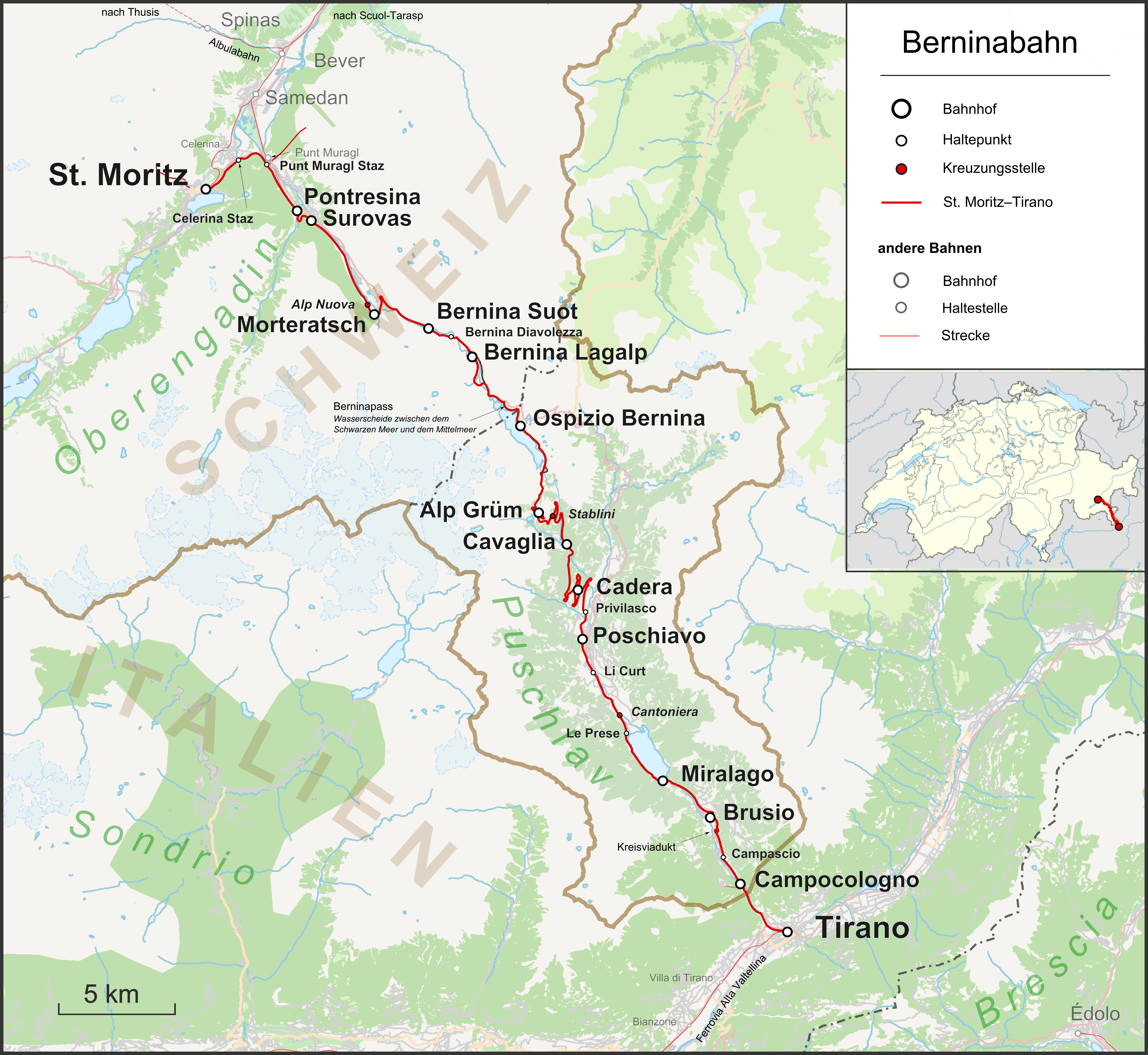
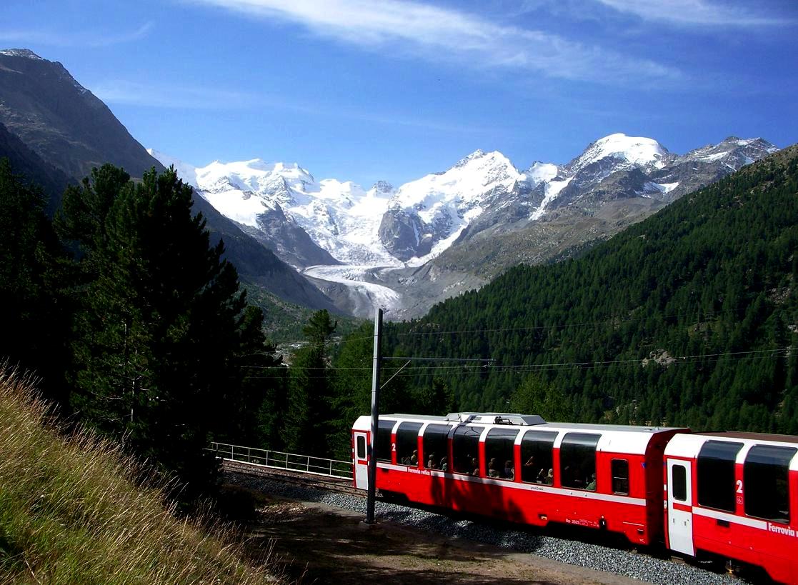
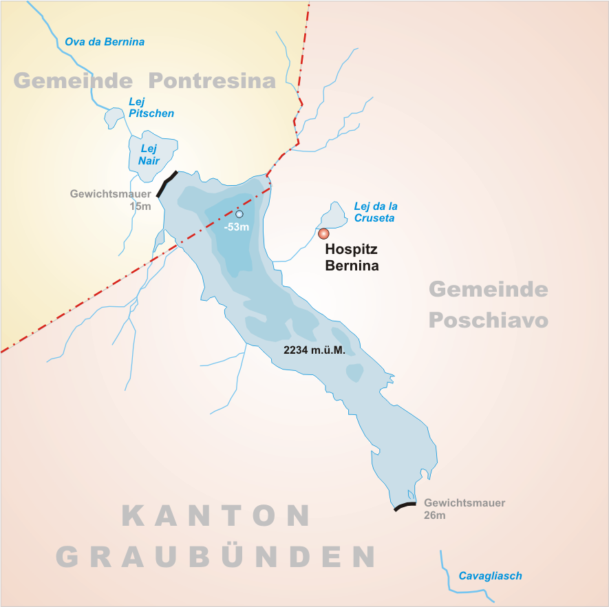
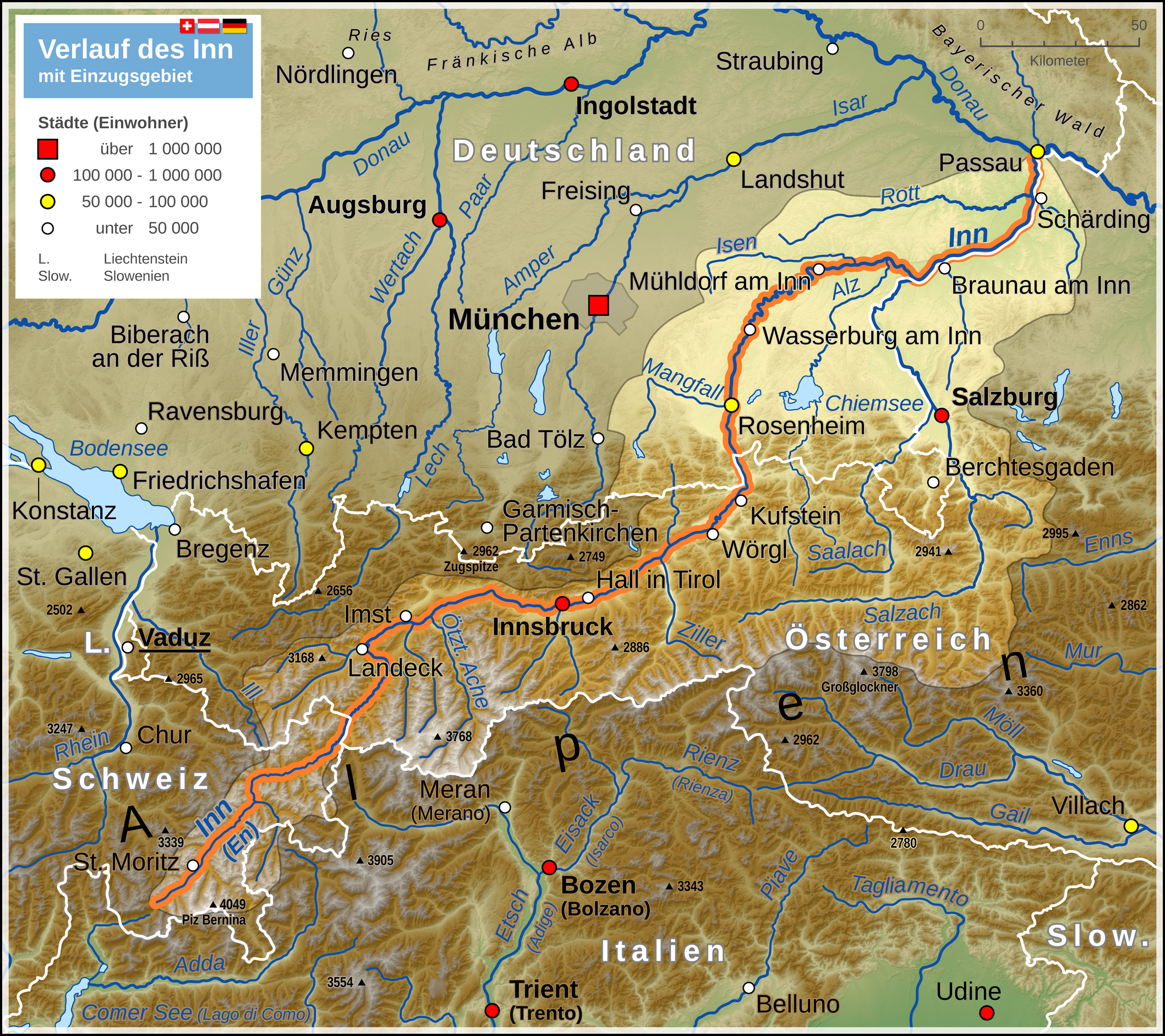
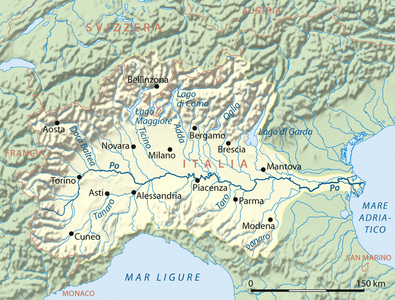
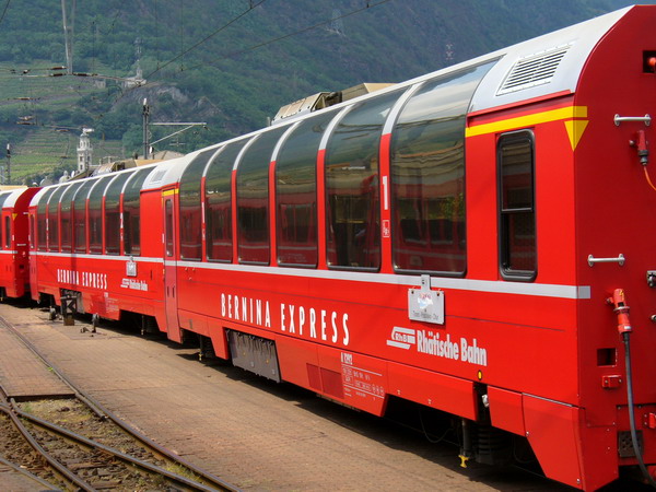
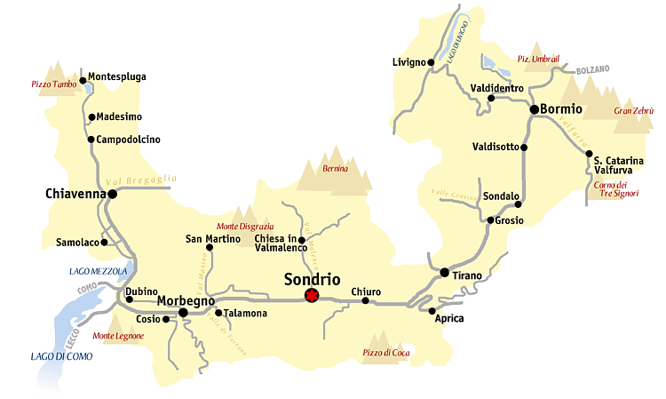
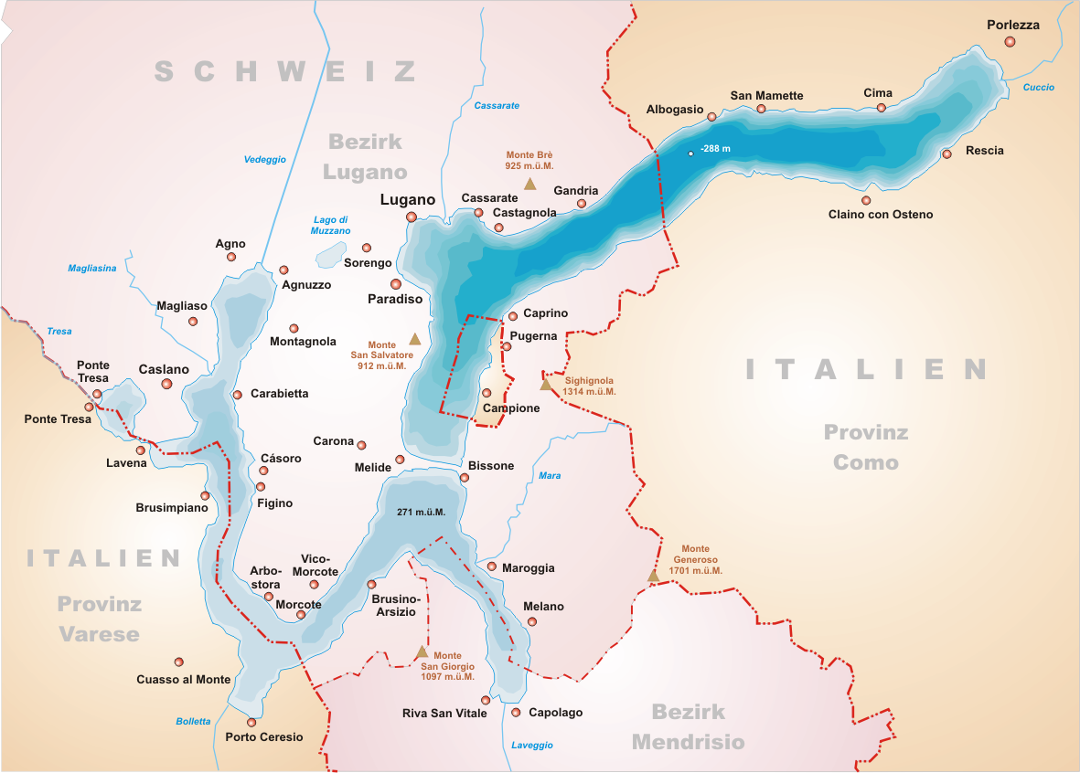
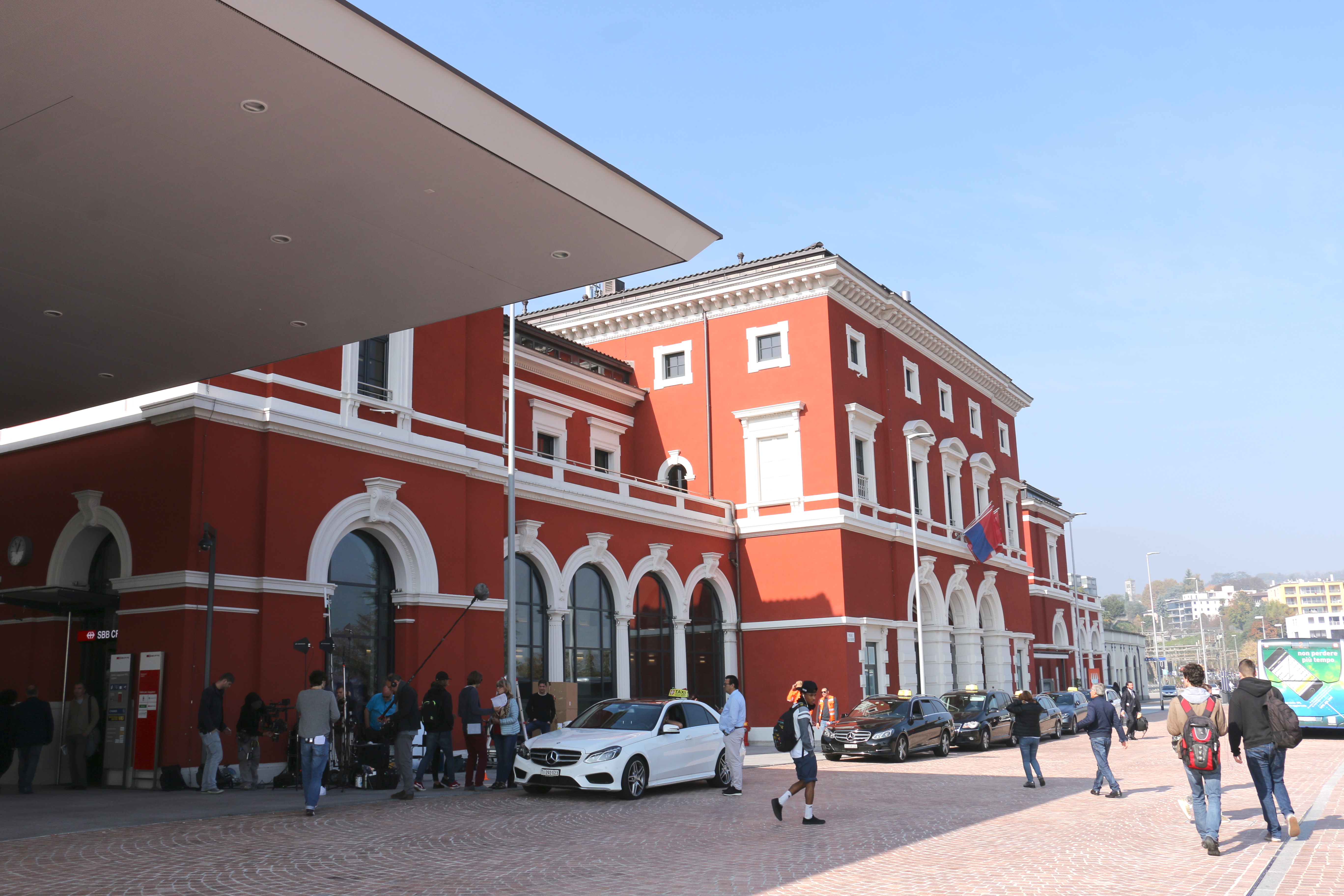
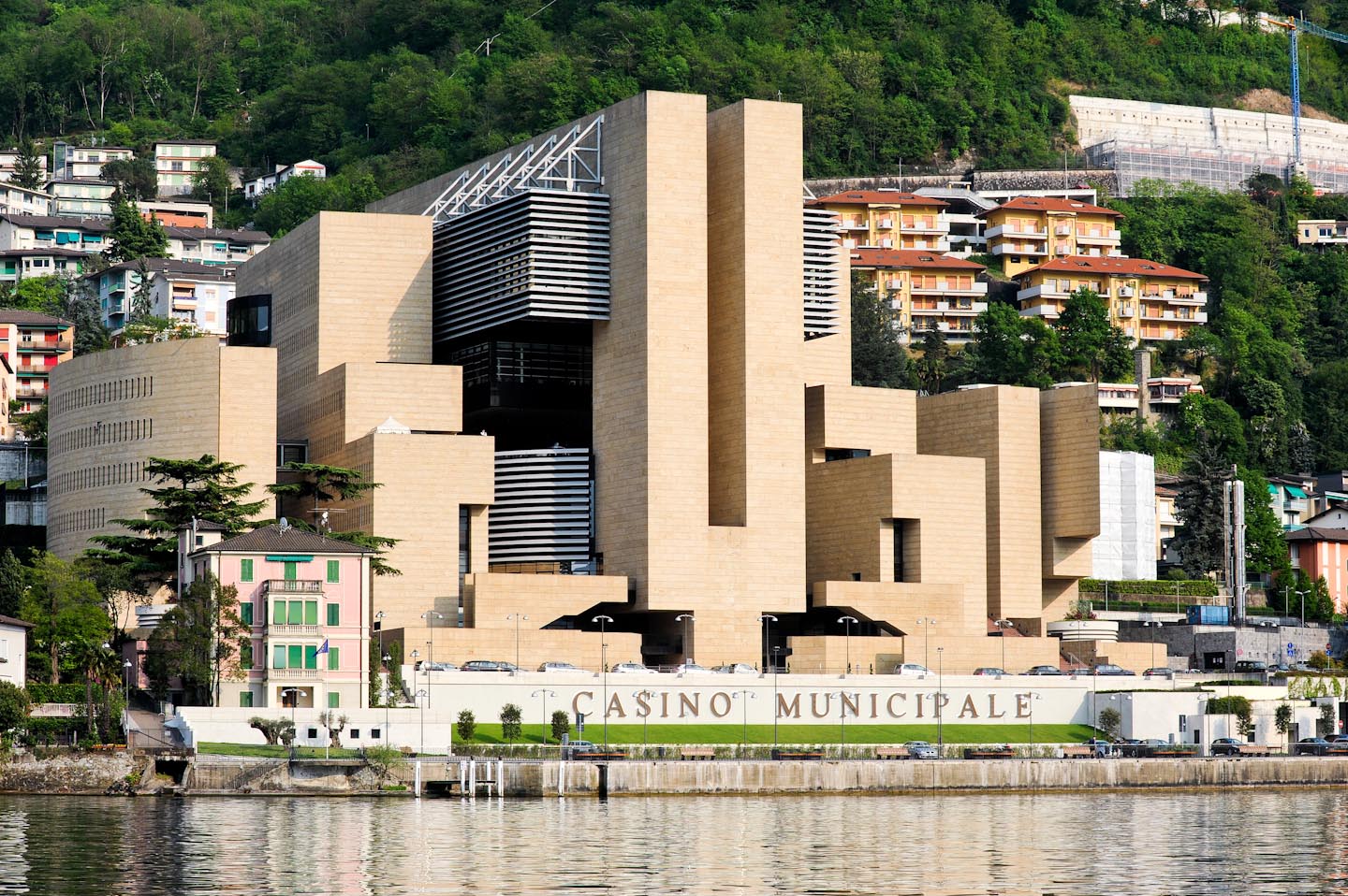
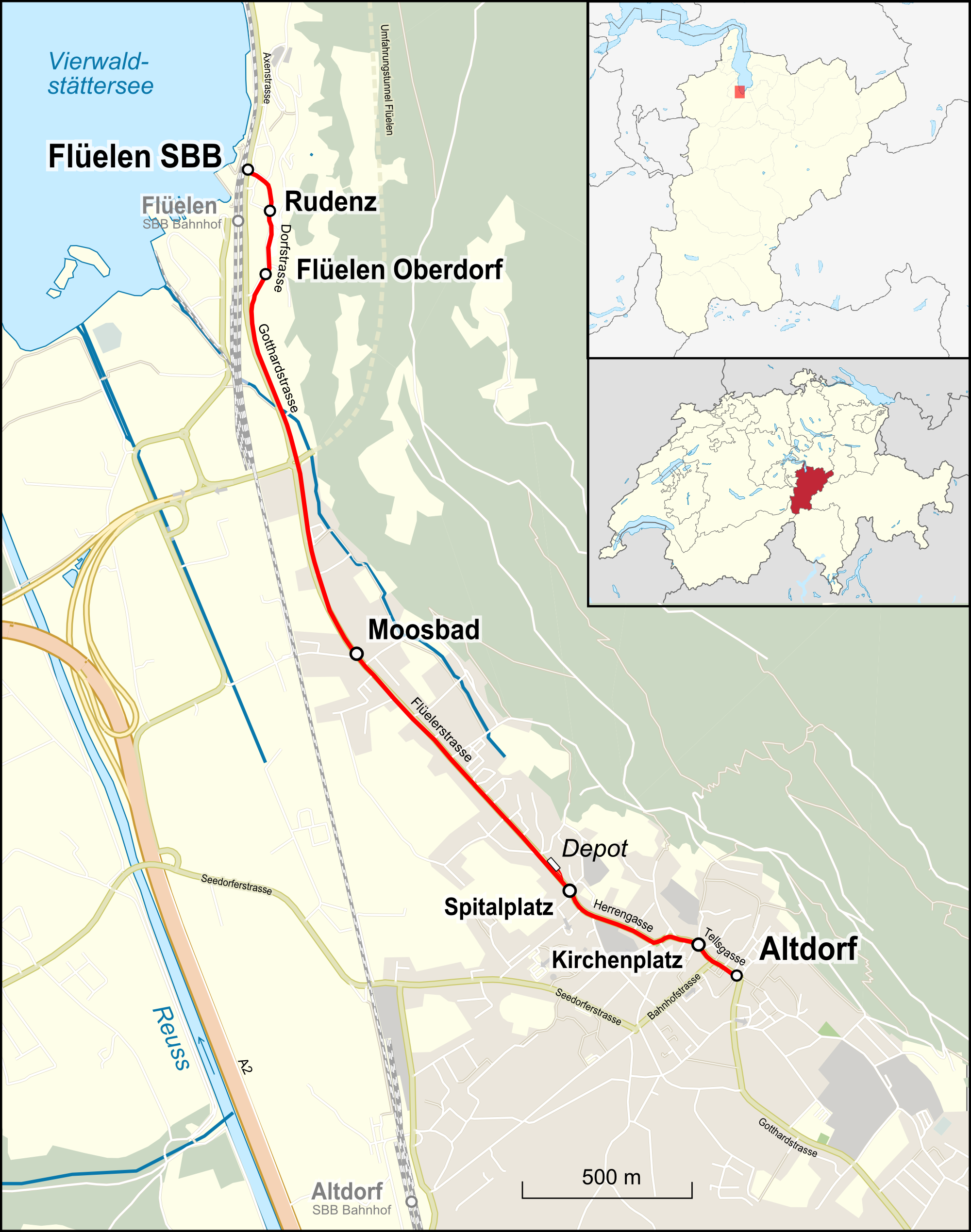
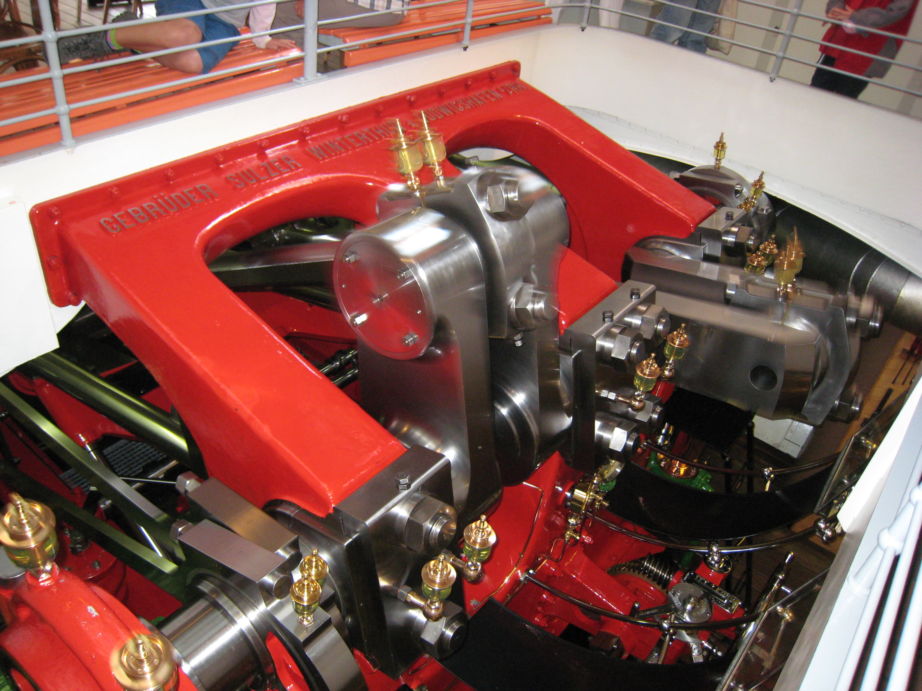
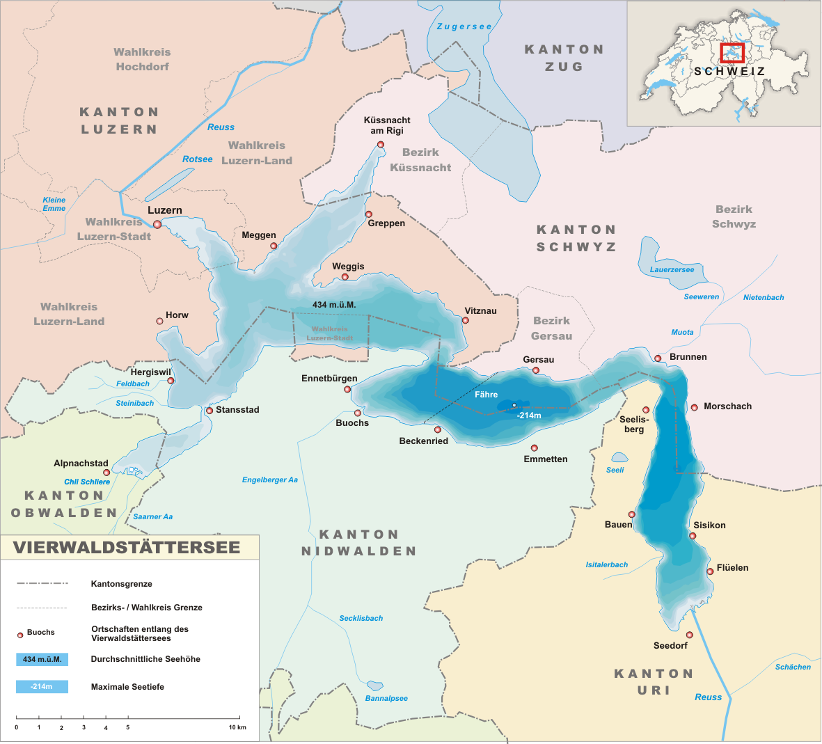
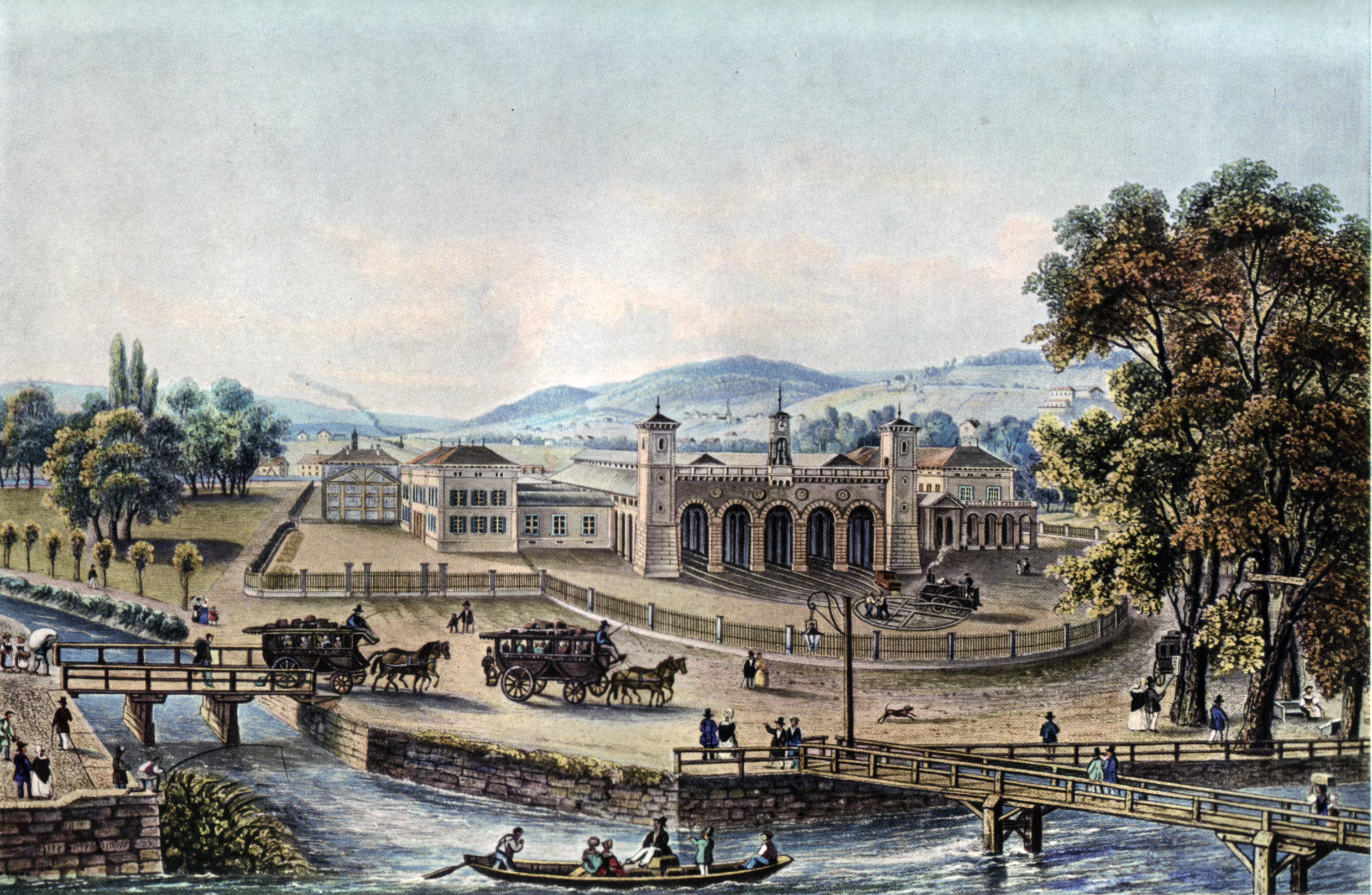
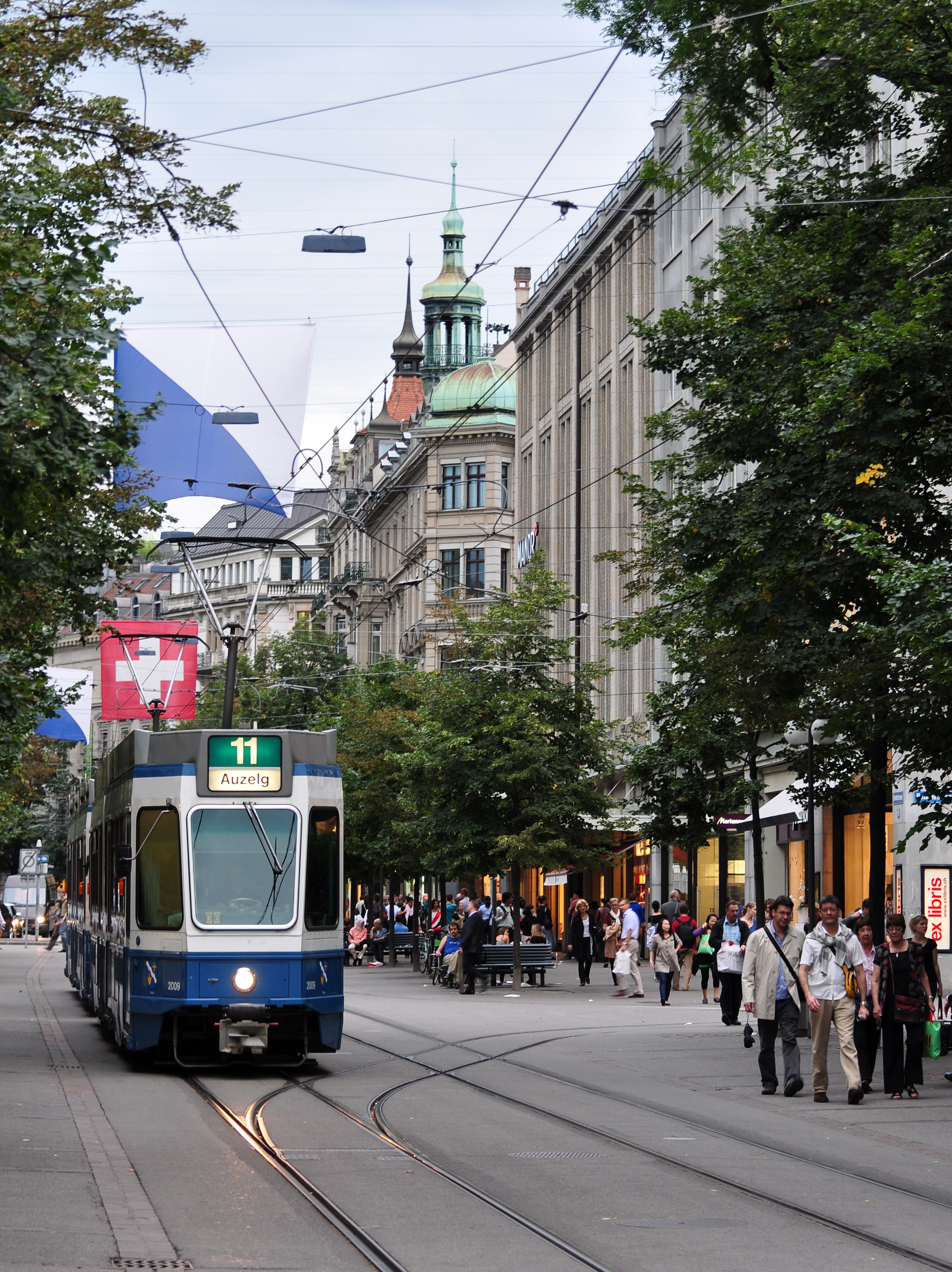
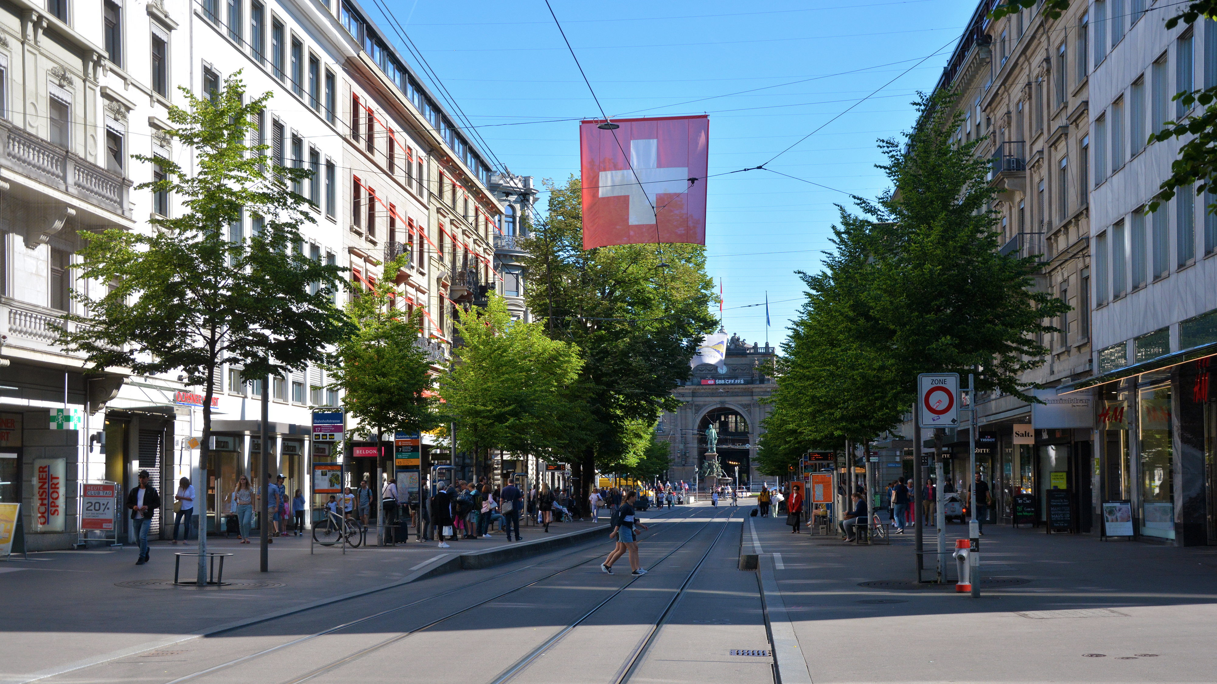
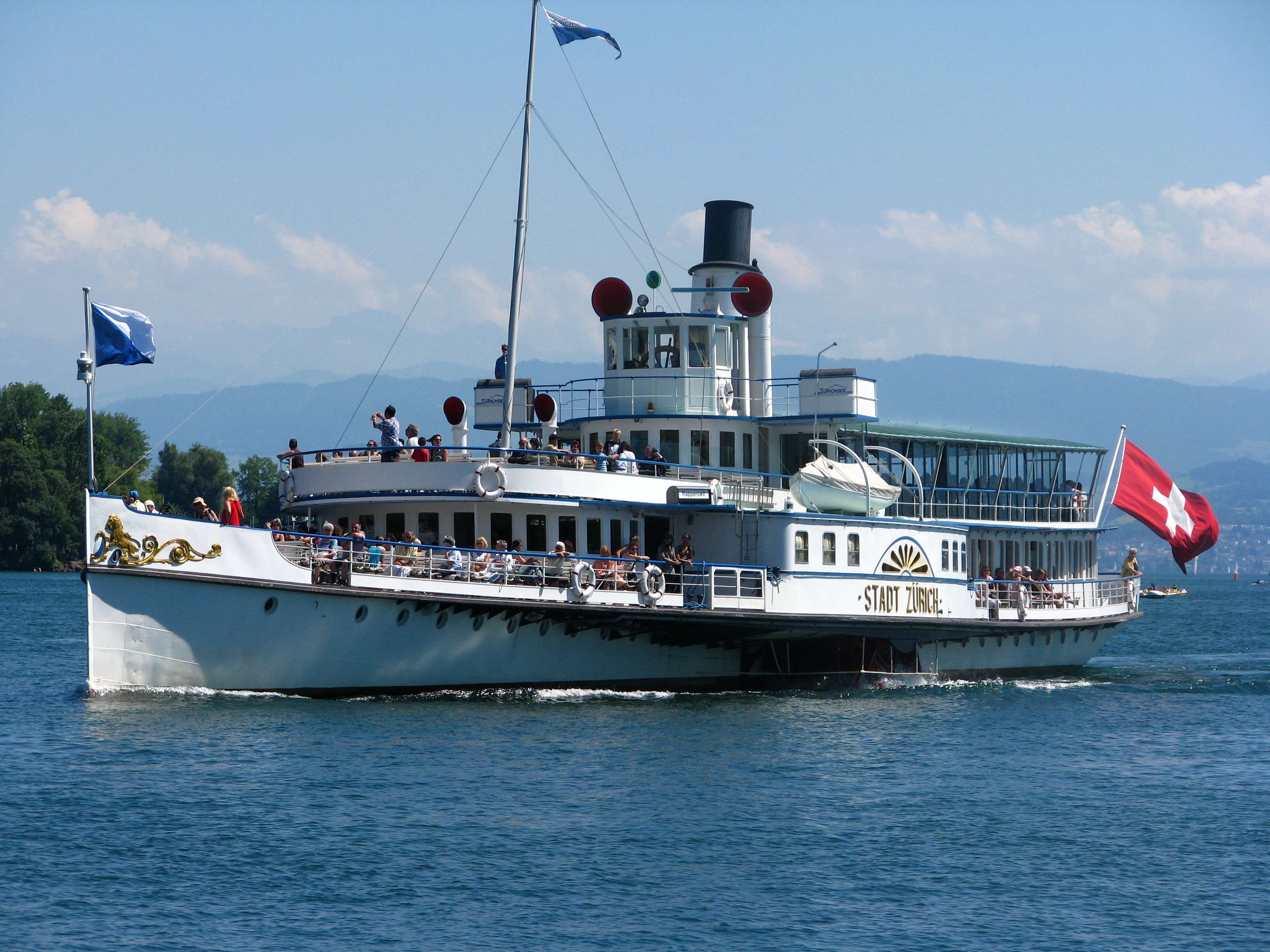
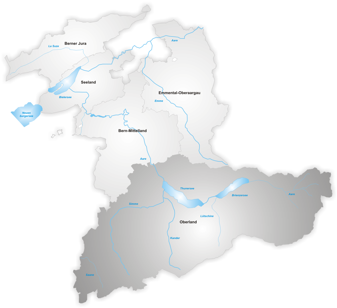
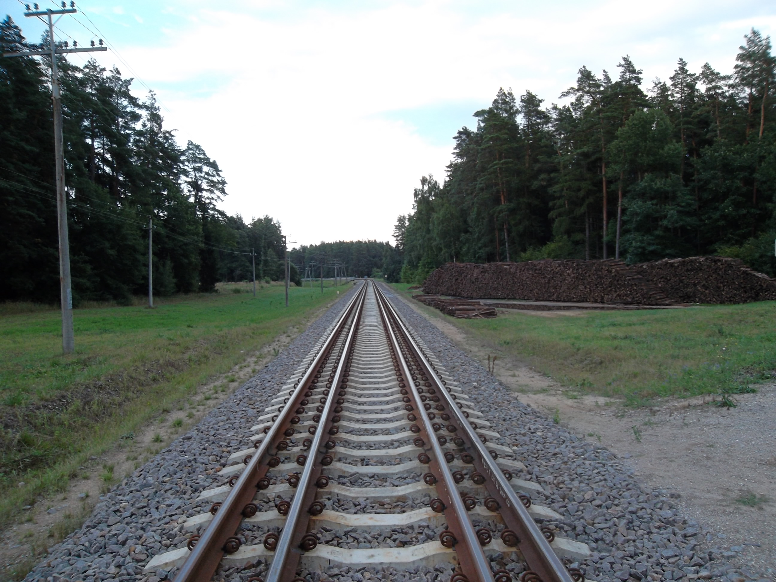
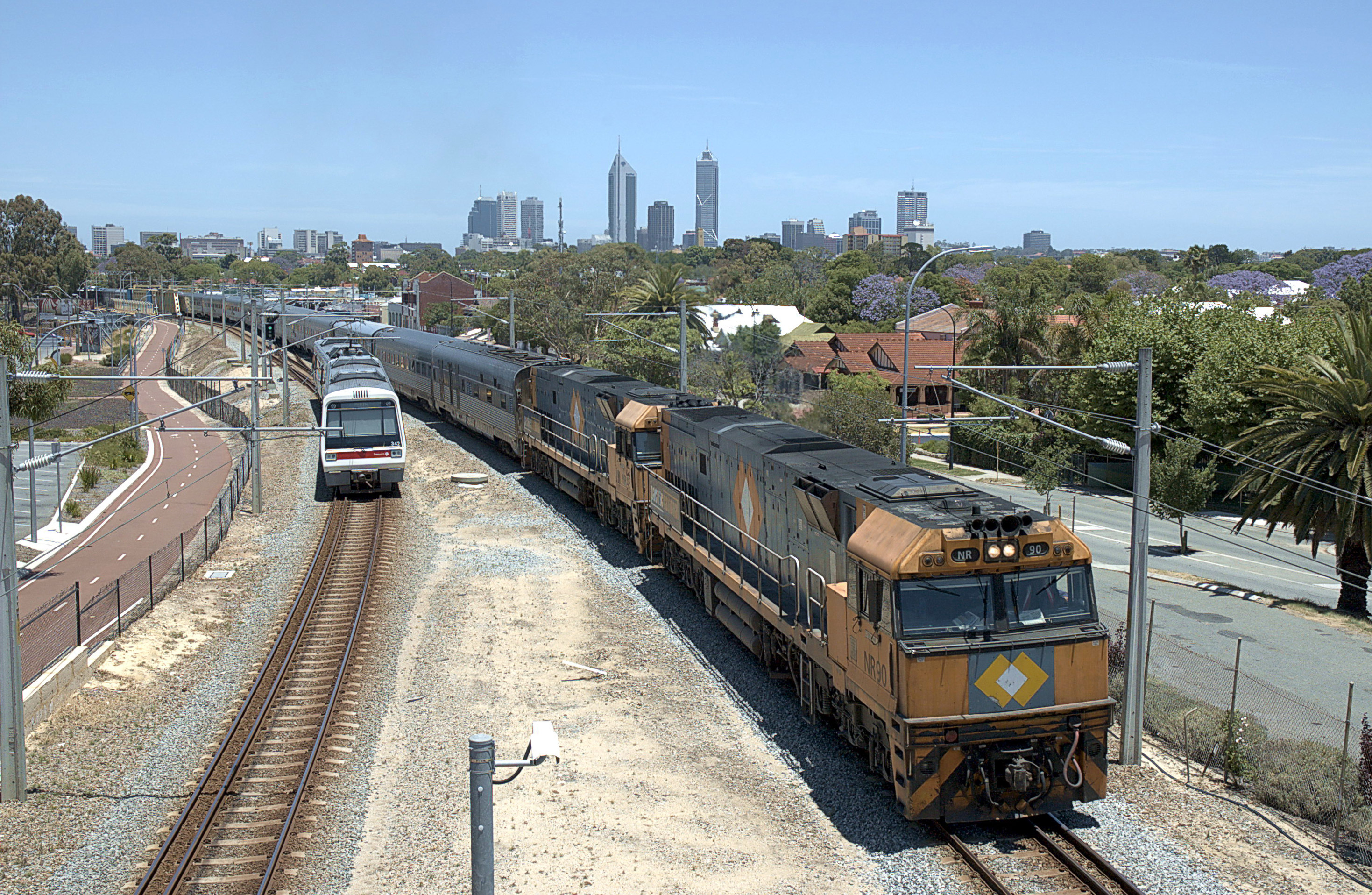