|
Reflections 2023
Series 2
April 3
Street Cable Cars Worldwide II: US Domestic III: Brooklyn Bridge
| | We're still in New York, and just had the story of the Montague Street cable car in Brooklyn Heights. We continue now directly adjacent to that (with some overlap at Fulton Ferry) to the cable car on the Brooklyn Bridge. It's not our purpose here to give the full history of the Brooklyn Bridge. If you're unfamiliar with that story, and are interested, I eagerly refer to David McCullough's 1972 book "The Great Bridge" and/or (but preferably and) Ken Burns's 1981 documentary "Brooklyn Bridge". You won't be disappointed with either. | | | | The Wonder of the Age The Brooklyn Bridge remains world famous, but with other bridges adjacent now, it's hard to imagine today the huge impact that it had when it was first built. It was under construction for 13 years, starting in 1870. Remember the iconic year it opened, 1883.
Think of the excitement. There's the City of New York (Manhattan) on one side of what I've called the "cradle" of Greater New York, the Lower East River. There's the then City of Brooklyn on the other side. Just a river apart (actually a strait), but nevertheless worlds apart. The Brooklyn Ferry-cum-Fulton Ferry tried to bind the two sides for years, like the dumbbell image we discussed last time. But the water was still a barrier. Who could imagine that with this wonder of a huge bridge that a person could actually WALK on solid land between New York and Brooklyn? What's next? Drag London and Paris next to each other?
The bridge opened officially on 4 May 1884, and that evening saw a great celebration. This is a Currier & Ives etching (C&I is always a great source) of the "Fireworks & Illuminations" at the opening of the "Great Suspension Bridge" (click). We're looking from Manhattan to Brooklyn here, where we can not only see fireworks on the bridge itself, but also elsewhere. (Nowadays there are often fireworks on the East River on the Fourth of July, but this shows there were spectacular fireworks there, long before that, not for a national holiday, but specifically for the Brooklyn Bridge.)
It wasn't only that what were then two separate cities were now physically directly connected, it was also the mammoth size of the bridge. We'll talk about statistics in a moment, but for now we'll just mention the length of the roadway. The bridge's longest span is the main span (between the towers), which is 486.3 m (1,595.5 ft) long, which made it at the time the longest span in the world. (However, times they were a-changin', and that record lasted for only seven years, until the completion of the Firth of Forth Bridge in Scotland in 1890.) But a more helpful number for people crossing it is the length of the bridge's roadway end to end, beyond the towers themselves. That comes to a grand total of 1,834 m (6,016 ft), or just over 1.8 km (1.1 mi).
| | | | The World of Currier & Ives Among the best documentation of the pre-photography era has always been provided by Currier & Ives prints—we just saw the celebration etching above. But I can't think of anything more momentous than this following Currier & Ives print entitled "The City of Brooklyn". Tho it's copyrighted in 1879, it's shown as of the completion of the bridge in 1883. The explanation is probably that, since the bridge was under construction for 13 years, four years before completion, they published the print and just projected from architectural plans what the bridge would look like when completed.
https://upload.wikimedia.org/wikipedia/commons/6/6d/Currier_%26_Ives_Brooklyn2.jpg
You will enjoy this cartographic masterpiece more if you followed the previous posting carefully. This is a bird's-eye view of Brooklyn from over Manhattan, and it seems to show everything.
Let's first look at the bridge itself and the Lower East River. The bridge had to be built well above the water to allow for passage of ships, which were much more plentiful there in the late 19C before even larger ships moved to the Hudson River. The bridge's clearance above mean high water is 38.7 m (127 ft), which would allow for the tall-masted ships shown to pass below it. But shipping was in transition, and steamboats are also to be seen.
Now let's look along the Brooklyn shoreline. Start way at the left, in Williamsburg, an area we haven't discussed much so far. It had been the City of Williamsburg, but was annexed to Brooklyn in 1855. The main street in white with the domed building (Williamsburgh--with an H--Savings Bank) is Grand Avenue, at the end of which is the dock for the Grand Street ferry, which connected it to Grand Street in Manhattan, with the word "Grand" included throughout, similarly with "Fulton" for the ferry further south.
Next is Wallabout Bay, known for the prison ships mentioned earlier, followed by Vinegar Hill. Then comes, near the bridge, the area today known as DUMBO. Just to the right of the bridge is a perfect illustration of the Fulton Ferry Landing, including a ferry in the terminal and Fulton Street running off into the distance, just as today. But as we know, today, this is called Old Fulton Street, then becomes Cadman Plaza West where the plaza is today. It runs into the distance to "my" East New York and beyond.
The near side of Brooklyn Heights shows where the original western slope was before the Brooklyn-Queens Expressway (BQE) defaced it. On the shoreline, the piers and warehouses block the view of Furman Street. But spectacularly obvious is the cut in the slope where Montague Street runs down to the ferry connecting to Wall Street, right next to the warehouse called Pierrepont Stores. Even the Penny Bridge is visible. However, the Montague Street cable car didn't appear here until 1891, which means that the Brooklyn Bridge cable car we'll read about in a moment beat it by seven years. (Then cable cars came to Manhattan in 1894—see next posting.) It was a heady time for cable traction.
Just a few blocks to the right is South Ferry at the foot of Atlantic Avenue, connecting with South Ferry in Manhattan's Battery. This is still the era when the LIRR came down to the Lower East River, to connect to that ferry, then had to make its way laboriously up the slope, which is why the Atlantic Avenue tunnel was dug. The next white line we see is Hamilton Avenue in Red Hook, also connecting to a ferry. Today, the Brooklyn-Battery Tunnel makes this connection under the East River.
On the horizon, from the right, is Gravesend Bay where the British had landed, with Coney Island and the Atlantic Ocean. The railroads leading out to Coney Island are today subway lines. Just below, along Flatbush Avenue, is Prospect Park with its 1776 battle site. South of that is the Gowanus Canal. It's an amazing Currier & Ives illustration.
| | | | | | As an additional backup about all the pre-Brooklyn Bridge ferries we just saw, this is an earlier map than the C&I one. It's an 1847 map of New York (Manhattan) and Brooklyn. Start on the right in Williamsburg, where two ferries leave Grand Avenue, one for Grand Street in New York, and one for Houston Street. There are then several other ferries before the Fulton Ferry connecting the two Fulton Streets, right where the bridge was being built. You see the two ferries leaving the Battery, one to Hamilton Avenue, plus the most interesting thing shown on this map, the ferry to South Ferry in Brooklyn, that connects to the LIRR terminal on the waterfront. Entering Atlantic Avenue, those trains then go uphill in the tunnel, emerging finally at Court Street, before continuing to the next stop, today's western terminus, Atlantic Terminal. (This map shows only to Hoyt and Bond Streets, but the terminal is 4-5 blocks further on Atlantic.) |
| | | | Currier & Ives' fascination with the Brooklyn Bridge has to show the great popular interest in the structure back in the day. I've found a total of three C&I prints showing the bridge, all from different angles. We already saw the great panorama from the NY side looking northeast. Now we have here the reverse, from the Brooklyn side to the southwest in 1883, looking at what was then all of New York, and is now Lower Manhattan. The title shows great pride. The note at the bottom gives statistics, including the fact that there are "tracks for cars, roadway for carriages, and walks for foot passengers." The cars are of course not automobiles, which didn't exist yet, but rail cars. We've mentioned those red-brick, Civil-War-era buildings in the foreground before. They are largely still there and this neighborhood is today's trendy DUMBO. In the dead center of the picture, over in Manhattan, is Trinity Church, on Broadway at Wall Street. That its tower stands out and can be seen from Brooklyn makes one realize how low-rise the city was then. On the other hand, it also makes one realize how tremendously large the Brooklyn Bridge was at the time in comparison to surrounding structures. Today it blends in more to its taller surroundings.
The third and final C&I lithograph of the bridge is a bird's-eye view from Manhattan southeast to Brooklyn, circa 1892. It's really spectacular. Click to inspect the paddlewheel steamers docked at Fulton Landing and the other river traffic, and don't miss the bridge traffic near the Manhattan terminal. You can see how its far end connects to nothing. On the right, Trinity Church still stands out, and you can see the green of Battery Park, and to its left, the fort on Governor's Island, where the Dutch first landed before timidly venturing further onto Manhattan Island. Beyond it, in Brooklyn, is Red Hook, then Bay Ridge (once called Yellow Hook), then Coney Island. In the far distance, beyond the Narrows, is Sandy Hook in New Jersey; coming back we pass Staten Island. But you can't miss the Statue of Liberty, dedicated in 1886, just three years after the bridge and about a half-dozen years before this lithograph. Which makes me think.
In a low-rise city, did the Statue of Liberty really appear that big? How did its height compare to the towers of the Brooklyn Bridge and how to both appear from low-rise buildings? The Statue of Liberty, from the ground level to the torch, is 93 m (305 ft). The height of the bridge towers above water level is: 82.9 m (272 ft). Thus the bridge towers are 89% of the height of the statue. But the statue is distant, off in the Bay, while the bridge towers are right there, next to you in the street. (So is the spire of Trinity Church, at 86 m [281 ft]).
The contemporary Flatiron Building (1902) in Midtown is 86.9 m (285 ft) high, meaning the Brooklyn Bridge towers are 95% of the height of the Flatiron Building, which is considered to have 22 floors. Now picture the Brooklyn Bridge as the tall "building" it is, among low-rises.
| | | | The Roeblings Growing up and going to elementary school in my Brooklyn neighborhood of East New York, I remember learning quite a bit about the Roeblings who built the Brooklyn Bridge, and therefore tend to think of it as common knowledge, tho I'm sure it isn't. I'll just retell the highlights of the story.
It was a family affair, father, son, wife/daughter-in-law, tho I'm sure in many minds, that comes not to three, but to 2+1 people. The father was born in Germany as Johann August Röbling, as this 2006 German stamp says, commemorating the bicentennial of his birth. But on emigrating to the US, he anglicized his name to John Augustus Roebling, using the alternate OE spelling for Ö (Goethe is pronounced Göte.) As an engineer, his specialty was using what was called wire rope, which we call cables today. He replaced hemp ropes with wire cables on the Allegheny Portage Railroad (2019/7) and, along with many other projects, built the Roebling Bridge across the Ohio River between Cincinnati OH and Covington KY (2019/2).
In 1867 he started designing work on what is today called the Brooklyn Bridge. In 1869, he was standing on the dock at Fulton Ferry deciding about the location of the bridge when an arriving ferry crushed his foot. He died of tetanus one month later at what was then his son's home on Hicks Street in Brooklyn Heights, a year before construction on the bridge even started.
His son, Washington Roebling, was also a civil engineer and was then named chief engineer of the project. He is usually given credit for the bridge, but as we'll see, that's not entirely the case. In 1863, he had served at the Battle of Gettysburg, and from mid-1865 to 1867, had worked with his father on the Cincinnati-Covington Bridge (since renamed the John A Roebling Suspension Bridge). On becoming chief engineer at the Brooklyn site upon his father's death, he made several important improvements on the design of the bridge, and further developed bridge-building techniques, including using pneumatic caissons for the foundations of the two bridge towers.
As you may know, a caisson is a structure that can be placed underwater, then pumped dry, to provide a workspace for workers on, say, bridge's tower foundation (Schematic by Yk Times). However, as with divers, workers coming out of a pressurized area need to decompress slowly, or otherwise be subject to decompression sickness ("the bends"), whereby air bubbles form in body tissues and joints, which can be highly debilitating, or even rapidly fatal.
Ironically, it was the latter bridge-building improvement that turned Washington Roebling into an invalid for the rest of his life and almost lost him his engineering position. In 1870, a year after his father's death and in his first year as chief engineer, he went down into a caisson after a fire had broken out in it to direct putting it out. On coming back topside, he did not decompress adequately and got "the bends". It ruined his health and kept him from visiting the work site for all the remaining years of construction, and he'd battle the after-effects of the disease for the rest of his life.
| | | | | | One must appreciate the irony of the fact that John Roebling was fatally injured right at Fulton Landing next to the bridge site, and within a year, Washington Roebling became an invalid in a caisson at one of the nearby bridge towers. And all this took place right next to Brooklyn Heights, where the Roeblings were living. |
| | | | It's at this point that attention has to shift away from the two blood relatives and to an in-law Emily Warren Roebling, Washington's wife and John's daughter-in-law. I have to suppose that she's a bit less remembered because she was (1) "just a spouse", (2) a woman, and (3) didn't have an engineering degree. But starting with Washington's incapacitation in 1870 thru to the bridge's completion in 1883, Emily took over much of the chief engineer's duties including day-to-day supervision and project management. She affectively taught herself bridge construction on-the-job, assisted by her husband. She developed an extensive knowledge of how to calculate catenary curves, and of cable construction, strength of materials, and stress analysis, all vital for building a suspension bridge.
They would jointly plan the ongoing work as she tended to his health, then he would remain in their Brooklyn Heights apartment while she went to the bridge site as supervisor of construction and as a liaison between her husband and on-site personnel. After supervising day-to-day operations, she would relate the events of the day to her crippled husband. Tho they worked on it jointly, she successfully lobbied the authorities for formal retention of Washington as chief engineer up to the successful completion of the bridge.
https://images.fineartamerica.com/images-medium-large/1-washington-a-roebling-granger.jpg
As this painting shows, I remember learning in school how Washington Roebling would follow bridge construction with his binoculars from their Brooklyn Heights apartment. Tho this next picture, taken in 1876, was probably taken from a balloon, it approximates what he would have seen from his window of the ongoing construction.
For the record, we should state that the Brooklyn Museum has these two portraits, one of Washington Roebling and one of Emily Warren Roebling.
When the bridge was completed, before it opened officially to the public, Emily Warren Roebling, in a horse-drawn carriage, was given the honor of being the first person to officially cross the bridge, from Brooklyn to Manhattan. While Washington Roebling was not able to attend the opening ceremonies, he held a celebratory banquet at his house at the same time. I don't believe he ever physically visited the completed bridge, tho years later, the Roeblings did leave Brooklyn to live in other cities. Later in life, Emily went on to earn a law degree from New York University.
For the final word on Emily, let's go back to this "main map" of Brooklyn Heights we used on the last posting, which we'll also be needing from now on:
https://i.pinimg.com/originals/ed/47/b0/ed47b0cd75ed5ce99055dbba9834866b.jpg
The Roeblings lived at 100 Columbia Heights, which would have been on the west side of the street, a half-block south of Orange (see main map). According to Google Street View, it seems to have been replaced by a modern building today. One can only imagine Washington sitting at his desk, watching progress on the bridge via his binoculars, while Emily went off to the bridge to tend to affairs they'd both decided upon.
In 2018, there was a revival of interest in Emily. Find the intersection of Columbia Heights and Orange Street, which is a half-block north of where they lived. The southeast corner was renamed in her honor thusly:
https://thebha.org/wp-content/uploads/2018/05/Emily-Roebling-street-sign.jpg
This would imply that the block of Columbia Heights south of this corner, including where they lived, is now co-named for her. Also in that year, the New York Times, as part of its "Overlooked" series, published a long-belated obituary of Emily.
| | | | The Brooklyn Bridge Today The bridge retains the fame it's always had, but its function is no longer being the special thing it was. Let's look at the present first, then illustrate the past. The bridge is still the icon it's always been, famous around the world. But on a practical basis, it's no longer the wonder combining two cities, but just another bridge of several crossing the East River, to which we can add two vehicular tunnels and all the subway tunnels we mentioned in the last posting. So its mission is no longer unique.
There are two ways (plus a new one) to cross the bridge today, one great fun, the other quite humdrum. All ways are free of charge. The fun pedestrian walkway, shown here in 1899, has existed since Day One, hovering in the center over the traffic lanes. Here's a contemporary view, showing the relatively narrow walkway squeezing thru the massive main cables that support the suspension cables (Photo by InSapphoWeTrust), and here's a more distant view (Photo by Guushing at the English-language Wikipedia). In both pictures, note the barriers on the massive cables that prevent daredevils from trying to walk up to the top of the towers. But you can get incredible in-your-face views from the walkway when going under the towers (Photo by Benson Kua).
| | | | | | Here's a view you normally never see: no pedestrians on the walkway! (Photo by AndrewHenkelman). But there's a special reason. This was taken during the travel restrictions of the pandemic, when no one was allowed to use the walkway. |
| | | | I've walked over the bridge twice, both times from Brooklyn to Manhattan, since that direction has the best views. Many pedestrians use the bridge as a hiking trail, but it's never had a practical use of any consequence. People use it for recreation, and I very much doubt that there are many who walk it regularly as commuters going to work. As a pathway, it also serves for protest marches.
Below the walkway nowadays hovers over six vehicular traffic lanes (recently reduced to five), three in each direction. Whenever I've driven across the Brooklyn Bridge, I have to psych myself to thinking "This is the famous Brooklyn Bridge!!", but I doubt anyone else does that. It's about as much fun as driving along a boring stretch of superhighway, so it's no big deal. And because of height and weight restrictions, there are only cars, no trucks and no buses, so if you don't have a car, there is NO public transportation across the bridge today, unless you hire a taxi. This is very different from the old days, when most transportation across the bridge was public, and by rail.
As for the "plus one" way to cross the bridge, we come to bicycles. I have no indication that there was any dedicated bike route back in the day. But by the mid-20C, perhaps later, half the pedestrian walkway was turned over as a bike path. Look back at any of the pictures of the walkway and you'll see the line dividing the pedestrian side from the bike side. While this was a nod to cyclists, it was totally inadequate. The route is narrow enough just for people, so crowding them to one side was a poor idea, especially for two-way pedestrian traffic. And the balance was inadequate for two-way bike traffic! When I crossed I felt that the two groups were always brushing by each other.
The situation is now quite different, tho still inadequate. As of 14 September 2021, the Department of Transportation closed off the innermost car lane on the Manhattan-bound side with protective barriers and fencing to create a new bike path down at the vehicular level. Cyclists are now prohibited from the upper pedestrian walkway. However, this has resulted in what is still a rather narrow two-way bicycle path. These lower lanes, most of which were originally meant for rail, are just 8 ft (2.4 m) wide, awkward for two-way bike traffic. It's considered that a width of 12 ft (3.7 m) would be much more desirable. But that's how things stand now.
| | | | Naming the Bridge A lot can be said about naming the bridge. The Currier & Ives print above used one of the more common names at the time, the EAST RIVER BRIDGE, which alternated with the GREAT EAST RIVER BRIDGE, names showing amazement that such a location was crossed at all, and then but something of such size. But it was officially called the NEW YORK AND BROOKLYN BRIDGE, a logical description of what it connected. (Compare the Bronx-Whitestone bridge, connecting the Bronx with the Whitestone neighborhood of Queens.) But such bureaucratically correct names can be unwieldy, people shortened the name, and in 1915, it was officially renamed the BROOKLYN BRIDGE.
Now Brooklynites are very proud that such a world-famous icon bears the Brooklyn name, and rightly so. But I need to play the devil's advocate here, and say the name includes just a slight tinge of second-class status. Only on doing the current research did two dates I well know seem related, 1883 when the bridge was completed, and, a mere 15 years later, 1898 when New York (Manhattan) swallowed up the former City of Brooklyn (plus other areas) to form the current NYC. I'm sure that the heady feeling of bringing two cities together via the bridge had a direct effect on the municipal consolidation. The result was named New York, putting it in the superior position, with no consideration of even consolidating the two names.
| | | | | | In 1873, close to the time period we're discussing, the three separate Hungarian towns of Buda, Óbuda, and Pest were officially unified into one city, whose name was also unified as Budapest, where all three older names can be discerned. Nothing similar was done with New York and Brooklyn.
I've known that for some time, but now I learn two more items that amaze me. First, before the consolidation, the three towns together—a metropolitan area already—had often been referred to colloquially in Hungarian as "Pest-Buda". Second, also in colloquial Hungarian, the whole city today can be referred to by the short form "Pest".
A tangential point you might already know: Hungarian has both sounds, S and SH, but be wary of the spelling. SH in Hungarian is spelled S, which explains why Hungarian gulyás is called "goulash" in English. Thus, Pest is pronounced PESHT, and Budapest is BU.da.pesht. Conversely, S in Hungarian is spelled SZ, which is why the Hungarian composer Liszt is pronounced LIST, and Hungary's third-largest city, Szeged, is pronounced SE.ged.
|
| | | | Thus, the East River bridge naming always intimates that New York (Manhattan) is the location of primary importance, and the bridges lead away to the hinterlands of secondary importance. That's my take on the Brooklyn Bridge "where Manhattanites can reach Brooklyn".
https://i.pinimg.com/736x/34/c5/bf/34c5bff1ac7a9183ecb195280e6fc688.jpg
Check out these other East River bridges above. The same argument also follows about the next bridge built, the Williamsburg Bridge in 1903, "where Manhattanites can reach the Williamsburg neighborhood of Brooklyn", and further north, the Queensboro Bridge of 1909, "where Manhattanites can reach Queens".
I only now learn about a controversy—which I can understand—about when the Manhattan Bridge opened nine months later in the same year, 1909. Authorities had established and confirmed its name five years earlier, at which time the New York Times criticized the name as "meaningless". The Times urged calling it the Wallabout Bridge, naming it after Brooklyn's adjacent Wallabout Bay, stating that "All bridges across the East River are Manhattan bridges." That argument would further confirm that all the bridges point to hinterland destinations. I think the thought was a good one and can only speculate why it was named for Manhattan. It's very close to the Brooklyn Bridge, especially on the Brooklyn side, where the entrances are barely two blocks apart (see main map). Since "New York" was dropped from the name of the Brooklyn Bridge, naming this one after Manhattan (despite the fact that they ALL lead there) gives some balance to the naming.
This is an excellent panorama of the Lower East River looking north at three bridges (Photo by Юкатан [= Yukatan]). We see most of the Brooklyn, then Manhattan bridges, and clicking in the distance, we see one tower of the Williamsburg Bridge.
| | | | Ultimate Fame There's fame, and then there's consummate fame. Something is consummately famous when you can easily refer to it without naming it. If you're in Paris and refer to going to "the tower", or if you're in Arizona and say "the canyon", everyone will know what you're talking about. But in this present case, the situation is particularly droll. The fame of the Brooklyn Bridge has caused it to become part of the American idiom, where apocryphal references to "selling someone the Brooklyn Bridge" have always abounded. Superficially, the reference would refer to the gullibility of the greenhorn, or the hayseed, but in actuality it refers to any idea that's beyond credible belief. This image of gullibility is so well ingrained in American speech and in the American psyche that the name of the bridge need not be cited. One might say: "If you believe X, then I have a bridge I want to sell you", showing that just talking about "selling a bridge" is sufficient to make it totally clear as to just which bridge is meant, and just how gullible you're accusing the person of being.
The Brooklyn Bridge has been designated a National Historic Landmark, a New York City landmark, and a National Historic Civil Engineering Landmark.
| | | | Brooklyn Bridge Basics This is a view of the Brooklyn Bridge today, as seen from the Manhattan shore (Photo by Suiseiseki). Since it looks northward, the adjacent Manhattan Bridge is seen nearby, and is also visible (click) as it enters DUMBO, with its Civil-War-era brick buildings. Just to the right, Fulton Landing is directly across in green & white.
The massive catenary (like a hanging chain) cables between the towers stand out, but look carefully at what seems to be a jumble of cables hanging below, and you'll begin to understand that this bridge is a hybrid of two styles: it's a cable-stayed suspension bridge. We've talked about cable-stayed bridges before (this one in the fan design), since it's a very popular style in modern bridge-building. It has angular cables connecting the deck directly to the towers. A suspension bridge, on the other hand, has vertical cables connecting the deck to the massive main cables that run between the towers and are anchored at both ends of the bridge (Both Sketches by Tizio). Now look again and you'll see both angular and vertical cables, making this a hybrid-style bridge.
https://historicbridges.org/newyork/brooklyn/drawing_large.gif
Even on this simple sketch of the bridge, clicking will show both sets of cables. But the purpose of this sketch is to show a lot more. First, let's mention again that the bridge's clearance above mean high water is 38.7 m (127 ft), which was to provide clearance the high-masted ships of the day. Fewer ships ply the East River today, and most are smaller, anyway, so perhaps today, the height seems like a bit of overkill. But because of the height, as the sketch shows, the Brooklyn Bridge incorporates long approach viaducts on either end to raise it from low ground on both shores.
First follow the ground level from Park Row in Manhattan to Adams Street in Brooklyn, and note that its height (in feet) almost doubles. That explains why the Manhattan approach is longer than the Brooklyn one. En route, as we go from land to water to land, we find quirks about the two towers. The Manhattan one is surrounded by water, as it's planted well out in the river, a good distance from the shore, while the Brooklyn one is essentially on land (tho its western side does "wet its toes" in the river). I'm surprised to see that this tower, being on higher land, is also shorter than the other one, and I'm rather amazed to see that we're being told that the original channel and shoreline used to be inland from the tower. This has to be a change Roebling made.
Other than the two towers, it's the two anchorages that catch the eye. This is where the two massive catenary cables are solidly planted ("anchored") in concrete. You might picture them as two people holding the ends of a jump rope—tho very tightly, with the rope sagging nevertheless. While the two towers are the most spectacular, it's actually the anchorages that define the bridge's two distinct areas, the two approaches and the three spans.
Look at the (longer) Manhattan and (shorter) Brooklyn approaches. Both are built on solid ground and neither is part of the suspended section of the bridge, which is important to what follows. Think more of a stone Roman viaduct with built-in warehouses. This is a section of the Brooklyn approach ramp looking roughly west (Photo by BriYYZ). Behind the buildings in DUMBO (see sign) can be seen parts of the nearby Manhattan Bridge (see main map). But it certainly seems to resemble a stone viaduct. The warehouses in between are used for storage.
I have this 1898 period photo for later use, but it also shows something worth mentioning now. It shows the Manhattan approach to the bridge, and we're looking east along what I believe is Frankfort Street. The combined 2nd & 3rd Avenue els cross under the structure in the distance, along Pearl Street. But I'm showing this picture now to illustrate the massive size of the bridge approaches. Aside from the fact that it spans well above the el, compare the six-story buildings across Frankfort Street to judge just how tall the bridge approach is. It's a massive structure among the local buildings.
http://1.bp.blogspot.com/-2PYrL4YwyMM/U2V3O2eDuRI/AAAAAAAAD64/KPgwJflceKA/s1600/3082953775_74f9a9a8b1_o.jpg
https://untappedcities.com/wp-content/uploads/2018/05/Brooklyn-Bridge-Champagne-Vault-Wine-Storage-Anchorages-NYC-11.jpg
Now look at those massive arches in the first link below the roadway on the bridge approach. As I understand it, today those warehouses are used for general storage, perhaps public, perhaps for Parks Department equipment. But early on, they were used—are you ready?—for wine storage. Those huge warehouses served as wine cellars! That's because they maintained a steady temperature of 60°F (15.6°C), very amenable for wine storage. The second link shows an interior, and even today, you can still see that this one was once used to store Pol Roger Champagne from France, as illustrated by this small demi, or half-bottle (Photo by Tomas er).
Back on our blue sketch, we see that it's between the two anchorages that we have the three suspended sections, two equally long land spans, then the main span between the towers. These suspended sections obviously do not have the solid footing that the approaches have. And that will affect what we'll be saying about cable cars. But we can see here that the main span is the longest at 486.3 m (1,595.5 ft), while the total length is 1,825 m (5,989 ft) or just over 1.8 km (1.1 mi).
| | | | Rail on the Brooklyn Bridge We purposely just made the point that the vehicles today mindlessly crossing the bridge are cars, cars, cars. This is now where we have to say that, when built, road vehicles (horse-drawn at the time) were not the main vehicles crossing, since road vehicles were shared with rail transport, and it would be logical that a railroad carriage would carry far more people than horse-drawn carriages would. As I see it, there's a strong argument that the Brooklyn Bridge, based on number of people crossing, was initially built as a rail bridge that also carried road vehicles and pedestrians.
This is an overview of the three kinds of rail transport across the Brooklyn Bridge in its heyday: (1) cable cars, (2) elevated trains (els), and (3) trolley cars/streetcars/trams, and they appeared in that sequence. While you'd expect the cable cars were replaced by trolleys, that's not the case. Surprisingly, cable cars were replaced by el trains on the same tracks, and when the els left, the trolleys moved from the vehicular roadway to the more central tracks—until they disappeared as well. Just do realize that, between the vehicular roadways on the left and right, and below the pedestrian walkway above, there were many decades of rail traffic running down the center of the bridge.
| | | | Rail Development We now have all our background put together to tell the cable car story. Washington Roebling knew from the beginning that rail transport across the bridge would be essential for serving the public. Given the construction date of 1870 to 1883, rail transport at that time consisted only of steam locomotives pulling carriages. Rail bridges already existed over waterways, but those would have been causeways and other non-suspended bridges. Roebling's problem was that the sensitive suspended part of the bridge in the center wouldn't be stable enough to carry steam locomotives, which would impose unacceptable concentration of weight on the bridge; that even one might destabilize the bridge, let alone several crossing in both directions. In addition, he felt that steam locomotives wouldn't be able to pull loads up the 3.75% grades involved.
Based on the success of cable traction in San Francisco and elsewhere, Roebling recommended the use of street cable cars for crossing the bridge, since that would involve no locomotives in the suspended areas, and because he also knew cable cars would not only be able to climb up the grade involved, but could also slow themselves down on the other side, at which point they'd even be helping the cable. The cable was powered from a generating station under the Brooklyn approach. There were 24 cable cars, and because of the cable, they were also able to maintain a constant interval between each other.
https://i.pinimg.com/originals/3a/80/7a/3a807a9386779cbcc021ad68d2493b5c.jpg
https://www.funimag.com/wordpress/wp-content/uploads/New-York-Brooklyn-Bridge-Cable-Railway-045-1024x678.jpg
The caption in the first link is self-explanatory, but by "railway line" they're referring to the cable line beside the pedestrian walkway. I cannot account for everything in the picture, but this is the only photographic glimpse I've found of a bit of the Brooklyn Terminal. The second link is similar, and identifies the picture as showing the "cable railway". I have no details.
Thus the New York and Brooklyn Bridge Railway, using the official name of the rail company, was a cable car service that also began operations in 1883. It was one of the most successful cable car systems ever. In two years, cable cars were running at a 1 ½ minute headway during the rush hours. Because it uniquely just crossed the bridge, then returned, it was actually a cable car shuttle service.
http://catskillarchive.com/rrextra/bb07.jpg
This great sketch shows just how the Brooklyn Bridge started out serving the public. As ever, the pedestrian walkway was in the center and above all traffic. The outer roadways served street traffic, which in this pre-car era consisted of horse-drawn carriages and wagons. (Of course, the trade-off of not having car fumes would have been the problem of horse manure.) The lanes, two in each direction, were relatively narrow at only 2.4 m (8 ft), which continues to be a bit of a problem today. I do not believe there were ever any horse cars crossing the bridge (again, there are no buses or trucks today, either), so the only public transportation would have been the cable cars—and later, other rail. Their right-of-way was on the inner lanes of the bridge, as shown. You can even see in the sketch where the grip reached below the cable car to grab on to the moving cable.
Since the cable car served as a shuttle, there were passenger terminals at either end of the bridge. Look again at the Currier & Ives panorama we saw earlier and click to see the Brooklyn terminal. Now look at this same view of Frankfort Street on the Manhattan side that we saw earlier and realize that we're also looking at the Manhattan terminal. We also see horse-drawn carriages on the bridge, but, this being from 1898, the rail vehicles are by now probably already electric trolleys/streetcars/trams.
Back to our cable cars. While it may be surprising to know that street cable cars operated for a time across the Brooklyn Bridge, and that it was a cable car shuttle service, the story is even more unusual. The shuttle service was actually a hybrid cable-car/locomotive service. I have not been able to find out why one single cable line could not have operated between the two terminals, but instead, it operated this way: steam, cable, steam. Tho the passengers did have just a one-seat ride, the propulsion varied during the ride. At one end, a locomotive brought the car out of the terminal (located on the solid foundation of the approach) and up to the cable at the suspended part of the bridge. Somehow the car was transferred to the cable (maybe pushed from behind? I don't know), and it then crossed over the river by cable. On the other side, it was reversed, and a locomotive picked up the car and took it into the terminal, and also moved it to the other track to return, so there was no need for a turntable. At first, each cable car train had a single car, but business grew so quickly that by late in the first year, two-car trains were in use. In the first six months, the cable line carried 3M people, then 9M in 1884 and 20M in 1885.
You may be aware that numerous elevated lines (els) in Brooklyn were run by the Brooklyn Rapid Transit Company (BRT, later called the Brooklyn-Manhattan Transit Co, or BMT). There were highly controversial plans for the BMT to extend its el lines right onto the bridge on the pretext that that would extend transportation service to the public, and two el routes were built to the bridge on the Brooklyn side (details below), running to the Manhattan terminal--but no further. Manhattan never had any rail connections over the bridge. But how the el trains worked with the cable cars might amaze you. On the Brooklyn side, just before the bridge, the el trains were uncoupled from their steam locomotives, then coupled to the cable cars, and the cable cars would pull the el cars across the bridge! We saw something similar in Chicago, cable cars pulling streetcars in the downtown area, but this was cable cars pulling el cars.
With a further increase in passengers, in 1888 the track layout was rearranged and more cars were built, resulting in four-car cable trains. (!) When Brooklyn and New York (Manhattan) were unified in 1898, the cable car company was finally officially absorbed by the BMT, which was using their tracks anyway.
First the steam engines were replaced by motor cars physically added to each train, which still ran on the cable in the suspended central area. In 1908, everything went electric and all cable car service ended on the cable roadway over the bridge in favor of electric trolleys (next paragraph). Thus, on the Brooklyn Bridge, cable car service operated for a quarter-century, from 1883 to 1908.
In 1898, trolley service from Brooklyn was added to the Manhattan terminal (but no further), with tracks sharing with road vehicles the inner lanes of the vehicular roadways. A decade later, in 1908, a shuttle trolley service between the two ends of the bridge was introduced and that was it: the cable car shuttle service ended the next day, leaving the cable car tracks for the sole use of the BMT els. When the els stopped running in 1944, the trolleys stopped sharing the roadways and moved to the more protected center area, meaning the same tracks that had served the cable cars later served the els, and finally served trolleys! But then trolley service ended in 1950, and the whole bridge was unfortunately redesigned for automobile traffic, losing all rail service.
I'm continually amazed how picture postcards illustrate history so well. This is a colorful view--most likely hand-tinted—showing the Brooklyn approach to the Brooklyn Bridge. It's not necessary to identify which side it is for those in the know, who realize all rail connections onto the bridge only came from Brooklyn and then dead-ended at the Manhattan terminal. Any rail connections in Manhattan involved a change of seat. Thus it should be clear what this next 1903 view shows the same direction:
https://list.lisimg.com/image/6300342/380full.jpg
Finally, we can show a drawing of the New York (Manhattan) terminal (click) as shown in Harper's Weekly of 12 October 1895.
https://1.bp.blogspot.com/-ixqm-HHG69I/YN42cjerFHI/AAAAAAABf-o/ROyQmJdSgxc50vbgma5ZxlOK7t3TTfZ3wCNcBGAsYHQ/s961/bbmansta.jpg
The steam locomotive apparently was still shuttling cars (cable cars? el cars?) to the center of the bridge. The horse-drawn carriage leaving the bridge and the cop's helmet lend marvelous period atmosphere.
We are now at a point where an illustration showing the layout would unify everything we've been saying.
https://i.pinimg.com/originals/d4/54/87/d4548773bd16539564787b9affe2ef9f.jpg
This double illustration should put it all together. The upper half is the same as the one we saw earlier, tho of much poorer quality. Aside from the pedestrians and road vehicles, in 1883, the two rail lanes consist just of cable cars. Now compare that with the lower half, which shows a sampling of rail traffic at its height, as it might have looked a half-century later, in 1933. The inner lanes, once exclusively for cable cars, then shared by cable cars and also el trains pulled by the cable, by now just serve electric el trains. Then, since the turn of the century, trolley cars started to share the inner vehicular lanes, where traffic gradually started to be in the form of automobiles.
The rest you can imagine. Here the cable cars were already gone. Later the el cars disappeared and for a while, the trolley cars took over their rails to give more room to automobiles. Then the trolleys disappeared as well. All rail was gone, and the bridge was reconfigured to six automobile lanes, now five, with one presently for bicycles. What a history!
This example of the 20C automobile revolution shows how the bridge now caters to drivers, but not to the general public at large. It's like what happened in Los Angeles, where two major rail transit systems disappeared in favor of automobiles. Check out this chart:
https://i.pinimg.com/originals/41/b4/9f/41b49ffa8057e85146fa670806144b0f.png
It compares all four of the Lower East River Bridges over time, but for our purposes, just look at the Brooklyn Bridge, and you'll see that the reallocation of space from transit to automobiles has been disastrous. In 1902, with some rail, the bridge transported 341,000 people over the East River across all its modes. In the peak year of 1907, with more kinds of rail, 426,000 people were served. In 1989, when this chart was evidently drawn up, with just car traffic only 178,000 people were served, and on the 2010 update, it was only 159,000.
According to the New York City Department of Transportation, as of 9 August 2022, over 100,000 cars, and an amazing 10,000 pedestrians (come walk the bridge!), and 4,000 cyclists cross the bridge daily. For the bridge to carry as many people as it did at its peak, each of those present cars would need to carry more than three people, but they do not.
| | | | The Brooklyn End Let's take a closer look at the areas on both ends of the bridge, Brooklyn first. For this, we need to take a look at, and click on, the above Brooklyn "main map" again. Look at the tiny—but historically highly important—Fulton Landing. This tiny neighborhood is also called simply Fulton Ferry, after the more famous of the ferries (coming after the earlier Brooklyn [Brookland] Ferry), that physically docked here. The historic area south of the bridge is so tiny that it's usually considered a sub-area of adjacent DUMBO, north of the bridge, yet its importance belies its small size, since it allowed both adjacent Brooklyn Heights and the adjacent Civil-War era commercial neighborhood now highly upscale and whimsically called DUMBO to grow and thrive. (As we said earlier, some mid-20C real-estate developer made up the name from "Down Under the Manhattan Bridge Overpass", which is redundant and insults its historical character. But it does evoke Disney's flying elephant, which was apparently important to the developer. The Fulton Ferry Historic District, today crouched under and to the side of the Brooklyn Bridge, is listed on the National Register of Historic Places. It consists of 15 contributing buildings, an assortment of commercial and residential brick buildings built between 1830 and 1895, many located along what is now called Old Fulton Street, which has to be considered the main street of the tiny area.
This is an 1831 view of what was still then the Brooklyn Ferry at the start of Fulton Street. I find it somewhat bucolic in nature. This is a modern, striking river view of the area (Photo by Laslovarga). It's obvious how the bridge, particularly this tower, looms over everything, especially when you're in a tiny ferry docking there, as I've been. To its left is DUMBO, and Brooklyn Heights on the right descends to the area. Just imagine George Washington evacuating his troops and equipment from this very area that night in 1776.
We'll inspect the white buildings on the right in the next picture, but click in the center on that building with that horizontal strip of windows. That's the upscale River Café, here at night. It was built on a former coffee barge and has one Michelin star. This is its entrance on Water Street (Both Photos by Wgreaves).
This is the main pier at Fulton Landing, called Pier 1, with its visitor facilities (Photo by Joe Mabel). Permanently docked at its side is Bargemusic (click), a classical music venue also located on a former coffee barge, this one dating from 1899. You'll see on our "main map" that Pier 1 also refers to the parkland in Brooklyn Bridge Park adjacent to the actual pier.
While I've driven to this area many times, often over the Brooklyn Bridge, I have arrived twice by water once to stay, look around, and dine, and one other time in passing. The latter was on the modern East River ferry, which makes a number of stops along the route. Stopping under the "towering tower" of the Brooklyn Bridge was very impressive from the water.
http://dumbonyc.com/wp-content/uploads/images/blog/janekrat_5247E.jpg
https://live.staticflickr.com/7252/13857985575_c9d4ac3a16_b.jpg
Let's look at the land side. The first link above shows how the area huddles under the bridge. The buildings on the lower right (click) are typical of (Old) Fulton Street. The trees are hiding the entrance to the River Café, so that's Water Street, running under the bridge into DUMBO (see map). For the second link, we just turn our view right to look along Water Street into DUMBO. I hope it doesn't surprise that the view now reveals the nearby Manhattan Bridge. It's hard to find a bad view in this area. On the right, click to read the brown street sign showing it's the beginning of Old Fulton Street. In NYC, a brown, and not green, sign indicates you're in a historic district.
Look at our main map again. Let's stand at the Fulton Ferry Landing where we're looking east down Old Fulton Street (Photo by Thomson200). The car is turning south down Furman Street—click to read its street sign located on the left; Water Street takes off right afterwards. Under the bridge are some of the older brick buildings in this historic district. The right side of the street is in the Heights, with a mix of older and newer buildings. Now let's walk up a block on Old Fulton to Front Street.
One of the iconic dining venues in the area is Grimaldi's Pizzeria, whose story plays out like an Italian opera. When the original Grimaldi wanted to open up his own place, feeling that coal-fired brick ovens produced the best pizza, and knowing such ovens were illegal in Manhattan, he opened his restaurant in 1990 in Brooklyn, at 19 Old Fulton Street. It immediately became wildly famous, and very popular. He expanded to other locations, and after four years, he sold the Grimaldi's name and franchise to another owner and retired in 1994. Still, in 2007, Zagat named Grimaldi's the best pizzeria in NYC. It very well may be.
The time I said I arrived by ferry to look around and dine, I went to Grimaldi's. It was still located in this small, original building under the bridge (Photo by Jim.henderson). Grimaldi's did not take reservations and was famous for its long waiting lines. On weekend nights the lines could go up Fulton Street--I once saw a line going around the corner onto Front Street--but I arrived in the late afternoon with almost no wait. If you click on their window, you'll see that Grimaldi's offers "No Slices", so you order a whole pizza or nothing, a challenge for a solo diner. With some wine, I found a whole pizza went down just fine.
The company expanded further nationally, and in 2010, the year the above picture was taken, the BBC called it one of the best pizza restaurants in the US. But the next year, in 2011, the landlord of the building didn't renew the restaurant's lease, so that second owner renovated a stately, abandoned bank building next door at 1 Front Street and moved the restaurant into it.
https://i.pinimg.com/736x/d0/f2/27/d0f227c460930722f11b2559cda78756--dumbo-fulton.jpg
Tho I'm familiar with this very attractive corner building, 1 Front Street (click to read the brown street signs), I've never seen it as a Grimaldi's. It had opened in 1869 as the first safety-deposit bank in Brooklyn. It's the area's only cast-iron building and is in the Palazzo style. In the door it still says "No Slices", and I'm surprised to see it also says "Cash Only".
But this saga is not over. The very next year, 2012, the original owner came out of retirement and opened a new restaurant, Juliana's Pizzeria, named after his mother, in the original small building that the second owner had had to leave in 2011 (Photo by Wgreaves). Note in the window he still emphasizes "coal-fired". In 2015, TripAdvisor named Juliana's the best pizzeria in the US. In 2016 and 2017, Zagat called it the best place for pizza in NYC.
https://i.pinimg.com/originals/d4/f8/7b/d4f87b05a9815016cfa55116320303a9.jpg
Here, with the bridge in the background, are the two pizza locations, side-by-side. Now there is enmity between the two owners as the pizza wars rage on. So which one to visit? Well, Juliana's does take credit cards.
One last stop in the neighborhood. Let's now turn down Front Street into DUMBO for a surprising view, and probably the best view ever. On our main map, after a curiously named "Main Street", is Washington Street. This is the same street, part of which further south has so ignominiously been renamed Cadman Plaza East. The first time I was here, by pure chance, thru the period brick buildings, I had a perfect view of the Manhattan Bridge—the map will confirm that, and it gets better if you walk up Washington a block to Water Street for a seemingly impossible view.
http://1.bp.blogspot.com/-H9vaQ9_LC5c/VZlxM07tdYI/AAAAAAAACUQ/BAurqj4IO8w/s1600/DUMBO-view.jpg
You have period brick buildings and one of the bridge's towers centered perfectly. But click on the tower, and you also get the Empire State Building centered perfectly within the tower. Unbelievable.
| | | | Els to Ferry & Bridge Tho it was the cable cars that started rail service over the Brooklyn Bridge, later to be joined by trolleys, surely it was the BMT el trains that offered the greatest bulk of service. We have a very helpful route map of BMT service in 1924. We also have a copy of the SAME map for those who wish to be able to peruse it more thoroughly as we continue:
https://upload.wikimedia.org/wikipedia/commons/c/cd/Bmt1924.png
While the late date of 1924 also shows BMT's entry into Manhattan and beyond, it's still helpful for our purposes. In 1924, the BMT was still a separate company, so there's no indication of where the IRT lines were (surely a lack of public service), and the IND hadn't happened yet. So disregard the top of the map in Queens, and most of Manhattan, including BMT service on the Williamsburg bridge. Also ignore it on the Manhattan Bridge, with its loop service from there to Chambers Street and down to Broad Street and the Montague Tunnel. We'll get to all that Manhattan-side business in a moment.
All we're paying attention to now is trying to picture how the BMT might have looked as a private company at the turn of the 20C. Look at all the lines in Brooklyn, most of them els in red, while some are subways in black. The only East River crossing we're paying attention to is the Brooklyn Bridge and its area. Just look how all the lines on the east and south sides of the map all converge on downtown Brooklyn and then the Brooklyn Bridge. Most of these routes had been separate companies that the BRT-cum-BMT had acquired. (That included the Montague Street Line, which it never saw any need to replace.)
Click on downtown Brooklyn, and you'll see that only two red el lines approach the bridge. These were the only two routes that connected structurally to the bridge, each bringing in its own multiple feeder lines. At the river there were dual termini that served both the Brooklyn Bridge and Fulton Ferry (it wasn't dead yet!), with trains marked for one terminus or the other. As the map shows, the ferry had its terminus for both lines, the Fulton Ferry Station (not named), and both lines went via the huge Sands Street Station in Brooklyn across the bridge to the other terminus at Park Row, Manhattan, opposite City Hall. At this early date, the Park row station was the only toehold the BMT had in the "enemy territory" of Manhattan's IRT. However, over time, the majority of trips began using the bridge, since that was a one-seat trip with no need to transfer to a ferry.
Our interest covers the period from the New York-Brooklyn consolidation year of 1898 to 1913, during which ALL the Brooklyn lines mentioned below crossed the bridge, at least part-time. Of the two red el lines at the bridge, let's first trace the upper one. Go back to the BMT's Lexington Avenue Line. It was the first standard elevated railway in Brooklyn, operated in its later days by the BRT, then by the BMT, and then finally by the City of New York. The original line, as it existed in 1885, went between Fulton Ferry/Brooklyn Bridge and East New York (my old neighborhood!), ending along a distant part of Fulton Street, at Van Siclen Avenue (misspelled on the map). In 1893 it was extended to Cypress Hills and in 1918 to 168th Street in Jamaica.
| | | | | | Much of this line is now gone. Everything has been demolished from the bridge and ferry up to, but not including Gates Avenue. (Gone with it is the Myrtle Avenue Line up to, but not including, Broadway.) At the Jamaica end, also demolished are all stations beyond 121st Street, with the line reconfigured.
But the section above Fulton Street (which then bends up to Jamaica Avenue) from Alabama Avenue east still exists and is the oldest such structure in the NYC subway system (first two stations from 1885, next four from 1893). I went to Abraham Lincoln Junior High School (it's now an Intermediate School) on the line from where we lived about a block north of the Van Siclen Avenue Station to the school a few blocks south of the Cypress Hills Station.
When I later went to Brooklyn Tech, I again left from Van Siclen Avenue, but in the other direction, connecting after two stops at Broadway Junction (not named as such) to a subway line (see below). When we moved to Hollis, Queens, at first I took two buses to 168th Street, then later made the same connection. In time, I found a more direct subway route to Tech from Queens.
|
| | | | The Lexington Avenue Line route was also used by the Myrtle Avenue Line (sometimes the whole route used that name instead). After Navy Street they were joined by the Fifth Avenue Line (see map), which carried with it a host of lines from the south: the Third Avenue-Bay Ridge Line, the Sea Beach Line, the West End Line, the Culver Line.
Now let's trace the lower red el line from the bridge. Find the BMT's Fulton Street Line that also served both the ferry and bridge. It opened in 1888 and ran elevated along western Fulton Street to Broadway Junction in East New York. However, this entire section was replaced by a subway in 1940. Beyond that, the el still exists out along Liberty Avenue, but has been reconfigured to connect with the subway line.
| | | | | | Going to Tech from Van Siclen Avenue, at Broadway Junction, this is the subway I changed to. Other than that, Brooklyn els were an important part of my going to both Junior High and High School. |
| | | | Also using the Fulton Street Line route was only one other line, the Brighton Beach Line, which used the connection at Franklin Avenue which no longer exists, since the Fulton Street Line is gone. Thus today, the Franklin Avenue shuttle runs from there south to Prospect Park Station.
It would seem that you could take rail from anywhere in Brooklyn to cross the Brooklyn Bridge.
| | | | Stations We need to mention the three stations at the western end of this rail system on the East River, actually two termini and one hub station:
https://mellowone.webs.com/BKLYN/BBridge10.jpg
At the center bottom of this view is the Fulton Ferry Station, the terminus of the BMT els. It's the Victorian building to the right of the tracks coming up to the river, where a ferry is waiting. It was built in 1888 along with the line. The Lexington Avenue Line abandoned its connection there in 1904, but the Fulton Street Line served it until it closed in 1940, along with that whole section of the el along Fulton Street. To the left is a bit of Brooklyn Heights, along with the warehouses along the docks. Striking, as ever, is the Brooklyn Bridge, with the Manhattan Bridge beyond, and some historic buildings in what is now DUMBO between them. I would estimate the River Café is where the station was. And it's hard to imagine an el line above what is today Old Fulton Street (and Grimaldi's and Juliana's) up to the river.
Serving as a rail hub just before the Brooklyn Bridge was the Sands Street Station, which like the others nearby has the dates 1888-1940. This is a stereoptic view dated 1890 whose caption below only says that it shows the "Brooklyn Bridge and elevated railways", so it's up to a bit of interpretation. Given its location before the bridge, it's obviously the Sands Street Station, and the perpendicular tracks above it seem to be over Fulton Street going over to the ferry. That line crosses here, but does not connect. That is without a doubt a steam locomotive under that cloud of smoke, since els were not electrified until later.
This next picture is of the hub, the Sands Street Station complex, dated 1936. We are looking north, toward the bridge, which is half off the picture to the left—that's the Manhattan Bridge at the top. This picture was taken after much of the area was cleared for widening the road approach to the Brooklyn Bridge, so I think it informs us less than it could have. I assume the station is that larger complex in the center. I can say that the lower level of Sands Street Station served trains going over the bridge to Manhattan. It had four tracks and two island platforms, with the outer platform faces serving streetcars, so it was indeed a rail hub. The upper level had a terminal and a loop for terminating trains. Perhaps you can figure that out in the picture. However, what is clear is that the rail split at the bottom of the picture is indeed where Fulton Street takes off and runs up, bending left to Fulton Ferry, not seen.
Now compare this view with our "main map" of downtown Brooklyn. Virtually all the infrastructure you see in this circular area is now Cadman Plaza, whose development also took a bite out of Brooklyn Heights. As you'll recall, this bit of Fulton Street to its left is now called Cadman Plaza West. This bit of Washington Street to its right, the street with the nice view in DUMBO, is now called Cadman Plaza East. The disappearance of the els in this area really gave it a different look.
The other BMT terminus in this area isn't in Brooklyn at all but in Manhattan across the bridge. It's the Park Row Station on the street of that name opposite City Hall, at the time, the only point where the BMT gently tiptoed into Manhattan. We talk about it in the next section.
| | | | The Manhattan End When we talked about Brooklyn Heights, we saw on our above "main map" how far inland the bridge approaches reached. While the vehicular lanes originally serviced just city streets—and still do—ramps have been built in modern times to connect cars to highways, notably the BQE.
For that reason, I'd like to include the following picture of the Manhattan end of the Brooklyn Bridge as it looks today, totally rail-less and just servicing auto traffic (Photo by GK tramrunner229). You may remember that picture of low-rise buildings near the former wine cellars under the approaches. They're no longer low-rise, as you see. Also compare with the picture this map of the City Hall area (keep it for the next section):
https://i2.wp.com/newyorkertips.com/wp-content/uploads/2016/01/Screen-Shot-2016-01-27-at-11.32.52-AM.png?resize=800%2C644
As in Brooklyn, there are exits right onto city streets, and there always have been. Since I live in Lower Manhattan, I used to always drive off the bridge onto Park Row, then Lower Broadway, to get home (see map). I'd use the ramp in the center of the picture (click) to do this, but since Nine Eleven, that ramp has been closed, since it exits near 1 Police Plaza (1PP), the headquarters of the NYC Police Department. The map shows the NYPD, as well as the alternate exits available.
| | | | | | While Park Row was historically a major artery thru the City Hall area (see next section), since Nine Eleven, part of it has been closed to thru civilian traffic, since the NYPD feels it would be a major target for truck bombs. Nearby residents in Chinatown were particularly bothered by the disruption, and asserted that, if the NYPD headquarters were that much of a target, it should move out of a residential neighborhood. That didn't happen, but in 2018, two lanes of the restricted Park Row section were converted into a cycling and pedestrian greenway. |
| | | | But the most interesting part of this picture (and map) are the serpentine ramps you see, bending back on the bridge. If a driver wants a highway and not city streets, he or she needs the FDR Drive along the East River, but the bridge has already passed over it! So in 1969, these ramps were built to back-track to the FDR connection. | | | | Park Row & Park Row Terminal We just saw how the Manhattan end of the bridge looks and functions today for auto traffic, with pedestrians and bicyclists left to work their way around all the cars. So now we go back to how it was, when there was instead a railroad station there. My suspicion is that it was grander and busier than the Brooklyn terminus, since Brooklyn had a lot of thru traffic (with some shuttle traffic), while in Manhattan, everyone had to get off and either walk away or make a connection for further rail travel.
You may recall earlier discussions (2011/7) of colonial trails, one of which became the (New York and) Boston Post Road, which had several alignments en route to Boston (click). But within Manhattan (Map by SPUI), where it was called the Eastern Post road, much of it was abandoned and eliminated between 1839 and 1844, when the standard street grid was laid out, based on the Commissioners' Plan of 1811 (2018/2). On this last map, the surviving portion in southern Manhattan runs from the Wall Street area up Lower Broadway, Park Row, the Bowery, Fourth Avenue, thru Union Square to Broadway again, to Madison Square Park at 23rd Street. On this last map, the first bit is Lower Broadway, and between the first and second bends, it's Park Row.
To drive further home the historic aspect of Park Row, let's look at this British map I'm sure we've seen before of the entirety of the City of New York in 1776. We again see the "Brookland" Ferry in Brooklyn, which at the time often connected with Murray's W(h)arf at the foot of Wall Street (not named!). Follow the post road up (The) Broadway (Street) to the New York Common (now City Hall Park), where it took off to the right, now Park Row, thence up to the "Road to Kings Bridge [Kingsbridge, in the Bronx], where the Rebels mean to make a Stand".
While the original Dutch settlement of 1624 (that became British in 1664) was at the southernmost tip, and the first two city halls were in that area, the present City Hall was built on the north side of the Common between 1803 and 1812, and this is the area of our concentration. Park Row had been known as Chatham Street, but was renamed Park Row in 1886, three years after the Brooklyn Bridge reached it, in reference to City Hall Park.
This is a view of the area in question after 1905, looking roughly east. By then, Park Row was nicknamed Newspaper Row, because most local papers set up their headquarters there to be near City Hall. Facing City Hall (left) and the park, among the earlier newspapers were these four: The building with steam rising was the 1857 New York Times Building, housing the first NYC paper to be located in a building specially for its own use. Today, it's a building of Pace University.
The building with a spire was the New York Tribune Building, today replaced by Pace buildings. Next comes the 1873, low-lying New Yorker Staats-Zeitung Building (German-language, it was a major 19C daily; only the World and Tribune had more circulation)—later demolished. The domed building housed the New York World. This is now the site of one of the Brooklyn Bridge entrance ramps. (NO!)
But wait! What do we see squeezed between this last one and City Hall? This is the large Park Row Terminal for the els, cable-car shuttles, and trolley cars coming from Brooklyn over the Brooklyn Bridge. And protruding from it, partially obscured, is some sort of a pedestrian bridgeway over Park Row.
Let's see that more clearly here in 1911. Don't be confused by the distortion of the fish-eye lens used to get this panorama. Park Row is not bent, tho it's seen on both the left and right. The southern tip of City Hall Park was then occupied by the much-unloved 1869 City Hall Post Office and Courthouse (click), finally demolished in 1939, with the park once again extended to the southern tip of the former Common. Beyond the park is Broadway. Behind City Hall is the infamous 1881 Tweed Courthouse on Chambers Street, whose location was also once part of the Commons. Then comes the attractive 1907 Beaux-Arts style Surrogate's Courthouse on Chambers, and finally the Municipal Building that straddles Chambers, housing the overflow offices from City Hall. It was built between 1909 and 1914, so it's still under construction here in 1911.
But then filling the foreground is that bridgeway extending from the Park Row Terminal over Park Row right to the City Hall side, showing how the Brooklyn Bridge did connect the New York City Hall with the Brooklyn City Hall (almost), now Borough Hall. But there's more transportation here beyond those horse-drawn vehicles we see. Not visible in this picture, are two major rail connections when you come off the bridge on the Manhattan side. The bridgeway blocks our view of the connection on Park Row with the City Hall Station of the Second & Third Avenue els. And below ground are the Brooklyn Bridge subway station right where we're looking, and the Chambers Street subway station a bit further north, under the Municipal Building. More in a moment.
This is a c1907 view from City Hall Park centering on the elaborate exits from the Park Row Terminal. The Beaux-Arts Surrogate's court has just been built, but to its right, there's no Municipal Building yet, which came still several years later. We also have a reverse view. This is the Park Row Terminal taken from a tower of the bridge taken c1907-1915. Seeing how squeezed it is between other buildings, it's understandable that, when the bridge was surrendered to the automobile, the World Building on the left had to be sacrificed for an exit ramp.
| | | | Manhattan Rail Connections So there were two rail possibilities on the Manhattan side, but no thru service. One was an el connection and the other subway. The el connection is shown on this map. Click to inspect the station detail and trackage. | | | | | | Note right to the south where it mentions the World Building, and also the archways and "stores" under the bridge approach. "Stores" here means storage, probably the wine. |
| | | | But now notice the item in yellow perpendicular to the station along Park Row, labeled "Manhattan Railway Station". At the time, elevated railways (els) were often just looked at as railways, so what we're seeing is the joint City Hall Station of the IRT's 2nd Avenue (upper level) and 3rd Avenue (lower level) els, arriving here down Park Row. Obviously there would have been no transfer between the rivals, the IRT here and the BMT on the bridge. | | | | | | We can judge the date of this map by what's not there yet. The blue cluster at Chambers and Centre would be replaced by the Surrogate's Courthouse, so this has to be before 1907. And it's well before the Municipal Building, but do take note how big that building would be. It would straddle Chambers and face Centre, running up to Duane and down to Park Row. It's a big building, especially for its time. Enjoy this gorgeous 1922 painting in the New-York Historical Society. We're looking east down Chambers Street, with period cars, as it passes thru the towering Municipal Building. On the left is the Surrogate's Court and on the right is the Tweed Courthouse. |
| | | | Now use this map showing Manhattan rail service in 1939 (my year!), the last year all three subway services were independent of each other before the city took all of them over in 1940.
https://external-preview.redd.it/EMnGJhNAjyR3V3vdxOcoR3lzPKoQ66s8-9IjZfpeTQg.png?auto=webp&s=714ea6c529190f2bf8860c1d09c4f4255ff8eaae
The IRT, centered in Manhattan, is in blue/purple, with els in gray. The BMT, centered in Brooklyn is in green, including its els—but only one appears in Manhattan, on the Brooklyn Bridge. By 1939, each company has entered the other's boroughs, but we only see here where the BMT has entered Manhattan. A triangle shows an express stop. The 1878 6th Avenue El was demolished the previous year, 1938. The older (1868) 9th Avenue El on the West Side would be demolished the next year, 1940, in Manhattan (1958 in the Bronx). Those two else at times intertwined.
But our concerns are the 1878 3rd Avenue and 1880 2nd Avenue els on the East Side, which also intertwined. (The 2nd would survive three more years, to 1942, the third remained the longest, to 1955 [1973 in the Bronx]). All four els ended up merging at South Ferry next to Battery Park, as shown here:
https://3.bp.blogspot.com/-ZVcx7h_odXc/Tg9X5561h1I/AAAAAAAABwA/Jc5ZfcOmM94/s1600/Map.jpg
You can see the two intertwined West Side lines and two East Side lines at their terminals. But as we know, the 2nd & 3rd Avenue els had a spur terminus at City Hall diverging at the Chatham Square Station (Chatham rhymes with "atom"). Alternate trains from each line served City Hall and South Ferry. So we see that the Park Row Terminal had good el connections around Manhattan.
However, new bridge and subway service elsewhere increased over the years, taking pressure off the Brooklyn Bridge services, so Park Row service was gradually reduced from 1913 to 1940. In 1944, all el trains were terminated on the Brooklyn side, and the Park Row terminal was demolished. Trolleys were shifted to the el tracks and used them until 1950, when all public transit was removed from the bridge. At the City Hall el station, the 2nd Avenue upper level closed in 1942, the 3rd Avenue lower level in 1953.
| | | | | | A train crossing a bridge usually offers some exciting views. When it's an intercity railroad, the views are often rural. An exception is the Hell Gate Bridge between the Bronx and Queens. I've seen some beautiful urban views of Manhattan when coming southbound from Boston to New York.
But taking a subway on a bridge to get urban views is a rarer animal. The 2nd Avenue el had a long-gone branch over the Queensboro Bridge, as is any rail over the Brooklyn Bridge. But two bridges still have rail. The Manhattan Bridge has four tracks carrying B, D, N, Q trains, and the Williamsburg Bridge has two tracks carrying J, M, Z trains.
Even our 1924 BMT map shows earlier versions of these routes. Look at it and trace the route across the Manhattan Bridge from DeKalb Avenue to Canal Street. Now this is a cross-sectional lane diagram of the Manhattan Bridge. Note the south tracks and pedestrian path (Diagram by Mingwei.Samuel). Now look at this superb YouTube video, which is far too short at only 0:32. We're on an N train to Manhattan in the evening, getting a "drop-dead" view of the skyline with the Brooklyn Bridge in the foreground. It doesn't get better than this, and it's a shame the clip isn't any longer. You'll want to play it twice.
Looking north instead from D train on the Manhattan Bridge, you can see the Williamsburg Bridge crossing the East River, with Wallabout Bay on the right (Photo by DanTD).
On our 1924 BMT map. locate the Essex Street and Marcy Avenue stations on either side of the Williamsburg Bridge. Note the transition from subway to suspended bridge to street el. Now take at least a short look at this video (7:24) of a J train making this connection. Skip ahead as needed. It starts in the dark Essex Street subway station, then joyously bursts forth into the daylight. It's quite a distance over land, as with the Brooklyn Bridge, until the suspended part over water appears at 2:50. Leaving the suspended part at 4:50, the sky above becomes happily clear the rest of the way over land. You know you're entering the former City of Williamsburg when you see the dome of the iconic, landmarked 1875 former Williamsburgh (with an H) Savings Bank, now a banquet hall, reached at 5:30 (Photo by Jim.henderson). At 6:47 we reach the Marcy Avenue elevated station (sign at 7:10).
|
| | | | So let's also see the subway situation on the Manhattan side of the Brooklyn Bridge. The Manhattan map above shows in light blue NYC's original subway line, the IRT east side line, with its stop at Brooklyn Bridge and very short loop to City Hall.
It also shows one of the BMT's early forays into Manhattan, an interesting one, involving the Nassau Street Loop. To take pressure off the BMT el service over the Brooklyn Bridge, starting in 1931, trains could enter Manhattan one way and not terminate or reverse, but return another way. Follow the light green route over the Manhattan Bridge, then running south and returning via the Montague Street Tunnel—or vice versa. A principal station was Chambers Street under the Municipal Building (misplaced on this map—it's further north). This clever loop service ran until 1967. That N-S stretch is now served from over the Williamsburg Bridge, and ends at Broad Street, with the tunnel connection still existing, but unused. I find it interesting since it reflects the newbie status of the BMT early on in Manhattan, wanting to "dip its foot in the former rival's water" then go running home again to Brooklyn.
Now refer back to the modern map of the City Hall area I said to hold on to, and compare what we know from the past. Review the car exits from the bridge, plus the gray ones now closed off near the police headquarters. Park Row traffic is now blended into Centre Street. You see Pace University, which uses some former Newspaper Row buildings. City Hall Park now extends all the way to its original southern end, with the old post office long gone. Behind City Hall, the Tweed Courthouse is still within the park. The Chambers Street subway station is below the Municipal Building, further north than that map showed, and opposite Surrogate's Court. There's no rail in sight, just cars, cars, cars. Now let's go underground.
https://lh5.googleusercontent.com/-XPq5fld7bqM/UwJw6bwRA1I/AAAAAAAAjL0/6hKxew0HBcw/s576/NYC%2520City%2520Hall%2520Superimpose.gif
Oddly, this map shows where the post office used to be at the bottom of City Hall Park. But we can now see exactly where the Brooklyn Bridge subway station is, right under Park Row between the bridge and City Hall, the best location, because the IRT got there first, in 1904. It wasn't until 1913 that the BMT, venturing more into Manhattan, had to be satisfied with a nearby, yet secondary location, under the Municipal Building (more visible here) for its Chambers Street station.
We spoke in detail about the small City Hall loop in 2011/8. It was the original southern end of the line, and remains a highly ornate circular station (odd enough), decorated with skylights, chandeliers and Gustavino tiles. Since it was a showplace station to begin with, having little patronage due to the Brooklyn Bridge station being so close, it was closed in 1945 due to that reason, so the latter is now officially called Brooklyn Bridge-City Hall. Local trains still pass thru the station without stopping, using the loop to change direction. It's possible to visit the station, and I have, but since Nine Eleven, its proximity right at City Hall makes it vulnerable, and it won't be opened as a museum (Both Photos by Rhododendrites).
https://s3.amazonaws.com/nycsubway.org/images/trackmap/detail-cityhall.png
This final sketch shows precisely the subway service that the Park Row Terminal had available to its passengers. In green is the ex-IRT Brooklyn Bridge station with its City Hall loop now just used for turn-arounds. Also abandoned is the Worth Street Station to the north; when in 1962 platforms were extended for longer trains, Worth Street was also too close to the Brooklyn Bridge station and was closed, which I remember. You can also see exactly how close to it the ex-BMT Chambers Street station in brown is, so close in fact, that both were connected in 1948 and today count as one single, large station.
Looking back at the turn of the century, the rivalry seems still evident. The bridge brought the only BMT service at the time to "enemy territory", Manhattan. The IRT had the els and a big subway station at City Hall. It's not surprising that there was no rail interchange between the rival companies. It also explains why, when both systems cooperated (but before the city takeover) the BMT built its Chambers Street station as close as it could to City Hall.
'Twas rivalry that begat two stations, tho now they're wedded into one.
| | | |
| |
|
|
|


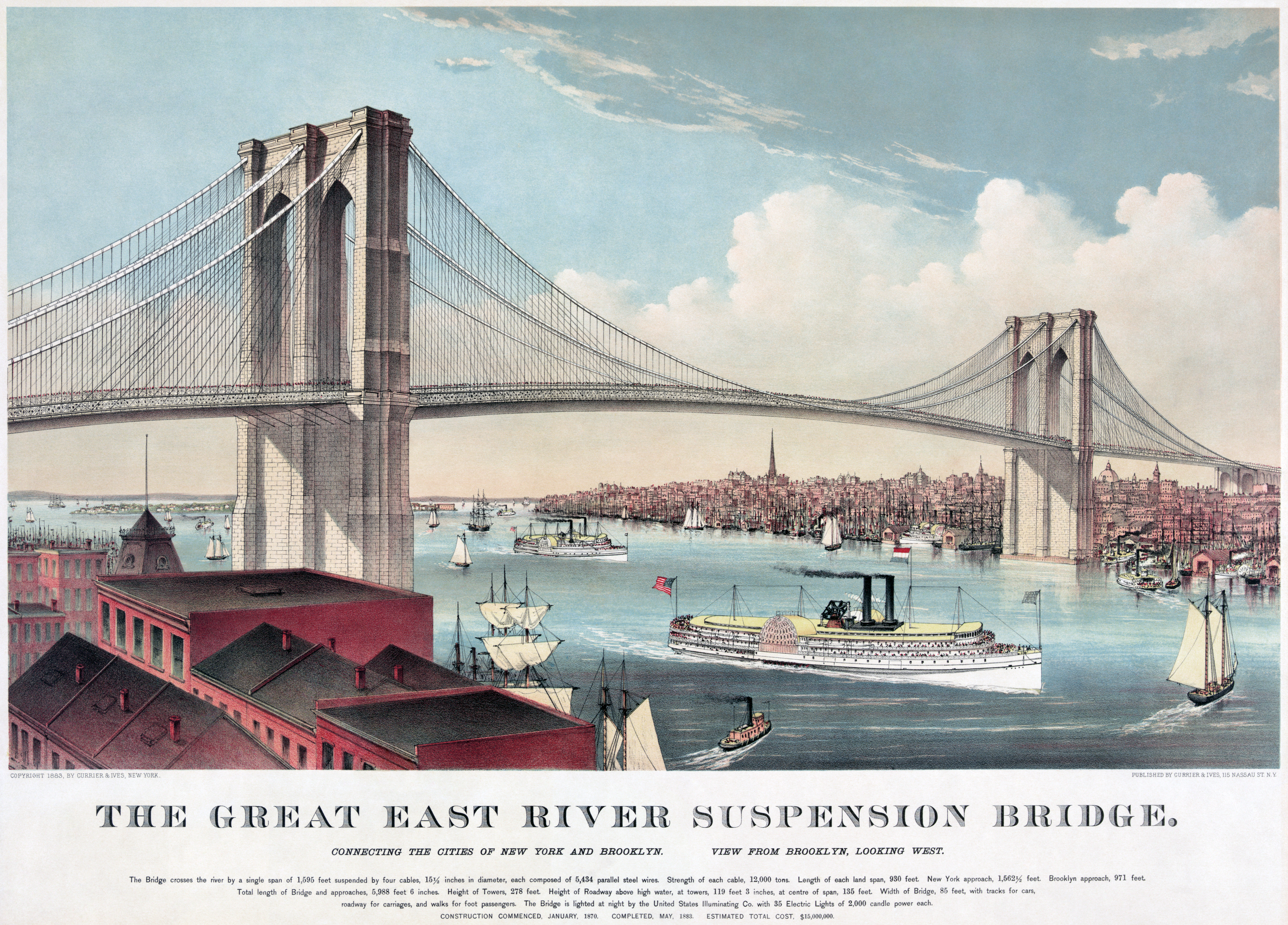
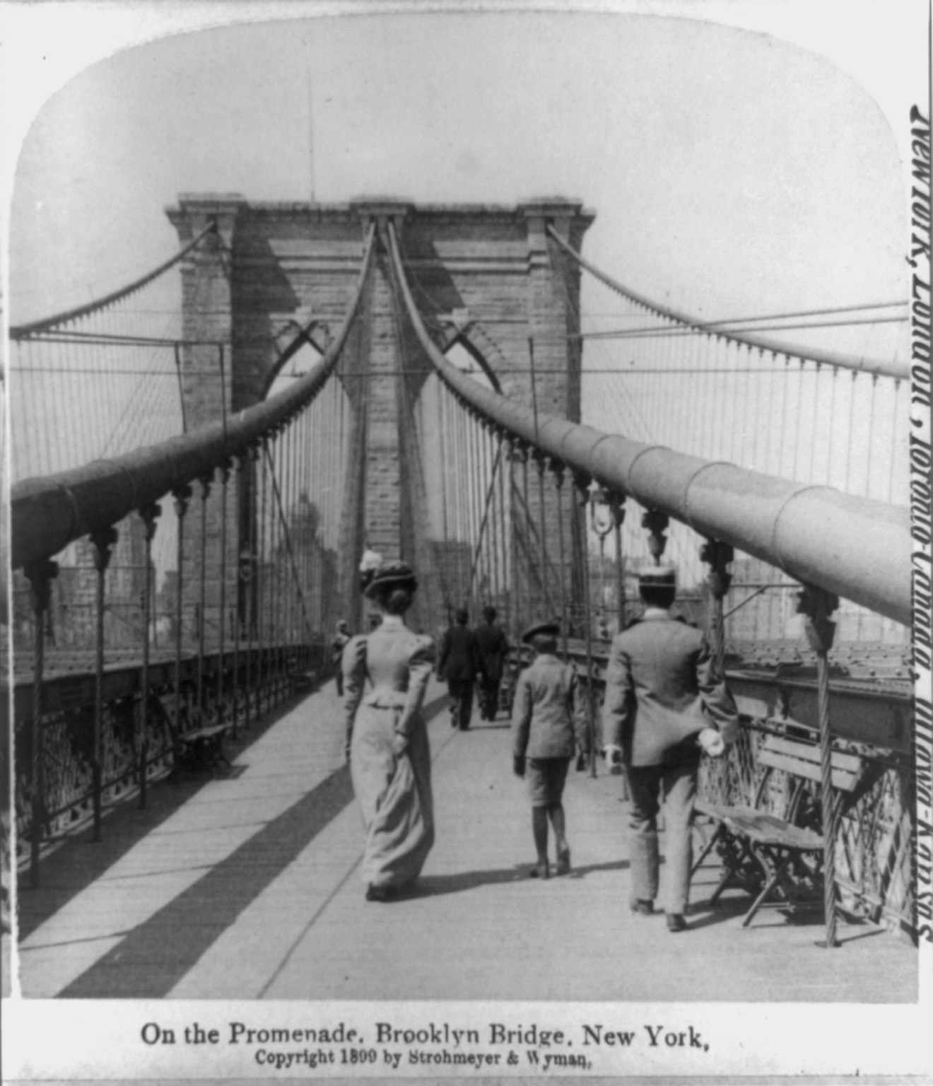
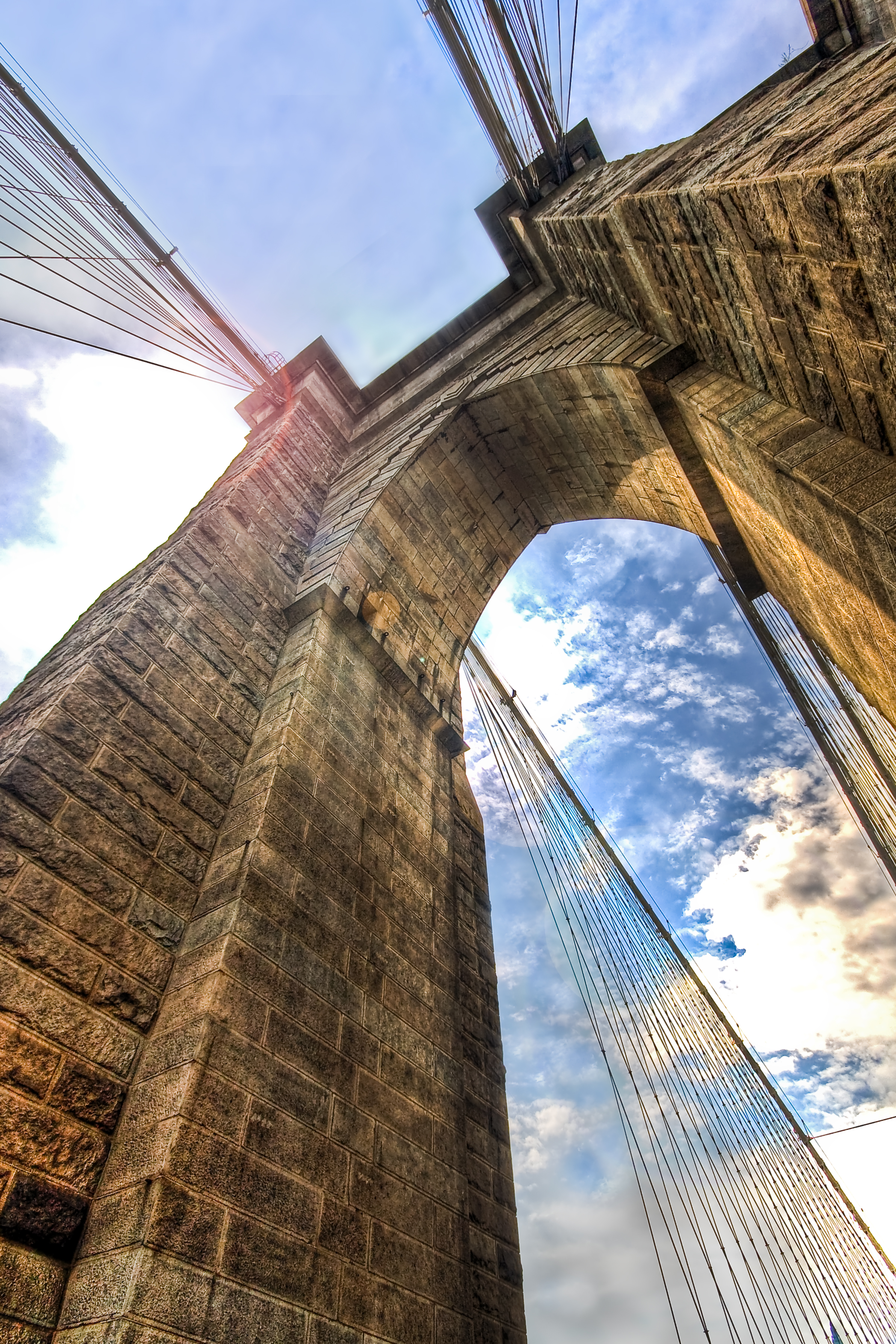
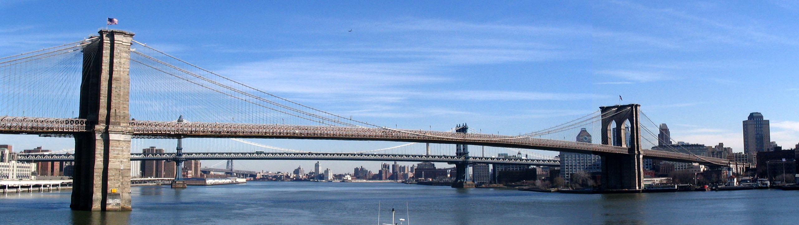
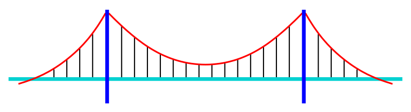
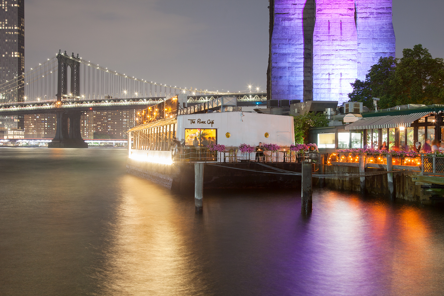
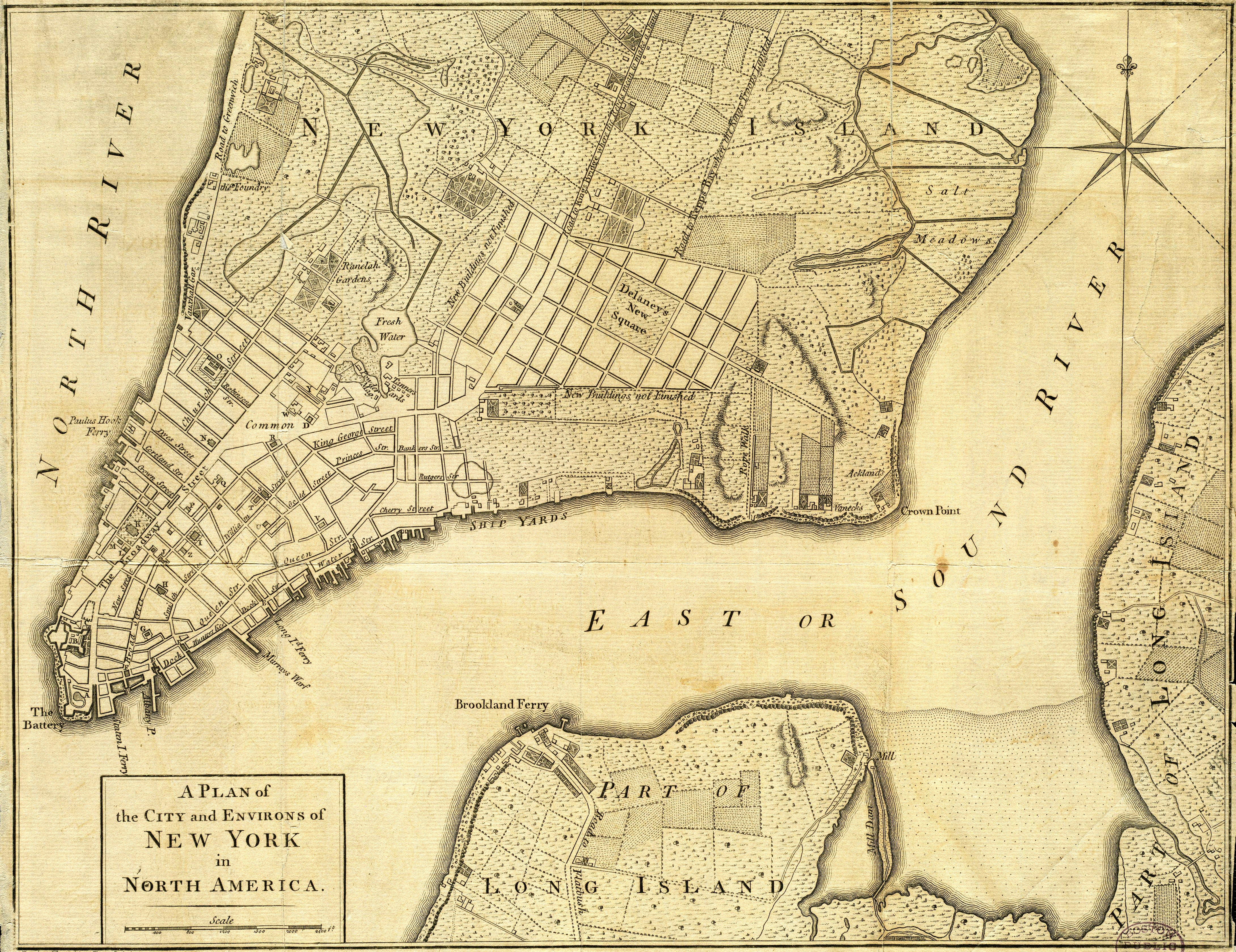
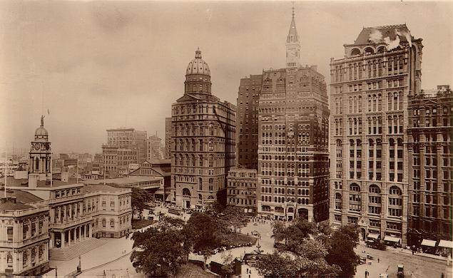
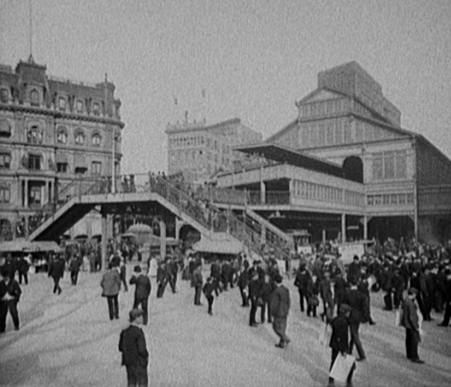