|
Reflections 2024
Series 2
February 29
Islands - SE Florida III: The Florida Keys – Flagler's Quest for Key West
| | Islands We've heard statements like "all poodles are dogs, but not all dogs are poodles". Similarly, all keys (cays) are islands, but not all islands are keys. The only thing all islands have in common is being land masses surrounded by water. In that regard, they are all subject to the vagaries of fluctuations of sea level, not only over the millennia, but also as seen in today's headlines.
I suspect we all have a umbrella mental image of an island like this one, in total isolation. Or even one step further, where it becomes even more of a standard meme we're all familiar with, where this mental image is actually called a "desert" island.
| | | | | | Using "desert" in this way is very odd. It doesn't involve sand, as in the Sahara Desert, but is short for "deserted". And even that is odd, because being deserted seems to imply people once having lived there, then leaving, like on an "abandoned island", and that isn't necessarily the case. A much better way of referring to a "desert[ed] island" would perhaps be an "isolated island/islet". But that's not the phrase we're stuck with. This often happens in language—the name we've inherited and use is not the best one. |
| | | | But I'm writing this from the island of Manhattan, and there are far more than two of us here. Thus, isolation does not define an island. | | | | | | This, even despite the fact that the word "isolate" derives from Latin insula "island", via Italian isola, becoming Italian isolato "isolated", then French isolé, then English "isolated".
Then there's the related word "peninsula", a would-be island that isn't, because it's connected to the mainland at one point via a neck or isthmus. I never really associated the two words until I learned about them the long way around. When I learned the German word for "peninsula", Halbinsel, it was obvious to me that that is cleverly constructed as halb + Insel or "half island". Only then did I look up "peninsula", which comes from Latin paene "almost" plus the above insula, so it's just as clever a construction. This illustrates the situation of English, a blended language of Anglo-Saxon and Norman French, where derivations can often be easier to see via the Germanic side.
|
| | | | Thus there are many kinds of islands. Let's talk about a few, most of which we've discussed in the past, tho this is not a comprehensive study! It just presents a partial array. | | | | CONTINENTAL ISLANDS Pieces of continents do break away to form islands, which then remain close to the continental shore. Let's call these continental islands. A close one to me is Long Island.
Millennia ago, Long Island was the south shore of what is now New England, of Connecticut to be exact (Map by © 2004 Matthew Trump). Ice ages left two moraines on this area, and eventually, melting ice created fresh-water Glacial Lake Connecticut. This eventually became Long Island Sound (in pink) connecting itself at either end to the ocean, cutting off Long Island from New England and creating the present Connecticut shore.
https://pubs.usgs.gov/fs/FS-008-99/images/CT_fig04.gif
This map shows this in more detail. The two red lines are the glacial moraines left on Long Island, each forming its own fork at the east end. The Glacial Lake became more saline when it (1) broke thru to the ocean at the east end and (2) when it formed the East River (not a river, but a strait) at the west end to connect to the Hudson at Upper New York Bay (Map by © 2004 Matthew Trump). What eventually became Manhattan Island already faced the Hudson River on its west side, but was attached on its east side. The breakthru of the East River separated the lower half of Manhattan from Long Island, and a similar channel formed the Harlem River (also a strait) separating Manhattan from the Bronx, on the mainland. Thus Manhattan became an island as a secondary act to Long Island doing the same.
We recently discussed the development of the English Channel, when we pointed out that the British Isles, not only Great Britain, but also Ireland, had been connected to the European continent. We saw this map of Doggerland in the North Sea, which included the Thames being a tributary of the Rhine (Map by Max Naylor). Rising sea levels again expanded the North Sea (Map by Halava) and formed the English Channel and the Irish Sea, forming the British Islands. (I wish the idiotic Brexiteers had realized this.)
One more of these "detachments" we never discussed, because I only found out recently about Tasmania having originally broken away from Australia. On my trip in 2010, I enjoyed taking a cabin in the overnight ferry from Victoria to Tasmania, then a few days later again, returning. It would have been an extra bit of pleasure if I'd known that back in prehistory, there had been no Bass Strait to cross. It was only by perusing YouTube videos that I found out this tidbit.
Look at this map of the region--we'll explain the odd names in a moment (Map by Kanguole).
Sahul is also called Greater Australia, which is the name I prefer to stick with. It was a paleocontinent that included, with Australia, not only Tasmania to the south, but also New Guinea to the north, the second largest island in the world after Greenland.
The last Ice Age started 30,000 years ago, and a lot of sea water froze into ice sheets and glaciers. With less water in the oceans, sea level dropped by about 120 m (400 ft), which exposed land bridges along continental shelves, creating, for instance, a continuous land mass between Papua New Guinea, Australia, and Tasmania. When global temperatures increased and the ice melted — which took about 6,000 years — sea levels rose, flooding the land bridges, forming straits in their place.
Thus mainland Australia separated from New Guinea about 8,000 years ago (that land bridge is now the Torres Strait) and from Tasmania, about 6,000 years ago, (that land bridge is now the Bass Strait I sailed across). But as the map shows, all three areas to this day remain on the same continental shelf.
| | | | | | An aside on New Guinea that I just learned: it was named by a Spanish explorer in 1545, who felt that the indigenous peoples of the island resembled those in the African region of Guinea.
So where is Guinea? That needs further clarification, because the word refers to a traditional region, not one particular place. I find that "Guinea" seems to be synonymous with "West Africa", a very large area.
First look at this map of the Gulf of Guinea (Map by PresidentistVB). What's that gulf named after? It turns out that all these countries, from Gabon to the Ivory Coast, are within the traditional region of Guinea--but only Equatorial Guinea uses the name. You would then think the Gulf would define the region, but you'd be wrong, since a large area to the west is also part of the traditional Guinea. Let's use this convenient Czech map of Západní Afrika (West Africa), which repeats the part of Nigeria to the Ivory Coast (in beige), but continues up the coast to Senegal (Map by Honza Záruba). And sure enough, here we find two other countries that use the name, Guinea-Bissau, which uses its capital city to help distinguish which "Guinea" it is, out of three, and finally Guinea, sometimes called Guinea-Conakry, to do the same.
I continue to be amazed how researching something like New Guinea ends up giving me information I never knew about West Africa, so very far to the west of the area being studied. There are three small countries there, as well as the Gulf, that use the name, but otherwise not really an "Old" Guinea to be a counterpart to New Guinea.
|
| | | | Let's return to finish discussing this same map from a moment ago (Map by Kanguole), where we should at least mention the area called Sunda. Here we can see that southeast Asia, including the Malay Peninsula, was all the same land mass as much of western Indonesia, and are still on the same continental shelf. We also see that Borneo, the third largest island in the world, Sumatra, the sixth, and Java, the thirteenth, were all separated parts of a continent, Asia, as well, and this includes other islands, such as Mindanao in the Philippines as well. Thus the number of islands separated from continents increases.
The three dashed lines on the map represent three scientists' views of the separation of Australian and Southeast Asian fauna. But bluntly, it points out that there are no kangaroos or koalas in Borneo.
As to those odd names: the name "Sunda" first appeared in the 11C as a Javanese term used for their neighbors to the west. Scientists seems to have appropriated it for ancient western Indonesia.
Geologically, the Sahul Shelf is a part of the continental shelf between Australia and Timor (shown on the map, tho not named). The name Sahul appeared on 17C Dutch maps as "Sahoel" (in Dutch, OE=U, as in "rule"). On his 1803 map, Matthew Flinders made note of the "Great Sahul Shoal".
You may—or may not—recognize Flinders' name from our discussions in the past. He was the British navigator and cartographer who led the first close-to-shore circumnavigation of mainland Australia, then still called New Holland (Map by Summerdrought), on board the very appropriately named HMS Investigator (Etching by Geoffrey Ingleton, 1937, copy of a photo from the State Library of NSW {PD-1996}). Flinders is also credited as being the first person to use the name "Australia" to describe the entirety of that continent, including Tasmania (then still called Van Diemen's Land), a name he regarded as being more pleasant than previous names such as Terra Australis ("South Land").
| | | | BARRIER ISLANDS While talking about being close to continents, we can now add barrier islands, which are a type of dune system and sand island where an area of sand has been formed by wave and tidal action parallel to the mainland coast. They usually occur in chains, consisting of anything from a few islands to more than a dozen. They are subject to change during storms and other action, but absorb energy and protect the coastlines and create areas of protected waters where wetlands may flourish. A barrier chain may extend for hundreds of kilometers, with islands periodically separated by tidal inlets. Chains of barrier islands can be found along approximately 13-15% of the world's coastlines and can be observed on every continent on Earth, except Antarctica. Sometimes an important inlet may close permanently due to currents and tides, transforming an island into a peninsula, thus creating a barrier peninsula.
Barrier islands are found most prominently on the East and Gulf Coasts of the US, where every state—from Maine to Florida (East Coast) and from Florida to Texas (Gulf coast)—features at least part of a barrier island. We'll just show a small selection of these.
The south shore of New York's Long Island shows a string of five barrier islands and two barrier peninsulas, most of which are quite famous. From west to east click to discern: Coney Island (small; artificially attached to mainland Brooklyn), the Rockaway Peninsula, Long Beach Island, Jones Beach Island, Fire Island, Westhampton Island, and the narrow and short Southampton Peninsula. All of these have famous barrier beaches; beaches further east of them are on the Long Island mainland. There are six openings, which are tidal inlets, that separate the barriers and connect the inner bays with the ocean.
In New Jersey, Sandy Hook is a barrier peninsula; among many islands is Absecon Island, where Atlantic City is located.
The Outer Banks of North Carolina are a particularly prominent part of the US coastline.
In South Carolina, Hilton Head Island is particularly well-known.
Most of Florida's east coast consists of barrier islands and peninsulas, including Palm Beach and Miami Beach, which is the last one on the Florida's east coast. On Florida's west coast, Sanibel and Captiva Islands are well-known.
On the Gulf Coast, Texas has almost continuous barrier islands and peninsulas (Map by Bryan Rutherford). Galveston Island is known for the city of Galveston, and the longest barrier island in the world is Padre Island in Texas, which is 182 km (113 mi) long.
No barrier islands are found on the Pacific Coast of the US due to the rocky shore and short continental shelf, but barrier islands can also be seen on Alaska's Arctic coast.
| | | | VOLCANISM & HOT SPOTS Many islands are the result of volcanic action. Fair enough. But even more interesting is one "volcano"—actually a hot spot--spawning a series of islands. A single sketch easily explains islands developing from a hot spot in the Earth's mantle.
http://archipelagointhewater.weebly.com/uploads/4/3/4/6/43460085/5220807.jpg?1090
This shows the formation of the Hawaiian Islands, all caused by a hot spot spewing lava up from the Pacific Floor. As the Pacific Plate moved westward, Kauai was over the spot first, and is therefore the oldest of these major islands. Each island took its turn over the hot spot, and now the Big Island of Hawaii continues to have lava rising to extend its shoreline. These are the volcanic zones of the Big Island of Hawaii, some extinct, some dormant, some active. Not surprisingly, Kohala being up in the northwest and therefore the first area over the hot spot, is the only volcano is extinct. Mauna Kea, the next in line, is dormant, but the other three are considered active. I've been in a helicopter above Kilauea, watching red and yellow lava rushing down to the sea. So Hawaii continues to grow.
| | | | ATOLLS I've been wondering where to put atolls in this summary, because most of the islands in this atoll category are neither fish nor fowl. Put in other words, they're islands in transition from one form to another, odd as that may seem. Some are completed atolls, but most are still changing from having been volcanic islands.
An atoll (like saying "AT all", but clearly pronouncing the T) is a ring-shaped island made up of a coral reef rim that encircles a lagoon. The coral rim, possibly partially underwater still, may have small coral islets (keys/cays) on it, tho in the Pacific, such an islet is called a motu. Tokelau is a dependency of New Zealand, lying roughly north of it, and this is a satellite view of Atafu atoll which is part of Tokelau. As you can see, Atafu is a late-stage, fully-formed atoll, having completed the transitional cycle. We see the circular reef in brown, partially submerged. The green spots are motus (keys), sand islands that have spottily formed upon the coral thru wave and tide action, tho not everywhere. In the center is the lagoon, which is protected by the reef, acting as a barrier island. There is no trace of any volcanic mountain that might have once been here.
Atolls are located in warm tropical parts of the oceans and seas, or even in less warm subtropical areas--anywhere that's warm enough for corals to still be able to develop. Most of the approximately 440 atolls in the world are in the Pacific Ocean.
But if atolls are the end result of a process, how does it all start? There are two theories, but I'll go back to the theory Charles Darwin promulgated in 1842, based upon observations made during his voyage aboard HMS Beagle in the South Pacific from 1831 to 1836.
Think of the meaning of "to subside", essentially "to lessen". A fever can subside; so can anger or pain; also a storm. The less obvious noun form is "subsidence". That word describes Darwin's subsidence model for the formation of an atoll. A volcanic island develops (which is why I list atolls at this point), and over time, the volcanic island erodes and sinks ("subsides") completely beneath the ocean, long having become extinct. But while it still existed, a coral reef formed around it. As the island subsides, the circular coral reef becomes detached from the disappearing island and becomes a barrier reef. Small sandy islets (motus or keys) develop on the reef, and in time, there is no longer an island, but only the reef and its islets. The enclosed lagoon indicates where the original island used to be. Think of a person wearing a belt, then disappearing, leaving the belt to indicate where the person used to be.
Thus there are several stages of development over geological time until a volcanic island completely transforms itself into an atoll, which may take 30 million years. Therefore, atolls are among the oldest of islands. It's reasonable to say that many islands called atolls are still in stages of change and don't yet meet all requirements to be an atoll. (Shall we call them "almost atolls" or "wannabe atolls"?) We have two illustrations that will help us envision this transformation.
Review this series of illustrations.
#1 shows a volcanic island over some hot spot with no sign of any change.
#2 shows a dormant if not extinct volcano, around which a fringing coral reef has started to form, very close to the mountain.
#3 shows a subsiding mountainous island, but while it erodes downward, there's no way for the reef to move inward, so it ends up being a barrier reef (with keys/motus) forming on it, and the space in between becomes a lagoon.
#4 shows a completely subsided mountainous island underneath the lagoon, and the reef is now a completed atoll, like Atafu. But remember again, most "atolls" have yet to complete the cycle.
A second series of illustrations will help further.
(A) is like #2 above. The mountainous island is still there, but a fringing reef has begun to form.
(B) is like #3. The barrier reef is remaining while the island is subsiding, leaving the lagoon in its place.
(C) is like #4. The island has completely subsided, leaving a lagoon surrounded by a coral reef, a completed atoll. However, these pictures do not show the development of the islets on the reef, sometimes here and there, sometimes covering most or all of the atoll.
BORA BORA My own experience with an "almost" atoll was a delightful one, when a ship I was on in Polynesia, the appropriately named MS Paul Gauguin, stopped in Bora Bora in the Society Islands for a day. It's a beautiful place, and busy with lots of vacationers. We have several maps, each adding a bit more.
First, we have this French map (Map by Sardon, modified by Telim tor). You see how small Bora Bora is--it measures only 8 km (5 mi) from north to south and 5 km (3 mi) from east to west.
The lower part of the inset map tries to show where in the Pacific we are, far from everywhere. But the upper part of the inset map shows Bora Bora in the red box, with Tahiti (where we also stopped) being the large white island shown to its southeast. (This detail map shows it better [Map by Holger Behr].) But look at the chart on the right of the main map, which indicates that the lagoon (in French lagon, also lagune) is the lightest blue, and is by far shallower than any waters around it.
https://i.pinimg.com/originals/aa/a4/dc/aaa4dc446ff25aa3a4d397bfdb65ecb0.jpg
The advantage of this map is that it shows how many major hotels there are, indicating Bora Bora's popularity. It also names the islets as being motus, and shows the Teavanui Pass[age], the only opening to the ocean, where large cargo and cruise ships, including ours, enter and leave the lagoon. Without this "front door", visits by ship would be difficult if not impossible (you see the airport, tho). Surprisingly, it also not only shows the area of cruise ship anchorage, it shows specifically the MS Paul Gauguin, perhaps because it's the most frequent visitor.
As you can see, Bora Bora, tho some would be tempted to call it an atoll, is not one--yet. But it IS clearly in transition to becoming an atoll, so wait a few million more years. It has the partially submerged, necklace-shaped coral barrier reef that works like a protective dike, and an extensive system of motus covering about half of the reef. It has a lagoon, broken into several baies / bays. All that looks to the future.
However, looking to its volcanic past, in the center of the island are the caldera-wall remnants of an extinct volcano rising to two peaks, Mount Pahia and Mount Otemanu, the latter being highest point, at 727 m (2,385 ft). And this final map is the only one that shows both.
https://www.divediscovery.com/images/bora_bora_map.jpg
You'll see in a moment why I wanted to locate both. Otemanu, the tallest, is to the east, can be seen from the whole island, and to my mind, is the more attractive. It has a distinct, slender, finger-like single summit--there's a joke there somewhere (Photo by K5 Boardshop). Notice those hotel rooms in the lagoon—I understand they have a window in the floor to watch sea life in the lagoon from your own room.
On the other hand, Pahia lies to the west and has a very distinct set of twin peaks (Photo by Balou46). In this aerial view of the island (Photo by The TerraMar Project), we must be looking west. If you click to look closely, the two mountains line up, with the single peak closer and twin peaks behind.
BORA BORA UP & DOWN A short summary of this great adventure really should be repeated here. The ship was in Bora Bora for under two days. The first day I signed up for two very memorable and exciting adventures, so that I was happy using the partial day for just relaxing. For the full story, with additional details, you can also refer back to 2009/16.
In 2008, I happily went "copter crazy" and took helicopter rides four times during trips: (1) once over Victoria Falls, which divide Zambia and Zimbabwe (spectacular), and thrice in Hawaii (2) Maui, above Haleakala, (3) Big Island of Hawai'i (spectacularly over flowing lava), and (4) Kaua'i, along the Na Pali coast. In 2009 I did it again in (5) Bora Bora, and in 2010 again in Australia, over (6) Uluru/Ayers Rock. Those six times in two years (!) were the only times I ever flew in helicopters, and they provide great memories.
BORA BORA UP The five other flights were very proper and professional, but the one in Bora Bora was a wild time, and great fun. The four of us who signed up in the morning for this arrived at the copter office, run by a military-looking guy. But then he turned out to also be the van driver, then he "changed hats" again to be the pilot. We did NOT take off from the airport shown on the map, but from a lot that could have been someone's (the pilot's?) back yard. In that posting, I call the pilot Cowboy Joe. Il ne parlait que le français / He only spoke French, but that made no difference, since there was no narrative at all as we flew around the island for the prescribed 15 minutes. We flew over some motus, and, surprisingly, right over the ship. But the end was the most shocking and thrilling experience. With no explanation, we started flying toward a mountain wall. Before hitting it, the pilot suddenly changed direction—but the new direction was UP. It was like going up in an express elevator to the top floor. We reached the top of the wall of the mountain, and for a split second, enjoyed a most spectacular view over the other side, but then immediately, started to plunge back down to earth. We stopped before the "basement" and flew back home at the original reasonable altitude.
What a thrill. I found a picture online of what might be the climactic moment going over the top (Photo by rachel_thecat). I never knew at the time just where we crossed the two mountains, but this ridge between the two is most likely it. We see distinctive Mt Otemanu on the right, and the picture is described as being a "northeast view from Mt Pahia", whose twin peaks are presumably off camera to the left. If the top of Otemanu is at 727 m (2,385 ft), it's reasonable to assume that we crossed at 700 m (2300 ft). What a ride!
BORA BORA DOWN But descending in the copter isn't the "down" I meant, because after lunch, I'd signed up to go down under the sea, making it a truly up (in the air) & down (under water) experience on the same day. A launch zipped across the lagoon and took us out thru the Teavanui Passage just a small distance into the open ocean to a floating dock. There were six of us, two couples, another gentleman and myself. We got onto the dock, where we entered a "submersible", not a submarine, not self-propelled, just a spherical submersible on cables that was let down into the sea. We each entered down into it one at a time thru the hatch, and were seated in a circular area. The captain (?) who'd greeted us followed us down, secured the hatch, and got us started. The room was small. Three sides of it had very large round windows, with two seats in front of each. We had thirty minutes' worth of fish swimming, but better was to experience the coral reef from down below as we descended alongside it. I had read that the maximum depth we could expect was 120 ft, or about 36.6 m, so I was quite satisfied when we reached our maximum depth of 33 m (108 ft).
Thus in the morning it was up and down over the mountain, and in the afternoon down and up to the coral reef. Great day.
| | | | | | There's another half to this story, and I must squeeze it in. As a matter of fact, only now do I realize that on my trip to Australia the following year, 2010, I did both one more helicopter ride (over Uluru, see above) and also a coral reef visit, but they were many days apart from each other, so I never realized the parallel to Bora Bora until now. For further details see 2010/20.
It was out of Cairns, in Queensland, to see the Great Barrier Reef, the biggest coral reef in the world, with a length of 2600 km (1600 mi) between Brisbane on the east coast of Australia north to Papua New Guinea. I took a catamaran trip taking a couple of hours to run 60 km (37 mi) out to the Outer Reef. En route we stopped at a coral reef called Green Island.
The company maintains a very large pontoon off Norman Reef. From which you can take a half-hour ride in a semisubmersible, quite a change from Bora Bora. The semisub was totally different. It was NOT tethered, very large, and totally self-propelled. It didn’t have a hatch, but regular entrance on the upper level, after which you went down to the lower level on one of two staircases. The lower level was one huge bench, with windows all around the very large cigar-shaped sub. We went horizontally, not vertically. Unlike Bora Bora, we never achieved any depth of note whatsoever, with the water surface always seemingly at arm’s length. However, we saw considerable fish, but the absolute best was the selection of colorful corals, as seen here on this outcropping on Flynn Reef (Photo by Toby Hudson). It just doesn’t get better than this. Given the height of the reef, close to the surface, we were above and next to the most unbelievable variety of huge corals, some dome-like, some tree-like. It was such a good viewing experience that a number of us, including myself, did the submersible ride a second time before leaving the pontoon for the day.
These two experiences with coral reefs have now prepared us to talk about keys, including the Florida Keys, our main topic below.
|
| | | | KEYS While some types of islands were formed spectacularly by volcanoes and ice ages, a few types were formed quite simply, by tides moving sand around, as on barrier islands. Keys are among those. So here we can forget geology, and move to biology. We've already heard about low-lying, sand-covered coral reefs in the western Pacific (where they're called motus); in the Caribbean and adjacent West Atlantic area they're called keys/cays. This map shows the warm-water distribution worldwide of coral reefs. Their concentration in the western Pacific/East Indies and in the extended Caribbean area is obvious.
I've just put my biology hat on and learned the following online about exactly what coral is.
Corals are marine invertebrates (animals having no backbone) that typically form compact colonies of many identical individual polyps. Polyps in zoology are roughly cylindrical in shape and have a vase-shaped body. Each one is a sac-like animal only a few millimeters wide and a few centimeters high. Oddly, these tiny animals have qualities of both plants and animals.
With solitary polyps, the lower end attaches to a surface by means of a disc-like foot, while in colonies, polyps are mostly attached to each other. The upper end contains the mouth, and is surrounded by a circle of tentacles. Corals eat plankton, which is what gives them their varying colors. They require sunlight, so they grow in clear, shallow water, typically at depths less than 60 m (200 ft).
Coral species include the important reef builders that inhabit tropical oceans and secrete calcium carbonate to form a hard outer skeleton near the base. Over multiple generations, the entire colony thus creates a mass skeleton that can grow to several meters/yards in size. These grow into reefs, which are underwater ecosystems held together by calcium carbonate, which is essentially limestone. Thus, these animals, with plant-like qualities, build stone-like formations, and therefore seem to check each box as to animal, vegetable, mineral.
A key/cay forms when a coral reef breaches the surface during a period of dropping sea levels. Even those that are merely close to the surface can still be affected by tides and ocean currents that transport loose sediment across the surface of a reef, at which point the current is forced to slow down, releasing its sediment. Gradually, layers of deposited sediment build up on the reef surface. If the accumulated sediments are predominantly sand, the island is called a key/cay.
As for the word(s) we've been using, three languages are involved. That the terminology is Caribbean is explained by Taíno. It was an Arawakan language spoken by the Taíno people, indigenous to the Caribbean. When the Spanish arrived, Taíno was the most common language in the Caribbean. It's now extinct.
The Taíno word for "small island" was cairi. The Spanish adopted it in the form cayo (rhymes with "[O]hio"). What happened with English is the most confusing, and this is my best attempt at explaining the language mess we have today.
When you hear KI today in English, it can be spelled "key, quai, cay". The French word quai (KÉ) entered English meaning "wharf" with that spelling but developed the pronunciation KI. The Spanish word cayo entered English with the shortened spelling "cay", but also acquired the pronunciation KI, perhaps somehow by association with the French word.
The spelling "cay" is maintained in British English for the island form, but the altered spelling "key" developed in American English, possibly simply by association with the key in your pocket. The result is that in the Bahamas, which uses British spelling, you find "cay", while in adjacent Florida you find "key". (Can you imagine Key West being spelled Cay West? Horrible.)
| | | | | | I will not get into a rant on awkward English spelling beyond this. At least Daniel Webster tried to remove "silent" letters in words like "colour" to "color" and avoided French spelling in "centre" for Germanic "center". But British spelling persists with other one-on anomalies, like "gaol" for "jail" and "Geoffrey" for "Jeffrey", and now I find "cay" for "key". I'm an internationalist, but I do find this irritating.
Apparently, visitors in the know in the Bahamas, see "cay" and say KI for historic accuracy, while others might say KÉ, rhyming it with "day". The problem is that as more and more say KÉ, it begins to become an alternate standard, and any quality dictionary is forced to be honest and show both pronunciations. Still, be in the know and, confusing as it is, when you see "cay", say KI.
|
| | | | As an adjunct to the spelling quirk "cay", let's take a look at this map of the Bahamas, right next to Florida. The Bahamas consist of 700 islands and 2,400 cays (and I have to spell it that way). Obviously most are tiny and not named on this map, but named to the east are Samana Cay and Rum Cay, in the south, Northwest Cay, and in the west Cay Sal.
There's been an over-touristy trend that I've been sorry to see. There are plenty of interesting destinations in the Caribbean as well as in the Bahamas (which are in the Atlantic), where I've enjoyed both Nassau and Freeport. But most of the 2400 tiny cays are surely clones of each other, and not of great interest. However, cruise lines have been taking over some nondescript cays, and making them into what I'd call amusement parks with beaches. Worse is that most of them are avoiding the legal names of these cays and giving them "new" names, sort of "doing business as" names, which are usually much more touristy. These seem to me to be non-destinations, or as I call them, faux islands. I know of four.
In the north, find the Berry Islands. In 1977, the Norwegian Cruise Line purchased Great Stirrup Cay and developed it into a private island for their cruise ship passengers. In this case, they didn't change the name.
In 1990, Royal Caribbean Cruises acquired nearby Little Stirrup Cay for their use and also for Celebrity Cruises. It's now a private island renamed CocoCay (one word!), about as glitzy and touristy a name as you can get.
In 1997, the Walt Disney Cruise Line purchased a 99-year lease from the Bahamian government for Gorda Cay (near Great Abaco Island in the north) and, for the use of their passengers, renamed it Castaway Cay. As you might guess, it's run like a theme park.
The year before, in 1996, the Holland America Cruise Ship Line purchased Little San Salvador, located in the center, between Eleuthera and Cat Islands. I strongly suspect this island is NOT a cay, but that didn't stop them from renaming it Half Moon Cay. Perhaps they figure touristy vacationers wouldn't know the difference, or even care. However, in this case, the pseudo name is clever. Not only is the major sandy beach on the island shaped like a half moon, but the line's logo includes an image of Henry Hudson's ship the Halve Maen (Half Moon). Holland America is now part of the Carnival Corporation.
I'll mention again that I was taking this Florida trip in 2019 because the Holland America cruise on the Veendam to Cuba and other islands had been canceled. One of the other islands was to have been the so-called Half Moon Cay. It had crossed my mind that if I'd been forced to stop there, I might not even get off the ship. It was one more reason I didn't mind the cruise was canceled.
| | | | Florida's Covert Geography I'm sure that, when people are asked to list major natural destinations in North America, they would come up with Niagara Falls, the Grand Canyon, perhaps the Canadian Rockies, and more. I don't think that flat Florida would make that particular list, because it's known instead for its warm climate and beaches, but hardly any spectacular geography. But there are some things that people don't realize: | | | | | | 1) Florida is more than twice as wide as the peninsula we're used to seeing on maps.
2) While we picture Florida as flat, it has a cliff over whose edge there's a drop deeper than that of the Grand Canyon.
3) At another, very significant point, the cliff isn't quite as high, tho the drop-off down the abyss is still as high as the famously "mile-high" city of Denver is up. And more—the Florida Keys are perched on the edge of this cliff.
|
| | | | Why do we not know this? Because so much of "very flat" Florida is still hidden under water, since in the last Ice Age, ice cap and glacier formation using up sea water lowered sea level just so far, but not all the way, so that only some of Florida emerged, but much never did. And what's out of sight is out of mind, right? If you can't see it, it's not there. Picture a swimmer's head and neck emerging above water in a pool. That doesn't mean that his shoulders—and more—aren't there.
https://i.pinimg.com/originals/f9/e3/e9/f9e3e9b70e9c2930ef87413a9713f313.png
This view shows three different stages of Florida and the sea. The white and dark areas together show Florida today.
During this time of lower sea levels, the Florida land mass was much larger than it is today and the area now referred to as Florida Bay south of Everglades Park was forested. As glaciers and polar ice caps started melting 15,000 years ago, much of the land became flooded.
The white area alone shows Florida 5 million years ago, surrounded by high sea levels. Not only are the Everglades part of the sea, the whole area up to what is today circular Lake Okeechobee is also part of the sea.
But what a difference a few million years make! The red line indicates what is today underwater Florida, all or most of which seems to have seen the light of day at a time when developing icecaps at the poles took up large amounts of ocean water, lowering sea levels.
Let's take a look at the continental shelf around Florida to give us an initial idea of what we're talking about. The shelf is relatively minimal on the east side, but reveals enough room for a "second Florida" on the west side. The shelf here is also known as the Florida Platform, and here's a more detailed map of it (Map by Noles1984).
We see that, in reality, the Florida peninsula is merely the area where the Florida Platform breaks the surface of the water.
The Florida peninsula can be easily seen as being located on the eastern side of the platform, where in places it lies only 4.8 to 6.4 km (3-4 mi) from the Atlantic edge of the platform.
In comparison, on the Gulf side, the platform ends over 160 km (100 mi) to the west of today's shoreline. Its initial depth continues at about 91 m (300 ft), but then suddenly plunges dramatically over a cliff down a steep slope to a depth of about 3,000 m (9,800 ft). The slope commonly exceeds 60°, with some small portions approaching being vertical. This cliff is called the Florida Escarpment and continues around the south side, along the Florida Strait.
To compare, the Grand Canyon has an average depth of 1,200 m (4,000 ft), but at its deepest point reaches 1,800 m (6,000 ft). Thus, Florida "wins" the depth race, with the caveat that Florida's asset is under water.
https://cdn.britannica.com/11/6011-050-C3CE9A57/Gulf-of-Mexico.jpg
For the sake of completeness, we should show that the Gulf of Mexico, the largest gulf in the world, is deeper still than the Florida Platform. The deepest part of the Gulf of Mexico, Sigsbee Deep, is estimated to be roughly 4384 m (14,383 ft) deep while the average depth is around 1600 m (5,300 ft).
Move your attention out of the Gulf and into the Florida Strait, where the Florida Escarpment continues, but is slightly less deep. The Florida Strait separates the Florida Keys from Cuba, and carries the Florida Current, the beginning of the Gulf Stream, out of the Gulf of Mexico. The Strait is 150 km (93 mi) wide at the narrowest point between Key West and Cuba.
Now look at this jaw-dropping three-dimensional map of the Florida Strait section of the Florida Escarpment. The depth of the abyss has been sounded to 1,800 m (6,000 ft). Denver, at 5,280 feet, is known as the mile-high city. This abyss is deeper than Denver is high.
We can also see here how the Florida Keys (in green) developed near the edge of the Florida Platform, on the edge of the cliff. People, including acrophobics, driving along the Keys don't realize the precipice they're so very close to, since the calming waters block the view downward. In red you see the coral reefs--North America's only living coral barrier reef lies approximately 10 km (6 mi) seaward of the Florida Keys in waters that are typically 4.5 to 9 m (15 to 30 ft) deep.
We should keep some thoughts in mind in regard to the Florida Strait.
1) It's known for danger. The strait is notorious for bad weather with resulting shipwrecks. This goes back to the Spanish losing ships trying to bring gold back to Spain, and ships have been lost there ever since. This has resulted in people making a living from salvaging, notably Bahamians who moved to the Keys even before they were connected by rail or road, to deal in salvaging lost cargos and wrecked ships. The Bahamian influence remains in the distinctive Bahamian architecture in Key West.
The danger of using the Florida Strait has altered Florida history. When the Spanish colonized it, they made it two colonies—on the east coast was East Florida with a capital in Saint Augustine and on the west coast was West Florida, whose capital was Pensacola. This dual-colony set-up was apparently for convenience, since there was no cross-route to sail between them, but also to avoid the danger of constant sailing around the strait.
I'll repeat the story of the state capital. When Florida became a state, the two former colonies were united, but the two historic capitals were maintained at first. The first legislature met in 1822 at Pensacola, but eastern delegates had to sail for up to 59 days to attend. The second session in 1823 was in St Augustine, and western delegates needed 28 days to sail perilously around the peninsula. During that session, they decided to locate a point on a trail halfway between the two cities and establish a new capital, Tallahassee. The third legislature met in 1824 in a log building in the new capital.
2) The Florida Keys are known for deep-sea fishing. For this you obviously need some deep sea. North of the Keys is the ridiculously shallow Florida Bay, so that won't do, thus it takes place in the Florida Strait.
Continuing that thought, Ernest Hemingway wrote The Old Man and the Sea about an elderly Cuban fisherman—Cuba is on the Florida Strait--in pursuit of a marlin. It won him both the Pulitzer Prize for Fiction and Nobel Prize for Literature.
3) And let's not forget the Gulf Stream, Florida's gift for northern Europe. Without this gift, northern Europe would be as frigid as northern Canada facing it across the Atlantic. But now I learn that technically, the Gulf Stream only makes it halfway, since the balance is considered the North Atlantic Current.
We can see that both are part of the North Atlantic Gyre--gyre rhymes with ji[ve] + [t]ire—think of a gyroscope gyrating to get the image of movement (Map by Jack). The warm, swift Gulf [of Mexico] Stream flows thru the Florida Strait and up the eastern US coast, bringing warmer waters to the US South. It veers east near North Carolina and moves toward northwest Europe via its extension, the North Atlantic Current (or Drift), which affects northwestern Europe's climate to even a greater degree. We can see that they're both part of the North Atlantic Gyre, part of which continues to turn back with cooler waters in green returning around the gyre.
At the heart of the gyre is the Sargasso Sea (not named here), noted for its still waters and quite dense seaweed accumulations. I always wondered why there was a sea with no land borders, but the gyre explains it.
But the North Atlantic is not unique, as there are many gyres around the world. Some are small and local, but there are five major ocean-wide gyres in the world, the North Atlantic, South Atlantic, North Pacific, South Pacific, and Indian Ocean gyres.
But why should water move about like this? We did a bit of biology with the coral, so now let's do a bit of physics. I've just discovered that what is called the Coriolis force results in the Coriolis effect (Sketch by Anders Persson), which acts on objects in motion opposite to their rotation, either clockwise or counterclockwise (UK: anticlockwise). This is seen most obviously with water. Due to the Coriolis effect, water in a sink going down the drain will create a vortex. Since, when viewed from the North Pole, the Earth spins counterclockwise, in the Northern hemisphere, draining water moves clockwise (see sketch), and in the Southern hemisphere, it moves counterclockwise. On the equator, water goes straight down, with no vortex.
Sounds good, right? But take it with a grain of salt when it comes to the bathroom sink, because it's all theoretical and less suitable for a small-scale demonstration. It's very possible that the pressure of the water coming out of the faucet will force water in the sink to go down the drain in whichever direction the faucet is facing, throwing theory out the window. Instead, consider the large scale demonstration of the ocean-wide gyres. The two in the northern hemisphere DO turn clockwise, and the three in the southern hemisphere counterclockwise.
| | | | Non-Keys We know we shouldn't believe everything we hear, and that stands true with familiar names that were misnomers in the first place. We continue to call it the Caspian "Sea", even tho we know it's a lake, just like the Great Lakes. We continue to call it the East "River" in NYC, even tho we know it's really a strait—same for the Harlem "River". Thus we should be aware of "keys" that are not what they claim to be, just regular islands.
https://travel4wildlife.com/wp-content/uploads/2016/04/cedar-key-map1.jpg
North of Tampa is a lovely cluster of islets known as Cedar Key. Beverly and I drove up there 2-3 times to look around and have dinner. But it's not a key. It's a barrier island, and its main island is surrounded by other islets. It was named after the eastern red cedar, which was once abundant in the area, but apparently no longer is. So this enjoyable location has two lies in its name.
If we take another look at northern Biscayne Bay at Miami, we find three "non-keys" (Map by Comayagua99 at English Wikipedia). Note South Beach in Miami Beach, which we know is a barrier island. Fisher Island is semi-artificial. It was a part of South Beach until Government Cut was sliced thru to aid shipping. Then come Virginia "Key" and "Key" Biscayne. Both are the southernmost of the Atlantic barrier islands, composed of sand, with no coral reefs. Worse still, Brickell "Key" isn't a key either, and hardly even a real island--it was man-made, going back to Flagler.
I spotted something right away. Want to do some language guessing as to which was named in Spanish and which in English? What do you think?
Key Biscayne had to have been named in Spanish, since it's the only one showing Spanish word order. If it had been first named in English, it would have been *Biscayne Key, just as Virginia Key is. And some research indicates that a 17C map shows it as Cayo de Biscainhos. In addition, the Spanish name even today is Cayo Vizcaíno.
| | | | The Florida Keys If you're looking for keys, you need to find reefs.
1) The world's largest is the Great Barrier Reef of Australia, named by Matthew Flinders himself (see above).
https://elibrary.gbrmpa.gov.au/jspui/bitstream/11017/869/9/SDC-041206-GBR-Gen-Ref.jpg
It lies along Queensland, covering by eye maybe three-quarters of it, and not reaching down to Brisbane. It's on the appropriately named Coral Sea. Click at the top to see that the reef actually extends a bit beyond Australia, into the Torres Strait and reaching Papua New Guinea. Click further down at Cairns and you'll see Green Island, the coral reef where my tour paused en route to the Outer Reef.
https://mail.lacgeo.com/sites/default/files/inline-images/mesoamerican_reef_system_map_opt.png
2) Second largest is the Belize Barrier Reef, which is in reality the major part of the Mesoamerican Barrier Reef along Mexico (from the Cancún area of the Yucatan) to Belize, Guatemala, and Honduras.
3) And finally we come to the Florida Reef, which is not only the only living coral barrier reef in the continental US, it's the third largest barrier reef in the world. As we saw it drawn in red earlier, the reef proper lies a few kilometers/miles seaward of the Florida Keys, is about 6-7 km (4 mi) wide and extends (along the 20 meter/yard depth contour) 270 km (170 mi) from Fowey Rocks just east of Soldier Key in Biscayne Bay to just south of the Marquesas Keys (map to follow).
The barrier reef tract forms a great arc, concentric with the Florida Keys. Those keys, in turn, rest on ancient coral reefs lifted above the present sea level. They extend southwest to the Dry Tortugas, a longer distance of approximately 220 miles.
Now to understand all this correctly, picture this chain in three sections with these unique names (my personal terminology: easternmost are what we can call the Unknown Keys, followed by the Famous Keys, in turn followed by the Far Keys. While I could legally link to the following three maps of the Keys, I'd rather give you the links so you can study them at your leisure.
https://upload.wikimedia.org/wikipedia/commons/d/d0/Biscayne_National_Park_Map_2009.png
THE UNKNOWN KEYS I want to call these easternmost keys the Unknown Keys, because it's not common knowledge that they're there. We're used to seeing the northern part of Biscayne Bay at Miami. This is the southern part of Biscayne Bay we "never" see, which is now enclosed in Biscayne National Park, whose borders are shown. As you can see, 95% of the park is water, whose western shore is an extensive mangrove forest. Click to find the visitor center on SW 328th Street. This is the extent Beverly and I ever got when we drove out due east from Homestead. My main memory of doing that is being surrounded by all the sawgrass (next link). Sawgrass , which is not a real grass, but a sedge, can grow to 2-3 meters/yards high, higher than your car.
https://wildsouthflorida.com/images2020/sawgrass.1.jpeg
Click at the top center of the map and you'll see Key Biscayne, the non-key that's the last of the Atlantic barrier islands. Scroll down to find a purple area. While close-in waters like Biscayne Bay are surprisingly shallow (hence all the causeways and Port of Miami) this is particularly shallow. The key shows that blue indicates a depth of 3.6+ m (12+ ft), which is just over swimming-pool depth; light blue shows 1.8-3.6 m (6-12 ft), or swimming-pool depth, and white shows up to 1.8 m (6 ft) or hot tub depth. Purple indicates it's so shallow that it's a shoal or sandbank.
Now unclick and look at the purple area. It has a very unusual name, the Safety Valve, which is a series of shallow sand flats separated by tidal flow channels, stretching about 13 km (8 m) from the south end of "Key" Biscayne to the Ragged Keys at the north end of the Florida Keys. It gets its name because it essentially moderates storm surges into Biscayne Bay and allows storm surge water to flow out of the bay after the passage of tropical storms. That was the argument against building a causeway and bridges connecting "Key" Biscayne to the Ragged Keys and beyond, on the grounds that such construction would impact the entire bay negatively after a storm as to flooding.
Now locate Fowey Rocks, seaward. We just said above that that was the northern end of the coral reef. Similarly, find Soldier Key on the Safety Valve. This flyspeck island is technically the northernmost of the Florida Keys.
https://www.floridakeys-guide.com/wp-content/uploads/2015/09/soldier-key-florida-300x195.jpg
This is an aerial view of Soldier Key lies on the Safety Valve. The island is small, about 200 meters/yards by 100 meters/yards with a maximum elevation of 2 meters/yards. It's at the southern end of the along-shore movement of sand that feeds the barrier islands to the North (such as Key Biscayne) and is the northernmost exposure of the Key Largo limestone (fossilized coral reef) which forms the "true" Florida Keys. This limestone represents the ancient coral reef which existed along the southeastern edge of the Florida Platform about 100,000 years ago, until the last ice age lowered sea levels, leaving the reef above water. The dead reef became fossilized, forming the Key Largo Limestone, commonly called "coral rock". At the top of the map, Key Largo Limestone underlies the eastern edge of the barrier islands and the shoals (the Safety Valve). It makes a brief appearance at Soldier Key, in the middle of the Safety Valve, and rises above sea level to the south to form the ensuing Florida Keys, starting with what I'm calling the Lost Keys.
After a few other tiny keys, the first significant of the Florida Keys is Elliott Key, the largest of the Unknown Keys and (practically speaking) northernmost of the true Florida Keys, formed from fossilized coral reef. All the keys here are either completely or virtually uninhabited. However, note all the black symbols east of Elliott Key that look like wagon wheels. These indicate coral reefs near the surface, and along with those off Key Largo (below), are among the best in the keys.
However, since all park lands are barely above sea level, they are vulnerable to rising sea levels. Park Service studies project that much of the park's land area will be lost in the next 200 years. By 2030, sea level in Biscayne Bay is projected to rise between 8 and 18 cm (3 and 7 in), and by 2060, 23 to 61 cm (9 to 24 in).
You may recall our saying that southern Florida is divided between Miami-Dade County in the east and Monroe County in the west (Map by David Benbennick). At the time of the creation of what originally was called Dade County in 1836, it contained—by my estimates—about 70% of the Florida Keys, from Key Largo to Bahia Honda Key in the Lower Keys. Thus, only the westernmost Keys up to Key West were originally in Monroe County. It was only in 1866 that the rest of the Keys up to Key Largo went to Monroe County as well. This finally explains to me why the only keys in Miami-Dade County are the very easternmost "Unknown" Keys, beyond Key Largo.
THE FAMOUS KEYS Just outside the park, at the bottom of the map, is Key Largo, the first of the next group, which I'm calling the Famous Keys.
https://upload.wikimedia.org/wikipedia/commons/2/2e/Map_of_the_eastern_Florida_Keys%2C_from_Key_West_to_the_Ragged_Keys_in_Biscayne_National_Park%2C_showing_boundaries_of_National_Marine_Sanctuaries_2000.jpg
Click on the top of this map for orientation. In Everglades National Park you see what is now the park road down to Flamingo on Cape Sable. East of the park is the area including Greater Miami, showing both Route 1 down to Homestead and Florida City as well as Krome Avenue, that avoids the busiest areas. East of Homestead is where we drove to Biscayne National Park. Running south are the two roads leading to Key Largo, the first of the Famous Keys, which continue down southwestward to Key West. These are informally divided to the Upper Keys, closest to Miami, then the Middle Keys, and finally the Lower Keys, terminating in Key West.
The first key reached coming down from Miami is Key Largo, the largest of the Florida Keys, 53 km (33 mi) long. It starts at that border and ends in the community of Tavernier. Its name is one of those strange half-translations from the original Spanish Cayo Largo—the full translation would be Long Key, so "Key Largo" has a word in each language. Oddly, there's another key further west actually called Long Key, so these two have almost the same name.
| | | | | | This quirk is not uncommon. Off West Africa are the Cape Verde islands. The local Portuguese name is Cabo Verde. The translation of both words would be Green Cape, so "Cape Verde" is a blend of languages.
The famous spectacular coastline in California called the Big Sur is another example. When the Spanish founded Monterey, this coastline south of it was called el país grande del sur or "the big country of the south", usually shortened to el sur grande or "the big South". Nevertheless, this name ended up in English as the Big Sur, one word in each language.
The common English pronunciation of Sur is the same as "sir", which strikes me as a bit odd. After we visited there, Beverly and I talked about it pronouncing it to rhyme with "poor", to imitate the Spanish pronunciation. We stopped doing that when someone asked "if it's so beautiful, why is it called the Big Sewer?"
|
| | | | Growing up, I was familiar with the name Key Largo because I'd heard of the well-known 1948 film by that name:
https://image.tmdb.org/t/p/original/iU9j8ACFKjTB1b7nTfVfLjMVGAe.jpg
I vaguely knew it was some island, maybe in the Caribbean, and only later learned where it really is—maybe others have had a similar problem. But the film did give the island a degree of fame it had never had, even despite the fact that, apart from some background filming used for establishing shots, the movie was shot on a Warner Brothers sound stage in Hollywood.
But there's an associated great story of Life Follows Art. While the southern 5 km (3 mi) of the island was and still is served by the Tavernier post office and has a Tavernier address, after the film's success, pressure from local businesses resulted in a change three years later, in 1952, of the name of the post office serving the northern part of the island, from "Rock Harbor" to "Key Largo". After that, every resident north of Tavernier had an actual Key Largo address and the postmark read "Key Largo", or further up, "North Key Largo". Even tho the island is, oddly, not named on this map, you can still find the village of Key Largo.
As a continuation of the best of the coral reefs along Elliott Key in Biscayne National Park, just off Key Largo is John Pennekamp Coral Reef State Park, approximately 40 km (25 mi) in length and extends 5 km (3 mi) into the Atlantic Ocean. It's named after an editor of the Miami Herald who championed its founding. The reefs may be viewed from glass-bottom boats, snorkeling, and scuba diving.
Continuing down the Keys, you'll see one thing I find irritating on maps of the Keys and even more so, when driving there. Towns, which often run over several keys, are usually indicated by name, rather than the name of the key or keys the town is on. We just noted that on Key Largo.
Look for a section lacking keys, with L[ittle] Duck Key at the far end. This is the famous Seven Mile Bridge (7 mi = 11.3 km), which was among the longest bridges in existence when it was originally built, from 1909 to 1912. Little Duck Key is in the Lower Keys, and the bridge starts in the Middle Keys in the City of Marathon. But specifically, the bridge connects with Knight's Key, which is part of Marathon, yet is not shown on the map.
In the Lower Keys we come to wildlife refuges, notably the National Key Deer Refuge. The Key Deer is a miniature deer the size of a large dog. On all five of my drives in the Keys we stopped at Big Pine Key to find some in the wild, usually within a few minutes. Later I'll tell about the current drive in 2019, when I had to go as far as No Name Key until I was successful.
We finally come to Key West, for me a fascinating location, to be discussed later. Here I just want to talk about its highly unusual, very attractive, name. Apparently, when the Spanish arrived on this island, they found that the Tequesta and Calusa Native Americans before them had been using it as a communal graveyard, so they named the island the not-so-attractive Bone Key, which in Spanish is Cayo Hueso, with that last word being pronounced WÉ.so. You can see folk etymology taking over here—when English speakers arrived, they heard WÉ.so and felt they must have been hearing "west", especially since the island was the westernmost of the inhabitable ones. Thus developed the name Key West. While both words are now English, do you see the remnant of Spanish in the name, similar to what we've seen before? The word order is Spanish! If it had been named in English in the first place, it would have been *West Key (or *Western Key). Needless to say, in Spanish, both the island and the city are still called Cayo Hueso, so while English speakers sense a western direction in the name, Spanish speakers still "see" bones.
THE FAR KEYS Beyond Key West there are still some minor keys, which tend to group themselves in two areas. They're also referred to as the Outlying Islands.
https://upload.wikimedia.org/wikipedia/commons/4/46/Map_of_the_western_Florida_Keys%2C_from_the_Dry_Tortugas_to_Little_Torch_Key%2C_showing_boundaries_of_National_Marine_Sanctuaries_2000.jpg
Click on Key West, and you'll see the first area right beyond it where the Marquesas Keys stand out. There are several of them that form an uninhabited island group about 32 km (20 mi) west of Key West. The Marquesas are 6 km (4 mi) in diameter, and largely covered by mangrove forest. The other tinier islets in the area are the uninhabited Mule Keys, named after the easternmost one. Note Ballast Key, which we'll come back to later.
Go back to the main map to find Dry Tortugas National Park, located about 109 km (68 mi) west of Key West. The park, more than 99% water, preserves Fort Jefferson and the several Dry Tortugas islands, the westernmost and most isolated of the Florida Keys. The archipelago's coral reefs are the least disturbed of the Florida Keys reefs.
https://www.thearmchairexplorer.com/florida/a-florida/national-parks/Dry_tortugasmapbig.jpg
Click on this map of the whole park, then center in on Fort Jefferson on Garden Key. Fort Jefferson is a massive but unfinished coastal fortress. It's the largest masonry structure in the Western Hemisphere, composed of more than 16 million bricks. Among United States forts, only Fort Monroe in Virginia and Fort Adams in Rhode Island are larger.
It was built as a naval station that would help suppress piracy in the Caribbean. Construction started in 1847, and work was half complete in 1860 at the start of the Civil War, during which the Fort remained in Union hands. It later was used as a prison until finally abandoned in 1874. Dr Samuel Mudd, famous for being the doctor who treated John Wilkes Booth in the wake of the Lincoln assassination, was imprisoned here for conspiracy with three others until early 1869, when he was pardoned after helping avert a viral outbreak. It's worth contemplating how remote the US government felt Fort Jefferson was to have sent Mudd as far away from everyday life as possible.
Most visitors arrive in Dry Tortugas National Park by either boat or seaplane from Key West. I considered taking the ferry on my 2019 trip to Key West, but decided such a complex day trip was far more trouble than I was ready to undertake.
| | | | Flagler's Quest for Key West We know that Flagler had Key West as his goal, where he'd have his steamship line connect with Havana, and that Henry Plant also had the steamship line sail out of Port Tampa to both Key West and Havana. But was that the limit of what attracted them? There couldn't have been too much of a draw in the rest of the Caribbean, and the east coast of South America was more easily reached by sailing down the Atlantic Coast. So what other draw was there? Hint: it was the turn of the 20C in the Caribbean. | | | | | | It was common knowledge that the French had been trying to build a canal thru Panama for the last two decades of the 19C. Then the US became involved in the first decade of the 20C. The FEC reached Key West in 1912, and the Panama Canal opened in 1914. You do the math.
My favorite story about "canal fever" overtaking this region involves Panama City in Florida's northern panhandle. Panama City had had previous names, including Harrison. A developer hoped to spur real estate development in the area during a period of intense popular interest in the construction of the Panama Canal by changing the town's name in 1906 from Harrison to Panama City, because a straight line between Chicago and Panama's capital, Panama City, passed thru what had been Harrison. It didn't seem to bother them that their new name duplicated that of Panama's capital. Also, since other routes meandered more than it's straight line, Panama City was the closest developed port in the US mainland to the Caribbean entrance of the Panama Canal.
https://www.worldatlas.com/r/w768/upload/5a/f9/32/gulf-of-mexico-map.png
On this map, Panama City is located west of Tallahassee, on the west side of that bulge of land. Estimate where Key West is, north of Havana, and compare the sea routes to Panama. It would seem that all of these Florida routes would not only gain access to the west coast of North and South America, but also gain transpacific access to East Asia and Australia.
Actually, it seems to me that all rail companies from the US Northeast to Florida would have felt they had just as good a chance of reaching across the Pacific as did the transcontinental rail lines from the Northeast to the West Coast. Perhaps they should have been considered "pseudo-transcontinental".
https://nicolasrapp.com/studio/wp-content/uploads/2018/07/SHIPPING_MAP_hi_res.png
This is a modern map of world shipping routes showing both US West Coast and Panama Canal shipping routes today. On the Gulf of Mexico, it would seem that the major players today are Houston and New Orleans. Two dots east of New Orleans might be Panama City, and Tampa seems to also be the major player out of the Florida peninsula. It shows how shippers out of New York have to either go east of Cuba or else use the Florida Strait to join Gulf traffic to the Canal.
|
| | | | In any case, Flagler was set on reaching Key West by rail. While that plan was particularly spectacular, it wasn't unusual for the 19C, when rail lines often were built out to islands, most usually for beach access. Flagler even built a branch from West Palm Beach over to Palm Beach island. There are several examples near me, all involving the barrier islands and peninsulas off Long Island.
https://www.westland.net/coneyisland/articles/images/con-transport1879.jpg
https://www.nycsubwayguide.com/subway/images/small/coney_island_station_on_map.jpg
The first link shows Coney Island in 1879 before the creek was filled in connecting it to mainland Brooklyn. Quite a number of private railroads had depots there for beach and hotel access. Note also the road, Ocean Parkway. The second link shows a creek-less Coney Island and how all these lines have been consolidated into five subway lines doing the same thing, one of them with a stop at Ocean Parkway.
https://www.vanshnookenraggen.com/_index/wp-content/uploads/2010/01/1929_IND_rockaway.jpg
This 1929 map shows (somewhat poorly) how the Long Island Rail-Road in Queens crossed Jamaica Bay to reach the Rockaway Peninsula with its beaches, then splitting in two directions for best access. A road did the same thing. That route was taken over as a NYC subway line, shown, highly stylized, in blue on the right (Map by User:CountZ). This National Park map shows Jamaica Bay and the Rockaway Peninsula excellently, but doesn't show all of the rail route as it splits in both directions.
As a child, I was taken to Rockaway on the LIRR once. I've also taken the subway route (and road). A train on a causeway "going to sea" is always a thrill, as you'll see on this short video (0:25). It's a shame Flagler's railroad to Key West wasn't salvaged, perhaps by government intervention, but it was the Great Depression. We'll get to that sad story later.
http://newyork.singstrong.org/uploads/7/2/6/3/7263919/9087730_1_orig.png
This is the LIRR today. It still has a separate branch leading to Long Beach Island. The Far Rockaway Branch ran overland and once connected to the former branch across Jamaica Bay.
There may be many more, but I have one last one to present, with fond memories of the time that Beverly and I took the train across the Hindenburgdamm to Sylt (say ZÜLT), to stay in Westerland with its famous nude beach. Great side trip.
| | | | | | The Hindenburgdamm is an 11 km (6.8 mi) causeway exclusively for rail opened in 1927. There is no road to Sylt, and so the train carries cars. The ride takes 10 minutes, and the time between auto terminals is about 30 minutes. Daily, over 100 trains pass over the causeway half ferrying cars—450,000 vehicles annually.
I again wonder how this compares to how things would be today in the Keys if the government had saved the Key West Extension.
|
| | | | The Cutler (Homestead) Extension After successfully building his line all the way down Florida's east coast to Miami, Flagler considered furthering his route to be extensions. The first one went from Miami to Homestead, yet was, oddly, called the Cutler Extension. After that came the Key West Extension. | | | | | | I need to state at this point that much information, plus many maps and photos you will see here about Flagler reaching Key West, (tho far from all) were found on the website of the Historical Preservation Society of the Upper Keys located in Tavernier on Key Largo. While I collected these notes at the time of the trip in 2019, I just discovered that Jerry Wilkinson, the Society's President and Webmaster, has since passed away, and only recently, in March 2023, at age 94. For additional details, maps, and photos, here is the link to the website:
http://www.keyshistory.org/index.html
|
| | | | Beyond the possible Panama connection, it really did make sense for Flagler to want to reach Key West. In the federal censuses of the late 19C, Key West and Jacksonville flip-flopped for being the most populous city in Florida. In 1890, six years before Flagler even reached Miami, it was again Key West's turn at first place, with a population of 18,080, the first city in Florida to surpass 10,000. (That year, Jacksonville was second at 17,201.) | | | | | | From that high, it has since slipped, as the rest of Florida grew rapidly. In 1900, Key West was third after Jacksonville and Pensacola. In 1910, it was fourth, when Tampa took second place. In 1920 it was fifth, when Miami took fourth place. In 1930, it was tenth, and afterward no longer even appeared within the top ten. In 2020, Key West remained at five figures (26,444), while the larger Florida cities all ran to six figures. |
| | | | Thus, having his rail line reach the then "big city" of Key West would not only connect it to places like New York, but would also connect the two largest cities in Florida, Key West and Jacksonville. And a further water connection would connect everything to Havana. His dream made quite a bit of sense.
Flagler had reached Miami in 1896, and by 1903, he was ready to go further. He extended his main line southwest across open country near Cutler Ridge, which he felt could provide agricultural traffic to the FEC, and in 1904 continued on to Homestead.
Remember that he had avoided building his hub in the former town of Cutler, but instead took Julia Tuttle up on her offer in Miami. Cutler then disappeared, when its farmers relocated further west to the rail line at Perrine. The only remnant of the name is Old Cutler Road and place names like Cutler Ridge. I still find it curious that Flagler nevertheless named this line to Homestead the Cutler Extension and not the Homestead Extension.
http://www.keyshistory.org/CSEE-CenterOf%201896%20Flagler%20Map%20in%20Npaper.jpg
While this map states the FEC crossed the Miami River between the former Avenues E and F, that is technically accurate, but misleading. Practically speaking, the FEC ran on the former Avenue E, while F, which was stunted even then, is almost gone today.
https://i.pinimg.com/736x/92/15/8e/92158e82a673ac9957a6fd2e8368d87d--street-names-miami.jpg
Using this map we've seen before from the transition period between street names, it's obvious that the FEC is on a rather wide Avenue E which became NW/SW 1st Avenue. You see a stunted, minor Avenue F on its west side, which runs for only a few blocks, and this map suggests it became NW/SW 2nd Avenue. Maybe that happened temporarily, but does not seem to be true in the long run. Many of those blocks of the former F have disappeared by having been built over, and the remaining discontinued few blocks lie to the north and are now called NW 1st Court. Therefore, this map still has a serious inaccuracy. What was Avenue G, not F, is now really NW/SW 2nd Avenue, and so on westward.
The bottom line to remember here is that the FEC crossed the Miami River on SW 1st Avenue, which is just one block west of what we've called Point Zero. That also accounts for the Brickell Metrorail station being located between SW 1st Avenue and SW 1st Court.
http://flottery.com/images/Homestead.gif
Let's use this modern road map of the area to estimate where the FEC ran. But we also have to adjust our mindset to the times. There was no National Park and other lands put aside for preservation. Today, Homestead, with adjacent Florida City, is the end of the extended urban area bordering a lot of parkland, but then it was just located in the middle of open country extending coast-to-coast, and everything was up for grabs.
For orientation, note Flamingo, now in the Park; Biscayne National Park with its "Unknown Keys"'; Key Largo, with the town of Rock Harbor, now actually called "Key Largo". Note also the Tamiami Trail, US 41, that I often used in order to drive down from Tampa, either to Miami or to the Keys. Also note State Route 997, also known as Krome Avenue (and West 177th Avenue), which is a convenient bypass of Miami to reach Homestead and beyond.
| | | | Homestead The name of the city is unusual. Basically, a homestead is a plot of farmland with buildings, but in North America, it's also specifically a parcel of interior land distributed by both the Canadian and US governments to settlers from elsewhere in the east, or from Europe. The way the city got the name was based on the FEC, which was passing thru open lands opened to homesteading, in other words, settlement. The camp at the end of the line didn't have a name, so supplies for the workers were sent in a general sense to "Homestead Country", which was later simply shortened to Homestead. The city was incorporated in 1913 and is the second oldest city in Miami-Dade after Miami itself.
Tiny Florida City abuts the southern border of Homestead. It's the southernmost municipality in the South Florida metropolitan area, and also the southernmost city on the US mainland. That also makes it the last stop on the mainland before the Florida Keys. It originated as a land promotion named "Detroit". There were no buildings in the area when the first thirty families arrived in 1910, and they had to stay in Homestead until their houses could be built (more homesteaders!) The name was changed to "Florida City" when the town incorporated in 1914. It serves as the main entrance to Everglades National Park, and has the only road running thru the Park, which terminates at Flamingo.
https://printablemapforyou.com/wp-content/uploads/2019/03/homestead-florida-map-homestead-florida-map.jpg
Since Homestead, with Florida City, has become a nexus for the region, both historically and when traveling today, we should expand a bit more here. Homestead is in pink, Florida City in a darker gray. US1 represents Dixie Highway coming down from Miami, and then it continues south to the Keys and Key West. The FEC would have had a similar alignment. Krome Avenue (SR 997) enters US 1 in Homestead. These are the two routes I've used. (SR 821 is the Homestead Extension of Florida's Turnpike, which I've never used. I like the laid-back nature of the local roads.)
I always have to smile at the street grids in this area, since there are three. (!!) You see the Miami street numbers north of the area (SW 308th Street), and south of it (SW 356th Street). But Homestead never relinquished its street grid when Miami's was changed, so you'll note that that same SW 308th Street becomes NE 11th Street in Homestead. And Florida City has another grid still! Look downtown to see NW 12th Street.
Finally, in Florida City, West Palm Drive coincides with SR 9336, and bends into the Everglades as the Main Park Road. The route is the only signed four-digit state road in Florida, making it the "highest-number state road in Florida". Florida City is also pleased to be the location of the road leading to the Main Entrance of Everglades National Park.
In a moment, we'll have to separate our 21C mindset of this region from how it was after the turn of the 20C, so let's take another look at this map we've seen before showing details of Everglades National Park. Picture it as ALL wilderness (except a nascent Miami) in 1904 when the FEC arrived at Homestead.
Now back to today. The slender gray area is urbanization. Note how it intrudes onto the wilderness. Let's review more modern changes. The inset shows the four preservation areas. Everglades NP dates from 1947, with Big Cypress National Preserve following in 1974. (The other two are later still.)
At the top, find the Tamiami Trail (US 41; completed 1928) that I used frequently when coming down from Tampa. In the west, I know we visited Everglades City, but am not sure if we physically entered the Park itself. One sees a lot of the Everglades from that road, especially birds such as herons. I remember passing the Shark Valley entrance, but never stopped. The Krome Avenue route to Homestead stands out, joining US 1 (Dixie Highway) on the way to the Keys. The connection to Biscayne NP, SW 328th Street, is shown. We'll talk later about why Card Sound Road exists.
But now let's enter Everglades NP, following the zigzagging SR 9336 (West Palm Drive) from Florida City, which runs for about 14 km (9 mi). When it enters the Park, it becomes the Main Park Road for another 63 km (39 mi) and connects to a number of points of interest including the visitor center at Flamingo on Florida Bay. (This is as far as I've gone; we didn't know when we visited that there was anything left to see of the ghost town of Flamingo itself, which apparently it is used today as a campground.)
While here, also note Cape Sable to the west. Unusually, it's a triple cape (Northwest, Middle, East). Specifically the East Cape of Cape Sable is the southernmost point on the US mainland, so I've been near it, tho not quite there.
Now this entire road between Flamingo and Florida City is historically the Old Ingraham Highway, which is to say that it wasn't built as a park road. It had been a state highway, SR 27, built to connect Flamingo with the outside world. Construction began in 1915, and in 1916, it was named for J E Ingraham. You may recall that, in 2023/7 we talked about Flagler and his two vice-presidents, J E Ingraham and J R Parrott, signing the resolution in 1893 to go to Key West. (Take this as a hint.) In 1922 it reached Flamingo. This is a photo of the Old Ingraham Highway. Its date is unknown, but the flood-ridden, boggy condition of the road shows it's of an early date.
Construction of the road had been slowed down by numerous difficulties, including underwater caverns. But once the Park was declared in 1947, the road was rebuilt with detours onto higher ground, and with portions of the old road re-purposed as park trails, or otherwise totally removed. Only in this reconstructed sense can it be said that today's road is a dedicated park road.
| | | | Flamingo The elephant in the room that we've been dancing around is Flamingo, now a ghost town. The settlement of Flamingo, was formed around 1892, and was the only major settlement in the area of Cape Sable. Once again go back and picture it in the wilderness.
In 1912, Henry Flagler received 260,000 acres (105,000+ ha) of land across 3 counties. I don't know if that was in addition to Julia Tuttle's Cape Sable land, which he got as part of their Miami deal. Of that acreage, 210,000 (85,000 ha), or 81%, was located on or near Cape Sable. Evidently, that made him very interested in the area. Remember that real estate as always a major factor in early railroad building, and so the Cape Sable Land Company was set up as a subsidiary of the Florida East Coast Railroad to manage and sell property in the area. Now we see where Ingraham comes into the picture, since he was president of the subsidiary and a vice-president of the FEC.
The settlement had received its name in 1893 when the settlers had to choose a name for their new post office. They chose the flamingo as it was the most distinctive bird seen in the area. While the flamingo did not breed in Florida, birds from Cuba and the Bahamas once traveled in large numbers to the area. Flamingos were last seen in large numbers in the area in 1902. The post office closed in 1909. Nothing seemed to go right for the town.
Flamingo had a small boom in the early 20C when speculators thought that Henry Flagler would choose a route for his FEC across Florida Bay to Key West. By 1900, about 50 families lived in Flamingo, and it had a Monroe County school. But by 1910, only three houses in the town were still occupied. Ultimately, only a few lots would ever be sold, and the town's Club House was destroyed around 1931 by a hurricane. In 1948 the real estate company sold their 135,000 acres to the National Park Service, so the property is now part of the Park. All that remains of the former town are a few remnants of building foundations, and it is considered a ghost town.
| | | | Exploring a Cape Sable Route via Flamingo We now come to the whole point of this direction the narrative is taking. The reason the Flamingo settlers thought Flagler would build the rail line via their town is because this was his favored route! First, his extensive land holdings in Flamingo would indicate his desire to make it his next metropolis, in which he'd own a lot of property. But also looking at any map will show that a straight line running southwest from Miami would very closely connect Homestead, Flamingo, and a point in the Lower Keys just before Key West.
In 1902, before the Cutler Extension started, Flagler's staff hired a professional engineer and surveyor, William J Krome to perform an engineering survey from some point near his Miami Royal Palm Hotel to present-day Homestead. (We now see where Krome Avenue got its name.)
At that point, Krome was to turn westward, to check out Flagler's favored route. Much of the area had never been surveyed; previous ones did exist, but their published maps were entirely unreliable. It was to be an exploratory feasibility survey to Cape Sable, and was called the Cape Sable Expedition—conveniently via Flamingo. The thinking was, if feasible, the rail route would then be extended over open water on Florida Bay for over 40 km (25 mi) to No Name Key, at the beginning of the Lower Keys, then to Key West.
http://www.keyshistory.org/CSEE-MyCSableMap072611.jpg
This is one of the excellent maps created by Jerry Wilkinson for his Society. The black lines at the top show the previous expeditions, all of which went due west from Miami, which didn't help Flagler's goal of Cape Sable. The rest was terra incognita. In green is the Cutler Extension to Homestead, a better starting point than from Miami. In red is the Cape Sable Expedition route, ending at the East Cape. Blue shows the route eventually chosen out of Homestead for the Key West Extension: south to Key Largo, then turning west. It's also today's road route.
Thus Krome did both the survey of the Cutler (Homestead) Extension and of the Florida Everglades region in 1902 and 1903, and ended up mapping much of Everglades for the first time. Toward the end, Krome's team of 16 men passed just north of Flamingo, then turned west to angle down to Cape Sable. He found that the Northwest Cape had no water source and no harbor, and the Middle Cape had no harbor. He decided that at East Cape, 16 km (10 mi) west of Flamingo, a harbor could be established secure against anything except hurricanes, and that would be without doubt the location for a railway terminus.
Wilkinson found a number of pictures taken during the expedition, but it must be noted in advance that Florida was still part of the Old South in the US, and the team was segregated. These two pictures show the party's Christmas dinner in 1902, somewhere in the depth of the Everglades, with Wilkinson's captions.
http://www.keyshistory.org/CSEE-Xmas%20Dinner%201902%20copy.jpg
http://www.keyshistory.org/CSEE-BlackPartyXmasDinner.jpg
Krome described the Everglades as a tropical jungle, and pointed out that even Native Americans had avoided it. One of the reasons might have been the horrendous mosquito problem, which might also have caused the eventual failure of the Flamingo settlement. You may also recall the related history of a large part of central Florida further north once being called Mosquito County.
https://lh4.googleusercontent.com/-6_ZhC2dtI9g/VMgvHieB0RI/AAAAAAABjnQ/3lgG47cQsMo/s500/Photo%25252020150127193643338.jpg
Well, this was southern Florida, yet Krome and the team needed to be protected from the mosquitoes when in the Everglades. The picture shows not only netting on the hat but also a smudge pot and large fan. Surprisingly, this wasn't only a problem in what became the Park, but also in Miami, where he found the mosquito situation almost as bad as in the Everglades! From Miami on down, they had terrible times fighting off mosquitoes, especially at night, when the netting they were given wasn't fine enough to keep the bugs out. Wilkinson quotes Krome as writing:
We found the mosquitoes at . . . Camp No 1 something fearful. It was bad enough during the daytime but at night they became almost unbearable. As soon as it began to get dark we were compelled to build smudge fires and hug them closely. We drenched ourselves with Citronella . . . until our clothing and persons were saturated but the effect was at best only temporary and very slight. To accomplish anything in the way of platting or computing after dark was an impossibility and even letter writing was a burden. We were well supplied with mosquito bars but most of them were of ordinary netting and the pests went through them without much difficulty. . . . Newlander . . . tried sleeping with no net at all over him but was soon driven to terms by the swarms that settled on him.
| | | | | | I must interrupt here with a personal experience. On one of our trips to the area, Beverly and I booked a motel for two nights in Homestead, and spent the full day in between visiting Everglades National Park. We were fully warned in advance to bring bug spray. Even today, this is the online warning the Park still gives: Insects, including mosquitoes and a variety of biting flies, may be present year-round, and severe in the hot, humid summer months. Be prepared for insects, and often intense sun, with hats, long sleeves and pants, sunscreen and insect repellent.
We, as ever, had "done our homework" and arrived at the park with a can of bug spray. I remember clearly driving into the Park and parking at one of the first trails. It was a shaded boardwalk trail, and I remember it was short, just a few minutes to go around its loop. Still in the car, we sprayed each other thoroughly, and when we set out, we even carried the can with us. I remember stopping at some of the informative signs along the route telling about the trees, vines, animals, birds. After a few moments we were brushing the odd mosquito away from us and from each other. Then we started trotting along the trail to avoid the bugs. I remember looking ahead and seeing maybe a dozen mosquitoes on the back of Beverly's blouse. It then became intolerable, and we ran down the return side of the loop in a cloud of bugs. I'm sure I heard some them declare "Ha! We eat bug spray for breakfast!" We jumped into the car, taking "guests" with us, and sat swatting them until finally we were alone. Needless to say, we didn't stop at any other off-road trails. I remember we did stop at the Flamingo Visitor Center and didn't even think to go searching for the ghost town itself.
I've been to many national parks, and years ago purchased a lifetime "America the Beautiful" pass for Seniors (it was only $10 then!), but the Everglades experience was not a notable success. So I can commiserate with Krome and his team.
Writing this, I was wondering which trail it must have been. Looking back at the park map and you'll see two adjacent trails that could be the possible "culprits", the Anhinga Trail, named after a local bird, and the Gumbo Limbo Trail, named after a local tree.
https://www.intrepidscout.com/wp-content/uploads/sites/530/2022/02/Everglades-104-1920x891.jpg
I do not remember which one is was, as they're both reached from the same parking lot and both have loops, as well as at least partial boardwalks. We've never been hikers, and they're both listed as "easy". The Anhinga is 1.2 km (0.8 mi) long, and the Gumbo Limbo 0.6 km (0.4 mi). All this is within what we would have attempted.
https://photos.smugmug.com/Hikes-in-the-South/Florida-Hikes/Anhinga-Trail-Everglades-NP/i-gsV9mNz/1/800e517e/XL/aGE-XL.jpg
https://www.floridavacationers.com/wp-content/uploads/2022/01/gumbo-limbo-trail-everglades-fl-e1642311647738.jpg
I show the aerial view of the Anhinga because it gives a feeling for the lay of the land, but my bet is that it was the Gumbo Limbo in the second view, because that's just what the boardwalk looked like. So picture a natural wonderland, with markers along the route telling about it, then being chased away by some very pesky "wildlife" that loves to dine on bug spray.
|
| | | | Back to Krome and Flagler. There has to have been another elephant in the room as we discussed this route. How on earth would a proposed rail route get from Cape Sable to the Keys over Florida Bay? What kind of bridge would do that? None, because there's no such need. For that, we have to thank the unusual geography of southern Florida, including Florida Bay. | | | | Florida Bay Let's back up a bit for another look at southern Florida, where we again see the vast ecosystem that is the Everglades. It starts at Orlando via Lake Okeechobee and drains south. Much of that land has been settled on, mostly agriculturally, and leads down to the Park areas. Florida Bay is all part of this. I suspect, so are the Keys, but that's beside the point.
While offshore, the land plunges into huge abysses, inshore waters are notoriously shallow. We know how shallow Biscayne Bay is—in modern times they filled the center in to form Port Miami, and the exit passes over the Safety Valve. Florida Bay is just as shallow, if not more so.
Look at this detail map of Florida Bay, and remember that many centuries ago it was a forest. In gray is Everglades Park, and some major waters in it are in blue, pink, or dark yellow.
The blue areas of Florida Bay are shown to be 1-2 meters/yards deep. That's the same as the depth of a swimming pool! Light yellow areas are just 1 meter/yard deep. That's about the depth of a hot tub! Green areas are shoals, which barely reach—or even break—the surface. That's the depth of a footbath. Tho it would be a major engineering project, a causeway could be built across the very shallow Florida Bay.
Also note on the map that the heavy black line shows that Florida Bay lies in Everglades National Park right up to the Keys, and encompasses about one-third of the Park area. (The part close to the Keys not in the Park falls within the Florida Keys National Marine Sanctuary.) It would be a gross exaggeration, but a good rule of thumb, to picture it this way: the mainland part of the Park is mostly land, with a lot of water. The Bay part of the Park is mostly water, with a lot of land. But together they form a large ecological unit. It's very yin-yang.
One last repeat of a map to complete the thought. This was our map of the Keys. Zone in on the yellow area of the Key Deer Refuge at the start of the Lower Keys, then find No Name Key. Scroll up to include East Cape (not named) west of Flamingo, and imagine a potential causeway running over 40 km (25 mi) between the Cape and No Name Key, then to Key West. Thus, such a route would have still included a string of keys, but not as many as the final route via Key Largo did, which of course required the Seven Mile bridge causeway between Marathon and Little Duck Key anyway. Also, if the causeway had only gone to the Lower Keys, would the Upper and Middle Keys have become part of the "Famous Keys"?
But Krome's report was negative, and the idea of the Cape Sable route was abandoned as not being as feasible as the route via Key Largo.
| | | | Key Largo Ocean Port While Flagler did want to get to Key West, he did consider one other alternative, since he did need a deep-water port, perhaps closer to Miami.
Once Flagler reached Miami in 1896, in addition to all the improvements he did there, he also bought or built three hotels in the Bahamas, as well as setting up a steamship line to connect to them. His dilemma was that Biscayne Bay in Miami was much too shallow for his ships. (Only in 1993 did dredging start in Biscayne Bay for PortMiami, which has continued to grow to the present day, when it's the busiest cruise/passenger port in the world. But Flagler was about a century too early for that.)
He did have another option in addition to Key West. Just as Henry Plant had built Port Tampa for his ships further south from downtown Tampa, which had shallower water, Flagler considered building a deepwater port south of Miami, on Key Largo. In late January 1904, Krome was asked to survey a rail route from Homestead to Key Largo's northern end, to construct an ocean terminal on the south side of the Key, out into Hawk Channel to an area called Turtle Harbor (see above map of Keys). However, on 6 July 1904, the Turtle Harbor route and project were canceled and a route from Homestead across the appropriately named Cross Key to central Key Largo (see map), then west to Key West, was mandated, which ended up being the final route.
Flagler was born in 1830, so in 1904, he was 74, and this final rush forward was a major decision for him. He had run rails down the east coast of Florida all with his own money, none borrowed, and he wanted quality work done. Of all the money he put into Florida investments, about 40% was used to complete the Key West Extension.
We'll see how that dream went in the next posting.
| | | |
| |
|
|
|


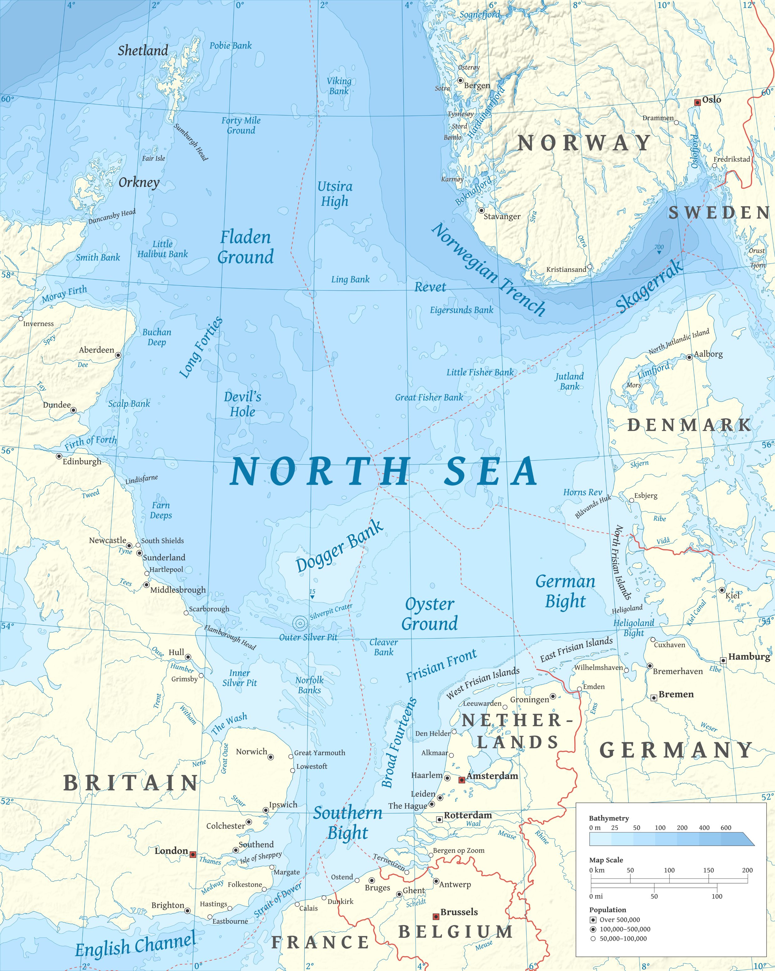
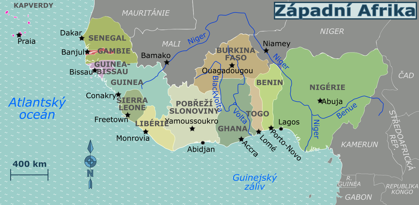
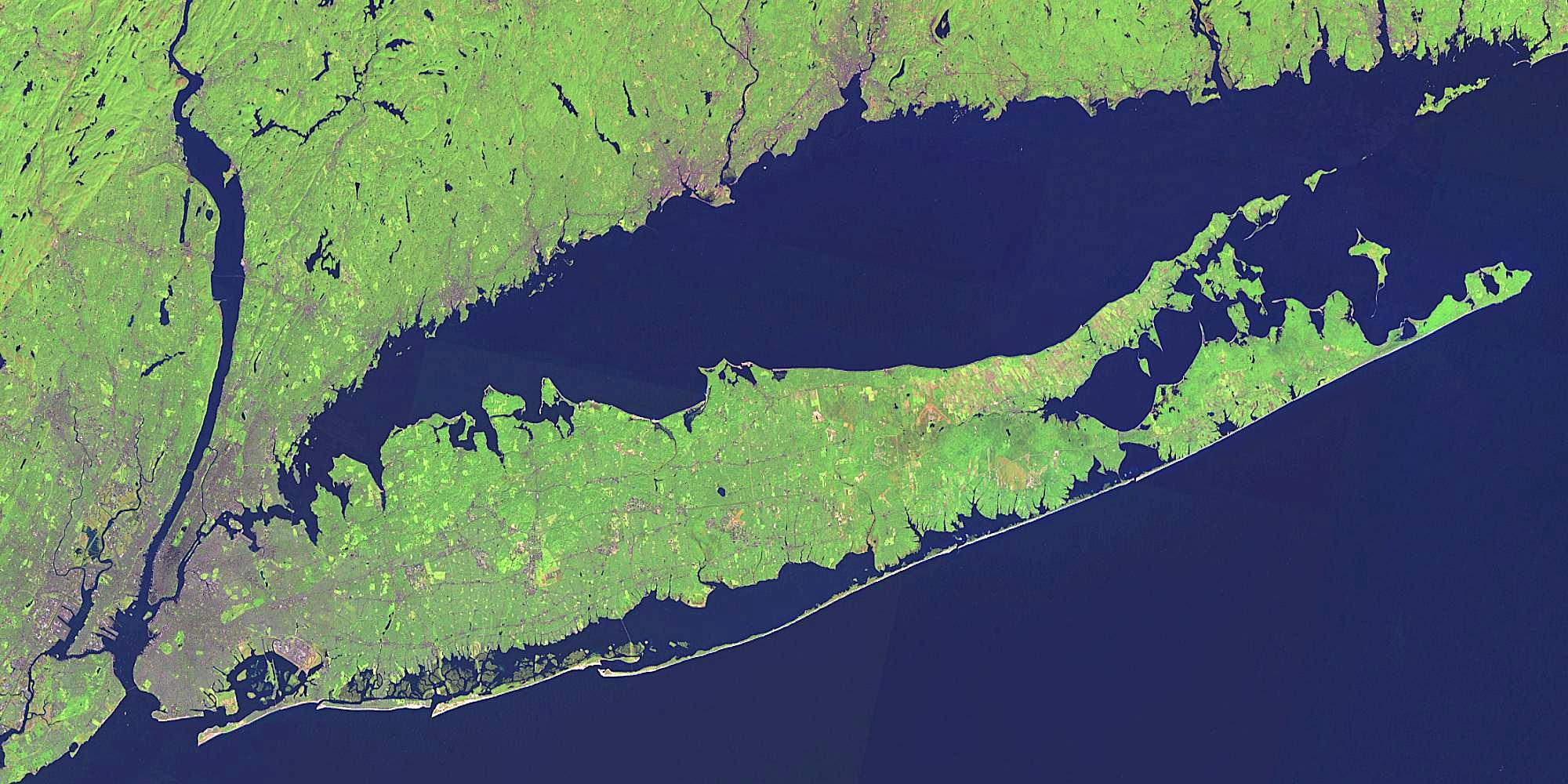
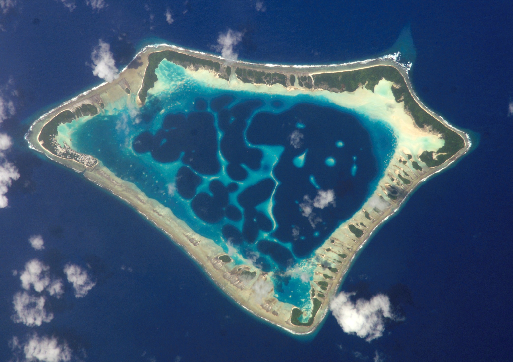
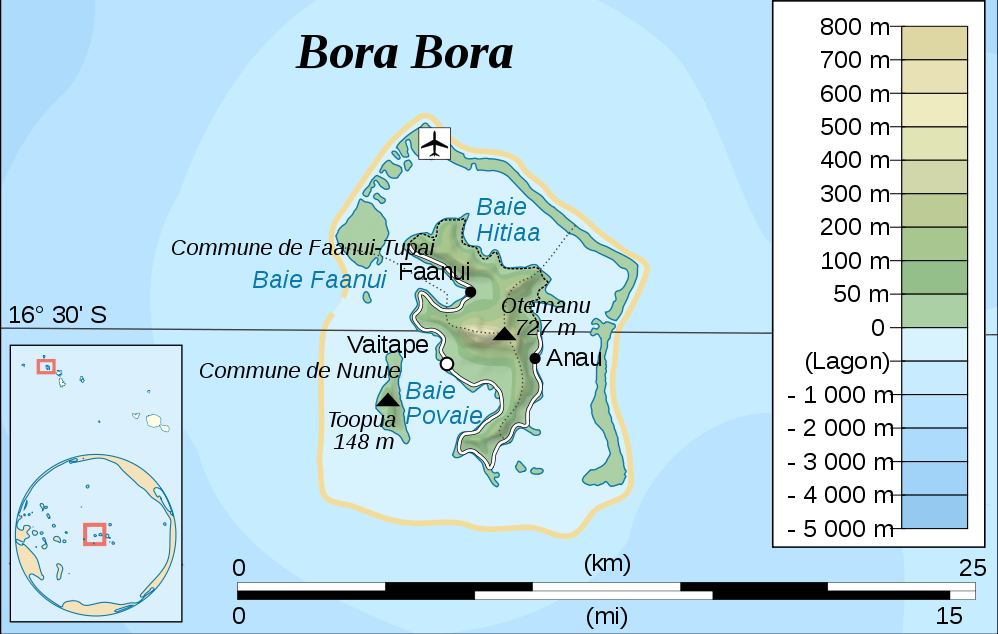
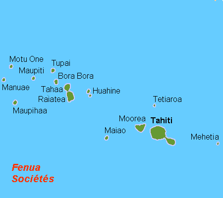
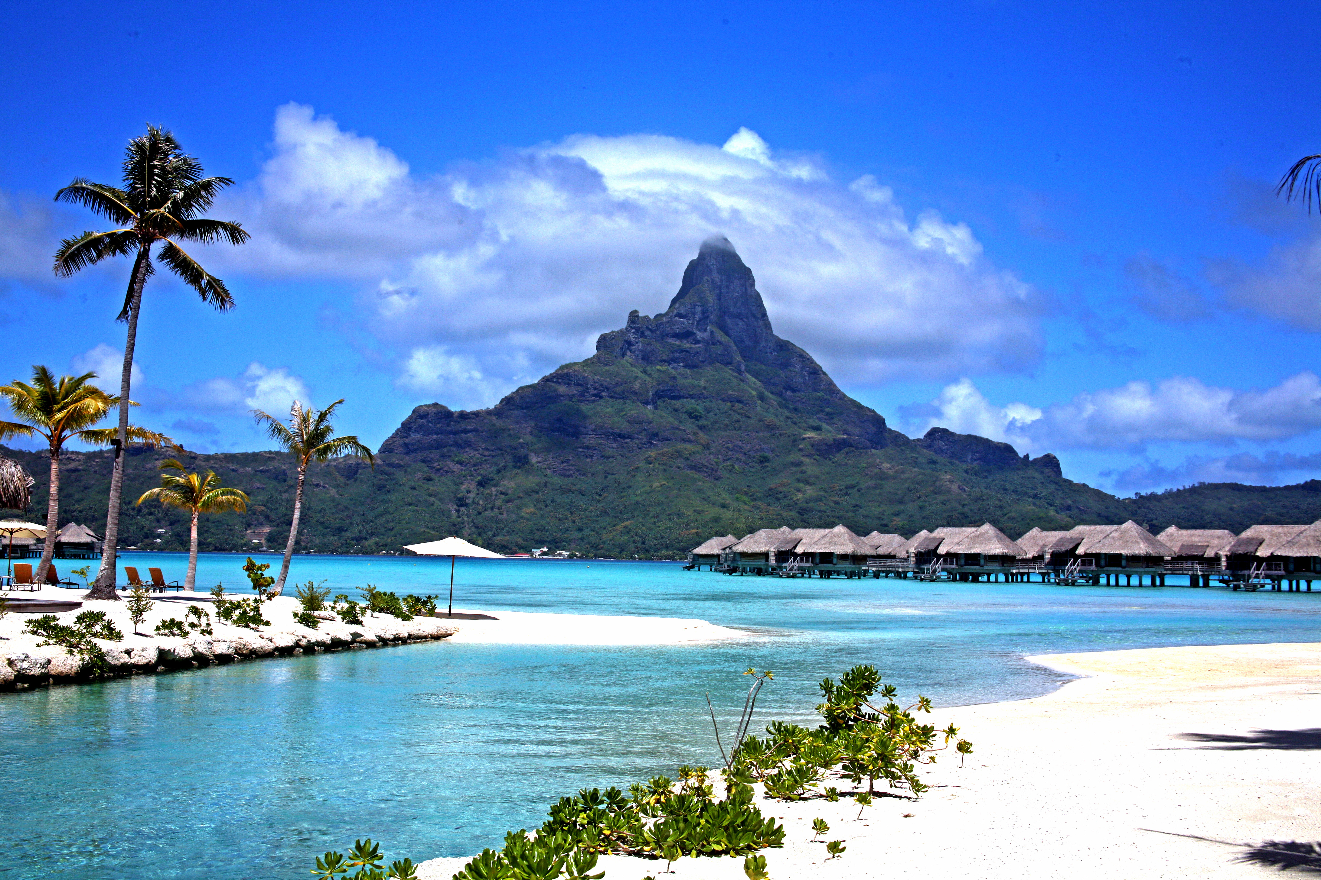
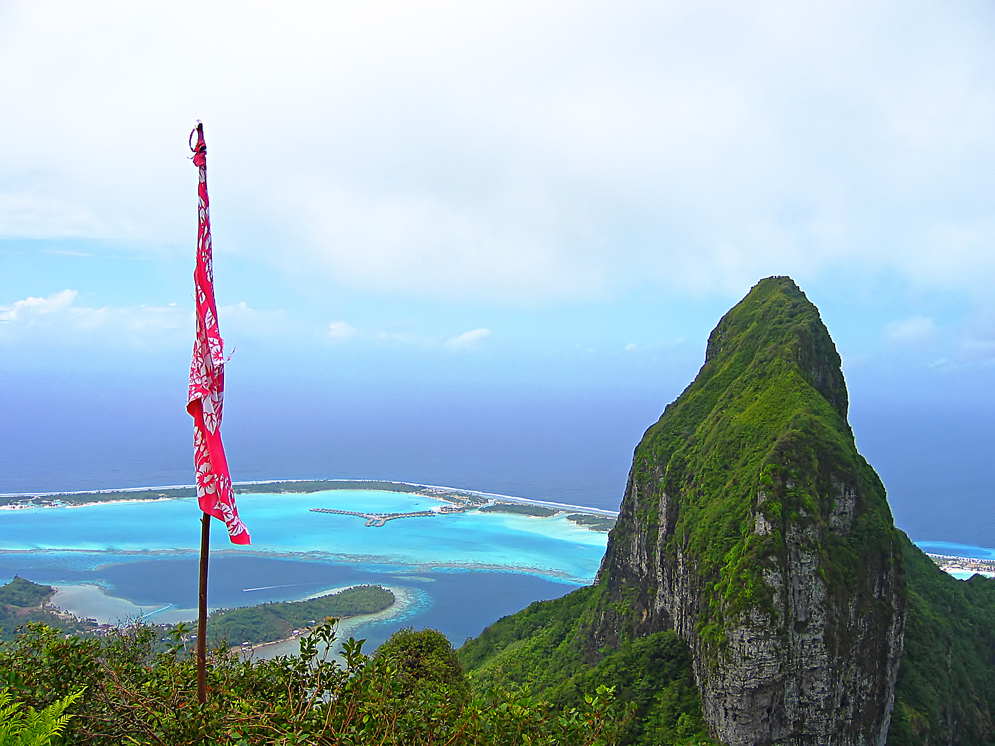
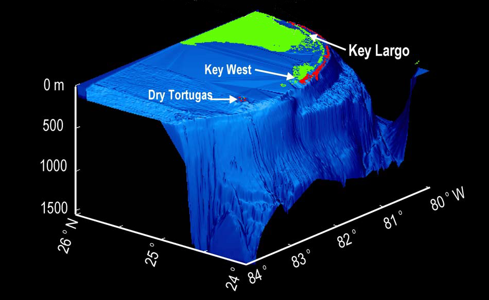
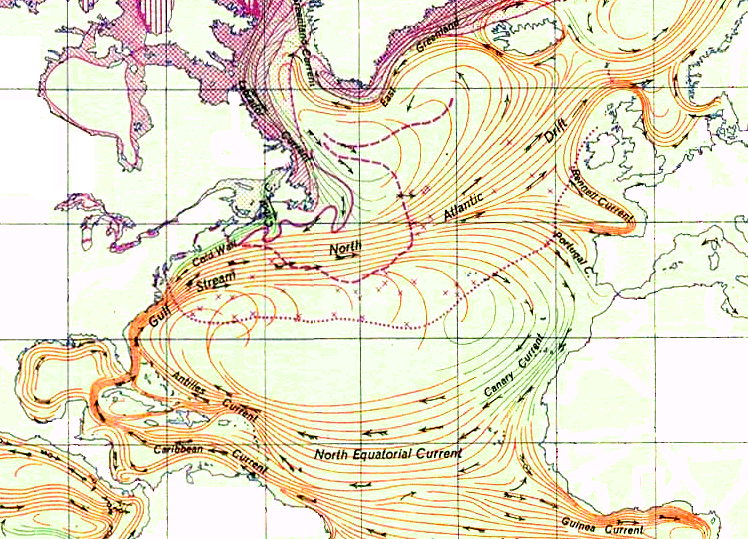
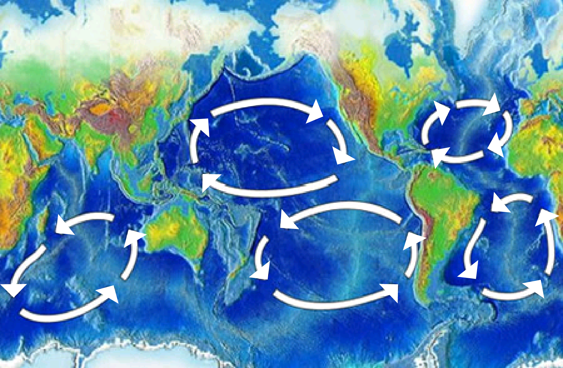
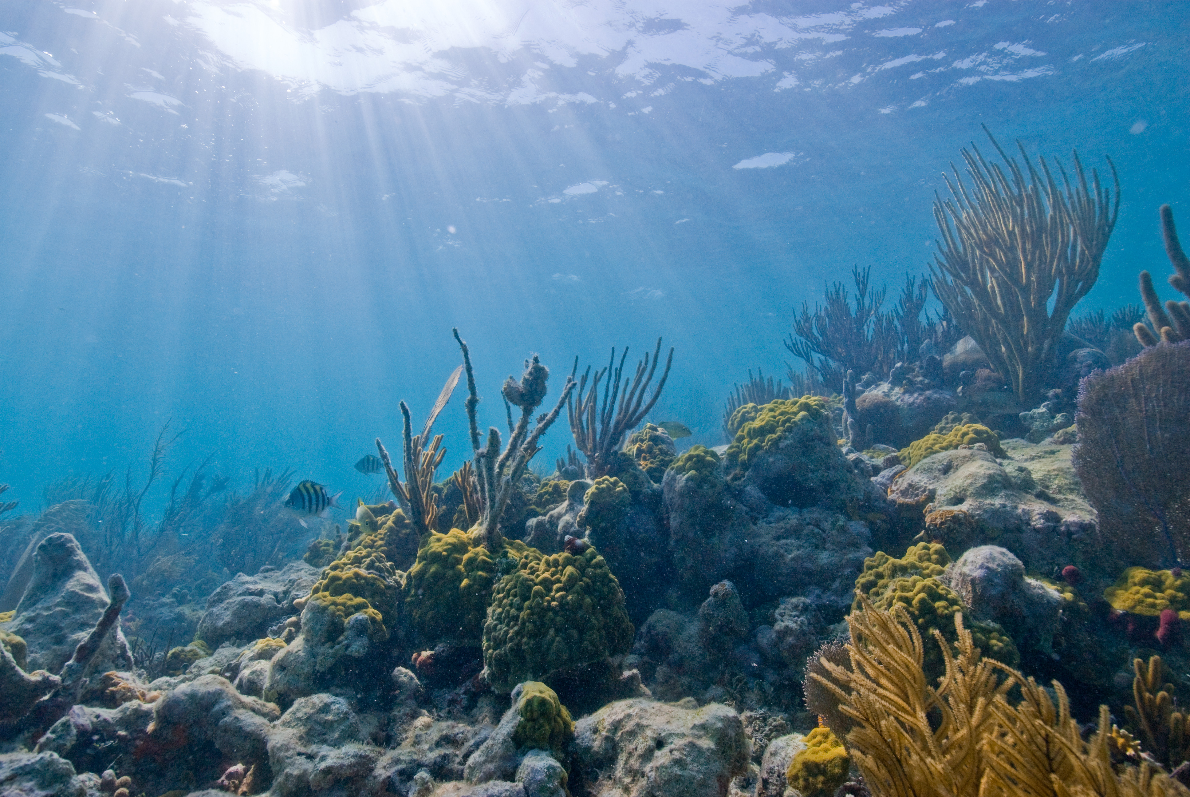
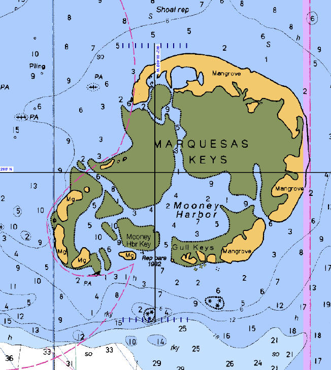
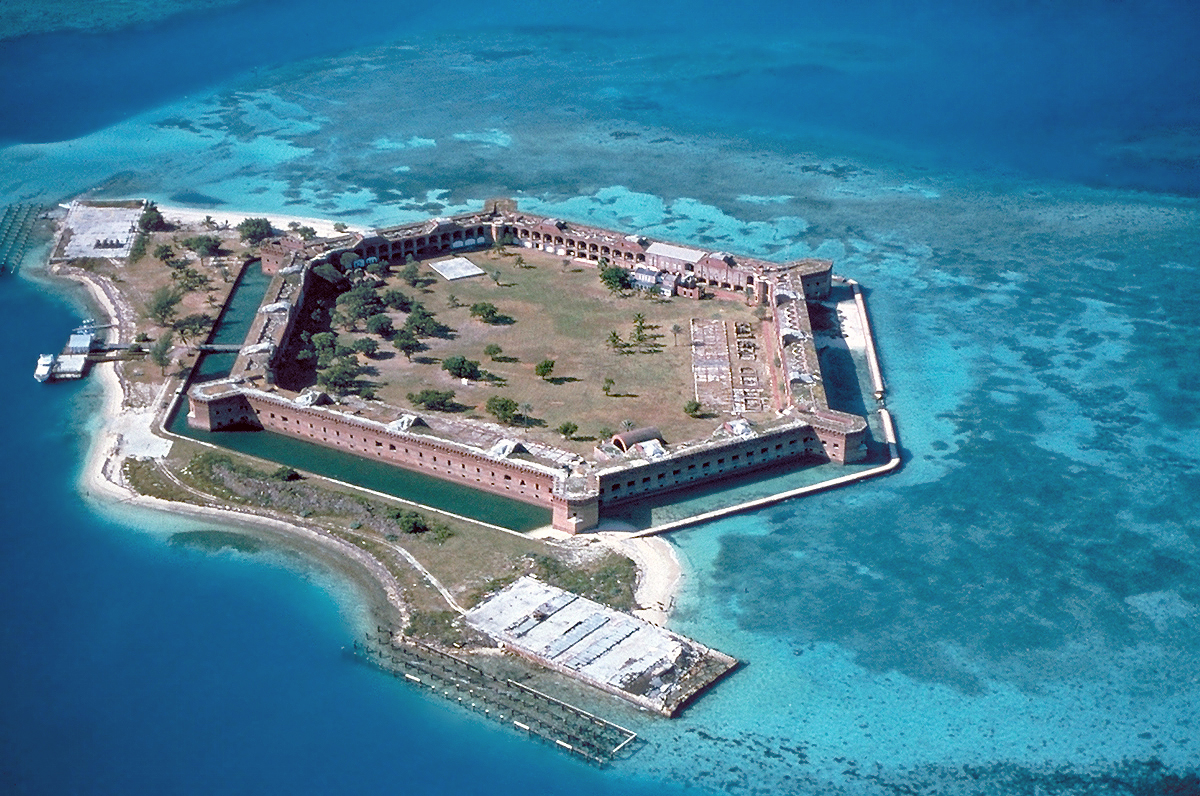
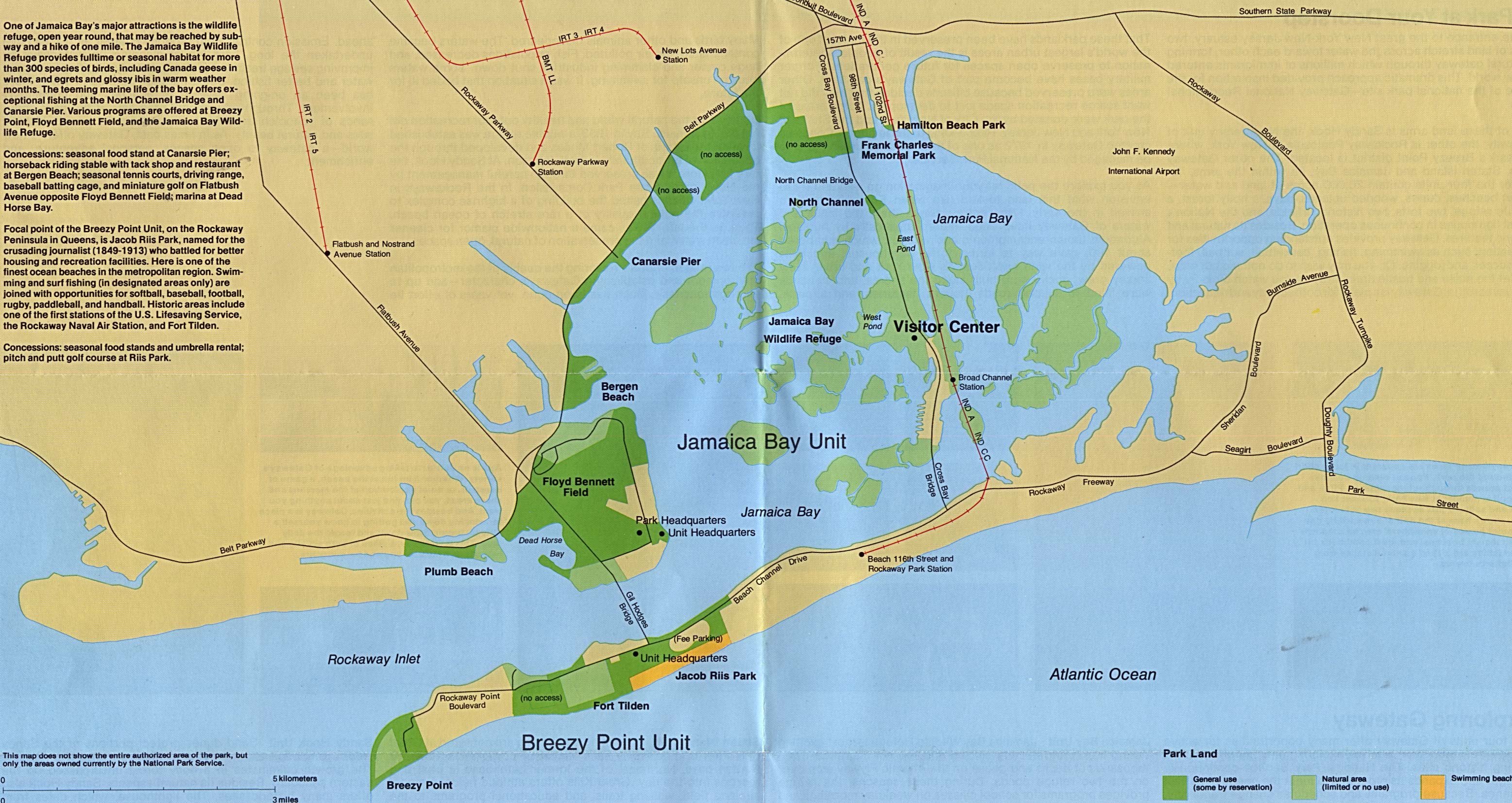
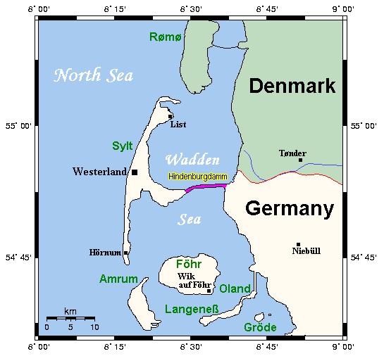
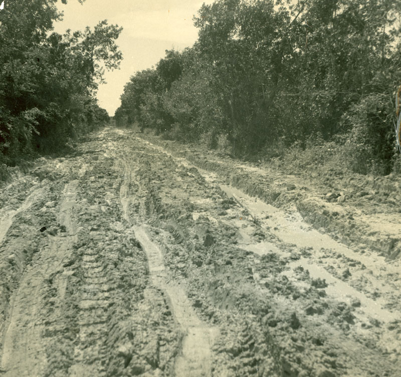