|
Reflections 2025
Series 2
January 26
Hamilton & Burr in Manhattan II: Hamilton's The Grange – Subways Exiting Hills
| | We explained in the last posting that we won't start our narrative with the Hamilton-Burr duel, but leave it to the end. From a travel and sightseeing point of view, our emphasis is now instead on locations, primarily in Manhattan. We dealt with Burr in southern Manhattan in the last posting, and here we have Hamilton in northern Manhattan.
I've mentioned already that I was not satisfied at all with Hamilton, the Musical, primarily because of its rap music, and we'll go into that more later, when I'll also point out a number of its positive elements. I can say now that the most positive thing about it is how it's changed history. Art usually follows life, but when life follows art, it's noteworthy. The musical has generated a huge amount of interest in Alexander Hamilton, and anything related to it. We saw how even the Morris-Jumel mansion received a surge in visitors, even tho it has nothing to do with Hamilton himself, but is where Burr found—and divorced--his second wife. Talk about replacing Hamilton on the $10 bill in favor of a woman has ceased since the musical. Hamilton's grave in Trinity churchyard has been spruced up considerably.
| | | | Alexander Hamilton On that basis, I want to start with an early quote from the musical by Lin-Manuel Miranda, a quote I knew about and was looking forward to hearing on my visit, but did not. I was wearing the complimentary infrared listening system given out by Broadway theaters, something I've been doing in recent years, but the rap music flew by me and I do not recall hearing this quote I expected. Or actually very much of the rap lyrics throughout. Despite already being acquainted with the subject matter, the rat-a-tat style caused me to miss much. | | | | | | If you're not familiar with the complimentary infrared listening system that picks up and amplifies the action on stage, its use is explained in this YouTube video, set to start at 0:26, the part on the infrared listening system. The part about audio ends at 1:51. |
| | | | Miranda, basing himself on Ron Chernow's 2004 biography, has Burr portray the first Secretary of the Treasury as follows:
How does a bastard, orphan, son of a whore and a
Scotsman, dropped in the middle of a forgotten
Spot in the Caribbean by providence, impoverished, in squalor
Grow up to be a hero and a scholar?
I can see rap as being cleverly done, tho I find the results juvenile, particularly the annoying rhythm. In any case, let's build on the above.
The "forgotten / Spot in the Caribbean" was what is today Saint Kitts and Nevis (Map by Burmesedays), the smallest sovereign state in the Western Hemisphere in both area and population, as well as the world's smallest sovereign federation. Hamilton was born in Charlestown, Nevis.
| | | | | | The first syllable of Nevis rhymes with "knee", not ne[ver]. The name developed from the Spanish name Nuestra Señora de las Nieves / Our Lady of the Snows via shortening and anglicizing the Spanish word Nieves (NYE.ves). In Spanish, Nevis is still known as Nieves, and Saint Kitts is San Cristóbal/Saint Christopher. This is explained by the fact that Kit used to be a popular nickname for Christopher, and that Saint Kitts is an unusual spelling for what logically should be spelled *Saint Kit's.
Consider the American frontiersman Kit Carson, whose first name was really Christopher. Kit is a male nickname, but very oddly, the diminutive, Kitty, is a female nickname and serves as a form of Katherine, as in the case of the actress Kitty Carlisle, whose first name was really Catherine. Language study never ceases to surprise.
|
| | | | As to the nasty reference "bastard, orphan, son of a whore and a / Scotsman", that's only partly true. Hamilton's mother was Rachel Levien, a half-British, half French Huguenot and his father was James A Hamilton, a Scotsman. They met on St Kitts, but moved to Nevis, her birthplace, where Hamilton and his older brother James Jr were born out of wedlock in Charlestown, the capital of Nevis. James Sr later abandoned his family. Both Rachel and Alexander contracted yellow fever, which killed her, leaving the boys motherless. | | | | | | Rachel Levien had divorced her first husband, John Michael Levine, in 1759 on the grounds of adultery and desertion, but according to the prevailing Danish law, she wasn't allowed to remarry. Thus she had no recourse but to cohabit with James Hamilton. This did not make her into a sex worker as Miranda implies, tho the two boys were necessarily illegitimate. While the boys became motherless, they were abandoned by their father, which still did not make them orphans. |
| | | | James Jr apprenticed with a local carpenter, while a wealthy Nevis merchant gave Alexander a home. Community leaders collected a fund to send Alexander to the North American colonies to continue his education. He first studied at the Elizabethtown Academy in Elizabeth NJ from 1772 to 1773 (Burr had also studied there, several years earlier.) He later moved to King's College in Manhattan. | | | | King's to Columbia Columbia was established in 1754 under the name King's College on the grounds of Trinity Church, as a colonial college by royal charter under George II of Great Britain. Hamilton entered King's College in 1773 and stayed until 1775, leaving to fight in the American Revolution. The war broke out in 1776, and was catastrophic for the operation of King's College, which suspended instruction for eight years beginning in 1776 with the arrival of the Continental Army. The suspension continued through the military occupation of NYC by British troops until their departure in 1783. He also studied to be a lawyer and was admitted to the New York Bar that year. In 1788, he was awarded a Master of Arts degree from his alma mater. It was during this post-war period that Hamilton served on the college's board of trustees, placing it on firm financial footing.
Until doing this research, I never realized—and suppose most people don't either—that the name "Columbia" was a sign of defiance right after the Revolution. Most US colleges dating from colonial times bear people's names--usually benefactors--such as Harvard, William & Mary, Yale, Washington & Lee, or reflect place names, such as Princeton and the U of Pennsylvania. Columbia was different. Superficially, the new name was a patriotic reference to Columbus, and it was also a poetic name for the US. But given the political feelings of the time, renaming King's College Columbia was tantamount to defiantly calling it "Not King George's College" any more. The revolution ended in 1783 and the name change took place when the college was reopened in 1784. Instrumental in the reopening and renaming were Alexander Hamilton and John Jay, both alumni. Since we're investigating here Manhattan locations, I want to expand on this academic thought.
Columbia University today is a private Ivy League research university in NYC. It's the oldest institution of higher education in New York State and the fifth-oldest in the US.
https://www.college.columbia.edu/sites/default/files/styles/timeline_tile/public/0134.kings-college-17-july-1754.jpg?itok=sZO39uVJ
I find it not totally clear just where on the grounds of Trinity Church King's College may have existed. The above etching was completed for the 200th anniversary of King's College, 1754-1954. It shows Samuel Johnson, the first president of King's College, leading the first students from the Trinity Church schoolhouse on the right, up to the front of the church. If Columbia feels this to be accurate, then King's College would have been on the north side of the church. If we review from the last posting this 1905 map, in 1754 the school might have been where the Trinity Building (in brown) was later built, but more likely, it could have been in the northern part of the churchyard in front of it.
But that location was only the first of four for the college, as we've hinted at earlier. This 1797 detailed map shows its first two locations. Click on the lower left to see where it had been on the Trinity Church grounds. But back before the war, in 1760, it moved to a parcel of land given it by Trinity Church on what is now Park Place, but that was called Robinson Street until 1813. Move up to the triangle then called the Common, now City Hall Park. Across it is Robinson street, with "The College" taking up two full blocks. This is now gone, and Robinson Street is now called Park Place, which goes right thru, uninterrupted.
In 1857, the college moved again to a primarily Gothic Revival campus between 49th & 50th Streets and Madison & Park Avenues, which is the block immediately southeast of St Patrick's Cathedral. It remained there for the next four decades, until 1897.
In 1896, the campus was moved to its current more spacious location in what was then the developing neighborhood of Morningside Heights and Columbia College was renamed Columbia University. The main entrance is at 116th Street and Broadway—a subway stop I know so well--while the campus runs from 110th to 125th Streets de facto between Riverside and Morningside Parks.
Back to Hamilton. He served as an officer in the Revolutionary War, where he saw military action against the British in the New York and New Jersey campaign, served for years as an aide to General George Washington, and helped secure American victory at the climactic Siege of Yorktown. He practiced law and founded the Bank of New York. In 1786, Hamilton led the effort to replace the Articles of Confederation with the Constitution of the United States, which he helped ratify by writing 51 of the 85 installments of The Federalist Papers. As a trusted member of President Washington's first cabinet, Hamilton served as the first US Secretary of the Treasury from 1789 to 1795.
| | | | The Hamilton Family Hamilton married Elizabeth Schuyler (say "Sky-ler"), known as Eliza, a socialite of eminent lineage. She was the second daughter of Philip Schuyler, who would later be a general in the Revolutionary War, and Catherine Van Rensselaer, from one of the wealthiest and most politically influential families in the Province of New York.
The Hamiltons had eight children: Philip, Angelica, Alexander Jr, James Alexander, John Church, William Stephen, Eliza, and Philip. We should mention four of them, the three eldest plus the youngest.
Philip, the eldest, was killed at 19 in a duel three years before his father was (more later). When Philip died, the whole family was devastated, but Angelica suffered the most. She had a mental breakdown and lived to age 72 in a state described as "eternal childhood", unable to care for herself. We heard in the last posting that Alexander Jr became a lawyer and was hired by Eliza Jumel to divorce Aaron Burr, the results of which Burr learned of on the day he died. Finally, the youngest, Philip, also called Little Phil by the family and formally Philip Hamilton (the Second), was named after his older brother, who died in 1801, a year before he was born. Obviously, the Hamiltons tried to emotionally "replace" their eldest by their youngest.
| | | | Ten-Dollar Bill US currency is known for its portraits of famous people, mostly presidents. There's George Washington on the $1 bill, Thomas Jefferson on the $2, Abraham Lincoln on the $5, Andrew Jackson on the $20, and Ulysses S Grant on the $50.
Non-presidents on currency are two Founders, Alexander Hamilton on the $10 and Benjamin Franklin on the $100.
The source of Hamilton's portrait on the $10 bill is John Trumbull's 1805 painting (click) that belongs to the portrait collection of New York City Hall. The painting dates from the year after his death in the duel, so apparently was painted from memory. The $10 bill is unique in that it is the only denomination in circulation in which the figure faces to the left.
A suggestion to remove Hamilton was controversial. Many believed that Hamilton, as the first Secretary of the Treasury, should remain on US Currency in some form, all the while thinking that US Currency was long overdue to feature a female historical figure. Names that had been raised included Eleanor Roosevelt, Harriet Tubman, and Susan B Anthony. This led to the Treasury Department first stating that Hamilton would remain on the bill in some way. But in 2016 they announced that Alexander Hamilton would remain on the $10 bill as is, due in part to his sudden popularity after the success of the 2015 Broadway musical Hamilton, a point I already alluded to.
| | | | Location Summary I've come across the following helpful indicator of Hamilton and Burr locations in and around Manhattan:
https://i.pinimg.com/originals/52/38/24/52382419699e4dd87afdf490b66456b3.jpg
Start at the bottom left. We find Burr in Staten Island; the school both attended in Elizabeth NJ; Trinity Church with Hamilton's gravesite; Burr's Richmond Hill; the Bayard House where Hamilton died; the Weehawken duel site. On the right is Wall Street with their separate law offices; Hamilton's town house at 52 Cedar Street (two blocks north of Wall, and parallel to it; more later); and, in northern Manhattan, Hamilton's Grange.
| | | | Northern Manhattan When I started this research about the duel, I had two concerns. Just where did it take place? I then stumbled across Weehawken. But how did Hamilton get there? I knew Burr was rowed round trip from Richmond Hill, and the dying Hamilton was brought back to Greenwich Village. But where did Hamilton live, and how did he arrive at Weehawken?
Then it struck me, and I realized how remiss I'd been. In 2008, most New Yorkers followed the great news of Hamilton's mansion finally being moved (for the second time!) to a suitable place from the inadequate location where it had been for many years. The news was in the papers for several days; I found it interesting, but had no urge to definitively visit the site. Still I wondered: did Hamilton cross the river from way uptown? How would he have gotten there at dawn? But I've since figured it out.
For his entire life, Hamilton had rented or leased his residences and offices. But in 1802, he decided to build himself a home. It was the only home he ever owned, and he lived in it for only two years, until the 1804 duel. He wrote: "I have purchased about thirty acres [12 ha] nine miles [14 km] from town, have built a house, planted a garden, and entered upon some other simple improvements." The petite mansion was the Grange, named after his grandfather's estate in Scotland.
I have a theory as to why he chose a site so distant from the City. The Hudson Valley has always been a location for mansions. Northern Manhattan isn't considered to be part of that valley, tho it really is. My guess is that he wanted the best of two worlds, a remote "valley" location, but still in Manhattan, with access to the City. But that's just a hunch.
Burr's Richmond Hill, just south of Greenwich, put him in the suburbs of that era, but still not far from his office on Wall Street. Hamilton's Grange put him way in the exurbs. How did he reach his Wall Street office?
https://c8.alamy.com/comp/2EJ6R7E/a-topographic-map-of-northern-manhattan-made-by-the-british-in-november-1776-2EJ6R7E.jpg
Click to inspect northern Manhattan in 1776 and its many hills. Toward the top, find Fort Washington, defended by George Washington as he was forced to abandon Manhattan. The neighborhood is still called Washington Heights, and today, the George Washington bridge crosses the Hudson at 178th Street. At the bottom, note Snake Hill, in Dutch, Slang Berg. It was name for the wooded promontory in Harlem (old spelling Haerlem) that is now part of Marcus Garvey Park on 5th Avenue, which today runs from 120th to 124th Streets. Now with those streets as approximate parameters, estimate the following.
A quarter of a century after this map, in 1802, the Grange would have been built a bit further north of Snake Hill, at the equivalent of 143rd Street, just west of the Albany Post Road (shown). The hilly area around it, sometimes called Harlem Heights, would come to be known—to this day--as Hamilton Heights. As a reminder, the oldest extant house in Manhattan, the Morris-Jumel Mansion from 1765, is further north still than the Grange, at about 163rd Street.
https://bostonraremaps.com/wp-content/uploads/2022/09/BRM4179-Kitchin-Map-of-New-York-Island-1778_lowres-scaled.jpg
On this 1778 map, south of Fort Washington, "Morris" is clearly noted, as is Snake Hill. Hamilton's Grange would have been built later at a point between them, tho closer to the Hudson side. Find the Albany Post Road (not named). Back in 1669, the provincial government of New York had designated a postal route between NYC and Albany, the colony's two most important settlements at the time. From here, follow it via Bloomingdale (today's Upper West Side—remember part of Broadway was once Bloomingdale Road) to the compact City at the south end, noting how the Post Road blends into the Bowery (Bowry Lane) right after the turnoff for P[eter] Stuyvesant's property from the previous century. To the left of the road, find the Mortier property that would become Burr's Richmond Hill. Above it, cross Minetta Creek (unnamed) into Greenwich, showing L[ady] Warren's property as well as that of Ol[iver] Delanc[e]y. Finally, trace the two unnamed roads leading to Greenwich, today's Greenwich Street on the Hudson and today's Greenwich Avenue leading to the former Monum[en]t. Just for fun, find the ferry between New York and Brookland (Brooklyn), with road connections beyond.
Burr commuted to his Wall Street office from his suburban location, but I was surprised to find that Hamilton was also a commuter to Wall Street from his very exurban location! It was a three-hour round trip from his estate, but he nevertheless traveled to his law office by stagecoach several times a week. As mentioned, the Grange was close to the Albany Post Road, which brought him directly to Lower Manhattan. However, he also had his second residence in Lower Manhattan on Cedar Street, and his wife maintained the Grange during his absences. Today, we hear of long-distance commutes via bus, train, subway, maybe streetcar, but I can't imagine commuting by stagecoach. Yet the route was quite direct. This also answers the question about the duel—he left for the duel from his Cedar Street house.
https://onemanz.com/wp-content/uploads/2016/05/manhattan-map.jpg
I cannot resist one last map from 1776, largely because of the colors (click). The City is in deep red, and you can imagine Hamilton catching a stagecoach to bring him home at the end of a busy day. Coming north, the Albany Post Road is in yellow as it runs into Bloomingdale. Today's Central Park is superimposed as the road crosses it to enter Harlem. Note the ridge that runs along the Hudson, which remains unnamed to this day. However, the Dutch called it Lange Bergh/Long Hill. Then note how it has a break at today's 125th Street. This period map is the only one I've found that shows that geographic break so well. Today, the #1 subway line leaves the ridge via a portal to cross this short valley, and the 125th Street station is elevated between portals. Right after, the subway re-enters the ridge via another portal to go underground again. Further north, it leaves it a final time—see below. None of this was however an issue for the Post Road as it enters what is today Hamilton Heights to reach the low 140s. At this early date, this map calls both Hamilton Heights and Washington Heights beyond by the generic term "Harlem Heights".
| | | | The Grange With his political career effectively winding down in the late 1790's, Alexander Hamilton shifted his focus and passions towards the building of a country estate in Harlem Heights. The Grange served as a refuge for Hamilton in the last two years of his life, and, due to some later maneuverings, continued to serve as the Hamilton family home after his death, so that his wife Elizabeth could continue to use the home for some 30 years beyond (story to follow).
In 1801, Hamilton commissioned John McComb Jr to design a Federal-style country home on his estate in upper Manhattan. Between 1790 and 1825, McComb was NYC's leading architect, who designed many landmarks, often in the Federal style. John Jay had spoken highly of his work to Hamilton. McComb designed, among others, the Montauk Point Lighthouse in 1796, Gracie Mansion in 1799, now the Mayor's residence, Hamilton's Grange in 1802, New York City Hall in 1803, and Castle Clinton in 1808, in Battery Park.
This is a photocopy of a drawing showing the house in its original site, before it was ever moved. The view looks south to the front and the east side. It shows the Grange had 2 ½ floors, the main floor being raised half-way over a basement to allow for an imposing formal entryway. It shows ample porches--they say Hamilton requested them, since the porches reminded him of the Caribbean (we saw the Bahamian porches in Key West architecture).
You should be aware of a major architectural feature of the Grange, which I call the Octagon. Much of the main floor, petite to begin with, was taken up by two very large rooms situated left-to-right, the dining room and the parlor, two octagons which could be joined together to form a delightful super-octagon shape. To achieve this, McComb added a three-sided bay window at either end of two long walls. The bay windows projected out into the side porches—check the drawing again to locate the bay inside the west porch.
https://www.nyclgbtsites.org/wp-content/uploads/2021/06/house-locations.jpeg
Hold on to this fabulous "three locations" sketch well into this posting, as it tells the whole story. Other than online, it appears today inside the restored Grange, and in its front garden, readable from the street. It shows two things, the original property with the modern streets superimposed over it, which will explain the fate of the house. The borders of the estate are shown in maroon, showing that in its two moves, the Grange never actually left Hamilton's estate. We see (click) that the original dwelling had been located on what later became the south side of 143rd Street. It was up high, and had uninterrupted views of both the Hudson and Harlem Rivers.
Note the markings that show that the land drops from this height to the east and south, where Hamilton's outbuildings were located, such as his barn. Because of this drop, when the streets were cut thru, a number of them did not even reach the new Hamilton Terrace (!) down the slope, to say nothing of reaching Saint Nicholas Avenue. Yet we see his estate reached to a piece of Kingsbridge Road, at the time, part of the Albany Post Road, so we see where he caught his stagecoach to work.
The west side of his estate bordered on what was then Bloomingdale Road, but that should not be misunderstood. While much of Bloomingdale Road, as we know, has been renamed Broadway uptown, this piece of it is now another street named after him, Hamilton Place. Today's Broadway is one block west of here.
So much for the original site. We'll talk about how it was saved by suffering two moves that together form a Z-shape around two corners, first to a terrible site almost "kissing" the side of a church on 141st, then finally being rescued to move around the church and move down the hill on 141st to the Hamilton Terrace level, at the northern end of Saint Nicholas Park underneath a steep cliff.
WIDOWHOOD I get the feeling that people today don't realize the financial difficulty that Hamilton's sudden death brought about. Hamilton died leaving behind his large family and much debt. I've come across two explanations about what happened next, one more sentimental and the other more financially realistic. I don't know which way it actually went. The truth is probably a blend of these two stories.
The more sentimental story is that a fund was secretly established to support his widow and children. Three weeks after Hamilton’s death, his Treasury Department associate and successor as second Secretary of the Treasury, Oliver Wolcott, wrote to James McHenry, a signer of the US Constitution, who the famous Fort McHenry in Baltimore is named after, to appeal for the latter’s participation in a secret subscription fund for the remaining Hamilton family. He wrote that "A number of Gentleman of Fortune should come forward & pay these debts & provide handsomely for the family." Chief among these debts were those involving the Grange, which had been completed just two years before. It was an expensive estate to maintain, and with a mortgage and very little income, it would have been impossible for Eliza and the children to stay in the house. However, some of the benefactors, in a dual transaction, purchased the Grange for $40,000—equal to over $1 million today--but sold it back to Eliza for $20,000, meaning it only cost the benefactors half the purchase price, the rest becoming a de facto endowment, ensuring that the family would live in the home for decades to come.
The more financially blatant story is that, on Hamilton's death in 1804, the Grange was sold at public auction to cover Hamilton's debts. However, Eliza was later able to repurchase it from the executors, who decided that she and her children should not be publicly dispossessed of their home, and purchased it themselves to sell back to her at half-price.
In any case, almost three decades later, in November 1833, Eliza, at the age of 76, resold the Grange for $25,000 (over $789,000 today), funding the purchase of a two-year-old New York City townhouse, today known as the Hamilton-Holly House, where she lived for nine years with two of her grown children, Alexander Hamilton Jr (who had done the Burr divorce) and her youngest daughter, Eliza Hamilton Holly, and their spouses. In 1836, Eliza was also able to collect from Congress Hamilton's pension from his service in the Continental Army. In 1848, after the nine years, she departed NYC for Washington DC, where she lived with her widowed daughter Eliza until her own death in 1854 at age 97, outliving her husband by an even 50 years. She was buried near her husband in Trinity Church in Manhattan.
| | | | | | This house was news to me, and required more research. I find that the Hamilton-Holly House is a Federal style (as is the Grange) townhouse at 4 Saint Mark's Place (= East 8th Street in this area) between 3rd and 2nd Avenues in Manhattan's East Village. It is one of only three remaining such townhouses built in 1831 on both sides of the street by a developer, Thomas Davis. In 1833, in another double transaction, Alexander Jr purchased the townhouse from Davis for $15,500 just as Davis was purchasing the Grange from 76-year-old Eliza for $25,000. Thus it was the sale of the Grange that funded the family's move into the City. The Hamilton-Holly House was designated a landmark in 2004 by the NYC Landmarks Preservation Commission.
This is the house as it appeared in the 19C, and in 2010 (Photo by Beyond My Ken). In the 1870s and 1880s, the building became a rental meeting hall with the two upper stories apartments. Later the street level and basement was rented by commercial tenants, including the Tempo Playhouse, which staged the American premieres of experimental works by Jean Genet and Eugène Ionesco. In 2016, the vacated building was purchased by an investment group. Portions of a renovation plan were approved by the Landmarks Preservation Commission, including approval for restoration of the façade, reconstruction of the grand curved balcony at the first floor, a new entryway, and rebuilding the interior space to provide additional residential units.
|
| | | | Back to the Grange and our "three locations" map. I do not have any record of who owned it in the half-century plus from Eliza's sale in 1833 to 1889, when it was first moved from its original site to alongside the church, but I've read that it was various families, as the Harlem neighborhood rapidly grew. But by 1889, two amazing events altered the history of the house. To help us understand it, we have to add, to our "three locations" map, the below older map showing just two locations:
https://myinwood.net/wp-content/uploads/2017/02/Bolton-map-with-Grange.jpg
Once again, it's sideways, with north on the right—so tilt your head. Let's see what it adds to what we know. It confirms that Bloomingdale Road, most of which became nearby Broadway, in this area became Hamilton Place. We see more clearly the nearby route of the Albany Post Road, leading to its southernmost last stop at Cortlandt Street, just steps away from both Hamilton's city residence and law office. (St Nicholas Avenue came later.) We again see the original site of the Grange on what became 143rd Street, with the barn and other outbuildings. We also see 13 sweet gum trees that had been planted to represent the 13 original states. We have St Luke's Church on 142nd, where later the so-called "Hamilton House" was tucked in by its side.
What is now St Nicholas Avenue bordered some property belonging to a Johannes Myer, with a Meyer's Inn. This plot is just the shape of St Nicholas Park, which would become the third home of the Grange, right along 141st Street. But look at the cliff above the park, which is noted as having had a 1776 breastwork, a reference to the Revolutionary War. We know that Washington's troops came thru this area on their way to Washington Heights. (I find that a breastwork is a temporary earthwork fortification at chest [=breast] height to protect defenders standing behind it firing.) Thus we see the height of CCNY, especially that imposing curved building, Shepard Hall, above the new site of the Grange.
Now for the first amazing event. This second map is very informative. It's the only one that shows accurately the problem that almost doomed the Grange in its original site. Take a close look. In the late 19C, the numbered street grid had finally reached uptown, and numbered streets were being added to Hamilton Heights. By chance, the planned route for 143rd Street failed to avoid the Grange, which lay at an angle to the grid. Actually, most of the house by chance happened to be set back far enough—it was only the northwest corner that would have impinged on the street. If this map is accurate, it's possible in might have only impinged on the planned sidewalk. Nevertheless, the City decided that the house had to go, to be torn down, since apparently the City was prouder of its developing street plan than getting involved in historic preservation.
| | | | | | Such idiocy was not limited to 1889. The magnificent Pennsylvania Station was demolished over three years, 1963 to 1966. After that, landmarking of historic sites became common. Look at the irony: back in the day, the City wanted to tear down the original Hamilton Grange, while today, the City has landmarked even the Hamilton-Holly House! |
| | | | Movement Northward As I've studied world urbanism, one thing has become clear. As cities grow, institutions move out for various reasons. Paris is illustrative. Since the 11C, the central market known as Les Halles (lé AL) existed on the Left Bank, but as of 1973, it was removed to Rungis in the south of Paris and the former area was redeveloped. Also, the University of Paris, known as the Sorbonne, has existed since 1253 in the center of Paris, but since 1973, it's been divided into 13 universities, most with its own specialty, managed by a common rectorate. They're numbered 1 to 13, with some of them retaining the name Sorbonne, and others rejecting it. Some facilities are located in the historic building, but others are spread around Paris and its suburbs. Perhaps one of the better known ones has the official title "University of Paris 10, Paris-Nanterre" to the northwest of Paris, often just called Nanterre. But some of these have merged back with each other, and more mergers are planned.
In Manhattan, it's similar, except for the direction. All expansions in Manhattan have been northward, sometimes abandoning the original site (like Les Halles) and sometimes maintaining it (like the Sorbonne). We've already had the example of Columbia University, which has had four (!) locations, Trinity Church, Park Place, Midtown, and it's current Uptown location. The three earlier locations have left no trace of a school.
On the other hand, we recognize St Patrick's Cathedral to be in Midtown on Fifth Avenue and 50th. But not everyone knows about St Patrick's Old Cathedral, familiarly Old St Pat's, on Mulberry, Mott, and Prince Streets in what used to be Little Italy. It dates from 1815, and when the Cathedral moved uptown in 1879, it became a parish church.
One more: What is now called Manhattanville University started, in 1841 on Houston and Mulberry Streets as a Catholic girls' school called the Academy of the Sacred Heart. In 1844, it moved to the Ravenswood section of Astoria, Queens. However, within two years, that location across the East River proved to be too remote, proving that in Manhattan, movement is to the north, not east to Queens. So in 1847, it moved again to a large estate in the rural village of Manhattanville in Manhattan's Harlem Heights. In 1917 it became the College of the Sacred Heart, and in 1937, the Manhattanville College of the Sacred Heart, whence the current reference to a location. It was situated in the Heights between 130th & 135th Streets, and when it moved on, its former campus was incorporated as the South Campus of CCNY, which today goes from 130th up to 141st Street and the Grange! Small world. And here's one more: City College (of the City University of New York) started out in 1849 on Lexington & 23rd, and moved uptown in 1906, as another example of uptown moves!
| | | | | | I know there was also a Convent of the Sacred Heart on 133rd Street and Convent Avenue (hence that street name), which burned to the ground on 13 August 1888.
https://1.bp.blogspot.com/-znetFSoe-SE/YG4g0VVIoAI/AAAAAAABfWE/Dh-jmebgzM0Iedt36L7If2tJfUdfGVz5ACLcBGAsYHQ/s1600/cb9m-detail.jpg
More precisely, the Convent grounds apparently ran from 126th to 135th, between Amsterdam and St Nicholas (blue line--see above map), with Convent Avenue running up the middle and to the north, into the 140s and beyond. This seems to be the same as the location of the Academy/College of the Sacred Heart, yet I find no connection with the Convent. Still, there logically must have been one.
I only mention this because, if you consult our "three locations" map again, you'll find that Convent Avenue to this day runs between all three locations of the Grange. The world gets smaller still.
|
| | | | The college stayed in Manhattanville until 1952, and when it left, it not only left Manhattan (despite its name), it kept going north, past the Bronx, and into Westchester County, ending up in Purchase NY, roughly across the street from where Beverly and I built our house in the early 1970s. In 1966, the last four words of the name were removed, shortening it to Manhattanville College, and indicating its total secularization. In 1971 it went coed. To my surprise, just in 2024 it became Manhattanville University. Despite the frequent name changes, moving from Houston Street to Purchase is a startling example of local movement northward. | | | | Saint Luke's Episcopal Church Maybe I surprise easily, but more to the point, we saw on the map that a church was involved in the first move, so let's look into that. Then I was amazed to find it was a church I already knew something about.
This is the Church of St Luke in the Fields, an Episcopal church located on Hudson Street between Christopher and Barrow Streets in Greenwich Village (Photo by Beyond My Ken). It was founded in 1820 on farmland donated by Trinity Church (who else?), to accommodate the expansion of NYC northward into Greenwich, which at the time was a sanctuary for people fleeing the endemic diseases of the city proper. Today, every time I take my M20 bus northbound on Hudson Street, I pass this on my left.
The name of the new parish, St Luke in the Fields, was chosen to evoke the pastoral quality of the area. My guess is that the name was also influenced by London's St Martin-in-the-Fields on Trafalgar Square, built a century earlier, and also Church of England (= Episcopal).
But seven decades later, when the surrounding neighborhood became predominantly poor and largely composed of immigrants, the elitist congregation decided in 1887 to move north to Harlem Heights, to a site on 141st Street and Convent Avenue where it was about to build a new church. The congregation elected to move "far enough north to be sure of peace for at least a good long term of years." Thus they were assuring themselves that that new neighborhood would never change [wink, wink]. The original St Luke's became a chapel of Trinity Church for almost a century, only regaining its independence in 1976.
The new stone church uptown was only planned and not yet built, yet the congregation was eager to move north, so they needed a temporary location there to hold services. A banker, Amos Cutting, in 1889 purchased the doomed Grange that was under threat of demolition and gifted it to the congregation, at which point they moved the Grange to its second location next to where the new stone church was planned. I understand this was done with horses, and I assume, rolled on logs as had been done years earlier with Burr's house.
We said the first amazing event dealing with the initial move of the Grange was the City's callous decision to condemn it as an obstruction to laying out 143rd Street. If by any chance you might think that the motives of Amos Cutting and St Luke's were preservationist in nature, think again. Their motives were strictly utilitarian. The church wanted a meeting space, and this old building filled that need. So the story gets worse. John McComb’s elegant side porches, and the cornice and roof balustrade were stripped off. The broad entrance steps were removed and the imposing entranceway was boarded shut. The building was now more of a petite cube in shape, except for the two bay windows on the sides, no longer protected by porches.
Remember that the building has 2 ½ stories, because of the raised basement, something like brownstones in NYC that have an iconic stoop, with an entrance to that lower level under it. The basement level could not be moved, meaning the Grange has had three different basement levels in its three locations. Thus the original basement was lost, and a new one built in the second site.
Could things have gotten worse still? Of course, when you're discussing people not interested in historic preservation. Once the disrespected building got to its new location, it was moved into the lot sideways, with its west side now facing the street, the side with the dining room bay window. A new entryway was cut into this end of the building, I believe into Hamilton's study, leading into the now closed-off entry hall, and then into the octagon. Thus there was no thought whatsoever to maintain the Hamilton history or even the integrity of McComb's architectural design. A sign above the new entrance read Saint Luke's Chapel.
I always wondered why pictures (to follow) showed the Grange standing so very close to the church, but now I learn that the Grange was brought to the church property first, in 1889. The first church service of St Luke's in Harlem was on 18 December 1892 inside Hamilton's Grange. Construction on the new church started that year and wasn't completed until 1895. Upon completion, it came unusually close to the Grange, which would indicate bad planning or bad measuring, probably both. A few decades later a six-story apartment building rose on the north side, also rather close, cramping Hamilton’s house in between.
https://www.boweryboyshistory.com/wp-content/uploads/2016/08/hamilton_grange_1897_MCNY_20Collection.0.jpg
https://www.boweryboyshistory.com/wp-content/uploads/2016/08/MNY80047.jpg
Both these links are from the same source. You can see that the first one is dated 1897, two years after completion of the church building. The west side of the Grange faces the street with a new entryway at the near corner. Its north side, identified by the pair of chimneys facing north, shows no trace of the original entryway, and faces an empty lot, where the apartment building would later be built. You see the second basement level. The roof still shows the cornice and roof balustrade.
The second link is also period, but newer, and the cornice and roof balustrade are now gone! So is the balustrade on the entryway. I cannot explain that they were removed at a later date. It's obvious that the church was built much too close to the Grange, both behind it and even the protruding loggia in front of it! This loggia is what made the second move in 2008 so much more difficult. The apartment building is also very close, but not quite as bad.
The once-elegant residence which had sat among 32 acres (13 ha) of lawns and gardens was unrecognizable in its claustrophobic setting. Even after the congregation finally moved into the church proper, it continued to used it as a chapel, rectory, and schoolhouse until 1924.
That was the year that common sense started to prevail, since the American Scenic and Historic Preservation Society purchased the house and, nearly a decade after that, in 1933, opened it as a museum. Since the house in no way was restored, surely due to lack of funds, I assume the museum must have been minimal, with just exhibits on Hamilton and his history.
https://americansystemnow.com/wp-content/uploads/2020/01/Hamilton-at-church-near-Grange-1024x768.jpg
Then in 1936, the Crescent Athletic-Hamilton Club in Brooklyn Heights presented the Grange with the above 30-foot (9 m) bronze statue of Hamilton, which had stood before the club since 1892.
Finally, we have a 21C view of the Grange in color. Click to see the statue and again to see how incredibly cramped the building was. The statue is still there, even after the house was moved the second time.
That was the status quo for the early 20C. It then became a NYC designated landmark, a US national memorial, and is listed on the National Register of Historic Places. After being landmarked, in 1962 the Grange was acquired by the National Park Service (NPS) to be operated by them. Congress required the NPS to relocate the house to a more suitable location and restore it to its original appearance, but it was 46 years, almost another half-century, before that happened in 2008.
| | | | Three Saves via Degradation Historical monuments are lost all the time (Penn Station again among many others), but how some are saved is an exercise first in consternation, but then followed by joy. I have personally witnessed three examples.
1) TAMPA STREETCAR SOCIETY In the early 1990s, Beverly and I lived full time in our Tampa condo after selling the house we'd built in Purchase, but before buying our present condo in Lower Manhattan. We joined two historical museums, and also the Tampa & Ybor City Street Railway Society. Tampa had had an extensive streetcar system until 1946, when it was replaced by buses. The Society worked to restore the present line between the Ybor City neighborhood and Downtown.
However, the Society wanted a heritage "Birney" car to run on the line. When the original lines were closed down, some of the streetcars were sold to South America, some were repurposed for various uses, and the rest were stacked in a field and burned! However, members found the hulk of one streetcar in 1991 in a backyard in the Sulphur Springs neighborhood. It had been stripped down and first used as a vacation cottage, then it became a tool shed in the garden. It was donated by the owner, and I remember going to regular meetings in the car barn to watch the progress made as volunteer members completely restored Birney #163, built in 1923. Some of the woods used in the restoration are ash on the roof, oak flooring, cherry seats, and mahogany wall panels, window frames, and doors. It took over 10,000 volunteer hours and about a decade to put #163 back on the tracks. On a later visit to Tampa, we rode not only on the line, but also on the heritage Birney #163, shown here running westbound on 8th Avenue in Ybor City (Photo by Azalia Negron). Even better, this is its restored interior (Photo by Peter K Burian).
It was only because of its period of degradation that this historic artifact survives today.
2) ROSA PARKS BUS Rosa Parks is not only nationally known, but internationally. On my last visit to Paris, I stopped at the RER suburban rail station Gare Rosa Parks, served by the Rosa Parks tram stop. It's fitting that transportation facilities be named after her.
On 1 December 1955, African-American seamstress Rosa Parks was arrested for failing to give up her seat on a Montgomery city bus to a White man, breaking existing segregation laws. On buses, Whites sat up front, Blacks in the back. Blacks had to pay their fare up front, then exit the bus and reenter in the back, so as not to pass by Whites. It was not unknown for a bus to sometimes pull away before they could reenter.
If no seats were available for boarding Whites, the law required for Blacks to surrender their seats to them, a rule that was called "flexible seating". Three others had moved, but she didn't. At that point, the driver, who had a gun, came to enforce the law, but she still didn't move. This act started the Montgomery Bus Boycott, and many believe this act also sparked the Civil Rights movement.
Over time, city buses were, as usual, retired and replaced. Well after the fact, there was interest in preserving the "Rosa Parks bus". But how do you find it? Did it still exist? The bus identification number was not recorded in any official documents when she was arrested. As it turns out, when bus #2857 was retired some two decades after the event in the early 1970s, a Montgomery man bought it. He stripped it down (as in Tampa) and set it up in his field to store lumber in. He'd been told it was the Rosa Parks bus, but had no proof.
Finally, in 2001, when the bus was to be auctioned off by an internet auction house, documentation was found. The Montgomery bus station manager had maintained a scrapbook of newspaper articles during the 1955–56 Montgomery bus boycott. Next to articles describing the arrest of Rosa Parks, he wrote "#2857" and "Blake/#2857." James Blake was the bus driver who had had Rosa Parks arrested.
Bidding started at $50,000, and the Ford Museum in Dearborn MI kept on bidding until it won, at $492,000, even outbidding the Smithsonian. At the same time, the Ford also bought the scrapbook and a Montgomery City Bus Lines driver's uniform. The restoration of the bus took five months and cost over $300,000, using original material and parts from identical 1948 GM buses. It was finally exhibited in 2003.
This is the restored Rosa Parks Bus, indoors, in the center of the Ford Museum, whose historic collection is similar to that of the Smithsonian (Photo by Maksim). When I visited it, near the bus, "We Shall Overcome" was playing softly in the background. I found you enter the bus, sit down, and a guide tells the story. He said at the time, Parks sat on the right, in the second row, which happened to be just where I was sitting.
This is a well-known picture of Parks in the bus, but I feel it's often misunderstood. It in no way shows the actual event, as some may assume. It's a totally staged photo, tho valid, of Parks on a Montgomery bus just over a year later, on 21 December 1956, the day Montgomery's public transportation system was legally integrated. Behind Parks is a White reporter covering the event. The point of the picture is that a Black person was legally sitting in front of a White person for the first time on a Montgomery bus. There's one more picture of interest. This is President Obama in the museum sitting in the bus. He's sitting in the same row as she had been, but she was on the opposite side.
It was only because of its period of degradation that this historic artifact survives today.
3) THE GRANGE The comeback of the Grange as of its second move in 2008 is the third instance of the sort I've experienced, so we know where this narrative is heading. All three artifacts were saved only by being severely disrespected.
| | | | Moving the Grange Once the NPS had government financing to move ahead, it hired a house moving company from Pennsylvania do to the job. That it was from Pennsylvania is significant. The Wolfe House & Building Movers, in business since 1970, is located outside of Bernville PA (Bannwill in Pennsylvania Dutch [German]), a town founded in 1737 by a man from Bern, Switzerland, hence its name. Nearby was the Northkill Amish Settlement of 1740, the first Amish community in America, later the largest, but which has since declined.
http://www.pavisnet.com/pa-dutch-country/padutchcountrymap.jpg
These places are all in Berks County, in the Pennsylvania Dutch Country (above). During the Grange move, onlookers often asked if the movers were Amish or Mennonites since they often wore the flat straw hats, plain clothes and facial hair most Americans associate with those groups. However, the Wolfe movers are neither; they belong to a related sect known as the German Baptist Brethren. The German Brethren are an offshoot of the Amish, one of many religious sects known for their vigorous work ethic. On moving day, their families were there to cheer them on, the wives in the traditional long dresses and white bonnets, the kids dressed accordingly.
They were selected to move the Grange because their technique enabled them to relocate the house without having to cut it into two pieces in order to get it past the projecting stone loggia of the church. But still, this move had two parts, a vertical one first, followed by a horizontal one thru the streets. After being separated from its (second) basement, the vertical move (pictures to follow) involved lifting the house 38 ft (11.6 m) in order to roll it forward on elevated tracks for 50 ft (15 m) over the loggia and out to the street, then lowering it again into the street.
The work started in early May 2008. First, internal bracing and a mile (1.6 km) of chain were used to support the house and keep it from being stressed. This drawing shows where hydraulic jacks were placed under the house to raise it, a process that took two weeks to accomplish.
https://www.wolfehousebuildingmovers.com/wp-content/uploads/2016/02/Hamilton-Grange-4-1024x768.jpg
This excellent picture taken by the movers themselves before the house was raised shows several things: the removal of the (not original) basement first; how close to the apartment building on the left the house was when moved; just how far the church loggia jutted out in front of it; the location of the Hamilton statue; the location of the doorway during these years, which would have led into Hamilton's study, then the "front" foyer, before accessing the octagon, three sides of which are obvious in the bay window of the dining room.
https://www.wolfehousebuildingmovers.com/wp-content/uploads/2016/04/Hamilton-Grange-Manhattan-NY-61-1024x582.jpg
https://www.nps.gov/articles/000/images/GrangeHighup.jpg?maxwidth=650&autorotate=false
These two views show the elevated track structure built over the loggia and Convent Avenue. Remember, the twin chimneys were above the original front of the house, meaning we now see the back, with the west side leading the move, from the site out onto the street.
https://www.nps.gov/articles/000/images/MovingGrange.jpg?maxwidth=650&autorotate=false
This is the house being lowered onto a flatbed dolly in the street. Nine computerized and remote-controlled dollies were used to move the Grange, and heavy forklifts were used to provide braking power. In this view, one worker neglected to use his hard hat and stayed with his Amish-style hat.
Here's the Grange on wheels! I studied this picture until I finally realized we're turning at the intersection of Convent Avenue and 141st Street (click to read the green street sign). We're on 141st, looking west. The apartment building seen is on the southwest corner. Not seen is the church to our right on the northeast corner. The Grange is moving south on Convent and entering 141st Street, to its new home behind us. Note the wedges at curbside to even out the sidewalk and street. Of the $8.4 million earmarked for the restoration of the Grange, the move itself accounted for approximately 40%.
As it turns out, the horizontal street move was not that horizontal. Convent Avenue is level here, but from the intersection, 141st Street eastbound drops down the hillside at a 6% grade (or 3.43°).
A grade as a percentage = 100 x rise/run, so 6% means a change (rise or drop) of 1 unit for every 6 units moving forward (the "run"). On 141st Street, that means for every 6 meters/yards going forward downhill from Convent Avenue, there's a drop of 1 full meter/yard, awkward when you're walking it downhill—worse uphill--but dangerous when you're moving a house down it. Hydraulics were used to compensate for the hill's steep slope.
https://patch.com/img/cdn20/users/23562214/20220615/012952/styles/patch_image/public/st-lukes-episcopal-church-harlem-sale___15124612354.jpg
https://static.wixstatic.com/media/f1eca6_c9f3b721717647968112e245522112ae~mv2.png/v1/fill/w_980,h_616,al_c,q_90,usm_0.66_1.00_0.01,enc_auto/f1eca6_c9f3b721717647968112e245522112ae~mv2.png
These two links show front and back views of St Luke's on 141st. Imposingly located on the corner, it's built of red-hued brownstone in what was the fashionable Richardsonian Romanesque style. The architect’s design was not entirely fulfilled; the construction of a tower, presumably at the corner, was postponed, to be built at a later time, but that never happened, and the brownstone was left uncarved, leaving the church minimally ornamented. Note that the front is almost at sidewalk level, while the nearby side entrance already requires a staircase. The back view shows that an entire extra lower level develops because of the drop, and even the rear entrance requires a short flight of steps.
https://i.ytimg.com/vi/Z5xezt3eKXo/maxresdefault.jpg
https://www.wolfehousebuildingmovers.com/wp-content/uploads/2016/02/Hamilton-Grange-3-1024x680.jpg
The first link shows the Grange being lowered down the steep slope. A platform of dirt and gravel was built at the entrance to the new site in order to turn the Grange. The second link looks north toward Hamilton Terrace and how the new site was excavated in the park's hillside to build the third half-level basement. The octagon shape is already obvious, ready to match the octagon shape of the arriving structure. It again can be noted how petite the footprint is. I know from personal experience that period Virginia houses like Washington's Mount Vernon and Jefferson's Monticello would be far too big to move in a similar way, especially thru city streets.
This is an amazing YouTube stop-action video (3:25) of the move proper. The street move actually took six hours. I love the end after 2:55 where you see steel girders being slid out from under the building on its new basement. The entire move took 38 days from the time the house was separated from its foundation to when it arrived at the new site just around the corner in St Nicholas Park.
https://www.nps.gov/hagr/learn/historyculture/images/HAGR-Garden-Website-Landscape-Map_1.jpg?maxwidth=650&autorotate=false
https://www.e-architect.com/images/jpgs/new_york/hamilton_grange_harlem_r120911_2.jpg
The sketch in the first link is "upside down", that is, it looks south into the park. But the house again faces north, as it originally did, and as the "three-location" map verifies, it never left the boundaries of Hamilton's estate. The landscaping includes 13 sweet gum trees that recall the grove of sweet gum trees that was planted on the first site to represent the 13 original states.
The second link shows a right-hand view the restored Grange today. Check out the three-sided dining room bay window in porch, part of the octagon. The front entrance is not used—visitors use that path behind the shrubbery to enter the basement level under the entryway. Now compare this view with the sketch of the original location.
We also have a left-hand view of the Grange showing the other bay window in the parlor. Finally we have a view looking down the cliff from City College above to the new site (Last Two Photos by Jim.henderson). This slope shows how much lower the park and the Grange are than CCNY, and also gives an idea of how steep the adjacent block of 141st Street is that the house had to move down on.
This next YouTube video (3:37) repeats the story of the Grange, so you may want to jump to the first new item of interest:
1:07 shows the octagon when it was outfitted as a chapel.
1:13 shows how open the neighborhood was at the time of the first move.
1:53 shows nicely the octagon shape of the center of the new basement.
2:05 shows the restored back entrance.
| | | | The Visit I mentioned three Wednesdays in October 2024. On the first, the subject of the musical came up at a restaurant dinner with a circle of friends. Based on that, on the third, I saw Hamilton the Musical. On the second in between, I decided to spend the day visiting Hamilton Heights, very much worth the effort.
https://easgrad.ccnysites.cuny.edu/wp-content/uploads/2021/11/Screen-Shot-2021-11-01-at-5.51.40-PM-480x317.png
https://www.ccny.cuny.edu/sites/default/files/campus_map_new2017.jpg
First some present-day orientation. The #1 subway near me leads directly to the stop at 137th Street/City College, shown on the first map as a blue M. City College (of the City University of NY) is the Manhattan location corresponding to "my" Queens College (of the City U of NY). The stop is on Broadway at what is today a little park where Hamilton Place takes off—uphill already—to 141st Street. (At Amsterdam Avenue, "The Grange" in orange was apparently a former restaurant that didn't survive Covid.) 141st is level up to Convent, where the slope starts down to St Nicholas Avenue.
The second link shows the CCNY campus east of Amsterdam. Click on 141st east of Convent and walk down its slope to find the Grange at the bottom of the cliff, on top of which is CCNY's curved Shepard Hall.
The house is open Wed-Sun and the tours are free. There are three tours weekdays, more weekends. I arrived Wednesday just before the 1:30 tour, so I visited the lower level afterward. However, it's best that we start there.
https://home.nps.gov/hagr/learn/historyculture/images/Basement_1.JPG?maxwidth=650&autorotate=false
Having been moved twice, this is the third basement attached to the Grange. Remarkably, some structural evidence for the basement's original layout still exists, and today's walls roughly reflect the original layout. While it's impossible to know exactly how each of the rooms was used, evidence reveals that the kitchen used to exist in the back, where the two restrooms are located today. Use the size of the restrooms to estimate how petite the entire floor plan of the house is. The center area reflecting the two rooms of the octagon upstairs might have been the family dining room. The formal dining room on the main floor would have been just used for company, especially given the difficulty of moving food from the kitchen up the narrow staircase. Again, remember the large size of the Hamilton family. The elder Philip was killed the year before the house was completed, leaving seven kids plus two parents. They could easily have filled this area for meals. But now it's used for exhibits, including a film.
As for the narrow stairs, you can see the duplicated ones to the left of the entry to the bookstore. The staircase is in three sections, with two sharp turns, awkward to climb, but accurate to the original.
| | | | | | Before we go up to the historic main floor, let's take a quick look at the second floor:
https://www.nps.gov/hagr/learn/historyculture/images/SecondFloor2.JPG?maxwidth=650&autorotate=false
The second floor, which was used as sleeping quarters (all those kids!), is accessed via the spacious stairs to the left of the central foyer. Because no historical records exist to tell us what the second floor contained, this space is used today as NPS employee offices. It is thought that the east (left) and west (right) rooms were used by Eliza and Alexander, respectively, and the rest by the kids. This is not confirmed, however. Furnishing style and layout are also unknown. Thus there was no basis for this floor to be restored.
|
| | | | When the tour started, the guide asked where people were from. I said Lower Manhattan, I remember one couple was from LA, and we were all surprised to hear another couple say Poland. It was quite unusual, also, moving between centuries. Here we were in a basement on a twisting staircase rebuilt in 2008 and moving vertically to a house from 1802.
https://home.nps.gov/hagr/learn/historyculture/images/FirstFloor2.JPG?maxwidth=650&autorotate=false
The NPS refers to the main floor as the "historic floor", since it's the only one enough was known about to restore after all that time. Actually, you can eliminate the two rear rooms, thought to be guest bedrooms for visitors, because they're just exhibit rooms today, like the basement. It all comes down to the four front rooms, which are well worth it.
https://www.nps.gov/hagr/images/HAGR-entrance-hall.JPG?maxwidth=650&autorotate=false
While the tour comes upstairs on the narrow, reconstructed stairs, it exits into the foyer (above) under the larger staircase to the upper floor (see floor plan). The large, stately front door, not used today, opens onto this foyer, and this is the view the tour gets, but it's also the view that guests would have gotten back in the day. The floor plan shows how the foyer wedges itself into a triangular alcove at the octagon. We see that the wedge contains a bust of Hamilton in a Roman toga—this was still the period of Classical idealization of modern figures. Bits of all four rooms are seen here; per McComb's plan, the foyer wedge allows views of both rooms of the octagon, with the parlor on the left and the formal dining room on the right. The green room to the extreme right is Hamilton's study, used as the entrance for all those "church" years.
https://i.pinimg.com/originals/41/ef/25/41ef25e01889aa267df303212603f2ea.jpg
https://decorativeartstrust.org/wp-content/uploads/2020/06/Hamilton-Grange-2.jpg
https://npplan.com/wp-content/uploads/2017/10/Hamilton-Grange-11-590x332.jpg
The lush green color of the study is startling (first link). The guide explained that at the time, green pigment was more expensive to come by, so painting a room green was a statement of wealth. The five books on the table on the left are original to Hamilton; otherwise the room would have been full of bookshelves. On the right, Hamilton's desk and smaller travel desk (detailed in links 2 & 3) are replicas. The originals still exist, but are in Bentonville, Arkansas, in the museum founded by one of the Waltons (of Walmart). The travel desk is typical of the period, and was the "laptop" of its day. Picture Hamilton using on his regular stagecoach rides as he commuted to and from work on Wall Street.
But of course the highlight of the tour is entering the two rooms of the octagon. If you study the floor plan carefully, you'll find a trick that McComb used. Each room is already its own octagon, and when the doors between them are opened—which I take was usual—the two octagons together formed a grand, long-sided octagon, similar to a figure-eight. This is very clever architecture.
https://c2.staticflickr.com/8/7159/6660239399_35ab3713f2_b.jpg
https://npplan.com/wp-content/uploads/2017/10/Hamilton-Grange-07.jpg
The western half of the octagon is the formal dining room, used just with guests. It's furnished as per the time period. The only original items are the silver plateau that sits at the center of the table and one of the water pitchers. A wine cooler located on the credenza (second link) is a reproduction of a gift that George Washington gave to the Hamiltons.
https://www.e-architect.com/images/jpgs/new_york/hamilton_grange_harlem_r120911_1.jpg
https://npplan.com/wp-content/uploads/2017/10/Hamilton-Grange-08-775x436.jpg
The eastern half of the octagon is the parlor, where guests were entertained before and after dining. The four chairs in the center are Hamilton originals; the others and the sofa are identical reproductions. The pianoforte belonged to Hamilton’s daughter, Angelica, the one who developed mental problems after her older brother Philip's death.
Now take a moment to try to imagine how St Luke's converted the dining room/parlor into a chapel, with the house turned sideways, and the entrance from the west end via the study, to the foyer, to the octagon.
| | | | St Luke's Today After an enjoyable tour of the Grange, I self-toured the neighborhood. Use the "three-location" map to see how I slogged back up the hill to St Luke's, which was entirely shrouded in metal netting, apparently for some sort of restoration. And the news gets even weirder: the church is gone! First the Grange at the church location left, then the church congregation itself! You'll recall that it had moved up from Hudson Street because the neighborhood had changed. Apparently, when it reached Harlem, it continued to take an elitist stand and remained aloof from the neighborhood. While eastern Harlem is famously largely a Black neighborhood today (tho gentrifying) Hamilton Heights, with all its beautiful row houses amongst the apartment buildings, became a Latino neighborhood, along with Washington Heights to the north (Photo by The Fixers). The other show besides Hamilton that Lin-Manuel Miranda is known for is "Into the Heights" about the Washington Heights he still lives in.
Only in recent years did the St Luke's congregation began to accommodate the needs of the neighborhood (such as with ethnic celebrations), but it was too late. Due to low membership, church leaders declared in a court filing that the decaying building was empty. In 2015, its congregation merged with--and moved to--another church in Central Harlem, St Martin's at W 122nd Street and Malcolm X Boulevard (= Lenox Avenue, also = 6th Avenue.) Parallel to early neighborhood fears about the Grange when it was next to the church, now there were fears that the church building itself would be torn down! However, it will be renovated and converted to a school with 26 classrooms, plus administrative offices and a recreation space spanning most of the third floor. What goes around, comes around.
http://2.bp.blogspot.com/-u3RwdoCBfEA/UwIfjMJ0j9I/AAAAAAAASHw/g-tfgx_v434/s1600/hamilton+statue.jpg
As I walked around the church, I could see a large hole in the ground where the Grange used to be. It was said to be unclear whether developers plan to construct any additional buildings on the site, which also includes some green space surrounding the church. (HA! I wonder what used to be in that green space!) The Hamilton statue is still there, in front of the loggia—perhaps it continues to belong to the church--but with no Grange behind it, only the apartment building still looms to the left side.
It was one more block up Convent to 143rd Street, which was a disappointment. There was no marker to indicate where the original site of the Grange had been. I kept on walking past Amsterdam and Hamilton Place, and in one more block I was at Broadway near the subway. Right on Broadway at 143rd, I found a spot for a bite to eat, and it was actually named the Hamilton Hall Bar & Restaurant! Afterwards, it was just two blocks north to the 145th Street subway stop, the next one up from where I'd gotten off, and I was on my way home from Hamilton Heights.
| | | | The Ride Home While Hamilton regularly traveled from the Grange by stagecoach on the Albany Post Road to the Wall Street area (possibly with his travel desk on his lap), that can't be replicated today. The route might still be there, but broken up among other streets, some of them one-way. Not only wouldn't a bus route replicate it, I don't see how even a private car could follow the same route. So going home, I made my subway ride a fantasy stagecoach ride running the same distance, tho closer to the Hudson. Follow on this route map:
https://new-york.metro-map.net/images/nyc-metro-route-1-broadway-7th-avenue-local-map.png
I got on on Broadway at the 145th Street Station, then stopped at the station I'd arrived at, 137th Street/City College. For the next station, 125th Street, the train popped outdoors, and this was therefore special (discussed below). Right after that, underground again, we stopped at 116th Street/Columbia University, which brought back memories of my using this stop during the academic year 1963-1964, when I did advanced studies at Columbia. Of course, Hamilton attended it when it was next to Trinity Church and used the name King's College.
The route continued via Times Square/42nd Street and 34th Street/Penn Station, places that didn't exist in Hamilton's day. 14th Street is today near the Bayard house in Greenwich, where Hamilton would eventually die after the duel. When we reached Houston Street, we were in Aaron Burr territory, just south of Greenwich, which in Hamilton's day was suburban NYC. Only at Chambers Street would we be entering the urban part of New York—confirm here on the Ratzer map. We stopped at Cortlandt Street (now operational again after Nine Eleven), which was the southern terminus of Hamilton's stagecoach route, just steps from his house in town and his law office. My last stop would be Rector Street at Greenwich Street, just a few steps west of Trinity churchyard, where Hamilton is buried along the Rector Street wall.
| | | | Subway in a Ridge So much for the Hamilton fantasy commute to work. But the subway line we just discussed is unique in some ways—I'll compare it to one in Paris--and I'd like to pursue that for a bit, just as a change of pace.
https://onemanz.com/wp-content/uploads/2016/05/manhattan-map.jpg
In modern Manhattan, due to urbanization, especially of tall buildings, people are far less aware of natural changes of elevation, so the only map of hills and ridges I find is this period one we used before. Note in the Midtown area how hilly it gets along the Hudson, near where Central Park would eventually be---this ridge continues north to Upper Manhattan.
Then comes a spectacular break in the ridge at Manhattan Valley, where 125th Street cuts thru (there is also a neighborhood elsewhere called Manhattan Valley).
https://www.dukelabs.com/ForTeachers/NYC_2001_Quake/Lobeck.jpg
I used to wonder if a river somehow had cut thru here, but the story is quite different. There are rifts in the earth's crust running across Manhattan. I learn now that, the western end of one of them is under 125th Street (above map), so it's known as the 125th Street Fault. As this map shows, it's the cause of the rift valley (or fault valley) in the north-south ridge at this point, and this is also very evident on the period map.
I now also learn that there's another fault further north, the Dyckman Street fault (say Dike-man). I only learn now that it's caused another fault valley in the ridge, which we'll get to in a moment. This one is much harder to see in the period map, but does seem to be there.
When the subway line in the ridge was being built in 1905, engineers found that, altho it was technically feasible to run the subway tunnel way down under the 125th Street valley, they concluded that such a tunnel would have required such a steep downhill grade, followed by an equally steep uphill grade that it wasn't worth it. Their solution was unusual, but very logical. They had the route, running as level as ever, exit the ridge via a portal, then cross the valley on an elevated structure. This included a station at 125th Street. Then the route entered the ridge again via another portal. Slightly closer to the river, Riverside Drive also crosses over the fault valley on a high viaduct. Let's take a look at this example of a subway "losing its tunnel" but forging ahead until it regains it.
125th STREET FAULT VALLEY: This is a very short video (0:34) of a northbound #1 train, having left the station at 116th Street/Columbia U, exiting a portal at 122nd Street, between the uptown and downtown lanes of Broadway. Note how the train remains level, headed for the 125th Street station, while the city bus on northbound Broadway to the right runs downhill to 125th Street itself in the valley.
https://live.staticflickr.com/6004/5916303001_a231fa92f9_b.jpg
This is another view, perhaps easier to follow, of the level el segment running to the station ahead, with northbound Broadway descending to a point underneath the station's access viaduct. And here is a view from Broadway of the elevated 125th Street station, (Photo by Daniel Schwen) with its huge arch spanning 125th Street below. (The #9 train no longer exists.) The other portal is at 135th Street, just before the station we used earlier at 137th Street/City College.
There may be other places where subways rise out of the ground or els descend into the ground (I remember enjoying one greatly in Brooklyn as a small child), but those are at an angle. It's rare for a line to emerge from a portal and stay at the same level, and rarer still for it to re-enter another portal.
DEEP STATIONS: The ridge then continues. It's time to look at this map of Line #1 (no attribution) in conjunction with the station map. The line runs south to north from the Battery at South Ferry along the Hudson until it crosses the Harlem River into the Bronx to end at Van Cortlandt Park/242nd Street. Now refer back to the station map. We already know from our trip to the Grange that the next two stops after 125th, 137th & 145th, are in hilly Hamilton Heights, but normal stations right under the street level. So is 157th. But then things change.
Now check out the three stops before Dyckman Street, 168th, 181st, 191st, all within Washington Heights. At this point, the ridge has gotten much higher, while the subway continues at its usual even level. Construction here wasn't by cut-and-cover from the street, but a subway tunnel was dug like a mine, and this 3.2 km (2 mi) section is called the Fort George Mine Tunnel. That means that there are long, long elevators from street level way down to these three stations. The depth of these three stations increases the further north we go, and 191st Street turns out to be the deepest station in the NYC subway system at about 53 m (173 ft) below street level.
In the middle of the three, we have pictures of how the 181st Street station is entered exclusively by these street-level elevators, bringing passengers down to the lower mezzanine at the platform level (Both Photos by MTA of State of NY).
| | | | | | For full disclosure, we have two points: (1) while all three stations have elevators, only 168th and 181st use elevators exclusively. As it turns out, the deepest station, at 191st, early on had a level pedestrian tunnel built to the platforms. Thus the elevators here access streets on top of the ridge, while on the side of the ridge, pedestrians can walk the distance to and from Broadway thru the tunnel to find subway platforms level with Broadway. How's that for odd? The 300 m (1,000 ft) tunnel extends west for three blocks under Wadsworth Avenue and Wadsworth Terrace to Broadway and 190th Street. In recent years, the drab tunnel and its Broadway entrance/exit have been brightened up with art works (Both Photos by Beyond My Ken).
(2) There are, however, actually three NYC subway stations exclusively accessible by elevators, but the third one is elsewhere, and I've used it a number of times. In addition to 168th and 181st, also the Clark Street station in Brooklyn Heights, serving the #2 and #3 trains, is 24 m (80 ft) deep and can only be reached by elevator. Below, a Clark Street passenger goes from platform to street.
https://s7d2.scene7.com/is/image/TWCNews/clark_street_stationvo0506224122100833776_05072022
There are two reasons for this. The station is quite close to where the Clark Street tunnel from Manhattan under the East River reaches land, and the tunnel hasn't had enough of a chance to rise very much. That, added to the fact that this is, after all, Brooklyn Heights makes reaching the street level even more distant.
|
| | | | DYCKMAN STREET FAULT VALLEY: Until the current research, I was unaware of this other fault and just remembered the train leaving a portal and becoming an el. But now I know a lot more. Again we need old maps to determine natural elevations, so let's start with this 1777 military topographical map of the narrow northern tip of Manhattan. Click in the middle to study Fort Washington.
During George Washington's defense of New York during the American Revolution, Fort Washington and Fort Lee on the New Jersey side of the Hudson were both created to prevent the British from being able to flee up the Hudson River as an escape route (which never happened). As mentioned, the George Washington Bridge now connects the two sites. But note the natural geography north of here. I never understood that our ridge, coming up from Midtown, at this point splits into two fingers, and only now do I understand that the Dyckman Street Fault cuts both of them off. On the Hudson side, the ridge continues north of the fault, but on the Harlem river side, the ridge dead-ends. To see the fault line more clearly—and a century later--use this 1870 map, which superimposes modern streets on the natural typography:
https://c8.alamy.com/comp/P642WT/1870-knapp-map-of-northern-manhattan-new-york-city-harlem-washington-heights-inwood-geographicus-northernmanhattan-knapp-1870-P642WT.jpg
The GW Bridge today is at the green promontory. We saw that the Dyckman Street Fault runs from the Bronx across the Harlem river and slices thru this very thin part of Manhattan. You can see the inlet it formed (the shallower part is filled in today), next to which Dyckman Street runs river-to-river—but only because of the fault. Again, we see the Hudson side of the ridge continue after the fault. But here it's questionable—does the eastern finger really end, or resume beyond, slowly petering out, all the way up to the Marble Hill neighborhood in the north? I cannot say.
https://graphics8.nytimes.com/images/2009/02/27/realestate/28livi_map.jpg
Now jump to modern times with this NY Times graphic. We see that Dyckman Street separates Washington Heights from the northernmost neighborhood in Manhattan, Inwood, and that that inlet is now smaller. The finger of the ridge near the Hudson now includes Fort Tryon Park, the home of the Cloisters, the fabulous medieval museum of the Met. North of the break is Inwood Hill Park, which contains the largest remaining old-growth forest on the island of Manhattan. The gray line shows that the "A" train subway reaches Inwood under this finger of the ridge and ends on Broadway at the Inwood-207th Street Station. At Broadway and 204th Street (tho on the same block as a subway exit) is the Dyckman House, now the Dyckman Farmhouse Museum, a wonderful site to visit. It's the oldest remaining farmhouse in Manhattan, a vestige of its rural past. The Dutch Colonial-style farmhouse was built by William Dyckman, c1785. and was originally part of over 100 ha (250 acres) of farmland owned by the family.
But now let's look at the other finger of the ridge. The gray line shows that our #1 train exits Fort George at Dyckman Street, then continues as an el on Nagle and 10th Avenues to Broadway, where the el crosses the Broadway Bridge to Marble Hill, then the Bronx. (Reminder: as we saw, Marble Hill is a piece of Manhattan that was cut off when waterways were changed, making it the only part of Manhattan now physically connected to the Bronx.)
https://images.squarespace-cdn.com/content/v1/57154d604d088e8318875db8/1461874578123-XY4TZ9VDBGKJAHBX2JDR/image-asset.jpeg?format=1500w
Those maps have led us up to this one, the best one to work with. Rarely, it shows typography along with streets and neighborhoods. South of Inwood we see two sub-neighborhoods of Washington Heights, the recently named Hudson Heights along the Hudson's ridge, and the Fort George neighborhood along the Harlem River's ridge. Note the Dyckman Street station and subsequent ones up into the Bronx.
Fort George was built in 1776 on Fort George Hill. The area encompassing the hill is also called Fort George, and is considered a sub-neighborhood of Washington Heights. The Dyckman Street station is built into the base of the steep Fort George hill, with its southern end at the northern portal of the Fort George Mine Tunnel (Photo by Beyond My Ken). The portal of the tunnel is an arch made of rusticated granite blocks, atop which is a keystone and a concrete parapet. Click to see, flanked by scrolls atop the center of the arch , the rectangular pediment with the inscription "Fort George 1776-1905", including the year the subway line was built. The station is immediately after the portal and maintains its level route (Photo by Kidfly182).
North of the station, to maintain its level, the route is elevated (note the street below it), and remains so all the way for its final six stations (see route map, showing Marble Hill in Manhattan) ending at Van Cortlandt Park–242nd Street (Photo by GeneralPunger). This is the entrance to the Dyckman Street Station underneath the el structure (Photo by MTA, State of NY).
Many (not enough yet) NYC stations have (short) elevators to platforms to avoid staircases, so this elevator (Photo by Ed) at Dyckman Street is not unusual (tho it does only access the southbound platform). But just think of the irony. The next stop south, 191st Street, has the longest elevator in the system, going DOWN to the platform level, while here the short elevator goes UP to the platform. Yet the route of the train remains level. That's what's so odd about Manhattan's natural geography affecting daily life.
The nearby Broadway Bridge has two decks. The lower deck carries Broadway and its car traffic and the upper deck carries the #1 train. We see on this short (0:35) YouTube video how the #1 crosses the Broadway Bridge. Note the cars on the lower level. Remember that the Broadway Bridge connects two pieces of Manhattan, one attached to the Bronx.
| | | | A Paris Parallel I've been on many subways. In 2005 alone, returning from my Round the World by Rail via Siberia trip, by chance, within a two week period, I was in six subways/metros/the underground: Saint Petersburg, Moscow, Berlin, Paris, London, New York—and there have been others. However, it was on another trip to Paris in 2017, on my way to sail on the Luciole canal boat, I rode several métro lines I hadn't ridden before, and one line stands out, Ligne 6.
I described this line in 2018/8 as making the southern half of a circle thru Paris, along with Line 2 completing it in the north. I said that "this is one of the most appreciated lines in Paris, since 45% of its route is elevated on a viaduct, more than any other. Thirteen out of 28 stations are thus out-of-doors." I also point out that, on this line, we " 'burst forth' from the 'mountain and stop outdoors at the Passy Station." This might now sound similar to Dyckman Street—and so it is.
Earlier, in 2018/5, we talked about Benjamin Franklin in Passy (pa.SI) and the first successful manned flight in a hot-air balloon in 1783. We used this Paris Elevation Map (Map by ThePromenader) to show how over millennia, the Seine has carved a plain between what is now the remnants of several hills. The most famous one is Montmartre, but we can also see where the flight left from Passy in the Chaillot area and landed in the Butte aux Cailles.
But for our present purposes, we need to note the location of the Colline de Chaillot/Chaillot Hill (sha.YO) at the edge of the Seine facing a flat plain on the other side. Its maximum height is shown as 70 m (230 ft). At its top you see black roads coming together at the Place de l'Étoile (Star Square, with the Arc de Triomphe). It continues south, formed geologically by the erosion of the Seine, and dominates the Seine in Passy along a distance of 3 km by about 20m (66 ft) over the water.
OK, we've got our hill. Here's the route of Ligne 6--pictures to follow (Map by Sémhur). It runs from Étoile to Place de la Nation, with the first three stops underground, within Chaillot Hill. But after Trocadéro, it "bursts forth" from the hill to stop at the Passy Station immediately outdoors, on the edge of the Seine. But while our #1 goes a distance before crossing the Broadway Bridge, Ligne 6 crosses the Seine immediately on a viaduct resting on a road bridge, the Pont Bir-Hakeim, named after a WWII battle site in Libya. Once across the river, it stops at the Bir-Hakeim Station, then stays largely elevated as it crosses the plain to Nation.
Now let's see what that looks like, and how similar it might be to Inwood in Manhattan. Here we are facing west toward Chaillot Hill as a métro train "bursts forth" out of it onto the Viaduc de Passy (Photo by Tangopaso). (Full disclosure: the train is actually entering the hill from the Viaduc, but use your imagination—not every picture I find is perfect.) Click to see what appears to be a dead-end street above the train.
Now we have the exact reverse. This is the view from that street on the hill down onto the metro route emerging from under it (Photo by Oliver H). The Passy station below is too close to see, but the Bir-Hakeim station across the Seine is somewhat visible. (More full disclosure: Google maps shows that that street, the Rue de l'Albioni actually turns left, is then called Square Albioni, circles three sides of a large city block, then returns to cross under the Passy station. But that's hilly terrain for you!)
This is the open-air Passy station, right after the portal, from above (Photo by Clicsouris). Again, this train would be entering the portal. Click to try to see the Bir-Hakeim station across the river. And here we have a train out of Passy immediately crossing the Viaduc de Passy resting on the Pont Bir-Hakeim over the Seine (Photo by Cramos78). The line remains elevated much of the rest of the way.
| | | | Epilog We said we'd be doing the Hamilton/Burr story by locations. The last posting involved Lower Manhattan and Aaron Burr and his house, Richmond Hill. This posting covered (with a deviation or two) Alexander Hamilton and his house, the Grange. The next posting should finally get to the duel and to the burials of both Philip and Alexander Hamilton at Trinity.
I still haven't discussed Hamilton the Musical, which, as mentioned, I did not care for to a large extent. I have some positive things to say about it, as well as about the Lion King, which I saw shortly afterward (for the second time) to "cleanse my palate" and "get the bad taste out of my mouth" as to the most recent Broadway show I've seen. But, to avoid too much negativity, both of those will be buried at the end of a following posting covering Theater, and theater as part of domestic and international travel.
| | | |
| |
|
|
|


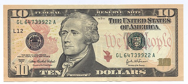
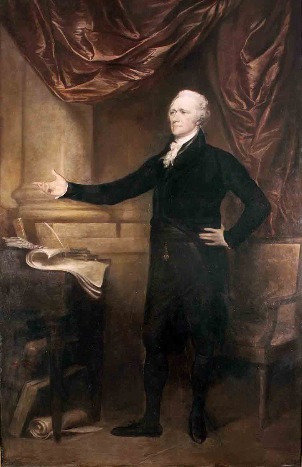
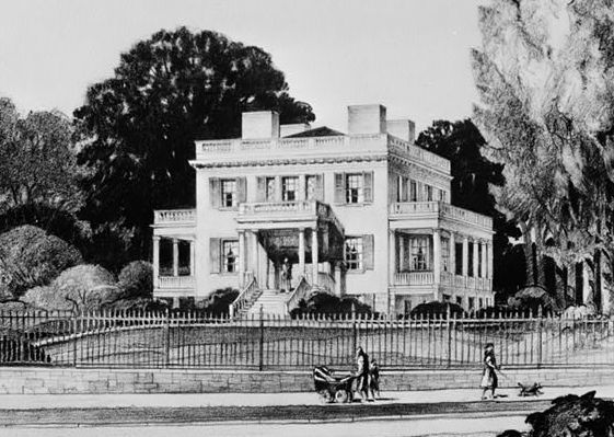
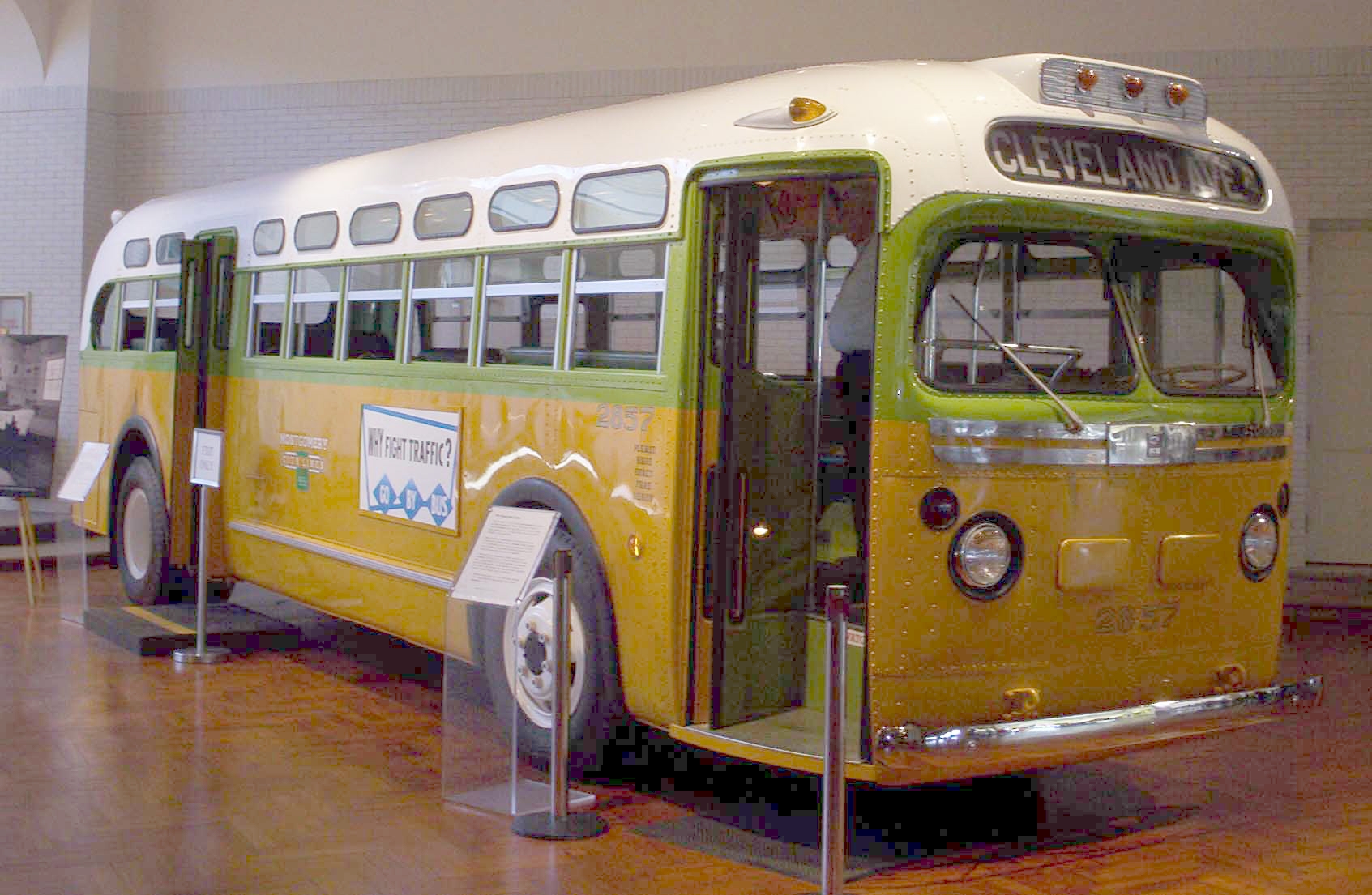
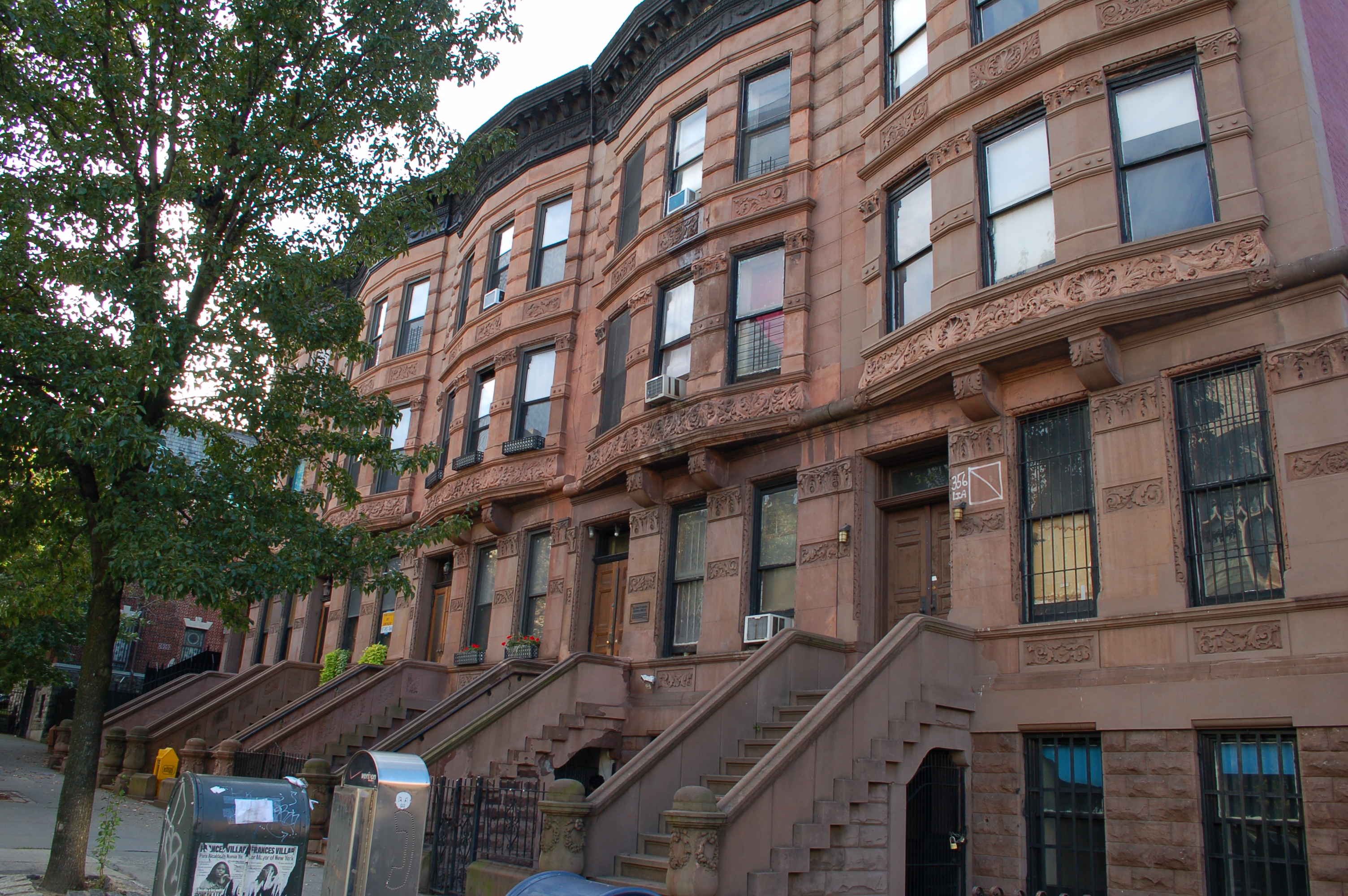
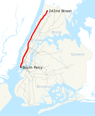
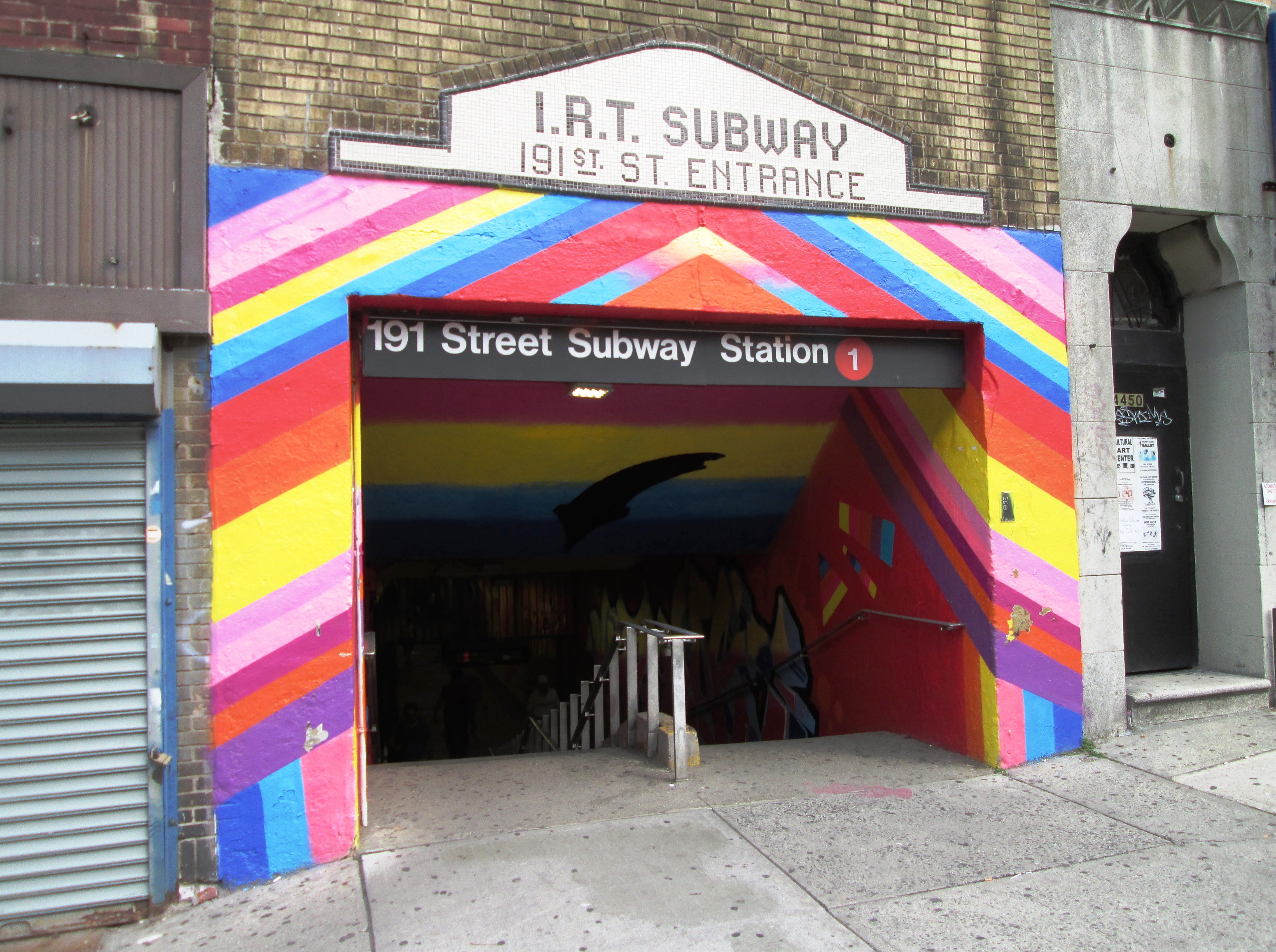