|
Reflections 2017
Series 3
February 18
Montréal-NYC Rail & Sail I: Great Lakes Outlets & Subsequent Canals; TCC Viewpoints
| | Rationale Lately I've been traveling twice a year, spring and fall. In spring 2015 I had Jim McDaniel in Austin, my South American advisor, book me the Ecuador trip, both the Galápagos and the mainland, and had considered extending that Central Andes trip into Peru and Bolivia, but that didn't work out. I then considered having him set up Peru and Bolivia for me for two weeks in October 2016. But some medical problems in January had usurped my time, and I was slow on making advance reservations—also for the East Coast trip. | | | | | | We all have our own ways of functioning. On the below trip, I spoke with a woman who never planned travel more than a month or two in advance, and who couldn't imagine doing it otherwise. I feel just the opposite. As it was, when I booked, I got the last room in the B&B in Gettysburg that weekend, and the last room of only three at the Ledge House in Harpers Ferry, which was still available because it cost a little more. In Charleston I was delighted with the location of the motel I ended up in, but earlier, I'd been looking at a B&B (not as well-located), but it was sold out when I went to book it. On the boat on the Rideau Canal, there was only one single cabin, and worse, there was only one trip a year that included the flight of locks in Ottawa. I booked it a full year in advance, and got what I wanted. I cannot imagine willfully waiting for the last minute, especially on a highly-detailed trip. |
| | | | And here it was suddenly August. I was reviewing my Peru and Bolivia notes and rough outline of the trip, now only two months in advance, and was reminded that Bolivia requires a visa, and as usual, they want six months' validity remaining on one's passport. Mine expired on 9 Apr 2017, and six months earlier was 9 Oct 2016. That wasn't going to work, and I didn't want to rush into that trip anyway, so I wrote Jim that we'd do Peru/Bolivia in late May 2017 after I got a new passport. That's now accomplished, and so I'm good for ten more years, and we're booked for late May. | | | | But then I was free for October. It seemed something local would be the best bet, and I was hoping a last-minute booking for something, so unusual for me, would at least get me a good discount. We'd been discussing canals recently, and the Erie Canal came to mind. Online checking brought up a problem, particularly if you want to go end-to-end, which I wouldn't have minded. There are plenty of boat rentals available, in other words do-it-yourself. I know friend Tom in Chicago would like to do that—and I sent him email greetings from the Erie Canal during the trip—but that's definitely not me. There are numerous public trips at towns all along the canal's length, but they're mostly day trips, with the odd overnight, but obviously meant for locals. Then I realized the canal's not all that big to accommodate larger, overnight vessels, at which point I discovered Blount Small Ship Adventures. They have autumn trips either way between Montréal and New York City, which included the Eastern Erie Canal. This seemed ideal for me, and I'd want to do it southbound. In addition, my old passport would still be valid at the Canadian border. I could have contacted Blount myself, but instead asked my cruise advisor, John McGlade nearby in the Hudson Valley, to look into it. | | | | He came back with better news than I could have expected. They offered a cabin with NO single supplement (often 50% extra), NO port charges (often a few hundred dollars), and 40% off the room rate! Jokingly I thought that that fare was cheaper than staying home! And that became the centerpiece of the two-week trip in the last half of October. All I had to add on top of that reservation was booking Amtrak's Adirondack (once again) from New York to Montréal. And that was IT. It was the easiest trip to plan, ever. There were no pre- or post-extensions to plan out like Gettysburg and Baltimore had been. Train north—ship south, period. No hotels, no cars, no restaurants. It was rail 'n' sail at its simplest and most exquisite. | | | | The Route Since it started with looking at the Erie Canal, I tended to call it the Erie Canal Trip, but it turned out to be more than that. The boat trip had three distinct phases, and the train trip made the fourth. This is the route the boat took:
http://www.greatlakescruising.com/bssa/locks-legends-canals_map.jpg
| | | | The entire two-week rail 'n' sail trip in late October looked like a backwards capital P.
1) The rail phase was straight up the Hudson and Champlain Valleys from New York to Montreal, which is the staff of the P. The "sail" phase then formed the loop of the P, turning down back into the staff.
2) The first boat phase was on the St Lawrence from Montréal down to Québec City, then back up and across the east end of Lake Ontario to Oswego NY, with the stops are noted.
3) The second boat phase was on two canals. Out of Oswego, along the entire length of the delightful Oswego Canal, leading into the Eastern Erie Canal, and then into the Hudson. The stops are as noted except the Fonda NY stop was moved just a bit east to Amsterdam NY.
4) The third boat phase was from Troy NY with stops as shown down to a triumphal, exuberant entry into New York City, which was much more of a Grand Entrance than I ever expected.
| | | | I noticed something that wasn't obvious to me at first. Everything in Canada took place in the Province of Québec. Although we did sail along Ontario, with it lying on the north shore of the river, at no point did anyone on this trip set foot onto the Province of Ontario. Similarly, although on the train trip we had beautiful views of Vermont to the east, across Lake Champlain, we were always in the State of New York. So this trip took place entirely in the two entities of Québec Province and New York State, although somehow, looking at the map, it doesn't seem that way. Finally, after at first calling it vaguely the Erie Canal trip, since that was the original destination, I changed the designation to the Montreal-New York City Rail & Sail (MTL-NYC R&S), after the end points for both the train and boat. | | | | Great Lakes Outlets We lean here heavily on history and geography, and so often, the most interesting part of geography is the geology that formed land and water areas as we know them today. We've talked (2014/8) about India traveling across from South Africa to slide under Asia to form the Tibetan Plateau. We've talked (2016/1) about the North American Great Plains—in Canada, the Prairies—being so flat because they were once all an inland sea. So it's appropriate to call the next topic Great Lakes Outlets, since that's actually what this entire R&S trip traces, by pure happenstance. | | | | But to discuss this properly now—and it's crucial to this entire trip--we have to reprise an earlier discussion. We had first talked about why Niagara Falls exists in 2005/14 as part of the "Cataclysmic Inundation Trilogy". We covered the topic much more comprehensively in 2010/25, called "The Ice Sheet from the Great Lakes to the Hudson". That title shows it includes the present topic, but also discussed additional events like the Outer Lands from Staten Island to Cape Cod, Glacial Lake Connecticut becoming Long Island Sound, and other goodies. There we saw how the predecessor of Lake Ontario, Glacial Lake Iroquois, altered its river outlet from the Hudson to the St Lawrence. This is all Great Stuff. | | | | But, digging further for this trip, I have since learned a great deal more, and, while all that was said earlier remains valid, the new information fills out the story and makes it even more interesting. Rather than suggesting you refer back to 2010/25, I feel it appropriate to bring sections of it here, comment further, and add information. But here we'll concentrate on the outlet routes—all of which we're going to follow! | | | | Instead of it being a matter of the routes simply following 1) the Mohawk-Hudson valleys and later 2) the St Lawrence valley, we now find the routes instead were the 1a) Mohawk-Hudson, then 1b) Champlain-Hudson; this was followed by the route to the 2a) Champlain Sea, which finally morphed into the present 2b) St Lawrence. It's far less complicated than it sounds, and some excellent online maps will clearly show these outflow changes. | | | | It's all based on the ice sheet, of course. This is what we said earlier: There have been four major periods of glaciation, called Ice Ages . . . The Quaternary (Fourth) Ice Age began 2.58 million years ago and we are still in it (ice sheets still exists in Antarctica, Greenland, and Canada, for instance), but we are [still] in an interglacial period [a period when the ice is receding]. The last glacial period began roughly 70 millennia (70,000 years) ago [and] reached its maximum extent 20 millennia ago . . . This Laurentian (or Laurentide) Ice Sheet is named after where it apparently was formed, in the Laurentian Mountains (French: les Laurentides) in Québec north of the Saint Lawrence River. | | | | The Laurentide Ice Sheet is shown here in its Last Glacial Maximum (furthest extent of glaciation) about 20 millennia ago. . . . In North America it covered Greenland, all of Canada, only part of Alaska, and the northern United States, the area in which we’ll be concentrating. Notice in particular how it covers the eastern US from the Great Lakes to New York City on the east coast. . . . The ice sheet was formidable, up to 3-4 km (1.9-2.5 mi) thick inland, but about 400-500 m (1300-1600 ft) thick along its southern edge.
| | | | Prior to the Ice Ages, most northern rivers in North America flowed north into Hudson Bay. The ice sheet blocked and diverted them. . . Major effects of the ice age were . . . modification of river systems [and] creation of lakes . . . In regard to proglacial lakes, note that an isostatic depression is the sinking of part of the earth’s crust due to the weight of a glacier, and if meltwater collects and is trapped in such a depression this can also form what is known as a proglacial lake. Such a lake can also be formed during the retreat of a melting glacier by the damming action of . . . [an] ice dam. As the ice sheet receded 10 millennia ago, large proglacial lakes were a widespread phenomenon in the northern hemisphere, such as Lake Albany in the Hudson valley . . . Glacial Lake Albany was the basis for the Hudson River. | | | | We'll interject here to bring up an arcane, scientific word, "isostasy". Taking it apart reveals its Greek roots, "iso-" for "equal" and "stasis" for "standing". Thus, isostasy describes a state of "equal standing", of equilibrium, of balance. An obvious example, applying an up-market word to a down-market event, is arm-wrestling. The event starts with the two arms theoretically in a state of isostasy, of balance, since each wrestler applies half of the physical force needed for the arms to remain upright. But as one participant (the growing ice sheet) applies more force, both arms move to the opposite side, since the opponent (the earth's surface) is forced to yield—but the situation continues to retain isostatic balance, to use the adjective form. So the ice pushes down and the earth yields. This is the isostatic depression mentioned above. The opposite is isostatic rebound, when the disappearing ice yields and the earth pushes back, but we'll deal with that below. | | | | The geology that created the upper Great Lakes took place 1.1 to 1.2 billion years ago when tectonic plates split and formed a valley that became Lake Superior. Later on, 570 million years ago, a fault line appeared and created the basis for Lakes Erie and Ontario, and the Saint Lawrence River. The lakes as we know them were then formed about 10 millennia ago after the Laurentide finally receded, leaving behind a huge amount of meltwater forming the lakes. | | | | The more I think of what this last map shows, the more significant it becomes. It's true that the Great Lakes are a single chain of lakes, but we see that the big, upper lakes were not only formed separately from the two, much smaller lower lakes in the chain, Erie and Ontario, but that the latter two are only about half the age of the others. That's a surprising quirk, but is hardly the least of it. At that same later point is when the huge fissure appeared, that fault line, running to the northeast, helping to form what is now called the Saint Lawrence Lowlands. Thus, before any lakes or river were formed, two large, empty "potholes" and an "alleyway" were laid out, foreshadowing what was to come. It's fun to see how Erie and Ontario line up with the St Lawrence to this day in a relatively straight line from the southwest to the northeast. But those potholes got filled first, even while the alleyway was still blocked with ice, so whereas the St Lawrence was predestined to be the eventual outlet of the Great Lakes, in the earliest period, it could not fulfill its mandate, the water exited elsewhere, and the Hudson took over. It would be many years before the St Lawrence could overcome this "second banana" status. | | | | [The] height of the lakes is very significant and is best illustrated by this Great Lakes System Profile. Measurements are only given in feet, but the numbers can be used for comparisons. . . . All the lakes had been preceded by proglacial lakes of varying sizes and shapes, but the one of interest to us is Glacial Lake Iroquois, a prehistoric version of Lake Ontario that existed about 13 millennia ago. It was larger and deeper than Lake Ontario because its surface was about 30 m (100 ft) higher. Remnants of its former shoreline can be seen surrounding Lake Ontario in Toronto and along Ridge Road in New York State. The Niagara River flowed into Lake Iroquois at close to an even level, just like the other short rivers that connect the Great Lakes. . . . However, the Laurentian Ice Sheet blocked the northeastern end of Iroquois/Ontario, preventing an outflow down the Saint Lawrence, but also artificially maintaining the height of Lake Iroquois. With this height, the Niagara River flowed calmly into it from Lake Erie. Here is a map of how Lake Iroquois might have looked, superimposed over its remnant, the current Lake Ontario.
| | | | For our discussion of the Erie and other canals, it's essential to note the two varying lake heights involved. All the lakes from Superior through Erie are of about the same average height, one just slightly lower than the previous one to allow for the ongoing flow that helps define a chain of lakes. Let's call this the "traditional lake height" of the Great Lakes. Glacial Lake Iroquois would have fit nicely into this category. But with the disappearance of the ice cap that held its northeast wall in place and the subsequent loss of water, it developed into Lake Ontario, which, despite its still considerable size, is historically the water left in a partially emptied, half-filled bathtub. Note that the altitude above sea level of Ontario is less than half that of Erie. We can call this Ontario's "lowered lake height". You can imagine how this difference would affect canal building.
http://4.bp.blogspot.com/-hAAqcneigss/U81AJhxoJ-I/AAAAAAAAOMk/jGWFIW1E8xI/s1600/179E-Image+2+maps.jpg
| | | | The difference in these two lake heights is what caused the change in the Niagara River, from flowing gently into traditional-level Lake Iroquois to dropping into low-level Lake Ontario. The left side of the above sketch shows the Niagara River, with north at the top. The right side looks south, and shows how the falls have eroded the earth and retreated from what had been Lake Iroquois' edge to the position they have today. The falls are predestined to eventually reach Lake Erie, but I suspect that will be a LONG time in the future. | | | | The Lake Iroquois map we saw within the quote above is important enough to our discussion so that I'm repeating a direct link of that same map here. Continue to refer to it in upcoming discussions.
https://upload.wikimedia.org/wikipedia/commons/2/2f/19th_century_estimate_of_the_boundaries_of_Lake_Iroquois.jpg
| | | | The ice sheet is shown in stylized form blocking a potential Saint Lawrence outlet. The Niagara River flows in at an even level. Lake Iroquois being larger, apparently one of the Finger Lakes, Lake Cayuga . . . was a slender arm of it. But most importantly, a much larger arm is located to the southeast where the current Oneida Lake is, with a channel down the valley of the Mohawk River, leading to the Hudson. Now compare the Lake Iroquois map with this contemporary map of this region (Map by Karl Musser). It becomes obvious that most if not all of the Finger Lakes are lined up as having been tributaries to Lake Iroquois, which was then much closer to them, and would also account for their lining up like "fingers". But more importantly, picture Lake Iroquois as including all of Lake Oneida, plus having an extended outlet down the Mohawk River in a glacial meltwater channel beyond what is now Rome NY (on both maps), and you'll visualize just what Great Lakes outlet 1a) Mohawk-Hudson looked like.
| | | | However, today, there's a continental divide between Rome and Lake Oneida. The Mohawk today rises north of Rome before continuing east on its traditional route, while the waters of Lake Oneida, no longer serving as the eastward outlet of Iroquois/Ontario, now flow west instead down what is currently the Oswego River. This is perfectly logical, since Oneida is a traditional-height remnant of Iroquois, flowing back downhill into the current low-level Ontario, just as the Niagara River does. The beige watershed of this area shows that all the Finger Lakes do the same. | | | | But now consider this comparison of the drop in elevation due to Lake Iroquois shrinking to Lake Ontario. At the west end, Niagara Falls drops 51 m (167 ft). At the east end, from the level of Lake Oneida to the mouth of the Oswego River is a drop of 37 m (124 ft). It's only about ¾ as much, but continues to illustrate the problem of canal builders trying to build links to the Great Lakes. (Don't fail to notice on this map, cheek-by-jowl with these waterways, the NY source of Pennsylvania's Susquehanna, which we discussed recently.) | | | | Finally, in the later stages of deglaciation 13,350 years ago, there was a catastrophic draining of Lake Iroquois, reducing it in size to what is today Lake Ontario, and this outflow was through what would become the modern Mohawk Valley. This enormous discharge of water on the way to the Hudson caused local deep scour features. . . . So it was the Hudson, not the Saint Lawrence as today, that was the original outlet for the Great Lakes. This shows the area of the Hudson River Watershed. . . . But there’s more. Glacial Lake Albany was a proglacial lake that existed between 15 and 12.6 millennia ago. It was created when an ice dam formed in the lower Hudson Valley, holding back meltwater from a retreating glacier plus water from the Mohawk River and others. The lake covered the Hudson Valley for some 260 km (160 mi) from Glens Falls in the north to Newburgh in the south. This would indicate that about 1/3 of Lake Albany was north of the Mohawk confluence with the Hudson and 2/3 south, but didn’t reach the present New York Harbor. The remainder of Lake Albany drained about 10.5 millennia ago down the Hudson River.
| | | | Returning to the half-drained bathtub metaphor, it can be imagined that in such a case, the upper rim of the bathtub would still be obvious, despite its half-filled status. This is true about Lake Iroquois, whose ancient shoreline still exists, and is discernable in two areas in Toronto. In 2011/29, I finally got to visit the Casa Loma mansion in Toronto, which sits on top of Davenport Ridge forming that ancient shoreline, with downtown Toronto to its south, which would have been inundated by Lake Iroquois. I've copied here three illustrations from that posting. To get up to Casa Loma, I had to climb the Baldwin Steps (Photo by SimonP) to get me to the top, a perfect illustration of the height of the former shoreline, which here comes to 23 m (75 ft) and is 2 km inland from the modern shoreline. East of downtown are the Scarborough Bluffs (Photo by Swatisgood), which are directly on Lake Ontario. I didn't visit them, but they are higher, at 65m (213 ft). On the south side, in New York State, the old shore is marked by Ridge Road (Map by TwinsMetsFan), part of State Route 104, which runs east-west for 195.5 km (121.5 mi) through four counties along the ridge that marks the old southern shoreline. But do note how close Ridge Road comes to Oswego on the right, where we'll be on the boat during the trip. | | | | We now have a bit more newly-found information to further illustrate 1a) Mohawk-Hudson, and I now discover the substantial influence on our scenario the Adirondack Mountains had. Let's take a look at the Northeast US for a closer look at the main ranges of the Northeast Appalachian Mountains (Map by Pfly). This entire area is very near to where I live, and I've either driven through, or visited, all the ranges shown. But while the ranges are either strikingly linear or otherwise totally amorphous, notice the distinctiveness of the Adirondacks. Their circular shape seems defined by the Mohawk River to their south, Lake Champlain to their east, and the St Lawrence River to their northwest. We'll also see that the Adirondacks are geologically distinct from the other ranges. Does it start to make you wonder if this "island" nature of the Adirondacks, surrounded by water, influenced the outlets of Iroquois/Ontario?
http://www.vizettes.com/kt/upstateny-history/images/iromohawk/lake_iroquois.jpg
| | | | This is a newly found map showing the 1a) Mohawk-Hudson route, but the advantage of this map is the emphasis put on that "island" of the Adirondacks. We see Lake Iroquois, larger than Lake Ontario, stretching toward potential outlets, but we see the ice sheet continues to block, so the water follows the Mohawk to Glacial Lake Albany, and thus the Hudson. Also note on the map that geologists like to call this first stretch of water the Iro-Mohawk, to show this early version of the Mohawk existed only because it was the one and only outlet for Lake Iroquois. Regarding the circular Adirondacks, note that this route passes by them in a counterclockwise direction.
http://www.vizettes.com/kt/upstateny-history/images/iromohawk/gmap2.gif
| | | | This is the other new illustration that demonstrates what we've said about the catastrophic draining of Lake Iroquois 13,350 years ago. The scouring action of this enormous discharge of water down the river brought down extensive sand and gravel deposits to form the substantial delta shown at its mouth, narrowing Lake Albany at that point. We'll pass later on the several large islands at the mouth of the Mohawk before it quite joins the Hudson. | | | | The above set of extended self-quotes were basically it for that discussion, since a Hudson outlet was the big news, although there was also this vague comment about a route 2): At a later date, outflow from Lake Ontario did make its way down the Saint Lawrence, where it remains today, cutting off permanently the outflow down the Mohawk and Hudson. Well now it's time to complete the story, and there's a lot more to it than that.
http://geology.gsapubs.org/content/33/2/89/F1.large.jpg
http://www.whoi.edu/cms/images/oceanus/2005/6/v44n1-briefs2-1en_10817.jpg
| | | | These two maps are similar, but not quite the same. The first, rather ugly one has the advantage of showing the glacial retreat well. The lower line shows where the ice sheet was 13,400 years before the present, and the upper one shows it only 300 years later, a mere blip in geological time. The map shows a nascent Saint Lawrence River was trying to form, but the thing in that first time period holding Glacial Lake Iroquois from invading the Saint Lawrence Lowlands was that the ice hadn't cleared the northernmost point on the west flanks of the Adirondacks, called Covey Hill. North of the Hill the land drops rapidly to the Saint Lawrence Lowlands, but to its southeast, the land drops rapidly instead to the Champlain Lowlands, the location of Glacial Lake Vermont, the forerunner of Lake Champlain. And this is the route that cleared first, via what is known as the Covey Gulf. | | | | The second map shows the water having breached the ice dam, this time flowing clockwise around the Adirondacks. Both maps show the outflow flooding Glacial Lake Vermont causing it to flow into Glacial Lake Albany and forming a much longer Hudson River Valley, longer than it had been, and longer than it is today, since it included Lake Champlain! We now see Great Lakes outlet route 1b) Champlain-Hudson. In a sense, at this moment in time, you can visualize that the Hudson River, as it drained the Great Lakes, also "drained Canada"! | | | | On both maps, compare the current shoreline with the one during this period, when a great deal of the continental shelf was exposed and the Hudson formed the Hudson Canyon in the Hudson Shelf Valley, which we've discussed in the past. Also be reminded that, when the ice sheet itself had earlier reached this area, it left a glacial moraine still visible on Staten Island and across Brooklyn, Queens, and Long Island. The moraine was a single unit between these locations. The Hudson, which arrived later than the formation of that moraine, had to breach this Narrows Dam to reach the Atlantic, resulting in the narrow strait called, appropriately, the Narrows, at the entrance to the present New York Harbor. | | | | Back further north, the rate of retreat was not consistent across the ice sheet. The western and central portions of it disappeared much faster than the eastern sector, slowing considerably the clearing of the Saint Lawrence Valley. It disappeared fastest over western Quebec, with the ice margin retreating about 700-900 meters/yards per year. Over central Quebec, ice retreated at a rate of about 300 meters/yards per year. But over eastern Quebec, ice retreated only at a rate of about 150 meters/yards per year, so that was the last to be cleared. So what do you suppose happened once the Saint Lawrence Valley was finally clear? | | | | Not at all what you'd think. What happened was totally counterintuitive. True, the 1b) Champlain-Hudson outflow ended, but the nascent Saint Lawrence River didn't yet lengthen down what was to become its valley. Instead it was shortened UP the valley! To see why, we need to revisit isostatic depression and isostatic rebound. Exactly what sinks under glacial weight and where does it go? | | | | This is a cutaway-schematic of the Earth (Schematic by Anasofiapaixao). Start at the left to trace the gray area of the core, then the orange area of the mantle. On the surface is the relatively thin crust, which rests on the mantle. However, the uppermost part of the mantle is composed of rock that is even denser than rocks common in the crust. These two superficial rigid regions together form the lithosphere, the outermost shell of the Earth. However, as rigid as the lithosphere is, it behaves elastically over very long periods of time. | | | | The other region of importance to our discussion is the next layer, the asthenosphere, lying 80-200 km (50-120 mi) below the surface. It's hot, highly viscous, weak, and ductile, meaning it deforms easily under stress. And now we have the two players in our scenario to explain more accurately what isostatic depression is. The ice sheet presses down on the rigid, yet elastic lithosphere, which then presses down on the viscous, ductile asthenosphere, which moves aside to accommodate the intrusion. Or look at it this way. Take a ripe peach and press hard. The skin (lithosphere) forms a dimple, but remains intact. It's the flesh of the peach (asthenosphere) that squishes out of the way. And so you have your dimple (isostatic depression). | | | | But the opposite is even more amazing. We can't continue with the peach metaphor, so let's move instead to tar. Press your finger into tar and it makes the same impression as the peach. But tar is flexible, and if you wait long enough, the tar will slowly rise (rebound) and flatten out most of the dimple. Or better yet. Sit down on an old, tired cushion and you'll have a butt impression remaining for the ages. Sit down on a new foam-rubber cushion and it will rebound as soon as you leave. | | | | Now consider the ice sheet disappearing. The pressure is gone, and the viscous, ductile asthenosphere below SLOWLY begins to flow back closer to how it had been. This then raises the elastic lithosphere, and the ground rises. This is isostatic rebound, also called post-glacial rebound. It takes thousands of years until the process is complete, but seems to have happened in two stages. The initial uplift was almost immediate after the ice was gone due to the elasticity of the lithosphere. The second stage involved the viscous asthenosphere moving back into place, so uplift proceeded much more slowly, decreasing exponentially. And the rebound is still going on. Uplift continues at about 1 cm (0.4 in) a year or less. Studies suggest rebound will continue for at least another 10,000 years. Total uplift varies, depending on the ice load, but near the center of rebound, it could be several hundred meters/yards. | | | | | | It's at this point that we should refer back to our old friends, tectonic plates, as they move about on the surface of the Earth. Tectonic plates are pieces of the rigid lithosphere, and they move about, collide and subduct under each other because they're "slipping and sliding" along the asthenosphere right below. One explanation for them is that they're affected by the gravitational forces of the sun and the moon. In any case, isostatic depression and rebound are the vertical counterparts to the horizontal motion of tectonic plates. |
| | | | So as it turned out, once the ice sheet had left the upstream Saint Lawrence Lowlands (and also the Champlain Lowlands) after a few hundred years, these already low areas were below sea level! And instead of the nascent Saint Lawrence River lengthening beyond the Adirondacks, once the valley was clear of ice, the Atlantic Ocean rushed in from the other end and formed the Champlain Sea (Map by Orbitale). And so we have to consider that the beginning of the shift of the Great Lakes outlet from the Hudson to the Saint Lawrence was the 2a) Champlain Sea. After the ocean flooded the Gulf of St Lawrence (not on this map), note that it then flooded the Saguenay Fjord and Lac Saint-Jean (2013/1), the future locations of Québec and Montréal, the Champlain Valley, the Ottawa River Valley, and the Upper Saint Lawrence Valley, causing that river to shrink back to the Thousand Islands area. | | | | The Champlain Sea existed for about 3,000 years, from 13,000 to 10,000 BCE. It's estimated that the sea was up to 150 m (490 ft) above the modern river levels. The remaining glaciers kept feeding the sea during that time, meaning its water was more brackish than having the saltiness of typical seawater. Also, the early rebound covered those 3,000 years, meaning the sea was continuously shrinking downriver during that time as the land continued to rise above sea level. | | | | Obviously, the Champlain-Hudson route disappeared during this time. T (Map by Chris Light). What had been Freshwater Lake Vermont, then outlet 1b) had been overwhelmed by the saltwater Champlain Sea. But as the Champlain Sea drained—northward, of course--freshwater Lake Champlain developed, flowing north via the Richelieu River and the separation with the Hudson River was complete. Freshwater Lake Albany had served both outlets 1a) and 1b). It existed between 15,000 and 12,600 BCE. It drained about 10,500 BCE through the Hudson River due to post-glacial rebound. Also note that temporary glacial lakes developed into the Connecticut River on the right, which flowed into Glacial Lake Connecticut, which the ocean eventually invaded, possibly from both ends, making it Long Island Sound. | | | | Back to the north again. Like draining a dishboard, but taking 3,000 years, the Saint Lawrence valley rose to allow the Saint Lawrence River to expand and push back the Atlantic, bringing us to the modern Great Lakes outlet, the 2b) St Lawrence River. And I've found a marvelous map of the St Lawrence River (Map by Halava) that DOES include the Gulf of Saint Lawrence. But when you see that it's called the Saint Lawrencen lahti, you may realize that this map happens to be in Finnish! The wonders of what one finds on the internet! I don't know a word of Finnish, but that shouldn't finish (!!) this exercise! | | | | Look at the lower left at the Ontariojärvi (you can figure out what that is). You see Oswego, Lake Oneida and the Mohawk River below the Adirondacks. On the lower right is the upper Hudson, with the Champlain Canal connecting to the Champlainjärvi; then the Richelieu connects to the Saint Lawrence. But the best this about this map is how the light green indicates the Saint Lawrencen alanko (lowlands). You can trace every bit of the Champlain Sea along here and down into Vermont/New York. | | | | But related to this outlet are the Thousand Islands, so find them at the start of the St Lawrence. Why are so many islands—by one count, actually 1,864, all in one place? A river might cut off a sandbar here and there and transform it into an island, but what was this all about? It turns out that it was directly connected to the fact that they're located right at the Great Lakes outlet through Lake Ontario, and also involves a connection I'd never have thought of. | | | | On our 2013 visit to Labrador (2013/12) we discussed the Canadian Shield. We said it's a huge rocky area that forms the ancient geological core of North America, covered by a thin layer of soil. . . . This is a geological map of North America, (Map by Qyd—click to enlarge) . . . [The] Canadian Shield [is] the area in the deep earth-colored shades of red, purple, and brown on the map. . . . [It's] roughly circular around Hudson Bay, like a donut around a donut hole. . . . From the map you can see that roughly, the Shield covers the eastern half of Canada and extends somewhat into the Upper Midwest of the US, west and south of Lake Superior. However, I failed to notice something at the time on the map, but the current research has made me go back and confirm that it really is there. Not only does the Shield extend into the US south and west of Lake Superior, I now notice it also does so east of Lake Ontario. There's an outlier there to the east, and sort of looks like a glassblower blowing a huge, round bubble. The key word there is "round".
http://www.a2acollaborative.org/uploads/7/6/8/5/7685208/_4736536_orig.jpg
| | | | The Canadian Shield on this map is shown in purple, and we find that the huge "bubble" our "glassblower" is blowing is the round range of the Adirondack Mountains, lying well away from the bulk of the Shield. The map also celebrates the fact that Canada has its own nearby park within a small part of its Shield, Algonquin Park. The two parks join together in the Algonquin to Adirondacks Collaborative (A2A) on environmental issues. Let's refer to this as our A2A map. | | | | But given our recent realization of the part the Adirondacks have played with the Great Lakes outflow having occurred on all sides of these mountains, it would seem that this "neck" connecting them with the Canadian Shield might also be a contributing factor. And so it is. | | | | It's that connection between the Adirondacks and the rest of the Canadian Shield that's the player in this game. It's a raised ridge called the Frontenac Arch, which is an arch-shaped fold in the earth (Diagram by Jesús Gómez Fernández). An imaginary line drawn along the crest of the fold is called its axis, which is why this ridge is also called the Frontenac Axis. It seems to get its name from Frontenac Provincial Park (see map), which lies on the Arch/Axis. | | | | Some 1.2 billion years ago, this was a different landscape. All of the Canadian Shield, including the Frontenac Arch, was a massive range of towering mountains. It took hundreds of millions of years for these mountains to weather down to their roots, which had then become a relatively uniform plain rising to a maximum of less than 100 meters/yards. | | | | Much later, about 500 million years ago, the oceans overlapped this primeval rock. (Don't confuse this hugely ancient occurrence with the relatively young Champlain Sea, which dated only from 13,000 to 10,000 BCE.) These oceans brought sand and lime, which were deposited in large quantities as sediments, which eventually hardened into solid rock in the form of sandstone, limestone, or shale. And all this lay on top of the primeval rock. But additional erosion then stripped back this overlying cover to expose more of the primeval rock. | | | | One of the features of the Arch, including the park, are its granite outcroppings, which, given the above, is significant. Let's put some scientific terms into play here. In place of the poetic term primeval, let's now say that the Arch is an exposed strip of Precambrian rock. To understand that, I found I needed to do a little more scientific digging as to geologic time. | | | | | | The Precambrian is the oldest of the old. It covers the first 89% of geologic time, from the formation of the Earth about 4.6 billion years ago up to, as the name says, the beginning of the Cambrian period, about 541 million years ago. For our purposes, we just need to know that the Cambrian (541 million to 252.17 million years ago) was the earliest period of the Paleozoic Era that followed.
Take a look at this geologic "clock" (Diagram by Woudloper), where Ma, Megayear, is a million years ago and Ga, Gigayear, is a billion years ago. Our limited use of this diagram is to understand that everything from "noon" to about 10:30 is Precambrian, most of geologic time. Starting at 10:30 is the Paleozoic Era, whose first period is the Cambrian.
|
| | | | Now look back at our map. The Canadian Shield in purple is marked as Precambrian. It's the oldest of the old, dated at1.2 billion years old. It's composed of igneous (volcanic) rock (see below), but that rock is not necessarily totally exposed, as suggested above, since the Canadian Shield is mostly covered by a thin layer of soil. This accounts for the Shield, including the Arch and all associated parks, being characterized by mixed forest, lakes, wetlands, as well as the above-mentioned granite outcroppings. | | | | Back to the map. All the beige areas are described as consisting of Paleozoic (that is, Cambrian onward) sedimentary rock. So I dug more into geology, and now we can talk about rock. | | | | | | The earth's crust is composed of igneous, sedimentary, and metamorphic rock.
Igneous rock is formed through the cooling and solidification of magma or lava.
Igneous rock forms about 15% of the Earth's current land surface.
The predominant igneous rock is granite.
Sedimentary rock is formed from mineral and/or organic particles brought by water that settle as sediment, are deposited, the get cemented together (lithified).
Sedimentary rock covers 73% of the Earth's current land surface.
The predominant sedimentary rocks are sandstone, limestone, shale.
Metamorphic rock results from the transformation by heat and pressure of either igneous or sedimentary rock.
Metamorphic rock forms 12% of the Earth's current land surface.
One metamorphic rock is gneiss (say "nice"), which we last mentioned as part of the foundation to the former Alexandria (Canal) Bridge between Georgetown and Rosslyn (2016/4).
|
| | | | So as the Arch, as part of the Shield, is mostly solid granite, the beige areas are softer sandstone, limestone, or shale. We now also know that that sandstone and limestone also settled on top of the granite, but now it's mostly eroded away.
http://www.thousandislandslife.com/Portals/Properties/images/News-Articles/2010/Dec-photos/WLW-ThousandIslandsRocks_123EA-Potsdam%20Sandstone_thumb.jpg
http://www.frontenacpark.ca/images/Frontenac-Arch-Figure-2.jpg
| | | | Both the sedimentary and igneous rock can be seen along roadsides, sometimes together. The first picture shows softer sandstone layered (you can see the layers) on top of gneiss, probably developed out of hard granite. The second picture shows Ordovican limestone, again with the layers showing, lying over Precambrian granite (the Ordovician was the second period, immediately following the Cambrian, of the six periods of the Paleozoic Era). We also now know that the beige areas of our map, showing sedimentary rock on the surface, have igneous rock below it, and that the purple areas of exposed igneous rock probably were at least partly covered by softer sedimentary rock that is now eroded away. Also note how the outline of the beige sedimentary-rock area also helps to define both the St Lawrence Lowlands as well as the Great Lakes Lowlands, the remnant of Lake Iroquois with Lake Ontario at its bottom. You can also see why, back in the day, the Champlain Sea abutted the Frontenac Arch, even as the Arch helped contain Lake Ontario.
http://78michel.8.7.f.unblog.fr/files/2013/10/frontenac-arch-et-les-milles-iles.jpg
| | | | This additional map reveals even more. The upper part reiterates the relationship between the Axis, the River, and the Thousand Islands ("les Mille-Îles", misspelled on the map), and the gray area also shows the area still covered by sedimentary rock. But note the location of the A-B cross-section repeated on the lower part, close to, but not at, the river and lake. It graphically shows the ridge that the fold of the Frontenac Axis makes, and how it separates the two areas of lowlands. The last sentence at the bottom also leads in to the fact that the Axis ridge produced the Thousand Islands. | | | | But before we get there, it suddenly struck me that we've traveled over the Arch before, it was also by boat, and not so long ago, just two years. It was the trip on the Rideau Canal (2014/16) from Kingston (see A2A map) via Smiths Falls to Ottawa. You'll remember that the canal had been built, partially to avoid some rough waters on the St Lawrence, but mostly to avoid having Canadian shipping pass along the US border after the contentious War of 1812, since canal traffic beyond Ottawa could go down the Ottawa River to Montréal and beyond. The canal boat was the Kawartha Voyageur, and you'll note Kawartha Highlands Park on the map, although the boat was named after the chain of Kawartha Lakes near Orillia (see map), the boat's home port. At any rate, note the following:
http://www.rideau-info.com/canal/history/rideau-route/images/frontenac-axis-web.gif
http://www.rideau-info.com/canal/maps/rideau-profile-web2.gif
http://www.rideau-info.com/canal/ecology/images/frontenac-axis.gif
| | | | The first, rather small map, shows the route of the Canal, but with emphasis on its crossing the Frontenac Axis not too far out of Kingston on the way to Ottawa. At the time, I was well aware locks kept us ascending before later descending, but I never knew the name of the ridge. The graphic shows a profile of the Canal with all the locks. While Lake Ontario is higher (see graphic) than the Ottawa River, so that there is an overall descent in any case, the summit of the ridge is at Upper Rideau Lake, a considerable difference between the two ends. (The actual watershed divide is at the town of Newboro, which is a bedrock (!) ridge separating Newboro Lake from Upper Rideau Lake). The second map is a detail of the southern part of the first, showing Newboro separating the two lakes near the summit of the ridge. This area of the canal is completely underlain by the Precambrian rock of the Canadian Shield's Frontenac Axis. Both maps also indicate the location of some of the Thousand Islands in the St Lawrence, leading us to finally discuss their formation. | | | | Let's now leave the canal route and finally get to the river route across the Axis. We can now say that, unlike the odd sand bars here and there, or pieces of shoreline that a river may have cut off from the mainland, the Thousand Islands area is flooded land. We know they're solid rock, over 900 million years old, hard granite and gneiss. They were formed about 12,000 years ago at the end of the last ice age. Glacial erosion scoured and sculpted them into what is called a "knob and hollow" surface, in other words, little hills and valleys between them. Eventually those hollows/valleys flooded and the rocky knobs/hills became islands. | | | | Now the literature is unclear about one thing. One school of thought is that softer sedimentary rock originally did cover the older and harder igneous rock of the Arch itself, but was later the first to be stripped away by erosion and ice. Others think that the Arch may not have ever gotten a sedimentary rock cover. But we can let the geologists mull over that question. As far as we're concerned it's moot, as long as we realize that the islands are exposed primeval granite. The explanation for the large number of islands is that this was a very irregular surface to begin with, further broken down by the glacial erosion and later, river erosion, as glacial rebound helped Lake Ontario eventually rise and overflow the Frontenac Arch, spilling between the granite hilltops and through the depressions, helping to further fracture the granite. The islands are elongated parallel to the river's course, indicating the river's shaping of them. In this flooded landscape, a thousand hilltops became the Thousand Islands. Or, to be precise, 1,864. | | | | We'll illustrate the rocky outcropping nature of the Thousand Islands with three pictures. This is an entire island (Photo by Mykola Swarnyk), whose rocky nature is irrefutable (click). Flying the Canadian flag, this house (Photo by Laslovarga) has a dock built onto the rocky shoreline. Finally, these are Victorian cottages (Photo by Roy Googin) on Wellesley Islands in the US (click), right on the rocky shore. Just be sure to realize that you're not looking at some sandy riverbank but rock that is primeval, igneous, Precambrian, Canadian Shield, Frontenac Arch, very solid, granite. | | | | Building Canals We now have seen where the Great Lakes emptied over geologic time, and we come to the early 19C, the grand era of great canal building. What the canal builders did was to restore in modern times all the geologic connections of the past—and then some. Of course, they didn't get the waters flowing again, but they did establish 19C-20C commercial traffic on those very same routes. Did they realize they were recreating geologic history? Or did it just seem like a good idea to build these connections? My guess would be that it started out in the early 19C merely as a good idea, and later in the 19C, scientists began to realize how these efforts were duplicating geologic history. I base this on the fact that map of Glacial Lake Iroquois we used is dated 1893. | | | | The 19C-20C canals we're discussing in fact retraced both outlets from the Great Lakes. Just as the outlet to the Hudson River preceded the outlet to the Saint Lawrence River geologically, so did the canals leading to the Hudson River precede, for the most part, those leading to the Saint Lawrence River. | | | | Canals Leading to the Hudson Of all canals anywhere—certainly within the US—the Erie Canal is the one that has reached folkloric, if not mythic, status. Even those with a superficial knowledge of history are aware that it was a great engineering project that connected the Midwest to the East Coast via water. Even to those early-19C builders and their supporters, the canal had been imagined as an extension of nature—building an artificial river where there was none. I'm sure that's true, since I doubt the canal builders were imagining they were replacing the most ancient of geological water routes. That's "routes", plural, because even the oldest iteration of the Erie Canal had two branches, resulting in three routes. And every bit of the Erie Canal and its branches leading to the Hudson was within New York State (NYS). | | | | It will work best to start with the present, and then flash back. I really like this simple, clear schematic illustrating the status of the modern canal(s). And since even the newer successor canal and its branches are no longer commercial in the transportation sense, but instead recreational, I like the fact that the map is issued by the Canal New York Marketing and Business Alliance, Inc, which is instead commercial in the touristic sense, with members that are villages, towns, cities, B&Bs, hotels, museums, visitor bureaus, boating companies and much more, including, to my pleasant surprise, Blount Small Ship Adventures, the company whose ship we'll be sailing on. But to the point: I totally agree that their map should regard the Western Erie Canal and Eastern Erie Canal as distinctive from each other, as well as the Oswego Canal, Champlain Canal, and the (purely local) Cayuga-Seneca Canal. Thus we can most accurately say that the canals we'll be using on our trip are the Oswego and Eastern Erie Canal, not its western counterpart, other than for its easternmost end. That's very precise, and also clear, that, in this way, we're not referring to the Old Erie Canal. We'll have two far better maps than this to work with, but this color-coded map meant for visitors sets our parameters, so keep it in mind. | | | | Old Erie Canal People in the know, when referring to the 19C waterway with its improvements, and its bits and pieces remaining today, call it the Old Erie Canal. But if you leave out the word "Old", the context will explain what is meant, since the discussion will cover things like mule power, which clarifies the period.
| | | | Shipping goods west of Albany, often by oxcart, was expensive and tedious. For passengers, the stagecoach ride from New York City to Buffalo took two weeks. Promoters, most prominently New York Governor DeWitt Clinton, wanted to exploit the only low-elevation passage through eastern mountain chains between Georgia and Canada. Other canals that tried to do what the Erie Canal did lacked this topographical advantage. Most were not completed—we just visited the B&O Canal in Maryland that never passed Cumberland—and none was a financial success. The completed Erie Canal, on the other hand, ended up being North America's most successful and influential public works project of its day. It advanced settlement all along its route, plus further along the Great Lakes. It brought prosperity to every town along its path, all while paying for itself within two years. It made New York the Empire State, and made New York City the prime seaport of the US for world trade. | | | | While doubters in the beginning called it "Clinton's Ditch" and "Clinton's Folly" (you'll also remember the Alaska purchase being called "Seward's Folly") Clinton gained fame because of its success. You'll recall our recent visit to Clinton IA, with nearby DeWitt IA, both settled by proud New Yorkers. You'll also recall our visit to Delaware City DE adjacent to the C&D Canal, whose main street along its canal was, proudly, Clinton Street. There are numerous Clinton Avenues and Streets named after him—I know of one of each in Brooklyn, plus the Clinton Hill neighborhood named after the former. In the far west 50's in Manhattan there's a DeWitt Clinton Park, and the Hell's Kitchen neighborhood around it since 1959 has also acquired the alternate name of Clinton. | | | | The canal was built between 1817 and 1825, and was so successful that even in the 19C it soon required what was called the "First Enlargement" between 1834 and 1862, to say nothing of the 20C successor canal being much larger still. Some, including Will Van Dorp, the ship's lecturer who gave a talk about it on the ship, suggest that there therefore were three canals. I respect that, but prefer to interpret the data as covering an original, then upgraded, 19C canal, then followed by a 20C successor canal. I look at it as 19C Canals 1a and 1b, followed by a very different 20C Canal 2. | | | | Bulk goods that had been directly carried by pack animals were limited to an eighth-ton, or 250 pounds (113 kg), and so water was the most reliable, cost-effective way to ship these bulk goods. And freight rates dropped 90% by canal compared to shipping by oxcart. Passengers traveled comfortably from Albany to Buffalo in only five days, not a couple of weeks as by stagecoach. (This is reminiscent to our discussion in Ellicott City, where by 1840, it was trains that attracted people away from stagecoach travel.) The canal's peak year was 1855, when 33,000 commercial shipments took place. As we experienced on the C&O Canal, mules and horses on towpaths were used (until 1918, when the successor canal took over), using a towrope connected to the boat. Animals and crews worked in six-hour shifts, 24 hours a day. | | | | Civil engineering as we know it today was just gaining a toe-hold in the early 19C, and it's really quite incredible that the first "engineers" on the Erie Canal had little experience, but learned on the job. For that reason, the canal was nicknamed the "Erie School of Engineers". They were amateurs who figured things out, devised techniques, and taught themselves how to design, lay out, and execute construction. The chief engineer was a judge, and the assistant chief was a lawyer who had made a preliminary survey of the route. But they gathered together some very talented people to become among the foremost canal builders of the day. A tribute to this team stated that "They have built the longest canal in the world in the least time, with the least experience, for the least money, and the greatest public benefit". (The "longest canal" claim is hyperbole—the modern canal is only the sixth longest in the world, and the 19C version was only a little longer than it was.) | | | | This is a profile of the Original Erie Canal as of 1832. We'll review the modern canal much more carefully, but for now, click to inspect how the brown landscape horizon matches with the black line showing canal water levels. You also see, written vertically, the junction of three other canals that still exist, and that are also part of the successor canal. Given the small size of the channel, you can see that the original canal had 83 locks, where the larger more modern, successor canal has only 36. The elevation differential (difference between Lake Erie and the Hudson River) is about 172 m (565 ft). You can see how the altitude of the Western Section mostly declines toward the Middle Section, but then there's a temporary rise again. That's in the area of Lake Oneida, whose outlet leads back to Lake Ontario. We then see the divide between that and the Mohawk River's watershed. The canal then descends to the Hudson, rather sharply at the eastern end where there used to be numerous small locks, today far fewer. The length of the Old Erie Canal was 584 km (363 mi) from Albany (literally) to Buffalo (literally). We'll see that the modern canal doesn't reach those cities, and has other alterations, so that it runs 544 km (338 mi), or about 93% of the old length.
http://www.eriecanal.org/Langbein_section.gif
| | | | As the above cross-section shows, the original canal was tiny, only 4 ft (1.2 m) deep and 40 ft (12 m) wide on the surface, but 28 ft (8.5 m) wide at the bottom. The resulting trapezoidal shape is referred to as the "prism" of the canal. But as we said, it promptly needed upgrading. An extensive upgrading program started as early as 1834 that was called, as we said, the First Enlargement. Its dimensions were close to doubled to 7 ft (2.1 m) deep and 70 ft (21 m) wide at the top and 56 ft (17 m) wide at the bottom. Locks were either widened or rebuilt in new locations, or both, and a number of new water bridges ("navigable aqueducts") were built. Double locks, or two locks side-by-side, were built along the entire length of the canal to allow for two-way traffic. The route was straightened and altered a bit in some places, meaning that even at this early point there were some bits and pieces of the original 1817-1825 canal abandoned. To be clear, it's this 1834-1862 upgrade that's usually referred to as either the Improved Erie Canal, or, better yet, the Old Erie Canal, all of which was a (laudable) product of the 19C, to be distinguished from its present, 20C successor, a gem in its own right. As a matter of fact, on 11 January 2017, as this posting was being written, at the urging of New York's congressional delegation, including both senators, the National Park Service named the NYS Canal System a National Historic Landmark. | | | | | | Water bridges (no more exist) and bits and pieces of the two original iterations of the Erie Canal remain around the state, we can mention Schoharie Crossing State Historic Site near modern Lock 12 on the Eastern Erie Canal. I've not been there, but it has an interesting collection of what we're talking about. This is the east guard lock (for the intake of water for the canal) of the Original Erie Canal. It very obviously shows the original "prism" shape of that waterway. This is Old Lock 28, plus a canal store, of the Enlarged Erie Canal. Finally, from the latter period we have the ruin of the Schoharie Aqueduct over Schoharie Creek (All Three Photos by R24b96w). It was completed in 1841 with fourteen arches. Because of ice jams, floods, and, in 2011, Hurricane Irene, only five arches remain today, so this picture is somewhat dated. I did get to see the ruins of another waterbridge, which will be described later. |
| | | | The (Newer) Erie Canal The 20C successor Erie Canal was built between 1905 and 1918 and given the unattractive (to me) name New York State Barge Canal. It included the Erie and three other connected heritage canals. While some people still use that name, in 1992 it was renamed the New York State Canal System, a name I now try to use.
http://eriecanal.org/locks/locks-1912.jpg
| | | | I'm delighted with this sketch I found online that attempts to present to the public just what was being done at the turn of the 20C. It shows the size of the "present" canal lock—the "present" is 1912—as compared to the size of the new locks on the Barge Canal. I think it's the best indicator I've found representing the difference between the Old Erie Canal and its current successor. | | | | It has recently occurred to me that this sort of upgrading has taken place across the board in transportation. I find it easiest to look at this in reverse order. (1) Rail: Nowadays, we are in the midst of a rail revolution, with high-speed rail (HSR) around the world (in some places faster than others) developing routes that supplement, but also overlay, traditional rail routes. Most often there are totally new rights-of-way, but sometimes a HSR route will overlay an older one where the older one was located exceptionally well. (2) Road: In the early-to-mid 20C, there was a superhighway revolution, with a new highway network supplementing, but also overlaying, the older network, totally under the same circumstances as with rail. (3) Water: In the early 20C the same thing happened to canals, the equivalent of HSR or superhighways. Our first encounter with that phenomenon was with the C&D Canal in 2016/11. The new, much larger, present canal was overlaid on most of the route of the original canal, since it already had the best route, but the new one was dug deeper to sea level and eliminated all locks. The only remnant of the original canal is the older east entrance in Delaware City, while the newer canal has its own east entrance south of town. | | | | But as I learned about the technological improvements of exactly how the newer Erie Canal replaced the Old Erie Canal, I realized that, for the last couple of years, I had not been seeing the forest for the trees. It seems so simple now I wondered how I didn't realize it. | | | | On the Erie, new digging and flood-control technologies allowed engineers to canalize rivers that had been previously avoided. This was, for example, most obviously the case with the Mohawk. The Old Erie Canal ran alongside the Mohawk in what essentially was a ditch. It's still there, and we can now understand the basis for detractors calling it "Clinton's Ditch". The new canal runs WITHIN the Mohawk, starting as soon as the river begins to get wide enough. | | | | Then I realized what I'd missed before. The entire length of the 19C C&O Canal was a ditch that ran alongside the Potomac, and usually a few steps away from it. This was, in other words, the old style. You could almost say it had nothing to do with the Potomac, except using its valley as a route and "stealing" water from it at those "guard locks" to keep the canal watered. When it was necessary for the canal to move over from the north bank to the south, up at the far end closer to Cumberland, the canal needed a water bridge to do so. | | | | Now compare that with we encountered on the Upper Mississippi. While levees control the Lower Mississippi, the entire Upper Mississippi is channelized. Dams, which also help control flooding, divide the river into successive lakes. While no one actually dares to call it a canal, that's essentially what the Upper Mississippi has running through it. Our ship would move along a length of "lake" then, when encountering a dam, would use the lock on one side of the dam or the other to move to the next "lake".
http://www.greeningthegrey.org/wp-content/uploads/2013/02/Parks-Map.jpg
| | | | That really hides the fact that the river is serving as a canal route. So let me repeat the above map we used in 2015/20 when visiting the Chain of Rocks bridge. The rapids in the Mississippi were too severe at this point, so what is called the Chain of Rocks Canal, with a lock, was built along the eastern side of those rapids, forming some artificial islands. Call it the Chain of Rocks Canal if you like, but in reality it's the route of what we can dare to call the "Mississippi Canal" leaving the center of the river for a bit and turning back into the traditional "ditch". Since the ship didn't actually leave from St Louis, south of this area, but from Alton, north of here, we didn't actually sail through this lock and canal. | | | | Now, when we talk about the Old Erie Canal, picture the C&O Canal "ditch" experience. When we later talk about the St Lawrence Seaway, think of the Upper Mississippi channelized-river experience. And as we talk about the present Erie Canal, picture something in between. Long "ditch" sections (but large in size), yet also frequently running down the middle of channelized rivers. As we said, this was the case with the Mohawk, but this was also done with the Oswego, Seneca, Clyde, and Genessee ("Gen-" as in "general") rivers along its upgraded route. | | | | We are going to see momentarily that the new Erie Canal totally avoided the two major cities at either end of the Old Erie Canal, Buffalo and Albany, and also notably bypassed two major cities on the route, Rochester and Syracuse. Where the new canal could not canalize rivers, it did follow the route of the old canal, but enlarged it to 37 m (120 ft) wide and 3.7 m (12 ft) deep, greatly increasing capacity. And even as the Improved Erie Canal (1b) resulted in abandoned bits and pieces of the original canal (1a), so did the successor canal (2) result in quite a number of abandoned sections, which we'll note shortly as we inspect the routes of both canals. | | | | But before we do that, we need to report unfortunate news. Even as the new canal was being built, it was doomed. While it was a great improvement, railroads were taking business away from the Erie Canal. Once the St Lawrence Seaway opened in 1959, coupled with the Welland Canal (see below) it drew traffic away from the Erie. Why would a ship on the Great Lakes take the New York route and unload its cargo in Buffalo to be transported on barges, only for the cargo to be reloaded onto ships at the other end, when it could take the cargo itself on the route through Canada?
https://static01.nyt.com/images/2012/03/18/realestate/18living-map/18living-map-popup.jpg
| | | | And where was this "other end" from Buffalo? It wasn't Albany or its area, because the barges just continued down the Hudson. The other end was New York City. And in the early 20C, there was more unfortunate news in that that attempt at improvement was another fiasco. In 1924, as part of the Barge Canal redevelopment, the Red Hook Grain Terminal was built in the Red Hook section of Brooklyn to handle canal cargo. The above map shows Red Hook, adjacent to Governors Island, which itself faces Lower Manhattan. In Buttermilk Channel you see the location of today's Brooklyn Passenger Terminal, where Cunard's ships dock. But then, on Gowanus Bay, next to the Gowanus Canal, also notice the now unused Erie Basin, where barges from the canal docked. On the Basin, at the foot of Columbia Street, is where the Red Hook Grain Terminal, also called the Gowanus Bay Grain Terminal, was built (Photo by Jim.henderson). This view of the now abandoned grain elevators looks east from Columbia Street at the Basin. | | | | The explanation for the fiasco is this. There had been two grain elevators in NYC, but they were owned by the railroads, which denied storage privileges to barge operators. Therefore, instead of dropping off its load at an elevator for storage, to be picked up later by a ship, and then returning upstate, the fully loaded barges had to wait for the ship to arrive to do a direct transfer of cargo. For this reason, the Barge Canal system built this storage facility, but it vastly overbuilt it. The structure is 12 stories tall, contains 54 cement silos, and it the tallest structure in Red Hook. But the whole canal upgrade was actually really a failure, since canal usage was already in decline at the time. In 1918, the canal system was running at 10% capacity. While in 1880, the canal system carried 30 million bushels of grain, in 1918, it carried only one million. Therefore the facility was hugely overbuilt and failed to generate a profit, and was decommissioned in 1965. | | | | So commercial traffic on the Erie Canal declined, and the last regularly scheduled commercial ship ceased operation in 1994. Since the 1970s, the state has ceased modernizing the system due to the shift to truck transport. Use of the canal has shifted to recreation, and it's preserved primarily for that and for historical purposes. The canal is open for navigation from early May to mid-November. It is financed through tolls collected on the New York State Thruway, though boaters pay a fee to transverse the locks. Depending on the speed, sailing the entire Erie Canal today takes about 5-6 days. | | | | Another recognition of the canal was that, in 2000, the US Congress designated its route as the Erie Canalway National Heritage Corridor to recognize the national significance of the canal system as a most successful and influential man-made waterway and one of the most important works of civil engineering in North America.
https://www.nps.gov/erie/planyourvisit/upload/ERCA_brochure_large_2007.pdf
http://www.canals.ny.gov/maps/
| | | | The Old and New Routes We're going to simultaneously follow the routes of both canals on these two maps. The first, "map A", will be our basic route map—it shows very few locks. The second, nicely interactive one, "map B", will be our lock map and will show great detail of the 35 locks on the successor canal.
On A, scroll down to the second page, where our map is at the top. Click on "Automatic Zoom" at the top and set the page size to taste--I like 200%--then wait for it to focus. Move over to Buffalo, in the west.
On B, there are four possibilities, to your taste. Default is this road map. On the upper left, click Map, and check Terrain to add that possibility. Then click Satellite; finally, on Satellite, decheck Labels to remove them. My favorite is Map with Terrain, but make your choice. Now drag Buffalo to center screen, then hit the plus sign in the lower right to taste, maybe 6 times or so, and adjust later as needed. Later on, click on any red lock symbol for additional info.
Let's start with A, where the dotted line shows that the Old Erie Canal (OEC) started in downtown Buffalo and went north some distance. Let's explore that here:
http://www.eriecanal.org/maps/Buffalo-1905.jpg
| | | | This map shows Buffalo in 1905, towards the end of the OEC. You'll note the Erie Basin, protected by a breakwater, just as we saw in Brooklyn. The Buffalo River comes in from the southeast, and the OEC comes in from the northwest—just as you should expect it, in a ditch. Now compare this with map B, and get in real close. You still see the Buffalo River, and the Erie Basin is discernable, but no OEC. What you do see is that part of I-190 has been built along the former right-of-way of the Erie Canal. This is the first of our lost "bits and pieces". | | | | On A, you'll note that the (Newer) Erie Canal (NEC) starts (or ends) in Tonawanda, located close to the Niagara River. Now on B you'll notice something surprising. The NEC has unofficially moved from a ditch into a channelized section of the Niagara River, that even has a lock, the Black Rock Lock. The reason I say "unofficially" is because the NEC does end at Tonawanda. This lock, though referred to informally as Lock 36, the highest number on the NEC, is operated instead by the US Army Corps of Engineers. Yet canal traffic from Lake Erie and Buffalo still does have to go through here to get to Tonawanda. Technically, the stretch from Buffalo Harbor to this lock is called the Black Rock Canal, and it protects boat traffic from reefs, rapids, and fast currents on the upstream Niagara River. Check out on both maps how close Niagara Falls is, and no one wants to be swept downriver. | | | | On A, check how the Western Erie Canal region begins at Tonawanda, and, given the lack of local rivers, does actually run along the exact route of the OEC, much enlarged, similar to what we saw on the C&D Canal in MD/DE. B shows that the actual westernmost locks on the NEC are the pair at Lockport, Locks 34-35, technically called E34-E35 to distinguish them from the locks on other canals. | | | | But then we do come to a river crossing our path, the Genessee (Map by Pollinator), flowing north through Rochester. And Rochester is the second of the four city bypasses we mentioned, clearly visible on A. The OEC crossed the Genessee River in downtown Rochester, while the NEC crosses it south of town, but then uses the Genessee to access Rochester, as the heavy blue line indicates. You can zoom in on B to see the intersection of the NEC with the Genessee. But the OEC didn't intersect, but instead had a waterbridge! This period picture shows the OEC's Broad Street Aqueduct crossing the Genessee in downtown Rochester in c1890, one of the major waterbridges in the old system. It had been built between 1836 and 1842, is 240 m (800 ft) long and 21 m (70 ft) wide. I say that in the present tense, because the waterbridge is still there! In 1927, a roadbed named Broad Street was added along its roof for car traffic, and it's now called the Broad Street Bridge (Photo by dickie cooper). This is the abandoned interior (Photo by David Maiolo). Though I've been in Rochester, I've never seen the bridge. I read that there's interest in somehow rewatering it and connecting it to the river below. | | | | As we move into Central New York, if you're checking the locks on B, you'll see there is no Lock E31. Then, on A, as we approach Lyons and Clyde, we find that the canal has moved from the old ditch into the now channelized Clyde River (not named) between the two. We now come to the Oswego River Drainage Basin (Map by Karl Musser), shown here with the Seneca River highlighted (the Clyde flows into the Seneca). At this point we're at some major rivers, and find that the OEC was abandoned for quite some distance, since the NEC now runs in the channelized rivers. This map shows how the Seneca was used for the NEC, and how it included an upriver segment that had already been a local OEC connection since 1825, bringing the two largest of the Finger Lakes into the canal system. Map A shows this as the first of the branch canals of the system, the Cayuga-Seneca Canal, about 32 km (20 mi) long. The B map shows how the locks here have a CS designation.
https://s-media-cache-ak0.pinimg.com/736x/79/9c/9d/799c9dd90b20ce9e86783fd06e93909d.jpg
| | | | South of the next stretch, we can see on map A how the OEC went east to Syracuse, then beyond, and how a huge swath has been abandoned. The above picture, from 1904, shows the canal as it looked in Syracuse. But, like Rochester, Syracuse, our third bypassed major city, is still accessed, but now across Onandaga Lake. | | | | But all of these natural waterways drain down the Oswego River into Lake Ontario, as that drainage basin map shows, and so map A shows the next side canal as the Oswego Canal, with the new canal more channelized than the original had been. Map B shows the numbers of the locks include the letter O. | | | | Since the OEC needed a towpath for the mules, it couldn't take advantage of large Oneida Lake, but the NEC cuts right across that lake. It's the largest lake entirely within NY State, and, as you'll recall, a genuine remnant of Glacial Lake Iroquois. It's not one of the Finger Lakes, but is sometimes referred to as their "thumb". It's here at the town of Sylvan Beach (Map A) that the Western Erie Canal region, coming from the Niagara River, is today considered to end, and the Eastern Erie Canal region to begin, running on to the Hudson. | | | | We now should pause to take a look on A at the rest of that long swath abandoned east of Syracuse. I have not seen this area, but it's of particular interest. It's called the Long Level. Why? While it's more common on the Western Erie Canal to have longish stretches that are level—notably the very long lockless stretch between Locks E33 and E34/35--it's unusual in the East, and for that reason, this stretch got its name. As can be seen on map A, the Long Level ran 110 km (70 mi) from Syracuse through Rome, and then reached east of Utica, to Frankfort. If you have map B set on Terrain, you'll see that the flat topography of this area resulted in no need for lockage. | | | | What's particularly interesting is that the Long Level was the section of the OEC that was constructed first, since it could be built quickly. As soon as this stub section was built, it was opened, to show the usefulness of "Clinton's Ditch" and helping to silence critics. By October 1819, it had been extended west to the Seneca River and at that point, the first boat traveled from Rome to Utica. | | | | But now that boats are self powered and a mule towpath is not needed, the NEC crosses Oneida Lake, and the Long Level is now known as the Long Level Bypass. But it is not lost. Starting at the appropriately-named Dewitt NY, an eastern suburb of Syracuse (zero in on map B), and running 58 km (36 mi) to the outskirts of Rome, is the linear Old Erie Canal State Historic Park. The park includes restored segments of the waterway and towpath (Photo by DASonnenfeld), which were in active use from 1825 to 1917. The towpath (click) has been resurfaced with asphalt and stone dust, and is suitable for biking, hiking, horseback riding, and snowmobiling, while the canal is navigable by canoe or kayak for short segments. This rewatered canal remnant is very reminiscent of the narrow, rewatered segments of the C&O Canal in MD. | | | | On map A, the dashed lines would make it seem that the remaining Rome-Utica-Frankfort segment of the OEC's Long Level now runs alongside the NEC, and continues to the eastern end. That should not surprise, since the NEC, as soon as possible, enters the Mohawk River and runs within it, with the OEC remnants remaining as a ditch to the side. In regard to that, on map A find Schoharie Crossing State Historic Site between Fonda and Amsterdam, and on map B, go to Lock 12 and zoom in closely to inspect this area. Once you get close enough, you can see the land contours of the Mohawk River Valley, the river containing the canal, and to its south, the ditch of the OEC. From the south, you can also see the Schoharie (sko.HA.ri) River entering the Mohawk. Check again above for the pictures of the remaining bits and pieces, including the ruin of the waterbridge over the Schoharie.
http://www.eriecanal.org/images/Schenectady/Rexford-map.jpg
| | | | Now on map A, move downriver to Rexford. As this sketch so nicely shows, this is where the OEC crossed the Mohawk on a waterbridge, the Rexford Aqueduct (Photo by Clifton Park Collection), from the south to the north bank. It's one of 32 "navigable aqueducts" (water bridges) that were on the OEC, with none left today. There would seem to be a towpath on both sides of the canal as it crosses the river, although perhaps one is a local road. Today, a modern highway bridge (Photo by Howard C Ohlhous) brings Route 146 across the river just upstream from the two remnants of the waterbridge. Actually, this waterbridge ruin is of the Improved Erie Canal of 1842, which replaced the smaller, original 1824 aqueduct. We see here the two of the original 14 arches on the south side of the river, while one arch remains on the north side. We'll show this picture again when we actually sail down the canal in the upcoming narrative, since it was actually a sight we managed to spot.
| | | | Map A shows at the eastern end that traffic coming off the NEC can turn south on the Hudson, as we did, or turn north on the Hudson to use the third of what I consider the branch canals, the Champlain Canal. But if you follow the dashed lines, you'll see that the old Champlain canal was not in the river, but in a ditch on the banks, starting on the west side, and that it actually connected with the OEC, which went all the way to Albany, just as we saw in Buffalo. We can see all this spectacularly, if you turn back to map B and zone in on the last big bend of the Mohawk before the Hudson, because just after this bend, the River and NEC, part ways. Without an excellent, interactive map like this, it would be difficult to understand why the two waterways have different towns at the eastern end. | | | | Let's start with the river. After the fork, it swings sharply southeast, and ends at the town of Cohoes. I've always wondered how that was pronounced, and now I've learned it: kuh.HOZ, an almost-rhyme with "the rose". To help myself remember, I put together this bit of nonsense doggerel: Where's the rose? / It's in Cohoes. | | | | You' see the broad Mohawk arriving at Cohoes, but where it doesn't enter the Hudson smoothly, since several islands, including two large ones, alter the flow. It's my guess that these sedimentary islands are the result of that huge prehistoric flooding out of Glacial Lake Iroquois, but that is speculation. (The "unpronounceable" one, Van Schaick, I've now learned is pronounced as though written *Van Skike. There are a LOT of Dutch names remaining in New York, and in them, SCH, which in Dutch is always S+KH, is always pronounced SK—use the Dutch-influenced spelling of "school" as a benchmark.) | | | | Now go upstream to the area of Manor Avenue, zoom in one click, and you'll find why the NEC doesn't run through here, as the words Cohoes Falls appear. I'd never heard of them, but now I read that they were celebrated back in the 18C by travelers in their letters and journals as a sight to be seen. They were also called the Great Falls of the Mohawk, and were considered the second most beautiful falls in New York State after Niagara. Now the OEC was built through Cohoes, and perhaps that channel west of the falls is part of that. The Enlarged Canal was realigned, but still went through Cohoes. As we just saw, the NEC does not. | | | | These are the Cohoes Falls (Photo by Skeat78), which I have never seen, at high water volume (click), presumably in springtime. They're 28 m (90 ft) high and 305 m (1000 ft) wide. This is an aerial view:
http://www.albanypostcardproject.com/wp-content/uploads/2015/02/Map-Cohoes-Falls-Mohawk-River.jpg
| | | | But later in the season they're far less impressive, since much of the water is diverted—much to the NEC through its Lock 6 (see below), much to power generation, some to the local water supply. During the summer, the falls are virtually dry (Photo by Ohlhous). What a shame. | | | | Now go back to map B, and go higher one click, back to where you see the fork where the NEC takes off just before the aforementioned Lock 6. As you see, the NEC bypasses Cohoes and reaches the Hudson in the village of Waterford, to its north. The sudden drop of terrain---51.5 m (169 ft) in 3.2 km (2 mi)--is taken care of by the five locks, 6-5-4-3-2, known as the Waterford Flight of locks, which we'll discuss when we're there, and from which the route continues directly into the Hudson. | | | | We'll discuss the Champlain Canal when we're on the train going alongside it, but for now just note that traffic to it comes either from the Erie or up the Hudson, with the first lock, C1, on the west bank, but within the Hudson. I now understand that the fact that the old Champlain Canal went up along the west bank influences the location of the first modern locks. Follow the Champlain up along the Hudson to Fort Edward, then zoom in to see that the uppermost Hudson comes in from the northwest, so the canal then takes to what is probably the original ditch up to the village of Whitehall NY on the border with VT, and which is the southernmost village on Lake Champlain. Traffic continues on the lake and into Canada. | | | | Back to Waterford on map B. You'll note that the last (or first) lock on the NEC is E2. Traffic then pulling south on the Hudson then goes through another lock that is NOT part of the Erie system (similar to the situation on the Niagara River), the Troy Federal Lock, run by the US Army Corps of Engineers. Nevertheless, you can imagine that this lock is familiarly referred to as lock E1.
http://www.eriecanal.org/images/east-2/Cohoes-1915.jpg
| | | | But look really close at Waterford, and you can see that the OLD Champlain Canal actually intersected with the OEC, and the common traffic did cross Cohoes and the mouth of the Mohawk, as shown inn the above 1915 postcard illustrating the status as of 1859. With the falls and town in the background, OEC traffic (surely including Old Champlain Canal traffic) passed right through on the way to Albany.
http://www.albanyinstitute.org/tl_files/collection/maps/map50b_albany-lumber-district.jpg
| | | | Map A shows the old route to Albany. It's harder to follow on map B, mostly because it's filled in, but continue to the intersection of two interstate highways, and zoom in again. You'll find Erie Boulevard in northern Albany, which is the filled-in OEC. On the above map of Albany (click)—it's undated, but is surely late 19C-early20C—you see the OEC where Erie Boulevard is today, leading down to the [Erie] Canal Basin. | | | | "Low Bridge" We cannot leave this introductory section on the Erie Canal without music, can we? We always add traditional music, and how many canals do you know of that have a famous "folk" song about it? None other than this, I'm sure. But what most of us know as the Erie Canal Song is not really a folk song, and has an official name other than that.
| | | | Instead of it really being a folk song, it was a popular song (although they do evolve into "folk songs" over time), written not early on during the heyday of canals in the 19C, but in 1905, by one Thomas S Allen. He named it "Low Bridge, Everybody Down", as this 1915 cover of the sheet music indicates. But the illustration is misleading. It shows a boy on a mule on the towpath ducking to go under a bridge, and the boat they are towing has no passengers. But in reality, as the word "everybody" implies, the phrase was a standard warning given to all the passengers that typically rode on top of a boat; THEY are the ones, plural, who are supposed to be ducking. | | | | Aside from it's official title, it's also called quite simply the "Erie Canal Song". In addition to that, we have the titles "Fifteen Years on the Erie Canal", the inaccurate "Fifteen Miles on the Erie Canal", and, since it's sung by a muleteer largely about his mule Sal, a "Mule Named Sal". One might think it's just another song sung by a transportation worker, such as the 1894 "I've Been Working on the Railroad", but this has a distinct difference, and its date tells a lot. It's filled with sad nostalgia, since the muleteer realizes that change is afoot, and the OEC with its towpaths for mules is about to disappear, in favor of the NEC, and he and his mule will become figures out of the past. In other words, the song is about change as much as it is about the canal. | | | | It's indicative about how the one word of the song, "years", was changed over time to "miles", resulting in two different alternate titles. The original version sung about fifteen years of work with Sal coming sadly to an end. The altered version just refers to the fifteen miles that were the average distance a mule would tow a barge before resting or being relieved by another mule. The latter interpretation removes the nostalgia of an era coming to an end. | | | | I've found video put together by an expert on the subject, which uses period recordings. All five original verses and choruses are sung. The first four are sung by Edward Meeker in 1913, who left out the last verse. So verse five is then picked up from a 1929 recording by Vernon Dalhart. Here is the YouTube video (3:53) of the "Erie Canal Song", or "Low Bridge". Enjoy the trip, but watch out—Sal has a mean kick. | | | | Canals Leading to the Saint Lawrence While we've covered the main topic, the discussion is incomplete. It's amazing how history repeats itself, even geologic history vis-à-vis human history. The Great Lakes originally emptied via the Hudson, then moved to the St Lawrence. Then, the most successful canal of its day, the Erie, led to the Hudson, but was finally surpassed—once again—by canals leading to the St Lawrence as well.
https://futureeconomicsdotnet2.files.wordpress.com/2016/08/lr-welland-canal-map.jpg?w=696
| | | | Welland Canal You can find the Welland Canal by merely turning to map B once again, zeroing in on Buffalo, then moving just the slightest bit to the left. There the canal is unnamed, but obvious, and you can see close-in details. But to describe it, it'll be easier to use the above map. Either way, it's perfectly obvious how the Welland Canal was built as an alternate to the Niagara River (those falls, you know!). You can see the proximity to both Buffalo and Tonawanda, and why the Welland took so much traffic away from the Erie Canal. Why transship your cargo to barges in Buffalo, to be transshipped to ocean-going vessels in New York, when your ship can sail directly through via Welland and transship in Montréal or Québec City? Why do you need that middleman? | | | | The Welland Canal is strictly a Canadian operation, more specifically an Ontario operation. The first Welland Canal opened in 1829, making it a contemporary of the OEC. The government of Upper Canada (Ontario) completed its buyout in 1841, when it was deepened and a number of locks eliminated. This is contemporary with the Improved Erie Canal. The third Welland Canal dates from 1887, giving it a shorter alignment at the north end, as the map shows. Finally, the fourth Welland Canal, today's, was completed in 1935. In addition, the 13.4 km (8.3 mi) downtown bypass of the city of Welland was completed in 1973 (see map), further shortening the alignment. The canal has an annual traffic of about 3,000 ocean-going and Great Lakes vessels, and has been a major factor in the growth of Toronto. It's 43 km (27 mi) long, as compared to the Niagara River's 58 km (36 mi), and again, there's that nasty waterfall. | | | | As the map also shows, an obvious feature here on the Niagara Peninsula is the Niagara Escarpment (no attribution), which is like a cliff that runs through New York, Ontario, Michigan, and Wisconsin. This is what it looks like (click) in Grimsby ON (Photo by Devastator), which is on Lake Ontario just 26 km (16 mi) west of Port Dalhousie, which would put it (unnamed) at the left edge of our map. | | | | Obviously, the Escarpment is a major obstacle for the Welland Canal. This is the profile of the canal (Diagram by Daniel M Short), with Lake Erie at its southern end to the right, and Lake Ontario at its northern end to the left. The horizontal axis is the length of the canal, and the vertical axis is the elevation of the canal segments above mean sea level, which results in a differential of levels between the lakes of 99.5 m (326.5 ft.). You can see that six locks take care of that difference, but that most of them are concentrated on the Escarpment. To a large extent, the ghost of Glacial Lake Iroquois is represented by the drop at the left. Note that the Welland Canal makes the same connection that the Oswego Canal does. | | | | The three locks directly on the Escarpment, Locks 4, 5, and 6, are referred to as the Flight Locks. This is what they look like from the air, looking south toward Lake Erie. The Flight Locks alone account for raising or lowering ships 42.5 m (139.5 ft).
https://www.canadiangeographic.ca/sites/cgcorp/files/images/web_articles/magazine/ja09/seaway_map2.jpg
| | | | Saint Lawrence Seaway Perhaps because of the unusual word "seaway", I never fully understood this "canal", but now I see that, just like the Upper Mississippi is a channelized river, so is the upper Saint Lawrence between Lake Ontario and Montréal a channelized river under the name Saint Lawrence Seaway (see above map). In French it's la Voie Maritime du Saint-Laurent; since Voie Maritime is "maritime route", perhaps the French name is clearer. Also similar to the Upper Mississippi, the Seaway is a system of locks, canals, and navigable channels, working together as a unit. The odd canal or two here is similar to the situation at the Chain of Rocks Bridge, used to bypass some rapids. There had earlier been small side canals along the route going back to 1871, allowing ships to bypass rapids, but only by channelizing the river was passage made much easier. We'll discuss it more when we're there, | | | | It has seven locks, shown in red on the map. The four clustered downriver, all quite close to Montréal, are in the Canadian Section, specifically in Québec. The three clustered upriver are all in the International Section; Snell & Eisenhower in New York, and furthest upriver, Iroquois in Ontario. The map shows another quirk. The Welland Canal, with its own lock numbering system and not located on the St Lawrence, is today nevertheless considered a section of the St Lawrence Seaway. While a binational waterway had been discussed for the St Lawrence going back to the 1890s, the Seaway was a mid-20C development and only opened in 1959.
http://boating.ncf.ca/images/chart-canals-north.gif
| | | | Our Trip Route At the outset, we described our rail 'n' sail trip route as looking like a backwards capital P, by rail from New York up the Hudson and Champlain valleys to Montréal, then by boat along the St Lawrence, Oswego and Eastern Erie Canals, then down the Hudson. Now compare that to this summary map showing many waterway routes in this area. The people that took just the boat ride out of Montréal experienced most of the historical Great Lakes outlet waterways, but only those of us going north by train experienced all of them, including the Champlain Valley. To my knowledge, only one other person did this, and he turned out to be the above-mentioned Will van Dorp, the ship's lecturer, which I found out only when in Montréal. But as ever, I find doing it all, even if by train and not by boat, is better than doing even just most of it. | | | | This map also shows one major reason the Rideau Canal was built, to bypass the international border by connecting to the Ottawa River. Our Rideau trip in 2014/16 covered that route, although it only included a bit of the Ottawa River adjacent to Ottawa. In that posting, we also mentioned that the same boat, the Kawartha Voyageur sails the Trent-Severn Waterway, covering the route from its western end to Kingston in 10 days, but in two separate voyages. As we speak, I'm on the waiting list for that single cabin for the back-to-back voyages for both 2018 and 2019. | | | | Passenger Trains & Freeways Follow the Water Routes The rivers came first, followed by the canals, which opened up all these routes to major transportation. As for rail, this is the route of Amtrak's Empire Service (Map by Pechristener) between NYC and Buffalo/Niagara Falls. It roughly parallels the Erie Canal route, including along the Hudson River. This rail route extends from Niagara Falls to Toronto as the Maple Leaf; from Buffalo-Depew to Chicago as the Lake Shore Limited; from Albany-Rensselaer to
Montréal as the Adirondack (which we'll be taking), paralleling the Champlain Canal.
| | | | In Canada, two Great Lakes plus the Saint Lawrence define VIA Rail's Corridor Service (Map by Airodyssey), including from Kingston to Montréal and Québec. VIA also provides passenger rail service downstream from Québec (Map by jkan997) on the way to Halifax. | | | | As for highways, it can also be seen that the New York State Thruway (Map by TwinsMetsFan), started in 1954, roughly follows our canal route, designated as I-87 from NYC to Albany, then as I-90 west to Buffalo and beyond. In August 1987, the Adirondack Northway (Map by Nick Nolte) extended I-87 from Albany to the Canadian border, where Québec Autoroute 15, the Autoroute Décarie, continues on to Montréal. | | | | In Canada, Ontario freeways (Map by Floydian) corresponding to the rail and water routes along the lakes and river are Ontario Highway 401, the Macdonald-Cartier Freeway. Further downriver, there follow two Québec freeways (Map by Jpak), Autoroute 40, the Autoroute Félix-Leclerc, relatively close to the river on the north shore and ending in Québec City, and Autoroute 20, somewhat away from the river on the south shore as far as Québec City but then the only one to continue downstream, where it's much closer to the water. In addition, the blue road entering Montréal from the south, is Québec Autoroute 15, connecting to the Adirondack Northway. | | | | TCC Viewpoints In the original spirit of calling each of these postings a series, meaning a series of different, often unrelated, topics within the posting, which is not really the case any more, we've been occasionally going back lately to including the odd add-on topic of interest at the end, as a change of pace. Based on a pleasant TCC happy-hour experience enjoyed on the 1st of this month in the company of friend Allan and friend Simi as my guests, I think the following discussion of wanderlust philosophy might be of interest to readers. But it comes with a caveat. We are presenting here to followers who like to read about travel, two points of view involving people who like to travel very extensively, frequently enough to have visited the hundred destinations (not countries) required to gain membership in the Travelers Century Club (TCC). | | | | There are those who like to use the term "world travelers" for this category of people. I accept that term, but it's not a favorite term of mine and I rarely if ever use it. As I look at it, if you do travel a great deal, even with delightful return visits to favorite places, you begin to run out of closer destinations, so where else can you go but out into the world? Anyway, this discussion involves both a (minor) revolution in, and revelation about, the TCC. | | | | Let me lead into this topic in a roundabout manner by first talking about "trophies" as regards two different organizations I belong to, Mensa and the TCC. When you graduate from high school or college, although you, your family, and your friends now are aware that you've reached a certain point in your education, you're nevertheless glad to get that diploma that proves it in writing. It's a rite of passage, just so you can put it on the wall if you like, as a trophy, your own personal Golden Globe or Oscar. | | | | Beverly and I each got our Doctorate of Modern Languages (DML) from Middlebury in 1980 and the diplomas went up on the wall. At that point we wondered if we should look into Mensa. Mensa's basis for admission is perhaps not what one may think—it's just a matter of doing well on a supervised test, any one of some 200 different tests available. You're accepted if you score in the 98th percentile, in other words, in the top 2% of the general population. It tells nothing more about personality, lifestyle, or anything else, so do keep that in mind. In 1981 we each took the standard unsupervised test to see if it was worthwhile to go further. It was. We then took the supervised tests in early 1982—two are given, one as a backup. We were pleased to hear that the higher of the two scores, the one they would count, put us each in the 99th percentile, the top 1%. But not to worry. On the other test, we each made 98th, or 2%. | | | | But my point in telling this story is that we weren't really interested in the organization. I never care for their bulletin, have never gone to annual gatherings or other meetings. I considered membership as a virtual trophy to put on my virtual mantelpiece, in other words, a marker for an achievement, just like a diploma. All Beverly and I ever did was attend social functions. In recent years, I've often invited Allan and Simi to the December holiday party given by Greater New York Mensa (GNYM), and also just this month, the Mensa Valentine's Day party on the 12th, just eleven days after the above TCC happy hour. I think the three of us agree that, although one meets some interesting and nice people at these functions, there are many in GNYM that can be described, most charitably, as eccentric. I'll give only one example. At the Valentine's party last Sunday, Simi and I had a nice conversation with a seemingly pleasant woman. Then she moved the conversation to where she told us she had had an exorcism from an African witch doctor. (!!!) Charitably, I asked her if she did that as a cultural exercise, but no, she really believed in what happened. Wouldn't I, she asked, and I said "No comment", with Simi agreeing. Would you call this Mensa member a kook? I'm charitable—she's eccentric, but not rare among Mensans, in my experience. But I still like that virtual trophy on my virtual mantelpiece. | | | | Now back to the TCC and its happy hour. Ever since I'd first read about the Travelers' Century Club years earlier, I was intrigued. I see little use in just counting countries a frequent traveler has been in. The TCC on the other hand, has set up, according to specific rules, different destinations. The list is made up of areas of sovereign government—literally "countries" (Australia), areas within one that are separately administrated (Scotland, Guernsey, Jersey), areas that are geographically discontinuous (Alaska), islands 200 miles (322 km) from the mother country (Hawaii, Madeira, Easter Island); if closer than that, islands having a population of 100,000+ (Prince Edward Island, Sardinia, Corsica). The official TCC total is presently 325 destinations. I've always felt this was a much more exciting mix of destinations beyond just "countries", that they're far more meaningful, but, most importantly, that they're tailor-made for frequent travelers. For instance, people who make it to Italy don't necessarily visit Sicily. If you do, it's another feather in your cap. These examples I've given, all of which I've visited, are fascinating places. | | | | Early on, I'd added up the places on their list I'd been to, and I saw that when I took a Caribbean Cruise on the Deutschland in December 2004 (2004/20), I would hit my 100th destination when we docked in Tortola in the British Virgin Islands. I signed up right after that, and continued traveling. Sometimes I return to places (Charleston and Baltimore, Newfoundland, many more), but when a place happens to be new, I add it to my list. The Galápagos in 2015 was 149, and the upcoming trip to Peru and Bolivia (Peru is a repeat) will add Bolivia as 150 and I'll apply for Silver Status. It took 13 years to increase my total by 50%. | | | | But TCC membership, too, was just a virtual trophy for my virtual mantelpiece. I, friends, and family know I travel; TCC membership is that trophy marking that fact. I hardly look at the quarterly newsletter, and have not been interested in regional meetings. There is a New York chapter, and the newsletter would tell about luncheons they had with speakers. But I'm not a fan of luncheons, I like to dine out with friends in the evening, and speakers don't attract me. Most significantly, I was never invited to these lunches, just read about them after-the-fact. So I paid my dues to maintain my trophy status and didn't get involved. | | | | Well, that all changed this January when I got an email invitation to the above-mentioned TCC happy hour the first of this month. Not only was it a real shock to be invited to a local TCC function the first time ever, but it would be a lot more casual, in a Midtown pub. But as to that "revolution", it also seemed that something was afoot. It was being organized by someone named Stefan Krasowski, a member with no official, elected status in the TCC. It was easy to read between the lines of the invitation, and so I engaged Stefan, a very interesting person, in a vigorous email exchange to find out what was going on. He had been concerned that TCC was very conservative, that there was no useful activity locally for him, had contacted the California headquarters with several ideas, and finally got approval to try this happy hour, just to break the mold of business-as-usual. It then became clear to me how sclerotic the organization was, especially the local chapter. Sclerotic is my word, not Stefan's, since he's been the perfect diplomat and would say no such thing. Not only had the local chapter not been sending out invitations, they didn't have that many email addresses, so Stefan had to scrounge around to invite people to this function and hoped they would pass the word. I called what he was doing the action of a Young Turk, and was glad to find out he'd managed to get some 25-30 local members to attend. It was a very pleasant evening, not only my first TCC function, but my first TCC social function. Allan, Simi, and I talked to a number of interesting people, and didn't encounter any eccentrics. Quite the contrary, the people we met were quite sophisticated. | | | | That was the TCC revolution, and I hope it continues. Now for the TCC revelation, and it's about wanderlust philosophy among TCC members. Now that I've actually met other members after over a dozen years of trophy membership, I see two ways of looking at doing extensive world travel. It will be very easy to appear judgmental here, so I have to emphasize that I do respect the outlook different from mine. It's just not my way of doing things, not my cup of tea. | | | | I have difficulty fairly naming the two categories of TCC wanderlust philosophy that I've now learned more about. I'll avoid saying "reasonable" travel versus "obsessive" travel, because that isn't fair. As to one's total number of destinations visited, perhaps "mid-range" versus "extended" is fairest. | | | | Stefan had a clever idea for the name tags. He had you put your TCC total below your name, so I wrote 149. To the left and right he said to list your last and next trips. I interpreted that as the trips that made a numerical difference to the total, so I did not list "Charleston & Baltimore", but instead "Galápagos" for the last, and "Bolivia" for the next. | | | | Stefan had presented his views on travel, as did I, in those emails, and I found quite a few people whose totals fell in the mid-hundreds, like mine. This is the "mid-range" philosophy. I think there is SO much more to travel than raising totals. I love to return to places (Québec, Baltimore, Iceland) and go to places that really interest me, not that are just spots on the map. As followers know, my trips involve three phases: weeks of planning trips and collecting online notes, the actual trip, and then months of writing the trip up. I find all three phases highly fulfilling. While I've gone to the odd out-of-the-way place (Easter Island, the Azores, St Pierre and Miquelon), it's because I was really interested in seeing those places. | | | | At the happy hour we chatted with other people with mid-range totals, among others, a young man from China who's teaching Mandarin in Connecticut, a woman just returned from business postings abroad, and a woman from New Zealand practicing law in New York after transferring her credentials. The only odder situation here was a couple of retired teachers from Connecticut, with mid-range totals, who said they were away, on and off, about six months a year. Well, to each his own, but that seems a bit much. In addition, she said they financed a lot of flying based on owning 62 (!!!) credit cards and taking out new ones with introductory free mileage. When it came to paying annual fees, they usually talked their way down to a no-fee card from the same issuer. Well, perhaps this was a case of some eccentrics in the TCC, too. | | | | For the first time, I met and talked with people whose wanderlust puts them into the other category, giving them an "extended" total of TCC destinations visited. Actually, I used the word "obsessive" with both of them, apologizing for my abruptness. One, actually, was Stefan himself, and the other was another man we met at the event. Both had TCC totals in the 280s (out of 325). They both reveled in their outlook, which I admire, but which, again, is not my cup of tea. First, so you can inspect this point of view for yourself, take a look at Stefan's blog:
http://rapidtravelchai.boardingarea.com/
| | | | Look at the "About" section to hear about his speaking events, his having attended Wharton, and his fluency in Mandarin. "Events & Talks" will tell you what he speaks on. | | | | But I can use excerpts from Stefan's emails before the event to further present his point of view. This is why he arranged the event: I had to decide to either quit TCC or make it a club useful to me. I joined to meet active travelers to exchange tips, in short, if someone finds a legal way to Diego Garcia I want to be in the know. That does not happen with current TCC. | | | | I find that very interesting as a point of view, but totally uninteresting as a reason to meet other travelers. Stefan (and others) wants TCC to be a practical tool. I want TCC to be a social tool (finally). Diego Garcia is a flyspeck atoll in the Indian Ocean. Yes, it's a TCC destination. He added: Take the upcoming Socotra charters. I heard nothing from TCC people, but learned about it from a great discussion in my Facebook group. He had me here. Not only did I not know (or care) about these charters, I had no idea where or what Socotra was. Online I found that Socotra/Soqotra is a tiny flyspeck island in the Arabian Sea belonging to Yemen. I had to check the TCC listings (http://travelerscenturyclub.org/), and yes, it's a destination. If I have absolutely no interest in going to Yemen, why would I go to Socotra? Apparently, it's a new addition: Socotra has been on my own list for years prior to TCC adding it to their list last year. From what I have seen of pictures, it deserves the appellation "Galapagos of the Indian Ocean." I regret not taking the chance several years ago prior to current hostilities on the mainland. The chance to now see it and inject desperately needed commerce to that starving island is exciting. | | | | Stefan seems to really travel extensively: This month I have European travels to add 10 more: Monaco, Corsica, Italy . . . , San Marino, Sardinia, Sicily, Lampedusa, Isle of Man, Scotland and Wales. These were intended to be my retirement plan, however some Africa and Pacific travels become possible and now is the time to close out Europe. I enjoy Stefan's enthusiasm, but it does seem a bit intense. I've been to all of these places except Lampedusa (no interest) and the Isle of Man (hopefully, someday). | | | | I remain ga-ga at Stefan's plans and outlook, an I do respect them, but I told both him and the other gentleman, I feel the two wanderlust philosophies differ in "quality" versus "quantity". I've read that, as of 2012, 19 TCC members have visited all 325 destinations. That would include all seven national claims in Antarctica, not just the British one I stopped at. That would include all the flyspeck islands in the Pacific that I left out when I went to the ones I chose as interesting. It is refreshing to have looked into both outlooks for the frequent travelers of the TCC. Still, I'll continue to relish the TCC for that virtual trophy and, hopefully, more social gatherings of interest like this one. | | | |
| |
|
|
|


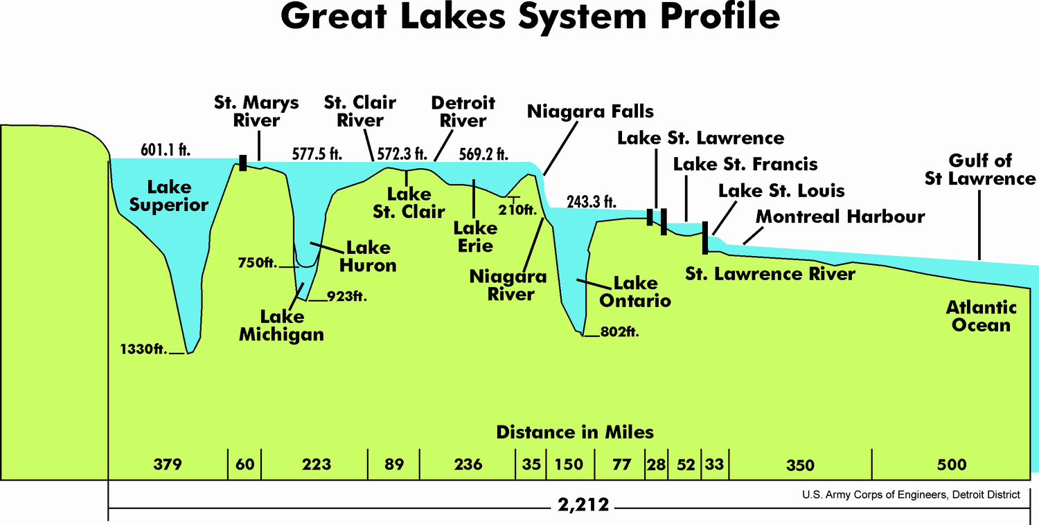
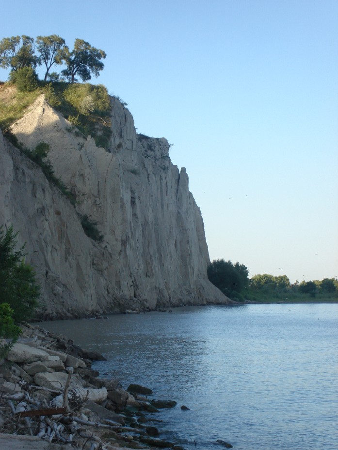
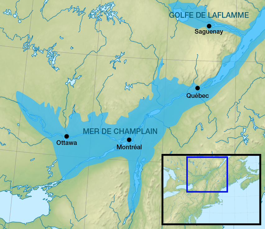
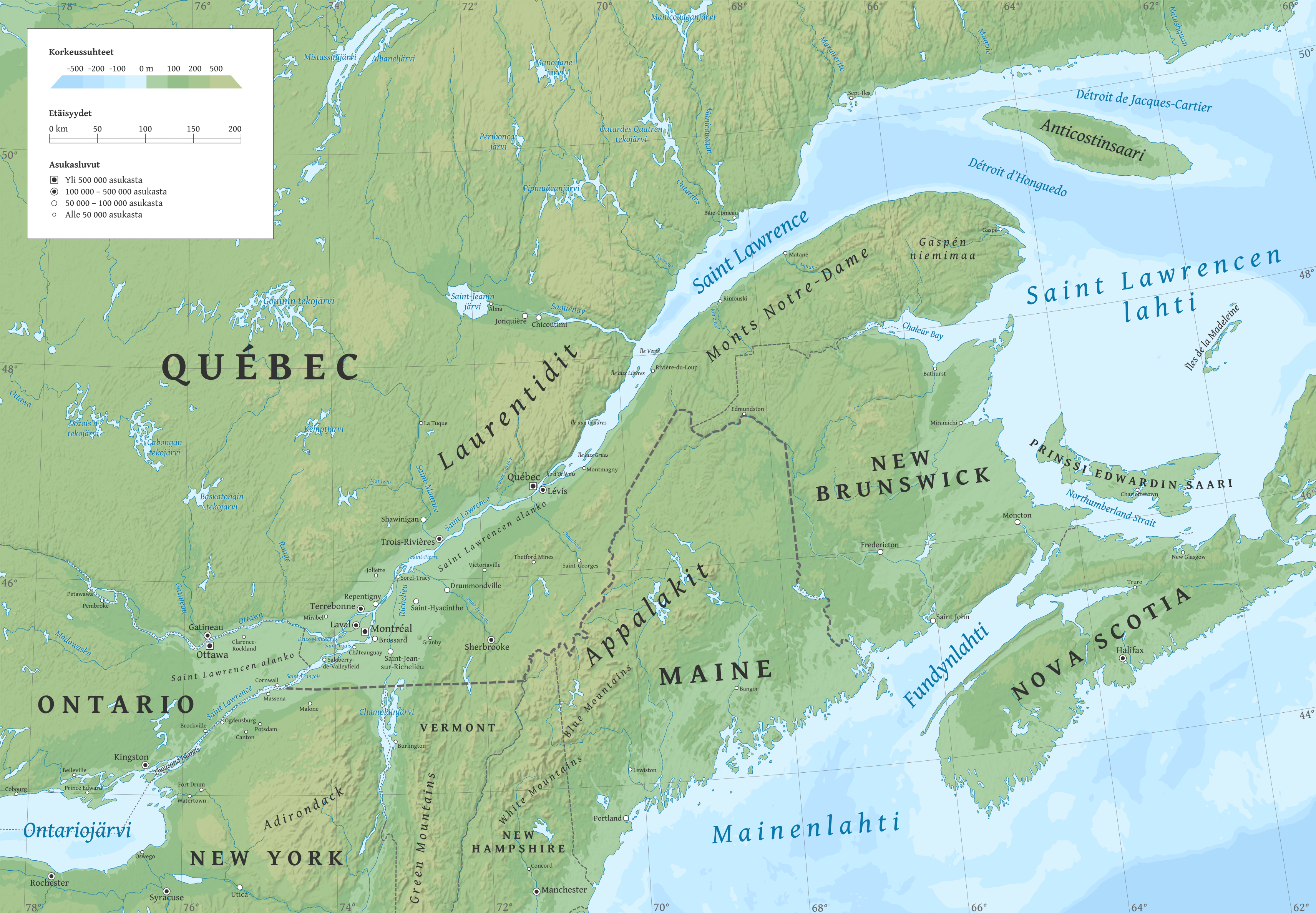
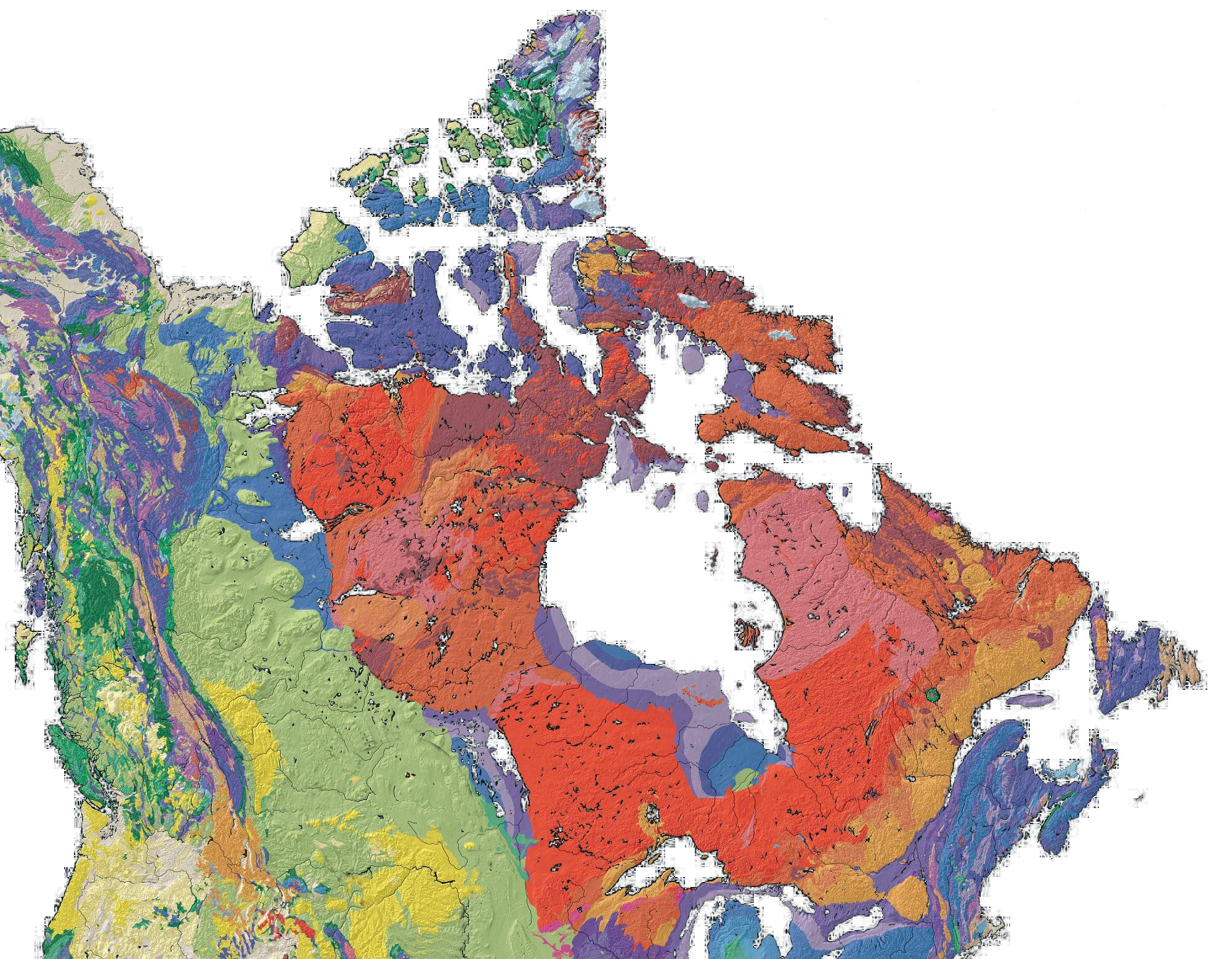
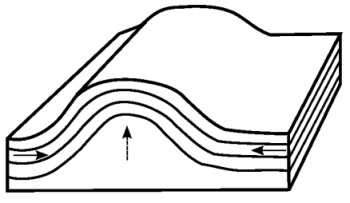
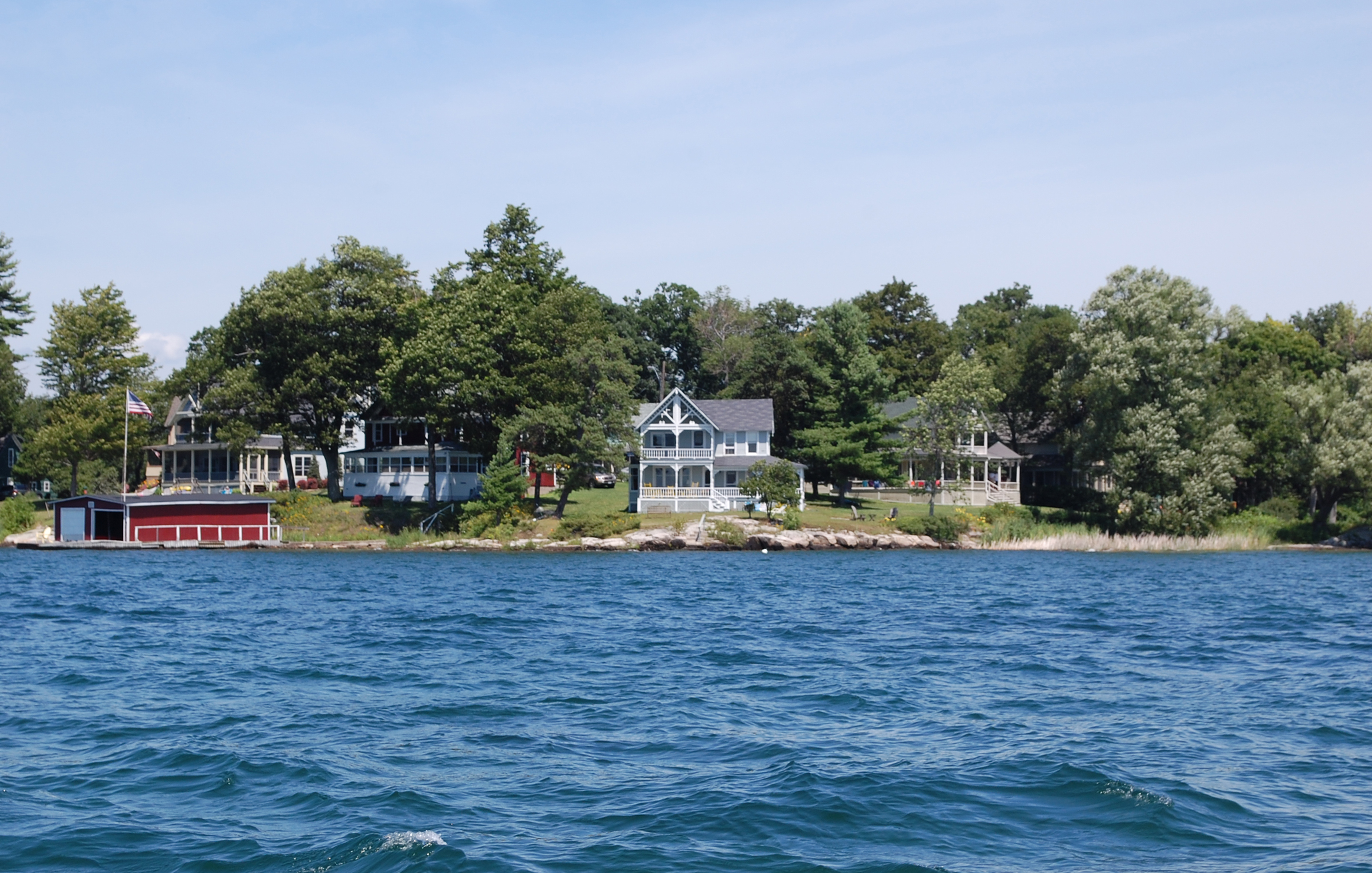
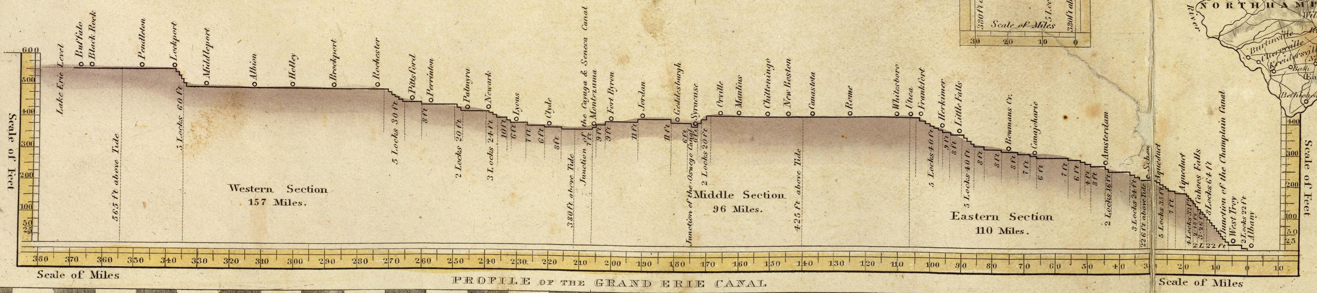
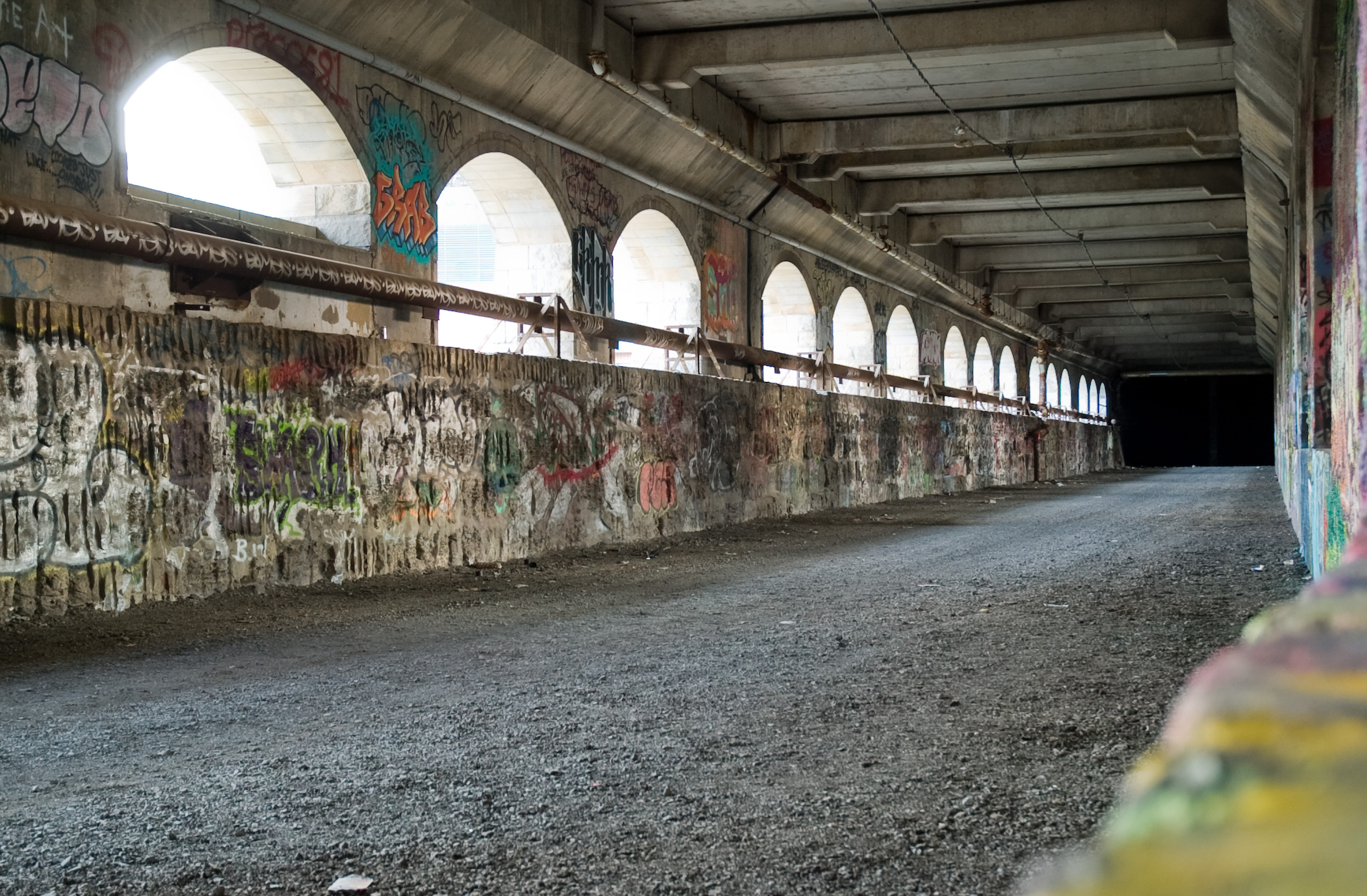
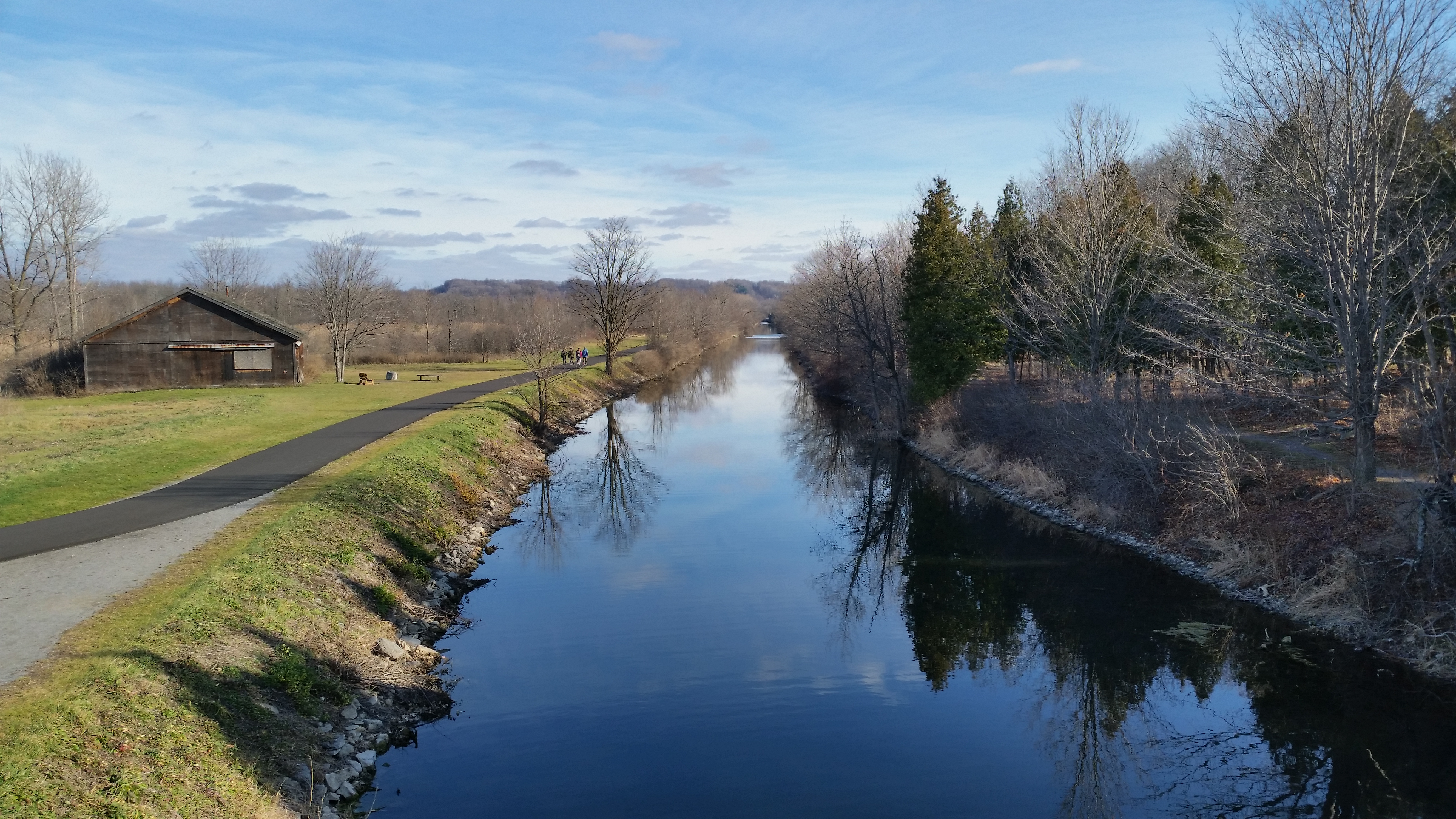
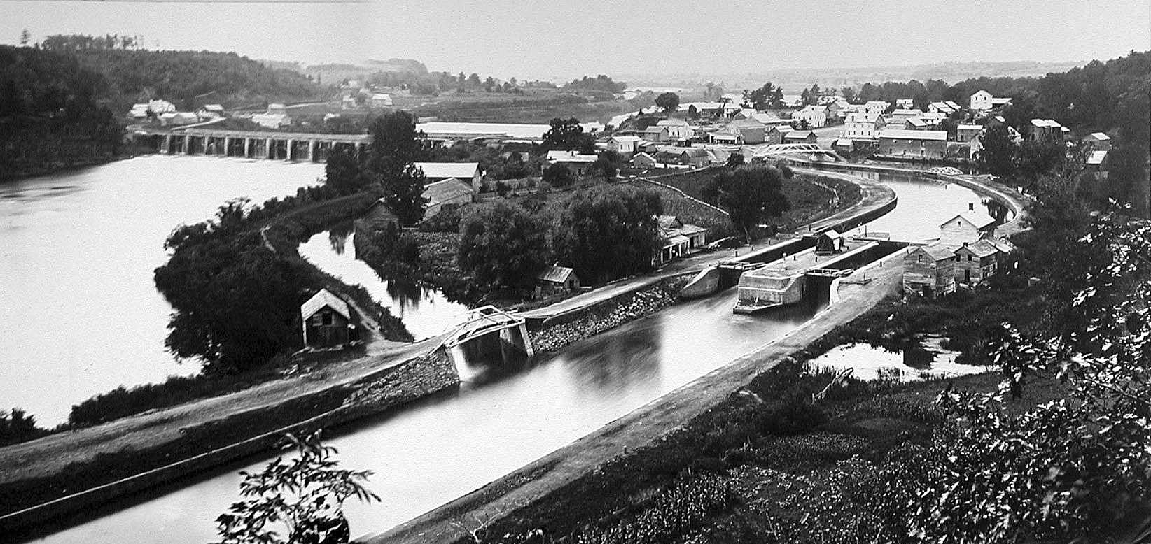
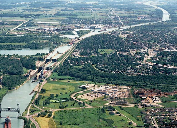
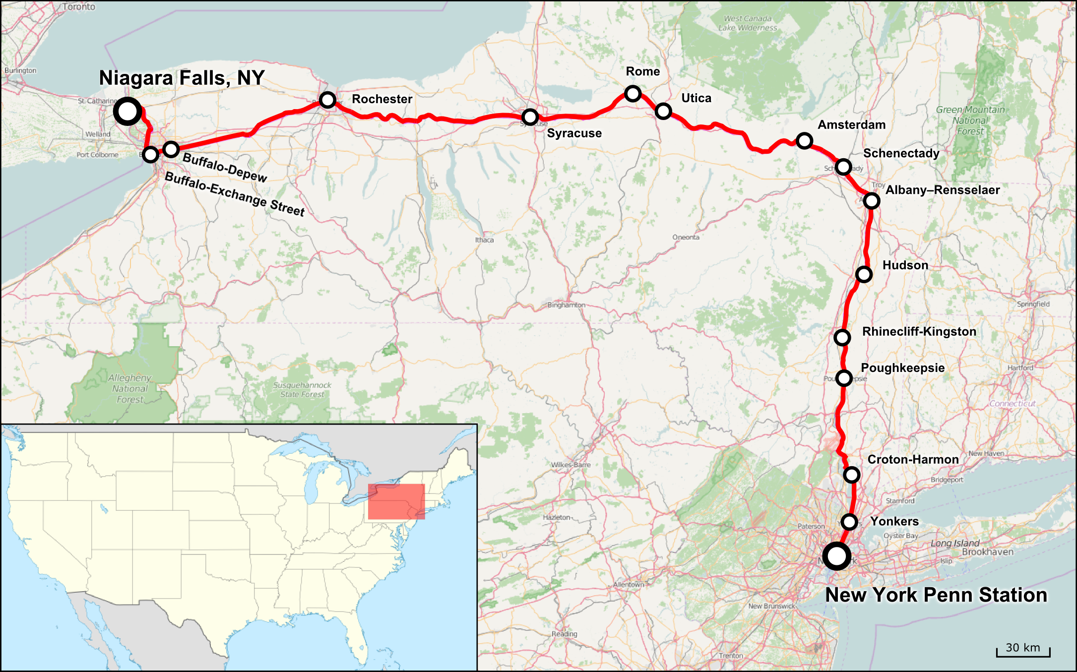
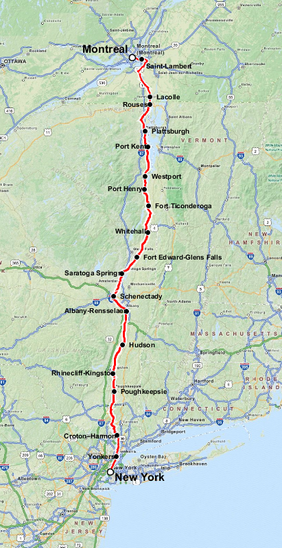