|
Reflections 2020
Series 3
May 3
Miami Downtown: Rail Renaissance
| | We've seen plenty of examples of how rail killed the canals for the most part in the 19C. Many canals that remain are often just for pleasure craft (thank goodness there's a good use). And who would have thought that by the mid 20C cars, if not killing the rails, would have beaten them down in submission? (Of course, planes didn't help either, but we're talking surface transportation here.) We saw the streetcar tracks down Flagler Street in Miami with cars on either side. Those streetcar tracks are gone, as happened in many places. Now, as we review what's been lost, rail is coming back, but it's not cheap to restore infrastructure. | | | | Of course not only local street car rail, but also intercity rail, including commuter rail, has also suffered horribly. You once could go almost anywhere by train, but the remaining choices are severely limited. Boston is an example of some old lines being brought back, perhaps with new extensions. But how about Miami? Miami exists because Flagler brought the FEC there. Compare that with the fact that in 1963, intercity and commuter rail passenger service had ended in Downtown Miami, and the city of Miami tore down its railroad station and tore up the tracks. Why? Because car drivers were complaining about blocked cross streets, since the tracks were at street level. And the last indignity cars imposed on rail was that the site of the station and tracks became parking lots for cars. Could that possibly be more ironic? | | | | But there's good news, which we got a preview of when talking about West Palm Beach. The two rail corridors from there to Miami now have commuter rail service, and it's getting even better. That can be added to the fact that Miami now has Metrorail and the Metromover. Today, Miami's in the forefront of rail restoration and expansion. | | | | Now the story can be confusing, so let's defuse it before we tell it. We'll be talking about two main locations. Today, there are what I can only call dual stations across the street from each other in Downtown Miami in the same location where Flagler's FEC station once was. And also, there's another rail station at Miami airport. And more plans are afoot. Rail news in Miami is heartening.
https://legacy.lib.utexas.edu/maps/historical/miami_fl_1919.jpg
| | | | Government Center We'll need a flashback in order to start at the beginning in 1896, but we can use our 1919 map from the last posting, which is close enough. While 1896, a very busy year in Miami, saw the Florida East Coast (FEC) railroad arrive, Miami incorporated, and Flagler's hotel built, the 1919 map is just sixteen years later and serves as well as any map to show Miami's early status. We said earlier that the railroad and station were on (Old) Avenue E, where it's now been reconstituted, altho the street now is called NW 1st Avenue (compare with Avenue D, now Miami Avenue, the base line). The map also shows the later rail extension south to the Keys, running across (Old) 12th Street, now Flagler Street, and therefore becoming SW 1st Avenue and moving on into Brickell.
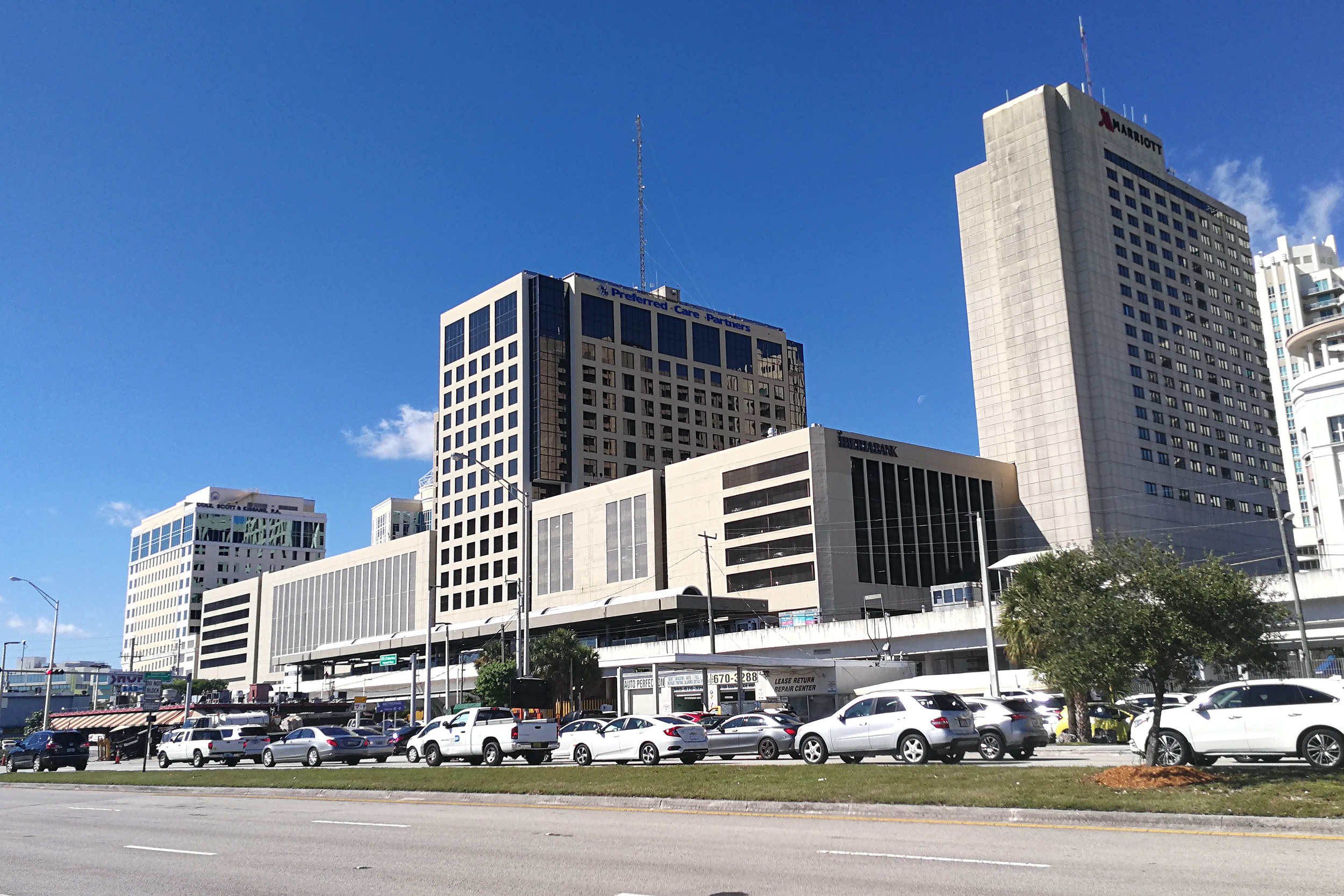
You can tell the basis for this neighborhood being called Government Center. We see here in 1919 a county courthouse, jail, and city hall right at the tracks at the corner of (Old) 12th Street/Flagler Street. However, Miami grew so quickly in these years of its heyday that all that was altered in the 1920s. The courthouse shown on the map (shown here as of 1923), was built in 1904, and was expected to be permanent, but it lasted just over two decades. With the city's growth, a new Courthouse, the present one, was built between 1925 and 1928, and included a jail. And that city hall on the map was one built in 1907, which also proved too small. Thus when the Dade County Courthouse was completed in 1928 (shown here c1933), it included the Miami City all, so everything on the map was in one building. As we know, tho, in 1954, City Hall was removed from the Courthouse to Dinner Key in Coconut Grove, where it remains today. Here we see again that the building had been the Pan Am seaplane terminal.
What is today named the Miami-Dade County Courthouse (Photo by Averette) is still visible in period pictures of the rail station. At 110 m (361 ft) and 28 stories, in its day it was the tallest building not only in Miami, but in all of Florida.
| | | | Original Miami Station The original FEC Miami Station that opened in 1896 included a wooden structure built later, in 1912, and was located on the FEC main line on the east side of NW 1st Avenue and NW 1st Street, directly to the north of the Courthouse across NW 1st Street.. It was not particularly impressive, and publicity photos always showed the Courthouse in the background, implying that that might actually be the station. This view shows passenger trains in the 1930s looking southeast toward the tower of the County Courthouse. The old FEC station, trains, and tracks are now gone. The station and tracks being located at ground level was a major part of their undoing. | | | | | | UPDATE: While we still have the old station in mind, let's project the scene today on that image. The modern, elevated Government Center station for Metrorail and Metromover has replaced the structures in the foreground of that last picture on the west side of NW 1st Avenue. The FEC station site on the east side of NW 1st Avenue is now becoming the Virgin MiamiCentral (one word) station for intercity rail, which will compliment the Government Center station across the street for local rail. For this reason, I call them dual stations. The stations have a bridged pedestrian passageway between them. More below. |
| | | | We can illustrate the original station further:
http://a4.pbase.com/o6/21/571721/1/77364321.hP50TGNk.1962_DowntownMiami_600H.jpg
http://swampysflorida.com/wp-content/uploads/2012/08/2012-0824-Miami-Railroad.jpg
https://a4.pbase.com/o2/21/571721/1/103253316.f0q70U7y.1950s_FECstation_rc03668_400H.jpg
The first link is to an impressive 1962 view north from the Courthouse with the whole FEC line visible on the left, and the station. The other two links face south, always to the ever-present Courthouse, one mid-level and undated, the other ground-level dated to the 1950s. It's fun to see the nearest traincar with the Florida East Coast name on it.
| | | | Do remember from an earlier posting that by the 1920s, the former Plant System had become Seaboard Air Line (SAL), and had a branch coming down just west of the FEC line from about West Palm Beach to Miami, forming two parallel rail corridors. Thus, SAL also started service to the FEC Miami station in 1927. When FEC ended its passenger service, this left SAL as the sole intercity rail in Miami, and this was the passenger service absorbed by Amtrak in 1971. This is why Amtrak trains follow the SAL inland route to Miami and not the FEC coastal route. The Miami station was regularly serviced until 1963, when it was closed, demolished to improve auto traffic flow, and was replaced by that quintessential urban eyesore, a parking lot. | | | | Later Stations But while Downtown had lost rail service, trains still did arrive in Miami. Intercity rail service stopped at what became a decaying terminal in the Allapattah neighborhood to the north and west of Downtown at NW 22nd Street and NW 7th Avenue—just count the streets and avenues to see how far away it was. But because that station was in decline, in 1978, Amtrak moved to its current location adjacent to Hialeah, even further away, but right along the SAL rail corridor. The current Amtrak Station (Photo by Phillip Pessar)—you can see the platform roof behind it (click)--is way to the north, at NW 37th Avenue, and way to the west at NW 83rd Street. Again, just count the streets and avenues. This "Miami" Amtrak station is quite nice, but it could hardly be further out in the boondocks. It's in a semi-industrial neighborhood—but out front it does have a large parking lot! (I hope you see the sarcasm in that statement.) | | | | Local Rail And so there was no rail service in Downtown Miami after 1963. That lasted for two decades, and Flagler, who'd supplied the rail, and Tuttle, who'd supplied the land, must have been spinning in their graves. But then a rail renaissance came to Miami when Metrorail came to Downtown in 1984 and Metromover in 1986 (extended in 1994), and Miami has since become one of the leading cities of the "return to rail" movement we've been noting in recent decades, both in local urban/municipal rail and commuter rail.
But don't think in terms of subways. Florida, as we said in the beginning of this series of postings is low-level and prone to flooding. I doubt that the soil would support such construction, anyway. And of course, forget putting railroads on the surface, which eventually caused the 1963 automobile issue with Flagler's tracks. (Possible light-rail streetcars in dedicated lanes are another story, tho. See below.) Both Metrorail and Metromover are elevated systems, away from any conflict with car traffic. Being relatively new systems, ALL stations have elevators and escalators (as well as stairs) for easy access.
And don't think these systems are run by the city of Miami. Given the nature of the region as we've discussed it, they're run by an agency of Miami-Dade County called Miami-Dade Transit (MDT).
| | | | Metrorail Metrorail is the heavy-rail rapid-transit system on standard-gauge track. It opened in 1984, and it is Florida's only rapid transit metro system. This is a map of Metrorail (Map by Howchou). You may want to hold on to a copy of the SAME map in a separate window for further study:
https://upload.wikimedia.org/wikipedia/commons/thumb/c/c2/Miami_Metro.svg/1000px-Miami_Metro.svg.png
In the approximate center of the system is a small rectangle indicating the main station at Government Center (on the west side of NW 1st Avenue), but it also shows the importance of the Brickell station, since Brickell has become so developed and serves as the main financial center. This is a northbound Metrorail train (Photo by FrickFrack) at Government Center station with the courthouse in the background, as in the past.
As you see, Metrorail presently has two lines—sort of. The Green Line runs the length of the entire system. In addition to downtown, there is now a rail station at Miami Airport, served by the Orange Line. But practically speaking, that line only runs one stop, out of Earlington Heights. But perhaps half the trains coming from the south do run directly to the airport, so the Orange Line is considered a second line. Of course, to go to the airport you can also change from the Green Line at Earlington Heights for one stop, so the issue of "two lines" is somewhat moot. This is a train on the Orange Line (Photo by Alancrh) having arrived at the very modern Miami International Airport station. Click for detail.
| | | | Metrorail tracks are mostly elevated. There are three short sections that are not elevated, and all involve crossings under superhighways: (1) descending under I-95 between Vizcaya and Brickell stations; (2) descending under I-95 again just east of Culmer station; and (3) descending under the Palmetto Expressway going west into the Palmetto station. In each of these brief instances, the tracks are on ground level, but do not conflict with road traffic. | | | | If you compare Metrorail routes to the Miami grid, you'll see the quirk that Metrorail serves exclusively the NW quadrant and the SW quadrant, roughly in equal measure, which again illustrates how small the NE and SE quadrants are. Also note that it serves Brickell as a center-city station, further illustrating the fact that Brickell has become an alternate downtown; perhaps that's better phrased as a twin downtown. | | | | In the NW quadrant, note the station here called "Tri-Rail". Actually, that station has a much longer, but more accurate, name. It's the Tri-Rail and Metrorail Transfer station, since the two systems cross there, and form a transfer point. At 3-4 blocks away, it's also the closest station to the Amtrak station, and is the one we'll be using, so we'll talk more about it at the time. | | | | In the SW quadrant, after Brickell, you'll notice stations at Vizcaya and Coconut Grove, a couple of familiar names. But if that makes you suspicious of something, you'd be right. Metrorail here follows Flagler's FEC right-of-way (Photo by Dtobias) going down to Homestead and Florida City, and at one time, to the Keys and Key West. And the irony is, while FEC trains had been on the surface, Metrorail is up in the air! This means that the former FEC right-of-way from Miami to Florida City is still serving the public—but on the ground below the elevated. | | | | You'll note that Metrorail ends at two stops named Dadeland, which is a neighborhood centering on the 1962 Dadeland Mall. This outstanding view looking south shows a Metrorail train T (Photo by Alancrh) departing Dadeland North for Dadeland South. Try to picture Flagler's trains instead on the right-of-way down below going all the way to Florida City and even to Key West. Unfortunately, Metrorail was never built all the way to Florida City (but could it possibly be extended in the future?). | | | | On the left in the picture is (South) Dixie Highway leading to Homestead and Florida City. As US 1, it goes beyond to the Keys and Key West, a route we'll be driving and talking about when we get to the trip narrative. Click for detail, and also to note the pathway with yellow markings before and after that large grove of trees, which runs both under and next to Metrorail. The former FEC right-of-way itself is now being developed into a nearly contiguous bicycle and pedestrian trail called the Underline (nice name), which was built in 1984 from Brickell to Dadeland South along with the Metrorail system.
https://www.theunderline.org/wp-content/uploads/2015/07/JCFO_Underline_Brickell-Backyard_existing-e1436454908406-1408x960.jpg
https://cdn.vox-cdn.com/thumbor/3PoBS2cyVwTrK4itefAtTAgNHqY=/0x0:3301x1823/1200x800/filters:focal(1387x648:1915x1176)/cdn.vox-cdn.com/uploads/chorus_image/image/61836739/JCFO_UNDERLINE_04_BRICKELL_BACKYARD_OOLITE_ROOM_PROPOSED.0.jpg
| | | | The first link shows the right-of-way as it's been for some time. The second link shows how the same spot is planned to look when the project's completed. It'll be a linear park as in several cities, notably like New York's High Line. As a matter of fact, the firm that converted the High Line into a park is the one designing the Underline.
This is the last Metrorail stop at Dadeland South (click), dwarfed by tall buildings, and as seen from the Dixie Highway (Photo by Alancrh). Here we can take a look at the interior of a Metrorail car (Photo by https://www.flickr.com/people/vxla/).
At SW 88th Street, between North and South Dadeland, the Underline becomes instead the South Dade Rail Trail, which then continues to follow the old FEC right-of-way down to Krome Avenue in Florida City.
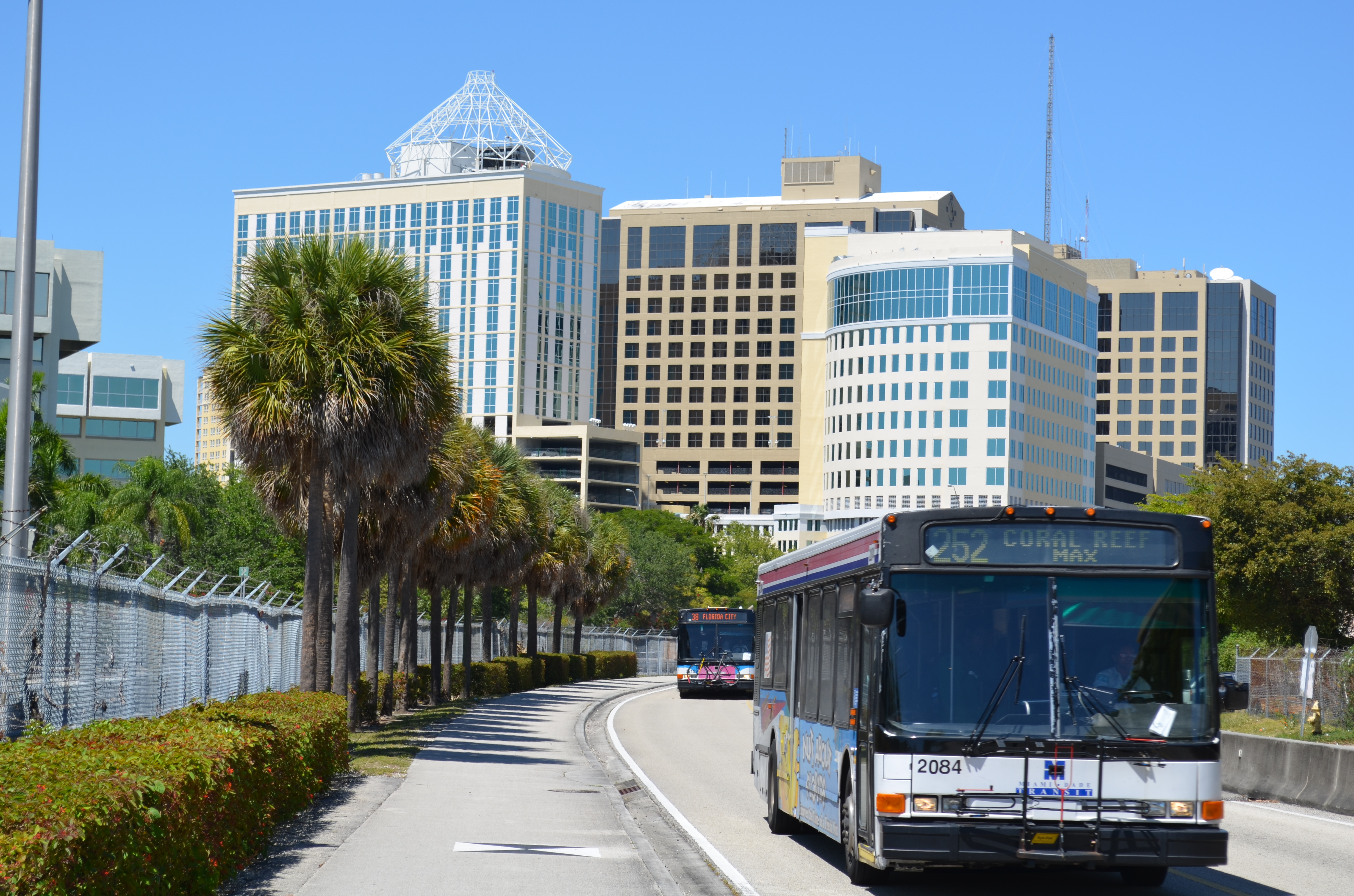
Tho Metrorail ends at Dadeland, the South Dade Rapid Transit Transitway--more accurately, a busway, but "transit" sounds fancier--serves as an extension of Metrorail, running alongside the South Dade Rail Trail from Dadeland South, all the way to Florida City. It's also parallel to Dixie Highway. It began operating in 1997 and was extended in 2005, with the final segment extension to Florida City taking place in 2007. The 13-mile (21 km) roadway was built by the Florida Department of Transportation (FDOT) just for Metrobus routes and emergency vehicles. Express buses on the exclusive lanes shuttle passengers between Dadeland South and Florida City in under 40 minutes.
| | | | This view looks north on the busway (Photo by B137) toward South Dadeland, which is located at roughly SW 91st Street. Routes labeled as MAX (Metro Area Express), are limited stop services—call them expresses. While the 252 MAX bus in the foreground (click) is going to SW 152nd Street, which is only part way down the busway, the 38 MAX behind it is going all the way to SW 344th Street in Florida City (yes, the street numbers do go that high). | | | | Unlike Metrorail on high, the busway has no grade separation, therefore there are several at-grade crossings with main roads. This is a level crossing (Photo by B137) at SW 128th Street, looking south. Next to the busway cheek-by-jowl is the bike route, the South Dade Rail Trail, and to the left you see how close Dixie Highway is. | | | | The busway has been the site of many accidents, as some car drivers driving south on Dixie Highway and looking to turn right (west) do not stop at the red arrows that govern the right turn lane at an intersection that has a busway crossing adjacent to it. They make a right turn and go right into the path of a bus that is entering the intersection. Buses currently must slow down to 15 mph (24 km/h) before crossing the intersection, and the police often patrol the intersections looking for red arrow runners. Surprisingly, even the intersections on which the busway runs as far as two blocks west of Dixie Highway suffer the same problem, with car drivers not seeing or flatly ignoring the red lights at SW 184th and 186th Streets. City planners and residents alike have commented that rather than dismantling what was left of the former FEC rail line for the busway, the Metrorail system could have been extended southward over the railway line. Amen, but there's always hope for the future. | | | | | | Actually, a surprisingly simple solution has been suggested to extend Metrorail to Florida City. Since it's the elevated structure that obviously drives up costs, how about using surface rail?
https://www.miamiherald.com/latest-news/801ceg/picture104555206/binary/09-28-Metrorail.jpg
This is a map published in the Miami Herald in 2016 (click) based on information it got from the county. Two corridors were found that could benefit from having Metrorail trains gently descend from the elevated structure to run at ground level. As the map explains, one could go north to NW 215th Street, which is on the county line. It could start where shown, but it's also suggested it might also start at the Airport station before following this route.
And most interestingly, the other could go south along the busway to Florida City, just to the side of US1, which is Dixie Highway. A limited number of grade crossings could be allowed this far away from Downtown, or at more expense, could be eliminated.
|
| | | | Metromover We now come to the other train system, the Metromover, which is quite different and in some ways, more fun. It's a free mass-transit automated people mover, also operated by Miami-Dade Transit. It is totally elevated above-ground. As our earlier rail map shows, Metromover connects directly with Metrorail at both Government Center and Brickell stations, but you can see it better in this detail map (Detail Map taken from original design by Howchou, updated). Again, for easier reference, here's the link to the SAME map:
https://upload.wikimedia.org/wikipedia/commons/thumb/c/c1/Metromover_system_map.svg/1000px-Metromover_system_map.svg.png
| | | | On first view, the system is much more petite than that of Metrorail. That said, just as we noticed that Metrorail serves exclusively the NW and SW quadrants, do note that Metromover serve almost exclusively the NE and SE quadrants. Obviously the two stations where they connect are on the west side, as is Wilkie Ferguson station. Both the Miami Avenue and 3rd Street stations straddle Miami Avenue, the border. All the other stations are on the east side. | | | | You'll recall I was suspicious that Chaille copied his quadrant system from Washington DC, and I turned out to be right. Now the most obvious thing about the Metromover system map is that it's based on a loop that encircles downtown. No one has pointed the following out, but I feel confident that the builders of the Miami Metromover took inspiration from Chicago.
https://www.evl.uic.edu/aej/424/pics/ctatrainmap.png
| | | | Since the end of the 19C, downtown Chicago has been encircled by an elevated loop of heavy-rail trains. The structure is called the "el" for "elevated", tho some interpret the name as the letter "L" (see map), which is cute, but makes no sense. This rail loop is called The Loop, and has also given its name to downtown Chicago, a neighborhood that in turn is called The Loop. Note in the above map and its detail how numerous outlying lines enter central Chicago, distribute (and pick up) passengers by circling the Loop, then leave again whence they came. It's much more massive and extensive than Miami's Metromover, but you cannot convince me that Miami didn't copy Chicago. | | | | Now inspect the Metromover map. Its loop is a pair of tracks—actually guideways (see below)—that largely encircle Downtown, which I continue to roughly define as once being the extent of Julia Tuttle's property. Look at the blue loop called Inner Loop, which opened first, in 1986. Those trains run exclusively clockwise and never leave the loop. In 1994 there were two extensions of the system, the Omni Loop and the Brickell Loop. Those trains run exclusively counterclockwise and, at appropriate points, leave the loop, the Omni north and the Brickell south. So when you arrive at any loop station, if you're going clockwise, there's no problem. If you're going counterclockwise or are going north or south, check one of the prominent electric signs to see where the next train is going.
I have to add that I have absolutely no explanation as to why the loop splits in two at the stations at Miami Avenue (at 1st Street) and 3rd Street (at Miami Avenue), which limits choices at those stations, tho they're only two blocks apart. I must say that I get very cynical and suspicious when I see something like that. Could politics have played a role? I don't know.
| | | | Until 2002, the Metromover had a nominal fare of 25 cents. The fare was lifted because it was realized that the cost of collecting the fare nearly exceeded the revenue generated from the fare, which I find absolutely hilarious. But then, there's always the fact that more Metromover ridership would likely lead to more Metrorail ridership.
The inner loop generally runs tandem two-car trains while the outer loops only run single-car trains. Each car can carry over 90 passengers. I remember seeing a sign at the last top in Brickell that the two outer loops can be combined "when needed". I don't know when that would be needed, but it would be fun to see the system run as one from north to south.
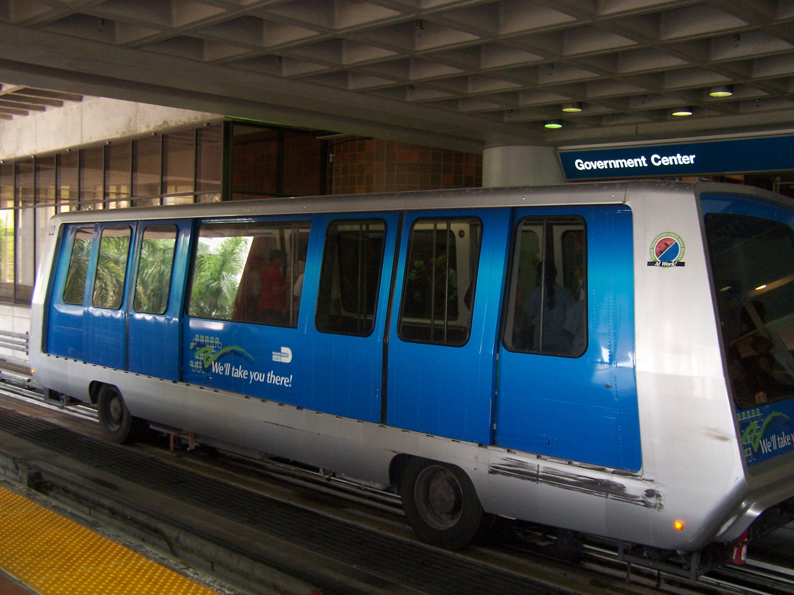
| | | | Let's get some definitions. The Metromover is a people mover, which is transit on a fully automated (driverless), elevated guideway. The guideway guides the vehicles just as tracks do in rail systems. The vehicles often have rubber tires. I first encountered them in NYC, where one connects the LIRR at Jamaica Station to all the terminals at Kennedy airport, going around a loop when arriving at the airport. Another one connects a NJ station with Newark airport, doing the same thing. Both of these have regular seating. Most recently, we talked about the people mover at De Gaulle Airport in Paris (see 2018/5, Ctrl-F: CDGVAL), in which passengers stand for the short trip. That's the style of Metromover in Miami, whose interior (Photo by Ed Webster) has only minimal seating at each end of the car, since the trips are also quite short. But there's also a rail beneath the windows (click), which I call a butt-rail. Along with the sill behind it, it allows you to semi-sit while standing. It does work. While "taking a load off" is best, taking half a load off is better than nothing. Some stations in the Paris Métro and RER without benches have similar sit-stand waiting areas. | | | | This is a single-car Metromover train (Photo by Miami92) waiting on the lower level of the Government Center station. Notice the rubber tires, similar to certain lines on the (heavy-rail) Paris Métro. And this is a double-car Metromover train (Photo by Ed Webster) en route. Notice the guideway and the rubber tires moving along it. | | | | When we get to our visit and the narrative, we'll ride around the Metromover loop and to Brickell. But I'd like to quote something from nine years ago. In the last posting, I mentioned the 2011 trip where I stayed in Coral Gables for the first time, then worked my way to PortMiami to sail on the Regatta to the Amazon and back, a voyage where I met some people I'm still friends with. Here's a transportation quote from 2011/12: | | | | | | I was also determined to ride the Miami Metrorail and Metromover, which I’d watched being built over the years, but always without participation. I’d decided to travel from the airport via Coral Gables to the ship just by public transportation. After having checked online about fares and routes, I simply took the 42 bus from the airport directly to Coral Gables City Hall, which could not have been easier. The next morning I took it again on to the Douglas Road station of Metrorail . . . It was only four stops to downtown at the Government Center Station. . . . I had plenty of time, so I rode both the southern loop of the Metromover, which has nice views down over the Miami River, and the northern loop. In the central area of the loops I had a nice, elevated view out in the harbor of large Dodge Island, the passenger ship docking area . . . When I was ready to make my travel move, I found that bus 243 out to Dodge Island didn’t run on weekends--a fact not pointed out on the website--so I hailed a taxi on Biscayne Boulevard for the five-minute ride to the ship. |
| | | | I'm glad I'd written all that down. I do remember hailing the taxi, something I usually do not like to do where there is public transportation. I do remember riding Metrorail, and slightly remember Metromover to Brickell. But I have absolutely no recollection of having been at Government Center station and also having ridden all the way to the north. That's what travel diaries are for. | | | | Miami Overland Connections Let's now move away from local rail and back into intercity and commuter rail. There aren't many possibilities. For roads, some will say three, I say two. I view the Keys and Key West nowadays as an appendage to Miami. While some fly to Key West and a few cruise ships stop there (there's no coastal ship service) Key West relies on its umbilical cord to Miami, once by Flagler's train, today by road. It's a unique situation involving metropolitan Miami's south side. If traveling by land, you have to go to (or at least around) Miami to get to Key West.
That leaves two road routes to Miami, from the west via the Tamiami Trail and from the north—the main connection--by several roads. And when it comes to rail, given the Keys rail service is now gone, there's only one way to reach Miami, from the north, where we have two rail corridors, as discussed in the Palm Beach posting. In this regard, Miami hangs like a yo-yo from its connections to the north.
| | | | Two Rail Corridors Let's review the two rail corridors we talked about in West Palm Beach. Miami's NW 37th Avenue is the route of the former Seaboard Air Line (SAL) line, now the state-owned South Florida Rail Corridor, a bit further inland than the other corridor, with the Amtrak Station lying directly on the tracks of this main line. Also on that corridor are the Tri-Rail commuter trains that we discussed in West Palm Beach.
http://www.mobilemaplets.com/thumbnails/4152_thumbnail-1024.jpg
Note how it crosses Metrorail at the above-mentioned Transfer Station. Otherwise, that line has, since its start in 1989, led to the Miami Airport station, as shown. More on that below.
http://s3.amazonaws.com/floridatrend/11515/rail-service-from-miami-to-orlando.jpg
| | | | Just a short bit closer to the shoreline is the Florida East Coast Rail Corridor, which is still privately owned by the successor company to the FEC. As the above map shows, West Palm and Miami are now also connected on that corridor—via Fort Lauderdale--by express trains of Virgin Trains USA (the former Brightline). This route does lead to Downtown Miami, to the new Virgin MiamiCentral station built after 2014 by Virgin on those former parking lots, since the FEC successors still own that land. This complex is still on the FEC main line at NW 1st Avenue, but extending further north than the original station, up to NW 7th-8th Street. | | | | | | Note: This is an express route serving just the three stations mentioned. To update what the map says, they are all now built. Virgin will be extending this service up the FEC line and building a perpendicular connection to Orlando Airport (due to open in 2022), where there'll be a fourth station. There are also plans to further extend service up the FEC line to Jacksonville, which would mean that Saint Augustine, as we discussed it earlier, would regain direct rail service.
In the Palm Beach posting, we also mentioned that Virgin Trains was also building a link to PortMiami. We'll discuss that topic separately at another time.
|
| | | | Miami Stations Today So we now see that rail is thriving in Miami, with an airport station and dual stations downtown, facing each other across NW 1st Avenue. We need to refer again to the "Moon" map from the last posting:
https://i.pinimg.com/736x/91/ac/e2/91ace2c3429ed92c23b9a7b6a489d2f8.jpg
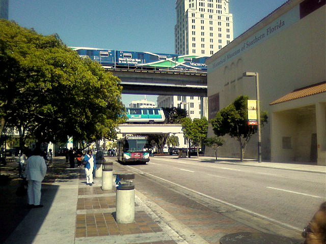
Find the local Miami rail hub at Government Center station at, as we know, NW 1st Avenue and just above NW 1st Street, opposite the HistoryMiami museum (running two words together seems to be the fashion, à la MiamiCentral and PortMiami). The elevated station serves as a transfer point for Metrorail, Metromover, and Metrobus, and thus accommodates purely local service. I don't have a decent picture of the building itself, which is frankly rather nondescript, but look at this very interesting view along NW 1st Street (Photo by Johnnyjoe23/FrickFrack). We're looking east, with the history museum on the right (south) side and the entrance to Government Center station on the left (north) side, hidden behind the trees. No surprise, the Courthouse is in the distance on the southeast corner of the intersection. But look at what we have! Metrorail is crossing above, Metromover is crossing in the middle, and a Metrobus is arriving at the station. This view shows everything! In addition, on our last day of the trip, we'll be on an express MAX bus coming from South Beach in Miami Beach, and it will let us off at the station EXACTLY where that bus is about to stop.
| | | | Across NW 1st Avenue, on the east side, where Flagler's original Miami station used to be, is now Virgin MiamiCentral, built by Virgin along with its commuter line, and is for longer-distance rail. It's too new to be shown on the "Moon" map, so use this one:
https://virginmiamicentral.com/wp-content/uploads/2016/08/MC_MASTER-MAP_EARTH-TONES-WITH-NAMES-FOR-SITE-NOV-2016.png
This map shows Metrorail and Metromover for reference only, since its main purpose is to show the former Brightline, now Virgin Trains USA, as it comes down the FEC corridor from West Palm Beach. While it shows Government Center on NW 1st Street, you see that MiamiCentral is part of a major real estate development with tall buildings, and will include a multi-level retail and food and beverage hub, along with office and residential space. This complex stretches from NW 1st Street to about NW 7-8th Streets. While the station is completed in that complex, much of the rest is not. The MiamiCentral station is also elevated to avoid street crossings, and the southern part of MiamiCentral is directly connected to the Government Center station via a pedestrian bridge over NW 3rd Street.
| | | | This is a view of Virgin MiamiCentral station (Photo by Phillip Pessar). Click to see the entrance sign behind Virgin's boastful use of the letter V as part of the structural element. | | | | | | It's very rare for two stations to be across the street from each other. I think of the Gare du Nord in Paris, just about two blocks away from the Gare de l'Est, but this is even closer. Government Center station is public and Virgin MiamiCentral station is private, but it would be nice if the names were at least unified. Calling them both Miami Central (TWO words) would be nice, but Virgin has so branded itself on the station, with the name and the V, that that would seem impossible. |
| | | | This is a Brightline train en route (Photo by BBT609), and here's one at MiamiCentral (Photo by Phillip Pessar). The Brightline livery is, well, bright. It has to be assumed that the Virgin Trains livery will be different when the rebranding is complete. | | | | The rebranding is scheduled for mid-2020, but the use of Virgin Trains' name is largely cosmetic. The railroad is owned and operated by an investment group, and the Virgin Group provides branding rights and acts as a minority investor. Virgin Trains USA began operating in January 2018. It's the only privately owned and operated intercity passenger railroad in the US.
http://www.orangesmile.com/common/img_city_maps/florida-map-0.jpg
Here's our FL map again to see how the system is growing. Boca Raton has been chosen to be added as a stop in 2021, and Aventura, which is in the NE corner of Miami-Dade county just south of Hollywood, is to be added as a stop, with service by 2022. Virgin Trains USA is in negotiations with the Florida Department of Transportation to lease a right-of-way along the Interstate 4 corridor (see map). This would be used for an extension of the line from Orlando International Airport to Downtown Tampa. Potential stops along this route would include Walt Disney World and Lakeland.
| | | | Miami Airport Station As mentioned earlier, aside from the dual Downtown stations, Miami now has a station at Miami International Airport, built on the SAL corridor. As it serves both Tri-Rail and Metrorail, it's both for local and commuter rail. However, since it also serves public and private bus lines, the bureaucrats have insisted on naming it the Miami Intermodal Center (MIC). I, and others, regard that as bureaucratic rhetoric, and will continue to call it the Miami Airport station. I wish bureaucrats would pay more attention to common, everyday usage.
https://www.transportation.gov/sites/dot.gov/files/TIFIA_Miami%20Intermodal%20Center%20Schematic.jpg
We saw on an earlier map that the airport is outside the Miami city limits. The station is shown above in yellow, with Tri-Rail coming south on the light blue line (the SAL corridor) and Metrorail coming from downtown on the dashed gold line. (Highways are in dark blue.) The station is located between NW 21st & 25th Streets along NW 37th Avenue (Douglas Road), which places it 37 blocks from downtown. The airport is west of the station, beyond the rental car center (in red) and on the other side of NW 42nd Avenue (Le Jeune Road).
| | | | Actually, there's a third rail connection, the thin green line going from the station to the airport. It's an automated people mover called the MIA Mover, named after Miami International Airport.
https://www.royalrentacar.com/ViewImage.ashx?ImageType=6&Key=3&ext=.png
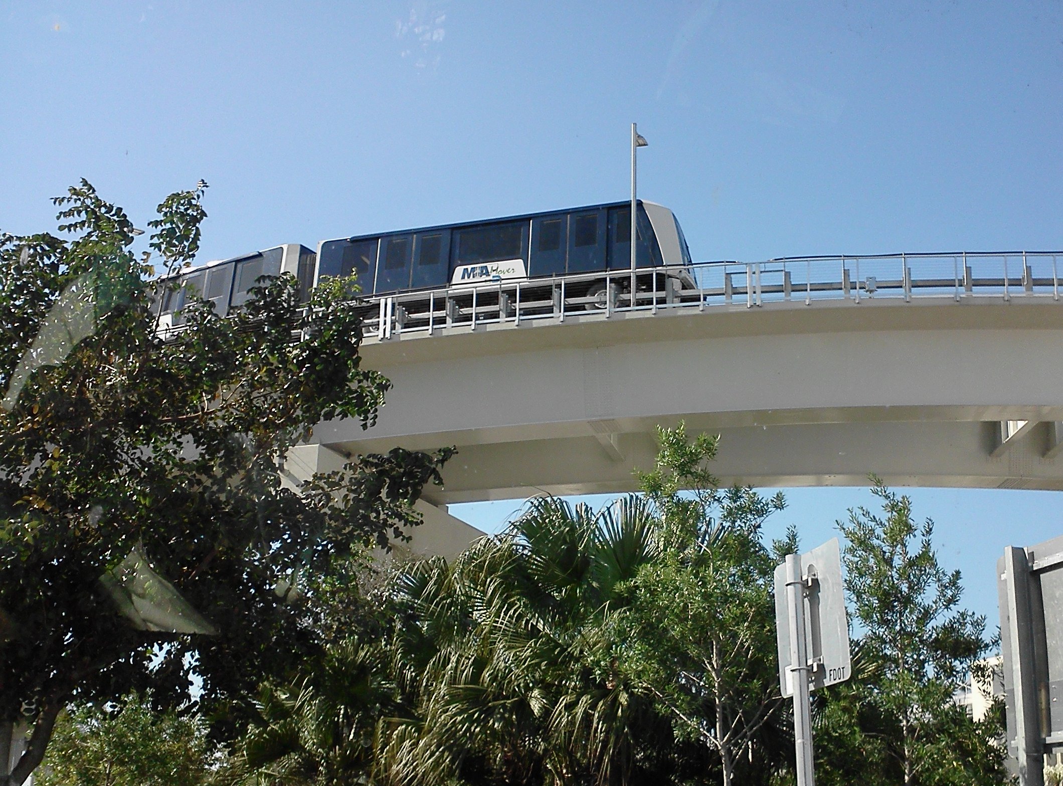
This detail map shows the route of the MIA Mover more clearly. It's purely a shuttle, with just two end stations, traveling between the rail station and the Main Terminal in about three minutes. I understand there are two other people movers completely within the airport. This is the MIA Mover en route (Photo by Patriarca12) and here it is on high, approaching the rail station (Photo by Daniel Christensen). Click to see the rubber tires.
| | | | | | Tho I've had flights connect at Miami Airport, only once did I use the airport to actually visit Miami, more exactly, Coral Gables, as mentioned above. It was in 2011, which was also the only time I sailed via PortMiami, on the Amazon cruise. I'd been in Tampa and flew into Miami to stay and dine in Coral Gables. At the end of the cruise I flew from Miami back to NYC. I mention this because that trip was mid-March to mid-April 2011, while the MIA Mover only opened in September that year, so I never got to experience it. I used Metrobuses both ways, which connected directly at the terminal. |
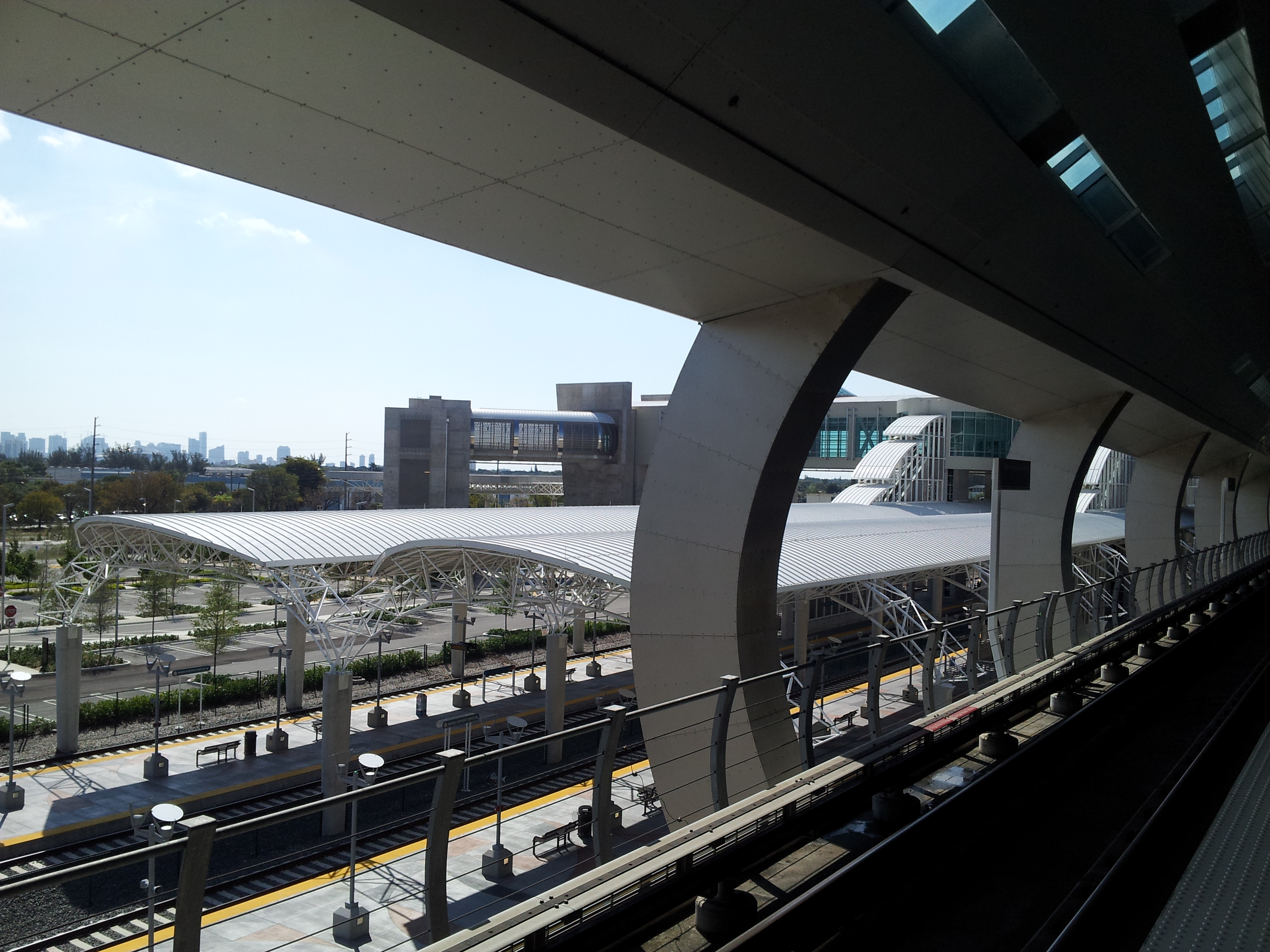
| | | | I don't have a photo, but a rather good sketch of the Airport Station. We're looking west, and the MIA Mover (in blue) is arriving from the terminal around the car rental facility, with an overpass accessing other trains. The Metrorail station is of course above ground, and is the first line perpendicular to the overpass, followed by the canopies for the Tri-Rail platforms on ground level. All trains point north, to the right. This is one of the newer Tri-Rail trainsets at ground level, looking south, and this is another angle showing Metrorail above (Both Photos by Phillip Pessar). For the reverse view, this is looking southeast from Metrorail down to Tri-Rail, with the Miami skyline in the distance (Photo by John Petito). | | | | | | Since the Orange Line to the airport is in fact only one stop long, it's been proposed to lengthen it.
https://pasarelapr.com/images/miami-railroad-map/miami-railroad-map-16.jpg
From the Airport rail station, it would swing south of the airport westbound. Tho this map suggests it could run as far as SW 137th Avenue, newer thinking suggests it should only run to FIU/SW 107th Avenue, and then turn south to the university.
|
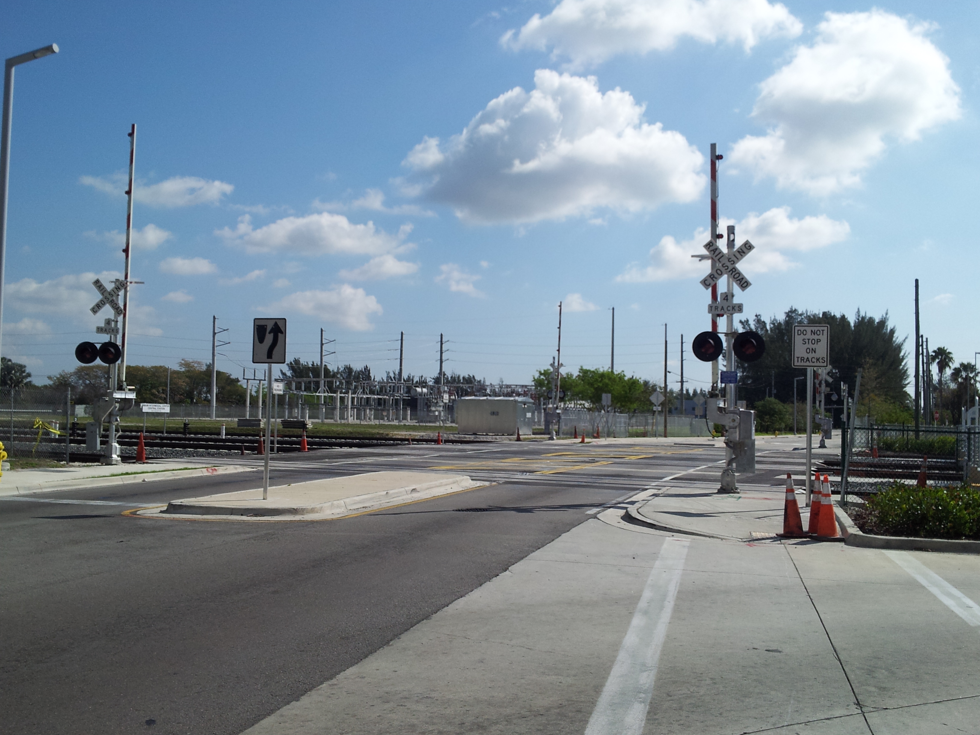
| | | | Oops! Knowing that the Amtrak station lies directly on the SAL corridor with Tri-Rail, it would seem logical that it would be very easy to close the Amtrak station and have its trains serve the airport further south instead. Tho it seems to me that most train passengers who needed airport access would have flown to Miami in the first place to make the flight connection, there's always the argument that Amtrak passengers could have used Metrorail to access Downtown, for a two-seat ride. | | | | As plans for the airport station were being made, Amtrak had agreed in principle to move to the new station and had approved necessary dimensions. Usually, Amtrak Florida trains have nine cars, which require 1,030-ft (310-m)-long platforms, and the platforms at the new station would be of the required length. Then in February 2012, someone at Amtrak woke up to a problem. In winter, when more people want to come to Florida, Amtrak runs longer trains that need 1,220 ft (370 m) of platform length (my calculations show that to be roughly 1-2 extra cars), which is too long for the platforms. Oops. | | | | Return to the map of the airport station and find NW 25th Street, which forms its northern limit. This was the point of conflict, since extending platforms would block it. When the problem was first announced in January 2013, three options were being considered as to any extended platforms, which were already under construction: close the street; build a road tunnel under the tracks; or build a road bridge over the tracks. By May 2013, local objections eliminated closing the street, and the tunnel or bridge options--or extending the southern end of one platform into the station building--would have been far too expensive and would have delayed opening the station by a year. | | | | Once it was decided not to close the street, the FDOT spent $380,000 to demolish the partially-built platform extensions. In October 2013, FDOT announced another solution. The street would remain open, but in the winter would be blocked up to 45 minutes by the longer trains stopped at the station. This would be for the Silver Star and Silver Meteor, each one both northbound, and southbound. To accommodate traffic during the four blockages, FDOT built two road realignments, including an extension of NW 28th Street east across the tracks, which would have been behind any trains protruding from the station. | | | | We have two views of the offending rail/road intersection. This view looks south along the tracks into the station, with NW 25th Street crossing, while this view looks east along NW 25th Street, with the tracks crossing (Both Photos by John Petito).
| | | | But nothing worked out. Amtrak had been scheduled to move in to the station by the Fall of 2016, but refuses to sign the lease with FDOT, claiming they could not comply with the request to relocate. My guess is that they don't like the solution of having their trains hanging out of the station into the street. And it goes back to the car-versus-train problem that led to the original Flagler station and tracks being removed downtown. It's a mess, but there's still one positive possibility, which would be even better. See below. | | | | Tripling Tri-Rail But there's even more afoot in the Miami rail renaissance. When we spoke about Palm Beach, we said Tri-Rail had two additional routes planned. We can now expand on that, and it's really quite simple. It involves a combining of the two rail corridors.
https://i.pinimg.com/originals/1e/c1/a0/1ec1a03c20faec4143317b0c67398d0c.jpg
The route shown in black is the one we know, from the Palm Beach area to Miami Airport. It's so successful, that Amtrak's Silver Star and Silver Meteor leave local service to Tri-Rail in this stretch, not allowing local travel on Amtrak south of West Palm, and only discharging Amtrak passengers southbound and receiving them northbound.
| | | | The route shown in orange runs on the FEC corridor closer to the water, and Tri-Rail is therefore calling it its Coastal Link, projected to take place in the period 2025-2030. It will operate between Jupiter, north of West Palm (see FL map) and MiamiCentral. You might think it's in conflict with Virgin Trains, but Virgin is offering express service on this route with few stops, and Tri-Rail will offer local commuter service. | | | | There are two connections being developed between the two corridors at opposite ends. In the north, just north of West Palm, the Northwood Connection will provide a new link and upgrade an older link so that trains on the SAL can switch over to the FEC to access Jupiter. In the south, the Iris Connection will link the two corridors between the Hialeah area, just south of the Metrorail Transfer station, and MiamiCentral. | | | | As the route shown in red on our map shows, the Tri-Rail Downtown Miami Link will bring trains from the SAL corridor to MiamiCentral. About half of Tri-Rail's southbound trains will go to the airport, and half to Downtown on the new Iris connection. This route is planned to be operational in 2020. A later phase, not shown on the map, would allow Tri-Rail on the north end of the SAL corridor to use the new Northwood connection to link to Jupiter, plus other stops, on the upper end of its route. No official timetable has been given for this phase.
https://www.miamiherald.com/news/local/community/miami-dade/47emi0/picture33654405/ALTERNATES/FREE_960/09-03-TriRail
| | | | This map details the new Iris connection. All Aboard Florida was an earlier name of Brightline, and the connection obviously didn't happen in 2017. But follow the connection as it passes right below the Metrorail Transfer station to go downtown, and note Amtrak's location and its lining up with the airport, (which resulted in nothing). It's possible that Amtrak could now use this route to connect to MiamiCentral and complete the historic circle—we had a long-distance gain to Downtown with Flagler and a loss to Downtown in 1963. We need another gain. We'll see what, if anything, happens. | | | | Possible Expansions There have been numerous suggestions as to how to further expand local public transportation in Miami, many of which have come and gone. The most recent summary of options was made in 2016, and is known as the SMART Plan (Strategic Miami Area Rapid Transit). I understand these are a list of desirable options as to how to expand the system. Along with rail, busways might be considered. The biggest issue is always funding.
https://www.fasterbettersafer.org/wp-content/uploads/2019/11/SMART-Plan-Map-scaled.png
Let's inspect these options. Click as necessary. I find the six local corridors that have been named to be most interesting—and we've already talked about four of them. Locate the already-existing Green and Orange Lines to eliminate them and make the new suggestions stand out.
In the northeast, #5 is the 13.6 mi (21.9 km) Northeast Corridor following Biscayne Boulevard from Government Center up to the Broward/Miami-Dade county line in Aventura. This being a Miami-Dade local plan, it doesn't pass the county line, but this is the potential Tri-Rail Coastal Link to Jupiter we've discussed.
To the north, #4 is the 9.5 mi (15.3 km) North Corridor up NW 27 Avenue to the county line, mentioned earlier. It could start where shown, or at the Airport station.
To the west #2 is the 17.2 mi (27.7 km) East–West Corridor from Government Center west past the airport to the Florida International University main campus in University Park, some of which obviously already exists. This, however, also could be a busway. Not shown, but still an interesting suggestion is an eastern continuation from Government Center to the Port of Miami on Dodge Island. We've already mentioned, and will expand on below, that Virgin Trains is planning a private link to the port that bypasses the Downtown stations, so the thought of a public link from Government Center to the port is interesting.
Also to the west is #3, one we haven't mentioned before, the 15 mi (24 km) Kendall Corridor down Kendall Drive (SW 88th Street) from Dadeland North station west to Krome Avenue/SW 177th Street.
To the southwest is #6, the South Dade Transitway, the potential 21 mi (34 km) extension of the Green Line from Dadeland South to Florida City that we discussed. It remains a busway.
To the east is #1, the other one we haven't discussed yet, which to me one of the most interesting. It's in gray and a little hard to see. It's the 5.1 mi (8.2 km) Beach Corridor, historically known as the BayLink (no space, once again) from roughly the Julia Tuttle Causeway to Downtown Miami, then via the MacArthur Causeway to Washington Avenue in South Beach, Miami Beach.
There's been infrastructure here historically. The county was granted the right to build and manage a streetcar line over the causeway, which operated from 1927 until 1939. It's long gone.
http://www.heritagetrolley.org/images/MiamiMap02.jpg
| | | | More recently, proposals for a separate light-rail system known as BayLink have been revived. Above is a simple illustration of how it would connect the two cities, from the dual rail stations, across MacArthur Causeway, and up 5th Street and Washington Avenue in South Beach, which is a major traffic intersection. (At present, the local "S" bus route making this connection has the highest ridership route in the entire Metrobus system.) But a rail link would connect Miami Beach to rail mass transit at Government Center for the first time ever, and provide a direct rail connection into one of the Miami area's most visited neighborhoods, South Beach. While I'm strongly for streetcars/light rail, I think the alternate suggestion of having the Metromover go to Miami Beach would be even better. Either way, I know it would have simplified this current trip for me on leaving to go home. (I ended up having to take the 120 MAX express bus, which wasn't bad, I'll admit.) | | | | The report of the SMART plan eliminated some ideas and Phase I proposed that Metromover, light rail/streetcar, monorail, and bus rapid transit would all fit the proper requirements. In its evaluation of a Metromover extension, the report said that the Metromover "is an existing technology operating in Miami; an extension of the Metromover would provide the opportunity for one-seat rides or cross-platform transfers from any of the locations currently served by Metromover, as well as an easy transfer from Metrorail at Government Center. . . . [It's] reliable (does not get stuck in traffic) and is resilient in the face of climate change impacts (particularly flooding)."
It said about light rail (LRT) now has "[o]ff-wire technologies that allow LRT to operate without overhead wires mak[ing] it compatible in urban settings where views and aesthetics are important considerations." But as a surface technology, it's subject to flooding on low-rise areas, such as the causeway. As for bus rapid transit, it "carries fewer passengers per vehicle than rail transit modes."
https://www.miamidade.gov/transit/images/beach-corridor-project-location-board.jpg
https://i.imgur.com/Aw0clHb.jpg
This is the most recent news I could find, both from early 2020. The first link is to a map from the commission. Instead of just linking the Government Center station to the causeway to South Beach (follow some of those orange lines), the study suggested a route from NE 41st Street down North Miami Avenue as well. Well, that would break a direct connection from the station. Across the causeway, ideal would be to go at least to 5th and Washington, but then up Washington to the Convention Center.
| | | | The second link shows what was reported in February 2020 via the Miami Herald. As of then, a Metromover on the Miami Avenue route had been approved by the board, but not yet by the county, so it was up in the air (pun intended). But if and when the county does/did approve it, it would no longer have anything to do with Miami Beach. Still, it would be an interesting extension of the northern end of the Omni line of the Metromover, as shown (click). | | | | As for the BayLink, something unusual was approved by the Board: either a monorail or Metromover across the causeway, but nowhere else. On its west end, it would require a new Metromover transfer station. At its east end, it would go to the hub at 5th & Washington, but nowhere else. Now I would say a Metromover is still the superior solution, even with that transfer (which also could be eliminated with a direct train). Also, a Metromover is more likely to eventually be extended up Washington. | | | | However, a major financial group has proposed building a privately operated monorail system on the route, with a station on its property that would connect to the Metromover system. The county is accepting competing bids before voting on whether to accept offer. But it would come to that sudden end on the South Beach side. On the other hand, Metromover to Miami Beach is forecast to have higher ridership if built instead of a monorail, but it will also cost more to build and operate, and there are no private bidders for it. | | | | Summary of the Rail Renaissance If I'd shown the following schematic summary map of the rail renaissance in Miami at the beginning of this discussion, it would have been confusing, but if you've been following, it should now be perfectly understandable. It shows all current rail routes in Miami (Schematic Map by FrickFrack). Here's a copy of the SAME map for more continuous reference:
https://upload.wikimedia.org/wikipedia/commons/8/87/Miami_Metro_Map_2017.png
Click only when necessary, as it gets over-large.
On the right are the Metromover's three present routes.
In the center are Metrorail's Green and Orange Lines, including the airport station with the MIA Mover.
At the bottom is the busway in red.
On the upper right, the yellow line north is Virgin Trains' route, soon to be semi-duplicated by Tri-Rail.
The upper left line is trifold (click); blue is Tri-Rail to the airport; pink is Tri-Rail's upcoming Downtown link; brown is Amtrak coming from New York to the Amtrak station, also in brown, and well positioned to be potentially extended along Tri-Rail's pink line to MiamiCentral.
************************
| | | | The Great Deviation Please note that my most recent trip to South Florida took place in November 2019. However, the discussion of South Florida we've been having in the last four postings now gets interrupted, and leaps forward in a "Great Deviation" for four years and a month to December 2023 and to the posting of 2023/7 and those following, where the subject will be continued and concluded. Please move to that location. | | | |
| |
|
|
|

