|
Reflections 2021
Series 3
February 28
Agatha Christie's Middle East, Act II: Max
Tracing Her First Orient Express Trip
| | Agatha Christie's Middle East, Act II: Max We've just concluded Act I in Agatha Christie's life, the Archie part, which culminated in the disastrous year of 1926, when her mother died, Archie told her about Nancy and asked for a divorce, and Agatha disappeared for 11 days. During her 1927 voyage to the Canaries she did continue to write, but remained emotionally devastated. In 1928, while Archie was selling Styles, Agatha lived in a flat in London, and as ever, continued writing, even while the divorce was being finalized. She was free by October and wanted to leave England behind, at least temporarily, to really recover. Now on her own, a long trip should clear her mind, and so she bought ship tickets to Jamaica. But Baghdad was in the news, and a couple she met at a dinner party who'd just come back from there praised it highly, including the bazaars of Mosul and Basra and the archaeological site of the ancient ruins of Ur, where Leonard Woolley was making discoveries. She apparently felt that to leave the past behind she needed not only distance, but the time shift that ancient ruins would give her so that the change would be more apparent and significant.
She immediately turned in her ship ticket and booked her trip on the Orient Express and Taurus Express to Baghdad and beyond. I'll repeat here what she wrote in her autobiography: "All my life I had wanted to go on the Orient Express. When I had traveled to France or Spain or Italy, the Orient Express had often been standing at Calais, and I had longed to climb up into it." After this first trip, she used the OE quite a number of times, describing it as "the train of my dreams". This momentous trip at the end of 1928 would be her first solo trip abroad and her very first trip on the OE, the first of many. And we'll now be able to take it with her, via a period copy of Cook's famous rail timetable.
| | | | Cook's Rail Timetable In 2021/1 I mentioned how modern rail timetables use local names, while older ones might not have. I said: This is certainly true in my 1986 Cook's, but the reprint of the 1939 Cook's shows names were still being presented in a more parochial style, usually leaning toward guiding the eye of the English speaker [such as where] Sirkeci was Sirkedji. We should now elaborate on that.
Cook's Rail Guide has always been a standard book for independent travelers, travel agents, and rail enthusiasts. I've always known it as the Thomas Cook Continental Timetable, which is what both my copies say, but it's also been known with "Continental" being replaced by "International" and also "European". To remain compact for carrying by a railway traveler, it's always been a (large) soft cover book, and, for the sake of simplicity, has never shown every scheduled train, every single line, and every station for each country. Instead, it shows all major lines and most minor ones. It was first published in 1873 by Thomas Cook, and various improvements came slowly over the decades, to wit:
24H CLOCK: A positive improvement took place in December 1919, when, following the example of Italy's rail guide and others, Cook's began using the 24-hour clock.
NUMBERING: Older timetables were listed by major cities served by the route, but post-WWII, for easier reference, Cook's started numbering the timetables by route, with the numbers also appearing on route maps.
THE UK: The title says "Continental", since early on, it either didn't include the British Isles at all, or just very limitedly mentioned some main routes. But when another rail guide to Britain stopped publication, Cook's felt it could compete with the British Rail timetable book and in 1970, added Britain and Ireland.
LOCAL NAMES: Around 1970 Cook's started veering away from anglicized place names and began using local ones, so The Hague became Den Haag. But that was gradual, and it wasn't completed until mid-1975. This also applied to "helpful" spelling changes, so my 1986 Cook's does say Sirkeci and no longer Sirkedji. However, there are some limits, as my book doesn't say Haydarpaşa, but Haydarpasa.
MI/KM: Distances between stations on the timetables had been expressed in miles, but as of 1976 were expressed in kilometers.
Cook's always included additional travel information with its rail timetables, most notably, shipping information, both ferries and quite a few longer voyages. As Wikipedia points out, my August 1939 reprinted edition has 130 pages of shipping routes among its 520 pages, while my 1986 has only 30 pages out of 480.
But all good things come to an end. Cook's eventually declined, and in 2013, publication ceased after 140 years. But fortunately, within a few months, a new, independent company was formed that secured the rights and took it over under the name European Rail Timetable. In 2016, monthly digital editions were introduced, while the printed editions were reduced from 12 to 6 a year.
So I still have my July 1986 copy, heavily used at the time, and also the (hardcover) reprint, republished in 1987, of the August 1939 issue. I now learn it was chosen because it was the very last edition published before the war started on 1 September 1939, (publication resumed in 1946), so it backs up exactly to my birthday to the day, giving me an additional affinity to this reprint.
This is a selection of various covers of Cook's over the years, almost always in orange. My 1986 copy is like the one on the upper right. For a paperback, it's rather large and thick, yet still quite portable.
http://www.europeanrailtimetable.eu/ekmps/shops/potterjph/resources/Design/april-2017.jpg
This is the new version, which I have not seen in person. Adding German, French, Spanish, and Italian names on the front is a positive sign. All travel writers have always praised Cook's; both the old and new versions are also highly recommended by Marc Smith (Seat 61).
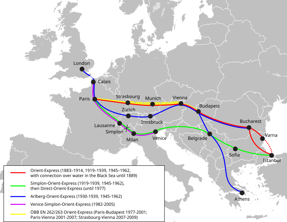
| | | | Validity of the Reprint For our use here, tracking Agatha's trip in 1928, and continuing with repeated trips thru the 1930s, my Cook's August 1939 reprint should be quite accurate. One of Cook's longtime editors comments in the book: The August 1939 edition, now reprinted, shows Europe's train services at the peak of their pre-war development . . . Annual changes were fewer than today, so this 1939 edition gives a good idea of how the Continent's trains ran throughout the 1930s . . . Thomas Cook's timetable has changed far more [in the post-WWII period] than it did in its first 66 years to 1939. This is quite reassuring that we'll ride with Agatha on her first OE trip pretty much as she did it. As a reminder, this is the OE route map (Map by MissMJ) we've been using—follow the line from London to the Simplon Tunnel to Istanbul—but we'll have local maps to further understand the areas traversed. | | | | The Timetable Since the timetables weren't yet numbered back then, we have to go by page numbers and headings, naming cities and possible train names. A low page number of 83 shows that we'll be starting with a major route, which has the heading SIMPLON-ORIENT-TAURUS EXP. We see immediately that, not only is Wagons-Lits considering the Taurus as an extension of the OE, so is Cook's. I continue to think that people today don't realize that, just because of the change of name. Way back on page 334 there's a separate timetable for just the Taurus Express, giving much more information, so we'll move to that at the appropriate time.
There are then several lines of information:
1st and 2nd class – This tells us there are both Wagons-Lits sleepers and coaches
Daily, Calais and Paris to Istanbul – This is just what we want to hear. Calais, of course, stands in for the London connection.
Daily, Istanbul to Paris and Boulogne – The return trip has a bit of a surprise. Boulogne is 16 km (10 mi) southwest down the coast from Calais. Perhaps its ferry schedule to the UK meshed better than Calais's on the return trip, but that's something that could have easily flip-flopped over time.
Daily, Paris to Bucharest and back – This is the Kurswagen (thru coach) that takes off to Romania. It obviously no longer goes on to Istanbul at this point.
Daily, Paris to Athens and back – This Kurswagen fulfills what we said about the early interest in reaching Greece.
Haydarpasa [sic] to Mosul, M-W-F – Again that prejudice against the letter ş. Agatha's railhead in 1928 would still have been Nusaybin, the last stop in Turkey and right on the border, but we see that by 1939, the line has been extended to Mosul, Iraq. This is now the Taurus Express that runs only thrice weekly, and is not daily like the OE, so extra planning is required to get the right travel day.
Mosul to Haydarpasa T-Th-Sa – The return trip. Neither Wagons-Lits nor Cook's is claiming that the Taurus runs any further than stated, tho connections to Baghdad and Basra are still shown in the timetable.
Haydarpasa to Aleppo and Tripoli M-W-F, returning from Tripoli T-Th-Sa. The Mosul route also stops in the hub that is Aleppo, but Aleppo is only mentioned in the heading as the connection for Tripoli, again with no claim that the Taurus goes further, tho connections to Cairo are still shown via a Tripoli footnote.
| | | | | | I've used the 24h clock for decades. My computer is set for it, as is my alarm clock and others in the house that can be set that way. If you're not used to it, just subtract 12 from any large number in the schedule, so that 18:00 minus 12 is 6PM. Midnight is 24:00 if you're looking behind, but 0:00 if you're looking ahead.
To my great annoyance, when the 24h clock IS used in English, people call it "military time", because the military does make use of it. I just call it the 24h clock. Worse, the military reads 18:00 as "eighteen hundred hours". Ridiculous. Beverly and I always just called it "eighteen o'clock", just as German calls it achtzehn Uhr and French calls it dix-huit heures. Sometimes you just have to stand up to nonsense and do it right.
|
| | | | Her First OE Trip, Middle East, 1928 We'll follow the eastbound schedule in Cook's for Agatha's first trip. She did this as a round trip many times afterward. We don't know the exact date she left, or even the day of the week, so we'll have to be generic to an extent. The train listed in the timetable that would connect to the Orient Express in Calais left London's Victoria Station at 14:00 on Day 1. This view looks south to the façade of London Victoria (Photo by Yorick Petey). You see how the station is rather crowded in within the streetscape, showing an unusual number of buses. Actually, it's even more crowded than you think. As we've said in the past, Victoria Station is not named after Queen Victoria. It's named after Victoria Street where the station is located (but not using the word "Street"), similar to Liverpool Street Station or Fenchurch Street Station. But this view of the front of the station doesn't show Victoria Street! It shows Terminus Place, the location of the adjoining bus station.
http://photos.wikimapia.org/p/00/03/30/73/11_big.jpg
Apparently this entire bus area is still considered part of the station, so the station does have a Victoria Street (top) address.
https://www.railtechnologymagazine.com/sites/rtm/files/styles/banner/public/2021-02/9c39307a54a0453db388af28eddf10c2.jpg?itok=uzSZOd_b
https://www.londonreconnections.com/wp-content/uploads/Victoria-Station.png
The street plan is even more obvious in the aerial view in this first link. Victoria Street is cut off at the bottom, but you can see how Victoria is a terminal station, with tracks coming into its back side. The second link shows that even more clearly. Tracks 2-7 come far forward, while tracks 8-13 are set back a bit, and 14-19 even more so. The schedule doesn't indicate what track Agatha's train would have left from, she'd have to check on arrival.
| | | | | | I love giving little previews. Find track 1, pulled way back along the side wall. This is where today the British Pullmans leave from, including the ones that connect to the modern VSOE Cruise Train. In a later posting, we'll follow the 2002 trip Beverly and I took on it out of Victoria. |
| | | | Oddly, the timetable doesn't mention the arrival at Dover on the English side of the Channel, nor how long the ferry crossing took, just the Calais departure time. But elsewhere online I found that she would have reached Dover at 15:35 and then boarded the 15:55 ferry to Calais.
https://retours.eu/nl/03-simplon-orient-express-1950-frankrijk/image/Calais-Maritime_fmt.jpeg
https://railwaywondersoftheworld.com/wpimages/wpbcfcb0f3_05_06.jpg
These two pictures, plus the two below, show the station at Calais-Maritime. Three of these four pictures date from 1950, but should give a good idea of what Agatha saw in 1930. As the first link says within it, this is the Simplon Orient Express in Calais-Maritime in 1950. The second, undated, link shows passengers moving from "sail" to "rail" in Calais. But this train is not the SOE. In 2020/5, we mentioned in passing the prestige express train from London to the coast, the Golden Arrow. After passengers crossed by ferry, its sister train in Calais had the French version of the name, the Flèche d'Or, which then served Paris. That's what shown here.
https://retours.eu/nl/03-simplon-orient-express-1950-frankrijk/large/5b15f94f00b58ba2_large.jpg
https://retours.eu/nl/03-simplon-orient-express-1950-frankrijk/enlarge/grid/10090a3c5f60975d_large.jpg
Still in Calais in 1950, both these pictures are marked "LIFE" in the bottom, since they were a part of a photo essay the magazine made that year. Many of the following pictures will also be from that collection, which will be marked so at the bottom. In this first link, this particular SOE car (click) shows that its route is Calais-Paris-Lausanne-Milano (notice the Italian version of the name)-Trieste, and no further. The second picture shows a car that went all the way to Istanbul. Again, Belgrade appears in its local form, Beograd.
Cook's then says the departure time from Calais was at 17:35.
I found the next stop, Paris-Lyon, a bit of a surprise, so I checked the schedule of the old warhorse, the original Orient Express (OE) itself, on the next page of Cook's. It was revealing. Sure enough, the OE left from the good ol' Gare de l'Est, or East Station, always appropriate since, as we know, "orient" means "east". It wasn't daily like the newer Simplon Orient Express (SOE), but ran thrice weekly, leaving Paris T-Th-Sa. It cut across Germany and Austria, and after Budapest, continued to Bucharest for its last stop. Only if one changed trains back in Budapest could one make connections on to Istanbul. In addition, the Calais Coach bringing London passengers to the original OE did NOT go to Paris, as we saw once on an earlier map. When the OE left Paris at 19:55, it stopped at some distance to the east at Châlons (full name: Châlons-en-Champagne) at 21:46 for the Calais Coach to join it, showing the Calais Coach to be the Kurswagen (thru coach) that it really is.
http://www.projectmapping.co.uk/Europe%20World/Resources/france-railway-map-lg.gif
We'll be using supplemental rail maps such as this one of France to follow Agatha on the SOE. Click to inspect her route so far: London-Dover-Calais (note that Boulogne is next door)-Paris. Where the OE Calais Coach joined the OE in Châlons is not shown, but it's just southeast of Reims, so you can see the route it took from Calais. But what happened with Agatha and the SOE in Paris?
http://1.bp.blogspot.com/-dzcxiC2aQDQ/VTna-S7Gm_I/AAAAAAAAAKc/G4vZk2H_2Zk/s1600/paris-train-stations.gif
These are the six large mainline railway stations of Paris. Coming from the northwest, the OE Calais Coach would—at one time--have joined the main train at the Gare de l'Est, serving the east, tho by this time it joined it later at Châlons. But since the SOE was to leave Paris to the southeast, toward Lyon and Switzerland, the SOE Calais Coach would have swung around the city to join the main train at Paris-Gare de Lyon. It arrived there at 21:17 and the then completed SOE left at 22:20. (For the sake of accuracy, I'll note that Cook's at this date spelled it the Gare de Lyons, since the English name of that city at that time included a "silent" S. Avoid that nonsense nowadays, as Cook's did later on.)
Note that I'm saying that Agatha is on the SOE Calais Coach. It's a simplification of the facts to say that the SOE (or even the OE) had Calais at its western terminus, which was Paris. True, the ride starting in Calais is longer, but it's only one coach that's a Kurswagen, nothing more. The SOE is waiting in Paris, and once this extra car joins the train, it's ready to leave. That's why I always say the western terminus is Paris—with London piggybacking. Let's sum it up this way: while the train served passengers the full distance from Calais to Istanbul, the train RAN just from Paris to Istanbul. That's the cute trick a Kurswagen can accomplish.
My only personal connection with the Gare de Lyon was mentioned in 2018/11, when I was dropped off there to make Métro connections when returning from the Luciole canal boat trip between Auxerre and Clamecy. Curiously, Agatha's express train, running southeast, would have whizzed right thru the Auxerre area back in 1928. Anyway, for the record, we'll repeat these two pictures: this is the exterior of the Gare de Lyon with its clock tower, both raised slightly above street level (Photo by AlNo), and here's the panorama of its train shed (Photo by Johann "nojhan" Dréo). Like London Victoria, it's a terminal station, so trains leave with an engine at the far side in the picture. What does that mean for Agatha? Her Calais Coach would have pulled in, perhaps backwards, and joined the consist, maintaining the reverse direction on departure.
https://www.arjandenboer.nl/beeld/galleries/SOE/_medium/32b90a91fc14a9c1_large.jpg
Here's another 1950 period picture from LIFE. The sign says it's the SOE, and this has to have been taken in Paris, since the next stop shown is Vallorbe. The sign is still old-style, since it doesn't yet say Milano or Beograd.
The French rail map shows that the route southeast out of the Gare de Lyon, while it does head toward Lyon, also forks and heads toward Lausanne on Lake Geneva in Switzerland, which is the route we're taking. The moment it crosses the border into Switzerland it stops at Vallorbe from 5:25-5:45. It's now Day 2. Why would Agatha's 1928 SOE stop at such a small place? Border controls--but this wouldn't happen today, since Switzerland has joined most EU countries in the Schengen area with no border controls. (See 2008/16 "Schengen".)
http://hawkdawg.com/img/maps/eur/Switzerland-2011.jpg
We now move to this rail map of Switzerland—click to find Vallorbe again in the far west. This is the Gare de Vallorbe, a Swiss Heritage Site (Photo by G CHP). It's the northwestern terminus of the historic Swiss Simplon line (Vallorbe–Domodossola) that runs to Lausanne, along Lake Geneva, then the Rhône (not shown), to Brig, then thru the Simplon Tunnel to Iselle and Domodossola in Italy. Let's do that with Agatha.
We're at Lausanne at 6:26. Lausanne lies directly on Lake Geneva, called Lac Léman in French (Photo by Rama). This aerial view shows the station and route (click), which is just south of the old town and north of the lake, out of view on the right. This map (click) shows better where we are (Map by Mark Jaroski), and this view of Lake Geneva from town (Photo by Patrick Nouhailler's…) shows how well situated it is. We're looking here across Lac Léman (Lake Geneva) toward Évian-les-Bains in the Alps on the French side, often just called Évian (whence the bottled water). Lake Geneva was more fully discussed in 2008/13, including its dual names (Map by Tschubby), but here we see that it's a de facto huge bulge in the Rhône, which comes down the valley from Brig on the right and into the lake, then leaves it on the left at Geneva, for France and the Mediterranean.
But as the train rounds the eastern end of the lake, Agatha would have been in for a pleasant surprise located in the lake, as are all newbies here, including me in that first trip in 1957. It's not a ship, and is not the Loch Ness Monster. It's an unexpected castle, right in the lake.
http://cdn.retours.eu/nl/05-simplon-orient-express-1950-zwitserland/image/0523e861d619fb41_large.jpg
This is the 1950 LIFE view, looking north, of the SOE having just passed the Château de Chillon in Lake Geneva, an amazing sight because of its location, and so unexpected by newbies. I've passed it by train maybe three times—but have never visited it--yet it's always exciting to see.
https://www.weather-forecast.com/locationmaps/Montreux.12.gif
http://www.eilandeninfo.nl/kaarten_groot/chateau_de_chillon_zwitserland.jpg
The location doesn't show on our larger maps, but it's named on this first link, lying south of Montreux and as far at the eastern end of the lake as is seemingly possible, so the train leaves the lakeside shortly after passing it. The second link shows how incredibly close to the lakeshore the tiny Chillon Island and its castle actually are. If you're only passing, the tracks give the closest view, the road is next best. There's also an autoroute further up the hillside, but I can't imagine its view of Chillon is any good. Here's an aerial view of exactly what that last map showed, including the tracks, roadway, and—as an extra—a bit of the motorway up on the hill (Photo by Alexey M). Even tho I've never stopped here, I love this place, but—call me a cynic—that water around the castle looks shallow on all sides, becoming deeper on the lake side. Doesn't it look like someone dug a moat to turn a small peninsula into an island? I'm not going to believe that thought I've conjured up , and will accept that the island really is natural, as I've not heard otherwise.
I've now read more about it and I'm not really surprised that Chillon began as a Roman outpost on this oval limestone island, guarding the original strategic road winding thru the Alps, over the Simplon Pass from what today is Italy and around Lake Geneva to France and Germany. A garrison placed at this location could control the road militarily, but also commercially, applying a toll for its use. Construction on the present building dates back to the 10C, tho objects dating back to Roman times and even the Bronze Age have been found.
One thing, tho, has really surprised me. Over the years, I've pictured Chillon as a being on a sleepy little byway location, with only the occasional visitor, but I'm amazed to find that it's among the most visited castles in Switzerland and Europe, and also is listed as Switzerland's most-visited historic monument! How foolish do I feel? And visitors have included the famous, such as Jean-Jacques Rousseau, Victor Hugo, Alexandre Dumas, Gustave Flaubert, and Lord Byron. Actually, I found out the first time my train passed it in 1957 about Lord Byron having written his 1816 poem "The Prisoner of Chillon" based on an actual 16C prisoner there. And now I also find that Lord Byron actually carved his name (Photo by Rama) on a pillar in the dungeon, now in a frame. It's still graffiti, but historic graffiti!
Henry James also used Chillon as one of the settings in his 1878 novella "Daisy Miller". And Gustave Courbet painted Chillon several times, the most famous view being The Castle of Chillon, oil on canvas, in 1874, signed at the lower left. It's from the other side, and thus a southern view, toward the mountains. Actually, that's the first view Agatha would have gotten (as I did) from the train, looking like this (Photo by Zacharie Grossen). Of course, good mountain views are notoriously fickle and hard to get, so let's enjoy this one. We're looking south beyond Chillon toward the peaks called the Dents du Midi at 3,257 m (10,686 ft). Behind them is the Mont Blanc Massif. And all this as the train goes rushing by Chillon. It's too much to take in at once!
| | | | | | A bit of language study: Some of the numerous Alpine peaks have types of names worth commenting on. German Horn is the same as in English, but in German-speaking Switzerland, it's used to mean a mountain peak, for obvious reasons. Thus the Gletscherhorn would be Glacier Peak, Weißhorn is White Peak; Schreckhorn is Terror Peak. On my last visit to Switzerland we talked in 2008/15 about the most famous of these, the Matterhorn, and we can elaborate a bit more precisely on that name (I like this more complete explanation better than earlier). A Matte is a mat, but in the Alps it describes the flatness of an Alpine meadow. Zermatt is derived from zur Matte / at the meadow. The Tal (valley, dale) that Zermatt is located in is the Mattertal, and, further upvalley, the "horn" at the head of the Mattertal is the Matterhorn. Tho really untranslatable, we could say that the Matterhorn could be Meadow Peak.
But back to the French-speaking part of the Alps, where the horn imagery is replaced by tooth imagery. French dent is "tooth" (think dentist), so the Dent Blanche is the White Tooth. So what do we make of the above 3 km (1.7 mi) long ridge of seven peaks called the Dents du Midi? I saw online someone fall into a translation trap. While it's perfectly true that midi means "noon" (think mid-day), I would never say as I found online that these are the Teeth of Noon. What nonsense. The word is also related to "meridian" and is used to mean "south", as an alternate to sud. In Brussels, South Station is the Gare du Midi. So the Dents du Midi are the South Peaks, lying just south of Lake Geneva. And see how they can glisten in the sun--in clear weather!
|
| | | | The Swiss map shows how our route forms a V, following the Rhône River and its valley. As it proceeds, it approaches the language border. Sion (Zion) is still French-speaking, but Sierre is the last French-speaking town. Agatha's SOE then enters German-speaking Switzerland, and passes Visp (FIShP), with its rail connections to Zermatt, thence to the Gornergrat (Gorner Ridge) with its view of the Matterhorn, and shortly reaches Brig at 8:38 (old Cook's spelled it Brigue, using the French spelling, as was its wont).
Brig has two rail stations, one indoors and one out in the street in front of it (Photo by Photnart). Service to Brig began in 1878 when it became the eastern terminus of the Simplon Railway from Vallorbe and Lausanne. The opening of the Simplon Tunnel in 1906 extended the Simplon Railway southeast to Domodossola. The main station—the white building on the left—accommodates two standard-gauge lines, including trains going thru the tunnel, which we will do with Agatha. In the center of the picture, and adjacent, is the open-air Brig Bahnhofplatz railway station serving two meter-gauge lines, serving nearby Visp and then ascending up the mountains to Zermatt, where the Gornergratbahn connects further to the Matterhorn.
This view does NOT face southeast to the Simplon Tunnel (see Swiss map), but to the northeast up the Rhône Valley towards the Fülhorn (2,738m / 8,983 ft), beyond Fiesch on the Swiss map. Train routes in Brig would have to turn right shortly beyond these Brig stations for both mountain and Simplon Tunnel access.
| | | | | | This striking view is from the top of the Fülhorn (Photo by Caumasee at German Wikipedia) looks southwest toward French Switzerland. That's Brig down below in the Rhône Valley. The name Fülhorn, which I haven't heard before, intrigues me. A German source says the first syllable is based on the word faul, which usually is "lazy"; it rhymes with, and is related to "foul", another negative word. But faul can also be "decaying, crumbling", and the source says the mountain is named after it's brittle, crumbling rock. That may be true, but I have to believe my notion that the name Fülhorn, with one L, was influenced by Füllhorn, with two Ls, where the first syllable means "fill". And what is a horn that is filled? Füllhorn is the German word for "cornucopia", the symbol of good fortune! (A cornucopia is literally a "copious horn".) I have to imagine that this word, with a charming play on "horn", had some influence on the name. |
| | | | We can continue using the Swiss map into Italy, but can supplement it with this:
https://www.alpentourer.com/alpine_passes/lago_maggiore/simplon/karte_simplon/simplon_karte.gif
It's a map of the area around the Simplon Tunnel. We see more clearly the Rhône, and the connection from Visp to Zermatt and the Matterhorn, a rail connection I used in 2008/15. The brown line out of Brig shows the road that crosses the Simplon Pass (click) at 2,005 m (6,578 ft), which is, as shown, on the Swiss side of the Italian border (Photo by Rolf Nagel). (Brig is to the left, and Domodossola to the right.) You can imagine Romans crossing here, and probably even earlier peoples. However, the road was built between 1801 and 1895 under Napoleon. The river shown on the Italian side is the Toce, part of the Po River watershed.
We see the rail route as a dashed black line, turning right from Brig and going straight thru the mountain for 20 km (12 mi). Note the loop on the Italian side, also shown on the Swiss map, which is just after the tunnel exit at Iselle (i.ZEL.lé). This is the 2,968-meter (9,738 ft) "Varzo Spiral Tunnel", (Varzo village is named on the map) probably the longest spiral tunnel in the world, used to gently change the altitude of the rail line.
The Simplon Tunnel is actually two single-track tunnels built nearly 15 years apart. The first to be opened (1898-1906) is 19.803 km (12.305 mi) long; the second (1912-1921) is 19.823 km (12.317 mi) long, making it the longest railway tunnel in the world for most of the twentieth century, from 1906 until 1982, when Japanese construction surpassed it.
https://upload.wikimedia.org/wikipedia/commons/2/28/Simplontunnel_01.jpg
https://www.arjandenboer.nl/beeld/galleries/SOE/_large/14b8f4f1b197cb36_large.jpg
The first link shows the North Portals of the Simplon Tunnel, near Brig, showing two different completion dates. The second shows the SOE at the 1905 portal in 1950 next to a sign identifying it in French. These are the South Portals (Photo by Markus Schweiss [?]) near Iselle, approaching Domodossola, and below is the SOE at the South Portals in 1950.
https://retours.eu/nl/03-simplon-orient-express-1950-frankrijk/enlarge/grid/4c8b9af85c0c9e84_large.jpg
Agatha would have stopped at Domodossola from 9:22-9:53, to allow for customs formalities, but today, the stop wouldn't be that long because, as at Vallorbe, Switzerland and its neighbors are all within the Schengen area of open borders. While I rarely pay attention to twinned cities, I find in nice that Domodossola is twinned with Brig! I cited my first of several times in the Simplon Tunnel from Brig to Domodossola in 2020/5, where I mentioned my affection for the name, saying doesn't "Domodossola" just roll off the tongue? I've also learned that it commands the head of the Ossola Valley, and that the name was once spelled as separate words: Domo d'Ossola, making it the "dome" of [the] Ossola.
https://lh3.googleusercontent.com/proxy/1A4Q23qYkIN3aGD87GF4hnB5MtSkVuzvKNDWoHEnuZr4TETIkiBXh5rF_-5vnc8zvwFbOpcEmN9mHOVkvTkCXXUL2cADdf0X-Ko=w1200-h630-p-k-no-nu
Here we now have a rail map of (northern) Italy, and see it's a direct run to Milan at 12:15, where we stop at Milano Centrale, today the largest railway station in Europe by volume.
http://ontheworldmap.com/italy/city/milan/milan-tourist-attractions-map.jpg
Milano Centrale is at the upper right, and is a terminus, meaning new engine, new direction. You can see the distance to the center of town with the magnificent Cathedral (Duomo) at #1, the beautiful Galleria Vittorio Emmanuele II at #5, La Scala at #3, and the Last Supper to the west at #2. Great memories—see 2002/3, after we took the VSOE cruise train.
| | | | | | On the rail map, find Verona, at the intersection of a line coming down from the north. The SOE did NOT stop in Verona, but it's a factor in the VSOE cruise train today, which will be discussed in a later posting. |
| | | | After Milan/Milano, Agatha's train went right to Venice at 16:00. Everyone realizes that Venice/Venezia is located on a group of islands in the middle of the Venetian Lagoon, but I suspect that many people are unaware about (1) how those islands are accessed (other than by sailing there) and (2) how big Venice really is. While this is not a travelog about Venice, we'll clarify how Agatha's train got there, and then continue.
First let's take a look at how huge the Venetian Lagoon—or let's say the Laguna di Venezia--really is (Map by Nikater), and we see immediately the answer to issue (1), the causeway leading out from Mestre and Marghera to Venezia proper. And do note how the barrier islands define the lagoon—somewhat similar to how the peninsula-cum-island that the City of Miami Beach is on helps define Biscayne Bay, with the City of Miami similarly on the mainland (we'll be getting back there in time). As for barrier islands, we shouldn't fail to mention the world-famous beach resort at the Lido di Venezia, #31, at one end of Lido Island.
| | | | | | The only time I was on the Lido was on that first trip with my friend in 1957. I remember picking up a small, 3 cm (2 ¼ in) brown-and-white shell on the beach, and back at the hotel, writing in black ink "1957" inside it, having a feeling it would have "time" significance years later. I still have it. |
| | | | To answer issue (2), two other maps will help. This larger one shows the entirety of the Municipality of Venice (Map by Vonvikken), where we see that the historic center on that cluster of islands is not all of Venice, just the oldest (and most interesting) part. Other lagoon islands are included, as is Lido Island and its neighbor, and a HUGE swath of the mainland which was annexed in 1926. As of 2014, this red area is called the Città Metropolitana di Venezia or Metropolitan City of Venice. | | | | | | Try this interesting parallel, using Paris as an example for many cities. The most historic part of Paris is the Île de la Cité, with its adjoining neighborhoods on the north and south banks of the Seine. But this historic center has grown into the large Paris as we know it, as we described in 2017/17, when we talked about the "Historic Circles" of Paris, meaning new walls that grew further and further from the center. But how could something similar have happened to the historic center of Venice, surrounded by water? Well, it did expand as Paris and others did. It just had to go beyond the limiting body of water. So while other cities might be continuous, Venice is a donut hole surrounded by a donut of water. Only beyond that is the rest of the city. But visitors just tend to admire the (magnificent) donut hole. |
| | | | This smaller map explains more (Map by Frassionsistematiche). Here we see that the area is subdivided into six municipalità--it's best to translate them as boros. We can point out Venezia (1) and its islands, Lido Island (2) and its mate, and, on the mainland, Marghera (6) and importantly Mestre (MES.tré) joined with Carpenedo (4). Mestre-Carpenedo is the most populous of all; Venice-Murano-Burano has only 78% of Mestre's population.
http://www.johomaps.com/eu/italy/venice/cityrail_venezia_full.jpg
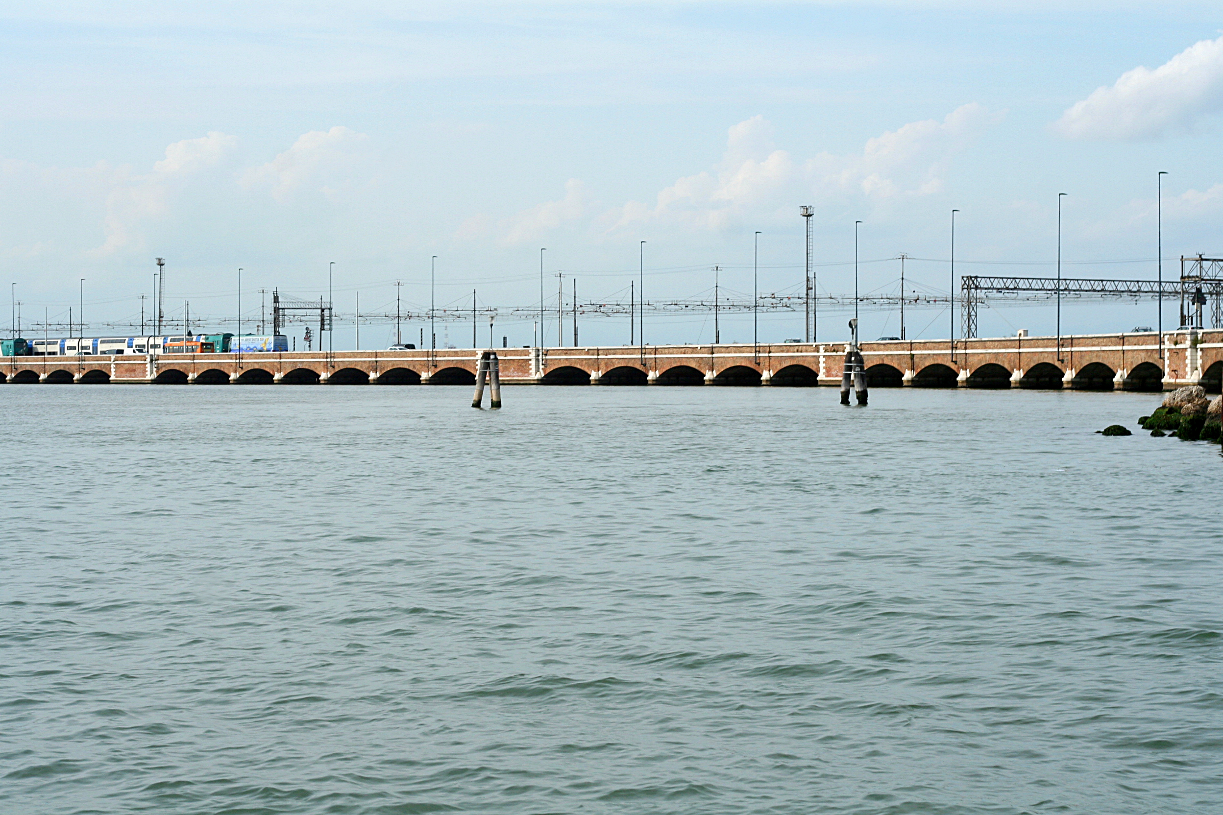
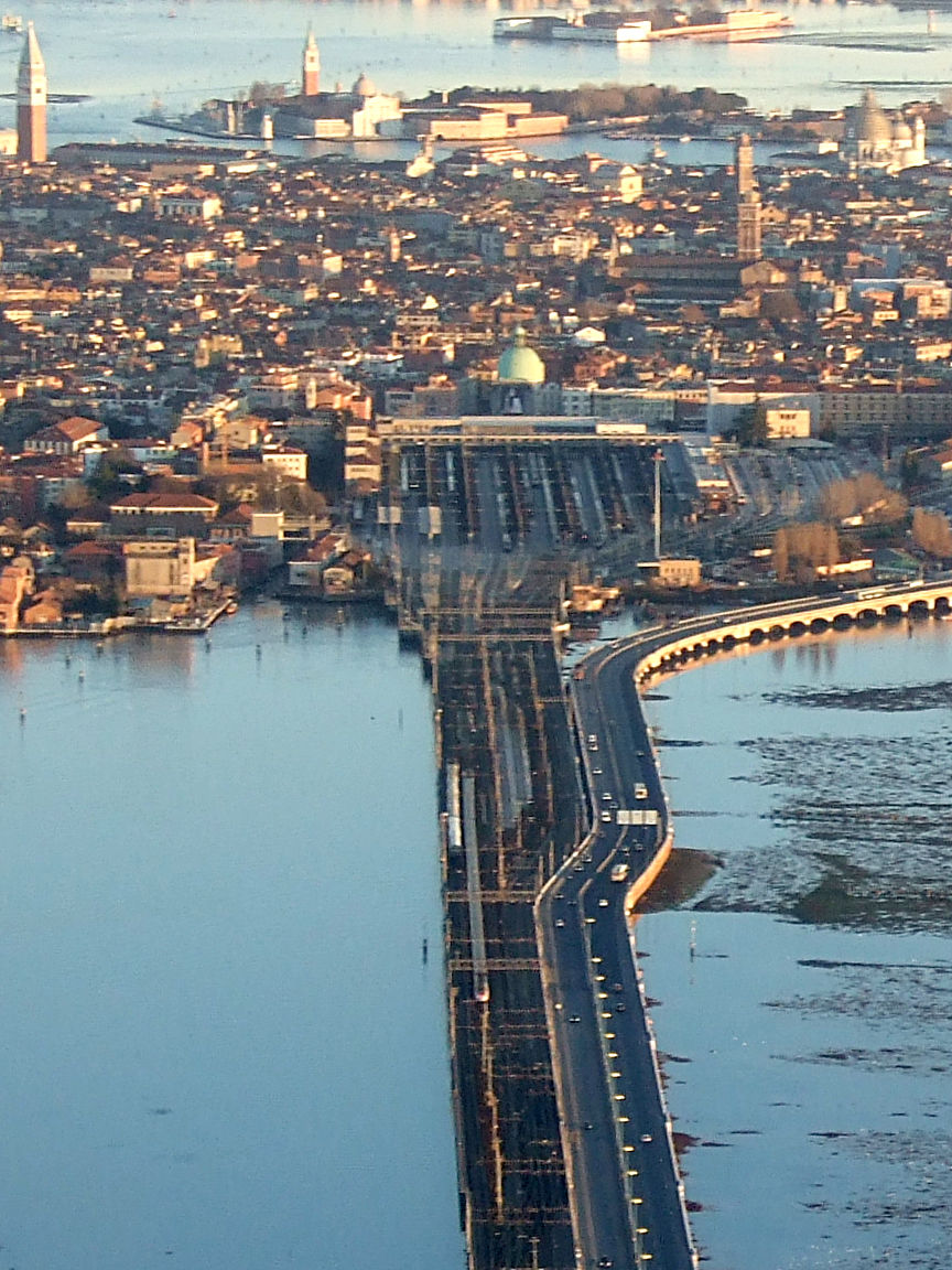
Let's get back to that causeway, shown particularly clearly in this map. The brown lines are train routes, and we see how Agatha would have come in past Padova (Padua) and Verona to Mestre, at the Venezia Mestre station—no stop—and then crossed the causeway to Venezia Santa Lucia. Obviously this is a terminal station—what else could it be?--so her train would have to leave via a new engine added to its end. We then see the route of departure toward Trieste. So passing Mestre is always a signal that Venice is just a few minutes away, just as stopping at Newark means New York Penn is coming up shortly.
But this map is specially good in that it shows the road bridge, in pink, joining the causeway after Mestre and then leaving it near the end to go to Piazzale Roma, for the Venice bus station, car park, and car rental location. (Trick question: are there cars and buses in Venice's historic district? Well, actually yes, just a tiny bit.) Here's an aerial photo of the causeway (Photo by Didier Descouens), where you can see (click) both trains and motor vehicles on it. Full disclosure: on my three trips to Venice I always thought they were one single structure, but now I learn they're technically two, located cheek-by-jowl. The Venice Railway Bridge on the left, built first in 1846, has two tracks each way. It adjoins the Ponte della Libertà (Liberty Bridge) on the right, built in 1933, which has two car lanes each way. They are 3.85 km (2.39 mi) long. You can again see the wide track area of Santa Lucia, as well as the roadway pulling off to the car area.
| | | | | | For newbies who are not expecting this causeway, perhaps such as Agatha in 1928 and certainly me in 1957, this sudden train-on-a-causeway is spectacular, just as the Château de Chillon seen from the train was. On her first trip in 1928 that we're tracking, plus the next few years, the rail structure would have stood alone, but in her many repeated trips after 1933 she would have experienced seeing the adjacent road bridge. I'll say now that my first two trips on the causeway were round-trip by train, but the third one was on the VSOE Cruise Train arriving from London Victoria, and, after five days, I drove Beverly and myself out of Venice in a rental car along the roadway side of the causeway for our further adventure across Italy. More later. |
| | | | This is a surface view (click) showing both trains and cars on the causeway (Photo by Jean-Pol GRANDMONT), and this view better shows the track-and-roadway split (Photo by Unofeld781 et al).
https://public-transport.net/a/Venedig/Peoplemover/slides/8838_81.jpg
https://live.staticflickr.com/65535/48436339442_d2603776e4_z.jpg
The first link shows the auto and bus area of the historic district at a bit of a distance from a train on the causeway. The second link shows a platform at Santa Lucia and this is the station façade (Photo by Marc Ryckaert). The current station building is one of the few modernist buildings facing the Grand Canal, and is therefore unique in its own way. As the station building is low and wide, it does not dominate its surroundings of historic buildings. Truth be told, since it was under construction between 1936 and 1943, and wasn't completed until after the war in 1952, Agatha wouldn't have seen it in the 1930s, but rather the previous station building. She may have experienced it on her post-WWII trips.
http://onelight.com/hec/targets/Venice/Map2_VeniceOnLine.jpg
Finally, for those who can't imagine cars and buses in the Venetian historic district, you can see here the roadway to the Piazzale Roma and its parking structures. However, those who have been to Venice almost certainly would have arrived at Santa Lucia, with easy access to canal transportation.
https://www.seat61.com/images/venice-ljubljana-train-map-large.jpg
Leaving Venice thru Mestre (above) Agatha's next stop was Trieste at 18:22, another in-and-out, as the map shows, and the last stop in Italy before crossing into Slovenia for its stop in Postojna. But as we leave Italy, we should pause and take a close look at exactly what the [Simplon] Orient Express consisted of. There's confusion today as to just what it was. As we already know, the public eye confuses the OE thru Germany, popular at the turn of the 20C, with the SOE thru Italy perhaps even more popular in the Interwars Years (plural). But even that isn't clear, since Kurswagen served so many other cities. Let's take a careful look at this 1921 SOE consist (Image by Wahldresdner) :
https://upload.wikimedia.org/wikipedia/commons/5/51/Zugbildung_SOE_1921.png
I'll point out that Mailand is Milan and that wöch[entlich] is "weekly", and I think you'll follow the rest. We have to start by realizing that, despite the comment in Cook's that the schedule was quite consistent, we'll spot some quirks immediately. An obvious on is that the "Calais Coach" in 1921 left from adjacent Boulogne, and that one car started in Lyon, so that must have been a slightly alternate route. So be it. Otherwise, let's take this consist apart and see what it was that went from Paris to Constantinople.
Disregard the engine. We know that that changed at every terminal station where the train changed direction with a new engine on its tail. Disregard the two baggage cars (one carried mail) in gray and the diner in red, all of which did go all the way, but we want to see passenger cars. Third is the "Calais" coach out of Boulogne. We'll say again that, tho service to Constantinople started at Calais/Boulogne, that wasn't the train that started there. It was waiting in Paris, the real starting point, for this Kurswagen to join it. We can see how it was added to the train, then the new engine backed up a baggage car and diner to it, and took off. We also see that thrice weekly two Kurswagen were sent off, with one Paris coach taking off to Athens and another to Belgrade. But we also know from the Cook's 1939 listing that the two Kurswagen to Athens and Bucharest had also become daily by then, like the rest of the train, so minor adjustments did happen. Further back we see a Kurswagen starting in Ostend and joining somewhere to go the entire route to Constantinople.
But of particular interest is to see how the train changed in another way. It seems that Day 2, which began in Switzerland, but importantly covered northern Italy, was of particular importance, being just one overnight out of Paris/London. Note that the salon or lounge car, in yellow, only served Milan-Trieste. Note that Milan is mentioned as part of the route of EVERY car and that two of the sleepers (from Paris and Lyon) were also dropped off in Trieste (we saw a photo in Calais of a car like this, along with another of a coach that went the whole way). So what sleepers made the entire "classic" connection from Paris to Constantinople? Just ONE (!), along with the diner and two baggage cars. To be generous, let's add two more, the one from Boulogne (Calais) and the one from Ostend also went the whole way. So as many coaches as this consist may have while we're here in Italy, only THREE ended up in Constantinople, and only one of those starting in Paris. The SOE (and OE) is not necessarily what one may have pictured.
Thus, to travel from the English Channel to the Bosporus, Agatha could have only traveled in the first sleeper on the train, the Calais (Boulogne) Coach—handy to the dining car. Even the second sleeper, starting in Paris, wouldn't have worked. And we also can see why the alternate name for Murder on the Orient Express is Murder in the Calais Coach.
https://www.acprail.com/wp-content/uploads/2018/04/Croatia-map.jpg
Both the map out of Venice and this map of Slovenia and Croatia show the next stop out of Trieste, Postojna (po.STOI.na), the only stop in Slovenia. But of course, in Agatha's day, this would have all been Yugoslavia all the way down to the Bulgarian border. But old Cook's being what it is, it lists the city by its Italian name, perhaps better known at that time, Postumia, from 19:55-20:15, probably for a customs check.
Then at night, the SOE crossed into what is now Croatia to stop in the wee hours at Vinkovci (VING.kov.tsi), on the far right of our map, arriving at 4:34 to start Day 3. Being an express train, it avoided what are now the capitals of Ljubljana (lyu.BLYA.na) and Zagreb (tho that may have varied at some times), but made these last two stops for technical purposes. [NOTA BENE: the climax of Murder on the Orient Express took place in the area of Vinkovci.] This Vinkovci stop is particularly interesting for operational reasons. Let's see why (Cook's is a bit confusing here, but it can be figured out).
http://assets.atlasobscura.com/article_images/24285/image.jpg
This is a rather decent, but smallish, map of the entire route, and you can stick with it if you like, tho I'll prefer to go back later to our "yellow" map of the Taurus route. But I show this because it's the best example of two Kurswagen leaving the SOE (it does show further variations from the norm as to Dijon and Zagreb). But find here Vinkovci, and follow Agatha on the main train leaving this operational point. Then watch the one Kurswagen to Bucharest and the other to Athens taking off. Look how three "fingers" serve a large swath of southeast Europe!
https://www.holidaysonlocation.com/images/rail/balkans-map.jpg
Now finally move here to the rest of southeast Europe. I list the following in detail to show the craziness of Wagons-Lits planning all these changes, particularly starting in Vinkovci after the 4:34 arrival. The SOE leaves Vinkovci (not shown here, but in eastern Croatia) after 15 operational minutes at 4:49. It crosses into what's now Serbia (here listed as "Yugoslavia") and is in Beograd (listed in Cook's as Belgrade) from 7:18-7:45, and in Niš (rhymes with "quiche" and listed in Cook's as Nisch) at 11:33.
| | | | | | Meanwhile, a minute later in Vinkovci and 16 minutes after arrival, the Kurswagen for Bucharest leaves at 4:50, enters Romania, and stops at Jimbolia (not shown, but west of Timișoara) from 10:06-11:28, then Craiova at 17:40 and Bucharest (București) at 21:45.
But something else goes on quietly at Vinkovci. The Kurswagen for Athens stays with the main train one more stop to Belgrade, arriving with it at 7:18, but then apparently gets its own engine there. Then the main train leaves 27 minutes later at 7:45, while the Athens coach leaves 10 minutes later still at 7:55, apparently following the main train down the track, and having a later arrival at Niš, at 12:24. It's only after Niš that the two trains take separate tracks. The Kurswagen stops in Skoplje 16:26 (in today's North Macedonia), at the border town of Guevgueli from 20:00-21:20, thence crossing into Greece, at Thessaloniki at 22:51? and at Athens at 10:26.
|
| | | | While those two Kurswagen went on their merry way, Agatha's SOE, having left Niš, reached the Serbian border town that Cook's spelled Tzaribrod at 13:30, tho a preferable spelling is either Tsaribrod or even Caribrod, where C=TS, common in Slavic. However, you'll find it on the map of southeast Europe under the name Dimitrovgrad, a name it got in 1950, named after a communist leader of Bulgaria (which is why there's another one on the map in Bulgaria, founded in 1947). I understand that the former name is still used locally, often in the form Caribrod, and there's a movement to restore it. | | | | | | The old name has intrigued me, but the best I can do is this. The first part of Цариброд/Tsaribrod is obvious. As far as I have found, брод is Bulgarian for a ford (in a river). The word "ford" is included in lots of place names, like Bradford (Broad Ford), Crawford (Crow Ford), Langford (Long Ford), Milford (Mill Ford), Oxford (Ox Ford), Redford (Red Ford), Rockford (Rock Ford), Sandford (Sand Ford) and more. German does it in Frankfurt (Franks' Ford) and Schweinfurt (Swine Ford). So this name in Serbia would appear to translate as Tsar's Ford, perhaps even Tsar's Crossing. Particularly since that's the traditional name, it's surely preferable to Dimitrovgrad. |
| | | | Agatha would have experienced it under the old name, but the LIFE photographer was there on the SOE in 1950, the year the name was changed, so that's the name we see posted here:
https://i.pinimg.com/originals/61/ef/56/61ef56d6bd8077d7096c74721f639040.jpg
Do remember that this stretch from Niš to Belovo beyond Sofia was the incomplete section that had the horse-and-carriage "bustitution" for a few years in the 1880s. But that wasn't Agatha's problem, and her SOE crossed from Serbia (then Yugoslavia) to Bulgaria and reached Sofia at 16:28 and Svilengrad (Cook's spelled it Svilengrade) from 22:57-23:10, then entering the East Thrace part of Turkey and ending Day 3.
https://i.pinimg.com/originals/bb/88/08/bb880811a0b39608a936511ae145966a.jpg
http://cdn.retours.eu/nl/13-simplon-orient-express-1950-turkije/image/d2c2f993c6b00be9_large.jpg
Very early the next morning, her train, like the above one in 1950, circled around the tip of Constantinople's/Istanbul's historic peninsula. As the first link shows, one would first pass the Hagia Sophia. The second link looks east from Topkapi Palace over the Bosporus, the old city walls, and the lower gardens. Sirkeci Station would be around the bend to the left, so the SOE train shown wouldn't be ours, but would be instead departing Istanbul. And finally, Agatha reached Istanbul at 7:20, at the beginning of Day 4. This is Sirkeci Station as it looked c1918, a decade before her visit.
As we know, in Istanbul Agatha often stopped at the Pera Palace Hotel. Whether she did that first time I do not know, but my inclination is that she was eager to get to Mesopotamia, so we'll assume she didn't stop this time. While she'd ended her first trip on the SOE, her first trip on the connecting Taurus Express now lay ahead. Cook's schedule then continues with the indication "Str.", apparently indicating the Bosporus Strait. Spelling Sirkeci rather uniquely, Cook's lists the ferry connection as: Sirkedji Mar[itime]—we know it was just a few steps across a park--8:20, arriving at Haydarpaşa (with the S spelling) at 8:40, and we know that that docks directly at the station, where her train left at 9:00. It was really a rather nice connection from Europe to Asia.
Now that combined timetable on page 83 does go on to the Taurus Express stops, but that information is crowded into the lower third of the timetable. It shows highlights down to Baghdad and Basra and a bit on the Teheran bus connection, but then it says for Cairo, see page 334. I think it makes clear that the emphasis of this trip is considered to lie on the SOE itself. Therefore, it's time to move to the free-standing Taurus Express entry on page 334, plus Cairo on 335.
It should also be pointed out that post-WWII, Cook's downplayed non-European connections and for a while, even published a non-European "Overseas Timetable" that included the nearby Middle East. But the 1939 timetable still included everything we need. Once again, here's our "yellow map" showing the Taurus Express routes (Map by Matsukaze):
https://upload.wikimedia.org/wikipedia/commons/thumb/3/3b/Taurus_Express_route_map.svg/1000px-Taurus_Express_route_map.svg.png
Remember that the SOE ran daily, but the Taurus timetable points out that, tho the initial Haydarpaşa-Ankara connection also ran daily, beyond that, service was only thrice weekly, M-W-F. Therefore, Agatha had to either start out from London on a day that would connect smoothly with this restriction or spend a night or two in Istanbul so as to continue further on a M-W-F. The alternative would have been to spend an unwanted night or two in Ankara. The Taurus had 1st and 2nd-class sleeping cars and a restaurant car—all only on M-W-F--to both Tripoli and to Mosul.
So for Agatha, Day 4 out of Istanbul continues. But it's also Day 1 on the Taurus, so I'll be writing it as Day 4 (1). Leaving Haydarpaşa at 9:00, there's one stop about halfway, but is otherwise a full day to Ankara, arriving at 21:03. Then, if it was M-W-F, the Taurus left Ankara at 21:18, apparently doing an in-and-out on that branch off the main line. On Day 5 (2) there were three stops (none of them Konya, oddly), with a stop in Adana from 12:23-12:45. After two more stops in Turkey, it crossed into Syria, with one more stop, then arriving in Aleppo at 20:12. This is, as we know, where the train split. The section for Cairo left second at 21:31, and we'll look into that later. But the section for Baghdad/Basra left promptly at 20:46 with Agatha on it.
| | | | | | Agatha loved Aleppo, and she loved staying at the Baron Hotel there (ba.RON), even doing some of her writing there. But I know for a fact that she first stayed there on her second trip in 1930, and so we'll talk about the Baron later as well. |
| | | | Overnight there were two stops in Syria, the second one being back at that town on the Turkish border, after which the Taurus crossed back into Turkey. This was that odd stretch where the international border had been drawn on the south side of the tracks, so the train had to return to Turkey. Then I found an odd thing that happened, which had to have involved a Kurswagen. It left the border town at 5:50 and just went to Mardin (Mardine in Cook's), arriving at 6:55. But the main part of the train left the border town first, at 5:31, arriving at Nussaybin at 6:46. This would have been Day 6 (3). | | | | | | Now in 1928, Nussaybin would have been the railhead, the end of the Taurus, where Agatha would have had to switch to a motor vehicle all the way to Kirkuk (see map). But Cook's in 1939 shows the line having been extended to Mosul. So for this bustitution stretch, we'll have to use data for Agatha as she would have done it a few years later, up to Kirkuk, then get back to 1928. |
| | | | After Nussaybin in Turkey there was a stop back across the border in Syria in Tel Kotchek at 9:45, then at Mosul at 16:15 , which by then was the railhead, where passengers would switch to a motor vehicle. But that didn't leave until the next day, so obviously a hotel stay in Mosul was necessary. I know nothing about Agatha staying in any Mosul hotel.
So this would now be Day 7 (4). Scheduled departure from Mosul was at 13:30 and the schedule says quite nonchalantly "by Motor". I wonder if Agatha climbed into a Rolls-Royce car or a Thornycroft bus (suggested pictures 2021/2). Actually, over the years, it was probably both. Arrival at Kirkuk was at 18:30. And to my surprise, the connection "by Rail" was right away, the narrow-gauge train leaving at 20:15.
| | | | | | I'm a bit surprised at the transfer in Kirkuk. It's highly unusual for a narrow-gauge train to have sleepers—my Transcantabrian ride in northern Spain (2020/6) was a notable exception—and no further information is given here. This was possibly an overnight ride in coach class, but I have no information. |
| | | | It would have then been Day 8 (5) that Agatha arrived in Baghdad at 6:50. One would think that that was it, but Agatha had been of more than one mind as to destinations in Mesopotamia. Baghdad was one attraction she'd considered, but she quickly soured on it and changed destinations.
On arrival in Baghdad she was carried off to the English expat colony in the little Baghdad suburb of Alwiyah. She was already a well-known author, and she received a steady stream of invitations from the British colonial population when she arrived. But their games of bridge, tennis, and cricket bored her. Just as in Tenerife, she avoided this type of expat gathering--she wanted more. If she'd wanted England, she'd have stayed there. She wanted to explore the rich history of Mesopotamia, and after a few days in Baghdad, she set off alone on a trip to the site of Ur, the great capital of the kings of Sumeria from the middle of the third millennium BCE (see map), to which she had been invited (see below).
| | | | | | Now the narrow-gauge train that connected to the Taurus left Baghdad at 19:00 and went overnight to Basra by 8:20. I do not know how Agatha got to Ur on this trip or later ones. Basra is closer to Ur, and she'd wanted to see "the bazaars of Mosul and Basra". Could she have gone there and backtracked? Were there other local trains that served intermediate stops? Buses? I don't know, but prefer to think that she did make it somehow to Basra all the way from London, end-to-end, either now or on later trips. |
| | | | So Ur (rhymes with "tour") was her final escape route. Back in London, she'd already heard about the archaeologist Leonard Woolley and his discoveries at in the Middle East. Here's a bit about him. | | | | | | The archaeological site of Carchemish lies on the west bank of the Euphrates about 60 km (37 mi) SE of Gaziantep, Turkey, and 100 km (62 mi) NE of Aleppo, Syria (see map, tho it's not named). The site is crossed by the Baghdad Railway that now forms that unusual border we've spoken about, so that the very large site lies in both countries, tho more in Turkey. This is a view of Leonard Woolley (in the hat) and a visitor at Carchemish back in the spring of 1913, in the pre-war period; here they are again with Woolley on the right, and once more, with an early Hittite artifact, with Woolley again in a hat, with his visitor. Why do we show these? To indicate the high esteem in which Woolley was held. Who's that visitor? T E Lawrence. If you don't recognize his visitor's name, that's Lawrence of Arabia. |
| | | | So Leonard Woolley was very well-known. But he's best known for his post-war excavations at Ur, where he was working in 1924 when he met a widowed British military nurse and archaeologist. They married in April 1927, and Katharine became his field assistant at Ur, where she also did her best archaeological work, the couple working together. This is Katharine and Leonard, in the center foreground, excavating grave material in 1928, the year of Agatha's first trip.
It was Katharine Woolley who lured Agatha away from Baghdad and to Ur. She'd enthusiastically read Agatha's novels, and had been particularly taken with The Murder of Roger Ackroyd, published three years earlier, and so now she made it her business to get Agatha to Ur. A close friendship developed between the two women, and Agatha was delighted by Ur and life at the excavation, so much so, that Katharine invited her back in just over a year for a second visit!
This is a simplified plan of the site of the ancient city of Ur (Map by Zunkir), and below is a drawing of what it might have looked like:
https://external-preview.redd.it/hcv2b7mkpq5qOi0c_m0YOJxuoneBrJVvKlWq5qvmNs4.jpg?width=1200&height=612&auto=webp&s=4290156b23ab531ecdbcff93eb8d84389cca8fc9
That's the Euphrates, and based on the first map, north would be to the right. Checking Google Maps, I suspect the train station Agatha would have used is in the nearby city of Nasiriyah.
Looking back, the most curious thing about Agatha's first trip in 1928 is something that did NOT happen. This is a picture, also taken in 1928, but not when Agatha was there, of the staff at the Ur expedition house. Fifth from the left is Leonard, with Katharine. But third from the left is the young archaeologist Max Mallowan—emphasis on young--Leonard's assistant at this site. He would later go on to run his own expedition sites across Mesopotamia, and be knighted for it—as was Leonard.
He also would become Agatha's second husband, in a happy, "till death do us part" marriage. But not yet. Why didn't they meet on Agatha's first visit? I had to go digging in a German source to find out that during Agatha's first visit, Max was away in a hospital with appendicitis!
Now from reading between the lines, I'm quite sure that Katharine Woolley wanted to play matchmaker, but couldn't do so this first time. I have a feeling that's why she'd invited Agatha back for the spring of 1930 for her second visit to Ur. It's just a feeling, and I also don't know if Agatha was suspicious of any such plans.
I don't know how long Agatha stayed at Ur, but I suspect just a matter of a few weeks, not like her later trips with Max that lasted for months. But at one point between the two trips (perhaps in 1929?) Agatha hosted the Woolleys at her home in Chelsea, in London. It's obvious that in the Middle East Agatha gained confidence again after Act I of her life that had included Archie.
| | | | Her Second Middle East trip in 1930 To paraphrase Winston Churchill, if 1928 was the end of the beginning--life with Archie in England--1930 was the beginning of the end—life with Max in both the Middle East and England. When Agatha arrived back in Ur in February 1930, Katharine promptly asked the young Max to give the maturing Agatha a tour of the site and nearby areas. Now read between the lines with me. Agatha had already spent weeks in Ur and must have had a pretty good idea of what it was like. But yes, of course she'd like Max to give her a tour. Katharine's matchmaking had worked well, and the two became a couple.
https://cdn.nationalarchives.gov.uk/blog/wp-content/uploads/2017/06/01150521/mallowan-AC-and-CLW.jpg
This is Max and Agatha with Leonard. While the date and site are not mentioned, it has to be in Ur in 1930, since the Ur project was completed shortly thereafter. Now the next information I got confused me, that they got married in September that year in Edinburgh. That made me believe at first that they stayed in Ur from her arrival in February on. It was another item in that German source that clarified part of this. Sometime that spring, Agatha got news of a medical emergency involving her daughter and she had to return to London. And Max accompanied her there. Not only was he from London himself, but perhaps (?) the site would shut down in the heat of the Middle East summer, I don't know, but that summer they both were already in London.
But what was that business about marrying in Edinburgh? After that eight-day long haul on those trains going, and then back, why spend another overnight on a train up to Edinburgh? Why not get married in London? The answer is twofold: media circuses and personal embarrassment.
Agatha was uncomfortable with the press, was suspicious about the media, and didn't like to give interviews. That could be true about any celebrity, but she had the trauma of her disappearance just two years earlier, and the press coverage that made a marriage spat into national and worldwide news. She must have felt the press didn't need to cover another marriage after that media circus. But the other problem was personal embarrassment. While Archie was a decade older than Nancy, Agatha was almost a decade-and-a-half older than Max. That might have raised one eyebrow on everyone, but the fact that in this case, it was the man who was the younger party would get those second eyebrows skyward. She must have been personally embarrassed, but adding that to the press saying she was "robbing the cradle" would have been too much for her sensibilities.
| | | | | | A personal comment about nosy people with rubber eyebrows. Except for some egregious circumstances, age doesn't matter in these cases. First of all, I was 2 ½ years younger than Beverly, but more extremely, I know of another close instance where the man was approximately a quarter-century younger than the woman, and that was another "till death do us part" marriage. Nosy people should just mind their own business and certainly not be judgmental. |
| | | | So what could they do? They solved the first problem by quietly going up to Edinburgh, with only the closest family and friends knowing they were doing so, and also being vague about the exact venue, Saint Cuthbert's Church. But how did they mitigate the second issue? Easy. They both lied about their ages!
The wedding was on 11 September 1930. If you remember, you add ten to the year and see that Agatha would turn 40 in 1930, one of those birthdays with a nasty zero in it. And worse still, she'd turn 40 just four days after the wedding, on the 15th. Max, on the other hand, was born on 6 May 1904 and was just 26, usually noted as being 14 years younger. But to be charitable, he was 26 and 4 months, making the gap 13 years and 8 months.
https://live.staticflickr.com/8218/8394788117_a2f791b3a4_b.jpg
This is a copy of their marriage certificate, on display somewhere in Edinburgh, with Mallowan misspelled as Mallowen. It declares: "On 11 September 1930, [the marriage took place] of Max Edgar Lucien Mallowen [sic], bachelor, age 31 . . . and Agatha Mary Clarissa Miller or Christie, age 37 (divorced from Col Archibald Christie)." So Agatha "lost" three years, and Max "gained" a full five. He was still younger, but the gap had been "reduced" by more than half, to only 6 years, putting them both comfortably "in their thirties". Cute trick.
| | | | Agatha & Max: 1930s Middle East During the 1930s, the Christie-Mallowans established an annual rhythm, spending half the year on excavations, Agatha writing, Max digging. Over time, Max continued his rise, emerging from Woolley’s shadow to become a director of archaeological sites in his own right. The second half of the year was spent in London or in one of their country houses where the finds were evaluated and made public. Neither the long, exhausting journeys nor the austerity of life on a dig was obstacle to her writing, and actually enriched her plots. When she was young, she'd shown little interest in antiquities, but that changed now--she seemed to have become an amateur archaeologist herself. She got very good at photography, and would take pictures of the sites and artifacts for the record. She also catalogued what he found, and restored some of the pottery. Many of the artifacts the two of them discovered are still on display in the Mesopotamian rooms at the British Museum.
In the early stages, Max, with Agatha, spent more time in southern Mesopotamia (Map by Goran tek-en). On this map of archaeological sites, note between Basra and Baghdad Ur, Nippur, and Babylon (of the hanging gardens). In the north, Nineveh is well-known, and Nimrud (not shown) is nearby. Also locate Aleppo, for reference.
https://i.pinimg.com/originals/17/a9/73/17a973e0347a6b84cad57617d391229d.jpg
This picture shows the dig in Nippur, with Agatha at left in the hat and Max in the center in the vest. In 1931, Max also spent some time working at Nineveh on the outskirts of Mosul. For the 1931 digging season at Nineveh, Agatha bought a writing table to continue her own work. She also provided funds for the expeditions.
| | | | | | I came across this odd bit of information online: when Agatha and Max wanted to vary their frequent trips to the Middle East, they "didn't use the Orient Express", but instead "traveled by sea from Trieste to Beirut, and then overland". Maybe so. But how did they get from London to Trieste? Wouldn't that still have been on the SOE? And since early on, rail service north of Beirut only started in Tripoli, did they use Nairn Transport to get to Tripoli, then to Aleppo and beyond? If that were the case it could have been an alternative route, but not an easier one. |
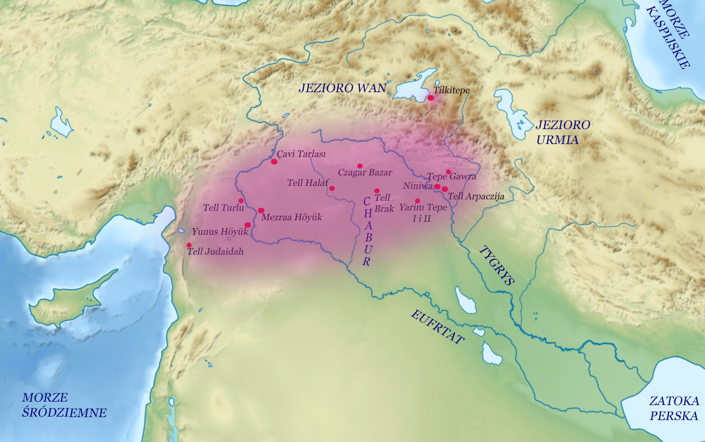
| | | | But much of Max's work dealt with the Halaf culture centered in northern Iraq near Mosul and in northern Syria. This is a Polish map (Map by Adrian84) showing in purple the range of the Halaf culture, with archaeological sites in northern Mesopotamia on the upper Tigris and Euphrates. Note Tell Halaf, Tell Arpachiyah (in Polish spelling), Chagar Bazar (ditto), and Tell Brak. You can judge where Aleppo would be, on the left, near the Mediterranean.
The Halaf culture in northern Mesopotamia lasted between about 6100 BCE and 5100 BCE and is named after the site of Tell Halaf. In 1899, Max von Oppenheim, a German diplomat traveled from Cairo thru northern Mesopotamia on behalf of Deutsche Bank, working on establishing a route for the Bagdad Railway. On 19 November, he discovered Tell Halaf (!!), following up on tales told to him by local villagers of stone idols buried beneath the sand.
http://www.abutbeirah.com/blog/wp-content/uploads/2015/09/Max-Mallowan-and-Agatha-Christie-min.jpg
This is Agatha and Max at Tell Halaf in Syria. But Max (also Agatha) is particularly associated with three locations in northern Mesopotamia:
TELL ARPACHIYAH, now located in the suburbs of Mosul, Iraq, was the most important site. It was excavated by Max and a colleague along with Agatha, in 1933.
In the last two months of 1934, Agatha joined Max on a surveying expedition in Syria.
CHAGAR BAZAR, Syria, an early Bronze Age settlement where numerous cuneiform tablets were discovered, was excavated by Max, with Agatha, from 1935-1937. Many of the artifacts discovered were brought to the British Museum. Besides pottery, a large number of clay tablets written in cuneiform script were discovered.
TELL BRAK, Syria, once a thriving city, was excavated by Max (apparently not with Agatha—explained later) in 1937-1938. The artifacts from Mallowan's excavations are now preserved in Oxford's Ashmolean Museum, the British Museum, and the National Museum of Aleppo.
| | | | WWII The war put an end to Max Mallowan′s excavations and temporarily separated the couple. Max had a command of Arabic, and so was posted to Egypt in February 1942 with the British Council, a cultural organization, and also served with the British Royal Air Force in North Africa. Agatha was back in London and did war work part time in the dispensary (pharmacy) at University College Hospital, using the knowledge she had gained doing the same job in WWI. She updated her knowledge of poisons as well.
Otherwise in this period, she wrote her autobiography, published in 1946, Come Tell Me How You Live, which leaned heavily on travel. She wrote "out of nostalgia" feeling badly the separation from Max and wanting to recapture the "poignant remembrance of our days in Arpachiyah and Syria." While she never went back to her maiden name, Miller, she also didn't take Max's name on a regular basis—tho neighbors might have called her Mrs Mallowan. However, the autobiography is one of only two books she wrote and had published under both of her married names of "Christie" and "Mallowan", the other being a 1965 religious book, Star Over Bethlehem and other stories, containing 6 short stories and 5 poems. The title of the autobiography is from Lewis Carroll, and is also a word play, since a tell is also an archaeological mound, which appears in the names of many sites.
| | | | | | The title of her autobiography is a quote from Lewis Carroll, but the translated titles tell more than the English title does. The original French title was a direct translation: Dis-moi comment tu vis. But a later French edition changed the title to La romancière et l'archéologue : Mes aventures au Moyen-Orient / The Novelist and the Archaeologist : My adventures in the Middle East. The Portuguese title was simply Na Siria / In Syria. Both of those point clearly to how Agatha was a Woman of the Middle East. The Dutch title Speuren naar het verleden / In Search of the Past, reflects on archaeology; the Italian / Traveling is my Sin, emphasizes the love of travel; and the German Erinnerung an glückliche Tage / Memories of Happy Days, shows how she puts this travel to the Middle East in a very positive light. |
| | | | After the War After four wartime years in London, Agatha hoped to return to Syria, which she loved.
https://i.inews.co.uk/content/uploads/2020/10/PRI_168722946-760x617.jpg
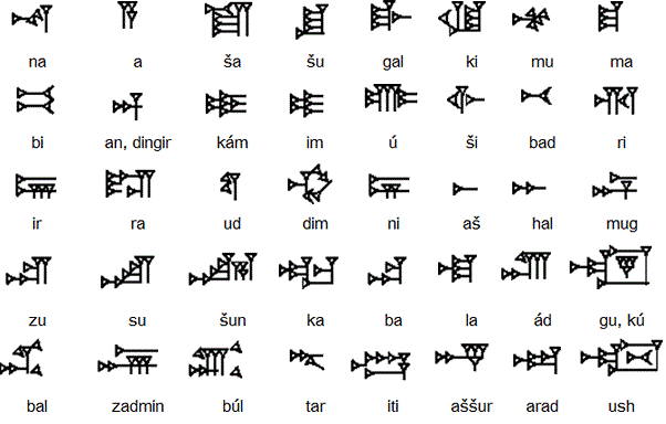
This is Agatha Christie typing at home in England in 1946. But they didn't restart their archaeological work until 1947 with another surveying expedition, this time returning to Iraq. Agatha recalls in her memoirs that as early as 1932, Max had taken her to see the site of the Assyrian city of Nimrud. It was, he said, the site he longed to excavate above any other in the world. He felt it was a place as important as Ur and potentially as rich as Tutankhamun’s tomb in Egypt. Then in 1949, Max was appointed the first director of the British School of Archaeology in Iraq, and he secured the necessary support for the excavation from the Metropolitan Museum of Art in New York. He considered this the biggest project of his career. And so for ten years, from 1949-1959, Nimrud became Agatha Christie′s "hometown" in the Middle East, just like a second home. As a matter of fact, she paid to add a small writing room to the team's house at Nimrud and so for the first time, she had her own little annex, with a sign on the door written in cuneiform (!), calling it in Arabic Beit Agatha / Agatha's House. Filled with modern Iraqi art, it served as her study, and here she continued her writing.
| | | | | | Along with Egyptian hieroglyphs, cuneiform is one of the earliest writing systems. It's a script that was used to write several languages in the Ancient Middle East from the early Bronze Age until the beginning of the Common Era. Like Chinese and hieroglyphs, it's NOT an alphabet. But similar to Chinese, cuneiform was logo-syllabic, which just means it used logograms--symbols representing words (not sounds)--that also could be used to depict syllables. It was originally developed to write Sumerian in southern Mesopotamia. A later language it was used for is Akkadian, whose texts are attested from the 24C BCE onward, and which make up the bulk of the cuneiform record. This is a selection of some cuneiform syllables in Akkadian. As a silly exercise, on lines 2 & 3 find the symbols for the syllables kám & ra and make believe you're writing "camera". Now picture how they gathered, from a larger selection of syllables, enough syllables to write "Beit Agatha" to post on her door in Nimrud. |
| | | | Max in retirement, and possibly earlier, was a member of the Archaeology Department at Oxford University. I came across this domestic scene--domestic, at least, for Agatha and Max, as they pore over pictures of artifacts and sites. It was taken in 1950, which puts them in their Nimrud period, and it was at their Winterbrook House. I knew nothing of this house, so I looked it up.
Winterbrook is a small hamlet in Oxfordshire at the south end of Wallingford, about 1 ¼ hours WNW of central London by car. Agatha and Max bought Winterbrook House in Winterbrook early on, in 1934, and she liked to call it "Max's house". Since we knew her history, it seems to say how much she felt that Styles had been "Archie's house". They didn't stay at Winterbrook House for very long at first, having to return to Syria for more excavations, but it was their house for the remainder of both of their lives.
https://c1.staticflickr.com/3/2732/4119745063_f369e00d6c_b.jpg
https://i.pinimg.com/originals/3c/9b/f8/3c9bf846313a1d46bde9296bf3a051d3.jpg
This is Winterbrook House, in mid-18C Queen Anne style. It's believed to be the model for Miss Marple's house in the fictitious village of St. Mary Mead. The second view shows the name above the door, and the historic marker telling of its two famous owners.
| | | | Deaths Archie Christie died in 1962 at 73. Nancy, tho 10 years younger, predeceased him 4 years earlier, in 1958 at 58. They'd had a son, Archibald Jr, in 1930, the year Agatha remarried.
Max became Sir Max in 1968 for his contributions to archaeology, after which Agatha could also be styled as Lady Mallowan.
However, Agatha became Dame Agatha in her own right three years later, in 1971, for her contributions to literature. Max and Agatha are among a small number of married couples who each held knightly honors in their own right. (Archie didn't live to see her honored this way.)
Agatha and Max's marriage lasted until her death at Winterbrook House in 1976 at 85—"till death do us part".
Max, tho almost 14 years younger, died just two years later, in 1978 at 74, in nearby Wallingford.
https://i1.wp.com/memolands.com/wp-content/uploads/2020/06/p1050406-1768474307-1592858081212.jpg?resize=640%2C438&ssl=1
Above is the blue historic plaque we saw at a distance earlier on Wallingford House. It has, of course, their true birthdates on it. No trickery here! They are buried together at the church she attended in Cholsey, also near Wallingford, just as Winterbrook is. She's listed first as Agatha Mallowan, then as Agatha Christie. Notice above the heavy inset monogram of A and M for Agatha and Max.
London has an Agatha Christie Memorial (Photo by Diagram Lajard-Alexis Jazz), located near Covent Garden in the theater district. While shaped like a book as a reference to her novels, its location is also a reference to her 1952 murder mystery play The Mousetrap, which holds the record as the world's longest-running play, having surpassed 28,000 performances. I've seen it twice (2007/11). However, as did all other plays, it stopped running due to Covid on 16 March 2020 and is, with others, perhaps only on hiatus. If it and other plays start up again remains to be seen.
| | | |
| |
|
|
|

