|
Reflections 2023
Series 3
May 2
Street Cable Cars Worldwide II: US Domestic IV: Manhattan I
A Cable Car Ride up Broadway I: Bowling Green to Herald Square
| | This posting, together with the next, which completes it, should complete our series of postings centering on street cable cars. We've seen the relatively short routes on Montague Street and on the Brooklyn Bridge. Now we see how three cable car lines spanned most of Manhattan! | | | | Street Cable Cars in Manhattan I suspect that even many well-educated people are underaware of local history, and what they know might be largely political in nature, if that. Beyond that, it's even less probable that transportation history would be something the man on the street would be aware of. This included me. As for rail, I'm well versed on subways and intercity railroads, but never even had an inkling of even something more obvious, like trolleys/streetcars/trams in Manhattan, and certainly had no concept of street cable cars there. That's San Francisco, fool!
My awakening came from a highly unlikely source, going to the movies. When Beverly and I first moved to Lower Manhattan in the early '90's there was no cinema in Battery Park City or nearby, and it was a few years until Regal Battery Park opened a ten-minute walk away. Fortunately, we found that the Angelika Film Center (& Café) was not that far away up on Houston Street, a block from Broadway. It's an art house that opened in 1989 featuring independent and foreign films. We went there quite a bit, and were intrigued by its odd design, a multiplex obviously located in a recycled building, with a café upstairs and five cinemas underground. I do not remember how I found out, but in time I was thrilled to learn that the downstairs location had been the powerhouse for cable cars that once operated up and down Broadway! But I knew no more until I recently discovered a map of Manhattan that told the cable car story. It was finding that map that got this whole cycle of cable car stories started, from London to New York's Greenwich Street to San Francisco and across the US. So now we're back at where it all started for me.
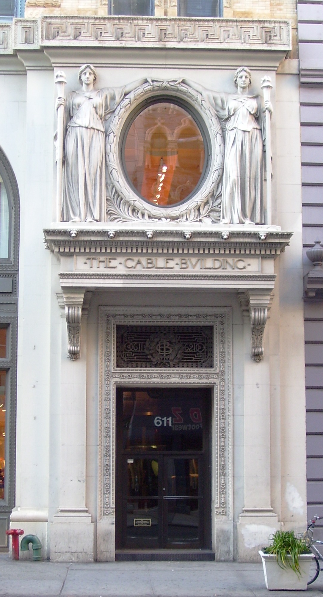
| | | | Cable Building I was certainly not paying attention when I was at a building I now know is called the Cable Building (!) on Broadway at the right) at Houston at the left (Photo by Tony Hisgett). After the four arches on the Broadway side is (click) the stately main entrance, better seen in this detail shot (Photo by Beyond My Ken). I've actually shopped at that Crate & Barrel that fills the whole corner—the wooden wastepaper "basket" at my desk is from there. Walk down Houston to the back of the building at the corner of Mercer Street, and that's the Angelika. But I never put two-and-two together.
https://www.nohomanhattan.org/noho1.jpg
It gets better (worse?). Above is the NoHo Historic District, NoHo, contrasting with SoHo, being an area NOrth of HOuston Street. The Cable Building fills the entire southern half of that block on Houston between Broadway and Mercer. Shouldn't I have known better? Well, I do now.
The Cable Building opened in 1894, built in the Beaux-Arts Style by none other than Stanford White of McKim, Mead & White. Its dual use as both what was then a major powerhouse (in its basement level) and the headquarters for one of NYC's cable companies is unique in the McKim, Mead & White portfolio. As we've seen, a cable car powerhouse is usually a very utilitarian building, and of the 29 American cities that built cable car systems between 1870 and 1900, this is the only one whose powerhouse was built by an architect of such stature, and with a headquarters of enduring artistic refinement as well. This is a drawing of the Cable Building in 1893 with cable cars on Broadway. Compare it to the above modern photo.
The company founded in 1892 that later became the Metropolitan Street Railway Company had numerous rail interests in Manhattan, and by 1900 had acquired the last independent street railway in Manhattan, giving it complete control. It spent $12 million on a cable car railway system to move street cable cars on Broadway starting at Bowling Green, and ran to 59th Street. It became operational in 1893 and was the most expensive system on a per-mile basis of any system in the US. It had 125 cable cars and served 100,000 passengers a day. The Cable Building held its central power station and main offices.
The basement of the Cable Building (today's Angelika multiplex), had been excavated 14 m (46 ft) under street level (the length of the escalators patrons today descend to see a film). It housed four steam engines, that powered four 9.8 m (32ft) winding wheels, that moved the cables that pulled the cable cars.
But we already know the story of cable versus electricity. Just seven years after the Cable Building was finished and occupied in 1894, cable traction became obsolete in 1901, and the company switched to electricity. Still the building retained its original name. The last Broadway cable car left the Battery Station at 8:27 PM on 21 May 1901. Its final journey marked the end of cable street transportation in New York City. Again, the Manhattan dates for cable cars are 1893-1901.
As we now know, it wasn't until 1989 that the powerhouse became the Angelika Film Center, and I wonder what it was in all those years in between. We saw that the Broadway end of the ground floor, plus all of the floor above, became a Crate & Barrel store in 2002. The other seven floors of offices are rented out. Not a hint of cable remains, other than in the name of the building.
| | | | The Angelika We just walked down the Houston side of the Cable Building to Mercer Street. At that corner is the entrance to the Angelika Film Center, up some steps (click) to the box office (Photo by Nightscream). Those windows to the left and right are the on-premises café, and in the window above the entrance you can see furniture or sale in Crate & Barrel.
https://3.bp.blogspot.com/-rN7IdgNS0Rk/VbB-8HEF6yI/AAAAAAAALsQ/WdIkRcR4D-A/s1600/Angelika%2BFilm%2BCenter%2BNew%2BYork%2B8.jpg
This is the café/lobby, and those huge columns indicate the grandeur of the building. I've stopped here for a sandwich or a pastry. All around the café are historic movie posters, some in French (click). Everything is kept very orderly. When a given cinema downstairs is letting out, an usher (remember them?) at the lobby exit announces the new starting time, collects your ticket, and you leave and turn right to go down a long escalator, even as those leaving the cinema are on the up escalator, and will leave onto Mercer Street, with no return to the café/lobby. Downstairs, there is one cinema under the café/lobby, and is of a standard shape. But across from the concession stand are the more interesting four cinemas.
https://lh3.googleusercontent.com/p/AF1QipOPgcxH87W5xQKhE71DpDvH02c5XnMI7Bkf5xgH=w660-h440-c
Each of these four cinemas faces east and looks like this, long and narrow, located under the main part of the Cable Building, with the screen being close to Broadway. The tunnel-like layout allows only for one center aisle, with short rows of seats left and right. Of the films I've seen at the Angelika, I only remember one by name, Shakespeare in Love, in 1998.
Now visualize, in place of these four long cinemas, four steam engines powering four huge winding wheels straight ahead, with cables feeding out to Broadway and its cable cars.
| | | | The Map We are now ready to look at the map that shows it all, the one that started me on this entire saga of cable cars—the present posting—and next--are the latest on the topic (2022/4-5-6-7 & 2023/1-2-3-4).
https://external-preview.redd.it/LJwq3zruACLRHnRIN5gSEaofFXFWjTeyMedqxxxm5fg.jpg?auto=webp&s=99b16c9aa02e436d6b4b776fc5a0ffd6b9ab1f6d
This magnificent map of Manhattan (accept that the island is "lying on its side", with north to the right) shows the extensive urban rail transport back in the day. It isn't dated, but would seem to stem from the turn of the 20C, give or take a few years. Then let us bewail together that on this map, every single bit of urban rail transport, is GONE!
| | | | | | We're talking above about urban rail, not mainline, interurban rail. You see the dashed-gray rail line coming out of Grand Central (click). That's still there.
This is easily a decade before Penn Station and its Hudson River Tunnels were built.
The dashed-gray rail line along the Hudson coming out of Saint John's Park Depot was the former Hudson River Railroad. From the Depot to the bend before 14th Street, it's now gone. From there to 34th Street, it's the non-rail park called the High Line. From there north, it serves Amtrak's Empire Service trains out of Penn Station to the north.
|
| | | | ELS: Let's start at South Ferry. We know all four el lines are gone, but let's review that. On the West Side, the dark blue 9th Avenue and gold 6th Avenue lines connected at either end. On the East Side, the light blue 2nd Avenue and green 3rd Avenue lines also connected at either end, tho this doesn't show that. Remember both lines ran alternate trains both to South Ferry and also to the Park Row Terminal at the Brooklyn Bridge and City Hall. They also seem to have a common el shuttle at 34th Street to the East River ferry, and one had an el shuttle to Grand Central (not to be confused to the modern subway shuttle from Grand Central to Times Square). All these els are gone.
TROLLEYS: Follow the green lines north-south and the olive green lines east-west of the trolley/streetcar/tram lines in Manhattan. I can't imagine there were this many. They would have been all-electric, but without overhead cables, which aren't allowed in Manhattan. In 2022/7 we talked about conduit cars, which got their electric power from a trench between the tracks. That must be what all these trolley cars had.
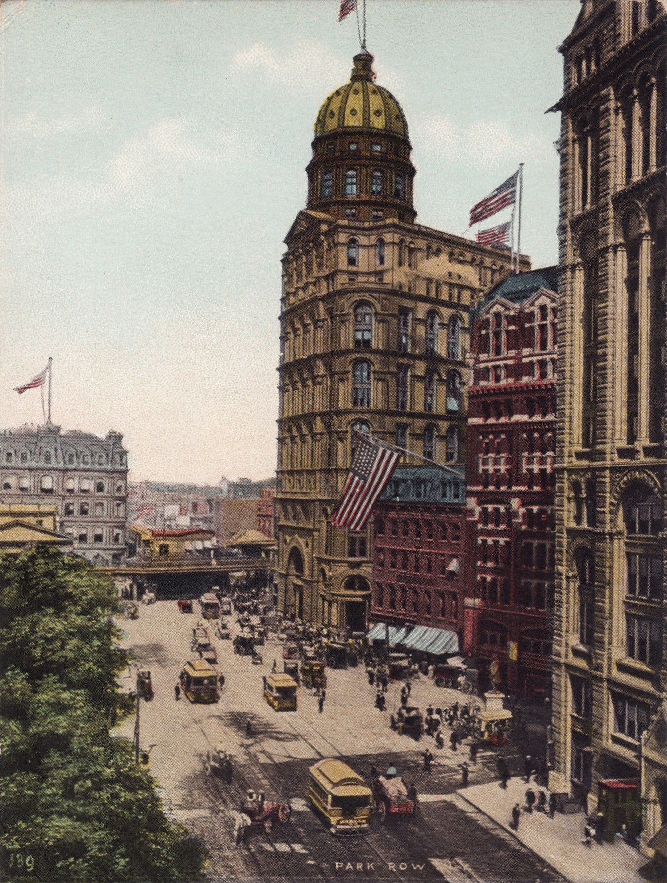
| | | | | | I've been aware for a long time why Manhattan (not the outer boroughs) doesn't allow any utility poles or overhead lines of any sort. It all goes back to the infamous, powerful Blizzard of '88. These are snow piles on 14th Street after the blizzard—this is pre-autos, so those piles are all snow. This is the front page of Frank Leslie's Illustrated Newspaper of that date. As we know, in those pre-photo days, "illustrated" referred to drawings. This is a scene in Printing House Square, adjacent to Park Row (Newspaper Row), with "Blizzard" emblazoned across the masthead. But neither of those illustrations gets to the point. What about utility poles and overhead cables? That story is told by this picture, where a group of stockbrokers in the Wall Street area survey the damage to power lines. In such neighborhoods, the number of overhead cables attached to utility poles and buildings had become nightmarish spider webs, and the blizzard took many of them down, with injuries if not deaths.
https://www.boweryboyshistory.com/wp-content/uploads/2013/02/1888-1.jpg
But also residential neighborhoods like W 11th Street in Greenwich Village suffered damage, as this drawing shows. Thus Manhattan forbade overhead power lines and utility poles—and this says nothing about the visual pollution the new regulations removed.
|
| | | | CABLE CARS: And finally we come to the three cable car lines in brown, which run the length of the island. B is the Broadway Cable Car, which covers the central city. The other two are extensions of it: C is the Columbus Avenue Cable Car on the Upper West Side and L is the Lexington Avenue Cable Car on the Upper East Side. But remember that these uptown areas to the north were considered far away at the turn of the 20C and still contained many vacant lots. | | | | Metropolitan Street Railway As mentioned earlier, the company that was eventually known as the Metropolitan Street Railway ended up owning all the street trackage in Manhattan. In 1885, a company called the Broadway and Seventh Avenue Railroad opened the Broadway Line to run initially along Broadway between Bowling Green and Union Square, later extended. Tho not specified, this has to have been a horsecar line. In 1893, the company installed a cable system instead, and it also operated the Lexington Avenue Line and Columbus Avenue Line by cable as branches. This company was consolidated into the Metropolitan Street Railway in 1895.
I originally misunderstood how the three lines worked, assuming a change of cable car was necessary between them. But now I know that's not true. All three lines started at the Battery, meaning the central Broadway line had triple service, with the other routes peeling off it, with those cable cars apparently switching from one cable to another.
| | | | The Three Lines I have surprisingly more info and pictures of Manhattan cable cars than I'd expected. Let's break down the three lines to learn more. Follow this on the map.
BROADWAY CABLE CAR: The main cable car line was the Broadway line, which opened on 1 May 1893. It ran on Broadway from the Battery to Central Park, with slight divergences being at the two ends. Follow on the map to see how it went from Whitehall Street quickly to Broadway for a long distance. You can see how at the northern end, at Times Square, it shifted from Broadway to Seventh Avenue, up to 59th Street. Actually, for the three blocks bordering the park, 59th Street is called Central Park South. But that name change took place in 1896, right in our time frame, so still calling it 59th Street is not inaccurate. As we well know, its powerhouse, called the Houston Street Station, was in the Cable Building. Below is a Broadway cable car, showing its designated route.
https://1.bp.blogspot.com/-sLJSrtIJfYo/Uemjaw2w1lI/AAAAAAAAe8w/OFUylno2Ihc/s1600/Unbenannt.png
COLUMBUS AVENUE CABLE CAR: The Upper West Side branch opened late the following year, on 6 December 1894. It ran on the Broadway line, also shifting to 7th Avenue in Times Square, but six blocks before the end at 59th Street, it branched off to the west on 53rd Street. After two blocks, it turned north on 9th Avenue/Columbus Avenue (9th changes its name after six blocks to Columbus, north of 59th Street), then served the Upper West Side up to 109th Street. It apparently ran under the 6th Avenue el (in orange) from the point it branched off. Its powerhouse, the Uptown Power Station, was at 50th and 7th, just before it left the main line.
https://media.clarkart.edu/1955.4384.jpg
Once again we have a formidable picture from Frank Leslie's Illustrated Newspaper, with a handwritten date of 1897. While the car says Broadway, it also says it goes from the Battery to Harlem, which could describe either of the branches, so let's assume it's the Columbus line. Since the car is open-sided, it's perhaps a special warm-weather vehicle. It's marvelous to see the fashions of the day. Also note the barefoot newsboy, evidently typical of the time. Click at the bottom if you want to see how Leslie's grumbles about how, especially in the rush hours shown, the cars are "not only uncomfortable but also very unsafe." Well, if people read newspapers while standing on the running board, that might be the case.
LEXINGTON AVENUE CABLE CAR: The Upper East Side branch opened ten months later, on 14 October 1895. It also followed the Broadway line, but only to 23rd Street at Madison Square, where it turned east on 23rd for three blocks before turning north on Lexington up to 105th Street, four blocks earlier than the west branch reached.
https://library.baruch.cuny.edu/wp-content/uploads/sites/2/2018/10/NewmanLibraryasaPowerStation.jpg
http://bcausa.com/sites/default/files/styles/full_size/public/baruch_newman_0.jpg?itok=CAzJVcKp
Its 1894 powerhouse (first link) was located right after it left the main line, at 25th Street, just east of Lexington. The powerhouse building now houses the library (second link) of Baruch College of CUNY, the City University of New York.
https://media.gettyimages.com/photos/new-york-cable-car-in-1896-broadway-picture-id515547198
http://www.cable-car-guy.com/images/nytar_starting_001.jpg
https://i.pinimg.com/originals/21/b3/cc/21b3cc52df024326a505893e38e2f623.jpg
The first link shows, in 1896, a clearly identified Lexington Avenue cable car, tho the scenery still looks more like downtown.
The second link is self-explanatory. The Third Avenue Railroad was acquired by the Metropolitan Street Railway in 1900. With this acquisition, the Metropolitan had complete control of all the street railways of Manhattan and the Bronx.
The third link is a shocker, but I have no more info about it. Still, it does show that people saw a great deal of promise in the use of cable cars.
| | | | Crossings First, let's review one thing we learned back in San Francisco, which is the problem that occurs when two cables cross and one has to go above the other. One well-known case in SF is where the California Street line crosses the Powell Street lines. As we saw in 22/5, at that intersection the Powell cable is the upper one, so that gripman does nothing and rides thru the intersection. But the California gripman knows he has to "drop the rope", coast a bit, and then "take the rope" again to continue. There were, to my knowledge, two instances like this in Manhattan.
At the crossing at 53rd and 7th, the Broadway line had, understandably, the upper cable, and the gripman could sail right thru, while the Columbus gripman had to contend with the lower cable, with its necessary maneuvering. As for the crossing at Broadway and 23rd at Madison Square, unfortunately, I've not been able to find any info. However, common sense would suggest that again, the Broadway line's cable crossed on top, and the Lexington branch went underneath.
| | | | A Ride on the Broadway Line We can only make believe, but let's take a northbound ride on the long-gone Broadway Line cable car. Our fanciful date can fall somewhere in the decade overlapping the change to the 20C. In this posting, we'll make it from Bowling Green to Herald Square, and complete the trip to Times Square and Central Park on the next posting. Follow on the map. | | | | | | In 2018/2, we discussed Manhattan's early streets, and followed how Broadway and the Bowery were grandfathered into the new street grid (do a Ctrl-F: grandfathered). That discussion centered on the roadway itself, dating from pre-colonial times. But now we'll center our remarks on the cable car route that ran along Broadway starting in the late 19C. Clearly, we'll be expanding on some of the same places along the way. |
| | | | BOWLING GREEN The route map refers vaguely as the southern terminus being Whitehall Street, with other sources mentioning Battery Park, but with nothing more precise. But these surround the park at Bowling Green, where Broadway begins, so let's take a closer look at it to see where we're starting our ride.
We can first mention that Bowling Green had been a significant Lenape Native American site and is likely the place where Peter Stuyvesant purchased Manhattan from the Lenapes for "$24 worth of merchandise" in 1624. The museum behind it is the site where the Dutch later built their Fort New Amsterdam. It's the oldest public park in NYC (1733) and is surrounded by its original 18C fence, which is landmarked on its own. As for the name, it's where the original Dutch settlers had had an actual green where they could bowl ninepins.
https://c2.staticflickr.com/4/3787/8972377458_be4d5dcb83_b.jpg
https://cdn.cms.prod.nypr.digital/images/2009_01_henhud5.2e16d0ba.fill-1200x650.jpg
The first link centers on Bowling Green (keep it for later), where we see the museum, with Bowling Green Park to the north. At the very tip is the famous Charging Bull statue. To its left is the beginning of Broadway, as it faces State Street. To its right is what I've always considered to be Whitehall Street merging into Broadway at the bull, but that's apparently not true. The area on the east side of the park is, oddly, also considered Broadway, then the name finally changes to Whitehall Street for the next four blocks. Some say the change happens at the bottom of the park, others say at Stone Street.
Battery Park is adjacent, and, as shown in the second link, along with State Street, wraps around to the south of this area to border on the southernmost block of Whitehall Street. One block south of that, at South Street, is the Staten Island Ferry Terminal, officially known as the Whitehall Terminal.
So where on Whitehall Street did the cable car service begin? Down at the ferry? Up near Bowling Green? An educated guess would be at the ferry terminal.
https://www.history101.nyc/system/carrierwave/evo/98/w1280_1.1900-Bowling-Green-and-Lower-Broadway-6749x5083.jpg
We see the area in this 1900 postcard, looking north. While it seems that there are streetcar tracks everywhere, even making the park into a turnaround circle, we know that the cable car came up Whitehall Street to the right, to join Broadway going north. This next picture looks south at the Charging Bull (click) with the park, museum, and Battery Park, and shows where Whitehall+Broadway joins regular Broadway (Photo by Epicgenius).
| | | | LOWER BROADWAY From Bowling Green we move up Lower Broadway, the original part of Broadway that goes back to Dutch days.
https://www.oldimprints.com/pictures/medium/53425.jpg?v=1586296011
https://www.geographicguide.com/united-states/nyc/antique/trinity-church/images/broadway.jpg
https://thumbs.dreamstime.com/b/trinity-church-intersection-wall-street-broadway-new-york-usa-april-manhattan-freedom-tower-visible-61474564.jpg
I cannot place what part of Lower Broadway (clearly marked) the first link is showing, but the cable cars, tracks, and cable slot are clearly seen. The next two links show the same area, at Trinity Church, a century apart. The second link dates to 1908-1917. Rector Street (shown on our map) is immediately next to Trinity, before that next building. The tracks and cable slot down Broadway can be clearly seen. However, the cable was gone by 1901, so by now, these must be electric streetcars running as conduit cars. But they're also doomed, and this picture shows why. NYC's first subway, had opened from Brooklyn Bridge north in 1904, and in 1905, it was extended south to Fulton Street, Wall Street (here), and Bowling Green. If you click on the right of this early picture, you'll see a primitive subway entrance marked "UP-TOWN". The subway has arrived to Lower Broadway, and all street rail is on the way out. But our fantasy trip takes place earlier, and our cable car runs north on those tracks you see.
The third link is just to bring us up to date, as One World Trade Center in the background shows. In both pictures, the church faces east down Wall Street (not seen) to the right, which is perpendicular to Broadway.
| | | | | | To compensate, this is a view facing west from the first block of Wall Street, showing Trinity with Broadway crossing in front of it (Photo by Gryffindor). In addition, this map shows the full length of Wall Street from Broadway down to the East River--where Washington landed (Map by Hu Totya). #1 is Trinity; the last picture was taken from between New and Broad Streets. #4 is Federal Hall (Photo by Ajay Suresh); when NYC was the national capital, the original building there hosted the First Congress of the US and was where George Washington was sworn in as president. Turning to the right, #3 is the NY Stock Exchange on perpendicular Broad Street (Photo by Arild Vågen). Not only is Federal Hall still visible here, so is Trinity (in shadow).
I will add that, in early 1961, I worked as a clerk for a half-year for a now long-gone brokerage house, Decoppet & Doremus, at 72 Wall Street, at Pearl, before my Middlebury/Mainz year.
|
| | | | Back to our third link photo, Rector Street is much more clearly seen here. The present neo-Gothic Trinity Church building dates from 1846, and was the tallest building in the US until 1869, and the tallest in NYC until 1890. We could tell that in the Currier & Ives print we saw looking over from Brooklyn. Behind the church in both pictures is the landmarked Trinity Building of 1905, one of the first Gothic-inspired skyscrapers. Several of my doctors have their office here.
The green dome at street level is a modern subway entrance/exit, which I still use on occasion. Another entrance/exit to the Wall Street station is in the building at the left, 65 Broadway, which is the landmarked, neo-classical former American Express Building, where AmEx remained until 1974. I worked for AmEx as a translator of German and French the first year we were married, 1963-1964. Both jobs in the Financial District were fun times.
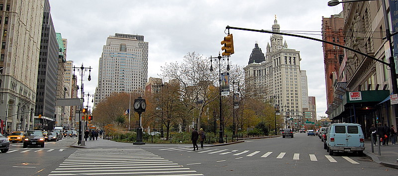
| | | | CITY HALL & PARK ROW Continue on our route up Broadway to where a gray line takes off to the right. We've reached City Hall Park, and that line is Park Row, leading up to the el and to Park Row Terminal. Since cable on the bridge lasted till 1908, it would have been entirely possible for a rider on the Broadway cable car to get off here and walk a short distance to ride the Brooklyn Bridge cable car.
Looking north, this is the modern view at City Hall Park (Photo by Alexander Fiebrandt). Broadway's on the left, and Park Row takes off toward the Municipal Building. Remember that the colonial post road had come up Broadway and turned left here, leading to Boston and Albany. The building on the left with the white terra-cotta façade is the 1913 Woolworth Building, the tallest in the world until 1930.
https://images.fineartamerica.com/images/artworkimages/mediumlarge/3/lower-broadway-c1899-granger.jpg
We jump back in time to our travel period—try not to be fooled. Tho this view looks west down Vesey Street, it's the same location as the previous one. While it does add Saint Paul's Chapel, look at the two other buildings. In the center is the one that preceded the Woolworth Building, so this view is pre-1913. And if I say that the ornate building to the right is City Hall Park today, we know we're looking at that former, unloved City Hall Post Office and Courthouse of 1880, demolished in 1939 to extend City Hall Park down to this intersection. Thus, that's Park Row to its right, and we'll proceed up Broadway to its left.
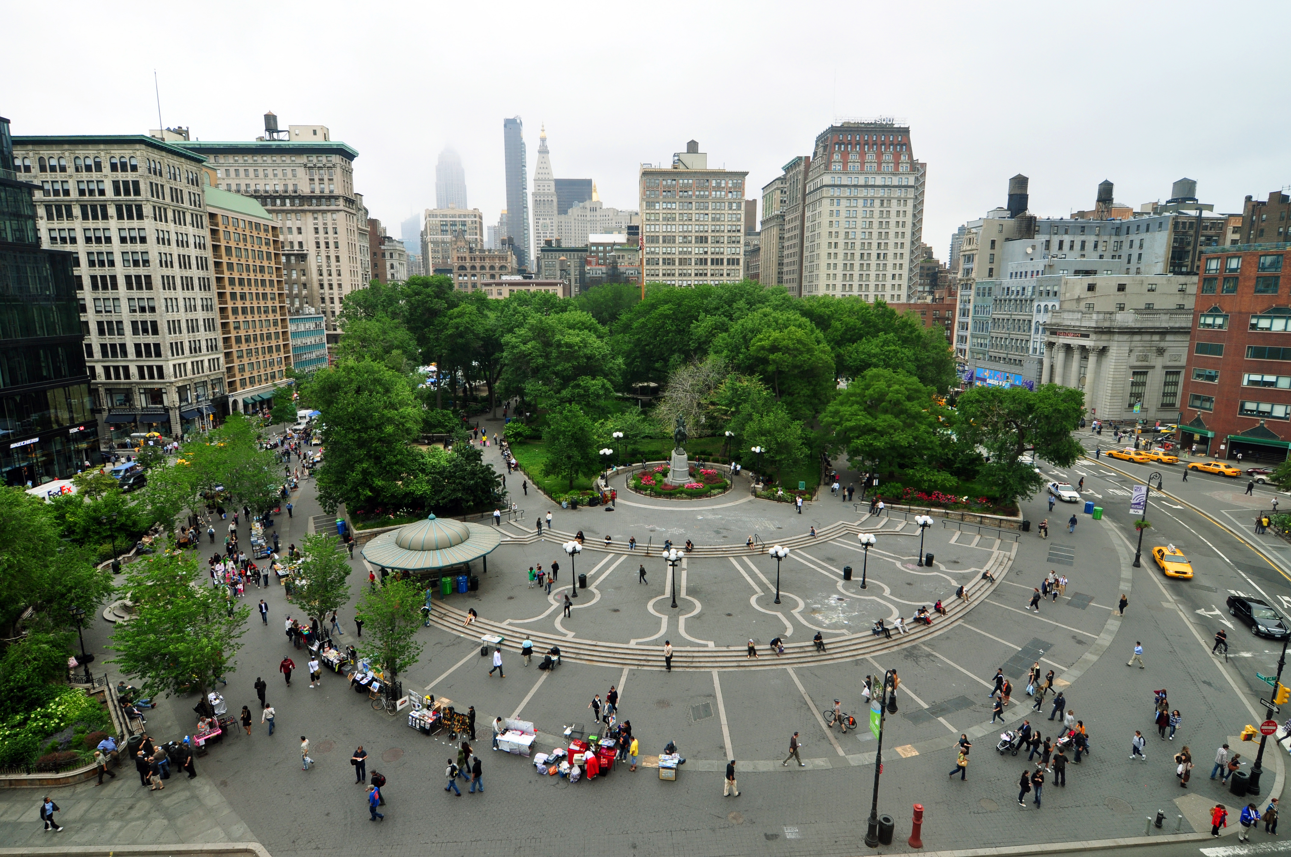
| | | | UNION SQUARE On our map, continue past Canal Street, where we cross Houston and pass the Cable Building, whose powerhouse is propelling us. Then we pass Astor Place, then a bend, to a curve to the left around a green park. This is Union Square (not named).
https://i.pinimg.com/originals/f6/42/7b/f6427bbf3cccc96a84310ec732e66428.jpg
https://media.gettyimages.com/photos/workers-laying-the-cable-for-the-broadway-surface-railroad-at-union-picture-id81668258
The first link shows working laying cable car track in 1891 for the Broadway Line near Union Square. The second is a very nice drawing on the same topic c1893. This one shows Union Square Park ahead, so we're probably on Broadway, about to turn left on 14th Street to avoid the park and go around it. To understand why that's necessary, we need this very old map we once used before:
https://forgotten-ny.com/wp-content/gallery/union_square/parade.jpg
I don't have a date for this map, but the built-up city is in dark black. On the east side, the name North Street is indicative—this has to be the late 1700s, since North didn't become part of Houston Street until after that. So the streets in the lighter area are mostly planned, with country roads running irregularly. You see both Broadway and the Bowery running north out of town, and eventually joining at a VERY steep angle, and then becoming Bloomingdale Road up to the town of Bloomingdale in what is today the Upper West Side of Manhattan. The "union" of Broadway and the Bowery at this point is the origin of Union Square--it has nothing to do with labor unions. (Keep this "black map"--we'll come back to it for our next stop.) When the Commissioners' Plan of 1811 was being prepared, that pre-existing very steep angle and the narrow block between them was seen as a problem to develop buildings, so in 1815 they decided to instead make the union (= intersection) into a square, and eventually, a park.
http://images.nymag.com/nymetro/realestate/neighborhoods/maps/map050328_500.gif
Few people probably see the irony in that the union of the two roads was totally obliterated, yet it's still called Union Square. The upper six blocks of what was the Bowery is now called Fourth Avenue, which enters at the lower right, as does Broadway, but then both are cut off by the square and park. Diagonally across was Bloomingdale Road, which was later renamed Broadway to serve as an extension of the original Broadway. Otherwise, the square runs from 14th to 17th streets, with the side streets renamed Union Square East and West. That's why in the last picture we saw the route turn west on 14th Street, after which it turned north on Union Square West to continue on Broadway. That's how things have to go when a union of roads no longer exists in Union Square (Photo by chensiyuan). While 14th Street is the major crosstown boulevard here and is always associated with Union Square, I'd estimate that the actual "union" intersection would have been at about 16th Street.
But here the plot thickens. There was always a problem at the curve at the southwest corner of the square.
https://i.pinimg.com/originals/7d/3e/25/7d3e2533ca34eda476583c1fd63c45e4.jpg
http://2.bp.blogspot.com/-CdXlRkVw3As/TzKjze4AtyI/AAAAAAAACUg/WE1cxN0zsoU/s1600/Union_Square%252C_1906.jpg
That spot, as the first link shows, always had a lot of foot traffic, plus horse-drawn vehicles, plus early automobiles, and cable car tracks (shown with the cable slots between them) only added to the traffic. The second link shows cable cars on the curve. As we know, before the issue was modified and the problem solved, cable cars were in a difficult position on curves, since the gripman had to release the cable before it touched the pulley(s) and coast around the curve until he could take up the cable again afterward on the straightaway. A coasting cable car around a curve added to the danger, and this corner became known as "dead man's curve."
We can once again rely on Leslie's Weekly to illustrate a cable car accident someplace else on Broadway in 1895. The location is not specified, but could perhaps be at dead man's curve. The car is marked Broadway as a horse-drawn ambulance arrives on the scene.
You'll recall where we mentioned in the previous posting how all Brooklynites in this time period could be referred to as Trolley Dodgers, and the term surely included cable cars.
| | | | MADISON SQUARE We continue from 14th Street to 23rd and Madison Square with its park (see route map). But before continuing, review again on our "black" map how, early on, a huge park called The Parade had been envisioned for where Broadway crosses 5th Avenue. This never came about, tho a smaller version did, called Madison Square.
https://i.pinimg.com/736x/05/b8/0e/05b80e98fa4a32072e5bb5483eedcc66--gramercy-park-parks-and.jpg
It runs from 23rd Street, the major crosstown boulevard here, to 26th, between 5th Avenue and the very beginning of Madison Avenue (not named). However, here, Broadway is not eliminated as it reaches up to cross 5th at 24th. Instead, the park is slightly truncated. But before we arrive at the square and park, the Lexington line takes off to the east at Broadway and 23rd (compare with route map). It runs east for three blocks, then turns north on Lexington Avenue, which itself had just originated two blocks south at Gramercy Park. You'll recall that its powerhouse, now a library, was on 25th, just east of Lex.
But we're not turning east. We're waiting on Broadway at 23rd to continue north. To our left, if we're in the 1890s, is nothing if importance, but after 1902, that entire block would be completely taken over by the iconic Flatiron Building, which today famously gives its name to the whole neighborhood—rare for a single building (Photo by Imelenchon). I always thought it was an equilateral triangle, but this view, taken from the Empire State Building, clearly shows a right angle on the right back (SW) corner. We're looking south, so that's 5th on the right, and Broadway on the left. Our fantasy cable car (or streetcar by this date) would be sitting right there (click). The name of the building is now dated, and derives, of course, from the shape of a period cast-iron clothes irons of the day (Photo by George Shuklin).
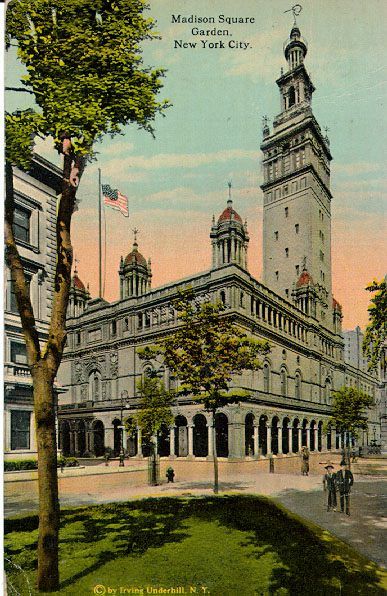
As we pass northward along the west side of Madison Square, we should mention what's NOT there now at all, but would have been at the turn of the 20C, Madison Square Garden, hence the present name of the arena. Why is it no longer where its name says it is? And why is an arena called a garden? There were four buildings that have used the name over time. Let's take them in order.
On our Madison Square map, locate the northeast corner, then cross over diagonally to the block at the southwest corner of 26th and Madison Avenue (not named). This corner, actually including the whole block from 26th to 27th and from Madison Avenue to Park Avenue, was where it all started. It was owned by Cornelius Vanderbilt, where he had a small passenger depot until 1871, when he moved operations to Grand Central. The site was vacant until 1874, when he leased it to PT Barnum, who converted it into an open oval arena, where he presented circuses and such. In 1876, the arena was leased (subleased?) to bandleader Patrick Gilmore, who called the arena Gilmore's Garden. Gilmore used the venue for flower shows (aha!!), beauty contests, music contests, various meetings, and for the first Westminster Kennel Club Dog Show. He later also presented boxing matches.
| | | | | | I was intrigued by this reference to "bandleader Patrick Gilmore", and then it came to me. Think back to the musical The Music Man, where con man Harold Hill is trying to enthuse the townspeople about starting up a boys' marching band. He evokes his own past experience: ". . . and you'll feel something akin to the electric thrill I once enjoyed, when Gilmore, Liberati, Pat Conway, the Great Creatore, WC Handy, and John Phillip Sousa all came to town on the very same historic day!" This was immediately followed by the booming "76 Trombones".
I looked up the first four unfamiliar names, and they're indeed all valid, well-known musicians of the period. But we can now note that Gilmore, who wrote "When Johnny Comes Marching Home Again", started the use of "garden". But he did have flower shows among other events, and so the flowers gave—some--credibility to calling it a garden.
|
| | | | After Vanderbilt died in 1877, his grandson William Kissam Vanderbilt took back control of the site and announced, on 31 May 1879, that Gilmore's Garden, tho now flowerless, was to be renamed "Madison Square Garden", evoking the prestigious square and park diagonally across from it. So now we have an arena no longer known for flowers, but still called a garden. Use of the term "garden" for an arena has since spread to other venues—the former arena called the Boston Garden comes to mind. I think we can credit William Kissam Vanderbilt for this quirk.
This structure can be referred to as MSG I. Vanderbilt presented sporting events, a horse show, track & field meets, and boxing, including John L Sullivan exhibitions. PT Barnum also leased it--he exhibited here his famous elephant, Jumbo, whose name has since become a part of the language. MSG I existed from 1879 to 1890, but the venue was financially unsuccessful, became structurally unsafe, and was demolished.
MSG II existed in our time frame, from 1890 to 1925, in the same location. It was a spectacular Beaux-Arts structure that dominated the park, and was designed by Stanford White. This view shows MSG II and its relation to its namesake park. White included a minaret-like tower modeled after the Giralda, the famous bell tower of Seville Cathedral. It was 32 stories tall, the second tallest building in NYC at the time. It also included boxing, musical performances, both the Barnum and Ringling circuses, and the 1924 Democratic National Convention. This is MSG II in 1908, and our fantasy cable car ride would have passed it a few years earlier. Those are either cable cars or streetcars on 23rd Street, with Broadway to the left.
I suspect that if NYC had its present Landmarks Preservation Commission (formed in 1965 after the horror of the loss of Pennsylvania Station), this building might have been landmarked and might still exist. But MSG II was also unsuccessful and was torn down to be replaced with another building. We have a video in the next section about the loss of these landmarks.
MSG III existed from 1925 to 1968, but was the first of two locations NOT at Madison Square, making the name somewhat nonsensical. And this is the explanation of the other part of the mystery of the name: Madison Square would no longer have a Madison Square Garden. MSG III was on 8th Avenue at 49th/50th Streets. I was taken to see the circus and rodeos there as a child several times.
| | | | | | I just mentioned the former Boston Garden that used to be above Boston's North Station, and did look it up. It was built in Boston in 1928 by the same guy that took MSG III away from Madison Square, and I was amazed to find that he originally actually had the nerve to name it Boston Madison Square Garden, later shortened to Boston Garden. Not only did the word "garden" travel, so did "Madison Square". It's hard to believe. |
| | | | MSG IV has existed since then as a barnacle defacing Penn Station, and was a factor in the original station being torn down. Tho I once went to MSG IV when we were given free tickets to some ice show, I am obviously not a booster of this venue.
Thus today we have an arena called a garden that's NOT a garden, named after a place across town where it has NOT been located for a century. Truth is surely stranger than fiction.
| | | | | | However, it's not unprecedented for a famous name to be kept when it's no longer accurate. Second Avenue was once the center of Jewish culture, referred to as the Yiddish Theater District. The well-known Second Avenue Deli opened on Second at 10th Street in 1954. A rent increase and dispute in 2006 caused the owner to move the next year to 33rd Street off 3rd Avenue, yet still keeping its name.
This phenomenon happens notoriously with sports teams. In 2023/1, we saw how the name Trolley Dodgers was thoroughly associated with Brooklyn back in the day, and in shortened form, became the name of its baseball team. Now the Dodgers are in Los Angeles, and their name makes no sense. But it's kept. Minnesota is known for its 10,000 lakes, and the basketball team there was called the Lakers. They, too, moved to Los Angeles, and I remember reading where someone was wondering where the LA Lakers had gotten their name.
Now refer back to the "Bowling Green" map from earlier. We saw that the stock exchange, near Wall Street, was actually on Broad Street. That street name still makes sense, because the street is still wide, tho most people probably don't know that it's because there used to be a canal down the middle. Now find Bridge Street at the bottom of Bowling Green. The name was helpful when it led to a bridge crossing the Broad Street canal, but now it makes no sense. Look one block north at Stone Street, the first cobbled street in New Amsterdam. In those days, after you slogged thru muddy or dusty streets, the street name pointed out that you could walk on a street paved with stones instead. Now it's tarred over and makes no sense.
This whole phenomenon to my mind connects with Salvador Dalí's best-known work, The Persistence of Memory, in NYC's Museum of Modern Art, famously showing melting watches. The general interpretation is that the soft watches are a rejection of the assumption that time is rigid. It would also seem to say that memory is a factor of perceived time. That's why we still say we're "dialing" a number, or "hanging up" the phone, when phones haven't had those features in decades. Memory outlasts and defeats time. MSG IV is not on Madison Square. The Dodgers are no longer in Brooklyn. Still, the names continue to reflect in the collective mind that which once was.
|
| | | | HERALD SQUARE Where our fantasy cable car ride up Broadway crosses 6th Avenue, at 34th Street, is Herald Square.
https://redpawtechnologies.com/downloads/2014/12/NYC-TimesSquare.jpg
We're using this "HSq/TSq" map to show the position of Herald Square vis-à-vis its surroundings, especially Times Square, clearly marked as the Theater District, with which it's historically connected and which will be our next stop, in the next posting. Theaters (also hotels) are noted in orange (click). One block west of Herald Square is Penn Station (with MSG IV riding its back), and one block east is the Empire State Building (surprisingly, not named), at the southwest corner of 34th & 5th. Find 34th & Lexington, and in your head go four blocks east to Kips Bay, and you'll be where the British invaded Manhattan in September 1776, after the battle of Long Island.
You see Macy's, which we'll discuss in a moment. Look just to the south to what is now recycled as the "Manhattan Mall". This was formerly the Gimbels department store, which moved to NYC and built this building in 1910. Gimbels closed in 1987. Gimbels was always considered the chief rival of nearby Macy's, and American culture popularized their "feud". The question "Does Macy's tell Gimbels?", used to brush off a question about something not to be divulged, became part of the American idiom. In the well-known 1947 Christmas film "Miracle on 34th Street", a certain fictitious "Mr Gimbel" even tries to show up a certain fictitious "Mr Macy".
While on Madison Square, it's the Flatiron Building, not the square, that gives its name to the Flatiron District, in the case of both Herald and Times Squares, each square gives its name to its surrounding district within Midtown.
We saw that Bowling Green Park and Union Square Park each lie in the center of surrounding traffic. Madison Square Park, oddly, lies completely to the east of the actual "X" intersection of Broadway and 5th Avenue and, with the Flatiron Building, actually seems to draw attention away from the intersection itself. But these next two squares are different from all of the previous ones, and similar to each other. Both Herald and Times Squares are in a "bowtie" pattern, meaning the "X" of the intersection is what stands out. Note for now on the map that the intersection at Times Square is at a much more acute angle than that at Herald Square. I've measured that on a map, and Broadway crosses 6th Avenue at Herald Square at just over a 20° angle, allowing for parkland on the triangular blocks thus formed, while at Times Square, Broadway crosses 7th at just above 10°, squeezing the closest blocks to mere slivers.
https://2.bp.blogspot.com/-wvaGMaPzvKo/UengliVAafI/AAAAAAAAfE8/CgDUUvSxBY0/s1600/herald+square+map+101g.JPG
The major crosstown boulevard here is 34th Street, tho the actual intersection of Broadway and 6th Avenue (also drearily officially called Avenue of the Americas) seems to fall about a half-block further south of it. But here, there's no park in the center, nor is there a park on the side, as earlier. Both here and in Times Square it's the X of the intersection that's the major point of reference. But because the angle of the intersection is so acute, that leaves the narrow blocks form by the intersection spread wide apart, making a rather wide vertical "bowtie".
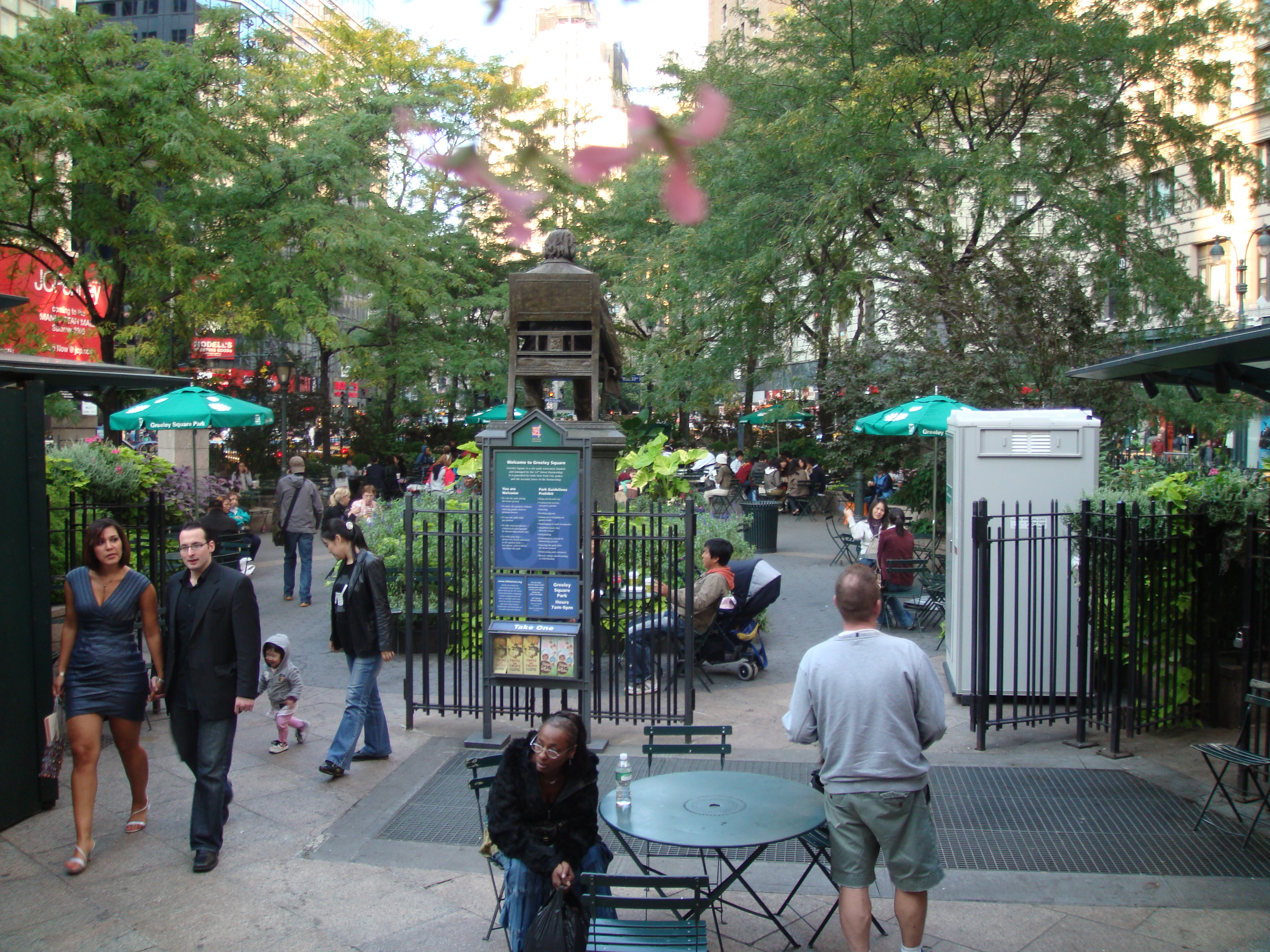
Strictly speaking, Herald Square is just the one triangular park area to the north facing Macy's, plus the streets bordering it, surrounded by red dots. But you have to skip over the block between 34th and 33rd Streets to find its southern complement, Greeley Square, surrounded by blue dots. I suspect there are plenty of people who don't realize Greeley Square is even there, let alone part of the Herald Square complex.
Disregard the yellow area. The orange area attempts to show how the thinking in recent decades has begun to reject the strictness of the unrelenting grid pattern, where street grids are primary and the blocks have to conform to them. The change is similar to saying that the Swiss cheese itself is more important than the holes within the cheese. If we're going to downgrade the holes, we'll downgrade the ever-powerful streets. Thus the orange areas show where bits of Broadway have been pedestrianized, with the effect of making some city blocks larger. Along with doing that, the two parks have been improved.
| | | | Pedestrian Zones Since 1992, Herald and Greeley Squares—the entire bowtie--have been cared for by the 34th Street Partnership, a Business Improvement District (BID), which provides sanitary and security services and which has added and maintained trees, gardens, and planters. It's also added movable chairs, tables, and umbrellas to the parks. In addition, since 2008, each square has had a food kiosk serving as a sandwich, soup, and salad shop.
Then in 2009, the NYC Department of Transportation started to pedestrianize parts of Broadway in this area. Pedestrian zones were developed on Broadway in Times Square, along the length of Broadway from 35th to 42nd Streets, part of which is visible at the top of the bowtie map, and on Broadway in Herald Square. Thus the pedestrian space in Herald and Greeley Squares more than doubled, altering the entire character of the area.
As the bowtie map shows, the first changes affected two blocks of Broadway from 35th down to 33rd Street, in three segments, later becoming four. Most striking was the first segment that effectively connected Herald Square park with Macy's, de facto giving the world's largest store a garden outside of its east entrance. The 34th Street Partnership filled the new space with chairs, tables, and umbrellas. This view looks north up a pedestrianized Broadway at an entrance to Macy's (click); the trees at the right are in Herald Square Park (Photo by Ingfbruno).
The second and third segments are split by 6th Avenue. Look carefully at the second one, on the left. It contains a tiny triangular traffic island, an indication of the slavishness that the grid system traditionally followed. I doubt that it's more than a few meters/yards in length, and half as wide, yet it's technically the disconnected southernmost tip of Herald Square Park! It's perhaps one of the smallest "city blocks" in the city, carved up by the grid system, tho no one calls attention to it. At least with the new pedestrian area, this flyspeck is now attached to the large block to the west.
The third area is still there, tho it was altered in 2019. 33rd Street, the only cross street to have been closed, is now open to traffic again, making the third segment slightly smaller. This view looks south along 6th Avenue at the third segment (Photo by Ingfbruno). The white building at 33rd Street (click for the street sign), is the former Gimbels, which faces Greeley Park in the distance.
In exchange for the small loss, a new fourth area was developed. Now the block of Broadway between 33rd and 32nd Street is the fourth pedestrian zone, effectively attaching Greeley Square Park to the block to the east, just as Herald Square Park is attached to Macy's to the west. This view looks north at the 32nd Street (southern) entrance to Greeley Square Park (Photo by Naked Pictures of Bea Arthur [sic]). To the right, the fourth segment connects the park to those buildings, and ahead is the back of the statue of Horace Greeley (see below).
https://cdn.vox-cdn.com/thumbor/ieM7uwM6DJtEemIDmho8jmLRsgU=/0x0:2000x1328/1200x800/filters:focal(840x504:1160x824)/cdn.vox-cdn.com/uploads/chorus_image/image/65125712/120508_17_58_19_P_15_Fl___View___1.0.jpg
This view puts the whole area together. We're looking south from above 35th Street, and most striking is the obvious X forming the intersection. But only 6th Avenue, with all the traffic, is viable thru the area today. Herald Square (click) is below us, with the first pedestrianized segment attaching it to Macy's (as the other picture showed, it looks much better than this picture shows it). Beyond 34th Street is the second segment, with that tiny "city block" visible. The next crosswalks are at 33rd Street, separating the third segment from Greeley Square Park, reaching to 32nd. In this picture, the fourth segment has not been established yet, and we still see traffic next to the park.
Our fantasy street cable car ride would have taken us northbound up Broadway, passing thru all four of today's pedestrian zones, running to the east of Greeley Square and to the west of Herald Square.
| | | | The Name I cannot think of any streets, avenues, or city squares elsewhere around the world named for newspapers, and if any exist, they certainly aren't world famous. The exception is NYC, which has not one, but two city squares with journalistic names, the better-known Times Square and its nearby cousin, Herald Square. However, time marches on, and while the New York Times still exists—tho no longer in Times Square!--the New York Herald (and its successors) no longer does.
The New York Herald was a large-distribution newspaper founded in 1835, which three decades later moved to a new site at the southern edge of—what else—Newspaper Row. The site was on the corner where Park Row and Broadway converge at Ann Street. The corner site had been the first home of the famous Barnum's American Museum, which had burned to the ground, and was then replaced by the new home for the Herald.
https://www.geographicguide.com/united-states/nyc/antique/city-hall/images/herald-building.jpg
Picture the point where we earlier came north on Lower Broadway and faced City Hall Park with Saint Paul's Chapel on the west side of Broadway. This view looks south from City Hall Park at St Paul's on Broadway. The spectacular white building on the left is the Herald Building at the end of Park Row. The French Second Empire structure was of marble and cast iron and rose four stories to a monumental two-story mansard roof, pierced with ornate dormers and round oculi above.
Do not make the mistake of dismissing the Herald as unimportant. By 1845 it was the most popular and profitable daily newspaper in the US. It financed Henry Morton Stanley's expeditions in Africa to find explorer David Livingstone, where they met on 10 November 1871. The Herald's own first account of the meeting, published 1 July 1872, reported Stanley's probably fictitious greeting "Dr Livingstone, I presume?", most likely embellished by Stanley after the fact to make it the catchphrase it eventually became. In 1887, the Herald started a European edition in Paris. In 1895, the Herald moved to a new (spectacular) building in Herald Square, which was named for the newspaper (more below on the building).
At this point, we have to mention another newspaper, the New-York Tribune, founded in 1841 by none other than its famous editor, Horace Greeley. The quote that Horace Greeley is most closely associated with is "Go West, young man". However he didn't coin it—just who did is unclear—but he popularized it. One of Greeley's many causes was urging the settlement of the American West, which he saw as a land of opportunity, particularly for the young and the unemployed. The entire phrase he popularized is actually "Go West, young man, and grow up with the country."
The Tribune was the first to publish Edgar Allan Poe's poems "Annabel Lee" and "The Bells" upon Poe's death in 1849. In the last posting, when we were discussing Newspaper Row on Park Row, we identified the building with a spire as the New York Tribune Building, today replaced by Pace University buildings.
We mention the Tribune because in 1924, the Herald was sold to the owners of its smaller rival, the Tribune, creating the successor newspaper, the New York Herald Tribune, and in Paris, the International Herald Tribune. Thus, the two rivals on Newspaper Row became unified on Herald Square, tho the square's name was never changed. But as we know, the adjoining square to the south was named Greeley Square, and has his statue.
The New York Herald Tribune (the "Trib") received 12 Pulitzer Prizes in its lifetime, and remained in publication until 1966. At that time, the Times and the Washington Post were involved in an agreement to continue operating the International Herald Tribune in Paris, and they did so until that paper ceased publication in 2013.
| | | | | | Talking about the Times & Trib brings back memories of high school in 1953-1957. Both newspapers sold reduced-rate subscriptions to students, and one of the activities I remember being involved in was being on the Newspaper Delivery Squad, bringing papers to student subscribers during homeroom. I just checked my yearbook, and under my picture are these homeroom or after-school activities: German Help Squad, Math Help Squad, Math Honor Roll, Attendance Office Squad, Newspaper Delivery Squad, Prefect Class [Homeroom] Vice-President, Library Squad, Horizons [literary magazine--one short story]. It's a good thing they're listed there, since the only ones I can actively remember are three: German, Newspaper, Horizons. |
| | | | Turn-of-the-20C Herald Square While we've been popping back and forth in time, let's now concentrate on roughly the period straddling the century change in 1900. Look again at our route map of our fantasy cable car ride, and you'll see that, as we proceed up Broadway from Madison Square at 23rd Street, we cross under the former 6th Avenue elevated and its 33rd Street station, just before the main crosstown boulevard of 34th Street.
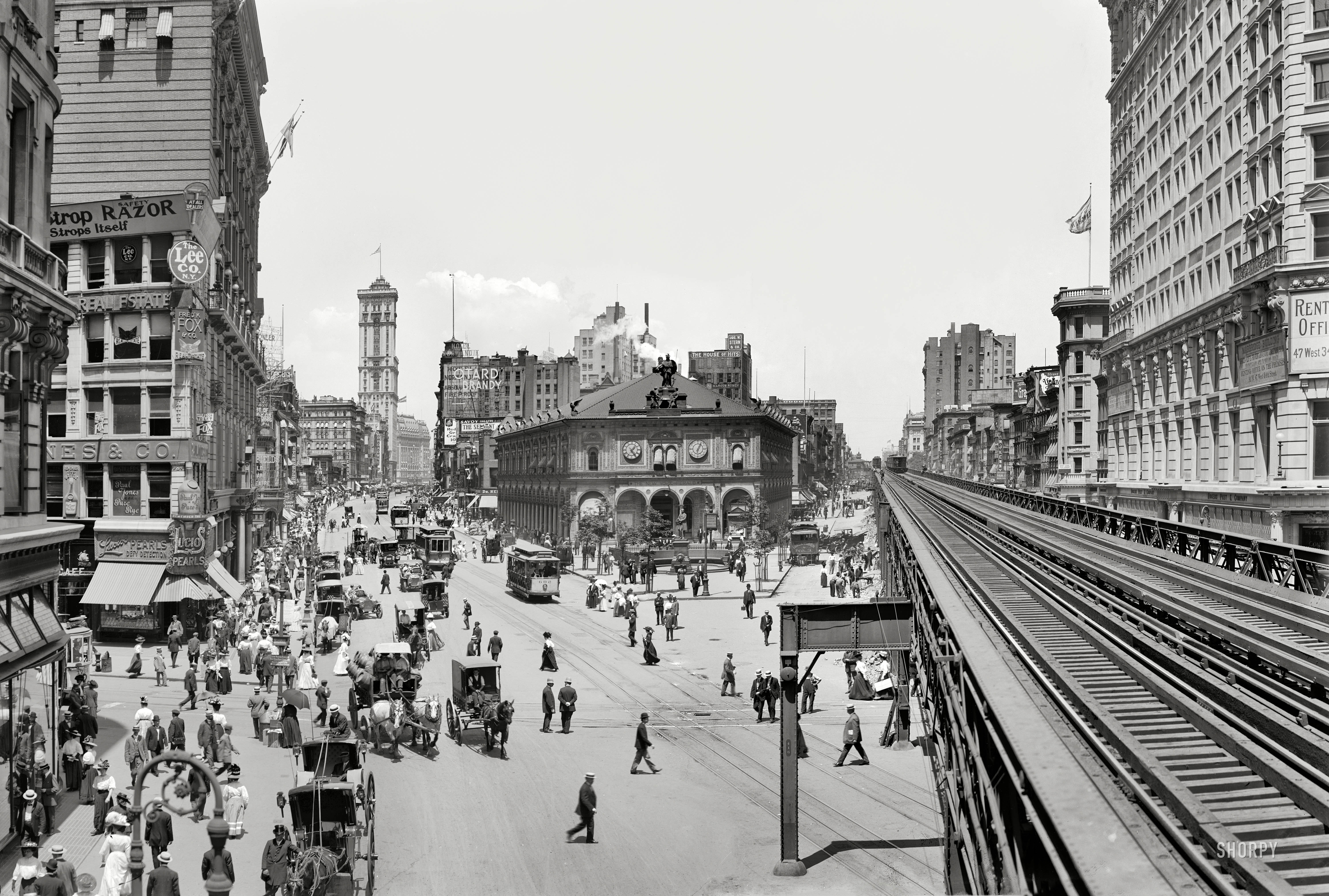
http://www.cable-car-guy.com/images/ny_herald_square_1893_001.jpg
I'm amazed that I can find pictures like this 1893 view that I couldn't imagine existed. Almost nothing you see is still there. You see the cable cars on Broadway, in one of which we're riding northbound. We've just crossed under the 6th Avenue el, which has a train approaching, which is very likely steam-powered, since electric power on els wouldn't appear for a few years still. Near the "leg" of the el are trolley tracks curving into 34th Street on the left.
We have a first view of the old Herald Building (see Herald Square map) on 35th to 36th Street (the line on that block shows that today it's replaced by two nondescript buildings). It's evidently incomplete here, since completion was still two more years off, in 1895. Not yet built is Macy's, which wouldn't appear on the left until seven years later, in 1902. Look up Broadway seven blocks to 42nd Street/Times Square. Missing, because it's not yet built, is the Times Tower, which was finished in 1904.
Now let's look at the exact same view 15 years later, in 1908. The most amazing thing is that you can see the Times Building up Broadway in Times Square, and if you click, can get a good view of it, with cable cars running up to it, as we'll soon do.
Now look further to the left. There is a low-level building with signs that say "Razor", "Lee Co", down to "Lucio's Pearls". Keep this building in mind for a few moments. The hulking structure above it would seem to be Macys. Right beyond, is a building that I now determine to be on the NW corner of 35th Street and Broadway whose sign says [??]fields [Hera]ld [Squ]are [Th]eatre, also discussed below.
But be sure to click and revel in the street views; along with the cable cars are horse-drawn vehicles, and early automobiles. Look at the fashions people are wearing! Everyone is wearing a hat, and ladies' skirts are to the ground. Here's a detail. And a few years later, in 1913, a caption describes this picture as getting on a Broadway trolley in Herald Square. Those skirts must have made it difficult. We are obviously looking south at the 6th Avenue el crossing 34th Street. By this time, cable cars would have already have been converted to trolleys.
| | | | The Herald Building In the late 19C, the owner of the Herald recognized that commerce in Manhattan was moving north, and decided to move from Newspaper Row to a new building at what is now Herald Square. However, how he did that was very unusual, and would result in the loss a few short decades later in the magnificent building he had built there. The problem was, he did not buy the land, but only leased the irregular plot between 35th and 36th Streets and between Broadway and 6th Avenue (see Herald Square map). One lease was for 20 years, and the second for ten. The owner claimed that, with the movement north of commerce, “Thirty years from now the Herald will be in Harlem". Well, that never happened, and the building was eventually lost.
Once again Stanford White of McKim, Mead & White was hired, the famous architect who had many projects locally, notably MSG II in Madison Square. For his inspiration, White used the 1476 Palazzo del Consiglio (Council Hall) in Verona, with its arched loggia, arched window designs, and roof statues (Photo by Andrea Bertozzi).
https://2.bp.blogspot.com/-dVfwPxpdhIE/UIPZZps6AKI/AAAAAAAAJzo/BOPRrgmKug0/s640/new+york+herald+loc.jpg
Compare the Verona building (click) with the new Renaissance Revival Herald Building above, completed in 1895, when the Herald moved north from Park Row to what was now Herald Square. The arched loggia is the same, tho here extended around the building. The arched window designs above are the same. There are statues around the roof—and that's worth discussing.
The owner of the Herald was fascinated by owls, and he had Stanford White install along the edge if the roof bronze statues of owls, each 1.2 m (4 ft) tall. There were four at each end and nine on each side, totaling 26. The four owls on the corners had spread wings (see picture) and were given green glass eyes that glowed on and off with the tolling of the bell of Herald's clock, which had two faces below. The owls were meant to symbolize the wisdom of the newspaper’s printed words. The owl motif was continued further within the particularly impressive grouping of bronze statues on the southern façade of the building (see photo), which we'll discuss separately in a moment.
https://4.bp.blogspot.com/-UTKV5ceRC78/UIPbyxWXdwI/AAAAAAAAJ0Y/KO_DpjFLuzg/s640/herald+building.JPG
Evidently both the owner and architect wanted the public to be part of what was happening in the building, and it did attract scores of visitors and New Yorkers alike every day, who would press against the expansive street level windows to watch the printers at work. In the above picture, passersby stare into the large windows to watch the giant presses churn out the newspaper. The tracks show that this has to be the west façade, on Broadway.
The magnificent Italian palazzo was a show stopper. One critic called it "too perfect". Another said that "Stanford White’s work in terra cotta is the best of the period." On 21 March 1895, at noon, the bronze figures on the roof tolled the hour for the first time. An industry journal wrote that "thousands of persons cluttered up the neighborhood and gazed at the two figures." In addition, the New York Herald building was now the costliest newspaper office building in the world.
We said regarding MSG II above that if NYC had had a Landmarks Commission in the early 20C, that building would have been saved. Surely, so would this iconic building that defined Herald Square have been. Tho oddly, since it was based on a 15C palazzo, it was only two stories tall, unusual for a major NYC building in this period. Perhaps its petite size also added to dooming it to not be a moneymaker once the Herald's leases ended. When art comes up against profit, you know which one wins (without a landmarks commission).
Tho the land leases starting in 1895 would have run to 1925, change came about early, in 1921. The Herald didn't end up in Harlem as Bennett had feared but was instead gobbled up by The New York Tribune in 1924 to become the New York Herald Tribune. But the combined paper did move north—just a bit, five blocks. The combined paper ended up based in a building near Times Square (!!) now known as 219 West 40th Street, next door (east) of the 21C office of the NYT (!!), which is on 8th between 40/41. The ex-Trib building is still rich with newspaper connections, since it's the home of the CUNY Graduate School of Journalism.
Sources say the old Herald Building died in 1921, which is true, but its death was eerily prolonged. In that year, only 2/3 of the raped building was torn down when the northern half of the Herald Building was replaced by a 20-story nondescript building (see Herald Square map). It must have looked odd seeing the architectural masterpiece cut in two, missing its tail end, leaving only its dead, guillotined head. But the builder who did it called his new building "a structure of great income-producing capacity." Then finally in 1940, the remaining front half was replaced by an utterly trivial 4-story building. And one of New York City’s masterpieces of architecture was gone.
http://3.bp.blogspot.com/-yAYJxn1SXcg/UJPuBd6VcBI/AAAAAAAAKXA/3FKTB3Js1ec/s640/herald+building+047.JPG
Seen from the Broadway pedestrian zone next to Herald Square Park (just where our 1895 view had been taken), the 1921 tower to the north and the short 1940 building to the south are what replaced White's magnificent Italian Renaissance Herald building.
But happily, not all was lost. The huge freestanding bronze grouping on the roof was salvaged, and simply moved in 1940 across the street, from the rooftop on the northern side of 35th Street to Herald Square Park on the southern side as part of a granite monument, which now has a clock above the statuary along with a few owls, some green-eyed. The pedestrians enjoying a fine day in the park may or may not realize the monument used to be on the roof of the previous building that was replaced by the two in the background (Photo by Martin Dürrschnabel). Click to see the owls above and the statuary below.
https://i.pinimg.com/originals/3d/a3/d6/3da3d68aedc7dac6e85707fdca98f5c7.jpg
https://c2.staticflickr.com/6/5537/11220145834_ebdc5a3e75_b.jpg
The first link shows one of the standing owls, while the second one is at night, showing one of the green-eyed owls taking off. Below this, the magnificent bronze grouping from the roof is in three parts (click), each part symbolizing newspapers as communicators of knowledge (Photo © Ad Meskens / Wikimedia Commons). Above is Minerva, the goddess of wisdom, whose traditional attendant was the owl—more wisdom. Second, Minerva stands over a large bell, also surmounted by an owl. The old town criers in colonial days rung handbells to gain attention for the news they were about to announce. Thirdly, the bell in turn is "rung" by two bellringers, 2.1 m (7 ft) tall, that swivel at the waist, making it look like they're ringing the bell. Each double ring signals one hour. The bellringers are two mechanized typesetters wearing leather printers’ aprons—obviously representing newspaper printing--and swinging mallets, tolling the hour. They're nicknamed Stuff & Guff, but are only faking ringing the bell, which in reality is struck by mallets located behind the bell. Listen to this YouTube video (0:40) as Stuff & Guff "ring" three o'clock.
Watch the chains pulling the figures. On this day, perhaps due to a mechanical failure, the figure on the right (Guff?) misses his middle strike.
| | | | | | Stuff & Guff are perhaps less known than the other named pair of statues in NYC. This is the New York Public Library (Photo by ajay_suresh) on Fifth Avenue (front) at 42nd Street (behind trees on right). Click to inspect the lions Patience (left) & Fortitude (right), named by Mayor Fiorello LaGuardia during the Great Depression in the 1930s. |
| | | | Historic Preservation I've found by pure chance a YouTube video running 13:05 about the painful loss of architectural landmarks in NYC earlier in the 20C, before the Landmarks Preservation Committee was formed. Architectural Digest presents a NYC architect discussing the loss of Penn Station, MSG II (at 5:45), and the NY Herald Building (at 9:21). All three buildings were either designed by Stanford White or by his firm, McKim, Meade, and White. Happily, White's Cable Building downtown is still with us. | | | | | | Reference is made twice in the video (8:04; 9:24) to the 1890 New York World Building on Newspaper Row (Park Row), the building that was torn town in 1955 to allow for a new automobile ramp (!!) to the Brooklyn Bridge. The World Building was the tallest in NYC until 1899.
This was the building of the New York World c1905, and here's another view of it as part of Newspaper Row. Both views show the Park Row Terminal to its left, at the end of the Brooklyn Bridge. The World Building was also known as the Pulitzer Building, as Joseph Pulitzer owned the New York World.
This next view looks east across the Brooklyn Bridge (Photo by Raman Patel). Today it's an automobile ramp to the bridge, but this is the site of the Park Row Terminal, and in the trees to the right is the site of the World Building until 1955 (2023/2).
|
| | | | Macy's Herald Square As we've seen, Macy's has long been a major presence on Herald Square, and has its flagship store there. We first talked about RH Macy when in Nantucket (2011/18), in this paragraph: | | | | | | Rowland Hussey Macy (R H Macy) was a Nantucketer who, at the age of fifteen, became a crew member on the whaling ship Emily Morgan, at which time he had a red star tattooed on either his hand or forearm. He founded several stores that failed, but eventually found success in NYC with what became the first modern department store in the US. The red star to this day is part of the logo of Macy’s and a version of the star also replaces the apostrophe in the name. |
| | | | When he reached New York, his dry goods store founded in 1858 was originally called RH Macy & Co, later becoming a nationwide chain. As of 2015, Macy's was the largest US department store company by retail sales. Macy's has conducted the annual Macy's Thanksgiving Day Parade since 1924 and has sponsored the city's annual Fourth of July fireworks display since 1976. Macy's flagship store at Herald Square is one of the largest department stores in the world and serves as the endpoint for the Thanksgiving Day parade.
But his original store was further south--still on 6th Avenue but at 14th Street, which at the time was WAY uptown from similar dry goods stores of the day, yet it thrived and expanded. In 1902, the flagship store was moved to the present newly constructed building 20 blocks further up 6th Avenue to 34th Street and Herald Square. This again was SO far north of similar stores that Macy's had to offer a shuttle service for customers from 14th to 34th Streets. Macy's Herald Square was originally just one building, but in 1931, it expanded to fill the entire block to 7th Avenue. Oddly, for some reason, the two buildings never matched up correctly, and to this day, each floor has a few steps between the corresponding floors of the two parts. The entire building has been added to the National Register of Historic Places as a National Historic Landmark.
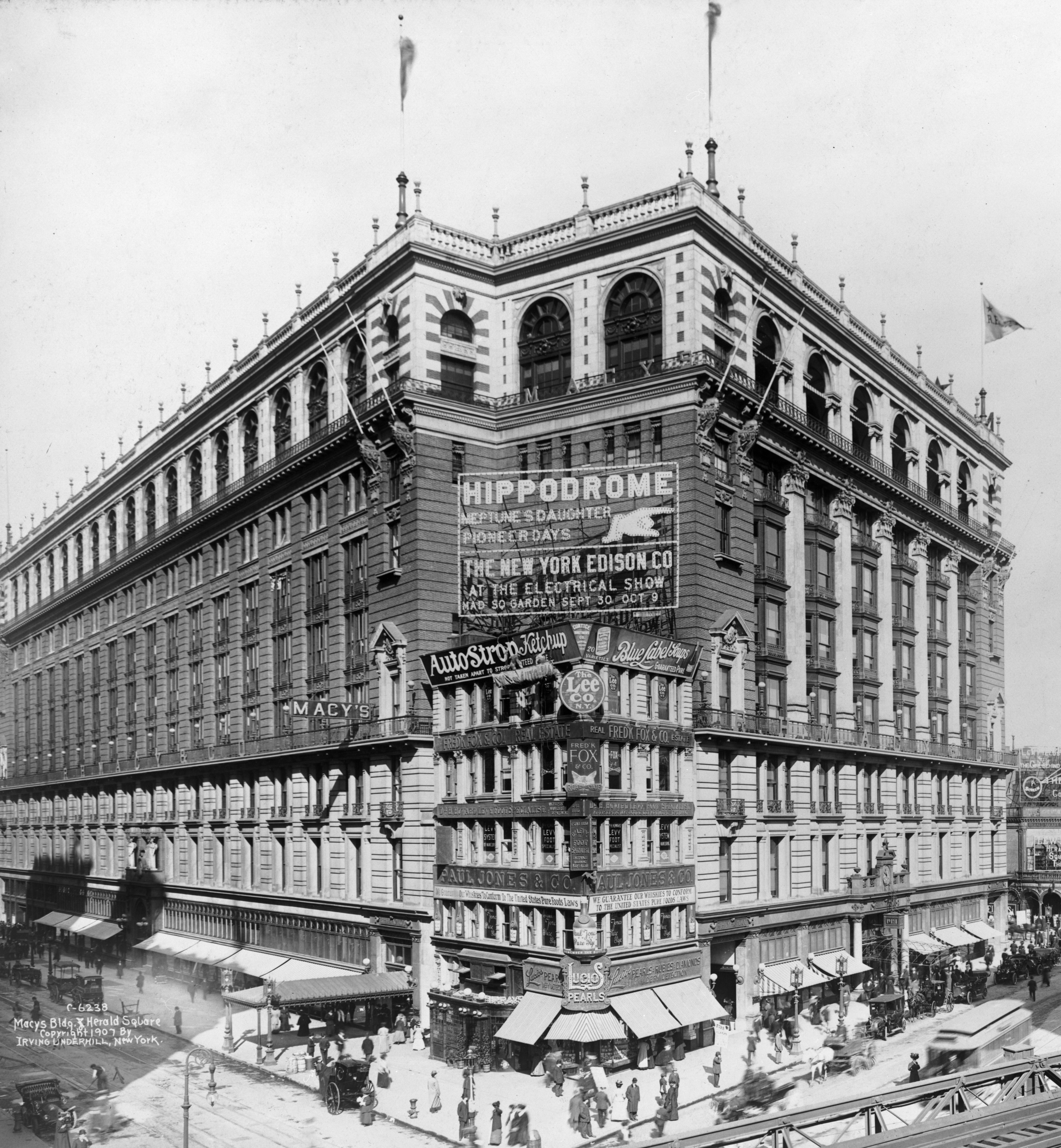
But there was a problem from the start, which later added a second problem. This is why I've waited until now to show this picture of Macy's Herald Square in 1907, when the building was five years old. You recognize from before the building that says "Lee Co" and "Lucios Pearls". This is a better view of it, a thorn in Macy's side.
| | | | Holdouts Holdout buildings exist worldwide. This is the situation where a landowner refuses to sell his property when a large real estate developer is assembling properties. NYC has its good share, and Macy's Herald Square has had not one, but two holdouts. Go back to our "HSq/TSq" map and click on Macy's. That map shows building lines, and as you can see, Macy's does not quite cover its entire block—you'll see the two holdouts diagonally opposite each other. Let's first look at the underwhelming holdout.
I was totally unaware of this building, on Macy's northwest corner at 7th & 35th. I must have passed it frequently, and never noticed it--only Google Maps showed me where it is, and the best picture I could find was this sketch.
http://blogs.wvgazettemail.com/popcult/files/2019/07/NYC-street-0003.jpg
It would have been a minor problem when the 7th Avenue building was added in 1931. It's today the two-story Dali Market. The intersection is identified on the lamppost. Macy's just built around it—Macy's 7th Avenue entrance is under the marquee to the right.
But MUCH more spectacular, and therefore very well-known, is the holdout we just saw above, diagonally across on the very public corner of Broadway and 34th, right at Herald Square. And this holdout was no accident, but was planned by a business rival who believed their store was the world's biggest, and who wanted to prevent Macy's from being able to make that claim. They had someone buy up the corner property in 1900 and build a five-story building on it. Macy's had no choice but to simply build around the holdout.
The corner developed its own name, the Million Dollar Corner, since it sold for $1 M in 1911, equivalent to over $29 M today. Some of that value surely would have been from its advertising potential, since the corner sees so much foot and vehicular traffic. Apparently, the owner(s) of the holdout building began to allow it to be covered by billboards, for more revenue. This is a view of the Corner in 1936, showing a profusion of billboards. The 6th Avenue el is still there, and wouldn't be taken down for another two years.
| | | | | | I'm absolutely shocked to now find something else in this picture I'd never seen before. It shows the 1921 20-story building that killed the rear of the Herald Building, leaving the front stub that now looks to be maybe a third of the original structure. In addition, all statuary has been removed tho the bellringer group must have been put in storage. There is also signage (click) on the stub, which adds insult to injury. It's a horrible remnant, which apparently sat there from 1921 to 1940. |
| | | | However, Macy's was later able to strike a deal whereby it exclusively leased the building's façade above street level to carry a large Macy's billboard shaped like a shopping bag, and proclaiming it to be the world's largest store (Photo by Ajay Suresh). This view also shows very well (click) the pedestrian mall on Broadway.
However, things are still not perfect. Macy's had heard rumors, not denied, that the owners of the building might not renew Macy's billboard lease, and might even lease the façade to a competitor, most likely Amazon. Legal action is afoot.
| | | | Theater District While London's theater district is referred to broadly as the West End, an entire neighborhood, New York's theater district is less precise. Tho the district lies primarily on side streets in the West Forties, it's given the universally accepted name "Broadway", tho there are only three of the 41 theaters actually with Broadway addresses, the Broadway, the Palace, and the Winter Garden. By far, most "Broadway" theaters have always been in side streets NEAR Broadway. But we'll discuss the Forties in the next posting, when we move further north to Times Square.
The word "Broadway" meaning "the New York theater district" has over time been a flexible appellation, which we noted back in 2018/2 when we first discussed Cohan's song on the subject. See that posting for a fuller discussion of other places in the song, including "Coney Isle" and "the [old] Waldorf", and also for a recording of Cohan himself speak-singing the song. but here we'll just quote this bit from that posting about the opening lines, which apply here:
| | | | | | George M Cohan's "Give my Regards to Broadway" from "Little Johnny Jones" (1904), . . . [his first of many musicals] has come to represent NYC's Theater District. Cohan himself played Jones when the show debuted on Broadway. The Johnny Jones character was a jockey (based on a real jockey) longing to return from England to New York, who sings the song to his friend, who is about to sail to America.
Give my regards to Broadway, remember me to Herald Square,
Tell all the gang at Forty-Second Street, that I will soon be there . . .
|
| | | | No lines are more iconic to represent feelings for the Broadway theater. But when Cohan sang about "Broadway", just what did he mean? He clearly meant Broadway in the Thirties around Herald Square, which he specifically mentions by name. The theater district had barely reached 42nd Street in 1902 when he wrote the play and song in 1904, and he gave it only a token mention. He didn't mention Times Square at all, whose area, other than 42nd street, was not yet particularly known for theaters. Even today, the phrase "Times Square" evokes many things, but not theaters, so "Broadway" is used instead.
Yet in 1958, when a statue of Cohan was put up on Broadway, it was located at 46th Street, on the Duffy Square side of greater Times Square (Photo by Beyond My Ken). The 2.4 m (8 ft) bronze remains the only statue of an actor or entertainer anywhere on Broadway or in the theater district. Click to read the title of his famous song, with Broadway lying just steps to the left. But also think about the dilemma. Logically, his statue citing Broadway should be on Herald Square, since that was the section of Broadway he was referring to, but no one today would ever have understood such a thing. Today, theatrical Broadway is in the Forties, where they put his statue, not in the Thirties, where it would logically belong, and so putting it in the Forties is what makes sense to the general public.
But it behooves us to look deeper into that, and we've already had an inkling about it. Earlier we saw just a bit of the sign for the Herald Square Theatre, which I now find out was built in 1883 and closed in 1914, just fitting into the Cohan era. It was on the northwest corner 35th Street and Broadway, which would put it diagonally across from the back of the Herald Building. But times change, and in 1911, it became the first New York theater to be converted into a movie house for silent films. And yet it was demolished only three years later, as New York's garment district expanded from 34th to 42nd, west of 6th Avenue, and as the theater district migrated north of 40th Street.
But another, fuller, discovery excited me even more, when I first looked at this period view of Herald Square c1907. From the right, we see familiar things, the 6th Avenue el, the Herald Building, the Times Building in the distance on Times Square, cable cars/trolleys, Macy's, the Million Dollar Corner. When Cohan in 1904 wrote "Give my regards to Broadway, Remember me to Herald Square . . . " he was referring to the theater world that was still here, and hadn't fully moved up to Times Square, enticingly in the distance.
But on the extreme left, facing Macy's across 34th Street, click on what electrified me: a theater, the Savoy. Don't strain to read what it says, because I also have this excerpted detail of the Savoy. As you can see, the Savoy in 1907 was playing The Man of the Hour, by George Broadhurst, which is declared to be a "great success". A little research tells me that Broadhurst was a theater owner/manager, director, producer, and playwright. His plays were most popular from the late 1890s into the 1920s. He's associated with the 1917 Broadhurst Theater (uptown!) on 44th Street. It's not shown on our map, but is located just to the east of the Majestic.
The Savoy Theatre opened in 1900, so it was just seven years old in this picture. Listed among the notable runs that played there is indeed The Man of the Hour, which ran for 479 performances over roughly 14 months, from December 1906 to January 1908. Here's a surprise: it starred a young (maybe 23-25), pre-Hollywood Douglas Fairbanks. But the Savoy, too, converted to a cinema around 1910, which lasted until it was closed in early 1952, and then demolished.
The Savoy is shown in pink on this 1911 map. North is to the right, and Macy's (not shown) would be across 34th Street. Gimbels is on the left. The layout (click) is common for theaters, at least in New York. Frontage on a main street is more expensive than on a side street, so the theater itself backs onto quiet 33rd Street, and is connected by a long, narrow lobby to the smaller frontage on busy 34th Street.
We might as well also mention what's at the bottom in yellow. The "Manhattan Railway" under Greeley Square is still there. At the time, it was the Hudson & Manhattan Railway connecting to New Jersey, which opened in 1908, today the PATH system (Map by Voyager). Their goal was to reach both NYC rail stations, but the closest they got to Penn Station on 7th Avenue was here, at 33rd Street (not even 34th!). Then in February 1909 the H&M announced plans to extend its uptown tubes northeast to Grand Central Terminal, but that never happened.
We've seen that our upcoming final stop on our fantasy cable car ride on Broadway will be Times Square, before ending at Central Park. That will be described in the next posting.
| | | |
| |
|
|
|

