|
Reflections 2024
Series 3
March 15
SE Florida IV: The Over-Sea Railroad – State Road 4A – The Vets
| | The Over-Sea Railroad The route chosen for the Key West Extension was longer than the Cape Sable straight line, which was the hypotenuse of a triangle. It did have to deal with the gap over water that became the causeway known as the Seven Mile Bridge, but avoided the longer causeway across Florida Bay. | | | | | | Let's start with a language issue, actually two. I think we all know what a causeway is, but let's check the American Heritage Dictionary, which says it's "a roadway . . . usually crossing open water" or also "a long bridge consisting of many short spans." Thus we see that the Seven Mile Bridge was actually a causeway that did have a swing bridge as part of it (since removed) just beyond Pigeon Key for maritime traffic to pass. We'll see later that the modern road bridge is also clearly a causeway, tho at one point it rises up high to the level of a real bridge to let ships thru. So calling these causeways bridges is misleading, but no big deal.
The other issue does irk me, but I feel the battle is long lost. Flagler and his team knew that the Key West Extension was unique, since the rail line island-hopped (key-hopped?) as it did. They decided to refer to it—check with the Flagler Museum website in Palm Beach if you like--as the Over-Sea Railroad, a charming designation using a unique phrase pointing out that between keys it travels "over [the] sea". Are we clear on that?
Of course, English does have a similar word "overseas", but that means something totally different: "abroad; on another continent, not this one". Most people in the military serve overseas, on other continents; Beverly and I studied overseas in Germany; an Australian getting a job in Hong Kong is working overseas. Are we still clear?
Now get this: most references you see today refer to the former Key West Extension as the Overseas Railroad. I've even seen historical markers in Key West saying so. That would mean that the rail line wasn't here in North America, but abroad, on some other continent! But it gets worse.
The highway that replaced the rail line is without doubt called the Overseas Highway, there's no getting around it. It would seem that the implication is that Route 1 in the Keys is located somewhere across the ocean, and that isn't so. However, I'll continue to refer to the bygone Over-Sea Railroad by its proper name, tho I have to yield and call the "Overseas" Highway by the awkward name that it's been stuck with.
|
| | | | Building the Over-Sea Railroad was, and remains, the most ambitious and daring engineering feat ever undertaken by a private citizen with private funds. Flagler announced in 1904 that the FEC would be extended 128 miles (206 km) beyond the end of the Florida peninsula to Key West, and work on the line started in 1905 (it was completed in 1912). The project cost more than $50 million. In 1904, the average US worker made $200 to $400 a year. According to my online calculation of 1904 dollars, where I found that "$100 in 1904 is equivalent in purchasing power to about $3,465.36 today", an exact $50 million would be today $1,732,650,000. That's as if well over $1.7 billion dollars came out of Flagler's own pocket to build the Over-Sea Railroad.
The Keys were long accessible only by water. From what I understand, there were a number of Bahamians living in the Keys. There's a whole neighborhood in southern Old Town in Key West today named Bahama Village, and a prominent architectural style thruout Old Town is Bahamian. In addition, Bahamians living in other keys made a living by salvaging cargoes and more from the shipwrecks in the Florida Strait. But while Key West was Flagler's goal, he had plans to set up fishing camps along the keys for vacationers to do deep-sea fishing.
https://www.floridamemory.com/fpc/reference/rc14059.jpg
The work force in the early days varied between 500 and 800 men; in the last "rush" years, it increased to between 3,000 and 4,000. Above, some are grading the roadbed, always near the water. During the seven year construction period, three hurricanes—one in 1906, 1909, and 1910—threatened to halt the project; the one in 1906 killed 135 of Flagler's workers. The Over-Sea Extension was completed in January 1912, a mere 16 months prior to Flagler's death in May 1913. There were those at the time who considered the Over-Sea Railroad the eighth wonder of the world.
https://www.american-rails.com/images/x79900432p235673900098324.jpg.pagespeed.ic.BopcbPELlh.jpg
Click on this map of the completed FEC. At the top, other railroads entered from Georgia over the Saint Mary's River to Florida, where the FEC started in Jacksonville. Move down the coast to inspect cities and hotels we've discussed. In Miami, with its Royal Palm Hotel, the extensions to Key West began, shown in purple. The entire Ingraham Highway is shown from Miami via Homestead and Florida City to Cape Sable. Note some well-known names such as Key Largo, Islamorada, Long Key (which had one of Flagler's fishing camps), Marathon, Sugarloaf Key, then Key West. Also follow Henry Plant's shipping route from Port Tampa (not Tampa proper) to Key West and beyond. This is the new, rather lonely-looking rail station on Sugarloaf Key.
Key West was the only place Flagler built a rail and port terminus without also building a hotel. (The Casa Marina Hotel mentioned in Key West on the map opened in 1921 and has nothing to do with Flagler himself.)
Some maps of this period refer to Key West as "America's Gibraltar", a term I'd never heard before. A bit of online research found this New York Times quote from 11 May 1890: Opinion is freely expressed among naval officers in the North Atlantic squadron at Key West that the Government is making a grave mistake in not strongly fortifying Key West. It is pointed out that Key West virtually controls the Gulf of Mexico, the Straits of Florida, and three-fourths of all commerce with the West Indies, Central America, and the northern part of South America. The comparison is of course with Gibraltar's position at the entrance to the Mediterranean. However, the (incomplete) Fort Jefferson already stood in the Dry Tortugas. In any case, as of 1917, the US Naval Air Station was established in Key West and to this day is a major presence there.
In addition, we have a more precise map of the Key West Extension (here including and extending the unnamed Cutler Extension). This map is a bit earlier and is dated 1912, and uniquely, still calls Florida City by its original name, Detroit. Again, the Fishing Camp on Long Key is pointed out. But click to see the Long Key "Viaduct" connecting Long Key and Conch Key; it's the second-longest causeway on the route at 4.3 km (2.7 mi).
Further along is the city of Marathon, which runs over several small keys, as many local municipalities do. Marathon includes 11 small keys, from Grassy Key via Vaca Key to Knights Key (not named, but marked "Marathon"). However, note the causeway called the Knights Key-Little Duck [Key] "Viaduct", the longest on the route, connecting the Middle Keys to the Lower Keys. (Back in the day, they seemed to like the word "viaduct" for these causeways.)
You see that this "viaduct" tip-toed across Pigeon Key. The workers were housed at multiple camps up and down the Keys, but Pigeon Key was a main hub for the workers. At the height of construction, 1908-1912, 400 workers lived on Pigeon Key, making $1.50 a day. Working conditions were harsh, and the hours were long, running to 10 hour days, 6 days a week.
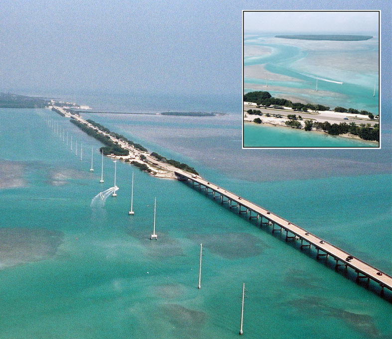
The entire time this was a rail bridge, it was called the Knights Key Bridge. When it was converted to a road bridge, it still kept that name. It was only in 1953, as a road bridge, that the name Seven Mile Bridge (= 11.3 km) became popular. The name is almost accurate, since the length was actually 6.765 mi (10.887 km).
| | | | | | Another language matter: The name Marathon dates back to the building of the Over-Sea Railroad. Toward the end, the workers were at it night and day to get it completed. Because of the pace of the work being done, workers complained that "this is getting to be a real marathon". Thus that name was given to the rail station at that point, which developed into the municipality of Marathon.
In addition, Flagler was 75 years old and in decreasing health when the project began, so toward the end, there was a push to finish the railway before he died (they did make it), and work increased. The men were split into two groups, each working 12 hours on and 12 hours off. This meant that the railway was being worked on 24 hours a day, a real marathon.
|
| | | | Among the multiple work camps along the route, I've found this picture of a so-called "quarter boat":
https://c1.staticflickr.com/5/4115/4888586229_c8cd88c9d4_b.jpg
The name seems odd until you realize the boat was used for workers' living quarters! How unique this must have been! A quarter boat apparently would have moved along the route as rail progress continued. That this is marked quarter boat #5 means there would have been at very least four others. Having a boat to live on while working and have it move along as work progressed has to have been unique for an "over-sea" rail route.
https://www.smarttinc.com/wp-content/uploads/overseas03.jpg
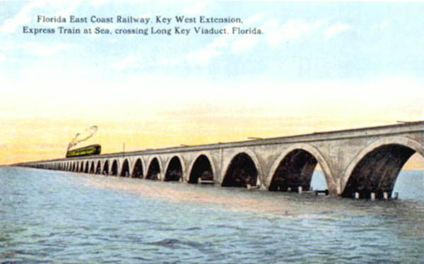
We just saw on the map the Long Key Viaduct, the second longest in the route. This is a view showing the typical method of construction for concrete arches, and this is what the completed Long Key Viaduct looked like on a period postcard. This is another showing the longest causeway, the Knights Key Viaduct, the one renamed the Seven Mile Bridge once car traffic replaced rail traffic.
I really like the below dramatic view of the railroad that went "over the sea".
https://2.bp.blogspot.com/-kYWl54tP5zA/WEiAJLgowAI/AAAAAAAFV48/XTzLsjF1pLs1JRgv3gd7j7D9oEW1FDJJwCLcB/s1600/Overseas%2BRailway%2B5.jpg
Just imagine the views out the window, where you'd only see water. We can also mention here that the entire route was single tracked, with periodical double-looped passing tracks.
For the Key West terminus, which was both a rail station and transfer point for ships, landfill was used to extend the north side of Key West's Old Town for an area known as Trumbo Point. I have three maps, since each has something to offer:
https://c6.staticflickr.com/5/4094/4890523021_d02a5bf3e3.jpg
http://1.bp.blogspot.com/-b4nnWCpHo_E/UFdKMJr9DoI/AAAAAAAAAIA/A5kBcKMgW3k/s1600/Capture.JPG
http://www.keyscashsaver.com/wp-content/uploads/2013/08/KW-map-04KW-only1.jpg
The first is a period map showing the rail route entering Key West's north side, but then moving to a crude depiction of Trumbo Point, clearly an addition to the island. In black is the FEC Station on "Land made by Mr Flagler". Below that is the "Old Shore Line", and we see the two bodies of water that were captured and formed by Trumbo Point. (The main engineer of the dredging company that built it c1912 was Howard Trumbo.)
The second map is a modern aerial view of Key West, even showing on the lower right where an airport has been squeezed in. Trumbo Point has already been converted to part of the Naval Air Station, but the red route shows again how the trains arrived. Since Trumbo Point is now off limits to the general public, Palm Avenue serves local traffic (remember this name). It also shows more accurately the three piers on Trumbo Point.
The third map shows today's Key West best. Trumbo Point is no longer connected at its east end, and both captured bodies of water, one crossed by Palm Avenue, are now open to the sea. The three piers are numbered 1-2-3, but they are for military use. Cruise ships today dock near Mallory Square, at Pier 8.
https://live.staticflickr.com/6028/5967557615_007bfc38e7_b.jpg
https://www.american-rails.com/images/039o3857uo88602o498603o302002.jpg
You can now easily recognize the first angular view of the three piers with six ships docked at Trumbo Point c1934, with the rail line arriving from the left into the rail yard. In the second view, a train is ready to leave from the FEC's main terminal at Trumbo Point during a late afternoon in 1933.
https://heartwantsbooks.com/wp-content/uploads/2020/09/Key_West_FEC_station_and_yard.jpg
This is an undated aerial view looking south across all of Key West's Old Town, with its FEC rail station and yard out on Trumbo Point, showing ships waiting to make rail contact, and this is a view from the Library of Congress of a ship arriving from Cuba connecting to the Over-Sea Railroad. While I cannot identify the ship (I'd love to), click on the center car to read "Florida East Coast".
Even while the route was only partially built, the FEC took advantage of what it had so far. As early as 1908 there were daily train running from Miami to Knights Key, at the western end of Marathon and just before the point where the Seven Mile Bridge would be built. Use this map to judge just how far west Marathon is located.
https://i2.wp.com/floridakeystreasures.com/wp-content/uploads/2015/07/Knights-Key-Campground.jpg?ssl=1
Then use this map of Knights Key in Marathon to locate the "heritage trail" following the original rail route next to the modern highway.
| | | | Arrival in Key West That was 1908. In 1912 the rail line arrived in Key West. A pilot train—a construction engineers' train—arrived on 21 January to check things out, but Flagler's special train arrived the next day, 22 January 1912, which is considered the first day of service on the new route. This marked not only the completion of the railroad's over-sea connection to Key West, but also the linkage by railway of the entire east coast of Florida.
This next picture shows Flagler's special train en route crossing the Long Key Viaduct. The two passenger cars are #90 for Mrs Flagler, followed by Flagler's own private car #91, named Rambler.
| | | | | | Car #91, Rambler, is now on exhibit at the Flagler Mansion Museum, Whitehall, in Palm Beach, where I've toured it. It's in its own pavilion on the grounds (Photo by Khowald). Below is the only picture of the interior I could find online. It seems to show the salon, or living room area, including sleeping bunks for guests that could be lowered from the ceiling.
https://global-geography.org/attach/Geography/America/United_States/Pictures/East_Coast_Florida/Palm_Beach_-_Whitehall_Flaglers_Private_Railcar/fl0187_Salonwagen_Whitehalljpg.jpg
Until now, I never knew about car #90, and only now learn it's located today in the Monon Rail Museum in Monon, Indiana, between Chicago and Indianapolis, the hub of the former Monon Railroad. I have no idea how the two cars got separated. I now see that, while #91 is lush and plush, it isn't quite as good as #90, which seems really worth looking into. Fortunately, I've found several online pictures.
https://mononconnection.net/wp-content/uploads/Flagler-Car-90.jpg
This is the observation room in the car, which includes two drop-down beds, a desk, and a sitting area.
https://mononconnection.net/wp-content/uploads/Flagler-Car-90-Master-Bedroom.jpg
This is described both as the master bedroom and as Mrs Flagler's stateroom. Behind her bed can be seen the entrance to her private bathroom. The woodwork in this car is called white or blond mahogany and comes from the Canary Islands.
https://mononconnection.net/wp-content/uploads/Flagler-Car-90-Dining-Room-1280x853.jpg
This is the dining room, with more of the hand-carved woodwork. When Louis Comfort Tiffany found out Henry Flagler was going to have a train car built for Mrs Flagler, he wanted to make special Tiffany glass windows for it, and so there are 30 of them in this car, two on the upper right. There is also the next surprise.
https://mononconnection.net/wp-content/uploads/Flagler-Car-90-Onyx-Fireplace.jpg
Also located in the dining room is this marble onyx fireplace, which is believed to have three of the largest pieces of marble onyx ever quarried in Pakistan. This fireplace matches what Flagler had installed in his Palm Beach mansion, Whitehall. (I had to look up some geology on this one. While onyx and marble are two different substances, marble that resembles onyx is indeed called "marble onyx". Live and learn.)
|
| | | | Now while Flagler's private cars that we just saw crossing Long Key Viaduct on opening day were ultra-luxurious, do not confuse them with the Over-Sea Railroad, which would be mixing apples and oranges.
This is the first official FEC train, with Flagler, arriving in Key West in 1912, as it pulls into the station. He was met by thousands—note the people on the station roof--and it was international news. This is another view with the train pulled in all the way, and showing much more of the crowd. Finally, this is a color-tinted postcard from another angle. I cannot explain why some pictures show more cars than just Flagler's coaches.
https://www.floridamemory.com/fpc/prints/pr09281.jpg
This is Flagler and the Mayor of Key West detraining from what is evidently Flagler's private car. The citizens of Key West presented Flagler with mounted silver medallions made by Tiffany & Co to commemorate the occasion. The FEC employees presented him with an 18kt gold telegram of congratulations "on the completion of the crowning work of your life" housed in a highly decorated gilt-silver box also made by Tiffany. (Most "gold" presentation pieces, including Olympic "gold" medals, are really gilt silver.)
Following is a photo from the Library of Congress of the Flagler team, which apparently traveled with him. It seems caps or hats were the order of the day. Again, I'll mention that, in 2023/7 we talked about Flagler and his two vice-presidents, J E Ingraham and J R Parrott, signing the resolution in 1893 to go to Key West. Parrott is apparently at the left. I cannot speak for Ingraham. But that's Flagler right of center, with the moustache.
After staying two days in Key West, Flagler returned home to Whitehall in Palm Beach on 24 January 1912. This is his train returning. Again, I can't account for there being so many cars. It was his final visit to the city, as he died 16 months later in May 1913 at age 83 after falling down a flight of marble stairs at Whitehall two months earlier, in March. At 3 PM on the day of the funeral, every engine on the Florida East Coast Railway stopped wherever it was for ten minutes in tribute. As the funeral train traveled from Palm Beach to Saint Augustine, people waiting all night along the railway line to see it.
In February 2006, a statue of Flagler was unveiled in Key West near where the Over-Sea Railroad once terminated. A major street in Key West is also named after him. In July that same year, a statue of him was unveiled in Miami on the steps of the Dade County Courthouse—on Flagler Street—just steps away from the southbound tracks coming down from Government Center, where his original rail station once stood.
The Over-Sea Railroad forever altered the history of the Florida Keys and Key West and brought conveniences like daily mail, ice, and reliable transportation for visiting family members. There were other immediate developments that same year.
On 26 January 1912, four days after the opening, the first excursion train left Key West with 123 passengers for a quick visit to Long Key. The round trip cost $2.60.
On 8 February, the Key West Fish Company transported its first shipment of iced fish to NYC.
On 13 May, the P&O Steamship Line announced a roundtrip excursion rate of $5.00 between Key West and Havana on the Olivette and Mascotte, both of which we'll mention again later.
But on the negative side, Flagler predicted on that arrival day in 1912 that Key West's population would soar to 50,000, but eight years later, in 1920, it was 18,749, nowhere near his prediction. While it's a marvelous place, it never became a boomtown.
| | | | State Road 4A You've never heard of a highway called Florida State Road 4A (SR 4A). Neither had I. (Some say State Route instead of State Road.)
I also thought I knew the story of the Keys after driving round-trip to Key West five enjoyable times. You know: railroad built; railroad ruined; highway takes over its roadbed. Bada-bing bada-boom. Simple.
A better word is "simplistic". There's a lot more to the story of how the railroad was ruined than meets the eye—more later--and to my great shock, there's a lot more to the image of the railroad being the only overland route to Key West. It was not.
Starting about a decade after the railroad opened, there was a highway that allowed motorists to drive between the mainland and Key West, tho it happened bit-by-bit. First cars reached the Upper Keys, then later beyond as the route was extended. This is an amazing revelation to me! Miami cars appearing in Key West, and vice versa!
But there was a caveat: the route had a ferry gap, tho it was promptly reduced to two smaller ferry gaps. This route was nevertheless State Road 4A, end-to-end, despite the ferry gaps. And this is the story I never knew before now.
As we know, the first major step in bringing updated land transportation to all the "Famous" Keys was the railroad, completed in 1912, which brought some settlement, post offices, and daily deliveries of people and goods throughout all the Keys. No one can deny that.
But the automobile age was beginning at the same time, and in 1921, the Miami Motor Club wanted to attract tourists to fishing areas in the Keys, which could only be reached by boat or train at the time. An irony of history was that the feeling was, if a railroad can island-hop, so can a highway, even if the road might someday preclude the rail route. There was talk of an "Overseas Road", adapting, but mangling, the nickname of the railroad.
The Florida land boom of the 1920s was underway (more on that later), which attracted real estate interests, especially to the closer Upper Keys.
https://printablemapforyou.com/wp-content/uploads/2019/03/map-of-areas-servedflorida-keys-vacation-rentals-vacation-upper-florida-keys-map.jpg
UPPER KEYS The railroad was built east to west, but in any case, it was a completed unit when it went into operation. On the other hand, SR 4A was built in sections based on the three groupings of Keys. Above is a modern map (hold on to it for now as our "Three-Groupings" map) showing US 1, but can be used as a guide to remind us of the groupings. We'll start with the Upper Keys section of SR 4A, which was also built east to west as a unit. Note the names Key Largo, Tavernier, Islamorada, ending in Lower Matecumbe Key. While there are some 800 named keys in all the Florida Keys, we'll discuss a few interesting ones as we move along.
https://fla-keys.com/news/img/UpperKeysMap.jpg
The first step was to connect the mainland to the nearest convenient key, Key Largo. This map shows today's double connection (I always wondered why there were two). You see US 1 coming down from Homestead and Florida City, meeting Key Largo in its central area, then turning right towards Key West. Now project back to the 1920s—you're looking at the railroad route that US 1 eventually took over. I now learn WHY there's another bridge—it was always the highway bridge for SR 4A, even while the railroad was running.
In response to the newly perceived need, commissioners from Dade (now Miami-Dade) County on the mainland and Monroe County, in Key Largo and beyond, agreed to build a highway connecting Florida City to Key Largo. They preferred to build it alongside the Over-Sea Railroad, to the middle of Key Largo, but commercial interests and motorists attending the joint meeting expressed a preference instead for a road extending to the northern end of Key Largo, via Card Sound. The Card Sound route won.
Dade County was to build 11 miles (18 km) of road from Florida City to the edge of the mainland, while Monroe County was to build a drawbridge, then connect the Dade road to the existing road on Key Largo. Before they could be completed, the roadway and bridge were severely damaged by the hurricane of 1926, the same one that took out Flagler's Royal Palm Hotel in Miami. Awaiting for its reconstruction, in March of 1927 a barge-type ferry towed by a powerboat transported vehicles from Florida City to the Key Largo shore. This temporary solution was known as the Key Largo Ferry.
| | | | | | On the map of the Card Sound Bridge, flip mentally back to today. The modern "Overseas" Highway, US 1, has taken over the rail route. That leaves two things that seem out-of-date, but apparently are not. The remnant of the former SR 4A serving the northern end of Key Largo is now known as Monroe County Road 905. Fair enough. But the bridge would seem more than redundant, especially since it's the only toll bridge on the Keys (fortunately avoiding today's Overseas Highway). To my amazement, this is not the case. The Card Sound Bridge (actually, again, a raised causeway) has been recently rebuilt, and totally modernized (Photo by Florida Keys--Public Libraries). The toll is now $1.50 and up, and to save money, it's a toll-by-plate system, where you sail thru the toll (that creeps me out), a camera takes a picture of your license plate, and then you're billed thru the mail, like a negligent criminal. At least the toll is waived during hurricanes. But as of 2016, 3500 vehicles crossed this bridge daily, which amazes me, since it only serves the northern part of Key Largo, probably mostly locals. It would seem that even locals in central Key Largo would just use the free bridge. |
| | | | Back to 1928. At this point, the railroad has been connecting all the Keys since 1912, but only the Upper Keys are now fully connected to the mainland by road, making these first keys a de facto extension of it. The day-to-day needs of the Upper Keys are now being served better by delivery trucks and buses that make additional stops between the train stations. This more frequent auto service resulted in more weekend travel down from the mainland, plus the development of small fishing cottages and more charter fishing.
https://c1.staticflickr.com/5/4276/34928550315_57ca1a72fa_b.jpg
https://c1.staticflickr.com/5/4202/34796669131_4b940ddafc_b.jpg
The first link shows SR 4A in red where, coming south from the Card Sound Bridge, it joined the rail line in blue on Key Largo. As you see, the two routes ran cheek-by-jowl in this area. The second link shows that they stayed adjacent in Tavernier in southern Key Largo. One Tavernier resident interviewed remembers the old highway as a bumpy rocky road when he first drove his new 1928 Chevrolet coupe down from Miami, and also remembers bus and freight vehicles starting to appear. Nowadays, he points out that the northbound lane of today's US 1 in Tavernier used to be SR 4A, while the railroad tracks ran where the southbound land of US 1 is now.
While the Card Sound Bridge was being rebuilt, the road was made serviceable as far as Islamorada. However, you're surely looking at this with modern eyes, picturing a blacktop surface running off into the sunset. No way. We know that the Oregon and Santa Fe Trails were dirt, traversed by wagons. But we forget that, in the early 20C, roads were still always dirt, and that includes the famous Route 66 when it was laid down in 1926. So now understand why the Tavernier guy talked about a bumpy, rocky road and picture SR 4A as a dirt road into the distance, being made "serviceable" up to Islamorada.
| | | | | | I find the name Islamorada of interest. Early Spanish explorers named this place islas moradas (purple islands), reportedly because of the violet sea snails they found here. However, local usage has made the name singular, and, surely influenced by the so-called "silent S" in English "isle", rhymes "isla" with [m]ile a [minute], contrary to the original Spanish usage, where it rhymes with "[we m]iss La[haina]". |
| | | | Islamorada is a town that runs over five keys, mainly Plantation, Windley, Upper Matecumbe, and Lower Matecumbe Keys, plus tiny Tea Table Key on the side.
Plantation Key's name is a reference to the pineapple plantation that once existed there.
Windley Key had been two separate islands called the Umbrella Keys, but railroad construction required that they be joined, and were then named after an early settler.
The name Matecumbe is thought to be Spanish, and might go back to the 16C, making it the oldest place name in the Keys, but there is no clear explanation as to its origin. To my chagrin, I find absolutely no online consensus as to its pronunciation. I'd been rhyming it with "hum", skipping the last syllable, and have heard some online recordings doing the same. I've also heard it rhymed with [g]umby, with the U as in either "but" or "put", and also with that last syllable rhyming with either "bee" or "bay". I give up. But I will now adopt a new more elegant pronunciation: U as in "put" and E as in "bay", which makes it very close to what is likely the original Spanish.
https://c1.staticflickr.com/5/4201/34887275516_33952fa303_b.jpg
https://c1.staticflickr.com/5/4202/34887275836_95edd0b139_b.jpg
Both these links show Islamorada's Upper Matecumbe Key, where Islamorada was incorporated. The first link shows where the routes separated slightly, a block apart. The second link is further along, where they came together for a bit at today's Hurricane Monument, but then diverged again. Where they come together a second time, the road crosses the rail route at a grade crossing, then stays on the north side all the way up to the ferry connection.
When I stopped at the Hurricane Monument on the current trip for the first time ever, I drove around to park on its south side. Only now do I see that that was the merger, where SR 4A came around to rejoin the railroad. While the main road (the rail route) is now named the Overseas Highway, US 1, the quiet former SR 4A has the sad name "Old Highway" for most of the length of Upper Matecumbe Key.
http://3.bp.blogspot.com/-jmtTZ8JuVww/UD1lU-_l0WI/AAAAAAAAAGs/X07MZcsTxHA/s1600/lowmat.JPG
By 1928, the rebuilt Card Sound Bridge was done, and the road and bridges for SR 4A were completed as far west as Lower Matecumbe Key, the last of the Upper Keys (see map). This photographic map shows how SR 4A in blue remained on the north side of the (red) rail route here as well, then veered off to the north at Matecumbe Harbor to where the ferry landing existed from the current year of 1928 to the disaster of 1935.
This next picture shows the construction of SR 4A near the [Lower] Matecumbe rail station in 1927. It serves to show how very close to each other the two routes were, at least in the Upper Keys. But don't be fooled by thinking this is a very early stage of road building, since it continued to be a dirt road, just about like it looks here.
We'll refer back to the "photographic" map later to point out what I think is an essential part of the story of the loss of the Over-Sea Railroad—the fact that, in 1935, work was actually being done to build, separate from the already functioning rail bridge, a dedicated road bridge for SR 4A, of which there are remnants of bridge piers to this day as witnesses. Who knows how things might have been different after the disaster if this and potential other infrastructure had been completed for the road, and road builders didn't have to "steal" damaged rail infrastructure.
This is a modern view of that same rail extension from Lower Matecumbe Key in the distance, now part of the Overseas Highway (Photo by Dominika Durtan). Tiny Tea Table Key is at the upper left, connected by a short road to US 1.
Thus by 1928, all the Upper Keys were connected for the first time by car to the Florida mainland. The designation State Road 4A, which had already existed from Miami to Homestead/Florida City, was extended from there into the Upper Keys, and eventually all the way to Key West, despite the ferry gaps, as seen on this period road sign, shown on a background of a partial outline of Florida.
LOWER KEYS Refer back to our Three-Groupings map to locate the Lower Keys, which of course should show Key West as part of the grouping. Note keys such as Stock Island, Boca Chica, Sugarloaf, Summerland, Ramrod, Little Torch, up to Big Pine; to the northeast of which is the unnamed (!) No Name Key. We'll come back later to this map for the Middle Keys, but for now, let's move to this excellent map of the Lower Keys.
https://www.keyscashsaver.com/wp-content/uploads/2012/06/lower-keys-map1-e1340379023111.jpg
While construction on SR 4A was going on westward in the Upper Keys, mostly cheek-by-jowl with the rail route, SR 4A was also being built eastward out of Key West, but conversely, mostly apart from the rail route! This map shows today's Overseas Highway, largely the old rail route. Picture on this map the highway being built out of Key West, then south of today's Naval Air Station on Boca Chica Key (here unnamed) and along the south shore of Sugarloaf Key, only swinging up to the rail route after that big curve. The routes then stayed together to Little Torch, then the road swung north across Big Pine to No Name Key and its ferry landing. Let's look more closely at the road route.
https://c1.staticflickr.com/5/4172/34612924352_7967ae9bed_b.jpg
We'll start with the names. Stock Island is very close to Key West, only separated by a very narrow channel, and seems to act as an extension of it. It's supposedly named for herds of livestock formerly kept there, tho some local historians suggest that it may be named for an early settler.
Today's Naval Air Station is on Boca Chica Key, a very simple Spanish name, but one that's a good example of the sort of thing that might separate those with a "little knowledge" of Spanish from others. One might think that boca is "mouth" and chica is "girl", so, despite the lack of common sense, we've got some sort of a "girl's mouth" here, right? Very wrong. First, chico, chica as adjectives are a more casual way of saying "small"; secondarily, as nouns, they mean "boy, girl".
In English, we use the word "mouth" to refer to a river's mouth, where it meets the sea. Similarly, Spanish uses boca to refer where a bay meets the sea via an inlet. Thus, Boca Chica is Little Inlet.
Now for the routes. In blue, the rail route runs from Trumbo Point westward on a northerly route. I'm a little surprised, but SR 4A actually began on Stock Island. Still, that's within the orbit of Key West.
https://excursionsofkeywest.com/wp-content/uploads/2017/01/stockisland-map.jpg
SR 4A took off from the rail route (US 1) on MacDonald Avenue, then bent southeast on Maloney Avenue. It continued along the south shore of Boca Chica Key, completely away from the rail route. Interestingly, for a time, even US 1 used this southern SR 4A alignment from Stock Island to Big Pine Key, tho the Boca Chica stretch has now largely been washed away.
https://c1.staticflickr.com/5/4275/34643302241_b4c75615d3_b.jpg
https://c1.staticflickr.com/5/4179/34612924042_2e29793413_z.jpg
The first link continues along Boca Chica past today's Naval Air Station while the second one skips a bit and picks the route up later on Sugarloaf Key where the route bends north to join the rail route.
https://c1.staticflickr.com/5/4181/33933484544_c6f3e71d62_b.jpg
Still on Sugarloaf, the route not only joins the rail route for the first time since Stock Island, but crosses it on a grade crossing then reaches Cudjoe Key, possibly named for a local tree. It will stay on the north side of the rail route from here on—inasmuch as it sticks to the rail route at all. This north side route reflects the similar situation on the western end of the Upper Keys. Thus, only on the eastern end of the Upper Keys is the road on the south side of the rail route.
https://c1.staticflickr.com/5/4165/33933483254_4614333caf_b.jpg
This shows both routes crossing Summerland and Ramrod Keys side-by-side. Ramrod is named for an early 19C ship that was wrecked on a reef south of it. Both routes first tip-toe over Middle Torch Key before crossing to Little Torch Key (not named here), where they separate.
There is also a Big Torch Key further north. The three Torch Keys are named for a flowering plant in the citrus family called torchwood or candlewood (also bois chandelle in French). The islands were named for their forests of this wood, which is effective as kindling even when green.
https://cdn-assets.alltrails.com/static-map/production/location/cities/us-florida-big-pine-key-669-20180309094456-600x350-1.png
Since the routes separate here, we'll insert this modern road map to follow the split. Unnamed on this map on the left are Ramrod Key, the bit of Middle Torch Key, and Little Torch Key, the dividing point.
As you see, on Little Torch, SR 4A turned north, took a northerly crossing to Big Pine, and ended in No Name Key—more on that in a moment.
Meanwhile, the railroad (and the modern highway) took a southerly crossing to Big Pine, then turned down to its southern end. It crossed to smallish Spanish Harbor Key (originally three islands that the railroad builders connected), then crossed the Bahia Honda Rail Bridge (Photo by Marc Averette) to Bahia Honda Key, since 1961 a state park. Here's a more detailed map:
https://cdn-assets.alltrails.com/static-map/production/area/10108709/parks-us-florida-bahia-honda-state-park-10108709-20190606143238-625x365-1.png
Bahia Honda is Spanish for Deep Bay, since the channel at its west end is one of the deepest in the Keys. This also explains the need for a more substantial bridge, one that joins in importance with the Seven Mile Bridge and Long Key Viaduct. East of Bahia Honda Key we see three tiny keys, not named here: Ohio, Missouri, and Little Duck Keys.
http://rondougherty.com/photoalbum/2005/20050205FloridaTripIndex/20050209/Z09LittleDuckKeyMediumHybrid.jpg
And now we see the reason for making this point: Little Duck Key is the western anchorage of the Seven Mile Bridge to Knight's Key in Marathon in the Middle Keys. While this aerial view showcases the modern Overseas Highway, the remnant of the old rail bridge can be seen just north of it. If you refer back to our Three-Groupings map, you'll confirm that reaching the Seven Mile Bridge means the route is leaving the Lower Keys.
https://c1.staticflickr.com/5/4163/34612921972_00b2efebf3_b.jpg
Back to Little Torch Key, where SR 4A went to its north end to cross over to the second largest key of all, Big Pine Key (note Key Deer Boulevard, which we'll mention later) and then continuing to No Name Key and the ferry landing at the end of what is today Watson Boulevard, where the ferry connected to Lower Matecumbe Key in the Upper Keys. There is an 1849 reference to the key being called No Name, and in 1878, a US Coast & Geodetic Survey Chart identified it as No Name Key, so there it is. Of course, "No Name" IS a name.
Below is a picture of the No Name Key ferry landing in 1937, with a period car. This is two years after the disaster that ended the railroad, but still before the new Overseas Highway replaced the rail route in 1938.
https://i.pinimg.com/736x/9a/ae/59/9aae59ff2bb8e29d7db63989b31884f6--florida-keys-key-west.jpg
MIDDLE KEYS Back to 1928. The rail line still connects everybody. As for motorists, the Upper Keys are in the best shape, and are already a de facto extension of the mainland—sort of a peninsula reaching to the southwest. The Lower Keys are connected for cars, but remain in their insular status, as tho they were one big island, far from the mainland. The problem was that the Middle Keys had larger water gaps between themselves and between them and the rest of the keys. Thus, a ferry system was needed complete the road route from the mainland to Key West.
As we saw, ferry landings had been included in the road construction in Lower Matecumbe Key and No Name Key, and on 16 January 1928, three ferryboats were put into operation between them. One ferry would go south and one ferry would be returning north. The third was kept in reserve or in maintenance. (However, one ferry burned eight months later.) Officially, the entire route, including the ferry, opened to the public on 25 January 1928. The ferry trip was 66 km (41 mi) long. Each ferry could take 20 cars, and the trip took about four hours. The toll for cars (driver included) was $3.50 to $6.50, depending on vehicle length. Passengers were charged $1.00 each.
https://bigpinekey.com/wp-content/uploads/ferryboat-k.w.-1934.jpg
https://keysweekly.com/wp-content/uploads/2022/08/Monroe-County-at-No-Name-terminal-John-Harold-Sands-Jr.-Collection.jpg
The first link shows the car ferry "Key West" in 1934. The second shows the car ferry "Monroe County" leaving the No Name landing.
The chairman of the Monroe County commissioners was the first to drive a car from Key West to the mainland on 18 July 1927. After that, State Road 4A fully opened to public traffic in 1928, including the ferry section. Thus from 1928 until 1938 (three years after the disaster, when the new Overseas Highway took over the rail route), State Road 4A was the first highway connecting the mainland and Key West.
http://keyshistory.org/mapferryroute1930.jpg
This 1930 road map, from two years after the start-up, shows the entire route. But it also highlights the big problem. Basically, it's the keys forming what is today the City of Marathon in the Middle Keys that are skipped.
| | | | | | But in tantalizing contrast, one can also see the route from Miami to Flamingo, and how that could have connected over Florida Bay to No Name Key if that route had been found feasible. |
| | | | It's obvious that we need to take a closer look at Marathon, which existed for a long time, but only became incorporated in 1999.
https://ontheworldmap.com/usa/city/marathon/marathon-tourist-map.jpg
The City of Marathon occupies some 13 keys--some of which are miniscule--and thus comprises by itself most of the Middle Keys. Duck Key is not part of the city. Note that Marathon's easternmost key is Grassy Key and the westernmost pair are Knight's Key and Hog Key.
What connections outside the Middle Keys did the rail route have that the highway did not?
https://virtual-geology.info/vft/fl-keys/maploc05.jpg
http://keyshistory.org/CK-Nau-Map-66.jpg
TO THE EAST: In the first link, we see the rail route from Lower Matecumbe (unnamed at the right) crossed via tiny Fiesta Key to Long Key, then used the Long Key Viaduct (second longest in the route) to reach tiny Conch Key (say KONK). The second link shows that Conch Key (there's also a Little Conch Key) is the western anchorage for the Long Key Viaduct, and lies just before Duck Key (barely attached to the route). The rail route then entered and crossed Marathon.
TO THE WEST: On the western side, the rail route left Marathon's Knight's Key onto the Seven Mile Bridge (longest in the route) to Little Duck Key in the Lower Keys.
Reviewing these connections, we see how Marathon's keys essential comprise the Middle Keys. There are no other Middle Keys to the west, and to the east, there's only Duck, tiny Conch, and Long Keys.
To be more inclusive, in 1930, two years after the ferry's start-up, a 21.7 km (13.5 mi) road was completed running the length of Marathon, also named State Route 4A. Thus Marathon had its road, which became part of the thru route, tho it did not lead off Marathon's keys. Thus, ferry terminals were built on Grassy Key at its east end and on Hog Key in its west end. This reduced the thru ferry trip to two 22.5 km (14 mi) water gaps and provided Marathon with automobile service to and from the other Keys. By 1933, one ferry ran between Lower Matecumbe Key and Grassy Key, and one operated between Hog Key (Marathon) and No Name Key.
But the handwriting was on the wall. By the early 1930s it was clear that the ferries were insufficient for the travel needs of the Keys, and Monroe County and the State Road Department began making plans to connect the now three portions of State Road 4A to make it a continuous highway. If this had had time to have been completed, there would have been two complete routes, one rail and one road, from end to end. In a "what if" of history, when disaster struck in 1935, rather than losing the railroad, things might have turned out differently. I'll repeat this SAME aerial map from before to illustrate this:
http://3.bp.blogspot.com/-jmtTZ8JuVww/UD1lU-_l0WI/AAAAAAAAAGs/X07MZcsTxHA/s1600/lowmat.JPG
We can now see again that, separate from the rail bridge, construction of a road bridge connecting Lower Matecumbe Key and Long Key was already underway in 1935, and there are remnants of eight bridge piers (Photo by Sanibel sun) that would have supported the alignment SR 4A. But they were abandoned after the disaster, when the road swallowed up the rail route.
| | | | Reaching Havana To fully try to understand the situation at Trumbo Point back in the day—which I do not, and I have to try to piece it together—we have to review the subject of boat trains, which was the very thing that got us off-topic in Miami as of 2020/4-5, and we've only returned to the topic of Florida recently. Here we'll try to be concise.
RAIL MEETS SAIL Trains can meet ships in two ways. Trains can pull up on the pier next to the ship, and passengers can walk across the pier, transferring one way or the other, for a two-seat trip. In those postings we gave examples I've used in Southampton, Cherbourg, Le Havre, and elsewhere.
The other possibility goes beyond a simple meeting of modes. In this scenario, the train pulls onto a rail ferry and the passengers have to do nothing at all, since it remains a one-seat ride, and the train sails away right along with the passengers. I recall two instances: the first was on my first trip to Europe as a teenager with my friend, we went overnight from Switzerland to London. We were almost unaware how, during the night, the train pulled onto a ferry across the English Channel, and in the morning, we were in England and on our way to London. This service is now replaced by the Channel Tunnel.
Then when Beverly and I were studying in Mainz, we took the train to Copenhagen, which had to cross the 19 km (12 mi) stretch of water from Germany to Denmark between Puttgarden and Rødby (Map by Michael Bienick). This is a more modern train taking that same ferry ride (Photo by Diesel3200). However, I do not remember the trains sharing the trip with road vehicles, but I may be wrong. In any case, as of 2019, the ferry no longer runs, and trains temporarily have to take the long way 'round, since a tunnel is being built here instead, and in addition, high-speed rail is being planned for the route.
KEY WEST & HAVANA What does this have to do with our situation in the second decade of the 20C? I hear two stories, with no summary talking about both passengers and freight, so we'll have to try to put together our own summary. From what I can tell, the meeting of rail 'n' sail for passengers was a different experience than it was for freight. This is how I understand the difference.
Passengers The original P&O line (Peninsular & Oriental) was a British steamship company that started out sailing from Britain to Spain and Portugal in the Iberian Peninsula (hence the name), then went on to the Middle East. We know from the name of the Orient Express train to Istanbul that back in the day, the Middle East was considered part of the "Orient", and the name of the Peninsular & Oriental Line followed suit.
However, in 1900, well before the Over-Sea Railroad was even begun, a joint venture was formed called the Peninsular & Occidental Steamship Line, also called the P&O. Read that again, because it might not say what you thought at first—it tricked me, too. This joint venture was between Henry Flagler and Henry Plant, believe it or not. (Another source includes the Atlantic Coast Line.) The routes listed were a simple Miami-Key West, but also Miami-Key West-Havana; and Port Tampa-Key West-Havana, thus linking both sides of the peninsula of Florida—presumably yielding the name—via Key West--to Havana. I've seen a list of about a dozen ships that came and went on this "American" P&O Line. Some selected ship names were: City of Key West, Cuba, Florida, Miami, Mascotte, Olivette—we heard of these last two earlier. Another ship was the Governor Cobb, which I include here because I have pictures. This is a postcard of the Governor Cobb from 1906, the year she was built. Howell Cobb was an early 19C governor of Georgia and later Speaker of the House. Typical for many ships, she was seasonal. One company employed her on the Boston to New Brunswick route in the summer, but during the winter she was leased to Flagler's P&O to run between Key West and Havana, as seen here, where the Governor Cobb is meeting the Havana Special in Key West in the 1920s.
https://www.floridamemory.com/fpc/general/n038721.jpg
Flagler's P&O also connected Miami to Nassau (then known as New Providence) in the Bahamas, where he had acquired some hotels, as mentioned earlier.
We've seen pictures of trains and ships at Trumbo Point and saw that ongoing passengers walked across the pier between modes for a two-seat ride.
Freight However, the other story I've heard involves train ferries, with trains pulling onto ferries and crossing between Key West and Havana. I believe it was only freight trains that did this. Also, while passenger ferries and trains sit side-by-side at the pier, trains pulling onto ferries do so end-to-end, so it's unclear what spot in Trumbo Point such rail ferries served, perhaps at the end of the docks we've seen. But following are the details from the Florida Keys History and Discovery Center.
After reaching Key West, Flagler’s freight train cars were transported to Havana via Flagler's Florida East Coast [Rail] Car Ferry Company. It is considered to be the world’s first ocean-going rail car ferry operation, and remember, it was crossing the dangerous Florida Strait. There were three ferries, built so that inside, 26 rail cars could fit on four sets of parallel tracks. The ferries brought high grade goods in box cars and refrigerator cars back and forth to and from Key West and Havana from 1915, shortly after Flagler's death, until the Over-Sea Railroad was no more, in 1935.
The first of the three freight car ferries to operate in 1915 was appropriately named the Henry M Flagler, who had died in 1913. It departed Key West on 7 January 1915, with a load of 26 railcars and arrived in Havana Harbor the next day. Some of the cargo shipped aboard those railcars include thoroughbred racehorses brought to open the racing season at the Oriental Park Racetrack in Havana, which opened that same year and was operated during the winter by the Havana-American Jockey Club of Cuba.
The second ferry became operational in 1916 and was named the Joseph R Parrott after the former president of the FEC, who died in 1913. Here it is in Key West in 1930, ready to load.
http://fpc.dos.state.fl.us/reference/rc00329a.jpg
The third ferry was launched in 1920 and named Tomas Estrada Palma after the first President of Cuba, who died in 1908. When the ferries left Key West for Havana, they carried vehicles, building materials, and machinery among loads of other mainland cargoes. On returning, the rail cars were loaded with sugar cane, molasses, tobacco, as well as vegetables and fruits, like pineapples. With the aid of the ferry system, produce could leave the docks at Havana and arrive at New York markets four days later. It also boded well for pineapples produced on [Pineapple] Plantation Key and elsewhere locally.
https://thehistorybandits.files.wordpress.com/2017/03/long-key.jpg?w=1024
This period postcard shows a "pineapple special" crossing the Long Key Viaduct. Jacksonville is mentioned because it was the FEC's home office.
The end of the Key West extension did not end the Florida East Coast Car Ferry Company. Because Key West was no longer a viable port without the railroad, the ferry line moved north to Fort Lauderdale’s Port Everglades. After WWII, the ferry began operating out of the Port of Palm Beach.
| | | | The Operating Rail Line With the completion of the Over-Sea Railroad, the entire east coast of Florida, from Jacksonville to Key West, was linked by a single railroad system. The FEC was the product of Flagler's resources and imagination. Flagler's building hotels along the railroad and his development of the agricultural industry through the Model Land Company established tourism and agriculture as Florida's major industries, which remain so even today.
The Over-Sea Railroad was not only a local phenomenon—it received national recognition. Elihu Root (EL.i.hyu), Theodore Roosevelt's Secretary of State from 1905 to 1909, who received the 1912 Nobel Peace Prize, stated: "I regard [the Over-Sea Railroad] as second only to the Panama Canal in its political and commercial importance to the United States."
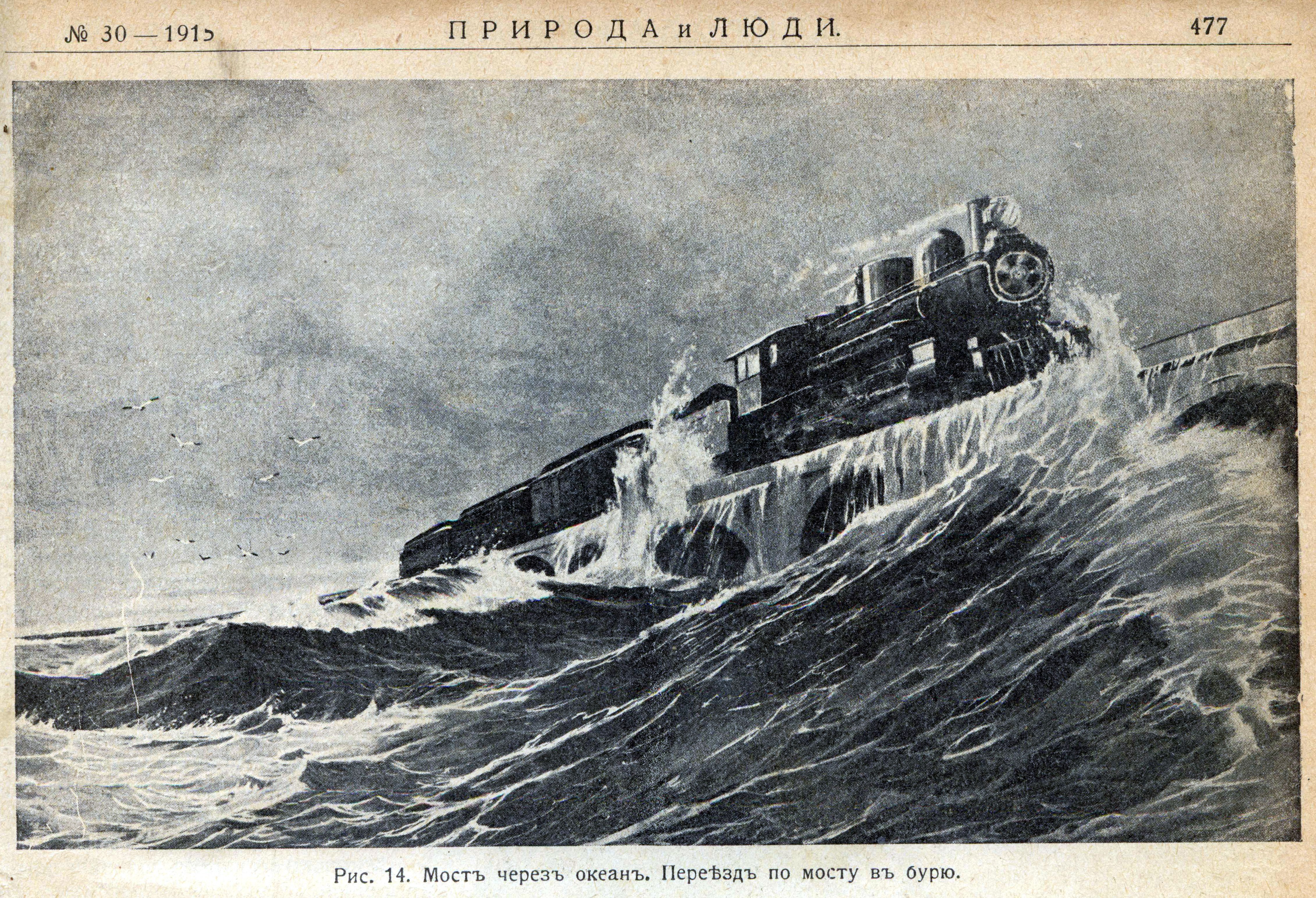
And its fame wasn't only domestic, but international. I found one particular example of this that I'd like to cite. I first saw pictures in English Wikipedia, then looked up the publication in Russian Wikipedia. (While I know some Russian, I readily admit I cannot read it at length, and so I used Google Translate to wrest information from this source.)
So let us move internationally—and historically—to the Russian Empire of 1915, and to a publication that had been around for many years. We should note that, at this time, the World War (later called WWI) had been in progress since the previous year, and that the Russian Revolution would occur two years later. This is the masthead of the magazine Природа и Люди / Priroda i Lyudi (Nature and People). The subheading says it's an "Illustrated Magazine of Science, Art, and Literature", issue No 38 of 23 July 1915. The magazine was published in Saint Petersburg from November 1889 to April 1918 (the two Revolutions had occurred in February and October 1917), and was very popular among all segments of the population, issues selling out promptly, despite its lofty topics. Russian Wikipedia says that the magazine introduced readers to the latest technical innovations from everywhere. News about engineering innovations was published under the heading "From all over the world", and it included one illustration I recognized from English Wikipedia, with a simple caption I was able to read and understand:
Иллюстрация к статье о морской железной дороге. Illustration for an article about the maritime railway.
And that illustration was one of three I'd already found on English Wikipedia. Also, I was intrigued by its calling it a "maritime railway". As you see, the magazine at least here, used drawings, and the article was from an earlier issue, No 30, but still in 1915.
This illustration is interesting for several reasons. First, it's a strikingly super-dramatic graphic view of storm waters sweeping up to a train on the Over-Sea Railroad, which was then just three years old. Being pre-revolutionary, the text includes older Cyrillic spellings. The caption for this "Drawing 14" in modern spelling (compare the two) is Мост через океан. Переезд по мосту в бурю., which I'd translate as "[A] bridge across [the] ocean. Crossing [the] bridge in [a] storm."
| | | | | | For those that remember our discussions of Cyrillic spelling—and for those that don't--two changes that came at the time of the Revolution were abolishing the letter ѣ in favor of the already existing e, which it duplicated, still seen here in the fifth word from the end, and removing the hard sign, ъ, as unnecessary following consonants at the end of words—you'll see it still used a full five times here just in this short caption. Since Russian doesn't have articles, I added "the" and "a" as appropriate. |
| | | | A little less dramatic is Drawing 15. The caption translates, with a bit of hyperbole, as "From Miami, [the] ekspress flies into [the] sea …". Since Russian doesn't have the Latin letter X, it replaces it with KS, so that's what I also wrote to illustrate "express" (Note the names spelled Aleksandr & Aleksandra). Find the four hard signs at the end of words. Finally, note the old spelling of "Miami", showing how Russian used to have two letters for I. After the revolution, one was dropped, unfortunately the one that looked like the Latin I. Today, the city is spelled Майа́ми / ma.YA.mi, much closer to the English version.
The third one is Drawing 16, a nice map from an interesting angle. You can read where Miami in the old spelling is. Next to it is the word Флорида, or "Florida". You can figure out where it says Atlant[ic] Ocean. Instead of calling Florida Bay as such, it says, not totally inaccurately, that it's the Meksik[anskiy] Zaliv or Mexican Bay, that is, the Gulf of Mexico (note the KS).
Finally we see "Key West" in the old spelling, which would have been pronounced Kéi-Vest. Today it's more accurately written Ки-Уэст or Ki-Uest. Find three words on the map ending in the old hard sign.
The four words of the caption translate, oddly, as: Map [of] part [of the] Meksican Bay.
Finally, I have to mention my discovery as part of the fuller caption behind this article. It breathlessly reported how the train to Key West actually got onto a ship and went to Havana! I knew that wasn't true, so I investigated further, finding out for the first time about the Key West-Havana connection. That's when I first learned that, while passengers did have to change from the train to a ship at Trumbo Point, freight trains did actually travel across the Florida Strait by boat—so the article was half-right in that respect.
But the Russian magazine was indeed thrilled about the train that went to sea.
Thru the 1920s, passenger traffic consisted of both local and long distance trains. In 1929, the Havana Special was the premier train, providing year-round coach and sleeping car service between New York and Key West, daily except Sundays, with connecting ferry service beyond to Havana. Since speed was restricted to 24 km/h (15 mph) on the long bridges in the Keys, it took a leisurely four and a half hours to travel the distance between Key West and Miami.
| | | | | | It should be remembered that Havana’s nightlife scene has a long and colorful history. In the early 20C, the city was a hub of gambling, drinking, and dancing, with many famous performers and musicians passing thru. Tourists were drawn to the city’s exotic atmosphere and vibrant nightlife and legendary nightclubs drew crowds from around the world. Remember also the thoroughbred racing scene described above.
Thus it was logical that the premier train should have been called, with hyperbole, the Havana Special, even if passenger trains never went to Havana, but passengers had to change to a ship in Key West. It would have made no sense to name a major train the *Key West Special, since Key West at the time had nothing like Havana's reputation.
|
| | | | Another train, the Over-Sea, operated locally between Miami and Key West during daylight hours. During the winter months, the Over-Sea's consist included a deluxe parlor-observation car. It was a popular train for vacationers traveling to the various fishing camps in the Keys. The Caribbean Mail also operated over the line.
The round trip fare for travel on the FEC Railway from Miami to Havana was $24.00. A daily round-trip excursion rate from Key West to Miami cost $4.75 and only $2.50 on Sundays.
As for its Havana Special, the Over-Sea Railroad published this exuberantly breathless ad: A GLORIOUS TRIP ON THE RAILROAD THAT WENT TO SEA! Possibly America's single greatest train trip, an excursion on the over-the-sea railway would, at the center of the Seven Mile Bridge, literally put the passenger out of sight of land. The train had daily coach, sleeping car, and dining car service, complete with an open-end observation car at the rear of the train, making it a wondrous journey.
http://4.bp.blogspot.com/_OLc2TjnHOgQ/TOxsepraQUI/AAAAAAACIpo/YtSLl1trxC0/s640/Florida+East+Coast+Railway+1913+print+ad+Passenger+Train+Railroad+vacation+travel+St.Augustine+FL...jpg
Read the above ad for the FEC in general. Notice the hotels listed, including the Royal Palm in Miami, which means this ad dates before the 1926 hurricane. It also mentions the Long Key Fishing Camp and an affiliated hotel in the Bahamas. And why not sail on thru the Panama Canal?
http://2.bp.blogspot.com/-u0kf38OzDHQ/VpmkE7k7L5I/AAAAAAAAKSs/JSWfpXsAsKc/s1600/Havana%2BSpecial%2BSchedule.jpg
This is the schedule for those coming from the North along the Atlantic Coast, including via the ACL itself.
Out of New York's Penn Station you recognize the Pennsylvania Railroad.
The RF&P was the Richmond, Fredericksburg, and Potomac Railroad, which connected Washington with Richmond. It was a "bridge line", whose slogan was "Linking North & South".
The ACL was the Atlantic Coast Line that we've discussed before.
Only upon entering Florida at Jacksonville did the train enter Flagler's Florida East Coast Railroad.
We see Flagler's P&O line connecting Key West and Havana that we spoke about.
There have been numerous changes with all the above rail lines. As for P&O, some subsidiaries still exist, such as P&O Cruises and P&O Ferries. In 2007, my overnight trip across the Bay of Biscay from Bilbao to Portsmouth on the Pride of Bilbao was operated by P&O Ferries.
https://fecrwy.com/wp-content/uploads/2018/04/Fecrwy-Protfolio-Feature-ImagesHavana-Special.jpg
This is another ad, with a map of the route. The thru Service from Boston was apparently on the New Haven Railroad.
http://s3.amazonaws.com/rrpa_photos/39695/FECtt003.jpg
But most revealing of the rail services offered is this FEC schedule (click).
FEC trains terminating (or starting) in Miami were named: Florida Special, The Biscayne, Caribbean Mail, The Miamian, Gulf Stream, Royal Poinciana.
Only the Havana Special went beyond; having served West Palm Beach, Fort Lauderdale, and Miami southbound (northbound adding Hollywood and Boca Raton), it stopped later only in Homestead, Long Key (those fishing camps!), and Key West. Caveat: all this was overnight, arriving at 7:40 in the morning. Northbound in the Keys it was an evening train, leaving Key West at 6:00 PM and stopping in Miami at 10:00. Thus you saw very little of the Keys themselves on this train, as the following night view illustrates.
https://i.pinimg.com/originals/71/61/e0/7161e0370f20206c7554658ac7fbcb1d.jpg
However, there was also an unnamed local day train—presumably the Over-Sea--leaving Miami at 11:05 and arriving in Key West at 4:35. It crossed with its counterpart day train returning at 1:35 PM which ended in Miami at 6:35. The schedule shows that they actually met each other in Marathon at 3:00 in the afternoon. It's also fun to look down at the names of the stations in the Keys to see how many names we can now recognize.
Finally, we have two YouTube videos. This first one (2:35) is an interview with two women who remember riding the Over-Sea Railroad as children, with hints as to the coming disaster.
The second video (4:00) is a recap of the Over-Sea Railroad. You'll recognize a number of the pictures.
| | | | Veterans in the Keys We need to point out another issue which was a major factor in the resolution of the historical narrative, and this issue came about because of two major events taking place during the time period of the construction of both the railroad and highway: the (First) World War and the Great Depression.
In 1924, the US Congress passed the World War Adjusted Compensation Act in favor of WW veterans. It created a bonus payout of $1 per day for domestic service, capped at $500, and $1.25 for overseas service, capped at $625. But the payout seems to have been intended as a sort of pension, since it would only take place over two decades later, in 1945, or upon death. $625 by 1945 would have been worth about $10,000.
But then the Great Depression turned everything on its head, and the vets, like many people, were jobless. The House passed legislation for early payment of this "bonus", but it failed miserably in the Senate in June 1932. However, in support of the bill, up to 20,000 veterans had gathered at the Capitol, many with their families. They erected tents and shanty huts on sidewalks and in parks, trying to support the legislation. Once it failed, President Hoover ordered the "Bonus Army" vets out of Washington, and used the military to remove them. It was an additional factor in tarnishing Hoover's reputation.
Franklin Roosevelt was elected in November of that same year, 1932, and he promptly initiated his New Deal, promising relief, recovery, and reform. This included the creation of the Federal Emergency Relief Administration (FERA), in 1933. Its purpose was to grant relief funds directly to state agencies. In Florida, this at first included having repairs done to the Civil War-era Fort Jefferson in the Dry Tortugas, to which three hundred WWI veterans were assigned.
But it was realized that Flagler's train to Key West was not bringing much of a tourist trade, sorely needed to help revive the economy, and State Road 4A was incomplete, with its two ferry gaps. Thus, a change took place, and the 300 veterans who were to go to the Dry Tortugas were reassigned to the Upper Keys (specifically Upper) to build a bridge system that would eliminate the need for the ferry system. They began arriving in late 1934.
The vets were housed in work camps, two on Lower Matecumbe Key and one on Windley Key, which is the next key north of Upper Matecumbe. Note that these locations are all within the village of Islamorada.
To house the vets and other workers, the work camps were set up with small wooden structures and about 30 tents. Each camp housed up to 250 workers.
https://www.floridamemory.com/fpc/general/n041519.jpg
http://www.keyshistory.org/camp3ww1vets2.jpg
Camp 3 (above) was the first one established for the vets, and the largest. It was also located in the most logical place for bridge building, at the far southwest end of Lower Matecumbe Key, where the railroad continued, but where the bumpy dirt road comprising the highway ended, at the ferry landing. Equipment and building materials were also stored at Camp 3, because of the adjacent harbor. It is also where the first bridge project was underway that would have connected Lower Matecumbe Key to tiny Fiesta Key, just before Long Key. In the shallows off the harbor, landfill was being dredged up and then dumped to create a causeway for the road and the highway bridge that was to roughly parallel the already existing rail bridge.
http://www.keyshistory.org/Bridge-VeteransKey-Piers.jpg
This is an excellent view of the area. It shows the modern "Overseas" Highway that runs along the rail route. The causeway the vets were building is now covered with mangroves and is called, significantly, Veterans Key. We'll repeat the picture of the eight bridge piers they built (Photo by Sanibel sun) that would have supported the extension of the highway. Both the piers and the island serve as a memorial to the vets.
While Florida Camps 2 and 4 were located elsewhere, in Saint Petersburg and Clearwater, Camp 1 was located on Windley Key, just across Snake Creek from Plantation Key. Vets assigned here worked in a nearby quarry, cutting slabs of fossilized coral limestone, which was loaded into train cars and carried south to Camp 3, where it was used as part of the bridge piers under construction. Camp 5 was located at the northeast end of Lower Matecumbe Key, thus between the other two. It was used primarily as a housing barracks, but lacked some of the amenities of the other camps, such as a recreation hall.
| | | | | | I have to admit something here. As careful as I am about knowing my history, during the five times I've driven round trip along the Keys to Key West, I now see I didn't really know very much at all. I knew about the vets, but since I never knew there had been an earlier highway, SR 4A (!!!), I'd assumed the vets had been brought to work on the railroad! Maybe they were to just do maintenance work. I never knew they'd been building a highway bridge, which of course makes me wonder what others know or don't know. |
| | | | The railroad served the public for 23 years, almost a quarter-century, from 1912 to 1935.
And now I know a highway was being completed to Key West, giving double access from the mainland.
What could possibly go wrong?
| | | |
| |
|
|
|

