|
Reflections 2025
Series 3
February 15
Hamilton & Burr in Manhattan III: The Duel–Trinity Burials–Wall & Broadway Redux
| | Two postings ago I'd planned to plunge into the duel first, since we'd just been talking about Weehawken, but later decided to treat the topic by dealing with locations, first Burr's, then Hamilton's. We'll now start with an edited version of what I'd written about the Jersey location. | | | | Jersey Again, we have to think way back. Forget what's on Jersey's Hudson shore today, the towns, the rail infrastructure. Let this map be a guide. It's a more extensive version of the earlier map, but here showing Jersey in the colonial period. As with others, it's dated 1776, so it's a bit too early, but not much. We see the tiny New York at the bottom of a rural Manhattan (click). It's opposite a very rural Brooklyn ("Brookland"), whence Washington skillfully evacuated his troops to Manhattan. Now, look back over to Jersey. The most recognizable location is Paulus Hook (we'll mention this again later), which to this day has a ferry to Lower Manhattan. But where Jersey City later developed is here just farmland. North of that is a rural Hoboken ("Hobocken"), and beyond that (off the map) is open area, into what later developed into Weehawken, with its eventually active dueling grounds. | | | | | | Weehawken's written history goes back to Henry Hudson's 1609 voyage into Weehawken Cove at the southern end of what would become the township. But any settlement was along the top of the Palisades cliff, since the low-lying areas were mostly marshland. Descriptions from the period speak of the dense foliage and forests and excellent land for growing vegetables and orchard fruits, but that was all up top. At the foot of the Palisades was a remote, barely accessible strip of land, technically part of Weehawken, yet distant from it on a practical basis. The township of Weehawken wasn't established until 1859, long after the dueling period. |
| | | | Dueling Killing someone over an argument is an extreme way to settle matters, but that was how upper-class men settled disputes in Europe and North America from the 17C to the early 20C. The code of honor and dueling originated in Renaissance Italy. (Does that surprise anyone?) In the 17C-18C duels were usually fought with swords, such as the rapier. In the late 18C, duels in England became more common with pistols. By the 19C, duels were fought with both pistols and swords, and were often political. After that, dueling became a thing of the past.
In the southern US, dueling was common from the 17C until the end of the American Civil War in 1865. In France, duels were so common that Charles IX issued an ordinance in 1566 that punished duelers with death.
Wikipedia is an excellent source of lists, and has a rather lengthy list of people killed in duels over several centuries, most people quite obscure. Other than Philip and Alexander Hamilton, four names stand out to me, two Americans and two Russians.
1) Button Gwinnett, Signatory, in 1777, at age 42. I've been aware for some time of one of the signers of the Declaration of Independence, Button Gwinnett from Georgia, tho only now do I learn that his last name is pronounced gwi.NET. (As for his unusual first name, I learn he was named for his mother's cousin, Barbara Button. At least she didn't name him Barbara.) Of the 56 signers, his is the one with the rarest signature. His signature on other documents is more valuable than those of any other signer, including Jefferson, Hancock, Franklin, either Adams, or any others. It's because there are only 51 known signatures in existence by him, and the fewer the signatures, the higher the value. This is due to his relatively obscure political career, but also to his early death in a duel only ten months after signing.
Gwinnett was the military superior of his rival Lachlan McIntosh and he had had McIntosh's brother arrested and charged with treason. He also ordered McIntosh to execute a military action, which failed, and they each blamed each other, McIntosh publicly calling Gwinnett "a scoundrel and lying rascal". Gwinnett then challenged McIntosh to a duel, which they fought on 16 May 1777, at a plantation near Savannah. They exchanged pistol shots at twelve paces, and both were wounded. Gwinnett died of his wounds three days later. McIntosh recovered and went on to live until 1806. He was not charged in connection with Gwinnett's death. This is just one example of dueling in the American South. He was relatively obscure, and died young.
In 2010, a Gwinnett signature sold for $722,500 at Sotheby's in New York (Image by Connormah).
2) Stephen Decatur, naval hero, in 1820, at age 41. Decatur's life and distinguished service in the US Navy came to an early end when in 1820, Commodore James Barron challenged Decatur to a duel, related in part to comments Decatur had made over Barron's conduct. Decatur had served on the court-martial that had found Barron guilty of "unpreparedness". Barron was met with a great deal of criticism among fellow naval officers, and Decatur was one of the most outspoken among them. As a result, Barron became embittered towards Decatur and challenged him to a duel. This happened during a period when duels between officers were so common that it was creating a shortage of experienced men, forcing the Navy Department to threaten to discharge those who attempted to pursue the practice.
The duel was to take place at nine in the morning on March 22, at Bladensburg Dueling Grounds, near Washington, at a distance of only eight paces. Decatur, an expert pistol shot, planned only to wound Barron in the hip. Decatur's shot hit Barron in the lower abdomen and ricocheted into his thigh. Barron's shot hit Decatur in the pelvic area, severing arteries. Both of the duelists fell almost at the same instant. Decatur was mortally wounded, while Barron survived.
Washington society and the nation were shocked. Decatur's funeral was attended by Washington's elite, including President James Monroe and the justices of the Supreme Court, as well as most of Congress. Over 10,000 citizens of Washington and the surrounding area attended to pay their last respects to a national hero.
3) Aleksandr Pushkin, poet, in 1837, at age 37. Pushkin was a Russian poet, playwright, and novelist of the Romantic era. He's considered by many to be the greatest Russian poet, as well as the founder of modern Russian literature.
In the autumn of 1836, Pushkin faced scandalous rumors that his wife was having an affair with Georges d'Anthès, a French military officer and politician. In November, he sent a challenge to a duel to d'Anthès, but with efforts by Pushkin's friends, the duel was cancelled. Shortly afterward, d'Anthès proposed to Pushkin's sister-in-law, but that marriage did not resolve the conflict. D'Anthès continued to pursue Pushkin's wife in public and rumors circulated that he'd married her sister just to save her reputation.
In the new year, on 26 January 1837 (7 February in the Gregorian calendar), Pushkin sent a "highly insulting letter" to d'Anthès. The only answer to that letter could be a challenge to a duel, as Pushkin well knew. The pistol duel with d'Anthès took place on 27 January (8 February) at the Чёрная Речка / Chornaya Rechka "Black River", a small tributary of the Neva north of Saint Petersburg, known for dueling.
The duel they fought is a type where they walk toward each other. They could fire at any time they wished, but the one that shot first was required to stand still and wait for the other to shoot back at his leisure. D'Anthès fired first, critically wounding Pushkin; the bullet entered at his hip and penetrated his abdomen. D'Anthès was only lightly wounded in the right arm by Pushkin's shot. Two days later, on 29 January (10 February), Pushkin died of peritonitis.
4) Mikhail Lermontov, poet, in 1841, at age 26. Lermontov was also a Russian writer and poet of the Romantic era, and was the most important Russian poet after Pushkin's death in 1837 and the greatest figure in Russian Romanticism. In 1832, Lermontov moved to Saint Petersburg, where his literary career flourished. The poem "Death of the Poet," written after the death of Alexander Pushkin, gained Lermontov significant fame. It was then that his school friend Nikolai Martynov, dressed as a native soldier wearing a long sword, affected the manners of a romantic hero similar to one of Lermontov's characters. Lermontov teased Martynov mercilessly until the latter couldn't stand it anymore. On 25 July 1841, Martynov challenged Lermontov to a duel, which took place two days later at the foot of Mashuk mountain in the Caucasus. Lermontov allegedly made it known that he was going to shoot into the air. Martynov was the first to shoot and he aimed straight into the heart, killing his opponent on the spot. On 30 July, when Lermontov was buried, thousands of people attended the ceremony. His death marked the loss of one of Russia's most promising literary talents.
Our four examples involve a verbal insult where the recipient died, a defendant killing a judge, a lover killing a cuckolded husband, and an artist dying defending his creation. In each case, the shooter survived.
| | | | | | We said dueling was a thing of the past, and it involved upper-class men. As for it being men, the custom obviously involved an excess of testosterone, since estrogen never seemed to get women to be so foolish. But is it really in the past? Not if you broaden the field to lower-class men. To settle a dispute in a bar nowadays, two guys might agree to "take it outside", not waiting for dawn. Or, they may even "settle things" on the spot, right in the bar. Either location might end up in a brawl, with many people involved in a melee. Is this really so different? |
| | | | Weehawken Dueling Grounds We explained earlier how we discovered the exact site of the dueling grounds, technically in Weehawken, but not up top on the Palisades where the town really lies, but down below on a strip of land on the shore of Hudson, and very difficult to reach by land back in the day, meaning it was de facto only reachable by water, which is what gave it such privacy and made it a popular dueling grounds. As a reminder, it's the Palisades that make all the difference. The red line very roughly shows the location of the Palisades in NY and NJ. The ferry in Port Imperial in Weehawken faces Manhattan's West Fifties, and Hamilton Park in Weehawken faces the West Forties. Hoboken faces SoHo and Greenwich Village. Now look at it more closely:
https://www.freecountrymaps.com/map/free/united_states/weehawken-map-united_states-158827461.png
Note on this map the Port Imperial Ferry Terminal where I spent the night as a freebee in the adjoining Envue Hotel; in gold, Port Imperial Boulevard along the water (not named); in black the light rail line exiting from the Palisades to run along the water, and the overpass over these two, leading to steps up to the actual town. Then move down beyond Days Point to estimate a location corresponding to the following point up top.
Up top find where JFK Boulevard bends inland and a short, unnamed white road goes straight. This is Hamilton Avenue--at its midpoint would be today's Hamilton Monument, while the corresponding spot below is the actual dueling site.
Now project back to 1804 when everything here was totally rural--hardly a house up top, at most, farmland. Down below, subtract the rail line, added in 1870, as well as the road, and all the landfill that's replaced the original duel site. By my measurement on Google Maps the correct spot is about 0.8 km (0.5 mi) south of the light rail station at the ferry, and roughly across from 44th Street in Manhattan. There was a natural, wooded ledge here along the water, long gone due to landfill, that was just 11 paces wide and 20 paces long, situated about 6.1 m (20 ft) above the Hudson. This ledge was the site of 18 documented duels and probably many unrecorded ones in the years 1798–1845, including Hamilton-Burr in 1804. Also having dueled here besides Hamilton/Burr were DeWitt Clinton, Governor of New York, and at another time, US Navy Commodore Oliver Perry. All came to "defend their honor", according to the custom of the day.
| | | | | | Clinton's duel was also Burr-related, and before Hamilton's duel. In 1802, Clinton, using his authority as a director of the Manhattan Company (founded by Burr) to force the withdrawal of Burr and his key supporter John Swartwout. Swartwout accused Clinton of destroying Burr to advance his own political career; in response, Clinton called Swartwout "a liar, a scoundrel, and a villain." Swartwout challenged Clinton to a duel in Weehawken, in which Clinton wounded Swartwout.
Perry is most noted for his role in winning the Battle of Lake Erie in 1813. He is remembered for the words on his battle flag, "Don't Give Up the Ship", which was a tribute to the dying command of his colleague Captain James Lawrence. He is also known for the message he sent, which reads in part: "We have met the enemy and they are ours . . ."
Perry charged the commander of his ship's Marines, Captain John Heath, with "disrespectful, insolent, and contemptuous conduct to me, his superior officer", and slapped him. A court martial found both guilty, but with mild reprimands. Later, Heath challenged Perry to a pistol duel in Weehawken, fought on 19 October 1817. Heath fired first and missed. Perry declined to return fire, satisfying Heath's honor.
|
| | | | Dueling had been outlawed in New York, where the sentence for conviction of dueling was death. It was illegal in New Jersey as well, but the penalties were not as severe as that. While that may have been true, it also becomes obvious that the remoteness of this riverside location was a major factor, making it difficult for Jersey authorities to patrol. | | | | Philip Hamilton It was a revelation to me when I discovered that Hamilton's eldest child, Philip, had also been killed in a duel, at the age of 19, three years before Alexander, and that most sources reported that it also took place in Weehawken. Only afterward did I learn that the musical showed this event for the major issue it was, and that anyone familiar with the musical would already know about this. But I can fill in details.
Philip enrolled in Columbia College, where he was compared to his father, already a renowned alumnus. He graduated with honors in 1800 with a BA, and went on to study law.
George Eacker was a New York lawyer, known as a supporter of Aaron Burr (that name again!). He graduated from Columbia College in 1793 and later had a house on Wall Street. He'd given a Fourth of July oration in which he reportedly said that Alexander Hamilton would not be opposed to overthrowing Thomas Jefferson's presidency by force. On 20 November 1801, Eacker attended a play at the Park Theatre on the east side of the Common. Philip Hamilton and Stephen Price, the theater manager and his friend, approached Eacker's box together and loudly ridiculed him. Eacker called them "damned rascals." In response to that insult, as was then common, both challenged Eacker to a duel. Price faced the 27-year-old Eacker two days later, on November 22. Four shots were exchanged, but neither party was injured.
While sources say the duel took place at the same spot in Weehawken where his father would later be killed, Ron Chernow, who write the biography on which Miranda based the musical, has said it took place in Paulus Hook, facing lower Manhattan. In any case, on the very next day, the 23rd, Eacker fatally shot the 19-year-old Hamilton. Hamilton refused to raise his pistol to fire after he and Eacker had counted ten paces and faced each other, following his father's instructions to reserve his fire. Eacker, determined to fire second, did not shoot. After a minute, Eacker finally raised his pistol, and Hamilton did the same. Eacker shot and struck Philip above his right hip. The bullet went through his body and lodged in his left arm. In what may have been an involuntary spasm, Hamilton fired his pistol in the air. He was brought back to Manhattan, where he died 14 hours later.
After Philip died, the whole family was devastated and fell into disarray. This is when his sister Angelica, two years younger at 17, she who played the piano in the parlor at the Grange, suffered a mental breakdown from which she never recovered, compounded by the death of her father three years later. She was never again fully lucid, and could not always recognize family members. She often would talk to Philip as tho he were still alive. She lived the rest of her life in a state of mental confusion and child-like behavior, remaining in the care of her mother and siblings. Her family, choosing grace and patience, cared for Angelica until her passing at the age of 73.
| | | | Hamilton/Burr It is uncertain when Alexander Hamilton and Aaron Burr met for the first time, but they were in similar social and professional circles for many years, beginning in the 1770’s.
The cause of the fight was Hamilton’s opposition to Burr’s run for New York governor, but the showdown had been a long time coming, a point the musical makes very clear. In 1800, Jefferson and Burr had tied for the presidency in the electoral college runoff, and, despite philosophical differences, Hamilton endorsed Jefferson over Burr, who, he thought, was unprincipled. When Burr ran for governor of New York in 1804, Hamilton again campaigned against him, arguing that he was unworthy.
The specific event that led to the final duel began in the early months of 1804. A letter, written by Charles Cooper and published in the Albany Register in April 1804 referenced a conversation between Hamilton and other dinner guests in which Hamilton mentioned that Burr is a "dangerous man, and not to be trusted." The letter also references a "more despicable" statement made by Hamilton about Burr.
Burr wrote to Hamilton on 18 June 1804. He requested an "acknowledgement or denial of the use of any expressions which could warrant the assertions of Dr Cooper." Hamilton wrote back to Burr two days later, replying that he could not avow or disavow any statement that was said. Moreover, Hamilton refused to detail what was meant by the "more despicable" reference. Burr insisted on an apology from Hamilton, but Hamilton refused to do so. After a series of attempts to reconcile were to no avail, a duel was arranged through liaisons on 27 June to take place on 11 July 1804.
Hamilton made many preparations in case he would not survive the duel. Among these preparations were financial plans, lists of debt, and farewell letters to Eliza. In these letters and documents preceding the duel, he expressed an unwillingness to carry out the act.
However, a surprising discovery is that Hamilton had previously been a party to ten "affairs of honor", an elevated name for duels. Three of them were just as a second, but in seven he was a principal! The first was in 1779. These were often concluded prior to reaching the final stage, so none of these resulted in bodily harm. In fact, Hamilton wrote before his duel with Burr that it would "even give me pain to be obliged to shed the blood of a fellow creature".
I had wondered how Hamilton got to Weehawken from the Grange, but now know he was already at his town residence at Cedar Street, near Wall, the night before. This is when his second, Nathaniel Pendleton, visited him there to try to talk him out of it, to no avail.
Aaron Burr was the sitting Vice President of the US, and remained so until the next year, 1805. Alexander Hamilton had been, until 1795, the first ever Secretary of the Treasury of the US. Burr and Hamilton were rowed in separate boats from different locations across the Hudson on the morning of July 11, since the spot was not accessible from the west due to the steepness of the adjoining cliffs. They were accompanied by their seconds, Pendleton and Van Ness, and the surgeon Dr David Hosack. Eight men were employed to row the boats, four to each boat. Burr's boat arrived first around 6:30; Hamilton's arrived around 7:00.
Lots were cast for the choice of position and which second should start the duel. Both were won by Hamilton's second, who chose the upper edge of the ledge for Hamilton facing the city to the east, toward the rising sun. After the seconds had measured the paces—ten paces apart each, or 20 paces--Hamilton, raised his pistol "as if to try the light" and had to wear his glasses to prevent his vision from being obscured. Burr shot Hamilton, delivering what proved to be a fatal wound. Hamilton's shot was said to have broken a tree branch directly above Burr's head. Neither of the seconds could determine who fired first, as each claimed that the other man had fired first.
Hamilton had written days before of his plans, saying "I have resolved to reserve and throw away my first fire, and I have thoughts even of reserving my second fire." This is the same advice he'd given Philip. Burr's shot hit Hamilton in the lower abdomen above his right hip. The bullet ricocheted off his rib, fracturing it and causing considerable damage to his internal organs, particularly his liver and diaphragm, before becoming lodged in his first or second lumbar vertebra. The biographer Ron Chernow considers the circumstances to indicate that, after taking deliberate aim, Burr fired second, while the biographer James Earnest Cooke suggests that Burr took careful aim and shot first, and Hamilton fired while falling, after being struck by Burr's bullet.
The duel took place before the era of photos, but there are some very good drawings.
https://www.neh.gov/sites/default/files/styles/large/public/2022-04/2022_Spring_web-images_Dueling_34.jpg?itok=8TBf6do3
https://c7.alamy.com/comp/dxa1t9/alexander-hamilton-dying-after-his-pistol-duel-with-aaron-burr-1804-dxa1t9.jpg
These two I find to be excellent. We saw a black-and-white version of the first one earlier, while this one is colorized, like the second. Tho this took place in 1804, look at the outfits to see how this event was a de facto extension of the 1700s. The second is particularly poignant, showing the Burr party leaving in their boat while Hamilton's boat in the lower corner waits for the wounded Hamilton to be tended to. Both sketches show the area to be wooded and narrow, right at the water. I have the feeling that the artists of both definitely visited the area afterward to get the feel of it. However, I think the distance across the river to Manhattan is probably shown as too close.
| | | | The Location We've been emphasizing locations, so let's look one more time at Weehawken, not today, but back in the day. We saw this 1841 map before, almost four decades after the 1804 duel. Hoboken is at the bottom, and the southern part of Weehawken is in the center, with all roads up top, but none in the remote area below. South of Days Point, we again find the dueling area (click), but last time we purposely didn't point out where it shows a Hamilton Monument there, since that's indeed where an original monument was set up.
DOWN BELOW: The first monument to commemorate the duel was erected down below on the dueling grounds in 1806. It was a 14-foot (4.3 m) marble cenotaph, consisting of an obelisk topped by a flaming urn and a plaque with a quote from Horace, surrounded by an iron fence, and was raised about where Hamilton was believed to have fallen. But the site's remoteness continued to make it hard to police, and by 1820, the monument had been taken apart and removed by souvenir hunters. Other small markers later appeared at the dueling grounds. Then the site was disturbed in 1858 when the road was cut thru. In 1870, the shoreline was reconfigured for the railroad tracks, and the dueling ground site was completely obliterated.
From 1820 to 1857, the site was marked by two stones with the names Hamilton and Burr, placed where they were thought to have stood during the duel. But by the time the road came thru, only an inscription on a boulder where a mortally wounded Hamilton was thought to have rested—one of the many pieces of graffiti left by visitors—was all that remained. No primary accounts of the duel confirm the boulder anecdote.
UP TOP: After all that difficulty, it was decided to put the monument in a more accessible (and patrollable) spot, on top of the Palisades on Hamilton Avenue, so in 1894, the boulder was hauled to the top of the Palisades, where it remains today. An iron fence was built around the boulder, supplemented by a bust of Hamilton and a plaque. The bust was thrown over the cliff in 1934 by vandals, and the head was never recovered.
Finally, the current bronze bust of Hamilton (click) was sculpted by John Rapetti in 1935 (Photo by Theornamentalist), and placed near the boulder which folklore claimed Hamilton rested on after being hit in the duel. The boulder does have historical value, whether or not Hamilton rested on it, because it is the only surviving physical connection to the original dueling grounds. There is a small park called Hamilton Park next to the monument that offers a great place to enjoy a fantastic view of the Manhattan skyline (Photo by NederlandsNederlands).
However, I'm sure that people who seek out this monument take with them the impression and memory that the duel took place where the monument stands, up top at the edge of the cliff. But how could Hamilton and Burr and their parties have rowed across the Hudson to end up on a cliff? Even Google Maps identifies the monument up top as being the site of the duel. In any case, I've never been up top and experienced the area down below only passing thru on the light rail.
On 11 July 2004, the 200th anniversary of the duel, new historical markers were added to the monument. This one does say the duel took place down below, but I still think people will remember the area above. This other one also asserts that Philip dueled here as well (Both Photos by Billy Hathorn).
| | | | The Pistols The pair of pistols used in the duel were originally owned by a Hamilton in-law. In 1930, they were sold to the Chase Manhattan Bank, which is now part of JP Morgan Chase. They are kept in the bank's headquarters at 270 Park Avenue and are not on public display. However, a number of replicas have been made, including a pair available at the Historical. | | | | | | An update is needed here. The institution that's been called the New-York Historical Society since its founding in 1804 (the year of the duel!) just altered its name on 29 October 2024. Cosmetically, as to spelling, it dropped the age-old (and very dated) hyphen. Even the New York Times started out in 1851 with a hyphen as the New-York Daily Times (click).
But more substantially, it dropped the word "Society", which they deemed to be pompous. They wanted to keep "New York" in the name, to remind everyone New York's importance as the first US capital, but hope people might unofficially shorten the name to just "the Historical", similar to saying "the Met".
I've since seen the Times refer to "the Historical", and so do I. We'll see if it works.
|
| | | | But not only are there replicas of the Hamilton/Burr pistols at the Historical, there's also a startling pair of statues:
https://www.cityguideny.com/columnpic2/92157d_HamiltonBurrStatuesInstall-2.jpg
Anyone entering the Historical will be struck by the pair of statues showing the Hamilton-Burr duel in the lobby, right where you can't miss them. I understand they're just the requisite ten paces apart. It's really a striking, memorable, and unique display.
| | | | The Burr Aftermath Vice President Burr was indicted but not arrested. Burr was charged with multiple crimes, including murder, in New York and New Jersey, but was never tried in either jurisdiction because of the state line, New York arguing that the duel took place in New Jersey, and New Jersey arguing that the death occurred in New York.
Burr fled to South Carolina, where his daughter lived with her family, but soon returned to Philadelphia and then to Washington DC to complete the last year of his term as vice president. He avoided New York and New Jersey for a time, but all the charges against him were eventually dropped. He fled to Europe after being acquitted of treason on another matter, but he still faced criminal charges and numerous creditors. He lived in London from 1808 to 1812 during his self-imposed exile in Europe. He died in 1836 after his failed second attempt at marriage, and, as we said, he's buried in Princeton next to his father.
| | | | Philip's Burial This is one of the strangest stories in the whole affair, so we'll get right to the point. While Philip is buried in the Trinity churchyard, no one knows where, as his grave is unmarked. Apparently Trinity didn't want to bury anyone who'd died in a duel, and it was only after negotiations with the family that a compromise was reached—they'd accept him quietly, but with no fanfare, including no headstone. While not explicitly stated, the lack of a marked grave for Philip is interpreted as Trinity Church's way of not condoning the act of dueling, even while still providing Philip with a burial, which is recorded in Trinity Church's burial register, but with no specific location given.
Now that's a nice story, but let's get cynical and into the real world. I call that a cover story. Trinity had its rules, but Alexander Hamilton, a figure of national importance, and his grieving family, asked Trinity to bury his son. How would Trinity look by refusing? I believe it was family pressure backed by public opinion and potential PR headache, that caused them to relent.
The church didn't record a location; all church officials and the gravediggers are long dead. In the three years between Philip's and Alexander's duels, the father—and family—must have frequently visited the son's grave. Thus I find it surprising that the family didn't record in some diary where the location is, but that's apparently the case.
| | | | Bayard Mansion Hamilton was immediately tended to in Weehawken by the same surgeon who had tended to Philip three years earlier. Burr and Hamilton were each rowed back separately to New York. The 47-year-old Hamilton was in great pain. As we know, he was taken to the home of his friend William Bayard Jr, a banker in Greenwich [Village], who was waiting on the dock. Eliza and the children, who were at the Grange, were sent for. They arrived at the Bayard home in time for a final farewell. He died there at 2:00 the following afternoon, 12 July 1804, 36 hours after the duel, accompanied by his wife and other family and friends.
https://cdn.shopify.com/s/files/1/2130/1141/files/gems-of-meatpacking-map.jpg
This is a map of today's Meatpacking District, a trendy, changing neighborhood with a pedestrian name. (I just read that the City has bought out the last meatpacking company. But Paris still has Les Halles, where the last food halls disappeared some time ago.) You see Gansevoort Street, where the High Line begins today near Washington Street. Go down Washington two blocks to Jane Street, where there is a fine row of period townhouses on a cobblestone [Belgian block] street. Turn east. Mid-block, south side, is 82 Jane, where a plaque purports to mark the location of the Bayard house—though historians say that Bayard’s home (long gone) was actually located a little further north.
https://m.media-amazon.com/images/I/81lgd4+zJ2L._AC_SL1200_.jpg
http://lh3.googleusercontent.com/Td23T8e-9JRZ8t8r3uU4Gbb-7ocrt7w1NOpxssnFooMZIwZh_nUBJaRk0gFSsPy3jlnsa616p27l5VD0e4W56C_l5bpVsg
https://4.bp.blogspot.com/-7NiA3IOL3i8/WNrEpJeoAtI/AAAAAAAAAFg/DOxdNaCd--oPl4rbYZLbtR7jXe46cVrlQCLcB/s1600/661F7450-.jpg
The first link shows a sketch of the Bayard Mansion; the second, the plaque; the third is a detail of the plaque.
| | | | Hamilton Burial If you think the Hamilton-Trinity burial negotiations were unusual for Philip, what would you expect for Alexander? I'll start by saying that, if Hamilton had died at the dueling site, he surely never would have been buried at Trinity. But he did make it back to Manhattan for a final day, so let's see what happened then.
As in Philip's case, we'll get right to the bottom line on that final day. On his deathbed, Hamilton asked the Episcopal bishop of New York, Benjamin Moore, to give him the last rites. Moore initially declined to do so on the grounds that participating in a duel was a mortal sin. But after leaving, he was persuaded to return that afternoon by the urgent pleas of Hamilton's friends. Upon receiving Hamilton's solemn assurance that he repented for his part in the duel, Moore gave him communion and permission to be buried in the Trinity graveyard.
Now let's get cynical again. While Hamilton might have been sincere in repenting, since he was dying, he had nothing to lose, and might have agreed to anything. Moore, on the other hand, was under even greater pressure than with Philip, since now the national, if not international, figure was asking for himself. What might Trinity's PR have been if he'd never agreed? It also seems to me that he might have envisioned the amount of prestige that such a burial might bring to Trinity. Indeed, on my first visit there as a teenager, it was the Hamilton grave that was the most famous one I found.
So an elaborate funeral procession was planned to take Hamilton to his final resting place. The city fathers halted all business at noon on 14 July 1804, two days after the death, for Hamilton's funeral. The procession route of about two miles (3.2 km) had so many participants of every class of citizen that it took hours to complete and was widely reported nationwide by newspapers.
This is a fantastic YouTube video (3:20) from the Trinity archives about Hamilton's funeral. Pause it at 2:04 to further examine the circular route map of the funeral procession, mostly along Beekman, Pearl, and Whitehall Streets, then ending going north on Broadway.
We also have another video called Hamilton at Trinity. However, at 8:48 it's lengthy and repeats facts we already know. You may wish to jump to the following spots:
1:26 shows the grave of George Eacker, Philip's duelist, who died earlier in the same year that Alexander did.
1:54 points out that today's is the third Trinity Church, while Hamilton would have known the first, and even more so, the second, from 1790.
5:22 to 6:22 discusses Hamilton calling for Moore and renouncing dueling.
When Eliza died a half-century later in 1854, she was buried next to Alexander (photos to follow). But I have very distinct memories of the two adjoining graves. Eliza's gravestone back in the day, was set into the ground and absolutely flush with the terrain (no longer). I always felt she had been "shoehorned" into the crowded site. This is because Alexander's monument is short and squat and my memories are always of looking at it north to south, so when I first saw Eliza's stone lying west-to-east, I felt she was lying somehow perpendicular to him. But as I reconsider it now, I disagree with that thought. Putting her grave where it is would probably have put her perfectly parallel to him. However, I felt it was disrespectful to have to step onto her flush stone to get closer to read Alexander's stone, tho this is no longer the case.
| | | | Brooklyn Boy I want to end with a contemporary revisit to Wall & Broadway, but would like to lead up to it first.
Up until I started high school, I was a Brooklyn Boy, thru and thru, from East New York (ENY) in the eastern part of Brooklyn (Map by Peter Fitzgerald). Note that this map groups several neighborhoods together in the yellow zone. Brooklyn forays out of ENY were to Coney Island and Prospect Park.
The Dutch had called the area Ostwout (East Woods). In 1670 they founded the town of New Lots when the area seceded from Flatbush (the "old lots"). In 1835, Connecticut merchant John Pitkin (cf Pitkin Avenue) purchased the land of the Town of New Lots north of New Lots Avenue, and named the area "East New York" to signify it as the eastern end of the influence of New York City/Manhattan (there is still a sub-neighborhood called New Lots). The City of Brooklyn annexed ENY in 1886, and then Brooklyn became part of the City of New York in 1898. All those years later, Pitkin would have been astounded that his area so far East of New York actually became part of it. I cite this history to show I come from an area that goes back to Dutch days, as does Lower Manhattan. While ENY was a pleasant middle-class neighborhood when we were there and we could walk to visit many relatives nearby, it has since declined considerably.
This is a more detailed map of ENY (Map by Zietz). I was born in a hospital on Eastern Parkway in Brownsville (see map), and we lived on Pennsylvania Avenue just south of Broadway Junction, on Jerome Street (not named) at Sutter Avenue, near where my school was for grades 1-2-3, then on Arlington Avenue north of Atlantic in the sub-neighborhood of Cypress Hills, the same street where my school was for grades AR4-AR5-AR6.
VISITS TO MANHATTAN: While my world was Brooklyn—my high school was also Brooklyn Tech—on reflection now I can determine some early tenuous links to Manhattan, before those regular solo trips I took as a high schooler.
(1) When I was very little, various relatives took me a couple of times each to the circus and also to the Wild West rodeos that used to be presented. These events could have been located on the moon—I only remember elephants and cowboys. I later figured out that each time we went to Madison Square Garden in its third iteration (of four) in Midtown on 50th & 8th. I discount these trips as meaningful Manhattan visits, tho they do count as my first time there. Much more memorable were my next two forays.
(2) At one point in later elementary school, we took a very memorable class trip to Lower Manhattan. We toured the New York Stock Exchange (NYSE)—my only visit--and I have clear memories of our class standing on the balcony above the trading floor where the opening and closing bell is rung, often by VIPs. We then crossed the street to take a look at the Federal Hall National Memorial, the first capital of the US, where the height of the Washington statue (click) indicates the balcony level of the original building where he took the first oath of office (Photo by Ajay Suresh). The current 1842 building (which I visited as an adult) is run by the National Park Service. The original building had been an early City Hall from 1703.
Our class then walked up Wall and saw Trinity, but just passed it by, headed to a further destination a block south. There we turned right into Exchange Alley, to our delight.
In ENY we'd experienced normal streets, with ample sidewalks on both sides, followed by parking space and at least one lane of traffic in each direction. I'm not sure how aware we were of the older streets in Lower Manhattan, which hardly had enough room for parked cars. Even Broad Street and Broadway are not really all that broad. But turning from Broadway to the miniscule width of Exchange Alley was an exhilarating eye-opener about historic city centers, one that I remembered years later when traveling abroad.
Exchange Alley (since modified slightly) consisted of a formidable building wall on either side; at their bottom was a fractional sidewalk not wide enough to walk on. Between these sidewalks was a single lane of traffic, one-way of course. Years later, I once drove my VW Beetle down Exchange Alley just for the experience, and was glad the car wasn't any bigger.
The teacher was clever enough to realize that elementary school kids could absorb just so much about stocks and presidential oaths of office, but something tangible like this narrow street seemed like something just made for kids. I remember we all tried to reach out our arms to touch both sides, then realized that you needed 2-3 kids touching fingertips to reach wall-to-wall. While the whole field trip was enjoyable, this was surely the most fun—and perhaps the most graphic and memorable.
(3) My father worked long hours and only occasionally did we go on family drives. However, just before I started junior high, I got it into my head that I wanted to see the Statue of Liberty (the first of three times). I was still too young to go on my own, and I cajoled my father to take me one quiet Sunday. This is extra significant, since it's the only time just the two of us went on an excursion like this. When it was over, I know he enjoyed it as much as I did.
He drove us to a deserted Lower Manhattan and the first thing I saw electrified me. He parked on Pearl Street outside Fraunces Tavern on Pearl (left) at Broad (right) (Photo by Jim.henderson). I devoured the information I was able to glean outside the building. Now I can add more. It was built as a house by a DeLancey in 1719. His heirs sold it in 1762 to Samuel Fraunces, who converted it into a popular tavern. Many historic events took place there, but most notably, a week after British troops evacuated New York in 1783, Washington gave his Farewell Address to his officers of the Continental Army. Fraunces Tavern today is both a museum and a restaurant. I never have toured it or dined there. I suppose that original thrill of discovery has satisfied me.
We then took the ferry to the Statue of Liberty, took the elevator up the pedestal, and climbed the long spiral staircase within the statue itself into the crown area for the view—note the waves in the hair (Photo by Kevin Daley). Here's the external view of the crown windows (click) (Photo by Brandon Mowinkel). It was great fun, and I still have trouble realizing that it was actually my father who went on this adventure with me.
While I still consider my teenage wanderings in Manhattan to have introduced me to its various neighborhoods, including "Wall & Broadway", I do also think the class trip and dad trip were prolog to that.
| | | | Lower Manhattan Now let's go back to this map we've used before:
https://www.maps-of-the-usa.com/maps/usa/new-york/new-york/large-detailed-road-map-of-lower-manhattan-nyc.jpg
"My" Lower Manhattan consists two adjacent areas. One is Battery Park City (BPC), the rectangular area west of West Street between Chambers and Battery Park proper. It's the newest area built on landfill with the first building being ready for occupancy in 1980—my building dates from 1989. It's a nice place, but I have a keen sense of its artificiality and feel its architecture to be sterile. It has a beautiful Esplanade, and I enjoy the views across the river. To clarify my position, I wouldn't want to live in an apartment that just had an internal city view—it's the river view that makes it. On the map, I'm at South Cove, southwest of the intersection of South End Avenue and West Thames Street. My activity in BPC is basic; my dentist is here, the local ATM, two markets, a couple of restaurants. But I'm not carried away by it.
Since I'm into history and natural geography; to experience that, I cross West Street. We previously discussed this route in 2022/4, which has more complete info than this quick review.
You can easily follow my ten-minute route on the map: West Thames, tiny Ward, a cut thru the Battery Parking Garage (mismarked on the map—it's a block east) to tiny Edgar, measuring just 19 m (63 ft) long, the shortest thru street in Manhattan. On its north side is the recently restored c1810 Dickey House. Then it gets particularly interesting as I cross Trinity Place to walk up Exchange Alley (more below). This gets me to Broadway, and to Wall.
HISTORIC DISTRICT: I'm afraid I've been remiss on something I should have caught long ago. Today there are, thankfully, historic districts everywhere that preserve the past. I've always pictured Wall Street as being so famous that I never considered it to have one. But now I discover that the Wall Street Historic District was declared way back in 2007 (!) and the area is on the National Register of Historic Places.
https://cdn.shopify.com/s/files/1/0851/1162/products/IMG_5259Adjustment_1024x1024.jpg?v=1439672578
It's the peach-colored area above, and does not include any of the landfill districts on its edges. Click to see that it can be pictured by three lines. It's roughly bounded on the north by Cedar Street above the Trinity Building, zig-zagging to Maiden Lane;
on the east, it runs very irregularly along and near Pearl Street to Bridge Street (!) and the Custom House at Bowling Green;
and on the west by Greenwich Street, except for the middle, where the line moves one block in to the two blocks of Trinity Place on either side of Exchange Alley. I find this delightful, since for years, I've used Exchange Alley as my direct route to Broadway & Wall. I do it because it's most direct, but I also find it's like walking thru a gateway in a European city wall to reach the Old Town. Which is, of course, exactly what I'm doing.
GEOGRAPHY: THE TERRAIN But that's just superficially the walk I often take. There's much more to it than that—a real passage in time. First, picture the area without BPC, with West Street being just what its name says it used to be, the westernmost street in Manhattan. That alone puts us into the 19C. Now look at this historic 1865 map. For those who want it in their own separate window for more careful study, this is the SAME map:
https://upload.wikimedia.org/wikipedia/commons/9/9a/Manhattan_Topo_Land_Use_1865_below_Fourteenth_Street_%28LCN_g3804n.ct002003%29.png
In green we see more or less the original V-shape of Lower Manhattan, before repeated landfills made it into a U-shape. They use the term "made land" for the areas in brown, instead of "landfill". The green area is roughly the size of Lower Manhattan when the Dutch settled here in the 1600s. Add about half the thickness of the brown area, and we reach 1800, so those would be the shorelines Hamilton and Burr knew. With all the brown area, we'd reach the early 1900s (with BPC later).
Let's concentrate on the lowest part of the island. On the East River side, find Wall & Water (also in the inset). Adjacent Pearl Street got its name when it—or part of it—was on the shore and the street was cluttered with broken shells of the very popular and abundant oysters, displaying the mother-of-pearl on the inside of their shells, hence the name. Water Street would have gotten its name when it, too, actually was on the water. In 1776, when Washington spectacularly evacuated his troops from Brooklyn Heights to Wall Street, the shoreline was most likely at Wall & Water. With further landfill, the new frontage was at—well, Front Street. With more still, the final street was named South Street. All three of these streets are still with us today.
Move to the left to see the channel that the Dutch made for the Broad Canal, that reached all the way to Wall Street. It's shown here in 1656 with roadways on either side. (Misprint: the Dutch word is gracht.) There had been a deep, natural inlet that the Dutch lined with timber to make the canal. Due to gross overcrowding by small boats, the canal was filled in in 1676 and became Broad Street, first paved in 1673, explaining the large width of today's Broad Street. A further influence on street names was that bridge in the picture. It became Bridge Street (see map), a name that doesn't make sense unless you know about the canal. On the period map, note how centrally located the canal was in its day.
As we swing around back to "my" side, we see that even all of Battery Park itself was built on early landfill. But now let's concentrate on the "made land" along the Hudson. Look at any modern map, and you'll see Broadway centered in Lower Manhattan. But look at the period map and you'll see that's a modern illusion, due to all the landfill. Concentrate on Rector Street and Broadway on the green map and you'll see that originally, Broadway was off to the side, just over a modern block's distance from the shoreline. In the center was the canal on Broad Street!
THE SLOPES: Now concentrate on Trinity Place in both directions of Rector, two blocks north to Thames and Cedar, and two blocks south to Exchange Alley (unnamed) and Morris Street. Trinity Place was the shoreline below the riverside bluff, of which little trace is left—but we'll find it!
In modern Lower Manhattan, everything slopes down from Broadway. Everyone who walks around here feels it, but probably pays it little attention. To the east, it's a long, natural slope. We'll talk shortly about how most noticeably, Wall Street and Exchange Place slope downhill eastward, abruptly right off Broadway, then more gradually. The reason is that Broadway is on a ridge, and it was the Native Americans who laid out their trail along this rise, the trail ending up as Broadway.
| | | | | | For a moment, let's go WAY back to Dutch days. As we showed in the past, this is the famous Castello Plan of New Amsterdam in 1660. We see Bowling Green, with the fort next to it. We know about the Broad Canal. We see the wall on Wall Street, but where it crosses Broadway, we're too early to find any sign of Trinity Church, the first iteration of which (of three) wasn't built until 1698 (and facing the Hudson!). Most important, we see here that the town was laid out downhill from Broadway to the east—that's where all the streets are. The first street south (left) of Wall was actually the two short streets that later became Exchange Place.
We see clearly that from Broadway to the west was a solid block of land, ending in a river bluff, with no side streets going down to the riverbank except for a small one near the fort. There was no port on the Hudson. The port was on the more sheltered East River, celebrated to this day by the South Street Seaport Museum, of which I am a member.
|
| | | | On the other hand, we'll see how streets such as Rector Place and Exchange Alley slope downward westward, but I'm convinced this is all artificial! I know that Broadway is simply on the eastern side of that ridge, and the ridge extended originally about one (modern city) block to the river bluff, never losing altitude. For those that care to pay attention, it's obvious to this day—tho at first hard to imagine.
There are a number of revelations in this picture and others following, but only if you concentrate on the geographic history of the area (Photo by Russell Lovrin). That's Trinity Place to the left, and Rector Street to the right--with the white Hamilton Monument—as it leads up to Broadway, so this is Trinity Church and its graveyard—from the back. Three things tell us about the former river bluff:
(1) I say that this piece of land is the only place remaining today where you can see the onetime riverside bluff side-to-side. Back in the day, we'd be standing on the riverbank at this spot, looking up at the bluff. Click to see the person walking between the subway kiosks to judge the height of the retaining wall that obviously had to be built at some point to keep the cemetery from falling into the Hudson. The church and graveyard to this day are about the same level as Broadway in front of the church, showing that Broadway also fits onto the ridge here that forms the bluff.
(2) We need to refer back to St Luke's Church in Hamilton Heights to explain the second proof. You'll recall that St Luke's front is at street level, yet as 141st Street descends at its side, a lower level develops that ends with its own entrance at the far end. I'd like to call this lower-level phenomenon a "wedge level" that wedges itself under the main part of the building. Now transfer that thought to Trinity Place, where several buildings have these. The previous picture showed the Trinity Building in the background. It's hard if not impossible to spot its wedge level that corresponds to the church's retaining wall, so let's look at this:
https://c8.alamy.com/comp/C2EATW/buss-passing-trinity-building-trinity-place-financial-district-new-C2EATW.jpg
Click to see that we're still looking at the retaining wall, but we also get to see the Trinity Place Pedestrian Bridge that connects the church to the third iteration of a building that houses its offices and preschool on the far side of the street. This bridge alone is a stark illustration of the height of what had been the river bluff.
But then look beyond to see the Trinity Place side of the Trinity Building. Its main entrance at 111 Broadway leads to the main floor and above, but here down below, the back entrance leads to the lower level ("wedge level"), which even has a separate address, 95 Trinity Place (Photo by Kidfly182).
(3) If Broadway and the graveyard are at the height of the river bluff, and if buildings north and south of the church all have wedge levels below their main floors on Broadway to compensate for the difference in height, then the only explanation for the slope in cross streets in this section, most notably the first block of Rector Street and also the entire single block of Exchange Place, is that they must have been artificially cut at some point of their history in order to reach the shoreline from Broadway. I have no proof of this, but it's the only logical explanation for their slope. Had they been trails dating from Native American days? From Dutch days? I do not know.
This western slope down from Broadway is most obvious on the first block of Rector Street. This picture follows the graveyard retaining wall from the Trinity Building in the distance along Trinity Place as it turns uphill at Rector (Photo by Patrick Nouhailler's). Note the height of the man next to the wall; also that on Rector, one is walking down at the grave level itself.
https://live.staticflickr.com/5031/7237004372_fc80ce6060_b.jpg
This view looks downhill on Rector from Broadway. Very obvious are the shops filling the wedge level of the building on the south side of the street, whose main entrance is on Broadway. This is also true of the American Express building next to it where I worked for a year.
Finally, we have a YouTube video showing a walk uphill on Rector. I've set it to start at 2:01 and it runs to 3:10.
2:01 Here at the start, we're facing east up Rector, about to cross Trinity Place. Trinity Church and its graveyard are behind the retaining wall on the left, de facto still "on the bluff". The building on the right has its main floor level with Broadway in the distance, but the "wedge basement" facing Rector and Trinity Place, with small shops, is quite obvious underneath that.
2:28 As we walk up Rector, on the left we see the obelisk on Hamilton's grave. Walking this one block, we've gone from the former riverbank to a spot equal to the top of the bluff.
2:50 On reaching Broadway, take note across the street of the massive Art Deco building now called One Wall Street—more shortly.
| | | | Exchange Alley The other cross street where the western slope from Broadway is particularly palpable is just one block south of Rector, Exchange Alley, as I discovered years ago on that class trip. We can use this map of the area:
https://c8.alamy.com/comp/H6F993/road-map-of-the-new-york-financial-district-stock-exchange-H6F993.jpg
As we can see (and said earlier), Exchange Place is the next street south of Wall east of Broadway, while the very narrow Exchange Alley sort of extends it west of Broadway. I'll summarize what we already said in 2024/11, that the origins of Exchange Place go back to 1657 in New Amsterdam, as we saw earlier on the Castello Plan. Two colonial Dutch roads, one from Broadway to Broad, the other from Broad to William, were put together as one in 1827 and renamed Exchange Street because of its proximity to a newly-built, but now former, Merchants' Exchange at William and Wall (which is now called 55 Wall, and is residential). The street was extended in 1836 east to Hanover Street.
West of Broadway a narrow, one-block downhill lane called Oyster Pasty Alley (or Oyster-Pastie-Lane) had developed. I tried to explain that name in 2022/4: "I can put two things together to try to figure out this name. Oysters were once so common in NYC that they were the cheapest of street foods [see "Pearl Street" above]. I've also had in England a Cornish pasty (say "PASS+tea"), a delicious meat-filled pastry (Photo by David Johnson)." So maybe oyster pastries were sold in this narrow lane? In any case, in 1827, the name of Exchange Place was extended across Broadway to make this Exchange Alley. Otherwise, it has absolutely nothing to do with any exchange. Ironically, with the demise of the Merchants' Exchange, neither does Exchange Place have a factual reference any more, tho people surely think it's named after the New York Stock Exchange. But there's no wall on Wall Street any more, either.
| | | | One Wall Street At the end of the video we saw across Broadway the large building now called One Wall Street--it's had three bank names in the past. On the last map, note that, unusually for the neighborhood, it takes up a full city block. It runs from Wall to Exchange Place, and from Broadway to New Street, and is a neighbor of the NYSE. I only cite it because I accidentally found out that, like buildings on the west side of Broadway hiding an eastern, artificial slope, it shows a wedge lower level on the east side, where the slope is natural.
I found this out a while ago, when I heard that Whole Foods had opened a market on Broadway. As I came out of Exchange Alley as usual and crossed Broadway, I looked down the slope of Exchange Place, and one level down, near New Street, I saw an entrance to Whole Foods. I went down there to find I was on the lower level wedge of One Wall Street.
https://www.brrarch.com/wp-content/uploads/WholeFoods_One_Wall_003_Edit_website-1024x772.jpg
https://www.brrarch.com/wp-content/uploads/WholeFoods_One_Wall_019_Edit_website-1024x793.jpg
I came up the escalator (first link) and found myself shopping on the main level of the market on Broadway (second link). Just those escalators alone illustrate the drop of the eastern slope off Broadway.
This large building also is an illustration of the changing scene on Wall Street, where three successive banks have moved on, with the building becoming mixed-use. They've built 566 luxury condominiums; Whole Foods is on two levels; there's a private gym with an entrance on New Street; and the biggest surprise, a branch of a French department store is to open as we speak.
Paris is home to three main big stores: Le Bon Marché (1852), Printemps (1865), and Galeries Lafayette (1895), and Printemps announced in 2022 that it's opening a branch at One Wall Street.
https://i.pinimg.com/originals/e4/2e/2f/e42e2f082ff47463f78771b4ccbf153d.jpg
https://newyorkyimby.com/wp-content/uploads/2015/07/Screen-Shot-2015-07-08-at-4.44.29-AM.png
Printemps is to occupy the historic tiled Red Room (first link), which had been the main lobby of the building on the Wall Street side, plus a portion of the main floor. The Red Room is landmarked, and its tiles have been restored at a cost of a million dollars. The second link shows the floor plan for One Wall. Above is a typical residential floor, and below is the main floor. On the northern Wall Street side would be the Red Room plus the rest of the area for Printemps. On the right would be Whole Foods on two floors (unclear). On Exchange Place at New Street is the lower entrance I used. The gym entrance is on New Street.
| | | | | | One wonders about the viability of a major store located in an area not noted for that type of shopping. Neiman Marcus went bankrupt and closed its venture at Hudson Yards. I hope Printemps is successful on "my" Wall & Broadway. |
| | | | Printemps means "Spring[time]". The word has two nasal vowels and ends in a "silent" PS. I wonder how New Yorkers might mangle the name. However, we do already have multiple branches of two restaurants with French names: Le Pain Quotidien ([Our] Daily Bread) is a Belgian company (there's a branch right up my street); Prêt à Manger (Ready to Eat) is a British company using a French name. It's a take-off on the standard expression prêt-à-porter, used for clothing that is "ready-to-wear". I wonder how authentically non-speakers of French manage all these names. | | | | Exchange Alley Today The passage has been modified over the years since the class trip. The alley is still there, and the building to the north is still has the same close-in wall. But the building to the south was replaced in 1982, bearing the address 55 Broadway, yet naming itself One Exchange Plaza to maintain the reference to Exchange Alley. The building includes a separate arcaded colonnade parallel to the Alley with a short escalator to equalize the difference in the slope. Such a space is called a Privately Owned Public Space (POPS).
Look at this view of the arcaded colonnade of One Exchange Plaza at its lower end (the wedge) down on Trinity Place (Photo by Tdorante10). You just see the curb of Exchange Alley going off to the left (and the street sign), with the columns on Trinity Place turning the corner up the Alley. Beyond the left column the arcade leads to the escalator (to my consternation, usually out of order!).
| | | | | | The Sale & Pepe restaurant shown, which used the unusual address 1 Exchange Plaza, has closed. It's been replaced with a UPS Store, which uses the more sensible address of 27 Trinity Place. But note that neither has used the address 55 Broadway, which is logically valid only for the upper front of the building. |
| | | | Right here at the corner, this barrier shows that Exchange Alley is now car-free (Photo by Tdorante10). It also shows that it's quaintly paved in brick.
https://ixtayul.blogs.com/photos/uncategorized/20060401019abw.jpg
As you look up the still bricked Exchange Alley to Broadway, you can imagine how narrow it originally appeared to us school kids coming in from Broadway when the right wall was as stark as the left one still is. It's also starkly obvious on the left wall that the lower floor is wedged in, full-sized here and disappearing near the top. But to the right the columns of the arcade hide the escalator from its level lower half to its level, but higher, upper half.
https://www.bers.nyc.gov/assets/planning/images/content/pages/plans/pops/dcp-pops-03-history-09-55-broadway.jpg
Once you've reached the top of the escalator (functioning or not) you see the spacious upper "plaza" area of the arcade, complete with some nice benches offering a respite from walking. To the left you can see Exchange Alley proper still ascending. Facing the benches is Starbucks on the extreme right, and a Just Salad restaurant closer to Broadway. Both have Broadway addresses, yet the arcade itself is considered an extension of the Alley.
https://apops.mas.org/wp-content/uploads/2012/10/55-Broadway-1-Exchange-Plaza-1024x689.jpg
https://forgotten-ny.com/wp-content/uploads/2017/07/exchange-alley2.jpg
Both these views are westward from Broadway. The first looks toward people getting off the escalator and shows how wide the plaza area is compared to the Alley proper. It's also high enough to require steps to reach down to even this upper end of the Alley. The second one has street signs showing this petite intersection. You can imagine how narrow the Alley looked in kids' eyes all those years ago.
| | | | We'll end here by taking an actual (mostly) walk I took a few months ago in October to the historic side of my neighborhood. My wristwatch needed a new battery, and my watchmaker was on Wall Street. That might surprise some, so let me say that Wall Street started out residential in the Dutch days. It added a commercial element in British colonial days—Hamilton's time. It wasn't until the late 19C to the first half of the 20C that Wall Street became the brokerage and banking center we know it as. But after the mid-20C, the internet took business, and firms moved elsewhere—and the pandemic didn't help things. Thus we see that what goes around, comes around, and Wall Street is developing a strong residential and commercial element again.
I took the route I've taken for the three decades since I've lived in Lower Manhattan—straight across tiny Edgar Street to my gateway, Exchange Alley. (I usually return by perhaps Cedar to Trinity Place, otherwise Rector.) At Broadway I can turn right (south) for a block down to the Raging Bull at Bowling Green to a pharmacy I use, facing a bagel shop I sometimes get sandwich deliveries from, but this time I do my usual walk left (north) up a block to Rector, passing right in front of the arched building where I worked for a year for American Express (Photo by Benoît Prieur). At the corner, the graveyard with Hamilton's monument is visible from two sides. I often continue to my doctors' offices in the Trinity Building, but this time I turned to the right down Wall Street.
https://www.bridgeandtunnelclub.com/bigmap/manhattan/lowermanhattan/financialdistrict/wallstreet/03wall-broadwest.jpg
The upper end of Wall Street has changed. It used to be a normal intersection, but since Nine Eleven, the first block, from Broadway down to Broad (see photo) has been closed to car traffic, since it borders the New York Stock Exchange, which is considered vulnerable to terrorism. But it's opened to pedestrians which are confined to the north side of the street. Note the natural downhill slope of Wall Street from Trinity Church, evident on buildings on both sides.
Note also the two lanterns on that building, which designate the entrance to 14 Wall Street, built in 1912 as the Bankers Trust Company building, but which now has retail tenants. It's just beyond New Street, and faces the side of the NYSE and will be just beyond Printemps across the street.
https://images1.loopnet.com/i2/qcYWaad0LaoJNSW9TTqAw68pukoBAR4vBdvrOXNryNI/112/image.jpg
http://www.14wall.com/images/img_specs_bldng.jpg
The first link shows 14 Wall, with the two lanterns at the entrance, looking downhill toward Broad, where the George Washington statue is visible in front of Federal Hall National Monument. Remember that the stockade fence that gave Wall Street its name was located where we're walking on the north side—see the Castello Plan above.
The second link is a detail looking into the large lobby. One turns abruptly left and goes up a hard-to-find staircase to reach the snug cubbyhole of Charles Patrick Jewelers. As he replaced the battery of my Movado and cleaned it, I sat in an easy chair in the cramped space and we chatted.
https://www.jewelrystoredirectory.com/wp-content/uploads/2020/05/Charles-Patrick-Jewelers-Jeweler-Manhattan-407076361.jpeg
https://downtownny.com/wp-content/uploads/2023/02/charles-patrick-blog-828x646.jpg
This is the full size of his tiny shop. After my visit (my second one), I found this review on Yelp: Charles Patrick (actually Patrick Charles) seems to know every watch of every vintage inside and out. . . . And he treats his customers as guests in his homey [boldface original] and unique store. Not the easiest place to find, but worth the effort, tucked into a semi-hidden staircase in a classic Wall Street office building.
On leaving the building, I turned right, up to Broadway to go home, but for our present purposes, I'll add this fantasy stroll, where we turn left, down Wall. At the corner is Nassau Street (facing Broad—see map) and Federal Hall--click on George Washington to look back where we just came from, with Trinity Church (Photo by Arild Vågen). This view shows how the Federal Hall National Monument is diagonally across from the NYSE. This next view shows the width of Broad Street in front of the NYSE, with more barrier fencing. Finally, we'll turn around for a final look at the Federal Hall National Memorial, housed today in a later Greek Revival building (Photo by Upstateherd).
Federal Hall was home to the first US Congress, Supreme Court, and Executive Branch offices. The Judiciary Act of 1789 was enacted in Federal Hall, establishing the US federal court system, and court trials were held in the building. The building was demolished after the opening of the current New York City Hall in 1812.
Are we done here? Not so fast! There's more Hamilton news here. After Hamilton became Secretary of the Treasury in 1789, he attended two sessions held by Congress at Federal Hall. There, he submitted reports that eventually became legislation, including the Tariff Act of 1790. And then, as a lawyer with his office down the street, Hamilton also argued cases at Federal Hall, including the infamous Manhattan Well Murder Trial in early 1804 (Hamilton died that July), which was not only widely sensational—think of the OJ trial--it was the first murder trial in the US for which a formal record remains.
Elma Sands and Levi Weeks, a 24yo carpenter, were purported to be lovers, and when her body was found in the recently dug Manhattan Well, he was accused of her murder. (The Manhattan Well was in the Lispenard Meadows near the intersection of today's Spring and Greene Streets, east of Burr's Richmond Hill.) Levi turned to his older brother (and employer) Ezra Weeks, who was a wealthy prominent citizen with connections. They hired for the defense three of New York's most prominent attorneys, Henry Brockholst Livingston (the Livingston name is prominent in New York), Aaron Burr, and Alexander Hamilton. While Burr and Hamilton had strong political and personal rivalries, they often worked together.
Another interesting connection is that the Weeks brothers' main construction project at the time was Hamilton Grange (!) and that key defense witnesses for Levi would be both Ezra and John McComb, the architect of Hamilton Grange. (!!)
The trial, People v. Levi Weeks, took place on 31 March and 1 April 1800. Aside from the attorneys, there were other major names involved: presiding over the trial was New York Supreme Court Chief Justice John Lansing Jr, and the prosecutor was Cadwallader David Colden, who would later become Mayor of New York.
The State’s case was entirely circumstantial and the defense produced witnesses who testified that Levi was in the company of his brother Ezra and other friends during the evening in question. Chief Justice Lansing instructed the jury that there was not sufficient proof against Levi Weeks to warrant a decision against him, but he stopped short of directing a not-guilty verdict. Nevertheless, the jury, deliberating for only five minutes, acquitted Weeks of the crime. Although the State had failed to establish its case, and Judge Lansing’s instruction was proper, his charge to the jury was widely criticized. The public strongly disagreed with the verdict and Weeks was generally ostracized (think of OJ), forcing him to leave New York He eventually settled in Natchez, Mississippi, where he became a well-respected architect and builder.
Go back to our map and let's walk down Wall from Nassau. On the north side, just west of William was Aaron Burr's law office, at 40 Wall, in a row house that was the headquarters of the Manhattan Company, the bank that Burr founded in 1799 to compete with Alexander Hamilton's Bank of New York.
Now let's walk 107 m (350 ft), crossing William, then crossing Wall to the south side, to where Hamilton practiced law from an office at 57 Wall, just before Hanover Street. (I clerked 79 m [260 ft] east of Hamilton at 72 Wall, north side, at Pearl.) This is how small this world was.
| | | | | | OTHER OFFICES: Go to Hanover, turn right (south) and walk three short blocks; turn right (west) on Pearl at Hanover Square, then continue across William to the north side of Stone. Hamilton later moved his office to 69 Stone Street. After that, he moved to an address somewhere on Exchange Place.
TOWNHOUSE: Also note where Hamilton had his townhouse, at 52 Cedar Street, roughly at William. This is where his second tried to convince him out of dueling, but from where he left the next morning for Weehawken.
MAIDEN LANE: A block north of Cedar is Maiden Lane. Thomas Jefferson’s New York City residence was at 57 Maiden Lane, north side, between Nassau and William. It was here that, on 20 June 1790 three prominent men had a meeting, Hamilton, the Secretary of the Treasury, Jefferson, then the Secretary of State, and James Madison, a key figure in the House of Representatives (the latter two would later be president), that resulted in one of the major events of the era, the Compromise of 1790, also known as the Dinner Table Bargain.
Hamilton wanted the national government to assume and pay state debts to develop a fiscally strong federal government. Jefferson and Madison, both Virginians, wanted to move the nation’s capital from New York to Washington DC, adjacent to Virginia. Madison brokered the compromise over a dinner hosted by Jefferson, whereby Hamilton agreed to moving the capital and Madison agreed to support the debt issue, and so both events became part of American history.
I think I'm pretty good at history; I knew both these events happened, but never knew before that they happened at the same time, as the result of this compromise. I fully understand it only now, as I've researched it. In retrospect, I believe I saw this event re-enacted in the musical, very clumsily, but since I couldn't follow so much of the rap babble describing this complex issue, I'm not totally sure.
While the house that contains "the room where it happened" is no longer there, I understand that there’s a plaque in its place.
FRAUNCES TAVERN: We spoke earlier about my encounter with historic Fraunces Tavern during my early "dad visit". On our map, it's just off the bottom of the map, where Pearl and Broad meet. Just before their duel on 11 July 1804, Hamilton and Burr had their last social meeting here.
|
| | | | But now let's get back to Wall Street itself. I've found an outstanding picture online of Wall Street in 1790. It was painted much later, in 1913, but then that's so often the case with historic paintings. Even the Hamilton painting on which the $10 bill is based was done a year after his death. If you want to study it at length in a separate window, here's a link to the SAME picture:
https://upload.wikimedia.org/wikipedia/commons/2/2f/Aaron_Burr%2C_Alexander_Hamilton_and_Philip_Schuyler_strolling_on_Wall_Street%2C_New_York_1790.jpg
Uphill in the western distance is the second iteration (of three) of Trinity Church, at a time when its steeple was the greatest height on the street—now it's probably one of the lowest. The townhouses illustrate a residential period of the street, but with some commercial overtones, such as law offices. The carriage in the distance sets another tone; the sedan chair surprises me a bit.
But the foreground illustrates the main subject. We're just west of Hanover Street, and to the left is Hamilton's law office. The first figure is Hamilton himself, and he's speaking with his father-in-law, Eliza's father, Philip Schuyler (SKY-ler), prominent in his own right. Approaching them is rival—and colleague—Aaron Burr. With Burr is his daughter Theodosia, 7, named after his late wife.
| | | | | | So where did all this disappear to? Certainly we have a habit of willfully tearing down the old to replace it with the new. But I also want to remind that fire destroys. We know about the London fire of 1666 and the Chicago fire of 1871. But I suspect even Manhattanites know little about the three fires in the colonial and post-colonial period that took out great swaths of the then still smallish, and still very wooden, city.
GREAT FIRE OF 1776 This occurred during the British occupation of the City, overnight between 20-21 September 1776, and destroyed 20-25% of the buildings. This map shows it covered the west side (click), mostly west of Broadway, then further south, west of Broad Street to Broadway.
GREAT FIRE OF 1835 This one covered 17 city blocks, killed two people, and destroyed hundreds of buildings, with damage of $20 million, equal to $624 million today. It happened on 16-17 December 1835, and was even visible in Philadelphia. It started at in Beaver Street, just south of Hanover and Wall, where Hamilton's first office had been. Water would have been pumped from the Hudson and East Rivers, but they were frozen. Finally, marines brought gunpowder from the Brooklyn Navy Yard to blow up buildings in the fire's path to try to stop it. 23 of New York's 26 insurance companies were bankrupted, leaving Hartford, Connecticut to dominate New York's fire insurance market since. This diagram of the fire (with north on the right) shows the area affected went from Wall to Broad to two waterways, Coenties Slip (filled in that same year) and the East River.
GREAT FIRE OF 1845 Just a decade after that destruction, another fire broke out on 19 July 1845 resulting in property damage estimated at the time between $5 million and $10 million (equivalent to between $164 million and $327 million today). Four firefighters and 26 civilians died. It burned for 10 ½ hours, reaching north to Wall, south to Stone and Exchange Place, west to Broadway and Bowling Green.
|
| | | | The Epiphany Let's move back to the point where we left the watchmaker's, thereby ending our fantasy walk down Wall Street. I did turn north to Broadway, where I stopped at a food cart for a lamb gyro on pita, as I often do. Then, as I was waiting to cross Broadway, I had an epiphany.
I'd been inside the Trinity graveyard a number of times, but they were all years ago. There was no need to enter it again, since it was pretty much visible from two sides. Also, it had been closed for construction, as well as during the pandemic. But the epiphany I had was to visit it again, especially since I've been writing about Hamilton. And a wise move it turned out to be.
As with all older graveyards, where potentially visiting family members themselves have died out, it was never too busy, but whatever grass there was, was scruffy. There usually was little reason to plant flowers. There probably was a path back in the day, possibly dirt, but if it was paved, it was very rudimentary.
https://trinitychurchnyc.org/sites/default/files/styles/content_hero/public/2021-05/TC_Churchyard_Aerial_CW_353-208-2%20Panorama%20fxhdr.jpg?itok=fXcu3Xfr
This view of the southern half of Trinity churchyard (the more interesting part) looks west from Broadway, but from several stories up, likely taken from One Wall Street. We expect to see the south side of the church—the entrance faces Broadway. Rector Street visibly goes downhill, shown by the wedge-shaped bottom level of that building. But look at the change! I've since learned that, while the church maintains ownership of the graveyard, it's the National Park Service (NPS) that manages it, as part of Federal Hall National Memorial, just a block away. This must have a lot to do with the upgrade. Now there's grass everywhere, occasional plantings, and the path is new and attractive. There is also a knee-high fence bordering the path, which frankly, I don't think is necessary, and I did scale it. And, as ever, Hamilton's obelisk is visible along the wall.
I walked up to the Hamiltons. First let me show again the old picture I purposely used in 2025/1 showing the monument in 2012 while it was still showing its age—click to read it (Photo by Gigi alt). It's interesting how it says that Hamilton's "talents and virtues will be admired . . . long after this marble shall have mouldered into dust."
Now this is how Hamilton's monument looks today (click), thoroughly cleaned and surrounded by grass (Photo by Sirozha). I would say that Broadway's Hamilton is responsible for all this attention.
https://newyorksimply.com/wp-content/uploads/2024/03/Trinity-Church-Cemetery-Eliza-Hamilton-05239-1025x1536.jpg
https://4.bp.blogspot.com/-KFITRmjurkw/WYF5CV5MMsI/AAAAAAAABSs/X05AEJLzFOcphDo8nfGzsuJmtjv29VsvACEwYBhgL/s1600/20170122.XG5A1379.jpg
https://newyorksimply.com/wp-content/uploads/2024/03/Trinity-Church-Cemetery-Eliza-Hamilton-05239-1025x1536.jpg
The first link shows Eliza Hamilton's gravestone. As I said, it's perpendicular to Alexander's monument, as the flagstones on the path indicate. Remember, she died in Washington at her daughter's home, a half-century after Alexander. A reference is made to her father, who was shown with the others on that painting of Wall Street. Notice the coins.
I don't have to point out the coins in the next two links. Because of Broadway's Hamilton, the graves now draw musical-theater pilgrims, some leaving coins, flowers, and mementoes. The second link shows the scruffy grass I remember, while the third one shows the lush grass today. But there's one big difference, particularly noticeable in the second link. Eliza's stone had been absolutely flush with the ground, and crowded in closer to Alexander's, so that one had to reluctantly step on it to read Alexander's. The stone has now been lifted from the ground, moved further away, and set onto some sort of stone base.
https://thumbs.dreamstime.com/b/grave-alexander-hamilton-trinity-church-cemetery-new-york-usa-august-new-york-city-62698722.jpg
https://c8.alamy.com/comp/MFH105/alexander-hamiltons-grave-site-nyc-MFH105.jpg
The first link shows is a left-looking eastward view, uphill toward Broadway, looking at One Wall Street. I include it because it shows lush plantings, but also because it shows one of the new small white plaques, one for Alexander (second link-click), one for Eliza (when I was there), explaining in a few words, for anyone who is clueless, who they are.
Most burials here are at best of local city and state interest, but it was on this visit that I first (I think!) noticed the Hamilton's neighbor on the right, also of national and international importance. It was the grave of Robert Fulton, who in 1807, built the first commercially successful steamboat, the Clermont (Photo by DanielPenfield). He died in 1815, eleven years after Hamilton.
https://bloximages.newyork1.vip.townnews.com/lancasteronline.com/content/tncms/assets/v3/editorial/2/72/272eba0c-292c-11e7-a8cf-ff15fb9b03e3/58fe5fcd2dbc3.image.jpg?resize=667%2C500
This view shows how close Fulton is to the Hamiltons. But notice that other little white plaque in the grass. This was the great surprise of the day.
https://1.bp.blogspot.com/-AY_Rhv-rPZ0/WAtLX37yb4I/AAAAAAAAG3k/87Vo_gndsU8ZY7CXlWwdBgOj_0qqi6w8gCLcB/s1600/burial3.jpg
https://pm1.narvii.com/6548/66d7ef0dce6ed89c72f26bf48264c30c18017b91_hq.jpg
The first link shows Alexander's white plaque (Eliza also has one now) and how close—yet how far--this additional plaque is. Look at the second link, and click to read the sign.
For the first time in the circa 2 ¼ centuries since he died, there is an acknowledgement that Philip Hamilton is buried here at Trinity. It's not a grave marker, since no one knows where in the graveyard he's buried. This is surely due to the influence of Broadway's Hamilton, and the plaque is in the grassy area next to his parents as a convenience of playgoers, I'm sure. It was to read this plaque more closely that I stepped over the knee-high fence. It was a thrill to see this ancient injustice to Philip acknowledged, tho diplomatically, it remained unexplained. As far as it goes, I think it reflects both on the NPS and on the musical.
WISHFUL THINKING Let's look at some facts again, and then speculate for the fun of it. (1) No one knows where at Trinity Philip is buried. (2) Alexander died three years later, at a point where church officials and the Hamilton family still knew well where Philip was, even tho it was unmarked. (3) Alexander's burial location was not something planned long in advance, but was figured out ad hoc in the two days between when he died and when he was buried.
Now let's speculate, tho nothing from here on in is factual. Isn't it logical that the church and the family in their planning rush would have found a burial spot for Alexander close to where everyone at the time already well knew that Philip was located? Tho it's wishful thinking, it's logical to think that the family just might be more united than can be proved.
| | | | Epilog I refer back to the epilog on the last posting, where I said I'd discuss Broadway's Hamilton buried (pun intended) at the end of a discussion of what theater is, and my theory of how it developed, as well as theater as I've experienced it as a traveler in North America and Europe. I'll also discuss the Lion King on Broadway, which I purposely saw for the second time after I saw Hamilton to have my most recent theater experience a positive one, since I feel it demonstrates the ultimate in theatricality.
| | | |
| |
|
|
|


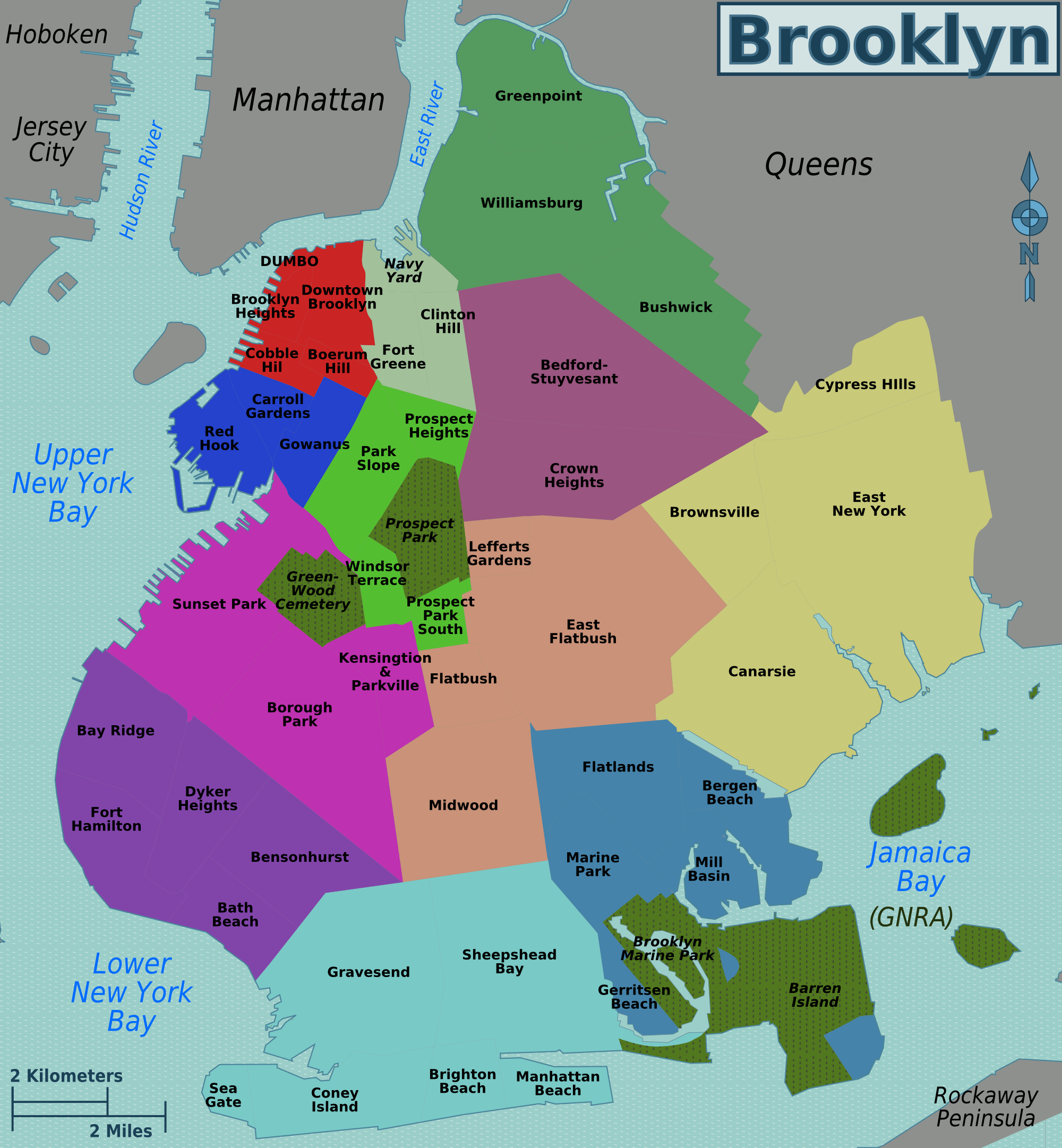
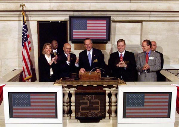
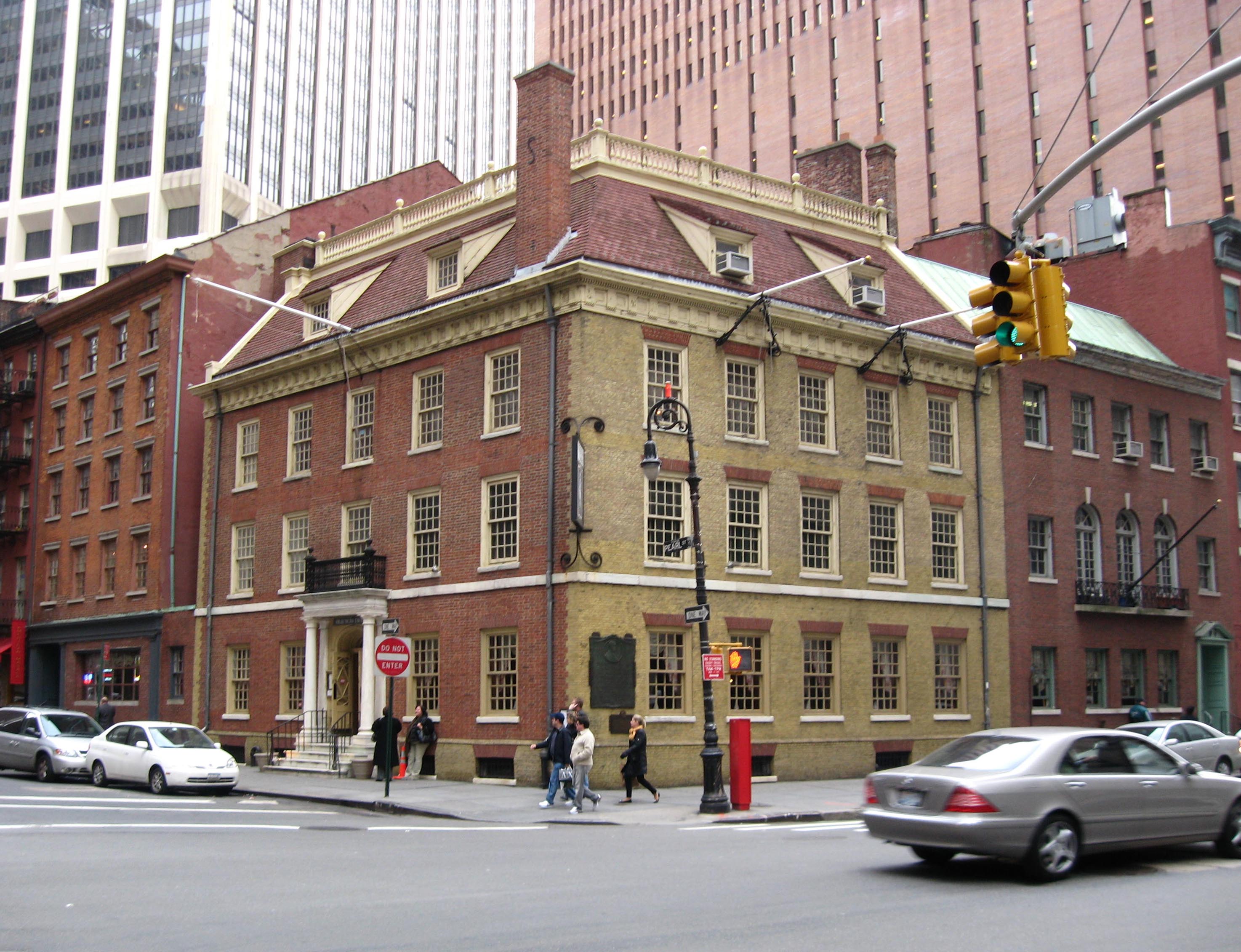
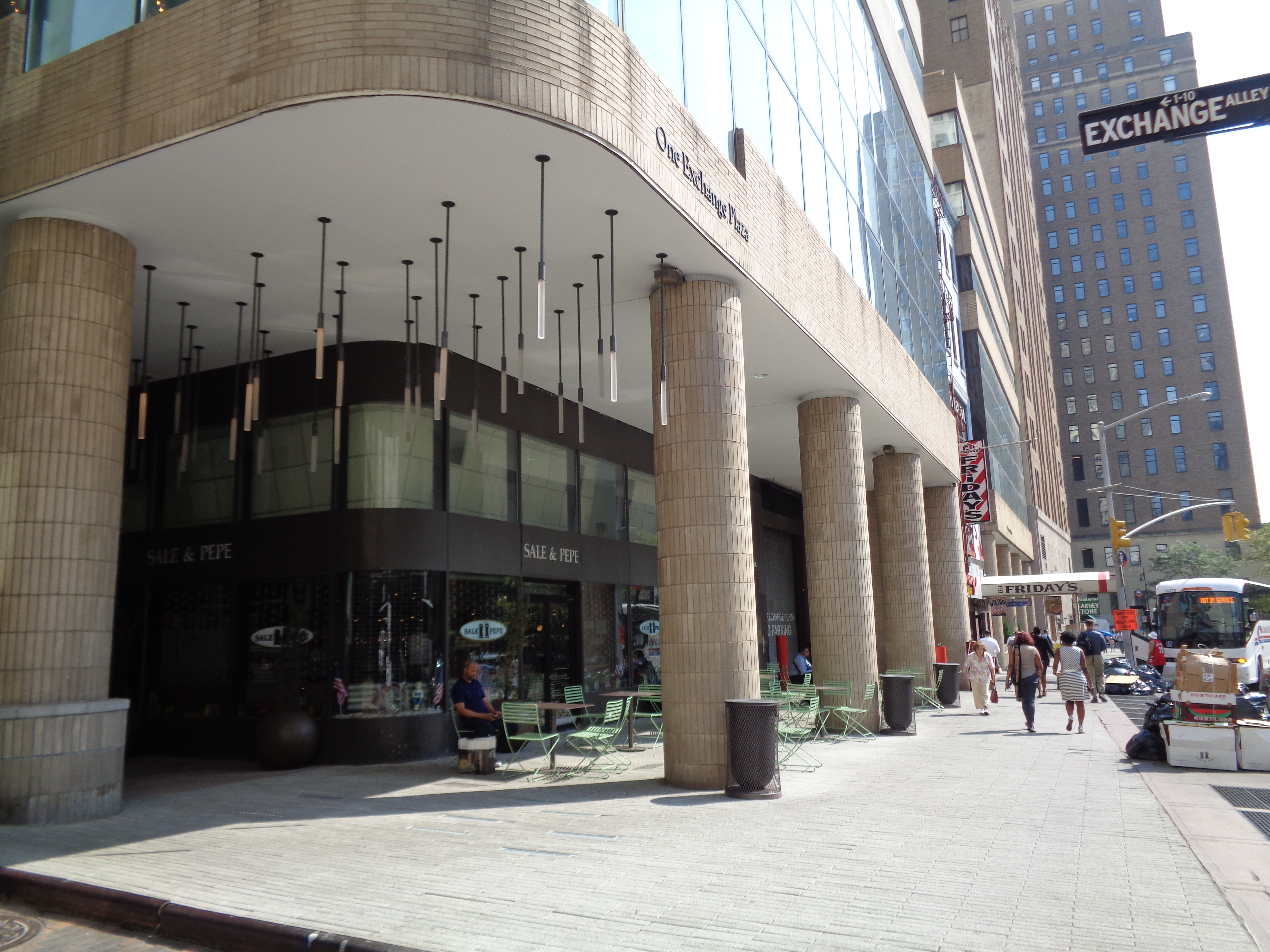
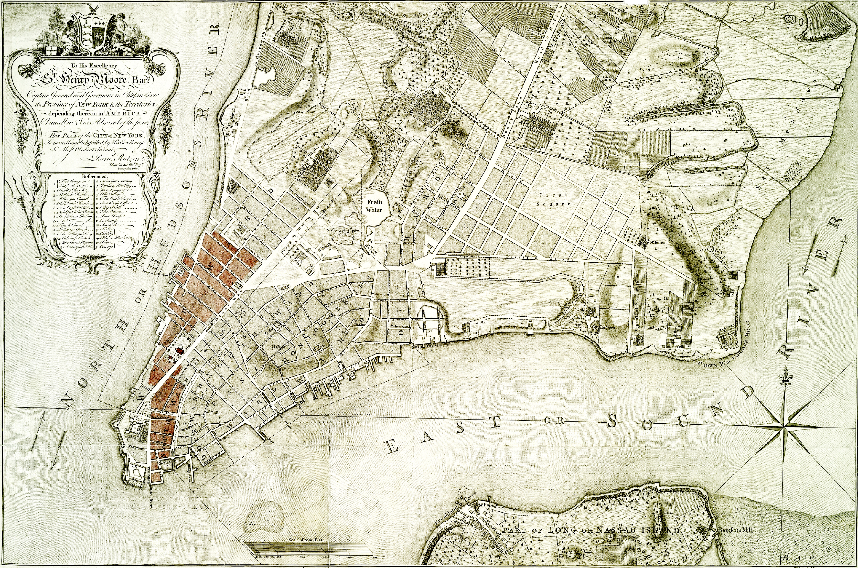
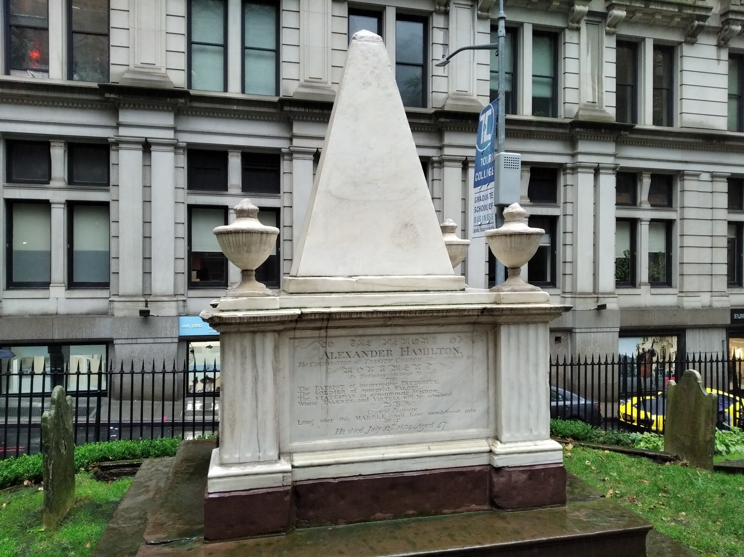