|
Reflections 2020
Series 4
May 29
Boat Trains I: English Channel – Southampton – Trips in 1957 & 2000-2007
| | In the last posting, we said we'd get back to discussing the service Virgin Trains USA is planning for the port of Miami that I'd mentioned when we spoke about Palm Beach. It's essentially Virgin Trains' planned boat train to PortMiami. Virgin isn't calling it a boat train, I am, because that's how I see it. But as I started compiling related information, the voluminous research was great fun and it "made me an offer I couldn't refuse". And so it got much too long for the last posting on Miami. Now I find it'll fill two tangential postings, of which this is the first, with the upcoming second already partially written. This is similar to what we did in 2018 when, in the midst of Paris, we projected to Bucharest, Berlin, and NYC, and to 2019 when we jumped from Cincinnati's Over the Rhine to New York's Kleindeutschland. So as the title says, we'll now go way off on a tangent or two—or three—and get back to Miami at the end (and Key West. And South Beach). The diversion [pun intended] will be enlightening. | | | | Boat Trains I've always liked boat trains, and it's worth talking about them, including my personal experience with them, which took place along the English Channel. Compiling and reviewing my history with the English Channel, particularly in Southampton, caused the topic to mushroom. So as we cover that topic, we'll also talk about the lush train coaches called British Pullmans and a number of related English Channel experiences. | | | | | | Trains bringing passengers to boats (ships, really) have a long and distinguished history. I can only assume that they are the model for three cities (at least) calling rail service to airports by a similar name with varying capitalization: New York (AirTrain), San Francisco (AirTrain), and Brisbane (Airtrain). |
| | | | I'm restricting my definition of a boat train as a dedicated train that connected a city to a harbor several hours away for the purpose of meeting with a ship, making the entire journey a two-seat ride for passengers, either boat-to-train or train-to-boat. None still exist. The train would pull up on the dock next to the ship for direct access, sometimes in an actual station, sometimes just on a track. It was an ideal example of combining rail 'n' sail. My familiarity with boat trains is for the ones connecting Paris and London with the corresponding Channel ports. There were others, especially in England. | | | | | | However, the rail 'n' sail experience can be more than that, so we'll expand a bit further. You can widen the definition of a boat train to another type of service with a three-seat ride: train-boat-train, which is valid for what it is, but which I mention only tangentially. True, each train at either end can be considered a boat train on its own, or be part of a three-seat ride, but something like this is not what I'm talking about right now.
An example would be the former dual-named luxury service called the Golden Arrow-Flèche d'Or that ran both ways between London and Paris. A British train would connect London and Dover; a ferry would connect Dover and Calais; a French train would connect Calais and Paris, the trip taking 6 to 6.25 hours. This ran from 1926/1929 until 1974, when needs changed. There was also a three-seat service on the North Sea connecting London-Harwich-Hoek van Holland-Amsterdam, and a similar one operates now, the Dutch Flyer, below in light blue. (Also note the two overnight cruiseferries, today's answer to yesteryear's coastal shipping.)
https://www.seat61.com/images/Neth-london-amsterdam-map.jpg
This expanded definition now compels me to refer to, and include here, the trip Beverly and I took in 2002 on the Orient Express (the modern version, called the Venice-Simplon Orient Express or VSOE) from London via Paris to Venice. It was the only three-seat trip of its kind I've ever taken, but there was no ship involved in the middle: it was train-bus-train! Or more precisely, train to bus-on-train-in-Chunnel to train. A VSOE train consisting of British Pullmans took us from London Victoria to Folkestone (FOHK.sten). We then all got on motorcoaches (a fancy word for buses) that were put on one of the trains that transfers motor vehicles thru the Channel Tunnel to Calais. (That was the only time I was ever on a bus—or any motor vehicle--that was simultaneously on a train! Even on Amtrak's Autotrain, people ride in coaches separately from their cars). Once the bus drove off of the train in Calais, it took us to VSOE's actual Orient Express to go, via Paris, to Venice. (See 2002/2. It's a little quirky, since my research and writing style was much simpler and more primitive then. The very short postings had minimal information and I hadn't yet learned how to add pictures and maps—but see below).
To my surprise, Wikipedia also includes in its definition of a boat train the one-seat ride that was offered between Paris and London called the Night Ferry. It was great idea in its pre-Chunnel day, but it was different, and calling it, not a train ferry run by railroads, but a boat train stretches the definition. It ran overnight from 1936 to 1939, then after the war from 1947 to 1980 between Paris and London. From Paris Gare du Nord it went to Dunkirk, where the engine put the coaches onto a train ferry, equally loaded on tracks on the port and starboard sides, for stability. This is a 1953 British Railways poster for the Night Ferry showing the loading of carriages onto the ferry. The carriages were chained to four parallel tracks in the ferry's hold. At Dover, another engine took them to London Victoria. (As to the chaining, it's like seat belts for vehicles, such as what is done to cars on the Autotrain, and on some ferries.)
But bringing this up included a revelation to me. As I speak below about my several "two-seat" boat train experiences, I'll be referring more than once to my very first trip to Europe, round-trip on the original Queen Elizabeth, in 1957 at age 17--I turned 18 in London at the end of the trip. For details, see 2013/7, Voyages 1 & 2. In sum, I was traveling with my friend and his parents, who were from Europe and went there every summer on business and for family, so they were all very experienced, while I was a teen-aged newbie. I'll speak below about our arrival in Cherbourg and our departure home from Southampton. But my friend and I separated from his parents in Paris to go further afield, and then we rejoined them later in London. I do remember that he and I went overnight on a boat train from Paris to London. But as a newbie I knew nothing about making plans or being aware of details, and just followed his lead. It's only now, all these years later, that I'm researching this Night Ferry and had an Aha! moment. I took that trip! I never realized I ever traveled via Dunkirk! I was just unaware about its history or even what its name was until now. What a sweet revelation!
|
| | | | Now after that digression, let's get back to the fact that I'm just talking about a two-seat ride, involving a dedicated train whose purpose is to meet arriving and departing boats for transfer to a major city. I have personally experienced three boat train connections in the past, all on the English Channel. In France, they were from Cherbourg (once) and Le Havre (twice), to Paris--just off the map to the right, just follow the Seine. But I had by far the most experience in England on boat trains between Southampton and London. Note that they were all SO civilized and convenient--and they're now all gone. There just aren't enough ships arriving and departing for the railroads to send a train to. The tendency nowadays has been for these ports to have "cruise terminals". Cunard will now send you from Southampton to London on a bus—excuse me, motorcoach—for a fee similar to what the boat train might have charged. | | | | Cherbourg On my first European experience in 1957, my friend, his parents, and I got off the Queen Elizabeth in Cherbourg (shown here in Cherbourg nine years later, in 1966), walked a few steps into the Gare Maritime (Port Station) to the boat train, then took off for Gare Saint-Lazare in Paris (Photo by Roland Godefroy). I'm delighted to have found some additional pictures of the QE in Cherbourg:
https://i.pinimg.com/originals/8b/5d/de/8b5ddec46744fb2c1655295b7c7b96cd.jpg
http://1.bp.blogspot.com/-UTXeYxSba88/TrOq6eZWp2I/AAAAAAAAAxM/naB0e23mhsI/s640/QE%2B%25C3%25A0%2BCherbourg.jpg
https://www.citedelamer.com/wp-content/uploads/2017/08/Hall-des-trains-1962c-1.jpg
The first two pictures above are undated, but of that period, and show the Queen Elizabeth docked next to the Gare Maritime with gangways connecting them. The third picture is dated May 1962, five years after my experience there, and shows the Hall des Trains/Train Shed, where trains were boarded, with the entrance bridge and stairs in the back. If you click in the center on the right-hand blackboard, you'll see that it says in English "Boat Train to Paris".
Two ships could debark a thousand passengers an hour into the station, and up to seven trains a day would take passengers to Paris in 3.5 hours. The facility was in heavy use in the 1950s and 1960s, and closed in the 1990s.
| | | | | | I can add tangentially memories of the experience on the boat train. It was an ultra-electric feeling for me, since it was my first time anywhere on European soil, tho my friend crossed regularly with his parents every summer.
https://s3-eu-west-1.amazonaws.com/lowres-picturecabinet.com/43/main/37/115938.jpg
It was still the period when people dressed up to travel (and smoked), as this scene in a British train compartment shows. Despite the summer heat, I was wearing a white dress shirt, tie, and jacket. It was also the period before air conditioning on trains, so we had the windows open. Despite the fact that it let in hot air, the blast of air was better than otherwise.
Tho it's always pleasant nostalgia to have traveled on a steam train, the fact is that the engine smoke spewed out cinders and soot, and as the train weaved around bends in the route, we'd come into occasional direct smoke entering the open window. What I remember most about this exciting ride on the boat train was the soot. It must have been all over us, but tiny black specks were visible on exposed skin. That you could wipe away, but the tiny black specks on a white dress shirt would only smear and become worse when you tried to wipe them up. It was a great experience, but with the heat and soot showed that not everything in life is perfect.
|
| | | | Le Havre The other experience in France happened twice in Le Havre, several years later, with Beverly. First it was debarking from the Liberté in 1961 for our year's study in Mainz, and then just a decade later, debarking from the SS France in 1971, at the start of our joint sabbatical year of study and travel in Europe. In both cases, we took the boat train into Paris to the Gare Saint-Lazare. | | | | | | Before we talk extensively about Southampton, I understand there were also British boat trains that didn't involve the English Channel. I've learned there was a boat train in the 1950s and 1960s that connected Glasgow Central in about an hour's time westward down the south bank of the River Clyde to Prince's Pier in Greenock. It connected with Cunard, for one. And there seems to have been another connection from Euston Station in London to the former Liverpool Riverside station (1895-1971) in three-ish hours.
[By the way, you might know that a person from Liverpool is called a Liverpudlian. I always considered that a word based on historic fact, maybe some erudite Latin word. But I just found out it started as a teasing joke (!) in about 1833, with the willful substitution of "puddle" for "pool"!]
|
| | | | Southampton The London experiences were all in connection with Southampton. Going home in 1957 on that first trip where we had arrived in Cherbourg, we took the boat train from London Waterloo to Southampton and connected directly to the Queen Elizabeth once again to complete our round trip back to New York. After that one time, all Southampton connections all took place in a period between four and five decades later. | | | | | | To explain that jump in time, I refer you back to the introduction to this website in the very first posting, 2000/1. It's quite short, and explains the basis for my three Travel Cycles, which I'll summarize quickly here:
My First Travel Cycle lasted roughly 3 ½ decades, from the start of my long-distance domestic travel in 1953 (see Diamond Jubilee [60] of Travel, 2013/7) and from the start of international travel above in 1957 (see Golden Jubilee [50] of [International] Travel, 2007/7; as of 2017, this now also reached 60 years, and is thus also a Diamond Jubilee). This First Cycle lasted until 1990 .
My Second Travel Cycle was a breach that lasted one decade, the Nineties. The reasons for the shift are in 2000/1—check it out--and are life-changing ones, largely medical.
That's why I call all present travel, thus far lasting exactly two decades, my Third Travel Cycle, 2000 to 2020 so far. In 2000 I decided we could manage with a wheelchair, and after a decade of no transatlantic travel, this cycle started with a frenzied return to Europe for several summers, often sailing via or to Southampton (details below) until Beverly passed away in 2004, weeks after we returned from Europe (see 2004/15 ff). Only after that did I expand my own travel to East Asia, southern Africa, Australia, and Antarctica.
Another manifestation of the Third Cycle was this very website, whose first posting dates from 2000. Think of it as a New Millennium website, if you wish.
|
| | | | Out of curiosity, I just calculated that, starting in 2000, I passed thru Southampton Docks, either coming or going, eleven times, and coming home on that first trip in 1957 makes it twelve. The only time I was on an absolutely genuine historic boat train was that first time in the First Cycle, since they were gone after that. In the 2000s, in the Third Cycle, we had two exquisite experiences on British Pullman dinner trains serving as lunchtime boat trains. These were wonderful, but by definition were just temporary recreations of what had once existed, just as Colonial Williamsburg is a recreation of the past, a (delightful) museum experience. The British Pullman trips were that, plus a wonderful, and very gourmet, meal to boot. Other than those two times, in Southampton it was awkward trips to Southampton Central for rail connections, or twice, a car rental. | | | | But we usually have something to say about names, and here we have a question. Is there an H in "Southampton"? Now I know you're too clever to think I'm referring to the TH sound in "south", so let's put that aside.
Well, the answer I've found may surprise you. It's on the fence—yes and no. I'm among those who do have an H in the word, but many do not. Let's take it apart logically, then build it back up.
| | | | Ham Sweet Home We start with a ham, but put your knife and fork away. This ham is a place. The word "hamlet", meaning a tiny village, is a diminutive of the now archaic "ham", from Old English hamm, meaning "piece of enclosed land", enclosed such as when surrounded by rivers or marshes. Such an area was easily and safely inhabited, so the meaning came to describe a tiny settlement on such a piece of land. It's one of those quirks of language, that the diminutive "hamlet" should survive, but not the original word it's based on. It's like keeping "booklet" but losing "book".
We still see "ham" today as a suffix in names like Birmingham and Nottingham, where each referred to a ham where a certain clan lived. (The H is lost in the UK, but reinstated by North American speakers. On the other hand, Beverly once taught in Pelham NY, where the H is gone.) It IS possible to find the word not as a suffix. There's a London district named East Ham—but ironically, it's part of Newham—no H!. And then, there's also an Eastham elsewhere in the UK with no H.
And who put the ham in Hamburg? And this now reflects upon one of the many relationships between Germanic languages. Most Germanists will have come across the older name of the city, Hammaburg, but where did that come from? Burg is easy, it's a fortress, but no perfect explanation has ever surfaced for the first part, and I've just been reviewing some suggestions in German that seem to me unlikely. Most promising is this. Middle High German hamme, referred to a Geest (G as in "go", rhymes with "paste"), which is a raised piece of sandy dry land surrounded by marshland and is a very typical landform all across Northern Germany, the Netherlands, and Denmark. It's posed that in the case of Hamburg, the piece of raised land was so well protected by the surrounding impassable moors that the inhabitants called it Hammaburg, a name that was hyperbole, since there wasn't an actual fortress—the Geest protected itself due to its location. I find that fascinating. Otherwise, there was a moated castle built there c825, but that isn't incompatable with the fact that the inhabitants might have already been calling their Geest a fortress, and that Burg/fortress might just have been icing on the cake. We'll never know for sure.
But it certainly seems to me that the old German hamme and the old English ham both referred to protected pieces of land, and I see a definite link there.
| | | | The Name Southampton originated as a ham in the Middle Ages with the naming of a settlement called Hamtun. That suffix is obviously a version of "town" shortened to "-ton", but in an earlier spelling. But what did that mean? My guess is that, while a ham was a minor settlement, a tun was perhaps a market town, of more importance, so perhaps Hamtun/Hamton referred to a town reflecting on its humbler origins as a mere ham—a little ham that "made good"--but that's complete speculation on my part.
We then get to the topic of intrusive sounds. The son of Thom[as] is logically Thom-son, but pronunciation was eased by saying it with a transitional sound, so an intrusive P developed to form modern Thompson instead.
| | | | | | Thimble, humble, and nimble are some words that developed an intrusive B that hadn't been there originally. Compare "fambly", the dialect form of "family", which also inserts an intrusive B. And how do YOU pronounce "dance"? Traditional is DANS, but very common is the more easily pronounceable DANTS, with an intrusive T (never written, tho). |
| | | | Similarly, Ham+tun became Hampton with an intrusive P. That P was retained when the entire region borrowed Hamp- from Hampton to become Hampshire (then later New Hampshire in the US). In the middle of the 11C, because there was another Hampton further north, "South" was added to form, presumably at first, South+hampton. The other Hamton/Hampton was then referred to as North+hampton.
But H is a very weak and fleeting sound—after all, it's simply breath. While "history" always keeps its H in its stressed initial syllable, "historic", stressed on the middle syllable, may or may not have an H. Some will say "a historic" with the H, others will say "an historic" without the H, tho it remains written (better might be "an 'istoric", but no one ever writes that).
So what happens? Hs in unfavorable positions tend to disappear. A hill with a church is named Churchill, with no H, later becoming a proper name. The Humber River in northern England gives its name to Northumbria and Northumberland, neither with an H. This is a typical and frequent development in England. As to our situation, the H was lost and it was spelled South[-]ampton. No H. The same with North[-]ampton.
But you can never tell what direction language will take. Not with other words, but with these two, the H reappeared (tho still never written), and today people pronounce both place names either with the H or without it. Let the Oxford dictionary illustrate it:
https://www.oxfordlearnersdictionaries.com/us/definition/english/southampton?q=Southampton
https://www.oxfordlearnersdictionaries.com/us/pronunciation/english/northampton
In both cases, look at the phonetic spellings with and without the H. Then click on the blue speakers for the British English pronunciation and on the red ones for the North American English pronunciation. Both pronunciations appear in all cases.
Since I use the H, I find again and again that touch-typing the word is slightly awkward. I find I type "South", then there's a nanosecond's pause in my mind because something is missing, before I type "ampton".
And those are the adventures of our little ham.
| | | | Southampton Docks Since we're talking about boat trains, let's first check out the "boat" side of things, then the "train" side of things. These are the Southampton Docks, with north in the upper left corner.
http://www.basingstokeairporttransfers.co.uk/img/destinations/southampton-docks/southampton-docks-map-large.jpg
We'll be talking about the height of ship and train travel, realizing that both have declined considerably today. There are four active passenger terminals servicing cruise ships, cross-ocean passenger ferries, and the ocean liner Queen Mary 2, for which Southampton is the home port. From left to right, in the Western Docks at berth 106 is the Mayflower Cruise Terminal (opened 1960, modernized 2003 & 2015) and at berth 101 the City Cruise Terminal (opened 2003, upgraded 2007). I have no experience with these, but do note that Southampton Central Station is just above the latter.
It's the Eastern Docks I'm familiar with, and actually, I now find out they're quite a bit older. At berth 46 is the Ocean Dock, where the Art Deco Ocean Terminal opened in 1950 to provide shore facilities for the "Queens" and other Atlantic liners. This is the one we used in 1957. Downstairs were trains to and from London. This is the RMS Queen Mary in Southampton in June 1960 (Photo by John Beniston at en.wikipedia) just three years after we departed from that terminal on the Queen Elizabeth in 1957.
At berths 38 & 39, the Queen Elizabeth II Terminal opened in 1966 to replace the Ocean Terminal and was modernized in 2003 & 2016. It remains in regular use—note on the map the rail line that pulls up to its side. This is the terminal we used on the trips in the 2000s. The original Ocean Terminal was demolished in 1983 and new one opened in 2009 (upgraded 2018-2019).
| | | | | | I remember making dinner conversation on the QE2 by asking if people knew how to say the name of the terminal. Don't fall into the trap. The terminal is named, using Roman numeral II, after the Queen, so it's the Queen Elizabeth the Second Terminal. It's not named after the ship, the QE2, whose name is read "Queen Elizabeth Two".
Conversely, a good question on the QE2 was to ask where the ship got its name. The easy, but incorrect, answer was that it was named after the Queen. The Arabic numeral 2 indicated that it was something more direct than that: it was named after another ship, the first ship called the Queen Elizabeth, the one I took in 1957. That's equally true about the QM2, also named directly after the first ship called the Queen Mary, not a queen.
And if we're going that far, we might as well go a bit further. Just which queen was the original RMS Queen Elizabeth named after? It's also a slippery slope, unless one thinks back to the fact that she was launched in 1938, when the present queen was 12 years old and was then Princess Elizabeth. The ship was named after her mother, the wife of George VI, who became Queen Mother in 1952.
And who was the original RMS Queen Mary, launched in 1936, named after? It was Mary, the wife of George V, the present queen's grandmother. There's a legend about the naming, which I cannot verify, but it makes a good story, and it does sound like it could have happened. Legend has it that Cunard wanted to name the ship Victoria, continuing the practice of naming ships with the ending –IA (Caronia, Mauretania, Lusitania, Carpathia, et al), but after asking the king for permission to name the ship "after Britain's greatest queen", he replied that his wife Mary would be delighted.
So there was a ship named after the present queen's grandmother and after her mother. Then in 2010, Cunard launched the MS Queen Elizabeth, finally completing that generational trio. And three years before, in 2007, Cunard also got to launch the MS Queen Victoria, finally completing the naming circle going back to Mary in the early 1930s.
Cunard always has denied the legend, but I have my doubts. There's one other feeble possibility. Cunard suffered in the Great Depression, and got a government bailout only if it agreed to merge with its chief rival, the White Star Line, becoming Cunard White Star. While Cunard ships used –IA, White Star ships used –IC (Titanic, Olympic, Baltic, Oceanic, Brittanic, et al). The claim could be that "Mary" was chosen to purposely break the –IA/-IC pattern. Maybe.
|
| | | | To get a better idea of what's on the maps, let's look at this aerial view of the original Queen Elizabeth at the equally original Ocean Terminal at Southampton Docks:
https://i.pinimg.com/originals/f3/f8/85/f3f8850abd71b32fa550aace99a36400.jpg
Unfortunately, it's undated, but no matter. We can do a little sleuthing on our own. We know this terminal opened in 1950 and that the Queens moved to the new QEII terminal in 1966, so there's a sixteen-year time frame, with my visit centered in 1957. No boat train is visible, but we see the tracks to the side of the building. Close enough.
| | | | The Rail Links We've now talked about the boat side of the boat train at Southampton, so we need some background on the rail side. All this rail background is new to me now as we speak, due to my teenaged newbie status that first time in 1957, and my not really following up on the story over the years. But it turns out to be a great rail story. | | | | It started with exactly what we're talking about, a desire to connect London with the Southampton Docks, and the subsequent construction of the appropriately named London and Southampton Railway (Map by Afterbrunel), which was built 1838-1840. But before long, there were changes at both ends.
As this earlier map shows, Portsmouth is not far to the east down the estuary from Southampton, and Portsmouth also was interested in rail service. A branch line was built, but the two cities were rival ports and the original name of the company was no longer accurate, so in 1839, the name was changed to the London and South Western Railway (LSWR).
But as the rail map shows, its London terminus was at Nine Elms in southwestern London, which was not well located. The reason that location had been chosen was that the planners had had freight in mind and Nine Elms station was close to a wharf on the south shore of the Thames for transport of freight but some distance from central London. Therefore, Nine Elms was most inconvenient for passengers, since it involved either a long wait for a boat going downriver, or paying tolls on roads. (!)
https://blackcablondon.files.wordpress.com/2014/01/waterloo-map.jpg
Therefore, the railroad decided to extend the line north about 2 mi (3.2 km) across Lambeth Marsh to another point on the south bank near Waterloo Bridge to what was at first called Waterloo Bridge Station, which opened in 1848, just as Nine Elms station closed (the name was officially shortened to Waterloo Station in 1886). Today, Waterloo Station is the UK's largest railway station, handling an average of over 90 million passengers a year.
| | | | | | Waterloo was not their main choice. They wanted to plunge forward, if not into the City of London itself, at least north across the Thames to the south side of Trafalgar Square:
http://kevinandbarry.homestead.com/files/londondec04/london_map.jpg
That station would have been called Trafalgar Station, but the duke of Northumberland's (no H) mansion stood in the way and he refused to yield his land, so that never happened, and Waterloo remained the terminus. Either way, a station ended up being named after one British victory or another in the Napoleonic Wars. But do note on the map that in 1864, another railway did manage to build Charing Cross station on the north bank at Charing Cross, quite near Trafalgar Square. Also note that that unnamed street to its south is Northumberland Avenue, which leads right into the Square.
|
| | | | But as they say, you cannot make an omelet without breaking some eggs. We've seen railroads kill canals, and planes and cars severely hamper rail and shipping. But who else could be damaged by building a railroad? The stagecoaches! Right as the original London & Southampton was being built, the new line was opposed vigorously, especially by people running the coaching business in the south coast area. One man owned 60 coaches and 1500 horses and stood to lose most if not all of it. But he was clever. He sold his business, invested in the railway, and became involved in it. In later years he became Chairman of the Board! | | | | The LSWR existed until 1922 during which time it expanded greatly in the southwest (Map by Afterbrunel). This map shows it in 1922 before the big changes the next year. In addition to all the extensions to the southwest (note particularly the western location of Plymouth for later discussion), you can still see the original line from London via Basingstoke to Southampton, and also Portsmouth. In that regard, we can now show an early LSWR boat train in 1911 running between Southampton and London Waterloo. | | | | During WWI, the British government took over the railways during wartime and realized the economies possible when the 120 railway companies weren't wasting time competing with each other, in many cases often causing losses of money. Parliament passed the Railways Act 1921, which took effect in 1923. Most railways were consolidated under what was known as the Big Four railways, one of which was the Southern Railway (SR), covering the area we're discussing, and including the LSWR as its largest component. The SR operated from 1923 to 1947. Its business, uniquely, was primarily passengers rather than freight.
https://d13z1xw8270sfc.cloudfront.net/origin/259990/1485114348289_southern-railway-map-of-system-and-continental-connections.jpg
This link is to a map of the routes of the SR (click), which is not easy to read. It's merely here to show the large scope of the SR from east to west, with Southampton in the middle. Along with other railways, the SR was nationalized in 1947 to become the Southern Region of British Railways in 1948.
http://www.rodge.force9.co.uk/images/map.jpg
This map (click), dated 1991-1992, shows British Rail routes in the southeast. Hold on to it. It would therefore include the time frame of my 1957 boat train from London Waterloo (via Basingstoke) to Southampton. The Southern Region of British Railways lasted from 1948 until 1992 when railways were re-privatized and routes were reshuffled into groupings of new private owners. The below map (click) shows the current rather confusing situation as of October 2018, with the list of, by my count, 27 different train operating companies.
https://www.thetrainline.com/cmsmedia/cms/11010/uk-train-map-30oct2018.jpg
| | | | Rail Meets "Sail" We now have some "sail" background and some rail background, but how did the two forces meet at Southampton? To my great surprise, the force that had the upper hand was not what I had expected. In addition, the rail transportation hubs within Southampton were totally different from what I would have thought. It was all quite a revelation.
First refer back to the map of the Southampton Docks, since it also shows most of the city. Find the Town Quay (say "key"). Since what is usually called Main Street in North America is called High Street in the UK, find the High Street and trace it up to the Bargate, the medieval Norman gatehouse (c1180) which was at the far northern end of the city walls. Thus this is the traditional heart of the city (maps to follow later). This is also the area that divides the Eastern Docks from the Western Docks.
The Eastern Docks, on that peninsula, are not on original land. Tho Southampton had been a port since Roman times, these docks were created in the 1830s by land reclamation of the mud flats between the two adjacent estuaries. I never would have expected that. The Southampton Docks Company was formed in 1835 and the first dock opened in 1842. P&O was the first deep-sea shipping line to use the port, and began service in 1840. The Union Line (later called the Union Castle Line) began service to South Africa in 1857. White Star moved in from Liverpool in 1907, followed by Cunard in 1919. Another large dock opened in 1911 called the White Star dock, but when Cunard and Canadian Pacific also used it, it was changed to Ocean Dock in 1922. Two of those lines merged in 1934 to become Cunard-White Star; in 1949, Cunard bought out White Star to become the Cunard Line once again.
But we're a bit ahead of ourselves. As we know, the railway arrived in 1840, so we come back to the London and South Western Railway (LSWR), the major predecessor of the Southern Railway. When the LSWR was founded it already showed interest in the Southampton Docks Company. Since the railway had greater financial resources, in 1892 it bought the company, operated the docks on its own, and continued the rapid development of them. From that point on, the rail facilities expanded considerably onto the docks, as one could imagine—they were their docks! Aside from the freight carried, a great deal of income was to be had by running passenger trains to and from the many quayside terminals, many of which were stations in their own right. Some of these terminals were more prestigious than others, such as at Ocean Dock.
And so the boat train was born in the last half of the 19C, at least in Southampton. And it's still to my great surprise that the boat trains were not the handmaidens of the ocean liners as I'd thought—the liners were docking on railroad property!
| | | | | | I can't find similar data for boat trains in Cherbourg and Le Havre. At best there are references to stations in town, but not to the docks. I believe they started in a similar time period, perhaps a little behind Southampton, but I don't know that for a fact. |
| | | | This excellent "historic rail map" will help explain a lot, since Southampton owes its layout as much to rail as to shipping.
http://www.disused-stations.org.uk/s/southampton_terminus/route_map.gif
But understand one thing. The rail stations you see are an amalgamation over time. They didn't necessarily all exist at the same time, but their positioning and repositioning formed Southampton.
We said that the Eastern Docks are the older ones, as is that peninsula, and that's where we see a cluster of rail lines. Picture it this way. Look at the fingers of one hand—these are the short rail spurs emanating from a main line. Look at the fingers on the other hand. These are the numerous docks. Now clasp your hands, and you'll see how this ideal rail 'n' sail combination worked at Southampton.
On the map, find Southampton "Central", which I now understand to be a misnomer, a bit of wishful thinking, since it started out as being in the western suburbs. Don't be fooled by it as I've been for a long time (tho I've driven thru town, we never overnighted in town). We'll get back to this station later.
On the map, find Southampton Terminus. This, now a casino, is the original rail station in town. When we said the first rail line here was called the London & Southampton, THIS is the Southampton station they were talking about. Southampton Terminus railway station served both the Port of Southampton and Central Southampton from 1839 until 1966. It opened under the name Southampton in 1839, tho it was not operational until the final link of trackage to London was completed in 1840. The line was later extended by the several spurs shown on the map onto the peninsula to allow boat trains to terminate on the quayside. The station did not originally handle passenger services because of a dispute. To overcome this, a small open platform at Northam (no H!) Road was opened (see map). In 1858 the name was changed from Southampton to Southampton Docks to distinguish it from Southampton West End station (which later was replaced nearby by Southampton Central).
| | | | Name changes continued. Southampton Docks was renamed Southampton Town & Docks in 1896. It was under that name that the passengers of RMS Titanic passed thru it in April 1912, with many of the wealthy ones staying in the hotel connected to the station. Later that year, in November 1912, it was again renamed, this time to Southampton Town for Docks (?), and finally Southampton Terminus in 1923.
After a period of decline, the station closed in 1966. It's ironic that what killed it was the move to electricity! Being a terminus is by definition being a dead end, and when the main line from London via Southampton to the west was being electrified, the upgrade bypassed both Northam station and Southampton Terminus (see map). Southampton "Central", off to the west, was on that main line, so it then became the main station.
| | | | | | On the green docks map see how the two stations were on the opposite sides of the old town. Locate Southampton Central on the main rail line again, then locate High Street. The former Southampton Terminus station was located on the east side of Terminus Terrace just north of Queens Terrace. You can see the rail line come right past it. |
| | | | By 1970, much of the track around Southampton Terminus was removed and the running lines were filled in to platform level to act as a car park. (US: parking lot; remember the fate of Miami station in 1963). The hotel adjacent to the station had been acquired by the military in WWII and Churchill and Eisenhower reportedly discussed the Invasion of Normandy in one of its small public rooms. It's now flats/apartments.
I presume my boat train to the QE in 1957 passed thru Southampton Terminus on its way to nearby Ocean Terminal, but I knew--and remember--nothing about it. Remember I was a teenaged newbie, and everything was so wonderfully unique. My main impression is the wonderful ease of getting off a train and in a few steps, boarding the ship.
Of the original platforms, all that remains is a single line that runs from Northam junction thru to the docks. I believe this is the route we used on the British Pullmans decades later to Queen Elizabeth II Terminal.
| | | | This is the former Southampton Terminus station building (1839) in the Italianate style, now recycled as a casino (Photo by Lupusaesticus). I believe that's the roof to the train shed behind it. It's a listed (US: landmarked) building.
In 1895, Southampton Central station was opened under the name Southampton West (showing they were aware it wasn't in the middle of town) to replace the smaller nearby West End station from 1847. But here's the surprise. The station was on the waterfront, which at the time comprised West Bay, with the water at high tide reaching right up to the edge of the platforms. It wasn't until the period between 1927 and 1934 that the Southern Railway (!) reclaimed additional dockland for what is now called Western Docks. Thus, all of West Bay disappeared and the station became landlocked. In 1935 the station was enlarged and was renamed Southampton Central. Now confirm this information on both our Docks map and our "historic rail map".
https://cdn.shopify.com/s/files/1/0510/1197/products/Southampton-1890_grande.jpg?v=1403390093
| | | | This map of Southampton in 1890 unfortunately doesn't enlarge much, but its purpose is to show that West Bay still existed at that time. The historic town area still faces water to the west, and even to the south. The black spot above the bay is today's Southampton Central, right on the waterfront. The large black spot near the Eastern Docks—the ONLY docks then--is Southampton Terminus, still called Southampton Docks then, and you can even follow the line up to Northam station.
https://www.londontoolkit.com/Images/southampton_rail_station.jpg.pagespeed.ce.9SrqaL8ITo.jpg
| | | | This is Southampton Central today. Since it was built in the mid-1930s, it retains a sleek Art Deco look from the period, which we'll discuss fully when we get to Miami Beach's South Beach in the future. This is the platform area (Photo by David Ingham), with a diesel-electric train. Remember that British trains pull in from the left, contrary to North American usage. I remember maneuvering Beverly's wheelchair here on the way to a group taxi to the nearby ship. | | | | "Third Travel Cycle" Channel Trips We have a bit more pertinent information about the trains involved, but that's best left for the next posting. First I need to establish the proper time frame.
When I first started to work on this boat train project, tho I knew that first boat train trip was in 1957, I was in the dark about just when in the 2000s we took the British Pullman trips which served somewhat artificially—but beautifully—as boat train trips. Rather surprisingly, I find we did not note in our travel diaries when we rode the British Pullmans as a boat train from London Victoria to Southampton. At the time, Beverly's health was continuing to fail—a major reason for our not traveling extensively in the 1990s--and I alone was taking care of travel planning and execution, and also of her, including how to figure out how to travel with a wheelchair—which actually worked out brilliantly, as the British would say.
But we'd always composed the diaries together, and she wrote it down. Now I was maintaining the diary on my own, and it got very slipshod. Sometimes I only mentioned the town and the hotel where we stayed. I might say that we took the train to Southampton (Central) and not I even mention which trips were on the British Pullmans (to the dock). Actually, I found that I'd often written more on the brand-new website than in the diaries, which was an aid in figuring out the following reconstruction of dates.
I know the two of us rode the British Pullmans together, not me solo after Beverly's passing, and that it was southbound, departing from the UK. Those rides are so embedded in my memory that they run together—I wasn't sure if we did it two or three times. My next step was to review my list on 2013/7 of "Fifty Voyages [Updated (to 60)]" to discover the dates we were in Southampton, trying to reconstruct ground transportation from and to Southampton so I could figure out when it was we took the British Pullman trains. Knowing that then allowed me to check the corresponding website postings, where I find I did make very fleeting—and terribly succinct--comments about the British Pullmans. In any case, I now know we rode them twice, southbound to the QE2, going home, in 2002 & 2003. But since I'd assembled all the Southampton information, I also wanted to summarize here just what interaction I had with Southampton all those years after that 1957 visit.
In retrospect, we did a burst of transatlantic ship travel in those first years of the New Millennium. Because of those years, out of my 60 Voyages, fully 19 of them have been transatlantic, one direction or the other, a number that surprises me, since 19 is almost a third of 60! I suppose it was an attempt to make up for the lost international travel time of the previous decade, but also I felt it easier to maneuver a wheelchair on a ship than on a plane. Therefore, from 2000 to 2004, Southampton was a regular transatlantic destination for Beverly and me, either one-way or round trip. That continued for me solo in 2005 and 2007. In 2000-2003 it was on the QE2, after that, on the QM2. By then the regular boat trains no longer ran. Unless otherwise noted, it usually involved a taxi connection to a train at Southampton Central connecting to London Waterloo (tho the British Pullmans left from Victoria).
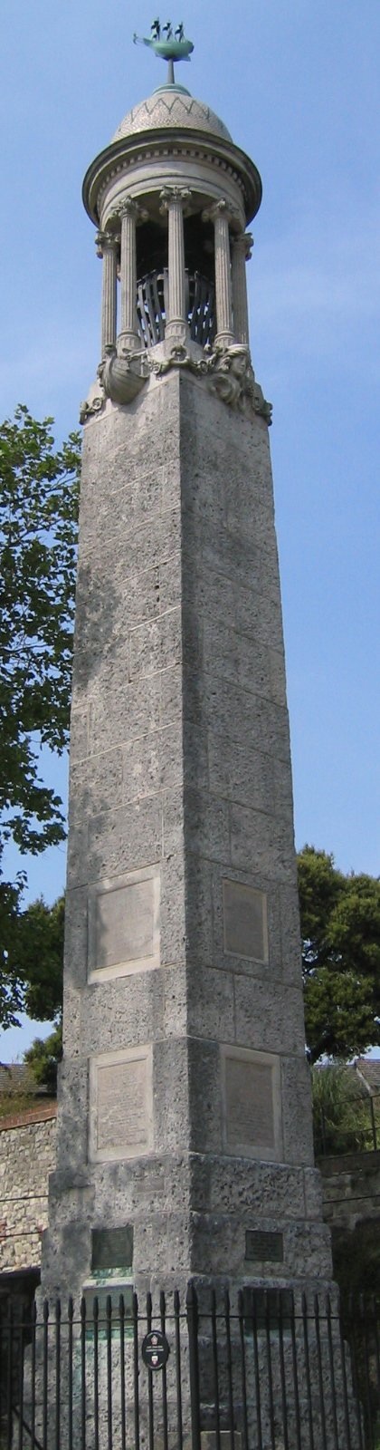
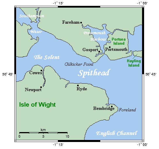
| | | | Southampton Summary, 2000-2007 It was a momentous year, 2000, the beginning of our Third Travel Cycle after our decade of just domestic travel (see 2000/1). In Southampton it was an arrival only. At the end of the trip, we came home on the Deutschland out of Cuxhaven on the south bank of the mouth of the Elbe, north of Hamburg. The ship made six intermediate stops (Cuxhaven to Plymouth to Waterford [in Ireland; then a short transatlantic hop this far north] to St John's to Sydney to Charlottetown to Halifax to New York). All of these were visits, so our visit to Plymouth was our only time there, and the only time we were on a ship that stopped on the south coast of England where we didn't go inland. | | | | | | 2000/1 also says a very meager bit of Plymouth, Waterford, and Canada. I want to repeat this map of the English Channel to show the locations of both Plymouth and Southampton, and also to quickly review the early part of the story related in 2019/16 in Cape Cod. When the so-called "Pilgrims" left Leiden, the Netherlands, their first refuge out of England, for America in July 1620, they sailed on the Speedwell. It reached Southampton and they met with the Mayflower and added additional colonists. The two ships sailed in August. This is Southampton's Mayflower Memorial, which has a model of the Mayflower on top (Photo by AlanFord). I have not seen it in person, but we can investigate it vicariously. On the Docks map, find Mayflower Park next to the Town Quay. The memorial faces it from across the road.
https://i.pinimg.com/originals/61/aa/da/61aadab4b8d031b7a1bc6844065052ef.jpg
https://icruise-assets.s3.amazonaws.com/uploads/download/file/2062/align_OldTownWalkmap.jpg
These two maps show Southampton at the time of the Mayflower's sailing in 1620. You can see the city walls, with the Bargate we saw earlier at the northern end and, at the end of what is today the High Street, the Water Gate. While there is a Pilgrims' Gate, I understand they actually left a bit further south, from the West Gate at the end of Westgate Street.
The second map is a modern view confined just to this area, showing which walls remain. We again see the two gates at either end of the High Street, as well as Westgate Street abutting the Western Esplanade. The Mayflower Memorial is at #14, with Mayflower Park (not shown) lying across the road that is named after the Town Quay. Now refer back to the Docks map, where you'll see that the road called Town Quay and the Western Esplanade are no longer on the water, but are surrounded by landfill, including Mayflower Park. The name Western Esplanade makes less sense than it once did, since it's not on the western edge of town, nor an esplanade on the water. The circle you see between the roads is the Mayflower Roundabout.
Back to 1620. The problem was that the Speedwell began taking in water, so both ships were diverted to Dartmouth (on our Channel map, on the east end the peninsula where Plymouth is at the west end). Repairs were made, but this second attempt only got them around that peninsula, and they had no recourse but to make an unplanned emergency stop in Plymouth. (Just ponder that, for a moment.) The Speedwell was finally considered unseaworthy and she was sold, with some of the crew transferring to the Mayflower. Of the 120 total passengers, 102 were chosen to travel on the Mayflower, about half of those having come from Leiden, the rest from Southampton, with supplies consolidated. They sailed in early September and arrived in Cape Cod on 9 November 1620.
Now consider these facts, and consider the ifs. If the Speedwell had been seaworthy, two ships would have arrived in Cape Cod. But that didn't happen. If the Mayflower had left Southampton alone, without the Leiden arrivals on the Speedwell, it wouldn't have stopped in Dartmouth or Plymouth, and the word "Plymouth" would be of little to no importance in Massachusetts. Maybe they would have called it Southampton Rock instead? These are the vagaries of history.
But I find it an interesting, but really unplanned, coincidence, that, in 2000, we were in two English ports on two different ships. We arrived in Southampton on the QE2, and going home, the Deutschland stopped in Plymouth, just down the coast, where Beverly and I walked around town, visiting among other things, the Mayflower Steps (Photo by RobertBFC at English Wikipedia).
|
| | | | It was a round-trip via Southampton in 2001 but that was the year we drove around the British Isles for the second time, so we picked up our rental car in a parking lot right on the pier at Queen Elizabeth II Terminal. Doing that was a bit surreal, since the rental company had left the car key above the sun visor in the unlocked car. It was also odd simply driving off a dock next to a transatlantic liner, as if it were an everyday occurrence.
In 2002, on arrival, we would have taken the regular train to London out of Southampton Central, because we stayed overnight at the historic Victorian-era Thistle Hotel at Victoria station. The next morning we took the British Pullman train to Folkstone to take the bus to the Orient Express, as described earlier. That's standard procedure for the Pullmans. I was well aware of this trip on the Pullmans, but didn't remember that it came before I used them twice as boat trains. As I ponder it, why did we, after booking the trip on the Orient Express, book the boat train the very same year? I think I can explain it this way. We knew nothing about what "British Pullmans" meant. We thought, incorrectly, that it would be the Orient Express right out of London somehow, rather than the OE's "sister train", the Pullmans, while on the British side. And we read in the Cunard brochure that there was a nice dinner train at lunchtime to the docks, still not knowing what British Pullmans were. I suppose we can consider it a "dumb mistake" doing the same thing twice during the same trip, but I must say, it's the smartest dumb mistake we ever made, and I'd do it again in a trice, if it came to that.
| | | | We'll be seeing pictures of the Pullmans in the next posting, but here's one of the Orient Express stopping at the Gare de l'Est in Paris (Photo by patrick janicek).
The 2002 return home would have been our first time using the British Pullmans as a boat train.
In 2003, on arrival we did go to Southampton Central, but took the train west instead for about 1.5h to Poole (see rail map for the trains, and the below map for the ferries):
http://www.channelislandferry.com/images/Channel_Islands_route_map.jpg
On this map, Southampton (not shown) adjoins Portsmouth immediately to the west, and is not that far from Poole. In Poole, we took a ferry to Guernsey for a night, then one to Jersey for a night, and then one to Saint-Malo in France, to make train connections to Paris, then to Italy. It was an unusual connection, both to cross the Channel and to get to Italy, but we wanted to see the Channel Islands on what was mostly an Italian trip. See 2003/6.
The 2003 return home would then have been our second time on the British Pullmans.
In 2004 we had our first trip on the QM2, to Southampton. I rented a car for the second time in Southampton to drive about 1h45 to Gatwick Airport to fly to Prague. By the return, Beverly was particularly ill, and it turned out to be her final trip. That wouldn't have been on the Pullmans.
In 2005-2006-2007 I was learning to travel solo, something I was not used to. (2006 was my "polar year", going north to Scandinavia and Spitsbergen, and later south to Antarctica.)
In 2005, Southampton to New York was the last lap of my round-the-world by rail via Siberia trip. I just saw that I'd noted in 2005/10 that there were rumors of bringing back boat trains, but that never happened.
In 2007, Southampton was the last part of my Portugal & northern Spain and "London Plus" trip (using a Britrail pass valid for the region around London), flying in to Lisbon, sailing home from Southampton.
| | | | | | So other than the car rental year, the train to Poole, and the two times on the British Pullmans, it was by taxi between Southampton Central and the ship. I remember the one time in particular when Beverly was in a wheelchair and arriving passengers piled in into shared taxi vans, and I had to store the chair in the back. It was hectic, but at least a short drive. |
| | | | Details for 2007 As for better understanding the past, I said earlier I just understood that the Night Ferry went via Dunkirk. I also just figured out, years after the fact, just how things worked out for me so nicely in Portsmouth in 2007, and now have more updated information about the start of that ferry route in Bilbao. Let me tell them in order.
I'd flown to Lisbon and visited Portugal and northern Spain, ending in Bilbao. That was followed by Voyage 41 (as listed in 2013/7) from Bilbao across the Bay of Biscay to Portsmouth on the cruiseferry Pride of Bilbao. The Voyage 41 entry says that the Pride of Bilbao stopped running on that route in 2010. Actually, I now find it had only started in the year I took it, 2007, so it didn't last long due to financial problems. But I have more news.
http://www.mobilemaplets.com/thumbnails/1589_thumbnail-1024.jpg
I knew it was a commuter train I took from Bilbao to get to its port and the ferry. Now I have this map to explain it. Click to find Abando, the main station in Bilbao. After staying overnight in town, I took the suburban commuter train (follow the route in gold) to Santurtzi, out on the harbor, which, making stops, took about a half-hour. Tho the stop is meant to serve the town, it was only steps to the cruiseferry, and was very convenient. But a boat train by definition is a train on a dedicated line to a ship, this doesn't qualify. It's just a convenient connection.
As it turns out, with the Pride of Bilbao out of the picture, the slack was immediately taken up by Brittany Ferries, who uses its ship Cap Finistière on the route.
https://www.brittany-ferries.co.uk/sites/default/files/2018-09/routeMapIJ-790x548-Portsmouth-Bilbao.gif
These are all the routes of Brittany Ferries, with our route marked in bold, so they're doing the same trip. But here's the catch. The Cap Finistière docks in Zierbena (see route map), out at the end of the estuary, and Brittany Ferries suggests taking a taxi for connections, so the idea of there being any boat train here becomes totally moot.
An unrelated note, but one I'm pleased about. This trip roughly completed a "circumnavigation" of Europe, as far as that is possible. I've sailed the Mediterranean from the Middle East to the Atlantic, with many stops; the Baltic from Finland to Denmark, with stops; the North Sea up to the North Cape and Spitsbergen; the Irish sea on various ferries. This connection from Spain to the English Channel across the Bay of Biscay very roughly completed the last major gap.
http://www.carsforstars-portsmouth.co.uk/images/portsmouth-map.gif
Back to Portsmouth at the end of the route, only about 30-45 minutes east of Southampton by train (see above map, also rail map). But I wasn't going to Southampton, and would go to London only indirectly using my "London Plus" Britrail pass. That evening I was planning to revisit delightful Chichester (first syllable rhymes with "itch") by train for the night (see above map), and the next day further east to Brighton, then north to London. But the cruiseferry had been delayed by weather for several hours and didn't arrive until 8:00 PM, so I found myself in a rush to take a taxi to the train (I had no Portsmouth map), get to Chichester, walk to the hotel (I had a Chichester map), check in, and have dinner before it was too late. All the delay and the late arrival hour started to stress me.
Let me explain how it worked out, then explain what I just now discovered about that evening in 2007. At the Portsmouth dock, I had no idea where the train station was, and went to the taxi stand and told the driver my dilemma.
As it turns out, tho I'm not a "taxi person" and like to do things on my own (when not under pressure), this taxi ride was very helpful and enjoyable, and worked out even better than expected. I told the driver I wanted to go to either Portsmouth Harbour Station or Portsmouth Central to get to Chichester, but he suggested the two local stations would not be as advantageous as another station nearby, so I took advantage of his local knowledge. He even used his speakerphone to call and find the time of the next train at the station he suggested. The ride was no more than about 10-12 minutes, and everything fell into place very nicely (see 2007/11 "Chichester").
But it's only now, thirteen years later, that I checked out exactly what I'm sure he must have done. I now discover that Portsmouth is actually on an island, Portsea Island (Map by Kelisi), tho it's located extremely close to the shore of the mainland, and is separated from it by a tidal waterway called Portsbridge Creek. It's this island that encloses Portsmouth Harbour on its west.
https://thenewcarly.files.wordpress.com/2012/10/portsmouth-harbour-map.gif
This map shows the rail story in Portsmouth. First, to my surprise, there's a Portsmouth Harbour Station, with connections to London Waterloo taking about two hours (plus other routes). This would indicate that there's a de facto boat train operating out of Portsmouth, tho evidently not named as such. However, I don't think it gets as much use as you'd think (see below). A bit further in is the main Portsmouth station, plus two others in town. So why did the taxi driver say there's a closer station? Look to the top, where this line blends into the main line, since it actually is a spur line. I believe he drove me to Cosham Station, in a northern suburb, because it was closer to the ferry, and, being on the main line, might also possibly have more frequent service.
| | | | | | I read that some say "Cosham" like all the other -ham words, dropping the H. It then rhymes with "possum". But there are those that pronounce it with an SH sound, which really doesn't make sense. So be it, but I don't approve. |
| | | | So now we need the "sail" story. Why were we closer to Cosham?
http://ontheworldmap.com/uk/city/portsmouth/detailed-map-of-portsmouth.jpg
This more complete map tells the story, tho it might be a bit harder to read. Click on the southwest part of Portsmouth, which is the Old Town. You'll promptly find the excellently located Portsmouth Harbour station, with the town station to the right. But you'll only see two dashed ferry lines leading to it, because this part of the harbour is relatively shallow. Follow the majority of the dashed lines north to where they end at what is now the Portsmouth International Port or, more practically, the Portsmouth Continental Ferry Port. I now learn that this deepwater port opened in 1976 (why hadn't I checked this out at the time?). All the dotted routes you see are Brittany Ferry connections (and surely my old Pride of Bilbao connection) to the French ports of Cherbourg, Le Havre, Saint-Malo, & Ouistreham (for Caen), and to the Spanish ports of Santander & Zierbena (for Bilbao). Condor Ferries has sailings to Jersey and Guernsey.
| | | | | | Tho I've driven thru Caen (rhymes with MA, but is nasal; is a homonym of quand), I've never heard of Ouistreham, but with that ending, I had to look up the name. Say "wi.stra.AM" and think oysters: Old French oystre, Middle French ouistre, today huître, so the Middle French form of the word stuck. But look at the suffix! Yes, it's the Saxon -ham (village) carried across the Channel in the Middle Ages. So Ouistreham is Oystertown! |
| | | | Now unclick on the last map and move to the top to Cosham Station, just north of the yellow roundabout. You can see that going south would have been out of the way and into denser traffic, and Cosham to the north was the right choice. I just checked, and it takes 20 minutes from Cosham to Chichester (check rail map), and so I made it quite easily and the evening worked out perfectly.
http://www.internationalrail.com.au/media/68533/britrail-map-2017.jpg
For those that are interested, this 2017 map shows that the London Plus Britrail pass covers trains in the gray region around London, including the yellow lines within the gray area, so from Cosham and Chichester I went to Brighton, London, Salisbury, Winchester, Oxford, Cambridge, Canterbury, Dover, and perhaps more. It was a great trip, details in 2007/11.
| | | | Channel Port Summaries There are a few extraneous details.
1) DOVER CONNECTIONS: For the sake of completeness, there were two cross-Channel sailings, both westbound, that lay further east than Southampton. Both today would be done instead by the Channel Tunnel (Map by Mortadelo2005). One was on what I now know was called the Night Ferry that arrived in Dover during that first 1957 trip. The second time was in 1966, when Beverly and I flew round-trip transatlantic. After visiting Germany and France for the first time since our 1961-1962 year in Mainz, drove our rental car to the ferry at Calais and crossed to Dover, for our first of two drives around the British Isles. After the Channel Tunnel opened in 1994, there were also a number of train trips under the Channel as well.
2) TWO BRITISH PORTS, SAME TRIP: Here's another tally for when I used TWO British ports on the English Channel during the same trip.
a) 1957, arriving via Dover on the Night Ferry, then Southampton home on the QE.
b) 2000, arriving in Southampton on the QE2, then stopping in Plymouth going home on the Deutschland.
c) 2003, arriving in Southampton on the QE2, immediately sailing that same day on the ferry out of Poole, and finally leaving for home on the QE2 via Southampton at the end.
d) 2007, arriving in Plymouth on the ferry from Spain, then taking the QM2 home out of adjacent Southampton six days later. On leaving on the QE2, I watched us passing Plymouth, it was that close.
| | | | 3) IN AND OUT: In addition to the twelve times being in Southampton mentioned earlier, I stopped in Southampton three times without deboarding, since it wasn't a destination, just an intermediary stop on a longer trip. It was in 1971 on the SS France from New York via Southampton to Le Havre, and in 2006 and 2008 on the QM2 from Hamburg via Southampton to New York.
For that matter, coming home on that first trip in 1957, we stopped in Cherbourg without deboarding, when the QE sailed from Southampton via Cherbourg to New York, and in 2001 we stopped in Le Havre without deboarding, when the QM2 sailed from Southampton via Le Havre to New York.
SUMMARY OF ALL CHANNEL PORTS: I decided to summarize, from east to west, which ports on the English Channel I've passed thru in any way whatsoever. In the UK: Dover, Folkstone, Portsmouth, Southampton, Poole, Plymouth. In France: Dunkirk (unknowingly until now), Calais, Le Havre, Cherbourg, Saint-Malo, plus the ports in Guernsey and Jersey.
| | | |
| |
|
|
|

