|
Reflections 2022
Series 4
June 26
Travel by Cable I: Attached vs Live Cables - Aerial Gondolas – Two Early Surface Cableways – Forgotten Greenwich Street
| | We'd gotten to talking about Switzerland, ending with Lugano and its funicular, the only funicular I've ridden in an Italian-speaking area. That led me into the subject of funiculars in Italy, which led me to learn that Funiculì, Funiculà was a "funicular song". We can now extend that all a bit further to talk about cable travel in general.
It happened this way. I was preparing online notes for my upcoming (postponed) Great Lakes cruise in July, which include a stop in Chicago. On my earlier visits there, I saw, but never rode, the els there, the elevated railroad system, for which Chicago is known. That got me researching the els of New York, specifically Manhattan, which are virtually all gone now. And in doing so, I found a map that by chance answered questions I've had for some time, and thus led to this posting. I did know NYC had had San Francisco-type street cable cars, but had no idea where they went in Manhattan. Now I know. But that will stretch out to the end of this discussion in the next posting.
| | | | Travel by Cable First we'll talk about travel by cable in general, which is perhaps more widespread than one realizes. To my mind, the culmination of that topic, and the most spectacular aspect of it, is what I like to call travel by live cable. It's not just a cable permanently attached to your vehicle. It's a continuous cable in a loop between pulleys that seems to take on a life of its own, where vehicles, otherwise powerless, "hop on" and "hop off" as needed. That's MUCH more adventuresome. | | | | | | We should make clear again that all the vehicles we're talking about, whether permanently attached to a cable or independently "on their own", are unpowered. An example is a wagon sitting in a barn that cannot move itself--a horse is needed. We're very used to vehicles that are powered, trains, planes, trams, and certainly cars. Tho horsecars gave way to electric trams in the late 1880s, the trams still required external power from an overhead pantograph. But when cars were invented after that, they were called "automobiles" ("auto" + "mobile" or "self-mover") because of their noted uniqueness in being self-powered. But every vehicle we're talking about below involves an unpowered vehicle, where an external cable, sometimes attached, sometimes live, provides locomotion.
EXCLUDED: CABLE FERRY There's one quaint form of transportation which, like the others listed, is fun to ride, but unfortunately doesn't fit our parameters, and that’s the cable ferry. These are only rarely found, but worth mentioning. We leave it off our list because the cable does no pulling, and the ferry is powered. Cable ferries are not found on major rivers. They exist on small backwaters with little boat traffic. One or several cables (sometimes chains) are fastened to each bank and very loosely allowed to lie across the riverbed, so as not to interfere with cross traffic on the river. The ferry's engine causes a winch to take up the slack cable and the winch causes the ferry to wind itself across the river. As the cable is used, it's lifted up from the bottom then let down again. It's the horizontal version of climbing a rope, where the person provides the climbing power and the rope is just a guide. Similarly, the cable is just a "flexible track" that gets the ferry across the stream.
This is a cable ferry crossing a stream in Queensland, Australia (Photo by Cybergothiche at en.wikipedia). Click to inspect the cable at both ends of the ferry, and note that such an operation is appropriate only for a narrow stream such as this. This is a picture of a cable ferry's winding mechanism in New South Wales, Australia as it takes up and releases the cable to propel the ferry (Photo by Gnangarra...commons.wikimedia.org).
|
| | | | Attached Cables: Elevators Several forms of cable transportation involve the cable and the vehicle being directly attached to each other. Surely the most frequently used one is the elevator (lift). While some elevators are hydraulically operated, the most common ones use cables attached to the cars (cabs). To distinguish them from hydraulic elevators, these common ones are called traction elevators. Explained most simply, a car is down below in an elevator shaft and one or several cables rise from its roof up to a deeply grooved pulley ("sheave") at the top. The cable goes around the sheave and its other end is attached to a counterweight near the top of the shaft. As the elevator functions, the sheave turns, raising the car and lowering the counterweight. There are guide rails (reminiscent of train tracks, but vertical) that guide the car, and others to guide the counterweight.
https://i.pinimg.com/originals/50/0f/97/500f97f69bc2c749c032a002edf4a2b7.gif
http://4.bp.blogspot.com/-MT749cQSS7Y/VlAyVhDayBI/AAAAAAAAEBk/oFZpQI7ExGI/s1600/geared%2B1.JPG
The first link shows the simplest schematic diagram of this. The car has risen and the counterweight has descended. The cables are referred to as suspension "ropes", but made of steel, so using the word "rope" is archaic and shows the history of what was used before steel cables were invented. The guide rails for the car are shown, tho not for the counterweight. There happen to be two sheaves in this drawing, but the principle is the same.
The second link is more complete. The car and counterweight are clearly seen; also indicated are the hoisting "ropes", the elevator rail, and the "roller guides" (tracks) for the counterweight.
We have here the view down a shaft (Photo by Harrihealey02). The main point is that one is traveling by means of several cables fixed to the roof of the car. The tracks are on the sides; that might be the counterweight in the back. I would daresay most people who've traveled by cable in one way or another have done so in a (traction) elevator. And most of those trips were very utilitarian, boring, and thankfully short.
| | | | | | The exception to that is of course a glitzy glass elevator, such as this one on a cruise ship (Photo by Mitch Ames). Those are so much fun that people might ride them even tho they don't really need to go upstairs. However, glass elevators don't use cables, but a vacuum system with brakes. |
| | | | Attached Cables: Funiculars Take the above, put it at an acute angle, and you have a funicular, whose cars are attached to each other by a cable that runs around a pulley at the top of the tracks so that each car works to counterbalance the other. When one is up, the other is down, which is the basis for singing Funiculì, Funiculà. The first funicular was in France, built in Lyon in 1862. There are three possible track layouts (Diagram by Cmglee). 4-rail takes up the most space but each car runs on its own tracks. 3-rail shares a common track in the center. But most economical, and surely most common, is 2-rail, with a passing loop in the center. | | | | Attached Cables: Inclined Elevator Contrary to what I may have mistakenly said in the past, there's a minor, yet significant difference between a funicular and an inclined elevator. Superficially, they look alike, but on closer inspection, the cars of an inclined elevator are independent of each other and each has its own counterweight, usually under its tracks, meaning these are really even more like traction elevators leaning at an acute angle, hence the name. That means it's possible to have a single inclined elevator running on its own cable and track, altho usually they are built in pairs, anyway. However, since they look like funiculars, and some of them are converted from funiculars, anyway, they are often called "funiculars" for historical reasons, hence my above error.
Two examples we've described in the past stand out. Paris's Funiculaire de Montmartre (2018/8) retains that name, tho it's been rebuilt as two inclined elevators. The Funiculaire de Québec (2017/5) is in exactly the same situation. Furthermore, we should make it clear that the underground structures recently built in NYC at the ultra-deep 34th Street-Hudson Yards subway station are definitely inclined elevators (Photo by Epicgenius).
| | | | Attached Cables: Aerial Tramway We move now from ground transportation using attached cables into the skies and to the general field of aerial lifts, and two modes come to mind that use attached cables. One is the aerial tramway, also called an aerial tram, or a sky tram. It's also called a cable car, which is a great name for such a mode of cable transportation, except that that name is applied to many of the modes we'll be discussing here—just think of the San Francisco cable cars—and an otherwise good name becomes essentially useless, since it refers to too many things.
An aerial tramway is should be visualized as a shuttle, usually between a lower and upper station. Three cables are involved. Two stationary cables just supply support and guidance for the car (as rails would), which would seem to disqualify this mode from our listing, since that's reminiscent of a cable ferry. But the third cable, which is attached to the car, provides propulsion, so it does belong here. This is the Roosevelt Island tramway in Manhattan (Photo by Autopilot). You can see how the car runs on tiny wheels on the two outer cables, which act as "tracks", while grip located on the cabin is fixed onto the center propulsion cable and cannot be decoupled from it during operations. This view has to be looking south, since the Tramway is on East 60th Street, next to the 59th Street Bridge ("Ed Koch Queensboro Bridge") in beige.
https://www.stewartmader.com/wp-content/uploads/2015/08/Roosevelt-Island-Tram.jpg
On this map, the bridge is in white and the tramway's in black. Disregard the yellow line, which is a subway and not visible. Note that the tramway does not cross the East River, just its west branch around the island. There are two cars that shuttle back and forth, and each can carry 125 people. The tram moves at about 26 km/h (16 mph) and takes 3 minutes to travel 940 m (3,100 ft) to the island. At its peak, it climbs to 76 m (250 ft) above the water.
| | | | Attached Cables: Chairlift (Fixed-Grip) For the other mode using permanently attached cables we have to split hairs, since there are two kinds of chairlifts. Both involve what appears to be a live, continuously circulating cable over intermediate towers between two pulleys, one of which is powered to run the loop, and both carry a series of chairs, mostly for skiers. But one kind of chairlift is called fixed-grip, meaning that each carrier is fastened to a fixed point on the cable. A fixed-grip chairlift usually operates quite slowly, to enable skiers to board and deboard without removing their skis. Chairlifts are usually small, carrying 2-6 people. I can vaguely recall being on two chairlifts, both times two-seaters, both in the summer, non-skiing. One was in Stowe, Vermont and one in Interlaken, Switzerland, and I believe both of those were fixed-grip. This is an excellent illustration of a two-seat fixed-grip chairlift on Lago Maggiore in Italy (Photo by Mbdortmund). Click to confirm that the grips seem to be permanent, so these chairs go round and round, like on a carousel. | | | | Live Cable All of the above modes of attached cable travel can be fun, but to my way of thinking, there's nothing comparable to riding a "live cable" (my term). With all the above modes, the car, cable, and (if necessary) counterweight function as a single unit. But now picture instead a continuous cable, either up in the air or near or just below the surface, zipping around all on its own, free as a bird, and actually humming because of its constant motion. Then picture separate (unpowered) vehicles, with no counterweight needed, waiting to grab on to it and take a ride with it. You can hear the hum of the cable as it make the round of its loop, and are waiting to "hitch your wagon to a star". This free, "live" cable might be up in the sky in the Alps, or under San Francisco streets. While all of the above cable travel might be fun, I find that grabbing onto something moving and having it propel you to be the most compelling, and most exciting. | | | | | | EXCLUDED: SURFACE LIFT While we above excluded cable ferries from our list because the cable didn't propel the vehicle, we have to exclude the surface lift for skiers here because, while a cable runs around its loop between large horizontal pulleys, powered by an engine at one end, there is no vehicle at all! A surface lift, or drag lift, or rope tow, is indeed cable transport (sometimes originally using hemp rope), but exclusively for snow sports, such as skiing and snowboarding. The riders, with no vehicle, simply stand on the ground on their skis or snowboards, grab the cable, and are pulled uphill. Sometimes there's a permanently-attached bar, handle (handle tow, pony lift), or even seat of some sort to make things easier (I've never personally seen a surface lift.) While surface lifts were once prevalent, they've mostly been replaced by gondola lifts or either kind of chairlift, which have higher comfort and higher capacity. Where they still exist, they're most often found on beginner slopes. Needless to say, there's one other glaring difference: riding a surface lift is a one-way experience. There's no need to use it downhill and there are no round trips!
This is a close-up of skiers arriving at the upper wheel (last stop!) of a surface or pony lift (Photo by IvanM~commonswiki). It seems to be a hands-on cable (with gloves!). Perhaps those streamers are just for visibility of the cable. This is a surface lift seen from a distance (Photo by edoug [?]). This one has handles, perhaps even with step-on capability. But there are no vehicles in either picture, and no round trips.
|
| | | | Cable Grips When the cable runs "live" around its loop while the lurking vehicles wait to hook up to the cable there has to be some method of them connecting, and that is the cable grip. It's the "hand" that reaches out to "grab" on to the moving cable, either way up in the air on a gondola lift or down below street level on a San Francisco cable car. In this way, the vehicle acts just like the above person without a vehicle who's using a glove on his or her hand to grab the cable on the surface lift.
But we also have to distinguish between two cable locations: (1) live cables looping around above the car, so that the car is hanging from it by its cable grip--these would be aerial cable cars. Yet sometimes they can be not quite so far up in the sky and the cars hang at (1a) a lower aerial level, just a little higher than an elevated railroad (el) would use, just a few stories above street level.
The other cable location would be (2) live cables moving below the car so that the grip has to reach downward, usually underground, as in street cable cars. But again we also have to consider cars on (2a) an elevated, above-street level cable, again just a bit above the ground.
| | | | Aerial Cable Cars Let's start up in the sky, where the cable is above the vehicle. Here, to my mind, there are two versions of the same thing, the gondola lift and the detachable chairlift. It's a bit awkward trying to group together these two kinds of unpowered, unattached cabs or chairs that have a cable grip to allow them to join the cable ride. To my way of thinking, the gondola lift is the main type of vehicle here, and the detachable chairlift, principally used by skiers, is limited-use, one-way, open-air version of the same. | | | | Gondola Lift In the case of a monocable gondola lift, one single cable provides both support and propulsion. I believe this is for smaller gondolas, and for detachable chairlift systems. But larger cabins require one or two stationary support cables in addition to a moving dedicated propulsion cable, so these are called either bicable or tricable systems. To illustrate, we can simply go back to the Piz Nair in Sankt Moritz in 2022/1, where we saw the gondola leaving the lower station at Corviglia (Photo by Roland Zumbühl). You can see it's tricable in each direction, since it carries a lot of people, up to 100 standees, as I'd heard. Also note its typical boxy shape, like a bus or a van, sometimes with seats, and sometimes just for standees. To contrast with this, we have this view of a much smaller monocable gondola in Lapland in Finland (Photo by Estormiz). Click to inspect the cable grip and to see how few people fit in the car on the right, making one cable sufficient to do everything. This would also be true for detachable chairlifts.
Now let's go back a bit further still, to the Luzern discussion in 2021/10, and the round trip over Mount Pilatus.
http://3.bp.blogspot.com/-e_uS8JepYYA/TrM3cpMr4jI/AAAAAAAAE3E/8wSlD2Z4l3c/s1600/Pilatus%2BGolden%2BRoundtrip%2BMap.jpg
You may recall from the above sketch that I'd taken the train on the Zentralbahn out of Luzern to Alpnachstad, then took the steepest cog railway in the world, the Pilatusbahn to Pilatus Kulm, the summit. I then explain that, to complete the round trip, I took two gondola cars: The upper one is a huge gondola car holding about 40 people standing. At an intermediate station, you get off and cross the platform to a smaller-style car that seats four people each, which brings you to the suburb of Kriens, then take a city bus back into town.
Let me now extend that information from the time of my 2008 visit. As the sketch shows, the larger gondola circulates between Pilatus Kulm and Fräkmüntegg. The line was rebuilt and upgraded in 2015, and now takes 3 minutes and 39 seconds, and each of two cars carries, not 40, but 55 passengers, so it's tricable. It's at Fräkmüntegg where the drive station is located for this upper system. It consists of a huge pulley called a bullwheel. This bullwheel is attached to the power system, so it's the drive bullwheel, while the one at the far (upper) end is the return bullwheel. This is a return bullwheel for a tricable system in Italy (Photo by Radapanda at Italian Wikipedia).
There had been a medieval legend of dragons with healing powers living on the top of Mount Pilatus, so the upgrade of this upper gondola lift is now called, not in German, but in English, the Dragon Ride. To my recollection, when I took this gondola in 2008, it looked like this, a familiar large, boxy shape—that's the Vierwaldstättersee/Lake Lucerne in the background (Photo by Dave Shafer). But the pictures I see of it today, after the 2015 upgrade, show a much sleeker cabin, here as it arrives at the upper station (Photo by Friedrich-Karl Mohr).
https://www.notabletravels.com/wp-content/uploads/2016/11/Lucerne_Mt.-Pilatus_Dragon-Ride.jpg
I'm also showing this very similar picture, because it shows that the people are seated, possibly in raised stadium-style seating. Also note the cable grip and the tricable system.
The smaller gondola cable lift runs between Fräkmüntegg and Kriens, but oddly, it includes a stop at Krienseregg, which also happens to be where its drive station is located. Its gondolas only seat four (!), so it's a monocable, but it has 132 gondolas, so it functions easily in tandem with the larger lift. I remember the transfer being immediate. Its total ride takes 30 minutes.
https://sunsetsandrollercoasters.com/wp-content/uploads/2019/05/5706-Mount-Pilatus-gondola.jpg
https://live.staticflickr.com/4080/4882105639_c66e890fa6_z.jpg
https://live.staticflickr.com/25/51106830_e5845defa4_b.jpg
I like the first link above because it shows a kid boarding one of these four-seaters, which is so petite and cozy, and is like getting into a car. The second one also gives a cute appearance. Again, note its monocable and cable grip. The third one shows a "flight" of these "birds" above Kriens, close to where you connect with the city bus back into town (that might be one, in yellow, on the bottom left). But it's also the best picture I have of an intermediate tower supporting all of the longer cable routes, whether they loop or not. And you can inspect where both the cable grip and cable go clickety-clack over those wheels at the top of the tower, which I always find just a bit disquieting.
| | | | Detachable Chairlift Up in the sky, we've talked about gondola lifts, so now let's talk about detachable chairlifts. While I'm sure some will disagree, I look at detachable chairlifts as open-sided and open-roofed small gondolas—and like other chairlifts, they're just ridden one-way, uphill. And sometimes I understand, they're not always even open-roofed. This is a detachable chairlift in Austria fitted with a "bubble" canopy for protection against bad weather (No Attribution).
https://cdn.wotol.com/YLf8-IwoKi3beaHS5NjjCqUUjFI=/fit-in/1000x1000/media/pictures/82b/82bfb746-4501-4219-9c72-1cfe2143b082.jpg
https://cdn.wotol.com/kA5xRzIHnL1V0jkAS3S4bfXlBA0=/fit-in/750x750/media/pictures/eb4/eb4a2390-9784-441b-8405-ac61d0b255e0.jpg
The first link shows a Doppelmayr detachable grip 4-seat chairlift. The second one is a detail of the detachable grip itself. Note how it hugs the cable. Detachable chairs usually move much faster, usually twice as fast, than fixed-grip chairs, and this speed is too fast for most passengers to safely get on or get off the chairs. I understand that they don't come to a full stop at the bullwheel as a gondola would. Instead their cable detaches, yet the chair moves slowly for easy loading and unloading, much slower than for a fixed-grip chairlift. This is a return bullwheel of a chairlift in Italy, which allows skiers to alight (Photo by Roberto Ferrari).
| | | | A Running Start Picture an attendant at a carousel wanting for some reason to board it once it's moving. It can't be done from a dead start—he'd be knocked over. Instead, he'd have to start running a bit in the direction of movement and then he could easily jump on with no problem. It's simple physics—he needs adequate acceleration to make such a move. So how does a gondola (or detachable chairlift) get a running start so that it joins the moving cable smoothly, so the passengers hardly feel it?
At the stations, the cabins hang from a rail as people get on or off. Then the attendant closes the doors (or lowers a bar across skiers' laps on chairs) and releases the car. There are rubber tires on top of the sloping track which spin progressively faster (or slower on arrival) and drive the cabin along until, in a very short distance, the car is rolling at cable speed, and the powerful spring-loaded cable grip grabs on to the cable, with hardly a jostle. It's reversed at the opposite end to slow down the cabin.
http://gallery.nen.gov.uk/assets/1208/0000/0601/img_2674.jpg
This link shows the rubber tires perfectly, just as they're ready to roll the next cabin up to the cable. In dark maroon at the left, the bullwheel turning the cable can also be seen.
| | | | | | As it turns out, this is a new discovery for me. The above photo shows a terminus of the London Cable Car, built across the Thames in the remote eastern part of London, in Greenwich in 2012—and built by Doppelmayr (see above).
https://1.bp.blogspot.com/-cjOhDecvLnk/T_IJvfno4YI/AAAAAAAAFrE/KSUikzbF0es/s640/1274384_Cable_Car_map.jpg
It's a monocable, and each car carries 10 passengers. It's at the former Millennium Dome, now called the O2 [Arena]. However, it's now in financial trouble because of its remote location and high ticket prices, and has become a political hot potato as to why it was built where few commuters or tourists use it. This view from the north shows the London Cable Car with its three support towers and with the O2 in the background (Photo by Nick Cooper at English Wikipedia).
|
| | | | Lower Aerial Gondolas As we speak about aerial cable cars hanging from the cable in the form of gondola, we said earlier that not all of them are way up in the sky connecting mountains and used for activities which may be fun, but are nonessential. Sometimes they're in urban areas as part of local mass transportation, not that far above street level. These are the urban lifts, and actually, we just saw one, the London Cable Car, tho not quite as close to the ground as others. | | | | | | We can squeeze in here the fact that the oldest aerial lifts centuries ago carried ore in mines; the only people they carried might have been mine workers. At the turn of the 20C, there were some primitive attempts at conveying tourists, but it wasn't until the 1930s and the growth of the leisure industry that the growth of aerial trams followed, which was then interrupted by WWII. Only after the war did the industry surge worldwide. |
| | | | Indeed, in recent years, gondola lifts have really come into their own in urban areas. And in 2017 we prominently featured the Mi Teleférico gondola cable car system in La Paz, Bolivia, which constitutes the largest urban cable transport system in the world—it's also the highest in the world--which forms the backbone of the city's public transit system.
That visit can be reviewed in 2017/16, but we'll summarize it here. La Paz is rather uniquely built in a valley, and it's grown up the slopes of the mountains around it to include areas on top, most notably, the twin city of El Alto.
http://www.centellas.org/miguel/img/2003/october/lapazmap.jpg
You can see from the highways on this map from the old posting that El Alto up above is relatively flat, and La Paz down below is quite convoluted. Subways or streetcars are impossible in such an environment, which is why Mi Teleférico was built (Map by Chumwa; Michael F. Schönitzer; Chuq). Note that station names are in the native language Aymara first, then in Spanish.
In Bolivia I had, quite unusually, both a guide and a driver, and when we arrived at the edge of El Alto, the driver dropped us off so we could use the cable cars immediately to finish the ride into town.
https://cde.laprensa.e3.pe/ima/0/0/1/6/3/163353.jpg
On the map, find the Blue Line. We got on at Rio Seco and went its full length. This was the flattest area I experienced, as the above picture shows. We were just going down a main boulevard, between—not above—the buildings along the way. This is what I mean by lower aerial gondolas. You can see where we changed gondolas to the Red Line, at which point we plunged down 400 m (1300 ft) into the valley to La Paz (Photo by EEJCC). NOW we were up in the sky and over the rooftops for the couple of stops to the Estación Central.
On another day, we were driven to the Yellow Line (Photo by Marco Ebreo). While this view is taken eastward from the Mirador station, we got on down the line at the Sopocachi station to ride one stop to the Green Line, which we then took to its end at the Irpavi station, which is again at street level (Photo by EEJCC).
While the La Paz system is the biggest (and constitutes the entire public transit system) other cities have lower-level gondola systems that supplement their systems. Notable is the Metrocable systems in Medellín, Columbia and Caracas, Venezuela, which are fully integrated into their public transit networks so that passengers can seamlessly transfer to the local metro lines.
https://www.gondolaproject.com/wp-content/uploads/2010/03/90-Degree-Turn-copy.jpg?lbisphpreq=1
This is a station in Medellín, which I show for two reasons. First, it's one of the hard-to-find pictures that show the rubber tires that speed up or slow down the gondolas. But also, it not only shows the bullwheel turning cables, but the caption explains that the two different cables on the bullwheel allow cables to be switched between cables at this point. I've never heard of that before. It would seem then that one could stay in the same cabin "hopping" from cable to cable.
There are also gondola systems in Bogotá and Manizales, Columbia; Guayaquil, Ecuador; Mérida, Venezuela; Greater Mexico City; Ankara, Turkey; and Portland, Oregon, US.
| | | | "Gondola" Quiz We're about to leave the topic of cables "above" to move to cables "below", but first, a bit of language study. I looked up the word "gondola" and find it refers to four different things. Two are no-brainers. Can you come up with the other two before peeking below?
The Online Etymological Dictionary explained the following, which I've embellished.
(1) The word "gondola", a Venetian Italian word of unknown origin, entered English in the 1540s with the meaning "a long, narrow flat-bottomed, black boat used in Venice". This is our first no-brainer.
(2) In US rail terminology—and only in the US—"gondola" was also used as of 1871 to describe a roofless, low-sided railway car for carrying loose, bulk materials (Photo by vxla). This is a Nickel Plate Road gondola car in a museum. There is some logic here—both the boat and car are roofless and low-sided—but then, so's a canoe. But "gondola" was chosen.
(3) As of 1896, "gondola" also took on the meaning of "cabin of an airship" (dirigible, zeppelin). There is a bit less logic here, since a passenger pod (or compartment) has a perceived similar shape to the Venetian boat—as the rail car has--but is no longer roofless when attached to the bottom of an airship. Thus this is a minor, yet significant shift of meaning. We can illustrate an airship gondola by showing the one attached to arguably the most famous/infamous airship ever, whose name most people recognize to this day, the one whose fate ended infamously in fire, the Hindenburg. This is the gondola of the Hindenburg as sailors from Lakehurst Naval Air Station in New Jersey use guy poles to help the airship to its mooring during its first US landing on 9 May 1936. Three days short of a year later, on 6 May 1937, the Hindenburg disaster took place at the same location, when the airship caught fire and was destroyed during a similar docking attempt. Nevertheless, this view of the Hindenburg's gondola is excellent. (We'll have more to say soon on the Hindenburg—it's too good a topic not to pursue).
(4) And our other no-brainer is of course the aerial cable car gondola we've been discussing, but I was surprised to read that that use of the name dates from only 1957--I would have thought it might have evolved earlier. Still, I'm convinced of one thing, where meaning (4) came from. I'm sure most people, on hearing that these cable car cabins are called gondolas think back to Venice and to meaning (1). But that makes no sense at all. Roofed-over passenger pods got to be called gondolas on airships, in meaning (3). But that's surely not the thought that pops into people's minds, illogical as that may be.
| | | | Surface Cable Cars Our topic of a live cable traveling in a loop now continues. We've talked about aerial cable cars which by definition have the cable ABOVE the vehicle. We now have surface cable cars which have the cable BELOW, usually underground, but possibly on an elevated structure, and always in an urban environment. Perhaps the invisibility of the cables makes them more mysterious and thrilling. As it turns out, surface cable cars historically failed twice, first in London, then in New York, before San Francisco got it right. | | | | London The first attempt at a surface cable car was in the East End of London and was called the London & Blackwall Railway. To locate the area we mean, this is a map of London's 13 major rail stations, some of which we've discussed before (Map by Hbf878). However, now pay attention to Fenchurch Street station, the first one to ever actually enter the City of London, whose borders are in purple. But to see a bit more about that station, look at this short animated YouTube video (2:10) showing the evolution of London's Railway Termini.
So first came London Bridge station in 1836, then two others, but the video clarifies that in 1840, Minories opened, but was promptly extended to Fenchurch Street in 1841, since that was physically located within the City.
http://www.disused-stations.org.uk/b/blackwall/route_map.gif
That leads us to this map of the London & Blackwall Railway (L&BR). It was built as a "cable" railway, tho at the time they used hemp rope instead of a steel cable for haulage. When it opened on 6 July 1840, the "cable" operation ran from Minories ("MIN" rhymes with "FIN") to Blackwall, and within a year, it was extended one more stop west to finally become Fenchurch Street to Blackwall, with these original intermediate stations: Minories, Shadwell, Stepney, Limehouse, West India Dock, Poplar. The line was 5.6 km (3.5 mi) long, and oddly, it was originally built to the obscure track gauge of 5 ft 1⁄2 in (1,537 mm).
We don't expect photos from that era, but we do get sketches. This is a view of Minories station of the L&BR c1840, when it still was the western terminus. That means we must be looking east, down the line, where the waiting train is obviously headed. There are two bidirectional tracks, which work independently of each other (not like on a funicular). We see the big winding spools with rope around them. They're (unexpectedly) vertical, not horizontal as we've seen on aerial gondolas (which came a full century later). The man on the right is using the lever to operate a brake that keeps the rope taut while unwinding. The instrument on the extreme left is the Cooke & Wheatstone "needle" telegraph. Also note the worker on the end of the train who is also working a lever (see below for more on both of these).
Each track had a double length of hemp rope, and power was provided by eight stationary steam engines at each terminus, four in use and four as backups. The ones at Minories, at 100 horsepower (82 kW), were stronger than the ones at Blackwall at 75 horsepower (56 kW) for the simple reason that the route sloped slightly towards the east, so pulling the trains toward Minories was somewhat uphill. As an engine was winding rope in from one end, the same length was being paid out from the other, with that worker at the brake to keep it taut. The rope was 14 mi (22.5 km) long and had metal swivels inserted at intervals--perhaps they looked a bit like these fishing swivels--to resist twisting of the rope.
| | | | | | Compare this use of hemp rope with its use, in the same time period, on the now abandoned Allegheny Portage Railroad (2019/7), which carried canal boats from the Pennsylvania Canal over the Allegheny Mountains for 20 years, from 1834-1854, as seen in this 1839 drawing. It also started out with hemp rope, with disastrously fatal results, before changing to cable. |
| | | | As for that unique mechanism shown in the drawing, let's start with this short (0:05-1:08) YouTube video about the L&BR Telegraph, the first commercially successful electric telegraph in the world. (At 0:40, note the names of intermediate stations at the bottom of the dials.)
So the terms were "Ready (to leave)" and "Stop" when a pair of trains was to leave each terminus. This is a view of a Cooke & Wheatstone two-needle telegraph (Photo by Geof Sheppard) as used on the Great Western Railway, c1837, which is the year it was invented, so in 1840, the L&BR was using cutting-edge technology.
I hope I can explain how the trains worked, since I'm not sure I understand it myself, but it's so odd, it's worth trying. Trains left every 15 minutes from each terminus, but no complete train ever arrived at the opposite end! Or at any intermediate station, either! Instead, the train would disassemble itself en route, dropping off cars at each station, and would reassemble itself on the return.
Leaving the terminus, sets of cars were dispatched in two groups. Group One had four cars for the three furthest stations, two of which were for their terminus. Group Two also had four cars meant for the three nearest intermediate stations.
We now refer back to that worker at the lever at the back of the car in the picture. These workers were involved in "slipping" and "pinning" the cars en route, which simply means detaching, then reattaching the cars. He stood on that open platform at whichever end of the car was leading and used that lever that was connected to iron grips (!) around the rope. Thus, each rearmost train was "slipped" away from the train and the convoy passed the station it was meant for. When the route was soon extended to Fenchurch Street—which I believe was never attached to the rope—the two cars for that terminus were "slipped" from the rope at Minories, but the brakes were not applied! It was pure momentum that carried those two cars up the slight slope from Minories to Fenchurch Street.
Do the math: eight cars (in two groups) would leave Blackwall, a car would be dropped off at each of the six intermediate stations, leaving two to slide into the Fenchurch Street terminus. The same would happen on the other track in the opposite direction. Then on the return, the two cars would "pin" cars at each station until the whole convoy reached the other end. I find this mind-boggling, and understand the telegraph precision needed to do it again and again.
https://www.ltmuseum.co.uk/system/files/styles/collection_item_gallery_fullscreen/private/collection_item/2020-10/i00008ii.jpg?itok=BoP-ZbVY
I found one more drawing of the L&BR in July 1840, from a newspaper, just days after opening. The bridge exits West India Docks station, carrying a three-car train either approaching or leaving it. You can't tell east from west here.
| | | | | | An aside on elevated railways. The earliest one was the London & Greenwich Railway, built between 1836 and 1838 on a brick viaduct of 878 arches. That was followed two years later, in 1840, by the brick-arched viaduct for the westernmost 4 km (2.5 mi) of the London & Blackwall Railway that we've been discussing (out of 5.2 km [3.25 mi]). The viaduct ran to the West India Docks station (above), then on an embankment, then a shallow cutting at the Blackwall terminus. This is a view of an original bridge (Photo by Pierre Terre) on this line in Limehouse (see map). It was built 1836-1840 and is still in use by the modern Docklands Light Railway. No other elevated railways were ever built in London, and it wasn't until the 1860s and later that they were built in New York (see below) and elsewhere. |
| | | | But the cable operation didn't even last a decade, and in 1849, the line was converted to steam locomotive operation and the track was converted to standard gauge, at 4 ft 8.5 in (1,435 mm). This was partly because there was much more wear on the rope than anticipated and because new extensions were being planned for that year. Curiously, they did try at one point to replace the hemp rope with steel-wire cable, but apparently it twisted and kinked terribly and didn't work out.
In 1871, long after the cable period, a branch was built to North Greenwich on the Isle of Dogs (see map) to connect central London with many more docks. But over time, the entire route declined, due to competition by water and rail, and to the decline of London's docks because of containerization, and over time, the stations were closed, one by one. The railway was operational until 1926 for passengers, then until 1968 for freight.
Finally, when the modern automated light metro system called the Docklands Light Railway opened in 1987, it reused part of the L&BR line, specifically between Minories (renamed Tower Gateway), and Westferry Road (Map by ed g2s & James D Forrester).
Thus the first attempt at a street cable railway, before giving up and changing to a different mode, lasted roughly nine years, from 1840 to 1849. There's another way to look at this "cable" failure. Originally, multiple steam engines operated the rope remotely from the actual train. But it was only when the steam engines morphed into a locomotive directly attached to the train, removing the rope "middleman", that the system proved successful. After all, it WAS the Era of Steam.
| | | | New York The second attempt at an urban surface cable car railway was not on the ground, but elevated about one story above street level. Perhaps it can be considered a romantic engineering dream that flickered for a few years of construction, but then flopped ignominiously. The cable railway only actually served passengers in the summer of 1870—and poorly, at that--before going out of business. The cable line was eventually replaced by the Ninth Avenue Elevated, the first elevated railway in New York. Of course, that ran on steam, tho later, it was electrified.
But not only was this cable railway located in New York, it was located steps from where I live. The closest subway station to me, is under Greenwich Street, where I use the Rector Street station of the #1 subway line. I enter at Rector, but often leave at the southern end of the station, in a park between tiny Edgar Street and small Morris Street, which is where the first experimental cable railway began. But to investigate this story properly, we need to know about Greenwich Street.
https://i.pinimg.com/originals/db/f0/7d/dbf07d9206cbaf53299e080883dff389.jpg
| | | | Greenwich Street The above map shows all of Lower Manhattan over time, so we'll pick off the modern layers of development to get to the original shape—what landfill now makes look like a U was originally more of a V (darkest area). Click on the Hudson side on the left, and you'll see two layers of history. The more solid area is the modern Battery Park City of the 1980s, created from landfill from the World Trade Center and other buildings. The BPC view is overlaid on the piers that used to exist there until containerization in New Jersey took away the activity from the declining piers. Find former Pier 6 and note how West Thames Street (not named) intersects where the pier used to be. The odd-shaped building on the Hudson just south of West Thames is my building (South End Avenue, not named, crosses it.) If you walk down West Thames to the subway, the location of the former pier, also pier 5, is marked in the sidewalk.
You then reach the older area of landfill starting at West Street, today widened to a broad boulevard. The older landfill goes for two more blocks, to Washington Street (once the location of Little Syria, discussed in 2020/9), and to Greenwich Street, all connecting a bit north at Rector Street, where the subway station is today for the #1 train. Underground, the station runs south closer to Morris Street, while Greenwich Street starts at Battery [Place]. To put the growth into proper sequence, in 1787, based on a proposal from before the Revolutionary War, the Common Council acted to extend the shoreline 18 m (60 ft) into the Hudson. That began the construction of Greenwich Street at the original shoreline. Washington Street followed in 1808 and, by 1830, West Street followed, tho not yet the wide boulevard it is today. But the dashed red line along Greenwich Street indicates that was later the site of the Ninth Avenue Elevated, which also tells us that earlier still, it was the site of the failed cable railway. Just one block away is wide Broadway, which starts at Bowling Green. Keep these names in mind.
https://bostonraremaps.com/wp-content/uploads/2015/08/brm1586-maverick-nyc-ca-1795_96-medium-res.jpg
Now we see just the pre-landfill original island in this map from 1796-7 (hold on to this map for a bit). At this point, New York was still quite small, directly abutting the nearby countryside to the north. At the oval of Bowling Green, #15 (click) is the beginning of "Broad-Way", that runs up the middle of the island. But along the Hudson is Greenwich Street, named that because it had been developed as the riverside road to Greenwich—follow it on the map. In the country, it's still called Greenwich Road or Road to Greenwich. Greenwich (GRE.nich) was a riverside settlement up in the countryside, not far north of New York. As New York grew, it became the New York neighborhood called Greenwich Village. But adding "Village" was a later development, as indicated by the fact that Greenwich Street has never included that word, so as built, it was the road to Greenwich, period. Perhaps "Village" was added later to indicate that Greenwich was once independent.
| | | | | | Orient yourself to other locations on this historic map that will come up later. Greenwich Street starts at Battery Park at the street here called "Market [Street]", which is now called Battery Place. You'll find Rector Street, where the rectors of Trinity Church, #3, once lived. It originally connected Broadway to the Hudson, as did most of these side streets. Find Cortlandt (spelled Courtlandt here) and Dey Streets, important to our story; Partition Street is now Fulton Street. All three are today at the former World Trade Center site. At the northernmost area near the river, the built-up area peters out at Warren, Chambers, and Reade Streets (spelled Reed here).
Go back to Trinity Church. The short street behind it had been called at various times either Lombard Street or Lumber Street (I see folk etymology in that confusion), and had been 12 m (40 ft) wide, which was reasonably wide for the time. But in 1834, a number of changes were made to make it rival Greenwich Street. It was renamed Trinity Place for Trinity Church, was doubled in width to 24 m (80 ft)--Greenwich Street is 20 m (65 ft)--and was extended north of Liberty Street to connect with Church Street (also referring to Trinity Church; Liberty is still the border between the two names). But in addition, a connection was cut thru to the south to extend it to Morris Street (still called Be[a]ver Lane here), where it then merged with Greenwich Street, also a reflection in the importance of the latter street.
|
| | | | While one could get to Greenwich via Broadway, that wasn't the direct route, making Greenwich Road/Street locally important as the riverside road. It was laid out in 1761 for the special purpose of being the main route from New York to Greenwich. It served New Yorkers to ride up for outings, but also became the escape route from New York to the countryside during the yellow fever epidemics of the 1790s to the 1820s. | | | | Greenwich The area that became the village of Greenwich had been populated since the 1500s by Native Americans who called it Sapokanikan. After the British took over New York in 1664, it became a pastoral country hamlet, upriver from New York, a mostly rural area of farms and estates, which was named Greenwich, after the Greenwich near London, whose observatory is known for having established Greenwich Mean Time (GMT, more accurately UTC).
This is a map of the (Manhattan) Greenwich area c1760. At the bottom, pick up Warren, Chambers, and Reade Streets to see that Greenwich is not that far away. Follow our Road to Greenwich to where it ends at this point in time at Gansevoort Street (not named)—eventually it would bend into the new Ninth Avenue. Today, a major artery, 14th Street, crosses just north of here. But a sudden switch from rural to suburban took place over a few decades because of outbreaks of yellow fever in New York to the south, which made Greenwich Village a part of New York since the 1820s.
From the 1790s to the 1820s, there were periodic outbreaks of yellow fever in New York because of unsanitary conditions, which would cause wealthier New Yorkers to leave to go to country homes, at least for the summer. A major destination was Greenwich for its fresh air, and the best way to get there by land was via Greenwich Street/Road. But it was the particularly bad yellow fever epidemic of 1822 that forced thousands to flee New York to move to Greenwich permanently. They built new houses and business and tried to recreate their lifestyles. New buildings went up fast. From 1825 to 1835, the population of Greenwich doubled, and by 1850, it had doubled again.
https://images.prismic.io/nyhs-prod/yellow-fever-hits-1790s-new-york-9.jpg?auto=compress,format&rect=0,0,1000,678&w=1000&h=678
This link shows a guide map of Greenwich [Village] (north is to the right) that was issued during the yellow fever epidemic of August 3-October 26, 1822. While West and Washington Streets end abruptly, Greenwich Street (now joined with Hudson Street) continues as a thru street uptown, merging with the new Ninth Avenue at Gansevoort Street (then called Great Kill Street [kill=stream]). In this period, many downtown businesses sought refuge out of town and built offices in Greenwich. The map shows the temporary homes of six banks, an insurance company, the Custom House, the Post Office, the Merchants Exchange, and two coffee houses.
| | | | | | The Bank of New York had its headquarters on Wall Street. In 1798, a clerk there was stricken with yellow fever, and the bank was quarantined and closed temporarily. To avoid that happening again in the future, the bank bought up eight lots on a nameless Greenwich lane and built a branch there for use in health emergencies. This lane became Bank Street (see map #1-2), which boomed during the 1822 epidemic. It retains that name to this day, tho I don't know of any banks there today, since it's purely residential. |
| | | | Of course, Greenwich would have been subsumed by New York over time as it expanded relentlessly uptown. But when it reached Greenwich—shall we call it a mini-New York?—it merely built up the area around it. In 2018/3 we talk about the Commissioners' Plan of 1811 to add the numbered streets north of the older parts of the city. But while First Street was laid out on the East Side, Greenwich was mostly avoided and most of its own grid remained. The numbered streets came north of Greenwich, and did little damage.
https://ephemeralnewyork.files.wordpress.com/2020/04/villagemapplanofthecityofnewyork1831nypl.png
This 1831 map shows how the already established Greenwich did retain much of its independent street grid. You see how north of Greenwich, 14th Street, a major route, marches river to river. 13th Street squeaks thru also, but 12th Street is broken up into two parts by already-existing streets in the village. That bit of West 12th near the Hudson is called today Little West 12th Street. However, the more rural areas of Greenwich succumbed to the Commissioner's Plan, which is why Washington Square is largely in the numerical area.
| | | | | | There's something I'll never understand. The original village area (in pink) around Greenwich Street is today referred to by New Yorkers as being the "West Village", which I consider dismissive, as tho it were some add-on, while what had been the rural area around Washington Square (in yellow) is what most New Yorkers would identify as "Greenwich Village." Go figure. |
| | | | Now back to Greenwich Street, the road that "grew" the village of Greenwich, and also let's go back to the 1796-7 map. At the turn of the 19C that we've been discussing, the lower part of the street near me had become part of one of the most fashionable residential neighborhoods in the city for New York's social elite and wealthy merchant class, lined with four-story Federal-style mansions. This elegant neighborhood was not only along Greenwich Street, but also included lower Broadway around Bowling Green and the Battery. The neighborhood remained highly fashionable for over four decades up until about 1820, but by 1828, the area gradually grew commercial and the affluent fled uptown. By the 1850s, the wealthy had deserted the neighborhood, and their remaining houses were converted into immigrant boardinghouses, saloons, and shops. | | | | Two Mansions I can't help but including here now two buildings, once mansions, that still remain on lower Greenwich Street. When I first moved to the neighborhood three decades ago, I'd passed them both on occasion. I did notice them, but paid little attention, just as one notices a homeless person sleeping in a doorway. Then gradually, I learned what gems remain in the neighborhood, despite there being no historic markers about the two buildings. Well, there are no historic markers for Greenwich Street, either, so I shouldn't be surprised.
https://upload.wikimedia.org/wikipedia/commons/b/b8/Perris_Manhattan_V._1_Plate_02_publ._1852.jpg
I could legally link to this map, but I'd rather you get it yourself to refer back to as we discuss it. Let's first catch up. It's from 1852, and covers what was then the First Ward of Manhattan, a term no longer used for electoral districts. West Street is still just a normal street, not widened to a boulevard. Lower Broadway and Bowling Green lie to the other side, and both Washington and Greenwich Streets start at Battery Place and run northward. Note how Morris Street is still whole and still runs thru to the river. Trinity Place now has that name, but remains a dead end. You recall that it would be widened and cut thru to Greenwich Street, right at Morris. Find tiny Edgar Street for below comments—it's still there, but not "there".
Both former mansions are in Federal Style, which is what the English Georgian Style was called here after the American Revolution. Both were built just at the start of the 19C, just as landfill was making Greenwich Street possible. Both have been designated NYC Landmarks. You have to imagine similar row houses up and down the street, and also realize that at the time, Greenwich Street was known as "Millionaire's Row" and in later times was referred to as the "Original Park Avenue".
Click on this map and go up to the top of Greenwich Street. You see #92. Across Rector on the northwest corner, but not shown, is #94, below:
https://live.staticflickr.com/5213/5383655807_b46dae0196_b.jpg
This is #94 as it is today. On the right, the Greenwich façade is 20 ft (6 m) wide, and, hidden behind the white car is the northern entrance to the Rector Street subway station of the #1 train. On the left, the Rector façade is 94 ft (28.7 m) deep, and shows up above where the roof line was changed when an additional story was added at one early point. It has a diner called Café Bravo on the ground floor. I'm surprised to learn that there are three residential apartments upstairs—sometimes upper floors in old buildings are left vacant. It was built as a posh mansion c1799-1800, for a prominent stock broker and banker named Lawrence. But by 1810 it had become a boardinghouse for merchants and professional men; by 1827 it housed a pub; in 1841 it was listed as a hotel. Yet what's significant is that it's a survivor into the 21C of the most elite NYC neighborhood of the post-Revolutionary War era. Nevertheless, it would be great if someone were to restore it to its original appearance and recycle it as something like a museum of the grand era of Greenwich Street. But that's just my thought.
On our map, move down Greenwich Street along what was then just individual row houses until you reach #67 (with #65 next to it). #67 was built c1810 by Robert and Anne Dickey (he a merchant) and is also known as the Dickey House. It's therefore about a decade younger than #94. Dickey built #65 at the same time, but that's been long gone. You'll see that both of these, as well as a few others, had an unusual bow-shaped back façade facing their gardens. On the Trinity Place side of the properties (then still called Lumber Street) Dickey built stables and a storehouse, and it can be assumed that other houses did as well. It seems obvious that the widening of Trinity Place subsumed these outbuildings, now leaving exposed to the street the bow façade of the back of the buildings over reduced gardens.
| | | | | | Now find Edgar Street, which I've usually ignored as being rather nondescript, but am now getting more and more interested in. There are numerous tiny lanes and alleys throughout Manhattan, but Edgar Street, measuring just 19 m (63 ft) long, is the shortest thru street in on the island. But the one you see on this map is not the one I walk regularly. You can see that originally, Edgar Street was south of house #61, three building lots south of the Dickey House at #67. But when the Manhattan portal of the Brooklyn-Battery Tunnel wreaked havoc on this neighborhood in the late 1940s, and the Trinity Place off ramp opened in 1953—more later—many buildings were torn down and Edgar Street was actually obliterated, and its twin built north three building lots, up to the south side of the Dickey House! At that time it was also widened from a mere 5.5 m (18 ft) to 20 m (65 ft).
I've also now learned that Edgar Street (in its original location) dates from sometime in the Dutch period, when it bore the Dutch name Tuyn Paat. In Modern Dutch that would be spelled Tuin Pad, and either way, it quite charmingly translates to "Garden Path". When the British took over the colony in 1664, folk etymology struck the Dutch name and English speakers began to change Tuyn Paat to Tin Pot [Alley]. When the city acquired the street in 1795 it was renamed Edgar Street, which probably refers to the shipping merchant William Edgar, since for a time, the street served as a driveway leading to the Edgar family property nearby. Until the landfill extension, this street would have run down to the edge of the Hudson.
This map offers me another surprise, and I have to say a bit more about it. Find Exchange Place on the right, named for the former Merchants' Exchange nearby. West across Broadway is what is today known as Exchange Alley, a very narrow passageway the width of one car (I may have driven it once), but it's now only for pedestrians.
https://ixtayul.blogs.com/photos/uncategorized/20060401019abw.jpg
This is the view of Exchange Alley from Trinity Place uphill to Broadway at the far end, and, with Edgar Street, I use it regularly to reach Broadway. Wall-to-wall, it's 7.6 m (25 ft) wide, and it looked much narrower when there literally were two walls, but then that open terrace area on the right was built adding some space. I see here that back in the day it was called Oyster-Pastie-Lane, listed elsewhere online as Oyster Pasty Street.
I can put two things together to try to figure this out. Oysters were once so common in NYC that they were the cheapest of street foods (but no longer). I've also had in England a Cornish pasty (say "pass+tea"), a delicious meat-filled pastry (Photo by David Johnson). So were oyster pastries sold in this narrow street? Research opens some doors, but closes others.
|
| | | | Back to the Dickey House and its rear façade, the northern part of which has that elliptical or bow-shape. This is a feature that has been compared to that of historic row houses in Boston. When the building was remodeled in 1872 to remove the hipped roof and to add a fourth floor, the ellipse was maintained.
In 1823, the Dickeys transferred the house to another owner, who kept it thru the 19C, renting it out to prominent New Yorkers. From 1830 to 1831, it also served as the French Consulate (!!), but by the 1840s, it became a boarding house. By the time of that 1872 remodeling, the building was used as a tenement, with the original upper-class residents in the neighborhood having relocated uptown to be replaced by immigrants. In 1890 there were 57 Irish tenants living in the house.
We'll see in a moment how the cableway went up the east sidewalk of Greenwich Street, meaning it was right next to the Dickey House. At Rector, it was across the street from #94. But we'll also see that, when the cableway failed, the elevated line came.
https://forgotten-ny.com/wp-content/uploads/2018/02/1885-greenwich.jpg
As a preview of the future, to see how the two houses were affected, above is our area in 1885 once the Ninth Avenue El replaced the cableway along Greenwich and the Sixth Avenue El diverged from it at Morris to move up Trinity Place. At the northeast corner of Greenwich and Rector is #94, meaning the el thundered by its front façade. But now find Edgar Street in its old location and move up three properties to find the Dickey House. It had els thundering by and darkening the street both in front and behind it! But the els were closed and dismantled in the mid-1940s.
| | | | | | To the right of where Edgar Street now is located you can see that Exchange Alley by this time has that new name. Now picture a line left of Edgar cutting thru to Washington. Everything between Washington and Greenwich from that line down to Battery Place, including that middle block of Morris Street, no longer exists, but since the mid 20C has been the huge exit portal for the Brooklyn-Battery Tunnel. |
| | | | This is a northern view of the area c1893. On the left, Greenwich Street can't be seen because the Ninth Avenue el fills it so completely as it passes the fronts of both our historic houses. On the right, the Sixth Avenue el diverges at Morris Street and blocks the view of Trinity Place, and, up a ways, runs along the back of the Dickey House.
https://static01.nyt.com/images/2021/04/11/realestate/09streescapes-slide-ED5R/09streescapes-slide-ED5R-articleLarge.jpg?quality=75&auto=webp&disable=upscale
Let's jump ahead almost a half-century. The Sixth Avenue el behind the Dickey House was torn down in 1939, and the above view shows the house in 1940. You can see why the Dickey House is called a survivor. The buildings on either side were not original structures, and they're no longer there, anyway. Where the foreshortened garden of the Dickey House used to be, was replaced by low-level shops facing Trinity Place. But the elliptical bay, raised to four floors, was still there—and still is. When I first moved into the neighborhood in the early 1990s, Edgar Street had already replaced the building on the left, and on the right a department store had replaced those structures. The low-level structures were by then a tavern, which was closed after Nine Eleven.
https://live.staticflickr.com/5216/5384261770_786e9c7812_b.jpg
This is the shambles of the Greenwich Street façade as I knew it when I moved here. The bricks had been painted a sickly gray, and the sign for a non-existent hardware store was still there. But I always admired the proud pediment that remained above the entry. As we'll see, the cableway passed along the sidewalk right in front of this building, as did later on, of course, the Ninth Avenue el.
But then the Dickey House fortunes changed. That department store on its north side was torn down to be replaced with a residential tower to be called 77 Greenwich Street, and this tower needed to use the air rights above the Dickey House. So the Dickey House has been renovated and is becoming an annex of the tower. It will house part of a public elementary school, which will extend into the lower floors of the tower. The low building behind it with the tavern was considered non-historical and has been torn down.
I remember them gutting the Dickey House down to its west, south, and east façades, and permanently strengthening the shell with internal steel beams. When all the demolition was done, the shell stood alone (Photo by Tdorante10). In this amazing picture, we're on Trinity Place looking west at the shell, which is always recognizable because of its ellipse. The low buildings behind the house are gone. That massive structure is the Battery Parking Garage, which faces the house across Greenwich Street. To the left are trees in a nascent park (more below).
https://static01.nyt.com/images/2021/04/11/realestate/09streescapes-slide-7BC1/09streescapes-slide-7BC1-articleLarge.jpg?quality=75&auto=webp&disable=upscale
The transformation of the Dickey House goes on as we speak, tho these "after" pictures are already dated, since the house looks much better than these older pictures do. The elliptical bow is spectacular. We also see the tower, and the blank wall now facing tiny Edgar Street. What I do find surprising is that I've heard that the new entrance to the school is to be from this side, maybe because there'll be more open space where the half-garden used to be.
https://tribecacitizen.com/wp-content/uploads/2021/03/67-Greenwich-Robert-Dickey-Mansion-1.jpg
And here is the developing Greenwich Street façade, proudly sporting that pediment above the door. But it's interesting that it's not an exact replica of what the Dickeys knew. It was decided that the fourth floor addition to the original house was old enough to be considered historic, so perhaps it should be called a modified restoration.
https://static01.nyt.com/images/2021/04/11/realestate/09streescapes-slide-ZJGE/09streescapes-slide-ZJGE-superJumbo.jpg?quality=75&auto=webp&disable=upscale
I particularly like this picture, also taken from the parking garage, because it shows the scale of what we're looking at. We compare the tower to the house, both in size and contrast of colors. We're right above our historic Greenwich Street, with Trinity Place in the back. And it's the only picture I've seen that shows the entire length of short Edgar Street connecting the two. Yes, it's been moved three houses north, and widened considerably, but remains the shortest thru street in Manhattan. And my walking route to Broadway is thru the parking garage, along Edgar, and thru Exchange Alley (click to look beyond the house to that brown building—where it curves on the left is narrow Exchange Alley).
| | | | Disrespecting Greenwich Street Back to the street itself, which has been totally disrespected and neglected for years. Just like there are no historic markers for either of these houses, neither are there any to explain the long history of the street. And there are these points:
1. Not only has Greenwich Street been made one-way, but it's been done piecemeal. From the Village down to Canal Street, it's northbound. From there to the Dickey House, it's southbound. And the last block from there to Battery Place is northbound again. There's no way to drive the length of Greenwich Street all at once to try to get the feel of history back in the day.
2. When the ill-conceived, misbegotten original World Trade Center was planned, its footprint covered a huge superblock that obliterated about a dozen regular NYC blocks. It also eradicated parts of about seven streets. After Nine Eleven and the construction of the memorial, most (not all) of these streets have been reconstructed.
https://si.wsj.net/public/resources/images/NA-CC592_WTCTRA_9U_20140903183610.jpg
Going north-south, some five blocks of Greenwich Street disappeared, but are now back. Toward West Street, the same happened to this section of Washington Street (not named) and remain gone, since that's the location of the memorial. Going east-west, pieces of Liberty, Fulton, and Vesey (say "V+Z") Streets have returned, but I call your attention in particular to the reappeared blocks of Dey (say "dye") and Cortlandt Streets, mentioned earlier on the historical maps.
| | | | | | That one "new" block of Cortlandt Street has now been given the cuter name Cortlandt Way. The red oval is Calatrava's Oculus, which I like to call The Bird (see 2020/9-10). I was just in it to visit the Apple Store, and the area is looking good—the Performing Arts Center is coming along and now looks like this (Photo by Zachbarbo). The light red area shows the transit hub, with the rebuilt Cortlandt Street subway station of the #1 train running between Fulton, Dey, and Cortlandt Streets. It's SO very ironic that, as we'll find in a moment, the southernmost passenger station of the cableway was at Dey Street, so the area has plenty of transportation history. |
| | | | 3. The elevated line that took over the failed cableway followed every bit of the same route along Greenwich Street, then continued onto Ninth Avenue (tho it was also extended further). Yet, to conform with the three later elevated lines named after numbered avenues, this replacement was famously called the Ninth Avenue El, as tho Greenwich Street, where it had all begun, hadn't even existed.
4. In the late 1940s, it was decided to build a tunnel from Brooklyn to Lower Manhattan at the Battery. Instead of trying to avoid the historic area, the Manhattan tunnel portal took out, as shown earlier, 1 ½ blocks of the fabric of Lower Manhattan.
https://i.pinimg.com/originals/12/b4/56/12b456c8dde6d45b7ae5095e909d5e86.jpg
The route came in under Battery Park, so at least that remained undisturbed. Click on the lower left corner of the above map and find the tunnel exit right past Battery Place (not named). There's two-way tunnel traffic to the left, connecting to West Street, thereby severing lower Washington Street. It took out the middle block of Morris Street, leaving the severed west block to join severed Washington for local traffic (I actually just walked it—it's rather nice, quiet and leafy). Trace (my) West Thames Street on the right and follow my walking route thru the parking garage to the Dickey House and this modern location of Edgar Street (neither named, and Edgar is two-way). Southbound traffic on Greenwich has no choice but to make two left turns and go north on Trinity Place. Greenwich and the other streets are sliced-and-diced by the tunnel portal.
If you stand on Battery Place with you back to Battery Park, you see the monolithic Battery Place façade of the tunnel portal building (Photo by Fletcher6). That's Washington Street on the left—very quiet now as a stub—and that's Greenwich Street on the right. On the other side, if you stand on a pedestrian crossing bridge (that I also just crossed recently), you see this southbound view of the tunnel portal building showing its north façade and the gaping maw of the tunnel exit (Photo by Jim.henderson). The stub of Washington seems very tranquil on the right, and Greenwich Street also has buildings only on one side with an open gap on the other. (Click behind the lamppost at the NYS Department of Motor Vehicles; it's where I renew my driver's license.) It's hard to see the onetime importance of Greenwich Street.
| | | | The Cableway We've been making references to it for quite a while, but now that we have an idea about what Greenwich Street is all about, it's time to study the elevated cable line that existed for so short a time before failing. I like to refer to it as the cableway. I'd love to call it the Greenwich St/9th Av Cable El, but it was never called either of those names. Its actual name was the West Side and Yonkers Patent Railway (I wonder at the use of the word "patent". Does it mean the cable system was patented? But it was a failure, so the matter is moot.)
After the London cable railway of 1840-1849 that ended up being replaced by steam engines, this was the second attempt worldwide—and it also went to steam. While London's was partially elevated, New York's was completely elevated for the entire 5.6 km (3.5 mi) length that did manage to get built on the Lower West Side of Manhattan, from Battery Place to 30th Street. The company had been chartered to build an elevated cableway for a total of 40 km (25 mi) all the way up the Upper West Side, then off the island ending up in the village of Yonkers on the Hudson in Westchester County, but obviously, that never happened. I should mention at the outset that in either case, in no way would the cable way consist of one single cable—it had multiple cables, transferring cars from one to another.
| | | | Experimental Section Charles T Harvey was an engineer who had built the Soo Canal and Locks in the St Mary's River in Sault Ste Marie, to connect Lake Superior and Lake Huron, and he was the one who proposed the cableway. He got the charter for it in 1866 and permission to proceed beyond an experimental section in 1867. It was built in the next two years and opened to passengers in 1870, but closed permanently later in that year. Harvey had chosen cable since he wanted to avoid using steam locomotives because of the soot and smoke, the noise, and the danger of exploding boilers. As in London, it was steam locomotives on the Ninth Avenue El that replaced the cableway. Electric motors weren't practical until c1885, and the Ninth Avenue El was finally converted to electric power in 1902.
When I first read about this cableway, I wondered why, of all the streets in Lower Manhattan, Greenwich Street was chosen for it. I see now that, other than Broadway, Greenwich Street still had the reputation of being a transportation corridor, so the choice was really quite logical. The first section built was to be experimental, and stayed that way, never accommodating cable passengers, tho perhaps one day it might have been meant to have been included in the passenger section. It started in the southernmost block of Greenwich, Morris to Battery Place, and eventually was extended north to Cortlandt Street for a total run of 0.8 km (0.5 mi). If you picture an el being a massively wide structure filling a street, as later did happen, the cableway was a little one-way single-track lightweight that covered only the edge of the eastern sidewalk, supported by a single row of graceful columns. For this reason, people called it the "one-legged railroad". Harvey built this first experimental block in October and November 1867.
Various websites I found had a selection of early pictures, many taken from glassine slides, but every single one included this early iconic picture, but which is one that doesn't include a train. It shows Harvey himself, in a top hat, on 7 December 1867, riding a handcar in a test run on the one block stretch going southbound from Morris Street. You see that black flywheel next to him. Normally, track workers would move the handcar by turning the handles on the flywheel. But instead, Harvey is holding a rope attached to the steel cable, as tho it were the reins of a horse wagon, to move him the one block. You see how the "one-legged" structure is on the sidewalk near the curb, not out in the street. That's Morris Street at the corner, so at the moment the end of the structure is barely out of the frame. And you couldn't want the location identified any more closely. Look at the two addresses, #39 and #37. Now look again at this 1852 map we used earlier, click, and you'll see those addresses. The map and photo are just 15 years apart.
Now find #10 on the map and compare it to this view. It shows we're at the southern end of Greenwich Street with our backs at Battery Place, looking north. We see the southern end of the cableway structure with some sort of car on it, not a regular train car. It's obviously not a strong structure, not able to carry regular trains. It's an interesting streetscape with horse wagons, one with milk cans, as being common transportation. Click to see two instances of German writing and also references to going to Havana. While all these buildings had been replaced by the mid-20C, today the left side would be the tunnel exit, and among those on the right would be my DMV. Since the experimental section eventually was built up to Cortlandt Street, this first, southernmost cable was called the Cortlandt Street Cable and was opened in 1868.
While the cable system Harvey used was unique in its entirety, this first cable was doubly unique. First, we know that most cables run on a horizontal plane. We've seen bullwheels, and they've all been horizontal, with the "live cable" also running horizontally left-and-right. But Harvey's bullwheels ran vertically. And so did the cables. (Actually, the London cableway also had vertical bullwheels and cables, but that whole system functioned differently.)
But the Cortlandt Street Cable was more unique than the others, because, while the cable ran one way between the tracks on the elevated structure, it returned under the street level. I picture it as running between the tracks, then downward somehow, under the sidewalk in the other direction, running around a bullwheel at a stationary steam engine in a neighboring building, then running up to the structure again. But it was promptly noticed early in the opening year that water got into the underground trench, would freeze, and slow down or stop the cable. (I assume San Francisco today has better drainage of its underground cables.) Perhaps that's one reason that this first, experimental cable never was joined to the others. But Harvey learned from the experience. None of the other cables went underground. However, they still ran on a vertical plane, one way between the tracks, but then returning directly below the tracks, but still up on the structure.
http://1.bp.blogspot.com/-CJouAIrIv14/TeQWQqnd6_I/AAAAAAAABtc/YWMCSS1Mz7c/s1600/fig2-21.jpg
In this view, up ahead, Cortlandt Street crosses Greenwich as we're looking north. This is the northern end of the experimental section, and shows a "trial car" on the structure, which suddenly ends, with plans to continue it northward for passenger service. We're somewhere between May 1868 and the start of further construction in 1869. When the structure was extended beyond what we see, the Cortlandt Street Cable ended and the Franklin Street South Cable took over. However, there was a gap between all the cables, and the single-car train was expected to coast across the gap from cable to cable!
The beams are very thin, tho a slightly heavier pair crosses Liberty Street behind us because of the wider distance. The tracks are flat iron strips laid over a cushioning material laid directly on the beams. The tracks are slightly broad gauge at 4 ft 10 in (1473 mm). Only when the cableway was converted and expanded to be the Ninth Avenue El using steam trains in April 1875 was the gauge standardized at 4 ft 8.5 in (1435 mm).
http://holidaymapq.com/wp-content/uploads/map-of-lower-manhattan-3.jpg
| | | | Main Line to Ninth Avenue Beyond the experimental section, the main line went further than perhaps one realizes. On the above map covering more of Manhattan, find the start of Greenwich Street at Battery Park, then the separation of Trinity Place (not named), and follow it thru the site of the WTC, Tribeca, Soho (not named), Greenwich Village, and Chelsea. Between the latter two, you'll see Gansevoort Street crossing where Greenwich Street blends into Ninth Avenue. The first passenger station was at Dey Street, just a block up from Cortlandt, and the last one was at 29th Street, with the structure running to 30th Street. The extra one-block stretch at either end was for layovers, since there were no sidings.
http://3.bp.blogspot.com/-qHdqGyp8wWc/TeQWQ4nlr5I/AAAAAAAABtg/n3OG2zzh6dg/s1600/fig3-11.jpg
Let's get back to the Cortlandt/Dey area. This picture is Greenwich Street at the corner of Dey Street. We're apparently looking south and are at the southeast corner, where the Dey Street station was still under construction in 1869, to be the southern terminus. The corner building is the Exchange Bank building, where the cableway ticket office was located.
http://4.bp.blogspot.com/-J2_UnpIOCiU/TeQWRYlUF1I/AAAAAAAABtk/E3XUe6KdSeI/s1600/fig7-3.jpg
Just a block north of Dey Street, this is a typical section of the main line, at Fulton Street, again showing the southeast corner. You can see the return cable below the beams. Again the beam across wider Fulton Street is a little longer and heavier than the others.
This is another modern map of the WTC, but showing a wider area (Map by Mangoman88). Let's trace the cableway thus far. At the bottom, after the tunnel exit severs Greenwich Street, we see the Dickey House (not named) at Edgar Street (and my walking route from West Thames—parking garage—Edgar—Exchange Alley [not named]—Broadway). Picture the cableway coming up Greenwich to Cortlandt, where the first cable ended, followed by a gap. Dey Street was the first station, and we also saw Fulton Street right beyond it. We now see that Calatrava's Oculus takes up that very same block today, with the Cortlandt Street subway station below.
For a larger view, this is Lower Manhattan today (This Five Map Series is by PerryPlanet). The red line shows the #1 train coming up from South Ferry to "my" Rector Street; the Cortlandt Street station hadn't been rebuilt yet after Nine Eleven. But while the cableway continued up Greenwich Street to what is now Tribeca, the #1 subway veers elsewhere. (Battery Place is mismarked on this map. Bowling Green is just the square where Broadway starts. The street coming out of it to the west passing Greenwich Street along Battery Park, then bending, is Battery Place.)
The cableway then moved into what is today Tribeca. Find Franklin Street at Greenwich. The Franklin Street powerhouse was located here, and operated, as we said, the Franklin Street South cable down to Dey. It also operated the Franklin Street North Cable up into Soho as far as Houston Street, where there was another cable gap. Then the cableway arrived in Greenwich Village, which was eminently appropriate, since that had been the purpose of Greenwich Street from Day One. Find Bethune Street at Greenwich, the location of the Bethune Street powerhouse. From there to the cable gap at Houston ran the Bethune Street South Cable, and to the north ran the Bethune Street North Cable as far as Gansevoort Street at (not named) Little West 12th.
http://3.bp.blogspot.com/-zbQ6U9mK49I/TeQWRvOyy0I/AAAAAAAABto/1gjrUObycOM/s1600/fig7-5.jpg
As we leave Greenwich Village now for Chelsea, we have a most interesting intersection and view. We are looking back south where we just came from, down Greenwich Street, with the cableway on its east side. Little West 12th Street runs off to the right. We are standing at the very beginning of Ninth Avenue, and this is where the cable structure transferred sides, so it now crosses to the west sidewalk of Ninth. This is the cable gap between the 22nd Street South Cable in the foreground, and the Bethune Street North Cable in the background. Cars had to coast across, losing speed as they went, until they were jolted back to cable speed at the other side. The big drum top center is the vertical bullwheel where the cable loops back under itself to return to the powerhouse, so it's obvious that the cable, quite unusually, ran on a vertical plane.
We now move to this map of Chelsea, where you can find the location of the 22nd Street powerhouse on Ninth Avenue that ran both the previous cable and the 22nd Street North Cable as far as 30th Street, just beyond the 29th Street station, the northern terminus.
http://3.bp.blogspot.com/-fjxmTznNK3w/TeQWSGhGE7I/AAAAAAAABts/AuUCAXrWL1Q/s1600/fig7-6.jpg
This attractive illustration shows the northwest corner of Ninth Avenue on the right and 22nd Street on the left. The 22nd Street powerhouse was below street level here. In addition to the horse carriage on Ninth Avenue, this is a very good illustration of what the passenger cable cars looked like (there were three, running one at a time).
http://4.bp.blogspot.com/-HQ_oYG-tdTk/TeQc0D8eKyI/AAAAAAAABt4/wwZgMHeSWZY/s1600/fig7-7b.jpg
https://www.midcontinent.org/rollingstock/CandS/dsp-passenger/images/nyelevated_cars_cable.jpg
We now have two pictures of the 29th Street station, the northern terminus, in 1869-1870, taken in two different directions. The first view looks east down 29th Street, with a stairway at the southwest corner. Up above, the stationhouse is that tiny, tiny darker structure, with one of the single train cars beyond it. The second picture looks down 29th Street to the west instead. It gives a better view of the car, which is numbered Cable Car #1, around with it says "West Side Elevated". My online magnifier shows me that above the windows it seems to say "Greenwich St and Ninth Avenue", which, unlike the later Ninth Avenue el, gives credit to Greenwich Street. I believe those are the racks for the cable beneath the track, indicating again the cable ran on a vertical plane. Both pictures show that the cars had large, roofed platforms at either end, which is where the cableman would oversee the cable connection. Also of interest in both pictures are illustrations of what horsecars looked like back in the day, running on tracks as precursors of streetcars/trams/trolleycars.
| | | | Cable Operation The multiple endless cable loops on this cableway were each 1.6 km (1 mi) long, which is short compared to later street cableways. The steam engines that drove them were in the cellars of buildings along the route, and any one cable loop fed out to one end of the designated section, then to the other end, then back to the powerhouse. But the cables did not run constantly—each cable started up when a car approached it and stopped after it had passed. (Why waste energy?) And as ever, the cars had no power, but had to connect to the cable to move, then release it, then brake itself to a stop at a station. The cablemen stood on either roofed-over platform on either end of the car to connect, disconnect, and brake.
Of all the design problems this cableway had, surely the worst was how the car connected to the cable. We used the term "running start" to describe how gondolas on aerial cable routes joined the cable, whereby rubber tires on the track got the car up to cable speed each time, allowing an almost imperceptible connection. But those were overhead. Years later, the San Francisco underground cable would be gripped by a pliers-like mechanism under each car, and the gripsman would tighten the grip gradually, at first allowing slippage for a gradual start, moving up to a tighter grip for full cable speed. But Harvey's solution was, sadly, nowhere nearly as good.
http://4.bp.blogspot.com/-IuMFfvb2yoQ/TeQWQbLqe6I/AAAAAAAABtY/4iPbX8dQDoM/s1600/fig2-18.jpg
Harvey's cables were instead equipped with little wheeled units (above) that he called "travelers". One was permanently affixed to the cable every 46 m (150 ft), with that little "horn" projecting upward containing an "eye". When it was time for the car to move, the cableman turned an iron wheel on one of the end platforms, depending on the direction being traveled, and a hook under the car would snag the next horn to come along. Turning the wheel back the other way would disconnect the hook. (Braking had nothing to do with the cable, but was purely connected to the car's wheels and axles.) As this hook-and-eye method could not allow for slippage of any kind, the car was jerked, presumably rather violently, each time it started to move again, either from a station or after one of the cable gaps. While cables on street systems usually run at 11 km/h (7 mph), Harvey wanted to run his cable at 16-24 km/h (10-15 mph), making the sudden jump forward each time even more severe. Various arrangements of springs were used on the hook, and the car body also had spring cushioning, but that didn't dissipate the jolt enough to make the ride comfortable.
| | | | Decline The cableway had ongoing problems, including maintaining the cable. Critics pointed out not only the jerking, but also the loss of speed when coasting over cable gaps. The greatest criticism was for the flimsiness of the lightweight system, the single columns causing a weak structure, with no side braces to protect against lateral motion. And on occasion, the cable failed when the car couldn't detach from the cable. And there were accidents, where passengers would have to be brought down to the street by ladders. Regular passenger service started on 11 June 1870, but ran intermittently because on many days, the cableway was closed for repairs. By mid-August the line was reported as no longer running. It reopened under cable power on 14 November, but was closed because of mechanical failure by the end of the same day. And that was all.
To picture the route of the cableway in modern terms, the experimental section ran from Battery Park to the WTC, and passengers could travel from the WTC to the Penn Station/Hudson Yards area.
| | | | Closure Harvey had already filed for personal bankruptcy in 1869, the previous year. The property was foreclosed and sold, and a new company was formed to operate the same line in April 1871 with steam locomotives. The catch was that the structure had to be twice as strong as it was to be able to handle the weight of steam locomotives and regular train cars/carriages. And so the cableway had to be rebuilt in 1880 to bring the Ninth Avenue El up to the same standard as the other three elevated railways on Sixth, Third, and Second Avenues that had opened from 1878 to 1880. Only after the rebuild was it possible to operate standard elevated locomotives and cars over the old road.
At that time too, the lightweight cars—at the odd gauge, at that--were sold or scrapped, even though they were only a few years old. The new company's management evidently had decided to chance using much heavier, standard-gauge engines and cars, although over the next few years they would keep adding braces to the old structure, just to make sure.
The cableway had been proposed in 1866, got building permits in 1867, opened experimentally in 1868, and opened for passengers--and closed--in 1870. While the London system used cable for about nine years, it would be stretching it to say the New York one lasted two years.
| | | | Ninth Avenue El, et al After permission was granted to the reconstituted company in 1871 for the changeover, and after repairs were made to strengthen the existing structure, steam operation began on 20 April 20, 1871. In 1872, the line was bought at auction by the newly organized New York Elevated Railroad Company. Thus commenced New York's first successful elevated railway, eventually known as the Ninth Avenue El (and forgetting Greenwich Street's leading role in its construction). What had been the cableway route was extended south a bit from Battery Place along Battery Park to the ferry terminal at South Ferry, and was extended a much greater distance up Ninth Avenue, beyond the 59th Street point where Ninth Avenue's name was changed to Columbus Avenue, and thence to the Bronx. Steam power was to be used on all subsequent el lines until the advent of electrical operation in 1902.
For the record, here are all four Manhattan els named for avenues, now all long gone:
9th Av El, 1868, demolished 1940 in Manhattan, 1958 in the Bronx
6th Av El, 1878, demolished 1938
3rd Av El, 1878, demolished 1955 in Manhattan, 1973 in the Bronx
2nd Av El, 1880, demolished 1942
While the 3rd Avenue el started at City Hall, the other three all started near Battery Park at a joint station at the South Ferry ferry terminal. While all four els had a practical starting date within two years of each other, the Ninth Avenue El is nevertheless considered the first elevated railway in NYC, since it "stands on the 1868 shoulders" of the cableway, officially the West Side and Yonkers Patent Railway. The nearby Eighth Avenue subway line having opened in 1932 is what led to the closure of the Ninth Avenue el line in 1940.
| | | | Lower Greenwich Street Today And so we see the transportation role of Greenwich Street, from a country lane giving access to Greenwich [Village], to a cableway, to an elevated line. While it's impractical to try to drive on it for any length today it still does serve a transportation purpose.
http://usoniangoodsstore.com/wp-content/uploads/2021/08/IMG_9279.jpg
In 1918, the Seventh Avenue subway line (in red on above map) was extended south from 34th St/Penn Station down 7th Avenue, 7th Avenue South, Varick St, and West Broadway. At Chambers Street station, the two express lines, #2 and #3, veered off to the East Side, then to Brooklyn, but the #1 local continued south on West Broadway to where it runs into Greenwich Street (confirm that on the earlier WTC map). At that point, the #1 continues south on Greenwich for the rest of its length, then goes on to South Ferry. This little spur from the main line is exclusively local, with two stations right on Greenwich Street. The first one, since its reconstruction after Nine Eleven, is now called WTC Cortlandt, is now extremely modern and an integral part of the WTC transportation hub, and was discussed and illustrated fully in 2020/9. Just keep in mind that that spectacularly new station, tho called Cortlandt Street, is underneath Greenwich Street.
The only other station on Greenwich Street is "my" Rector Street station (Photo by Gryffindor). It still looks much like it did in 1918—see the tiled name on this the uptown platform--except that its platforms were extended from eight to ten cars in the 1960s, accounting for the more modern-looking areas.
https://secondavenuesagas.com/wp-content/uploads/2009/03/southferrymap.gif
The last stop on this little Greenwich spur is the new #1 station at South Ferry where, after Battery Place, the line runs under Battery Park to the ferry building, where the station easily connects to the other station nearby.
But when this subway line was built, that meant that, from 1918 to 1940, lower Greenwich Street had two trains, the el above until it was demolished and the subway below. There were two Cortlandt Street stations and two Rector Street stations, above and below each other, tho the el also had a station at Battery Place at the foot of Greenwich.
But I don't mean to imply that the #1 train has a short route. From South Ferry it runs all the way up the West Side of Manhattan to 242nd Street in the Bronx (Map by NE2). The irony there is of course, that the original cableway had been chartered to cover the same route, and even beyond, to Yonkers.
http://www.columbia.edu/~brennan/abandoned/Cortrect.diag.gif
This is a delightful, tho somewhat outdated, sketch of what I like to call the Greenwich Street spur. It shows the Chambers Street split at West Broadway, and the original, pre Nine-Eleven Cortlandt Street station, now under the WTC and just where the Dey Street cable station had been. It shows how the Rector Street station is totally to the south of its namesake, and might even be closer to Morris once those platforms were extended. It certainly passes Edgar Street. Finally, it shows the original, semicircular station at South Ferry, now replaced, as above. The platforms there could never be lengthened, limiting train length. Trains would screech around the loop forming a hexagon along the circular platform, and so automatic platform extenders would reach out to close the gaps (0:36). At the beginning, watch the extender pulling away from the train, then watch the difference between the hexagonally-twisted train and the round platform. (The only other platform extenders still extant are on the #6 train at the curved platform at 14th Street/Union Square. Actually, I think they're quite fun.)
| | | | Berger Plaza In the hodgepodge the Brooklyn-Battery Tunnel off-ramp leading to Trinity Place made, a block-long slice of Lower Greenwich Street was obliterated, and two unwieldy, odd-shaped pieces of land resulted, as below:
https://untappedcities.com/wp-content/uploads/2017/01/Map-of-Elizabeth-H.-Berger-Plaza-Untapped-Cities-AFineLyne.jpg
North is to the left, as is the Dickey House (not named), beyond Edgar Street. The round building at the bottom is the parking garage. It's obvious how the tunnel exit cuts thru the area with some early attempts at being park-like. But of the particular interest are the three black rectangles showing subway exits. While the northern exits to the Rector Street station are next to historic house #94 at Rector & Greenwich, these southern exits show that they used to be on either side of Greenwich Street, which can be seen to the left and right, but which no longer exists for this short stretch. But the upper pair ran along the former east sidewalk, and show exactly where the part of the experimental section of the cableway ran.
https://newyorkyimby.com/wp-content/uploads/2020/02/IMG-2281.jpg
Here we have a picture of ugliness, probably taken from the parking garage, but it was temporary. On the lower left are the Dickey House and Edgar Street, beyond is Trinity Place, with Morris street on the right. On the lower right is a bit of Greenwich Street, detached from its lower block in the upper right, where the bus is.
But the two separate wasted spaces are now joined together with the former route of the off-ramp fully obliterated. If you click, you might make out two green half-globes indicating one of the temporarily closed subway exits. Most obvious is that you can see where the tunnel off-ramp no longer goes right into Trinity Place, but is diverted to a tiny fragment of Greenwich Street, after which traffic must turn right, down Edgar! (The only reason Edgar remains two-way is for traffic to access the parking garage.) But can this mess ever be made beautiful?
https://untappedcities.com/wp-content/uploads/2017/01/bergerPark-Schematic-768x495.jpg
https://untappedcities.com/wp-content/uploads/2017/01/Proposed-Design-Elizabeth-H.-Berger-Plaza-Untapped-Cities-AFineLyne.jpg
The planning sketch on the first link explains itself, and the second one, also self-explanatory, shows what has been developing (the subway exits in white are harder to see). Note the twin entrances at either end of Edgar Street, the connection to Morris Street, and the immediate access to the pedestrian bridge over the tunnel traffic, with elevators on either end.
The late Liz Berger was the president of the Downtown Alliance, and she was the one who advocated for the fusion of two traffic triangles at this location into an expanded park, so it's today called the Elizabeth H Berger Plaza. The Downtown alliance has existed since 1995, and most obviously for me, they provide the free shuttle bus, the Downtown Connection, in a U-shape around Lower Manhattan, as well as many other advocacy services. I understand they are planning tributes in the park to the former neighborhood of Little Syria (2020/9)—not there yet--but to my knowledge, will have nothing to say about the history of Greenwich Street, and certainly not about the cableway. Pity.
Here's a picture in the park, which is essentially complete (Photo by Harrison Leong). We are looking south into the park from roughly Edgar Street; click to see the pedestrian bridge in the distance. This view shows the two uptown #1 Rector Street station entrances/exits here at the southern end of the station. Click between them and the word "Subway" indicates the single downtown entrances/exits (downtown, it's the next-to-last stop). These having been originally on the sidewalks of Greenwich Street, that means that the strip of Greenwich Street that disappeared due to the tunnel exit runs between the uptown and downtown sets of stairs. It also means that, at a much earlier time, the two staircases closer to us were the location of the east sidewalk of Greenwich Street and therefore also the location of the experimental strip of the cableway.
The other day, returning from a doctor's appointment on Broadway (via Exchange Alley and Edgar Street), as usual, I bought a lamb gyro on Broadway from a food cart intending to take it home. But on a whim, I entered Berger Plaza via a twin-pylon stone entry, found a nice bench, and dined alfresco instead. The park was being well-used, probably both by locals and transients. It was fine weather, and the only untoward event was when a bold, daring sparrow flew down and tried to attack the sandwich in my hand, but to no avail. Afterward I used the nearby pedestrian bridge as an alternate route to go home. The park is a fine addition to the neighborhood, and a reflection on the history of Greenwich Street, at least for those who know that history.
| | | | | | NOTA BENE: While I intended to also talk in this posting both about the San Francisco cable cars and about the later successful ones in Manhattan (!), that will have to wait until Travel by Cable II in the next posting. And who knows, since, when we talked about gondolas earlier, we mentioned the Hindenburg, maybe we can expand on that history as well. |
| | | |
| |
|
|
|


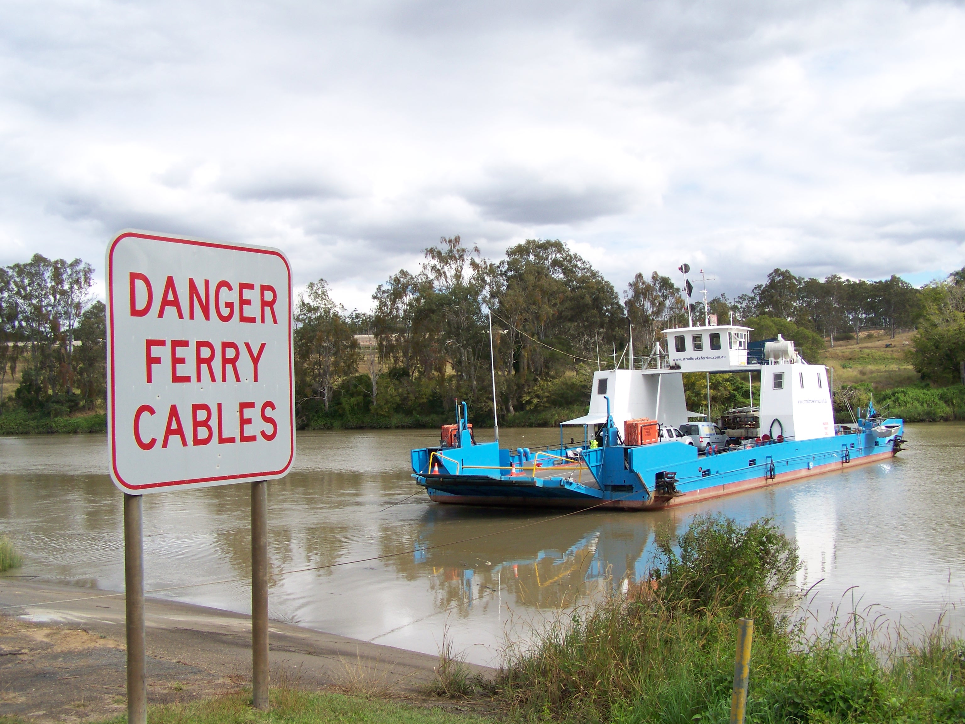
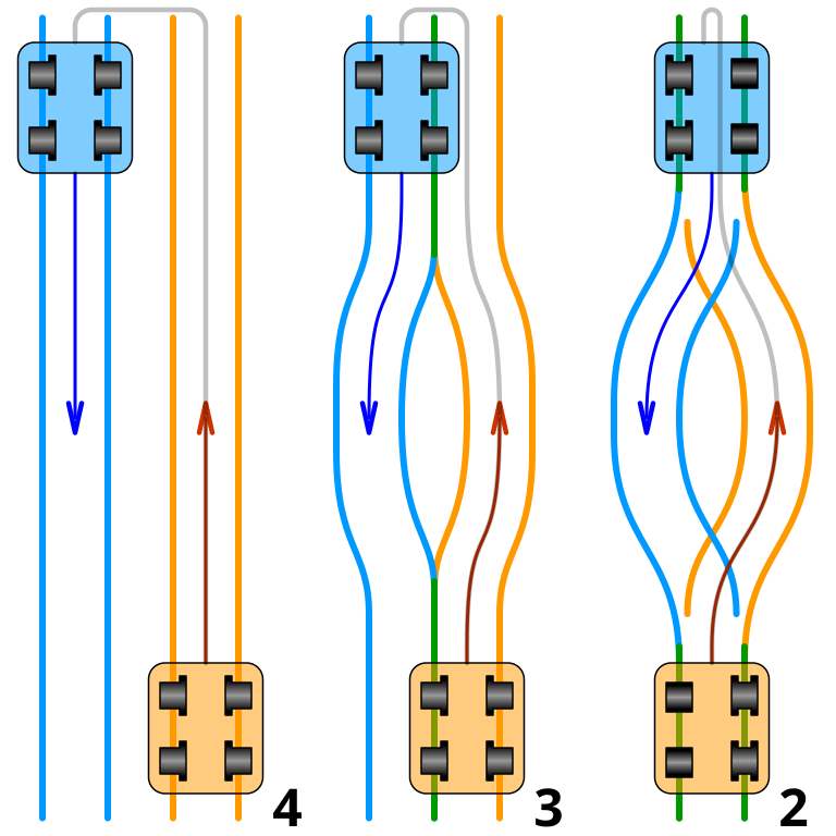
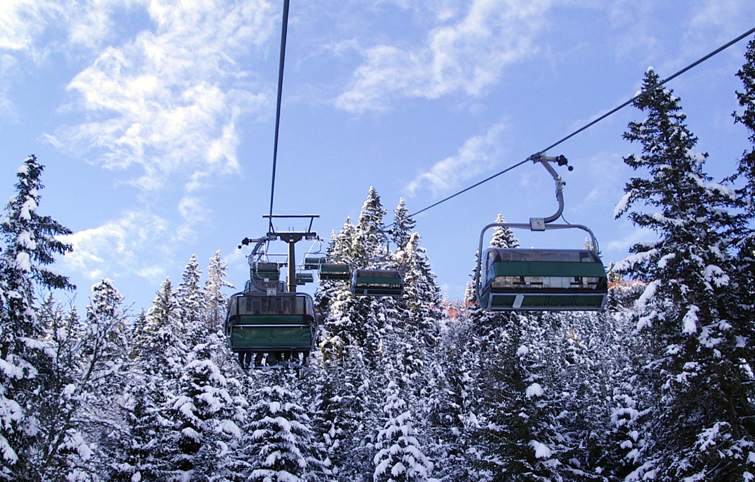
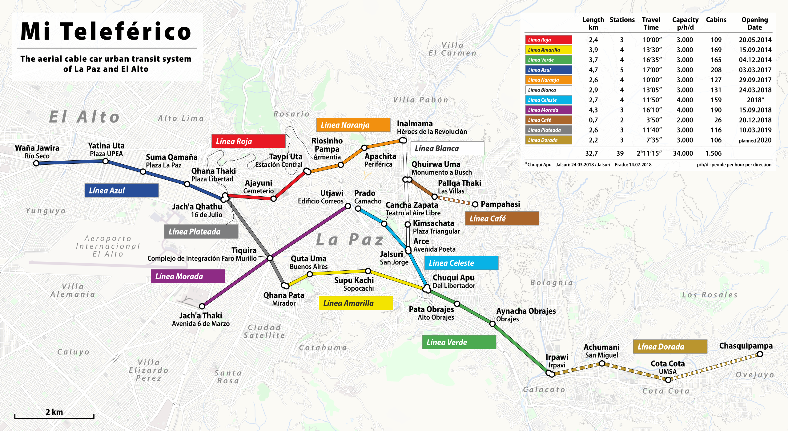
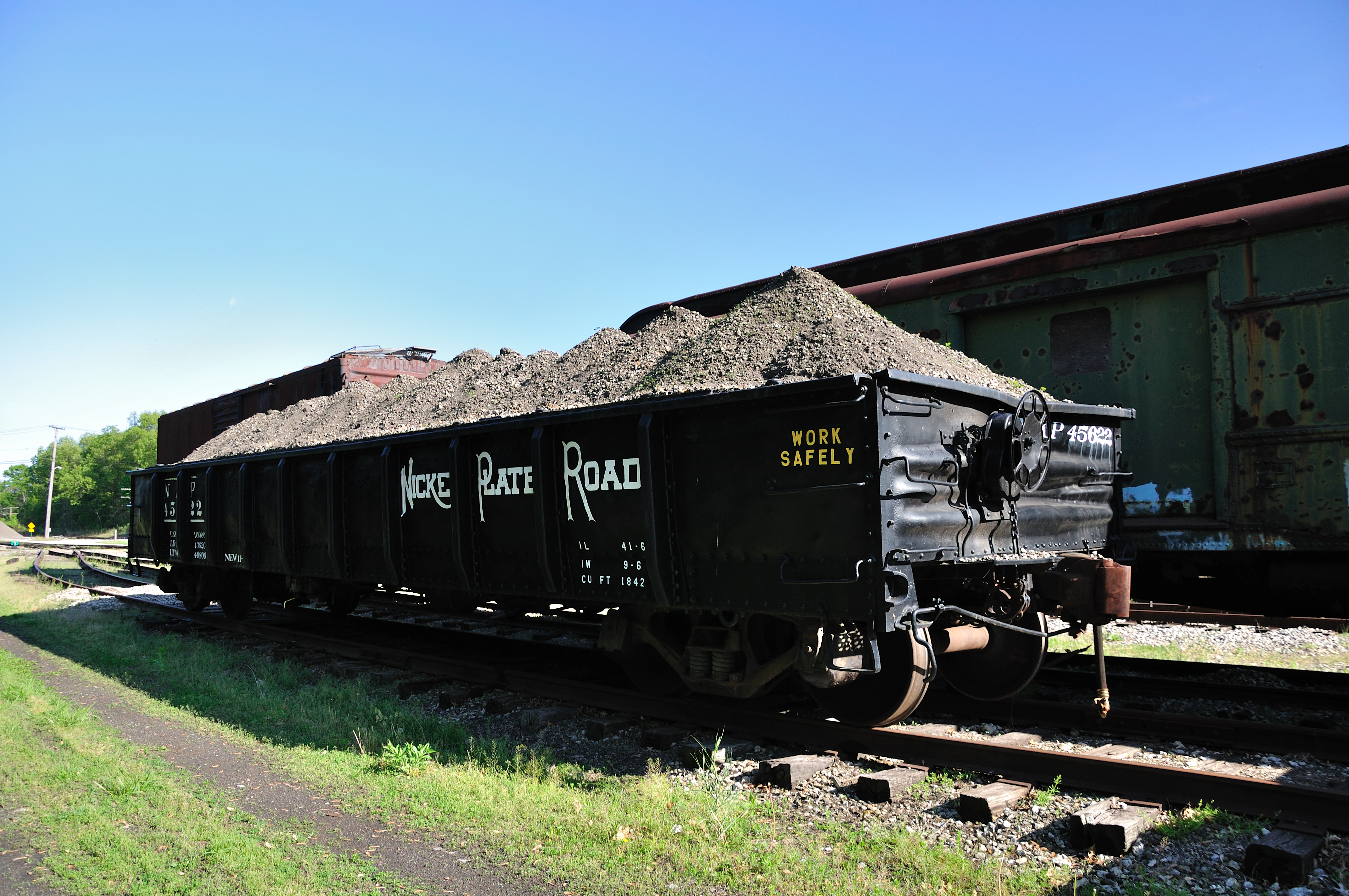
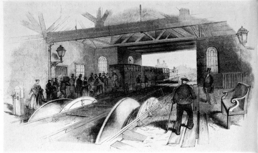
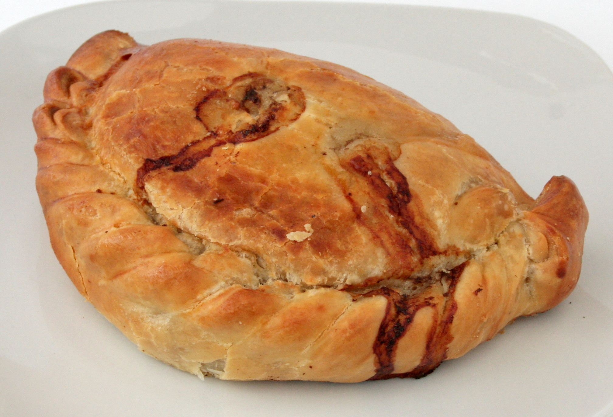
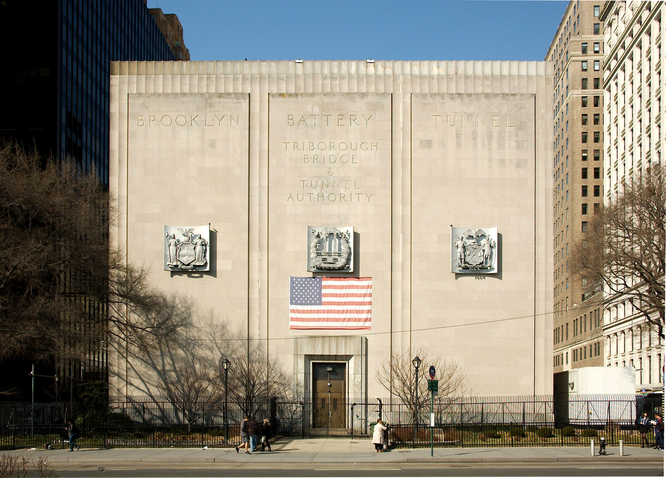
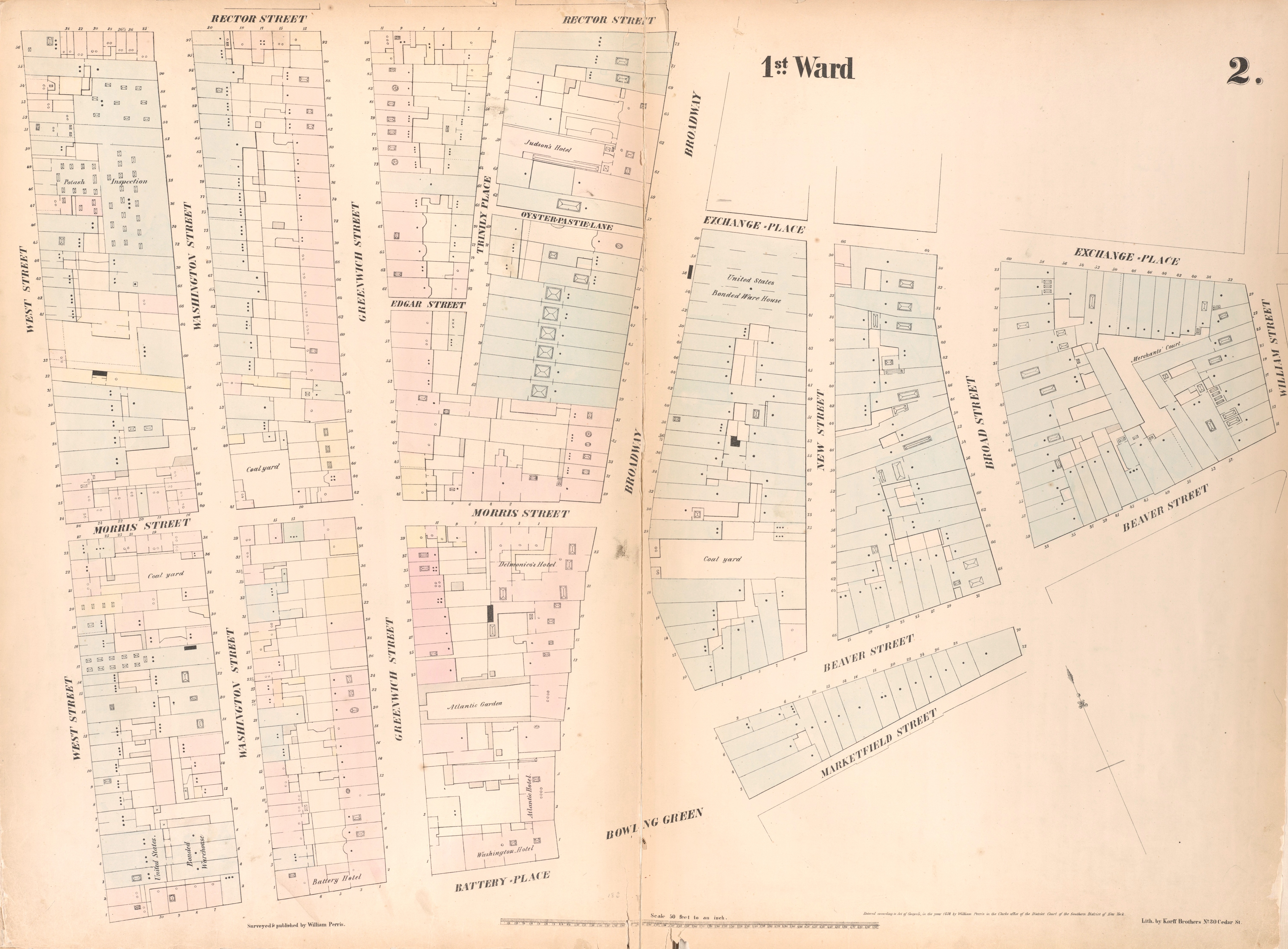
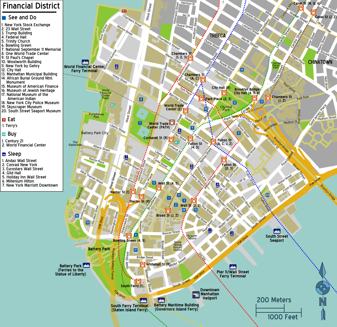
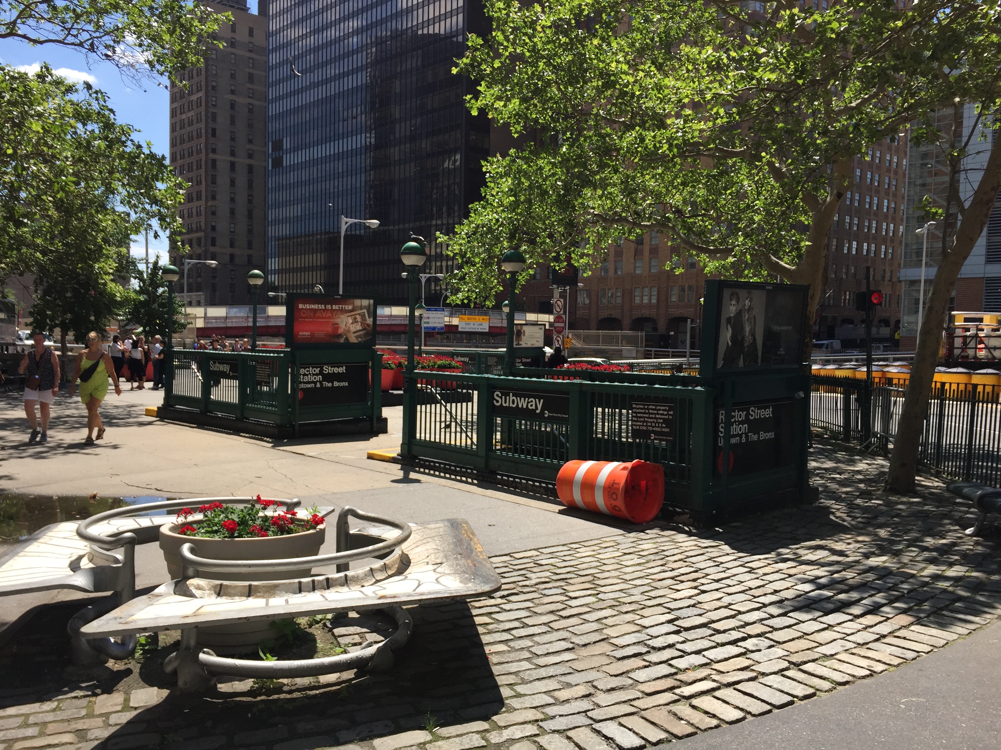