|
Reflections 2023
Series 4
June 21
Street Cable Cars Worldwide II: US Domestic V: Manhattan II
A Cable Car Ride up Broadway II: Times Square I
| | We've been enjoying a fantasy ride on the turn-of-the-20C (very real) Broadway cable car line in Manhattan. We started at the southern terminus at Bowling Green and visited Lower Broadway, City Hall & Park Row, Union Square, Madison Square with the Flatiron Building and the lamented, long-lost MSG II. That's where the Lexington Avenue cable car line took off to the Upper East Side. Finally, we visited Herald Square with Macy's and the former Herald Building. Continuing north, our next stop is Times Square, then the branch to the Upper West Side, before we end at the edge of Central Park.
https://external-preview.redd.it/LJwq3zruACLRHnRIN5gSEaofFXFWjTeyMedqxxxm5fg.jpg?auto=webp&s=99b16c9aa02e436d6b4b776fc5a0ffd6b9ab1f6d
Continue following that excursion (click) on our above route map.
https://redpawtechnologies.com/downloads/2014/12/NYC-TimesSquare.jpg
We'll also continue using our above "HSq/TSq" map (click) as we move from Herald Square to Times Square.
| | | | Garment District As the tireless cable pulls us north out of Herald Square (see map), using this image from the last posting, imagine that we're in the cable car in the center that's just passed 34th Street. It's just fantasy, since the photo is dated 1908 and the route would have already been electrified to a regular trolleycar/streetcar/tram line, but let's imagine it. We have right ahead of us, Oz-like, the icon of Times Square, the Times Tower (click), which was completed four years earlier, in 1904. A block further sits the 1905 Astor Hotel with its huge Mansard roof.
As we leave Herald Square, we pass 35th Street, not particularly notable except for the fact that here, at the turn of the 20C, is where we pass Macy's on the SW corner, Herald Square Park on the SE corner, the Herald Building on the NE corner (now gone), with working printing presses visible thru the windows and the owl statues wisely glaring down at us, and, on the NW corner, the Herald Square Theater (now gone), one of the venues that assure us that Cohan was right at that time, this was still an active theater district, even tho theaters (and all else) were gradually creeping north, to Times Square if not beyond.
These blocks moving north to Times Square, roughly between 5th and 9th Avenues, have been known since the early 20C as the Garment District or Fashion District, with 7th Avenue in this stretch being co-named Fashion Avenue (Photo by Billie Grace Ward). This is due to the manufacturing of clothes, plus many showrooms. The district may be considered to even stretch south to the mid-20s, where the Fashion Institute of Technology (FIT) is located.
https://www.nydailynews.com/resizer/IZ8I2-zk5f4DvvX-slkMLFAVH1I=/800x337/top/arc-anglerfish-arc2-prod-tronc.s3.amazonaws.com/public/UFXPHS4DZADFSPSHT4722P7BQM.gif
As we ride north on two pairs of tracks side-by-side, we also keep in mind today's large pedestrian areas of Broadway in both squares, augmented by similar ones in the strip of Broadway that connects them (above map), that is, between 35th and 42nd Streets. The eastern sidewalk has been greatly extended, with modern auto traffic running on the western side.
| | | | Three Entities As we approach the Times Square area, it's almost like there are three locations abutting each other that we have to talk about. There's the modern theater district, referred to as "Broadway", which has continued to prosper.
There's the theatrical block of 42nd Street, as I choose to call it, which became a theatrical mecca in the early 20C, then declined horribly, then recovered, but which still remains somewhat tangential to the concept of "Broadway", since it's just the southern border to it.
Then there's Times Square, which is an entity to itself. It's glitz. It's crowds. It's extensive advertising. It's the Ball Drop. Tho the theater district surrounds it, and tho Broadway as a street cuts right thru it, Times Square still is not "Broadway". If you're headed for the theater, you say you're going to the theater, you don't say you're going to Times Square, even tho it's right there. It's a bit odd.
Times Square declined as well in the mid-20C, but not as extremely as 42nd Street, and has also recovered. Yet these three entities continue to remain apart.
| | | | Theater District As we move between Herald and Times Squares at the turn of the 20C, we are aware that commerce in Manhattan also moved north—the movement of newspaper offices is an obvious example. And New York's theater district was also moving north between the squares. Thus, we really should discuss the theater district a bit.
https://forgotten-ny.com/wp-content/uploads/2021/06/theater-1800.jpg
The link on this map shows it dates from 1800, and will illustrate some early theaters, perhaps enough so that we can describe this as Manhattan's first theater district.
| | | | | | But first let's have some fun with the map. In the center is the Common, today's City Hall Park. There's no city hall, since that wasn't built until between 1803 and 1812. Partition Street and Fair Street won't be combined into Fulton Street until 1816, after the Fulton Ferry was established. Chatham Row and Chatham Street won't be combined and renamed Park Row until 1886. |
| | | | Described as "possibly the first purpose-built theater in Manhattan" was the Theatre on Nassau Street (here spelled Naſſau, twice using the "long S" typical of the time) also known as The New Theater. It opened in 1732 on Nassau between Maiden Lane and John Street (here spelled Iohn), presumably #18? on the map. In 1750 it hosted the first known troupe of professional actors, from London, and not amateurs. It later became a church, and was demolished in 1765.
John Street was the location of the John Street Theatre, which opened in 1767 and was situated a half-block east of Broadway—it's probably #33 on the map. In 1777, after the British forces captured New York after the Battle of Long Island in Brooklyn, the city's British garrison took over the theater and renamed it "Theatre Royal". Back under American rule in 1789 it was the John Street Theater again as NYC for a while served as the national capital. President George Washington visited it three times to see three different plays. He lived nearby, since the first of his two NYC residences was located where Dover, Ch[erry], and Pea[rl] Streets come together at the lower right. The theater closed in 1798.
But what drew my attention years ago in this neighborhood, something that still exists, happens to be circled here in red, Theatre Alley, a block-long cobblestone alley between Ann and Beekman Streets, one of Manhattan's few alleys that is not privately owned. The alley was behind, and named for, the Park Theatre on Chatham Row (Park Row) (#48?), shown here in 1830, the first large, long-term theater in Manhattan. It dated from 1798, which is probably when the alley was built and so named. The theater burned down in 1848, at which time it was beginning to lose out to other theaters springing up along the Bowery uptown, another indication of the constant moving uptown in Manhattan. The Astors, who owned it then, elected to not rebuild it.
The alley served as the service lane for carriages bringing theatergoers to the Park Theatre. But the carriages approaching each other from both sides of the narrow lane created NYC’s first traffic jams, finally causing Theatre Alley to become NYC’s first one-way street!
This is not a definitive history of the New York theater, but we've talked how the Bowery went from a country lane leading to Peter Stuyvesant's bouwerij (farm) to a major entertainment center—the Bowery Theater dates from 1826--then declined ("The Bowery, the Bowery, I won't go there anymore"), became a longtime homeless area, and is now revived ("If you have to ask the price of a condo there, you can't afford it".) In the 1850s, theaters moved to Union Square, then to Madison Square with its "Garden", then to Herald Square, as we've seen. Cheaper real estate was a factor in all this. But note this specific fact: Times Square became the epicenter for large-scale theater productions between 1900 and the Great Depression (1929-1939). Let me phrase it this way: it happened in the first four decades of the 20C.
| | | | The Theaters I've checked a list of Broadway theaters that fit into the modern definition of the 41 working theaters that officially comprise the Broadway theater district, as listed by the Broadway League. Of the 41, the three oldest all date to 1903, and oddly, all run thru-block (illustrated below in a moment). On our map, find 45th Street east of Times Square and the Hudson and Lyceum are opposite each other. Three blocks south, on 42nd west of 7th is the New Amsterdam.
The landmarked Hudson Theater, opened on 19 October 1903. Its address and main entrance are on 44th Street (Photo by ajay_suresh). In the 1950s it was a TV studio for the Tonight Show.
The landmarked Lyceum Theater (rhymes with "I SEE 'em") is on 45th Street and opened on 2 November 1903. It has the distinction as being the oldest continuously operating legitimate theater in Manhattan, since it's never been used for any other purposes (Photo by Jim.henderson).
The landmarked New Amsterdam Theater faces 42nd Street (Photo by Beyond My Ken). It opened between the other two on 23 October 1903, and it's remarkable that all three of the oldest still operating theaters on Broadway all opened within two weeks of each other. For about three decades, from 1907 to 1931, plus 1934 and 1936, the New Amsterdam hosted the famed Ziegfeld Follies. It became a cinema from then to 1985, then was bought and renovated (saved!) by the Disney Corporation to be their Broadway flagship location.
Now the New Amsterdam looks impossibly thin, but that's explained by the above statement that all three of these just happen to be thru-block theaters. Let's first look at the first two theaters, keeping in mind that this is a 1916 map of the area so the region has developed even more than it was in 1903. Go to 44th to see that the Hudson runs thru to 45th, while on 45th, the Lyceum runs thru to 46th. The Hudson seems a bit unusual in that the whole venue seems rather wide, while the Lyceum has the more typical wide auditorium and narrow corridor (rear lobby?). But there's no extra prestige in the "back street" in either case, so maybe they just wanted two entrances. You'll find a number of additional theaters built after 1903, including the Palace in 1913, and the George M Cohan, since demolished.
As for the New Amsterdam Theater, use this 1930 map, realizing that it's even further distant from 1903, and that many more new theaters would have joined it. We see that that thin structure is merely above the entrance lobby on prestigious 42nd Street while the auditorium is really on 41st. Here's a detail of the ground floor of the New Amsterdam as originally built, with 42nd on the right. The map shows three other theaters in this block alone that use this device to "reach" a more famous street.
| | | | Theatrical "42nd Street" This block between 7th & 8th Avenues—and not any longer, which may surprise--including its north side (not shown), is the total extent of the famous theatrical "42nd Street", famously cited by the 1933 film and 1980 musical called just that, "42nd Street". But it was much less theatrical in 1903, since it was just barely starting out as a theater mecca. Its fabulous heyday ran three decades, into the Thirties. Then, like the Bowery, the block plunged into degradation toward mid-century, but has now revived considerably. More in a moment.
I've checked the list of the 41 currently operating theaters for dates, which was the only way I could show how today's theater district grew in those first four decades of the 20C. After 1903, the flood followed. From 1907 to 1918, 13 new theaters appeared in the new neighborhood, four in 1913 alone. 19 more appeared in the Twenties, including six in 1927 alone. Then came the Great Depression, and the next new theater didn't appear until 1965, the first of a half-dozen built late in the century, ending in 1998.
To keep the records complete, we need more info. We just discussed the 41 "legitimate" Broadway theaters today being used for what they were built for. But we saw that here and there, there was some "moonlighting" as TV studios or cinemas. Thus we need to add the 8 still existing former theaters in the area that are still doing other things and not presenting Broadway theater. Well-known is the one now called the Ed Sullivan Theater, still used as a TV studio. Others include the Liberty, an event space, and the New Victory, a children's theater. Both of the latter are on the north side of the revived 42nd Street block.
Demolished 20C theaters in the theater district come to 17.
https://external-preview.redd.it/NWCe6dlXjF6-DsszN39EQcWvOC_Tfvj9QUGkmNHll1A.jpg?auto=webp&s=ff08c48bc719c369cfddbc3fb6d551e34c83cf3b
Above is a fun map that includes 40 of the 41 Broadway theaters—they forgot to include the Hudson! Also, theater names change over time, and the Brooks Atkinson is now called the Lena Horne, while the Cort is now the James Earl Jones. As we see, the theaters are wildly concentrated between Broadway/7th Avenue and 8th Avenue; you can see that the single block with the greatest concentration, eight, is the one between 44th and 45th—it's also the location of Shubert Alley (see below). The outlier of course is the Vivian Beaumont up on 65th Street and Broadway, part of Lincoln Center. That makes the Beaumont the furthest north, and the furthest west of the group.
Not counting the Beaumont, Studio 54 on 54th Street is the furthest north, and the Hirschfeld on 45th west of 8th, is the furthest west. In any case, the Nederlander on 41st, is the furthest south. The Hudson belongs to the left of the Belasco. Look back at the red map showing the Hudson & Lyceum, and you'll see where the Belasco really is on 44th, rather close to 6th, making it quite easily the easternmost theater. This is the size of the Broadway theater district as we speak. However, there's also Off-Broadway and Off-Off-Broadway.
| | | | Cohan's Anthem Now that we can picture clearly just when today's Broadway theater district developed and where it is, let's take another look at what Cohan was saying in his song. While Irving Berlin's 1946 "There's No Business Like Show Business" is similar in theme, it covers all aspects of show biz—remember it was written in reference to a Wild West show for "Annie Get Your Gun". On the other hand, George M Cohan's "Give my Regards to Broadway" is a specific reference to the Broadway theater in New York, and can serve as its anthem, as Cohan's statue in Times Square indicates.
Let's see how it fits in. "Little Johnny Jones" was Cohan's first full-length musical, and he wrote the book, music, and lyrics, and also directed and starred in the show. On top of that, joining Cohan in the cast were the three other members of The Four Cohans (his mother, father, sister) and also his wife.
You may recall the story from when we discussed it in 2018/2, but in sum: Johnny Jones is an American jockey working in London longing to get back to New York, and sends his "regards to Broadway" with a friend sailing home, since he intends to do well there. It's the chorus of the musical's most famous song that's become Broadway's anthem:
| | | | | | Give my regards to Broadway, remember me to Herald Square,
Tell all the gang at Forty-Second Street, that I will soon be there;
Whisper of how I'm yearning to mingle with the old time throng;
Give my regards to old Broadway and say that I'll be there ere long.
|
| | | | The traditional bugaboo of poets and songwriters is obvious here-- too many (or not enough) syllables. You know he wanted to end with the common phrase "before long", but three syllables were too many. So Cohan had to resort, reluctantly I'm sure, to the archaic word "ere" to say instead "ere long". The result was that, for the longest time, I never understood the end of that line, and I'm sure I'm not the only one.
If you want to hear the tune, sing along here, following the traditional bouncing ball. They do it three times.
The show debuted in New York on 7 November 1904 at the Liberty Theatre, which is on the south side of 42nd Street and had just opened a month before, on 10 October. This would imply Cohan knew what he was talking about in his reference to (that one block of) 42nd Street becoming a theater mecca.
| | | | 42nd Street 42nd Street was developed relatively late compared to other crosstown boulevards already cited, such as 14th Street and 23rd Street, which had grown during the Civil War. While it wasn't remote like today's Upper East and Upper West Sides, it was still considered far from the heavily populated heart of the city. That's why in 1854, when New York banned soot-belching steam engines from entering the heart of the city as had been the custom until then, they were limited to remote 42nd Street, which is why Grand Central is located where it is today. When the first Grand Central Depot was built on 42nd in 1871, it was indeed "Grand", but in no way was it "Central", which was pure hyperbole. (But they could hardly have called it Grand Remote Station.)
http://www.old-maps.com/z_bigcomm_img/ny/town/NYC_Atlases/1897_Bromley/Manhattan_1897_20_web.jpg
This map of what is today Midtown Manhattan is dated 1897. Click on 42nd Street in the center, starting at the right. It still shows Grand Central Depot, safely on the "remote" northern side of 42nd. Three years later, in 1900, it would be redesigned as Grand Central Station, and then it would be rebuilt as today's Grand Central Terminal, opening in 1913. (The location had housed a "station" when steam trains continued downtown; now it was a "terminal", but New Yorkers colloquially and affectionately still call it Grand Central Station. It's another one of those cute historical anomalies that come up all the time.)
Moving west, at 5th Avenue we come to the site of the old Croton Reservoir, where the main branch of the New York Public Library would be built, opening in 1911. After 6th Avenue we come to Bloomingdale Road. If you unclick for a moment, you'll see it's also called Broadway.
| | | | | | Let's remember that we mentioned in 2018/3 that the Native American Wecquaesgeek Trail had run from the bottom to the top of Manhattan. In Colonial times, the British named its southern end Broadway, now referred to as Lower Broadway. The name Bloomingdale referred to part of the Upper West Side, and part of the trail was called Bloomingdale Road. Part of it was further renamed The Boulevard in 1868, and part was also called Kingsbridge Road. In any case, on 14 February 1899, the whole length of the former trail was officially renamed "Broadway" end-to-end, after its southernmost point.
Our 1897 map seems to anticipate the official name change two years later, but to be safe, uses both names in this area. Cohan must have also seen the handwriting on the wall, so he did NOT name his song "Give my Regards to Bloomingdale Road".
|
| | | | At Broadway, 42nd borders a tiny block that will by 1904 contain the Times Tower. Notice that now in 1897 it has several small properties on it. North of it, Broadway and 7th move SO close together that there is (or will be, later) at most a traffic island, but no buildings there. The whole area north of it is Longacre Square (unnamed), which will become Times Square when the Tower is built, but we'll get to all of that. On it, you see the 1895 Olympia at 44/45th, later the Criterion, which later became a cinema.
Look south on Broadway and you'll find a cluster of theaters: the Broadway, the original Metropolitan Opera House, across from it the Empire, and south of it the Casino Theater. This all shows that entertainment was moving north from Herald Square, but had not yet hit the famous block of 42nd Street.
Let's pause for a moment on our 1897 map to see just where we are on our fantasy cable car ride. Look again on the map at that that tiny triangular block that will become the Times Tower. Our cable car going north up Bloomingdale Road (Broadway) is just crossing 42nd Street, where we get a view of the southeast corners of 42nd & Broadway, and just beyond 42nd & 7th. We'll now see that tiny triangular block in 1898, almost the same time as our map in this photo.
We're looking down 42nd Street on the left. You see our cable car tracks going up Broadway on the right, and those white horses are standing on 7th Avenue. Note how narrow this block is that will soon house the Times Tower.
A billboard where the Times Tower will later be advertises "The Moth and the Flame", which played the Lyceum Theatre in the spring of 1898. But wait! How can that be? We know that the Lyceum on 45th Street was one of those opening in 1903. That's the problem with the constant changing names of theaters. The Lyceum being advertised was nowhere near here. It existed on 4th Avenue (now Park Avenue South) and 23rd Street from 1885 to 1902, when an office building replaced it. The next year, the "new" Lyceum reappeared on 45th Street.
The next sign to the left advertises the Castle Square Opera Company, which played a season at the American Theatre on 42nd Street (see below) from December 1897 to June 1898. Note that opera tickets are 25c, 50c, and 75c.
Barely legible (but I'm told it's there) under the Kremonia sign on 7th is "Way Down East", which played the Manhattan Theatre in 1898. I find that the Manhattan Theatre was located at 33rd & 6th, across from Greeley Square—it's interesting that a show in the Herald Square area is being advertised way up here. If you're a movie buff, you may recognize the name "Way Down East", since in 1920, DW Griffith made it into a silent film starring Lillian Gish, most famous for its closing scene where her character is rescued from an icy river.
| | | | | | The scene was filmed at White River Junction, Vermont. Gish did her own stunts, and it was her idea to trail her hair and hand in the freezing water, and image that became iconic. Her right hand was somewhat impaired for the rest of her life. |
| | | | We'll come back to this photo of the building when we talk about the Times Tower, but for now, let's finally look at that block that Cohan cited, 42nd between 7th and 8th in 1897. Checking out both sides, one finds only one theater, the American Theater (see above), which had a 42nd Street address due to its long lobby, but had its auditorium on 41st Street. It opened in 1888 and burned down in 1930.
So what have we learned? Theaters are moving north, sporadically, but there's nothing theatrical yet that's very impressive on that one stretch of street that I'm calling "theatrical 42nd Street". What did Cohan foresee when he opened at the new Liberty Theatre in 1904?
Ideally, we'd need a map dated just after the turn of the 20C to show how quickly this block developed theaters, but it will also work if we go back to the map we saw above for the New Amsterdam, this 1930 map. However, it only shows the many theaters on the south side of the famous theater block of 42nd Street between 7th and 8th Avenues.
The American Theater is still there. Then comes Wallack's (1904) , the Julian Eltinge (1912, now the Empire), Liberty (1904), Harris (1914), New Amsterdam (1903). (The Hermitage was a hotel, the Stanley a cinema).
Keeping the dates in mind, when Cohan opened at the Liberty in 1904, on the south side of 42nd, Wallack's had just opened the same year (under an earlier name), the New Amsterdam had just opened in 1903, and the old American (1888) was still there. So other than the American, around the time Cohan arrived at the Liberty, two other new theaters also arrived.
We need to look at the north side of 42nd, and can use this map. However, this map has its limitations, since it only shows the eastern half of the block, and its 1916 date is only halfway thru that period of growth. But, starting next to the Times Tower (not named) at the lower right, we have the Rialto, Republic, and Lyric (on 43rd Street with a narrow lobby to get a 42nd Street entrance and address).
So let's instead look at this 1908 photo of that very same corner on the map, the northwest corner of 42nd and 7th, which we just saw ten years earlier, in 1898. The sidewalk on the lower right, where the white horses were standing, is by now adjacent to the Times Tower (not seen). But what do we see?
We find that the Rialto (look left and click) opened in 1916, the date of our map. It was converted from the original theater, Hammerstein's Victoria (and Roof Garden), built in 1899.
| | | | | | The name Hammerstein will be coming up a number of times. It refers to Oscar Hammerstein I, an impresario who built many theaters and opera houses. He was the GRANDfather to Oscar Hammerstein II, the Tony-winning librettist of musicals known especially for collaborating with Richard Rogers on Oklahoma!, South Pacific, The King and I, The Sound of Music, and many more. |
| | | | To the left, the Republic (1900) is now the Belasco (not the present Belasco!) and would also be called the Victory (theater names change like people change their socks).
The next marquee (half hidden) is the Lyric (1903).
After the dates of the photo and map there appeared further down the north side of the 42nd Street "theater block" the Apollo (1920), the Times Square Theater (1920), and the Selwyn (1918).
So who comprised "all the gang on 42nd Street" when Cohan opened his show in 1904? On the north side of the block there would have been Hammerstein's Victoria (1899), the Republic / Belasco / Victory (1900), and the newly opened Lyric (1903). Add these three to the four on the south side, so when Cohan was playing in Little Johnny Jones, he was in one of seven theaters on the "theater block", many of which had just opened. But how he knew as he was writing the play that that theatrical explosion would be taking place just as he arrived remains unclear to me.
| | | | The Decline Call it fame. Call it trends. Call it fads. Famous people, places, and things come and go. Talking about entertainment areas, I first think of the Bowery, just discussed , that went from THE place to go for an evening's entertainment to New York's skid row, and has now recovered. Exactly the same thing happened to both sides of the theater block of 42nd Street.
There were four decades of being a theatrical mecca, but it was in that fourth decade that the decline actually began, actually not so surprisingly. During the Great Depression, these theater venues were mostly converted to movie theaters by the 1930s, and by the 1970s, most of them had been relegated to becoming grindhouses (low-budget cinemas primarily showing exploitation films) or to showing pornography.
It was probably right after WWII that the serious decline began. One source claims that it was in 1946, when the streetcars on 42nd Street were downgraded and replaced by less efficient buses (see the last picture, showing Hammerstein's Victoria). From the late 1950s until the late 1980s, 42nd Street was, sadly, the cultural center of American grindhouse theaters, which spawned an entire subculture. In this period, the block was nicknamed the Deuce, not meant in a positive way. You will hang your head as you see the famous theater names we've discussed appear on the movie marquees affixed to the theaters.
https://www.grindhousedatabase.com/images/421982.jpg
https://i.pinimg.com/736x/be/2c/f7/be2cf7844a48973a19d7661e98fe09a3--the-theatre-theater.jpg
We start with a sampling of the north side of 42nd, looking west, during the "bad years".
In the first link, you recognize the names Rialto, Victory, Lyric, but there are many others.
The second link shows details of the Victory and Lyric.
https://www.grindhousedatabase.com/images/thumb/4177612677_811c9f1916_o.jpg/650px-4177612677_811c9f1916_o.jpg
https://i.pinimg.com/originals/6a/c6/ad/6ac6ad0bf934d246b32c6af372487725.jpg
https://list.lisimg.com/image/4854021/500full.jpg
This next group shows the south side, also looking west.
The first link shows in the distance, among others, the Liberty, but in the foreground, we see that even the Grande Dame New Amsterdam succumbed. This is where Cohan debuted "Forty-Five Minutes from Broadway" in 1906, about New Rochelle NY being unsophisticated, and where the Ziegfield Follies, ran in the Teens and Twenties. Performers in the Follies at the New Amsterdam included WC Fields, Eddie Cantor, Josephine Baker, Bob Hope, Will Rogers, Ray Bolger, Ed Wynn, Sophie Tucker, and Fanny Brice.
When Barbra Streisand starred in the 1964 musical and 1968 film "Funny Girl", she was depicting Fanny Brice's success in the Ziegfield Follies at the New Amsterdam Theater.
The second link shows a detail of the Liberty. This was where Cohan first presented "Little Johnny Jones" in 1904. "Give My Regards to Broadway" debuted here in that show.
The final link shows the Empire (ex-Julian Eltinge).
| | | | The Recovery In 1990, city government encouraged a cleanup of the Times Square area, and in that year, it took over six of the historic theaters on the "theater block" of 42nd Street, and a not-for-profit organization called "New 42nd Street" was formed to oversee their renovation and reuse, as well as to construct new theaters. In 1993, Disney Theatrical Productions bought the New Amsterdam Theatre, which it renovated a few years later. Since the mid-1990s, the block has again become home to mainstream theaters and several multi-screen mainstream cinemas, along with shops, restaurants, hotels, and attractions such as Madame Tussauds wax museum and Ripley's Believe It or Not that draw millions to the city every year. This area is now co-signed as New 42nd Street to signify this change.
On the north side, the former Selwyn (1918) since 2020 has been the American Airlines Theater (Photo by Sharktopus). Notice the sign (click) that says New 42nd Street. While I clearly remember seeing The Importance of Being Earnest on Broadway, I didn't recall until I saw this picture that it played in the American Airlines Theater, in 2011. The late Brian Bedford not only directed, but played Lady Bracknell—excellent. You must watch this YouTube clip of the presentation (2:43). Check out how he gives his line at 0:44, and how he give that icy glance at 1:35. It was great theater performed back on 42nd Street.
| | | | | | I have a last-minute update. I've always been irked when unrelated institutions purchase naming rights for a public venue—it seems so cheesy--and the name "American Airlines Theater" is among these. I just don't like seeing a Broadway theater with such a subservient, money-grubbing name. But on 3 June 2023, the New York Times reported that the Roundabout Theater Company, the nonprofit "with the biggest footprint on Broadway", is renaming its flagship venue the "Todd Haimes Theater", to honor its late transformational leader. The airline's naming rights expire in early 2024 (thank goodness), and the airline didn't respond to the Times's request for a comment. (Ha!) Roundabout has several theaters; the two other Broadway ones are the Stephen Sondheim and Studio 54. Two days before the article, all Broadway theaters dimmed their lights in honor of Todd Haimes. That's what theater names should be about.
I've also recently learned that the original 1895 London production of "Earnest" attended by Oscar Wilde himself was duplicated that same year at the Empire Theater (which was recently moved to become a cinema lobby—more below) on the south side of 42nd, right opposite the Selwyn/AA/Todd Haimes. In both productions, women played Lady Bracknell. Some notable other portrayers: in 1982, Judi Dench; in 1993, Maggie Smith; in the 1952 film version, Edith Evans. Other male actors have included Geoffrey Rush in 2011 and in 2015, David Suchet (Hercule Poirot!). It has to be one of the juciest roles around!
A friend, journalist Simi Horwitz, recently wrote me: I very much enjoyed interviewing Brian Bedford. Over the years, I interviewed him at least 3 or 4 times.
So, as the old line goes, I shook the hand that shook the hand . . . .
|
| | | | Also on the north side, but almost at the eastern end was the theater built as the Republic, but also known as the Belasco and the Victory. It was even once Minsky's Burlesque! It's now the New Victory Theater (Photo by Ajay Suresh), government-owned and serving as a children's theater. It was renovated in 1995 and its façade reflects its appearance in 1900.
What fascinated me at the time of the renovation is the special restoration at the front. In 1910, only ten years after original construction, the brownstone stoop with two staircases rising from ground level to the second story was removed. This was restored in 1995, as were the ten wrought-iron street lights decorating the perimeter. The NYC government had to approve the installation of the current stoop because it extends onto the sidewalk of 42nd Street.
Harry Potter is playing at the Lyric Theater, tho that name is not evident.
https://malmilligan.com/wp-content/uploads/2020/04/img_0286-scaled.jpg
This is now an evening view looking east down New 42nd Street. Click to see the vertical sign of what is still the American Airlines Theater across the street. Looking east, you can see the lit top of the Chrysler Building on East 42nd. Next to it is the dark sign of the New York location of Madam Tussauds Wax Museum, and on the right is the Empire Theater, now serving as a grand entrance to a 25-screen AMC multiplex cinema. This was because the Empire was too small for modern use to be fully restored, but to make proper use of it, in 1998, it had to be relocated 51 m (168 ft) west of its original location.
https://edc.nyc/sites/default/files/styles/1x1_md/public/2020-05/article-new42-empire-theatre-moving-west-on-42nd-street-image-the-new-york-times_0.jpeg?h=0eb9a054&itok=wexzFRF1
https://www.hilmanrollers.com/sites/default/files/styles/max_2600x2600/public/2018-09/empiredraw_0.jpg?itok=Ax95aJDH
The move took about five hours, with hydraulic jacks moving the theater in five-minute bursts, covering about 1.5 m (5 ft) in each burst. Two large balloons representing Abbott & Costello, who first performed together at the Empire in 1935, were rigged to appear as tho they were dragging the Empire westward. At the time, the 3700-ton theater was the heaviest building ever moved in NYC.
Finally, this is a view to the west down 42nd (Photo by Boston at English Wikipedia). Click to see the Empire again across the street, and Madame Tussauds is strikingly obvious in mid-block. As for the Grande Dame, the New Amsterdam, Disney restored it in 1997 and has ensconced itself there, spurring a redevelopment of all of Times Square. Disney productions at the New Amsterdam have been The Lion King in 1997, Mary Poppins in 2006 (as shown in picture), and Aladdin in 2014, which is still running.
This YouTube video (5:39) reviews the story of the New Amsterdam, the Grande Dame of 42nd Street, thru Ziegfeld and Disney, and is well worth watching in its entirety.
The big opening show was of course The Lion King (5:05), which Beverly and I went to see probably in the late 1990s, meaning I've seen two shows on the New 42nd Street. (It's playing presently at the Minskoff on Times Square.) It was a breathtaking experience, and I got to learn immediately who Julie Taymor was, for her set design and direction. When the (theatrical) giraffes walk out (1:26), you catch your breath. When the huge (puppet) elephant walks down the aisle (1:54)—with the baby elephant!—you just can't believe it. Then the rhino comes out (2:33)!!! Those are just the large animals—there's still plenty of other animals, and even symbolic grasslands and rivers, all with people in them! It's Broadway's third longest-running show, and has grossed over $1 billion. The show got eleven Tony nominations. Among those it won, was Best Musical. Julie Taymore got two, one for Best Direction and one for Best Costume Design. Her studying of Indonesian and Japanese puppetry and masks is very evident in what she accomplished in The Lion King.
In a word, 42nd Street is back.
| | | | TIMES SQUARE Again consult the "HSq/TSq" map to see the very acute angle where Broadway crosses 7th Avenue, resulting in VERY narrow blocks in between. Let me repeat what I said earlier: Broadway crosses 6th Avenue at Herald Square at just over a 20° angle, allowing for parkland on the triangular blocks thus formed, while at Times Square, Broadway crosses 7th at just above 10°, squeezing the closest blocks to mere slivers. That historic happenstance has strongly affected the architectural gem that was the Times Tower, leading to its death and mummification today at the hands of mammon. Pity.
Let's first find out what the area, which back in the day stood well beyond the fringe of metropolitan life, had been like. As our cable car arrives, we find it has the name Longacre Square. The original Long Acre is to this day an early-17C street in central London that borders on Covent Garden. It's a street that was once known for its coach-makers. What is today Times Square had been called Long Acre Square, then respelled as Longacre Square. It was an unfashionably rough area of tenements, bars, brothels, factories, and slaughterhouses, but was also the center of New York's carriage-building trade, and we find that this whole area of the West Forties was the horse center of NYC, so we have to assume some anglophiles named the intersection. And that's just what it is—a glorified intersection with sidewalks on both sides and in no way a city square in any traditional sense. Light industry settled along the slice of Broadway north of 42d Street in the 1860's, and by the 1870's wagon factories, harness shops and horse dealers concentrated in the area.
You'll remember the name William Kissam Vanderbilt, the grandson of the patriarch Cornelius Vanderbilt. He was the one involved in MSG I, including renaming it Madison Square Garden in 1879. Shortly after that, Vanderbilt, a horse enthusiast and one of the founders of the Jockey Club, along with a group very wealthy investors, built Longacre Square's biggest building, the American Horse Exchange, completed in 1896, almost filling the block between Broadway & 7th from 50th to 51st (see map). I think it's safe to guess that Vanderbilt and friends might have been among the anglophiles that influenced the naming of Longacre Square to reflect back on London, but I have no proof of that. If they didn't influence the naming, they must have nevertheless reveled in it.
| | | | | | I cannot resist mentioning this bit of info. In time, the horse industry started to decline—as we well know today—and the Horse Exchange closed. Believe it or not, the building was converted in 1911 (modified in 1922) to today's Winter Garden Theater! It was, for over three decades, the home of only two long-running musicals, early on, Cats, then Mamma Mia.
I said earlier only three of the 41 theaters were directly on Broadway, the Broadway, the Winter Garden, and the famous Palace Theater. However, truth be told, the Palace—check the map—is on 47th & 7th Avenue, and has traditionally just used a Broadway address across the thin sliver of the block in between. However the theater is being extensively modified and has been lifted (!!) 9 m (30 ft). In its new configuration it will use an address on 47th Street, so we'll be down to only two theaters with actual Broadway addresses, just two blocks apart:
This is the Broadway Theater, 1681 Broadway, west side, near 53rd Street, showing "Sister Act" in 2011 (Photo © Luigi Novi / Wikimedia Commons)
This is the Winter Garden Theater, 1634 Broadway, east side, near 51st Street, showing the revival of "The Music Man" in 2021 (Photo by Epicgenius).
So the expression "on Broadway" has become merely figurative, since most theaters are located on side streets off Times Square.
|
| | | | Earlier we rode our fantasy cable car to 42nd Street and Broadway, then paid prime attention to 42nd Street. Let's pick up again at that intersection, but now concentrate on the early years of the late, lamented Times Tower, and then continue up Broadway into Longacre (Times) Square. This was the scene we saw in at Broadway & 42nd in 1898. Again notice how narrow the building is between Broadway and 7th, just 58 ft (17.7 m) wide, and the plot gets narrower north of that! This tiny building plot will prove to be a permanent problem for the Times Tower, since what you're looking at would be the greatest possible street-level width of the building when it opens in six years, 1904. | | | | The Triangle The small block in question is easily called a triangle, but that's actually not quite accurate. It doesn't come to a point at the top, which is cut off, making it a trapezoid (British: trapezium). Even more precisely it's a right trapezoid because it has not only one, but two right angles. Nevertheless, in the public mind it's a (right) triangle, and we will call it that.
https://newyorkbefore.com/includes/newPoint.php?idt=27&latt=40.756214&lngt=-73.986558
The above map, undated, is being used to show our "triangle" is still being divided into several properties, narrowing as one moves north. I remeasured the top angle, which is a tight 10°, tops 12°.
We'll be explaining below how the wider end property facing 42nd was at first that undistinguished building we just saw above, then a posh hotel, and how the narrower properties facing Longacre Square were a group of five four-story brick tenements.
[Nota bene: I tried to date this map by looking up all the named properties. The only info I could get was that the Central Baptist Church, before it moved further uptown, was on 42nd Street from 1861 to 1912. New construction started in the triangle in 1898, so my best guess is that this map dates to the late 1890s.]
https://newyorkbefore.com/includes/newPoint.php?idt=8&latt=40.756214&lngt=-73.986558
This map, also undated, is being used to show our triangle completely taken over by the Times Building, completed in 1904, the same year the Times Square station of the subway (curved dashed lines) was built underneath the building.
[Still, the map is later. I found that the Fitzgerald building was built in 1907 and the Cohan Theater in 1911, and both were demolished in 1938. So the map dates from between 1911 and 1938, most probably in the earlier range.]
But we're in for a shock. Toward the beginning of those six years till the Times Tower opened, a new hotel with two restaurants was built, operated, and demolished on the wider end of the triangle before the Times Tower was ever built! I never knew this before the current research, but now see how the hotel and also those smaller tenements north of it on this block are also connected to—and doomed by--the construction of the Times Square subway station.
Look again at the SE corner of the triangle in early 1898 and see that very undistinguished building (Hammerstein's Victoria wouldn't appear across the street for another year, in 1899).
Now let's move up Broadway into Longacre Square to look at the northern point of our triangle, where we get the best view available of the five four-story brick tenements—this picture is from late 1898 or 1899. It suddenly strikes me that that's Hammerstein's Victoria under construction on the extreme right, at 42nd & 7th—men are working on the roof. I find the humble buildings interesting. Tenants in the narrow buildings would have had a main-street view of Broadway on one side and a main-street view of 7th Avenue on the other. The windows facing us would have had an extensive view north up the length of Longacre Square.
On the left, we see the Hotel Metropole, which has two levels, the lower one being on the south side of 42nd Street. That means that we have a gap from there to the tenements, also indicated by the work fence. Thus in this picture, the undistinguished building sharing the southern end of the triangle has been demolished, in preparation for the coming hotel, so oddly, the tenements are for the moment the only structures there.
https://rehs.com/eng/wp-content/uploads/2023/01/Longacre-Square-1900-Byron-Company-Museum-of-the-City-of-New-York-300x237.jpg
This is a longer view south along Longacre Square at about the same time. The tenements are there, and my take is that that's the Metropole behind them, and the new hotel is not built yet, or at best, under construction. Typical of the era, we see horse-drawn vehicles and a worker sweeping up horse manure in what will be known in a few years as Times Square.
When we last saw this SE corner in 1898 there was an undistinguished building here, but construction of the Pabst Hotel began later that year, in October 1898, and the hotel opened in November 1899. But it existed only three years, until November 1902, when it was demolished. How could that be?
Here's that very same corner as seen in April 1900. You can hardly believe your eyes. First look at its surroundings. Across the street (click), Hammerstein's Victoria is now less than a year old. Behind the hotel are the tenements that completed the block. But it's the hotel that catches the eye. I find it a handsome building. It rises nine floors, substantial for the time, probably because it was uniquely built with an innovative steel frame, another fact that drew considerable interest to it. It had 35 guest rooms in addition to its two restaurants, which were of particular note. It squeezed itself into a footprint comprising that narrow 58 ft (17.7 m) width, plus a petite depth to the north of only 25 ft (7.6 m). Using today's terminology, I think it would be called a boutique hotel.
It was the idea of the Pabst Brewing Company of Milwaukee. On my visit there last July I toured the formidable, landmarked Pabst Mansion, built in 1892 by brewer Frederick Pabst, and passed by the 1895 Pabst Theater downtown. Obviously, Pabst was into more than just brewing beer, and so ran a nationwide program for promoting that beer. In the 1890s, the company acquired or built nine hotels and restaurants in Chicago, Minneapolis, San Francisco, New York, and elsewhere, giving the venues its name and serving only its own products.
| | | | | | In NYC alone, Pabst also came to control at the turn of the 20C: the Pabst Loop Hotel (1900) in Coney Island; the Pabst Harlem Music Hall and Restaurant (1900) on 125th Street, billed as the largest restaurant in the world, seating 1,400; the Pabst Grand Circle Hotel and Restaurant on 58th Street (1903) with its adjoining Majestic Theatre (Grand Circle was an earlier name for Columbus Circle). |
| | | | However, in Longacre Square, its hotel and two restaurants conflicted not only with the plans of the New York Times, but also with plans for New York's new subway system. Worse, the Pabst was built on leased land, which was probably the basis of its downfall. (You'll remember that the owner of the Herald purposely wanted a short, 30-year lease for the Herald Building, so he frivolously pre-planned its downfall.) But ironically, it was the two restaurants in the Pabst that caused most of its troubles, in both cases because the building's footprint was just too small.
On the picture, click on that striking portico that down below served as the entrance on 42nd Street. But as you see, the upper part of the portico served as an extension of its second-floor restaurant, shown here in 1900, with the portico extension at the left. The extension was obviously necessary because there wasn't enough space for the restaurant. Worse, the portico was built beyond the building line and onto the city sidewalk, without authorization (check the photo again). While this was common practice, it was illegal. Yet the City was always loath to prosecute. Still . . .
| | | | | | This will recall the situation with the Victory Theater, built in 1900 with a spectacular staircase that also illegally encroached on the public sidewalk, and which was removed in 1910. But with the restoration of the New Victory Theater, the staircase was rebuilt in 1995:
https://farm2.staticflickr.com/1056/5110727470_208baca53b_z.jpg
|
| | | | The other restaurant at the Pabst was its Rathskeller, again shown in 1900. It was located, appropriately, in the basement of the hotel (Keller=cellar). But there still wasn't enough room, and so the restaurant was built wider than the building line and extended under the city sidewalks. This was also common practice, but was, surprisingly, perfectly legal. But to signal the looming upcoming problem, picture part of the Rathskeller today as being part of, the Times Square subway station!
Let's leave the SE corner on Broadway and walk over to the SW corner on 7th. We're still in 1900 or 1901, and it must be a warm day, since so many awnings have been deployed in this pre-air-conditioning era. The building has already become well-known as "The Pabst", as the sign shows. The portico (click)shows up well here and adds a lot of space to the building. We see many streetcar tracks and more horse-drawn vehicles. Beyond the tenement buildings is the Cadillac Hotel, on the NE corner of Broadway and 43rd Street.
Moving again north into Longacre Square, we get this view to the south of the buildings on the triangle. As many buildings did, it kept plain the view that wasn't supposed to be seen—after all, this view just faced the tenements. (!) But the painted advertisement on the back wall read, in wording typical of the era: The "Pabst" / Ladies' & Gentlemen's Restaurant / Rathskeller / Bachelor's Hotel / James B Regan, Prop.
That could be the actual cable car on Broadway to the left that we're taking on our fantasy ride!
But it was the mainly the new subway that caused the downfall of the buildings on the triangle. We'll talk more about it below, but NYC's first subway was built in sections from 1900 to 1904. The route included a wide curve directly under the tenements, which the subway company purchased and demolished in 1901, also excavating a hole for the subway work. The noise must have hurt the hotel's business. This picture, dated 1901-1902, is the reverse of an earlier one—here the hotel exists by itself in the triangle, with a hole in the ground behind it where the tenements had been, exposing the subway construction. As for the hotel, the situation was odd. Tho the hotel itself could remain, the subway company, in April 1902, took possession, for tunnel purposes, of the entire cellar space beneath the Broadway (east) side of the building and about half of the space beneath the sidewalk on 42nd Street, which eradicated a large part of the rathskeller and storage room. But since the hotel was leased on ground owned by someone else, with subway construction taking away part of its basement, it didn't consider the lease still valid, and this was the beginning of the end.
And it got worse. In August 1902, The New York Times announced it would move from Park Row (Newspaper Row) to this neighborhood, which it predicted would soon become the commercial center of NYC. The Times had purchased the real estate under the tenements from the subway company and got a long-term lease for the property under the Pabst. Also, in July 1900, the Times criticized city officials for allowing the illegal portico of the Pabst to remain, but the City still didn't want to move against this sidewalk encroachment any more than against all the others. Some people questioned the Times' motive for singling out this one violation when there were so many others, especially since they had eyes on the triangle for themselves. After many delays, a judge decided against the hotel in 1901. The portico must be removed, by the City if necessary, at the hotel's expense. If the portico was eventually removed, it wasn't ever reported. And the question became moot, since the Pabst was being demolished anyway.
This sad picture shows the demolition of the Pabst from November 1902 running into 1903. It's amazing how quickly billboards were added during the demolition, including for Hammerstein's Victoria (click), right across the street.
It was the first building completely supported by a steel skeleton that was ever demolished. The Times reported that professional builders were keen to discover whether the structural members had begun to corrode, which might threaten the structural integrity of the building and the future of this entire construction method, but no problems ever developed.
| | | | Times Tower, Early Years The owner and publisher of The New York Times saw an opportunity and selected a highly visible location to build the Times Building / Times Tower as the new headquarters of the paper. He knew this was a remote area—remember Grand Central's location was one of exile. Also remember that Macy's down on Herald Square had to have a shuttle in early years to bring customers that far north, and this was even further. But he recognized the northward movement of commerce in Manhattan, and it can be safely said that Midtown Manhattan today exists as a major business district (along with the Downtown business district) due to the Times's move to its new location.
But he had working in his favor the powerful fact that the new subway would have a zig-zag route (more later why) that would include Times Square, putting it a step ahead of Herald Square, despite it being further north. Another positive was that he'd successfully persuaded the New York City Board of Aldermen to rename the adjoining square after the newspaper, and Longacre Square was renamed Times Square in April 1904, as the Times Building was being completed. And he had the fortuitous idea to celebrate the newspaper's move at New Year's to have a celebration that eventually developed into the Ball Drop (more see the next posting). By the early 1910s, the Times Square area had become densely developed with restaurants, theaters, hotels, and office buildings.
This is the neo-Gothic Times Building under construction in 1903. We could be in those cable cars-cum-streetcars passing on Broadway (click). Notice how slender the building had to be because of the narrow block caused by the very acute angle of the Broadway and 7th Avenue intersection. As you look down Broadway you can see the old Metropole Hotel and the old Broadway Theater (not the newer one) you may remember seeing on our old maps. Looking across 7th Avenue we see Hammerstein's Victoria Theater seemingly thriving. I also find it of interest that there's a billboard for Pabst Blue Ribbon beer diagonally across from where the Pabst hotel came and went so quickly. As a sign of things to come, just three weeks after the Times Building opened, the first electrified advertisement appeared on the side of a bank at the corner of 46th Street and Broadway.
https://i.pinimg.com/originals/82/33/48/82334851b08b86cf5aa4fe9ed730fdcc.jpg
https://i.pinimg.com/originals/8d/3e/cd/8d3ecddccbdff2d08badc76eb331bd7a.jpg
Here we have the 25-floor Times Tower completed. Especially in the first picture, it's easy to see here why it had two roof levels, a higher one in the larger area where the Pabst had been and a lower one where the narrow tenements had been. That side probably never went any higher because perhaps they felt that more floors of very narrow offices wouldn't be worth it. You can see (click) where the main entrance was, on the Broadway side. The second picture shows the rear view, as we'd seen from Herald Square. Click to inspect that 58 ft (7.7 m) width we've been speaking about. Here it has a subway entrance. On the left is the Metropole Hotel, and Hammerstein's Victoria is in between. We also get a good look at Times (ex-Longacre) Square and one other of its iconic buildings, the magnificent Hotel Astor (see below).
We have next another picture similar to the last one, but specifically cited to discuss height. Today, many people are jaded as to tall buildings and don't appreciate how high some earlier buildings were for their time. In the period from 1899 to 1908, just the time frame we're discussing, the tallest building in NYC was the 119 m (391 ft)-tall, 31-story Park Row Building at 15 Park Row, also bordering on Ann Street and Theatre Alley. (It faced City Hall Park and is the same block where there had been that early Park Theater, Barnum's American Museum, and an early location for the New York Herald.) Now look at this 1906 view of the two-year-old Times Building, when it was the second-tallest building in NYC at 111 m (363 ft) and 25 stories. It's particularly remarkable when you realize Times Square was a remote location, far from the major areas of business.
| | | | Hotel Astor We think of today's glitz, gaudiness, and flash, but we should remember that Times Square was once much like other dignified squares, and can look at another of its iconic, elegant structures to confirm that. Look again at this view we saw earlier from Herald Square, looking up Broadway past the Herald Building and past the old Broadway theater. It's 1908, so the Times Building in the distance (click) is four years old. To its right we see another very distinguished building, the Hotel Astor. It had just been built as well, in 1905 for the Astor family, and was expanded in 1909–1910. This is the magnificent Hotel Astor in 1909, with part of Times Square—click for details, including the Astor and Gaiety Theaters to the right. It was an eleven-story Beaux-Arts edifice with a spectacular mansard roof. The Astor was an important element in the growth of Times Square and its character as an entertainment center. | | | | | | You know that the only constant is change, and that concept goes into high gear in Times Square. This view shows the Astor and Gaiety theaters in 1936, with 45th Street on the left.
The Astor Theater opened in 1906, and continued as a Broadway theater until 1925. At that point Loew's Theaters purchased it and converted it into a cinema in order to have a showcase right on Times Square for its first-run films (Grand Hotel, 1932; The Great Ziegfeld, 1936 [shown]; Gone With the Wind, 1939). It closed in 1972 and was demolished in 1982 to make way for the Marriott Marquis Hotel (see map).
The 1909 Gaiety, after in 1933 became Minsky's Burlesque (Gypsy Rose Lee), in 1943, became the Victoria cinema. In 1982 it was one of five theaters torn down to make way for the Marriott Marquis Hotel.
Tho we won't go into the subject deeply, you certainly have noticed, since we were talking about theaters on Herald Square and 42nd Street, how frequently theaters were turned into cinemas, including these last two. It's my take that, from the mid-20C on, regular Times Square tended to be the center of first-run films, with few theaters, while the side streets were replete with theaters. It seems to me I've never seen a cinema in the side streets around Times Square, only theaters. That may be the reason why people talk to going to the theater (in the theater district on the side streets), and don't talk about going to Times Square. Tourists—and locals—going to Times Square do so for the glitz and bright lights, and the Ball Drop. Indoor entertainment is usually elsewhere.
|
| | | | Back to the Hotel Astor. We've used this 1916 map before, and will reprint it again later for one last use. It shows 42nd to 45th Streets (not named) and the Times Tower triangle (lower right, not named). But the hotel was replaced in 1967 with an office building, One Astor Plaza, which contains the Minskoff Theatre. The building maintains an address at 1515 Broadway, tho it's actually on the west side of 7th Avenue, similar to what the Palace Theater has done until recently in reverse.
You can see on the map behind the Hotel Astor (today behind One Astor Plaza), facing the Booth and Schubert theaters, what is today the "privately owned public space" called Shubert Alley, connecting 44th and 45th Streets. It was built in 1913, along with those theaters, allowing each one to be a corner property, and has served many purposes, including a parking lot. Since twelve theaters immediately surround it on 44th and 45th Streets, including eight on the same block, Shubert Alley (Shubert left, Booth right) is today considered the theoretical epicenter of Broadway Theater (Photo by Andreas Praefcke).
| | | | | | In the 1930s, the alley was bisected by a metal fence displaying theater posters, and each side had a separate name, "Shubert Alley" for the theater side and "Astor Alley" for the hotel side. Tho One Astor Plaza retains the hotel's rights to the eastern half the alley, the entire alley has had the unified name for many years. |
| | | | Here's a view of a dignified Times Square in 1905, showing both the Times Building and the Astor Hotel:
https://images.fineartamerica.com/images/artworkimages/mediumlarge/2/times-tower-and-longacre-square-bettmann.jpg
See if you see the optical illusion I see. Looking at the "sharp" edge of the building facing you, the eye wants to balance things out and to see it as an equilateral triangle. But we know the far corner on the right (SW corner) is a right angle, so you have to consciously tell yourself that the building is "twisted" and that you really are seeing more of the left (east) side than the right (west) side.
http://www.geographicguide.com/united-states/nyc/antique/times-square/images/times-square-image.jpg
I'm including the above (undated) illustration as a happy symbol to remember of the early Times Square before it became overcommercialized and overpopulated.
| | | | Times Tower vs Flatiron Building It's obvious that the Times Tower and Flatiron Building have similar footprints. They're both right triangles, clipped at the top making them technically right trapezoids. They're just 20 blocks apart. The Flatiron backs onto 22nd and points to the larger 23rd; the Times backs onto the larger 42nd and points to 43rd. The Flatiron is where Broadway crosses 5th Avenue, the Times where it crosses 7th.
The main difference is in size. As mentioned, the Times Tower has a frontage of 58 feet (18 m) on its south side at 42nd Street, while the Flatiron has 27 m (87 ft) on 21st Street, so the back frontage of the Times Tower is only about 2/3 the width of the back frontage of the Flatiron, giving an idea of the comparative bulk of the buildings. (The Flatiron's north side is 2 m [6.6 ft] wide, while the Times's north side was triple that, but only 6.1 m [20 ft], but both were narrow and thus trivial.)
https://pic2.zhimg.com/v2-b146bd0954750a0071496d0831c86eed_r.jpg
Above is the original Flatiron Building floorplan for offices, looking south. The rooms are highly irregular in shape, and many are necessarily suites. At the wide end, there are four rooms. It's been devilishly difficult finding the tiny floor play of the original Times Tower, so I'm instead forced to direct you to see it on an actual website page:
https://artic.contentdm.oclc.org/digital/collection/mqc/id/66375/
Click on the fourth button on the left for a full-screen image, then use the + and – buttons to adjust. The left-hand plan is the ground floor, with the entrance on Broadway. Other than the lobby with the elevators, there's just a smattering of retail space. It's the right-hand plan that shows the upper floors. The biggest width is only three rooms wide and there just doesn't seem to be much space beyond the elevator area and stairways.
I find it quite amazing that the Times management was so taken by the superior location of this triangle that they thought they could jam the offices of a major newspaper into this slender building. You'll recall that the Herald had street-level windows for the public to watch the printing presses, but there was so little space on the Times Tower site that its mechanical basements had to descend into basement areas as much as 20 m (65 ft) below street level. It makes one wonder to what extent that conflicted with the new subway station.
Deciding on this charming, but small, building reminds me of buying a pair of shoes that are a little tight, but that you really like so much. You convince yourself that the shoes will stretch a bit. And of course, they never do.
| | | | The Times Moves I was always aware that the Times had had to leave its iconic building, but only with the present research did I find out how quickly that happened. The building was completed in 1904 and the Times outgrew the slender Times Tower in less than a decade! So, in 1913, it moved a half-block west into its newly-opened 18-story Times Annex at 229 West 43rd Street, mid-block, north side. It was the headquarters from 1913 to 2007, when it moved to its 52-story skyscraper on (620) 8th Avenue between 40-41 Streets (see map).
Thus, once the Times moved uptown from Newspaper Row, it's had three locations in Midtown. It was in the first for nine years in a building that influenced the entire neighborhood. It's been in the current one for 16 as of this year. So that leaves 94 years in the middle that it was on 43rd Street. Most of the operations of the Times quickly moved to the annex, except for the publishing and subscription divisions—it apparently wanted to keep a toehold in the iconic building. The Times retained ownership of the Times Tower and leased out its former space there. The building continued to be popularly known as the Times Tower for half a century, until the Times finally sold it in 1961 (on a day of doom!).
But the annex was really quite close to the Times Tower and Times Square. To see that, we'll return for the third time to this 1916 map. Look at the block south of the Astor Hotel and Shubert Alley. Right there on 43rd, you see the Times Annex not far from the triangle.
| | | | | | That's the only Times building I've ever visited, and I didn't realize at the time it was technically only the annex—it seemed to me that the full operation was there. It was the early 1960s, we were just married, and wanted to do things in Manhattan based out of our first apartment in the North Bronx. We read about free, private guided tours (in the Times?) of some places, and on two occasions, came in to take these tours. The first tour, just for the two of us, was of the Times on 43rd. Frankly, I remember very little of it, except for one thing that stands out, the newspaper "morgue", a room with many filing cabinets where obituaries were kept, and updated, for hordes of famous people—who were all still alive. That's how, when the person dies, they just add a first paragraph or so and the rest is ready to go. I remember that we were shown the obit for Queen Elizabeth, who at that point, had been queen for only a decade or so. When she recently died, I thought back to having seen her "temporary obit" way back then. I think that's what started me reading more of the Times obits for people who were less famous, but nevertheless interesting. I suppose the "morgue" is all digitized now.
I have to also tell about the other Manhattan tour we came in for. We had a free, private tour of the fortress-like building of the Federal Reserve Bank of New York, downtown between Maiden Lane and Liberty Street (Photo by Beyond My Ken). Of course the main thing that sticks in one's mind is seeing all the gold bars in the gold vaults, tho I remember seeing some piled on the floor—maybe they were being transferred. Don't try to slip a gold bar in your pocket (Photo by Szaaman)—they're heavy! They standardly weigh 11-13 kg (24.3 – 28.7 lbs)—the one shown is 12.5 kg (27.6 lbs).
The bank's underground gold bullion depository rests on Manhattan's bedrock 24 m (80 ft) below street level and 15 m (50 ft) below sea level. The vault is the largest known and confirmed gold store in the world and holds more gold bullion than Fort Knox does, so I can forget about visiting that.
|
| | | | First NYC Subway The developing history of the Times, the Times Tower, Times Square, and indeed Midtown Manhattan are all not only intertwined with each other, but also with the first route ever of the New York subway. And you might wonder why Times Square would be more important than all the other squares, such as Herald, Madison, Union. The story also explains the special link between Times Square and Grand Central, which is not coincidental.
In the 1890s, the state and city decided NYC needed a subway, and eventually, the private Interborough Rapid Transit Company (IRT) was to have it built. The first route planned on was very logical: up Broadway. It had been a Native American trail, then a major street. Even the cable car line that was built, the one we're making believe we're riding on in these postings, went up Broadway from Bowling Green. While it ended at Central Park, a branch zipped back over to, and up, Broadway way up the Upper West Side (there was, as you know, also a branch up the Upper East Side). Tho the Broadway route was pricier than any alternative, the authorities decided it was the best possible choice. I have not been able to find out if the potential route would have started at Bowling Green, as the cable car did, or at City Hall, whose WEST side faces Broadway.
However, there were some property owners along the lower part of Broadway—I can't find out just where--that sued to keep the subway away from their area. And they succeeded, with the litigation going on for several years ending in 1899. (It would seem they shot themselves in the foot, allowing Times Square and Midtown to take away their business, but eventually, the BMT built the Broadway line—more in a moment.)
So he route chosen in 1897 was somewhat cheaper, but also made sense. Ever since Grand Central had been exiled way up at 42nd Street to keep smoke and cinders away from built-up areas, there had been a need for transportation to move passengers to and from it. So the route decided started on the EAST side of City Hall near Brooklyn Bridge, which, as we know, was a major rail hub. It ran under Lafayette (then called Elm) Street and Park Avenue South (then called 4th Avenue) to Grand Central.
But since the original goal was where Broadway (under other names) was headed toward the Upper West Side, so the fateful decision was made to turn the route, after Grand Central, west along 42nd Street for three long blocks (4th to 7th Avenues), then at Times Square to finally reach the original goal of Broadway. Authorities referred to this plan as including the "awkward alignment...along Forty-Second Street". In other words, few people were happy about it. It was of necessity the second-best choice.
Construction on 42nd Street began early in 1901, and all the original 28 stations, including both Grand Central and Times Square, opened on 27 October 1904. By 1907, Times Square had 30,000 riders a day, making it at the time NYC's third busiest overall, and the busiest local station. (30k annualized would approach 11 million.) Let's see what that looked like:
https://bigapple.typepad.com/.a/6a010534c17559970b0120a60cdeef970b-320wi
(This sketch is out of scale; to show the actual route, the map should be longer and narrower, like Manhattan island actually is.) The purpose of this sketch (click) is to show the original 28 stations, but we're using it to show the original route, from City Hall/Brooklyn Bridge to 145th Street. I call this the "zig-zag route" for obvious reasons. In green is the original basis for it to Grand Central, and in red is the original goal of upper Broadway, so the route was obviously a compromise. In black is the connecting section. Later subways are in gray.
But out of scale as it is—the black segment is maybe 2-3 times too large—it serves to predict the immediate future. It's obvious that this one single route was destined to become two separate major routes, one on the East Side and one on the West Side. It lasted as is for 14 years, then in 1918, this single route was lopped into the three segments shown. The green route was extended due north under (gray) Lexington Avenue. The red route was extended due south under (gray) 7th Avenue. The black route became a back-and-forth shuttle between them. And notice how (gray) Broadway bends in an arc south of Times Square; the BMT eventually filled that gap, so those people did eventually get rail service, and Times Square became even more connected. After 1918, no single train ever again ran on the original green-black-red zig-zag route. Any railfan wanting to experience that route today needs to take three separate trains. I've never had occasion to do so.
We have another map that makes this much clearer (Map by John De Bruges). For those that want time to study it more carefully, here's a direct link to the SAME map:
https://upload.wikimedia.org/wikipedia/commons/a/a0/NYCS_H_System_1904-1918.jpg
The map shows both the IRT subway's original 1904 (to 1908) zig-zag route in dark green/gray/red, plus the 1918 change to make it into the so-called "H System" in light green and light red. As for naming, "both tails wagged the dogs":
When the east side line was extended north from Grand Central up Lexington Avenue (light green), it was the extension that gave its name to the entire east side line, the Lexington Avenue line.
Similarly, when the west side line was extended south from Times Square down 7th Avenue (light red), it was the extension that gave its name to the entire west side line, the 7th Avenue Line.
| | | | | | It does show distances more north and south than what we're talking about. By 1918, the red route had been extended way further north beyond 145th Street to 242nd Street in the Bronx, and in the south, all routes were also extended; the green route down Lower Broadway to Bowling Green and South Ferry (imitating our cable car!), and the new light red route to South Ferry, with a branch to Wall Street. All of these eventually went under the East River to Brooklyn. |
| | | | Grand Central Subway Station But lopping a single rail line into three pieces was not easy, and involved major changes. The below sketch shows what happened at Grand Central:
https://s3.amazonaws.com/nycsubway.org/images/articles/sa-jul1918-5.jpg
Do understand that this is a period map, and some things mentioned are no longer true. We see Grand Central Terminal at the top, with 42nd Street (unnamed) running in front of it. Perpendicular to it is Park Avenue (also unnamed). Park is equal to 4th Avenue.
At the upper left is the "present subway station", but that meant up to 1918 only. It's now the Grand Central stop of the shuttle. The bend between 42nd and Park is still there, but not the "existing subway tracks", since only the southbound local track still connects, but for service use only. One can see how many blocks to the south the separation of the lines had to be made. While the turn from Park west to 42nd had been a 90° turn, the turn up Lexington Avenue was not east, but northeast, so the route had to bend right at 45°, then turn back 45° to go up Lex. The new mainline station was then placed on this bend, which is so obvious to this day. If people don't sense the train turning, then turning back, it's certainly noticeable that the platforms are diagonal to the mezzanines above in GCT. What I find most interesting, tho, is that, at the time, this station was actually called the Diagonal Station, as opposed to the older station on the left. But today, it's all one complex station within the fare zone. It's called officially Grand Central-42nd Street, but is commonly called simply Grand Central.
| | | | Original Times Square Subway Station The Times Square subway station is also called just that, tho it's officially Times Square-42nd Street. But the official name is actually more accurate. Here, the station is definitely below 42nd Street but not under Times Square. It's only NEAR Times Square, whose center lies three blocks north, at the X intersection at 45th Street. And for reasons as to how it was built, the Times Square station platforms run the other way, south toward 41st Street.
This is the plan of the Times Square station as originally constructed in 1904 underneath the Times Building. Again, for storing on another page for further study, this is the SAME plan:
https://upload.wikimedia.org/wikipedia/commons/4/4b/Times_Square_subway_station_original_plan.jpg
Be forewarned that the sketch is turned around—north is to the lower right; 42nd and 7th merge at the top; Broadway enters from the left. Be aware that the basement of the Times Building is 18.6 m (61 ft) below the sidewalk, on several levels—I believe three, but cannot confirm that. Down here is where they originally had their printing presses. I still wonder to this day to what extent those basement levels (one of which was the Pabst Hotel's Rathskeller), mesh with the subway's passenger corridors. The footprint of the property is larger than the building, since, as we learned earlier, basements were commonly extended under the sidewalks in all directions. That explains the notations about the "building line" on the right as compared to the two "curb line" notations.
Theoretically, the curve could have been started just before Broadway, so the route could turn UP Broadway immediately. That was not the case. The turn came AT Broadway, under the Times Building, so that the route actually continued three blocks under the 7th Avenue side before veering left onto Broadway at the X intersection. Since it was under the building, note the comment showing that 7 columns supporting the building at that point went down thru the subway. Also note the dotted lines under Broadway indicating a "platform of lower station at 33' [10 m] below curb at 42nd St." That would be where the BMT Broadway line eventually reached Times Square underneath the other lines, but that didn't happen until 1918, so perhaps they had allowed for it to happen in the future. We also see that, with the station on the curve, the east and west platforms were not opposite each other, and that the west (downtown) one appears larger.
https://live.staticflickr.com/7263/6984096534_4643849dab_b.jpg
Finally, a sign of the times in 1904. Each platform has, opposite a ticket booth, a chopper, short for ticket chopper. This was before swiping Metrocards, before dropping tokens, before dropping coins in the fare box. The five-cent subway fare involved a paper ticket, which had to be handed to an employee to be "chopped" for entry. The above picture is a genuine NYC ticket chopper. Altho its caption didn't say so, I recognize it as being on display at the New York Transit Museum in Brooklyn, of which I am a member. A later turnstile is next to it.
Most of the subway infrastructure on the map is now either gone or severely modified, since the line has been broken here. Only the northbound local track connects today to the 7th Avenue line, and that is for service use only. The Times Square Shuttle Station is located along the curve, perhaps mid-point, with pedestrian access to corridors under 42nd. This is an abandoned section of the original northbound platform, now a closed-off section of the shuttle platform (Photo by Epicgenius). My guess is that it's the service-use-only connection to the 7th Avenue line.
| | | | The Shuttle This is a map in Italian (!) showing the 42nd Street Shuttle (Map by L9A8M). The original 4 tracks were reduced for many years to the three shown on the map, then track 3, the ex-uptown express line, was removed in 2021, leaving just two tracks. Apparently both track removals were done to speed up service on the platform(s), especially in the rush hours (Photo by MTA of NYS). I also recently found that the newest cars have no seats--except a couple in the back--to get more people in for the short ride (Photo by EmperorOfNYC).
The map shows how track 1 (the ex-southbound local track) is connected to the Lexington Avenue Line's southbound local track south of Grand Central, and how track 4 (the ex-northbound local track) connects to the Seventh Avenue Line's northbound local track north of Times Square station. Thus, as the map shows, it remains physically impossible for a train to go from the Lexington Avenue Line to the IRT Seventh Avenue Line or vice versa by using the shuttle tracks, so the original 1904 route cannot be replicated by one train.
With only two stations, the Shuttle is the shortest regular service in the NYC system by number of stops, taking 90 seconds to run 732 m (2,402 ft), or 0.732 km (0.45 mi). Trains reach a top speed of 48 km/h (30 mph) before they have to decelerate. The shuttle is used by over 100,000 passengers every day, and by up to 10,200 passengers per hour during rush hours, which explains why more platform space was needed, and why two tracks were eliminated. It's also perfectly accurate that the Grand Central shuttle area is perfectly rectangular under 42nd Street and that the Times Square shuttle area to this day reflects just a bit of its heritage from the curve. Note also that the map distance shows a block length of what I call "three long blocks", meaning avenue blocks, (not street blocks), and that I never include Madison (or Lex) because they were later additions inserted halfway between numbered avenues.
| | | | Today's Times Square Subway Station If all this is new to you, to avoid getting overwhelmed, let's look at this first map of today's Times Square station for large-scale orientation (Map by L9A8M-CC-BY-4.0). Here is a link to the SAME map if you wish to put it in another window for study:
https://upload.wikimedia.org/wikipedia/commons/0/0a/Layout_stazione_Times_Square-42nd_Street.png
First the remnants of the IRT. We see the gray shuttle (S) coming in on 42nd from Grand Central on its curve. We know it originally collected with the 7th Avenue line at 43rd, and ran under 7th for two blocks until veering off on Broadway the rest of the way at the X intersection at 45th.
Thus when the red 7th Avenue Line (1, 2, 3) was extended in 1918, there already was a stretch under 7th that was then continued south, right on 7th and NOT on Broadway, which had been that early plan.
Instead of that, coming up from Brooklyn for its foray into Manhattan was the Brooklyn-Manhattan Transit Corporation (BMT), who got to make use of the neglected strip of Broadway (it was the property-owners' own fault!). It entered the Times Square station (N, Q, R) at a lower level as we saw earlier, and passed under the remaining part of the shuttle, as the map shows. Then of course, it couldn't stay on Broadway because the IRT had taken the rest over, so at the X intersection at 45th Street, the BMT line switched north to 7th Avenue before turning to Queens. It does seem the IRT and BMT were playing Musical Chairs at Times Square.
| | | | | | And south of it as well. I've always loved about how the BMT snaked its way into Manhattan after the local boys, the IRT, had been there first and had taken the plum routes. But the BMT benefitted from those lawsuits having forced the IRT to avoid so much of Broadway. How did it make its way to the piece of Broadway it was offered? Look how it sneaked a way in and then snaked its way uptown:
https://freeprintableaz.com/wp-content/uploads/2019/07/lower-manhattan-map-go-nyc-tourism-guide-printable-map-of-lower-manhattan-streets.jpg
It's the yellow route. On entering Manhattan (click) at South Ferry-Whitehall Street, it could not go up Lower Broadway to City Hall, since the IRT (green) had already extended its East Side line to cover that area. It couldn't go up Greenwich Street, two blocks west of Broadway, since the IRT West Side line was already there. So look how it snaked in between, going up Trinity Place/Church Street, which is just one block west of Broadway, where it has stops at Rector and Cortlandt. Only then did it have a chance to cut over to the part of Broadway without subway service, just west of City Hall. So it bent to the northeast, and then bent back to reach its City Hall station and continue up Broadway.
http://www.columbia.edu/~brennan/abandoned/CityBMT.diag.gif
However, as the above map shows, anyone riding between Cortlandt and the City Hall station (that's the platform shown, not City Hall) to this day is familiar with the SCREECHING of wheels that the route makes to make some very tight turns to finally make it to Broadway. After that, it's smooth sailing--here's the BMT's Broadway Line (Map by L9A8M-CC-BY-4.0). But again, at Times Square-42nd Street, it does have to burrow under the IRT, then make two stops on 7th Avenue before turning to Queens.
In sum: while the early 20C cable car line did manage to have a route running the length of Broadway from the Battery to Central Park, no subway line ever did anything of the sort.
http://www.newyork.citysam.de/stadtplan-newyork/stadtplan-city-hall-3.gif
This map of City Hall Park will remind us that the IRT gained its station at Brooklyn Bridge-City Hall, then shortly afterward, extended its East Side route down Lower Broadway (not named, at bottom of map) to the Battery and Brooklyn. It also shows very nicely how the BMT, coming up from Brooklyn into rival territory, snaked its way between existing subway lines and went up Church Street, then screeched its way down Vesey for a block before screeching back to finally access Broadway at its own City Hall station.
So a railfan who, for historical reasons, wanted to ride the full distance under Broadway, would start at the Battery on the ex-IRT, and at Brooklyn Bridge-City Hall leave the subway, cross to the other side of City Hall Park, and use their Metrocard free transfer to get on the ex-BMT at that City Hall station. On arriving at Times Square, there would be another transfer, back to the ex-IRT, but within the station, to continue up Broadway. As with the earlier situation with the Shuttle, I've never had occasion to do this, either, and do not plan on it. But the original zig-zag route and the lack of a single subway under Broadway are both the result of that 1890s litigation by Broadway property owners.
|
| | | | Back on topic. Between 1915 and 1928, the IRT built its Flushing Line from Flushing in Queens to Times Square. In 2015, that line, the 7 train, was extended to 34th Street-Hudson Yards (Map by L9A8M). Coming in from Queens, when it reaches Grand Central (click), it runs underneath the Shuttle, and stays under 42nd for the 5th Avenue station, but then at about 6th Avenue, angles down to 41st Street, where it remains, until turning south over on 11th Avenue to Hudson Yards.
Now back to the Times Square station map. The 7 (purple), being the newbie here, has no track connections to other lines. Only numerous corridors allow passenger connections. One long 24h corridor, within the fare zone, even connects over to the blue 8th Avenue Subway (ex-IND). Not shown is another corridor that connects back to the 5th Avenue station on the 7, but that corridor is closed overnight. In theory, all this seems to make one huge station, but they're all considered to be separate.
Before we leave this map, let's point out again that the Times Square station runs from 42nd Street and well south of it, not in Times Square proper. It's also a bit odd that, with all its corridors making it look like a stylized capital A, it completely surrounds one irregular city block, between 42nd-41st-7th-Broadway.
https://imgs.6sqft.com/wp-content/uploads/2017/08/07151105/xray-subway-2.jpg
https://untappedcities.com/wp-content/uploads/2017/08/Times-Square-Subway-Station-X-Ray-Area-Map-Project-NYC-Subway-Candy-Chan-001.jpg
Now we're ready to move to some more complex maps. These two (the second is a detail) show outlines of buildings above the entire complex. We can see that the section of the fare zone on 8th Avenue serves the Port Authority Bus Terminal, and facing it, quite ironically, the newest New York Times Building, a skyscraper. Thus the subway was built under the original Times Tower, then it eventually followed the Times to its newest location! Notice the "ants" walking that long corridor. Finally, for those interested, a map showing the trackage of all of Midtown:
https://s3.amazonaws.com/nycsubway.org/images/trackmaps/detail-34-42.png
We said earlier that annualized traffic at the Times Square station in 1907 approached 11 million (MM). In 2021, it was the busiest subway station in NYC with annual passenger traffic approaching 30 MM.
It's followed by a cluster of three stations at about half that rate: 2) is 34th Street-Herald Square at 15 MM; 3) is Grand Central-42nd Street at 14 MM; 4) is 14th Street-Union Square at 13 MM.
The next six are all in the 9-10 MM range.
Final thoughts on the subway connection: 1) The zig-zag route apparently gave the development advantage to Times Square over Herald Square. 2) Because of that route, to this day there remains a special historic link, beyond the Shuttle itself, between Times Square and Grand Central.
There is so much about Times Square to talk about that we'll have to leave the rest to the next posting, which will include the Ball Drop, the decline of the Times Building, signage, the most famous photo ever taken in Times Square, and more.
| | | |
| |
|
|
|


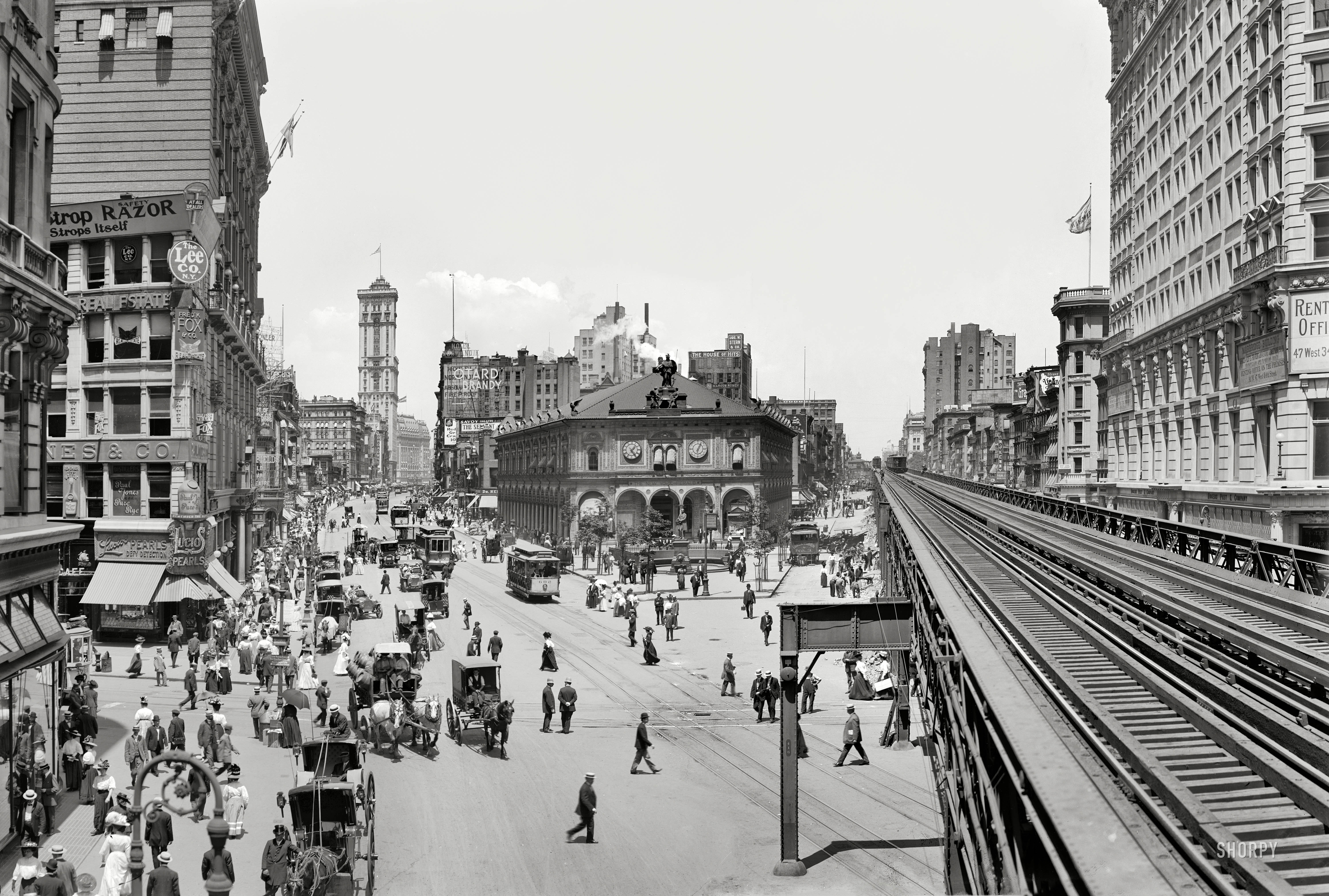
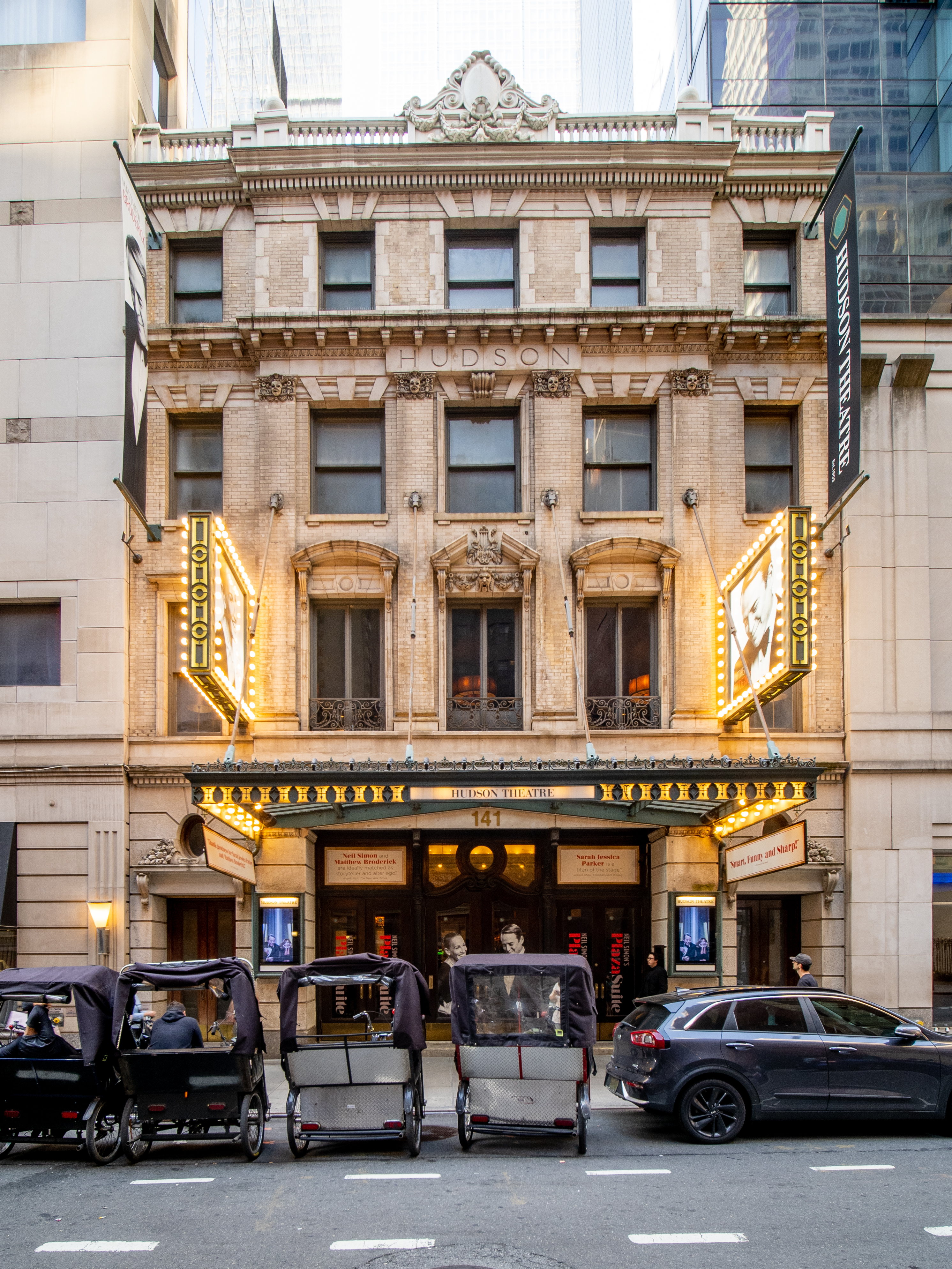
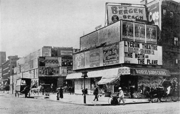
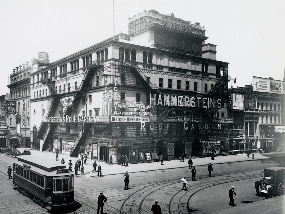
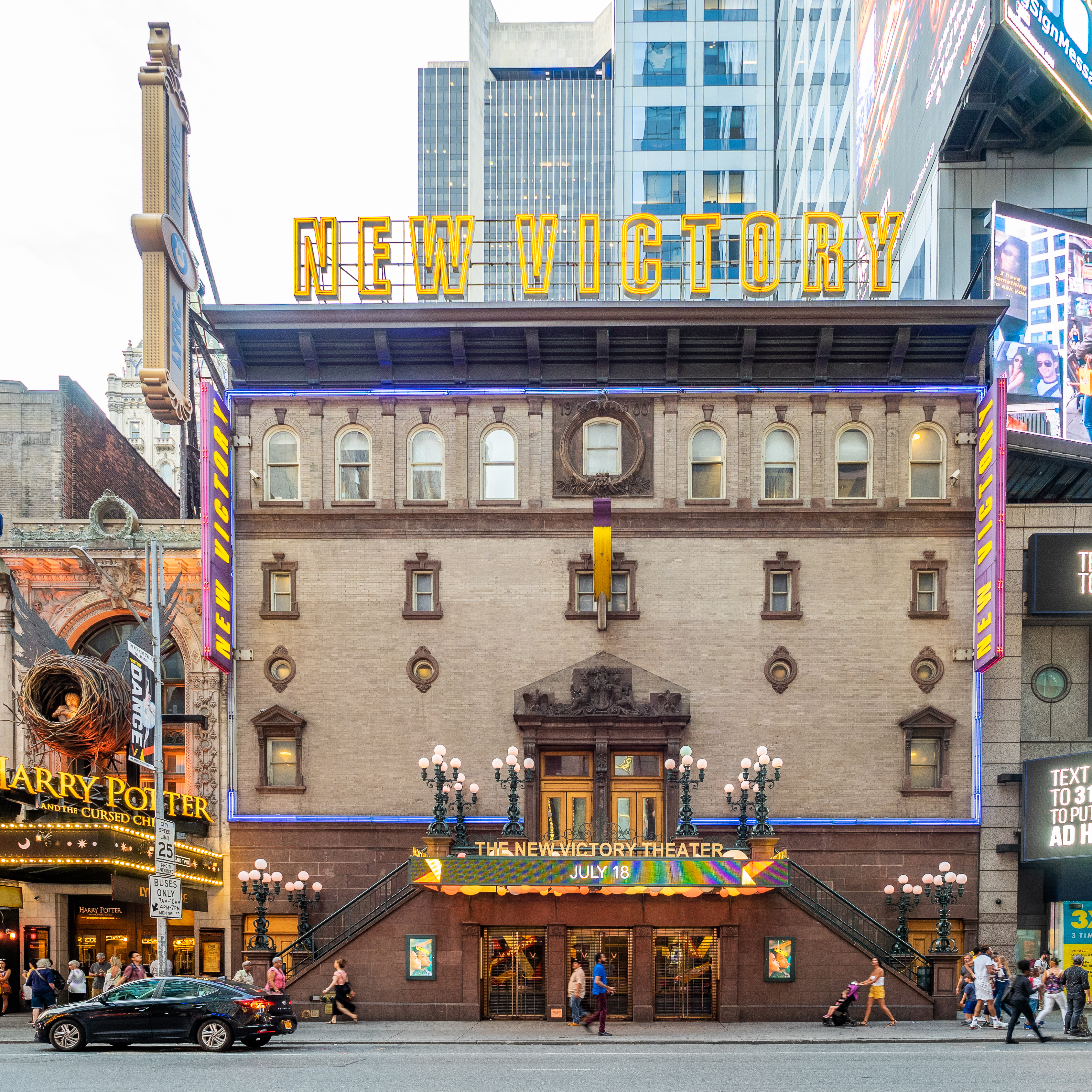
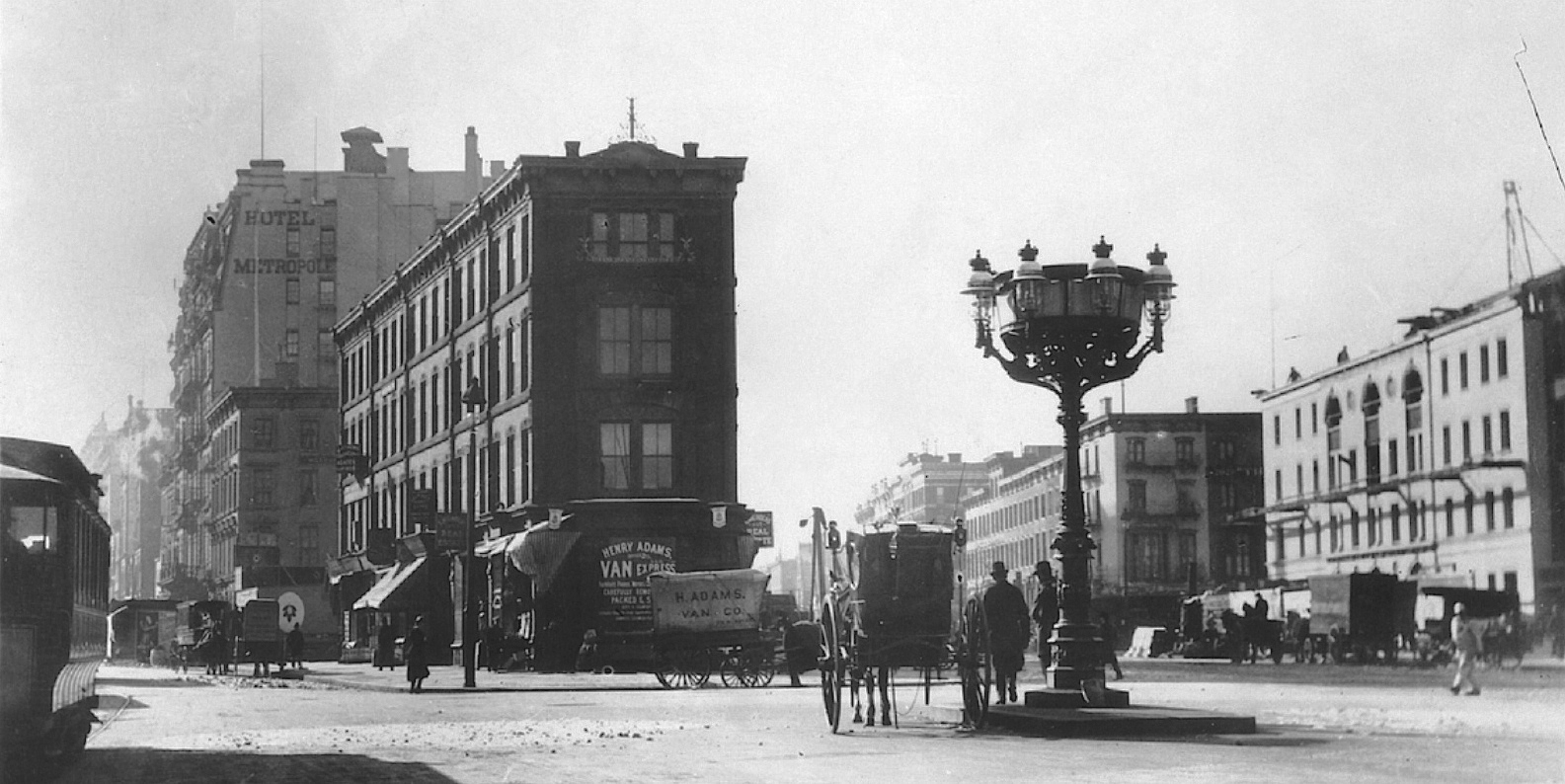
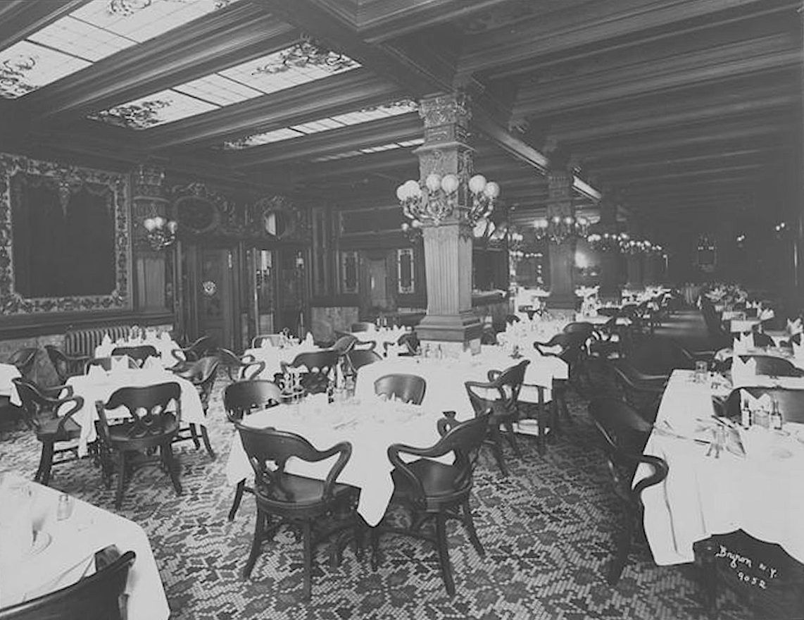
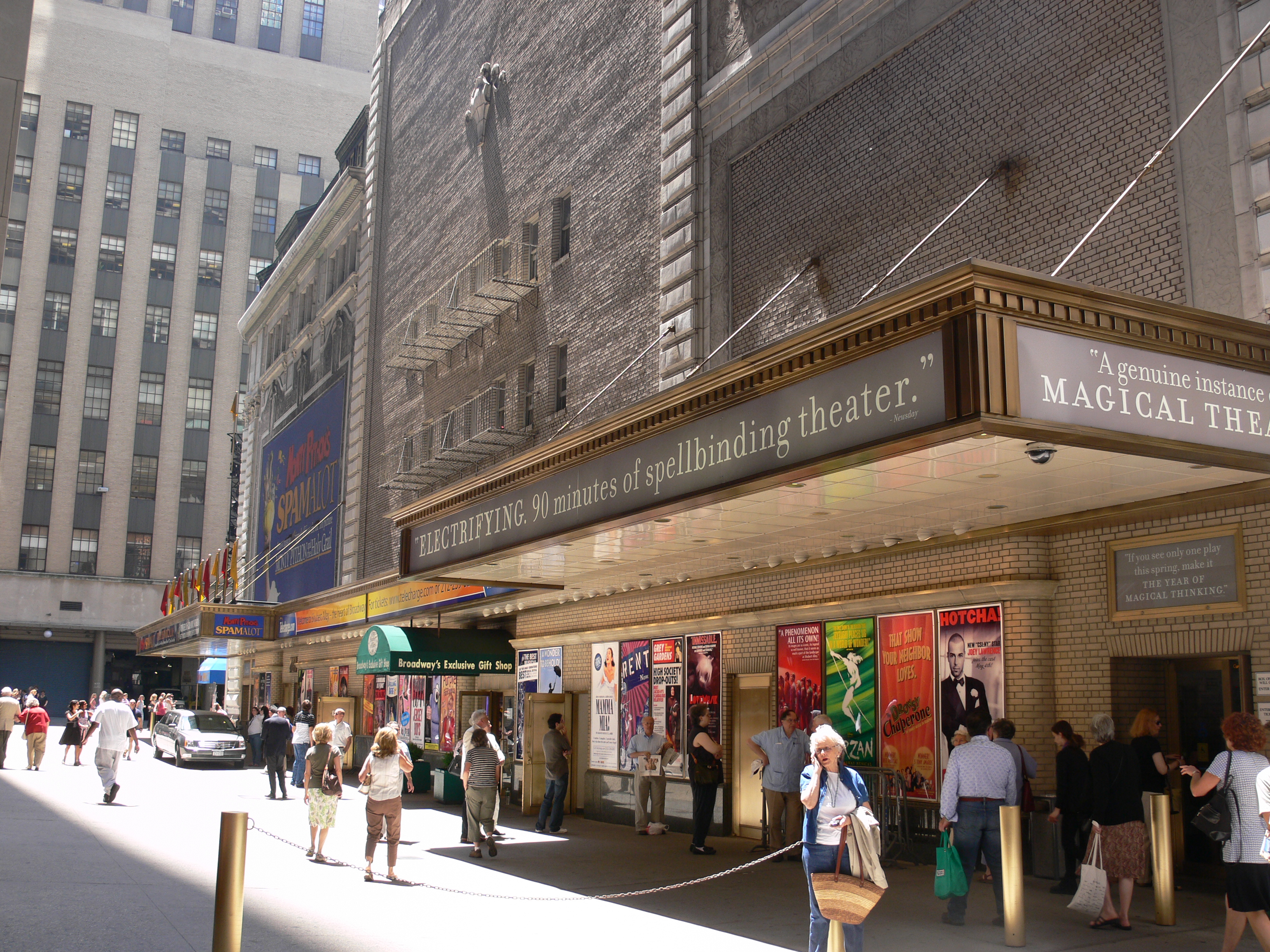
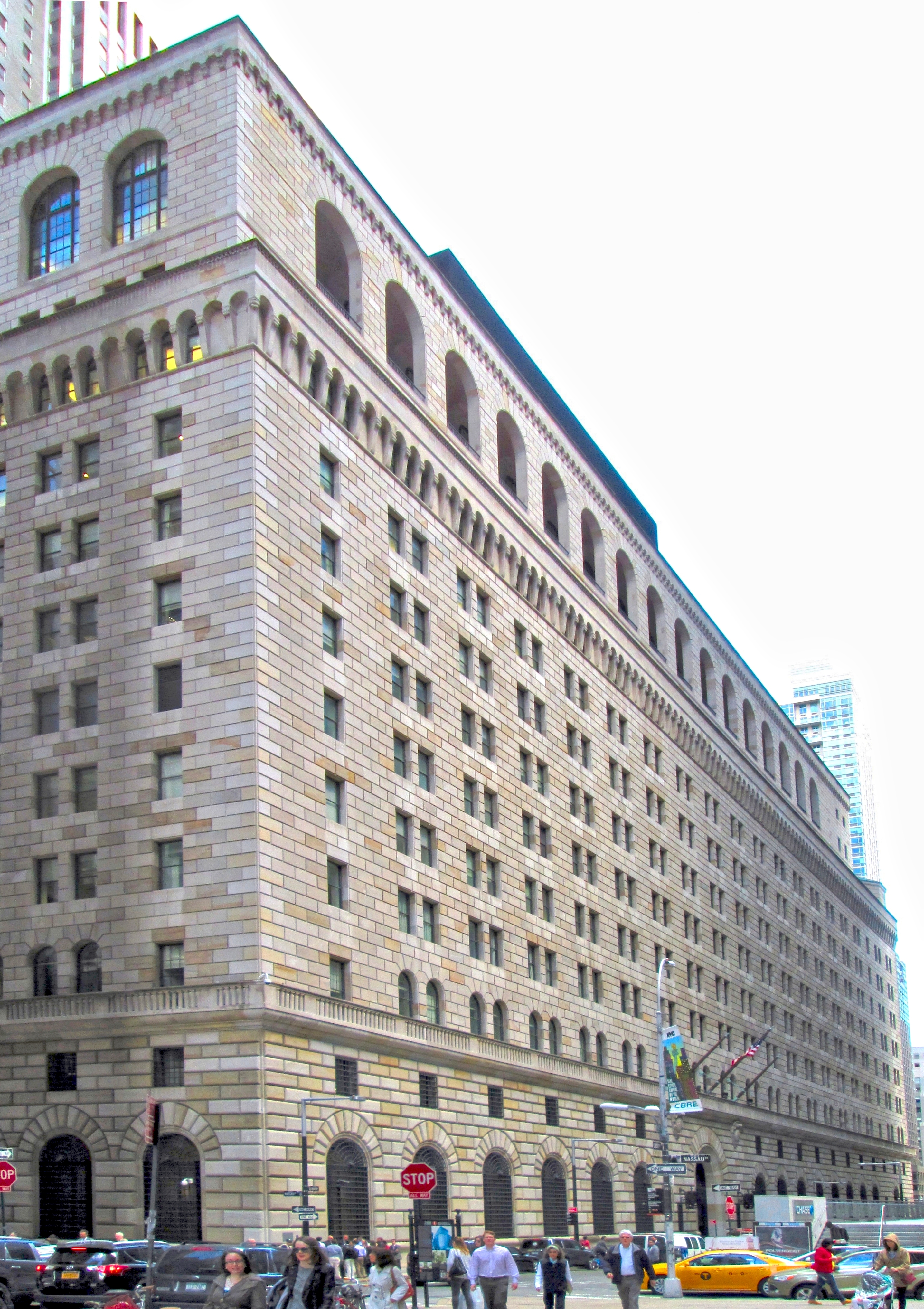
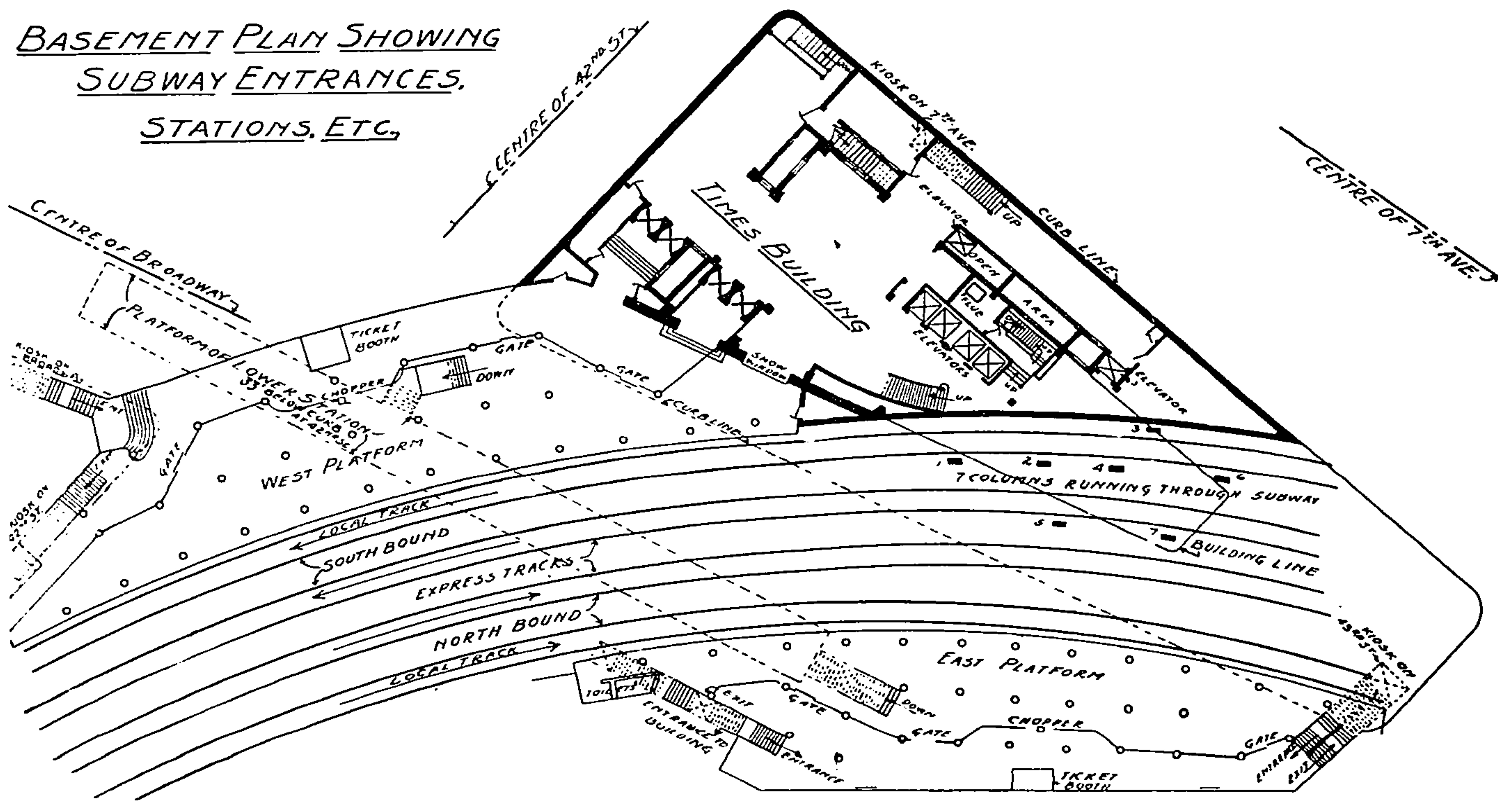