|
Reflections 2017
Series 5
March 22
Montréal-NYC R&S III: Québec-Trois Rivières-Seaway-Thousand Islands-Lake Ontario
| | St Lawrence River I've driven along the St Lawrence (Map by Karl Musser) from Montréal to Québec and then way out to the Gaspé Peninsula (and then into the Maritimes), and I've also taken the train, traditionally called The Ocean, along the same route a couple of times as well, out to Halifax. To fully define the waterway once again in its entirety, the above map shows the entire Great Lakes/St Lawrence watershed emptying into the Gulf of St Lawrence.
http://nicequebec.persiangig.com/image/Cities/Saint%20Lawrence%20River01.JPG
| | | | This map fills in the geography in more detail. At the top, it shows the Saguenay Fjord leading in from the river past Jonquière to Lac St-Jean; we took the inland train to Jonquière in 2013/1. While the river itself is scenic, most of the towns along the St Lawrence are on the modest side in population and interest, whether in Québec Province, Ontario, or New York State. Aside from Montréal and Québec City, there are just two larger cities (over 100K). Over by Lake Ontario and on the Rideau Canal is charming Kingston (2014/16) and downriver here is Trois Rivières, which we'll visit on this trip. | | | | The major road and rail routes run along the south shore, so one gets a one-sided view of things. That's the huge advantage of sailing down the river—you get an entirely different perspective of everything from mid-river. While we'd left Montréal at dinnertime for Québec City and traveled during the night, the return, via Trois Rivières, could be enjoyed in full daylight. | | | | Day 3: Québec I am greatly in favor of revisits. While it's perfectly true that "you can't go home again" to enjoy the visit in the same way, I find it is often better on the second or later visits. For an immediate example, I enjoyed the recent trip back to each of the places on the East Coast trip, Chesapeake City, Gettysburg, Harpers Ferry, Charleston, and Baltimore, far much more this time than on earlier trips.
| | | | But to be ready for revisits, you need time for mellowing. I place Québec with San Francisco as the two cities in North America with the most charm. But my most recent—and fabulous--visit to Québec was for three nights in 2012 as September turned into October, so our recent stop there in mid-October 2016 was premature. You really need more than four years for the longing to return to a special place to mature properly. | | | | In 2013/6 we talked about that enjoyable visit, about the city walls, gates, old streets; about Champlain and his Habitation down below in the Basse Ville/Lower Town, the location today of the charming Place Royale, also the Escalier Casse-Cou/Breakneck Stairs and the funicular bringing you up to the Haute Ville/Upper Town, arriving right at the terrace in front of the Château Frontenac. But what I loved most was the neighborhood where I chose to stay. It had been part of the old feudal land subdivision, the Fief du Sault-au-Matelot/Sailors Leap Fief, which was among the first areas settled when people started moving up the hill. The striking gray dome of the Séminaire de Québec/Québec Seminary was viewable across the street from my window, and I was very pleased to learn that the present owner of the Maison LaFleur B&B, Gilles LaFleur, was listed as of 1986 as the 13th owner of this property, originally a farm, then belonging to the Seminary until sold off in 1787. Although the modest building dated only to perhaps the 1930s, it had its simple charms and seethed with history. In this case, location, location, location referred not only to convenience to nearby special areas, but to Hic locus est, This is the Spot, where early settlement history began. These were the enjoyable memories I wanted to maintain, and not tread upon. | | | | We docked on the downstream side of Québec at 8 AM during breakfast. For the above reasons, I didn't want to overdo the visit, and thought I'd just walk around a bit for old times' sake during the morning, just to sample my favorite areas, but then relax on the boat during the afternoon while newbies scrambled around town, discovering and establishing their own favorite spots. This plan worked out quite well. If I had to guess, though, Will and I were the only ones who knew Québec, so there was a large group that signed up for a paid tour the boat organized, although a number did walk into town as I did. | | | | At first Will thought he'd have time to do what he wanted, but the cruise director then drafted him to "ride shotgun" on that tour to help out. As I recall the story, during the trip two ladies decided the tour was moving along too fast for them, and dropped out of the group without telling anyone, planning to return to the boat on their own. That understandably put the tour leader in crisis mode, thinking he'd lost some people. I'm not sure how things ended up, but I think it's clear why I would NEVER, EVER lead a group of people on a tour in any way, shape or form. At least not in reality. Those that wish to do virtual visits with me on this website are more than welcome to join in, an I'll make it as interesting as I know how. And Ill learn as much, if not more, than they will. | | | | There was a weather quirk this day, not bad, just different. For the whole two weeks of the trip, the mid-October weather proved to be pleasant autumn weather, worthy of no more than a jacket or sweater. But uniquely, the Québec day, while beautifully sunny, all of a sudden was freezing, literally. We were warned before we stepped off the boat that spots on the wooden dock that hadn't yet been hit by the morning sun continued to be covered with black ice, so walking alongside the boat out to the street was a bit of an arm-flapping adventure in retaining one's balance. In addition, when we reached the vast, wooden Dufferin Terrace at the top of the funicular in front of the Château Frontenac, despite the warm, bright sun, there was an icy spot shaded by a kiosk, and a woman hit the ground hard. Nevertheless, it was a beautiful winter's day in the midst of two weeks of beautiful autumn days. If you check the map, you will note that Québec is the furthest north we'll be on this trip, but that has absolutely nothing to do with it. Four years ago we were here just two weeks earlier during the same month of October, and the weather in Québec was perfectly mild. | | | | Before we start our walk, let's look at a spectacular panorama of Québec from Lévis, across the river (Photo by Datch78). Clicking only improves it slightly. The uninitiated will note the trees, which cover the slopes between the Haute Ville and Basse Ville (get used to the French terms, which were explained earlier). The funicular to the Haute Ville is obvious, leading up to the eye-popping Château Frontenac. To its right are some government buildings, and on the far right is the silver tower atop the Séminaire de Québec. The blue and white boat in the foreground is the ferry to Lévis, which I purposely took last time to get a feeling of being on the river, but now we're there full time. The Basse Ville continues a short ways downstream (to the right), where, as a small ship, we are docked in the Bassin Louise. But we are not alone in town today. In port today with us, and docked right along here directly in the river, are both Holland America's Rotterdam and Silversea's Silver Whisper. | | | | It strikes me that this is, however, a unique visit in our form of arrival. Sure, it's by boat for the first time, but it's more than that. All other visits, by car, or last time, finally by the restored train service to the Gare du Palais, involve arriving up in the Haute Ville, and only later making one's way down to the historic Basse Ville, by road on the Côte de la Montagne, by stairs on the Escalier Casse-Cou, or by funicular. But by arriving by boat we're visiting the city in proper historical order. Champlain arrived here by water to found Québec (down here, below) in 1608, and everyone in the water-based culture that lasted for centuries did the same. We'll do that, and then take the funicular UP to see the (only slightly) newer Haute Ville! | | | | In this unusual revisit, though, we're just going to do a quickie "remember four years ago?" tour. I think it's best if we first do the walk on the map, using some selected pictures from the earlier posting, and others as needed. Then we can redo it by satellite from up above, which should be a startling variation.
http://c14412660.r60.cf2.rackcdn.com/documents/pdf/carte_vieux-quebec_2009_e.pdf
| | | | I believe this was the map that served us well at the time, and will again. Much on the left shows the newer city, not my cup of tea. I suggest hitting the + up to ten times to get in really close, since were just interested in a small section of Vieux Québec/Old Québec. On the right top we have the restored Gare du Palais, from which I walked in the drizzle up to and through the city walls to the humble Maison LaFleur. It's at the eastern bulge of the ramparts, at the merger of Laval and Hébert, a short block away from the huge gray Seminary. | | | | But let's leave that for now and take a look at the Bassin Louise on the north side of the Basse Ville, where we're docked—approximately--at the Quais/Piers of the Vieux-Port/Old Port. Almost. Actually we're docked just outside the Bassin Louise, closer to the point of land, and to the right of Rue Dalhousie, alongside that long gray building which is (here unnamed) the Musée Naval de Québec/Québec Naval Museum, which was wisely pointed out to those of us walking as a landmark to use to get back to the boat (and was needed later, and worked). You can tell that the two big cruise ships in the river proper have the use of the Terminal de croisières/Cruise Terminal. La-di-da. | | | | It's only a couple of blocks until we're back to the northernmost point we'd walked to four years ago down here—there had been no reason to go further--the charming little square which I don't think I documented well enough at the time, so we'll do it right this time. It's marked on the map with the unusual name of Place de la FAO. The United Nations founded the Food and Agriculture Organization—FAO--in Québec, and to commemorate its 50th anniversary in 1995, the square was named after it, with an attractive statue and fountain. | | | | Notice how the two parallel streets I like, Rue St-Pierre and Rue du Sault-au-Matelot come north at this point, to be crossed by Rue St-Paul. Now look at this killer view of the Place de la FAO (Photo by Jeangagnon). How better can you connect the Basse Ville here with the Haute Ville up top, than with this view of the Séminaire de Québec from far below? Click to look closer at its tower, impressive even from this distance, a view I had from my window up top. Now pay attention down below. Rue St-Paul is crossing this area from the right. The two parallel streets are on either side of that building with yellow awnings, Rue St-Pierre closer and Rue du Sault-au-Matelot between the buildings. Now concentrate on the statue and fountain, which are interactive with the public. The statue is called La Vivrière/The Food Supply, symbolic of the FAO. It's a female figure carrying fruit, but she's a figurehead on the prow of a ship, symbolizing actual delivery of the food (by water, you'll note!). Notice how the fountain below illustrates the waves caused by the "ship", a motif continued by the sidewalk mosaics. It couldn't be nicer. | | | | This next view shows another angle, looking down the two parallel streets (Photo by Jeangagnon) we're about to walk down. It shows the quaintness of where we're heading, but I also want to emphasize the symbolism of the first street we'll take, on the right. Is its name familiar? Remember, up above, the original farm where the B&B is located was the Fief du Sault-au-Matelot [so.toh.mat.LO], the Sailor's Leap Fief, and this street down below has the same name. If some sailor leapt from the fief up above, might this street be where he landed?
| | | | On the map, check how we can weave between both these streets to check them out as we approach the road leading up above, the Côte de la Montagne, which is how the Basse Ville expanded into the Haute Ville in the first place, but then reach the little square (in green) the cobblestone Place Royale (Photo by Nowisaod). For details on everything here, refer back to 2013/6. | | | | For a bit of a rest, there's a park bench in front of the bust of Louis XIV (Photo by Selbymay) in the center of the square. But the bust and entire square have, amusingly to me, been given a seasonal touch. It's autumn, and there are large bales of hay, with pumpkins on them, all around the square! So we sit on the bench, rustically looking like hayseeds surrounded by the bales and pumpkins, all below an elegant and proud Louis. O tempora! O mores! | | | | A couple of blocks more and we're at the Escalier Casse-Cou, connecting to the Côte de la Montagne for those wanting to use the staircase (I doubt many necks actually get broken), but we're right at the funicular, which is far more fun. It had occurred to me that this would be the only other cash I'd need in Canada beyond the taxi in Montréal. I had C$5.00 left after the taxi ride, and I'd estimated well, since the funicular cost C$2.50 each way. Some others entering used US currency for the fare; I proudly remained local and did not, yet used up all my Canadian currency. One more check mark in the Yes! column. | | | | Again, details of the funicular (today actually a pair of inclined elevators) are back at 2013/6, including a video of the ride and an explanation of how counterweights work on elevators, inclined elevators, and funiculars. I will repeat here, though, this view from below showing that it's today really two inclined elevators on tracks (Photo by Christophe.Finot). I'll also repeat the schematic showing that funiculars can have four, three, or two tracks, in pairs (Schematic by Cmglee), 2-3 pairs being most common. However, an inclined elevator, which works independently, but which usually has a twin as a backup, can obviously only have two pairs of tracks, and can be considered a further development of a four-track funicular. | | | | I have some special reasons to repeat this information here, which we can consider as we ride to the top. The pair of inclined elevators replaced the Québec funicular when it was rebuilt. At the end of this current trip, we'll ride a recently built underground inclined elevator in Manhattan. But then I was quite surprised, when recently planning a return trip in September to Paris, to find out that the absolutely iconic funicular in Montmartre, which leads right up to the Sacré Coeur, the big white basilica visible from all across the city, was also recently rebuilt, and is now a pair of inclined elevators as well. | | | | We're now at the top (see map), on the Dufferin Terrace—watch out for that ice in the kiosk's shadow—in front of the Château Frontenac in the earlier panorama. A street musician is singing to a recording, filling the area with music. Looking over the railing in the bright sun, we get this downstream view (Photo by Joël Truchon). Click to inspect where we've just been, the area where we're docked and where the two ocean liners would be, then pan across the river, ever broadening in this direction, to Lévis.
| | | | We step into the Place d'Armes (see map), already discussed in Montréal, and wend our way through familiar streets in the center. Rue de la Sainte-Famille cuts us right down to Hébert, and to the Laval intersection—this location is SO very central to everything. These streets are just far enough away from the tourists that they are VERY quiet, although on this visit, the street was being resurfaced, so there were a few workmen around. | | | | As with the Place de la FAO, I realize I did not fully document visually the very modest charm of the Maison LaFleur in 2013/6, so forgive me for going a little overboard now.
http://www.lamaisonlafleur.com/images/l_photo1.jpeg
https://media-cdn.tripadvisor.com/media/photo-s/05/0e/a1/d4/la-maison-lafleur.jpg
| | | | The first picture shows Rue Laval coming in at the center joining Rue Hébert at the left. No, the Maison LaFleur is not the period, five-peaked gabled building, but the modest brick structure from the 1930s. Apparently this plot of land had been vacant for centuries until then, and had been used as a garden for adjacent properties. The second picture shows a direct view, and also includes part of the white building next door, which I suspect is an annex for it, perhaps Gilles's living quarters. Note the lower left window with geraniums and the upper left window as well.
http://www.lamaisonlafleur.com/images/l_photo3.jpeg
http://www.lamaisonlafleur.com/images/l_photo6.jpeg
| | | | The first picture shows the geraniums on the flip side of that downstairs window, in the absolutely charming, very Québecois breakfast area. There were just three guest rooms in this B&B, and that upper left window was mine. Very cozy, and it was through that window that I had the view, both during the day, and illuminated at night, of the silver spire (Photo by Hélène Grenier) of the main building of the Séminaire, just a block away. | | | | It's no secret that I really enjoyed being in this neighborhood, and if you look again at the map, we can walk over to the corner at the Rue des Remparts and look down to how ironically close the Maison LaFleur is to where we are on the Grande Mariner. But we are not sailors who leap, so we work our way back to the funicular and to the boat for lunch and a relaxing afternoon on board.
http://www.satellite-sightseer.com/id/3826/Canada/Quebec/Quebec_City/Chateau_Frontenac
| | | | But let's not forget our spectacular satellite view. It will open on the Château Frontenac, in isometric projection. Going up three clicks will allow us to move quickly, then drag the view down to move up to the Bassin Louise. Coming down two will be enough, and will be isometric again. At the point, you can see the long gray roof of the museum on whose side we're docked, and the white roof of the Cruise Terminal is also there. But move a bit to the southwest until you see the unmistakable wavy sidewalk tiles of La Vivrière and move in a little closer, but, since we're in the Sailor's Leap area, do compare it with the Séminaire up top, yet nearby. | | | | As we once again go down the two parallel streets, it's unmistakable how the tree-lined ramparts hover above us. You will have found the Place Royale when you see the church with its steeple at the south end. If you move in crazy-close to the north end, you can make out the circular area where my friend Louis XIV sits in the shade. Go up slightly, and drag right to move left and you'll first find people coming down the Escalier Casse-Cou from halfway down the Côte de la Montagne, and then the Funiculaire de Québec. While we're at it, we can mention again that the building the funicular leaves from is actually the 1695 house of explorer Louis Joliet, who visited the US Midwest. Back up to the terrace and hotel, and move left through the trees of the Place d'Armes, and then north through all those silver-colored seminary buildings. When you spot its silver tower, move in to crazy-close (or one higher) for one of the most enjoyable things I've ever spotted on a satellite image. You'll see the five-peaked gabled building, and the unmistakable modest brown brick Maison LaFleur with its white annex. To the left is the breakfast room window, and above it my room, my little piece of Vieux-Québec seen as from the skies. | | | | Day 4: Trois-Rivières Our next stop--and believe it or not, since things go so fast--our last stop in Canada, is Trois-Rivières, which is only about half-way back to Montréal. For that reason, we spent only half the night in Québec, leaving after midnight and arriving at 8 AM. Of the four major St Lawrence cities, including Kingston, Trois-Rivières was the only one I'd never been to before. Why might that be? I'd driven a couple of times along the south shore. Why not cross the bridge at Trois-Rivières to visit it? | | | | Although I fully enjoyed my time in Trois-Rivières (TR), frankly, it's not a major attraction. So often, a locality might be very nice, but still primarily of local interest. Remember, I use the old Michelin rule of thumb: 3* = Worth a Trip; 2* = Worth a Detour; 1* = Interesting. But of course, beyond that, one makes up one's own mind, based on what there is to see and do. Michelin Canada does give Trois-Rivières 2*, but reviewing its sights never convinced me it was worth the detour. But now that it was a stop on the cruise anyway, I reviewed it again and found some attractions that intrigued me, and so I printed out an online map and decided on a walking tour. This is what I call being prepared, and not arriving somewhere "blind", as so many do. | | | | Blount was selling passengers an industrial tour, a church tour, and a walking tour. I rejected all three. I had put together my own sights, and so my own walking tour, and why should I go see what someone wants me to see in the hope I'd like it, when I can find my own destinations? | | | | This is the background I discovered that I found of interest. The French explorer Jacques Cartier described the TR site on his second journey to the New World in 1535. In 1603, while surveying the St Lawrence, Samuel de Champlain recommended establishing a permanent settlement in the area, which finally happened when Trois-Rivières was founded in 1634 as a fur trading post by the Sieur de Laviolette, sent by Champlain (Champlain died the next year). It was the second permanent settlement in New France after Québec in 1608. | | | | | | Maisonneuve founded Ville-Marie/Montréal in 1642. To complete the set of four, Kingston, which is the only one of the four cities upstream from the Montréal barrier, was founded as a fort in 1673, but not until 1838 as a village and 1846 as a town. In sum, the founding years move upstream during the course of the 17C: Q 1608, TR 1634, M 1642, K 1673. |
| | | | The Michelin Green Guide to Canada was particularly helpful in facts and deciding on sights I wanted to see. Also, it's the only source that told me what I consider a fun fact, that the inhabitants of TR are called Trifluviens/Trifluvians. | | | | It also pointed out something I felt was very important. In all the years of Anglo hegemony in Québec Province, the city was known as Three Rivers. But times move on, and in recent decades it's been called Trois-Rivières in both English and French. But there was one irritating exception. If you'll recall Blount's route map for the trip—we'll be seeing it again later, in any case—this Québec city is listed in English as Three Rivers. And it didn't stop there. Both the captain and cruise director maintained the atmosphere of monolinguialism by constantly referring to it as Three Rivers, despite signs welcoming us to Trois-Rivières. Now calling a destination in Québec by an English name seems like you're making an unpopular political statement, but aside from that, it's just not consistent with other examples. In English, the South American island is Tierra del Fuego, don’t translate it to Fire Land; the Parisian boulevard is the Champs-Élysées, don't translate it to the Elysian Fields; the circular Viennese boulevard is the Ringstraße, don't translate it as the Ring Street. Just dig in and do your best to pronounce the original name, as used in English. The same goes for Trois-Rivières. | | | | One of course will wonder how the city was named, and there's a quirk. There ARE no three rivers. The name is a matter of, for want of a better name, poetic license. This is an aerial view of TR (Photo by abdallahh), but don't get confused, as it's "upside down". That is, it looks south, and Québec is downstream to the left as our boat pulls into the picture and reaches TR, center right, directly on the water. We see the Rivière St-Maurice entering the scene from the north at the bottom. But click to inspect what happens when it reaches the St Lawrence. There are several islands at what would have been the mouth of the St Maurice and these force the river into three channels instead. Thus it's not actually three rivers, but three river mouths that, with a bit of poetic license, give TR its name. Also note the different colors of the two rivers, with the St Maurice maintaining its deeper hue within the St Lawrence, and separated for some distance along the northern shoreline. This is a phenomenon we last saw in Brazil where the Rio Negro joined the Amazon at the Encontro das Águas / Meeting of the Waters (2011/13). | | | | But there's another minor irritation. As we approached TR, the captain was narrating, and actually said over the PA something like "The St Maurice joins the St Lawrence here. That's only two rivers. I can't imagine why they call it Three Rivers." The drivel you sometimes hear when traveling is not to be underestimated. The moral is to look things up yourself before arriving. As I said regarding taxis, it's good to be in control of your own fate. As we also said just last year in 2016/4 (check it out), Illegitimi non carborundum.
http://www.worldmap1.com/map/canada/trois-rivieres/Trois_Rivieres_map.jpg
| | | | This map shows our arrival right-side-up, with north at the top. The northeast route of the St Lawrence means TR's shoreline runs the same way. The three mouths of the St Maurice are obvious, and downtown TR is just upstream of them. As on the aerial view, we sea a highway and rail line cutting through town, with a probably rarely used rail loop curving downtown (you may have noticed a similar one in Montréal's Old Port). Notice the concentration of tracks somewhat inland. More about that later. | | | | You also see downtown, in an area called Vieux (Old) Trois-Rivières, a greensward labeled Parc portuaire, literally Port Park, but better translated as Riverfront Park. Adjacent on the Rue des Ursulines, there's also a Manoir de Tonnancour and a Monastère des Ursulines. Further in is a park and cathedral, and then those multiple tracks. This is an outline of what will be our day. | | | | There is good reason why a city as old as TR has a minimum of history to show visitors, something that no one told me but Michelin. In 1908, the greater part of the city burned in a fire in which the majority of the city's original buildings, many dating back to French colonial years, was destroyed. Only a precious few heritage buildings were spared—and precious is a key word here--including the Ursuline Monastery and the De Tonnancour Manor. So those are of course at the head of our list. | | | | The docking area, in the middle of this picture, is very centrally located at the Parc portuaire (Photo by Fralambert). But you can see something unusual in this picture. It wasn't until arrival that I realized that that Rue des Ursulines along the water was actually up on a small ridge, perhaps the equivalent of 1-1½ stories high, indicated by all the trees on the right third of this picture. There's another oddity. The Rue du Fleuve/River Street runs in front of the ridge, and rather surprisingly, there's an odd structure there. Above that red line is a roof terrace, which acts as a side extension to the Terrasse Turcotte, the street at the edge of the ridge. Below it are the side openings of a long, linear parking garage (a sign of the times), through which Rue du Fleuve runs, along with that set of rail tracks we noted. Ridge: nice. Garage: less so. The white building at the far right is the historic Ursuline Monastery. | | | | As for the actual docking area, this is the downstream view towards Québec (Photo by Claude Boucher), with a little bit of that roof terrace discernable. And this is the upstream view towards Montréal, with the bridge connecting to the south shore:
http://5moversquotes.com/wp-content/uploads/2016/07/canada-the-architectures.jpg
| | | | The riverfront is really quite nice, and during the visit I gained a lot of respect for TR, and moreso during post-trip research. That garage I suppose was necessary, and yields the roof terrace, anyway. There was a schedule on the dock of cruise ships due in during this period, and we were listed as the only ones due today.
http://www.3renblues.com/file/map-renouvell%C3%A9e-petite1.png
| | | | You will enjoy our walk through TR vastly more if you're well-oriented, and this is the map I'd found, a printout of which actually guided me around very nicely. But it's a waste if you don't orient yourself. From my point of view (click) it's all about the historic area up on the ridge, and I assume the black crosshatching indicates the historic district. This map has, oddly, a little red X on the Rue du Fleuve, and it does indicate where in the Parc portuaire we were docked. It also shows something that was too new to be in any guide books, a Monumental Staircase meant to bring arriving visitors up the slope to the Rue des Casernes on the ridge above. You see why I began to respect TR more and more. Crosshatching on the Rue du Fleuve shows where it's covered over to include the parking garage. | | | | The area to the left of the historic district is the downtown commercial district, as the symbols indicate. It seemed pleasant enough, but there was nothing here that attracted me, and my walking route, starting on the Rue des Casernes, moved first right, then straight ahead. However, I have just now, after the fact, learned why. This map shows the area destroyed by the disastrous 1908 fire. Disregard the dashed line marked Fire Limit, because that's not so. I have two other maps that confirm that the dark-colored areas show the area that burned. Using our Rue des Casernes as a benchmark, the fire moved only slightly to the right of it. But it moved four blocks along the river to the left of it, up to Rue St-Georges, which is just off our main map if you count the blocks. But this certainly covers the downtown area. On the fire map (click), locate the green corner in Block 50 half-way up St-Georges from Badeau. According to my research (all sources were in French, including French Wikipedia), this is where the fire started on 22 June 1908, before noon, when a boy struck a match in a dark shed for light. It fell on a bale of hay, spread, and a strong northeast wind caught the fire and spread it further. Remembering that the shoreline here runs SW/NE, you can see the influence of that NE wind, since the other side of St-Georges was not affected. | | | | Therefore, the fire crossed all of downtown, but fortunately hardly crossed into the most historic area to the right on the fire map. It also did not reach the cathedral further inland, nor, for that matter, Champlain Park opposite it in Block 54. 800 buildings were lost, some going back to the time of New France. Also totally destroyed were the 1723 governor's house called the Maison du roi ("King House") and the 1710 Immaculée-Conception church. The entire commercial core was gone, but there was only one fatality, not because of fire, but because of a wall that collapsed the next day. | | | | | | One other thing is typical of what one discovers when looking at old maps. On the fire map, the main street in the historic district is not called Rue des Ursulines, but seems to be an extension of Rue Notre Dame on the left. A Rue des Ursulines IS shown, but it's a block further north as the name of a street that no longer appears on the modern map. |
| | | | There are dozens of pictures online of the post-fire ruins; I've selected four. These are of a long windowless wall; the remains of a house; Trifluvians viewing broad destruction;
reviewing it all from period transportation. Now let's put the fire aside and take a walk.
| | | | An Autumnal Stroll Through Trois-Rivières After the cold but sunny day in Québec, the weather returned to its usual pleasant autumnal state. You may want a jacket—or not. As we disembark, we're right at the Parc portuaire, but are shunted through a large glass lobby that includes a tourist office. At one end, the walking tour group assembles, but on a whim, I stop at the tourist counter to look at brochures, even though I have the map (that you're keeping at the ready). If the lady had spoken first, she probably would have tried English, given the relentless stream of (mostly, if not all) anglophones trooping off the ship. But since our conversation blossomed in French, I must have spoken first. It was automatically French for two reasons. It just seems right to use the local language if you know it, just like using the local currency; and anyway, this was the last opportunity to speak French for sometime. To my amazement, the lady spoke a more normal French, and not the Québecois dialect. To make conversation, even though I knew how to zig-zag my way through town to the former (alas!) rail station, I commented that I wanted to go to the ancienne gare and checked my planned route with her. I suspect it's an inquiry she rarely hears since (1) Who wants to see a rail station? (2) Who wants to see a closed rail station? (3) Who wants to walk completely across town to see a closed rail station? Moi.
| | | | But she was parfaitement charmante about it and not only treated it like a question she hears all the time, she gave me some additional information, that there was a well-known chocolaterie opposite the former station called Chocolats Samson. | | | | Back to our map. Leaving the tourist bureau, we cross Rue du Fleuve as it descends to our right into the garage, and find ourselves at the point on the map indicated by the red X, and we discover the extent to which TR has spruced itself up in recent years. The whole park area from where we are up to and through the Place Pierre-Boucher is a very inviting river entrance to both the historic area to the right, as well as straight ahead. But we have to ascend the ridge, and that white thing on the map is a new Monumental Staircase to go up the hill.
http://media1.ledevoir.com/images_galerie/228560_161833/image.jpg
http://www.tourismetroisrivieres.com/partenaires/102298/images/escalier-monumental-trois-rivieres.jpg
| | | | It's more than just an Escalier monumental, it's a work of art, a sculpture, in its own right. Note how broad it is at the bottom, narrowing exponentially up the hillside. Note the serpentine railings, which, particularly further up, also serve as benches. (!!) And you cannot miss reading the history of TR on the riser from one step to the other (beware, monolinguals, it's in French—what else would you expect?). I've included the nighttime picture because it's easier to read the texts, and I also saw it at night, anyway. And this is a good time to make a comment. The bottom step makes the point that 1634 saw the foundation of the TR Fort by Laviolette. Maybe so, but I found another French source that said that the foot of this slope is the very spot chosen by Laviolette in 1634 for his trading post. Of course, if by fort they're including a trading post, then we agree, but in this one matter, this is the spot, Hic locus est. It's interesting based on some maps I just came across that the next step up confirms that in 1653, TR was made into a fortified town. More below. | | | | At the top of the stairs, we're already in the Rue des Casernes. It's nice, but had been involved in the fire, so it wasn't as quaint as what is ahead when we turn to the right, into the first block of Rue des Ursulines (Photo by Claude Boucher). If you click, you'll see the second block starting at Rue St-Louis on the right (it's called Rue St-Jean on the left), and the third block starting at Rue St-François-Xavier at that green roof and tower of the 1742 St James Anglican Church. The white building with the sundial and the silver tower will be our destination shortly. | | | | But as you see on the map, after only a half of that first block, we for the third time in three days come to a Place d'Armes, used as a park. In this case it's actually called the Parc de la Place d'Armes. We turn right into the Rue St-Louis and then turn around for a better view of the historic Manoir de Tonnancour (Photo by Sophie). The Tonnancour Manor was built from 1723 to 1725 for René Godefroy de Tonnancour, and today has been recycled as the Galerie d'art du parc. It's only another half-block on this detour to the Terrasse Turcotte and its extension over the garage, for beautiful river views from this raised area. | | | | We backtrack up St-Louis and turn right into the second block of Ursulines (Photo by Fralambert). That's the Anglican church again on the right--click for detail on the historic houses. | | | | The third block of Ursulines (Photo by Alain Rouiller) has that distinctive bend in it. We've now reached the principal institution here, the main building of the Monastère des Ursulines, keeping in mind that in French, monastère can refer to either a monastery or a convent. There are two long, white wings with the stone chapel in the center, all facing the river. Here we have the well-known end view of the wall with the iconic sundial, with the stone chapel projecting out of the front façade and its silver tower and cupola up above.
http://www.tourismetroisrivieres.com/partenaires/9/images/musee-des-ursulines-2013-01.jpg
| | | | As we walk around the bend we see the façade, including the chapel. The white wing in the distance is not visible in this photo, as it's difficult to stand back far enough because of the trees—note on our map the Parc du jardin des Ursulines. But turning down the Rue de l'Hôpital for a bit and looking back, we get a nice view of the chapel and cupola (Photo by Abxbay) between the two white wings. Click to see details, including the 1715 date. Michelin describes this building as "the jewel of the old quarter". This evening, we'll attend an organ concert here. | | | | As we now backtrack down Ursulines, I can reveal a happy discovery. One should become suspicious when, in a colonial city, there is a concentrated historic area like this that there might have once been a wall around it, and that’s exactly what I discovered during post-trip research. This is the walled city of Trois-Rivières in 1704, located completely up on this ridge. Click to inspect what is now Rue des Ursulines—so obviously the main street—starting at Rue des Casernes on the left and running for three blocks. The Monastère wouldn't be built for another eleven years in that third block, but it could not be clearer why that bend in Ursulines exists to this day; there was some sort of waterway where the park is today. | | | | On the right is a listing of 34 numbered buildings in town, mostly private houses. The letters are explained at the bottom "A" indicates an old enclosure while "B" indicates a new one as a replacement. I have no details about this. "C" up front is the powder magazine—we've seen several of those recently—and "E" on the left is a windmill. | | | | I was only aware before this trip of the walls of Québec—who could miss them? But I'm now pleased to have only recently "discovered" the long-gone walls of Montréal and Trois-Rivières. Added to having also found the former walls of Charleston SC within the last year, that's a pleasing travel discovery trifecta.
https://static1.squarespace.com/static/53f3887de4b01ae9c4407be6/543f0b66e4b01f8d6d25bcd7/543f0ba8e4b0cc0fc84cf5f8/1413419756830/La-place-Pierre-Boucher-et-le-parc-du-Platon-2.jpg
| | | | On our map, you'll see how we next proceed through the Place Pierre-Boucher, recently remodeled along with the nearby Monumental Staircase. The above picture shows exactly where we are. The Rue des Casernes enters on the right, and Ursulines enters left—note the silver and green domes. The park here and fountain afford a pleasant few minutes' pause as we pass. | | | | As we continue up Rue Bonaventure, we have the Parc Champlain on our left and the cathedral (not named here) on our right. This is a side view of the 1858 cathedral (Photo by Robert Cutts)—those trees on the right are the park. It's worth a step inside to see the interior (Photo by Tango7174), but then we continue on our way, zigzagging up some side streets—it's not really that long a walk—until we reach our destination, researched earlier, at Rue Champflour facing rue du Père-Frédéric. It's the former rail station, and the tracks are visible on the left. | | | | I'd read the background, but also there was a historic display at the entrance. It's all based on TR's geography. When railroads were first appearing, the main line went up the south shore, where it still is. TR thought it odd that, lying right between Montréal and Québec on the north shore, it had been bypassed. Finally a line was built on the north shore in 1872 and it included TR. As the exhibit pointed out, it was a wooden station building erected here in the fields, and I'm pleased to say I've found this 1909 postcard view of it, from the south, still showing the rural nature of the neighborhood. This was also just a year after the fire downtown. Here is a view in 1900 of the track side of the station. Given that date, you'll note it was still the period in Québec Province of Anglo hegemony, so the station name's in English. Actually, the town was quite pleased about the arrival of rail during this period, since it turned out there were more freight movements by train than there had ever been by boat. As passenger traffic grew, that station building was replaced in 1924 by one in a more severe Art Deco style, seen here from the north. | | | | The station was acquired by Via Rail Canada in 1985, and in 1987, it became an intermodal station for intercity buses as well as trains. But in 1990 came the infamous Via Rail financial cutbacks—I remember following them well—and passenger rail service ceased. In 1998 bus service to the station ceased as well. The station was closed, is now owned by the city, was declared a federal heritage site, and has been recycled for other use as offices not related to transportation. A wire mesh fence, sadly, separates the station from its own tracks. Here is the same north view today (Photo by Mario Groleau), although on our walk, we approach it from the other direction. It is so ironic that lying between Montréal and Québec didn't help TR, since the train promptly crosses to the south shore out of Montréal and later uses the Québec Bridge to come back to the north shore well beyond TR to access Ste-Foy and Québec (2013/5). | | | | In any case, we found the chocolate shop across the street and peeked in the window, then continued back toward the boat. Walking on the sidewalk along Champlain Park, we sat down on a bench for few moments to enjoy the park, and found an amusing site. Across was the cathedral which the boat's walking tour had just reached. The guide was pontificating in front of the cathedral to the first few of perhaps 20 bored people in a long line along the sidewalk. Surely most of them couldn't hear the guide, but also didn't seem to care. Taking up a position at the rear was Will, commandeered again to help out on a tour. I waved and he waved back, and I smiled at the apparent futility of it all. Did I say I myself would never lead a tour, ever? | | | | As I watched the sheep then follow the shepherd, I went the other way, back to the ship. You have to pass through that lobby again to reach the dock, so I stopped again at the lady at the tourist office, since it was my last chance to speak some French for some time. I'd walked off with her pen, so I handed it back to her now, saying J'ai volé votre stylo! ("I stole your pen!"). I told her I'd found the chocolaterie but was already eating too much on the ship to have stopped in. It was a pleasant exchange, and then back to the ship for an afternoon's relaxation. | | | | The only off-ship evening's entertainment of the entire trip had been announced for this evening, a free private organ concert at the Ursuline Chapel, and after dinner, maybe 20 of us interested in attending gathered to be led there by the cruise director. Now you know where the ship is and where the chapel is. How would you walk there? | | | | It's possible to put a painting in a beautiful frame, or in an ugly frame. Our cultural evening took the ugly route. I would have gone up the Monumental Staircase and down Rue des Ursulines to frame our concert. The cruise director, who's been here before, had other ideas. She led the group through the somewhat creepy parking garage for the three blocks. Fortunately, at the far end, we ended up on the pleasant Rue de l'Hôpital to arrive at the chapel. | | | | The chapel was attractive, and the 1858 organ was in the loft behind us. The concert lasted 30-40 minutes, and then it was time to return. I mentioned to several people that I was going back along a more sensible route, but no one was interested. So all the sheep followed the shepherdess as I took a short, lovely evening stroll down the quiet Rue des Ursulines, and then down the illuminated Monumental Staircase, at which point I met the sheep exiting the garage. It's so nice to control one's own destiny. | | | | Capitale de la poésie I have willfully left out a major part of today's walk until now, simply because it was extensive and I wanted to concentrate it all here at the end. Before I discuss it, I also want to say that any visit is always enhanced by knowing in advance what there is to see. If you are unaware that San Francisco has cable cars and only discover them on arrival, you'll still enjoy them, but won't have the anticipation, thrill, and satisfaction of having known about them in advance and then recognizing them when you get there. Having foreknowledge is the only way to go. | | | | I was unaware of two things about TR. First, I hadn't been able to tell in advance from the map that Vieux Trois-Rivières was up on a ridge, but I spotted that before I got off the boat. Second, I'm grateful to Will for telling me before we arrived about a unique aspect of the city, that it bills itself the Capitale de la poésie, or the Capital of Poetry. Not only are there poetry-related events held throughout the year, but much more visibly, there are hundreds of stone plaques on walls everywhere throughout the city quoting bits of poetry. Expecting this, when I saw my first one, on the Rue des Casernes right at the beginning of our walk, it was with meaningful recognition: sure enough, here's the first one. | | | | Of course, the poetry is in French, another gift of the city of TR to bi-, tri-, or multilingual travelers, in addition to native francophones. I doubt if anyone on the anglo-monolingual staff was aware of the poetry, and the (apparently) anglo-monolingual passengers wouldn't have cared anyway. But of course, Will speaks French, had been here before, and knew I'd be interested. | | | | A modification of the above: in the case of poetry from other languages, the French translation comes first, with the quote in the original language following, so only a quote from an English source would have any English on the plaque at all. There were hundreds, if not thousands of these plaques. They were up on the ridge, notably on the Terrasse Turcotte, where I found my favorite, which I memorized on the spot, but also wrote down. They were on all sorts of buildings, including numerous private residences all the way to and past the cathedral up to the station. Sometimes you'd have to lean in a bit to read something on someone's front porch. This was something that extended and fulfilled the morning walk today more than was perhaps apparent. | | | | I will readily admit that there was much of it that I didn't understand. Either some of the French vocabulary was beyond me, or the poetic imagery was too vague, or perhaps both, especially when reading snippets in the street and also en passant / in passing, or on the fly. But it certainly was fun, and added greatly to the visit.
http://img.src.ca/2014/10/02/635x357/141002_xz25y_rci-poesie-t-r3_sn635.jpg
| | | | I have found a number of photos of these plaques online. I don't believe I actually saw any of these, but they're representational of the ones I did see. This picture is typical of a couple of plaques affixed to a wall outside a shop. My translation of the text is:
I shall be your landscape / You shall be my passer-by
http://martincomeau.com/wp-content/uploads/2015/03/poeme-tr2.jpg
A heart, patient enough to wait for crumbs . . .
http://lalitoutsimplement.com/wp-content/uploads/2007/09/troisrivieres2.jpg
I've come to you / For an entire day of patience
http://www.ardenneweb.eu/files/francois.detry/a6699c49da3110b23eaee1c3ba6ef8a5.JPG
A bilingual plaque, the original in Spanish, from Mexico:
Tasting the fruit and knowing it's you
http://www.ardenneweb.eu/files/francois.detry/f1f580632fb08ad2ac120d2c3088a99e.JPG
| | | | I want to take a little more time with this bilingual one, in French and Russian. I've looked up the author, who I'd never heard of. Tatiana Shcherbina is evidently a widely-translated Russian poet and journalist living in Moscow. Between 1992 and 1997 she lived in Paris, and speaks fluent French. While there, she continued to write poetry and prose, translated poems from French into Russian, and worked for Radio Liberty, also in Munich. She spent a week at Dickinson College PA in 2010 as part of a poetry festival. While there, she met with beginning and advanced Russian language students who had been working on translating several of her poems as part of their language study. Therefore, I'd like to work a little with the nature of translation in this selection to illustrate how any translation, particularly of poetry (or music), necessarily includes a great deal of the translator, along with the original author. That's why they give prizes for translation--it's not simply mechanical. Let me repeat the Russian text:
| | | | | | но ни дать, ни взять
странный форпост Люблю
| no nyi dat', nyi vzyat'
strannyy forpost Lyublyu
|
| | | | The literal translation is: but neither give, nor take / [the] strange outpost, I love My first comment is the Russian use of the word форпост/forpost. Russian has borrowed extensively from Western European languages, and I immediately recognize this as a shortened form of German Vorpost[en], where V is pronounced F and which is literally a "fore-post", indicating remoteness just as English "outpost" does. This is just a point of interest, and has nothing to do with translation, other than deciding how it implies distance and remoteness. | | | | Starting a line with "but" like this is highly idiomatic in Russian, and subject to interpretation. Should we make it "You should neither give nor take"? "Watch out either giving or taking"? A preliminary rendering I came up with is on the left below, but I also have a looser, freer translation on the right that perhaps gets more to the point of the original. But even the first includes a large dose of Translator along with the Translation: | | | | | | be careful either offering or accepting
that strange, isolating utterance, I love
| love, and be loved, with extreme caution—
it's a far-out emotion
|
| | | | Now let's compare all this with the French translation on the plaque: | | | | | | on ne saurait prendre ni rendre
cette forteresse singulière: J'aime
| One wouldn't know how to acquire or return
that singular fortress: I love
|
| | | | What do you think of the French translation? What's that fortress doing there? How does that indicate remoteness? Somebody had better take Shcherbina's translation class again. | | | | The Best One I want to keep separate here the one I found out on the Terrasse Turcotte that I memorized. I do not have a picture for it. It's too, is bilingual, but with Spanish. It's by another poet I don't know, Tatiana Oroño from Uruguay. She's hard to find online, but Spanish Wikipedia says she's a prize-winning poet and professor of Uruguayan literature. Both the French translation and the original Spanish are quite easy to follow. | | | | | | Personne ne fait du pain
pour en manger tout seul
| Nadie hace pan para comérselo solo |
| | | | Here's my English translation, and, on a whim, also my German translation, since that's my principal second language: | | | | | | No one bakes bread to eat it alone
| Keiner bäckt Brot, um es alleine zu essen |
| | | | I love the theme, which is why I memorized them both on the spot. My most enjoyable activities when home are going out to dinner with friends, or having a gathering of friends at my place. The symbolism of bread has entered English in the phrase "to break bread", which involves more than just eating, but has the social component of sharing the bread with a friend. How well this verse conveys that fundamental sentiment. | | | | Let's consider the following set of words, which all signify the same thing: pain, pan; bread, Brot. The first two words are Latinate, and are obviously related, while the last two are Germanic, and equally obviously related. But we know about that little business in 1066 called the Norman invasion, when Norman French became an overlay on English, strongly influencing it. As it turns out, French pain worked its way into English, though in a hidden manner. It's in the middle of the word "companion", which breaks down this way: "com-", a variation of "con-" is "with"; "-pan-" is our bread; "-ion" is our doer, or agent, so a companion is a "with+bread+er", in other words, the person you break bread with, so there's that symbolism again. | | | | One more set of words, all also signifying the same thing: seul, solo; alone, allein, the first two in Latinate languages, the last two in Germanic languages. We had an example of a Germanic word entering a Latinate language when we saw Dutch haven becoming French havre (2016/11). Examples of the other way around would involve, for example, solo; I call myself a solo traveler; English talks of a solo flight and German of a Soloflug. But French seul also made the leap, but influenced just English, and so we talk of a sole survivor. | | | | The two Germanic words are even more intriguing, but we first have to understand about how English maintains some horrible spellings and does not update them. As an example, the second number in English is "tu", but it continues to be spelled instead with an O, and a useless W in between as "two". It probably was pronounced just that way, but changed, and the spelling wasn't allowed to catch up with reality. Worse is the first number, "wun". The W isn't written, the U is spelled O…E, and the spelling of wun ends up as "one", which visually looks like it should rhyme with tone or bone. | | | | But wait! That number is hidden away where it does maintain that old spelling, yet still rhymes with tone or bone, and that's in the word alone. Look at it: it's all+one, maintaining the original pronunciation of "one". I first discovered this years ago when learning the German word allein. As you know, the first German number is eins, so allein breaks down in exactly the same way, as all+ein. I like the quiet imagery in both languages of being "all one". Look how it indicates completeness in one's singularity. | | | | One more thing about poetry. There's a longer, three-syllable poetic variation of two-syllable allein which I used in my translation: alleine. The longer version seems to express even more solitude than the everyday version, and I felt it fit better in the case of this verse. | | | | Finally, talking about a farmer who's a sole proprietor, alone in his field working solo is an illustration of the richness and variety of English vocabulary due to its unusual hybrid history. And let's not forget the Lone Ranger from the Lone Star State of Texas, where a short form of "alone" is used. | | | | Day 5: St Lawrence River & St Lawrence Seaway In TR the boat does the same thing as in Québec, staying docked in port for the night, but then stealing away after midnight, upstream toward Montréal and the Seaway, and beyond. We now get to see in daylight what we passed in darkness in the other direction. As ever, you see things from the perspective of the middle of a river that you just do not see from either shoreline. | | | | This is a good time to review the entire waterway, as well as the drop in levels requiring locks for easy navigation. With rivers such as the Mississippi or the Potomac, you just have to consider the river. But of course, the St Lawrence is just the tail end of the Great Lakes, as we've reviewed in detail, so let's take a look at this Lakes-River-Seaway map we saw before, but which is appropriate again now. While I was legally able to link directly to it, some readers might nevertheless want to be able to keep it handy in another window, so here is a link to the SAME map you can copy and keep. The second map, though, I cannot legally link to, so do copy and paste that one, since these two maps are related.:
https://upload.wikimedia.org/wikipedia/commons/4/43/Great_Lakes_and_St_Lawrence_Seaway_navigation.png
http://images.publicradio.org/content/2009/04/27/20090427_diagram_33.jpg
| | | | Let's start with the Great Lakes. Count them, on the first map. How many are there? Your answer is both right and wrong. We've discussed this before, but it's a fun point. Are there five? Or are there four? This exercise is a perfect example of how science cohabits with human perception. "Everybody knows" that there are five Great Lakes. We were taught that HOMES acronym in school to remember all five names. They even LOOK like five! From Superior, the highest--that's what the name means; coincidentally, it's the biggest—down to the other four. Yeah, right. But that's the "everyday" answer, the one that we bow to, even though we might know better. | | | | The scientific answer is that the first and highest lake, Superior, is the second largest. The lake that follows is much larger. It's the huge, double-lobed lake either named Michigan-Huron or Huron-Michigan (or Michiron? Hurigan?) . Either way, it includes that large bulge to the east called Georgian Bay. If you'll recall, these upper lakes were formed by one system. Then come the 3rd and 4th lakes, Erie and Ontario, which were formed separately as part of the huge rift in the earth's crust that also laid the basis for the St Lawrence. In other words, it's no coincidence that Erie, Ontario, and the river form a straight line. | | | | Now what's the basis for this assertion? These lakes are a supersized chain of lakes, whereby water flows from one down to the next level of lake, like on some fountains. Now look at the second map. You see how deep Superior is, and it then flows down to the next lake—all of which is at the same, single level! It's just that this double-lobed lake has that odd form that people just assumed it was two lakes. Then comes the surprisingly shallow Erie, followed by the much lower Ontario, which, as we know, had been much higher as Glacial Lake Iroquois. | | | | | | This involves what I wrote bout in the past, what I call Dual Reality. One is the actual, scientific reality that isn't always obvious—Galileo's "preposterous" claim that the earth moves around the Sun—as opposed to the perceived "folk" reality of the Sun seeming to move around the Earth, which the Roman Catholic Inquisition steadfastly maintained in 1633. They even got Galileo to recant and agree that the Earth stands still while the Sun moves. Afterward, he is attributed to muttering the phrase, speaking about the Earth Eppur si muove ("And yet it moves"). If he didn't say it, I'd still like to think he did.
Furthermore, in this particular case, the Dual Reality has never really left us. Educated people looking west at the end of the day realize that they are falling backward on a moving Earth to the point where they can't see the sun anymore as the horizon gets in the way. But that stops no one from nevertheless talking about a sunset (or sunrise) or saying "look how quickly the sun's going down".
We all participate regularly in both scientific reality and folk reality. So the next time someone asks how many Great Lakes there are, will you maintain the scientific reality of four, thereby looking like a fool (as Galileo did), or give the expected answer of five, participating in the folk reality just to fit in? Of course you'll say "five", but then you can mutter to yourself Eppur si muove.
|
| | | | Back to our two maps—flip between them--to see how the levels change. From Superior to the next lake (ahem!) there's enough of a drop so that the Soo Locks were built there. From that lake, three intermediate waterways connect to Lake Erie, as this satellite image shows. They are north to south, the St Clair River, Lake St Clair, the Detroit River. This gradual change apparently doesn't require any locks. From Erie, as we know, the Niagara River requires navigation to use the Welland Canal (see 2nd map) to Lake Ontario, and that canal is considered, somewhat irrationally, part of the St Lawrence Seaway. As this map continues to show, the remaining level changes are within the river, taken care of for navigation by the Seaway. As we said in an earlier posting, the first map shows that four locks, all in the "Canadian section", specifically in Québec Province, are clustered in and upstream from Montréal. The three locks upstream from them are all in the "international section", with two US locks in New York and one Canadian lock in Ontario. We'll be passing through all seven. | | | | As we continue toward Montréal, there's a question we need to ask, one that shows that the more you learn, the more you see how little you really know. The question is, just what is a canal? The simplistic answer is that it's an artificial river, but that doesn't explain the "canals" that are IN rivers. Our basic image is a ditch canal. Everyone can agree that the Lachine Canal fits our description; also the Rideau Canal. So does C&O canal as it runs up the shore of the Potomac, and so is that part of the Champlain canal between the Hudson and Lake Champlain. But to use that image when what you're talking about a river doesn't make sense. | | | | First, let's look at names. While "Seaway" is a pretty word—a made-up one--the staff logician must have been out with the flu the day they decided on that name, since it's located in a river, the Upper St Lawrence, not at sea. I suppose the idea was that it allowed Great Lakes commerce to more easily reach the sea and vice-versa, but for me, that doesn't cut it. Mightn't "Riverway" have been better? | | | | But we can draw inspiration from the French name of the St Lawrence Seaway, the Voie maritime du St-Laurent. Now voie can signify several similar things, all linear, such as "route, way, track, road, path", but the one I think fits best here is "lane", as when a highway has two, four, maybe eight voies. So let's say the French are calling it a maritime lane (sea lane?) in the river, just as we talk of sea lanes in the ocean. | | | | Let's start with the Upper Mississippi. It has a couple of dozen dams making it like a fountain where water drips from one basin to another. Each dam has a lock (and Chain of Rocks has a ditch canal). But no one dares calling a ride on the Upper Mississippi a canal. At best, it's a channelized river. OK, perhaps we should say the trip we took followed a maritime lane up the river. | | | | But how does that differ from the St Lawrence. There are also several barriers here, dams and rapids. Yet when on the Upper St Lawrence we DO dare implying it's some sort of canal involved. OK, a maritime lane. | | | | Now we'll be going on the Oswego and Eastern Erie Canal, but most of the time, we'll be on the Oswego River, then bits and pieces of other rivers until we're on the Mohawk River. Yet here, we say we're taking two canals. And we call it the Champlain Canal, even though it starts on the channelized Hudson before entering the true ditch canal. The bottom line is, be careful when trying to define a canal. It seems that each case has its own peculiarities.
http://niche-canada.org/wp-content/uploads/2014/02/SHSL020-St-Lambert-Montreal_1.jpg
| | | | Our ship arrives in the Montréal area, heading for Lock #1, the St Lambert Lock, which would have been, of course, the "Montreal Lock", except that it's on the "wrong" side of the river, physically in St Lambert QC. This aerial view of the lock is invaluable. We're looking downstream, so picture our boat coming towards us. In the distance is the new port of Montréal. If we stay in that north shore voie / lane, between the mainland and Île Sainte-Hélène, we'd arrive in Montréal's Old Port, just as ships traditionally did when they couldn't go upstream any further. Later, they'd still go there, to use the Lachine Canal. Of course, we left from there downstream a couple of days ago. | | | | Anyone taking the next voie beyond the Île Sainte-Hélène but before the artificial Île Notre Dame would pass directly next to the geodesic dome-cum Biosphere (click) and then go under the Pont de la Concorde, from which I got my views of it as well as of the Victoria Bridge in the foreground. But since this is the main river channel, anyone going much further upstream had better be looking for some white-water excitement in the Lachine Rapids, so skip that. | | | | The third voie is the one we take, as we enter the Seaway toward the lock. We still get an outstanding view of the geodesic dome from here. We enter the St Lambert lock and, to use some crazily mixed and childish imagery, we realize "we aren't in Kansas anymore", as this is really a "papa bear"-sized lock. In the Rideau locks, our boat just fit in neatly, but here, the stone chamber soars above the boat, giving the sensation of being down in a cellar, until the water quickly flows in and starts lifting us. We're going in the same direction as the freighter in the picture, but I'd guess we're half its length, so there's lots of room. Finally, the upriver gate opens, as shown in the picture, and off we go. | | | | But let's not forget our rail 'n' sail crossovers. Four days ago we crossed over the lock by train on the Victoria Bridge, and today we sailed under it. It's the first of our three crossover completions. | | | | Ah, but wait--there's still more to tell. When we arrived on the train (2017/4), we pointed out, in this panoramic view, . . . the Pont Victoria/Victoria Bridge (Photo by Emdx) . . . click to follow our train route as we first cross over the St Lambert Lock on the left of the picture, hidden behind the trees, but recognizable by the two raised bridge structures. We said we'd explain them later, and you see them now in the lock picture. Scrutinize both towers, and you'll see each is a lift bridge, one above the upstream, and one above the downstream gate. But why? | | | | The St Lambert lock is unique in many ways because it's in the midst of a major metropolitan area, and the main span of the Victoria bridge, both the roadways and train tracks, passes over the downstream gate. In this picture, the gate is closed, so the lift bridge is down, and both road and train traffic can cross here. | | | | So what's unique? When the main crossing is unusable because it's open, traffic does not stop. There's an alternate crossing for both road and rail traffic at the upstream lock, which also has a lift bridge! This is not being used here, because the main one is in operation, but will be in use shortly. As boats go through the lock, it's a back-and-forth for bridge traffic. The roadway loops to shunt road traffic are obvious. Road traffic is very flexible, and can make short turns. At first, I wasn't sure what the trains did, but the train tracks make a much larger swoop, which you only can see across the bottom of the picture (a better view will follow). In all honesty, I'm not sure which crossing the train took that night, since it was getting dark, everyone was fussing to get off shortly, and I wasn't even aware at the time that there were two crossings. In any case, the boat passed under both crossings, so the crossover completion was valid! Now take another look at the Victoria Bridge panorama above and see if you can tell that, starting on the right, what you're seeing is the upstream branch of the bridge closer to you, and through its girders, can also make out the main downstream branch, up to the point where they join. | | | | | | I've been in recent touch with friend Neil in Oakland CA, particularly because, since he grew up in Montréal, he spent a lot of time poring over the posting about it, including sending me rail comments and eye-witness statements. He confirmed my information about rail traffic also being shunted, and offered a number of other useful comments.
The most useful of his comments is this. He noted my dissociation with Montréal proper over the years after visiting Expo 67, which was technically located in Montréal, but in the river, and he also noted my lack of feeling a connection on later visits to Montréal proper between it and the Expo site until this trip, when the boat left from what had been the Expo fairgrounds. Neil noted that . . . many tourist groups who booked Expo packages stayed on the south shore (which as you point out is due east) and many of those visitors never made it into the city itself. It is perfectly logical that, if the tour operator booked us into a hotel in St Lambert or nearby and shuttled us to the fair in the river from there, I might have never even at all BEEN in Montréal proper at the time an would have no reason to have a feeling the two were connected. Instead of visiting Montréal's Expo 67, could we have essentially visited the "St Lambert Expo 67"? That would indeed explain why I never felt I'd been in Montréal before when I first went there—because I hadn't. I do not know if this is the actual answer for my dissociation, but it certainly seems logical.
I was quite pleased about this support, and then a week later, Neil outdid himself. I had mentioned that I had met and spoken to a Victoria throughout the train ride from NYC to Montréal, and that she managed a wine bar in Oakland CA. Neil, being from Oakland, had written if I knew where, and I added that she said the wine bar was at Oakland Airport. Neil then wrote: This is a short note to let you know that I happened to be flying back into Oakland airport this afternoon (a short weekend excursion to Portland). I stopped at the wine bar on my way to the exit and asked if there was a Victoria there. And she was there; I introduced myself as a friend of yours who had heard about her Amtrak ride to Montreal with you. She was definitely surprised by this and very appreciative that I had dropped by. I asked how the rest of her trip went and she told me that she had developed a case of pneumonia a day after arriving so she had to cancel her original plans and instead spent time with a friend in upstate New York. I then wrote back to Neil that this is an ideal illustration of adventure in travel within a very small world.
Another thing occurred to me right afterward. I met Neil and Joe in 2009 on a Cunard ship sailing from New York to Los Angeles via the Panama Canal, after which I flew to Polynesia (2013/7, Voyage 45). Just five days after we sailed down the wintry Hudson that January, Sullenberger landed the plane where we had just been in the Hudson. Now that I've been discussing with Neil about Victoria as well as the Victoria Bridge over the lock, it occurs to me that the ship we met on was Cunard's Queen Victoria. You can't make this travel stuff up.
|
| | | | I have below another in the collection of satellite views, and this one is centered on the St Lambert Lock and Victoria Bridge. The opening shot should make the large arc of the rail shunt perfectly clear. Going closer will give you the isometric view, and you also might want to see more of the river while you're at it.
http://www.satellite-sightseer.com/id/4080/Canada/Quebec/St_Lambert/St_Lambert_Locks_and_Victoria_Bridge
| | | | But don't get rid of it yet. Rise up a bit and move south along the channel. Notice how the water in the navigation channel is a different color from the water in the open river. In a very short distance, there's a sharp bend in the shoreline, where there are two whitish built-up areas. The second one is Sainte-Catherine—check how it directly faces the Lachine Rapids. Go in close and you'll find Lock #2, the Côte Sainte-Catherine Lock—check the lock map. Rise up higher and go just a little further along the channel. Just after passing both a road bridge and rail bridge, you'll see how the navigation channel ends opposite Lachine, and we once again enter the open river. | | | | Before continuing further, let's pause to look at this view (Photo by Abxbay) right in the area of those two bridges. Now try and decide. Does this navigation channel hugging the shoreline so closely—our maritime lane--resemble more a ditch canal on shore, or a river channel? There are no easy answers when it comes to canals.
| | | | We're going to sneak a little more use out of our satellite view. Rise up a couple of clicks, then continue upstream, hugging the south shore. All of a sudden we come to a fork. The river is on the north side, and we have a genuine canal on the south side. The tiny settlement on the point at the fork is Melocheville QC, part of Beauharnois (bo.arn.WA) on the other side of the dam and canal, and this is the site—check our map—of the Lower & Upper Beauharnois Locks, which are Lock #3 and Lock #4. They are back-to-back to each other on the Melocheville side, despite being named after the larger, umbrella municipality across the dam.
https://c1.staticflickr.com/5/4144/5056391034_438829cded_b.jpg
| | | | I had a great deal of trouble figuring out the situation here, but now after much digging, it's clear. I had found the history, but understood it fully only after finding this online map. The river here once again has a series of rapids making this area impassible for navigation. The original Beauharnois Canal opened in 1843 on the south side of the river. It was a classic ditch canal, built during the classic period of canal construction. It became obsolete, and in 1899 was replaced by another ditch canal, the Soulanges Canal, on the north side of the St. Lawrence River. Meanwhile a hydroelectric development was built between 1929 and 1932 at Beauharnois, which included a dam and the New Beauharnois Canal further south still, purely for hydroelectric purposes. This canal is 24.5 km (15.2 mi) long. | | | | Finally, as the Seaway was being built in the 1950s, it was decided to modify the newer, hydroelectric canal for navigational purposes, so the pair of locks were added adjacent to the dam, and the Soulanges Canal was closed. Therefore the new canal, which I suppose has to be counted as a giant ditch canal, really serves two purposes, power generation and the Seaway. The very helpful map dates from 1929, so it's actually pre-Seaway. I also now understand much more clearly this picture I found online of the Lower Beauharnois Lock. We are looking roughly east from Melocheville over the lock and hydroelectric dam toward Beauharnois. Montréal would be downstream to the left, and the Upper Beauharnois Lock would be upstream to the right. In any case, it now becomes obvious that the first four locks (out of 7), all Canadian, all in Québec, are clustered in the Montréal area, as you can confirm on the below "pink" map:
http://www.canadiangeographic.ca/sites/cgcorp/files/images/web_articles/magazine/mar11/stlawrence_map.jpg
| | | | Disregard the red line, as that's some other cruise. Just note that we leave Québec Province and will never once set foot in Ontario, although we'll be seeing it on our right all the way to Lake Ontario, just as we saw Vermont from the train on our right, but didn't set foot there, either. As the map shows, when we pass Cornwall ON on the right side, the international border points at us from behind and joins us, and so we now have New York State on our left. | | | | We're now in the international section of the Seaway with three locks, and just before we pass Massena NY we go through another pair of locks, but these have seprarate names. Lock #5 is the Snell Lock and Lock #6 is the Eisenhower Lock. We then continue in the open river, and that evening Will gives one of his lectures, this one on canals, largely the history of the Erie Canal. It's then nighttime when we reach Iroquois ON and go through Lock #7, the Iroquois Lock (Photo by P199). Yes, it's in Ontario, but we didn't set foot in Ontario, and we didn't even see the lock, since we were there in the middle of the night. This is the last Seaway lock (see map), so we've been through all seven in one day. According to Google Maps, it's only a half-hour's drive further upstream from Iroquois to Ogdensburg NY, and so we continue through the night to arrive there at 7 AM.
http://www.ogdensburg.org/DocumentCenter/Home/View/723
| | | | Day 6: Ogdensburg, Singer Castle, Thousand Islands The Port of Ogdensburg NY, facing Prescott ON, is the only US port on the St. Lawrence Seaway. Tripwise, there's no real reason to stop there, but legally there is, as it serves as port of entry to the US. After breakfast, we were called by alphabetical groups to report to the lounge, where several customs officials checked our passports. It didn't take long until the ship was cleared.
Still, a couple of hours were allowed to walk around the quiet little town. There was a large park all along the river, and at its inland edge was the Frederic Remington Art Museum. He's the artist from New York State known for his themes of the Old US West, both in painting—this is "The Smoke Signal" (1905)--and sculpture—this is, in bronze, "The Bronco Buster" (1909)--and one of his residences is now this museum. I just peeked inside to get the flavor of what was there, but didn't tour the few exhibits, since the front desk was understaffed on a quiet Monday morning and there was a very long line of our passengers leading out onto the porch waiting to pay the entrance fee. It wasn't worth wasting the time. The town was very quiet at this time of day, and so I did walk down along the water's edge of the local stream as it entered the river, and into the park, where there was a concrete boat launching area. Oddly, a fire truck was backed up with its rear wheels almost in the water, so I kidded the 3-4 firefighters waiting there if they "were planning on launching that thing". They explained they were waiting for the their other truck to arrive, at which point they were going to test their hoses and pumps. Within a short while, they told me, I'd be seeing from the boat water shooting out into the river, which did happen, fountain-like, a while later back on the boat. They asked where we were headed and I said we were going to cross Lake Ontario to Oswego the next day. At that point, they warned that they heard there was a storm coming in from the west, so we might be having a bit of trouble doing that. Forewarned, I wondered how things would go.
http://www.thousandislandslife.com/Portals/Properties/images/News-Articles/2011/Jul-photos/Windows-Live-Writer-a2f3df1f1f2c_12C30-Singer%20Island%20map-8x6.jpg
| | | | To best judge our continued progress on the St Lawrence, note on the pink map the distance from Ogdensburg to Brockville ON, and, despite the fact that this map also shows Boldt Castle, it shows nothing else we need, so disregard the rest of it. Instead, move to the above "green" map and locate Brockville again as a point of reference, then the red dot in the river near Chippewa Bay NY. That dot is Singer Castle. | | | | There was a period of ostentatious mansion building before and after the turn of the 20C. We'll talk about a string of them along the Hudson River when we get there, and we saw already the rural reflection of this movement with the Great Camps of the Adirondacks. We also visited the Casa Loma up on its ridge in Toronto (2011/29). Since the Thousand Islands saw their greatest prominence as a resort between 1874 and 1912, with the majority of wealthy vacationers coming from New York City and other major US and Canadian cities, several grand hotels provided luxurious accommodations, and steamboats gave tours among the islands. There was frequent and extensive rail service to the towns on the New York side of the river. This also led to the building of mansions by the wealthy, usually called "castles". The first one was built in 1888 upstream from Alexandria Bay for George Pullman, the industrialist and builder of the Pullman sleeping car, who usually arrived in his private railroad car. His mansion was called Castle Rest, on Pullman Island, but was demolished in the late 1950s. It started the brief period of "castle" building here, followed by one in 1894, apparently unnamed, on Calumet Island near Clayton NY, which burned in 1956. Boldt Castle came in 1900, and the series concluded with Singer Castle in 1905. Boldt Castle, is the more famous of the two survivors, as that previous map indicated. | | | | Both of these "castles", really large mansions, are on US islands (as were the two lost ones). Singer Castle is on the oddly-named Dark Island. The building was originally called The Towers, then Dark Island Castle, and was recently renamed Singer Castle. Dark Island is one of the Thousand Islands, although it's considerably downstream from the main grouping. | | | | As mentioned, Singer Castle was the last of these buildings to be built here, in 1905, by Frederick Bourne, president of the company that made Singer Sewing Machines, hence the newest name. However, his daughter added on to the building considerably in 1928. Bourne had hired architect Ernest Flagg to build what he considered a small hunting lodge, which was based on an 1826 novel by Sir Walter Scott, "Woodstock". The book describes an elegant castle with secret passageways, tunnels, and a dungeon, and this was reflected on the building on Dark Island. | | | | | | Of course, we dug deeper. Woodstock Palace, seen here in an old print, was a royal residence in Woodstock, Oxfordshire, built as a hunting lodge by Henry I in 1129. Henry II made it into a palace. It was mostly destroyed during the English Civil War in the mid-17C, and the remaining stones were later used to build Blenheim Palace nearby (BLEN.im), the birthplace of Winston Churchill (2001/6). |
| | | | Singer Castle, unlike some others, was completed, fully furnished, and resided in during the heyday of the “great builders”. It's unclear how it was meant to be a hunting lodge located on a small island in the middle of the river; that aspect was I'm sure more in Bourne's imagination. The hidden wine cellars and secret passageways one sees on the tour are indeed fascinating. It's explained on the tour and elsewhere that the passageways allowed him to spy on his guests, for instance from openings in the loggia above the high-ceilinged dining room. | | | | One also hears that he had the secret wine cellars included to keep his liquor out of sight during Prohibition. Hearing that explanation is a good reason why one should be prepared in advance, and not rely on everything one hears. Bourne died in 1919, the year Prohibition went into effect. The building had been built in 1905. How could the hidden wine cellars have been purpose-built for Prohibition? At best, they were of use to his daughter during her later ownership, which did cover the period of Prohibition. On a tour, always remember: Illegitimi non carborundum.
http://www.singercastle.com/wp-content/uploads/2015/07/singer_header_1a.jpg
| | | | I really like this online picture, even if you do have to link to it yourself. The international border, Canadian waters, and the main shipping channel are just beyond the island. It's no surprise that Singer Castle is only accessible by water, but it's particularly fun that we, at least, needn't take some ferry or water taxi. As we cruise down the St Lawrence, we just stop there! Doing it that way is great fun. We're scheduled to be there after lunch, from 1-4 PM, for a 45-60 minute guided tour, and this is the only free, included tour on the cruise. | | | | You see the dock in the foreground, located at the boathouse, and to the left is the path on the ramp we take to enter the building. There are four floors to tour (click)—that Canadian flag is just a welcoming gesture--including the Great Hall, library, dining room, breakfast room, and much more. Those five arched windows on the right are on a through-and-through two-story hall. The wall on the right is an enclosed garden, rentable for wedding receptions and private parties. It's connected to other outbuildings in the back through a tunnel, which the tour includes. At the top of the building is the fourth-floor servant dormitory (Both photos by Ad Meskens).
http://www.satellite-sightseer.com/id/15453/United_States/New_York/Alexandria_Bay/Singer_Castle_on_Dark_Island
| | | | Have fun looking down on the island from above. You can check out that garden and outbuildings. If you rise up a bit and switch to "Map", you'll see how close the international border is. Meanwhile, as our green map shows, we're starting to enter the thick of the Thousand Islands on our way to Alexandria Bay for the night. Boldt Castle (not named) is directly faces Alexandria Bay. For pre-orientation, we'll be mentioning Clayton and Cape Vincent tomorrow. Also notice how close we are to Kingston ON, leading up to the Rideau Canal (2014/16). We arrive at Alexandria Bay, which I've read is nicknamed Alex Bay or even A Bay, at 6 PM, dinnertime, and leave after breakfast. If it had been during the day, I may have been tempted to walk around a bit, but no matter. I'm alarmed that no mention is made on board of Boldt Castle opposite, or of its being illuminated at night. We're not scheduled to visit it; unlike Singer Castle, it's closed this late in the season, but Blount boats don't seem to include it in their schedule in any case. However, I'm glad to say that this lack of attention was rectified in the morning. | | | | Day 7 (early): Alexandria Bay, Boldt Castle, Thousand Islands, Lake Ontario The green map has done its job getting us here, so now we'll move to our last detail map, the one that covers the uppermost part of the river that includes the Thousand Islands (Map by User: Stilfehler at wikivoyage shared). But again, some might want to keep it handy, so I'll copy the link to the SAME "island" map below:
https://upload.wikimedia.org/wikipedia/commons/a/ac/Thousand_Islands.jpg
| | | | You see here where we are at Alexandria Bay, and also Boldt Castle opposite. It also makes clear which of the major islands are in the US, and which are in Canada. The Thousand Islands form an archipelago that stretches for about 80 km (50 mi) downstream from Kingston. The majority of them, two-thirds, are Canadian, and no island is split by the international border. They range in size from 100 km2 (40 mi2) to small islands with a single house, then down to flyspecks, uninhabited rock outcroppings home to migratory waterfowl. There are a lot more than just 1,000. The official total is 1,864 islands, and that's not just an arbitrary number. To be officially counted as one of the Thousand Islands, a piece of land in the river must meet three criteria: (1) it must be above water level year-round; (2) it must be at least 1 ft2 (0.093 m2); (3) it must support at least one living tree. That's how the total of 1,864 islands is reached. | | | | On our island map, the red dots on both shores show the principal access points to the islands, which are a resort today for all, not just the wealthy as in a past era. Yet it seems to me that Alexandria Bay is particularly well-located for us to discuss a number of interesting island matters, and we'll do just that while we're sailing along.
https://www.blountsmallshipadventures.com/_resources/common/images/userfiles/resized/NYM_100413_D6_14_CMH_613x392.jpg
| | | | Shown here docked in Alex Bay opposite the Castle, the Grande Mariner leaves at 8 AM after breakfast. I'm very pleased when I notice that the captain starts out in the wrong direction, that is, we start downstream a bit, but then make a U-turn so that we pull up right in front of Boldt Castle. It couldn't have worked out better. We can take a look back first at Alexandria Bay from near the Castle (Photo by Weatherman1126). Click in this panorama to inspect the dock area in the center that we just left. But then let's turn to admire Boldt Castle (Photo by Teresa Mitchell) as well as the extended view. Let's start in the back, comparing what we see with our island map. | | | | The bridge is the Canadian section of the Thousand Islands Bridge, which hops over a couple of small islands between the north shore and Hill Island ON. The next river channel includes the international border, followed by Wellesley Island NY, an island that includes one of the four sights associated with Boldt Castle, the Yacht House, which I understand is accessible by a shuttle boat for visitors to the Castle. We then come to the main mansion, plus two other structures. The Power House on the right was built to hold a generator for island power. Now it's a museum of how power was obtained back in the day. The quirky tower on the left is the Alster Tower, purposely constructed with slanting and uneven walls, ceilings, and roofs. It apparently is what is known as a folly, and was used as a playhouse. | | | | George Boldt was the general manager of the Waldorf-Astoria Hotel in NYC. He'd earlier had a frame cottage on what was then Hart Island, named after an earlier owner. In 1900 he hired hundreds of workers and began his project of building his huge. six-story masonry mansion with 120 rooms, plus the outbuildings. He not only changed the spelling of the name of the island to Heart Island, he actually had the island physically reshaped to look like a heart. It was all meant as a present to his wife. | | | | But like many love stories, it ended tragically. Boldt's wife died early in 1904 and construction abruptly ceased. He never returned to Heart Island. All the buildings sat neglected for 73 years, exposed to winter weather and vandals. Finally, in 1977, the Thousand Islands Bridge Authority bought the whole package, including the nearby Yacht House, for $1.00. Contractually, all revenues would be applied toward restoration. While mere restoration and not completion was the goal initially, things have gone beyond that. For instance, I understand the main hall now has a stained glass dome, marble floor, and woodwork on the grand staircase, all or which were never originally completed. In any case, even without an inside tour, I feel we visited Boldt Castle quite to my satisfaction. | | | | I'm sure most people, when picturing the islands, think of the condiment that bears their name, Thousand Island Dressing (Photo by Rainer Z ...). Apparently many stories exist as to its origin, but most have no strong written evidence to support them. However, a commonly accepted story is that it was invented in the islands by a fishing guide's wife, Sophia LaLonde, who prepared it as part of her husband George's shore dinner. | | | | But a middleman was necessary in order for it to become famous. In this version of the story, it was Canadian vaudeville actress May Irwin. I never heard of her, and I suspect most haven't either, so fleeting is fame. She was a much beloved, leading performer at the turn of the 20C. She even wrote the words to a song that George M Cohan wrote the music to. She was a highly-paid performer and shrewd investor, and became very wealthy. She spent a great deal of time at a summer home on Club Island, a small island off Grindstone Island (see map). | | | | | | But if you're a fan of cinematic history, you may have seen her once. Her performance in an 1895 Broadway musical comedy, The Widow Jones, involved a lingering kiss in the final scene. Thomas Edison saw it, and hired Broadway star Irwin and her co-star John C Rice to repeat the scene on film. Edison's extremely short 1896 film The Kiss, became the first screen kiss in cinematic history, despite it being nothing more than a quick peck on the lips at the very end of some extended nuzzling. However, at the time, kissing in public could lead to prosecution, and the scene was denounced as shocking and obscene by some, and the Roman Catholic Church called for censorship. Of course, all the uproar led to people's greater interest in going to see it, and more films with kissing scenes being made afterward. In 1999 the US Library of Congress deemed the short "culturally significant", and it was selected for preservation in the National Film Registry. In this way, Mae Irwin is still with us.
I'm sure you're quite correctly expecting that we're about to be simply scandalized by May Irwin in the cinematic gem The Kiss. Forget the popcorn, as it's only 25 seconds long.
|
| | | | But we do digress. (And why not?) On a visit to the islands, May Irwin sampled Sophia LaLonde's salad dressing, was very impressed, and asked for the recipe. She then gave the recipe to another summer resident, George Boldt of the Waldorf-Astoria, who put the salad dressing on the hotel menu in 1894. Now you'll note that there's nothing intrinsic about the islands in the dressing. But when Irwin and Boldt got back to New York City from their summer homes in the islands, what else could they have called it but Thousand Island Dressing? | | | | I'm sure the Thousand Islands have their share of eccentrics, and I think the owners of this next island might qualify. It officially has the down-market name Hub Island, but is commonly known, for obvious reasons, as Just Room Enough Island (Photo by Omegatron). I think you have to stare at the picture a while to believe what you're seeing. It was purchased in the 1950s by a certain Sizeland family (that name seems prophetic) for a holiday getaway. Remember that to qualify as an island, it has to be more than a square foot in size. Check. It has to sustain at least one living tree. Check. It has to remain above the water level year round. Well . . . let's hope so. If the river doesn't naturally flood for some reason, it seems at least a good wind might scare up a wave or two that would wash away that patio furniture, at the very least. Maybe the house itself is raised up over a crawl space? How do they access it—is there a dock? What about privacy and solitude? They crowded this house onto this flyspeck of land, giving it its quirky nickname. Just Room Enough Island meets the criteria to be an island, but really it’s more house than island.
https://clubrunner.blob.core.windows.net/00000009754/VenueMap/Bonnie-Castle-31-Holland-St-Alexandria-Bay-NY-13607.JPG?&time=636131565342361505
https://s-media-cache-ak0.pinimg.com/originals/9b/3c/ac/9b3cacffbdfe90c9ea921286512f791f.jpg
| | | | Disregard the blue lines, but note Alex Bay harbor and Boldt Castle and its Yacht House beyond it. Then, join me in amazement discovering that tiny Hub Island is immediately upstream from Heart Island. The picture faces upstream, and clicking will not only give another view of Boldt Castle, it'll show the heart shape of Heart Island and also bring Hub Island closer. Our ship must have passed Hub, but I didn't know at the time to look at it. | | | | We've discussed the two castles that survived, but I've really dug deep and now know more about the two that didn't. On this last map, at the lower left as we sail down the American Narrows, you can make out where Pullman Shoal is followed by Pullman Island, about the same size as the others nearby, but mostly off this map. If you want to count islands on the picture, I think it shows up there, too, on the upper left, with large Wellesley Island behind it.
http://www.thousandislandslife.com/Portals/Properties/images/News-Articles/2009/Oct-photos/WLW-CastleRestItsStoryPartII_12FD8-post%20card-8x6.jpg
http://www.thousandislandslife.com/Portals/Properties/images/News-Articles/2009/Oct-photos/WLW-CastleRestItsStoryPartII_12FD8-DSCN2094a_thumb.jpg
http://static.panoramio.com/photos/large/108878306.jpg
| | | | As we said earlier, Pullman Island was once the site of Castle Rest, built by George Pullman in 1888 as the first castle, as shown in the first postcard view above. It remained in the family, but they'd stopped using it regularly as a summer home. They discussed the value of this historic landmark to the public and proposed to local officials getting a tax abatement so that finances would allow it to be preserved for the future, with the family hiring local staff to maintain it. When the municipality refused, the building was demolished, with only the tower and some outbuildings remaining, as shown in the second picture. The third one (click) looks back from Pullman Island downstream to Hub and Heart Islands. I do suspect the captain pointed out Pullman Island as we passed it, but at the time I was unaware of its full significance.
https://s-media-cache-ak0.pinimg.com/736x/57/81/da/5781dae011bd0c5843dd4749a96e4ccb.jpg
http://www.thousandislandslife.com/Portals/Properties/PropertyAgent/1007/Images/236.jpg
| | | | Look back at our islands map and find Clayton NY, and note the tiny flyspeck of an island right offshore. New York tobacco tycoon Charles Emery purchased what was then Powder Horn Island and changed the name to Calumet Island, since the island's shape resembled a Native American peace pipe. A year's construction ended in 1894 producing a 30-room "castle" with a ballroom (first picture, a postcard); on the grounds were a water tower, guesthouse, boathouse, icehouse, and a lagoon for his steam yachts. I'm unaware of any separate name for the castle—perhaps the island's name was enough to identify it. But tragedy plagued Emery. His first wife had died in 1899 of breast cancer. Of their five children, two had died young. But when his second wife died in the castle on his birthday in 1907, Emery abandoned the castle and island, as Boldt had three years earlier. The vacant property remained in the family until a fire in 1956 destroyed much of the building. The buildings remaining today (second picture) are the water tower, now converted into a lighthouse, the boathouse, the icehouse and a few other outbuildings, and, poignantly, the staircase that led up to the castle. In sum, the two oldest castles are gone, on Pullman Island (1888) and Calumet Island (1894). Remaining are Boldt (1900) and Singer (1905). | | | | On our Thousand Islands map, note the long, narrow channel leading upstream on the American shore from Alex Bay. This is the American Narrows (not named here), a natural geographic separation by large islands from the Canadian channels on the other shore. Despite its narrowness, it's very deep. As we sail down here, the captain does a good job of pointing out houses and landmarks, although some of them only had significance to me during post-trip research. We'll see more of this later. | | | | There are local ferries from each shore to nearby islands, but the only ferry connection between both shores is really two ferries connecting via Wolfe Island ON, one from Kingston ON and one from Cape Vincent NY. This is the furthest upstream route of any sort to connect both shores. But for now, let's look at this map of Wellesley Island (Map by Lucas Slominski), but for those who want to have it handy, this is the direct link to the SAME map:
https://upload.wikimedia.org/wikipedia/en/4/41/Map_of_wellesley_island_ny.jpg
| | | | It's in the US, and one of the largest of the islands. The American Narrows, although not named here either, is defined as the channel between Wellesley and the south shore. Here we see the fixed route, that is, land route, that's furthest upstream on the river. I hope you spot the error on the map. As we know, Ontario 401 is the major freeway along the river on the Canadian side (this is also the side that has the remaining rail service). On the US side, I-81 leads up to Canada, but of course a US interstate doesn't run onto Canadian territory. Beyond Wellesley Island, it's Ontario highway 137 that connects to 401. | | | | Now this route is called the Thousand Islands Bridge (Pont des Mille-îles), built in 1937, but that's is a misnomer, since actually, there are five bridges along the connecting highways. In an earlier picture of Boldt Castle, we saw in the distance the large Canadian spans, actually three (one larger, two smaller) that island hop (see map). Later, we'll see in a video the American span. That makes four. It's that last bridge that really interested me, a tiny span between Wellesley and Hill Islands, which is the genuine international bridge. But after extensive searching, I could not find a picture of it. Google the name and you usually get pictures of the larger Canadian bridge. But the search was worth it, because I learned something new. | | | | Earlier, we made it clear that the St Lawrence was predestined to drain the Great Lakes because of a natural rift in the Earth's surface, a rift that actually lines up Lakes Erie and Ontario with the river in more or less a straight line. I considered that an interesting fact, and thought no more of it.
http://i.ytimg.com/vi/cHuope0zY6g/0.jpg
http://playle.com/pictures/SCVIEW207729.jpg
https://www.picclickimg.com/d/l400/pict/291817677003_/Thousand-Islands-NY-International-Rift-Span-1000-Islands-Bridge-1950-Postcard.jpg
| | | | But with further searching, I now find out that the channel between Wellesley Island NY and Hill Island ON is actually called the International Rift, shown in the first picture above. The second picture is an old postcard that actually shows this bridge, and so does the third one, a picture postcard of it. Both pictures are dated though, because in 1959, increased traffic required a twinning of this bridge. So the International Rift Bridge here, unlike its four larger siblings, is a set of two parallel 27 m (90 ft) rigid-frame arched spans of reinforced concrete with masonry facing. Since this is said to be "the smallest vehicular international bridge in the world"—a fact I could not corroborate, but logically might very well be the case—I think it was well worth the search. | | | | We now come to Zavikon Island an interesting attraction to see visually, but which involves an outright fraud that occurs when visited, and is repeated all over the internet, to my frustration. Take a look at Zavikon Island (Photo by Malcolm Clark). Either they're called that together, or the right one can be called Little Zavikon Island, but they're both in Canada. Click to see how idyllic they are, what a nice pair they make, and to see how a footbridge has been built to connect the house with its garden on Little Zavikon. This is the pleasurable part of visiting Zavikon. Enjoy it while you may. | | | | Then comes the fraud. You will usually be told when visiting, and will read repeatedly on the internet, that the big island is in Canada, and Little Zavikon is in the US, as indicated by the flags on the bridge. The footbridge being only 9.75 m (32 ft) in length, it's claimed that it's therefore the "shortest international bridge in the world". This is a tourist ploy that's been going on since the 1880s, and when a lie is established, it's hard to eradicate, particularly when it makes a Good Story. | | | | The false reasoning used is this. The international border being in the middle of the river, no markers can be placed along it as they can be on land. So Little Zavikon apparently has a US-Canada Boundary Commission reference monument on it, from which, along with other reference monuments on the shore and islands, surveying measurements are used to calculate the turning points of the international boundary line in the river. The turning point this monument refers to is about 140 m (460 ft) SSE off the southern tip of Little Zavikon, and we'll prove that shortly. But that's technical, and the Story is Good, so the fraudulent lie goes on. But always keep in mind when traveling--and otherwise--Illegitimi non carborundum. | | | | Not far from Zavikon, the International Rift Bridge is next to invisible, since it just seems like a little overpass on a creek, yet its claim of being the world's shortest VEHICULAR bridge is likely valid. But the Zavikon bridge is what people see on tours. Try googling "world's shortest bridge" in search of the former, and you'll get info on, and pictures of, the latter. | | | | Go back to the Wellesley Island map. Look at its uppermost end, where a finger-like peninsula points downstream. The next green island, also in the US, is Mary Island State Park, but it, too, points to a cluster of purple Canadian islands. Find the group of four, making a square, and the lower right one is Zavikon. We'll see this better shortly. But I've had a thought, which is pure speculation. Could the International Rift separating Wellesley and Hill also be the reason that the two Zavikons are so close to each other, yet separate? If true, that would be a much more interesting point to make when viewing them. | | | | I have a family story to tell that fits in here. It's such an old story, that my two younger sisters are probably unaware of it. But while we have this map, look again at that "finger" peninsula and locate to its right, beyond a larger island, the second one over. This is Steamboat Island. I believe I learned, as a small child, the meaning of "white elephant" because of this, and here is my tale. | | | | I refer back to long before international travel began for me in 1957, and even before long-distance domestic travel began for me and my family on that car trip from NYC to Chattanooga TN (2004/22) during Easter 1953 when I was 13 (my age follows the year). I'm beginning to realize now that my mother's sister Anne and her husband Harry, who were at least travel icons for me, might well have also been travel role models for me at a young age. They lived well, and I can remember specifically two early trips they took. We are talking about the post-war period, beyond 1945, but before 1953, so let's say this was the late 1940s, perhaps when I was 8-9 or so. | | | | The first was when they drove (!!!) from NYC to Mexico, specifically to the resort of Acapulco when it was in its heyday. Since Chattanooga later became such a big deal for me, you can imagine how impressed I was before that at this long drive—and to another country! The second trip is when they went to the Thousand Islands, and I remember Anne telling my mother about it as I listened. | | | | While there, they'd stopped at an island whose name I was recently unable to remember. There was a house for sale on it, and as a whim, they decided to put a bid on it, perhaps thinking about a vacation home. Now I clearly remember that the bid was $5,000. At today's rates, that would be ridiculous, but this was the late '40s, and I'd have to guess that real house prices might have been only several times that low bid, so it's a very low bid, but more plausible. Anne made it clear that she knew it was unreasonably low, and had earlier laughed it off, since nothing would come of it. But her story included the fact that on their return home, they were shocked to be contacted saying that, if their bid was still valid, it would be accepted! Having thought it over after the excitement of having made a rash holiday decision, they unfortunately had to renege. But Anne pointed out that it was a lot of house that the owners were finally willing to take such a low bid for, and explained the concept of a white elephant—that something you think of as having high value is only worth what a buyer is willing to pay, which could be a pittance. | | | | I pondered that story as I was looking for Zavikon on Google Maps, and then scrolled down to Steamboat Island. My jaw hit my chest, literally, for an extended 15-20 seconds. That was the name! I remember because Anne had smiled of the quaintness of the name, which is why it had stuck with me in my deep memory. But now, as I think of the name, I have enough historical perspective to realize that people in the era it was named were proud of the steamship service throughout the Thousand Islands, and proud to name the island after that service. Anyway, I was glad to have found the location of this blast from my very distant past. | | | | I often mention previous visits to a location, and also that later visits usually have more substance to them. I knew I'd been to the Thousand Islands before but couldn't quite place when, or even remember details of that visit. But then I began to suspect that it must have been on our second Grand Tour of North America by VW Camper. The first visited the western US and Canada in 1968, and the second the East in 1969. Since it must have been when we crossed from Canada back into the US to go south that we'd been in the islands, I repaired to our set of 19 travel diaries looking for the 1969 volume. Beverly and I formulated each entry together each evening of a trip, and she wrote it down. | | | | I'd totally forgotten the details of all this beyond the fact that we had been there, but we apparently swung down from Ottawa on 16 July to camp in the mainland section of St Lawrence Islands National Park, which I now learn was renamed in 2013 to Thousand Islands National Park. Overnighting in the Camper (never on the ground!) was the norm in those years. The park appears on our island map under the old name. On 17 July 1969 we drove to Rockport ON (see map) and took a boat tour from the Canadian side. We then drove over the Thousand Islands International Bridge and down into New York State. So I now know that, unawares, we would have driven across the International Rift Bridge. But the entry also mentions two things we saw on the boat tour, and one was Boldt Castle, also just from the water. But then the diary added that we saw, and I do quote, "the shortest international bridge (32 ft)", referring to Zavikon. So I see now that we were among those who were hoodwinked at the time, and I have it recorded for posterity—posterity being right now--in Beverly's own hand.
http://www.satellite-sightseer.com/id/15454/United_States/New_York/Alexandria_Bay/Boldt_Castle
| | | | Let's now document even more accurately whereof we speak, and to do that, we have another satellite view, this one preset for Boldt Castle. Zoom in to inspect it, but then back up to see Hub (Just Room Enough) Island to its south. Pull over to Alex Bay to see its harbor, then and down to Pullman Island (after the triplet islands). Rise back up, then go down a bit on the American Narrows to see the American span of the Thousand Islands Bridge, then follow it to the International Rift Bridge, and zoom in to see the two adjacent customs areas. Then move over to check out the three Canadian spans. | | | | The next step will be easier if you switch to "Map". Rise up and move back to Boldt Castle, but stay low enough so that the island names appear. You will then stumble across Steamboat Island, still on the US side, just as I had. Switch back to "Satellite" to see if you'd like to buy a house there. Move up and over to the "finger" peninsula as a guide, abutting and extended by St Mary's Island. Right after that, you'll see the cluster of four islands in a box pattern. Move to the one at the lower right, and then swoop down on Zavikon and Little Zavikon Islands. Close in to see the bridge. Finally, rise up again and click on "Map". Not only will you see the Zavikons are clearly in Canada, you'll actually see the turning point of the river border that the monument on Little Zavikon refers to, about 140 m (460 ft) SSE off its southern tip. | | | | While we've been chatting, we've been moving along upstream. This YouTube video (1:58) is a time lapse recording along the American Narrows. Check out the American span of the Thousand Island Bridge near the beginning, although then your patience might begin to flag. | | | | But it hasn't really been so long since we left Alex Bay, and we're scheduled to stop at Clayton before lunch, between 10 and 12. Also scheduled is the only other freebie tour of the trip, at the Antique Boat Museum. That doesn't thrill me—if I'd been driving in the area, I wouldn't have stopped—but then the question becomes moot. The Ogdensburg firemen were right, and some heavy weather is due on Lake Ontario (see island map). Instead of crossing the lake in the afternoon and arriving in Oswego in the evening—we'd also had an evening arrival in Alex Bay--the captain announces an ad hoc change of plan. We're going to skip Clayton, and make a run for it, crossing the lake instead at midday and arriving in Oswego in the mid-afternoon, hoping to get there before the bad weather is due. Thus we pass Wolfe Island, the largest in the group, and Cape Vincent on the NY shore, and enter the lake.
http://kingstonherald.com/graphics/201007/seaway-navigation.jpg
| | | | This map gives a better feeling of where we are. The white line is the international border, and Kingston shows up very well here on the other side of Wolfe Island, as do pleasant memories of it and the Rideau Canal. Once again, so near, and yet so far. Many of us are in the lounge, and lunch is announced. Rather uniquely, since the staff is younger and passengers older, staff members line themselves up along the route out of the lounge, down the steps, and into the dining room, just in case someone stumbles due to the motion. But it's not a storm that gently rocks the boat. It remains sunny the entire time, though hazy. It's really a matter of winds making the water choppy, as in this picture of Lake Ontario (Photo by SYSS Mouse). However, since Toronto is visible in the distance (click), this is the western end of the lake, not the eastern, where we are. Still, after having seen the lake and then having lunch, it's easier to take a nap in my cabin. When I wake up and go up on deck, it's mid-afternoon and we're just passing the breakwater in Oswego. I wonder if the storm really got any worse after we'd crossed the lake. | | | | On land, I've seen my share of the Great Lakes. Off the top of my head, some examples are Ontario from the train to Toronto, Erie from Buffalo, Michigan from Chicago, Huron driving over the Mackinac Bridge in northern Michigan, and, most extensively, Superior, first Minnesota's North Shore, and later all along its south shore to the Mackinac Bridge. But as we've said, by water it's different, and this is only my second crossing of one of these lakes by boat.
https://ayamay.files.wordpress.com/2012/03/0001v4.jpeg
http://www.miseagrant.umich.edu/files/2013/01/Ontario-Basin-Map-crop.jpg
| | | | Decades ago, when we still drove all the way to Beverly's family in Minnesota, we once decided to avoid Chicago by taking the day ferry (click) across it the lake's short dimension from Muskegon MI to Milwaukee WI, just to be different. So now, we're taking a boat across Lake Ontario across its short dimension as well. Confirm again the border, then click to find the Oswego River, our goal. Within the lakes watershed in green, you can also see the later connections to the Erie Canal and Lake Oneida (not named), as well as the Finger Lakes and Genesee River, discussed in an earlier posting. | | | | Lake Ontario is the smallest of the Great Lakes in surface area, although it exceeds Lake Erie in volume. Lake Superior has more water by volume than all the other Great Lakes combined. Phrased another way, Lake Superior contains more than half the water in all the Great Lakes. But people usually figure lake size by surface area. Worldwide, the Caspian Sea is the winner—remember it's a misnomer—it's really a lake. Below is a summary of where the Great Lakes of North America fit in numerically among ALL the world's lakes, after 1) the Caspian Sea. | | | | | | Counting five Great Lakes:
2) Lake Superior
4) Lake Huron
5) Lake Michigan
11) Lake Erie
13) Lake Ontario
| Counting four Great Lakes (wink-wink):
2) Lake Michigan-Huron
3) Lake Superior
10) Lake Erie
12) Lake Ontario
|
| | | | Comment on An Innocent Abroad After Will Van Dorp's story on the green mamba appeared in the last posting, friend Simi wrote me to comment on its similarity to a well-known Sherlock Holmes story. I wrote back: In the past, I read the entire Arthur Conan Doyle canon, including The Adventure of the Speckled Band, so I do remember Sherlock's adventure with the pull-cord. Therefore, snakes hanging from above are not a new phenomenon. . . . Do you want to call it life imitating art? We agreed that the 1892 short story of Holmes solving a mystery by discovering a venomous snake appearing as a speckled band on a bell cord near a bed can be considered the fictional predecessor to Will's own real-life adventure. | | | |
| |
|
|
|


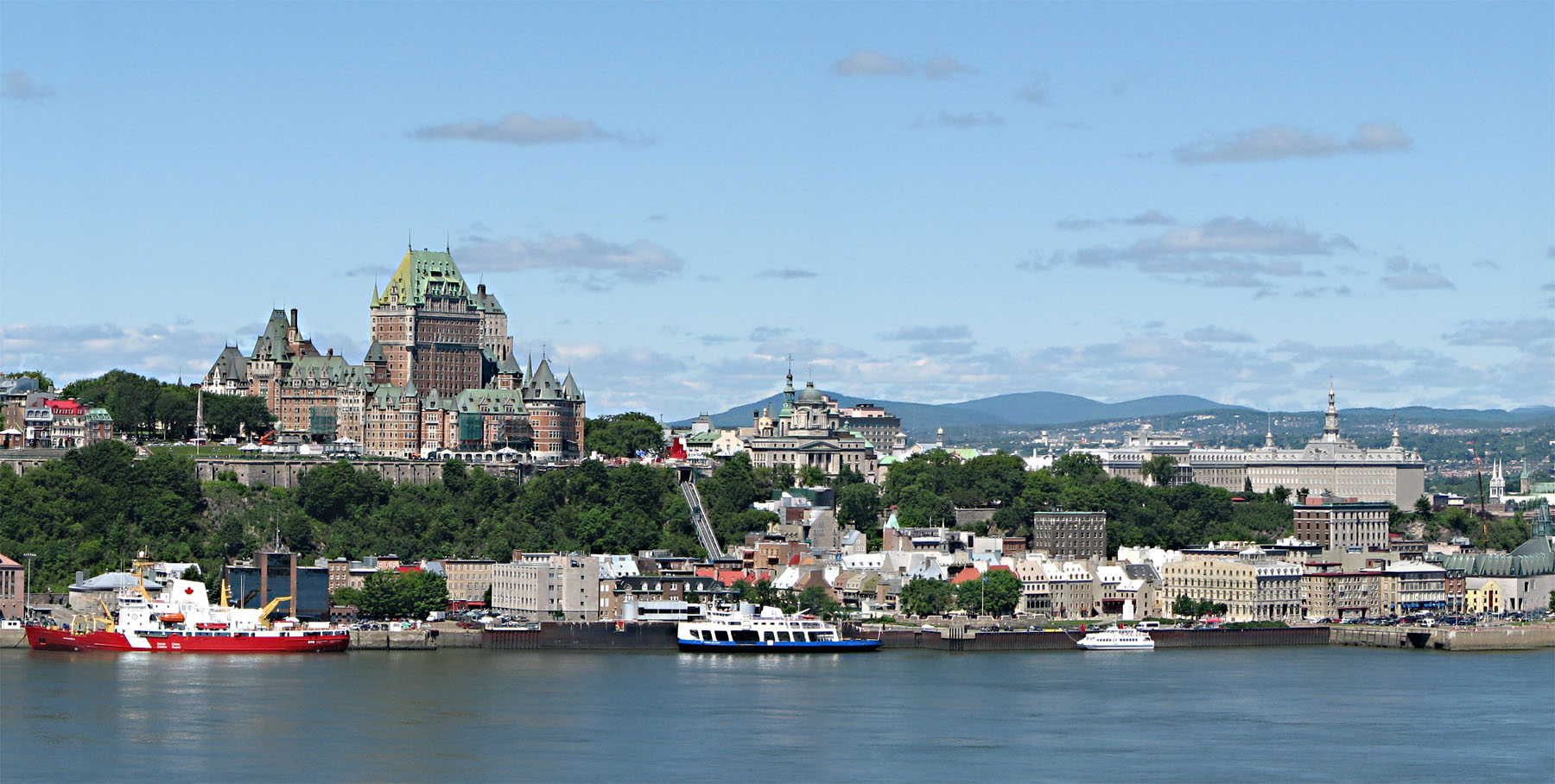
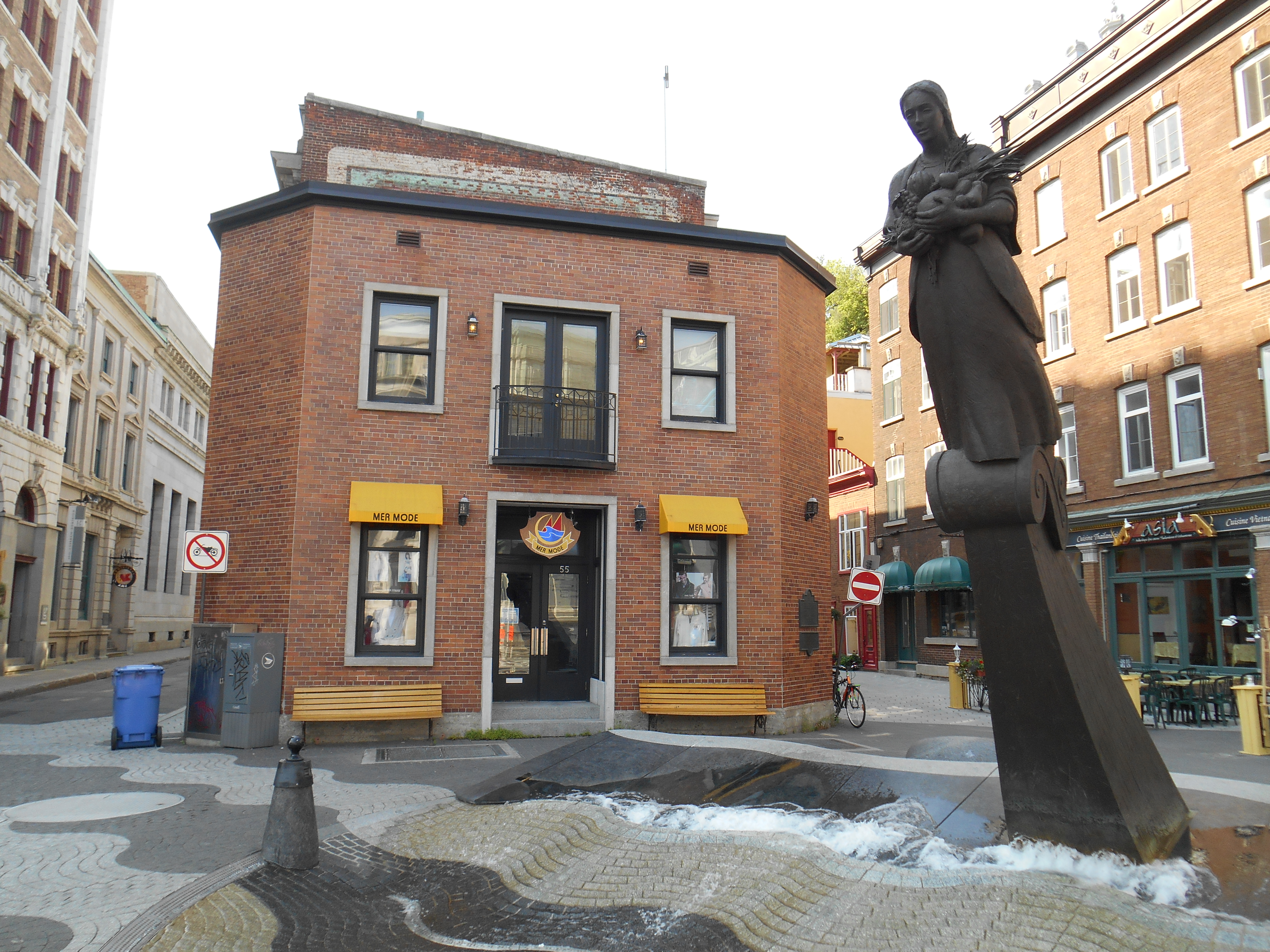
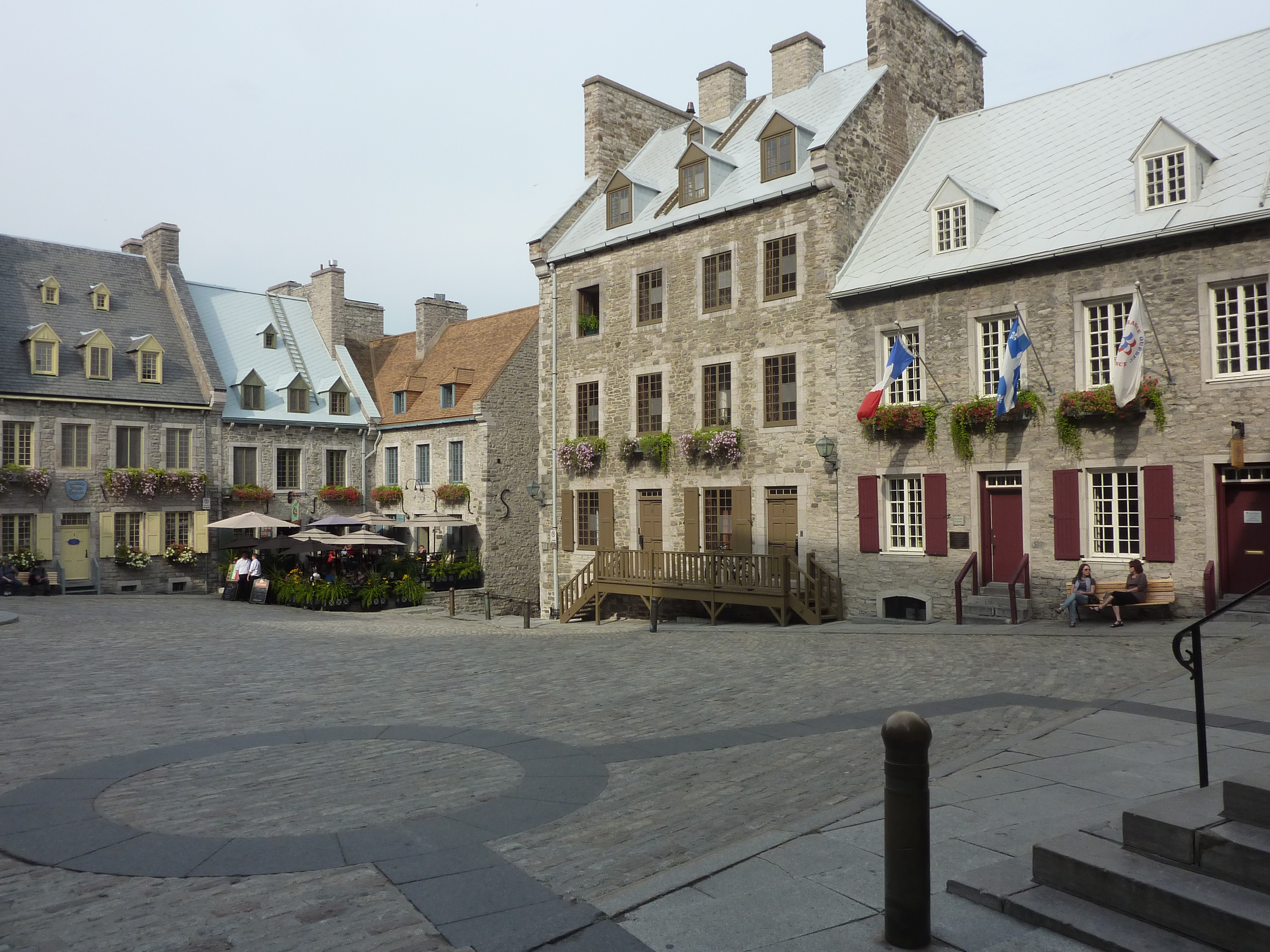
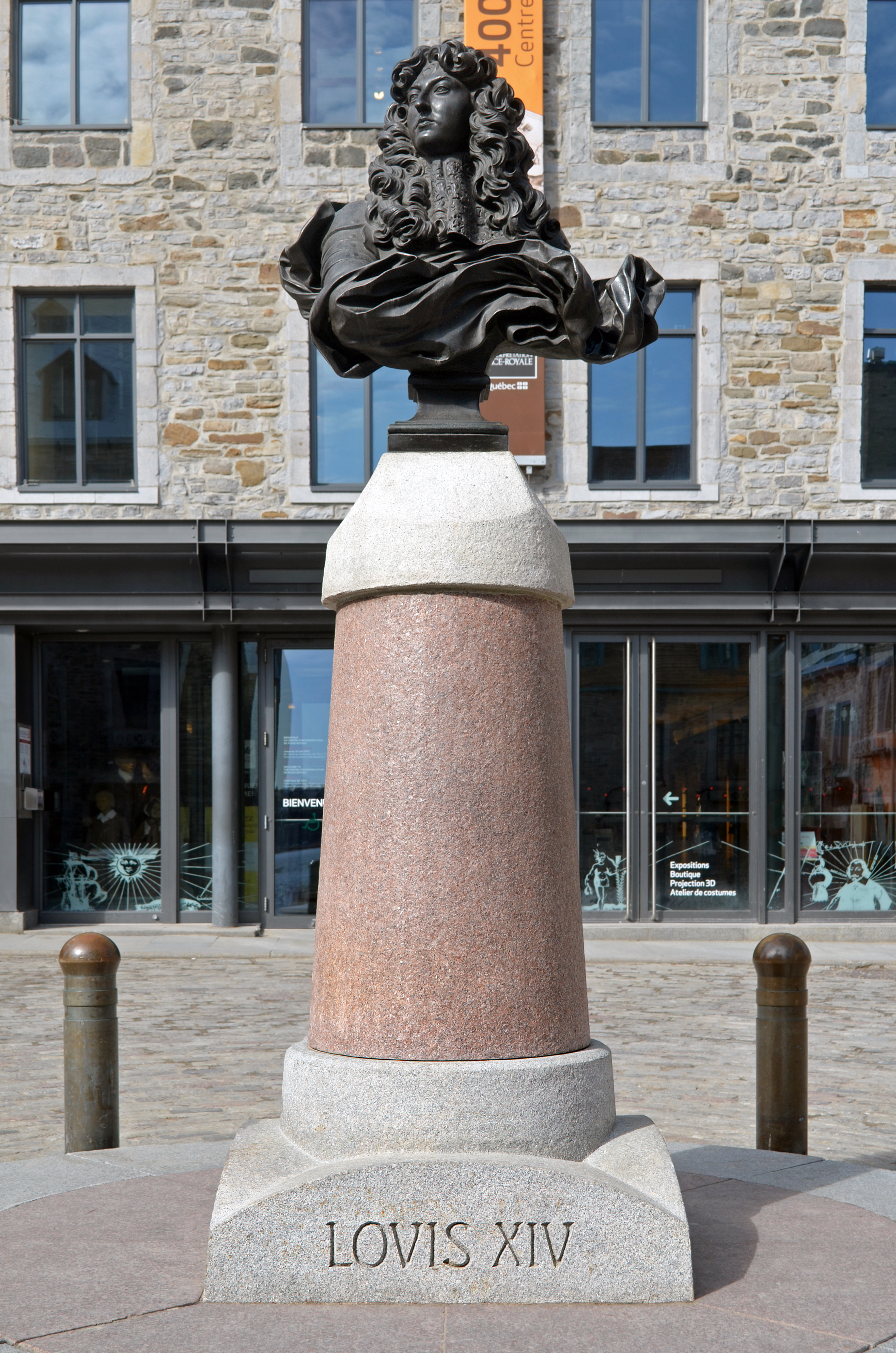
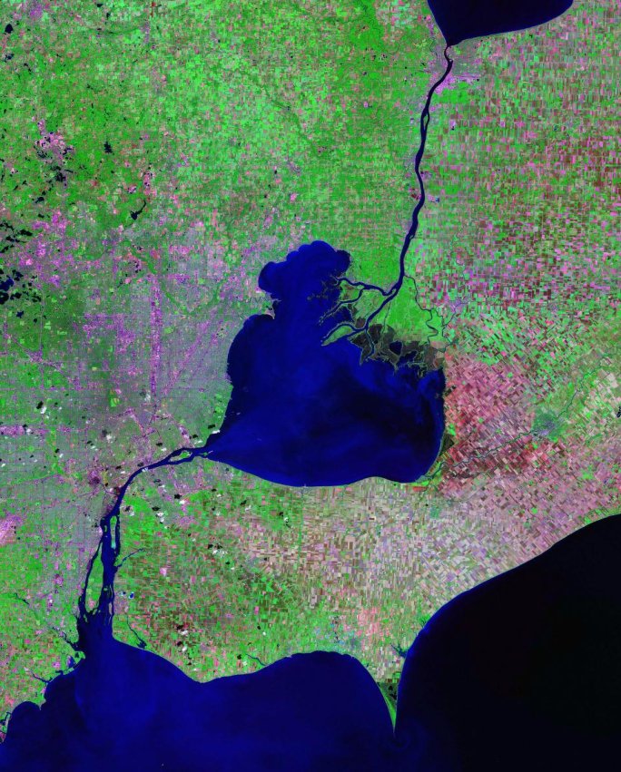
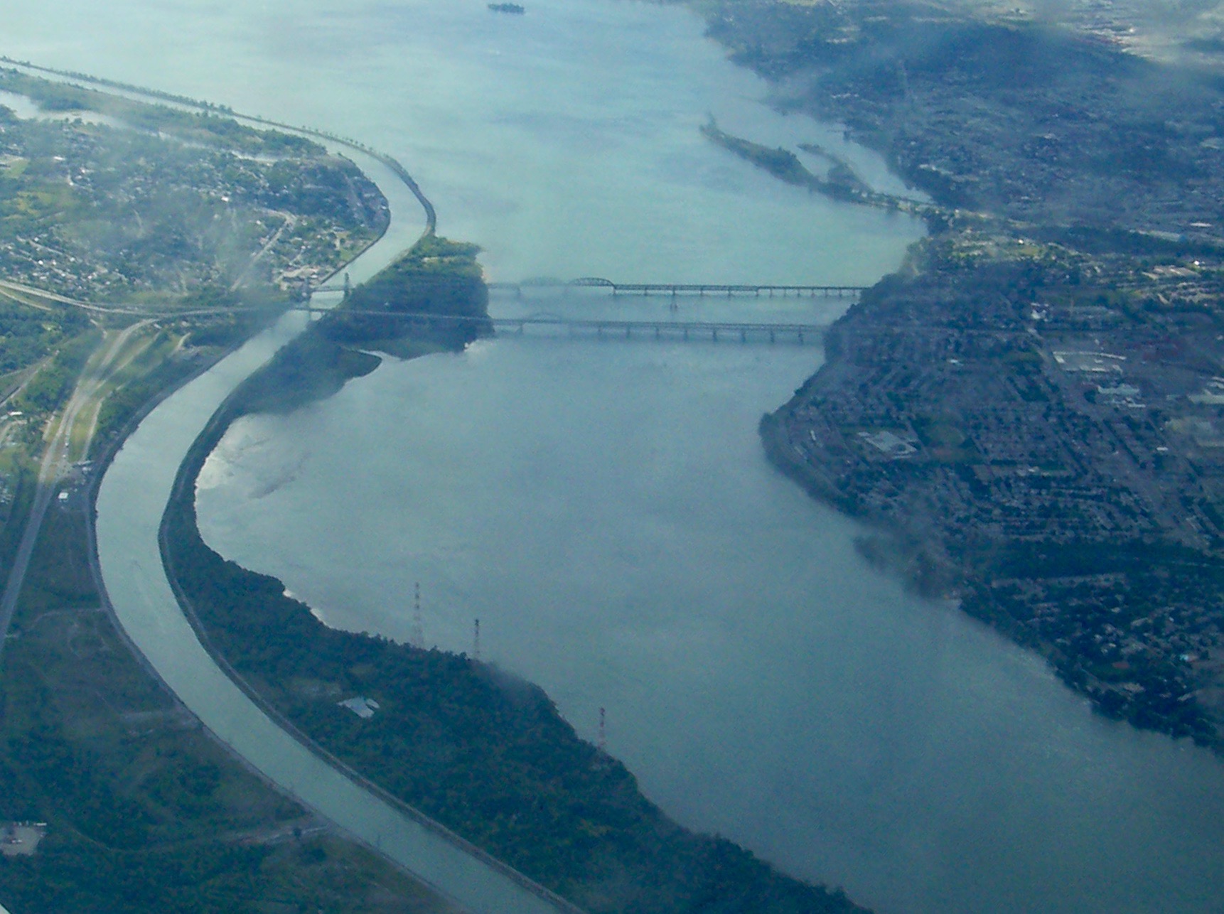
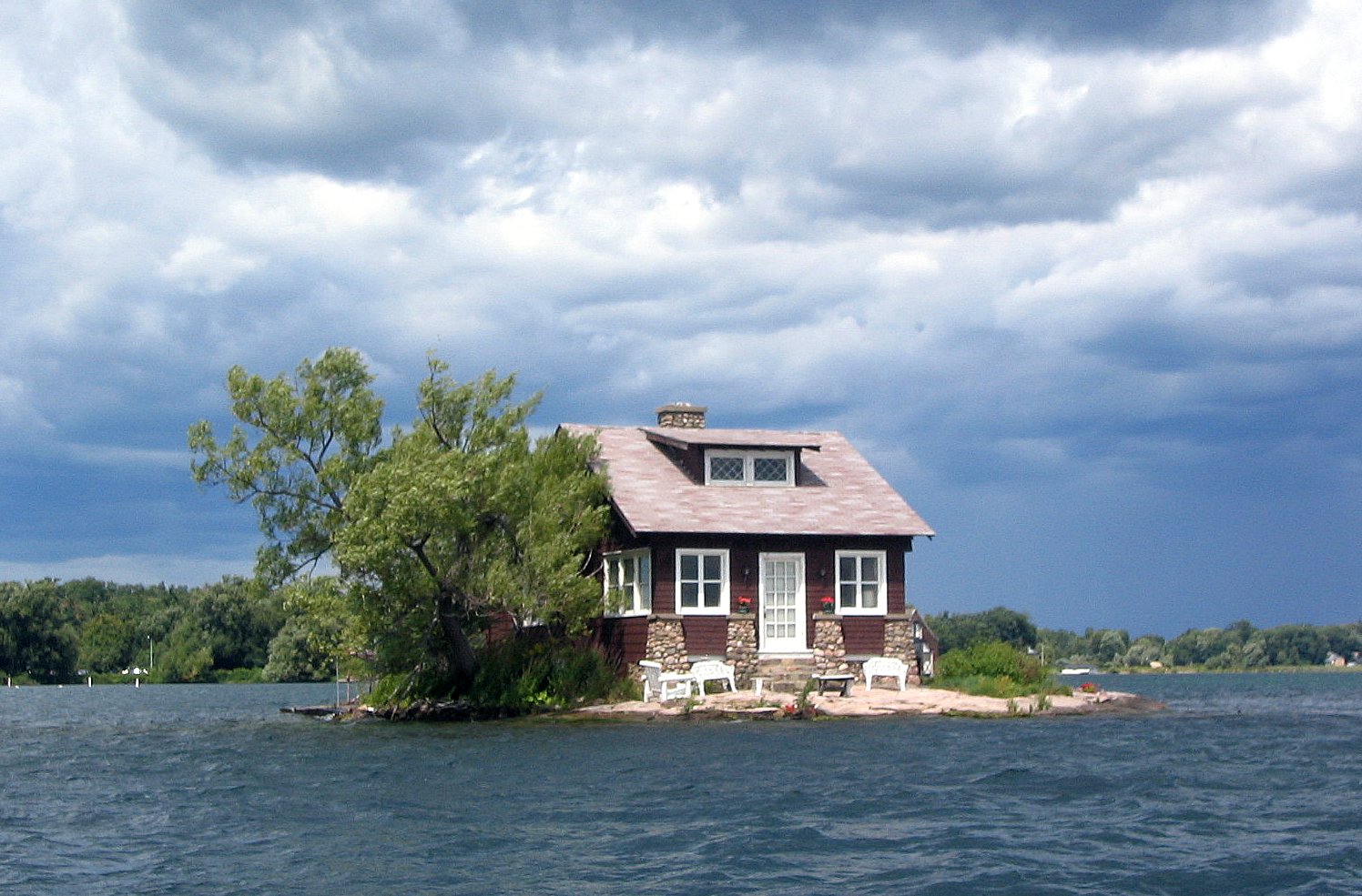
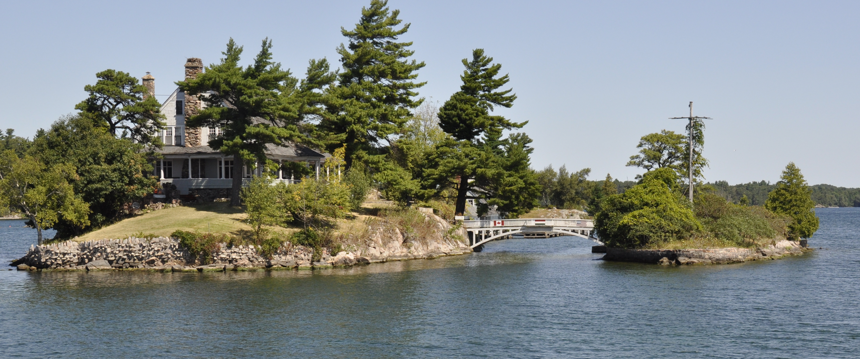