|
Reflections 2019
Series 5
May 8
Ohio River IV: OTR III: Revival & Renaissance–Bock Beer, Einbeck, Ilmebahn-Underground RR
| | Revival & Renaissance of Over the Rhine In the early 21C Cincinnati decided all this had gone on long enough, and such a depressed neighborhood was not only hurting itself, but also the adjacent CBD and all of Cincinnati. OTR has since been undergoing intense gentrification, and the Gateway Quarter in particular, being so close to the CBD, has become the trendiest spot in Cincinnati, with bars, restaurants, and high-end condos being developed in what had been the run-down and often-vacant buildings.
| | | | The neighborhood went from the D&D of the last posting, the Decline & Devastation, to an R&R, a Revival & Renaissance. The transformation happened very quickly, primarily over the last decade, and was done very precisely, from deciding on ground-floor businesses to putting trees in the park. It was not done by government. It was done by a single, corporate-funded entity that was freed from municipal politics. It was called the Cincinnati Center City Development Corporation, with the eye-catching acronym/initialism 3CDC. It invested or leveraged over a half billion dollars into OTR. It bought and rescued 131 historic buildings and built 48 new ones. It maintained subsidized housing, rehabilitated parks, and drove out criminals with cameras, with better lighting, by closing liquor stores, and by developing vacant lots. | | | | The historic district covers 146 hectares (362 acres), which makes it one of the largest, most intact 19C urban historic districts in the US (some say it's the largest, but Savannah GA contests that). It's believed to contain the largest contiguous grouping in the US of 19C Italianate architecture. It is also rich in German Revival buildings. While most American historic districts were so designated because of their impressive collections of mansions, OTR is significant for just the opposite reason—it was a working-class immigrant neighborhood. Back in the day, wealthy beer barons lived across the street from their breweries and adjacent to their workers. It's believed that OTR contains more intact 19C brewery buildings than in any other city in the US. | | | | The streetscapes are full of tenements storefronts, churches, theaters, and social halls that hark back from when they were peopled with working class immigrants in the 19C. OTR contains its iconic, brick Music Hall (see below), which was the first large concert hall in the US, the first German Methodist Church, and the first German Turnhalle (public gym) in the US. Among the many notable figures who lived in OTR are two whose stories are influenced by the former slave states across the Ohio River: Harriet Beecher Stowe lived in OTR before she wrote Uncle Tom's Cabin, as did Levi Coffin, a Quaker, abolitionist, businessman, and humanitarian, and active leader in the Underground Railroad who was given the nickname "President of the Underground Railroad". It's estimated that some 3,000 fugitive slaves passed through his care. | | | | Today, just a decade after OTR was declared the worst neighborhood, there are lines at lunchtime out of restaurants and condos going for a half-million dollars, with the large majority of buyers being 35 or younger. Office rents are about the same as in the adjacent CBD. Washington Park, in front of the Music Hall, has $47 million of new amenities. While the Brewery District to the north has progressed more slowly—and also had less displacement of former residents through gentrification—craft breweries have reopened in some long-abandoned brewery complexes. The stirring revival of Over the Rhine has to be considered a renaissance.
https://redpawtechnologies.com/downloads/2014/12/CincinnatiCBD_v1-01-1140x872.jpg
http://www.atlasdigitalmaps.com/media/catalog/product/cache/1/image/9df78eab33525d08d6e5fb8d27136e95/m/i/mimcincinnaticsmain.png
| | | | My OTR Route When we described the bus tour we took that morning in Cincinnati, I purposely left out the part of the route through OTR, so that we can fill it in now. The two maps we used are repeated above. The first "beige" map (click) shows best the downtown central business district (CBD) with OTR starting beyond the L-shaped Central Parkway, the former canal. It shows the near part of OTR, now called the Gateway Quarter, and how close Washington Park and the Cincinnati Music Hall are to the CBD. But it shows little north of Liberty Street, the traditional divider of OTR. The second "gray" map (click) is a little "busier" as it shows the same, but it also shows OTR beyond Liberty Street, the area now called the Brewery District. It you can find Elder Street crossing Pleasant between Elm and Race, that's the location of the Findlay Market, a prime destination, and beautifully revived. We can also show the precise outline of the OTR Historic District (Map by Wholtone), which is arguably the largest and most intact urban historic district in the US. You see (click) its two sub-areas divided by Liberty Street, and understand how it formed in its serpentine shape between the canal to the west and low hills to the east.
| | | | Knowing what I know now, I wish I'd had more time to see OTR and walk around a little--perhaps another time. In 1998 I had personally seen the decline, but then, too, was unprepared as to which streets I should drive down. Similarly this time, I can only estimate our route—but there are few major north-south streets in OTR. I know we saw the Procter & Gamble building (beige map) and then might have zigzagged or way up a main street, most likely Vine, to the area of Findlay Market (Elder). We did a small loop north of that, but then came down Elm—I'm sure—became we stopped to look at Washington Park to our right, with the Music Hall beyond. I remember the guide saying that not that that much earlier, you would have avoided that beautiful park because it would have been infested with drug dealers. It's been upgraded, as has the Music Hall. We then reentered the CBD to continue to Covington. | | | | But we need to speak more generally, and nothing will make the point better than this before-and-after view of buildings on the west side of a major route (see gray map) such as Vine Street, just north of 14th (Photo by Wholetone). Examine the sorry state of the four buildings in the left view. The low one on the left has a beautiful mansard roof, and the one on the right has an impressive Italianate copper cornice, so typical of buildings of its period. Otherwise we see empty, or boarded-up, windows and doors. The view on the right is the same (unfortunately in winter, but don't be distracted by the snow). The buildings were coming to life again when this image was posted in 2013, so you can imagine how they look today. | | | | | | Actually, that's wrong. You can do what I just did. I googled that intersection then changed to Street View, and I got an image dated May 2018, of how nice the buildings look. The commercial space of the mansard building now contains "Parvis Lofts", with a banner above saying "Condos Available". The same banner is above the building two doors to the right, so it seemed at that point that several buildings have been consolidated to become a condominium.
And it gets better, much better. It's incredible what you can do with the internet nowadays. I searched the commercial name, and found the full name is Parvis Lofts on Vine. I don't normally report on commercial ventures, but the whole point here is how modern commerce is transforming OTR. There's a flood of information. This was 3CDC's first market-rate apartment project in OTR, which responded to a growing need. The project involved some 9-10 19C and early 20C buildings along this block, from #s 1401-1423. They'd sat vacant for between 5 and 20 years, deteriorating. They first had to be stabilized to make sure they were structurally safe for renovation. They were then interconnected and renovated into 32 modern apartments, including a lobby and 10 commercial spaces. (It seems so 19C to be living "above the store"!) Behind the row of buildings is a "community courtyard". Each unit is different, and they vary from a studio to a three-bedroom townhouse. While they were built as rental units, the demand was so great that they were converted into condos. I saw an ad for a one-bedroom, one-bath unit priced at $178,500, and a two-bedroom, one-bath unit for $294,000. There's even a YouTube commercial video (2:20) for Parvis Lofts on Vine. This is OTR today.
|
| | | | To further indicate the progress that's been achieved, I'll mention a site I've found that has a 2016 article that lists "The 13 hottest neighborhoods for shopping around the US", and OTR is one of them. It points out that its "streets are lined with beautiful houses and old-school architecture. It's also home to craft breweries and unique eateries, which even caught the attention of [restaurateur and TV host] Guy Fieri, who featured the local gem Taste of Belgium on his show . . ." | | | | Street Names But it's not only the spectacular renovation that's impressive. It's also a matter of restoring the signs of discrimination that appeared during the WWI hysteria. And we can start with the street names that were changed en masse during the hysteria. They're being brought back, not totally, but in a way that will make them stand out that will memorialize the earlier discrimination. I understand an Ohio historical marker has been put up on the south side of Findlay Market, one side of which reads: The United States' declaration of war on Germany in April 1917 resulted in a tragic display of hysteria directed against everything and anything German. In Cincinnati, German teachers were dismissed from public schools, German professors were censored, German collections and publications were removed from circulation at the Public Library, businesses with German names had their names "Americanized" and, by police order, only English language public meetings could be held. The other side involves the street-name changes and is below--read it yourself:
http://96bda424cfcc34d9dd1a-0a7f10f87519dba22d2dbc6233a731e5.r41.cf2.rackcdn.com/overtherhinechamber/otr-historic-signs/422/422_gallery.jpg
| | | | In late 2017, the City Council decided to remedy the situation in time for the centenary of the original change in April 1918. This is how it worked out. In my earlier listing of the original changes during the hysteria (2019/3) I listed the streets in three groups, as follows. | | | | The first three original changes were unusual situations. They'd been altered thus: | | | | | | German St to English St, OTR
Bismarck St to Montreal St, OTR
Humboldt St to W H Taft Rd, Walnut Hills
| The first two couldn't be changed back because they no longer exist. They were absorbed into other routes because of widening projects.
On the gray map, just east of Jackson Hill Park is the William Howard Taft National Historic Site, where the 27th president was born (we visited it in 1998). Just north of that is W H Taft Road, whose name was not changed back. I'd imagine they wanted to keep the name of a local celebrity, even at the expense of scientist Alexander von Humboldt (2015/16), though that's just speculation.
|
| | | | The second three changes were the only ones that reverted back to their German names in their entirety: | | | | | | Hamburg St / Stonewall St, OTR
Hanover St / Yukon St, OTR
Berlin St / Woodrow St, Price Hill
| These are small streets, and didn't involve many address changes. Only one, Yukon, has a residence, whose owner supported the name change. |
| | | | The third group of seven streets will not have their names changed back. Instead, they will be co-named with their traditional German names, which will hang below as honorary designations | | | | | | Bremen St / Republic St, OTR
Frankfort St / Connecticut Av, College Hill
Vienna St / Panama St, California
Hapsburg St / Merrimac St, Walnut Hills
Brunswick St / Edgecliff Point, Walnut Hills
Wilhelm St / Orion Av, Pleasant Ridge
Schumann St / Beredith Place, Pleasant Ridge
|
| | | | Co-naming is so late-20C-21C. The most recent example we had was the co-naming of two blocks of W84th Street in NYC in honor of Edgar Allan Poe, since he'd lived and worked there. There is one advantage to co-naming in OTR. If they'd been changed back, in the future it wouldn't have been obvious that the hysteria had changed them in the first place, but with co-naming, everyone can get curious as to what it had all been about.
http://mediad.publicbroadcasting.net/p/wvxu/files/styles/medium/public/201709/GermanStreets1.jpg
| | | | At the renaming ceremony, present were city leaders, a representative from Germany, and the descendants of German immigrants to celebrate the righting of an old injustice. In the above picture, you can see that a street getting its name back, such as Hanover, will get a gray sign, while a co-named street, such as Bremen, will get a blue sign, typical of German street signs.
http://static.squarespace.com/static/5186d347e4b065e39b45c644/t/51fdc400e4b062260ffeec15/1375585637727/OTR+wayfinding+map+jun+26+12.png
| | | | Gateway Quarter First let's take a look at the southern part of OTR, the Gateway Quarter, called that since it serves as the entrance from the CBD—note at the bottom where it says it's just five blocks to Fountain Square (at Vine and 5th). The purpose of the above map (click) is entirely commercial, with the key to businesses at the bottom. If you look at Vine and the zigzagging 14th Street, you'll find the Parvis Lofts we just discussed. | | | | I've chosen the most attractive restored buildings that I could find to illustrate both the renaissance in general and the architectural styles in particular, and using the commercial names on this map, I've been able to confirm their location. On the map, find several orange buildings ("shops") on Vine at the corner of 12th. This is how these buildings on Vine at 12th look today (Photo by Wholtone). Look at the spectacular copper Italianate cornices unifying the buildings on 12th to the left, as well as the bay windows for each apartment. Of the buildings on Vine at the right, two are also unified by a cornice, so typical of the late 19C, early 20C. Click to inspect details, and you'll see something I've never seen before. Attic windows peer out from the length of the cornices. Another photographer (click) chose to showcase just the buildings on Vine (Photo by Niagara66). | | | | Buildings such as these are called vernacular buildings. Just like everyday language can be called "vernacular", that term is also used in architecture. These are buildings with residences above shops, which is a tradition going way back. True, it isn't the baker's family living above the bakery—the apartments wouldn't have anything to do with the shops. But living downtown like this with residential and commerce combined is returning to roots—big way. | | | | | | Here's a dictionary definition of VERNACULAR: Of or being an indigenous building style using local materials and traditional methods of construction and ornament, especially as distinguished from academic or historical architectural styles. |
| | | | On our commercial map, find the intersection of Clay and 13th Streets. Google maps shows that the following building whose caption describes it at that location is on the northeast corner (in green). It's described by the photographer as an Italianate greystone building with decorative cornices (Photo by Wholtone), and so it is. Click to admire this façade on 14th Street, and do note the attic windows once again in the cornice. Google street view shows, however, that only the upper floors are in greystone, while the shop on the ground floor (a bakery) has its windows surrounded by classic square white columns. As a corner building, it's a little odd that the perpendicular façade on Clay is made of red brick instead. | | | | Germania Building I now call your attention to a building in OTR I made reference to in the last posting when we discussed the name Germania, as well as the goddess with that name that symbolizes Germany, comparable to Britannia for the UK and Columbia for the US. | | | | In 1877, a beautiful four-story German Renaissance Revival building went up in OTR, built by an immigrant named Rattermann. Constructed in gray limestone, its surface was cut in intricate detail. But most notable was a large statue of Germania filling a large niche set in the façade in the first floor above street level. An article in the Cincinnati Enquirer dated 18 July 2014 pointed out that because of the statue, "even in a German part of town, Over-the-Rhine, this building was extraordinarily Teutonic." Because of the statue, the building was (and still is) referred to as the Germania Building, even though it actually bore the lengthy German name of an insurance company, which—notably--was written in stone in large letters, up high under the arched cornice of the building. The lengthy name was the Deutsche Gegenseitige Versicherungs Gesellschaft von Cincinnati (German Mutual Insurance Company of Cincinnati) written thus to fit better, though in practice, Versicherungsgesellschaft (Insurance Company) is written as one word. | | | | Lovely as this building was, it will come as no surprise that it was a major target during the WWI hysteria, and in my mind, is the perfect example of the idiocy of those days. (I've not personally seen the building, but Google Street View does wonders.) Two things happened at that time. As tragically amusing as it may seem today, Germania was renamed Columbia, presumably to "Americanize" her. Not only that, "E pluribus unum", considered at the time the motto of the United States, was chiseled into the hem of her robe! | | | | The other change was that the insurance company translated its name into English (as above), since that was better for business, with fewer questions asked. But along with that, the large German inscription at the top of the building was covered over with boards so that no one should have to look at the German language. It remained covered for a full century. | | | | The insurance company is long gone, and others use the building today. But in the spirit of revival and redemption, when the couple who's owned the building in recent years was told about its history, they readily agreed to uncover the name, and a basket crane rose up to the top of the building to take down the boards and reveal the original name, even though that company is no longer there. | | | | The Cincinnati Enquirer article concluded, rather poignantly and symbolically: And one block away, on 13th and Walnut, a century of wind and sun was beginning to uncover even more history. The paint over a boarded business has faded enough now that the name underneath that paint is beginning to emerge. It's in German, too.
http://s3.amazonaws.com/everystockphoto/fspid20/90/40/22/cincinnati-904022-h.jpg
| | | | On our commercial map, find 12th & Walnut. The shop in orange labeled Eden Floral is the present ground-floor occupant of the Germania Building, whose façade faces Walnut. The above picture shows this view on the corner, but before restoration. You can see Germania, and up top, the covered inscription. This is the only full-length view of the building I could find, but here's a detail of the middle façade (click to inspect the architectural detail), and here's a detail of Germania herself (Both Photos by Wholtone). While the pigeons have not been friendly to her, we see Germania with E Pluribus Unum carved into the hem of her robe (click), making her a pseudo-Columbia. Apparently a US shield is on her side, but I know nothing about it.
https://visualingual.files.wordpress.com/2008/09/germania2.jpg?w=450
https://farm5.static.flickr.com/4383/35629633353_58d634e5f4_b.jpg
| | | | Looking up high to the arched cornice, we see up close in the first picture above, covering the inscription, the boards that served as a pigeon roost for a century. And the second picture shows the symbolic redemption of the German language in Over the Rhine. | | | | Another thought comes to mind here. In the last posting, a scholar pointed out that the symbolic use of Yiddish today is more significant than the practical use of that language. The above sign brought to light is in the same position. The present revealing of it is purely symbolic, since in practice, it no longer serves any commercial function—not even as the name of the building, since Germania has taken that over. | | | | | | I've been teased in the past about my emphasis on pronunciation, though those who tease aren't realizing that language is spoken, and that the written form is meant to merely be a reflection of that (and an often inadequate one, at that). So I persist.
In that German inscription, when you reach the last word, you're probably going to need to say tsin.tsi.NA.ti, since that's the way it would have been said at the time, and is probably how most Germans would say it today. The issue is the TS sound, commonly spelled Z today in German, though historically C was possible. However, many names with C were purposely respelled with Z (Cigarette became Zigarette, both pronounced with TS. An exception is the city of Celle, still spelled that way, though a biological cell is spelled Zelle). At one time, the German spelling was actually Zinzinnati, though today, that's considered antiquated, and the English spelling is used.
My view is this. Even English-speaking Germans who try to pronounce Cincinnati in a German sentence with an S both times will find it awkward to do so, and it will tend to slip to a TS both times since that fits German phonology better.
|
| | | | Music Hall & Washington Park Continuing to look around the Gateway Quarter on our commercial map, we see it's only a few blocks to the Cincinnati Music Hall across Washington Park. Coming south on Race Street and making a stop, our tour bus got a beautiful view as follows across the refurbished Park to the renovated Music Hall (Photo by Fred Haaser). It's a classical music performance hall completed in 1878, serving as the home for the Cincinnati Symphony Orchestra, Cincinnati Ballet, Cincinnati Opera, and the Cincinnati Pops Orchestra. It's been recognized as a National Historic Landmark for its distinctive Venetian Gothic architecture (click). In 2019/3, I quoted friend Leslie about her memories of OTR, since she went some years ago to graduate school at Cincinnati College-Conservatory of Music nearby. She added: I do remember with fondness the Music Hall. I went to orchestra and choral concerts plus opera there. All professional events in a glorious and old venue! Here's a more distant, ensemble view across the park (Photo by Larsonj3).
| | | | Restaurants & Hotels Google Maps shows a large number of taverns and restaurants having blossomed forth in OTR, with heavy concentrations on some main north-south streets (see map). Krueger's Tavern on Vine north of 12th has not only a ground floor, but boasts rooftop seating under awnings. Many venues seem to find it more than worthwhile to include the letters OTR in their name, such as Bakersfield OTR next to Krueger's, The Eagle OTR in the next block north, The Mercer OTR (ditto), and A Taste of Belgium OTR, mentioned above and identifiable on the map in red on Vine & 12th. | | | | But when I checked on hotels, I found something else quite interesting. Online hotel results give you the chain hotels in the CBD, none of which are in OTR. But in fairness, those hotels are in the area of 4-5-6th Streets, which is steps away from OTR streets such as 12-13-14, so, no harm, no foul.
http://media.yellowbot.com/r/650x500/photos/gAYb-3WbCcc_o--/symphony-hotel-restaurant-cincinnati-oh.jpg
http://static.trip101.com/paragraph_media/pictures/000/142/976/large/Symphony_Hotel_front_door.JPG?1493959864
https://s3-media4.fl.yelpcdn.com/bphoto/7sLUw4umZ4cJdsJsdlknOQ/o.jpg
| | | | But there was one pleasant surprise. On the map, look just across 14th Street from the Music Hall and you'll see in green the aptly named Symphony Hotel (first picture above), which gets its theme from the Music Hall. Its luxury status is amazing, given the recent history of OTR. It's a boutique hotel and luxury restaurant in an 1871 restored townhouse (entry above in second picture). The rooms are named after Mozart, Mahler, Beethoven, Bach, Rachmaninoff, Brahms, Beech, Schubert and Copland (I have absolutely no idea, and have not been able to find out, who Beech is, possibly a local composer). The hotel offers five course pre-concert dining in its "Historic Dining Room" (third picture). What a step up for OTR. | | | | Brewery District We now move to the upper part of OTR, the Brewery District. Though it has less cachet than the Gateway Quarter because of its more industrial past, its inhabitants have been taking advantage of that past to serve its future.
http://www.urbancincy.com/wp-content/uploads/2010/05/Cincinnati-Brewery-District-Map.jpg
| | | | This is a map of the Brewery District, which as we know, lies north of Liberty Street. It shows the remaining brewery structures after the woes of the hysteria, but primarily after what Prohibition in 1919 did to the industry, driving them out of business. Some were able to reopen in 1933. So did a few new ones, but the market had changed and national breweries like Anheuser Busch and Miller sped their decline. In 1950, the Red Top Brewing Company was the 14th largest in the US, but by 1957, it had gone out of business and closed the last operating brewery in OTR. Over time, most brewery buildings were either torn down or left to go to ruin. Nevertheless, about 47 buildings from 14 different breweries still remain in OTR and the adjoining West End (to the west) today. Findlay Market is in the (unnamed) oval north of Liberty. | | | | Residents and business owners formed www.otrbrewerydistrict.org in 2003. Bonding over beer and a shared vision, its members recognized the unique history of this often ignored portion of Over-the-Rhine and wanted to bring awareness of the District by means of tours and events.
http://www.otrbrewerydistrict.org/files/BreweryDistrictUrbanPlanLARGE.jpg
This is a planning map they put out dated 2006 (click). The Findlay Market area in purple is a centerpiece, and Brewery heritage sites are in red. It looks like they were considering renaming, or co-naming, part of McMiken Street "Brewer's Boulevard", but I don't know how much of this actually came about in the last decade. The purpose in showing it is to indicate the enthusiasm involved.
| | | | We've heard in the past about the Christian Moerlein Brewing Company, private beer company that began production in 1853 by German immigrant Christian Moerlein. Up until it closed in 1919 as result of prohibition, Christian Moerlein was among the ten largest American breweries by volume. In 1981, the brand was revived as an early representative of craft beer, and is considered a pioneer craft beer in that movement. In 2004 a Cincinnati resident purchased Christian Moerlein as well as an incredible 65 other historic Cincinnati brands, returning local ownership to Cincinnati in an attempt to revive Cincinnati's brewing traditions. In 2010 the site of the pre-prohibition John Kauffman brewery's malt house and underground lager cellars was obtained. The first beer brewed in the new location was the Christian Moerlein Arnold's 1861 Porter. | | | | Another popular craft brewery name heard today in OTR is Rhinegeist, whose taproom and production facility occupy one of the former buildings of Christian Moerlein Brewing Company, its bottling plant. The German word Geist, which is related to "ghost", is best rendered quite similarly as "spirit". At first I wondered why they used the English spelling "Rhine" rather than calling it *Rheingeist / "Rhine Sprit", or "Spirit of the Rhine". Then I realized that they weren't talking about the Rhine River at all. The name makes a lot more sense when you realize that Rhinegeist means "[Over-the-] Rhine Spirit", giving homage instead to the neighborhood. It also plays off the German word Zeitgeist, used in English. It's literally the "time spirit", or more freely, the "spirit of the age", which is equally appropriate. I'll add that Yelp lists the best OTR breweries as Rhinegeist, Christian Moerlein Brewing, and Taft's Ale House. | | | | This is the main building of the former Christian Moerlein Brewing Company. Notice the name written in the arch at the top, similar to the Germania Building. This is the present entrance to one of the former Moerlein buildings, presumably the bottling plant (Photo by Warren LeMay), since you can see Rhinegeist is the present inhabitant. Click to see that this is the entrance to the taproom and rooftop, and how Rhinegeist uses the nickname for Cincinnati, Cincy. However, I think using the skull to represent the Geist/Spirit is a bit creepy. | | | | It seems that many remaining brewery buildings have been recycled in various ways, but the interesting architecture remains. This was the former Hudepohl Brewery Bottling Plant. Click to read the dates at the top of 1885-1911. This was the former Clyffside Brewery, Sohn Building (Both Photos by Warren LeMay). Click to see the fine brickwork, the date of 1887, and the Star of David at the top. I don't know the story behind that. | | | | The above Brewery District promotional organization attempts to bring awareness through events such as the Bockfest (see below; the Oktoberfest is promoted by the City) and the deliciously named Prohibition Resistance Tour. Their website explains: We regularly give tours of our historic Over-the-Rhine neighborhood, including the pre-Prohibition breweries, lagering cellars, and tunnels unique to the Brewery District. From the first tour in 2006, tens of thousands of people have experienced Cincinnati's brewing heritage above and below ground. . . . [T]hese tours are now given twice a year at Bockfest in the spring (first weekend in March) and at Oktoberfest in the fall ([third weekend in] September) along with walking tours on Summer weekends. These various tours are 1 1/2 to 2 1/2 hours long and visit two or three historic pre-Prohibition breweries, including long abandoned lagering cellars and tunnels 30-40 feet [9-12 m] below ground. | | | | Findlay Market Perhaps the most attractive part of the Brewery District is Findlay Market, which our bus tour did visit (Photo by Lanskeith17). It's not only the market itself, but the beautifully restored buildings around it that are so attractive. The market was founded in 1852, and is Ohio's oldest continuously operated public market. It's the last market remaining of the nine public markets that once served Cincinnati, and the market building is listed on the National Register of Historic Places. The below view looks east from Elm Street.
http://wwww.findlaymarket.org/assets/merchant-header-images/365_Winner-a21df75144cfcbe27dfc95cf49173821.jpg
| | | | Such public markets are similar to others in the US and Europe going back at least to the 19C if not beyond. Second-, third-, and fourth-generation German-Americans still operate fruit, vegetable, and meat stands on market days, and the market remains one of the most colorful and vital elements of OTR.
https://i.pinimg.com/originals/2c/26/19/2c2619ef4f587e1f096c68354fbf5444.jpg
| | | | This somewhat touristy map shows what's available at Findlay Market. It also shows how the market interrupts Elder Street between Elm and Race, and how the south side is, perhaps unofficially, called Essen-Straße or Food Street.
https://maps.googleapis.com/maps/api/staticmap?size=602x258&zoom=16&markers=1801+Race+St.++Cincinnati%2C+Ohio+45202&key=AIzaSyAHV6jjzGF3JVVxs4WMAQ6u_cMf85a3rUc
| | | | This shows a larger area around Findlay Market (Race Street to its east is not named here). The factory and showrooms of the famous Rookwood Pottery (discussed earlier) are located on Race at the top of this map 1½ blocks north of Findlay Street. The Lager House and Tap Room of the Christian Moerlein Brewery is shown on the diagonal Moore Street (also not named here) near McMicken. This is where the annual Bockfest parade ends each March. Finally, we have one more picture of the restored vernacular buildings at Findlay Market, here on the north side looking west to Elm (Photo by Wholtone). | | | | Cincinnati Streetcar Rail is coming back in so many places; sometimes suburban commuter lines are reactivated, sometimes new streetcar lines are built. And corresponding to the renaissance of OTR, Cincinnati has built a new streetcar line. It was first called simply the Cincinnati Streetcar, which is the name I'll stick with. However, we live in a period of crass decision-making. So often, instead of awarding names freely to admired people or things, naming rights are sold for hard cash, and admiration has nothing to do with it. To help finance the line, naming rights to it were sold to the local phone company, which cashed in on that. Hence the below map calls it by its official name, the Cincinnati Bell Connector.
http://mediad.publicbroadcasting.net/p/wvxu/files/styles/x_large/public/201609/connectormap.jpg
| | | | | | For a similar example in NYC that irks me, we can cite Broadway Theaters. In addition to those with elegant names, such as the Winter Garden and the New Amsterdam, and in addition to those named after admired theater folk, such as the Ethel Barrymore, Neil Simon, and Helen Hayes Theaters, when the City and State (happily) took over the dilapidated Selwyn Theater in 1997 and renovated it as part of the renovation of 42nd Street, it was renamed after a principal sponsor of the renovation (money!) and is today the American Airlines Theater, an over-commercial name that still makes me cringe. Ditto for the Cincinnati Streetcar. As for the same money-grubbing crassness happening to sports stadiums, you can work that one out on your own. |
| | | | The Cincinnati Streetcar (ahem!) opened to passengers in September 2016. Click on the map to see how it operates in a one-way loop of 5.8 km (3.6 mi) that is actually a "lazy figure 8". Find stop #1 at the bottom in the redeveloped riverside area now referred to as The Banks, which includes park areas, two stadiums, and the National Underground Railroad Freedom Center. In the CBD it uses Walnut and Main, passing Fountain Square, but when it connects with OTR, it switches to Race and Elm, passing Washington Park and the Music Hall in the Gateway Quarter, then continuing up to Findlay Market in the Brewery District. Future extensions have been proposed further north, to the University of Cincinnati and the Zoo, and south across the River to Northern Kentucky, both to Covington and to Newport, as the below map proposes (click).
https://farm2.staticflickr.com/1531/24124477329_ca26420800_h.jpg
| | | | On our bus tour, we saw the tracks and the streetcars making their way through town. This is one at Station 1 in The Banks (Photo by RickDikeman). | | | | With the coming of the streetcar there was one nice promotional event. The five different brewers that line the streetcar's route had each agreed to brew a new specialty beer to honor the delivery of the first five streetcars. I'll mention the three I particularly like. Rhinegeist went for rail history and called its beer "Traction". Taft's Ale House took the route of the pun and called its beer "Ryed the Rails". And the Christian Moerlein Lager House went the literary route and called its streetcar-themed beer—what else?—"Desire". | | | | | | I've just learned more about Taft's Ale House, which is a great story of recycling. On Race at 15th is the former Saint Paul's Evangelical Church, built by German immigrants in brick Greek Revival style, and which opened in 1850.
http://hgcconstruction.com/wp-content/uploads/2016/07/DLD0112.jpg
In 1950 the congregation moved to the suburbs (!), and after some other uses, title to the building reverted to the City, and it was vacant after 1993. In the summer of 2014, construction began to repurpose the building as Taft's Ale House, named in honor of the local boy, William Howard Taft, the 27th US president. It's a brewery and restaurant, including a large beer hall with communal tables.
http://static-15.sinclairstoryline.com/resources/media/c02e59a1-efcd-4c15-be53-36f05f895eab-DSmyth_20150401_Tafts_Ale_House_013_180243_1616.jpg?1446711719814
|
| | | | Oktoberfest Many places celebrate Oktoberfest in one way or another, but Cincinnati bills its Oktoberfest as the largest in the US.
http://mediad.publicbroadcasting.net/p/wvxu/files/styles/medium/public/201509/Oktoberfest_2015_Poster.jpg
As the above poster for the 2015 event shows, it likes to call itself America's Oktoberfest, and emphasizes that it takes place in Zinzinnati, USA, using the antiquated German spelling with Zs. That spelling alone should strike one as being as far in a positive direction as you can get from the anti-German hysteria of a century ago during WWI, to say nothing of the slightly corny, ultra-German images shown—remember during the hysteria, some bars wouldn't serve pretzels as being "too German".
| | | | Shorter than some other celebrations, particularly in Germany, it's just a weekend festival, taking place the third weekend in September, and has been doing so since 1976, attracting about a half-million visitors annually. Though it might at first seem odd that an Oktoberfest should fall entirely in September, do be aware that Oktoberfest in Munich, which runs for two weeks, always begins during the last week of September and runs into early October—hence the name. For that reason, it's also humorously referred to as a Septoberfest. | | | | For our purposes discussing OTR, note that this Oktoberfest is put on by the City, and doesn't take place in OTR, but downtown in the CBD. While the poster mentions 5th Street, once the new streetcar was laid down (see below), the celebration moved even closer to the river (and further from OTR) to 2nd & 3rd Streets between Walnut and Elm. Check our beige map to judge the location and note that the Interstate is submerged there in an open cut. | | | | I would leave this topic here except I do find one good reason to mention a cutesy-poo event that takes place each year, which is really "too much". You know that a dachshund is referred to sometimes as a wiener dog, a name alone that I already find as too cutesy. Well, apparently during Oktoberfest they have a dachshund race called the Running of the Wieners. To make it worse, competing dachshunds, to emphasize their "wiener" shape, each wear a tiny costume that looks like a hot-dog bun. | | | | This is how this year's event is described in current ads: The Running of the Wieners is the annual kickoff to Oktoberfest Zinzinnati! 100 dachshunds will race to be crowned the winning wiener at the Running of the Wieners, Friday, September 20, 2019. Each dachshund, outfitted in their provided hot dog bun costume, will run approximately 75 feet [23 m] in heats of ten to their owners at the opposite end. The winner of each heat will compete in a final race to determine the winning wiener dog! Prizes will be awarded to the 1st, 2nd, and 3rd place winners! The race takes place the Friday of Oktoberfest weekend on Freedom Way between Walnut and Rosa Parks in downtown Zinzinnati. This is the block—see beige map—equivalent to 1st Street in front of the Underground Railroad Museum. Are you ready for this picture?
http://img.gagdaily.com/uploads/posts/fact/2013/000102ff_big.jpg
| | | | In addition to showing the Z-spellings in the ad, I point this out for a serious reason. Compare this ultra-positive attitude towards dachshunds with the horrible story of what happened to many of them during the WWI hysteria, and that should sober you up quickly. | | | | Bockfest While Oktoberfest takes place downtown in the autumn, the springtime Bockfest is organized by Over the Rhine, and is meant to showcase it. Although the Bockfest parade does start downtown, it promptly moves north to culminate in OTR. | | | | Bock beer is a strong beer that was first brewed in the 14C in the Hanseatic town of Einbeck, today in Lower Saxony, south of Hanover (spelled Hannover in German and pronounced ha.NO.fer). The mascot of bock beer is a goat (explanation to follow), as shown in this 1882 print from the US Library of Congress. It was originally a dark ale, but is today a strong lager. Traditional bock has several substyles. One is Maibock, associated with springtime festivals and the month of May. It's stronger, but lighter in color. Doppelbock (double bock) is stronger yet and maltier. Eisbock (ice bock) is stronger still and is made by partially freezing the beer and removing the ice that forms, thereby concentrating the beer's potency.
https://img1.etsystatic.com/035/0/9285561/il_570xN.578367197_du0c.jpg
| | | | There are a number of bock beer festivals around the world, but the OTR Bockfest is the oldest and largest in the US. Like Oktoberfest, it lasts for just one weekend, the first weekend in March, and attracts about 30,000 attendees each year. Note on the above poster (click) how the Brewery District association is one of the sponsors, and how it's listed as "A Renaissance Celebration of Bock Beer, Over-the-Rhine, and the Coming of Spring." And you can't miss the goat! You'll also see on the poster that the parade starts off the weekend on Friday evening, and that it starts at "Arnold's". That's a reference to Arnold's Bar & Grill downtown on 8th Street at Main. It then continues up Main Street into OTR, which becomes McMicken Street, and ends at Bockfest Hall in the Lager House and Tap Room of the Christian Moerlein Brewing Company (as shown on the above map of the Findlay Market area). There is plenty of goat symbolism at the parade, including this goat float.
https://cdn.everfest.com/uploads/festival_series/hosted_cover_photo/bockfest-cincinnati-oh.jpg?v=1485168709
| | | | Bockfest originated because the Hudepohl Brewing company released a bock beer under the name of the Christian Moerlein Brewing Company in 1992. The Bockfest was then organized by residents and merchants in 1993 to showcase the neighborhood. Once the parade arrives at Bockfest Hall, the celebrating continues with live music, food, and bock beer. There's a free shuttle to take attendees to more than a dozen establishments in OTR on Friday and Saturday night until it all ends on Sunday. Brewery Tours take place all weekend. Thus festive German traditions are alive in Over-the-Rhine. | | | | Einbeck Over the years, Beverly and I traveled extensively in North America and Europe (only after she was gone did I travel to other continents). There are few places we missed on those many car or rail trips, particularly in the German-speaking area. Two places we visited in Germany were based on articles we'd read in the travel section of the New York Times, and one of them was Einbeck, 33 years ago, in 1986, the home of bock beer, where the Times recommended the Brauhaus tour.
| | | | And therein lies, as usual, a tale. The tale of our short visit of only several hours involves bock beer, the Brauhaus and its tour, the goat story, Einbeck, how it got its name, some embarrassing moments, and curiously, the story of a lost rail line that I now find has been recovered. | | | | As I reflect on this and other past visits, I'm bedazzled positively and negatively about how we did it all. On the positive side, I'm surprised at what we did manage to get done. Pre-internet, we must have made arrangements for the tour by letter and found rail schedules from the old Thomas Cook rail guides. But on the negative side, we knew only about the tour, not about Einbeck's background, not about bock beer, not that Einbeck has Fachwerk (half-timbered) houses. Just in the last couple of days on the internet I've learned so much about these things, that I'm amazed how very satisfied we used to be traveling, with much less knowledge and information than is available today. | | | | Let me give the wonderful, yet bare-bones, memories, plus the travel diary entry Beverly and I composed at the time, but which in those days, Beverly always entered in the diary. On this rail trip around Germany we spent 24 days, including crossing East Germany to West Berlin. We stayed four nights in Hanover, and always kept quite a pace. We visited Hanover the first day, then took trains to three adjacent historic towns the second day, Goslar, Celle, and Minden, and to two towns the third day, Friday, August 8, 1986, Hann. Münden and Einbeck. The memory of our arrival in Einbeck has bothered me over the years. We got off the train from Hanover, and only then discovered that we weren't in the center of town. (Why?) There was a shuttle train into the center, but it had stopped operating some years earlier. (Why?) Instead, we were directed to a local bus (ugh) into town, a short ride that was complimentary, though its financing was unclear. We walked across the center of town from the station to the Brauhaus and did take a look at some of the charming buildings, though in retrospect, we didn't know where to look for the best examples. Still, we'd seen lots of Fachwerk, even the day before, in Celle and Goslar. (When in Noyers in 2018/11, we saw, illustrated, and discussed Fachwerk houses, known in France as maisons à colombages.) | | | | Beverly wrote: In Einbeck we took a tour of the Einbecker Brauhaus. Afterwards in the Keller [cellar; Rathskeller] we sat on kegs and had beer (unlimited amount) and sandwiches. "Ohne Einbeck gäb's kein Bockbier". We then walked through the town to look at the Fachwerk [half-timbered houses] around the Marktplatz [Market Square]. I'll explain the quote later. I'll also add now that I do not remember seeing the houses around the Marktplatz or in the adjacent Tiedexer Straße at all due to an embarrassing situation you might already have guessed. | | | | But first some background. As we said above, bock beer is a strong lager with a number of sub-varieties, first brewed in the 14C in Einbeck. The Einbecker Brauhaus was founded before 1378, which makes it one of the oldest still-operating breweries in the world. It also happens to be the only remaining brewery in Einbeck. | | | | One notable drinker of Einbeck beer was Martin Luther. On 17 April 1521, he was reportedly sent some before his trial in Worms, whereupon he is supposed to have said: Der beste Trank, den einer kennt, der wird Einbecker Bier genennt ("The best drink anyone knows of, that's called Einbeck beer"). Afterwards he's supposed to have ordered a few barrels of Einbeck beer for his ensuing wedding. | | | | | | Luther rhymed kennt and genennt, but the word is today genannt. Did that used to really be the form of the word in the 16C—it's possible, maybe even probable—or was he taking poetic license, changing a word to make it rhyme? I don't know. |
| | | | The 1986 Visit Let me now do a better job telling about that visit to Einbeck, filling in details and pictures, and admitting why the diary entry was a version sanitized for posterity. I'll talk about everything but the rail story, which we'll deal with separately afterwards.
http://www.pizzatravel.com.ua/uploads/2014/17333.jpg
| | | | This is a pleasant map of the old center of Einbeck. At the bottom Einbeck is declared the Stadt der Brau- und Fachwerkkunst, the City of Brewing and Half-Timbering Arts. If you've developed any sort of an eye for city layouts, you'll guess that what we're looking at was once the walled city. All you have to know is that Tor is "[city] gate", and you can find on the map (click) short streets named Hullerser Tor and Tiedexer Tor on the left, and Ostertor and Altendorfer Tor on the right. The small stream on the left has the charming name Krummes Wasser ("Crooked Water"). It flows into the Ilme (say IL.ma), which runs west-to-east just south of town (not shown; more later). | | | | The numbers show there are a lot of individual buildings worth seeing, but we were there for only part of an afternoon. We arrived by shuttle bus at what was then the former rail station on the right, that small unnamed structure on Thiais Platz. Since we had to walk diagonally across town to the southwest, we would have passed, both arriving and leaving, the Marktplatz with its church (Photo by losch), # 1-6 on the map (newer maps show this a pedestrian zone now), and the adjacent north side of Tiedexer Straße (Photo by Longbow4u), #31. But these views are new to me; I don't remember seeing them, especially on the return! | | | | Continue on the map to #26 in Papenstraße, which is the Einbecker Brauhaus, with the actual Brauerei (brewery) behind it, #35. This is the view one has on arrival of the charming Brauhaus up front with the factory beyond (Photo by losch). Click to read Einbecker Ur-Bock, which we'll explain later. I've been to other brewery tours, a craft brewery in Tampa's Ybor City and the very interesting and enjoyable Guinness brewery in Dublin, but none have the charm of this scene. It's like you're visiting someone's home. The tour was fine, in German of course, and the dozen or so on the tour were all locals. But it was this wonderful homey atmosphere that was my undoing. (But what fun being undone!)
https://www.einbecker.de/files/themes/einbecker_standard/images/brauereitour/bierkeller.jpg
| | | | After factory tours like this it's not unusual to be given a freebie—maybe a glass of beer. But this Brauhaus was generous. After the tour, we gathered downstairs in the Bierkeller ("beer cellar") which was this homey room above. The beer flowed, with no limits. In addition, they served extensive complimentary finger sandwiches. We began chatting up others on the tour—it was fun to converse in German--and time flew. Wouldn't you want to fully enjoy what became a very gemütlich party? | | | | We both partook heartily of the refreshing free beer, me perhaps a bit too much. Once we left, they closed up shop, but I remember the beer having its usual dual effect. I had to sit down on a park bench somewhere for a snooze, maybe 20-30 minutes, before we took the train back. Afterwards, still groggy, with no rest room in sight in the quiet town, the beer took its second effect, and I was bursting. I knew I wouldn't make it, and so I managed to find a back alley somewhere to find some relief, and "pulled a Manneken Pis". My memories of that day were, in this order, the blessed relief, the short nap, the beer and great fun in the Keller, the tour, and least of all, the pretty town. But it was still a great day. By the way, newer maps of Einbeck show several public WCs, I'm glad to report. | | | | The Goat Story Goats have nothing to do with bock beer, it's just a trick of language. First came a mispronunciation, then a pair of homonyms (2019/4), resulting in an inside joke—but just in German. It all started because Einbeck beer became so popular, and spread across Germany. The Einbeck style of brewing was adopted by Munich brewers in the 16C. In their Bavarian accent, the people of Munich altered the vowel from E to O, and pronounced "Einbeck" as "Ein Bock"—that's the mispronunciation part. As for the homonym, since ein Bock is "a goat", the beer became known universally as bock.
| | | | That results in what must be a hardship for the city of Einbeck. If I've drunk chablis wine and I visit the town of Chablis, as I did from the Luciole, I make the association. If I've eaten cheddar cheese, and visit the English town of Cheddar, which I have, I make the connection. But if someone drinks bock beer and visits Einbeck, they won't see the connection, and thus Einbeck is cheated of some of the fame it deserves. This is not only true of non-speakers of German, I'm quite sure that's true of German speakers as well. Einbeck resists in two ways. First there's that quote we had in the diary, which also appears on the side of the Brauerei:
http://kgbrauereien.org/wp-content/uploads/2013/12/Bier-vor-Ort-Einbecker-Brauhaus-300x225.jpg
| | | | I love it. Ohne Einbeck gäb's kein Bock-Bier just states the truth: "Without Einbeck there'd be no bock beer". The other way Einbeck fights back is similar to what we discussed in 2018/11, where wines, cheeses, and other items associated with a certain place are given the Appellation d'origine contrôlée, meaning wine called champagne can only be produced in the Champagne area. But Einbeck's name is different from the word "bock", so they manage this way. The German prefix ur- can also be used in English to indicate something that's old or original. Thus, as we saw above on the sign on the side of the brewery, it now adds that prefix to all its beers, such as with Einbecker Ur-Bock, to show it's the original bock, and no one else can make that statement. That explains why this bottle of Maibock is called Einbecker Mai-Ur-Bock (Photo by Miguel Andrade). | | | | | | I got curious about the word, looked it up. Perhaps the word for a male goat started with a Proto-Indo-European root *bhugo, but by the time Proto-Germanic developed, it probably appeared as *bukkon. From this developed Old Norse bokkr, Middle Dutch boc, modern Dutch bok, Old High German boc, modern German Bock, all with the meaning of a male goat. Even Old English bucca referred to a male goat. But c1300, the meaning in English shifted, and as bucca developed into buck, it began to be used to refer instead to a male deer (!), which is the meaning today.
I also got curious about the name Einbeck. The last part is easy. Bek is a north German (Plattdeutsch) form of Bach/brook, with varying spellings including beck, beek (towns like Fischbek, Hornbek), even the city of Lübeck, so Einbeck lines up with those.
But there are a number of theories as to the first part of the name. One takes ein[s] at face value, so that Einbeck would mean "One Brook", since the Krummes Wasser flows into the Ilme. But that confluence lies well south of town, so forget it. Another theory is that it's a variation of "Am Bach" or "At the Brook". Possibly, but doubtful.
The one I found that I like the best is this, that the town is flat-out named after the nearby Ilme, of which the Krummes Wasser is a tributary. Apparently an earlier form of "Ilme" was "Eime", resulting in "Eimbeck" as a potential original form. That would be transposed to "Eimebach/Ilmebach" or "Ilmebrook" in English. I like it.
|
| | | | Before we move on to the rail story, I always like to add art to a subject, and I found this splendid 1839 painting, oil on canvas, by one Johann Wilhelm Preyer, located in the Münchner Stadtmuseum/Munich City Museum. It's called Stillleben mit Bockbierglas, or "Still Life with a Bock Beer Glass". Click to see the wonderful detail, including the little goat on the lid of the glass—who's holding his own glass!—and the other goat at the top of the Münchner Bock-Blatt (Munich Bock Sheet [Newspaper]). What a charming scene.
| | | | Ilmebahn In 1986 I knew so little about trains in the region beyond their schedule, that it bothered me why the train shuttle to Einbeck had been closed down and replaced by a bus. But then I also didn't have the internet sources available, either. Let's start with this great map I've found online showing train routes in the Einbeck area (Map by FJL, using OpenStreetMap data). We'll be using it a lot, so here's the link to the SAME map if you want it in another window:
https://upload.wikimedia.org/wikipedia/commons/f/f9/Einbek-Verkehr-01.png
| | | | Let's use a children's reference as to the routes seen here. The Papa Bear would be the big, bold north-south route, which is the high-speed InterCity-Express (ICE) route, this segment of which runs between Hanover (via Göttingen, Kassel, Fulda) and Würzburg. It was completed in 1991, five years after our visit to Einbeck, and its standard speed is 250 km/h (155 mph). En route, it disrespects Einbeck, even though it crosses its expanded territory (the city limits are the purple dashed line on the Einbeck map). However, the stop in Göttingen isn't all that far away. Here's all of its high-speed route, in red. For additional reference, this is the entire ICE network in Germany. With it, you can get oriented to the area we're discussing, and see the ICE route between Hanover and Würzburg, shown this time in gold. But as much as we like high-speed trains, let's put the Papa Bear aside. | | | | The Mama Bear on the Einbeck map would be the next route to the west, running from Hanover, with many stops, including Göttingen, to Kassel. It stopped in what originally were two independent villages, Kreiensen and Salzerhelden, but notably, not in Einbeck, which lay off to the west. It's still often referred to by its old name, the Hannöversche Südbahn, or Hanoverian Southern Railway (Map by OpenStreetMap contributors). Click to find Einbeck, and, for later reference, note the relatively short distance from Einbeck west to Dassel. The Südbahn is one of the oldest lines in Germany, opened between 1853 and 1856 by the Königlich Hannöversche Staatseisenbahnen (Royal Hanoverian State Railways), which existed from 1843 until the Kingdom of Hanover was annexed by the Kingdom of Prussia in 1866, at which point the railways were turned over to Prussia. While this route is still a mainline railway, much traffic has moved over to the ICE high-speed line. But other than the fact that we used this line on our way to Einbeck in 1986, let's also forget the Mama Bear. | | | | As we focus smaller and smaller, we now come down to the Baby Bear, our present center of interest. We're talking about purely local service on a secondary rail line. We'll see how this line grew out of need, eventually almost died, then made a comeback in our time. It's a mini-renaissance. | | | | Our Einbeck rail map will be slightly inaccurate for the moment, since it shows the situation before the renaissance, but which is how we encountered it in 1986. Note the dashed rail route from the mainline at Salzderhelden into Einbeck. At this point in time, it's marked that it's used only for special trains and freight trains. The red line shows the bus we had to use in its place to get into town on that trip, and back. Now let's see how the Baby Bear grew, declined, and was reborn. | | | | The mainline reached the independent village of Salzderhelden in 1854, at which time the station was built there. It obviously didn't sit well with Einbeckers that they lacked direct service to the mainline, and made their dissatisfaction known to Prussia, who eventually arranged to make Salzderhelden into a junction, from which a standard-gauge, but single-track rail shuttle would be built into Einbeck (the dashed line). But a quarter century passed until this short stretch opened to the new Einbeck station, in December 1879. It was only 4.6 km (2.9 mi) long. | | | | Once that was settled, it turned out it wasn't enough. We mentioned earlier the town of Dassel to the west of Einbeck. Both Dassel and Einbeck wanted the short route extended west to Dassel, but the Prussian authorities weren't interested. So less than three years later, Einbeck and Dassel sponsored the founding of a private rail company called the Ilmebahn—named after the stream that flowed from the Dassel area to the south of Einbeck and beyond—was founded in Dassel in October 1882, and by December 1883, standard-gauge single-track rail service began between Dassel and Einbeck. The new stretch, at 13.3 km (8.3 mi) was almost triple the length of the shuttle stretch. Since the Ilmebahn was private, and the shuttle stretch was part of the Prussian railways, I can only assume a change of trains in Einbeck was necessary. This map shows the entire original rural route, from Dassel to Einbeck to Salzderhelden (Map by OpenStreetMap contributors). For future reference, note the town of Juliusmühle in the center, and the city limits of an expanded Einbeck that run adjacent to it. | | | | All went well with our Baby Bear line until the late 20C. The overwhelming use of automobiles had a plague affect on rail around the world, and it was the small lines that died out first, all across the map. Passenger trains stopped running between Dassel and Einbeck in 1975. The shuttle between Einbeck lasted a little longer, but was shut down in 1984, which was the situation we encountered two years later, in 1986, at which point the Ilmebahn was just doing freight. The shuttle was replaced by bus route 230, a short, complementary trip, but it's unclear if it was financed by Einbeck or by the Deutsche Bundesbahn (DB; German Federal Railroad). | | | | Things took a worse downturn with the 21C. As with a tree, the end of the branch dies first, and between 2002 and 2004, the track from Dassel back to Juliusmühle was gradually dismantled. I wondered why the dismantling only went to this point, and my guess is that the Einbeck city line made the difference, and that Einbeck perhaps wanted to maintain freight service within its own borders as far west as Juliusmühle. | | | | This is the sad view of the former rail bed through the fields of the Ilme Valley to the west of Juliusmühle (Photo by GeorgDerReisende). Looking to the east toward the center of Einbeck, the track is still used for freight, but ends abruptly at this bumper marking the new end of the line (Photo by Sachsenfolker). I have not been able to find the location near Juliusmühle of the community of Sachsenbreite, but at the 7.720 km (4.89 mi) point, it's clear that about half of the line Dassel-Einbeck line is now gone. | | | | | | I find it amusing that such a bumper on a track to stop trains from going too far is called a Prellbock in German, literally a "bounce-goat". Just as in English you can do gym exercises—or saw wood--on what is called in each case figuratively a "horse", this type of bumper is called a "Bock/goat", the very animal we've been discussing. |
| | | | But the 21C looked down more kindly on the east end of the tracks. While the Ilmebahn always owned the section between Dassel and Einbeck, the section between Einbeck and Salzderhelden had been passed on from the Prussian railways to its successors, down to the DB. In 1999 the DB first leased that section to the Ilmebahn, and in 2005 it finally sold it to them, so for the first time since 1882, the shuttle tracks were no longer public, but private, and the Ilmebahn owned the entire route—or at least, what was left of it--and ran freight trains between Juliusmühle and Salzderhelden. It still does today, as well as on some local lines out of Kreiensen (see Einbeck map), including the one shown to the west. | | | | Einbeck has expanded its borders, as we've seen. Salzderhelden was incorporated into Einbeck in 1974, and both it and its station are now called Einbeck-Salzderhelden. Since the two stations are now within the town limits, the downtown one that used to be called simply Einbeck is now called Einbeck-Mitte (= Center, literally "middle"). | | | | And now for the good news, which is VERY recent. And again, it's all local news (for our Baby Bear), and has nothing to do with other regions. In January 2016, the State of Lower Saxony came to a financial agreement with the Ilmebahn to reactivate local passenger service on the short shuttle route. A new platform was built at Einbeck-Mitte, and the shuttle tracks were upgraded, including signals and crossings. The new passenger service started just months ago, on 9 December 2018, which, given the birth date of the Ilmebahn in 1882, is like "yesterday". Instead of regular trains with locomotives, the short route only requires a self-propelled, single-unit railcar for passengers. | | | | It may make you smile that the trains run this short stretch in just four minutes, but at the junction, they can connect with mainline trains north to Hanover and south to Göttingen. About two dozen shuttle connections a day are made during business hours, roughly half-hourly. But the best news is that there's additional service. Nine of those shuttles continue on to, and return from, Göttingen, something that never existed before: passenger trains from central Einbeck to central Göttingen with no change of train. Einbeck-Mitte, which had absolutely no passenger rail service between 1984 and 2018--as we personally noted in 1986)--now offers both the shuttle connection and a one-seat ride all the way to Göttingen. It's a noteworthy comeback and renaissance for the little Ilmebahn. | | | | This is a southbound view at Einbeck-Salzderhelden (Photo by Simon-Martin). The yellow train on the left is the mainline train between Hanover and Göttingen. Click to inspect the red railcar of the Ilmebahn on its own track on the right. In this case, it's a shuttle going back to Einbeck-Mitte, though similar railcars might be coming back from Göttingen, straight ahead. This is the railcar en route to Einbeck-Mitte. I cannot account for it being labeled DB; perhaps the Ilmebahn is affiliated somehow with the Deutsche Bundesbahn. Finally, here it arrives at the upgraded station at Einbeck-Mitte (Last Two Photos by Jacek Rużyczka). Despite the DB on the railcar, click to find the name of the Ilmebahn twice on the station building. And so, rail makes a comeback. | | | | Day 8: F 22 June (afternoon): Underground Railroad Museum Let's get back to where we left off. We spent this Friday morning on the bus tour of Cincinnati: CBD, OTR, Newport, Covington, Eden Park. After that, we expanded extensively about Over-the-Rhine, and took a side trip to Einbeck. But, getting back to Cincinnati, the morning tour bus returned us for lunch on the ship, and we were ready for the afternoon tour of the Underground Railroad Museum.
http://thebankspublicpartnership.com/wp-content/uploads/the-story.jpg
https://media.bizj.us/view/img/3630391/screen-shot-2014-09-05-at-11322-pm*1200xx1186-667-0-3.png
| | | | This aerial view and this map show the riverside area now called The Banks, as the first link indicates. The bridge shown is the Roebling Bridge, discussed earlier. Our ship was docked on the shore, adjacent to parkland, about two bridges upstream to the right. The aerial view shows how The Banks are being developed, including parkland between the two stadiums, and also how the National Underground Railroad Freedom Center--to quote its lengthy, official name--is noticeable for its three interconnected buildings (click). Because of the name of the museum, the street in front of it is called Freedom Way (see map), and that's where the dachshunds race during Oktoberfest, most of which itself takes place on 2nd and 3rd Streets along both sides of the interstate behind the museum. Stop #1 of the new streetcar is on 2nd between Walnut and Main. | | | | After lunch on the ship we were picked up by buses and brought to the museum. All in all, I enjoyed learning more about the Underground Railroad, but I did so despite three "bumps in the road". Still, I'm pleased to say I managed to make lemonade out of the lemons handed me and ended up with exactly what I wanted. Let's first clear away the clutter, then get down to the interesting part. | | | | Bump 1: Cruise Director Ditz told us, as we walked up to the museum, that the buses would be back for us in 90 minutes. This is the entrance to the central of the three connected buildings of the museum--note for later reference the outdoor terrace above the name (Photo by Rdikeman at the English language Wikipedia). As we entered the lobby, La Ditz abandoned us with no further instructions while she negotiated with the ticket window. Should we show ourselves around? Was a tour planned? In her usual ditzy way, she left us standing there in the lobby along with many other visitors who were already there. | | | | Bump 2: There were several docents milling around. Several of us hooked up with one scholarly-looking young man, who took us up one floor on the elevator and started a tour. The only thing I got of value from this docent was that he first brought us to that outdoor terrace above the entrance where we could look down the slope of The Banks to the river. He pointed out that we could see Kentucky across the river, which was a slave-holding state before the Civil War, while Ohio was free. Thousands of fugitive slaves crossed the Ohio River here to freedom. Some stayed, while many moved further north, even into Canada. One objection to the construction of the Roebling Bridge had been by southerners who felt such a bridge would facilitate fugitives escaping across the river, which is really food for thought. But beyond that, this docent wasted the rest of the first half-hour virtually holding a seminar about one tapestry on the wall that some woman had made. When I saw the time slipping away, I asked him about how much of the Underground Railroad we'd see, and annoyed, he said we'd see the important things. He vastly over-intellectualized the tour and I abandoned him forthwith. | | | | Bump 3: As I showed myself around and eventually hooked up with another, much more helpful docent, I realized my problem. I wanted to know about the Underground Railroad, but this museum had expanded its mission beyond that, in also calling itself the Freedom Center. I checked the two museum levels in the three connected buildings. Of the six halls, one was an auditorium; one showed the development of Black life since the Civil War; one showed how slavery still exists in the world, including sexual slavery. I went through those areas rapidly, because I had only an hour left, and they didn't meet my needs: I was here specifically for the Underground Railroad. I finally found the two adjacent halls that suited my needs, and learned a lot from the signage and from the more helpful docent, and in the end I was completely satisfied—though a bit rushed. But if a person doesn't stand up for himself in a situation like this, he won't end up getting what he wants. | | | | The following discussion is based on the bit I knew in advance, subsequent online research, useful material I found in the two parts of the museum that were helpful, and the second docent. Let's start with previous knowledge and an attempt for more emotional attachment. | | | | I got a good background in history at Brooklyn Tech. Like most, I'd learned about the Dred Scott Decision and of the Fugitive Slave Act, and vaguely recalled them, but found I understood them will little emotion or involvement. It wasn't until I was in Saint Louis in 2016 and visited the courthouse where the original Dred Scott case took place (2016/3) that led to the horrific Taney Supreme Court Decision—and saw the statue of the Scotts—that I fully understood the import of the court saying that that Africans and their descendants couldn't be US citizens. I also didn't fully get the import of the Fugitive Slave Act, which we'll discuss in a moment. | | | | I'd also been fully aware of Harriet Beecher Stowe's "Uncle Tom's Cabin", but didn't realize until Saint Louis that Eva was specifically escaping from Kentucky over the Ohio River to Ohio. I was aware of the Underground Railroad, but thought—perhaps many do—that it existed only in the North to help fugitives, and didn't really comprehend how it worked. We learn, yet we don't always internalize. | | | | The most helpful decision I came to in order to make me more emotionally involved with the Underground Railroad involves comparing it to events of a century later. Many of us have heard a lot more about the resistance movements in Europe during WWII that hid fugitives from the Nazis--think Anne Frank--or who got false documents for fugitives and led them from safe house to safe house, possibly even to ships leaving Europe—think of Joseph Migneret, that teacher in Paris who took in his students being pursued and sent them off with false papers (2018/9). If you can be inspired by that happening in the mid-20C, then draw a mental parallel to what the Underground Railroad was doing for fugitives in the mid-19C, since it's very much the same. | | | | Underground Railroad The name itself is a curiosity. I wonder if urban kids in school hearing the name Underground Railroad don't visualize a subway. But of course it's "underground" only in the sense of being secret, just like the French Underground, Dutch Underground, and other resistance movements were secret. Why it was referred to as a "railroad" is more problematic, but let's visualize the period. Travel not on water (rivers, canals, coastline) was overland, over dirt roads that were bumpy no matter what the conveyance. Rail lines were in demand in the first part of the 19C as salvations for easier cross-country movement—think of the Ilmebahn. It was surely with this sort of imagery in mind that the figurative term "railroad" was used when helping fugitive enslaved Africans to flee cross-country. | | | | The Underground Railroad was a network of safe houses and secret routes connecting them, established during the early-to-mid 19C to be used by enslaved Africans who had escaped, but who needed to get away, not only out of slave states, but out of free states as well (see below), sometimes ending in Canada (then called British North America), where slavery was prohibited, Ontario being the most popular destination. The system was established by abolitionists and their allies, sympathetic to their cause, and the name referred not only to the system, but to the people running it themselves. The abolitionists were both white and black, and blacks in the movement could have been themselves free or enslaved. The system was first formed in the late 1700s, and reached its height in the decade before the Civil War, between 1850 and 1860. It's been estimated that by 1850, some 100,000 enslaved Africans had escaped via this route. At its peak, nearly 1,000 per year escaped from slave-holding states this way, far fewer than the natural increase of the enslaved population. While the economic impact was minor, the psychological influence on slaveholders was huge. | | | | The need for the Underground Railroad arose directly from the US Constitution, where Article IV, Section 2, required federal officials to return escaped slaves: No person held to service or labor in one state, under the laws thereof, escaping into another, shall, in consequence of any law or regulation therein, be discharged from such service or labor, but shall be delivered up on claim of the party to whom such service or labor may be due. While this became moot with Article XIII abolishing slavery, it was the law from colonial times until the Civil War. The older Fugitive Slave Act of 1793 was meant to execute this constitutional requirement, requiring officials in free states to assist slaveholders or their agents in returning escaped slaves. Fortunately governments of many free states ignored the law, and the Underground Railroad thrived. | | | | This situation let to the Fugitive Slave Act of 1850, which was passed as part of the Henry Clay's Compromise of 1850. In exchange for California and the District of Columbia to be slave-free (plus other provisions), fugitive slave rules were tightened. For instance, fugitives could not testify in their own behalf, and there was no trial by jury; penalties were imposed on marshals who refused to enforce the law, or who allowed fugitives to escape, as well as on private citizens who assisted fugitives. Note this 1851 poster from Boston, and you'll realize why the North was almost as dangerous for Southern fugitives as the South. | | | | However, the severity of the Fugitive Slave Act of 1850 defeated its purpose. The number of abolitionists increased, the Underground Railroad became more efficient (1850 to the start of the Civil War in 1861 was the decade in which it thrived), and new personal liberty laws were enacted in some northern states which, among other things, forbade judges to take cognizance of claims and extended trial by jury to fugitives. These state laws were one of the grievances South Carolina used to justify its secession from the Union. | | | | | | To extend the comparison between fugitives in the US in the mid-19C to fugitives in Europe in mid-20C during WWII, picture how the invading Nazis required local police to round up Jews and for citizens to report any fugitives they knew of. Or in the film Casablanca, compare Conrad Veidt's Major Strasser, representing the invaders, overseeing that Claude Rains's Captain Renault, representing local French police, "properly pursued" fugitives. Even other locals, such as Bogart's Rick Blaine were required to do so—which leads to the interesting end of the film. |
| | | | As a secret organization, specific terms were used, using the metaphor of the railroad. People who helped fugitives find a "railroad" route were called "agents"; guides who on occasion would escort or transport fugitives to the next safe house were "conductors"; safe houses were "stations", run by "station masters"; fugitives were referred to as "packages", but ones who would be obtaining a "ticket"; financial benefactors were called "stockholders". | | | | Participants were usually organized in small, independent groups to maintain secrecy. To reduce the possibility of infiltration, many participants only knew their local part in the operation, and not the whole scheme. Fugitives traveled by night between "stations", which were roughly 16-32 km (10-20 mi) apart. As they rested in one safe house—and were given food--a message was sent to the next one to let the "station master" know a some "packages" were on the way. The stations were often in barns, church basements, caves, and hollowed-out riverbanks. Though fugitives on rare occasion might travel by boat or train, they usually went on foot, on horseback, or by wagon, and usually in groups of one to three, to avoid suspicion. And routes taken were often indirect on purpose, to confuse pursuers. | | | | I remember the helpful docent in the museum pointing out one difficulty one might not think of immediately. Enslaved Africans were usually kept illiterate, often by local law. Therefore they couldn't be expected to recognize road or town names, or even names on mailboxes. When on their own, the directions given would have to be something like "cross two creeks, then take the right fork in the road". | | | | I want to summarize again the fact that Cincinnati was a focal point. It acted as a large "border town" during the fugitive period between 1810 and 1863. I should quote again what I said above: Harriet Beecher Stowe lived in OTR before she wrote Uncle Tom's Cabin, as did Levi Coffin, a Quaker, abolitionist, businessman, and humanitarian, and active leader in the Underground Railroad who was given the nickname "President of the Underground Railroad". It's estimated that some 3,000 fugitive slaves passed through his care. | | | | This is one map showing routes of the Underground Railroad. Note how, as we discussed, the Ohio and Potomac Rivers were de facto borders between North and South. Note the numerous routes cutting across Ohio, which explains why the museum is here. However, the area around Philadelphia seems to come in second. But there's a defect here, which is possibly why I was years ago confused into thinking the Underground Railroad was located purely in the North. Here's a map from National Geographic:
https://media.nationalgeographic.org/assets/photos/000/233/23320.jpg
| | | | A map like this gives a much better view of the facts of the matter. The Underground Railroad HAD to exist in the South, since fugitives couldn't be expected to fumble around by themselves until they happened to cross the Ohio. Also note those who fled across Texas to Mexico, and across the almost unpopulated peninsula of Florida to either live with the Seminoles or go to the Caribbean. Both maps indicate the sea routes to New England, but the thickness of the brown arrows shows the importance of escape along the Mississippi River, either all the way, or turning along the Ohio River. Again, the thickest arrows are in Ohio and Pennsylvania. | | | | Artwork I always find it fulfilling to include art work with these discussions, as with bock beer above. In the present case, art is particularly revealing, given the virtual absence of photographs from these early times. I've found two works of interest. Located in the Brooklyn Museum is an oil on paperboard dated c1862 by Eastman Johnson called A Ride for Liberty--The Fugitive Slaves. A family is riding toward freedom at dawn. The man holds the boy, and the woman, holding an infant, looks back. She might be looking for pursuers, or might be contemplating what she left behind. Johnson noted that he based this work on his observations during the Battle of Manassas in the Civil War.
| | | | Located in the Cincinnati Art Museum is an 1893 painting by Cincinnati artist Charles T Webber simply called The Underground Railroad. Webber painted this for the 1893 World's Columbian Exposition in Chicago. In it, he portrayed three of his friends, the noted abolitionists Levi Coffin (!!), Coffin's wife Catherine, and Hannah Haydock, leading a group of people to freedom. Coffin (click) appears to be standing in the wagon, while the two women are helping people in the foreground. Perhaps the one in the center is his wife. Once again, the artist set the arrival of the figures at dawn, and in a wintry field. It's possible that the field is part of Coffin's farm, which was located between Avondale and Walnut Hills, two areas to the immediate northeast of Over the Rhine. | | | | The Museum Visit I was pleased to finally have discovered the two halls that showed me what I was looking for and wanted to know about, as well as to have found the helpful docent and to have joined his group. The first hall was large and encompassed the focal point of the museum, the Slave Pen. Before we look at it, let me tell what I read on the signs which was expanded on expertly by the helpful docent.
| | | | Only when we were in Louisville and talking about "My Old Kentucky Home" did I realize that slave life in the northern South was less severe than in the southern, or "Deep", South, where work in cotton and sugar fields was brutal and shortened human life. Stephen Foster wrote the song from the point of view of a slave from Kentucky that had been sold further south and was remembering the easier life in the purgatory of the northern south as opposed to the hell of the Deep South. Kentuckians who made it their state song seem to disregard that story, just picturing that the song is describing pleasant home life in Kentucky. | | | | The docent explained that it was common for slave dealers in Kentucky to ship slaves south, presumably for larger monetary gain. But shipments weren't constant, and the dealers had to wait until they'd acquired enough "stock" to make another shipment worthwhile. That's what the slave pen was for, to warehouse slaves until there were enough for another shipment, and also to wait until market conditions were favorable. Slaves were held in this pen for anything between a few days to several months. Sending a group south to markets in Natchez or New Orleans could have been done by boat on the Ohio and Mississippi, or overland, perhaps by wagon, or even by walking. That sounds to me like the WWII death marches one hears about in the Pacific and in Nazi Germany, but maybe not—the dealers wouldn't want to lose any of their "stock". | | | | This slave pen, the largest artifact in the museum, came from across the river in Kentucky from a farm near Germantown, which is a 20-minute drive west of Maysville--we'll be in Maysville tomorrow as we continue upstream. In 1998, the owner of the farm called the Museum to ask if they wanted to remove from his property a building that had reportedly been a slave pen. Museum archeologists investigated and found it had been built in 1830 by a veteran of the Revolutionary War who was a Kentucky slave trader, Captain John Anderson, and used as a holding pen from 1832 to 1837. It's described as the only known surviving slave pen. The reason it survived after it no longer could serve its intended purpose is the same why so many historic artifacts survive—it was recycled. That was done by building a tobacco barn around it, which the archeologists had to remove to get to the artifact. | | | | It's unusual to see a building inside another building. This is the view of the slave pen one gets on entering the hall (Photo by Rick Dikeman). It's a 6 x 9 m (21 x 30 ft) two-story log cabin. Men were kept in chains on the upper floor, while women and children were allowed to move about on the lower floor, where the women prepared meals for all. You see here the front and the left side, with some windows, barred of course, and the entrance, which is kept closed at the museum. Continuing around to the left, you see the windowed back, and the second side (Photo by quadell). The framework is used to indicate the location of a fireplace and chimney, where the women would do the cooking. The large opening would have been filled by the fireplace, but today it's left open to be used as the visitor entrance, which is why the front door is now unused. Click to inspect the way the building was moved, piece by piece to be reconstructed and restored. Missing elements were rebuilt in historic style. | | | | This is an interior view of the lower level. The stones in the floor indicate the hearth, where the fireplace used to be, now the entrance. You will recognize the lady in the center (click) as Michelle Obama during her visit in 2012, during her tenure as First Lady of the United States. The symbolism is powerful.
https://i.telegraph.co.uk/multimedia/archive/00433/travel-graphics-200_433908a.jpg
https://africandiasporastudent.files.wordpress.com/2017/05/john_w__anderson_slave_pen__as_found_-_google_arts___culture1.png
| | | | I was curious to see what the building had looked like two decades earlier when it was rescued in 1998, and I found the two above pictures online. The first one shows the remnants of the tobacco barn surrounding the historical artifact on the sides and above. The second picture shows all additions stripped away, but with the artifact still in situ. From this it's obvious that the original roof had gone missing early on and had to be reconstructed, and also that the fireplace and chimney were long gone, since they wouldn't have been needed in a tobacco barn, and only replaced symbolically. | | | | The other hall of interest was adjacent, with a number of displays that I unfortunately had to move through a bit apace. I remember the full-sized display of a white façade of what would have been a safe house, with a sloped entryway in front to its cellar, that would have been used to hide fugitives. I also remember a video display, that I only had time to view two segments of. One showed a young black actress in character in 19C garb explaining how after escaping she was able to go to nursing school and became a nurse in the District of Columbia. The other showed a young black actor in character in overalls and a cowboy hat, explaining how he had made it to Ontario to settle down, and how he still helps newly arriving fugitives. It was well done, and if my time hadn't been wasted earlier, I'd have liked to have seen more reenactments. | | | | But also very interesting in this second hall was the music display of Negro Spirituals. (While the word is in disfavor today in most situations, it's still used in this case, and also for the Negro Leagues baseball teams.) The display commented on the forced illiteracy of the enslaved Africans, and how much culture was passed along by singing. In particular, most of not all of the spirituals, while apparently religious in nature, had a subtext about escape. Thus the slaveholders would hear the music and calmly assume religion was the theme, while in reality, people were psyching themselves up to flee. | | | | A frequently heard spiritual is "Swing Low, Sweet Chariot": | | | | | | Swing low, sweet chariot
Coming for to carry me home
Swing low, sweet chariot
Coming for to carry me home
I looked over Jordan, and what did I see? / Coming . . .
A band of angels coming after me / Coming . . .
If you get there before I do / Coming . . .
Tell all of my friends, that I'm coming there too / Coming . . .
|
| | | | Superficially, it describes a chariot coming down from heaven to carry off the Prophet Elijah. But this spiritual is about the Underground Railroad. The "chariot" is any conveyance carrying the singer off. "Home" is a life elsewhere out of slavery. Looking over Jordan River? Nonsense. It's the Ohio River he or she's looking over, and the "band of angels coming after me" are the "conductors" helping him or her cross, possibly even the Coffins as in the painting. Listen to this YouTube rendition (2:50) of "Swing Low, Sweet Chariot". | | | | Another spiritual about the Underground Railroad is "Steal Away". Once one is aware that there's a subtext, it becomes very obvious. | | | | | | Steal away, steal away, steal away to Jesus!
Steal away, steal away home, I ain't got long to stay here
|
| | | | The lyrics of "Wade in the Water" seem to be about the Israelites' escape out of Egypt. In reality, they contain explicit instructions to the fugitives on how to avoid capture. This is a spiritual that Harriet Tubman used to tell escapees to get off the trail and into streams and brooks to make sure the dogs used by slavers lost their trail: | | | | | | Wade in the water
Wade in the water, children
Wade in the water
God's gonna trouble the water
|
| | | | And what could a spiritual with a title like "The Gospel Train" be referring to if not the Underground Railroad? | | | | | | The gospel train is coming
I hear it just at hand
I hear the car wheels moving
And rumbling thro' the land
Get on board, children (3×)
For there's room for many a more
|
| | | | We'll end with another famous spiritual, "Go Down Moses", often called "Let My People Go". It describes events in Exodus 8:1, where Moses is told to go to Pharaoh and tell him to "let my people go" referring to the Israelites being released from Egyptian bondage. | | | | | | When Israel was in Egypt's land
Let my people go
Oppressed so hard they could not stand
Let my people go
Go down, Moses
Way down in Egypt's land
Tell old Pharaoh
Let my people go
|
| | | | Again, the subtext is obvious. "Israel" represents enslaved Africans and "Pharaoh" represents the slavemaster. Harriet Tubman is quoted as saying she used "Go Down Moses" as one of two code songs for fugitive slaves to use to communicate when fleeing Maryland. Tubman began her underground railroad work in 1850 and continued until the beginning of the Civil War. We have a YouTube recording of none other than Louis Armstrong performing "Let My People Go" (3:40). | | | | The Evening After I learned and saw what I wanted to in the museum, I joined the bus taking us back to the ship for dinner. But this Friday evening was a bit different. Usually we would sail at around 5-6 PM, but from the very beginning, I'd noticed how odd it was that we weren't scheduled to leave Cincinnati until 9:30 PM. This was no last-minute change, since we would be arriving at Maysville KY at breakfast time Saturday to spend a full day there, with a morning and an afternoon tour planned. OK, so be it: 9:30.
| | | | Promptly at 9:00 PM, though, an odd thing happened. There were spectacular fireworks shooting up in the middle of the river from a barge somewhat downstream (aft), yet almost right above the ship. I'm used to seeing fireworks over the Hudson, and sometimes from boats in the river, but the Ohio is much narrower than the Hudson Estuary, so the fireworks being shot upward from the barge were really directly above. I found something I'd never come across before. After it was over, there was a gray, palm-sized piece of cardboard with singed edges on my balcony showing that the fireworks were so directly above, that they dropped detritus right near me. It was quite unusual. | | | | Now you're going to make an assumption that we were scheduled to sail at 9:30 because American Cruise Lines had carefully planned to sail after the 9:00 fireworks. I do not believe that. If that had been planned as part of our evening, the fireworks display would have not only been in the daily bulletin, but an announcement would also have been made at dinner or, at worst, just before it started. But there was radio silence throughout. My assumption is that the "circus crowd" running the ship was just as surprised at the fireworks as the passengers were. | | | | But we didn't move at 9:30, and, as time passed in the next twelve hours, I realized that "the honeymoon was over" at this point. Louisville, with Churchill Downs, had been fun, and everything in Cincinnati had been much more fun than I'd expected. But things were about to change. | | | | At precisely 9:35, Captain Bozo got on the pipe and said we'd be slightly delayed. One of the three engines running the ship "needed a new part", and they'd be "working on it", and we'd sail in the next few hours. That seemed reasonable, and so I believed it, at least for a while. | | | | I've mentioned more than once as a spoiler alert that this ship never did reach Pittsburgh, and that the passengers were bused there toward the end of the trip. And I'll state firmly again that that was not a problem at all. Actually, assuming that ACL knew in advance what the force of nature was that would prevent us from our destination, it's just as well they didn't bother us with it until after the two best stops on the trip. I'll say again, I did not find that change in schedule to be a problem. What did bother me is how Captain Bozo, after the "new engine part" announcement at 9:35, was not heard from again the entire next day, nor was Cruise Director Ditz. What was going on? | | | |
| |
|
|
|


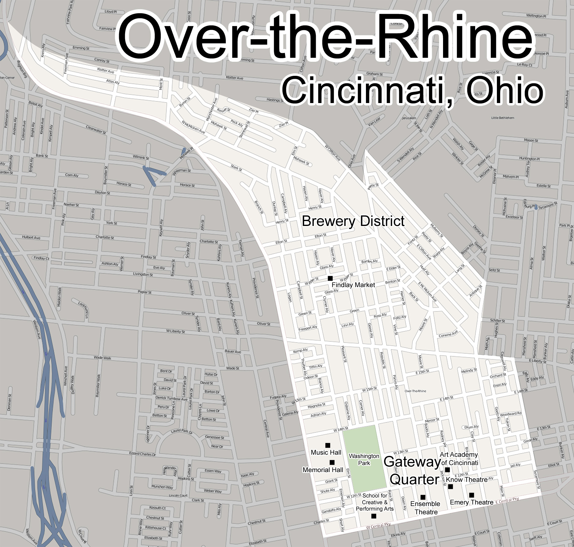
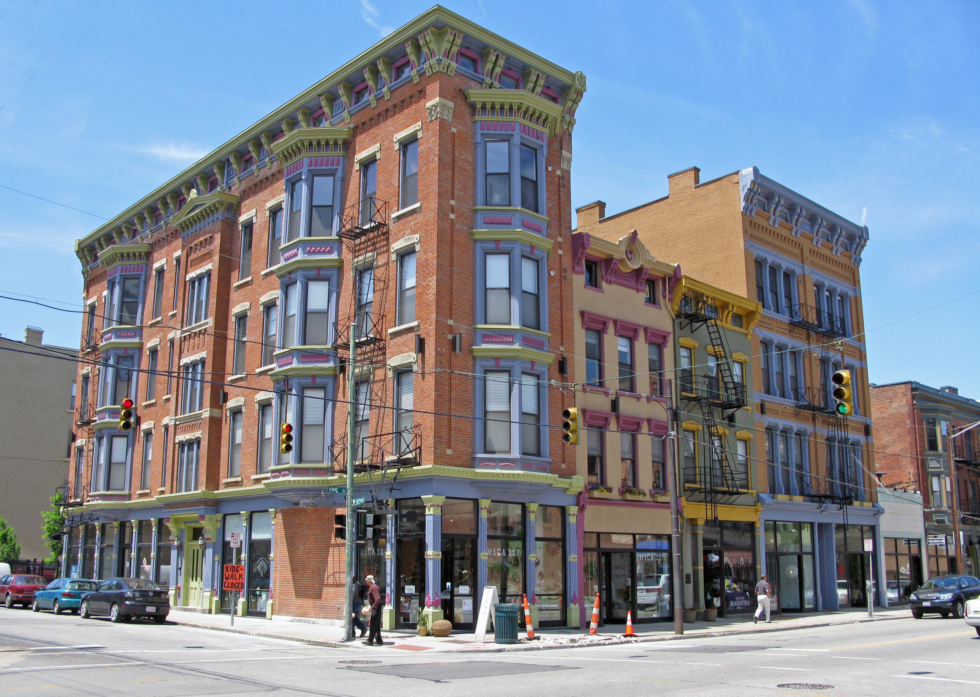
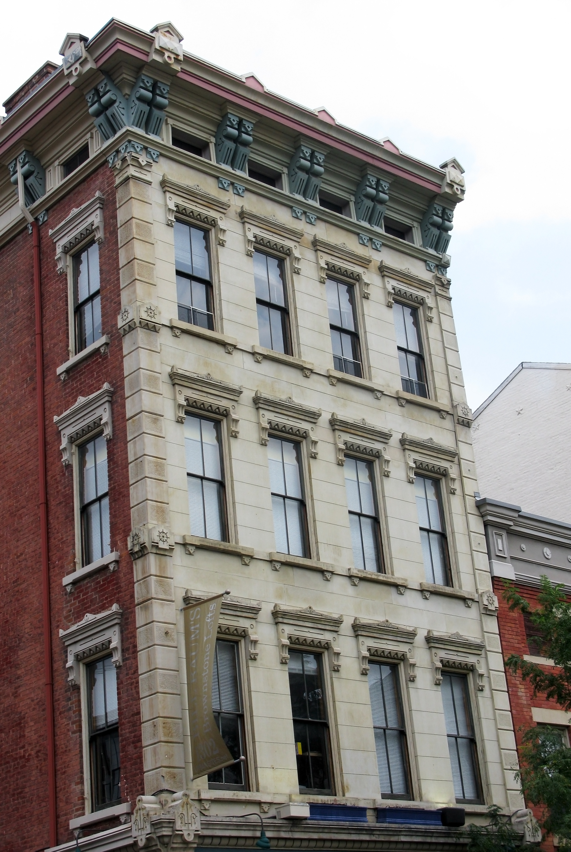
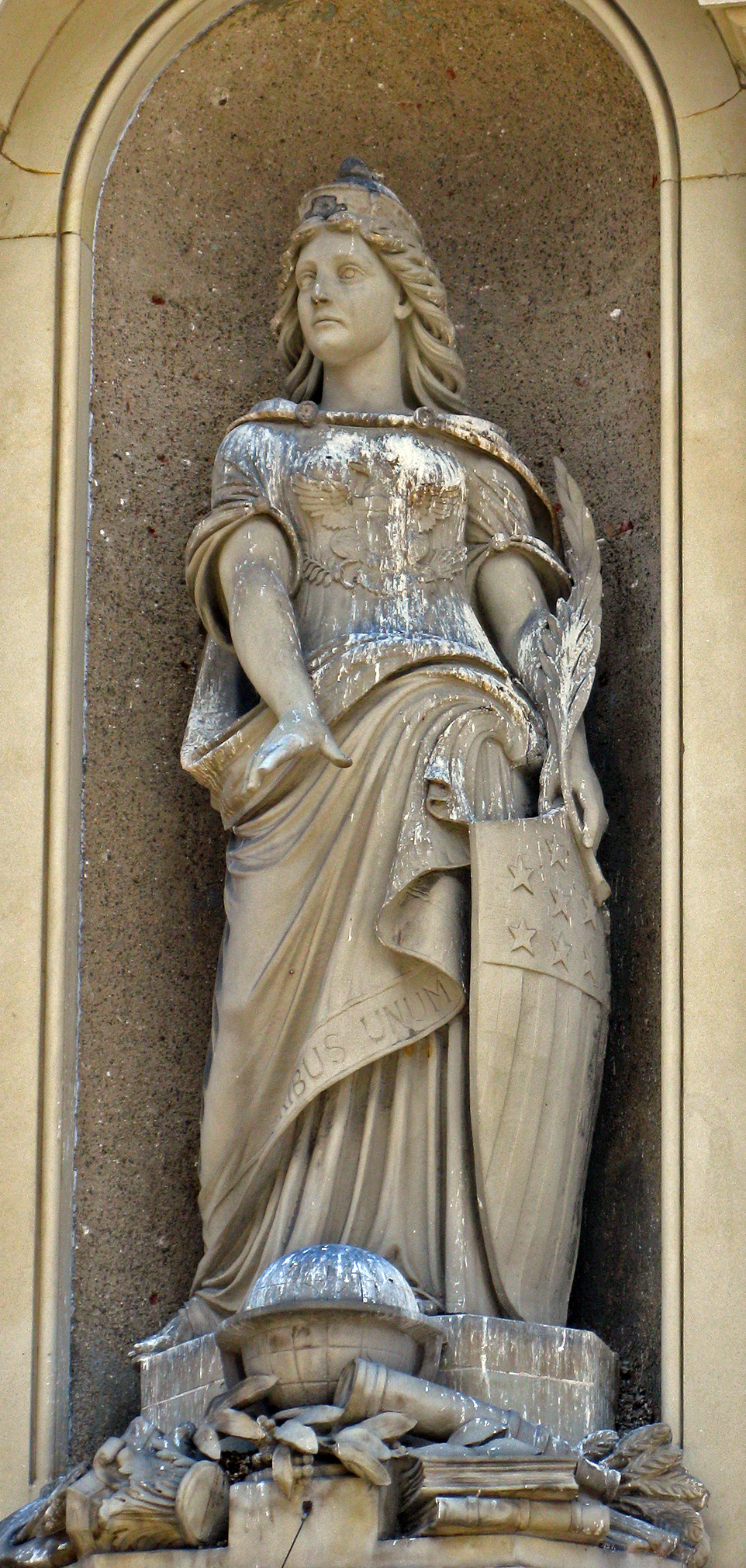
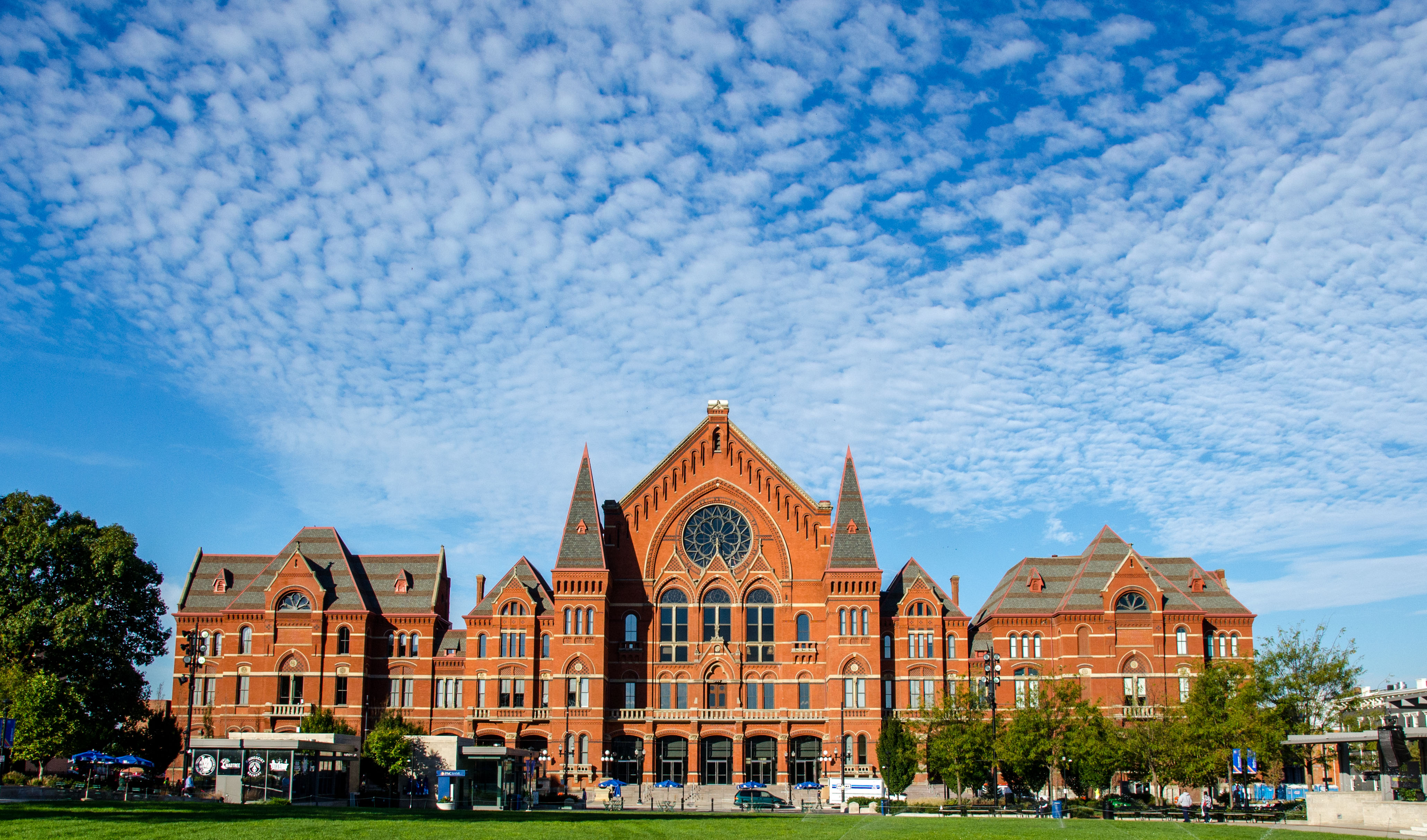
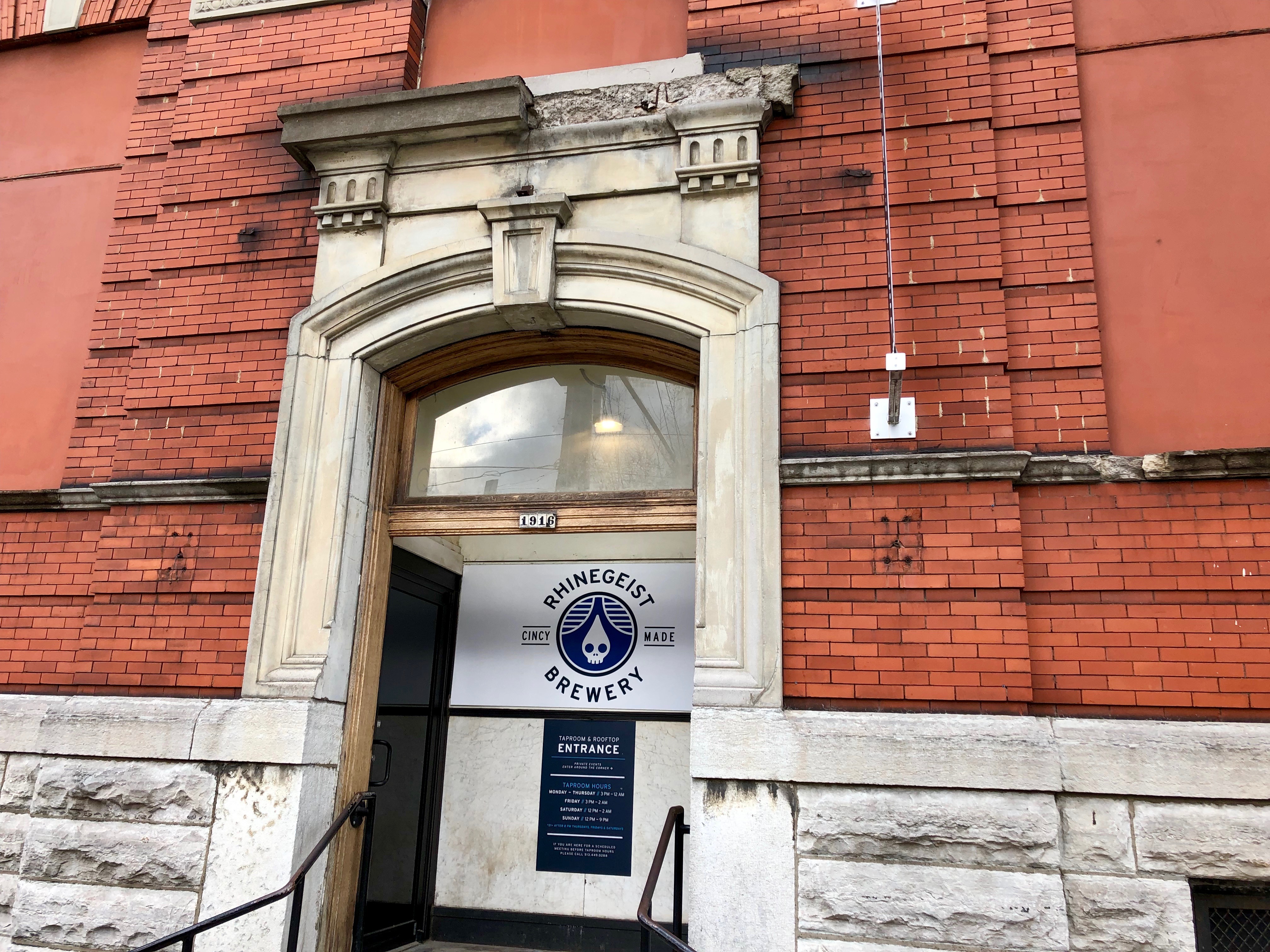
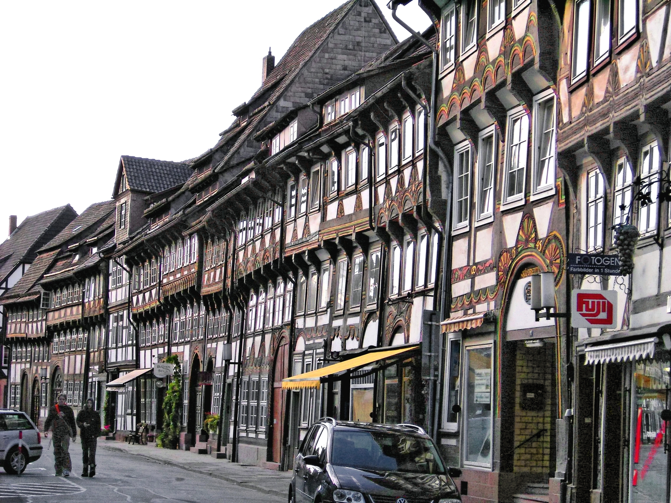
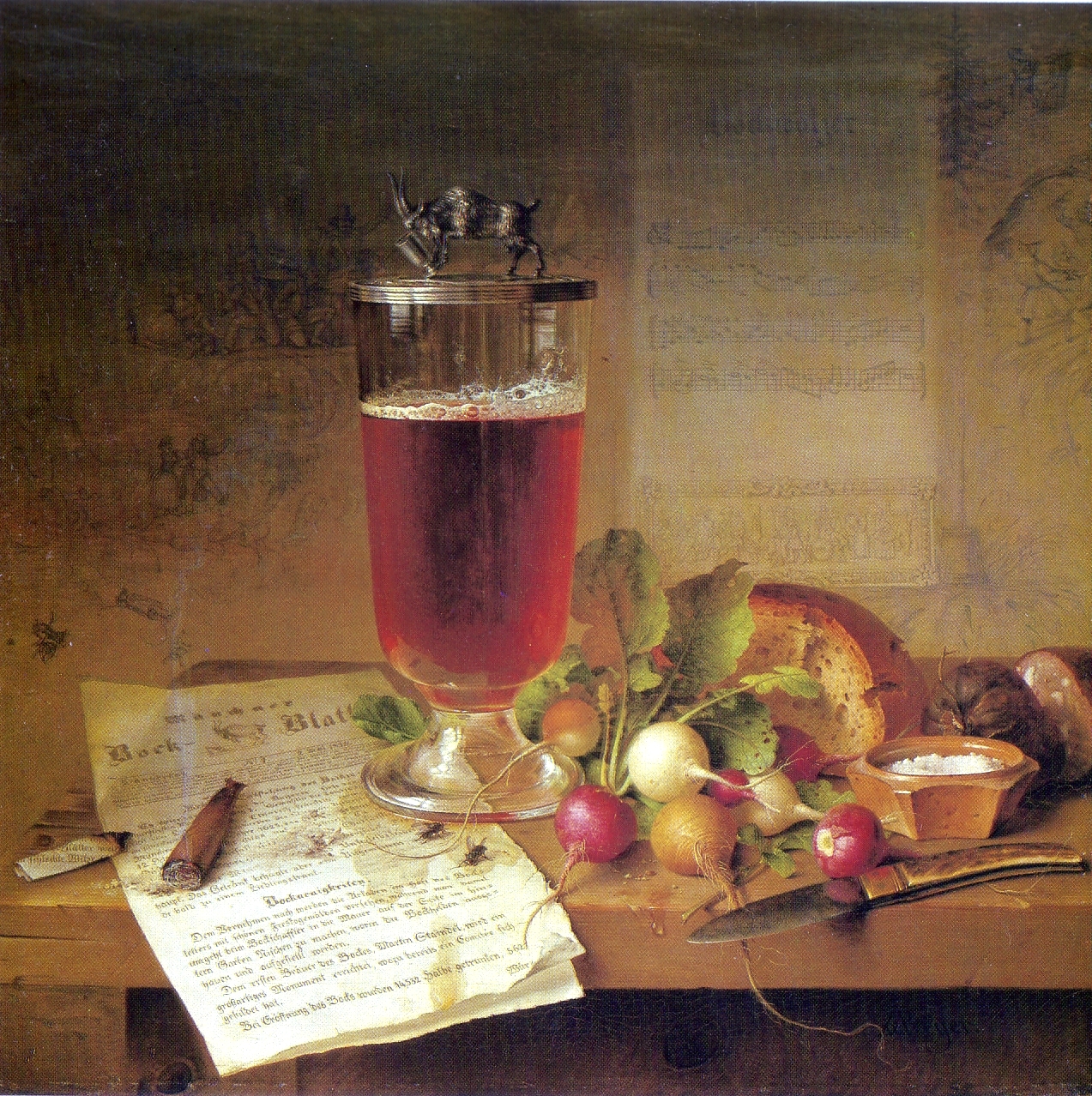
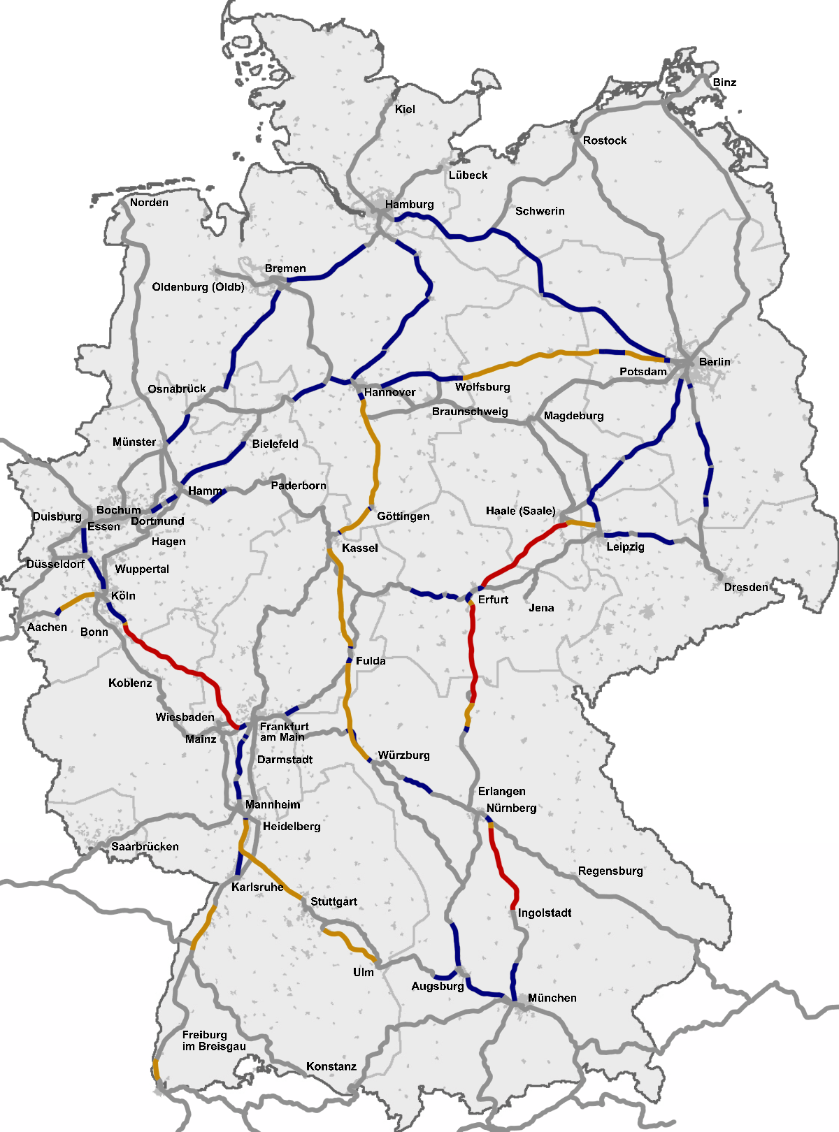
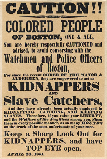
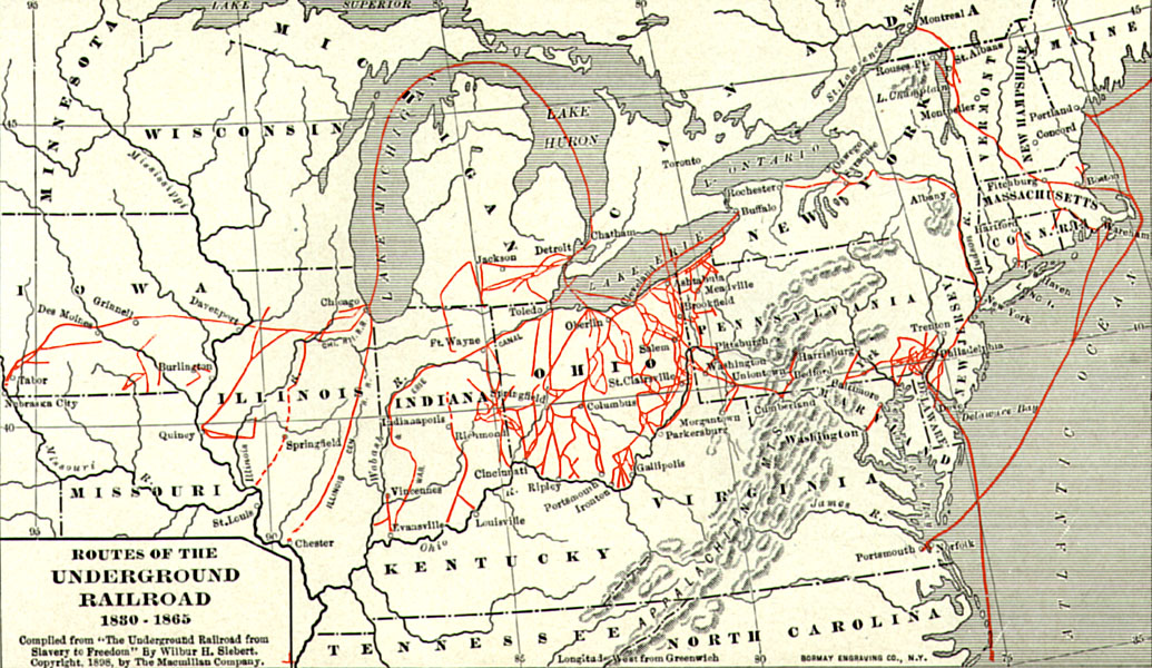
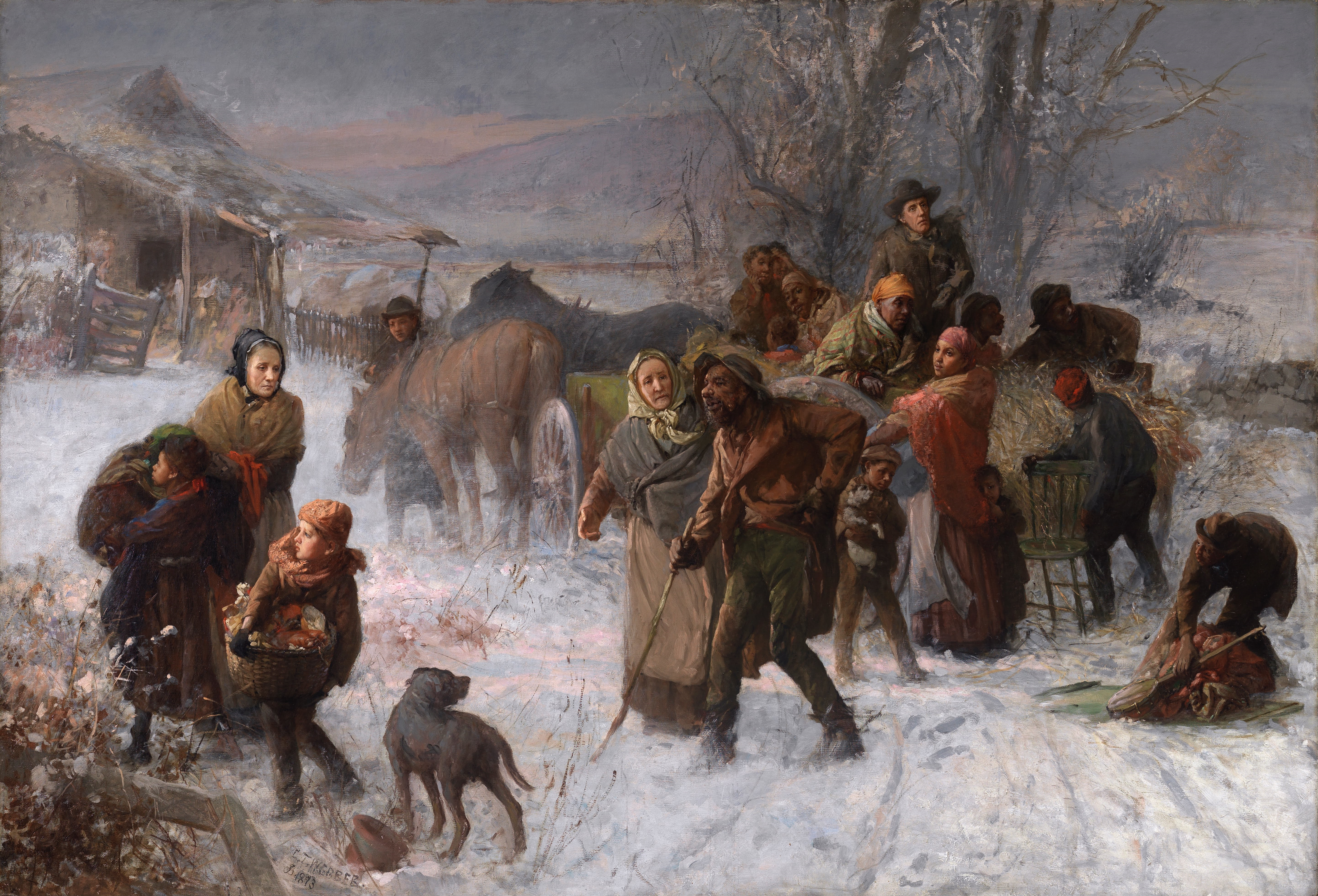
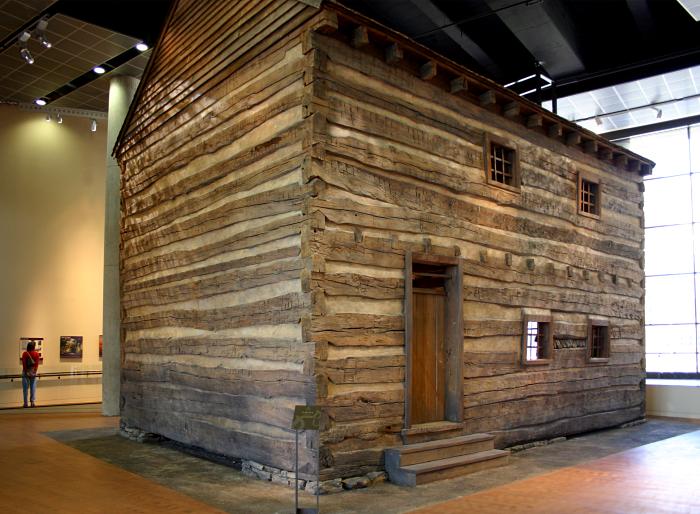