|
Reflections 2022
Series 5
September 18
San Francisco Street Grids, Hills, and Steep Streets
Travel by Cable II: SF Street Cable Cars I – Toonerville Trolley
| | San Francisco So we now know about the first attempt at urban cable cars in London in the 1840s, which didn't last a decade, and the one near me in Manhattan that didn't even complete its first season in 1870. But then, as the expression goes, the third try's a charm, and San Francisco opened its first cable car just three years later, in 1873. It was very successful, and after that, the technology spread around the world. But decline set in promptly and all the other systems were replaced, leaving San Francisco the only remaining location of a street cable car in the world. And there's nothing automatic or computer-driven about it. The cars remain to this day completely manually operated. It's ironic that San Francisco (SF) was both the location of the first successful urban street cable car, and of the last remaining one.
One hears so much about hills in SF causing crazy-wonderful steep streets, and of some of the exciting rides up and down them. Adding to some confusion in getting around SF are the conflicting street grids, so a bit problematic are both the verticality of the hills and the horizontality of conflicting street grids. And the story behind all that involves the early history of SF, something we've never discussed before, because I hadn't researched that topic. So there's lots of fun ahead.
| | | | | | There is in 2001/9 a very, very early, simpler discussion of SF cable cars.
In 2008/19 there's a discussion of a particularly wonderful SF visit, with memories of walking into the Pacific in the middle of a streetcar excursion, plus a number of Russian references.
|
| | | | SF Maps I often like to move from macro to micro, so let's start with what we'll call the "City Map" that covers the entire city and county of SF, which are contiguous and have the same name (Map by Droll):
https://upload.wikimedia.org/wikipedia/commons/0/0c/Location_map_San_Francisco_County.png
SF is located on the northern tip of a peninsula, with water on three sides: the Pacific Ocean on the west, the Golden Gate strait on the north, and SF Bay on the east. The straight line at the bottom (click) abutting Daly City (and more) is, quite uniquely, the only land border SF has. It was established in 1856; up until then the city limits remained clustered in the northeast corner of the peninsula, in what is now the downtown area.
Move up to a mountainous area that includes Mount Davidson, the highest natural point in SF at 283 m (928 ft), the fabulous Twin Peaks (a wonderful drive) at 282 m (925 ft), and Mount Sutro, at 278 m (911 ft). The map makes it perfectly clear that roads in this area wind around the hills and ascend them (if at all) in winding switchbacks. Further scanning shows other hills or "heights", but there are no roads crossing them, nor switchbacks up to them. If you do see a checkerboard street grid over a hill, there may be a steep street involved, but that’s just a minor local quirk.
In the northeast corner of the city (click) is Downtown, with its unusual twin grids. Actually, today the upper part is the central business district, and the part below the red diagonal of Market Street is what you may call a funkier part of downtown. Since it's SOuth of MArket, it's usually called SoMa. We'll concentrate on these two areas shortly.
| | | | Metropolitan Area Now the area of SF might seem peculiarly small, and it is. But that's not for lack of trying. Many cities have successfully expanded their borders—NYC comes to mind, when in 1898 New York (Manhattan & the West Bronx) expanded to include the former City of Brooklyn and other areas to form the present five boroughs. Shortly afterward, in 1912, there was a movement to create a "Greater San Francisco" that would have included adjacent areas. This is the region now known as the Bay Area (Map by Mliu92) that surrounds SF Bay (remember that the city limit of SF is an E-W line just north of Daly City). The 1912 movement sought to include (1) to the north, southern Marin County; (2) to the east, the part of Alameda County that includes Oakland and Berkeley; and (3) to the south, northern San Mateo County from San Bruno (inland from Pacifica) northwards. These areas would have become boroughs of SF, based on the NYC model. But the plan was defeated in the California legislature by opposition from the East Bay. Also defeated were later attempts in 1917, 1923, and 1928. Thus SF never grew beyond the borders it has today, leaving SF lopsided, a major city with a relatively modest population of 800,000+, in a metropolitan area of 4.7 million. | | | | SF Geology It's my guess that, up until 1937, when anyone with any knowledge of SF said "Golden Gate", it was understood they were talking about the strait. But in that year, the Golden Gate Bridge opened, and became extremely famous. It's also my guess that, if someone now hears "Golden Gate", they picture the bridge, and, sea travel having declined, may even have no knowledge whatsoever that there's a strait under the bridge. To make things perfectly clear, this map shows the actual Golden Gate, the one and only entrance to the vast SF Bay (Map by Georgewilliamherbert at en.wikipedia). And to locate the Golden Gate Bridge over the strait, we have this map:
http://imagizer.imageshack.com/img633/4276/lNkUg9.jpg
But why is the strait there? Even better, why is the bay there? For that we need this:
https://s3.amazonaws.com/gs-geo-images/bf0ba28b-dc52-4d48-9d67-7007aa52c184.jpg
During the last ice age, some 20,000 years ago, when the sea level was several hundred feet lower, the waters of the glacier-fed Sacramento River and the San Joaquin River scoured a deep channel through the bedrock on their way to the ocean. (A similar process created the undersea Hudson Canyon off the coast of New York.) We see that, with a lower sea level, much more of the coast was exposed. The glacial rivers cut thru what is now the upper bay, the Golden Gate, and the extended coast. When the sea level rose, the extended coastland and the bay flooded, and the Golden Gate, which had just been part of the river channel, developed into the entrance to the bay.
| | | | Downtown's Twin Grids Now let's move downtown (DT), for which I have two maps (both are clickable):
https://pacific-map.com/images/15-san-fr.jpg
https://www.orangesmile.com/common/img_city_maps/san-francisco-map-0.jpg
I'm using the first one, the "DT Street Map", because it shows the two street grids in dark black high definition. It's very easy to see the northern grid showing the main part of DT, with Nob Hill and Russian Hill standing out. Then we see bold Market Street separating this grid from the southern grid, known as the SoMa grid. But don't miss Mission Street one block into SoMa, since that's the most historic street of all, and the basis for the SoMa grid. The second map, the "DT Detail Map" will be more useful in finding locations as we discuss SF. Why two grids developed is tied to the history of SF, particularly the gold rush.
| | | | Development of SF Grids The original inhabitants of the SF area, dating back to 3,000 BCE, were a Native American people called the Ohlone, and this is the extensive Ohlone territory at the time of Western contact (Map by Noahedits). Its history of Europeans and Americans started in 1776, when colonists from Spain established both the Presidio of SF at the Golden Gate (for years a military reserve, now a park), and, more important to understanding the street grid, the Misión San Francisco de Asís, commonly known as Mission Dolores, since it was founded near Dolores Creek, both named for Francis of Assisi. The purpose of the mission, as is typical of colonizers, was to replace the culture and religion of the Ohlone with those of the missionaries. | | | | Yerba Buena To establish a place for housing the builders, a location was chosen accessible to both sites, east of the Presidio and roughly north of the Mission, which ended up being in what is now downtown SF (northern grid), more precisely Chinatown. This site established for the workers in 1776 was named Yerba Buena. After Mexico's independence from Spain, under Mexican rule in 1847 it was renamed San Francisco, evidently to conform with the name of the Presidio and Mission. | | | | | | Yerba buena ("good herb") is the name for a number of varying, mint-like, aromatic plants. Just which plants being referred to varies depending on the region. Perhaps the most common variation is spearmint. The name still exists in the form of Yerba Buena Island in San Francisco Bay, which connects two spans of the Bay Bridge. |
| | | | On the DT Detail Map, find Chinatown. Under the -WN of that word is an unnamed park located on Kearny between Washington and Clay. Its original name was Plaza de Yerba Buena, called that after the workers' village of Yerba Buena developed into a trading post serving both the Presidio and Mission. It's today called Portsmouth Square, renamed when the Americans took over the town in 1848. Yet San Francisco was still a small settlement with inhospitable geography. Its 1847 population was said to be 459. | | | | California Gold Rush But that year, 1848, was a momentous year for the area, because not only did SF and all of California come under the jurisdiction of the US after the Mexican-American War, that was the year of the California Gold Rush, which ended up having a huge impact on the development of SF. It began on 24 January 1848 when gold was found at Sutter's Mill in Coloma, and lasted until 1855. This map shows the location of Coloma vis-à-vis SF and the eventual extent of the California Gold Fields (Map by Hans van der Maarel). The gold-seekers were called "forty-niners", a reference to 1849, which was the peak year for Gold Rush immigration.
The Gold Rush brought rapid growth over its several years, transforming the tiny hamlet of SF into a busy port, which was the largest West Coast city at the time. Gold attracted some 300,000 people to California from the rest of the US and from abroad. That 1847 population of 459 became 36,000 by 1852, which is 180 times larger. The lust for gold was so strong that crews on arriving vessels deserted and rushed off to the gold fields, leaving some 500 abandoned ships in the harbor. Some of the ships were made use of, for storage, or for saloons or hotels. Others were just left to rot. By 1851, the shoreline and harbor were extended out into the bay over the rotting hulls. This is a daguerreotype made in 1851 that includes the abandoned ships in SF harbor.
| | | | Happy Valley Look again at the DT Street Map and find how Mission Street starts at the waterfront, and runs at the standard SoMa diagonal angle, but then turns and runs south toward the mission itself, with the entire SoMa grid following it as it bends to roughly conform to the northern grid. This illustrates the early importance of Mission Street, despite the fact that one hears of Market Street so much. Because of the importance of Mission Street, Yerba Buena was not the only settlement that developed in the area. While Yerba Buena was north of what today is Market Street, there was also development to the south. In 1849, the first known settlement here ran along Mission Street between 1st, 2nd, and 3rd Streets. The settlement was a tent city housing some thousand would-be gold miners, called Happy Valley. At this point we see the start of dual settlements, and can see already why there are two grids in SF.
https://www.foundsf.org/images/b/b4/1852-US-Coast-Survey-map-of-Mission-Bay-w-Mission-Plank-Road.jpg
As this link says, it shows a US Coastal Survey map of the area made in 1852. We can already see two grids beginning to form, but it also shows how few buildings most of those laid-out blocks actually had, among a lot of open area. On the DT Street Map, find 1st Street, and note how many blocks it is from the waterfront—it isn't the first street at all. Now compare that with the 1852 map (click), when 1st Street was a half-block from the waterfront and you'll see the extent to which the shoreline was extended over the hulks of old ships. So along Mission Street, you're looking at the extent of Happy Valley to 3rd—and the numbering only went to 4th! At the time, even "mighty" Market Street only went that short distance, but follow Mission Street as it continued its lengthy distance around the bend and to the Mission itself.
However, the route between the tiny settlements and Mission Dolores quite some distance away to the southwest was extremely sandy and swampy, impeding traffic, and so, as is labeled on the map, a plank toll road was built in 1850 to connect the settlements to the mission.
| | | | | | Our most recent discussion of plank roads was in 2020/10, talking about the Newark Plank Road (qv) to the Hudson, built in 1849, almost at the same time as this Mission Plank Road was built. We also mention other plank roads in New Jersey and Queens and include an illustration of how one works. |
| | | | As can be seen on all maps, including the 1853 one, 3rd Street in SoMa connects with Kearny Street north of Market, and Portsmouth Square is located on Kearny. So to connect both settlements, the Mission Plank Road started on Kearny, crossed over to 3rd, then turned right and continued down Mission Street to Mission Dolores. This raised adjacent property values along the route. SF's first public transit route opened along the Mission Plank Road in 1852, two years after the road was built, in the form of an 18-passenger variant of a stagecoach, what the Yellow Line called its "omnibuses". | | | | | | On the old map, find the Mission. That major E-W street is today 16th Street, and you see where the plank road runs. This entire neighborhood is today called the Mission District. Let's now locate Mission Dolores on the large-scale City Map, where you'll find a BART subway stop at 16th & Mission Street. However—surprise!—that's not exactly where the mission is—presumably Mission Street was twisted when the grid was extended. Go west on 16th a few blocks to Guerrero in red, then one more block to an unnamed yellow street, which is Dolores Street. Mission Dolores is at 16th & Dolores, on the SW corner. It looks like this today, which requires an explanation (Photo by Robert A Estremo). The small white building is the 1776 Spanish Colonial Mission Dolores, the oldest surviving structure in SF. The large beige building is the 1918 Spanish Colonial Revival basilica built to supplement it. |
| | | | The Vioget Grid Early on, in 1839, the Mexican governor ordered a survey of Yerba Buena, and the mayor hired a Swiss-born engineer, Jean-Jacques Vioget, to survey and plan the town. He laid out streets in roughly the cardinal directions, and his map is still available, but I find it confusing. The Vioget map of Yerba Buena was made in 1839, but published in 1853 as part of a deposition, a fact that already portends land claims. North is on the right, and it's supposedly centered on Plaza de Yerba Buena (later Portsmouth Square), which I can't figure out. He seems to have been much more concerned with naming property owners rather than streets.
https://notes.ericjiang.com/wp-content/uploads/2016/02/Selection_008.png
More helpful is this current map of Portsmouth Square, which here shows an overpass over Kearny. Vioget's map supposedly includes the area from Grant to Kearny to Montgomery and from Pacific to Jackson to Washington (the next one south). Interestingly, Grant Avenue is the main street of Chinatown today. As simplistic as Vioget's map may seem, it established the northern grid of SF to the satisfaction of the wealthy landowners, as noted.
| | | | The O'Farrell Grid Only about a decade later more street planning was done, but by then, two major changes had taken place, the Gold Rush and the US taking over the town. The new mayor commissioned Jasper O'Farrell, an Irish-born engineer, to improve and extend in several directions Vioget's plan around Portsmouth Square. O'Farrell widened the streets and discovered that Vioget's street designs were 2.5° off from true right angles and corrected that error, but he kept Vioget's grid pattern. This was surely because the land owners (as shown on the Vioget map) were already well established within their property lines.
Recent studies confirm that, during the Gold Rush, merchants catering to the prospectors with provisions and equipment made, as a group, far more money than the prospectors did themselves.
| | | | | | We can cite a famous example here. In May 1853, German immigrant Levi Strauss moved from Bavaria to SF to open a west coast branch of his brothers' New York dry goods business. He established himself as Levi Strauss & Co on Sacramento Street at Front Street, which is four blocks east and one block south of Portsmouth Square. Strauss partnered with a Latvian tailor who had the idea of using copper rivets to reinforce points of strain on denim cloth being made into work pants and they both received a patent for the idea in 1873. The riveted denim was later incorporated into the company's jeans, and the rest is history, with "Levi's" to some extent even becoming a generic word for jeans.
However, a historic caveat. Levi Strauss certainly prospered as of 1853, selling all sorts of dry goods during the Gold Rush period, some surely to prospectors, so the name deserves inclusion here, but they did not manufacture denim overalls until the 1870s (the patent was dated 1873), so they did not actually supply gold prospectors with jeans.
To this day, the company's corporate headquarters are located in Levi's Plaza on the Embarcadero just east of Telegraph Hill's Coit Tower. This is the first corporate logo for Levi Strauss & Co dated 1892, prominently mentioning the word "riveted".
|
| | | | In any case, these prosperous merchants became wealthy landowners in SF, and O'Farrell had to abide by their wishes, since their properties were already surveyed. Much was made in O'Farrell's time and ever since of the surveyors disregard for SF's topography, laying down a grid pattern on top of sand dunes and hills instead of going around them. But the influential landowners in the northern part of today's SF dismissed the issue, saying that the grid pattern was most convenient and existing buildings would not have to be realigned. Anyway, until the advent of the cable car—an upcoming story by itself--the hilltops were barely populated despite having planned streets running thru them. So O'Farrell continued laying out city blocks in a roughly square pattern measuring 126 x 84 m (412 x 275 ft).
But during the 1850s and 1860s, the city's most prestigious residential neighborhoods were located in the southern area, in Happy Valley and on Rincon Hill. These wealthy property owners forced O'Farrell to establish the alternate grid aligned with the pre-existing Mission Street down the center of Happy Valley. For reasons unknown, these city block were much larger, at 180 x 120 m (600 x 400 ft). Calculate the square meterage or square footage and you'll see that the city blocks in the southern grid are huge, twice the size of the city blocks on the north side. Anytime one walks south across Market Street to this day, it's noticeable how far apart the streets are set due to the big blocks, which appear diamond-shaped on the map, compared to the northern square blocks. Walking between the two parts of downtown can be slightly disorienting, since the grids are at a 36° angle from each other. This also makes driving between the two sides problematic. I've done it once or twice and didn't enjoy it. Aside from the difficulty of finding streets that actually connect across Market Street, you have to be careful about which of them are one-way!
| | | | Market Street O'Farrell realized the problem of having two grids at angles to each other and the solution he decided on was to separate them with the widest "no-man's-land" possible, which turned out to be Market Street. It was meant to transition between the two competing street grids, and his decision was to lay it out parallel to and one block north of Mission Street. There was a time when I wondered why he didn't use Mission Street, but now it's perfectly clear. There were city blocks of properties in Happy Valley belonging to landowners laid out on both sides of Mission, so Market would have to be located on the north side of those blocks.
Take another look at our Detail Map and find today's beginning of Market Street at the iconic Ferry Building, a symbol of SF, located on the Embarcadero (Photo by DaveOinSF). The Bay Bridge is in the background. On the City Map, you may be able to tell that straight-as-an arrow Market Street is pointed at Twin Peaks, tho it never runs beyond the Mission District—other streets connect. But that fact allows for this striking view, taken from Twin Peaks, of Market Street cutting a wide swath between the two grids for 4.8 km (3 mi). Click for details, including the Ferry Building at the far end (Photo by Vincent Bloch).
I always wondered where O'Farrell got the name for Market Street, since, unlike in many cities, there is no public market on Market Street, nor was there ever one. But there is a famous Market Street in Philadelphia, laid out by William Penn himself to connect a number of public markets. O'Farrell named the SF street as somewhat of an hommage to that Philadelphia street. But as for that wide swath, there's a unusual story about that. O'Farrell was certain that SF would one day be grander than Philadelphia, he built his Market Street to a whopping width of 120 ft (36.6 m) between property lines, a full 20 ft (6.1 m) wider than the original, and by far the widest street in town. Of course, this was also to help transition traffic between the two grids. However, this width infuriated the property owners on both sides of the street, who felt it encroached too much on their properties. They made preparations to lynch O'Farrell, who fled, riding a fast horse to spend a bit of time in Sonoma to the north of the Bay Area until things settled down.
https://upload.wikimedia.org/wikipedia/commons/d/d5/1853_U.S.C.S._Map_of_San_Francisco%2C_California_%5E_Vicinity_-_Geographicus_-_SanFrancisco3-uscs-1853.jpg
It's now time to show a historic summary of Market and the two grids. This (our "red map") is an 1853 map showing a government survey of SF at that time (click as needed).
Start with the northern grid, and you'll note immediately that those streets and blocks are all turned 9° counterclockwise from the cardinal directions. Portsmouth Square at this time was really quite centrally located.
It's immediately noticeable that the diamond-shaped blocks in the southern grid (SoMa) are huge in comparison. The first blocks of Mission Street comprise Happy Valley, and the Mission Plank Road runs out to the Mission. The Rincon Hill neighborhood is located at Rincon Point, between Folsom and Bryant, tho the point itself is today surrounded by landfill.
Now check out Market Street. It separates, but doesn't go anywhere! It ends right at 4th Street in SoMa. (Look across to the other grid and find—misspelled--O'Farrell Street.) But the bay end is even more different from today. On the Detail Map you see a shoreline that's almost perpendicular to Market. Now look at the red map. SoMa ends at 1st Street, which is the north end of Happy Valley. But the northern grid continues to Front, Davis, and Drumm (not named) Streets, and then runs out onto the Market Street Wharf. Find those streets on the modern map, then see that the wharf is long gone.
| | | | | | Before we leave the topic of Market Street, we need a fast-forward to the present day for just a moment. Numerous kinds of transportation have run on Market (even cable cars once); today there are Muni buses, trolleybuses, and the F-Market heritage street car line on the surface, while below, the two-level Market Street subway carries both Muni Metro and BART rail routes. In addition, surviving cable car routes terminate at Powell & Market and at California & Market. For these reasons, Market Street has now become, thankfully, car-free, with the transition having begun on 29 January 2020. On the Detail Map, trace Market from roughly the Ferry Building to the Van Ness area, where there's a Muni Metro station. This is the section that has now become car-free. Studies released the following month indicated between 6% and 12% in travel time saved on the transit routes, with minimal traffic effects on other streets. O'Farrell would have been happy. |
| | | | Columbus Avenue Take a look at the other map, the DT Street Map, which shows this following point best. You cannot miss the fact that there's a major anomaly in the northern street grid, since Columbus Avenue cuts across the grid at a steep angle, seemingly going from nowhere to nowhere, just blending into the grid. That's because you are looking at the only downtown street in SF that actually conforms to SF topography, which we can easily see on this SF topographic map.
https://1.bp.blogspot.com/-y_q26J3R1-8/T6AT66cLVmI/AAAAAAAAAfQ/Ozz2OgmXeXQ/s1600/SF_TopoPoster_geoNames_48x48_bluewtr2.jpg
It will remind you of the City Map, but without streets and with the high areas showing up MUCH more clearly. It's spectacularly obvious that the Twin Peaks area (with Mt Davidson, Mt Sutro), is the mountainous area in town, and much higher than other areas.
| | | | | | I've driven up to Twin Peaks at least a couple of times, and there are always memorable views in every direction. I'll never forget the time there close to noon when we looked north. On the left was the sun shining on downtown, and on the right was the sun shining down on a fog bank rolling in from the Pacific towards downtown, a memorable and impressive view. Picture it on this map. |
| | | | One purpose of looking at this map is to adjust one's thinking about steep streets, where they are in SF, and where they are not. At 283 m (928 ft), Mount Davidson is the city’s highest natural point of elevation, yet not a single one of the city’s steepest inclines is located in the surrounding neighborhoods. The same is true of Twin Peaks at 282 m (925 ft), where no street exceeds a 25% grade, which is still considered within the more normal range in SF. This is probably due to crafty engineering: the switchbacks leading to the peak are long and winding, and at no point is the pitch greater than 15%. (But on the east side of this grouping, do note Bernal Heights, and further east, Potrero Hill, which we'll be mentioning a bit later.)
Now move your glance to SoMa, where there's hardly any change in elevation. We see the remnants of Rincon Hill, today about 30 m (100 ft) high. There was not much removal of dunes and hills in SF, but when in 1869, 2nd Street was cut thru--this view looks north towards downtown—that marked the beginning of the end of split-in-two Rincon Hill as a now destabilized fashionable neighborhood and the start of its decline into commercialism, later becoming a slum.
But now look a northern downtown and we reach the basis for SF becoming famous for steep streets, Nob Hill, then blending north into Russian Hill. This pair of hills face across a low spot Telegraph Hill, the other well-known downtown hill.
| | | | Telegraph Hill This hill is not a factor in our story of steepness. The Detail Map shows it has a winding road with switchbacks that climb it (I've driven it to visit the Coit Tower) and the grid makes little to no attempt to run streets up it—thru streets just skipped it, altho a few black arrows show some local steepness. The Spanish had called it Loma Alta—High Hill—but in 1849, a semaphore was built on top of it to signal to townspeople the nature of the ships that were arriving via the Golden Gate and into the Bay. This gave those interested in the signals a financial edge, say, not to buy merchandise whose prices were about to drop because more of the same kind was about to arrive. But in 1853, the semaphore was replaced by the first telegraph in California, the Marine Telegraph Station, hence the present name of the hill, but this was destroyed by a storm in 1870.
And so now we get back to our point about Columbus Avenue. There had been a trail, perhaps from Native American times, on that low spot between Telegraph Hill and Nob & Russian Hills, which apparently still existed, but was ignored, when the grid was drawn. But in the 1870s, this trail was paved and is today Columbus Avenue, a popular venue for visitors. Thus it's perhaps the only street that follows the SF topography. (Look at the DT Street Map, and you'll see the quirk that Columbus, if extended, is perpendicular to Market Street.)
A PREVIEW: To indicate that it's actually Nob & Russian Hills that have always been the basis for steep streets downtown, and are therefore the location of the three remaining cable car lines in SF, let's take a preview look at this simplified map of the three remaining routes (Map by Dennis McClendon) so they'll be familiar when we describe them (using a better map).
Telegraph Hill is not named, but you can tell where it is.
The California Street Line, in blue, is relatively flat to the east, but to the west, climbs, then descends, Nob Hill. Because of the grid, you can't tell where its steep sections are, which is typical.
The Powell-Mason Line, in green runs on four streets, plus around a block in the middle on two more streets. It goes up Powell, later Mason, then runs for a bit on Columbus Avenue (ha!), ending up on Taylor. But to connect the two streets it's named for, northbound it runs on one block of Jackson, and southbound on one block of Washington. Much of this route runs along the eastern flank of Nob & Russian Hills.
The Powell-Hyde Line, in purple, runs mainly on those two streets, Powell and Hyde, but it too uses Jackson northbound and Washington southbound to connect, and uses them for a full five blocks each. This curious route runs on the east flank of Nob & Russian Hills at first, then crosses over to continue on their west flank.
The cable house or powerhouse for all the lines is at the corner of Mason and Washington.
To help in comparing the three routes with the hills, use this map of the Nob & Russian Hills neighborhood. It's easier to see which lines are on the east and west flanks of the pair of hills, and where lines cross over between sides. Tho the east half of the California Street Line is relatively flat—and there used to be lines in other flat areas—it can be seen that Nob & Russian Hills are at the core of the remaining lines, and were the basis for any lines being built in the first place.
Use this last map to find the actual peaks and their relation to the cable car lines. Jones Street sort of acts as the equivalent of a peak drive. The peak of Nob Hill is at 115 m (376 ft) and lies approximately at the intersection of Jones & Sacramento Streets, and the peak of Russian Hill is at 90 m (294 ft), and its summit lies at Jones and Vallejo.
| | | | | | You can see again how this northern street grid fools the eye as to altitude—me too, the first time. Find Taylor Street, almost as high as Jones. On our very first trip, we rented a car down around Post Street, and had booked a hotel off upper Columbus. Taylor seemed a perfect route to connect them. Then Up Nob! Down Nob! Up Russian! Down Russian! On a country road, going up and down hills isn't hard, but here, there's the problem of cross streets with frequent traffic lights. Going uphill and stopping with the car at an angle at a light up ahead is hard, even in an automatic car, but we had a stick shift. You'd stop and brake and maybe even add the hand brake. But at the moment of terror on getting the green light, you had to engage the clutch and quickly move from the brake to the gas (and maybe also release the hand brake), all while hoping you didn't roll backward and ram the car behind. Absolutely one white-knuckle experience after another. |
| | | | Nob Hill Before the 1850s, Nob Hill was called California Hill because of California Street, which famously crosses it. But during the middle and late 1860s, the Transcontinental Railroad was built, joining in 1869 (see 2019/8). The western portion was formed by the Central Pacific Railroad, which was funded by four famous and influential businessmen, railroad tycoons—and occasionally, philanthropists—popularly known as the Big Four. They were Leland Stanford (founded Stanford University), Collis Huntington, Mark Hopkins, and Charles Crocker. However, the four themselves personally preferred to be known as "The Associates." All four built their lavish mansions on the hill; as they were known as the Nobs, California Hill became known as Nob Hill. (After Mark Hopkins' mansion burned in the quake, it was replaced by the Mark Hopkins Hotel.) The Big Four have been widely regarded as robber barons, even swindlers, since they enriched themselves enormously with tax money, land grants, and monopolizing tactics. | | | | | | The word "nob" actually dates from 1755, referring to "a member of the aristocracy, a person of wealth and distinction". It was a slang shortening of "noble[man]". It's a bit hard to spot the connection because of the change in vowel sound: "no[ble]" rhymes with "no", while "nob" rhymes with "bob". |
| | | | Russian Hill It's my feeling that most people probably picture European settlement in North America as involving British, French, and Spanish colonists coming over the Atlantic from the east. Sure, most people are also aware that the Russians expanded into Alaska, but that sounds very remote. Still, people who think that way should adjust their thinking. The colony known as Русская Америка / Russkaya Amerika lasted from 1799 to 1867, and actually consisted of more than Alaska as was sold to the US.
The Alaska panhandle indicates how settlement was creeping down the west coast of North America from the main part of Alaska. If colonial funding hadn't been cut off, might that panhandle have grown further? There's no indication of Russian settlements in British Columbia, Washington, or Oregon, but do keep in mind, Russian settlement did reach central California. You may want to review 2001/8, which discussed my visit to Fort Ross (short for Rossiya [Russia]), the hub of Russian settlements in California from 1812 to 1842. It was an eye-opening experience for me in an area where one would expect, at that time, just Native Americans and perhaps nearby Spanish or Mexicans.
https://www.tide-forecast.com/tidelocationmaps/Fort-Ross-California.8.gif
This map shows how close Fort Ross is to SF, and this is a 13-ruble, Russian stamp commemorating 200 years of Форт-Росс / Fort Ross in 2012. And just 16 km (10 mi) along the coast to the southeast of Fort Ross, the Russian River, named by the founder of the colony, empties into the Pacific. The valley of the Russian River is famous for its wines (Map by Kmusser).
We're moving closer and closer to SF, and shouldn't be surprised to learn that the Russians themselves gave its name to Russian Hill. In 2001/8 I wrote: Apparently in the early 1840’s some Russian fur traders and sailors from Fort Ross had been in this area and some had died, and were buried at the top of this hill in a small cemetery. A few years later came the California Gold Rush of 1848, and arriving settlers in the [next few years] found the Russian cemetery . . . . Some graves in the cemetery were moved, but others were just covered over. Between two of my visits to the summit of Russian Hill for the magnificent view to the east, in 2005 a Russian cultural organization put up plaques in Russian and English, referring to Russian Hill as Русский Холм / Russkiy Kholm. While in the 1840s, Russians and Spaniards/Mexicans surely never met, it was as close to a joining of settlements of North America from both east and west as we have.
| | | | | | One doesn't think immediately of Swedish having an influence on Russian vocabulary, but there is one good example here. The Swedish word holm, as in "Stockholm", refers to an "islet", yet when borrowed by Russian, it refers instead to a hill. It's not hard to see the relationship. Swedish looks at the thing horizontally as an islet, and Russian looks at it vertically, as a hill.
Stockholm, like Venice, is built on many small islands, so the use of "holm" in its name in the singular is a curiosity. "Stock", comes from the old Swedish word "Stokker", meaning log or pole, and there are two theories to the origin of its name. One is that poles were used to mark important places like markets. But I prefer the other interpretation, that the city used logs in order to block shipping routes into the island-town, either in order to charge some kind of toll or to prevent enemy ships from entering the area. So "Stockholm" would either be "Pole-Isle" or "Barrier-Isle".
|
| | | | But Nob Hill and Russian Hill are a key element in SF's crazy-wonderful steep-street grid system, and remarkably, we have a picture showing the situation early on. It's a daguerreotype in the possession of the Library of Congress and shows Portsmouth Square in 1851, (click) right in the Gold Rush years we've been discussing. You'll have noted that the square today is on Kearny (N-S), between Washington and Clay (E-W). Which direction we're facing here is not indicated, but we can make an educated guess based on the hills that we're looking west, looking at Nob Hill (left) and Russian Hill (right).
CORRECTION: As I was working on the next posting, I came across this picture again with a label that identified its location more precisely. My educated guess was wrong. The view is NORTH to Telegraph Hill—check the Detail Map. Nevertheless points made below about extending roads up hillsides are still valid for Nob & Russian Hills.
We can also see that they're not that far from the square. It's obvious in addition that the shops in the foreground are on a sloping street, possibly Kearny, so the settlers were used to building on slopes from the earliest settlement times. On the hills, people have already started building houses, since land was valuable. Some of those lines are probably drainage routes, but some might be dirt footpaths, following natural contours, not like today. Now: visualize laying out the street grid right up the side of those hills.
First let's go back once again to the SAME "red map" we used earlier, showing this area two years later, in 1853. Click to find Portsmouth Square on Kearny at Clay, then let's walk west on Clay to see what blocks are platted and where any structures are—and there are few. First comes Dupont (renamed Grant after the Civil War), then Stockton, then Powell. The last street platted is Mason (name omitted), then the contour lines continue up Nob Hill.
That was Then. Let's go to Now, by referring to the Detail Map. Find Portsmouth Square at Kearny & Clay. East of here, except for Telegraph Hill, it's relatively flat and there are no contour lines. West of Kearny you can see that there are only a few blocks to Powell and Mason are, which are steep enough to need a cable car line.
The blue contour lines to the west show the increase in altitude from 50 ft (15 m) to 300 ft (91 m). Portsmouth Square (Kearny at Clay) is at about the 50 ft line. Go west again down Clay and watch the contours add up as we climb the east flank of Nob Hill. Just beyond Grant is 100 ft; Stockton is at 150 ft; between Powell and Mason (a cable car route) is 200 ft; almost at Taylor (my white-knuckle drive) is 250 ft; and as we said, Jones is at the top within the 300 ft contour. From there, the contours drop again on the west flank. Thus we can see that almost from Day One of settlement in the Gold Rush period, these plans were "in stone".
Look again at the daguerreotype and picture future E-W streets going from the square up the hills. Even better, picture the N-S streets along the hillside. I'd judge that we're certainly seeing the sites of Powell and Mason going left-right on that hill, and Taylor running along the top.
We'll shortly be seeing some of the surveying work of an SF resident, Stephen Von Worley. But he also made a statement that I think tells the whole story of SF's steep streets, which I'll paraphrase. As the Gold Rush started, and Forty-Niners invaded the town, haste won out over foresight. Foresight's defeat resulted in the loss of any grand plans of laying out major avenues or boulevards, and haste's win promptly expanded the rectangular street grid, willy-nilly up the hillsides.
| | | | | | Some leveling of hills was indeed done. At the time, the Market Street right-of-way was blocked by an 18 m (60 ft) sand dune at Montgomery Street, and 100 meters/yards further west stood a second sandhill nearly 27 m (90 ft) tall. Both dunes were leveled between 1852–54 and 1859–73 and Market Street is today totally flat. But the Gold Rush derailed many plans to level hills. Assisting haste would also have been the lack of labor to do so, given how sailors jumped ship to go seek their fortune in the gold fields, as did other potential laborers. Of course, Nob & Russian Hills would have been too tall to reasonably level. |
| | | | There are just two concessions to these hills. One is the E-W Broadway Tunnel thru all of Russian Hill between Powell and Larkin (best seen on the DT Street Map), built in 1952 to ease street congestion.
The other, nearby on the same map, the short N-S Stockton Street Tunnel under a bit of Nob Hill, from Sacramento & California Streets south to Bush Street, opened in 1914 originally as a streetcar tunnel and converted in 1951 to car traffic. This is a 1910 proposed streetcar view of the south portal showing the original shape of Stockton Street and how the tunnel would cut off the steepest parts. The grade on the north side had been 18%, and 12% on the south side, but the tunnel's maximum grade is 4.29%. At the top, you can see the skipped part of Stockton, but it shows much better in this 2020 view (Photo by Dllu). If you're a local living in the section at the top skipped by the tunnel, you still have steepness to contend with, but if you're just passing thru the area, it's smooth sailing via the tunnel.
| | | | Grade Let's make sure we know what we mean by grade using basic trigonometry (Graph by Madcap). If the distance you would have gone if the road (or rail line) were straight (d) instead rises a certain distance (h), your distance from A to B (l), the hypotenuse, is not only longer, but steeper. Divide (h), the rise, by (d), the run, and you get a percentage. If (d) is 20 units (meters, yards, feet, whatever) and (h) is 4 units, the result is described as a 20% grade. Angle (α) can also be calculated using trig, but I looked it up instead; in this case it would be 11.31°.
A flat road has a 0% grade. The lowest percentages are of no interest to us, but we can note that US federally-funded highways have a maximum grade of 4-6%. SF certainly has many streets with such low numbers—the above Stockton Street Tunnel has a maximum grade of 4.49%. But many SF streets just chuckle at such low figures.
Things get more serious at 10%, as this German road sign shows.
But a steep road would be one at 20%, as here in North Yorkshire (Photo by Roger Nunn / Steep Hill sign on Henside Road / CC BY-SA 2.0).
A very steep road would be one at 25%, as here in Wales (Photo by John Spooner). This is also the average grade of the Mount Washington Cog Railway.
An extremely steep road would be one at 30%, as here in Cassis, France (Photo by Thrasheur13 [?]).
We can add here that the maximum grade on the Mount Washington Cog Railway is 37%, and the grade on the Pilatus Cog Railway near Luzern (click), the steepest cog railway in the world, is 47% (Photo by Pascal Niederberger).
One thing must be kept in mind, as illustrated by the two mentions of the Mount Washington Cog Railway above. You can measure average grade, or you can measure maximum grade, since either rail routes or roads can vary along their course. We'll be talking below about lengthy steep streets of note as opposed to sudden short spurts of steepness, sometimes just a block long, and sometimes just a sudden few meters/yards.
Now we want to show that, while SF has more than its share of steep streets, it isn't unique. The Guinness record for a steep street goes to New Zealand, where, in the town of Dunedin, the second-largest city on the South Island after Christchurch, Baldwin Street stands out (Photo by Mark Oliver Dittrich). Guinness calls it the steepest street in the world, meaning no street rises more than this one in 10 horizontal meters/yards, measured along the street's centerline. The entire street is straight and runs uphill for 350 m (1,150 ft). The lower section rises at about 20%, but gets gradually steeper (Photo by James Dignan, User Grutness on en.wikipedia). At its maximum, about 70 m (230 ft) from the top, the slope is 35% or 19°. Expressed in another way, the slope is 1 in 2.86, which means that, for a run of roughly 3 meters/yards, the rise is 1 meter/yard. This picture shows the steepest part of Baldwin Street (Photo by Oyvind1979).
I've illustrated the street slope in Dunedin because it's much better documented. I understand it exists for a similar reason steep streets in SF exist. Planners were in London when they laid out the street grid, unaware this would be on a hill. As we talk about SF streets, think about longer streets being notably steep, but the craziest examples will remain the extreme upper ends of streets, or also, "one-block wonder" extreme streets.
| | | | | | It's worth noting here that the steepest cable car run in SF is at the upper end of the Powell-Hyde line, as it descends to the Hyde Street Pier at Fisherman's Wharf. This steepest section of the Hyde Line, here looking downhill (north), has a grade of 21%, even tho other streets might be steeper. Cable cars are versatile, but do not perform magic (Photo by Thomas Wolf, www.foto-tw.de / Wikimedia Commons / CC BY-SA 3.0). |
| | | | "Reasonably Steep" SF Streets We'll be concentrating on downtown, and specifically on and around Nob and Russian Hills, our two crazy-wonderful "bad boys". Running across them long-distance, both N-S and E-W, are "reasonably steep" streets, as mentioned. I do not have slope numbers for such streets, but it's safe to assume the slopes go from the teens into the twenties.
I find it easiest to use California Street as an example. Tho a cable car line runs along the section of it we'll discuss, this isn't yet about that, just the street itself. On the DT Street Map, find Nob Hill, and then the intersection of California and Van Ness. Count five blocks east and you'll reach Jones, at Grace Cathedral. But you cannot tell that you've gone up a hill, nor that Jones, runs along its crest.
Now look at the following excellent picture, where we're standing at the western end of the cable car line at Van Ness, looking to the east up California where we get this eastern view up Nob Hill (Photo by Tobias Kleinlercher / Wikipedia). We now see how the map lies to us. Click to find either sign on the right saying that the other end of this very level block is Polk Street. Then keep on looking up Nob Hill. We'll find cross streets after Polk at Larkin, Hyde, Leavenworth, and Jones, and note that intersections are, thankfully, always level. You can also tell the grade by following the rooflines of the houses, and also the trees. If at Jones Street at the top, one were to turn left (north) one single block, you'd be at Jones and Sacramento, which is the official crest of Nob Hill at 115 m (376 ft).
Since we know that the steepest cable car route is elsewhere at 21%, so this one must be less. We can assume that this slope is perhaps in the high teens. Might some nearby be steeper? Perhaps. My white-knuckle experience on Taylor might have been on a slope in the low twenties. But these remain the reasonably steep SF streets, the norm for downtown SF.
Let's consider going over the crest and coming down the east slope of Nob Hill. On our map, coming down from Jones at the cathedral, count eight blocks (past even Kearny where Portsmouth Square is) to Sansome. Now I'll repeat the picture I used in 2018/4, but which is horribly distorted—the cameraman should have used a more appropriate lens for a distance shot. Take a look at this (distorted) view of California Street looking west:
https://pix-media.priceonomics-media.com/blog/1022/Nob-Hill.jpg
It's misleading, as Nob Hill looks like a painted backdrop on a stage, with the street almost vertical. But in your mind, picture this to be similar to the previous view of the west slope. We see cable cars going in each direction in the foreground, showing a flat area that extends a few blocks behind us to the terminus at Market Street. The street sign on the right (click) tells us Sansome crosses in front of us, at level grade. Now find the crossings for Montgomery, Kearny, Grant, and Stockton, up to Powell at the crest, which has its own cable car. Presumably the view is too steep to see Mason, Taylor, and Jones, at the true crest.
| | | | | | We discussed SF's hills in 2018/14 (qv), including photos of some streets so steep that, if you turn your head at the angle of the street, the houses seemed to appear to be bizarrely leaning to the side. We'll add some fun shots here, repeated from that posting. I don't know exactly which street either of the following pictures is of, other than they're on Nob Hill. Here's a view of a severely tilting building (Photo by Håkan Dahlström) with cars parked on a level street. But of course, the photographer tilted to the camera to the left—cars perpendicularly parked must be on a steeply sloping street. Next we have a different, but very similar street showing reality (Photo by Andreas Praefcke). |
| | | | The Crazy Streets Do understand that, to understand SF cable cars, all you need to know is about the more normally steep streets. But there are those oddball streets, sometimes short and isolated, sometimes just the last block of a longer street, that are fun to know about. I quote earlier the SF resident Stephen Von Worley, who made the comparison between SF haste and foresight. We'll talk more about what he's found now.
Worley claims that if you Google "steepest streets of SF" you get an outdated list from the last century from the SF Bureau of Engineering of ten streets (actually short sections of streets a block long, maybe two) between 24% and 31.5%. But he suspected that didn't tell the whole story, so he traveled SF in 2009 and came up with an improved list and a new topper. Then in 2010 did it again still, refining it and getting a better list still, with a steeper new topper. He defined his list as showing the steepest paved public streets in SF. They are crazy steep, but usually short (single block; final block of a longer street), yet along which the public is expected to drive vehicles. While some of these were in Bernal Heights and Potrero Hill south of the Mission District (check on the City Map), the most fun are the ones that are actually in downtown SF. To keep his list short enough, he took as a given that percentages in the twenties in SF were still normal enough, so his list only includes those he found above the twenties. I'll review his list in reverse order, and illustrate what I can.
11. 23rd above Carolina; Potrero Hill; 31%; a final block of a long street.
10. Broadway above Taylor; Downtown; 31%; Broadway itself is underground, having already entered the Broadway tunnel approach from the east to avoid this:
http://journeyscope.com/wp-content/uploads/2014/10/IMG_1092.jpg
9. 22nd between Vicksburg and Church; Mission District near Bernal Heights; 31.5%; steep section of a long street.
https://i.pinimg.com/originals/30/44/43/304443664e384c1f66d782d17d24f870.jpg
8. Filbert, downhill from Hyde to Leavenworth; Downtown on Russian Hill; 31.5%; steep section of a long street.
https://i.pinimg.com/originals/5e/7b/4a/5e7b4a3f2dea9d0b2bd37d5ba004bd7f.jpg
This is a YouTube video (0:48) of a drive down Filbert, where the cars just seem to disappear. Note Telegraph Hill with the Coit Tower in the background.
7. 24th between De Haro and Rhode Island; Potrero Hill; 31.5%; final block of a long street.
http://www.datapointed.net/media/2010/02/24th-250x250.jpg
6. Ripley between Peralta and Alabama; Bernal Heights; 31.5%; upper block of a short street.
5. Baden above Mangels; west of Bernal Heights; 34%; upper block of a short street.
4. Nevada above Chapman; Bernal Heights; 35%; one-block street.
3. Prentiss between Chapman and Powhattan; Bernal Heights; 37%; upper stub of a street.
http://www.datapointed.net/media/2009/11/prentiss_big.jpg
2. Romolo between Vallejo and Fresno; Downtown, near Telegraph Hill; 37.5%;
http://pix-media.s3.amazonaws.com/blog/1022/romolo.jpg
This is the upper block of Romolo Place (which is only two blocks long), running one way downhill from Vallejo to Fresno. Romolo not only pitches steeply downhill—the centerline is at 32.5%--but also pitches a scary (and visible) 51 cm (20 in) sideways over its 3.7 m (12 ft) width. Von Worley considered the combined, two-way tilts to be at 37.5%.
1. Bradford above Tompkins; Bernal Heights; 41%; upper block of a short street.
http://www.datapointed.net/media/2010/02/bradford.jpg
This is the steepest street in SF that Von Worley found. It has a 41% grade at it steepest section but that has to be taken with a grain of salt, since that steepest section is only the 4.6 m (15 ft) section above Tompkins Avenue, and it then leads to a dead end. The majority of three-block Bradford Street climbs at about a 24% grade, which is much more normal for SF, but a car does have to surmount this 41% section to get thru as far as the houses up at the dead end.
Do note that most of these crazy-steep stubs of streets are in Bernal Heights (or adjacent Potrero Hill) near the central mountainous area of SF, but three of them are downtown. The Broadway one has been bypassed by the tunnel, and is only a problem for locals. The crazy Romolo Place one is a backwater street. But Filbert, serving Russian Hill, can be further commented on—along with Lombard Street.
On the Detail Map, find again the Filbert block from Hyde to Leavenworth at 31.5%, then look two blocks further north to see squiggles showing the corresponding block of Lombard. Both blocks have downhill arrows indicating special steepness. They would be near twins, except for an unusual experiment in urban design.
Here's another eastward downhill view of that one extra-steep block of Filbert, from Hyde to Telegraph Hill and the Coit Tower. In the foreground is the steepest stretch—you can tell by the buildings and by the cars parked perpendicularly to the curb (Photo by Alexander Migl). Click to see the next block, still steep, as the cars show, but not as spectacularly. Beyond that, the regularly parked cars indicate the more normally steep section.
Two blocks north, standing at Hyde and looking down along the corresponding block of Lombard Street--you still see Telegraph Hill and the Coit Tower—the foreground view is oddly different (Photo by Miranda.Kopetzky). The street between the rows of sidewalk trees is landscaped, and descending cars seem to be twisting their way down to Leavenworth. The next block, tho, does have cars perpendicularly parked, and the rest also resembles Filbert. What's this all about?
While the Filbert block to this day slopes at 31.5%, this Lombard block originally also sloped at a very similar 27%, but was redesigned in 1922 at the behest of property owner Carl Henry. The redesign rebuilt the roadway of that one block so that it twisted down via eight sharp turns, mild hairpin switchbacks really, as would used on any rural mountainside (Photo by Cmichel67). Click to see Hyde on the top, with its cable car tracks. You can tell it's at the crest of Russian Hill because of the continuation of Lombard down the opposite side. Then follow the cars coming downhill to Leavenworth, with turnoffs to each property en route along a red-brick roadway amid lush landscaping. Here is the lower portion with cars exiting to Leavenworth (Photo by Gaurav1146). This aerial view (Hyde on left with cable car tracks) shows cars pulling off to local properties (Photo by Cmichel67). To my surprise, I find a short dead-end street apparently called Montclair Terrace abutting this famous block.
This block of Lombard was originally a straight, cobblestone street at 27%. But it was the rise of the automobile that made residents complain it was too steep to drive up (!), hence the rebuild. Clyde Healy, a young city engineer, then proposed and implemented the curved, landscaped design we see today, which effectively reduces the maximum grade to a more manageable 16%. The straight block had been 125.7 m (412.5 ft) long; with the curves, the one-way downhill ride is now about 180 m (600 ft). The sign at the top recommends 5 mph (8 km/h).
The block is world-famous, and driven by visitors regularly, at about 250 cars per hour and about two million a year. During peak times, cars might have to wait 20 minutes to enter the street, lined up possibly starting at Van Ness, three blocks to the west. When I did it, there was no such problem, and was easy, and fun. However, to reduce the steady congestion and delays, there is talk that future visitors might have to pay a fee and reserve a time to drive the street.
Unfortunately, the hullaballoo calls it "the crookedest street in the world", which is nonsense. It's instead an excellent bit of urban civil engineering solving an obvious problem. But can anything be more typical of SF?
| | | | SF Cable Cars Today Now that we fully understand the SF street grids, the hills, and the gold-rush era urge for haste over foresight, we can talk first about the SF cable cars today, and then, in the next posting, their early development. We had a simplistic introductory map of the routes earlier to give us a foundation. Now we'll use this one, which is much more accurate. Keep it in another window during the discussion:
https://4.bp.blogspot.com/-UQj-86hN75I/XB0cfIXcPzI/AAAAAAAALhY/8qUEQMORd2wkxujnj15i5cohI5dYnz_vACK4BGAYYCw/s1600/cable-car-route-map.jpg
Retrace the three named routes. Note that the California Street line ends in simple terminals as any rail line would, while the other three routes end in "turnarounds", better referred to as turntables. We'll soon see why. You also see the powerhouse that runs all the cables, which is also serves as the Cable Car Museum.
I recently spoke to someone who I found had misunderstood what SF cable cars are all about, confusing them with streetcars, assuming that the cable referred to was the overhead power line. Streetcars are fun, but this is so much more wonderful than that. We talked about a "live cable" overhead in mountain areas circling around during the business day, sometimes with a hum audible to those who listen. They have gondolas attaching themselves to the cable for a ride. The gondolas are "dead cars", not powered any more than a wagon in a barn is powered. You have to attach a horse to a wagon to make it move, and the gondolas need the cable.
It's the same with the SF urban cable cars, except that live cables run in a trench in the street for blocks and blocks out of the powerhouse, to the end of each line, and back. The cable cars are also "dead cars" that cannot move at all on their own. Only when the grip reaches down thru a slit in the street and grabs the cable does the car move forward. Obviously, the car cannot back up.
If you listen near the trench in the street, you might hear the hum of the cable. I find it incredible that each morning, the powerful machines (once steam, now electric) can overcome the inertia of such long cables, which are guided left-and-right and up-and-down by pulleys. It takes a large amount of energy just to move the cables—95% of the effort of the machines goes to just moving the cables, with just 5% going to move the cars holding on to the cables. Look at it this way: the vehicles are motorless, but consider their collective "motors" to be the machines in the cable house, with the movement connected to the cars by the cables. In that sense, it's energy efficient.
As to the SF hills, the seeming explanation for the longevity of the cable cars is that it's because they can surmount (pun intended) those obstacles. There's certainly true, but cable cars routes also include flat straightaways, so overcoming hills is only part of the story.
Outside North America, an urban street cable car is usually known as a cable tram, which makes huge sense, since the word "car" can mean so many things and can cause confusion. The cable cars form part of the urban transport system operated by the SF Municipal Railway, which also includes two heritage streetcar lines (and the Muni Metro modern light rail system). This sketch combines the cable car routes with the two heritage streetcar lines, the yellow one coming up Market and the gray one coming up the Embarcadero, combining, and possibly being extended (Sketch by Mliu92).
The cable car lines, the first successful ones ever in the world, and today, the only remaining ones, are listed on the National Register of Historic Places and are also designated a National Historic Landmark. They are a major tourist attraction in SF. If you ask anyone who's never been to SF, or is going there for an initial visit, what they want to do first, chances are it would be to ride the cable cars. As far as that goes, I've done it on every visit. It never gets "old".
| | | | Cable Car Operation As we said, the cars are unpowered, tho they do have a battery for headlights, interior lighting, GPS tracking, and cameras. The entire SF cable car system is narrow gauge, at 1,067 m (3.5 ft). Each cable is 3.2 cm (1.25 in) in diameter and runs at a constant 15.3 km/h (9.5 mph). We said to picture the long cables running in irregular loops under the street. Here are specifics—compare with the route map:
The shortest cable runs from the cable house down to the common Powell segment (red-green), evidently because Powell does double-duty servicing the cars of two lines, and is 2.8 km (1.76 mi) long, round trip.
Next is the Mason segment (green), which is 3.1 km (1.95 mi) long.
The Hyde segment (red) is 4.9 km (3.03 mi) long.
Longest is the California segment (blue), not only because the route is so long, but because the cable has to duplicate some of the run out of the cable house along Powell to get to California; it's 6.4 km (3.98 mi) long.
To remember those figures, picture roughly between 3 and 6+ km and from almost 2 to 4 mi. That's a lot of steel cable to be humming in loops around city streets. That there are four cables for three lines also makes sense when considering the map.
The lingo is fun. To the gripmen operating the grips in the cars, the cable called "the rope". They've always been made of steel in SF, but that name might hark back to the ancient history of once using rope. So if a gripman comes to an intersection where another cable crosses, he does nothing if he knows his cable is above the crossing one, but will otherwise "drop the rope", coast a bit, and then "take the rope" again to continue.
The cars have brakes (see below), but other than that, there's a curious efficiency involving the SF hills. Going downhill (Photo by Ronnie Macdonald), the cable brakes the car so it doesn't run away; but the weight of the car actually HELPS the cable move along. That will tend to counterbalance the weight of another car going uphill somewhere else on the cable, so that it doesn't slow the movement of the "rope". That descending cars transfer energy to ascending ones is an efficient use of energy.
| | | | Two Styles While reconstituted streetcar lines around the world sprout sleek, modern vehicles, that doesn't happen with SF cable cars, where the older, nostalgic style of car is maintained, and rebuilt when necessary, which adds to its charm. There are two types of car, stemming from the fact that almost all public transit everywhere, including here, was originally started privately, each with its own style and livery. Now that the city runs the lines, the California (C) cars nevertheless maintain the style of that original company, and the Powell-Mason (PM) and Powell-Hyde (PH) cars maintain another style. I've been aware of that on all my visits, riding all the lines, but only now do I perceive a deeper difference.
We've already looked at California Street in terms of the slope of Nob Hill, now we'll look at the C line running on that street. C cars are double-ended and travel between Van Ness and Market back and forth like a shuttle, never turning around, so they do not need turntables (Photo by Didier Duforest). Click to see the gripman in the central enclosed cabin (entrance from the small platform to its right). Passengers can ride there (boring) or in the two (not one) open sections at either end. The conductor, not shown, hovers all around the car checking tickets. Rather unique for SF, passengers in these sections sit facing outward (fun!), or can stand on running boards in front of those sitting (more fun still—I've done both). The pagoda street lights and rooftops, and the "Dim Sum Corner" on the left, indicate—confirmed by Google Maps—that this is California Street at the Grant Avenue stop in Chinatown, looking north. Also click to inspect, between the tracks, the slit that the grip travels in under the car to engage the "rope". 12 double-ended cars serve the California Street line. They are only slightly longer than the PM/PH cars, despite having two open areas, not one. Still they give a longer impression.
Since they do not need to turn around, the termini are simple. This is the eastern terminus of the C line (Photo by Pi.1415926535). We are looking west down California from Market (click to see the Drumm sign on the left and compare this with our route map). You see how cars arriving on the left just cross over to the right track and have no need to turn around, just as most rail termini are, since the car is then driven from its opposite end on the new track.
All the cable car lines together serve around seven million passengers per year, but that's where the C line differs from the PM/PH lines. Perhaps the C cars are less cute, I don't know, but this line has far more local commuters rather than visitors (including tourists), especially on weekdays. I have a feeling some tourists never even bother with this line, and concentrate on the two others, making the C line more authentic as to its original purpose—local service.
Far more popular with visitors (including—ugh--tourists) are the PM & PH cars, which are identical. There are 18 of them. This is a Powell-Mason car at an undetermined location on Powell (Photo by © BrokenSphere/Wikimedia Commons). The similarities and differences with the C cars are obvious. The enclosed cabin (boring) is in the back, with inward-facing seats, and there's only one open section, up front, and that's where the gripman stands, right in the center (click to see the dark figure of the gripman in yellow work gloves). Over the gray shirt sleeve you can see the top of the massive cable grip. This area is so much fun because the passenger is torn between watching the passing scenery and the street theater of the gripman at work. Look at the top of the yellow posts—it's almost amusing that it has to say "Hold On", and there are plenty of places to do so. At the bottom it says "Two Standees Only" on the running board, to avoid overcrowding.
And here we have a southbound Powell-Hyde car on Powell between Geary and O'Farrell (as determined on Google Maps by the location of the Stratford Hotel). The dark phantom in the interior is the gripman, with his hand (click) on the grip lever. This picture shows a bit better that the entrance to the enclosed area is via the platform at the back, which is open only toward the curbside.
| | | | Turntables Since the PM/PH cars are single-ended, when they reach the end of their route, they need a turntable to turn around and return. All are great fun, and are part of the street theater aspect of these lines. All three turntables are shown on our route map, but surely, the one visited by most people is at the southern end of Powell Street, at Market. If the cable cars are low-tech, so are the turntables, which are NOT motorized, just very well balanced. This is the Powell turntable (Photo by Fabio Achilli). Market Street is literally at our backs. You can see how the southbound car on the left will pull onto the turntable, with its front facing the lower right. It's then turned almost a half-turn, so that the front lines up with the northbound tracks, then it's on its way, like the car on the right. You can tell from the crowds behind the barriers that the turntable is part of the "street fair" atmosphere involved with riding these cars. Be sure to click to read the yellow sign at the bottom left, advice for idiot tourists. I particularly enjoy the illustration about curves.
Well if the turntable has no motor, how does it get turned? Easy, just continue thinking "low tech". As we see here, the gripman sets the brake on the car that's just been emptied (passengers do NOT ride the turntable, tho I'm sure most would love to), gets out, and to turn it, just rests his hand on the car, and gently walks it in a half-circle. THAT's how well-balanced the low-tech turntable is (Photo by Elizabeth K Joseph). (I'm sure I remember on past visits, before the barriers were there, that some passengers would lovingly reach out and try to "help" turn the car. But no more.)
I'm sure you'd like to see it happen, but note that this video is mismarked! It's labeled Bay & Taylor, but is just the reverse, the turntable at Powell & Market (1:20). Notice that the gripman here has other workers that pitch in, especially at 0:45, when two guys put their backs to the car to roll it up to the next cable. Once the car is far enough, the gripman pulls the well-balanced turntable further by hand at 0:58 to set it up for the next arrival. It's all street magic.
| | | | The Grip This is an illustration about the grip from the Cable Car Museum (Photo by Joe Ross). Read what it says about skills needed. On the illustration, note the direction of the car, its floor, and the pavement. On the lower right, note the side view (click) of how the jaws grip the cable. Also in the museum is this disused grip with its jaws closed, as tho holding on to an invisible cable (Photo by HaeB). As the lever above is pulled back, two semi-cylindrical dies in the grip grasp the cable, but not hard. To actually start moving the car, the lever is pulled back even further. The more pressure, the more pickup speed, but allowing for slippage is essential to avoid suddenly jerking the car. This is where the gripman's skill comes in. Pressure can also be adjusted to accommodate steep grades where more pressure is required. With the lever fully forward, the grip opens and the cable falls out, needed when the cable crosses under another one, or at the end of the line. The dies themselves take a lot of wear and tear and so are replaced at regular intervals of 3 to 4 days. (!)
For stopping, there are two types of brake, and neither involves the cable. A foot pedal activates a metal brake shoe against the wheels, and the brake lever (behind the grip lever) presses wooden brake blocks against the tracks. The four blocks are made of Monterey fir and need to be replaced every few days. This is what the wooden brake blocks look like (Photo by HaeB), in three different stages of usage. At the bottom is a new, unused one, with a full base. In the middle is one whose base is worn down after 1-2 days of use, and at the top is how one looks with the bottom well worn away, and near end of its life. (Note that the conductor also controls the rear wheel brakes when descending hills.)
Some photographer had the masterful idea of putting a camera down in the Powell cable trench at the Washington stop and putting the video on YouTube (5:45). While most of it is as interesting as watching paint dry, we see the cable zipping by and hear its hum, and periodically, we see the business end of seven car grips zipping by holding onto the cable, so jump ahead. Car #1's grip passes at 0:34; Car #2 at 1:17, with sparks; #3 at 1:48, followed by a peek at daylight thru the slot; #4 at 2:09; #5 arrives at 2:30 and makes a stop, leaving with sparks at 3:25; #6 makes a stop at 3:46 and shows a particularly close view, leaving with sparks at 4:21; #7 at 5:40.
| | | | Riding the Cable Car The easiest location for tickets is at the Powell turntable, but it would be foolish to simply buy just one, which is now up to $8 one-way (oh, I remember when . . . ). It's wisest to purchase a "Passport" day pass at $24 (also available for 3 or 7 days) and ride, and get off and on, to your heart's content, including at the free museum.
When you ride a city bus, no one pays attention to the driver. The same is for a subway motorman, or even for the driver of a streetcar/trolley/tram. But in a SF cable car, especially on the more petite PM/PH lines, it's different, since the gripman is the highlight of the urban street theater aspect of cable cars. He's usually a consummate showman, with panache to spare, and everyone enjoys watching him do his vigorous work. It's all a part of the mystique.
This is the gripman's work area, facing forward, between passengers facing outward, and standees (Photo by Fabio Achilli). You see the grip and brake levers, and the brake pedal in the foreground. It requires some serious upper-body strength to do this job. Here, looking toward the rear, we see a burly gripman at work
(Photo by Antoine Taveneaux). I doubt that he's reaching for either of the two levers, more likely he's reaching for the one item we haven't yet mentioned—the bell! I wonder if the car would operate if the gripman didn't have his trusty bell (Photo by Listgod) to ring! ring! ring!. Just watch this next YouTube video (2:19) of a gripman-showman in bell-ringing action. He calls out "Chinatown!" at 1:16.
| | | | | | 1) Every year, there is actually a cable-car bell ringing contest among employees.
2) On the PM/PH cars, there are surely more visitors (including tourists) than locals, and they treat the trip like an amusement park ride. But locals do ride. I remember once when the gripman rang his bell and called out Chinatown!, an elderly Chinese gentleman got up, and with a smile and dismissive wave of his hand, he said "I know! I know!" to broad general laughter.
3) While cable cars are not streetcars/trolleys/trams, they certainly do resemble them. Hearing the bell ringing does bring to mind Judy Garland singing about a budding romance in the Trolley Song in the 1944 film "Meet Me in Saint Louis", which includes these lines: Clang, clang, clang went the trolley / Ding, ding, ding went the bell / Zing, zing, zing went my heartstrings / From the moment I saw him I fell.
4) Since we've used the word "trolley" and will use it again below, a word about it. I find it dates from 1823, and in the dialect of Suffolk it meant "a cart," especially one with wheels flanged for running on a track (1858). It comes probably from "to troll", with the meaning transferred to a device used to transmit electric current to streetcars, consisting of a trolley wheel which trolls along the overhead wires" (1888), then moving to describe the entire streetcar drawing power by a trolley (1891).
The modern term is "light rail", but traditionally, the British term is "tram" a word borrowed in other languages in Europe, either as such or as "tramway" or similar. In the US, the interchangeable terms are "streetcar" and "trolley (car)", with "streetcar" being more popular in the west and "trolley" more popular in the east. In Canada, the preferred term is likewise "streetcar", or also "tramway". Growing up in New York, the term I always heard was "trolley", and I remember riding them in Brooklyn. I love the term, and have watched it being denigrated by tour buses that are decorated to look like trolley cars, but are actually exhaust-spewing, rubber-tired buses. The new, more honest term for those travesties is now "trolley-replica buses", but an uninformed public is beginning to know them as simply trolleys.
Trolleys were so common in Brooklyn, and, being faster than horsecars, could be more dangerous, so many Brooklynites would refer to themselves as Trolley Dodgers. At one point, the local baseball team was renamed the [Brooklyn] Trolley Dodgers, and at that time, the term was an obvious reference to Brooklyn. In time the name shortened to just the Dodgers, and then the team moved to LA, wringing any remaining sense out of the meaning of the name—dodgers dodging nothing at all.
|
| | | | Back to the SF gripman. I found this description, saying that it's "a highly skilled job, requiring the gripman to smoothly operate the grip lever to grip and release the cable, release the grip at certain points to coast the vehicle over crossing cables or places where the cable does not follow the tracks, and to anticipate well in advance possible collisions with other traffic that may not understand the limitations of a cable car. Being a gripman requires great upper body strength needed for the grip and brakes, as well as good hand-eye coordination and balance." In connection with that, I found these two YouTube videos about two local workers: the first is about an Asian/American gripman (Japanese-Filipino) and his love for the job (starts at 0:19, to3:20). The second is—surprise—about a middle-aged gripwoman, the fourth ever in SF (2:32).
So let's all take a ride together via this video (8:49). We start again seeing the Powell turntable before and after. At 2:03, note how standees hanging on are knee-to-knee with people sitting. At 2:56, we reach Nob Hill and start going uphill (17% grade), which is obvious if you look at the buildings on the right. At 3:45, the green sign says we're crossing California Street, meaning it's a cable intersection, and you can see the California line tracks and cable slot on the right. But our guy knows that the Powell cable crosses OVER the California cable, so he doesn't have to do anything—it's the California car that has to release, coast, and regrip the cable. There is a slight dip after the coasting area so that the car can retake the cable before the imminent hill.
Since this is the Powell-Hyde car, you see that we make first a left, then a right turn to enter Hyde Street (check the route map), and the gripman rings the bell furiously! We come across an idiot car driver—surely an idiot tourist--trying to park on a corner where he has to fight a cable car! He loses.
We go down Nob Hill, then up Russian Hill. At 6:45 we see a green street sign saying we're crossing Union Street, meaning we're starting our final descent of Hyde Street to the waterfront, the steepest SF cable car descent at 21%. The gripman has a bit of trouble getting the people to get off, since they don't want to believe the trip is over. The final shot at 8:30 shows the brake and the mighty grip levers. And of course, for the closing shot, we can't forget the bell!
| | | | Cable Car Museum The route map shows the location on Nob hill of the Cable Car powerhouse and car barn, where the cable cars get parked overnight. It also serves as a free "working" museum, the Cable Car Museum (Photo by Jaredzimmerman [WMF]), showing historic cable cars of other lines and displays of how the system works. It's on Mason, to the right, at Washington, which promptly ascends Nob Hill along the side of the building up to Hyde. It's a non-profit, run by the Friends of the Cable Car Museum. (The route map we've been using is provided by the museum friends.) The 1887 building was the powerhouse for the defunct, narrow-gauge Ferries and Cliff House Railway that ran west to Cliff House on the Pacific. The smokestack in the rear of the building was damaged in the 1906 earthquake, restored, then soon decommissioned when steam power was replaced with electrical power at the winding station.
In the center of the viewing area are the motors and sheaves, or winding wheels (Photo by Christian Mehlführer). The signs above each cable (click) show which of the four cable lines it's driving. Watch the motors and sheaves at work (1:02) as they play out cables to the four streets.
This plan of the powerhouse should be helpful.
One of the most interesting areas is underground and outside the building (!) to the lower left, underneath the intersection of Mason Street, bottom, and Washington Street, left, going uphill toward the smokestack, #1 (click). [The building entrance is at this corner. Jackson Street is on the north side to the right, just beyond the car barn with the track.]
This lower level location is pointed out by the line at the bottom center saying that the sheave pit—all of it--is below street level, which actually includes all the motors and sheaves, #12-19, in the center (which we just saw), and #34-38, the deflecting sheaves under the intersection. The whole area can be visited, including under the intersection.
https://gatetoadventures.com/wp-content/uploads/2016/03/Cable-Car-Museum-5.jpg
https://gatetoadventures.com/wp-content/uploads/2016/03/Cable-Car-Museum-3.jpg
The first link shows the entrance to the sheave viewing room, which I estimate is under the building entrance. It's where you can see #34-38 under the intersection. Click to see the color-coded chaos of cables going out under the streets. The second link shows the deflecting sheaves under the street, which bend the cables toward where they need to go.
The previous plan showed a track entering the building on the Jackson Street side, but the top of that plan faced west. The top of this plan, tho, faces north, and you see where the track entering the building near Jackson street leads to the Cable Car Storage Barn on an upper level (where the cars "sleep" overnight). A track also enters from the Washington Street side, and you see the ingenious turntable (#24) that connects both entrances with all the storage tracks. We said each car does have a battery for its lights and all, and #22 is the battery recharge area.
While that completes discussing the SF cable car situation today, the background of how it all developed is just as interesting. And we haven't mentioned how street cable cars spread from SF around the world, including to Manhattan! That will come up in the second part of the subject, in the next posting.
| | | | Toonerville Trolley Many people still retain a beloved image of the Toonerville Trolley and still might even joke about some antiquated streetcar line by calling it by that name. As a child, I remember seeing it featured in the Sunday comics. While it seemed a little silly, a strong image of it has remained with me. After some research, I now see how extraordinarily popular a feature it was in the first half of the 20C.
Apparently the comic panel, lengthened to a comic strip on Sunday, was actually called Toonerville Folks, with an emphasis on the town itself. The comic panel included the largest cast ever seen in a comic strip, 53 different characters in all. But the alternate name was the lengthy "Toonerville Trolley That Meets All the Trains", reflecting back to the time when local rail transportation supplemented the growing railroads. But the most popular image remains to this day simply the Toonerville Trolley itself.
The narrative was set in the small town of Toonerville, which seemed to operate in its own little universe, and central to the story was always the rickety little trolley driven in a frenzy over hill and dale by the white-bearded old Skipper. It seems to me that the trolley was seen more in the countryside rather in town—rather than being seen IN Toonerville, it was apparently going TO or coming FROM it.
It was drawn by Fontaine Fox and ran from 1908 to 1955. It was featured in 250 to 300 newspapers across North America, and was one of most popular comics in the WWI era and after. Between 1920 and 1922, 17 silent film comedy shorts adapted from the strip were scripted by Fox, only 7 of which survive today. In the 1930s, there were also movie cartoons. It was made into comic books, toys, postcards, and board games.
https://i.pinimg.com/originals/b5/c6/af/b5c6aff9d3ae2b3ca89ad9d280997daf.jpg
The illustration of the strip that I found I liked best appears on this Toonerville Trolley game from 1922. The petite, ricky-tick trolley is bouncing along chaotically, with the Skipper, pipe in place, as the motorman at the controls. Passengers are rushing from everywhere. The overhead power line has become invisible, part of the chaos. This is a scene from a 1921 silent film based on the strip, and this is a charming panel, for some reason colorless, showing a unique way the Skipper has found to help the trolley climb a pesky hill, despite the power line, shown here in full.
https://i.pinimg.com/736x/a4/3e/33/a43e33f2060e395df24ce2586844a09e.jpg
In 1995, the strip was one of 20 included in the Comic Strip Classics series of commemorative US postage stamps. It has the very same scene as above, so now we do see it in its original colors. This short video (0:19) is fun: it's a toy, a Toonerville Trolley model running on a model train set. Watch it waddle, which seems just what it should be doing.
There are two cities that claim to be the inspiration for the Toonerville Trolley, but I find one far more compelling than the other. One is Louisville KY, where Fox was born and started his career as a reporter and cartoonist. The claim in Louisville is that the strip was based on the short Brook Street Line of 1915, which ran only until 1930. The route had become the joke of the town, since it had been getting the cast-off equipment of the main lines. At one point, the editor of the local paper asked Fox to draw some sketches caricaturing the antiquated vehicles. But it seems doing so might only have cast a germ of an idea in Fox's mind, and was not the conclusive location that Fox later described as the source of the Toonerville Trolley.
Far more compelling is that a trolley in Pelham NY that met all the trains was the direct inspiration for Fox, tho perhaps building on the earlier Louisville experience. And this is a surprise to me, since Beverly and I have had a great deal of experience with Pelham, which borders the New York city limit to the north:
https://www.bestplaces.net/images/zip/10803.gif
On the lower left you see the upper reaches of Manhattan. Everything else on the lower half is the Bronx, and suburban Westchester County is north of that. Lying between Mount Vernon and New Rochelle is the tiny wedge of a triangle of Pelham, shown here in green. Small as it is, Pelham nevertheless consists of three villages, and is often referred to as The Pelhams.
Fox himself described his inspiration in The Saturday Evening Post in 1928:
| | | | | | After years of gestation, the idea for the Toonerville Trolley was born one day up in Westchester County when my wife and I had left New York City to visit Charlie Voight, the cartoonist, in the Pelhams. At the station, we saw a rattletrap of a streetcar, which had as its crew and skipper a wistful old codger with an Airedale beard. He showed as much concern in the performance of his job as you might expect from Captain Hartley when docking the Leviathan. During that ride in Pelham, Fox also observed the streetcar operator gossip with passengers and, once, stop the vehicle to pick apples in an adjacent orchard. (This is all VERY Toonerville Trolley.)
The train Fox took to Pelham station would have been on the New Haven Line out of Grand Central, as it still does. It's totally fitting that the Pelham streetcar met the arriving train, and so the Toonerville Trolley also "meets all the trains". However the Pelham streetcar stopped running in 1937 and was replaced by a bus route. (!) Fox's experience was also reported by the New York Times that year.
The reference to "years of gestation" implies the earlier Louisville experience.
I find that Voight had a popular comic strip back in the day. He was born and died in Brooklyn, but did live for a while in Pelham.
The codger with an "Airedale beard" is of course a reference to the Airedale terrier's squared-off facial appearance (Photo by Angela Montillon). Thus the Skipper has the same beard.
The SS Leviathan, here in NYC in the mid 1920s, had been the Hamburg-Amerika Line's Vaterland until seized by the US Government in Hoboken, New Jersey, during WWI.
I always thought the name Toonerville was pleasant and fun. I must be slow on the uptake, because only now do I realize it's based on the word "[car]toon"—or even better, "[car]tooner", since a meeting of two cartooners/cartoonists was involved. Duh.
|
| | | | A bit more on Pelham:
https://3.bp.blogspot.com/-XYBda9PX2_M/V2FkoiKLdSI/AAAAAAAAF2w/Eqqjmgw2xDk4BRY8QoTnFtbTSmISeNtfgCLcB/s1600/Map_Trolleys_Detail_04.jpg
https://4.bp.blogspot.com/-d1Uq2ySiH5g/V2FohIPs0UI/AAAAAAAAF28/1L6tThaXcgAg3iFyVO1tWDrXJeE6K-wQgCLcB/s1600/Map_Trolleys_Detail_05.jpg
https://2.bp.blogspot.com/-JMc7zF1efoU/V2Fr-HAotCI/AAAAAAAAF3I/RAc66m0mtN4FuktfjtP7vukyDNuvUF6OQCLcB/s1600/Pelham_Manor_Trolley_Four_Corners_WCHS_Undated.jpg
The first two links are two excerpts from a 1924 map. The first shows central Pelham and adjacent Mount Vernon on the left. The New Haven Line runs across the top, stopping at Pelham Station. Of the numerous streetcar lines than ran in Pelham, notable here is the dashed line running N-S past the station on Wolf's Lane past the high school. The second map is south of the school, with the line running down Pelhamdale Avenue. The third link is a streetcar coming south on Pelhamdale Avenue (beyond the map), where it both crossed and connected to Boston Post Road.
| | | | | | The personal stuff: when we first got married, Beverly taught German and French at Pelham Memorial High School for a number of years before moving up to another school in northern Westchester adjacent to the school district where I was teaching all along. I'm quite familiar with Wolf's Lane and have used Pelham station on rare occasion to get to Grand Central. However, I never had any concept of the streetcar line until now. |
| | | | But let's go a little older and get closer to the point:
https://3.bp.blogspot.com/-p0SFl5Eubek/UxZKCVu6BWI/AAAAAAAABB4/0JRycnPMftU/s1600/Pelham_Trolley.jpg
Trolleys come to Pelham in the 1890s. This is an early view of a car on the H-Line that ran from Mount Vernon via Pelham to New Rochelle along Wolf's Lane with a short stint on Colonial Avenue then along the length of Pelhamdale. The two trolley operators standing in front of the car are skippers Dan and Louie, successors to James A Bailey, the skipper of the H-Line trolley the day cartoonist Fontaine Fox took his historic ride on the trolley that inspired "The Toonerville Trolley that Meets All the Trains".
This is as close as we'll get to seeing a Pelham trolley, learning the original skipper's name, and seeing a typical route past the rail station of what inspired Fox to come up with the Toonerville Trolley.
| | | | The Tenuous Connection Trolleys/streetcars/trams are not the same as cable cars, but they're as close as anything can be, just varying in mode of locomotion. Now the California Street line is more staid, and I'm not including that in this statement. But just picture the two Powell Street lines, with people hanging off the sides, and that warning sign telling people not to hang out wildly into the street. We've already seen how the sounds of the Trolley Song can relate to both kinds of vehicle, and the grizzled Skipper certainly does remind me a the gripmen, each commanding attention from passengers in similar ways. Also, the unique way the Skipper threw a hooked like up a hill and asked passengers to pull the tow line—doesn't that hill ascent remind one of SF?
To my mind, the wonderful PM&PH lines are as much fun as, and are as close as we really can ever get to, the fun of the Toonerville Trolley.
| | | |
| |
|
|
|


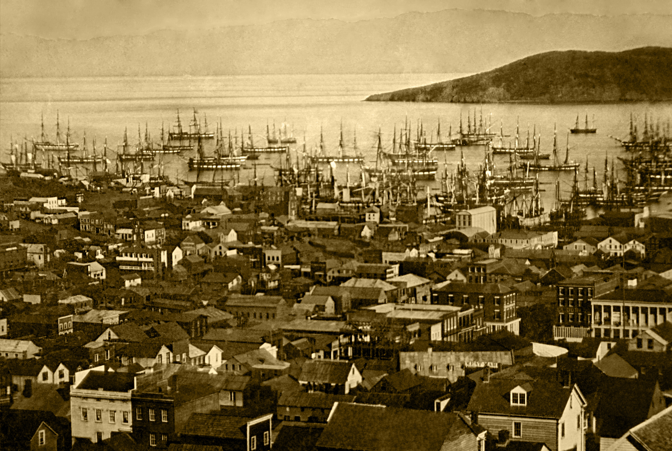
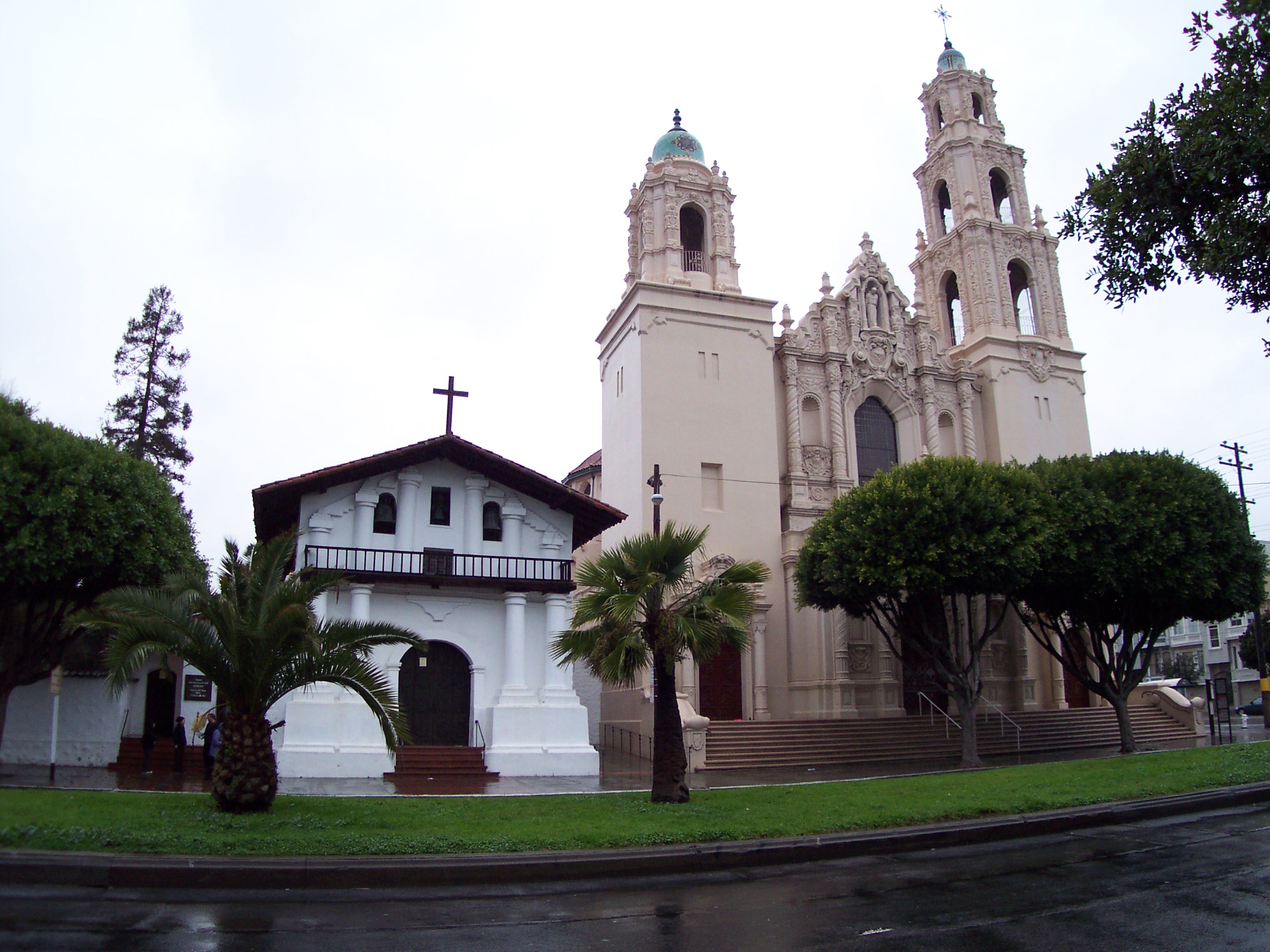
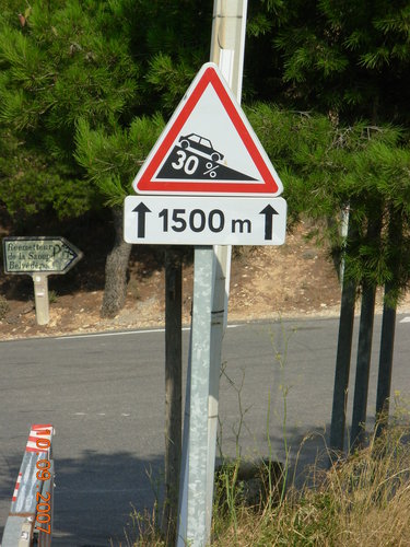
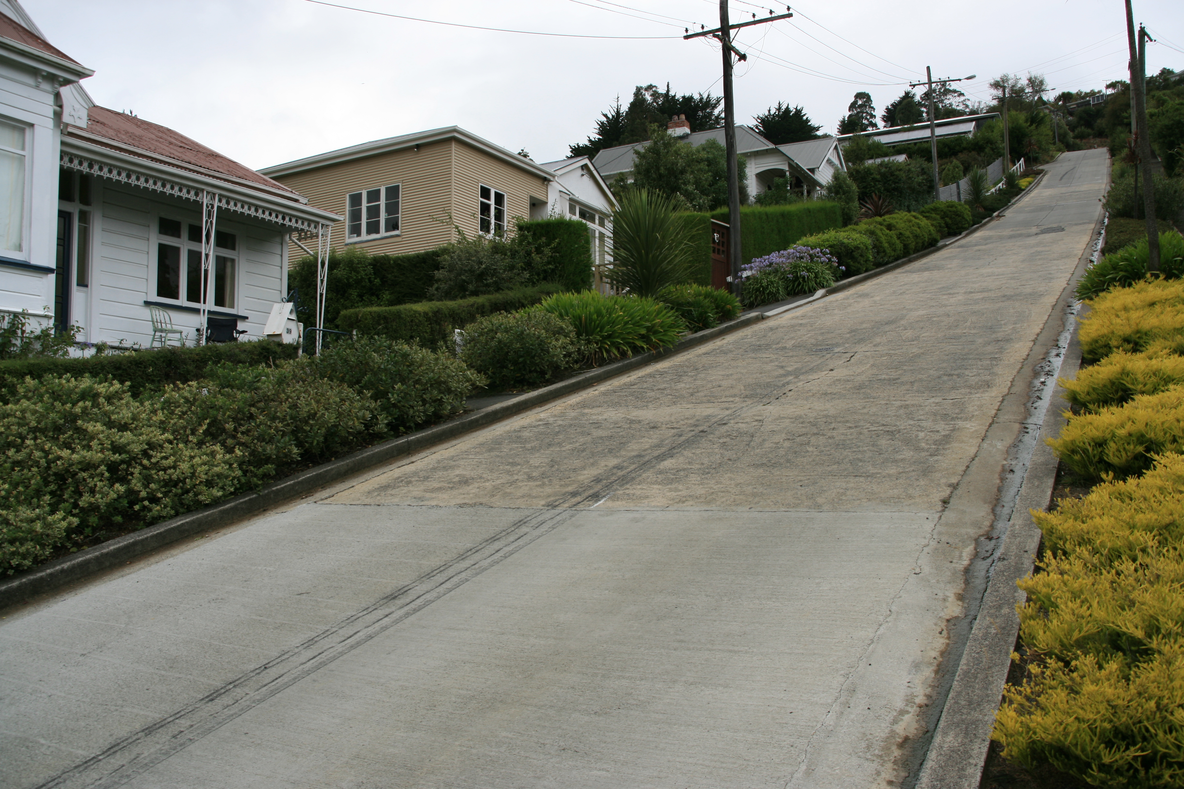
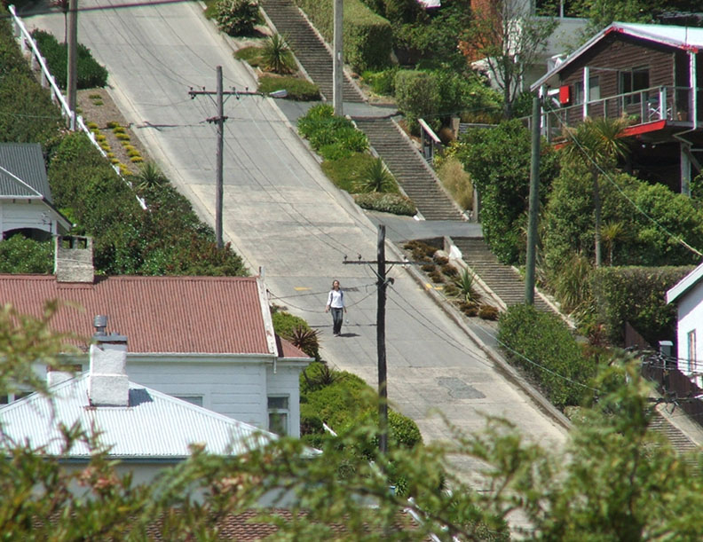