|
Reflections 2019
Series 6
May 18
Ohio River V: Maysville – Changes – Danube - Wheeling – Three Panhandles
| | Day 9: Sa 23 June: Cruising - Maysville KY This day was a Saturday and was the day after all the fun in Cincinnati. But Friday night I didn't really realize yet that "the honeymoon was over". We'd had some surprise fireworks at 9:00 and were set to sail at the unusually late hour of 9:30. As I wrote: At precisely 9:35, Captain Bozo got on the pipe and said we'd be slightly delayed. One of the three engines running the ship "needed a new part", and they'd be "working on it", and we'd sail in the next few hours. That seemed reasonable, and so I believed it, at least for a while. | | | | I also added a very important point: I've mentioned more than once as a spoiler alert that this ship never did reach Pittsburgh, and that the passengers were bused there toward the end of the trip. And I'll state firmly again that that was not a problem at all. Actually, assuming that ACL knew in advance what the force of nature was that would prevent us from our destination, it's just as well they didn't bother us with it until after the two best stops on the trip. I'll say again, I did not find that change in schedule to be a problem. What did bother me is how Captain Bozo, after the "new engine part" announcement at 9:35, was not heard from again the entire next day, nor was Cruise Director Ditz. What was going on? | | | | Waking up for breakfast perhaps around 6:00 (I can accomplish that feat—with an alarm--when traveling; when home, that's the "middle of the night"), I wondered just how late Friday night we'd finally left Cincinnati after the "engine repairs". But if they needed a "new part", just how would they get it? In any case, we were scheduled to sail overnight and arrive in Maysville by breakfast so as to have a full day there, with one complimentary tour in the morning and another in the afternoon. | | | | When I woke up I felt that we were moving, assumed we'd been traveling most of the night, and wondered how late our arrival into Maysville would be. But when I looked outside, I could see the Purple People Bridge downstream while we were going under the yellow "Big Mac Bridge". We were just leaving Cincinnati! What would be happening about Maysville? And the tours? But as I said, 9:35 the night before was the last time we heard from Captain Bozo. He maintained radio silence all day. Is this any way to run a ship? On purely freight shipping, the captain needs his engineering and navigational skills, but on a passenger ship, the captain has to be Chief Diplomat and Host, catering to and communicating with the passengers. Why the silence? Would we skip Maysville completely? And just how much was this situation due to Bozo's poor communicative skills and how much was due to some mandate of silence from the home office of ACL? Either way, it's not favorable to ACL.
https://www.americancruiselines.com/images/default-source/maps/mississippi-river/ohioriver_stl-pitts_700x700.jpg?sfvrsn=2
https://www.ezilon.com/maps/images/usa/kentucky-physical-map.gif
| | | | It's worthwhile now toward the end of the cruise to look again at their route plan above. You'll recall that we didn't stop at Cape Girardeau or Madison, but Wheeling WV had suddenly been added, just before Pittsburgh. That would mean we still had ahead of us, before Pittsburgh, Maysville KY (which I was interested in), Marietta OH, (so-so interest) and Wheeling, where my only interest was really sailing under the historic bridge, the first across the Ohio anywhere, and a model for the Roebling Bridge in Cincinnati. | | | | The second map above, of Kentucky (Ezilon likes to tilt its maps) we've seen before, but check out the short distance between Cincinnati and Maysville, where we're sailing at the moment, and—spoiler alert—locate two places in WV, Huntington and Point Pleasant, for future reference. | | | | I've described this day in the heading as a cruising day. It was really quite pleasant, sailing up the Ohio as it got narrower upstream, and being close to the green shorelines. But it was agonizing that the passengers didn't know what was going on. One rumor was that something was up and the officers and crew knew what it was, but had been told to keep quiet, just as Captain Bozo was doing. In retrospect, I think this was true—but who knows? One valid objection I heard was that "we're adults, and they're treating us like children". That's definitely true. It's a fact that a force of nature up ahead would indeed prevent the ship from reaching Pittsburgh. We'd later find out about it when a quite diplomatic executive from American Cruise Lines joined the ship in Maysville to explain the problem, although I think they made bad decisions and botched up the schedule from here on in in the attempt to straighten things out. I also have to speculate that Captain Bozo had told a boldface lie to the passengers the night before about "engine trouble" and "a spare part"—a lie he didn't wish to compound, hence radio silence today. While it's possible that ACL had told him to lie and to keep his mouth shut about the force of nature, my speculation is that the engine story might have been of his own making, and he just didn't have the cojones/i> to say anything more about it. But how were we do know if we were being kept in the dark? | | | | Do you know . . . ? We'll be cruising most of the day. I don't know on just which day of the cruise the following event took place, but since we have time until we get to Maysville, let's tell it as though it did happen today. | | | | Everyone has had the experience of meeting someone from a familiar place, whereupon they might have asked them if they knew so-and-so—or vice-versa. It never works out—except when it does, and it surprisingly did for me. | | | | HS was a high school friend in my class at Brooklyn Tech. To my knowledge, he was the only other one who then went to Queens College of the City University of New York, as I did. QC had no residences then, so we lived at home, and since HS had a car, he'd often pick me up in the morning. I remember that, to pay for gas, I'd give him 25 cents per trip, which sounds so low after all this time. Since HS was an English major, he knew what a haiku was, and showed me what it's all about, and so today, I send out holiday greetings in the form of a haiku, and was inspired to write several when in Japan (see 2009/40 "Original Haikus"). | | | | The only time I saw HS later on was just a year or two after graduation when he and his wife came to visit Beverly and me in our apartment in the North Bronx. I remember him saying that he'd gotten a job in the English Department of the University of Kansas in Lawrence. That was the last I knew about him. | | | | You may recall that, in 2016 I drove from Saint Joseph MO southwest down to Abilene KS to see the Eisenhower historic site (2016/2). Returning due east, I found myself on the interstate through Lawrence. HS came back to mind. Could he still be there? Could he even be alive? But I nevertheless continued driving on back to Kansas City. | | | | Back to the present. I was having lunch at a large table with Candy, a former lawyer from Des Moines who I met onboard. (I'll also be showing later on two pictures she took; in addition, she visited New York several months later and we went out to dinner. She's now a follower of this website.) On this occasion, a woman named Carmela introduced herself. She was a retired math teacher from the University of Kansas. (Oh?) She was traveling with her friend Vic across the table, a retired English teacher from the same school. (Really?) The urge was too strong to resist. Did they happen to know someone named HS? | | | | Well of course they did! Not only that, Vic taught with him in the same department, and still keeps in touch with him! I went and got my laptop where I had some high-school graduation photos, including one of HS. Sure, that's him! I gave Vic my card and he said he'd contact HS to email me. The seemingly impossible had just occurred! | | | | Some weeks later I got the first of a couple of emails from HS: I hear from my colleague Vic . . . that he met you on the Ohio River and that you know me (knew me). Who are you, unknown person from New York? And why did you have a photo of me to show him? That was worth a smile. Obviously, Vic didn't turn over my card, just gave him my email address, but oddly, without giving him my name. I filled HS in on the facts, and discussed the past. He did not remember picking me up in his car and being paid 25 cents for gas. I reminded him he showed me what a haiku was, and sent him an example of one of mine. He taught at Kansas all those years, and worked as a lecturer in France as well. I knew he'd studied French at Brooklyn Tech. I wonder if he actually lectured in French, or in English. The temporary back-and-forth was pleasant, but a favorite quote of mine is Thomas Wolfe's: You can't go home again. | | | | Old Washington Well lunch is over, and while the river views are pleasant, it's still agonizing not knowing what's going on. How far along are we? We've lost the morning in Maysville, but what about the afternoon tour? Will we get there in time to salvage it? Will we stay overnight or skip it to catch up to our schedule? If we stay, will we do both tours tomorrow? I suppose we can pass the time now reviewing some background.
http://www.landsat.com/town-aerial-map/kentucky/map/maysville-ky-2151024.jpg
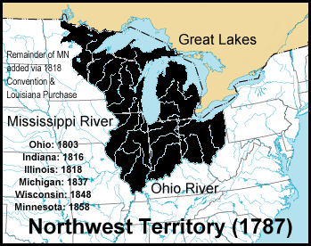
| | | | The complimentary morning tour was to have been to Washington, Kentucky, since its decline now usually known as Old Washington. The above map shows the Ohio River with Maysville on the Kentucky side. Further inland is Washington, per Google Maps about a 10-15 minute drive southwest of Maysville. You'll recall we said that the slave pen in the museum came from a farm near Germantown, which is a 20-minute drive west of Maysville. On the other hand, with the free state of Ohio just across the river, it should not surprise that Maysville was an important stop on the Underground Railroad. | | | | Washington was founded in 1786 as Washington, Virginia, since Kentucky didn't separate from Virginia and become its own state until 1792. Washington was one of the earliest settlements in Kentucky and one of the earliest US settlements west of the Appalachians. Among the first of its trustees was Daniel Boone, and it's believed it was the first settlement named for George Washington. The 1790 census listed 462 residents, including 21 slaves, making it the second largest town in what would become Kentucky—only Lexington to the immediate southwest was larger. | | | | The first regional post office was established in Washington in 1789, which served a huge area—the whole Northwest Territory across the river, including what later became the states of Ohio, Indiana, Illinois, Michigan, Wisconsin, and part of Minnesota (Map by Jengod). | | | | Washington was the residence of Thornton Blackburn, an enslaved African who lived there between 1815 and 1824. He eventually escaped with his wife to Detroit, where he was arrested as a fugitive slave, but he and his wife escaped across the Detroit river to Canada (Windsor, Ontario). While Canada was slave-free, it did return criminals to the US. His slaveholders tried to get him back from Canada by arguing in a Canadian court that he was a criminal, but they lost the case, which established the precedent that it would be very difficult to show that fugitive slaves were criminals and could be returned. This established Canada as a safe terminus of the Underground Railroad. This was also the first refugee law established in Canada and is a basis for Canadian extradition law to this day. Blackburn then moved to Toronto, where he set up the first horse-drawn taxi service and became well-established. | | | | Harriet Beecher (who after her marriage in 1836 was known as Harriet Beecher Stowe), moved from Connecticut to Cincinnati in 1832 at the age of 21 and was teaching there at the Western Female Institute when she came upriver to Washington in 1833 to visit a student. In doing so, she crossed from a slave-free state into a slave state. While in Washington, she witnessed a slave auction in front of the old courthouse. This auction, along with other experiences she'd had with enslaved people, led her to write Uncle Tom's Cabin, published in 1852, which includes that Washington auction scene and has a number of references to Washington. The Key House where she stayed on Main Street now contains the Harriet Beecher Stowe Slavery-to-Freedom Museum. The old courthouse was struck by lightning in 1909 and burned to the ground. | | | | The architecture of importance in Washington ranges from the period 1765 to 1850, with the buildings ranging from simple log cabins to late Georgian and early Federal styles in brick. Illustrative of the former, humbler style is the 1787 log cabin known as Meffords Fort, which was not a fort at all, but a residence. It's a "flat-boat house", which is an excellent example of recycling. It was built from the boards of the flat boat that the Mefford family sailed down the Ohio River in order to get here. Such houses were not uncommon, though this is the only survivor, at least in Washington. Click to read the sign that gives details. | | | | Illustrative of the latter, more elegant style is the Paxton Inn (Both photos by Greg Hume), a c1810 brick three-story Federal style example of an early Kentucky public inn. It served as a station on the Underground Railroad. I understand there's a hidden stairway between floors where fugitives could be hidden until they could be safely moved across the Ohio River at night under the cover of darkness. | | | | Another name of note in Washington is Marshall. The Paxtons had family connections with the Marshalls of Federal Hill, an 1800 two-story brick house with transitional details of both Georgian and Federal styles. One of the sons in the Marshall family was John Marshall, who became the Chief Justice of the United States Supreme Court (1801-1835). Thus there are several famous names associated with Old Washington. | | | | Bringing our attention back to the riverside, it may surprise that migrating buffalo once forded the Ohio River here and their movement in search of salt licks developed into a buffalo trace into the interior of Kentucky, down to the bluegrass region and Lexington. This trace became a well-used trail used for centuries by Native Americans. It is now US Route 68 from Maysville and Washington to Lexington (visible in red on KY map, though not named). This knowledge that a contemporary highway was not only a Native American trail, but before that, a buffalo trace, should interest history lovers. | | | | | | Do remember that Cincinnati developed opposite the Licking River between Covington and Newport, which was the site of saline springs, also used for animals as a source of salt and other minerals (2019/2). |
| | | | European-American settlers traveling down the Ohio in the 18C and early 19C found a natural harbor at Limestone Creek, where Maysville is located today. In 1784, a blockhouse was built there and the landing place began to be called Limestone. New settlers were met at Limestone to be brought to Washington, further inland. By this time John May had bought the land at Limestone and Daniel Boone, who was also involved with the town of Washington, had established a trading post and tavern there. In 1787 the settlement was incorporated as Maysville, though the name Limestone persisted for decades. | | | | In the early 19C, Washington experienced a slow decline, while Maysville thrived. There was a major fire in Washington in 1825. Outbreaks of cholera in 1832-1833 significantly reduced the population. But perhaps the major problem was that of location. Not only was Maysville from the beginning well-placed on the river, especially now for the growing steamboat traffic, but in 1820, the Lexington and Ohio Railroad was laid out from Lexington to the river at Maysville (similar to the route of the buffalo trace), bypassing Washington, which was a major economic blow. By the 1830s Maysville was the second-most important commercial city in Kentucky after Louisville, and so in 1848 came the humbling experience for Washington of having the county seat and government moved from it to Maysville. Finally, Washington was annexed by the City of Maysville in 1990. | | | | | | In 2016, we had a parallel example in Kansas City MO of an original city being taken over by a nearby one with better transportation, particularly river transportation. Westport developed as an outfitting place for settlers going west on wagon trains. It's distance south of the Missouri River was the basis for a landing spot to develop on the river to supply Westport. The landing spot became Kansas City, which thrived, while Westport declined, and is now a neighborhood of KC, known as an entertainment district (2016/2). |
| | | | Today, much of Old Washington is designated as the Washington Historic District, and is listed on the National Register of Historic Places. However, my take on the situation is this. If we'd been here for the tour, I'd have gladly taken it and was already signed up. But I get the feeling that knowing about the history of Old Washington is far more fulfilling than actually seeing it, so I don't mind missing it. It was to be a two-hour walking tour with a costumed guide. When I first had read that, I had the vision of everyone dressed in costumes, but that isn't the case. Google street view shows the main street to be a very quiet road, with only occasional houses and a lot of open spaces. I'm satisfied to just see Maysville, for which I have an online map printed out and am ready to show myself around. | | | | The Confrontation The afternoon rolled by as we slowly sailed upriver toward Maysville. In retrospect, I think we were just killing time, because we could have covered that distance much more quickly, despite the "engine trouble". It was precisely 4:00 PM when we pulled up alongside a park along the Maysville floodwall and docked. In retrospect, I even think arriving exactly on the hour to the dot is suspicious. I looked down from my balcony and could see the deckhands securing the lines. And this was my state of mind: Are we staying here or moving on to the next stop to make up time? If we are staying, will they salvage the afternoon tour of Maysville? It's two full hours to dinnertime at 6:00. If there's no tour being salvaged, can we at least get off? If we do, are we in danger of being left behind? | | | | | | As for the danger of being left behind, I have to make a point I hadn't mentioned earlier. Most ships, certainly the American Queen, keep very close tabs on passengers on land. One's room card also serves as a temporary credit card for incidentals, and when leaving the ship, a deckhand runs that room card through a reader to record one's absence, and again later to record one's return. I don't recall ACL ever doing that, at least not on this pseudo-steamboat the "Queen of the Mississippi". How can they be sure everyone's back? |
| | | | If we were staying, either overnight or at least till after dinner, and if all the tours were canceled and not to be repeated the next day, I didn't want to lose my opportunity to visit Maysville, since I knew exactly where to go and what I wanted to do. But rather incredibly, even after docking, radio silence was maintained. No one said a word. It was beyond frustrating. I had to do something. | | | | I took the elevator down to the Purser's Office and asked Cruise Director Ditz what the current plans were. She wasn't exactly evasive, but did say she didn't know. (A lie?) But she could see I was upset, and when I asked her who else I should then ask, she did an odd thing. She suggested I ask the deckhand at the head of the gangway! Is this any way to run a ship?
https://otrwjam.files.wordpress.com/2013/03/0702.jpg
| | | | I'm repeating above a picture of the ship. The picture is taken on the Mississippi, possibly near Saint Louis, but the docking area looks just the same as in Maysville—that concrete area with parkland beyond. I made my way to the front of the ship and came out of that double-wide doorway to the gangway area. Sure enough, there was not only a deckhand at the top of the gangway (why?) but also one at the foot of the gangway—with the golf cart! Yet no announcements were being made to passengers! What was going on? | | | | I asked the deckhand if we were staying the night in Maysville. He evaded looking at me as he said yes we would. Still, nothing had been said about going ashore in the two hours we still had before dinner, and it looked like Captain Bozo was going to fritter away a perfect opportunity for me to do something I wanted to do. So I asked the deckhand "Where's the Captain!?" (I avoided saying "Bozo".) He said he'd gotten off the ship and had walked along the bank to the entrance to town up ahead through the floodwall. (Was this to pick up that mysterious "new part?") On hearing that the Captain wasn't on board I suspect steam was coming out of my ears, which was more steam than this faux "steamboat" produced. I stepped onto the very top end of the gangway. As the picture shows, it's barely wide enough for two to pass, and I centered myself, arms folded, watching the white uniform walking back to the ship. | | | | Captain Bozo came up the gangway, and had to stop in front of me, since I was preventing him from returning to his ship. I confronted him, but I did not shout. I know exactly how I started, quite calmly: "Good communication is what yields good relationships." I'd been polishing that line for a while, and it summarized my entire point. I then mentioned a couple of obvious grievances, and ended with another truth, that his communication skills were all fouled up. Except I used another word. I then brushed past him and went down the gangway, allowing him to board his ship. At this point, few on the ship knew they could go ashore, and I met few to none in town. It was nice to get so much off my chest, and I was a bit giddy about having done so. At the bottom of the gangway, even though there was no slope to get to the nearby entrance through the floodwall and it was an easy walk, I got into the golf cart and had myself chauffeured to the entrance. (I'll talk about the visit below.) | | | | Coming back for dinner after maybe an hour and a half, I took the elevator up to Deck 5 to freshen up. Wouldn't you know it? For the first and only time ever, the Captain got on the elevator with me, since the pilot house is also on Deck 5. He very civilly asked how I liked the town, and I very civilly told him I enjoyed it. The rest of the ride up was in silence. After freshening up, I went to dinner, with a load off my shoulders. | | | | Déjà vu Before telling about the town visit, I have to talk about the surprise I had the moment we docked in Maysville. I'd been here before!! But how can a person forget such a thing? Easy. It was under rather different circumstances.
http://maysvilleplayers.net/images/map2.jpg
| | | | This is the best street map I could find of just the center of Maysville. It's the same one I'd printed out in advance and had ready to do my own walking tour. It was ideal for the walk, but is lacking a thing or two I could point out now.
Limestone Creek still exists. Google maps shows it's just to the east (upstream) of the bridge.
We'll be talking about Market Street, here unnamed. It's the next street west of Cherry Alley, at the #8.
We mentioned the riverfront park, which is a long, narrow sliver outside the floodwall. It's called Limestone Landing Park, which I find pleasantly historical.
When I printed out this map before leaving home, I visualized that the rail line shown ran along the riverside, which would make it vulnerable to flooding. I was amazed to note on arriving that the rail line runs on top of the floodwall! I'd never seen such a thing.
The rather short concrete docking area lies within the Park. It runs from an imagined extension of Market Street—which is where the ship did dock--up to Limestone Street, where there's an underpass from the Park through the floodwall into town. This will all become clearer with the below pictures.
| | | | Now for the déjà vu, which occurred on arrival, before talking to the Captain and before going into town. I looked at the map in my hand and from my balcony saw the actual tracks, surprisingly on top of the wall. Then on the map I saw the unexpected Amtrak station to the west, which jolted me back 3 ½ years. On 20 November 2014, coming back from Texas and the Lower Mississippi, I took the Cardinal out of Chicago. (Since it took place at the end of the trip, it didn't get written up until June [2015/19]). I wrote in that posting: I would have enjoyed looking out at Indianapolis and Cincinnati, but we stopped there during the night. When I got up, we'd already crossed the Ohio River to the Kentucky side. We were already 2.5 hours late, which would remain that way until New York, but this had the advantage of me being up while we were still along the river. After Ashland, we were in West Virginia and headed for one of the most scenic areas on the route, [the New River Gorge]. | | | | I then checked the stops on the south side between Cincinnati and WV (see KY map). They were (click): Maysville, South Portsmouth (opposite Portsmouth OH), Ashland (shown just before Huntington), and Huntington WV. We were scheduled to be at these stops roughly between 5:00-6:30 AM (too early for me), but being 2.5 h late, it would have instead been roughly 7:30-9:00 AM. I remember having woken up and looking out the roomette window at the early morning mists on the Ohio River. It's a very pleasant memory. This is the cozy little Amtrak station in Maysville seen from the west, located not far from the bridge, with the river also visible (Photo by Rupert Clayton). However, I didn't actually see the station, then or now. | | | | When sailing up the river yesterday, I hadn't thought about having been along the south shore on a train, not even when we arrived in Maysville, so this was a pleasant surprise. It's also particularly pleasing to me that these two events together constituted in their own way an Ohio River "rail 'n' sail". | | | | | | Later that night, I found the Cardinal, which runs only three times a week, was due in Mayville the next morning at 4:52. I was wondering if I'd hear it, so I could see it, but I didn't, so it passed me by like two "ships" in the night. To boot, I checked the Amtrak website, and it had arrived on schedule--as a matter of fact, two minutes early! |
| | | | Now that you have the map, compare it with these pictures to complete your orientation:
http://goldwing.eurekaboy.com/maysville/maysville22.jpg
We are in Limestone Landing Park looking west (downstream). The ship was at the far end of the concrete landing area, just before those trees. To the left is the rather remarkable floodwall, which, unlike others, also seems to be a retaining wall for downtown Maysville, whose ground level seems to equal it. You also see the guard rail at the tracks atop the wall.
http://www.railpictures.net/images/d2/3/7/8/9378.1472928935.jpg
I love this picture because it shows so much. It seems to have been taken from the center of the bridge. The last area to the right (click) is where we docked and at the left, in shadow, is the underpass into town. You can see how unnecessary it was for me to have used the golf cart for that short distance, but I wasn't thinking straight after the confrontation. There's a train—obviously posed—on the track atop the retaining wall, though I never saw one when I was there, not even a freight train. You'll notice that, aside from the lower wall supporting the track, retaining the town, and guarding against floods, there's an upper wall, in gray with the welcome sign, for further flood protection. And so—welcome to Maysville!
http://www.railpictures.net/images/d2/2/0/0/1200.1442533250.jpg
Apparently taken from the part of the bridge over land, this is a nice view of the river and Park, but we're showing it because of the upper wall. You see how it bends so that train traffic can get through the opening, closeable in times of flood. And it's on the town side of this upper wall where the Maysville murals are.
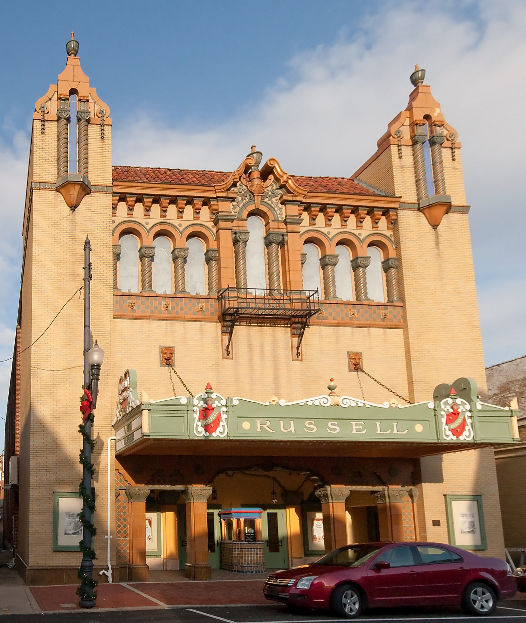
| | | | Maysville Visit So now let's do the visit that successfully I clutched from the jaws of non-communication. It's quite short, but pleasant. From Limestone Landing Park—remember the landing dates from 1784 when that former blockhouse was built--we first walk through the underpass in the wall that brings us to Limestone Street. The walk is uphill, suggesting that pre-floodwall, there was a slope down to the riverbank like Paducah had. Both of the two main streets in the historic district, 2nd and 3rd, exhibit vernacular architecture similar to Over the Rhine. But we have two destinations on 3rd Street to see, so we turn right when there. | | | | But we first have to know that Maysville is the home town of the Clooney family, most famously the singer and actress Rosemary Clooney, whose career reached its height in the 1950s. Rosemary and her sister Betty became entertainers, while her brother Nick became a journalist, anchorman, and television host in the Cincinnati area. Nick's son—hence Rosemary's nephew—is the actor George Clooney, born in nearby Lexington KY. | | | | On 3rd Street, just before Market (at the #8) we come upon the Russell Theater (Photo by Greg Hume), now repurposed as an arts and event center. Read both sides of the historic marker in front of it, from which you'll see its local importance:
https://www.gannett-cdn.com/-mm-/4b4285c1d64d50de5d52d9f73b4d2a8eb66f33a6/c=326-0-5433-3840&r=x408&c=540x405/local/-/media/2016/04/25/Cincinnati/Cincinnati/635971685622788456-XS0A3295.jpg
https://farm4.staticflickr.com/3294/3065464311_293ac5b00a.jpg
| | | | Her founding of the Rosemary Clooney Music Festival is significant locally, though it's unclear if it survived her death, since when she was alive, both she and her famous friends would perform gratis, but afterward, fees would have to be paid, and I can't tell if Maysville was able to afford them. Below is a movie poster of her first film, premiered at the Russell:
https://i.pinimg.com/236x/7e/80/08/7e80084d444a1347e31b35ffc3dbe2ec--mitzi-gaynor-rosemary-clooney.jpg
| | | | In a half-block, we reach Market Street, and on the left corner is the notable Cox Building (Photo by Greg Hume), in spectacular Richardson Romanesque style, as we've seen in a number of buildings recently (Cincinnati, Dallas, soon again in Pittsburgh). It was built in 1886 and the City of Maysville has purchased and restored the building. Click to inspect the architectural detail. | | | | We turn right on Market, a wide street with park areas, where we can rest on a bench and enjoy the view. We turn right again at 2nd Street (see map), where near the intersection we get this eastward view of vernacular buildings in the historic district (Photo by Greg Hume). | | | | Back at Limestone Street, before using the underpass, we see Maysville's murals on the inside of the upper wall. To our left is a spectacular rendition of Native Americans hunting migrating buffalo (click) on the buffalo trace through Maysville in the 16C (Photo by Greg Hume). Adjacent murals to the left include the 18C Limestone Landing, the visit of Lafayette, and the Underground Railroad.
https://2.bp.blogspot.com/-66WpvNR6XpY/W-HS_33ooMI/AAAAAAAAQG8/zbF0QNrv5nY6hn1_ty-Z7IKjI13rjhnYACLcBGAs/s400/IMG_6429.jpg
| | | | But when we look right just before the underpass, we see the Rosemary Clooney mural, including a view of the façade of the Russell Theater. Her brother Nick spoke during the dedication of the mural. One of the most famous songs she sang was with Bing Crosby, Irving Berlin's "White Christmas", in the eponymous film. Jump to where it starts at 0:49. | | | | Water Level Problems But an explanation was long overdue, and finally we were all called to a meeting in the lounge after dinner. An ACL company rep had arrived and would be speaking. As the Captain stood in the back of the room, the rep, who was very likeable, diplomatic, and had a way with words and with people, had some things to tell us about. | | | | I find it very significant that he did NOT start with what was to be the big news of the force-of-nature problem. That came second. He started by saying he understood there was a problem in communication with the passengers, for which he apologized. This caused a stir in the audience, and this was also when someone in the back made that statement referred to earlier, that we're adults, and have been treated like children. I was sitting in the second row, and also wonder to what extent my "discussion" with the Captain was being referenced. Still, with whatever we were told, I'm sure they were still suppressing details. | | | | The force-of-nature problem was simple. There had lately been too much rain in Pennsylvania, and the Allegheny and Monongahela Rivers, the two feeders to the Ohio, had been sending too much water down into the Ohio. Thus the river was in flood stage, which would raise the ship high enough that it wouldn't be able to pass under a number of the upcoming bridges on the way to Pittsburgh. | | | | As likeable and informative as this gentleman was, we still never got any details about why we delayed all day arriving in Maysville whereas we could have had both tours in addition to the rep being able to come on board. I still don't believe the "part needed" story, but even if it were completely true, that subject was never brought up again, so we, "the children" remained in the dark about it all. I'm also not fully satisfied with how they rescheduled the next couple of days, which I think could have been done more sensibly. | | | | Anyway, to the point: on one of those days, the second mate (not the Captain!!!) gave an excellent tour of the pilot house with details we'll discuss later. One point he made, though, was that, the Queen of the Mississippi, even with its two (faux) smokestacks folded down, needed 53.5 feet (16.3 m) to pass under those bridges furthest upstream, which, with the river in flood stage, we did not have. None of this change of plans bothered me, though, as I later took care of what I wanted to see in other ways. What continues to pique me, though, is the way all this was done, without telling us anything in any detail. | | | | The rep did point out, though, that even where we were here in Maysville (whose bridge was still OK for us to pass under), the water level was high enough so that the river was lapping over the concrete dock next to us, which I did confirm. I have to speculate—since no one discussed it—that further downriver, the Ohio was wide enough to accommodate the floodwaters, so that when the high levels reached that area, it would be less of a problem—or none at all. I'll add that the rep continued his "nice guy" role the next morning when he went from table to table at breakfast giving coffee refills. I cannot confirm the ship's officers doing such a thing to reach out to the passengers, even under the present unusual circumstances. | | | | I suppose this is a good point to talk about the letter I later got in the mail. This trip was in June 2018. Shortly before I left for my next trip to Canada at the end of the summer to sail again on the Kawartha Voyageur, I got a letter from ACL offering me a 25% discount on any available cruise thru 2019 booked by the end of 2018. The letter seemed most concerned about the truncated itinerary, not the issue that bothered me most, the lack of communication with passengers. I assumed all the passengers would have gotten something similar, but when Candy came to New York in the fall, she said she hadn't received any such letter, so again, I have to speculate that other passengers didn’t either, nor did the letter make any reference to others. Again, ACL was making a positive offer with one hand, while the other hand was wagging its finger warning not to ask too much. I'll talk more about this at the time, but I've been to most of the places where ACL sails. In the end, I chose their 11-day "Grand New England" cruise for June 2019, even though I've been to most, if not all, of the places they stop at. Nevertheless, it should be nice, and I wasn't going to throw away at 25% discount. But caveat emptor. Just today, as I write this, I heard from ACL about the passenger info sheet I'd sent in for that trip, where I told them I'd be arriving in Boston on Amtrak. Their question was, however, what flight was I taking? Can you believe it? | | | | But this current topic is Water Level Problems, about which I can cite two I'm aware of, perhaps because I travel a lot, especially on ships. The first problem didn't affect me, though I was well aware of it. It involves that above-mentioned trip to Canada at the end of summer 2018 where I'd be on the Kawartha Voyageur in the Kawartha Lakes. I heard in June 2017, over a year earlier, that the lakes and rivers were high, just like the present situation on the Ohio, and that they had to cancel three sailings because the ship couldn't get under a number of bridges. When I actually did sail with them in August 2018, I was well aware of when we went under bridges that had caused the previous problems.
http://www.orangesmile.com/common/img_country_maps/austria-map-2.jpg
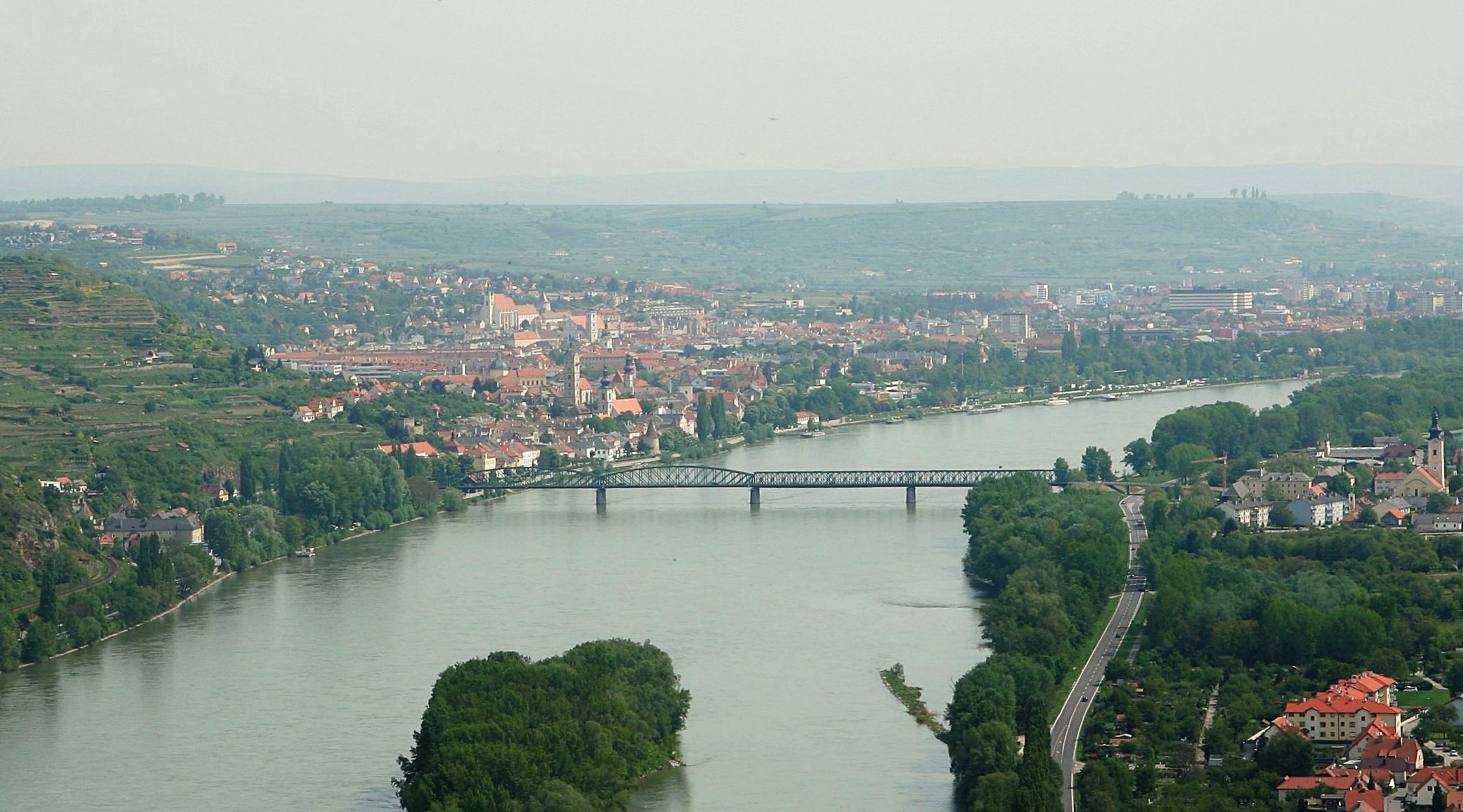
| | | | Danube The other problem did affect me personally, but involved exactly the opposite reason—low water on a river instead of high. It was in 1981 when we were doing one of our frequent trips to Germany and Austria. Somewhere in the middle of that rail trip making numerous stops in both countries, we were to have an overnight cruise on the Donau/Danube leaving from Passau (in both words, AU rhymes with "now"), which is just on the German side of the border (see above map). On 9 July we took the train from Regensburg to Passau, looked around the town, then showed up on the dock. The office was closed, but a sign in the window, in German of course, pointed out that, because of dry weather, the Danube was too low between Passau and Linz (LINTS) for the intended overnight ship to pass, in which we'd booked a cabin for the one night involved. Those were pre-email days, and I'm sure we must have done the booking by letter, yet they had no way to write us back while we were in transit to tell us about the problem. | | | | No matter. We just took the train to Linz, looked around Linz, and then found a hotel to spend the one night we would have had on the ship. The next day we boarded the Stadt Wien (City of Vienna), which was probably a smaller boat than the overnighter (I'm sure a partial refund must have been involved), and proceeded down the Danube as a day trip. If it had been an overnight trip as planned, my total times on overnight ships would have been one higher, since I don't count day trips, including the one we once took on the Rhine.
https://www.vagonweb.cz/razeni/mapy/A.png
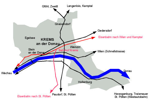
| | | | Use this stylized rail map of Austria together with the previous one to follow along. Red lines are the Austrian Federal Railways; green lines are private railways; solid lines are standard gauge, dotted are narrow gauge. I'm sure we must have had a railpass. You can follow our rail route from Passau to Linz. We sailed on the river through three locks, and I particularly remember in Melk seeing the famous Stift Melk/Melk Abbey high on its precipice above the Danube (Photo by Thomas Ledl). | | | | While you may think it odd, we were not going to Vienna, where we'd been many times. Our goal was Krems (see rail map, listed as Krems a. d. D, or Krems an der Donau). Melk and Krems are at opposite ends of the famous wine-producing region of the Wachau (Map by © Bwag/Wikimedia). In "Wachau", AU again rhymes with "now", but here is stressed; click for details on the map. Dürnstein is where King Richard the Lion-Heart of England was held captive. To its west is Weißenkirchen, which we discussed in Charleston SC in 2016/17 in reference to Grüner Veltliner wine from the Wachau. Put it this way—if the water level problem on this trip hadn't been resolved, I might have never gotten to see very much of the Donautal/Danube Valley (Photo by © Bwag/Wikimedia), of which this is a typical view in the Wachau. | | | | We got off in Krems, as planned (Photo by Konwiki), and looked around a bit. Then we made our way to the Krems Bahnhof/Rail Station (Map by Konwiki) and took the small local railway (in red) to Sankt Pölten (see rail map), a rail hub, a connection we'd discovered in those Thomas Cook rail guides we used on those years, as mentioned in the last posting about Einbeck. This continued our rail-to-sail-to-rail day. From there, things went much faster, since we took an express train, which whisked us back west via Linz to Salzburg, so we could cross back to Germany the next day to visit Berchtesgaden. | | | | Day 10: Su 24 June: (planned: Marietta OH) River Cruising Now back from water level problems on the Danube in 1981 to water level problems on the Ohio in 2018. We were still in Maysville this morning when finally, finally, finally, a public announcement was made. Though there wouldn't be the planned walking tour of Maysville as was due the day before, it would instead be an ad hoc one that the ship's lecturer was asked to do after breakfast, after which we'd leave. But perhaps I was one of the very few—if not the only one--in the position to say "been there, done it" after my experience yesterday, so I relaxed on board until we left. | | | | Take one last look at our Kentucky map, and review the location of Maysville and the two towns we mentioned earlier in WV, Huntington and Point Pleasant. These would be our last two stops on the river. We sailed all day, and arrived in Huntington at an unusual 11:00 PM. Now drop the KY map and let's start using this WV map:
https://www.ezilon.com/maps/images/usa/west-viriginia-physical-map.gif
| | | | You'll recall we said earlier that the Cardinal, after stopping in Maysville, made three more stops on the river, the last one being Huntington WV, after which it cut across WV to Virginia and beyond. It went via Charleston and the impressive New River Gorge, with several stops, of which only Hinton is shown on this map. Still, our stopping in Huntington was, as with Maysville, déjà vu all over again. | | | | But the stop that had been originally scheduled for today instead of the day of cruising was Marietta OH, visible on the WV map. I had signed up for a tour of an old mansion, but missing it—and Marietta—was no great loss. But I'd prepared a couple of notes about Marietta that I think are worth mentioning. | | | | Marietta is the oldest city in Ohio. In 1788, pioneers established it as the first permanent settlement of the new US in the Northwest Territory. If you've always wondered how "northwest" entered that name, I've learned that the formal name was the Territory Northwest of the River Ohio, so it was the river we're sailing on that was defining this huge area (Map by Jengod). We recently used this map to show the area served by the post office in Old Washington. Marietta was founded by settlers from New England who had invested in an entity called the Ohio Company. I'm sure the name referred to the river at the time, since the state didn't exist yet. It was a land company whose members are credited with becoming the first non-Native Americans to settle in what is today the state of Ohio. The area of the Ohio Company Purchase is shown here in yellow. (Map by Andy85719, Plssohio; Plssohio). Because of its location, Marietta was another station of the Underground Railroad. | | | | Marietta is another place name meant to honor someone, but in which you just can't tell just who that person was. Can you guess? Would it help if I told you it was a queen?
| | | | It was named in 1788 in honor of France's contributions to the US victory during the Revolutionary War, for the then Queen of France, Marie Antoinette. Little did the pioneers know the French Revolution would take place the very next year, 1789, and she'd be out of the picture. Why did the shrinking of Mari[e Antoin]ette make it so hard to tell whose name it was? I'd guess it's that A at the end. But why? The French suffix –ette in Italian is –etta, where she's known as Maria Antonietta. When she was born in Vienna, her name had been Maria Antonia Josepha Johanna, with a lot of final As. But I don't know the answer about that "obfuscating A" at the end of Marietta. | | | | Day 11: M 25 June: (planned: Wheeling WV) Huntington WV Today, Monday, had been planned for Wheeling WV, but we'll discuss it when we're bused by it on Wednesday. I find that Huntington was founded as a railroad town, and its location on the Ohio was selected by Collis Potter Huntington as ideal for the western terminus of the Chesapeake and Ohio Railway (hence "Ohio" in the name, meaning the river). The line is now CSX, specifically CSX Transportation, Huntington Division. The town of Huntington was founded by the C&O as one of the first planned communities in the US, and it developed rapidly after the railroad was completed in 1871. But, while I knew WV is not known for big cities, I was surprised when I learned about the meager populations locally. Huntington and the nearby capital of Charlestown (see WV map) vie for being the largest city in the state, but in 2017, Huntington had 47,079, while Charlestown had 47,929. Those figures are so close that I wonder if they ever flip-flop. In any case, small Huntington was about as populous as it gets in WV. | | | | While I suspect that Marietta and Wheeling had little to offer, Huntington and Point Pleasant had considerably less. Put it this way: if you were driving in the area, there'd be little reason to stop to see any sights in either. ACL set up an ad hoc bus shuttle loop around Huntington. It wasn't an officially guided tour, but one using the company's bus that followed the ship. It was the same fiasco as what they'd done in Paducah. The set up a route, told us where the "official stops" were, but no one dared get off, at least when I rode it. We just accepted it as a loop drive through town. Not only was there little to see that couldn't be seen from the bus, but the "stops" were unmarked and seemed so iffy that one feared not being picked up again, compounded by the fact that the ship didn't take attendance on disembarking and embarking. But don't get the wrong impression from these remarks—the time in both Huntington and Point Pleasant were relaxing, and to some extent, I have fond memories of each.
https://east-usa.com/images/193b.jpg?crc=48094233
| | | | Click to enlarge the center of this map of Huntington. We docked about five blocks to the right (upstream) of that bridge shown in black, route 527. My best memory of Huntington was sitting at a picnic bench under a tree in Riverfront Park, waiting for the shuttle to return from its previous run. It was nice river views, and good conversation with others. The loop ride went counterclockwise down to Ritter Park, then came back to take a look at Marshall University. | | | | The shuttle ran from 9-12, and we left at 12:30 for Point Pleasant for the night. I noted in the diary that, while the Ohio had been brown in color earlier, at this point it was muddier, and a deep butterscotch color, obviously due to the floodwaters coming downstream. | | | | Day 12: T 26 June: (planned: Pittsburgh) Point Pleasant WV This day would have been an early arrival in Pittsburgh, but we'll discuss it when the bus gets us there. Instead, we have a day in port, which will include two night, including our last night on the ship.
http://www.landsat.com/town-aerial-map/west-virginia/map/point-pleasant-wv-5464708.jpg
| | | | This should orient as to just where we are. We do pass under the blue line, which is a highway bridge from Gallipolis OH, across the river, to WV. We pass the mouth of the Kanawha River and dock in the center of Point Pleasant, just before the railroad bridge partly blocked by a word on the map. It's intriguing to know, as we look at the railroad bridge both during the day and at night, whether it's the first bridge that's blocking us, or if the first actual blockages are still a bit further upstream. Of course, ACL tells us nothing about such details. | | | | Point Pleasant is a small town, whose population in 2017 was just 4,153. But it dates to the 1770s, and has a bit of history associated with it. Where we're docked is quite attractive. Right from the side of the ship, we can see the floodwall with several statues in front of it, and different from elsewhere, the floodwall has its colorful murals facing the river, so we can see it all. This is one of the statues in front of the floodwall (Photo by Marginair). It really is quite colorful.
https://i.pinimg.com/600x315/3c/44/78/3c4478f810155d79d7b88a3e307e6014.jpg
https://otrwjam.files.wordpress.com/2013/05/1081.jpg
| | | | The first picture is a view to the south (downstream). It shows the size of the small town and the rail bridge that might be the first one blocking us. In the distance is the Kanawha, and a small ship is docked at the concrete docking area. The second picture, still looking south toward the road bridge, shows the docking area with the parkland and ramps sloping up to the statues and the murals on the floodwall.
Finally, we have my favorite view, looking WSW from above the Kanawha and downstream on the Ohio, where we just came from. Gallipolis is across the (gray) road bridge (click) and the center of Point Pleasant is off to the right, around the bend.
| | | | Some passengers wanted to walk up the ramps and stroll in the town, but I wasn't interested, and felt I'd be passing through the town anyway when we left on the bus, so I enjoyed a pleasant day relaxing and writing on board. But one thing made the stop here particularly nice. Once the locals found out we'd be stopping in town, apparently a rare occurrence, they were impressed with hosting a "stranded" cruise ship. Ad hoc, the Chamber of Commerce offered a walking tour of the town for those interested, and I heard we'd made the local paper. Sure enough, during the morning some copies of the Point Pleasant Register were brought on board and there we were, right on the front page (I kept the front page of one copy). Candy and I were looking at it at lunch, and she took a picture of me at the lunch table holding a copy of the Point Pleasant Register, which I put on my Flickr account to access here (Photo by Candy Morgan). We were "A Surprise Arrival", and you'll see a photo of the ship that was included, taken the previous year. Rather confusingly, the article reports that we stopped "due to the damages caused by high water", which makes no sense. Had there really been some engine damage? If so, how could the high water problem have caused it? It'll have to remain a mystery. The article also told its readers that, while it was not permitted for them to board the ship, "it will be a perfect chance to view the ship up close, take memorable photos, and speak with the passengers about their trip." We were being showcased! That's another positive side to how this cruise ended up. | | | | The busing schedules were announced, and there would be four groups. The ones flying out of Pittsburgh the earliest would leave at 1:00 PM today to be taken to the airport Hyatt Regency to spend the night gratis before their flight; the others would leave in the morning. Candy had been left out of today's group, but protested her reasons why she had to go, and was then added to the list. | | | | For those of us staying, this afternoon had a pilot house tour scheduled, with signups by the hour, and so I signed up. For reasons I don't know, it was, thankfully, not the Captain doing the tour, but his very friendly and well-informed First Mate. I had easy access, since the pilot house, as you'll recall, was at the front end of Deck 5, where my cabin was. | | | | I've been in a few pilot houses, most notably on the Explorer II in Antarctica (Voyage 40), when we were allowed regular access, day after day (2006/15). But this one was also a lot of fun. The First Mate was personable and skilled at dealing with passengers, and showed us what all the electronics were. He confirmed what I so clearly knew, that the paddlewheel and smokestacks were fake, but which may have surprised a few others. He told us, as mentioned earlier, that we need 53.5 feet (16.3 m) to clear bridges up ahead, which we didn't have. He also talked about our propulsion--that we had three Z-thrusters whose function I explained in an earlier posting. What was new was that he said one of them served as a bow-thruster, which would be turned sideways to help us dock by pushing the bow sideways toward the pier, or away from it on leaving. This was very informative and enjoyable, as shown by everyone's reluctance to leave once the next tour showed up at the door. | | | | Updating my summary at the end of 2013/7 of overnight stays on ships, varying from one night to seven weeks, this is Voyage 57. | | | | Day 13: W 27 June (early): Bus via Wheeling The other three bus groups were to leave for Pittsburgh very early today. Those with the earliest connections left at 6:00, and a second left at 7:00. Both of those went right to the airport. As I recall, they were given a boxed, take-along breakfast. Though, as I said, I can get up early when traveling, I'm glad I wasn't in flying mode. I was in the last group, which had time to go to breakfast before disembarking at 8:00. The others among us not rushing to the airport, who did almost fill a bus, were mostly planning to stay a couple of days in Pittsburgh before leaving by whatever mode. One plus: contrary to the messy baggage situation when we boarded in Saint Louis, this time the baggage was laid out along the side of the bus, and only once we identified our bags were they loaded on the bus. Improvement is learned slowly. | | | | I know there was one couple who was planning on returning to Saint Louis, from where we'd departed, by bus. I told them a rail connection was possible, but they hadn't researched their choices that far. Since I was going home by rail, and since the Pennsylvanian to NYC left at 7:30 in the morning, knowing the original plans were to disembark in Pittsburgh at 8:00 or 8:30, I'd planned a night in Pittsburgh from the very beginning as well. Now with the bus connection, we arrived noonish, so the pleasant day I'd planned would be a little shorter, but that was no problem at all. | | | | I don't know how geographically aware other passengers were, but it wasn't hard for me to figure out exactly what our bus route would be, and I was right—we'd be passing Wheeling. I hadn't been overly interested in the tour that had been planned if we'd stopped there, but I really wanted to sail under the historic, landmarked Wheeling Suspension Bridge. | | | | Wheeling Suspension Bridge The secondary reason I wanted to sail under—or at least see—the Wheeling Suspension Bridge was that, since it was the first bridge to cross the Ohio—in 1849, though only over the main channel (more later)--Roebling observed its construction before designing his own bridge in Cincinnati, now called the Roebling Suspension Bridge, completed in 1867 as the second bridge to cross the Ohio.
| | | | But the primary reason is included in the statement I just made—that it was the first bridge to cross the Ohio River, purposely built this far upstream where the river was narrower, to bring settlers and commerce further west. It was built as a link on the National Road, which we discussed in 2016/12 when in Ellicott City MD. I'll copy the following from that posting: | | | | | | The project started under the name Cumberland Road, but was then extended both west and east, and is also known as the National Road (Map by Citynoise) . . . It was the first major improved highway in the US, built between 1811 and 1837 by the federal government. Construction started in 1811 at Cumberland MD on the Potomac, hence the alternate name, and, reached Wheeling VA (WV) on the Ohio, well before the B&O eventually did. But congressional funding ran out and construction was stopped at Vandalia, Illinois, the capital of the Illinois Territory, some distance short of St Louis, which why the name Cumberland Road is limited to the stretch in the map. The reason for the cut in funding was because Congress realized that the railroads were coming and providing better access. Nevertheless, the road was the path to the West for thousands of settlers. |
| | | | As the map shows, the National Road also connected the Potomac River, at its starting point in Cumberland, with the Ohio, at Wheeling. Note that Wheeling was in Virginia at the time, well before West Virginia broke away to become a separate state. The Road arrived in Wheeling in 1818 and also allowed goods from the Ohio Valley to flow east. Because this bridge was designed during the horse-and-buggy era, 2-ton (1.8 metric ton) weight limits and vehicle separation requirements now apply. At the time of its construction in 1848, the Wheeling Suspension Bridge (click) was the largest suspension bridge in the world, but it held that title only for two years, until 1851. Litigation in the US Supreme Court concerning its obstruction of the new high steamboat smokestacks eventually cleared the way for other rail and road bridges to be built, especially needed by expanding railroads. | | | | | | You'll recall when discussing the Eads Bridge in Saint Louis in 2016/3 we said that 19C steamboat interests kept trying to protect their transportation monopoly from the railroads by contesting the building of bridges across the Mississippi.
And have you considered the irony of history repeating itself? At this moment we have bridges on the Ohio blocking our pseudo-steamship from continuing upstream?
|
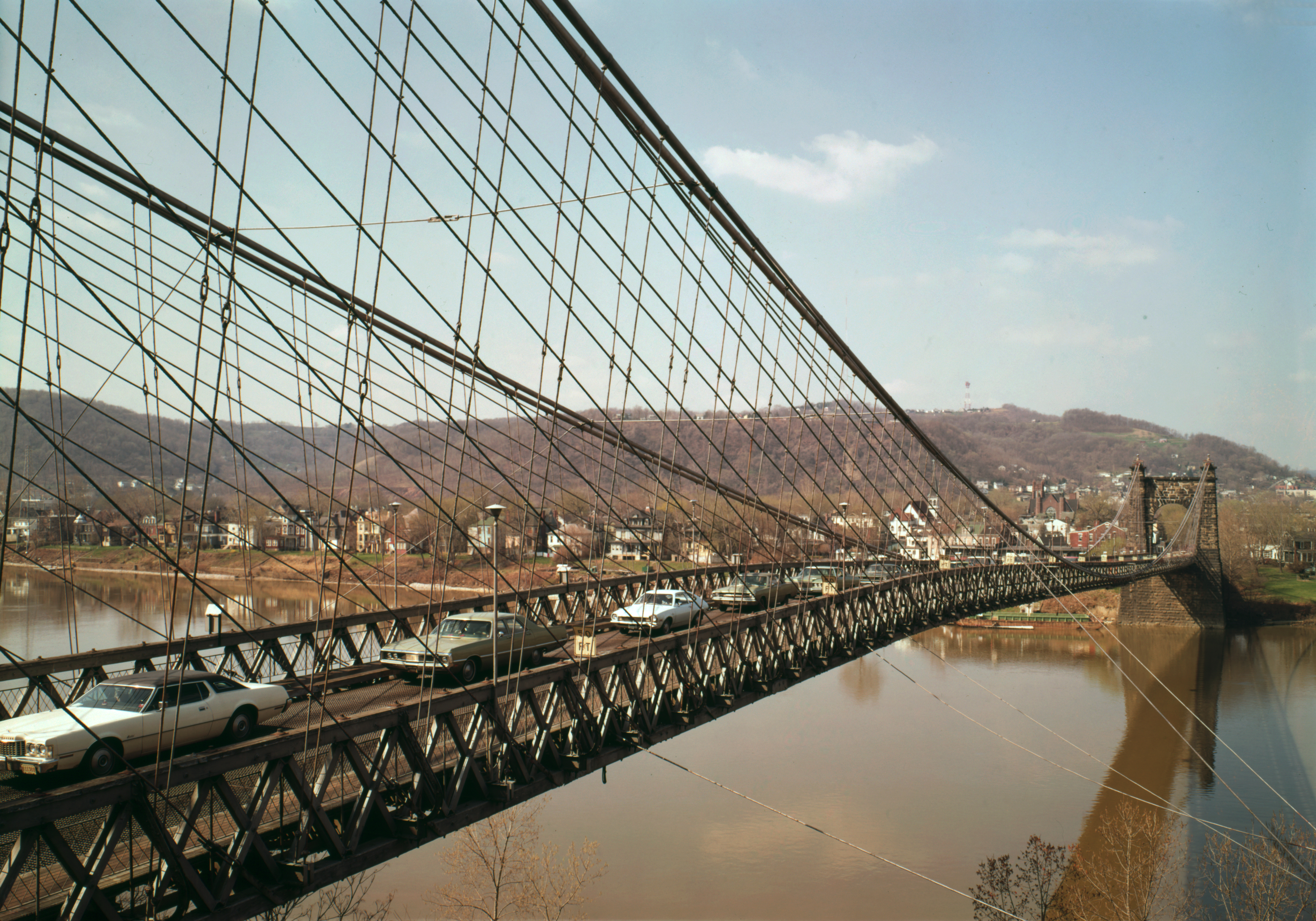
| | | | This is an online picture of contemporary traffic crossing the Wheeling Suspension Bridge over the main channel of the Ohio between downtown Wheeling and Wheeling Island. The bridge is both a National Historic Civil Engineering Landmark and a National Historic Landmark.
http://weheartwv.com/wp-content/uploads/2016/01/20160114_wheeling_old_map_big_sized.jpg
| | | | But we need to explain about the island, and this birds-eye period illustration does so very nicely. We're above Ohio looking southeast. Wheeling is on the far side, and you can see that the bridge only crosses the main channel of the Ohio to Wheeling Island, which is still in WV, and is also part of Wheeling. As you'll recall, all river borders dating back to Virginia included the rivers within its borders, so both KY and WV own the entire river up to the Ohio shore. To connect Wheeling Island with Bridgeport OH, another, smaller bridge has always been needed, and today, a 1998 bridge has replaced earlier ones. | | | | In the background of this illustration a road can be seen on the left, curving around a hill and entering Wheeling. This is the National Road on its way west to Ohio and beyond, and today is US 40. Now to REALLY jolt your sensibilities and to bring this view into modern times, you have to picture two Interstate highways crossing this tranquil scene. Picture I-70 in the upper left coming from Pennsylvania, tunneling its way through that hill, and crossing the main channel only about a block north of the historic bridge. It then crosses Wheeling Island and breaches the minor river channel to the south of the smaller bridge, right about where that little stream is in Bridgeport OH. Isn't the late-20C-21C an eye-opener? As for the other interstate, right beyond the southern tip of the island, thus just off this illustration, the bypass Interstate 470 crosses the entire river in one fell swoop. Confirm everything we just said on this modern map:
https://thumb7.shutterstock.com/display_pic_with_logo/837340/155021765/stock-vector-wheeling-west-virginia-area-map-155021765.jpg
| | | | The Bus Ride & Wheeling I'd guessed the route right. Go back to our WV map and find Point Pleasant. Just as I'd expected, we went a short distance east to I-77 and rode north. We crossed the Ohio River back into Ohio for the first time since Cincinnati, and went right by Marietta, as though prophesied. We kept going until we joined I-70, passing Saint Clairsville—remember than name—and up ahead at Wheeling the road split, with us taking I-470, cut through the northern panhandle of WV, and went on to Pittsburgh. (Note the location of Steubenville OH, mentioned in 2019/3 in regard to General von Steuben.)
| | | | I've been saying all along on this trip that I fortunately was able to regularly make lemonade from lemons, and it was equally true about the Wheeling Suspension Bridge. As a matter of fact, Wheeling turned out to be a triple-win situation, to wit:
● Though I was hoping we'd come in on I-70 next to the bridge, we came in instead on I-470, a bit further south. It wasn't that much further away, so I did see the historic bridge in the near distance.
● A few weeks after the trip, Candy had occasion to be in the area again, and she sent me this picture of the bridge, which I've posted on my Flickr account to access from here (Photo by Candy Morgan).
● As I mulled this over, it suddenly came to me that I've been there before! However, it was a full four decades earlier, exactly. It shows the positive value of maintaining travel diaries, one of which did remind me about that day. 1968 was the first of three summers we spent touring the US and Canada in our VW camper, this first summer starting furthest from home, with the West. With a nudge from the diary, I remember that we were eager to zip along, since we'd be driving around the East the next summer and could see more of it then. Leaving NY, we crossed NJ, then realized how crossing the length of PA seems to take forever. But we wanted to have more states under our belt that first day, so we pushed it. We didn't only want to finish driving through PA, but wanted to add that little bit of WV, and end up in OH. That much I remembered. Now the travel diary says that our very first stop that first day out of NYC was in Saint Clairsville OH on 25 June, mentioned above, a name I'd otherwise totally forgotten. I-70 already existed at that time (I-470 is much newer), and the only way we could have gotten to Ohio was through Wheeling. I'm sure we saw the older bridge to our left, but wouldn't have realized its significance at that point. Anyway, I count this as a win!
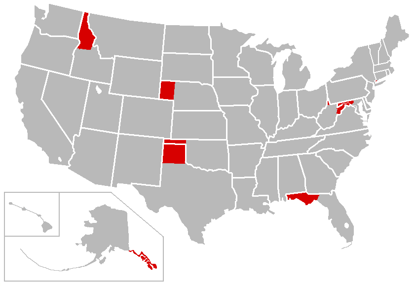
| | | | Three Panhandles At this point I was back in the land of three panhandles, and crossing WV's skinny northern panhandle for the second time in my life—1968 and 2018. It's worth reviewing how the first two panhandles came about, and adding the story of this one.
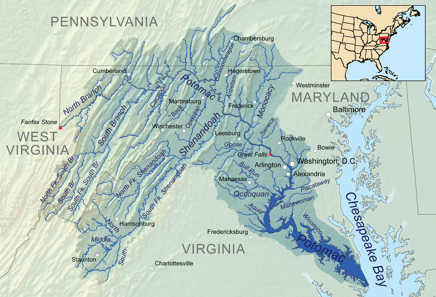
| | | | I knew exactly what I wanted to say, but checked in Wikipedia for confirmation. Interestingly, they point out that the more international word is "salient"—I like it—and that it's American English that uses the folksy "panhandle", and I like that, too. A salient/panhandle involves purely political borders and is thus surrounded by land, while a peninsula is geographic, and is surrounded by water. If you want a thorough list of panhandles, consult Wikipedia's entry on "Salient". It has some nice maps of Namibia's Caprivi Strip to its northeast, India's eastern panhandle surrounding Bangladesh, and many more. A notable double salient/panhandle is where a piece of Burma/Myanmar sidles down the west of the Malay Peninsula while one from Thailand sidles down into the center of that peninsula. | | | | But we're talking about the United States (Map by Porsche997SBS at English Wikipedia), and the article has this perfect illustration of what I want to discuss. (You can see that Florida is unique in having both a peninsula and a panhandle.) The insert shows Alaska's panhandle, and at the top is Idaho's, then Nebraska's. But the US has its own double panhandle, with the ones from Texas and Oklahoma directly adjacent. That brings us to the Northeast, where Maryland and West Virginia together show three panhandles, though not all three abut each other. | | | | ◊Maryland's Western Panhandle In 2009/22, we first discussed how Virginia and Maryland, the two colonizers of Chesapeake Bay, each expanded west, using the Potomac as the border all the way up along its North Branch, as specified in Maryland's 1632 charter. In 2016/10 we said the Fairfax Stone (Map by Karl Musser) had been laid to mark the source of the North Branch of the Potomac, thereby being the basis for Maryland's western north-south border and abruptly limiting Maryland's westward expansion.
http://farm8.staticflickr.com/7451/10727905993_45c1620f61_o.jpg
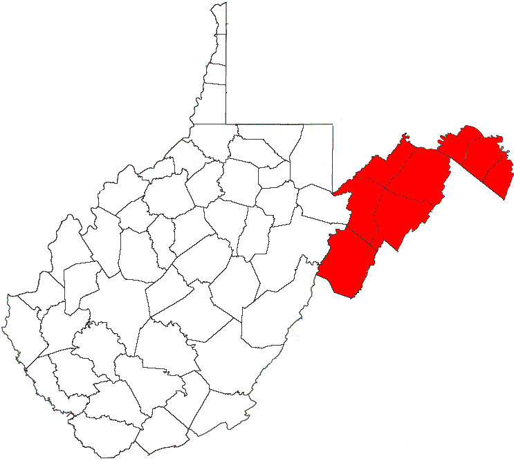
| | | | But the line drawn north from the Fairfax Stone in 1788, called the Deakins Line, now forming the western border of MD, was in dispute for years until finally being settled by the Supreme Court in 1910. On this map, the Potomac River border is in blue, the Fairfax Stone in red, and the Deakins Line in yellow. | | | | But Maryland's claim to its north was in conflict with Pennsylvania's claim to its south, as the map of the Province of Marylandshows (Map by Karl Musser). The final agreement to use the 1767 Mason-Dixon line as the border, which came a full century after MD's southern border was determined, gave MD its unusual western panhandle, with its famous wasp waist only 3 km (2 mi) wide. | | | | ◊West Virginia's Eastern Panhandle When we were in Harpers Ferry in 2016 (2016/13-14), we were in the easternmost tip of West Virginia's Eastern Panhandle (Map by Caponer at English Wikipedia). As we've said, WV was formed early in the Civil War when a cluster of Unionist counties west of the Allegheny Mountains in what was then northwestern Virginia decided to break away from Virginia because it had seceded from the Union, and formed their own state in 1863. The irregular breaking away along county lines accounts for much of this panhandle. However, the three counties at the easternmost end, essentially a panhandle on a panhandle, voted to remain with Virginia, but because of the strategic importance of the confluence of the Shenandoah and Potomac, Union troops occupied them, and they eventually became part of WV. In any case, if you look at the map of WV, you can see how MD's and WV's panhandles are layered, and seem to be like two arms hugging Virginia. Harpers Ferry is not shown, but is just east or Ranson at the easternmost point of WV. | | | | ◊West Virginia's Northern Panhandle We are presently in a bus out of Wheeling crossing West Virginia's Northern Panhandle (Map by Tom), known not only for being slender, but for rising straight up on the map like a smokestack or chimney. While one would wonder who would lay out such a shape, be advised that it isn't the result of an addition, but is the remnant after a subtraction. It's as though most of a building had collapsed, with only the western wall left standing.
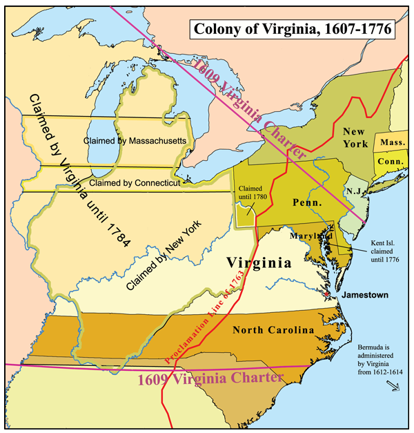
| | | | Look at this map of the Colony of Virginia (Map by Karl Musser), which reminds us that VA had claims reaching to the Mississippi and Great Lakes, yet much of that was surrendered to be included in the Northwest Territory. But nevertheless, as the map shows, the Ohio River was the western border of VA, and VA was still a colony of formidable size. Do keep in mind, that all the stops on this trip in KY once would have been stops in VA. But the western half of the Colony of Virginia, that part beyond the Appalachians, desired to break away and become its own state, and VA agreed, and so Kentucky became a state in 1792. WV breaking away later in 1863—without agreement by VA--means that the Colony of VA became three states, KY, WV, and modern VA. | | | | But when VA reached beyond and around the western border of MD, it had to contend with claims by Pennsylvania, just as MD had had to do. Look at that area of what is now southwestern PA labeled "Claimed until 1780", meaning claimed by VA. This is a reference to VA's considering every bit of the Ohio River, including the Allegheny River feeding it from the north, to be its distant northwestern border. The claim is even clearer on this map of the Province of Pennsylvania (Map by Karl Musser). [Note PA's further claim in the north to a huge chunk of NY.] | | | | But what of PA's western border? According to William Penn's original charter, the western border was to be located precisely 5° longitude west of PA's irregular eastern border along the winding Delaware River, sort of a winding mirror image, and not a straight line. In that way, the Colony would be a uniform, though very irregularly shaped, 5° wide. Maps of the time showed this, such as this one from 1758:
http://www.virginiaplaces.org/boundaries/graphics/pa.png
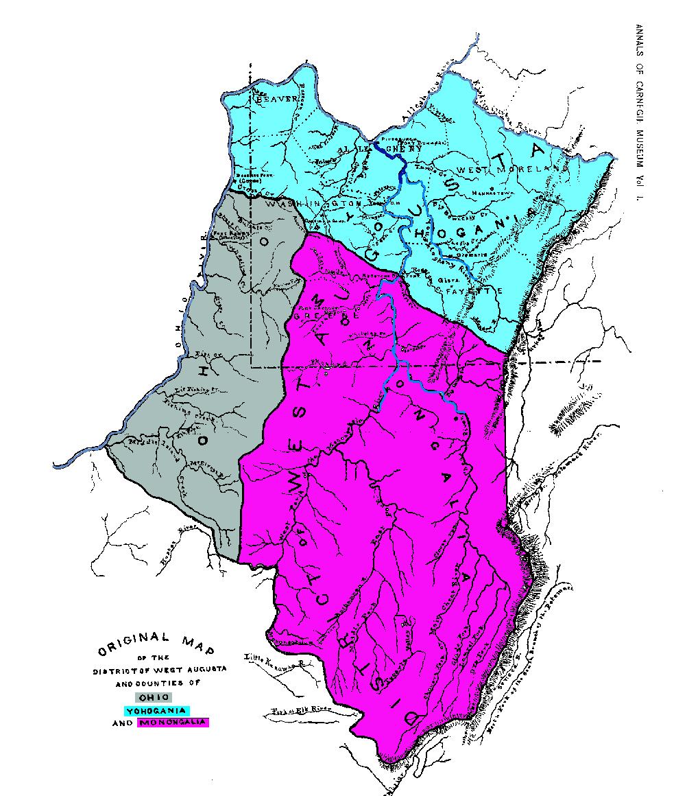
| | | | The southern straight-line border with MD is shown, as well as a northern straight-line border deep within what is today NY State, which we saw on the earlier map. The wavy eastern border along the Delaware is shown, and then surprisingly, that mirror-image wavy western border. Until 1774 it was assumed this is how the border would be drawn. | | | | But since PA's claim conflicted with the VA claim, the conflict had to be settled, which resulted in a compromise in 1786. It was finally agreed by both PA and VA to extend the Mason-Dixon Line between MD and PA to a full 5° west of the Delaware River at that southern border only. At the western end of the extended Mason-Dixon, a straight line was to be drawn northward. This line is called the Ellicott Line, named after Andrew Ellicott, a surveyor who worked not only in this region, but who also surveyed the boundaries of the District of Columbia. We know that name, not from him directly, but from Ellicott City MD, which we visited in 2016 (see 2016/12), and which had been founded by his family. In 1786, he was asked to survey the border between PA and the Ohio Country, which became the Ellicott Line. (Later it also became the base line for all the additional surveys deep into the Northwest Territory.) Thus the extended Mason-Dixon Line and the Ellicott Line formed what became the L-shaped southwestern border of PA, taking a huge gouge out of VA's river claim at its most upstream end. But it didn't gouge far enough along the Ohio, which left a remnant for VA, which became WV, and that is WV's northern panhandle. | | | | We can see closer detail on this next local map, on the county level, which shows the three former VA counties in the area under discussion west of MD. MD is distinguishable in white in the center right, east of the straight line showing the Deakins Line. The dotted L-shaped line is the modern PA border, showing the large amount of territory VA had claimed, and lost. Click to find Pittsburgh at the bottom of that V formed by the upper Ohio and the Allegheny River. The dark blue line coming in from the south is the Monongahela River, completely within the VA claim. Thus we can say that when VA claimed this area, both the south side of Pittsburgh across the Monongahela River, plus its downtown area between rivers at the Point, would have been in VA, with only its north side across the Allegheny being in PA. | | | | As to these three former counties, once the new border was drawn, most of Yohogania County (in light blue) became part of PA, while only the top of Monongalia County (in purple) and a northeast slice of Ohio County (on the Ohio River) were lost. Most of these two southernmost counties and the western strip of Yohogania remained in VA (now WV; where the remnant of Monongalia still remains a county). But it's easy to see how the two fragments of counties remaining between the Ohio River and the Ellicott Line subsequently became VA's (today WV's) Northern Panhandle, which has since been reconfigured into four smaller counties. | | | | After just a few minutes, we left WV's Northern Panhandle and entered PA, and Pittsburgh wasn’t that much further. We'd finally made it to our destination! | | | | Since this was a rail-sail-rail trip (as so many are), we have only the final rail segment to discuss in the next posting, which will include both Pittsburgh and our ride on the Pennsylvanian. | | | |
| |
|
|
|

