|
Reflections 2022
Series 6
October 30
Travel by Cable II: SF Street Cable Cars II
Street Cable Cars Worldwide I: International
| | SF Cable Car History We've thoroughly covered the topic of San Francisco (SF) street cable cars as of the present day. We'll now go back and explain now cable cars successfully came to SF after failing in London and New York, how they developed there and spread around the world, and how they declined—and why. | | | | Clay Street Hill Railroad Andrew Smith Hallidie, a Scottish émigré, arrived in California in 1852. About 1867, he devised an aerial tram to haul ore down mountain sides, called the Hallidie ropeway, yet another instance of the development of cableways from mines to passengers. He's often credited, especially in SF, with inventing the street cable car, which is wishful thinking, and nonsense. We already know about earlier cable cars, and certainly about the use of them in mines. So what did Hallidie do? Where should we give him credit accurately?
Horsecars were common urban transportation, but in SF, it was the hills again that were a problem. Horses not only suffered going up steep hills, they often just couldn't get the job done. Finally, the Clay Street Hill Railroad was built as the first SF street cable car ever.
https://www.orangesmile.com/common/img_city_maps/san-francisco-map-0.jpg
We repeat here the Downtown Detail Map from the last posting. Again, at the upper right, click to find Chinatown. The green park under the –WN is Portsmouth Square, the ex-Plaza de Yerba Buena. The southeast corner of the park is at Kearny and Clay, and that's where the Clay Street Hill RR started. Now follow Clay for eleven blocks to Van Ness—this was the route of the first cable car in SF. The novice will be fooled by the seemingly flat route, but we know that the route went up Nob Hill, over its summit, and down the other side—just look at the blue contour lines.
Hallidie was a manufacturer of steel cables and became interested in the Clay Street line, which used them, but his involvement is open to speculation. Some say he was instrumental as the instigator, since he was concerned for the horses pulling horsecars up the hills. Others say it's most accurate to say that his claim to fame was that he was the major promoter of the line, so his name became associated with it. It was the world's first effective and commercially successful urban street cable car system running at street level. It first operated experimentally in August 1873 and started regular service on 1 September.
There are also accounts that the first gripman hired by Hallidie looked down the steep Clay Street hill from Jones Street up on Nob Hill, saw the 307 ft (94 m) drop, and refused to operate the car, so Hallidie took the grip himself and ran the car down the hill and up again without any problems.
However, in 1888, this line was absorbed into another cable company's line and later became a small part of the entire city system. Demolished in 1942, none of the original line survives today, tho car 8 from the line is now displayed in the SF Cable Car Museum (Photo by Diego Delso, delso.photo, License CC-BY-SA). The picture is rather dark, but click to find, rising from the floor inside, the cable grip, and behind it, the brake. I've also found this much better side view (Photo by Daderot). It shows that the style with people sitting facing outward with the gripman in the center goes back to Day One. Click on the yellow sign. The most interesting part is at the beginning, saying that, this being the only surviving car from the oldest SF route, it is the oldest cable car in the world!
The Clay Street Hill Railroad was designated as a California Historical Landmark, with the landmark marker being placed in Portsmouth Square at the site of its eastern terminus near the corner of Clay Street and Kearny.
https://upload.wikimedia.org/wikipedia/commons/c/c6/Andrew_Smith_Hallidie_plaque%2C_Portsmouth_Square.JPG
It obviously gives inaccurate credit to Hallidie in that he didn't invent it, but became interested in it in its early years and strongly promoted it. But the illustration is very revealing. Look at the name: no reference is made to cables, but it's called a "hill railroad", surely a unique phrase in its day. As a railroad, it had a car up front doing the towing. Reminiscent of locomotives, it was a separate grip car—shall we call it a "work car"--tho with passengers seated around it. Just as a locomotive tows coaches, the grip car towed a separate passenger trailer car. These two cars are strikingly similar to the PM & PH cars today, but those cars are united into one single unit. We have a great illustration for this topic, showing the two-car set-up we saw on the plaque, and much more clearly. What a remarkable picture.
| | | | | | The picture is taken from The Street Railway Review, Chicago, 1891, digitized at the Carnegie Library of Pittsburgh. The article added this about operations after the August experimental run, and about expansion:
On September 1, 1873, the line was again started up and continued to run precisely as originally constructed until July, 1891, when the road was sold to the Ferries & Cliff House Railway Company, who extended it two miles [3 km]. Cable lines followed rapidly on other hill streets until to-day [sic; this was the spelling at the time] San Francisco absolutely could not part with them. They have made the city and added millions to its wealth and realty.
|
| | | | Let's expand on what the magazine said about cable car expansion. You can find the below streets on the DT Detail Map:
The second SF cable car line to open was the Sutter Street Railway (Photo by Fietsbel), which had opened in 1866 as a horse car service and converted to cable in 1877. (!) This line patented and introduced technical improvements including lever operation, which came about because they didn't want to pay Hallidie royalties. Note that the picture shows just a trailer car, not the grip car, at the Cable Car Museum.
In 1878, Leland Stanford opened his California Street Cable Railroad, whose first line of several routes was on California Street, and is therefore the oldest cable car line still in operation. Stanford was the first of the Big Four nobs to build on California Hill, later Nob Hill. His mansion, completed in 1876, was on the southwest corner of California and Powell. Altho the Clay Street Hill Railroad had already successfully climbed Nob Hill, it was two whole blocks away to the north. Poor baby. Presumably, he wanted service to his front door, so in 1878, he built his line on California Street, passing his mansion.
In 1880, the Geary Street, Park & Ocean Railway began operation.
In 1882, the Presidio and Ferries Railway followed, and was the first cable company to include curves on its routes. The curves were "let-go" curves, in which the car drops the cable and coasts around the curve on its own momentum to then pick up the perpendicular cable. Whee! (More about this below in Dunedin.)
In 1883, the Market Street Cable Railway opened its first line. This company was controlled by the Southern Pacific Railroad and would grow to become SF's largest cable car operator. At its peak, it operated five lines, all of which converged on Market Street to a common terminus at the Ferry Building. During rush hours, cars left that terminus every 15 seconds. (!)
In 1888, the Ferries and Cliff House Railway opened its initial system. The Powell-Mason line stems from this company, and the entire system today uses its car barn and powerhouse at Mason & Washington, where the Cable Car Museum is now also located. This company also purchased the original Clay Street Railway.
In 1889, the Omnibus Railroad & Cable Company became the last new cable car operator in SF.
In 1890, Stanford's California Street Cable Railroad opened two new lines, these being the last entirely new cable car lines built in the city. One of them was the O'Farrell–Jones–Hyde line, the Hyde section of which still remains in operation as part of the current Powell–Hyde line.
In all, 23 lines were established in the 17 years from 1873 to 1890, which averages to more than one new line a year! It must have been cable-car heaven. The new technology was gladly adopted, and in this period spread around the world (see below).
To summarize, today's three remaining venerable lines in SF date as follows:
(1) the California Street line to Leland Stanford's California Street Cable RR of 1878;
(2) the Powell-Mason line—and the powerhouse--to the Ferries and Cliff House RW of 1888;
(3) the Powell-Hyde line to Stanford's company's O'Farrell-Jones-Hyde line of 1890, later cut in two, with the northern Hyde section grafted (frankensteined?) onto the Powell-Mason line at the powerhouse.
| | | | The Greatest Extent As a reminder, let's reprint the SAME map we used in the last posting of the three surviving cable car lines:
https://4.bp.blogspot.com/-UQj-86hN75I/XB0cfIXcPzI/AAAAAAAALhY/8qUEQMORd2wkxujnj15i5cohI5dYnz_vACK4BGAYYCw/s1600/cable-car-route-map.jpg
I had known there were "a few" more lines than those existing today, but I discovered the below map before I compiled the history of all the above routes, so I was more shocked at this map than you might be, already knowing quite a bit of the history:
https://farm9.staticflickr.com/8517/8598363409_a8b95c2776_z.jpg
Click to see what the route map looked after 1890, once the last of the new lines was built, and I think it will still amaze you nevertheless. This is the fullest extent of the SF cable car system ever. Of the 23 lines established, we know that only three remain, which comes to only 13% of the number of routes (not the mileage) survives. Note the following:
Check out all the powerhouses that were needed, shown by little ovals.
The California Street line (dark red) ran to Central Avenue, which means it was over twice the length it is today, when it ends at Van Ness.
You can see how the Clay Street Hill RR (yellow) had already been absorbed into the much more extensive Ferries and Cliff House RW (blue), which accounts for its double coloring.
The Geary Street, Park and Ocean RW (dark green), at its western end, seems to overlap a bit with another line.
The Market Street Cable RW (light green) is formidable. Think of having a cable line on broad Market Street, with sub-lines spreading out on both sides. No wonder cars left the Ferry Building every 15 seconds during rush hour. Notable is that it extended down Castro Street, as well as having a second line in SoMa.
The Omnibus Railroad & Cable Company (red) also had a route into SoMa, as well as many other lines going west.
The Presidio & Ferries RR (brown) connects the Presidio with Columbus Avenue.
The Sutter Street RR (black), the second one built after Clay Street, also has a noteworthy N-S route running down into SoMa.
While I've been pointing out the extensions south into SoMa, also notable is the extent to which many routes went west, beyond Van Ness (usually considered the edge of downtown) into the Pacific Heights neighborhood, and others in the west.
| | | | | | Also, trace today's three routes on this map. As we said, the (1) California Street Cable RR's California Street line in maroon is considerably foreshortened today from what it once was, and no longer reaches Pacific Heights.
At the top, find the blue line of the (2) Ferries & Cliff House RW, and follow it down Taylor, Columbus, Mason, and Powell (with a few zig-zags) and you find today's Powell-Mason line fully intact.
Again at the top, find the maroon route of the California Street Cable RR. This is its former (3) O'Farrell-Jones-Hyde line. Follow it down Hyde, zigzag it for two blocks down Pine, then down Jones to Market. Look carefully for the shuttle line east along O'Farrell to Market, which explains why O'Farrell is part of the name. Thus this route connected with busy Market Street twice, once directly at Jones, and once via shuttle at O'Farrell. In the 1950s, there was great hue and cry, including referendums won and lost, about route elimination and about the city buying cable car lines. The result was that the city did end up owning the three lines it has today, but the two southern ends of this last line were lost, and only the Hyde section remained. Thus, at the surprisingly late date of 1957, the city formed a new hybrid line by zigging the route from Hyde over to Powell at the powerhouse, and doubling up from there to the south with the Powell-Mason line. So today, Powell-Hyde is historically a hybrid line.
|
| | | | So going back to the period after 1890, what happened? This was a thriving system. What attacked it? On the map, look at the area within the brownish borders and read the caption at the lower right for the reminder that, in 1906, SF was hit by its infamous earthquake and fire. And for that, we have this equally interesting post-catastrophe 1906 map.
https://c1.staticflickr.com/9/8099/8599464396_2032ac56f9_b.jpg
We'll talk in a moment a little about the quake and fire, but let's continue checking on the cable car lines.
In red, the two lines and O'Farrell shuttle of the California Street Cable RR seem to have remained intact, as of that date, anyway.
In dark green, most of the Geary Street, Park & Ocean RW still existed, except for that lost doubled-up bit at the western end.
But the largest number of lines, in light green, seem to be part of something now called the United Railroads of SF. That includes (1) the Pacific Avenue bit of the Sutter Street RW, (2) most, but not all, of the Jackson, Washington, Clay, and Sacramento Street lines of the Ferries & Cliff House RW, including most notably (3) the Powell-Mason line of today, and (4) perhaps most surprisingly, the now isolated Castro Street service way in the south of the Market Street Cable RW.
There are correspondingly fewer powerhouses, but note that, not only is today's powerhouse still there at Mason and Washington, two bits of the above (2) remain, pieces of Jackson and Washington Streets on either side of the powerhouse that allow Hyde and Powell to be connected on the Powell-Hyde line.
| | | | Decline of SF Cable Cars We get to the sad part about cable cars. Originally, the cables were powered by stationary steam engines burning anthracite coal, which explains the smokestack on the powerhouse. In 1901 the system was converted to oil, then, after the quake, in 1912 to electricity. While originally one electric motor ran everything, if it broke down, everything stopped, so now there are four motors, one for each cable.
Electric streetcars came in in 1892, and some companies wanted to convert their cable lines, but the ugliness of overhead power cables caused public opposition. But the 1906 quake and fire changed everything, destroying some companies' powerhouses, and 117 cable cars. The race to rebuild saw frequent conversion to electric streetcars. By 1912, only eight lines remained, all with steep grades that streetcars couldn't manage. But later, buses could climb better than the streetcars, and cable lines continued to close. Some public referendums were successful in stopping entire closures. Then as mentioned, in the 1950s the city ended up owning all the lines, including the hybrid one, and everything ran from the one powerhouse.
But by 1979, the system was wearing out due to age, and needed to be rebuilt at a cost of $60 million. In 1982, the system was closed for some seven months. During this time, 69 city blocks' worth of tracks and cable channels were replaced, the powerhouse was completely rebuilt within the original outer brick walls, new power equipment was added, and 37 cable cars were repaired or rebuilt. Since then, more has been done, including the rebuilding of the turntables. So now we've made the full circle back to today (or to-day).
| | | | SF 1906 Earthquake & Fire Most disasters that cause death and destruction in urban areas occur one at a time. Hurricane Katrina in New Orleans in 2005. The Great Fire of London in 1666. Vesuvius at Pompeii in 79 CE. The Tokyo Earthquake of 1923. But when disaster hit SF in 1906, it was a one-two punch. People remember the earthquake, but tend to forget the fires that followed, maybe because the earthquake caused them. The quake, plus aftershocks, was limited in time and destruction, but the fires burned out of control for four days and nights.
It was Wednesday, 18 April 1906 at 5:12 AM local time—more or less at dawn—that the major earthquake struck along the California coast with a magnitude of 7.9. Within the next three days, over 30 fires, caused by ruptured gas mains, destroyed approximately 25,000 buildings on 490 city blocks. But it wasn't only the gas mains. Surprisingly, some of the fires were inadvertently caused by the SF Fire Department. In an attempt to cause firebreaks, they dynamited some buildings. But the city's fire chief, who would have been in charge, had died of quake injuries, and the firefighters were untrained in the use of dynamite, so the dynamited buildings themselves often caught fire, just making things worse.
Here are some statistics, tho understandably, estimates vary widely:
More than 3,000 people died, and over 80% of the city was destroyed, including 28,000 buildings.
The area of the burned district covered 12.2 sq km [4.7 sq mi].
It has been estimated that up to 90% of the total destruction was the result of the subsequent fires.
One source says 225,000 people were left homeless out of a population of about 400,000, which is 56%. Another says it was between 227,000 and 300,000 out about 410,000, which varies between 55% and 73%.
The estimated property losses in 1906 dollars were $400 million ($8.86 billion today) from both the earthquake and fire, but that breaks down to $80 million from the quake and a whopping $320 million from the fires. Another source says that the fire damage alone came to $350 million ($7.75 billion today).
One thing may have put the loss statistics somewhat out of balance. While it was common for insurers to cover fire damage, but not earthquake damage, most of the destruction was blamed on the fires. There were instances of property owners who had quake damage but had been safe from the fires, who deliberately set fire to their damaged property to be able to claim the damage on their insurance.
These are the headlines of The New York Times the next day (cost: one cent!). Of particular interest in the center is the report that the SF shocks were recorded clear across the continent in Albany NY just 19 minutes after they happened.
This is a Fire Map published by the US Geological Survey in 1907, a year after the quake and fires. Below is a link to the SAME map, for easier reference:
https://upload.wikimedia.org/wikipedia/commons/1/1c/1907_Geological_Survey_Map_of_San_Francisco_after_1906_Earthquake_-_Geographicus_-_SanFrancisco-humphrey-1907.jpg
The red line delineates the "burned district", not the "quake district", tho the black hatching (click) shows the principal quake breaks in streets. They emphasize with the red hatching the area of brick structures, which I take to mean stone, or "not wood", but that burned anyway.
You can easily find Market Street, so we see that both street grids were affected, as was the Mission District to the southwest. In SoMa it included Rincon Hill, which declined thereafter as a fashionable neighborhood. To the north, the fire oddly left a couple of untouched pockets, as well as half of Telegraph Hill. It also swept over Nob Hill (not named) and Russian Hill and down their western sides, pretty much to Van Ness, usually considered the western edge of downtown.
https://3.bp.blogspot.com/-8k9G4aNN8QI/UqS9Dr5PcAI/AAAAAAAAoec/kttxfo2j5Gg/s1600/Earthquake+damage+to+residences+on+Howard+Street.jpg
Pictures of course tell the story best. On the Fire Map, find in the Mission District what was then Howard at 17th, the location of these wooden buildings. While the ones on the right do show some damage (click), the ones on the left have been moved completely off their foundations. Earthquakes are fickle.
These are ruins around the intersection of Post Street (bottom center) and Grant Avenue (lower right), looking northeast. Click to inspect closely, and then compare this with the Fire Map. As you may recall, Dupont was renamed for General Grant, and as it turns out, that happened while Dupont was being rebuilt in 1906, so both names appear on this 1907 map.
This is a view from the tower of the Ferry Building, looking southwest up Market Street toward the left. The intersecting street could be either California or Sacramento, but it's hard to tell, since the whole plaza area has since been rebuilt, and both streets had cable car lines. Just keep in mind, this was the area where cable cars had left every 15 seconds during rush hour. But if you click, aside from the period dress, you can see that the cable car tracks have a cable slot, but others don't, so those would be regular streetcar/trolley/tram tracks. Also typical for the era, horses pulling wagons (one with beer barrels!), but no automobiles yet, and no horse trams on rails. This undated picture must have been taken well after the quake and fire, since new foundations for buildings are recognizable going up in the upper right.
https://www.newyorker.com/wp-content/uploads/2014/05/san-francisco-earthquake-580.jpg
Tho this picture is at an unknown location, I include it because it shows so clearly "cable car tracks running downhill to nowhere". The period dress again establishes the time period. Some educated guesses. Could that be the Ferry Building in the distance? Could this be Sacramento Street coming down from Nob Hill? Maybe, maybe not.
I love the story of this next picture, which appears frequently online among SF quake pictures. The picture was one of several taken by German-American photographer Arnold Genthe. He said his own cameras had been severely damaged by falling plaster during the quake, so he went to his camera dealer on Montgomery Street and asked to borrow a camera. But the owner told him "Take anything you want. This place is going to burn up anyway." So he took a quality small camera, stuffed his pockets with film, and set out. He particularly liked this picture because it showed so much. We're looking east down Sacramento Street on the very day of the quake and fire. As the sign on the lamppost to the left states, the minor cross street was Miles (now Miller) Place, about a third of a block east of Powell. Just hours before, the quake had taken down the façade from the house on the right, but curiously, its occupants are seated in chairs in the street calmly watching the fire. As it advanced, they, and others, just moved further up the street, behind us. Genthe was right, this picture richly shows (1) the results of the quake, (2) the advancing fire, and (3) the people's reaction.
After 27 years of planning and construction, the original SF City Hall was built in 1899, as shown on this c1900 postcard. You can't miss it in the center of the Fire Map, where its triangular footprint is shown as #10 at McAllister & Larkin. It's so large because it also included the Hall of Records. On April 20, two days after the quake, the seven-year old building looked like this. It was replaced by the current, much smaller building, just to the west of it, which was started in 1913 and completed by 1915, in time for the Panama-Pacific International Exposition. Look at the Detail Map and find today's City Hall in what is today the Civic Center just north of central Market Street. The new building faces Polk, and the large open plaza on the east side of Polk was the site of the original building, whose ruins were sold in 1916 for $2,300 (equivalent to $57,000 today), with removal to be ignominiously completed in 40 days. A sad ending to a proud structure.
In 1898, the owners of The San Francisco Call newspaper built the elegant Call Building to house their offices. It was granite for the first three stories and marble above that, with a Baroque dome, and at 15 stories, it was the tallest building west of Chicago. We're standing on Kearny, looking south, and see pedestrians, again in period clothes, crossing the intersection of Market Street (right) and 3rd (left) in SoMa. Geary Street enters this intersection on the right, showing again how the two grids mesh at Market. Check this in the red-hatched area on the Fire Map, where the Call Building is #8. This picture shows the Call Building as it looked for the eight years from its construction in 1898 to 1906.
| | | | | | Click to see the ornate fountain to the left, called Lotta's Fountain. It was gifted to SF in 1875 by a very popular actress and philanthropist named Charlotte Crabtree, whose nickname was Lotta. Because the fountain had served as a meeting point during the disaster for people to look for loved ones and exchange information, since 1915, SF has officially commemorated the disaster each year by gathering any remaining survivors at Lotta's Fountain. |
| | | | This is the Call Building as it was being gutted by fire after the quake. The building had been dynamited to stop the fire, but the explosion failed to demolish the building and instead spread burning debris onto neighboring buildings, making things worse. The building was badly burned and damaged, but did not collapse, and has since been extensively remodeled, making today's version of it absolutely unrecognizable as compared to these pictures.
Finally, we have a panorama, which is a reproduction of the only photograph that shows the entire scope and extent of the conflagration, showing a fire line that's over 5 km (3 mi) long. We saw a similar (but happier) picture in the last posting, since this looks down from Twin Peaks down the length of Market Street, in the center. Click on Market Street, and amazingly, in the distance you'll see on the left the tower of the original City Hall, and on the right, the Call Building. Again compare the two on the Fire Map, to see the distance between #10 and #8, since in the panorama, they seem to be opposite each other.
| | | | After the Quake & Fire Reconstruction was swift, and largely completed by 1915, in time for the 1915 Panama–Pacific International Exposition, as we mentioned regarding the new City Hall. The exposition was meant to celebrate the reconstruction of SF and its phoenix-like "rise from the ashes". But quite frankly, things were never the same. We'll cite some long-term effects of the dual disaster.
Locally, the effect of so many people evacuating downtown tended to have many people decide to stay where they'd moved to. This accounts for so many houses being built, for example, in Bernal Heights, including some on streets too steep to ever have been considered before.
The disaster was also responsible for the development of the Pacific Heights neighborhood just west of the Van Ness side of Russian and Nob Hills. The quake and fire had destroyed all but one of the mansions on Nob Hill.
| | | | | | The only Nob Hill mansion that survived was the James C Flood Mansion, built in 1886 for Flood, a 19C silver baron (Photo by Frank Schulenburg). It takes up the entire city block between Mason & Taylor and Sacramento & California, and is now, as a National Historic Landmark, the home of the Pacific-Union Club. It was the first brownstone building built west of the Mississippi, and Flood had brownstone shipped from Connecticut around Cape Horn. I suspect he'd been impressed at the popularity of brownstone townhouses in Manhattan and Brooklyn, Boston's Back Bay, and Philadelphia.
But the story gets much more interesting. Tho his Mansion survived, in actuality it was gutted during the fire and it was then that the shell of the building was sold to the Pacific-Union Club, who at first thought of tearing it down, but instead restored it. It was Flood's decision to build in brownstone that made the building a survivor, since all the other mansions on Nob Hill were made of wood (!) with finishes that gave them the appearance of stone, so they all burned.
|
| | | | The burned wooden mansions were dynamited by the Army forces aiding the firefighting efforts in attempts to create firebreaks. Therefore, as one indirect result, the wealthy looked westward where the land was cheap and relatively undeveloped, and where there were even better views. Constructing new mansions without reclaiming and clearing old rubble simply sped attaining new homes during the reconstruction of the city.
But nationally, the affect on SF was fundamental. It had been the ninth-largest city in the US and the largest on the West Coast. Over some six decades SF, had become the financial, trade, and cultural center of the West. It operated the busiest port on the West Coast and was the "gateway to the Pacific" for US economic and military power. When gold was discovered in Canada's Klondike in 1896, when news reached San Francisco and Seattle (which was closer), people swarmed north. But tho SF rebuilt quickly, the disaster diverted trade, industry, and population growth south to Los Angeles which during the 20C became the largest and most important urban area on the west coast. Today, tho SF is a wonderful destination, when people think "west coast" or California, they think of LA and Hollywood before they think of SF. That would have been unheard of before 1906.
| | | | SF City Songs Many cities have songs about them such as: A Foggy Day in London Town (G Gershwin); I Love Paris (C Porter); New York, New York (Kander & Ebb). Few of these songs have any official standing, however. But SF has two official city songs, one is heroic & rousing, the other romantic & sentimental.
HEROIC & ROUSING: The film "San Francisco" is a musical drama based on the 1906 quake, starring Clark Gable and Jeanette MacDonald, as seen in this lobby card, which has been colorized—the film was in black-and-white. The film came out in 1936, three decades (and about two months) after the event—I saw it years ago on late-night TV. It was a major hit, due largely to MacDonald's singing. The title song, San Francisco, is possibly the best-remembered part of the film. It's a rowdy, rollicking, robust song, sung six times in the film by MacDonald, and becomes an anthem for the survivors of the earthquake. As an official song, it's since become a popular sing-along at public events, sentimentally sung as the city's annual earthquake commemoration, where it is shown at the historic Castro Theatre on the anniversary of the earthquake and fire. The pre-film organ performance always ends with the song as the organ console is lowered down before the film starts. The song was composed by Bronisław Kaper & Walter Jurmann, and the lyrics were by Gus Kahn. The lyrics:
San Francisco, open your Golden Gate
You let no stranger wait outside your door
San Francisco, here is your wanderin' one
Saying I'll wander no more
Other places only make me love you best
Tell me you're the heart of all the Golden West
San Francisco, welcome me home again
I'm coming home to go roaming no more
The reference in the first line is to the Golden Gate strait to the north of town, not to the Golden Gate Bridge, which is called that because it crosses the strait--the bridge opened a year after the film came out. Somehow the bridge has caused public amnesia about the strait, which until then was the major entrance to SF, as the song says. In any case, this, like the other official song below, involves a returning to the city.
We have videos to illustrate all this. First, Jeanette MacDonald sings the song in the film (4:34). Unfortunately, the clip has been colorized, so it loses a bit of authenticity from the original, but the music is totally original. It does go on and on, so watch as much as you like.
We cannot ignore the famous montage of earthquake scenes from the film (0:07- 2:36), which are impressive cinematography, especially given the 1936 date. In the film, tho, it's all wrong. The quake hit at dawn, and the film shows it happening the evening before, which fit better into the film's narrative. But take a look at the action. It's well done, given that talkies were just a few years old at the time. In the beginning of the clip, the barroom set was built on a special platform that rocked and shook to simulate an earthquake. At 0:50, it's amazing how they imitated the old City Hall crumbling. At 2:28 they show a fissure opening up in the street with people falling into it, which I suspect is more of a primal-fear, sensationalist fantasy than fact. But keep in mind, there were no computer graphics then!
I also have a clip (1:52) that was specially compiled to show the visual effects. Most of it is the same, but move to 1:15, where they show dynamiting and more of the fire. The special effects in the film were good enough so that, during the film's 1936 San Francisco premiere, some survivors of the 1906 quake became ill during these extraordinary sequences, and left the theater.
Also of interest is this clip (4:58) of the rousing final scene. I've set it to jump to 2:40 where a boy shouts "The fire's out!" and the tent city crowd marches over to see, singing The Battle Hymn of the Republic, which at 4:24 segues into a few bars of San Francisco as they see the ruins, which then blend into a 1936 view of the rebuilt city.
But today, the film, tho worth seeing, is quite dated in style, and by mid-century, Judy Garland felt its image needed a boost. So starting in 1961, when she performed the song in her concert repertoire, she added an introductory, slow-moving parody verse before the song got rollicking, which teased MacDonald's brave image of a quarter-century earlier. Listen to the Judy Garland version of San Francisco (4:16).
In the late 1950s, Garland first opened a concert at the Cow Palace on the edge of SF with her version. It was so well and tumultuously received that she sang it again as an encore, and kept it in her repertoire.
ROMANTIC & SENTIMENTAL: The other official SF song is, as I'm sure you realize, I Left My Heart in San Francisco, a ballad written in Brooklyn in 1953 by two amateur songwriters homesick for SF. George Cory (music) and Douglass Cross (lyrics) based the song on their nostalgia for the city. After Cory and Cross pitched the song unsuccessfully to many other artists for about eight years, the song was picked up by Tony Bennett's accompanist Ralph Sharon, who was friends with the composers. He suggested to Bennett that it would be a good song for a December 1961 engagement scheduled for the Venetian Room of the Fairmont Hotel in SF, where Mayor George Christopher and future mayor Joseph L Alioto would be in attendance. After a good response to the song, Bennett recorded it in January 1962 and released it in February. However, it was merely released as the B-side of another song, which received no attention, since people began flipping the record over and playing the B-side, making it a smash hit. Thereafter, from the 1960s thru the 1980s, Bennett always sang the song at his appearances at the Venetian Room, and it became his signature song.
When in 1969, after the song had become an enduring international hit, it was to be named as the second official song of SF, Cory & Cross were present at the meeting when the city's board of governors selected it by a unanimous decision. Tho they'd written 200 songs together, only 30 were ever published, and only "Heart" became a hit. But the royalties from that one successful song provided the composers with income for life.
https://s.hdnux.com/photos/51/15/04/10801438/8/1200x0.jpg
A statue of Tony Bennett (above, click) was unveiled outside the Fairmont Hotel in 2016 in honor of his 90th birthday, the hotel performance, and the song's history with San Francisco. On the Detail Map, find the intersection of California and Mason on Nob Hill. On the northwest corner is Flood's brownstone mansion. On the northeast corner is the Fairmont Hotel, where the statue is (I've seen neither the statue nor the mansion). In any case, that one block of Mason between the hotel and mansion has now been co-named Tony Bennett Way.
These are the lyrics to "Heart". I include the introduction, since it fits in so well:
The loveliness of Paris seems somehow sadly gay
The glory that was Rome is of another day
I've been terribly alone and forgotten in Manhattan
I'm going home to my city by the Bay
I left my heart in San Francisco
High on a hill, it calls to me
To be where little cable cars climb halfway to the stars
The morning fog may chill the air, I don't care
My love waits there in San Francisco
Above the blue and windy sea
When I come home to you, San Francisco
Your golden sun will shine for me
The imagery is beautiful, of the hill, of the fog, and above all, of the hyperbole of "where little cable cars / climb halfway to the stars". It's time to hear Tony Bennett sing his signature song I Left My Heart in SF (2:53). This video includes lyrics, if you want to sing along.
| | | | Street Cable Cars Worldwide! It's worth starting this next section with an additional quote from that earlier magazine, The Street Railway Review writing out of Chicago in 1891: Chicago was the next to supplant her horses with an iron rope, then Kansas City and Cleveland, Cincinnati, Denver, Pittsburg, Washington, St. Paul, Philadelphia, Omaha, Portland, Tacoma, St. Louis and many others, and more recently Baltimore and New York City. The development of electric traction has undoubtedly forestalled a large amount of what would otherwise have been cable lines, but where there is an enormous volume of traffic, or where the grades are exceptionally severe, the cable still holds an undisputed sway and will in all human probability continue to do so as long as any present system lasts. The magazine also mentioned that [n]early 700 miles [(1,127 km) of cable were] in operation in this country at the present time [1891]. | | | | | | NB about a historic spelling: a government agency had dropped the H from Pittsburg at that time, but the city eventually went back to the spelling Pittsburgh (see 2019/7). |
| | | | I find people who are well-versed in world and national history tend to be weak on local history, and the history of local rail transportation is even lower on people's totem poles in importance. Adding to the problem is the fact that the national and international explosive spread of cable car routes lasted for only a couple of decades at most, often less. But even the above article, while trying to be optimistic, saw the writing on the wall when it mentioned that "electric traction", meaning streetcars/trolleys/trams, were slowing the trend to cable. Eventually electricity would kill all cable car systems but for the three in SF, most commonly by converting the routes from cable to electricity.
We will point out a number of cable routes, but must caution that there are two possibilities of these, so we need to do a triage.
1) We will not mention any routes that have cables permanently connected to the car (like an elevator/lift but horizontally), being similar to an inclined elevator (perhaps called incorrectly a funicular) with counterweights around an end pulley. 2) Obviously, we won't include funiculars, either. All those might be of some mild interest, but are not the topic of conversation. 3) We will list only those routes where cars grab on to a continuous, "live" moving cable à la SF, which is what we are investigating as those systems spread around the world.
| | | | Urban Transport The earliest omnibus service using that word dates from 1828 in Paris. Similar services were introduced in Manchester in 1824 and in London in 1829. These were, of course, horse-drawn vehicles. The name means "for all", and was eventually shortened to "bus". Eventually mechanized, buses remain with us to this day, but are just tangential to the current topic of cable.
Seen as an improvement over the omnibuses, systems of horsecars on rails developed early on, using the newly improved iron or steel rail or "tramway". Streets at the time were likely poorly paved, or not paved at all, allowing wagon wheels to sink in mud during rain or snow, leaving dried ruts in the mud. Rails were seen as efficient, because of the low rolling resistance of metal wheels on them, resulting in an all-weather, smooth ride over dirt or cobblestones. Rails also allowed horses to haul a greater load for a given effort over the smooth tracks.
Horsecars were introduced at different times in different countries. The first passenger tram services in the world were started in 1807 by the Swansea & Mumbles RW in Wales. This is a London Tramways horsecar c1890 running from Tooting in southern London north to Blackfriars Bridge.
In the US, the first appeared in 1832 in both New Orleans and NYC, tho these were both precursors of railroads, such as the New York & Harlem RR. By the mid 1880s there were 415 street railway companies in the US using horsecars, operating over 9,700 km (6,000 mi) of track, carrying 188 million passengers a year. By 1890, New Yorkers each took 297 horsecar rides a year. This is a c1908 view of the first horsecar in Manchester NH, where they had first appeared in 1877.
But horses could work only 4-5 hours per day and had to be housed, groomed, fed, and cared for, and produced prodigious amounts of manure. Many systems needed ten or more horses in their stables for each horsecar. So by the turn of the 20C, horsecar companies started changing over to electric streetcars/trolleys/trams. However, some lasted a bit longer, for example, NYC had regular horsecar service on the Bleecker Street Line until 1917.
| | | | | | However, horsecars have not totally disappeared. Some still exist as nostalgic tourist attractions, notably in some Disney parks. I have found three in the German area, one near Linz in Austria, one on an offshore island in the North Sea, and one in Döbeln, west of Dresden, the Döbelner Straßenbahn / Döbeln Tramway, restored to run by the local museum on special occasions on part of its original meter-gauge 1892 route (Photo by Oxensepp). Another interesting-sounding horsecar is the Victor Harbor Horse Drawn Tram, in Victor Harbor, South Australia, on the coast south of Adelaide (contrary to British and Australian practice, the town and tram are NOT spelled "harbour"). The broad-gauge tram runs daily, largely on a causeway, out to Granite Island offshore, and a Clydesdale horse hauls one of three double-decker tramcars (Photo by Ian W Fieggen).
I've never ridden in a horsecar, but have had a similar experience. This past July, as part of a Great Lakes trip, I returned to Mackinac (say "Mackinaw") Island, Michigan, in Lake Huron, which prohibits motorized vehicles in favor of transportation via horse carriage (Photo by Eli Duke). These are NOT horsecars, and do NOT run on tracks, but have regular rubber tires. But during the four connections I made by different carriages, I enjoyed the rides pulled by either huge Percheron or Belgian horses, and certainly got a similar feeling to riding in a horsecar.
|
| | | | I've dwelt on horsecars since they were the granddaddies of urban rail transport. They were all eventually mechanized becoming various forms of trams/streetcars/trolleys. Odd as it may seem, a few were powered by steam, by naphtha or coal gas, and a variety of other options, some hybrid. And some became cable cars, the option we'll be pursuing. But a popular option was using electricity, and the world's first electric tram line operated near Saint Petersburg in 1875, and this option system spread, starting in the 1880s. Electric streetcars eventually overtook all the other modes, including cable cars. But even kings die, and thus, so many electric tram systems disappeared—not all!—being replaced by buses, a return to the original, but modernized, omnibus. How's that for the Circle of Life? | | | | Street Cable Cars Worldwide Cable cars rapidly spread from SF to other cities, although the major attraction for most was the ability to displace horsecar systems rather than the ability to climb hills. Thus, for a period, economics worked in favor of cable cars even in relatively flat cities. Companies in cities found cable transport to be the best state-of-the-art route to mechanization, and it worked well, and was popular, up until it ended up being replaced by electric traction. I've found lists of many cities that ran cable car routes, but only some of them had significant and interesting documentation (pictures, maps) for presentation. Thus, only selected systems are documented below, both internationally here and domestically in the US, in the next posting. Internationally. There were cable cars in at least Beirut, Manila, Lisbon, Liverpool, Birmingham, Glasgow, and Edinburgh, but we'll discuss the following five systems.
http://travelsfinders.com/wp-content/uploads/2017/07/56ff6a92765e256663f89dbeae2ef36b.jpg
| | | | Dunedin We'll begin in New Zealand, in the city of Dunedin (stress the E). As the above map shows, it's on the southern end of South Island. In 2009, my trip to NZ (2009/8-9-10-11) involved flying in and out of Auckland, then taking rail and ferry services from Auckland to Wellington and Christchurch, with a day trip to Greymouth, then back. Thus, I was never in Dunedin. But there's good reason for starting our discussion with Dunedin. In 1881, the Dunedin cable tramway system, a group of lines, opened, and became the first such system outside San Francisco. The last line there closed in 1957, meaning that the Dunedin system was, after SF, both the first and last cable car system in the world. Also, it's the only place where people are trying to restore a popular cable car route, that same one that closed in 1957.
It is not only the longevity of Dunedin’s cable cars that made them important, but also the system’s technological advances. We've explained that, where cable lines cross, even to this day at Powell and California, the gripman for the cable going under (California) has to release the cable, coast, and grab the cable again after the crossing. To ease this, the intersection is flat, if not tilted a bit to favor the coasting.
But in the beginning, it was even worse. Early cable cars had been notorious for the gripman having to release the grip and coast when the cable took him around a curve, because the grip couldn't hold onto the cable as the cable went into the grooves around the pulleys. But George Smith Duncan in Dunedin, faced with a 13% grade that made it too heavy for a let-go curve, invented the "pull curve", which allowed the cable car to negotiate a curve without letting go of the cable, since a traveling "gripper" held the cable away from the pulleys, as shown here:
https://dunedincablecars.co.nz/img/pullCurve.jpg
This pull curve system was later adopted in San Francisco.
https://i0.wp.com/www.transitmap.net/wp-content/uploads/2019/02/Dunedin-Tramways-Van-Der-Weerden.png?fit=848%2C1200&ssl=1
I continue to be amazed that you can find anything on the internet. The above map shows the Dunedin transit system at its height. It's significant that none of what you see exists anymore. The trams, cable cars, even ferries, are all gone, more's the pity. As we saw on the previous map, there's no longer even a rail connection from Dunedin north to Christchurch, a connection that died in 2002. The route information on the right also reads as an obituary of when each local service died.
| | | | | | In the last posting, 2022/5, we mentioned Baldwin Street in Dunedin as being recognized as the steepest street in the world. On this map of former transit routes, find the green route on North Road at the very top. About a three-minute drive south of Chingford Park, Baldwin Street (not shown) runs southeast off North road. |
| | | | Downtown Dunedin is close to sea level, while the green belt to the west indicates a significant rise in elevation. This is a ridge that was part of the crater wall of the long-extinct Dunedin Volcano. Beyond the ridge is the isolated Kaikorai Valley, which contains several suburbs. And indeed, this is the direction where the cable car routes used to run. In the obituary—er, route information—find the Dunedin and Roslyn Tramway Company and then trace the route of its Roslyn cable line "R" westward on Rattray Street. This line opened in 1881 and was the first cable line in Dunedin and the first in the world outside SF.
https://i.pinimg.com/originals/6d/d8/47/6dd847613d0cabc1d6189551eae90803.jpg
Above is a lunchtime cable car on Rattray Street in the days when many businessmen used it to go home for lunch. As you see, its destination is in the Kaikorai Valley.)
| | | | | | In the Kaikorai Valley, at the end of the former Roslyn Line is the Cableways Bar & Bistro, in front of which is a restored Roslyn cable car, which can also be used for dining (Photo by Motorau). Its design reflects the two closed ends and open center typical of Dunedin cable cars. As the sign shows, they call their restaurant area the Tramshed Bistro at Cableways, which seems to imply this building might have been the terminus of the Roslyn Line, but that's speculation. The cable car was purchased from the Dunedin City Council in 2006 for $1.50 (!!), then faithfully restored at the entrance to Cableways. |
| | | | Above the Roslyn Line in the listing are the tram and cable routes of the Dunedin City Corporation Transportation Department. Scroll down to its Cable Tramway Routes and find its Kaikorai Route "K"—also leading to the Kaikorai Valley, and named for it--which lay north of "R" on the map, running along Stuart Street. (Below is the Stuart Street cable car in the early 1940s. Note the pram [baby carriage] being carried up front.)
https://hewardblog.com/wp-content/uploads/2018/03/cable-car.jpg
But then we move to the crème de la crème, the Mornington Line "M", that ran from 1883 to 1957 (it was the second to open and was that last one we mentioned that closed) along High Street up to the Mornington Terminus in the hills. There one could change to either the Elgin Road Extension "E" or the jewel in the crown, the Maryhill Extension on Glenpark Avenue "G".
The Elgin Road Extension opened in 1906 and closed only four years later, in 1910. In contrast to Dunedin's other cable car lines, there was very little gradient on this 1.4 km (0.9 mi) line. However, the line featured a number of very sharp curves which caused the rope (cable) to wear out much faster than those on the other lines.
The Maryhill Extension followed Glenpark Avenue for 0.8 km (0.5 mi) and was open from 1885 to 1955. The cableway route was too steep for buses or cars so the cable car was the only means of transport from Mornington village to the upmarket suburb of Maryhill. The area could be reached by car along another route, but the cable car offered a more direct route from the center of the city. The line was perfectly straight, and was sometimes referred to as The Big Dipper, similar to a roller coaster, going steeply down one side of the valley and then up the other side. It was a must-see for visitors to Dunedin. One recounting said that local kids would gather at the start of the line and laugh and cheer when they heard the shrieks from passengers as the car plunged over the precipitous edge and rattled down the gradient, reported online at both 28.6% and 33%.
The Mornington line itself (1883-1957) traveled 1.6 km (1 mi) up High Street to Mornington. It was profitable, and ran in the black for many years. The peak passenger load was 3.5 million in 1945. But in the late '40s and '50s, anticipating the arrival of trolley buses, the service was allowed to decline, with poor maintenance of the track and cars. The last cable replacement was in 1955, and the last car ran in 1957. There was considerable resistance to closing the line, but in the end, the Council prevailed, with the vote for retention being lost, 9 to 3.
https://hewardblog.com/wp-content/uploads/2018/03/cablecar2.jpg
https://imgproxy.geocaching.com/c9cbb6f72b5384931d2ae5174daf6250d4299195?url=http:%2F%2Fwww.cablecarmuseum.org%2Farchive%2FLibrary%2Fimages%2FDunedin%2FDunedin20.jpg
https://www.phototimetunnel.com/wp-content/uploads/2019/02/2421-Dunedin-NZ.jpg
https://hewardblog.com/wp-content/uploads/2018/03/cablecar8.jpg
The first link shows a Mornington cable car on High Street in the 1950s. The main section of this line apparently also included a remarkable 28% grade. The second link shows the Maryhill Extension line, which was the world’s steepest public cable tramline. At the turn of the 20C, this cable car ride was a tourist magnet with people coming from everywhere to experience it, reminiscent of SF today. The third and fourth links show generic Dunedin cable cars, unspecified as to precise location, but the steepness involved would indicate the Maryhill Extension. The third one indicates the common style of car as mentioned above, with enclosed cabins at each end, and open seating in the middle, on either side of the gripman’s position. The fourth picture has the caption "Going home after school in the 1940s".
We have a YouTube video (1:51) of the Mornington cable car, which carried 18 passengers at 13-16 km/h (8-10 mph). Look how boxy the car looks, with the short car (5 m [16 ft 6 in] long) on a single bogie. The car is 2.4 m wide by 3 m high (8 ft by 9 ft 10 in)—almost as wide as it is high—and that on a narrow gauge track at 1.067 m (3 ft 6 in). The car is more than twice as wide as the tracks! It's no wonder that these cars have always been affectionately referred to as "little matchbox cars".
At 1:04, the owner of the video points out that he was the little boy getting off the cable car with his grandfather.
| | | | Restoration Over the past decade, the Light Rail Trust in Dunedin, assisted by the High Street Cable Car Society, has been making plans to reinstate the Mornington Line up the length of High Street. The project includes the Interim Cable Car House, already built at the terminus in Mornington Park, which provides a storage area for the cable cars. Presently, three original cars (two grip cars and one trailer) are being stored there, and it's open for visitors according to the availability of volunteers. This map shows, next to the site of the historic route in red, the two bus routes that will take visitors up High Street to the upper terminus.
http://dunedincablecars.co.nz/img/map-to-site.jpg
The second stage will be building a permanent Cable Car Building on the same site, which will house up to six cars, the cable driving equipment, a museum, and public facilities. While the original building is still there, it now houses a coffee shop. The third stage will be the installation of tracks and cabling up High Street, following almost exactly the original route. The fourth stage will be the commissioning of the service. The below view illustrates the High Street route.
http://www.dunedincablecars.co.nz/route.html
The additional new cars built for reinstatement of the service were constructed locally, by a small number of Dunedin firms. They have the traditional enclosed cabins at each end, and open seating in the middle, on either side of the gripman’s position.
| | | | Melbourne We now move across the Tasman Sea--"The Ditch"--from New Zealand to Australia to go from Dunedin to Melbourne (facing Tasmania—see below), then Sydney. | | | | | | Just as crossing the North Atlantic is often referred to jocularly as crossing "The Pond", Aussies and Kiwis often refer to crossing the Tasman as crossing "The Ditch". |
| | | | Melbourne (say "Melbin", or at most, rhyme it with "Coburn") has a lot to see and do, but we're concentrating here on its very noticeable huge tramway system, which Melbourne has preserved largely intact. It's electric, but many lines were once cable. This tram map (click), which also includes rail, is impressive.
https://i.pinimg.com/originals/5d/ff/e8/5dffe819bbbe6823b11fafc233cdff34.jpg
The Melbourne tramway network is the largest operational urban tram network in the world, consisting of 250 km (155 mi) of double track, 493 trams, 24 routes, and 1,763 tram stops. I'm pleased to say I've ridden these (electric) trams in Melbourne. On my 2010 visit, I enjoyed taking the free, iconic, City Circle Tram, #35 in brown on the map, which totally encircles the historic center of the city on restored heritage trams (Photo by John O'Neill), here seen looking east on Flinders Street, at Elizabeth (in green). I heard that the Saint Kilda neighborhood way to the south was worth a visit, and took the tram there and back. This is a #79 tram(Photo by Tintazul) arriving at the Esplanade (see map). It's electric--note the trolley pole. In contrast, this is a cable tram grip car and trailer of the North Carlton & Saint Kilda line in 1905, shown here on Lonsdale Street downtown, but which ran to Saint Kilda Beach (see map).
But those were just for fun, and I always feel such a ride is more significant when it's practical and useful. So when I took a planned side trip to Tasmania, I simply took the (noticeably electric) tram to Port Melbourne (see map, lower left) where, steps away, I boarded the Spirit of Tasmania for an overnight sailing to the island (Both Photos by Donaldytong). Several days later, the ship returned at about 7:00 in the morning, and there was my tram waiting to take me back into town. The tram rides remain part of the memory of the Tasmania trip.
As for cable cars, the Melbourne cable tramway system operated starting in 1885. The Government of Victoria had offered the Melbourne Tramway & Omnibus Company (MTOC) a 30-year exclusive contract to operate a tram system using either horse (!), steam (!!), or cable power. MTOC chose to use the cable system which was being used successfully in both San Francisco and Chicago. (!) From 1885 to 1891, when the last planned line was built, service was established to cover a string of suburbs. By 1887, MTOC carried 18 million passengers in their new cable cars. At its height the cable system was one of the largest in the world, with 75 km (47 mi) of double track, 1200 grip cars and trailers and 17 routes covering 103 km (64 mi). Its 17 routes were comparable to San Francisco's 23 lines. This is the MTOC powerhouse in 1898 showing the cable winding machinery.
Although the first electric tram service was introduced in 1889, the electric tram network did not seriously commence until 1906 when more routes were added. From 1924 on, the cable tram lines were progressively converted to electric traction or abandoned in favor of buses, with the last Melbourne cable tram operating in 1940.
https://i1.wp.com/www.transitmap.net/wp-content/uploads/2015/05/tumblr_no0dp265BO1r54c4oo1_1280.png?fit=1194%2C1672&ssl=1
This map, put out by the Melbourne Tram Museum, shows all Melbourne Tramways, electric and cable, as of 1914-1918. Unfortunately, this online copy is horribly out of focus. Just imagine that 17 of these routes are cable routes, since this map dates from just two decades after cable traction was founded here. Apparently white ovals indicate electric tram routes, and colored ones are the cable routes. But it's interesting that the man who made the map said he selected colors for the cable lines from the colors that the trams themselves were painted in; when the system was first built, much of the population was illiterate and couldn't read signage, so MTOC painted the trams in distinctive colors for each route and used appropriate colored lamps en route to guide passengers.
Of the 17 cable routes, we can pick out a few of the earliest ones as being illustrative; all of these ran from downtown to outer areas. The first route built was the 1885 east-west Richmond line in light blue. It ran from Spencer Street via Flinders Street to the end of Bridge Road, Richmond. It went electric in 1927.
The 1886 North Fitzroy line in yellow ran north south, and ran from Collins street up to North Fitzroy, going electric in 1930.
The 1886 Victoria Bridge line in red ran east-west from Collins Street to Victoria Bridge, going electric in 1929. This undated photo shows a cable tram at the Victoria Bridge terminus, ready to return to Spencer Street.
And so on. Compare at least these three lines with the current electric versions on our main tram map.
This last picture is one of compatibility. Find Flinders Street Station on our main map. To its northeast, you see the intersection of Flinders and Swanston. This is a view of Flinders Street Station in 1927. Swanston Street running left-right (N-S) has trams with trolley poles (click), so they're electric. Flinders Street runs diagonally (E-W), and the trams on Flinders are cable cars. They're the ones from the first ever cable line in town, the Richmond line.
| | | | Sydney The story in Sydney, which I also visited in 2010, unfortunately, is quite the opposite, since, like many cities worldwide, it got rid of all trams during the mid-20C. But to be fair, so did many others, including Manhattan & Brooklyn, and Paris, as we showed in 2018/6 and will show again below.
http://www.tundria.com/trams/AUS/Sydney-1947.gif
This link shows the extensive Sydney tram system in 1947. The Sydney tramway network (mostly electric) in its heyday, was the largest in Australia, the second largest in the Commonwealth after London, and one of the largest in the world. It served the inner suburbs of Sydney from 1879 until 1961. The network was heavily worked, with about 1,600 cars in service at any one time at its peak during the 1930s (cf. 493 trams in Melbourne today). Its maximum street trackage totaled 291 km (181 miles) in 1923. Electrification started in 1898, and by 1910, most of the system was converted from horse, steam, and cable traction. Throughout the first half of the 20C, an average of more than one tram journey per day was made by each person in Sydney. Patronage peaked in 1945 at 405 million passenger journeys. The system began winding down in the 1950s and was closed in 1961.
Only two cable tram routes were ever built in Sydney, and they were historically early on. When they were extended, they were first converted to electric traction, then extended electrically.
TO THE EAST: This is a detail map of tram routes to the east of downtown (Map by Quaidy). On the left at Darling Harbour (not named) find the stretch of red route between Clarence and Elizabeth Streets. This is King Street--oddly, also not named. (To my surprise, the name is not regal; King Street was named for Governor Phillip King, the third Governor of NSW.) The first cable route (no date available) ran from the King Street Wharf area on Darling Harbour at Wynyard Railway Station south to King Street and thru downtown, and ended, as of 1894, at Ocean Street in Edgecliff (see map). The Rushcutters Bay Tram Depot was originally built for the cable line, and included an attached cable winding house and boiler house. It remained a cable route until electrified in 1905, at which time it was extended east along Dover Road to Vaucluse, reaching Watsons Bay in 1909. The route was closed and replaced by buses in 1960.
These are cable trams in King Street c1900, as evidenced by the cable slots between the tracks. This is another view of King Street cable trams in 1892 looking east from Pitt Street.
TO THE NORTH: It was felt a cable tram was needed going north in North Sydney due to the steep terrain. For this, we have a detail map of tram routes to the north (Map by Quaidy). The second cable route in Sydney opened in 1886 ran as a double-track tramway from the original Milsons Point ferry wharf in North Sydney, where the north pylon of the Harbour Bridge is now, to that Ridge Street park area, and was extended west to Crows Nest in 1893. The winding house and depot were at Ridge Street. It used grip cars with trailers. It was all converted to electric operation in 1900.
Once the Sydney Harbour Bridge and Wynyard Railway Station south of it were both completed in 1932, tracks 1 and 2 were meant for a proposed rail line that was to cross the bridge, but that was never built. Instead, the northern tram routes, by then all electric, ran over the bridge to Sydney and into the station, using tracks 1 and 2 as a "temporary" measure (see upper part of the eastern map). This underground tram terminus at Wynyard was the only one of its kind in Australia. But sadly, 1 and 2 were converted into a car park after the tramway's closure in 1958, which explains why Wynyard station's actual railway platforms are numbered 3–6 to this day. This is a former tram tunnel leading to 1 and 2, with a car park on the left (Photo by Hpeterswald).
| | | | Paris We now move over to Paris and London. As mentioned earlier, we wrote in 2018/6 that, in addition to an extensive suburban network, this is the system of Paris tramways in 1923 (click), a system that functioned between 1855 and 1938. | | | | | | In all fairness, there are tram lines being restored in many places. That posting also discussed new lines in Paris, and we've also written about new lines in Minneapolis and Tampa. |
| | | | The map shows only electric tramways, even tho the one cable line in Paris existed until 1924, one more year after this map came out. We can assume the mapmakers knew of its impending closure and chose not to include it. But we have its route, going uphill to the Belleville neighborhood. In the upper right quadrant, click on the transit hub at Place de la République, and move uphill across the Canal Saint-Martin on the Rue du Faubourg du Temple, becoming Rue de Belleville, stopping just short of the Rue de Crimée, at a church (not shown) that was its upper terminus.
The Belleville neighborhood was once the independent commune (municipality) of Belleville ("Beautiful Town") which was annexed by the City of Paris in 1860. Geographically, the neighborhood is situated on and around Belleville Hill, which can be noted by this view over Paris from the belvedere in the Parc de Belleville (Photo by Mbzt). Click to see the Eiffel Tower on the extreme right.
Belleville vies with Montmartre as the highest hill in Paris, and this story takes on a life of its own. Practically speaking, Belleville and Montmartre are the same height. But if you want to compare them technically, you really have to split hairs. A subtle point exists regarding the highest point in Paris, since a distinction is made between "public domain" and "private domain", in other words between points freely accessible to the public and those which are not.
In the private domain, Montmartre has the highest point in Paris, culminating at 130.53 m (428.25 ft) above sea level inside the private Calvary cemetery, near the Saint-Pierre de Montmartre church. In 2018/8 we discussed both this church and cemetery (including its altitude), both of which are just steps away from the Place du Tertre.
https://www.unjourdeplusaparis.com/wp-content/uploads/2021/02/plaque-point-plus-haut-paris.jpg
In the public domain, there is a marker (above) at the entrance to the Belleville cemetery at 40, Rue du Télégraphe (not on our map, but a bit further east along the Rue de Belleville than the terminus of the former cable tram), that says that "this altitude mark located at 128.508 meters [421.614 ft] above mean sea level, is the highest on the public domain of the city of Paris". I calculate a difference of about 2 m (6.6 ft). Now compare that to the readings on this map we've used before showing Paris elevations (Map by ThePromenader) and showing a difference of just one meter/yard. Again the numbers do favor Montmartre, but the difference is so trivial—and subject to mismeasurement—that it's safest to say both hills are of equal height.
But Montmartre famously has a funicular (actually today an inclined elevator) to bring passengers up the hill to a location not far from the highest point. So what was done to access the top of Belleville close to its highest point? That brings us to the one former cable route Paris had, the Tramway funiculaire de Belleville. The Belleville Funicular Tramway was a cable car that ran from 1891 to (July) 1924. The name is totally misleading, as it was not a funicular at all, just as SF cable cars climbed hills but were not funiculars. However, funiculars were popular at the time, and the word in the name pointed out to an uninformed public that the line was able to ascend from Place de la République to the lofty Belleville neighborhood. But here's a fluke: the Montmartre Funicular opened in 1900, nine years after this cable car line opened in 1891, meaning Bellville got hillside service before Montmartre did!
That brings us to our Belleville map (Map by Paris 16). Below is a link to the SAME map if you want it handy for later reference.
https://upload.wikimedia.org/wikipedia/commons/thumb/c/c6/Belleville%2C_Paris_-_OSM_2021.svg/1024px-Belleville%2C_Paris_-_OSM_2021.svg.png
First, note in the center the belvedere in the Parc de Belleville with the view we saw above. But then trace where the cable car would have come up from République, entering this map center left up the Rue de Belleville and running to its upper terminus at the church, clearly identified on this map, the Église Saint-Jean-Baptiste de Belleville, completed in 1859 (Photo by LPLT/Wikimedia Commons). That modern picture compares well to this period postcard showing the church towers with the former cable car on Rue de Belleville at Rue de la Villette (left), one block downhill from the church. Note the cable groove, but also the single track, and rather narrow car, hardly wider than the track width. The line was narrow gauge (meter gauge); I have not been able to find the dimensions of the cars, but it certainly seems, by eye, not to be much wider than the track span. Compare that to that Dunedin cable car that was 2.4 meters/yards wide. Quite a difference.
This is a modern view of the upper part of the Rue de Belleville (Photo by LPLT), looking downhill toward Place de la République (not visible) and the Eiffel Tower in the distance (click). The former tramway would have run along here. But despite the row of parked cars, note how narrow the street is. Because the street was so narrow, instead of a double track there was a single track with several passing loops. The route length was 2.0 km (1.2 mi) of meter gauge (39.4 in), making six stops. It started down at Répubique with a shallow slope, but then climbed the hill with gradients of at least 3.4% but as high as 7%. The cable was 29 mm (1.1 in) in diameter and weighed 3 kg/m (2.0 lb/ft) and was made of hemp rope (!) reinforced by six steel strands. Each terminus had a pulley 2.5 m (8.2 ft) in diameter, mounted horizontally under the pavement, which drove the cable. A tension wheel compensated for cable stretch.
The vehicles were equipped with a grip system, detachable pincers which took hold of the cable in the underground channel. To put the vehicle in motion, the driver progressively tightened the grip, which limited the cable's lifetime to under six months. The cable ran at 11 km/h (6.7 mph) by day, but at night, when there was less traffic for it to tow, it speeded up to 13 km/h (7.8 mph). The driver had a handbrake acting on the wheels and brake pads acting against the rails. This is a cutaway view of a car with the grip grasping the cable below.
As seen here down below on the Rue du Faubourg du Temple at the Canal Saint-Martin, the cable tramway apparently often consisted of two cars. But, illustrating the problems of having only one set of tracks with sidings, most interesting is this postcard, canceled in 1904, also taken on the Rue du Faubourg du Temple, showing the downhill car (left) waiting at the siding at the Canal Saint-Martin to allow the uphill car to pass.
It's unclear what, if any, surface transportation replaced the cable car once it closed in 1924. But in 1935, Métro Line 11 was built, part of which passed under this route (Map by Sémhur). Since Line 11 is longer, note that the Métro stops corresponding to the cable route would be République, Goncourt, Belleville, and Pyrénées, while Jourdain deviates a bit, lying a long block south of the church that was the final cable stop. But of the five stops, only the last three are physically in Belleville.
| | | | Édith Piaf It's impossible for me to write about Belleville without mentioning one of the most celebrated performers of the 20C, the iconic French singer Édith Piaf, seen here in 1962 in Rotterdam, just ten months before she died in 1963 at age 47. Édith Giovanna Gassion was a child famously of Belleville, and at age 14, began singing as a street performer. Because of her petite stature—she was only 1.42 m (4 ft 8 in) tall--at age 20, when she was hired in a nightclub, she was given the stage name La Môme Piaf, because she looked so young and was so petite. The word môme is slang for "kid", with "street kid" overtones. A piaf is semi-slang for any tiny bird, usually translated as "sparrow". So she was the Sparrow Kid. Later on, Édith Gassion took her real first name and combined it with the last part of her stage name, and got the new stage name Édith Piaf. | | | | | | In 2007, the fabulous biographical film of her life came out called in most places (including Québec) "La Vie en Rose", after one of her most recognizable songs. But the original title in France was simply "La Môme", since the French knew exactly who that word was referring to. Marion Cotillard's performance was acclaimed. She got the Best Actress awards as follows: the Oscar (the first for a French-language role), the BAFTA, Golden Globe, and the César. The film got one other Oscar, three more BAFTAs, and for more Césars.
I visited Piaf (and many others) at Père Lachaise, the largest cemetery in Paris and the most visited one in the world (see 2005/10).
|
| | | | Now just how does this little aside fit in with our narrative? It's all about show biz legend and hype. If you go to Google Maps and type in "72, Rue de Belleville", you'll see a location on the south side of the street, just four houses in from Rue Piat (compare that to our Belleville map and it's just north of the Parc de Belleville). Google will also show you a note on its map that it's the Lieu de naissance d'Édith Piaf / Birthplace of Édith Piaf. And in fact, there's a commemorative plaque on that building (Photo by Ouicoude) that translates thus: "On the steps of this house was born, on 19 December 1915, as a momentous event, ÉDITH PIAF, whose voice would later conquer the world." | | | | | | The plaque was put there in 1963, the year Piaf died, by Maurice Chevalier, who was himself born in Belleville. He was born at 27, Rue du Retrait, a small street southwest of the intersection of Pyrénées and Menilmontant in the lower right of our map. |
| | | | You read the plaque right. It claims right at the start that the birth took place sur les marches / on the steps of the building. I found the details of this story only on French Wikipedia, which states that certain sources say that the steps were at the main entrance to the building where the parents lived, and that a cop assisted at the birth while the mother was lying on the cape, removed from his uniform.
We can also note here that when she was born, in 1915, the cable car was still operating down the Rue de Belleville, right past number 72.
It's a dramatic story, befitting a singer who was known for growing up on the streets of Belleville. Why couldn't she have been born right on the street? But it's apparently a legend formulated by a journalist, yet supported by Piaf's mother in interviews and by Piaf herself, then passed on in later biographies.
But it's all show biz hype. Piaf's birth certificate, witnessed by an attending nurse, the obstetrician, and an intern on duty, states that Édith Giovanna Gassion was born in the maternity ward of the Tenon Hospital at 4, Rue de la Chine, which lies a bit further to the southeast of the intersection of Pyrénées and Menilmontant than Maurice Chevalier's birthplace lies to the southwest.
| | | | London Highgate is a prestigious suburban area of north London, perhaps best known for the Highgate Cemetery in which Karl Marx is buried, along with many other notables.
http://travelsfinders.com/wp-content/uploads/2016/11/north-london-map_6.gif
On this map, locate well-known areas such as the City of London and Westminster (click), then look to the center left of the map to find Highgate. The village is at the top of Highgate Hill, which provides views to the south across central London.
https://i.guim.co.uk/img/media/bf0e79e25ce0254c5b0884aaa7c06b39bfe94193/0_203_3112_1868/master/3112.jpg?width=445&quality=85&auto=format&fit=max&s=b04aafb93d25e782ec45470bcde4389e
Highgate is 136 m (446 ft) above sea level at its highest point, which makes it slightly higher than both Montmartre and Belleville, but again with such a trivial difference so that we can say they're more or less the same height.
https://www.maps-of-london.com/map-highgate-9.jpg
This map shows Highgate in c 1940, and you'll easily spot Highgate Cemetery. Find the very steep street called Highgate Hill (click) running diagonally across the lower left (this is the former cable route that we'll come back to). You can see it once was an extension of Holloway Road, leading up to Highgate village, then further north. But by 1808, it was decided that Highgate Hill [Road] was too steep for such a main traffic route, so that new road you see slightly to the north, crossing a less steep part of the hill thru a brick tunnel was built. But during construction in 1812, the tunnel collapsed, so plans were adjusted to have the road run thru an open cutting instead. At that point, a brick bridge had to be built, since replaced, to carry Hornsey Lane over the cutting (see map). That bridge had a series of arches like a viaduct, and was called Archway Bridge. Thus, when the road under the bridge opened in 1813, it was called Archway Road (see map). The complex interchange, a roundabout, at its southern end, where the roads came together has since come to be known simply as Archway, as well as the area around it. The construction of the interchange left a few buildings isolated in the center of the roundabout, including what is now known as Archway Tavern (see map), whose site has housed pubs since the 1700s. The current Archway Tavern (lower left) was built in 1888, and is shown here with traffic surrounding it (Photo by John Greenwood).
| | | | | | The Northern Line of the London Underground reached this area in 1907, but the name for its station here flip-flopped. It was originally a terminus, and was named Highgate to reflect the name of the prestigious village up on the hill. Then in 1939 it was renamed Archway (Highgate) to reflect both locations. But the same year, the line was extended further north alongside Archway Road, and the next stop, a bit north of Highgate village, was called Highgate. So in 1941, this station was renamed again Highgate (Archway) to show which of the two stations near the village this one was. Finally, in 1947, they simplified things and renamed this station simply Archway. This is the Northern Line today (Map by ed g2s & James D Forrester). |
| | | | The Highgate Hill Cable Tramway was the first cable tramway in Europe. (!) It was opened in 1884, and this shows the opening day. Note the cable slot, and that it seems to be at one of the termini, where both tracks merge, making it a simple switchover, with no turntable. It was built to demonstrate the benefits of the technology first pioneered in San Francisco. It was designed by the man who had designed the pioneering Clay Street Hill Railroad in SF and created the grip currently used by SF cable cars.
On our map, start at the Archway Tavern, outside of which the cable car line started at the busy horse tram terminus, and trace Highgate Hill [Street] uphill to Highgate village. The cable car route ended at the upper end of the park, just west of the Cholmeley Park side street. This is where the depot and cable winding house were located behind 6-8 Highgate High Street. The route was quite short, just 1.14 km (0.71 mi) long, and so ran nonstop between the two termini. It had a gradient of 9%, which was too steep for horse drawn trams—a fact reminiscent of the story of the Clay Street Hill Railroad in SF.
The route was narrow gauge ("Cape gauge") at 3.5 ft (1,067 mm). The moving cable, which had a speed of 6.5 mph (10.5 km/h), was powered by a large steam-powered stationary engine in the winding house. The initial rolling stock was grip cars, pulling trailers (Both Photos by Simon Edwards Esq). These trailers could be shared with other lines pulled by horses. (!) Later the company used single-unit cars.
The cable car operated between 1884 and 1909, at which point it was both electrified and converted to standard gauge. There would have been a short overlap period with the construction of the Archway Underground station in 1907, so before the line went electric, the cable car was still running. Thus, as it had connected with horse trams at Archway Tavern, it also connected with the Underground. But of course, today all the trams are gone.
This concludes our summary of selected street cable car systems on the international level. The next posting will conclude with those that existed domestically within the US, and will add on a bit about People Movers, which may surprise you.
| | | |
| |
|
|
|


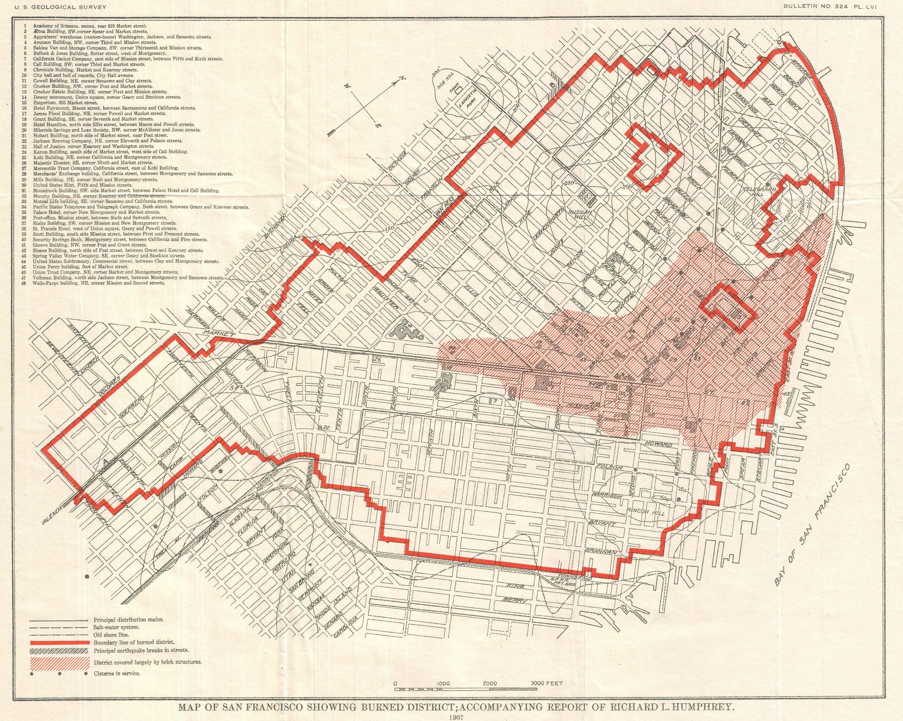
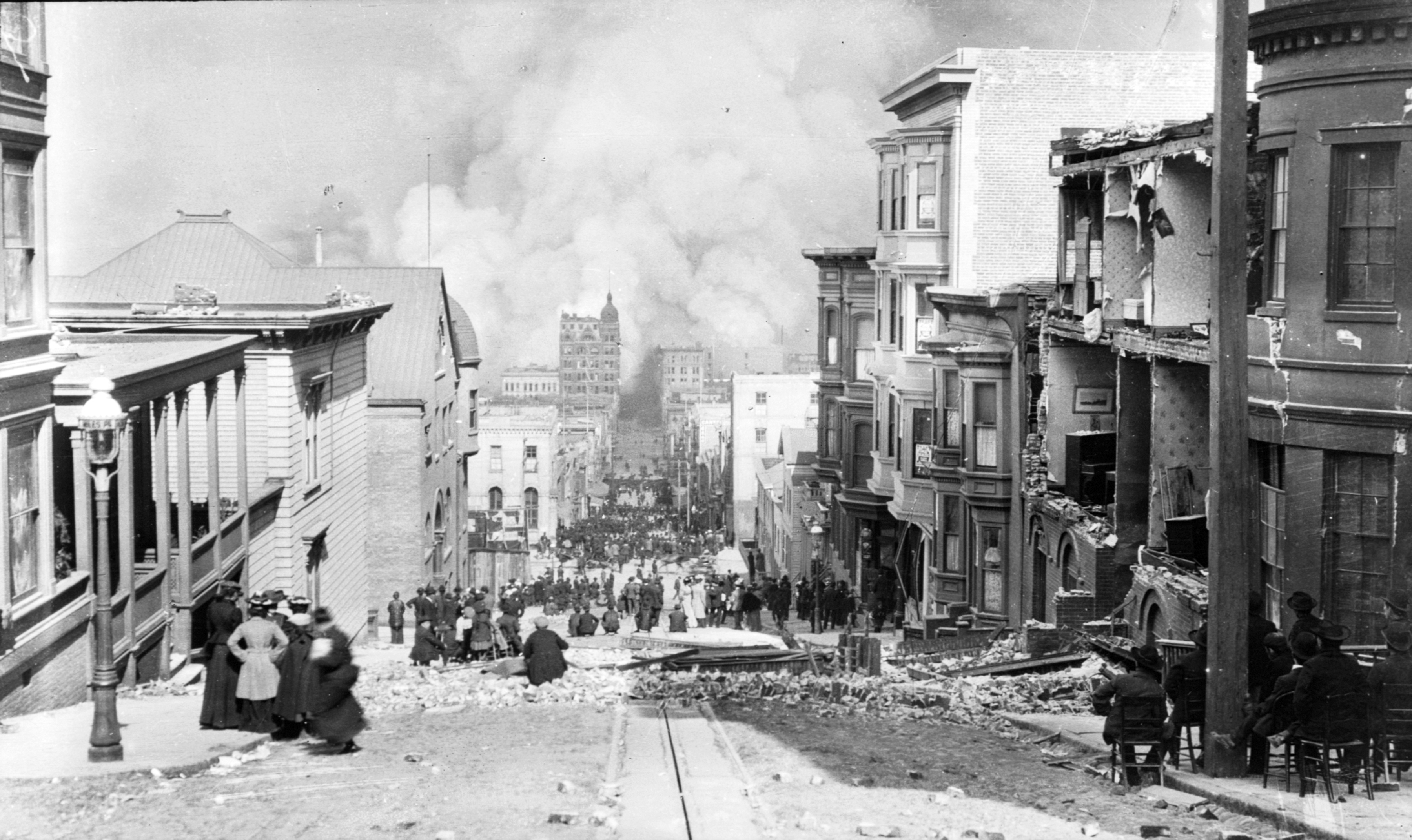
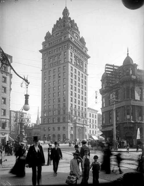
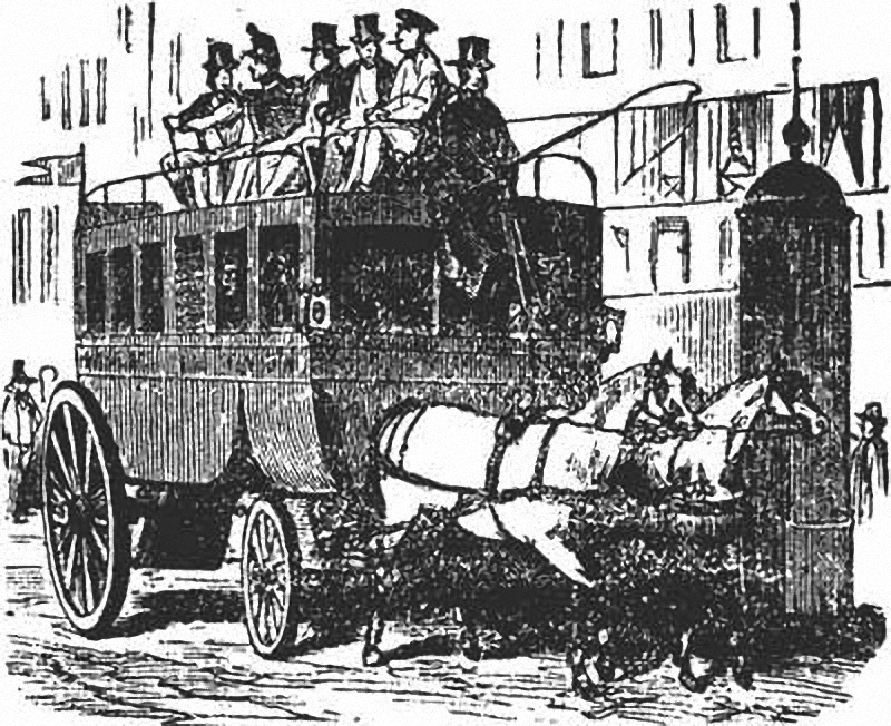
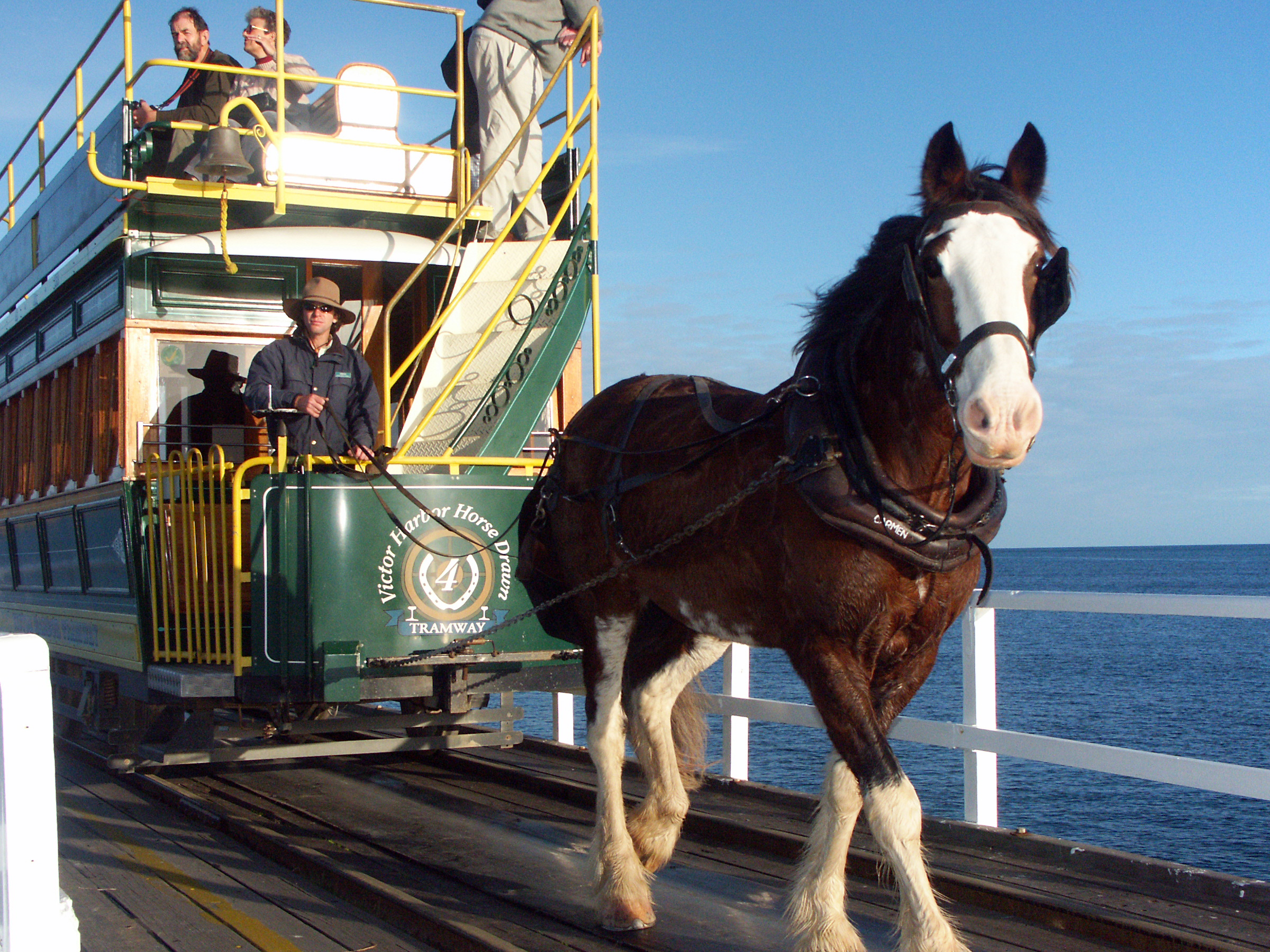
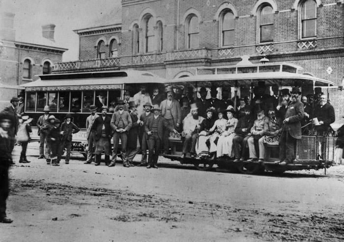
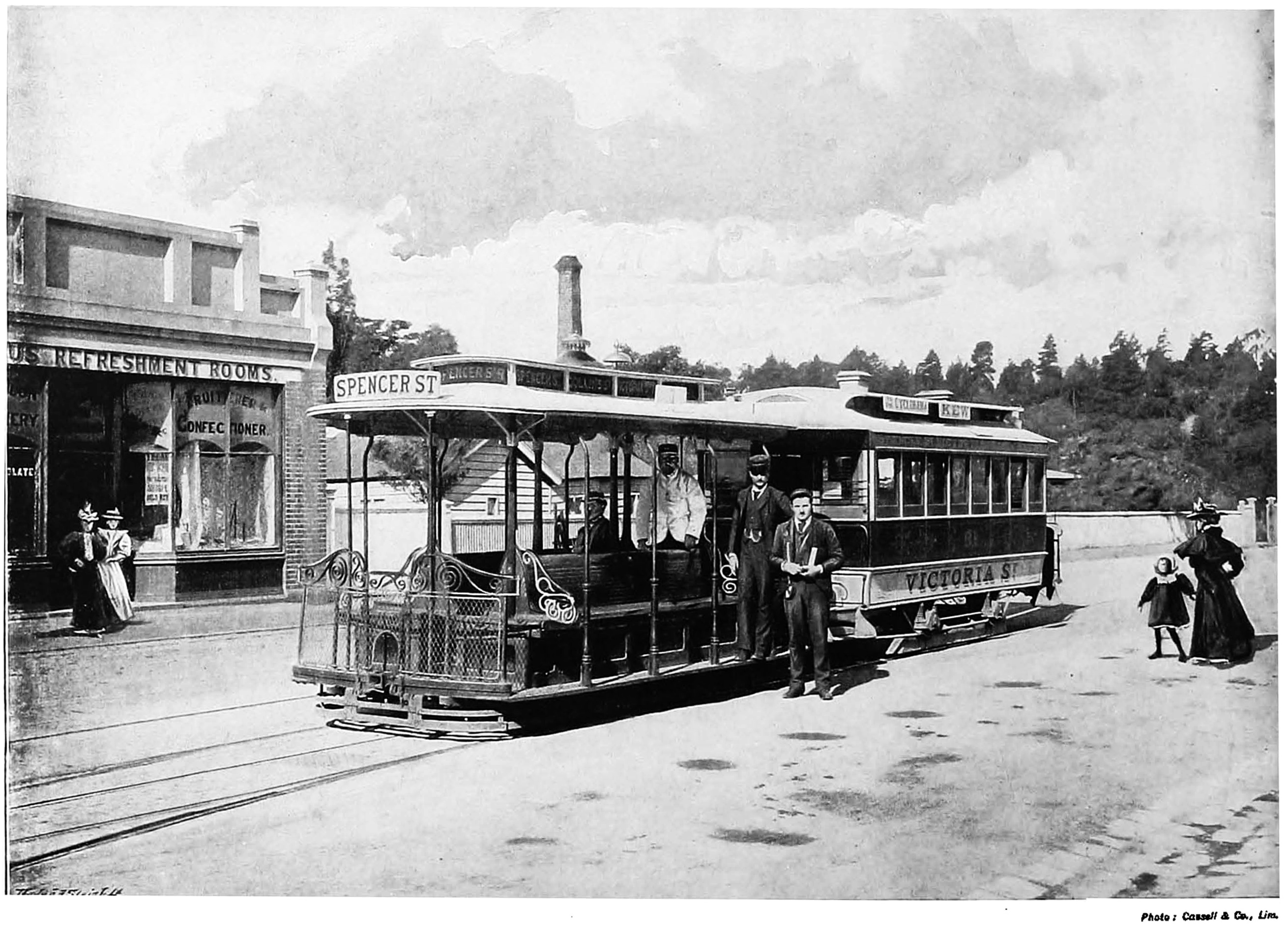
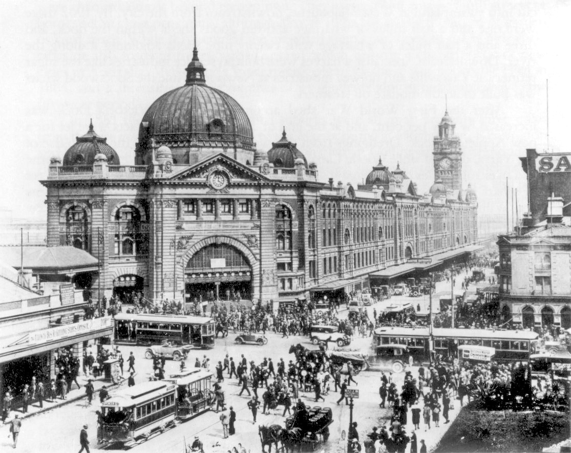
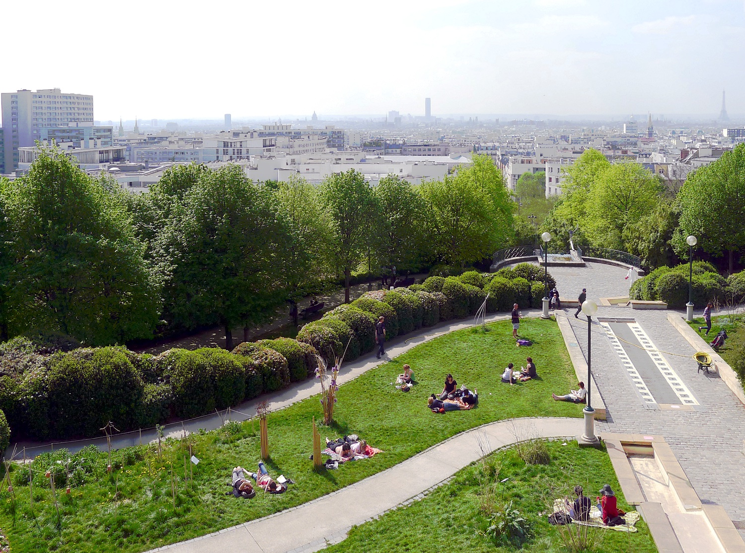
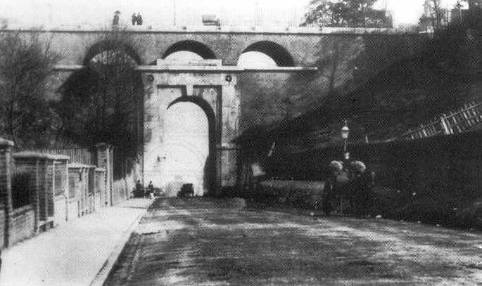
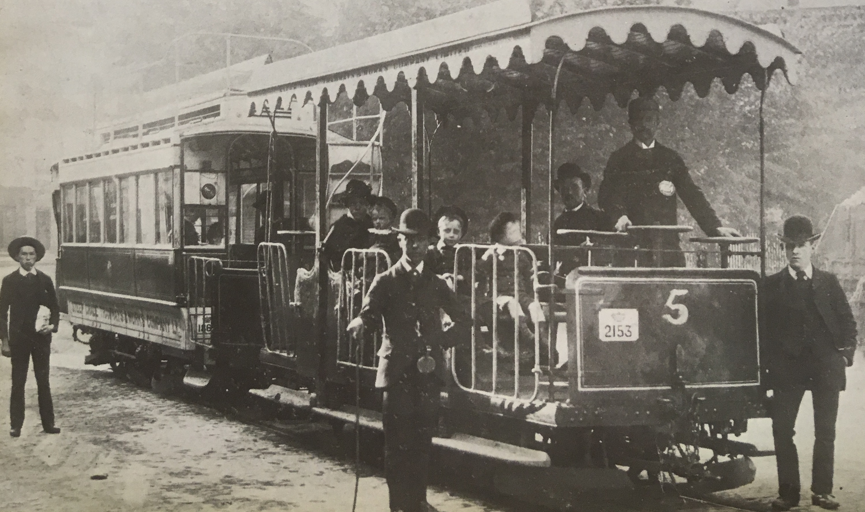