|
Reflections 2023
Series 6
September 28
Newest Street Cable Cars – Code Switching –
Gaelic - Scots – Auld Lang Syne – That Kiss
| | I'll remind that these postings are each referred to as a "Series" because each of the older ones used to have a series of unrelated articles. But we continued using the term even when one single topic filled a posting, or even ran over several postings, like Agatha Christie. For this posting at least we go back to the original concept of unrelated topics, tho you'll see that, after a final bit on a travel topic, cable cars, we move to language, and then to a couple of notorious kisses. | | | | Newest Street Cable Cars We need a recap. In the very beginning we started talking about cables by saying how we use them to travel. How much of this still applies? Vertically, we still hang from cables in elevators. At an angle, funiculars and inclined elevators still function. Horizontally, there are still aerial cable systems up in the sky; while in a place like La Paz, some sections temporarily hover above avenues not too far from the ground, it nevertheless remains an aerial system. What we need to know is about horizontal cable travel at ground level. Such surface travel could be on the street level, just below it in a subway, or elevated just above it. Has any new such urban cable services been built?
The answer comes from the unusually-named People Mover. I call it unusual, since many things move people—think of roller skates and canoes--but somehow, short-distance automatic shuttles have gotten this name in English. Worse, the term has been borrowed into most languages I've checked. For German it's der Peoplemover, for Italian, see below. An exception seems to be French, which apparently wisely calls it a navette automatique, which is, quite logically, an "automatic shuttle". But as we search for cable propulsion in the modern world we have to eliminate monorails, maglevs, and the large majority of people movers that run electrically, electric power being the same frenemy that cable car travel always had. Still, we CAN find new cable car people movers, all around the world, since in the end of the 20C there was a limited revival of the technology known as cable traction for use in some people movers.
People movers are used for short-distance travel, in airports, some downtowns, resorts, amusement parks, huge hospital centers. Where we do find cable traction, while often it's a matter of cars permanently attached to the cable—like a "horizontal elevator"—some companies build variants that allow the cars to be automatically decoupled from the cable under computer control, the computer being the modern "gripman". There is only a handful of companies that manufacture the street-level cable cars we've been studying. One is a name we've heard several times in the past, because of its ski lifts, is Doppelmayr.
| | | | Doppelmayr Doppelmayr is located in far western Austria, near Switzerland, and dates from 1892. In 2002 it merged with Garaventa (1928) of Switzerland to form the Doppelmayr/Garaventa Group to manufacture cableways of all sorts as the largest manufacturer of its kind in the world. As of 2019, the group produced over 15,000 installations in 96 countries. The company's core cable products include cable cars, funiculars, gondola lifts, detachable chairlifts, fixed grip chairlifts, and surface lifts.
In 1996, the Group established a wholly owned subsidiary, Doppelmayr Cable Car GmbH, which specializes in manufacturing automated people movers. Their main product is the cable-propelled Cable Liner system, used in airports, downtowns, and wherever short-haul shuttles are needed. They claim they can cover distances of up to 4 km (2.5 mi) and a peak passenger flow of up to 7,000 people per hour per direction. As with any people mover, cable or electric, a central control room powers the system, and therefore the train has no on-board drive engines, gearboxes or brakes. A fixed grip assembly connects the train to the cable, which propels, accelerates, decelerates, and stops the train, so there are no drivers, conductors or operators on board. We'll discuss a few notable Doppelmayr installations.
| | | | VENICE We'll start with a location we recently discussed. In 2021/7 we talked about the tiny section of Venice on its far western side where automobiles ARE used, around the transit hub of Piazzale Roma (Map by Luca Fascia, based on Giovanni Fasano). But note that connection in red to Tronchetto (tron.KET.to). Now check this out:
https://i.pinimg.com/originals/cd/e9/5b/cde95bb523a520a3a818fb059ccc2d7a.jpg
You may remember we used this above map, but I don't think we said very much about the blue line cutting across the area, which we see in its own map, next. It's the People Mover di Venezia / Venice People Mover, the automated elevated shuttle train that connects the parking area on Tronchetto Island to Piazzale Roma with an intermediate stop at the Stazione Marittima (sta.TSYO.ne ma.RIT.ti.ma) / Maritime Station (Map by Arbalete). As it turns out, the system—built by Doppelmayr--has two four-car elevated trains pulled by a cable, tho when I was in Piazzale Roma, I didn't have occasion to use this shuttle, or even see it.
When we were recently discussing the Paris Métro, we noted that on some routes, steel tracks and wheels have been replaced by rubber tires on solid guideways. The situation is similar with the Venice People Mover, tho not the same. This sketch shows a typical undercarriage (Image by Luigi Chiesa). In green are the rails supporting the rubber tires, but in red are the side stabilizer wheels that keep the tires in place. In navy blue is the cable grip system holding on to the cable.
This is the Venice People Mover leaving the Tronchetto station, with the cables visible between the tracks (Photo by Gf9). Close to the Maritime Station, this is the guideway, showing a cable and the guiding pulleys on a curve (Photo by Luca F [C]). Perhaps most revealing is this view of the elevated line from below (Photo by Lucaf1). To the left is an emergency walkway. Between the two tracks are the cables, which pass over guiding pulleys.
| | | | OAKLAND It has to be some sort of ironic justice that cable traction should return to the Bay Area. San Francisco is the Grande Dame of worldwide cable traction, and now Oakland, just across the Bay, has brought new cable traction back to the area.
Take a look at the system map for BART (Bay Area Rapid Transit). It connects San Francisco and Oakland under the Bay. Then, on the San Francisco side, the four lines run right under Market Street adjacent to the three cable cars, after which two continue to the SFO airport. On the Oakland side, the four lines fan out in four directions. Only the Orange Line remains permanently on the Oakland side.
Up until 2014, a shuttle bus connected the Coliseum station with Oakland International Airport (click), but in that year, a new rail service, the Beige Line, officially called the Oakland Airport Connector (OAC), replaced it. But this rail service came with a difference. While the other BART lines are conventional rail, it was decided that the Beige Line, being a short-distance shuttle, would have its own fleet of Cable Liner vehicles built by Doppelmayr Cable Car, that of course operate on fixed guideways and are cable-drawn. Thus, while integrated into BART's existing fare system, it isn't connected physically to existing BART tracks.
As the BART map shows, the Beige Line shuttles between BART's Coliseum Station and Oakland Airport. This next map shows a little more detail, unfortunately with no names:
https://cualbondi.com.ar/media/recorrido/recorrido-4829981.500x500_8te4fz1.png
The 5.1 km (3.2 mi) route is mostly elevated, and, leaving Coliseum Station, runs largely in the median of Hegenberger Road, which was presumably the route of the earlier bus. Approaching the airport, it crosses under Doolittle Drive (in yellow). This is its only underground section, and it's followed by one at-grade section (note cables and pulleys) just west of there, before finally entering the airport on an elevated guideway again. Thus, this cable car route, even within its short distance, does all three, running above, below, and at, street level. The reason this section is not elevated is shown on the map--it lies under the flight path of two airport runways! How's that for a cable car system interacting with air travel—or not!?
Also centrally located at Doolittle Drive is the Wheelhouse (used in addition for maintenance and storage). It's the powerhouse where the system's 3.7 m (12 ft) drive wheels are located--this, in gold, is one (All Three Photos by Pi.1415926535). Before early funding was cut, there was also meant to be an intermediate passenger stop at this point, Doolittle Station, and provision still exists for it.
The system runs on four cable loops with one train per cable. Just before each terminus, two lines merge into a single track. Cars do switch cables while waiting at the station, which indicates that they are NOT permanently attached to any one cable. Actually, the trains automatically switch cables four times: once at each end, and halfway between the two stops at the wheelhouse.
| | | | LAS VEGAS STRIP We now come to the other-world atmosphere of the Las Vegas Strip, where powerful financial interests compete. We do find rail there—yes, cable-hauled rail—yet the status may seem chaotic. But first, a number of questions arise.
Why does Las Vegas have, unusually, two centers of entertainment, the Strip and Downtown?
Why is walking a nuisance on the Strip and not Downtown?
We talked extensively about Nevada and Las Vegas in 2007/16, during my last visit. I happily stayed at the Mandalay Bay, the southernmost hotel on the Strip, and did have a rental car, since I'd been driving long distance. In the area, I also visited Death Valley and Hoover Dam, and moved around the Strip easily. But let's take time now to extend some of the history we told then, to understand it more completely.
Perhaps one gets the impression that Las Vegas, with its gambling, has been there "forever", but that's not the case. Both are products of the early 20C. And Las Vegas, like many US cities, especially in the West, is a child of the railroad, specifically of the Los Angeles and Salt Lake Railroad, connecting those two cities on a diagonal route. It was also called the Salt Lake Route, hence the call letters SLR. It was completed in 1905, but became part of the Union Pacific in 1921, which still uses the trackage.
This is a map of the Union Pacific RR in 1891, also showing connections. There is already a connection between Salt Lake and San Francisco, via a barely legible Reno NV, whose casinos largely serve San Francisco. You can see the SLR being built south of Salt Lake City to the Nevada border, but not yet crossing it, on its way to Los Angeles. Thus, there's no sign of Las Vegas yet, since it didn't precede the railroad, but followed it, and grew only after that.
In 1903, the Deseret Evening News in Salt Lake printed this ad, which anticipated the completion of the route two years later. (The original name included San Pedro, until that city became part of LA, and its name became redundant and was dropped.) Click to see what would be the final route of the SLR. In southern Nevada you can barely read where Las Vegas is being planned, but it wouldn't exist until completion in 1905. Note the stagecoach connections. Finally, this 1906 ad extolled the completed route. Note the connections to Chicago.
Las Vegas finally moved from being a notation on a map to a real place when settlement came the year the railroad was completed, 1905. That's when the railroad auctioned off 110 acres (45 ha) of land adjacent to the tracks in what would become the downtown area. In 1911, Las Vegas was incorporated as a city. It can be assumed that visitors to Las Vegas during this period came by rail. What else? Horseback? Stagecoach?
But the early 20C also saw the birth of the automobile, and highways began to develop, meant to be used by adventurous automobilists. Apparently, early roads, especially in the West, were called auto trails, which reflects interestingly on the earlier Conestoga wagon trails. And with that, during the 1910s, before highways were numbered, the Arrowhead Trail was laid out, shown here in 1917. It ran more or less the same route as the SLR (click to see the tracks on the map), connecting Los Angeles to Salt Lake, now via a growing Las Vegas, and was the first all-weather road to do so.
We only need to jump 17 years to 1931 to find a pivotal year for Las Vegas. That's the year, perhaps more recent than you may have imagined, that Nevada legalized casino gambling. Thus downtown got its casinos and more hotels and started to thrive. But that was Downtown, as there was no Strip yet. Let's use this map of Greater Las Vegas (GLV).
https://i.pinimg.com/originals/8e/d5/23/8ed523b84e68fb96159a43135407a956.jpg
To understand developments best, we have to jump to the present for a moment. The Arrowhead Trail, entering Las Vegas from the south, was named US 91 in 1926 when the numbering system came along, but was locally called Las Vegas Boulevard. More recently, Interstate 15 was laid out just west of it, at which point the road was downgraded to being merely SR 604, as on the map. As you can see, the Las Vegas Strip was part of the Arrowhead Trail, and locally is still called Las Vegas Boulevard.
But going back in time again, with increased traffic, why didn't Downtown just keep growing? Why did a separate entertainment district develop? And why did it overtake Downtown as a destination?
We said that Reno in the north developed as a gambling and entertainment destination for San Francisco. Even looking back at the Arrowhead Trail it's obvious that Los Angeles was both a larger city and closer to Las Vegas than Salt Lake ever was, so Las Vegas has since served as the gambling and entertainment center for LA.
The first casino opened on the Strip in 1931, the year gambling was first permitted, and the earliest Strip development happened in the first two decades, up to about 1950. The first casino-hotel, El Rancho Vegas, opened in 1941, and it was a bungalow hotel with 63 bungalows, very convenient for someone arriving by car. And that gives us a clue as to why the Strip developed. The mid-20C automobile culture was taking over. Downtown, while eminently walkable, like most downtowns was not as amenable to cars as the more open areas along the suburban strip. Also, hotel rates might have been more amenable as well. Many people arriving by car from the south were just happier staying outside the Las Vegas city limits.
Another indication of Los Angeles influence is the name. A Los Angeles businessman, having in mind the section of Sunset Boulevard in LA called the Sunset Strip, coined the name Las Vegas Strip for this section of Las Vegas Boulevard. Since the Strip lies outside the city limits of Las Vegas, this fact makes a point that's not all that obvious at first. If the Strip is not in Las Vegas, then it's not named after Las Vegas (directly). It's named after Las Vegas Boulevard, just as the Sunset Strip in LA is named after Sunset Boulevard.
| | | | | | Look again at the regional map. The Strip is located in two unincorporated towns. The smaller one is Winchester, which runs from Sahara Avenue to Desert Inn Road. The larger is Paradise (not "Paradise Valley"), which starts at Desert Inn Road and runs well south of Harry Reid (ex-McCarran) Airport. So, technically speaking, visitors to the [Las Vegas Boulevard] Strip who don't also venture Downtown, are not really visiting Las Vegas at all! |
| | | | The major point here for our cable-car narrative is that the Strip was car-oriented from the beginning, with much larger "city blocks" than downtown. This is what probably led it to becoming "the tail wagging the dog", in regard to Downtown. Downtown is an average casino area, like Reno and many others. The Strip on the other hand has developed into a mega-casino area, and can only be compared to Macau (see 2013/19).
https://www.feelingvegas.com/wp-content/uploads/2021/08/downtown-las-vegas-map-website.jpg
For reference only, this is a map of Downtown Las Vegas, certainly worth a visit if you're staying on the Strip. It's strikingly obvious that the railroad came thru at that diagonal angle that it did, since Main Street (note former station) and everything else was laid out at that same angle. This angle continues to the northern part of the strip, while the southern end then runs north-south.
You see that in actuality, the real main street, Fremont, is perpendicular to Main. Its principal area, a very walkable five blocks long, is now a pedestrian mall, and four blocks of it has now been covered over with a barrel-vault canopy called the Fremont Street Experience, where free entertainment and light shows take place (Photo by APK). At the east end of Fremont is the crossing of Las Vegas Boulevard, N and S, the former Arrowhead Trail. To the south, it does lead after a while to the Strip.
| | | | | | We've talked about Brightline building rail in Florida, but you've also surely heard of Brightline West, which is planning an express high-speed rail line to connect the LA area with Las Vegas. It will be a single-track route with passing loops. This restriction is necessary since it will run in the median strip of Interstate 15 (!). The Las Vegas station will not be in Las Vegas proper, but that shouldn't be surprising—it will serve the Strip instead. On the south end of our regional map, find where Las Vegas Boulevard crosses Warm Springs Road. The station will be on the southwest corner of that intersection, close to the bottom of the Strip. I calculate that the new station will be 3.62 km (2.25 mi) south of Russell Road, at the bottom of the Mandalay Bay complex. Note that the airport also serves the adjacent Strip, indicating that, one way or another, most people arrive or will arrive in Las Vegas at the lower end of the Strip. |
| | | | Now let's get down to just precisely where the Strip is located, using the regional map. We have two slightly differing definitions. The stricter one points out that the Strip is outside the Las Vegas city limits, so Clark County uses the term "Resort Corridor" to recognize the Strip as running from Sahara Avenue southwest, with a bend at Flamingo Road, thence running south to Russell Road.
https://www.tripindicator.com/images/compare/attraction-map/las-vegas-tourist-map.jpg
But now click at this more touristy map. At the southern end, we can start with the Mandalay Bay, whose complex does reach down to Russell Road, tho it's not shown. When you reach Sahara Avenue, this is, as we said, the official northern end of the Strip according to Clark County but as you'll note, the Stratosphere Tower, now officially The Strat Hotel & Casino & Tower, is just within the city limits—I measure the tower proper as being some 1,500 ft (457 m) north of the city line at Sahara. But it looks like it belongs to the Strip, and is commonly considered to be part of it. Thus, the general accepted Strip is just a bit longer than the official Strip. The length of the Strip from Mandalay Bay to the Stratosphere comes to about 6.8 km (4.2 mi). Walking at an average rate and NOT stopping along the way—which I cannot imagine doing--it would take around 1h30 to walk. In the desert heat.
Beyond the Stratosphere is a rather uninteresting section of the city, until Las Vegas Boulevard finally reaches Downtown, at Fremont street at the extreme right of the map. The canopy leading up to Main Street is visible.
As I wrote about the Strip in 2007/16: Moving from one hotel’s area to another’s is like moving from one shopping area on a road of strip malls to another. You need transportation of some sort to go any reasonable distance. This is the 20C car culture we still live with.
One solution is already shown on the map in red and blue lines. That's the tourist shuttle bus that started in 2005 called The Deuce. It got that name because it served the two gambling areas, the Strip and Downtown, and because the buses are double-decker (Photo by Cello06 at the English Wikipedia). It also got that name because the original fare was $2 one-way, but that's gone up to $4, or $6 for a two-hour pass.
But getting to the point, our issue is rail travel on the Strip, and specifically cable-hauled rail, which brings us to this map:
https://i.pinimg.com/originals/4e/67/9a/4e679aca000204840b5933212e0e76a1.jpg
If the situation seems a bit chaotic, it is. Rail was added to the strip willy-nilly, a bit here, a bit there. And it didn't go down the center of Las Vegas Boulevard, either. First note two things on this map, which show up well. At the top, note how the Stratosphere is apart from the others across Sahara Avenue, and at the bottom, note how the Mandalay Bay complex does reach down to Russell Road. But then, all rail is either left or right of Las Vegas Boulevard.
Look to the right, in red, and click as needed. This is the Las Vegas Monorail (Photo by Priwo), which is two-track and runs elevated for 6.3 km (3.9 mi). In 1995 it was built from MGM Grand north to Bally's, and in 2002 to the Sahara (now the SLS Las Vegas). There is talk of extensions north and south, but that has tended to fizzle. However, it has a history of malfunctions and breakdowns (parts falling to the street!) as well as bankruptcies—its history is not pretty.
One factor in its slow acceptance is inconvenience, since it runs behind the hotels it services, a long block from the Strip, and a long walk thru a hotel is required to get to the Strip. A ride goes for $6 per trip, $15 for an unlimited day pass. I saw a suggestion that a day pass would be worth it only if one is staying in one of the hotels it serves. I'll say again that I've NOT ridden on any of the vehicles we're discussing here, but I believe I would only try riding this monorail just for the fun of riding a monorail, not for any practical transportation.
| | | | Cable Cars on the Strip That finally brings us to the west side of the strip, which seems much more disjointed in its rail service, with three different cable-car lines, referred to as trams. However, all three are free, and are either in or very close to the hotels served, important in the desert heat of Las Vegas.
The first "tram" (click), in purple, is the shortest, the Mirage-Treasure Island Tram. It was the first to be built, in 1993, two years before even the monorail. It's only 300 m (1,000 ft) long, and just connects the two adjacent hotels it's named for, in a mere 90 seconds. However, when built, it was planned to go further south to cover the area of the present yellow route, down to the Monte Carlo. But talking about different business interests on the Strip: Caesar's Palace would not permit the cable car to cross its property, so the route was stunted to just two hotels! The route, built by a now defunct Nevada engineering company, consists of a single elevated track with a single two-car cable-hauled train shuttling back and forth on rubber tires (Photo by C4K3). It does seem a bit quaint in style, and, unlike all other rail we've been talking about, is not streamlined.
We then jump to 1999 and to the bottom of our map, where we find the Mandalay Bay Tram in green. In this case, the clients asked Doppelmayr to build it. It runs 838 m (2,749 ft) from the Mandalay Bay complex north to the Luxor (here) and Excalibur hotels. This is about as iconic a picture of the Strip as you can get, tho in reality, the Great Sphinx and Great Pyramid are in Giza, near Cairo, and nowhere near Luxor. But that's Las Vegas for you, where the Eiffel Tower, Statue of Liberty, and Empire State Building are also nearby.
This tram also runs a bit further to a station called Excalibur North, at the intersection of Tropicana Avenue and the Strip, an intersection with major hotel-casinos on all four corners (see map). Tropicana Avenue is also the major local street entry to the airport, and has a major exit off I-15, adding to the heavy traffic at the intersection. It's elevated, and being a Cable Liner system, is cable-driven. It runs on rubber tires, making it extremely quiet, and like the other trams, is free. The trains can reach a travel speed of 36 km/h (22 mph).
The guideway is double tracked, with two completely independent shuttle systems running side-by-side. This view has an obelisk from the Luxor Hotel on the left, and looks north toward the MGM Grand across the Strip. Click to see the cable between the tracks. The east track serves all four stations along the route, while the west track can at times provide an express link between the two end stations. Such express service is rather unique on a cable-car system (Both Photos by Doppelmayr Cable Car).
Finally, in 2009, the Aria Express was built, again by Doppelmayr using the Cable Liner technology. It runs for 620 m (2,034 ft) in the central area (in yellow on the map). This is where the Mirage-Treasure Island Tram never succeeding in reaching. The system consists of two elevated tracks, each with a single shuttle train (Photo by Priwo). It has a maximum operating speed of 37.8 km/h (23.5 mph). There are three stations, from the Bellagio (and adjacent hotels) in the north via the Aria (and adjacent hotels) to the Park MGM (ex-Monte Carlo) at the southern end.
| | | | LUTON London has several airports, the most well-known being perhaps Heathrow and Gatwick (Map by Cnbrb). But to the north, near the town of Luton, is Luton International Airport. It has a rail connection from both King's Cross and Saint Pancras stations at the Luton Airport Parkway station. This connection is the Luton DART (Direct Air-Rail Transit), shown in gold on the map. It is, again, a Doppelmayr Cable Liner system. This route replaced a shuttle bus—the entire story sounds similar to Oakland Airport above.
Since it's cable-powered, its station just abuts the main line rail station (Map by Cnbrb) and then leads for 2.1 km (1.3 mi) into the airport. That J shape of its route can also be seen in this aerial view, which shows the whole airport (Photo by Thomas Nugent). As part of the proposals to expand Luton Airport, it is envisaged that the DART line would be extended eastwards to terminate at a new station serving Terminal 2.
This is the Luton DART en route (Photo by Chris j wood), with the cable quite visible between the tracks. The aim of the line is to reduce travel times from the London rail stations to the airport terminal to 32 minutes. It should be pointed out that the Luton DART is quite new, having just opened in March 2023. Cable traction lives!
| | | | MEXICO CITY The Doppelmayr Cable Liner system operates in the Mexico City airport using the name Aerotrén, which connects Terminals 1 and 2, as below, in red:
https://s3.amazonaws.com/ifly-airports-v2/MEX/Mexico-City-Benito-Juarez-Airport-MEX-Terminal-map.jpg
The automated, single-track, single four-car train runs for 3 km (1.9 mi). It's used only by connecting, ticketed passengers, attaining a speed of 45 km/h (28 mph) between the two terminal stations. The train is connected to a cable, driven from under one of the stations, that propels, accelerates, and decelerates it (Photo by Doppelmayr Cable Car).
| | | | CARACAS In Caracas, Doppelmayr built a system, but I had some trouble finding just where it's located. Clarification came only from the Spanish Wikipedia entry on the Caracas Metro (remember, usually the native language entry has more info than just looking it up in English). The "Metro de Caracas" seems to be defined very broadly. It includes the Metro (subway) itself, but also local and long-distance buses, and two other very interesting systems, both involving cable, the MetroCable and the Cabletrén.
https://upload.wikimedia.org/wikipedia/commons/thumb/a/a1/Mapa_del_Metro_y_Servicios_de_Transporte_de_Caracas%2C_Venezuela..png/1024px-Mapa_del_Metro_y_Servicios_de_Transporte_de_Caracas%2C_Venezuela..png
This is the Caracas Transport Map (Map by ArielResma). Because of the complexity of so many routes, your eye will be distracted. Ignore essentially everything in bright colors, because those are the six lines of the actual Metro (subway) system. I also see a rail (ferrocarril) line at the bottom in orange and a bus line in purple at the top. Ignore them, but look for the following.
The MetroCable (say KA.blé) is a gondola lift system integrated into this transport network which provides quick and safe transportation for those who live in the neighborhoods situated on Caracas's mountainous regions. There are presently five; two are so new the names seem to be in flux. Doppelmayr partnered in this system.
Click on the left. In green is the line listed as Antímano, which seems to now be called MetroCable El Junquito.
Center left on the map, in pink, is the MetroCable San Agustín.
On the right, in orange, is the line listed as Petare Sur (South), which here seems to now be called MetroCable San Blas.
Above that, in yellow, is MetroCable Mariche (Photo by Guillermo Villegas).
Right above that, in teal, is MetroCable La Dolorita.
| | | | | | This isn't the first time we've seen an urban gondola cable car system. In 2017/16, when in La Paz, Bolivia, we described fully taking a couple of rides on Mi Teleférico the local gondola cable car system that sometimes runs along a boulevard, then, when reaching a cliff, continues "flying" over the edge on its cable and down into the valley. |
| | | | But those are all up in the air. Where's the type of urban cable car we've been following? That's the Cabletrén, known officially as the Cabletrén Bolivariano, and it's integrated thoroughly into the Metro system, just like the five lines of the MetroCable are. It's also by Doppelmayr, and it's surprising that one city should have both types of cable-driven systems.
On the map, this time look for a bright color. The Cabletrén (Photo by Alejandro Gómez) is shown in dark purple, with five stations, running north-south for 2.1 km (1.3 mi) and connecting two subway lines. It consists of four four-car rubber-tired elevated trains (Photo by Jeno Kairos) that can attain a speed of up to 47 km/h (29 mph).
| | | | Poma Doppelmayr's only major competitor is Poma, known also as Leitner-Poma after a merger and is now a subsidiary of HTI Group. Poma manufactures cable-driven lift systems, including fixed and detachable chairlifts, gondola lifts, funiculars, aerial tramways, people movers, and surface lifts. Poma has installed about 7800 devices for 750 customers worldwide. The majority of Poma's lifts are used in ski areas in Europe, Asia, and North America. This organization builds a family of cable-propelled automatic cable cars called the MiniMetro whose vehicles have either a fixed grip or a grip that detaches from the cable. One recent MiniMetro installation was the Miami Airport e-Train, which is one of three automated people mover systems operating there.
https://travelwidget.com/terminal-maps/MIA/MIA_overview_map.png
It connects the satellite building of Concourse E with the rest of Concourse E which is further connected to the main terminal. It consists of two three-car cable-driven MiniMetro trains, the two trains running on parallel independent elevated guideways shuttling back and forth.
But a far more interesting installation is to be found in Perugia, in the center of Italy, north of Rome (Map by F l a n k e r). Perugia is a small city, with a 2023 population of 161,593. But while much of what we've been talking about involves very short shuttles at airports, in 2008, Perugia opened its Minimetrò (say mi.ni.me.TRO in Italian), which crosses the city via seven stations, five elevated, two in tunnels, as below (Map by Maximilian Dörrbecker [Chumwa]):
https://upload.wikimedia.org/wikipedia/commons/3/3a/Minimetr%C3%B2_Perugia_map.png
The route runs 3 km (1.9 mi) with fully automated, cable-pulled trains attaining a speed of up to 25 km/h (16 mph). It starts in the east in the Old Town, at Pincetto, an underground station, and the tunnel continues to the second stop, Cupa (Photo by Michele Pinassi). The station in the center of its route is Fontivegge, named after the main Perugia rail station it abuts which in turn is named after its neighborhood, as there are other stations. The final stations of the route, including another bit of tunnel, are elevated in the west of town (Photo by Zorro2212). There are two parallel tracks--note the cables (Photo by Pava), and the trains run on rubber tires, not only vertical ones, but also horizontal ones below to keep the cars steady. The minimum frequency is less than a minute, with an average of 2.5 minutes. Most interesting are the turntables in each terminal station—this one in Pincetto—that reverse the direction of travel (Photo by Radapanda). I've never heard of any system before using turntables outside of the famous ones in San Francisco.
This second map (Map by Cantalamessa) shows a thing or two more. In brown is the main line showing the stations other than Fontivegge, and marking in yellow that it's a transfer point. Also, it shows on the right the planned extension of the system out of Pincetto. Cable traction lives!
| | | | Otis There's one last company to consider. When it comes to cable, what else should come to mind but the Otis Elevator Company? After all, it was Elisha Otis who invented a safety device that prevents elevators from falling if the hoisting cable fails. He famously demonstrated this at the 1853 New York World's Fair at the New York Crystal Palace, amazing a crowd when he ordered an axman to cut the only rope holding the platform he was standing on. It only dropped a very short distance and stopped, since the safety mechanism had worked, and people were convinced that elevators worked.
Anyway the Otis Elevator Company dabbled using cables horizontally in people movers, via the Otis Hovair. It does run via cable traction, but the vehicles have no wheels, not steel, not rubber! Hovair replaces the wheels with a hovercraft lift pad. They float on air! The Hovair is the only hovertrain system to be used in commercial service. It's used at a hospital complex, the Getty Center, and at some airports (Cincinnati, Detroit, Minneapolis-St Paul, Cairo). But the most interesting one I've found is its use as the Zürich Airport's Skymetro.
https://1.bp.blogspot.com/-kJrpFz25mwU/U5k8pKeH3hI/AAAAAAAAPes/tqRtQc--RhM/s1600/ZRH+map2.gif
We are not talking about the train into Zürich shown at the bottom. I've taken that into town and it's a regular train. The Skymetro is shown in dashes at the top. It connects the main terminals, such as Gates A and B, with the mid-field Gate E terminal, passing underneath a runway. It's 1.1 km (0.68 mi) long, takes 2-3 minutes, runs in two separate tunnels, and is fully automatic. The vehicles on the parallel guideways are pulled by steel cables and float on an approximately 0.2 mm thick air cushion generated by on board air compressors, running over a smooth concrete guideway. It's claimed to be the most used cableway in Switzerland.
Here's the Skymetro boarding point (Photo by Wikizh07) and here's the cable and smooth, trackless guideway (Photo by Chris.urs-o). Since this YouTube video of the Zürich Airport Skymetro runs for 2:43, just skim it to check out what it's like to float on air.
Everyone knows what an Autobahn is, and we've seen Straßenbahn often enough to know it's a streetcar. I was interested to learn that this system at Zürich Airport is called a Luftkissenbahn--Luft is "air" as in Lufthansa, and Kissen is "cushion, pillow". I believe the English version seems to be "tracked air-cushion vehicle". Ugh. I'll go with Luftkissenbahn.
But the whole point of all the above is to realize that street cable cars still live!
| | | | Code Switching This is the point where we move from a travel topic, cable cars, to a language topic, Scots, and how we've all used the Scots language without realizing it. But to get there, we need to take a stroll thru some simple language concepts, some new, others that we've touched on before. First is code switching.
The word "code" has expanded its meaning in the computer age, tho it really always did mean "language". When we've spoken of Morse code, that's a type of language, as Braille and Sign Language are. But now with computers, people actually talk about "writing code", which is really a new development.
But our current topic is simpler. We all do code switching every day. It refers to altering what we say, depending on the audience. If we're talking to someone who seems on our education level, we'll use certain words. But if we're talking to someone we feel might be less educated, we politely skip "big words" to make the person feel comfortable. That's code switching. On the other hand, a person might purposely NOT code switch when it would be appropriate in an attempt to show superiority. That person might then be labeled "stuck up" or "snooty".
We all have a formal "telephone voice" when speaking to someone we don't know, such as an office secretary. But when she connects you to your party, someone you might know quite well, your tone changes as you code switch. And when speaking to a small child, everyone code switches as appropriate. And some people—not I—use baby talk when "talking" to an infant. Also, pet owners do so when "talking" to their pets.
But that is all monolingual code switching, just sticking to one language. It gets even more interesting as we come to bilingual code switching, which is easy to do and is fun. Beverly and I were both fluent in German, but we never spoke it at home, since it didn't seem natural. On the other hand, on our frequent trips to Germany or elsewhere in the Germanophone area, we'd easily slip into German on arrival, including with each other.
But at home, we would salt our English occasionally with a German word when we felt it more fitting within the framework of our personal experience. Where I might ask someone else to slide over so I can fit on the bench, I might instead have asked Beverly to rutsch over. The familiarity of the term might even elicit a smile. This is bilingual code sharing in its simplest and happiest form.
Picture a bilingual Latino speaking to someone who isn't one. He might tell them he just visited his grandma who made him a stuffed sandwich for lunch. But if he's talking to another bilingual Latino, he might say he just came from visiting his abuela who made him an arepa for lunch. This would forge a link of solidarity between the two. Taken to an extreme, he might throw a lot of Spanish into his English, or a lot of English into his Spanish, a result which either way is called Spanglish. When done with English and French, it's called Franglais.
We spoke recently about Italy, pointing out that, while many only think Italian is spoken there, in reality, there are more languages, and we discussed in particular Neapolitan and Sicilian. I'm sure you realize that a speaker of Neapolitan would use it just with other Neapolitans, but when speaking with other Italians, he's likely to code switch to standard Italian. This happens with all languages.
| | | | | | I remember this anecdote Beverly told me. She had taught before we were married, and was somehow involved in a government program where she visited a school in Germanophone Switzerland. She told me that on her visit, everyone spoke standard German with her, but it was different when her teacher-guide took her to the faculty room. The would all continue to speak Standard German to her, but would then turn to each other and change into Schwyzerdütsch. No one was being impolite to Beverly. Indeed, they might have seemed impolite to one another if they started speaking standard German with their colleagues, which would have been much too formal. People just know when to code switch. |
| | | | Germanic Languages We've talked about this before, but now we can fine-tune it further to ascertain the closest sibling to English. First picture the below, which we've said before, then we'll see a map and a chart.
Our language family is Indo-European (IE), one major subfamily of which are the Germanic Languages. It's believed that Proto-Germanic (Map by Wiglaf) started in southern Scandinavia and northern Germany c500 BCE, and then spread from there south--both southwest ("West Germanic") and southeast ("East Germanic")--onto territory occupied by the Celtic Languages (say "Keltic"), another IE subfamily, reaching the green area at the turn of the millennium, roughly about 1CE.
But with gains come also losses. East Germanic, the only traces of which are in the Gothic language, had spread to an area between the Baltic and Black Seas in the 1C and 2C CE (Map by Ulamm). But in the late 6C CE, these were supplanted by another IE subfamily, the Slavic Languages, and no longer exist.
However, in the West, the Anglo-Saxon tribes invaded the British Isles in the 5C-6C and moved the Celtic languages remaining there to the western extremes. This map has two purposes (Map by YaBoiKlank):
https://upload.wikimedia.org/wikipedia/en/2/22/Germanic_languages_with_dialects_revised.png
First click on the British Isles to find in gray the non-Germanic areas, which are all remnants of Celtic. The Welsh and their Celtic language (not named) ended up in the west, beyond England. Speakers of Scottish Gaelic ended up in the northwest of Scotland, the Highlands. Speakers of Irish Gaelic ended up in pockets in the far west of Ireland. The rest of the British Isles now have an Anglo-Saxon-based Germanic heritage.
But primarily, this map shows the Germanic Languages today within Europe, where they originated before spreading worldwide (the Americas, Australia, more). Study it for a bit before we come to an excellent chart that ties it all together. But do note that, since the Angles and Saxons came from roughly the North Sea coast of Germany, Frisian is described as the Germanic language most closely related to English, tho they're in no way mutually intelligible (Map by ArnoldPlaton). This whole Dutch-German coastal area along the North Sea is part of historic Frisia, which is why all those coastal islands are called the (West- and East-) Frisian Islands, but the area of the remaining speakers of Frisian is much more limited. Spoken in the Netherlands is West Frisian, on the German coast is North Frisian, and the tiny pocket in Germany is where Saterland Frisian is spoken.
https://upload.wikimedia.org/wikipedia/commons/a/a1/Scots_Language_Chart_by_Carolyn_Emerick.jpg
Now this chart will help organize what was on the map (Chart by Carolyn Emerick). Let's start in the middle where East Germanic, as represented by Gothic, is extinct. That implies that what's left should be North and South (see map!), but for historical reasons, we still talk about North and West. Go figure. Note in advance that everything associated with the British Isles is in red.
North Germanic is really quite simple: it split two ways, leading to how the modern Scandinavian languages are grouped.
| | | | | | Obviously, Norn has to be explained here. While the Scandinavians did invade the British Isles, in the form of the Vikings, and did affect English extensively (for example that's why English still has patronymic family names Scandinavian style, like Johnson and Peterson) that is NOT what is the case here. Norn was a genuine North (not West) Germanic language, now extinct, that existed on the Orkney and Shetland Islands to the northeast of Scotland, as seen in this end of the 11C map showing Norse island possessions in Scotland (Map by Sémhur). Disregard the southern part, the Hebrides and Isle of Man, as that had nothing to do with language. But the fact that the northern area, the Orkney and Shetland Islands were Norse is significant, as this is where Norn developed, then died out. The name Norn developed out of a Norse word that is related to "northern".
This c1400 map of Scotland shows two things (Map by Caesar). In orange it shows where (North Germanic) Norn was spoken. But it also shows how (Celtic) Scottish Gaelic, which originally covered the whole country, was in the process of being pushed to the northwest to the point where we saw it in gray in modern times on the earlier map. It was being replaced by the Anglo-Saxon influence of (West Germanic) Scots (see below).
How these two island groups were transferred to Scotland is almost humorous, and so typical of the era. In 1469, they were pledged to Scotland by the King of Norway as security against the payment of the dowry of his daughter Margaret, betrothed to the King of Scotland. But the money was never paid, and, as the bank will seize your house if you don't pay your mortgage, Scotland took the islands permanently. I've heard that there's a movement for "repatriation". The headline-grabbing version is that the Orkneys in particular want to leave Britain and rejoin Norway, but the reality of it is that they just want more cultural connections between both groups of islands and Norway.
|
| | | | On our chart, now move over to the West Germanic branch. It, too, splits two ways to start with, to Old German and to Anglo-Frisian (aha!). In Old German, the mountains made a difference (see map). In the Alps and nearby mountains developed Old High German (that's why it's "high"), and on the northern plains developed Old Low German (both mismarked on the chart). You can then see how each continued, and keep comparing to the map.
But we said that the Angles and Saxons emigrated from the Frisian area to Britain, and the chart shows how Frisian and Old English separated at this point (again, everything in red is on the British Isles). Old English can also be called Anglo-Saxon and was spoken from c450 CE to c1150 CE.
The next development was Middle English in the period of c1150 to c1450, and in this period, something happened you don't hear about too much--Middle English started to diverge. In the south, in England, it became English, but in the north, in Scotland, it became Scots.
These two languages are very similar, but are not the same. I look at them as fraternal twins. It was Scots that began to displace Scottish Gaelic, and Scots also pushed out Norn on the islands. We'll see more about Scots in a moment.
| | | | | | We've been talking about languages displacing each other, East Germanic by Slavic, Celtic by Germanic. But sometimes they blend. In 1066 at Hastings, the Norman French conquered the Anglo-Saxons, and since then, Norman French heavily influenced Anglo-Saxon English, which is today a hybrid of the two. But that's another story. |
| | | | Languages of Scotland Our goal is to examine the Scots language, and to realize that when we sing Auld Lang Syne we're singing in Scots, tho twisted to sound like English. But before we get to Scots, we have to address the elephant in the room, Scottish Gaelic. While we've been talking about Germanic languages, it's fitting that we talk about the adjacent Celtic ones (again, Keltic). We need to mention both Irish Gaelic, sometimes simply called Irish, and Scottish Gaelic.
The language grew out of Ireland. The first written inscriptions date from the 4C CE, in what is known as Primitive Irish. During the 5C-6C it became Old Irish, and by the 10C, it had developed into Middle Irish, which by then was spoken throughout Ireland, the Isle of Man, and parts of Scotland. These Celtic speakers were all referred to in English as Gaels, hence the word Gaelic.
| | | | | | This map documents the horrible shrinkage of the world of the Gaels over the centuries (Map by CelticBrain). All three shades of green together represent the maximum expansion of the Gaelic language and culture in c1000 CE; the two darker shades of green show its shrunken reach c1700 CE; and dark green shows the remnant areas that are still Gaelic-speaking today. These bits and pieces are all furthest away from England. |
| | | | Middle Irish was the changing point (like Middle English becoming both Scots and English). From the 12C, Middle Irish in Ireland evolved into modern Irish (Irish Gaelic); on the Isle of Man it evolved into the Manx language (or Manx Gaelic); and in Scotland it evolved into Scottish Gaelic. So there we are. | | | | Scottish Gaelic Doing this research, I discovered one fact that startled me. I've been saying it wrong all along. It's true that when talking about Irish Gaelic, the first syllable rhymes with gay-. But when talking about Scottish Gaelic, the first syllable rhymes with gal-, as tho the word were gallic! (It thus rhymes with—pardon the expression—phallic.) You learn something every day.
However, all forms of Gaelic are endangered languages. Using Scottish Gaelic as an example, in the 2011 census of Scotland, 57,375 people (1.1% of the Scottish population) reported being able to speak Gaelic, 1,275 fewer than in 2001. It was also determined that there are no longer any monolingual speakers of Gaelic. That means that even the most fluent speakers of Gaelic also speak something else, most likely Scottish Standard English (see below). The highest percentages of Gaelic speakers were in the Outer Hebrides as is indicated by this map of Scotland (Map by Adam Dent). You can see history in this language map. The blue areas are where speakers of Scots are concentrated, and the green areas are where speakers of Gaelic are. It once was all Gaelic, so the influence of Anglo-Saxon English culture can be perceived entering the Scottish Lowlands, while the less accessible Highlands and islands were less affected.
But today, countries are recognizing minority languages more and more. Driving in from England, at the border you might now find this sign welcoming you to Scotland—or, shall we say, Alba (Photo by DeFacto). But you'd usually have to go well into the highlands and over to the islands to be sure to find other bilingual road signs (Photo by FrDr), which, with railroad station signs, and others, are gradually being introduced in Scotland, primarily in the northwest, tho also elsewhere. This one is on the Isle of Skye (Scots: Isle o Skye) in the Inner Hebrides in the northwest (Map by Kelisi). You can see how some English names like Portree or Dunvegan are similar to the Gaelic names, but how other place names have developed differently.
| | | | | | Language note: you may know the female Gaelic name Siobhan, as in the name of the late Irish actress Siobhan McKenna (who was fluent in Irish), and may have learned that the BH is pronounced V. That bit of knowledge can be confirmed by the place name at the very top. |
| | | | Scottish Gaelic has influenced English, Scots, and particularly Scottish Standard English (see next section).
Loanwords (some with perhaps older Irish Gaelic influence as well) include: whisky, slogan, brogue, clan, galore, trousers, gob (meaning a sailor, or, in the UK, slang for mouth, as in Shut your gob! or I'm gobsmacked! [amazed]).
Other loan words are based on Scottish geography: obviously loch for lake, but also glen, and ben, perhaps better known in the British Isles, since Ben Nevis is the highest mountain in Scotland, the UK, and all the British Isles.
| | | | Scottish Standard English The standardized variety of Scottish English is called Scottish Standard English (SSE), which may be defined as the characteristic speech of the Scottish professional class and the accepted norm in schools. Its pronunciation, grammar, and expressions are distinct, as are its vocabulary, particularly pertaining to Scottish institutions. SSE is therefore spoken all across Scotland.
Scottish Standard English is at one end of a linguistic continuum, at the other end of which is broad Scots. "Broad" refers to a particularly noticeable local "thick" accent, often associated with working class people. It contrasts with a more neutral "general" accent, often associated with the middle class. SSE may be influenced to varying degrees by Scots. Some speakers code switch from one to the other, as the situation may require. This would happen usually in more formal situations, or when speaking to someone of a higher social status.
SSE resulted from language contact between Scots and the Standard English of England after the 17C. The resulting shifts to English usage by Scots-speakers resulted in many phonological compromises and lexical transfers (translation: Scots was highly influenced by English). But it retains differences, some of which are below.
Scottish English makes a distinction between the vowels in fern, fir, and fur, while English usually uses the same vowel for all these words.
In many varieties, hoarse and horse are pronounced differently.
In the spellings W and WH, there is a distinction between the pronunciation W and HW in words such as witch and which, as when asking "hwich witch?" (The fact that there are two spellings indicates that W and WH used to be distinct everywhere.)
The sound KH is common in names and in SSE's many Gaelic and Scots borrowings, particularly well-known as the CH in loch.
| | | | | | English speakers who are timid about using sounds that are not native to English, such as the KH in loch or in the name of the German composer Bach. Many wimp out and say Lock Ness or Lock Lomond, as tho they are locking a door, and Johann Sebastian Bock, as in bock beer. It's the fear of the unusual, and not wanting to sound different. |
| | | | SSE has inherited a number of words from Scots, which are less common in other forms of standard English. General items are wee, the Scots word for small; bairn for child, common in all Scandinavian languages; bonnie for pretty, attractive, (or good looking, handsome, as in the case of Bonnie Prince Charlie); kirk for church (as in other Germanic languages); particularly striking is the word outwith meaning "outside of" (Photo by Ippei UKAI).
As with all language varieties, SSE has its own Scotticisms. These are of two types: covert Scotticisms, which generally go unnoticed as being particularly Scottish by those using them, and overt Scotticisms, usually used for stylistic effect, with those using them aware of their very Scottish nature. Perhaps the most common covert Scotticism is the use of wee (meaning small or unimportant) as in "I'll just have a wee drink..." This adjective is used frequently in speech at all levels of society. Some selected Scotticisms are below:
• A dinna ken. - I don't know.
• She's ages wi him. - She's the same age as him.
• What are ye efter? - What are you looking for? or (in pubs) What'll you have to drink?
• Ye missed yersel last night. - You missed out on a good time last night (by not being there).
• I'll come round at the back of eight. - I'll come round just after eight o'clock.
| | | | Scots We are now getting to the point. What is Scots like? It has nothing to do with Scottish Gaelic; we saw on that earlier map they're like oil and water. Scottish Standard English encompasses all of Scotland; in the northwest, there are also bilingual speakers of Scottish Gaelic and SSE; code switching there is a more abrupt process. In the southeast there are bilingual speakers of Scots and SSE. These two being related, and a speaker can more easily code switch between them. If an SSE speaker feels he's among locals, he may pepper his speech with more Scots words, pronunciations, and expressions, similar to what we said earlier about the Latino speakers in the US.
This is a map that specifically centers on where speakers of Scots were concentrated within Scotland as of the 2011 census (Map by SkateTier). We'll see in a moment that it's also spoken elsewhere. The word Scots, used to described either the people or the language, is very simply a mid-14C contraction of Scottis, the northern variant of "Scottish", which is how the name appeared in early Scots and late Old English. By the 1590s, another contraction developed, "Scotch", which was in popular use until the 18C and remained so for a century. However, in the 19C, it began to be used pejoratively by English speakers, and so began to be avoided. It's safe to say that today, the word "Scotch" applies exclusively to Scotch whiskey and is best avoided in other uses. In other words, enjoy a wee glass of Scotch among the Scottish who may be speaking Scots.
The orthography of Early Scots had become more or less standardized by the middle to late 16C. After the Union of the Crowns in 1603, the Standard English of England came to have an increasing influence on the spelling of Scots thru the increasing influence and availability of books printed in England. After the Acts of Union in 1707 the emerging Scottish Standard English, influenced by the developing Standard English of southern England, replaced Scots for most formal writing in Scotland (remember, the two are on a continuum). Despite the updated spelling, however, there are rhymes that make it clear that a Scots pronunciation was intended. We'll see this rhymes issue when we review the song Auld Lang Syne.
I've just learned a wonderful term, the apologetic apostrophe, which is the distinctive use of apostrophes in Modern Scots orthography. Apologetic apostrophes, introduced in the 18C, generally occur where a consonant exists in the Standard English cognate, but not in Scots, as in a' (all), gi'e (give) and wi' (with). It may be said that it implies an inferiority of Scots to English ("we're lacking in Scots what SHOULD be there--sorry"). Consequently, written Scots with apologetic apostrophes began to look very similar to contemporary Standard English, suggesting a somewhat modified version of it, rather than a distinct speech form that had been developing independently for many centuries.
The use of the apologetic apostrophe became less widespread after the mid-20C and is now considered unacceptable, the apostrophe-less forms such as aw (all), gie (give) and wi (with) being preferable. It's amazing how a little thing like an apostrophe could show earlier subservience of Scots to English, and how its present removal can show defiance. There is indeed drama in language.
Scots includes some unique plurals such as ee/een ("eye/eyes"), horse/horse ("horse/horses"), cou/kye ("cow/cows") and shae/shuin ("shoe/shoes") that survived from Old English into Modern Scots, but have become regular plurals in English – ox/oxen and child/children being exceptions in English that still exist.
| | | | | | Some English plurals have changed, with old forms only being found in some dialects, in old poetry, or in old biblical usage.
The English word cow came from Anglo-Saxon cū, plural cȳ (in German, it's still Kuh). The plural cȳ became ki in Middle English, and an additional N plural ending was added (like in oxen), yielding kine. (This was a double plural, just as child adds both an R and an N to become children.) Later it became regularized to cow/cows. But compare the older cow/kine to Scots cou/kye.
Look at Scots ee/een. English used to have eye/eyen, which was used by Shakespeare.
Look at Scots shae/shuin. English used to have shoe/shoon.
English also used to have tree/treen, knee/kneen, bee/been. All those English plurals are now archaic.
|
| | | | All languages have regional dialects and Scots is no exception. This is a map of Scots dialects (Map by Zakuragi). Look it over, but you see a new subject that it brings up. Just as Gaelic had moved from Ireland to Scotland, Scots instead moved from Scotland to Ireland, in the form of Ulster Scots. How did that happen? It was planned! | | | | Plantation of Ulster I know I've always wondered, and I'm sure we all have, why Ireland, a mostly Catholic country, should not only have a somewhat large Protestant population, but that it should all be concentrated on the northeast corner of the island. Why should that be? How does such a thing come about? Let's start from the beginning.
Christianity replaced paganism in Ireland just before the 5C, and it was Saint Patrick who famously spread it around Ireland. Missionaries from Ireland to England and continental Europe spread religion and learning, and scholars from other nations moved to Irish monasteries. It should not be any surprise that Ireland in these earliest days was totally Roman Catholic.
We are then aware of conflicts between England and Ireland in the following centuries, in which England conquered Ireland and made it part of Great Britain. Ireland was treated as the first colony of Britain before other colonies spread around the world. And it was not treated well. All of Ireland was subject to colonization, and this was done via a "plantation" system. But northern Ireland was affected most.
There are four traditional provinces in Ireland (Map by RossGannon1995): Munster (southwest, in orange), Connacht (center west, in green), Leinster (center east, in blue), and Ulster (north, in yellow). The 32 counties, many with rather recognizable names, are separated into 26 in the Republic and 6 in Northern Ireland. But Ulster is divided as well. On 6 December 1921, when the Republic of Ireland was declared, most of Ulster remained part of the UK. But as you can see, the Ulster counties of Donegal, Cavan, and Monaghan had sufficient Catholic inhabitants to have remained in the Republic. Thus one should be careful to distinguish which Ulster one is talking about. Most of the time, it's used synonymously with Northern Ireland, but that's not totally accurate. Parts of Ulster are in the Republic.
| | | | Now that we're sure where Ulster is, let's get to how it was changed, via the Plantation of Ulster. "Plantation" is a kind of euphemism, since large properties were confiscated from the native Gaelic chiefs (who fled) and turned over to settlers for farming. The settlers of these colonized "plantations" were also called planters. This happened during the Reign of James I. You remember him--he was James VI of Scotland who became James I of England and Ireland when the crowns of Scotland and England were merged in 1603. Most of the settlers came from southern Scotland (Scots territory) but also northern England—keep that in mind. Small privately funded plantations by wealthy landowners began in 1606, while the official plantation began in 1609. This is a map of Ulster (with modern boundaries) that were colonized during the time of the plantations (Map by Asarlaí). You can see that all nine counties of Ulster were affected, six in red by the king, three in orange privately, but with the king's support.
This should be a loud and clear indicator why to this day, Northern Ireland has the large population of Protestants that it does, and why they should feel a loyalty to Britain that Catholics do not feel. It was not haphazard, but totally planned.
So coming back to the subject of language, we saw where Scots is concentrated in Scotland, and we also see why Scots would have appeared in what is today Northern Ireland. This is the distribution of Ulster Scots in Northern Ireland as of the 2011 census (Map by SkateTier).
I only have a small sample from Northern Ireland, but I do like it. Take a look at this trilingual sign, in English, Irish Gaelic, and Ulster Scots (Photo by Kenneth Allen). Need the cludgies? (I love that word.) This is a sign at an arts center in Omagh, in the west of Northern Ireland. It shows how Irish Gaelic in the center, being Celtic, is quite different from English, but Ulster Scots at the bottom (other than cludgies), being Germanic, is easier to recognize from English.
| | | | Scotch-Irish We need to discuss one more emigration in this context. When most Americans are asked about their backgrounds, surely the most frequent response involves a hyphenated ethnicity, such as Swedish-American, or Italian-American. But there are some people whose families have been in the US for a long time who describe themselves simply as "American". When pressured further, they might yield to being vaguely "Scotch-Irish". I'm not convinced that even those who use this term really know what it means. Who are the so-called Scotch-Irish? Why is that term used exclusively in the US and nowhere in the British Isles?
Scotch-Irish Americans are American descendants of Ulster Protestants who emigrated from Ulster to America during the 18C-19C and have since become totally acclimated there. As we know, their ancestors had originally migrated to Ulster mainly from the Scottish Lowlands and Northern England in the 17C, and many were Presbyterian dissenters. When King Charles I attempted to force these Presbyterians into the Church of England in the 1630s, many chose to re-emigrate to North America where religious liberty was greater. Later attempts to force the Church of England's control over dissident Protestants in Ireland led to further waves of emigration to the North American colonies. Upon arrival, these migrants at first usually identified simply as Irish. It was not until a century later, following the surge in Catholic Irish immigration after the Great Irish Famine of the 1840s, that the descendants of the earlier arrivals began to commonly call themselves, after 1850, "Scotch-Irish" to distinguish themselves from the newer, poor, predominantly Catholic immigrants.
Thus, for these historic reasons, the term Scotch-Irish is an Americanism used primarily in the US, with people in Great Britain or Ireland who are of a similar ancestry identifying as Ulster Scots. And the term carries a lot of baggage with it. First, some of the so-called "Scotch-Irish" have little to no Scottish ancestry. Remember that numerous dissenter Presbyterian families had also been transplanted to Ulster from northern England. In addition, in the period the term came about the term "Scotch" was still being used to refer to ethnicity. If the term had developed in a later period, it might have been "*Scottish-Irish" instead.
The following map shows, in light and dark orange, US counties by percentage of the population self-identifying as "Scotch-Irish" or "American" ancestry according to the US Census Bureau. In those counties in dark orange, such ancestry is considered statistically overrepresented relative to the US as a whole. Note the concentration in the southeastern US.
Americans of Scotch-Irish ancestry are far too numerous to mention. Over a third of US presidents have ancestral links to Ulster. Bill Clinton spoke proudly of that fact, and made two visits to Ulster. Three presidents had at least one parent born in Ulster: Andrew Jackson, James Buchanan, and Chester Arthur.
Of the numerous names of Americans of such ancestry, I'm drawn to the world of literature: Mark Twain, William Faulkner, Carson McCullers, David McCullough, Margaret Mitchell, Edgar Allen Poe, John Steinbeck, Thomas Wolfe, L Frank Baum, Stephen King. Again consider the concentration in the southeast.
Scotch-Irish ancestry is supported by the traditional music and folklore of the Appalachian Mountains, settled primarily by the Scotch-Irish in the 18C. Among the numerous entertainers of this heritage are Stephen Foster, Johnny Cash, June Carter Cash, Crystal Gayle, Loretta Lynn, Reba McEntire, Elvis Presley, Ricky Skaggs, Dolly Parton. Dolly Parton's mother, Avie Lee, entertained her children with Smoky Mountain folklore and old ballads. Lee knew many ballads that immigrants from the British Isles had brought to southern Appalachia in the 18C-19C.
| | | | Sir Harry Lauder Back to Scotland and to the thought that fame is so transient. One of the most famous entertainers in the British Isles and the English-speaking world in the early 20C was Sir Harry Lauder, and I don't think many people remember him today. He was a Scottish singer and comedian popular in the music hall / vaudeville world, and also appeared on BBC radio. He was praised by Churchill, and became a familiar worldwide figure to great acclaim, having traveled and performed many times in Australia, New Zealand, South Africa, the US, and Canada. His shtick was that he always appeared on stage in a kilt and a walking stick (not always as crazy as this stick in 1906) and promoted an über-Scottish image, while mildly exaggerating it, but not to the extent of a parody. Here he is with Charlie Chaplin in 1922 in Chaplin's studio.
He was an "ambassador" of Scotland, especially in the use of language, because, as far as I can tell, he either spoke in Scots or in Scottish Standard English peppered heavily by "broad" Scots—and even a phrase or two of Gaelic. By 1911 he'd become the highest-paid performer in the world, and was the first British artist to sell a million records; by 1928 it became two million. He raised large amounts of money for the WWI war effort, for which he was knighted in 1919. He was a song writer, and we'll mention here two of his most popular songs.
The song whose name I recognized but knew little about until now is Roamin' in the Gloamin'. You may have also heard of it, but since half the title is in Scots, the name will have seemed meaningless, which goes to the point we're making. Lauder wrote it in 1911 and it was a hit in both his music hall shows and in his 1912 recording. This is the cover of the sheet music, which is also valuable in that it shows how Lauder appeared on stage, always in variations on a theme. Let's start with that Scots word in the title (which comes from the chorus).
The gloaming is the twilight, the darkening and coming of evening. It comes from Old English glomung, which came down both to Scots and to English. It's related to glowan, to glow, but its ancestor was glom, twilight, which probably lengthened on the model of æfning, evening. Put another way, gloaming is a variant of glooming, the coming of darkness. It was preserved in Scots, but became obsolete in English except for in the Yorkshire dialect, close to Scotland. And so therefore, Roamin' in the Gloamin' simply expresses how the singer enjoys romantic strolls in the evening as he courts his girlfriend. Here's the chorus:
| | | | | | Roamin' in the gloamin' on the bonnie banks o' Clyde.
Roamin' in the gloamin' wi' ma lassie by ma side.
When the sun has gone to rest,
That's the time we love the best.
Oh, it's lovely roamin' in the gloamin'.
|
| | | | You will recognize immediately the Scots influence, including the apologetic apostrophe in words like wi'. And of course there's the geographic reference—the Clyde is Glasgow's river (click):
https://i.pinimg.com/736x/9e/9d/ce/9e9dce9698c3e7634b800b1280097ec8.jpg
Full disclosure: In Scots it's the Clyde Watter or Watter o Clyde, and the city is Glesga or Glesca.
First we have a gem of a video. It's a copy of the 1911 recording of Harry Lauder himself singing the song, and also has the lyrics for analysis (leaving out the last verse). This YouTube video of Roamin' in the Gloamin' runs just 3:00.
Notice the strongly rolled Rs, such as in travels, heart (sounds like hairt), centered, McBride, throw, word, surprised, and of course, initially in RRRoamin'.
At 0:25, "no" is "not".
At 0:31 "mysel' " has an apologetic apostrophe.
At 1:12 "nicht", strikingly pronounced NIKHT, is "night".
At 1:32, he says "comin' hame" which rhymes with "the same".
I find Harry Lauder to be a great introduction to spoken (sung) Scots.
There's one more video, which tells a lot about Lauder (it runs 5:54). Two decades later, in 1931, he not only recorded the entire song, but apparently demonstrated a little bit of his stage act. You see the exuberance that made him so popular around the world.
At 1:35, he begins the verse left out of the shorter recording. He's been to the jewelers and bought her "a bonnie wee ring." At this point he goes into his shtick and pretends he can't find the ring.
At 2:39 he does a riff on supposed Scottish frugality, to a big laugh: "I must have it because I PAID for it!"
At 3:56 he finds the ring.
At 5:04 he gets back into the song, he gets the audience to join him, and they sing him off the stage. What a performer!
As for the other song: I'd heard over time that he was well-known for a certain catchphrase, one that made a fuss about the KH sound in loch. It took some searching online, but it turns out that the catchphrase appears in a very popular song of his I'd never heard of, and probably neither have you. It's called A Wee Deoch an' Doris, with most of the title being incomprehensible to English speakers (he spelled it that way, tho online it seems it perhaps should be "deoch-an-dorais".) Like "Gloamin'", it was also published in 1911, which seems to have been a very good year for Lauder, since that was the year he became the highest-paid performer in the world.
So first again we have to do battle with the name, but this time that odd phrase is not Scots, it's Gaelic! And it's both Irish and Scottish Gaelic. Look at it this way. Sometimes a host offers a guest who's about to leave his home "one for the road", meaning a farewell or parting drink. Deoch an' doris means literally a "drink of the door"; phrased better, it's a "drink for the door", which is exactly the same imagery as a drink for the road. I've reviewed several online versions and felt it best to do some editing of a few words. There are two verses, but the first verse and chorus say it all, including the catchphrase.
| | | | | | There's a good old Scottish custom that has stood the test of time.
It's a custom that's been carried out in ev'ry land and clime.
Where brother Scots foregather, it's aye the usual thing,
For just before they say "Good nicht," they fill their cups and sing:
[foregather is very Scots; aye is "always"; you know that "nicht" is NIKHT]
Just a wee deoch-an-doris, just a wee yin, that's a'.
Just a wee deoch-an-doris afore we gang awa',
There's a wee wifie waitin', in a wee but-an-ben;
If you can say "It's a braw bricht moonlicht nicht"
Ye're a'richt ye ken.
[yin is "one"; some versions change it to "drop"; some versions anglicize afore to before; gang ("go") looks German but isn't; a' and awa' rhyme in Scots, while "all" and "away" do not rhyme in English; a but-an-ben is a two-roomed cottage; braw, like Swedish bra, is good, nice; ken is know]
|
| | | | It's at the end of the chorus that we have what I feel has become a catchphrase for Harry Lauder because of this song, making the sound KH stand out. First of all, the song implies that speakers of Scots, being able to easily and comfortably use the KH sound, are an allright ("a'richt") in-group and thus have good reason to drink together. Be that as it may, it fits in with Lauder's ultra-Scottish image, making him sound different from many in his audiences as he traveled the world. In addition, there are a couple of versions that lengthen the phrase—I don't know if it's original. These versions have "It's a braw bricht moonlicht nicht the nicht" the last two words apparently meaning "tonight". But in either the shorter or longer version, Lauder presents the KH in "loch" as a point of Scots pride.
I again have two videos of the same song. Let this one be the main one, of Sir Harry Lauder recording, in 1926, for the Victor Talking Machine Company in Camden, New Jersey (!), A Wee Deoch an' Doris . It's part of his stage presence to be constantly laughing, but notice at the end after the song is over, at 3:11, he does say the longer version of the catchphrase, that the phrase does apply that night.
The real reason I'm presenting this older version of the same thing becomes apparent on the title page. You'll be listening to a recording Lauder made for Edison in 1912 on a wax cylinder like this, the older technology. Lauder would have been singing into a horn similar to this to make the recording on the brown cylinder, tho the picture shows the playback phonograph.
| | | | A Scots Text Aside from Wikipedia having so many detailed topics difficult to find elsewhere, another value is its multilingualism. That means that one can find text samples of many languages, whether one knows the language or not. I wanted to see some text in Scots, so I looked up Robert Burns in English, then transferred to the Scots page on the same subject. I found that, as expected, I understood maybe 80% of what I read, which is really enough to get the gist. See what you think: | | | | | | Robert Burns . . . cried Robbie or Rabbie Burns forby, is the naitional poet o Scotland. He scrieved in Scots, wi some Inglis influence whiles. He is weel-kent as the naitional makar o Scotland, an his wark is celebratit athort the warld. He is the best kent o the mony makars that haes wrocht in the Scots leid, tho he screived mony poems in Inglis forby, an in a kin o licht Scots that can be easy read by fowk nae sae acquent wi Scots, within an furth o Scotland. |
| | | | Did you get 80% of it? More? I will admit to panicking when I got to "makar". So, this being the internet, I clicked on the word and got the explanation—IN SCOTS: A makar in Scots leeteratur is a poet or bard . . . . That was a relief, since then I knew that "mony makars" in the next line were not moneymakers but many poets. Now let's have some language fun and figure out what else we can: it's interesting to see "cried" where English would say "called"; "forby" appears twice, and seems to mean "also"; "scrieved" is easily guessed as related to script; what can you get out of "wrocht"? I see it as being quite interesting: "work" in English has a regular past tense, but when you talk about wrought iron, you have the old past tense, which still exists in Scots;furth reminds me of "forth", so within an furth would have to be within and outside of. Let's try one more. This is another verbatim Scots text: | | | | | | Auld Lang Syne is a Scots poem written by Robert Burns in 1788 an set tae the tuin o a tradeetional fowk sang. It is weel kent warldwide an is aften sang for tae celebrate the stairt o the new year at the straik o midnicht on Ne'er's Day. |
| | | | I'm sure you understood 100% of that Scots text. Read this Scots sign (Photo by Walter Baxter). It's a gentle reminder to all walkers to take their litter home. The only misleading word here is "no", which is "not", as you may remember from above. This time, hame rhymes naturally with shame, not same. Should you want to disagree with someone, say "nae", otherwise "aye". | | | | Comin' Thro' the Rye In 1782, at age 23, Robert Burns was credited with writing the poem Comin' Thro' the Rye, which was eventually put to music. It seems to me that we always have staid images of historical figures. They couldn't possibly have had sexual thoughts, could they? Well, yes, they could have.
Again, there's the problem with the Scots name. What could it mean? There are several interpretations. But it's general accepted that it involves a young man and young woman walking thru a grain field of rye that's still wet with morning dew. Are they on separate errands and meet by chance? Are they meeting there on purpose for a tryst, for a proverbial "roll in the hay (or roll in the rye)"? Who knows?
I've found two online illustrations of the scene in the rye field. This one is from, of all things, an 1893 tobacco ad. They don't look very Scottish, and to me, this Victorian scene doesn't seem lusty enough, since, as we know, Victorians never had sex, which led to their dying out as a race.
On the other hand, this illustration of a randy young couple from 1920, not only looks Scottish, but it seems the two of them have other things on their minds. Who knows, the guy could be an avatar of Rabbie Burns himself!
There are several interpretations of the text of the poem-cum-song. The original words cannot be satisfactorily traced, and existed long before Burns worked on the text. In addition, posterity has unfortunately "cleaned up" most of the sexual imagery and wording, tho much still remains.
These are selected lines from Burns himself:
O, Jenny's a' weet, [all wet] poor body, / Jenny's seldom dry:
She draigl't [draggled] a' her petticoatie, / Comin thro' the rye!
Jenny is not further identified. Why should her petticoat be so wet? Why is she seldom dry? What's she been up to? Was she alone?
Gin [If] a body meet a body / Comin thro' the rye, / Gin a body kiss a body, / Need a body cry? [cry out for help]
"if a body meet a body" in English would be "if a person [were to] meet somebody"; what is meant by "kiss"?; why would she have to call for help?
Gin a body meet a body / Comin thro' the glen / Gin a body kiss a body, / Need the warl' [world] ken? [know]
Gin a body meet a body / Comin thro' the grain; / Gin a body kiss a body, / The thing's a body's ain. [own]
In addition, Burns had an early alternative version that made his sexual imagery much more explicit. It has a different chorus that refers to a phallic "staun o' staunin' graith", which I'm informed is an erection of amazing size. Throughout, "kiss" in this early Burns version was replaced by "f---", and Jenny's "thing" at the end is called her "c---". Rabbie did seem to revel in his sexual imagery!
It's all been "cleaned up". The modern version (1:10) is quite tame, and a lot of the Scots has also been removed. Listen to it here. It retains the Scots "a body"; it uses "cry", now presumably to mean "weep"; but it's no longer about a young couple meeting in a rye field, by accident or on purpose, for whatever reasons, but rather about a shy guy on some errand wondering why several girls are smiling at him.
| | | | Auld Lang Syne After talking in the last posting about Guy Lombardo playing Auld Lang Syne on New Year's Eve in Times Square, we see how we got into the subject of Scots only to come back to the song again. We're actually discussing it a second time, because we talked about it in 2018/12. I was sailing on the Caronia in 2004, a British ship, and by chance, it was 25 January, when the Scots celebrate Burns Night—Robert Burns is their national poet and was behind the song--and he Burns Night ceremonies ended with everyone standing and singing it.
You may have sung Auld Lang Syne, not realizing you were singing in Scots (tho wondering what the title actually meant), because you were substituting English pronunciation for the Scots text, which, as we've seen, has itself had been heavily influenced by English spelling.
As we already knew, and just read again in Scots above, Robert Burns is widely regarded as the Scottish national poet. He had heard an old man sing, in Scots, an old folk song that had never been written down. It can be said that the text today is a blend of bits of that song, extended by Burns's own texts in 1788. In 1799, Burns discarded the original tune and set the song to another traditional tune, which has since become standard. It soon became popular to sing the song on New Year's Eve (usually just the first verse and chorus), and the custom spread to the English-speaking world, and also beyond. As we know, in North America (Canada/US) it was even further popularized by Guy Lombardo via his near half-century of regular performances (1929-1977). By extension, it can also be heard at funerals, graduations, and as a farewell or ending to other occasions.
| | | | | | An arrangement of the original melody was used in 1792 by Joseph Haydn as part of a collection of 400 Scottish folk songs. In 1814, Ludwig van Beethoven also wrote an arrangement of it which was published as part of his 12 Scottish Folksongs. |
| | | | Let's start, as usual, with the title. It's the last two words that are the confusing ones. Lang syne in standard English is "long since", but this is meaningless until you realize it's just a phrase referring to the past. It's best visualized instead as "long ago", but it implies "the old days", "days gone by", "times long past", or "old times". I was fortunate to find illustrations that should solidify that image.
Look at this bilingual street sign (Photo by Nogger at English Wikipedia), and also this one (Photo by Aubrey Dale). Both bilingual street signs are in English and in Ulster Scots in the town of Balleyhalbert on the Ards Peninsula on the east coast of Northern Ireland (facing Scotland). Parts of the Ards Peninsula were settled by Scots in the 17C. They had their own names for places which now have anglicized names. Ards Borough Council (Burgh Cooncil o' the Airds) has erected street signs in those places where the Scots name is still known. Both signs show "lang syne" being used. Since it always refers to the past, it is used here in the sense of "formerly", or "in the old days".
| | | | | | A quirk has developed over time that I cannot explain. While "syne" starts with an S, and Scots speakers pronounce it that way, for some reason, English speakers standardly make it a Z so that "syne" sounds like "zine", rhyming with "mine"! |
| | | | In the song, "auld" is used before this phrase. Some English speakers might be tempted to respell it as "old". Don't do that. Enough damage has been done to Scots spelling. Leave it be. So how does English apply "old" to the past? Usually by adding "good" (thank goodness), so "auld lang syne" best corresponds to "the good old days". Thus, in a word, the sense in the song is not to forget the good old days, and especially the people from back then. The older one gets, the more meaning that thought takes on.
As we've done with other songs, let's look at it closely, and doing it by couplets works best. We'll see that it's also really a Scots text that has been twisted to fit English pronunciation. I'm not saying Anglophones should start singing it in pure Scots; just be aware of the facts the next time you do sing it. The below is based on Burns's original lyrics and starts with a very significant rhetorical question:
Should auld acquaintance be forgot, / and never brought to mind?
"should" in Scots is SHID;
"auld" could be ALD, or OLD, thus often written as "old";
English speakers do recognize Scots "acquaintance" and thus get the gist, but English would have said "friendship(s)";
English would have said "be forgotten";
for "never" Scots would say "niver" but still use the English spelling;
Lauder would have had a field day with "brought", since any Scot would say BROKHT, despite the anglicized spelling—remember Lauder's bricht moonlicht nicht;
both "and" and "mind" lose the D and might be written with the apologetic apostrophe;
better still, Scots would pronounce "mind" like "mane". This is especially significant, since in Scots "mind" rhymes with "syne", just as "mane" rhymes with "sane"—thus, the 2nd and 4th lines of the verse rhyme—but only if you're singing in Scots—in English, any such rhyme is ruined;
English speakers would recognize the Scots phrase "brought to mind" as poetic, but English would have said "remembered" or "thought about"
Should old friendships be forgotten / and never [even] thought about?
Should old acquaintance be forgot / and auld lang syne?
The original short fourth line "and auld lang syne" is often modified, both to better fit the music and the sense, appearing as "for the sake of auld lang syne", that is, "for the sake of the good old days".
Should old friendships be forgotten / and [also] the good old days?
For auld lang syne, my jo, / for auld lang syne,
These next four lines are the chorus. For "my", Burns said MA, but "my jo" today is replaced with "my dear";
For the good old days, my dear, / for the good old days
We'll tak' a cup of kindness yet, / for auld lang syne.
Again, English speakers get the gist of the Scots phrase about taking a cup of kindness, and recognize it as flowery usage, but English would have said "raising a glass", or in this case, "raising a friendly glass";
Burns wrote tak' with the apologetic apostrophe and he and other Scots would say TAHK, but it's usually replaced by English "take";
there's also an inner rhyme using "kindness", where "kind" sounds like "cane" ("cane-ness"), so between "syne" and "kind[ness]" the same rhyme (sane/cane) appears four times in the chorus, once on each line, and of course also reflects back to "mind/mane". After all, this IS poetry in song.
We'll raise a friendly glass now, / for [toasting] the good old days.
There other four verses are, as usual with poems and songs, far less well-known, but continue to show the divergences of Scots from English. I find the start of the second verse kinda fun:
And surely you'll buy your pint cup! / and surely I'll buy mine!
Burns is joking, as Lauder did, about supposed Scottish frugality.
| | | | Performance Let's listen to Auld Lang Syne twice. First, the 1947 Decca recording of Guy Lombardo's (largely) instrumental version, played to this day at midnight on New Year's in Times Square (2:33).
Other than that, most people have famously heard it sung in the closing scene of Frank Capra's 1946 film It's a Wonderful Life (0:20-1:41).
| | | | Other Languages The present melody is used in other countries, including many Asian ones, but often to different lyrics. Below are three versions where the words are close, or not so close, to the original.
In DANISH, the song was translated in 1927 by a Danish poet as Skuld gammel venskab rejn forgo. You might, with some thought, recognize skuld as "should", ven-skab as "friend-ship", and forgo as "forgot". I recognize gammel from Swedish gammal as "old". I believe the title translates as "Should old friendship(s) just be forgotten?" Listen to just the first verse in Danish, up to 0:45. What you should note is how the Danish læng sind, literally "long since", is directly parallel to the Scots phrase lang syne.
The GERMAN version, Nehmt Abschied, Brüder, written in 1946, is different in wording from the original, tho similar in sentiment, yet rather bleak. The first verse is:
Nehmt Abschied, Brüder, / ungewiss ist alle Wiederkehr.
Die Zukunft liegt in Finsternis / und macht das Herz uns schwer.
Say goodbye, brothers, / uncertain is any return.
The future lies in darkness / and makes our hearts heavy.
In FRENCH, the version was written in 1920 and it's known as Ce n'est qu'un au revoir, "It's Just a Goodbye". This is the first verse:
Faut-il oublier les amis / ne pas s'en souvenir ?
Faut-il oublier les amis / les jours du temps passé ?
Should we forget our friends / [and] not remember them?
Should we forget our friends / [and] the days of time past? (= the good old days)
I also like the chorus:
Aux jours du temps passé, ami / Aux jours du temps passé
Buvons ensemble à l'amitié / Et aux jours du temps passé.
To the days of time past, [my] friend / To the days of time past
Let's drink together to friendship / And to the days of time past.
| | | | That Kiss There's been another kiss in the news, and even tho I do not follow sports, this news transcends sports.
In the last posting, when talking about Times Square, we presented the famous photo from 1945 of a sailor jubilantly celebrating V-J Day by kissing a stranger without her consent. From the looks on people's faces in the background, they seemed to think it was fun. The image went around the world as iconic, and we also showed how in Spain, a copy of it was built in Valencia called a falla for an annual celebration similar to Mardi Gras. Still, there has since been condemnation of the event, since the kiss was not consensual, and the sailor clearly was holding the nurse in a headlock.
https://static.standard.co.uk/2023/08/24/07/luis%20rubiales.jpg?width=640&auto=webp&quality=50&crop=968:645%2Csmart
Well, what goes around, comes around. As we've all heard, after Spain won the Women's World Cup on 20 August this year in Sydney, soccer official Luis Rubiales kissed Spain's midfielder Jennifer Hermoso on the lips during the awards ceremony without her consent, holding her head in both his hands, as effective as the sailor's headlock.
It wasn't a hug, or even a European air kiss on each cheek, it was right smack on the lips. Now Spain is the country that gave us the adjective macho and the noun machismo, and that was on display here. But this time there was an uproar around the world. The women's team refused to play until he resigned. At first he refused, but now Rubiales is a former Spanish soccer official, inasmuch as he resigned on 10 September. One newspaper headline said that he "kissed his job away".
Sometimes we say that real life follows art, but in this case, it was just the opposite—real life tried to follow art but flopped ignominiously.
On the other hand, Robert Burns, in his early torrid version of the grain field, evidently felt that a kiss was tantamount to a roll in the rye.
| | | |
| |
|
|
|


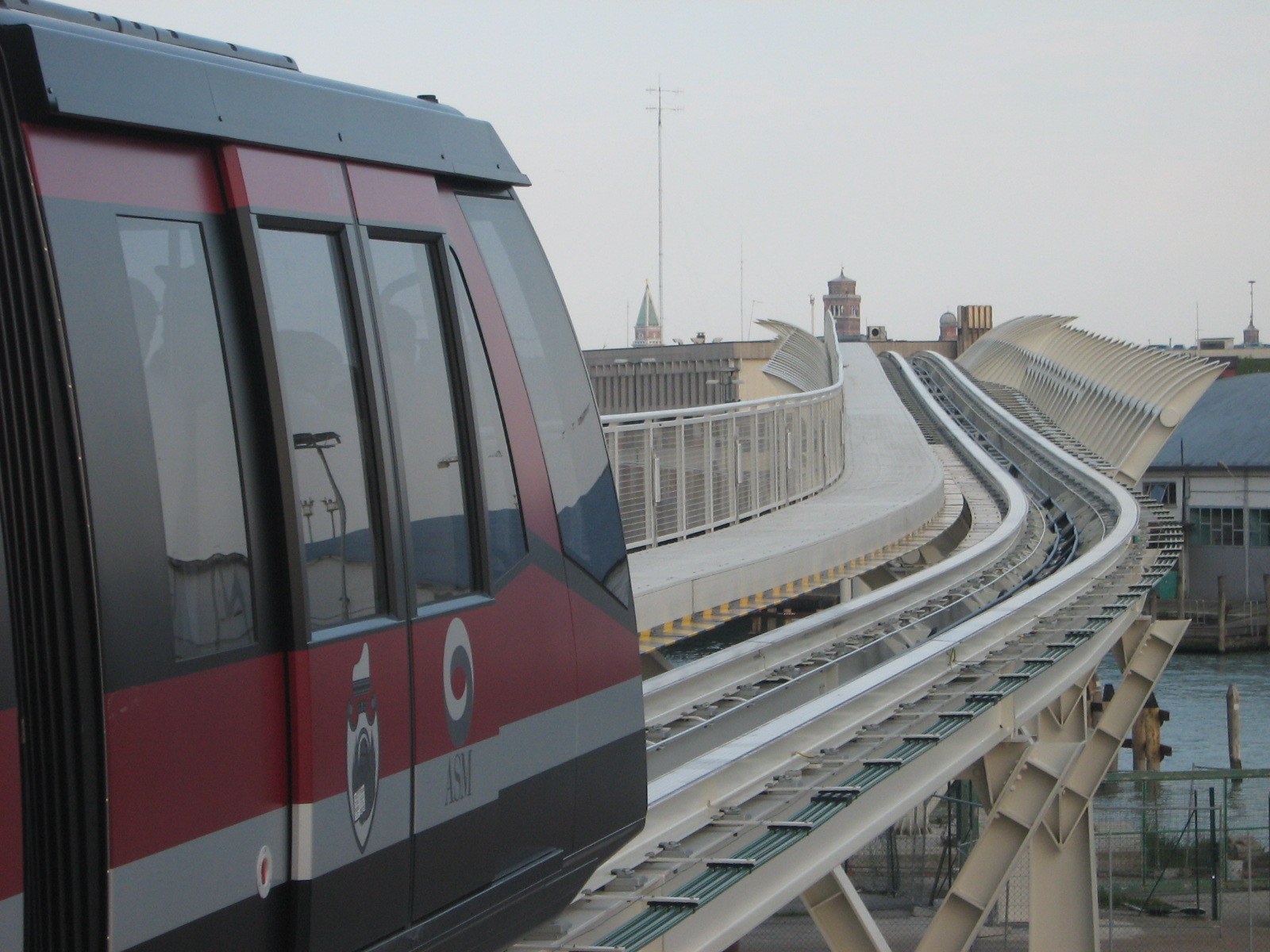
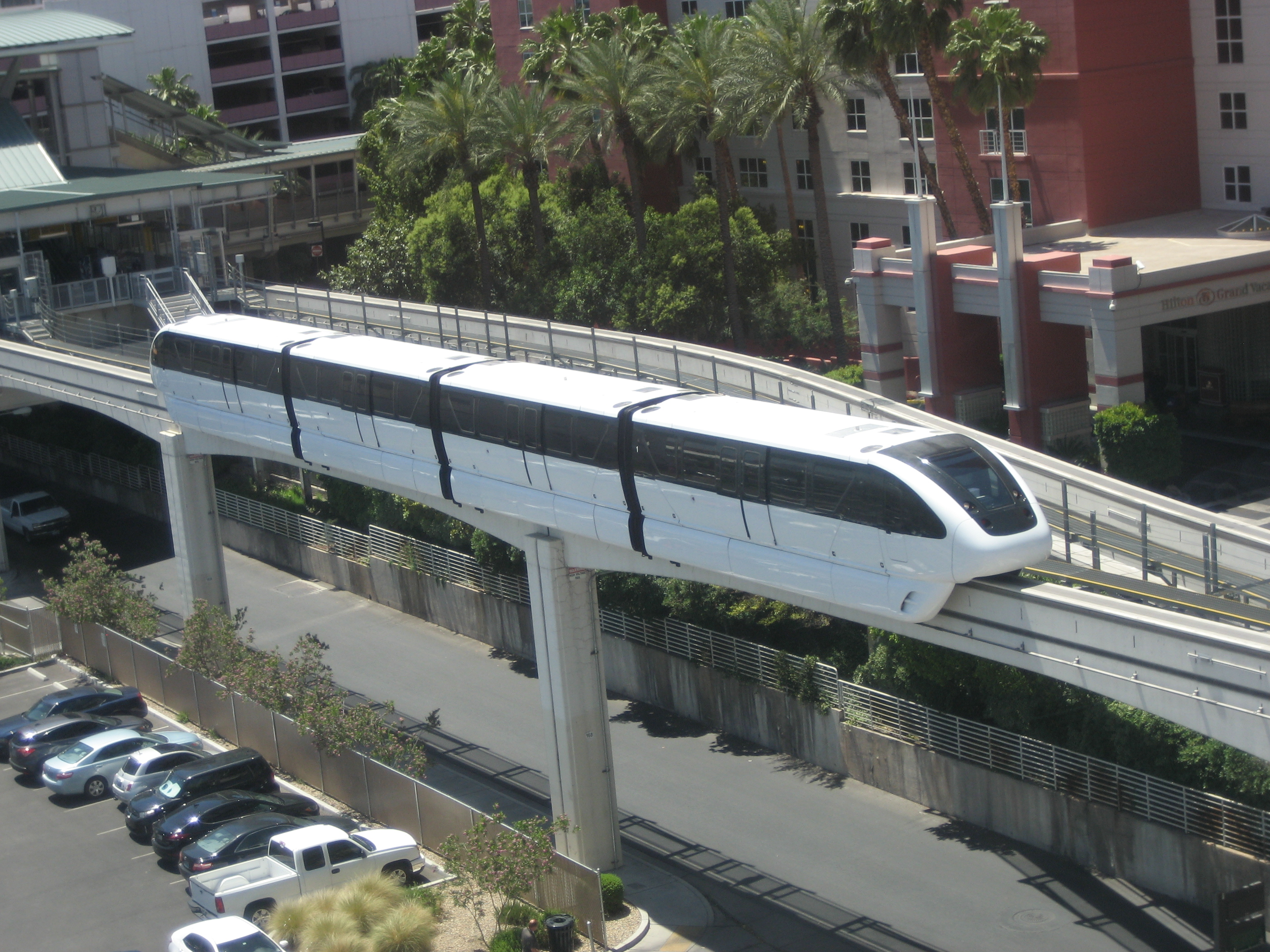
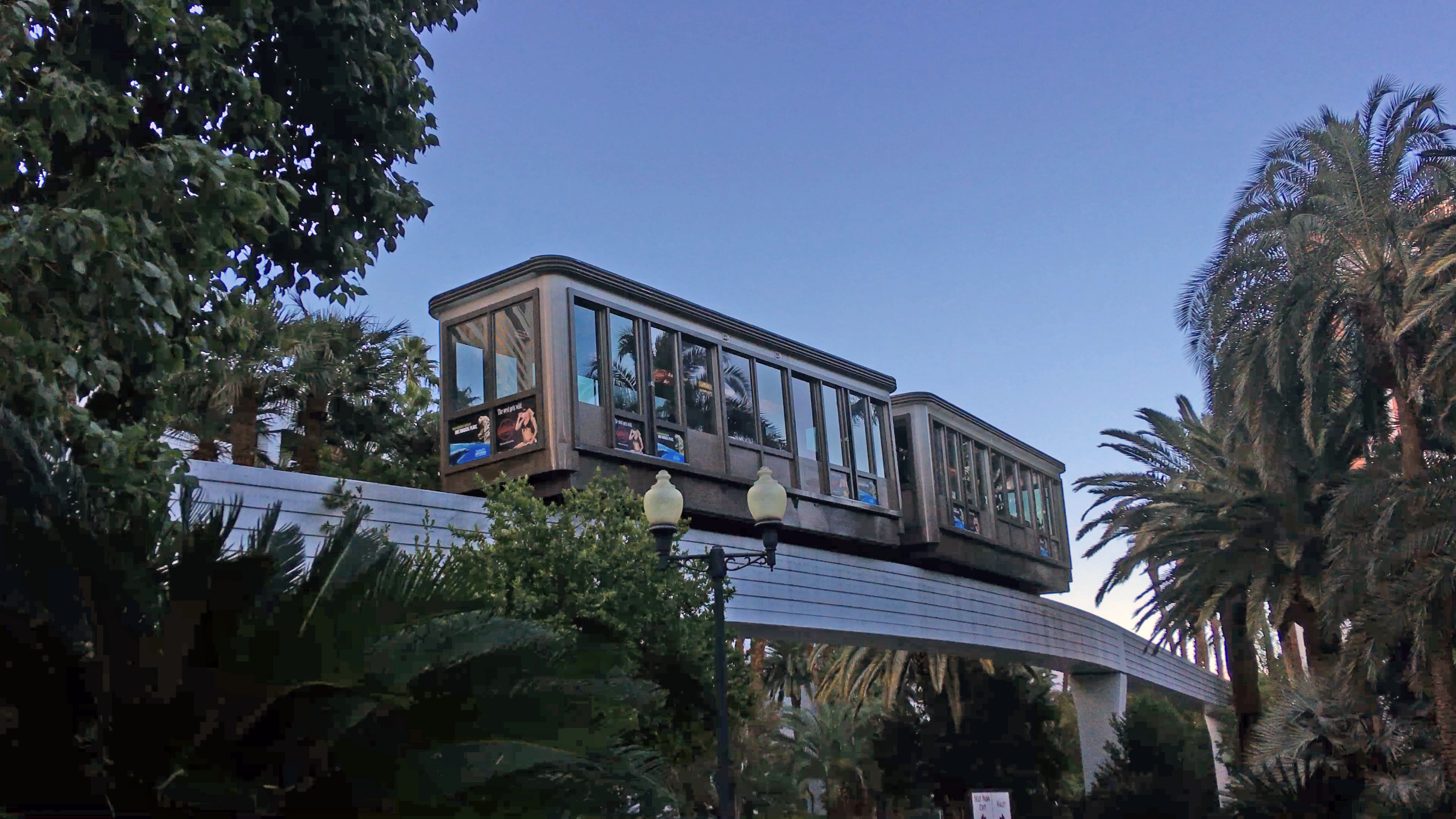
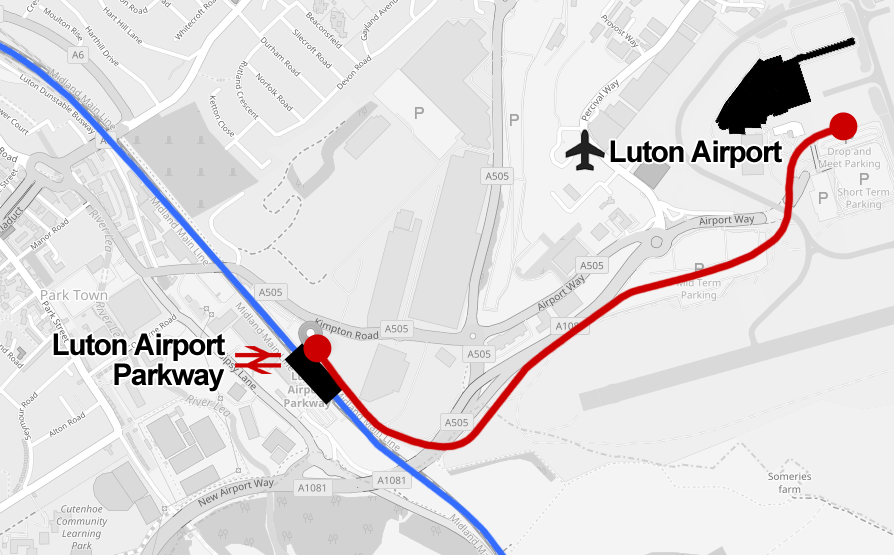
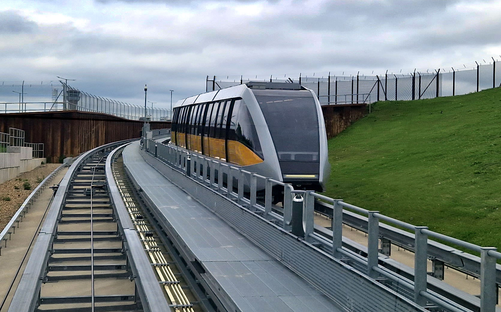
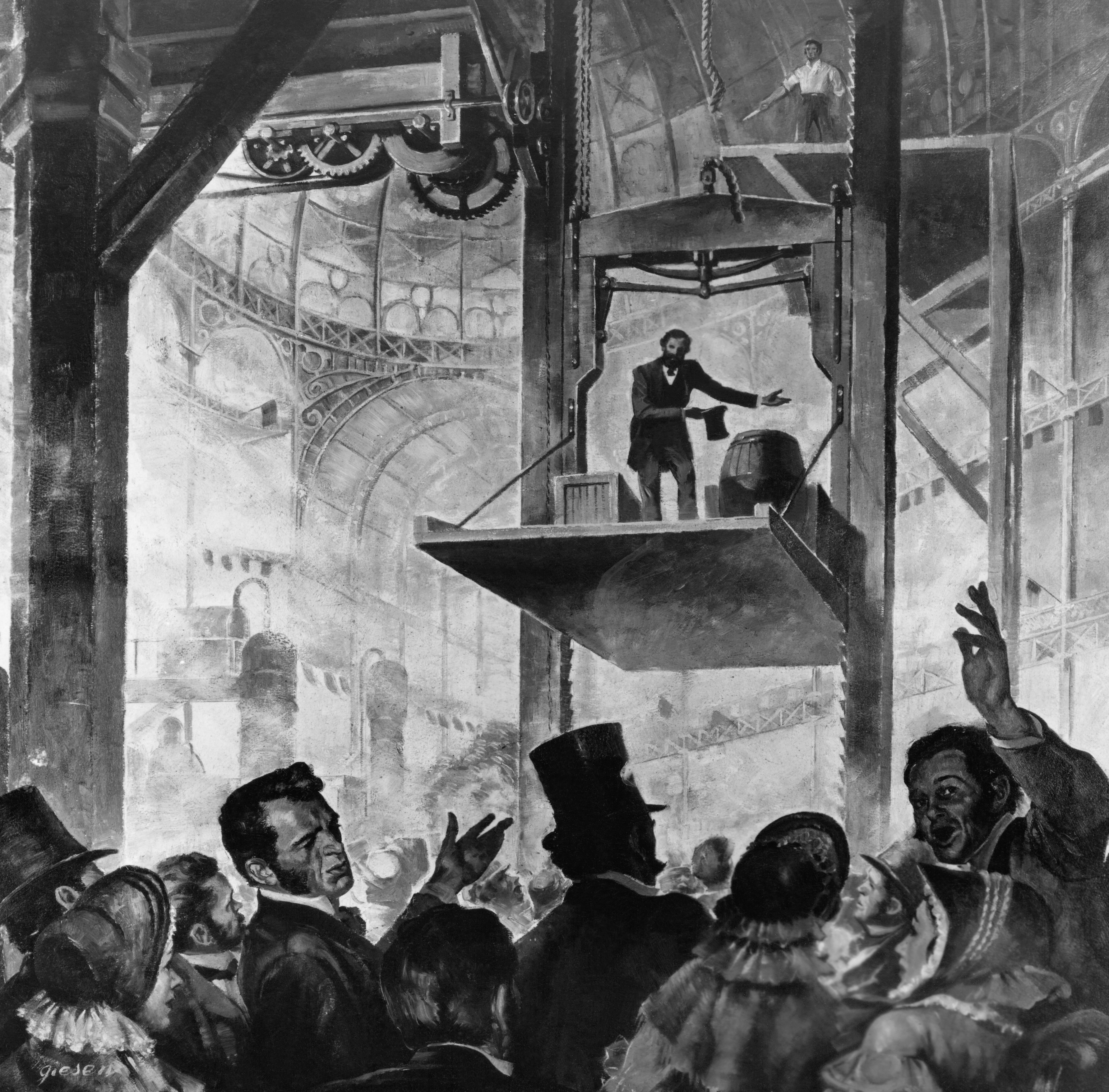
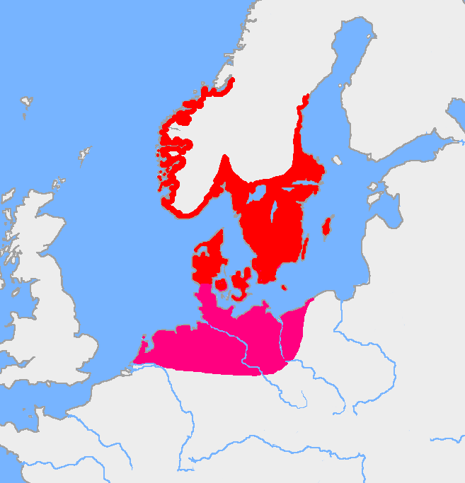
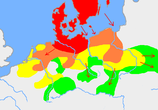
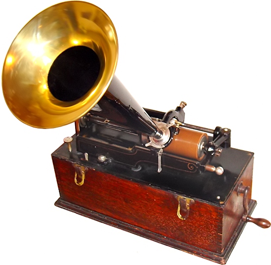
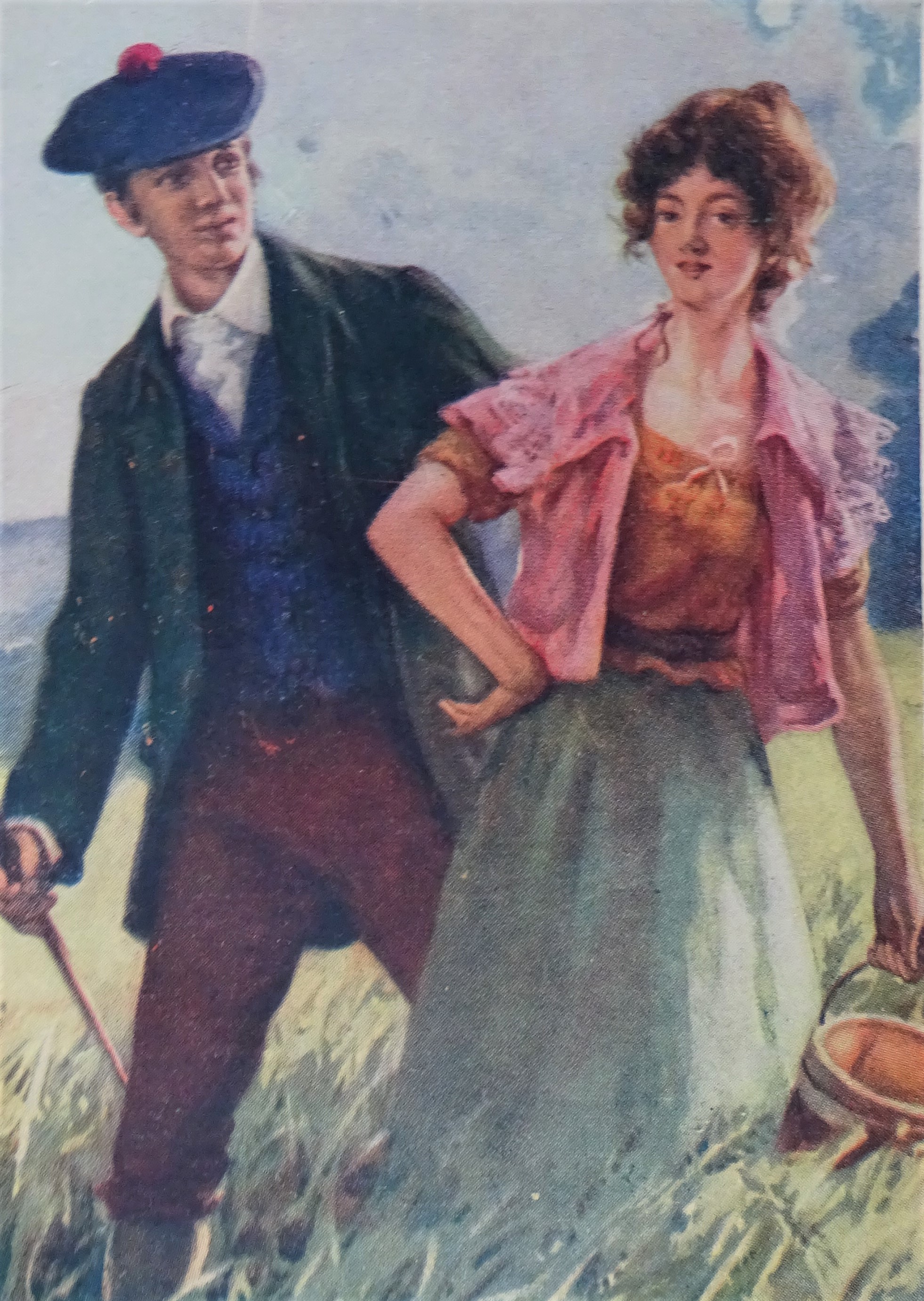