|
Reflections 2019
Series 7
June 6
Ohio River VI: Pittsburgh – The Pennsylvanian
| | 1978 I knew this was my third time in Pittsburgh. The second time was in 2006, and I remember all the details, but I only vaguely remember the first time, which remained in a fog. Thank goodness for travel diaries, where I find we were here back in August 1978 (just six weeks short of four decades ago!) as part of a stop-and-go trip to see Beverly's family in Minnesota, and by air of all things. We flew from White Plains Airport (we lived in Westchester then), stopping in Syracuse, Rochester, and Buffalo before arriving in Pittsburgh. It must have been just a half-day in town, since we stayed at the Airport Sheraton, before flying to nearby Johnstown to meet friends (see below), then on to Saint Louis to visit relatives in Illinois, and finally to Minneapolis. What a haul. And by air! That's probably the only time we air-hopped across a good part of the US. | | | | I certainly remember, beyond what the diary says, visiting the Golden Triangle, the name for the CBD, including Point Park and its two fort monuments. I remember we went some 5 km (3 mi) east of downtown to Oakland (but not that we took a bus!), Pittsburgh's academic center and one of its cultural centers, to see the Cathedral of Learning (Photo by Bill Price III) and its famous Nationality Rooms at the University of Pittsburgh. Adjacent was Carnegie Mellon University. | | | | But I have no memory of the things we did afterward, other than what the diary tells me. We apparently then went to the US Steel Tower on Grant Street (Photo by Derek Jensen), to this day the tallest building in Pittsburgh at 64 stories and notable for its triangular shape with indented corners. We had cocktails in the appropriately named Top of the Triangle restaurant on the 62nd floor, with a magnificent western view downriver (Photo by Andrew Russell). Consider this picture a preview, and note these things in this view of the centrally located Golden Triangle, all of which will be discussed below: (1) the blackish, pinnacled building on the left, which is One PPG Place; (2) immediately to its right is the Duquesne Incline up Mount Washington on the South Side beyond the Monongahela River (the Allegheny River comes in from the right); (3) note the height and length of the ridge along Mount Washington; (4) note the fountain straight ahead at the very tip of Point Park, which designates the beginning of the Ohio River where the two other rivers merge. I now read that unfortunately the Top of the Triangle lost its lease in 2001 after 30 years, and this view is no longer accessible to the public—so revel in it. | | | | The other thing in the diary I do not recall is that we then walked across the river to the Duquesne Incline and had dinner at the top, a few steps down Grandview Avenue at the Le Mont Restaurant. I read now that the Le Mont is five-star, and of course has a magnificent view, but I remember naught. Its online menu is pricey, but its prix fixe menu looks quite good, and a good value. | | | | 2006 But my much clearer and more fulfilling memory was when I returned to Pittsburgh in 2006 as part of a lengthier trip around the Northeast. This segment was a dedicated round-trip on the Pennsylvanian (2006/12) out of Philadelphia. I remember that time very well, and did very much enjoy the current re-visit, but it was only needed since my train didn't leave until the next morning. On this visit we'll do a quick revisit to a few nearby favorite locations, and make lemonade out of the lemons of the unplanned arrival. We'll also take selected items appearing in that last posting and extend and illustrate them here. | | | | | | As for illustrating, I have to explain what I expect most readers have already discovered. When I started this website, I not only didn't know how to include pictures and maps, I had no idea where to find any online. I've since learned the technique, and how to find maps and illustrations online—really good ones!--in many places, but heavily from Wikimedia and Wikipedia, as well as from bing.com, as recently explained. I also now have my Flickr account for personal pictures. As I look back to something as recent as 2006/12, I'm not only surprised at how little it's illustrated, but also how I condensed so much into such little space, writing about an extended trip around the Northeast in one posting, including a short section on Pittsburgh. As I look at that posting, I do find some pictures, but they were not originally there. I believe I came across them and added them later. But I can't go back now and illustrate all the years of postings without pictures or maps. |
| | | | That said, along with some new information, we'll pick out a few interesting tidbits from 2006/12 and elsewhere and add to them and illustrate them. | | | | The Name Pittsburgh was founded in 1758 and first named Fort Duquesne (rhymes with "cane"), after the fort at the Point. It was later renamed for British statesman William Pitt [the Elder], who was Prime Minister twice in the 18C under George III. I had to check—it was not named after his son, William Pitt [the Younger], who was also Prime Minister twice. It apparently was an active family. I find it of interest that with such a political British name, Pittsburgh wasn't renamed once again after the American Revolution. But then, neither were such places as Kingston NY.
| | | | Keep in mind how Edinburgh in Scotland is pronounced, either E.din.bu.ra, or, shorter still, E.din.bra. That would have been equally true at the time about Pittsburgh, whose original pronunciation would have either been PITS.bu.ra or PITS.bra. In time, though, the pronunciation shifted to be the same as in Newburg, Hamburg, or Harrisburg, the state capital. | | | | We then come to a spelling issue, and it shows how persnickety some people can be when, despite an effort for normalization, they just want to obstinately retain their quirky spelling. We first reported on this in 2011/24, when I stopped in Alberg/Albergh, Vermont, and the issue also applies to Pittsburgh: | | | | | | Albergh has had a spelling problem. It’s one of the places affected in 1891 when the US Board on Geographic Names decided on some rules to standardize the spelling of place names. We discussed this about Martha’s Vineyard (2011/18), when the island refused to accept the regulation dropping the apostrophe in place names and is therefore one of the very few US place names today that maintains one. Another simplification was to standardize place names ending in -burg/-burgh so that they were all alike, without the useless H, and Albergh became Alberg. The largest city affected by this was Pittsburgh, Pennsylvania, which was officially Pittsburg for just two decades, until it rebelled in 1911 and replaced the H. Apparently, Albergh thought about it quite a bit longer, because it wasn’t until 2006 that the town voted to put back the H, and it was approved by the authorities. Official signs around town do say Albergh, but many shop signs continue to say something like “Alberg Pharmacy”. It apparently doesn’t shame Alberg(h) that right across the Richelieu River Bridge is Rouses Point NY, which apparently remains quite happy without its apostrophe. |
| | | | We'll also expand here on what we said in 2006/12 about Pittsburgh and Allegheny City, and add some maps: | | | | | | [Pittsburgh's] development is another instance of the tail wagging the dog. I had mentioned that it was Saint Anthony on the Mississippi that was the established town opposite upstart Minneapolis across the river, and the upstart overwhelmed the established town and Saint Anthony is now a neighborhood of Minneapolis.
In this area, the town of Allegheny on the north side of the rivers was slated to become county seat, but Pittsburgh usurped that honor for itself, and in 1907, Pittsburgh annexed Allegheny to become one of its neighborhoods. It should be pointed out though, that Allegheny didn’t take it lightly, fighting all the way to the Supreme Court.
|
| | | | Now let's add a map to show what we're talking about. This is an 1898 map showing the City of Allegheny in yellow north of the Allegheny and Ohio Rivers, and Pittsburgh in red. Pittsburgh's 'tween-river area known as the Golden Triangle, had already expanded to the South Side (or South Shore) with the aid of the 17 inclines built there, of which only the Duquesne (1877) and Monongahela (1870) remain today. Once Pittsburgh annexed Allegheny, its shore area became known as Pittsburgh's North Side (or North Shore) area. | | | | It's an oddity of naming that there are three river names. We learned in Maryland that, as you go up the Potomac, once it splits, the two branches are simply called the South Branch of the Potomac and the North Branch of the Potomac, this one being the basis for MD's western border (reviewed below). But that logic doesn't apply here. While the Ohio River has tributaries, most are insignificant, such as Limestone Creek in Maysville. But the Allegheny and Monongahela are large, and actually form the Ohio. Yet it's a quirk that the Allegheny is NOT called the North Branch of the Ohio, and the Monongahela is NOT called the South Branch of the Ohio. The fiction has always been maintained that they are three separate rivers. The former stadium on the North Side was even called Three Rivers Stadium. | | | | Also realize that, if Pennsylvania hadn't won that land claim we discussed in the last posting that resulted in WV's Northern Panhandle, the former City of Allegheny (North Side) would be in PA, but both the Golden Triangle and South Side would have been in VA, more exactly, the part that later became WV. | | | | City of Allegheny The City of Allegheny had had a growing German population and was commonly referred at one point as "Deutschtown" because German was heard there. Born in Allegheny were painter Mary Cassatt (1844), writer Gertrude Stein (1874), and choreographer Martha Graham (1894). If Pittsburgh claims them as natives, it's only because Pittsburgh annexed Allegheny. An even more notable situation like that involves Andrew Carnegie. He was born in Scotland in 1835, and immigrated at age 13 with his parents in 1848 to Allegheny, NOT to Pittsburgh. Even though he's so thoroughly associated with Pittsburgh, it's only due to annexation that Pittsburgh can make its claim. While Carnegie Mellon University lies east of the Golden Triangle, not in the former City of Allegheny, the Carnegie Science Center (see below) is on the North Side, adjacent to the former City of Allegheny.
| | | | Helpful in our discussion will be this map of Pittsburgh neighborhoods (Map by Tom Murphy VII). Click to first find the Golden Triangle, here referred to as the CBD. The South Side is indicated—this is where the two remaining inclines are located. Note that all the neighborhoods shown in the North Side used to be part of Allegheny City, with three retaining that word; as we mentioned, the shore area is now called the North Side (of Pittsburgh). Abutting the CBD is the Strip District, which we'll mention again in passing in a moment. To the east are the four neighborhoods that constitute Oakland. I think the geographic layout of Pittsburgh among its rivers and hills is beautifully impressive, one of the best natural settings for a city. | | | | In passing, we can talk about size here. Even with annexations, Pittsburgh has a population of about 302,400. In comparison with Philadelphia, at the other end of the state, which has a population of 1,584,000, Pittsburgh is less than one-fifth the size. | | | | The Point & Point Park We won't be revisiting Point Park at the Point of the Golden Triangle this trip--we'll just be seeing it from a distance. This, of course, is what I'd expected to do coming upriver on the original route plan to dock in Pittsburgh, except that that was scheduled at a poorly-planned, ridiculous 2 AM--and we didn't arrive by ship anyway! | | | | Early European arrivals saw the military advantage of the magnificent location of the Point, and built forts there (Map by Tomcool). | | | | | | I have two comments about this map. I challenge the terminology used. This is a single splitting (or joining), and so it's a fork, not forks. Yet the plural form seems to be the one that's more frequently used here. And if in any case you're talking about the place where the Ohio forks, aren't you implying that the Allegheny is really the North Fork of the Ohio, and the Monongahela the South Fork of the Ohio? |
| | | | The French established Fort Duquesne in 1754. This was during the period of the French and Indian War (1754-1763), the name for the North American theater of the Seven Years' War (Map by Hoodinski), with the British fighting the French. As the map shows (click), in 1758 Fort Duquesne was taken over by the British, though the French destroyed the building the day before the British arrived. The British replaced it, building Fort Pitt between 1759 and 1761 near, but not on, the site of the previous fort. In 1797, the now American fort was decommissioned and demolished. In the 20C, archaeologists excavated the site, and one bastion was rebuilt to house a museum. The site of both forts is now occupied by Point State Park, where the outlines of the two forts have been laid in brick. | | | | While those structures are today reduced to outlines, a genuine historic gem remains to this day, the Fort Pitt Blockhouse, dating to 1764 (Photo by Kevin Myers). It was a redoubt of Fort Pitt, but when the Fort was demolished in 1792, the Blockhouse was left untouched because it was already in use as a residence, having been converted into a private house in 1785. | | | | | | It's notable in historic preservation how structures are preserved through recycling. The Blockhouse became a residence which saved it. The slave pen in the Cincinnati Museum became a tobacco barn, which saved it. |
| | | | In 1894, philanthropist Mary Schenley presented the deed to the Blockhouse to the Daughters of the American Revolution (DAR) so that the structure might be preserved. It has never been torn down, completely rebuilt, or moved during its 2 ½ centuries plus of existence. Much of its timbers, brick, and stone remain original to its 1764 construction. The Blockhouse is therefore the oldest still-existing structure in Pittsburgh and the oldest still-existing structure in all of Western Pennsylvania west of the Allegheny Mountains, which divide the state down the middle. | | | | This is the outline of Fort Duquesne on the inland side of Point Park facing downtown Pittsburgh (Photo by Kevin Myers). Click to spot the Blockhouse on the right, and the museum replacing the Fort Pitt bastion through the trees. | | | | It's easy to picture that Point Park was always there, but quite to the contrary. As Pittsburgh grew, the Point became a hub for industry and transportation. By the 1930s, the point was filled with warehouses and underused railyards. As this c1951 picture taken from the South Side shows, bridges had been built from the point across each river blending into the Ohio (Photo by JV Mullen). If that hadn't been a bad enough idea, there was no room at the Point for the interchange needed for the volume of traffic. | | | | This 1900 map shows how densely developed the site had become. Click in the lower right to find the surprising hole in the donut. You'll find the Blockhouse totally surrounded by other structures but listed as being owned by the DAR and "presented by Mary Schenley". This is how historic preservation found a way to success at this location. | | | | It was finally realized the extent that the city had wasted the unique scenic potential of its rivers and hilly landscape. In the 1950s eminent domain was used to acquire properties at the Point to make the Park. Fortunately, there were few residents to be relocated. Both bridges were demolished in 1970 and new bridges were built across each river further inland, at the far side of the Park, which opened in August 1974, when construction was completed on its iconic fountain, mentioned above, right at the very point where the Ohio River begins (Photo by Brent Moore). The fountain sprays water up to 46 m (150 ft) into the air. | | | | This is the scene today, as seen more or less from the top of the Duquesne Incline (Photo by Allie Caulfield). The fountain is not turned on here. You can see that the old bridges have been replaced by new ones over each river. While their connection, an interstate highway, does still run through the Park, it's about ¾ of the way back from the fountain area and relatively out of the way. Click to see, right behind the trees in the foreground, the outline of Fort Duquesne. The roofs near the bridge on the right are the museum at Fort Pitt. The museum covers the site of just one bastion, the other four would have been located beyond where the present highway is. The Fort Pitt Blockhouse is just to the left of the museum, but in this view is hidden behind the trees. And now we can recognize two skyscrapers, the black US Steel Tower, whose height is obvious, and the pinnacles of One PPG Place. | | | | Street Grids Many people look at a map not comprehending the history it shows. In 2018/2 we discussed the original street grids of Lower Manhattan, how several parallel-and-perpendicular grids developed next to each other, some parallel to the Hudson, others to the East River.
We can see exactly the same phenomenon here in Pittsburgh. It's still there today, but this 1795 map shows its early development. We see the site of small Fort Duquesne at the tip of the Point, followed by the much larger Fort Pitt. But then we see an early form of a narrow grid along the Allegheny River centering on two main streets. One is Liberty Street, which today is Liberty Avenue, then comes Penn Street, today Penn Avenue. Except for an added shore drive, and some other minor changes in cross streets, this "Allegheny grid"—my term--is the same today. This grid has traditionally been more on the industrial and manufacturing side, leaning toward blue collar businesses. This strip-shaped grid was eventually extended up the river, and widened a bit, to became the Strip District, a neighborhood we saw on the neighborhood map, which we'll mention again later.
| | | | Now look at the "Monongahela grid" that developed parallel-and-perpendicular to that river. It ended up being a triangular grid ending at about Grant Street, where it still ends. (A second interstate highway runs just east of Grant, defining the CBD in more modern terms.) Note for later reference the unnamed square between 4th and 5th, which is Market Square. Those ponds are no longer there, but into the 20C this grid was more white collar, and includes Pittsburgh's financial district—Fourth Street, now Fourth Avenue, was historically Pittsburgh's "Wall Street". Both grids are extremely walkable, and I walked parts of both during the current trip.
http://www.orangesmile.com/common/img_city_maps/pittsburgh-map-1.jpg
http://ontheworldmap.com/usa/city/pittsburgh/large-detailed-map-of-pittsburgh.jpg
| | | | We can now move into contemporary maps of Pittsburgh. The first one is much better for downtown, and will be our "downtown map". The second map (click), is more widespread, and will be our "outer areas map". | | | | Inclines I'd love to avoid splitting hairs between a funicular and an incline/inclined elevator, but I can't. With a traditional funicular, the cars, connected by cables around a wheel at the top, work in pairs, with one counterbalancing the other—one up, one down. They usually share a single track, with a passing track at the halfway point. With an incline/inclined elevator, each car works independently, on its own dedicated track, with counterweights running under each track. It would seem to me that the trend is more often than not moving toward building inclined elevators, though funiculars are still being built (see the Stoosbahn below). But we have examples of inclined elevators replacing funiculars, and the definition becomes fuzzy when the replacement is still called a funicular for the sake of tradition. We have two recently discussed examples. In Québec City, what is still called the Funiculaire de Québec, has been a pair of inclined elevators for some years. And in Paris, it's just the same with the famous Funiculaire de Montmartre, which kept that name even after it, too, became a pair of inclines. Further confusing the issue is that the two remaining inclines in Pittsburgh are both funiculars, yet have always been called inclines. So since the public throws the terminology around haphazardly, we can stick to that terminology as commonly used, but still know if it's accurate or not.
| | | | Pittsburgh Inclines The latest information I've been led to understand is that it was the impetus of German-Americans that started the building of inclines in Pittsburgh. The city developed and needed labor, which attracted German immigrants. But lack of space down below near the rivers prompted building houses up on Mount Washington. The Germans remembered using funiculars in Germany and proposed the building of inclines to connect where they lived atop the South Side with the city below.
| | | | In total, there were a total of 23 inclines (!!) built on the hillsides of Pittsburgh. The earliest ones were built by the various mining companies, particularly for transporting coal, also wagons and freight, but passenger ones were developed as well. It shouldn't surprise that today's Monongahela Incline is the oldest of all of them all, since the Monongahela Inclined Plane Company built and owned ten inclines! The hilltop neighborhood of Allentown had eight nearby inclines in service at one time: the Pittsburgh and Castle Shannon Plane, Mount Oliver, Monongahela, Monongahela Freight, Castle Shannon, Castle Shannon South, Knoxville, and Keeling Coal Inclines. You can find Allentown on the earlier neighborhood map, but roughly—see the outer areas map--it lies between the Monongahela Incline and the 10th Street bridge. An interesting remnant shown on that map is just south of the bridge, the greenway remaining at the location of the former Knoxville Incline (1890-1960). | | | | Pittsburgh had some of the longest and steepest inclines in the world. The following graph is a comparison of 14 passenger inclines in Pittsburgh—you'll recognize that the two that still exist, the Duquesne and Monongahela, are historically among the steepest (Graph by Phlegmatic). The horizontal length of a couple of them, including the Knoxville just discussed, is noteworthy. | | | | Since we're so used to seeing inclines for passengers only, it's worth illustrating one of the better-known former freight inclines, the Monongahela Freight Incline mentioned above. This is a rare, 1905 photo of what might be called twin inclines. On the right is the Monongahela, still functioning today. We can mention now that it (and the Duquesne, too) has a track with an unusual broad gauge of 5 ft (1,524 mm) as opposed to the standard 4 ft 8.5 in (1,435 mm). But on the left is the former Monongahela Freight, which operated from 1884 to 1935, used for vehicles, but passengers as well. A vehicle (click) can be spotted in the lower car. But the surprise of this incline is its unique 10 ft (3,048 mm) broad gauge track. Inspect the difference between the 10ft and the 5 ft gauge, best seen at the top.
| | | | The Inclines in 2006 There is no need to repeat on this trip one of the highlights of Pittsburgh, its remaining two inclines, the Duquesne and Monongahela Inclines on Mount Washington. But we will review, extend, and illustrate them, especially since the last photo of Point Park was taken from the top of one of them. On the 2006 trip, I made it a goal to see them both, by going up one and down the other, with a scenic walk along the bluffs in between. (When I did that, while the Duquesne did seem familiar, I did not remember having ridden it 28 years earlier.) Keep in mind the yellow bridge we saw to the right of Point Park as we review this text from 2006/12: | | | | | | From the park, I walked along the pedestrian walkway on the Fort Pitt Bridge to the south side. . . . I then took the Duquesne Incline up, walked a distance along the long ridge of Mount Washington that was equal the full length of the Golden Triangle back across the river, and then took the Monongahela Incline down. I am now convinced that Pittsburgh’s geographic location is [hard to equal] . . . From near where the top of the Duquesne Incline is today, George Washington once surveyed the lay of the land. . . . This ridge is like a balcony in a theater. . . . [A]s one walks along the aptly named Grandview Avenue, one is at a height halfway up the skyscrapers across the river, and still has their tops above one’s head. The view keeps on changing. The Duquesne Incline is to the west, even just a bit further west than the Point, and one has what can be called more of a splendid geographic view: before the Y-shaped intersection of the rivers and the Point and Golden Triangle to the right. As you walk along to the east, there are periodic lookouts to look at the changing view, and on reaching the Monongahela Incline, the view has changed instead to a splendid architectural view. The view is now of buildings, and the Point lies way off to the left. (Yes, it was a long walk, but with plenty of park benches.) |
| | | | We can now add maps and pictures to the above. This is the cross-river view of the Duquesne Incline (Photo by Allie Caulfield). Click to inspect both stations, plus the shape of the cars. Click on the outer areas map near the Point, and you'll see how walkable the lower station of the Duquesne Incline is from the Park (Photo by Dllu). Click to the right of the roof on this picture and you'll see two stories of glass windows. Google Maps tells me that's the Le Mont Restaurant—great view—but I still don't remember going there. You'll also see a car waiting to descend from the upper station. | | | | This is a car in the lower station waiting to ascend (Photo by Dllu). Note how much it looks like a traditional streetcar. The platform on its other side is a perfectly normal, horizontal platform. It's the undercarriage of the car that will conquer the steep slope ahead. | | | | The Duquesne Incline was completed in 1877 and is 244 m (800 ft) long and 122 m (400 ft) high. It travels along a slope of 30°, or 57.73%. (Compare this percentage with the maximum grade allowed on US highways, which is usually 6°, or 10.51%.) It was originally steam-powered and built to carry cargo. It later carried passengers, particularly Mount Washington residents who were tired of huffing and puffing up footpaths to the top. However in 1962, when major repairs were needed, the incline was closed, apparently for good. The private owners did little, given the few riders using it. But local residents on Duquesne Heights launched a hugely successful fund-raiser, and the incline reopened in July 1963, run by a non-profit organization. It's been totally refurbished, including stripping the cars of paint to reveal the original wood. An observation deck was added at the top to enhance the view. Today the Duquesne is one of the city's most popular attractions. | | | | Let's ride up. My term for this style of car is a "wedge" car--notice how in this upward view the black "wedge" undercarriage keeps the red car in a level position. This interior view, with the skyline appearing, shows just how level it remains (Both Photos by Dllu). From the top, we get a similar view of Pittsburgh as we saw before (Photo by Plastikspork), but this time including the Duquesne car with its distinctive undercarriage, showing the Point Park fountain in action, and showing better the distance from the nearby Fort Pitt Bridge we just walked across. | | | | On our outer areas map, we now follow Grandview Avenue (it really is!) atop the bluffs to the Monongahela Incline, built in 1870, and the oldest continuously operating funicular in the United States. Not only is it seven years older than the Duquesne, but it hasn't stopped running, as the Duquesne did in 1962-1963. At 194 m (635 ft), it's shorter than the Duquesne's 244 m (800 ft) and, at 112.59 m (369.39 ft), it's a bit lower than the Duquesne's 122 m (400 ft). But it wins in steepness. While the Duquesne has a slope of 30°, or 57.73%, the Monongahela remains the steepest in the US at 35.38°, or 71.54%. Again, both are broad gauge, and both run at 6 mph (9.7 km/h). It, too, originally ran on steam power, but was replaced with electricity in 1935. | | | | As mentioned earlier, the walk down Grandview Avenue gradually alters the cross-river view. Here we are at the Mount Washington Overlook at Grandview Avenue & Bertha Street (click)—see map (Photo by Andrew "Dobie" Koch). At the Monongahela Incline, the view centers much more on the skyline instead of Point Park (Photo by Suckindiesel at the English language Wikipedia). The river doesn't bend quite this severely—it's the wide-angle camera lens in both views that does this.
| | | | We'll now ride down the Monongahela Incline (Photo by Suckindiesel at the English language Wikipedia). Which car are we in, on the left or right? Read the cables! The car the picture was taken from has its cables in front of it, meaning it's ascending, so we must be in the car on the left, whose cables are lowering it from behind.
| | | | Incline/funicular cars take two shapes. On the Duquesne, we saw the "wedge" shape, which allows the cabin to be on one level. But the Monongahela has what I call the very common "staircase" shape, which you'll see in this view (Photo by pennsyloco). The car still has an undercarriage in black (click), but it's much less of a wedge. For that reason, the cabin is multi-level, with an entrance at each level, and probably a single bench inside. This requires the platforms to also be stepped to allow for entering and exiting. It also keeps passengers separated from each other. | | | | We then arrive at the lower station (Photo by Suckindiesel at the English language Wikipedia). Look again at the map , and note how the incline exits adjacent to the Station Square station (Photo by Luke H. Gordon) of Pittsburgh Light Rail (more later). Station Square itself is a recycled, landmarked former rail station (of the Pittsburgh & Lake Erie RR), now an entertainment and shopping complex. It's a short hop back across the river. | | | | Stoosbahn While doing research to update my notes, I came across something new, and rather startling. It's a Swiss funicular, and a genuine one—one car up, one car down. But nothing else about it is traditional. It's just east of Lake Lucerne (der Vierwaldstättersee) and connects up to the small village of Stoos--SHTOHS, rhymes with "dose" (Photo by Nix-dorf). It's a car-free village and skiing area up on a plateau at 1305 m (4282 ft). Though it has only 150 inhabitants, it has 2200 hotel rooms.
| | | | It used to have a regular funicular going up to it, the Stoosbahn, but as of December 2017, that's been replaced by the Neue (New) Stoosbahn, and from its pictures, it's like nothing I've ever seen before (Photo by Jag9889)—leave it to the Swiss. Each car has four barrel-shaped compartments, each with their own entry doors, plus a luggage area up front. At both the lower and upper stations, the four compartments are horizontal, meaning, like the Duquesne, they can be accessed from a flat platform. But once underway, they prove to actually be of the "staircase" type of funicular, meaning each of its four compartments begins to revolve so that passengers stay upright, as the four compartments become stepped go on to form a "staircase" (Photo by Nix-dorf). It's also rather unusual that the Stoosbahn passes through three tunnels en route.
| | | | The Stoosbahn is 1740 m (5709 ft) long and climbs to 744 m (2441 ft). It takes 4-7 minutes, and the upper station is right in Stoos village. The highest grade the Stoosbahn reaches is an amazing 47.7°, or 110%, making it the steepest funicular in the world. (Compare the Duquesne at 30°, or 57.73%, and the Monongahela, the steepest in the US, at 35.38°, or 71.54%.) | | | | Whenever this statistic comes up, either on the Stoosbahn website or elsewhere online, one clarification is always mentioned. In Australia, the Katoomba Scenic Railway (Photo by DGriebeling), in Katoomba in the Blue Mountains west of Sydney, has an incline of 52° or 128%, and makes multiple claims, that it's (1) the steepest funicular, (2) the steepest passenger railway, and (3) the steepest incline in the world. But Katoomba uses a winch system, and no counterbalances, meaning it isn't a funicular at all, but an inclined elevator of a sort (without counterweights). It can maintain its two other claims, but the steepest funicular in the world is the Stoosbahn. | | | | | | When in Australia I 2010 I took a wonderful side trip that included the Blue Mountains (2010/19), and in Katoomba, rode both the Scenic Railway, and Scenic Skyway, a partially glass-bottomed gondola car (Photo by Bjørn Christian Tørrissen). Both were great fun. |
| | | | This is a YouTube quality animation of the Stoosbahn (2:22). Notice that it's horizontal when entering, how freight is loaded, the steep angle it runs on, the three tunnels, the two cars crossing, and that it's horizontal at the end. Now watch it in real life (3:22). | | | | Pennsylvania Canal In 2006/10 I wrote what I think is quite a good summary of three related items within the State of Pennsylvania. In no way am I going to repeat it all. I suggest you refer back to that posting, and I think you'll find it of interest. Because the things were related, I called that part of the posting the Pennsylvania Trilogy, and because we're in Pennsylvania now, and will shortly cross it by rail on the Pennsylvanian, I'll give a minimal summary. I can also add some maps and illustrations, which the earlier posting was lacking. | | | | ALLEGHENY PORTAGE RAILROAD This first part of the trilogy was about the Allegheny Portage RR, a part of the PENNSYLVANIA CANAL. The entire canal system between Philadelphia and Pittsburgh opened in 1834—its winding route was 640 km (400 mi) long. It reduced the month-long trek by dirt road across the state to about 3 ½ to 4 days instead of the former 23-day horse-and-wagon journey. It was state-of-the-art for its time. This map shows the Pennsylvania Canal along with others in the state (Map by Finetooth, Ruhrfisch). You can see that four connecting railroads made the system more useful, though they portended the canal-killing future that railroads would bring. The route of the Pennsylvania Canal included both the Columbia-Philadelphia RR and the Allegheny Portage RR, the main subject of this entry. Therefore, the term "Pennsylvania Canal" should be understood as being a combination of canal and railroads, as the two illustrations in this period advertisement make clear:
http://www.brooklineconnection.com/history/Facts/images/canal2.JPG
| | | | The Allegheny Portage RR carried canal boats of the Pennsylvania Canal over the hump in the middle of the state that separates its eastern and western halves, the Allegheny Mountains, specifically the ridge known as Allegheny Mountain. It only lasted 20 years (1834-1854) before being rendered useless by the Pennsylvania Railroad. Canal boats were transferred to open railcars, which were then hauled over the mountain. Rather than being a railroad in the accepted sense, it was a series of inclined elevators operated by steam-powered winches pulling the boat-loaded railcars up one side of the ridge and down the other, as this 1839 drawing shows. In this, I see a relationship to the Katoomba Scenic Railway, as there were no counterweights here, either. The Allegheny Portage RR was considered a wonder of its day; Charles Dickens wrote about traveling on it in his "American Notes". As Beverly and I learned during our visit, early on, hemp ropes were used to pull the railcars, which sometimes snapped with spectacular and tragic results. It was Roebling's cables that replaced them and saved the day, and those cables went on to make suspension bridges possible, including his Brooklyn Bridge. Here's a map of the Allegheny Portage RR between Hollidaysburg and Johnstown. | | | | HORSESHOE CURVE The second part of the Pennsylvania Trilogy covers the period later on, when the Pennsylvania RR came through the ridge and built the famous Horseshoe Curve in order to adjust to coming down from the ridge in its own way. We'll review and discuss that below when we're on the Curve going home. | | | | JOHNSTOWN FLOOD The third part of the Pennsylvania Trilogy covers the infamous Johnstown flood of 1889. Its story is totally connected with the Pennsylvania Canal, since it was a damburst due to poor maintenance at a reservoir for canal water on the Little Conemaugh River (see Portage map) that caused the wall of water to come crashing down from the mountains a distance of 23 km (14 mi). For this reason, I maintain that calling it a flood just because water was involved is a misnomer. A flood rises from below, when a river overflows its banks. What happened in Johnstown was the equivalent of an avalanche of rocks, or snow, or mud, coming down from the mountains, except this was a wall of water released from the reservoir by the damburst. The movement of water—the "flood"--was horrifically over in just ten minutes, which you cannot say about a flood. Still, people call it the Johnstown Flood. There's a National Memorial that can be visited.
https://i.pinimg.com/600x315/6c/bc/c0/6cbcc0e37a6eb92f5ce4c7d3eb3581c6.jpg
| | | | This map shows the route of the wall of water—an avalanche--that came down the Little Conemaugh River from the reservoir in ten minutes to crush Johnstown. | | | | Update on the Pennsylvania Canal As I've pictured early-19C Pittsburgh in the past, I always felt Pittsburghers felt smug, knowing their city was the gateway down the Ohio and Lower Mississippi to New Orleans. It seemed that the transportation rush on the east coast was to reach Pittsburgh, as it sat at the head of the Ohio and waited to be courted. The first new thing I've now learned is that that was not at all the case in the 1820s. A 1999 article I found in the Pittsburgh Post-Gazette explained how Pittsburghers in the 1820s felt their status as the Gateway to the West was in jeopardy, since they felt that trade and travel were bypassing Pittsburgh. | | | | First they were concerned that the 1811 National Road (or Cumberland Road) from Baltimore to Wheeling bypassed Pittsburgh. (We'll see later that it passed through Washington PA to the south.) This was followed by the Erie Canal crossing New York State in 1821, nowhere near Pittsburgh. Then, as of 1825, Ohio built its two canals from Lake Erie to the Ohio River, the Ohio and Erie from Cleveland to Portland and the Miami and Erie, from Cincinnati to Toledo. Water traffic using the New York and Ohio canals together would leave Pittsburgh isolated and irrelevant as a center of commerce. Pittsburghers had wanted a canal for years, but Philadelphians, who would have to finance it, resisted. Finally they gave in, because they were losing business to the ports of New York and Baltimore. Both Pennsylvania cities needed the canal between them, and construction on it began in 1826. I had never before understood this sense of desperation. | | | | | | We shouldn't forget the other player in this game, the Chesapeake and Ohio Canal, which was under construction in adjacent Maryland in 1828-1830—but it never made it. It reached Cumberland in western Maryland and was never built further. In 2016/13, we discussed the difficulty of building the C&O Canal through the Allegheny Mountains. Once again, we'll show the map of the C&O Canal, with the completed portion, plus what would have been the Pennsylvania extension that was never built. You can see that the Canal did manage to cross some of the Alleghenies (remember the Paw Paw Tunnel in 2016/13), though not all, and then would have followed a tributary of the Monongahela, joining it just southeast of Pittsburgh. [Look carefully at the spelling "Youghiogheny"; I looked it up, and it's pronounced, incredibly, ja.ka.GÉ.ni, GÉ sounding like "gay". Who'd ever figure that out from that spelling?] |
| | | | The Pennsylvania Canal was successful and Pittsburgh thrived. The population grew to surpass Baltimore and Cleveland. Warehouses were built around the canal basin at 11th Street between Penn and Liberty, creating the Strip District. The canal fostered the iron industry, enabling Pittsburgh to grow into a big steel town. Yet by the mid-19C, canal-killer railroads had replaced the canal—they were faster and didn't freeze in the winter. The abandoned canal was filled in, locks were dismantled, and the land was put to other uses. | | | | The other thing that I learned was that the canal wasn't where I thought it was in Pittsburgh. In one sense, the canal went to Allegheny City, with Pittsburgh as an afterthought! But not really. Look at our downtown map, and on the upper right you'll see the Amtrak Station we'll be using, just to the right of the nexus where Liberty Avenue of the "Allegheny grid", Grant Street of the "Monongahela grid", and 11th Street (interesting in its own right—see below) come together. (It's also our hotel area.) On both my second and present trips, I saw the below sign outside the Amtrak Station (ex-Union Station of the Pennsylvania RR):
http://www.hmdb.org/Photos1/152/Photo152296.jpg
| | | | It refers to the Pennsylvania Canal accurately, as a combination of railroad, canal, and portage. But it flatly states that the loading basin and western terminus were here, where today's Amtrak station is. Common-sense logic would tend to indicate what I've believed for years, that the canal ran east from this terminus, between the two rivers, just as the rail line does. But I now find out that common-sense logic is totally wrong. | | | | The earlier map of Pittsburgh in 1795 I took in stride, but this was the first map that caused my jaw to drop, showing Pittsburgh in 1828. What does it show but the Canal entering the area on the "wrong side" of the Allegheny! While it seems to have Allegheny City as its terminus, I suppose we can be charitable and say that that's the last stop before it reached Pittsburgh, so it services both. Yet I must say, it seems to run through Allegheny City and into the Allegheny River, and then the Ohio. So just why was a Pittsburgh connection necessary, other than to give that city some of the business? And it wasn't until 1907 that Pittsburgh annexed Allegheny City, so they must have been in competition earlier on. Furthermore, to get onto the north bank of the Allegheny, the canal would have had to cross it on a canal bridge, only to have to cross it back to the south bank on another canal bridge to reach Pittsburgh proper, as we see on the map. | | | | Once it crosses on the bridge, it goes down what today is 11th Street, meaning that back in the day, that street was a broad entrance to Pittsburgh for canal boats, and today that street is the turn-in, hence an entrance, for vehicles coming up the riverside highway. The canal then does seem to have a basin there, which is where the Amtrak Station is, so that part is accurate, just the direction the canal entered from is a surprise. But then comes another surprise I cannot explain. Though the basin is described as the terminus, the canal nevertheless crosses over to a southern exit on the Monongahela, even though that required—as I read online—digging a 1,000 ft (305 m) tunnel through the impediment called Grant's Hill (more later on the hill). [As we leave this map, note again for later reference the public market square marked W.] | | | | I've found some meager additional information online, but not as much as I'd like, even after searching the Pennsylvania State Archives for maps to explain more. What I do know is that, coming from Johnstown, the canal did cross the Allegheny at Freeport PA, which we'll see in a while on a later map. It then ran down along the north bank. And there's some interesting news about the canal bridge into Pittsburgh. It was a suspension bridge for an aqueduct, the first one ever in the US, and built by none other than John Roebling, so we now know him for designing this, for cables on the Portage railway, and for the Cincinnati Bridge, all before he built the Brooklyn Bridge. The bridge was torn down (!) after the canal's demise. | | | | One last thing. Look at the outer areas map in the top center and you'll see the nexus of streets at Penn Station. Next to broad 11th Street you'll see a notation about the Pennsylvania Canal. Go north, and the location of Roebling's canal suspension bridge over the river is marked. Keep on going, disregard that cluster of annoying interstates, and you'll see the former Canal route marked along the right-of-way now used by the Conemaugh Division of the successors to the Pennsylvania RR. So the railroad literally won. | | | | Day 13: W 27 June (later): Pittsburgh This was again the day we took the bus from the ship at Point Pleasant WV and later passed Wheeling WV.
https://east-usa.com/images/36.jpg?crc=3928221894
Click to see where we came up from Wheeling on I-70 to Washington PA, where we changed to I-79, and later to I-279 into Pittsburgh. The airplane symbol to the northwest of Pittsburgh shows where the airport is, which means that those ship passengers who went to the airport in three groups never actually got to see Pittsburgh at all.
| | | | As we passed through Washington, we had to have crossed the National Road (Cumberland Road)—you can confirm it from the map in the previous posting. As you may recall, the National Road corresponds more or less to US40, which you can trace next to the interstate coming up from Wheeling to Washington, then bending down to Uniontown and crossing into Maryland, ending at Cumberland. So as you see, the National Road bypassed Pittsburgh, which is what caused them all that concern in the 1820s.
On the northeast side of Pittsburgh, find Freeport PA. This is where the Pennsylvania Canal crossed the Allegheny River for the first time on its way to Allegheny City—and Pittsburgh.
| | | | Now move to the lower left of the downtown map and see where I-279 passes through a tunnel under Mount Washington, the Fort Pitt Tunnel. And when our bus left it to cross the Fort Pitt Bridge, we burst out into the sun for one of the most spectacular entrances to a city you'd ever want. You know how spectacular the view is from the top of the Duquesne Incline. Picture the same thing, though at ground level, suddenly bursting forth unexpectedly in the sunlight. You have Point Park to your left, and the skyline to your right. While it's different from my missing sailing up the Ohio to Point Park, it's still a magnificent sight, and a great way to enter Pittsburgh. Knowing where we were added to the spectacle. I just wonder how many on the bus had prepared themselves enough to enjoy it to the fullest. | | | | But the view is fleeting, since in seconds, we've crossed the Golden Triangle. But we don't cross the Allegheny. Instead we turn right along the riverside, then turn right again into our 11th Street entrance to Pittsburgh and to the nexus of streets we discussed.
The block with the #7 on it is where the Westin Convention Center is, where I stayed facing the station (the Center is #14), and just south of the Westin, the yellow building shown is the Drury Plaza on Grant, where the bus dropped us off. How convenient! Take a look at this aerial view:
http://4.bp.blogspot.com/-v5BVHh8fMF0/Txwi-k-852I/AAAAAAAABnw/ZNO7sqjKxu0/w1200-h630-p-k-nu/Pittsburgh3.jpg
| | | | To the left of the square green roof at the bottom is Grant Street and the Drury Plaza Hotel, where the bus let us off. Remember that the trip had started at another Drury Plaza, in Saint Louis. Barely showing at the left center is the Westin, across Liberty Avenue, which bends slightly in order to continue past those trees and the Amtrak Station. Perpendicular to Liberty is 11th, running off the picture. In front of the Amtrak Station is the former station building, now apartments, with the spectacular, but now disused, Rotunda drive-in entrance in front of it. The blue lines show tracks coming in from the west from Chicago though we'll be leaving tomorrow to the east, off the picture. If you think this nexus of roads is a crazy intersection, I agree with you, but funky is fun. | | | | It was around noon when we arrived. If we'd have docked here in the early morning as planned, we'd have had the whole day to walk around. Now we'll have a half-day, and it will prove to be easily sufficient and highly enjoyable. I checked in to the Westin, freshened up, and went to take a look at the traditional station on a rise and the contemporary Amtrak station behind it a four-minute walk across the intersection, both as a dry run for the next morning and to see the Rotunda once again. | | | | It's officially Union Station, also Penn[sylvania] Station (1900-1902), but effectively is just the Amtrak station today. A $20 million restoration began in 1986 to convert the office tower above the station into apartments, now called "The Pennsylvanian" (Photo by DearEdward), the same name as the train we'll take in the morning. The concourse, now closed to the general public, was transformed into a lobby for commercial spaces. Click to inspect the magnificent Rotunda, standing on huge legs, with an oculus above. Cars are parked outside, since the Rotunda itself, which, at the time of its completion in 1903 sheltered carriages as they turned around what was essentially a traffic circle at the station entrance, is now closed to vehicular traffic. Modern cars and trucks are too heavy for the brick road surface and risk caving in the roof to the parking garage below it. | | | | This is a somewhat compressed picture within the Rotunda showing the oculus in the ceiling and the entrance to the apartments, formerly the entrance to the concourse (Photo by Ron Reiring). It's difficult to photograph this interior, and the oculus doesn't look perpendicular to the entrance, as it actually is. This is a detail of the oculus (Photo by David Wilson). Click on both pictures to inspect the Gustavino tiles covering the interior, which I didn't realize were Gustavino on my previous visit. We discussed Gustavino tiles in 2018/12 when we dined at the Oyster Bar at Grand Central Station in New York, including a picture of me waiting for my bouillabaisse with the tiles in the background. | | | | You'll recall in the aerial view of the intersection we just saw that the Amtrak Station proper today lies behind the rise of the traditional station complex, so we walk to the left along Liberty Avenue and that tiny park and treed garden to behind the complex. Sadly, there is now little enough train traffic in Pittsburgh , once one of the hubs of the mighty Pennsylvania Railroad, so that a small, tidy Amtrak station below the elevated platform that have always been there is sufficient.
http://cambooth.net/wp-content/uploads/2016/09/Amtrak2016_4000px.jpg
| | | | Let's use this stylized Amtrak map I like so much to show what's left for Pittsburgh. Other than being the terminus of the Pennsylvanian, Pittsburgh only sees the Capitol coming through, but in the middle of the night. We took the Capitol (2015/1) out of Washington on the way to Chicago to get the Texas Eagle to San Antonio. As you can see, the Keystone out of New York via Philadelphia only goes as far as Harrisburg. | | | | The commerce brought by the Canal and the railroad created the Strip District that we saw running north of here in a "strip" along the Allegheny on that neighborhood map. It's actually an extension of that "Allegheny grid" in the older part of town. It's a little wider than just Penn and Liberty Avenues, and runs quite a distance, from about 13th Street near the station up to about 33rd Street. In the early 19C, it housed mills and factories, since the river location aided transportation. Early tenants were US Steel, Westinghouse, ALCOA, and Heinz. That attracted a network of wholesalers dealing in fresh produce, meats, and poultry, also restaurants and groceries to feed workers. By the mid to late 20C, fewer products were being shipped by rail or boat and many merchants left to where highways were more easily accessed. By the 21C, heavy industry left, as did about 80% of the smaller merchants. Today, the district is being recycled, with warehouses now housing specialty shops, restaurants, nightclubs, and bars. There is also a historic market district with ethnic foods, art studios, antiques, and boutiques, all located where trains used to deliver produce. In the last trip we strolled a bit through this area, and need not do so again, though you may like to review my happy memory there of seeing "shoo-fly pie" in 2006/12. | | | | After this short foray to the station, let's backtrack to the Westin and get started with the walking tour I had laid out well in advance. It will help us to know that we'll be walking through historic districts (HDs), as shown on this "HD map":
http://phlf.org/wp-content/uploads/2013/05/NEW-downtown-districts-map1.jpg
| | | | We'll be skipping Point Park this time, but can see in blue it's a National Historic Landmark, extended to the red line. Beyond that, it's obvious that it would be difficult to avoid historic districts, even if you tried. We'll be starting across the 10th Street side (click) of our Westin hotel (unnamed, but in silhouette--so's the Drury Plaza), visiting the Penn-Liberty HD, centering on Penn Avenue, in black, extended in red. We'll then take a side trip by the light rail subway to the North Side, returning to another subway stop in and about the Pittsburgh Central Downtown HD in black and red. It's just steps to the National Historic Landmark, all by itself in blue, of the Allegheny County Courthouse and Jail. We'll then loop around to the Fourth Avenue HD in blue and red, plus the two plazas to its right, the PPG Plaza and Market Square we've referred to earlier. We'll be using the Michelin Guide to NY, NJ, PA as a basis, supplementing as usual its recommendations with personal preferences. It's the best, its maps especially, though my edition is dated 1998, and I believe it's out of print. Then it's back to an early dinner on Penn to end our adventures for today. | | | | Penn–Liberty HD It's so convenient having a well-located hotel. We merely walk to its northwest corner at 10th and Penn and get this view down Penn Avenue and into the Historic District (Photo by Nyttend). My feeling that it's just an earlier version of the Strip District that extends it. Its vernacular architecture reflects post-Civil War commerce and prosperity, making Pittsburgh a gateway to the West. It became a retail area in the 20C, then declined, and now is gentrifying into a renaissance. Click to see the architecture of the buildings, more visible here on the right, including what seems to be a pair of period buildings that now are a Marriott Courtyard hotel, one with a spectacular roof cornice. Not visible on the left, but opposite the Marriott, is the Sienna Mercato, a restaurant I chose months earlier for dinner. It had looked funky and fun, and exceeded my expectations.
The Penn-Liberty HD is also a center for the arts. We pass two former cinemas that have been renovated into performance halls for the arts, the 1928 Benedum Center at Penn & 7th, and the 1927 Heinz Hall at Penn & 6th, home of the Pittsburgh Symphony Orchestra.
| | | | Refer back to the downtown map. Note how 6th Street ends at Liberty as we "jump grids". We actually have to backtrack a bit on Liberty to reach Wood Street and its subway station. But as mentioned earlier, the subway here is an underground light rail system, at least downtown. If you're familiar with Boston, or remember our discussions of it, the two routes making up the Pittsburgh system are like the Green Line in Boston, also an underground light rail system, while the other Boston lines are true subways. | | | | This is the entire system of the Pittsburgh Light Rail, with the bulk of its two 42.2 km (26.2 mi) lines running to the south, and on the surface. But our interest is entirely in the downtown area with its convenient Free Fare Zone (Both Maps by Notyourbroom). Earlier, we mentioned taking it on the last trip when coming off the Monongahela Incline, at Station Square. This is the light rail crossing the Monongahela on its way downtown, with Mount Washington in the background (Photo by Dllu). The light rail system is the successor to the older streetcar network dating back to 1903, and is one of perhaps seven urban rail systems in North America that never fully abandoned streetcars. It continues to use, not standard gauge track at 4 ft 8.5 in (1,435 mm), but the special broad gauge known as Pennsylvania Trolley gauge, at 5 ft 2.5 in (1,588 mm). Only New Orleans and some lines in Philadelphia use this gauge. (For reference, both local inclines use a different broad gauge at 5 ft [1,524 mm]).
http://stadiumparkingguides.com/wp-content/uploads/2015/01/downtown_pittsburgh_T_map.jpg
| | | | It's easier to follow what we're doing when the lines (working de facto as one single line downtown, which is all we need) are shown on a street grid, as above. If you compare this to our regular downtown map, you'll note that the North Shore Connector was added in 2012, a route that is exactly what we need at this point. The Gateway Plaza station had to be altered from being a terminus to a through-station, and a tunnel went under the Allegheny, and two stations added on the North Shore, still in the Free Fare Zone. While the suburban lines to the south are surface, you'll note that they need a tunnel through Mount Washington, but then are surface again from Station Square to across the river. That's when they become a subway exclusively for the Golden Triangle's four stations. On the North Shore, while the North Side station is still underground, surprisingly the last stop, the Allegheny Avenue station, is not like any other one here—it's elevated! | | | | Here's the reason for our side trip to the North Shore, other than it's fun to ride the streetcar, especially to its new stations. The original plan for the ship was to have docked (at a ridiculous 2AM) at North Shore Riverfront Park, at the east side of Heinz Field (Photo by PerryPlanet). This picture is at the park, looking downstream on the Allegheny to where it becomes the Ohio in the distance, which is where we would have sailed up from. Click to see the red sign indicating Heinz Field, so this is where we would have docked, and disembarked at 8AM. My plan had been to walk one block to the other side of the Field, just before the Carnegie Science Center (with the cone in the distance), and turn right on Allegheny Avenue, which separates the two. Then I'd have taken the light rail into Wood Street and walked to the hotel. Since that didn't happen, we're going to reverse that short trip and see what the view is from Allegheny Avenue. | | | | | | You can take a look at the outer areas map, which shows Heinz Field very clearly. To its right would have been the docking area, and to its left the station and walk to the beginning of the Ohio. We spoke earlier about the former Three Rivers Stadium—it used to be to the east of Heinz Field. |
| | | | It's strange in downtown Pittsburgh walking into a subway and not paying—not going through a turnstile or getting any sort of a ticket. At first it feels like you're cheating. Anyway, three stops after Wood Street we were above ground at the elevated Allegheny Avenue station (Photo by 90.5 WESA). This view looks down the two blocks of Allegheny Avenue to the very beginning of the Ohio River. That black marker is the viewing area. Heinz Field is on the left, and you see that cone over the Carnegie Science Center. We're almost there!
https://www.tripsavvy.com/thmb/XPeDfpXe8yRf4li2SDHPCNL4WfI=/960x0/filters:no_upscale():max_bytes(150000):strip_icc()/heinz-field-639459090-59ef6f46d963ac0010207f36.jpg
| | | | With difficulty, I eventually found this picture that shows our goal. The green roof at the left is the elevated station, and Allegheny Avenue comes down between the Field and the Center to the Ohio River. I had no reason to go to the docking area, since the black marker at that flight of stairs affords the best view. There were benches to sit and enjoy it. | | | | Let's look at as close to our "would-have-been" arrival view (though at night) as I can find. This is an aerial view over the West End Bridge, which is the first bridge to cross the Ohio River. The ship would have come up the Ohio and under this bridge, past the area where we're sitting, and docked in the Allegheny River before that next bridge. We have a full view of Point Park with its fountain, and the city skyline. The Monongahela is to the right. Actually, from where we're sitting—though not from this view--we can watch the Duquesne Incline climbing Mount Washington. I think we can say that with this view, plus the spectacular bus entrance out of the tunnel, we've once again made lemonade from the lemons presented us on this cruise. | | | | Pittsburgh Central Downtown HD We backtrack on the light rail into the Golden Triangle, but this time go past Wood Street to Steel Plaza. Confirm that on both our downtown map and the HD map. The station is in a modern complex just east of the HD. Though the HD map shows more detail, the HD is really basically the northern wedge of the Monongahela grid between Grant and Liberty, and roughly as far down as Wood and Forbes.
http://www.brooklineconnection.com/history/Facts/images/MellonSquare6.JPG
| | | | We're right on Grant Street, the spine of the area and our main objective, but first let's step two blocks west (see downtown map) to Mellon Square—prominent Pittsburgh names such as Forbes, Frick, and Mellon will keep on popping up. Mellon Square is an attractive urban park in the Modernist style. It's particularly notable for its distinctive black and white geometric pavement. If we were to go a half-block beyond the Square on 6th Avenue—which we won't do since we just did it last trip—we'll come across something unusual. While it's not so odd to see handsome church structures in cities, it is unusual to see two of them right next to each other, side-by-side (Photo by Payton Chung). The single-towered beige structure to the left (click) is Trinity Episcopal Cathedral (present structure: 1872) and the double-towered gray structure on the right is the First Presbyterian Church (present structure: 1903). In 1787, the sites were donated for churches by the Penn family—heirs of Pennsylvania founder William Penn. When one is aware of how the sites were acquired, it isn't so odd that they're right next to each other. Directly opposite across 6th, is another fine structure, the Duquesne Club (Photo by Lee Paxton), founded 1873, present structure 1890. The Club has periodically been ranked as the number-one City Club in the US.
| | | | But let's go back to Grant Street, the main government and business corridor in Pittsburgh. If you're thinking it was named after President Grant, as I had thought, you'd be wrong. Think a century earlier. It was named after British Major General James Grant, who was defeated by the French on "Grant's Hill" during the French and Indian War. But it's that hill that's really of interest. It was centered on Grant between 5th and 6th, and spread out a little beyond that. Its existence strangled growth in downtown Pittsburgh, and was ignominiously referred to as "the Hump". You'll recall that that unusual southern extension of the Pennsylvania Canal had to burrow a tunnel through Grant's Hill. And so the city made three expensive efforts to at least lower the hill, and finally to remove it. They were in 1836, 1849, and finally in 1912, which the area was finally leveled off. They removed 10 m (33 ft) of earth from the surface, and travel was simplified for horses, streetcars, vehicles, and pedestrians. | | | | But buildings had already been built there, so with the lowering of the street level, many buildings had to be altered. Take for instance, the Frick Building on Grant between 5th and Forbes (Photo by TheZachMorrisExperience), with its Forbes façade seen here—notice the columns. It's #16 on the downtown map, facing the Courthouse at #9.
http://danepieri-images.s3.amazonaws.com/images/large_133142cp.jpg
| | | | This picture shows the opposite façade on 5th Street, but it's just the same. When the building opened in 1902 the columns were at ground level, as was the upper dark part of the entrance on the right (click). But with the lowering of the street level, the columns are now a story higher, and the entrance had to be extended downwards into the whiter area. I'm sure all those other openings now at ground level had to be added. When it opened, the Frick Building had 20 floors, and was the tallest building in Pittsburgh at the time. With the basement becoming the entrance, many consider the building to now be 21 stories high. | | | | I always like to find Richardson Romanesque buildings, and I recall most recently talking about the Cincinnati City Hall and the Cox Building in Maysville. But considered one of the finest examples of the style faces the Frick Building across Grant Street, a large complex completed in 1888 called the Allegheny County Courthouse at #9, a favorite of mine. This is a partial view of the Courthouse, with Grant Street to the right (Photo by TheZachMorrisExperience). Click to inspect the beautiful stonework and rounded arches, but then don't fail to note the darker stone at the base. This area used to be below ground before the removal of Grant Hill. At this point, 5 m (16 ft) of hill were removed, meaning that, here too, the former basement became the modern ground level. | | | | To my mind, the only defect with the massive Courthouse complex is that it was built right out to the building line, rather than having setbacks. This makes it difficult to get a good view of the overall complex. I remember literally leaning back against the Frick Building across the street to be able to look up high, and few views were really satisfactory. This comprehensive view, again with Grant to the right (Photo by Dllu), is only accomplished by a wide-angle lens, I'm sure, starkly exaggerating all the angles, and making the streets look much wider than they really are. But it's still a great sight, and as the HD map shows, a National Historic Landmark (in blue) in its own right.
| | | | Another block down Grant and we're at the other axis and HD, the Fourth Avenue HD. Fourth Avenue was the center of finance and banks in the early 20C. Its period of significance for the HD is from 1871, when the first part of the Dollar Bank building was completed, to about 1934. We have three very different buildings to point out architecturally. | | | | Walking down 4th from Grant, after two blocks we cross Smithfield, and just west of it on the left is the Dollar Bank (Photo by Dollar Bank). Walking up to its fabulously ostentatious Baroque design is so startling that you can understand why the starting date of the HD is based on when it was built. The bank was founded in 1855, and this, its onetime headquarters built in 1870 is still in operation today, among many branches. The building was constructed using 1400 tons of brownstone, pink granite, and large amounts of marble and brass. To symbolize stability, two stone lions were placed at the front door. After restoration, the original statues were placed inside the building, and exact replicas are outside. The building is on the National Register of Historic Places. | | | | A half-block away, on the northwest corner of Wood Street, is the 18-story Arrott Building, perhaps a bit more conventional for its 1902 construction date (Photo by Nyttend). While it's always housed offices, it's now empty, and the Pittsburgh Post-Gazette said last year there are plans to convert it into a boutique hotel. | | | | About halfway down the same block, on the right, is the strikingly different-looking Burke Building (Photo by Nyttend). And there's good reason for that. Its much simpler design indicates its greater age. It dates from 1836 and was Pittsburgh's first major office building and is a survivor. In 1845, the Great Fire burned over a thousand buildings, and so it's Pittsburgh's only remaining large Greek Revival building. But look to its left. That beautiful black glass indicates we're leaving this HD and the early 19C and entering the late 20C. | | | | I first came across PPG Place on the last trip in 2006 and fell in love with its modernistic, yet traditional charm. Actually, our route down Grant and along 4th really was meant to bring us here again. This is what I said in 2006/12: Centered around a large, very European-looking plaza with tables and chairs and a dancing, basinless fountain in the center splashing onto the paving stones, it consists of a tower and several flanking buildings, all covered in dark, reflective, extremely attractive plate glass. They . . . have dozens of pointed turrets, even the points being made of plate glass pyramids. I don’t often get excited about modern buildings, but this was most impressive, and I spent quite some time sitting in the plaza enjoying the fountain and admiring this set of buildings. | | | | I remember years ago when Pittsburgh Plate Glass would advertise on TV. I always thought it odd, since they weren't selling something you don't go to the grocery store to buy. What everyday people buy plate glass? Yet over time I remember being positively impressed by the company. But like so many other companies, they diversified into other fields, and altered their very specific name to a more general initialism—they're now PPG Industries. Furthermore, in 2016, they sold their glass business to Vitro, a Mexican glass manufacturer. | | | | They decided to build PPG Place, a city-within-a-city, something like NYC's Rockefeller Center in the thirties or Hudson Yards today. And as the picture showed, part of it directly abuts the Burke Building. On our downtown map, look south of Market Square at #3, between 4th and 3rd, and that's PPG Place, with buildings on four sides. It consists of six matching buildings designed by architect Philip Johnson that opened between 1983 and 1984 to serve as company headquarters, since they'd been in downtown Pittsburgh since 1895. The primary building is One PPG Place, a 40-story office tower, that we've been seeing in skyline pictures. There is also a mid-size 14-story building, and four much smaller 6-story structures. | | | | We saw the difficulty of taking a picture of the Courthouse because of its lack of setbacks. It's equally difficult to get a good picture of PPG Place when you're in the middle of it—it's a great feeling being in the midst of it all, but hard to photograph. This is a partial view of the complex looking south from Market Square, showing the tower and some low buildings (Photo by Cbaile19). Click for details—reflections in the glass depends on the angle. Here's another view (Photo by Allie Caulfield), and here's a detail of the splendid, mirror-like black reflective plate glass sheathing (Photo by David Brossard). Architectural critics and the media have called PPG Place "the crown jewel in Pittsburgh's skyline," and "the towering success of downtown Pittsburgh."
| | | | Aside from the black plate glass—of which there are 19,750 pieces—the most noticeable feature are the 231 plate glass spires, ending in pyramids at the top, with the largest being 25 m (82 ft) tall. The style is obviously neogothic, but with modern innovations. Among the inspirations are the Victoria Tower in London, as well as the nearby Courthouse and Cathedral of Learning to the east. | | | | | | I would say the main inspiration would be the Victoria Tower, but let's clarify what that is. Here are the Houses of Parliament (Photo by asimpatel) as seen from the London Eye (ferris wheel). Everyone will recognize Big Ben on the right (north side), though I'm sure many people don't fully understand what THAT means. That tower is the Elizabeth Tower (or "Clock Tower"). Nor is the clock itself Big Ben. It's the largest of the tower's five bells that's known as Big Ben. But that doesn't stop people from calling the entire tower Big Ben. Now look to the much larger tower in the left rear. That's the Victoria Tower, seen here with its northeast corner closest. This is a closeup of the Victoria Tower as seen from exact opposite direction, the southwest (Photo by Damien Everett). Click for details, especially of the spires, to best see the connection with PPG Place. [Conundrum: is a building based on a neo-Gothic structure a neo-neo-Gothic structure? Just kidding.]
|
| | | | But let's get into the plaza itself (Photo by Dllu). Again, the enclosed area causes a distorted view, but we see the obelisk on the fountain (apparently turned off seasonally). We also see One PPG Plaza on the far side. If that's the case it means we're standing in front of the Burke Building and 4th Street continues west ahead of us, so this is the very first view we would have gotten. | | | | Finally, we see the plaza at its best (Photo by John Marino). Note the attractive pavement, and greenery. My guess is we're looking at 3rd Street crossing the other side of the plaza. We sit down at one of those incidental gray round metal tables and watch the scene. See if you can tell that there's no basin on this fountain. The water shoots out of the pavement and drains back down into it directly on a slight slope, with no physical edge on the fountain. In addition, the jets are computer-coordinated to start and stop in myriad rhythmic patterns, which is usually referred to as "dancing waters". When I was sitting there, two little girls were having the time of their lives darting between the jets and getting very wet. | | | | On our way back (see map), we walk across Market Square (Photo by John Marino), which we've been noticing on the historical maps we've seen. It was home to the first courthouse and jail, both in 1795, and the first newspaper (1786) west of the Alleghenies, the Pittsburgh Gazette, now the Pittsburgh Post-Gazette, which we've just quoted a couple of times. The square had been very popular in the 19C-20C, and declined in the 1970s, but in 2009-2010 it was modernized as a hub, with traffic confined to its perimeter, making the square more of a European-style piazza. There's more outdoor seating, historic buildings have been recycled, and more restaurants have opened. | | | | But in this triangular area of central Pittsburgh, we find our walk is also triangular. Liberty is suddenly just steps away (see map), and we change grids to walk along Penn again almost up to our hotel at 10th. But just a half-block before is the restaurant I'd happily discovered online months before when planning this trip. Sienna Mercato ("Market").
https://abcandk.files.wordpress.com/2014/07/wpid-2014-07-29-01-56-01-1-jpg.jpeg?w=1040
| | | | It's in a recycled commercial building (though this is not the most attractive view of it). They have three levels. On the ground floor is the Emporio ("Emporium"), touted as "A Meatball Joint". Above that is Mezzo ("Middle"), for "Wine & Charcuterie" (which I never got to see), and above that is Il Tetto ("The Roof"), their Rooftop Beer Garden. It was late afternoon, maybe fivish, a little early for dinner but my day was over. The place was brimming with office types having their happy hour, as below.
https://liber.post-gazette.com/image/2014/07/31/20140730mwhseenseen01.jpg
| | | | I was seated along that wall by a very helpful waitress (note that this picture is from the Post-Gazette). I'd checked out the menu months earlier and knew just what I wanted at this funky place, but check it out yourself:
https://www.siennamercato.com/
| | | | Click on "Emporio" then "Meatballs" for the selection of meatballs and sauces & gravies. Of the options on the right, while the Hoagie, Panini, and Sliders also looked good, I took the Saucy Balls with the mix 'n' match option including 1 beef meatball, 1 sausage meatball (available at the time), and 2 spicy pork meatballs with chili pepper. I chose a favorite sauce, spicy arrabbiata, all served over penne. Below is how their meatballs are served, and identified.
https://s3-media1.fl.yelpcdn.com/bphoto/3S4AiIK9cwdPVU4Ffggp4A/o.jpg
https://s3-media1.fl.yelpcdn.com/bphoto/5pPUlmjn1F7Vn9oMAmxi5g/o.jpg
| | | | Go back one degree and click "drafts" to see the huge total of beers on tap. I may have taken a Yuengling, since I know that's a Pennsylvania beer, though I see they also have Cincinnati's Rhinegeist. | | | | I wasn't able to finish the meal at all, and had the waitress wrap it up with a plastic fork for a later snack at the hotel. But the helpful waitress suggested that, before I leave, I take the elevator up to the roof. And I'm glad I did.
https://abcandk.files.wordpress.com/2014/07/wpid-2014-07-29-01-56-22-1-jpg.jpeg
http://lebomag.com/wp-content/uploads/2015/11/Sienna-Mercato.jpg
| | | | The first picture shows the rooftop beer garden as seen from the Marriott across the street. When I got there, it was just as hopping as this shows. There's an open area on the street side, while the bar area is covered with a glass roof (see both pictures), which I understand is retractable. It was great fun just looking around, and I was still carrying some meatballs and pasta for my snack later. If Sienna Mercato, in this vintage building, were in New York, I'd be a regular customer. | | | | Day 14: Th 28 June: Pennsylvanian The next morning it was early up for an early train, at 7:30, which is why it's always good to be in a hotel near the station. You'll recall my saying that not only was the Westin free on points, but so was the entire Amtrak trip, including returning business class. Collecting points is a lot of fun. It was only about four minutes across the intersection to the Amtrak Station behind the former station complex. This is the Pennsylvanian, on the right (click), waiting to leave Pittsburgh (Photo by David Wilson). | | | | And here is the route of the Pennsylvanian (Map by jkan997). We'll be commenting on Johnstown and on the Horseshoe Curve, just before Altoona. The route is 715 km (444 mi) long. We'll be crossing the great barrier of the Alleghenies, which are part of the Appalachians, plus making stops in the state capital Harrisburg (no final H!), Lancaster in the Pennsylvania Dutch Country, Philadelphia, and New Jersey. I last rode the Pennsylvanian as a side trip on that Northeast trip in September 2006, westbound on the 15th and eastbound on the 17th. I'll also remind what I said at the beginning of this Ohio River trip in 2019/1, going to Chicago on the Lake Shore Limited: . . . just like we're now duplicating all of the route of the 20th Century Limited, when we return from Pittsburgh via Philadelphia to NYC, we'll also be duplicating the eastern half of the route of the Broadway Limited. | | | | Johnstown You may recall my saying that the day in 1978 after we'd flown west to Pittsburgh for our very first time there, we flew a short distance back east to Johnstown in a very small plane. We were met there by friends Terry and Peggy, who then lived in New York as we did, to visit the area where Terry grew up. They showed us around the area, including Johnstown, before we later flew on to St Louis. Johnstown is 1 ½ hours east of Pittsburgh on the Pennsylvanian, and while passing through Johnstown, I emailed Terry, now in Florida, to remind him of that past visit, which included the Johnstown Inclined Plane. Let's start with some orientation.
https://www.topoquest.com/place-detail-map.php?id=1215025
http://www.discoverjohnstown.org/_/rsrc/1396126796826/play-live/Map_Only.jpg
| | | | In the top map of Johnstown, you see how the Stonycreek River enters from the south and is crossed by a bridge leading directly to the lower station of the Incline. The Little Conemaugh River, down which the damburst came, enters town from the east. They join here to form the Conemaugh River. The rail tracks cross the two northern streams with the Amtrak station in between. The second map has a clearer detailed view showing the Incline and Amtrak station.
http://www.jtbell.net/transit/images/Johnstown/FullLength1.jpg
| | | | This view shows that bridge as well as the entire Incline, with both stations. Note the steepness, and that the outside of each car as an unusually large opening (Why?), next to a smaller one. The panoramic view from the top (Photo by Greg Hume) is as spectacular as any. Click right of center to find the Stonycreek River, and left of center to see the Little Conemaugh, down which all that water came. Keep moving left until you find a green, peaked brick building with columns. This is the Amtrak Station, with the tracks running behind it. In the heyday of the mighty Pennsylvania RR the station saw plenty of movements. Today, only the Pennsylvanian stops there. | | | | The uniqueness of the Johnstown Inclined Plane we touched on earlier: it carries cars. While I've read about inclines that carried coal and vehicles, they're all gone and I've never experienced one—other than this. The incline is a funicular—so we get a mix-up in terminology again. It's 273.3 m (896.5 ft) long and ascends 153.1 m (502.2 ft) to the top of Yoder Hill in 90 seconds, a drive that is 10 minutes by car. You may have thought it unusual that the two Pittsburgh inclines run on a broad track gauge of 5 ft (1,524 mm), but Johnstown surpasses even that. Its gauge is a very broad 8 ft (2,440 mm), well on the way to approaching double standard gauge of 4 ft 8.5 in (1,435 mm). On the other hand, the former Monongahela Freight Incline had a unique 10 ft (3,048 mm) broad gauge track, more than double standard gauge. | | | | Back in Pittsburgh, the Duquesne rises at a grade of 57.73% and the Monongahela's grade is 71.54%, making it the steepest in the US. Johnstown has a grade of 70.9%, which is close, but that's no problem. Johnstown bills itself as the "steepest vehicular inclined plane" in the entire world. That's absolutely true, although I'm unaware of any others that carry cars. | | | | It's explained that the Johnstown Incline was completed in 1891, after the Johnstown "Flood" of 1889, to serve as an escape route for future floods. That may be accurate, but I find that problematic. Since it really was a damburst that was over in minutes, I do not see how having had an incline would have helped anyone then. It then became a convenient mode of local transportation, having being converted in 1912 from steam power to an electric motor. However, Johnstown did suffer two actual river-rising floods, once in 1936 and again in 1977, and the Incline did fulfill its role as an evacuation mode, but I see that a happy circumstance having little to do with the damburst. It's listed on the National Register of Historic Places and is also a Historic Mechanical Engineering Landmark. While there was a mid-20C decline of commuter ridership due to new roads having been built, since the 1980s the Incline has become one of the main tourist attractions of Johnstown. But with the growing popularity of biking and walking, commuter use has also increased. | | | | This is a closer view of the Incline (Photo by Ron Shawley). Click to better inspect the wide auto area and narrower passenger area. This is an interior view of the auto area, which can hold one auto or several motorcycles, and this is the passenger compartment. Here you see both compartments together, along with a giddy view of Johnstown. And it goes without saying that it would be impossible to carry vehicles if the car had a "staircase" shape like the Monongahela. Only a "wedge shape" like the Duquesne could possibly work (Last Four Photos by Niagara).
| | | | I've found a nice YouTube video (3:31) of the Johnstown Incline. Note the steepness, how some passengers have sneaked into the empty auto compartment, and the great views:
1:18 Amtrak Station, with freight train
1:56 Optical illusion—the camera angle makes it look like the people might slide forward
2:07 Auto being carried
2:37 Auto in ascending car
2:50 Exiting to bridge
| | | | Mount Adams Incline Since we're talking about vehicles being carried by funiculars, I must refer back to something I came across in Cincinnati that is now long gone. Funiculars carrying streetcars! As elsewhere, streetcars were the main form of public transportation in Cincinnati in the late 19C and early 20C. The first began operation in 1889 and at its maximum, the system had 357 km (222 mi) of track, and carried over 100 million passengers a year. The streetcar system closed in 1951.
| | | | Cincinnati is surrounded by hills, and had five inclines (none today), four of which originally carried horsecars, and later electric streetcars. The incline platform had tracks corresponding to tracks approaching the incline at both ends, and the streetcar would be driven onto the platform—level of course. The incline also provided overhead trolley wires. The platform then moved on its own rails up (or down) the incline. | | | | We mentioned Mount Adams earlier lying to the east of downtown Cincinnati. Its funicular was 288 m (945 ft) long and opened in 1872 and began carrying horsecars in 1877, though it had to be strengthened later to carry streetcars, which were much heavier. Later still, it carried automobiles. Mount Adams was the longest-running of the five inclines. It closed in 1948 and has since been demolished. | | | | This is a 1904 postcard showing streetcars ascending and descending Mount Adams. We also have a photo of the Mount Adams Incline. Click to see the cables to confirm that this is a funicular in the traditional sense, since the two cars are counterbalancing each other rather than running independently as in an inclined elevator. Finally, we have a rare video (1:42) on YouTube of streetcars on the incline. While the overhead catenary cables aren't visible in the two photos, they're quite clear here.
| | | | Horseshoe Curve We said that the Pennsylvania Canal needed the Allegheny Portage Railroad to pass over the ridge formed by Allegheny Mountain. When the Pennsylvania RR came across the ridge, it built the famous Horseshoe Curve on its eastern (Altoona) side in order to adjust to coming down from (or going up to) the ridge in its own way. This map shows the area between the ridge and Altoona (Map by Keith Pickering). The location of the side valley housing the Horseshoe Curve to gain altitude for the route is obvious. | | | | The trackage was laid up, around, and down that side valley to lengthen the distance traveled, and thereby reduce the grade to something more manageable. As the route turns at the end of the valley, it forms the famous Horseshoe Curve, a National Historic Landmark, whereby passengers can look out across to the other side and see either the front or rear of their very same train going in the opposite direction—assuming the train is long enough. Nowadays, this is best seen from the observation area within the Curve (a tiny, free funicular accesses it), as Beverly and I discovered, especially as a long freight train maneuvers the Curve. The Curve was opened in 1854, and makes a 220° arc, which is 61% of a circle. It’s 549 m (1,800 ft) across, has a grade of 1.85%. The west side is 37 m (122 ft) higher than the east. This is Amtrak's Pennsylvanian running westbound toward Pittsburgh around the viewing area on the noticeably higher part of the Curve (Photo by David Brossard). Here is an aerial view of the Curve as it goes around the visitor center and viewing park, as well as a local reservoir. Trains going counterclockwise are ascending. | | | | I have also found two short YouTube videos. First is an aerial view of a very long freight train rounding Horseshoe Curve (0:59, but it starts at 0:15). And this is Amtrak's Pennsylvanian rounding the curve eastbound toward Philadelphia, which is our direction (1:00). | | | | The Alleghenies We've been talking about the Alleghenies, a local section of the Appalachians. First look at a physical map of Pennsylvania to see how they separate the state into two parts:
https://www.ezilon.com/maps/images/usa/pennsylvania-physical-map.gif
| | | | With a little difficulty, you can find Johnstown and Altoona on either side of the ridge. On this following map, the Alleghenies, in purple, can be seen more exactly where they fit into the Appalachians (Map by Karl Musser). We are presently in their uppermost reach. You can see the effect of the mountains on history. Notice, starting at the bottom:
how TN split from NC at the mountains;
how KY and WV split from VA at the mountains;
how MD reached, but never passed the mountains, since it's defined as to the source of the Potomac, which is in turn determined by the mountains
how PA is the first state that is not split by, but instead fully encompasses the mountains—yet it's two halves have always looked in different directions commercially.
| | | | We stop at Harrisburg and Lancaster. This is the Pennsylvanian passing Bryn Mawr, just northwest of Philadelphia (Photo by Centpacrr at English Wikipedia). When we pull into Philadelphia, there's a pause to change engines. As you'll recall, only electric engines can enter NYC, which is why we'd had that engine change at Albany-Rensselaer. But here, we pull in forward, but the electric engine attaches to our rear, and we ride backwards all the way to NYC! We cross into NJ at Trenton, and stop at Newark Penn before going under the Hudson to New York Penn, where we arrive at 4:50 pm. Remember that, during the summer of 2018, only trains going up the Hudson Valley were affected by track and bridge work, which is why we'd left from Grand Central, and will again in our late-summer trip to Canada. But as we're now returning from the west, there's no problem in accessing Penn Station. | | | |
| |
|
|
|


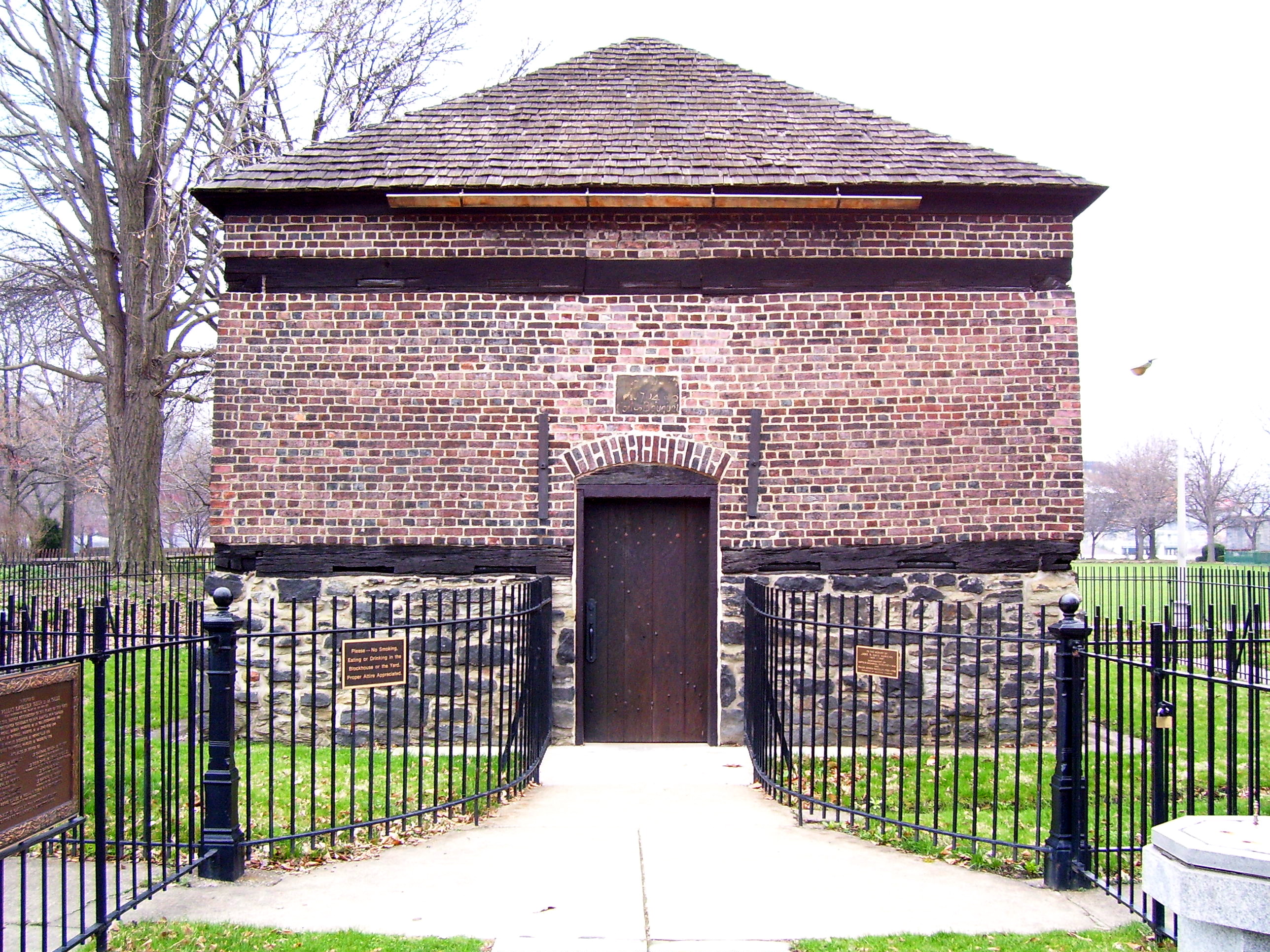
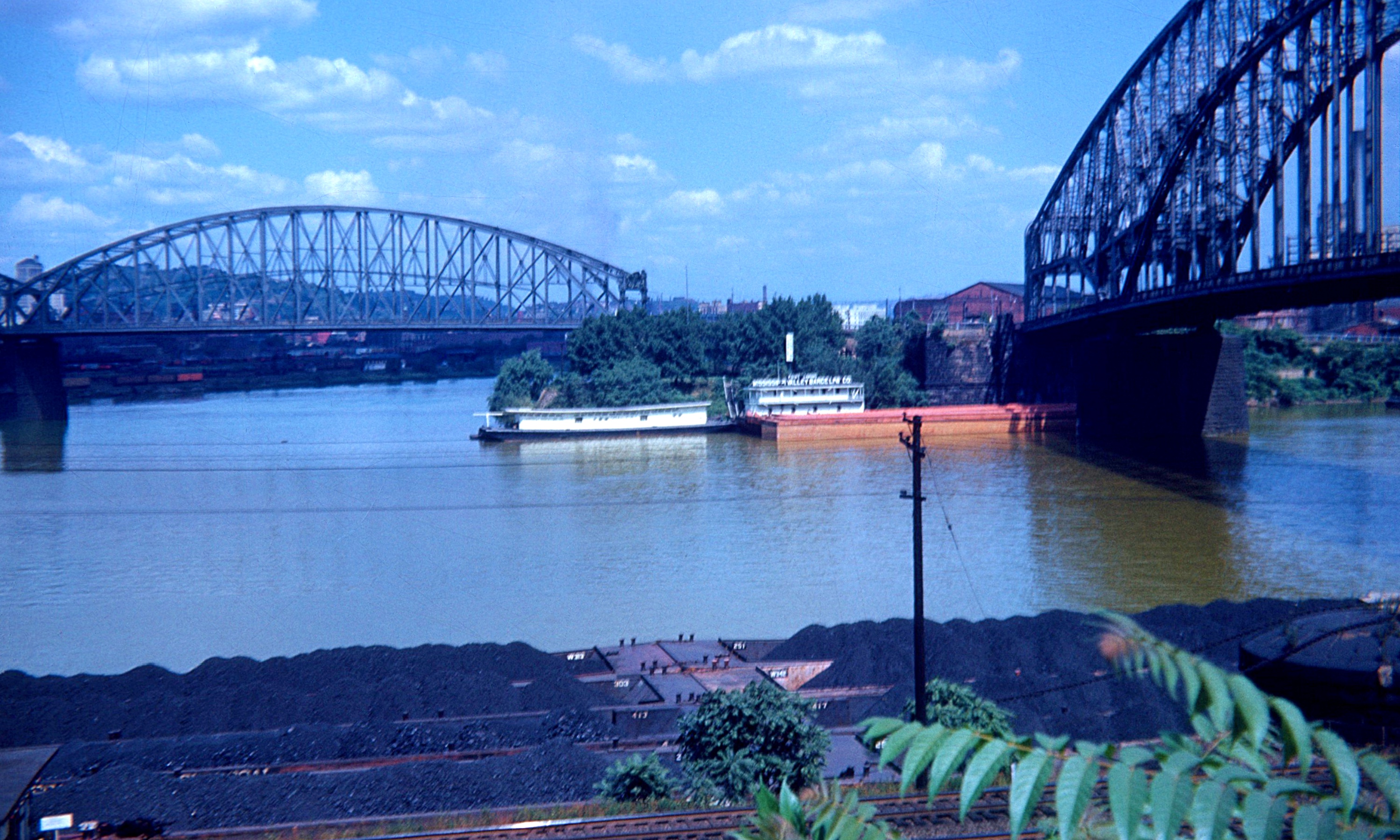
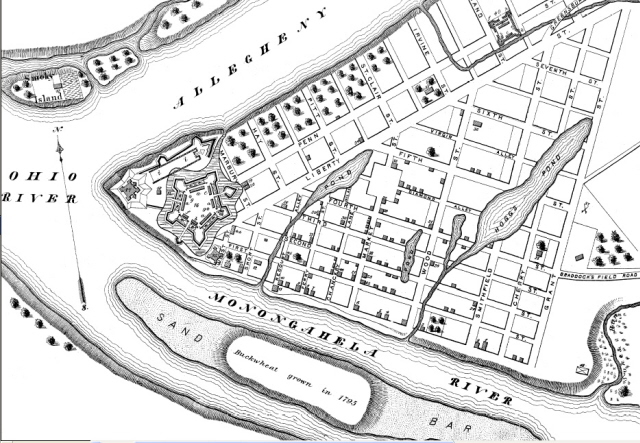
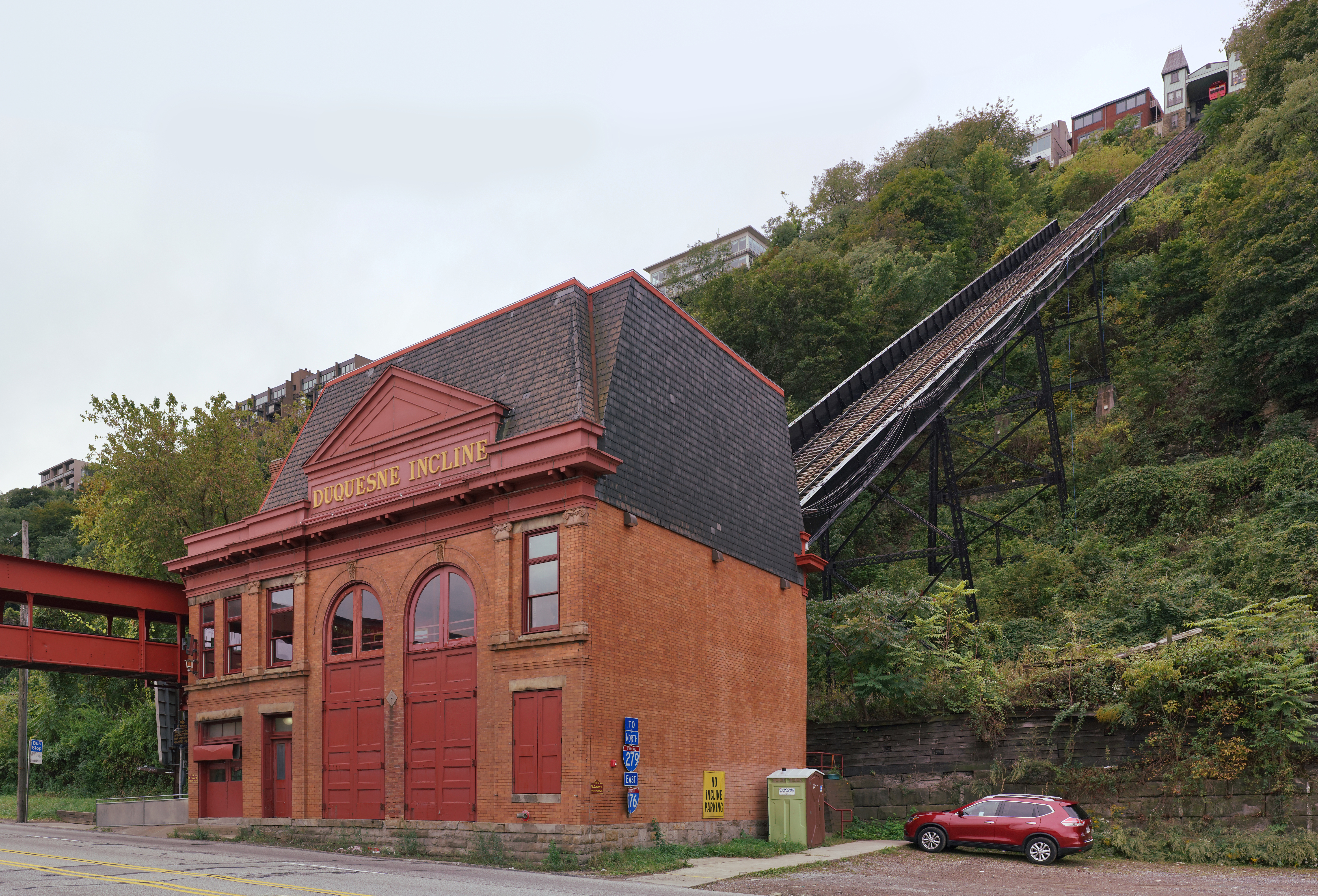
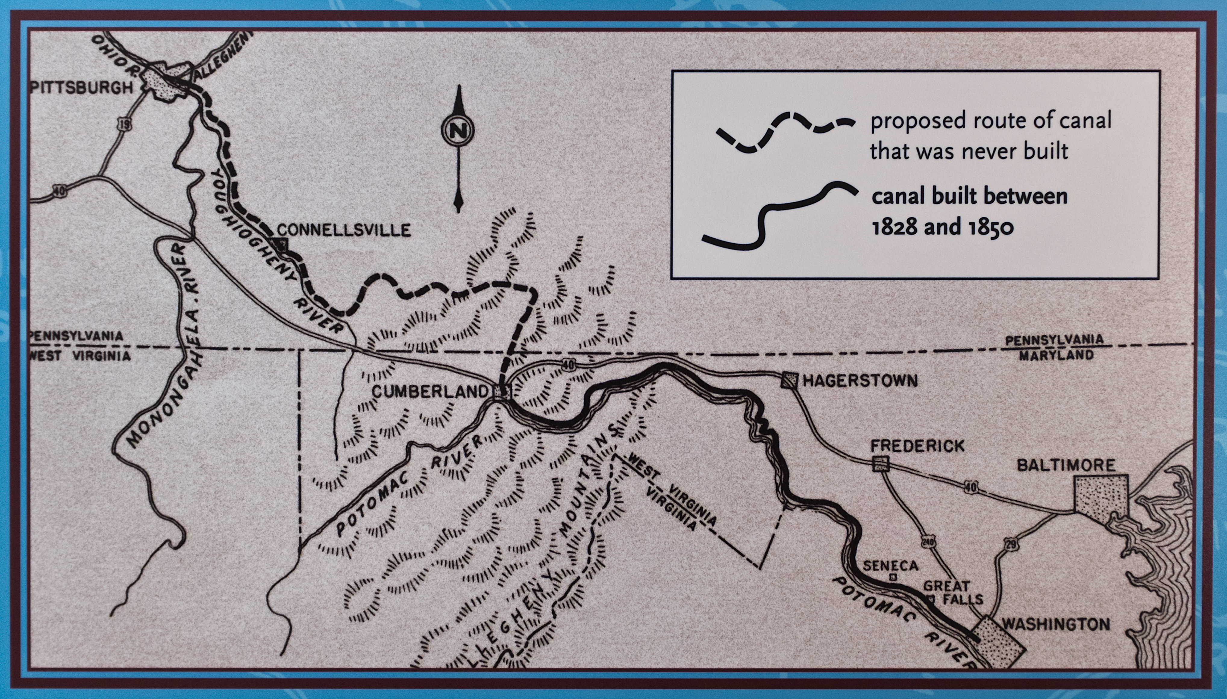
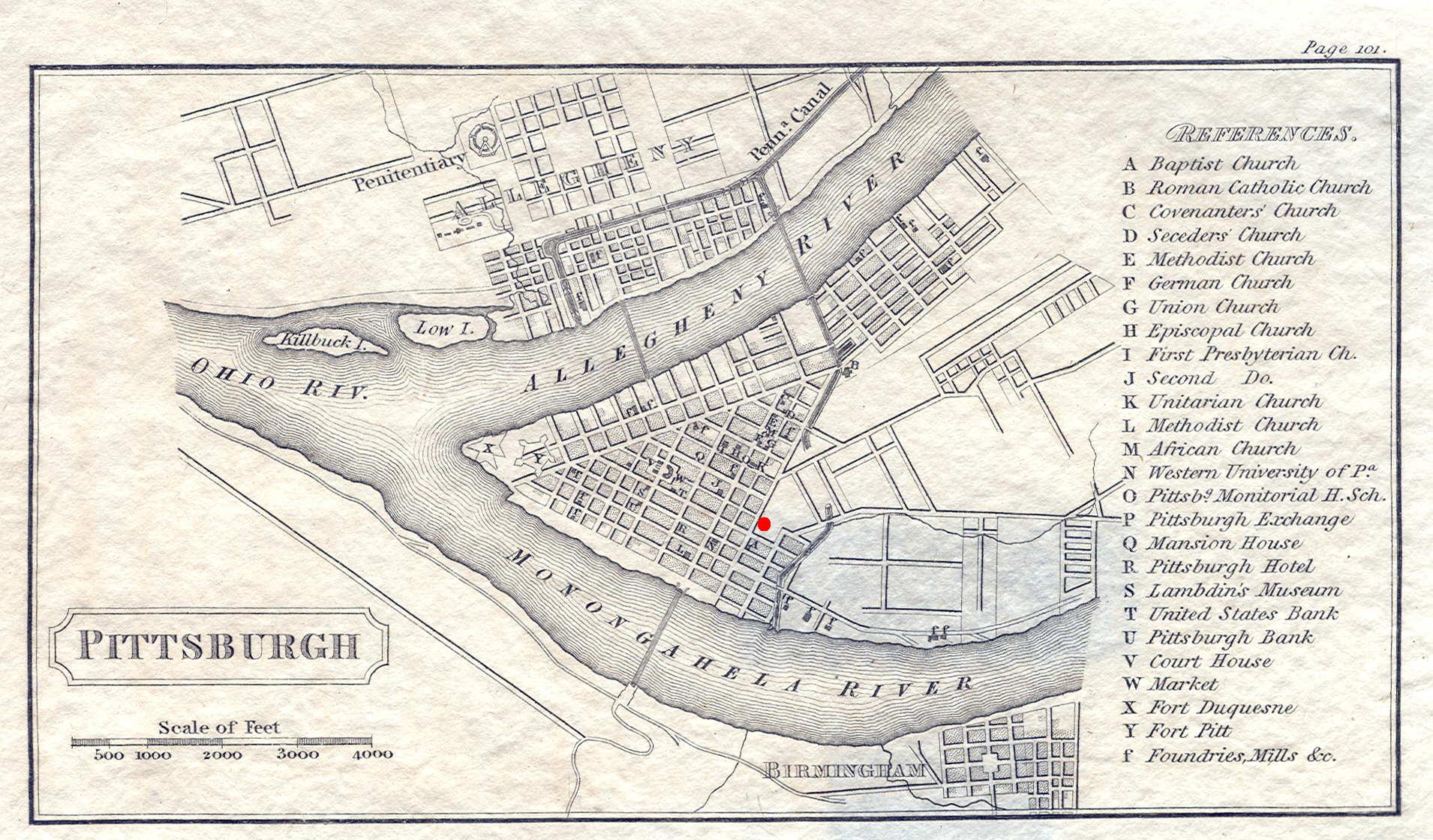
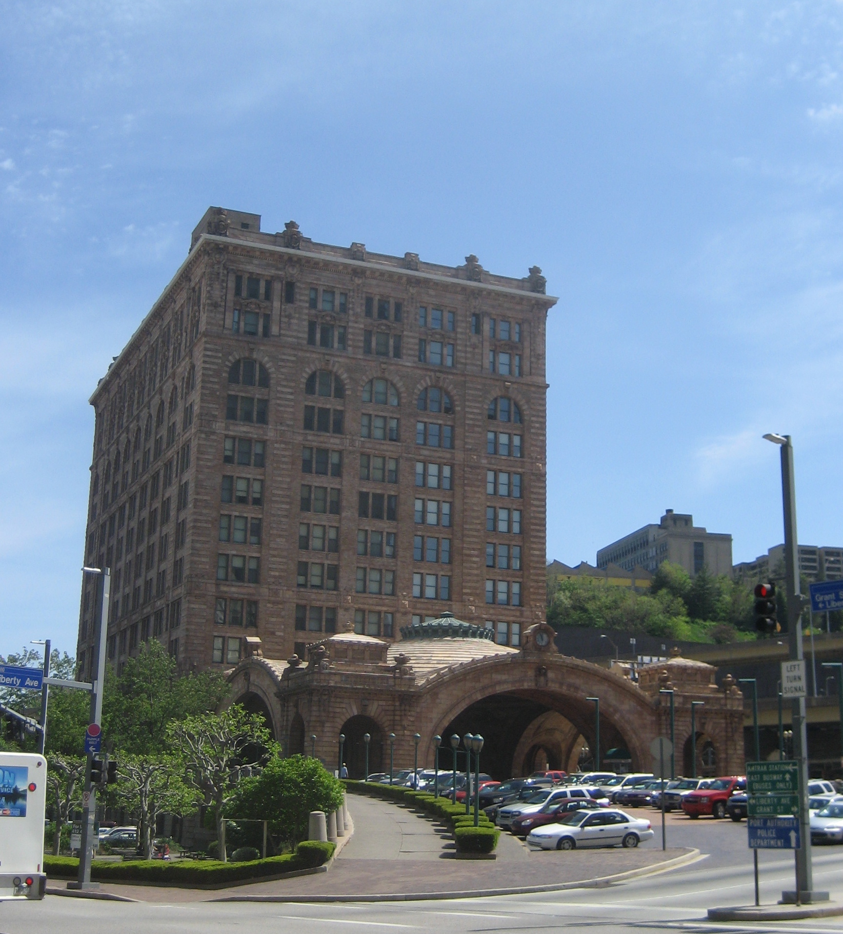
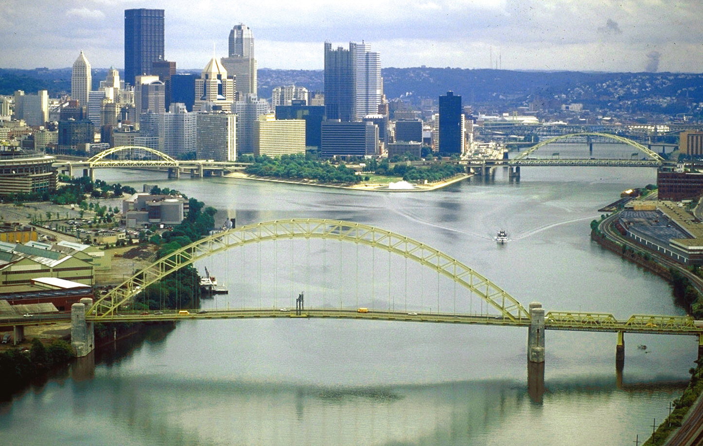
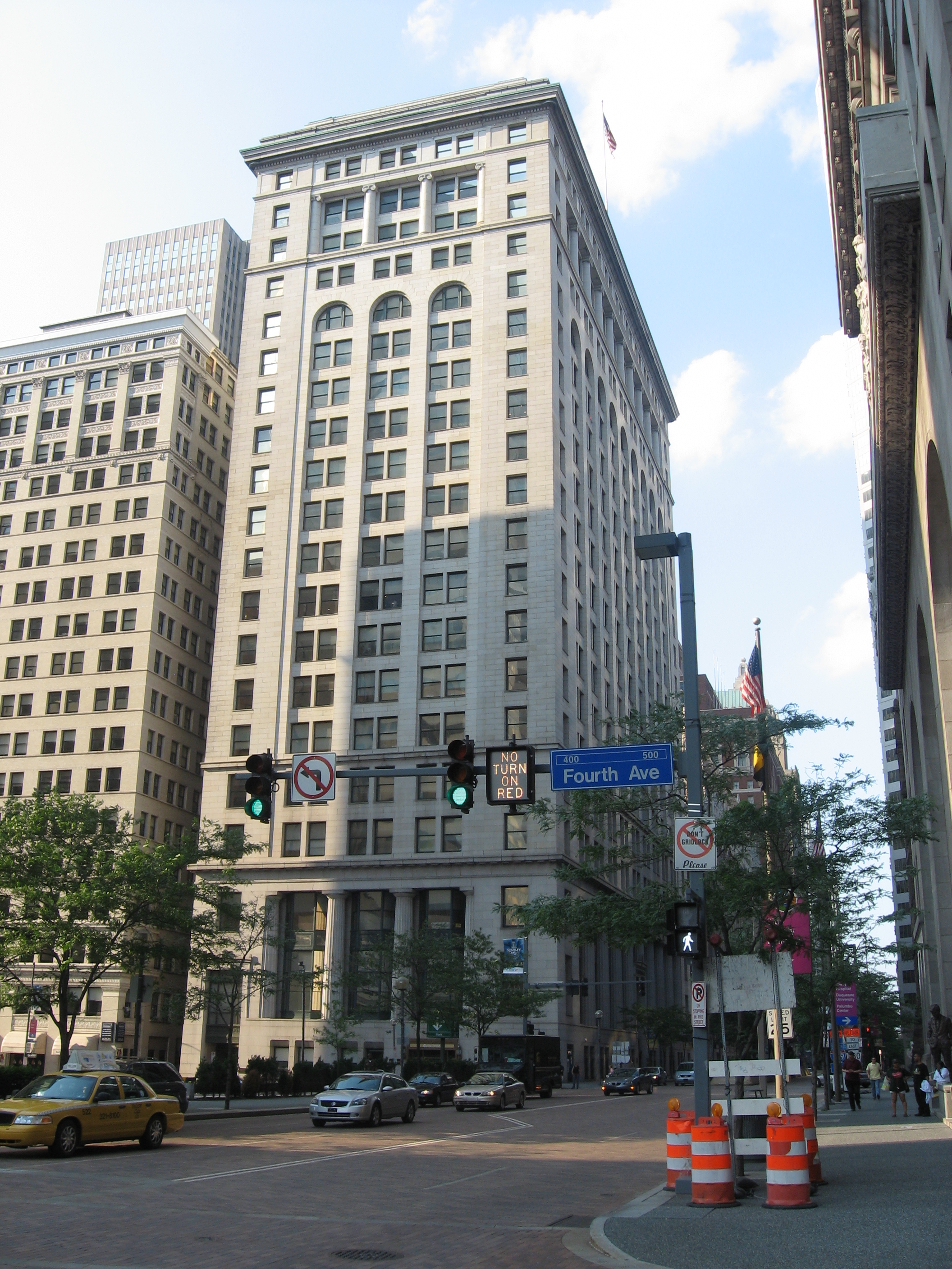
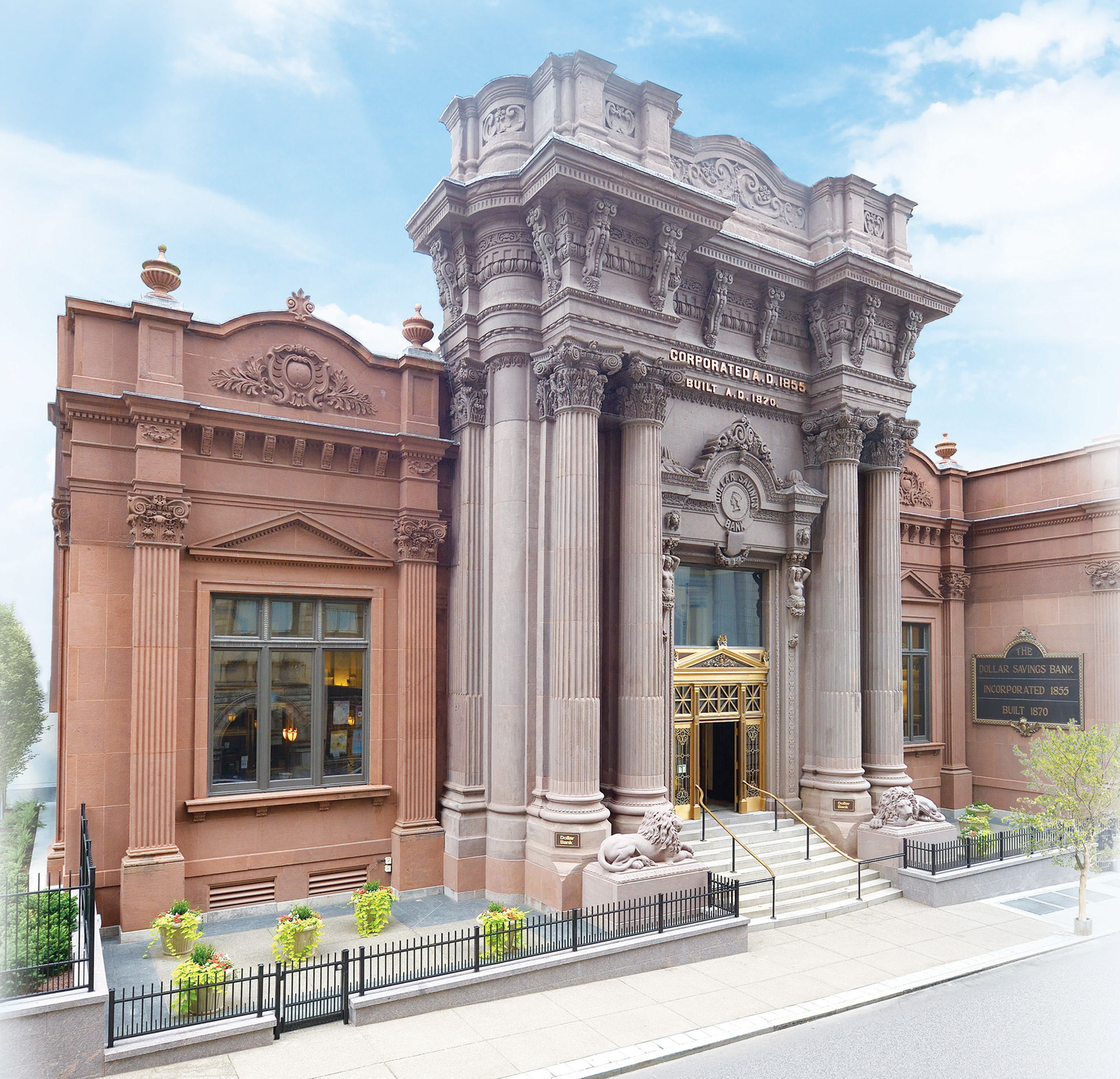
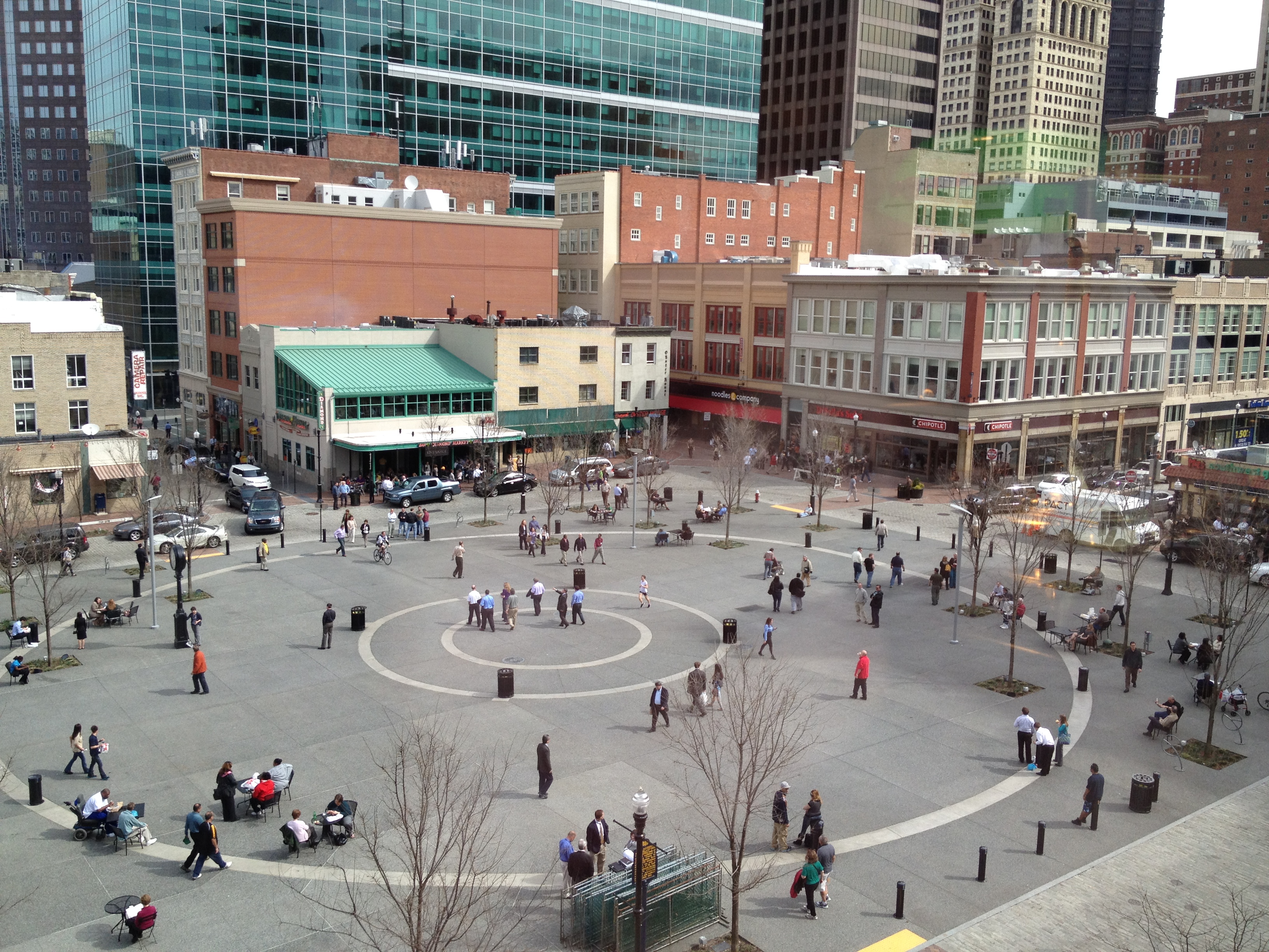
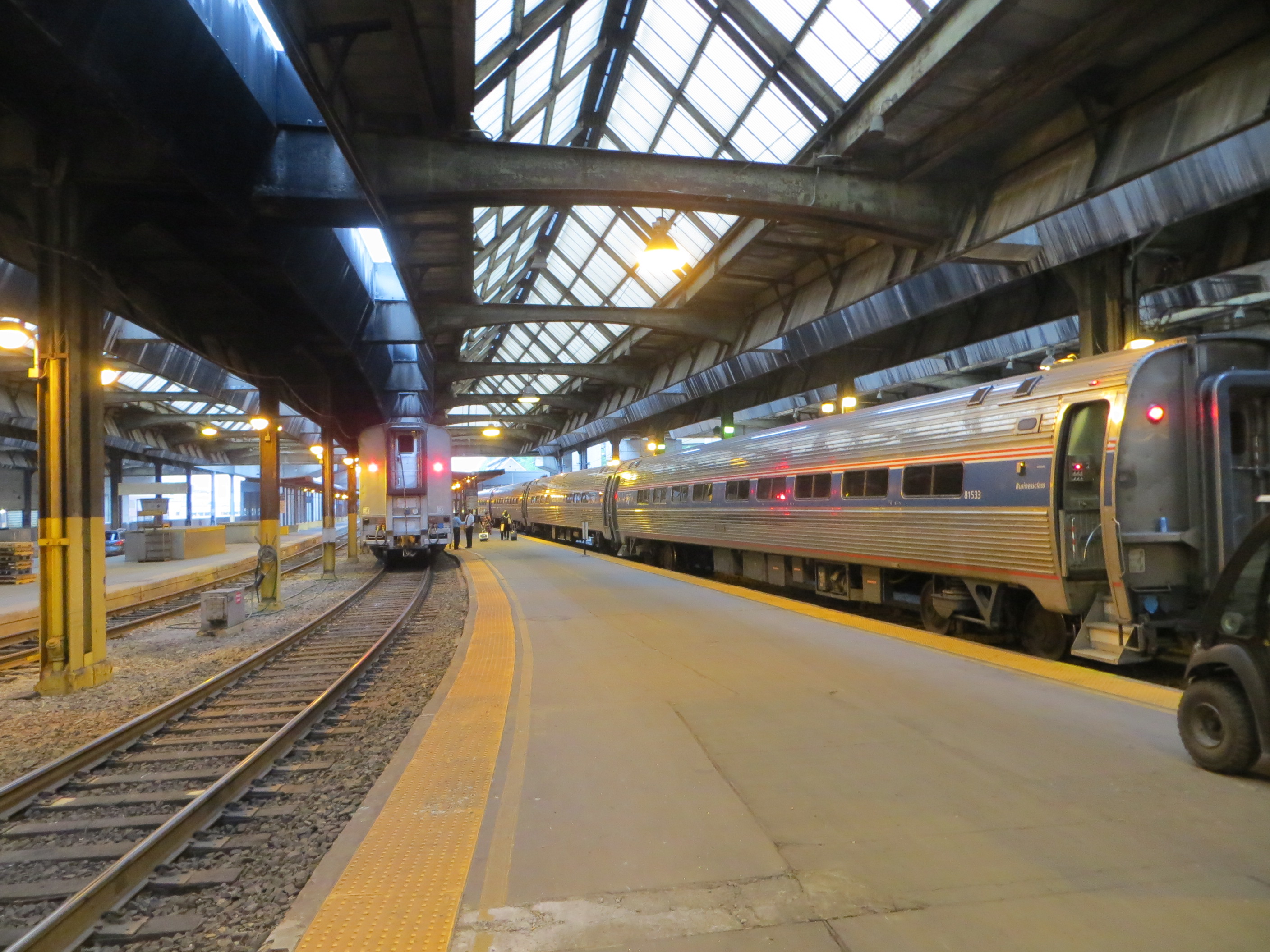
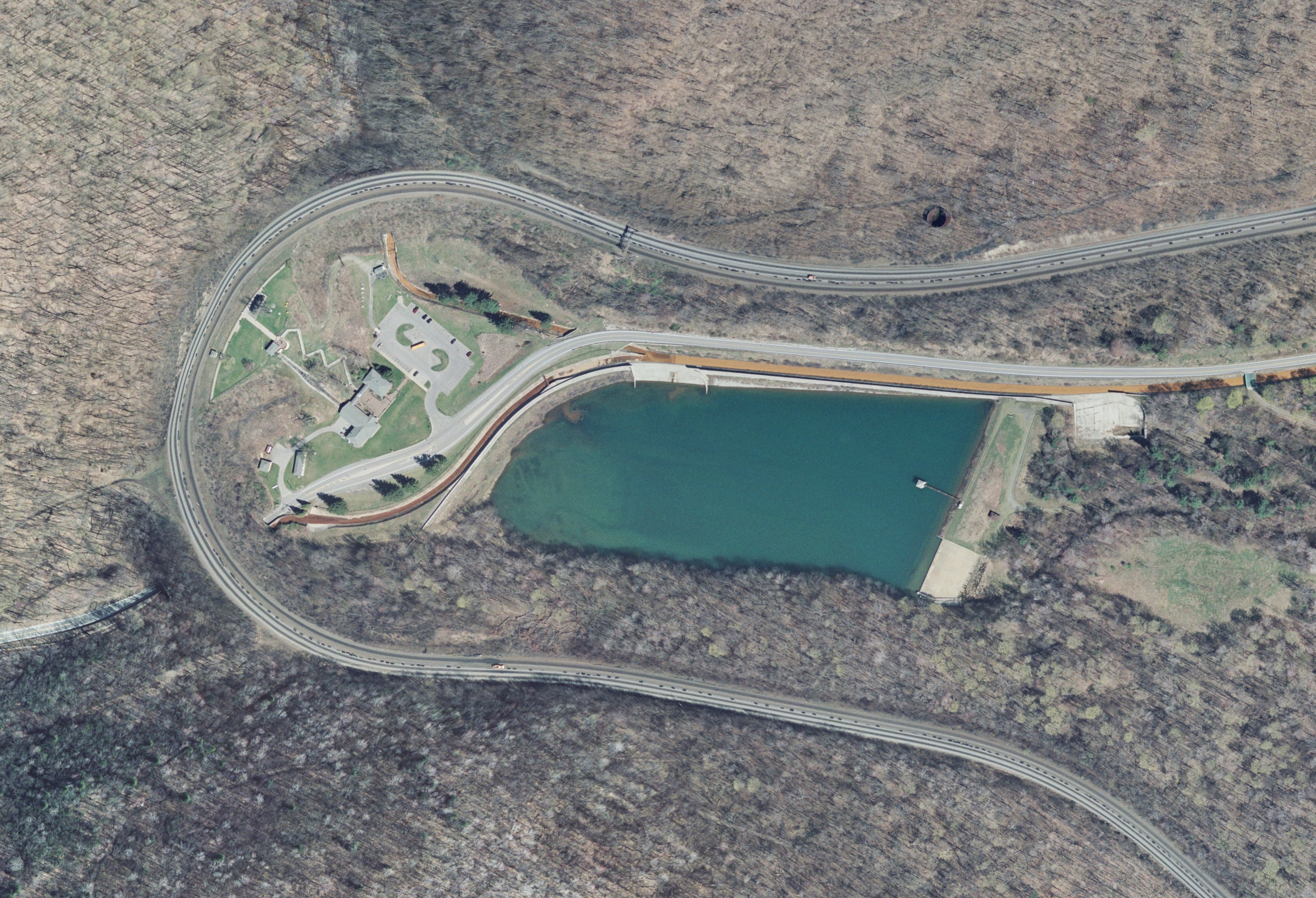
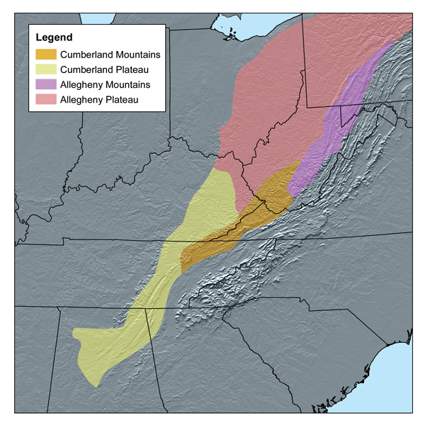